Prineville State Parks Master Plan Development Proposal ... · MASTER PLAN DEVELOPMENT PROPOSAL...
21
Prineville State Parks Master Plan Development Proposal Summary 2004
Transcript of Prineville State Parks Master Plan Development Proposal ... · MASTER PLAN DEVELOPMENT PROPOSAL...

Prineville State Parks Master Plan Development Proposal Summary
2004

P R I N E V I L L E R E S E R V O I R S T A T E P A R K M A S T E R P L A N D E V E L O P M E N T P R O P O S A L S U M M A R Y
Prineville 1 2004
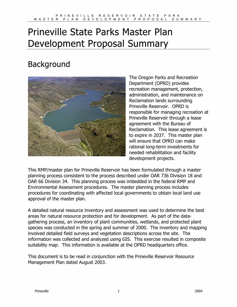
Prineville State Parks Master Plan Development Proposal Summary Background
The Oregon Parks and Recreation Department (OPRD) provides recreation management, protection, administration, and maintenance on Reclamation lands surrounding Prineville Reservoir. OPRD is responsible for managing recreation at Prineville Reservoir through a lease agreement with the Bureau of Reclamation. This lease agreement is to expire in 2037. This master plan will ensure that OPRD can make rational long-term investments for needed rehabilitation and facility development projects.
This RMP/master plan for Prineville Reservoir has been formulated through a master planning process consistent to the process described under OAR 736 Division 18 and OAR 66 Division 34. This planning process was imbedded in the federal RMP and Environmental Assessment procedures. The master planning process includes procedures for coordinating with affected local governments to obtain local land use approval of the master plan. A detailed natural resource inventory and assessment was used to determine the best areas for natural resource protection and for development. As part of the data-gathering process, an inventory of plant communities, wetlands, and protected plant species was conducted in the spring and summer of 2000. The inventory and mapping involved detailed field surveys and vegetation descriptions across the site. The information was collected and analyzed using GIS. This exercise resulted in composite suitability map. This information is available at the OPRD headquarters office. This document is to be read in conjunction with the Prineville Reservoir Resource Management Plan dated August 2003.
P R I N E V I L L E R E S E R V O I R S T A T E P A R K M A S T E R P L A N D E V E L O P M E N T P R O P O S A L S U M M A R Y
Prineville 2 2004
What is the purpose of this document?
1. Clearly identifies proposed development requiring land use review
This document is intended to provide a development proposal summary that will be incorporated into the Crook County Comprehensive Plan. This document will provide a synopsis of the development proposals requiring land use approval as presented in the Prineville Reservoir Resource Management Plan. This document includes an illustrated development concepts for major development areas as well as an accompanying table that describes the development in greater detail.
Development Concepts Development Concepts show how to fit needed facilities into the park. These concepts will provide the “blueprint” for the park development over the next 25 years. The development concepts reflect resource constraints, as well as, demand and address goals as determined in the planning process. They reflect appropriate type, size, location and access for the proposed facilities. Illustrating these concepts provides the public and the department a unified vision for the future of the park. The RMP outlines a plan for developing several high use primitive areas. These undesignated camping and day use areas are often the most difficult to manage by OPRD. Management issues occurring in these areas include health and safety issues to resource management issues. Crowding, poor access for emergency response, and uncontrolled use are common within these areas. Through organized development and supervision of these sites OPRD seeks to provide a quality recreation experience.
Design Parameters • Avoid conflicts with existing park uses and facilities • Provide good access and circulation for vehicles and non-motorized travel
within the parks • Place facilities, roads and trails in a manner that is understandable by the
public to find activities they are interested in • Avoid significant impacts to important natural or cultural resources in or
adjacent to the park • Present an appearance that is harmonious with the setting of the park and
the region and the state • Provide choices for park visitors who may have different desires for park
amenities and settings • Avoid or mitigate conflicts with local services or adjacent uses
P R I N E V I L L E R E S E R V O I R S T A T E P A R K M A S T E R P L A N D E V E L O P M E N T P R O P O S A L S U M M A R Y
Prineville 3 2004
• Avoid or mitigate potential impacts on the park by adjacent uses • Achieve compliance with regulatory requirements include the state land
use goals, local comprehensive plans, building codes, resource laws, etc.; • Provide opportunities for access by visitors with disabilities or different
economic or cultural backgrounds.
2. Defines OPRD Management Goals and Objectives
The RMP includes a set of goals specific to recreation. These goals correspond with OPRD goals for recreation related development at the reservoir. The proposed development reflects these goals. These goals are listed below.
Recreation Goals
• Provide adequate sites and facilities to support the demand for land-based recreational uses while affording the public a quality recreational experience and consistent with natural and cultural resource objectives.
• Provide adequate shoreline and water-based facilities to support the demand for boating and other water-based uses consistent with natural and cultural resource objectives.
• Manage the Prineville water surface to accommodate a variety of uses in a safe manner while minimizing conflicts among users.
• Provide appropriate vehicular and non-motorized access to recreation sites at Prineville Reservoir consistent with natural and cultural resource objectives.
• Ensure that appropriate facilities, programs, and signage, and/or an equivalent experience are provided and accessible to persons with disabilities.
3. Clarifies Agency Priorities
This document is to help more clearly define OPRD’ s priorities while providing a general construction schedule. This schedule is subject to funding levels and other statewide priorities. The construction schedule helps define for the reader ORPD’ s priorities for construction. This schedule is included on the development concept table. Within the RMP/MP the Table 6.2-1, a column entitled the implementation schedule identifies a tentative timeline for proposed actions outlined including the development proposals. The schedule identified in the table demonstrates OPRD’ s and Reclamation’ s commitment to a specific project and a general implementation schedule.
P R I N E V I L L E R E S E R V O I R S T A T E P A R K M A S T E R P L A N D E V E L O P M E N T P R O P O S A L S U M M A R Y
Prineville 4 2004
In summary OPRD has placed major development priority for new use areas.
1. Powder House Cove Boat Ramp – High Priority
Powder House Cove is a physically small day use area with high use at the western end of the local reservoir just south of Bowman Dam, near the old powder house used to store explosives during dam construction. Use has been increasing due to recent road improvements. Features of this site include a one-lane boat launch, two gravel parking areas, and two vault toilets. Portable toilets and trash cans are installed at the site during the peak use season. The existing boat launch is best characterized as primitive as it has a gravel surface only on the uppermost portions before becoming mostly dirt on the lower portions. Given the popularity of this site, overflow parking commonly occurs on the shoulder of Highway 27, creating a traffic hazard. Boats also launch from numerous locations along the shoreline in the cove. OPRD has ranked this project as a high priority too alleviate the existing crowding, improve highway access and to provide needed year-round boat access development. This project includes:
Phase 1:
1. Build new entrance and boat ramp access road.
2. Construct new boat ramp east of existing ramp.
3. Provide additional truck and trailer parking (75 max.).
4. Close old boat ramp.
5. Construct day use area with separate parking area (20 max.) and trailhead.
6. Construct non-motorized trail - interpretive loop trail to old Powder House and Taylor Butte.
7. New vault toilet(s).
8. Manage for day use only.
9. Work with appropriate agencies to eliminate parking on Hwy 27.
Phase 2:
1. Add additional parking for trucks and trailers (45 max).
P R I N E V I L L E R E S E R V O I R S T A T E P A R K M A S T E R P L A N D E V E L O P M E N T P R O P O S A L S U M M A R Y
Prineville 5 2004
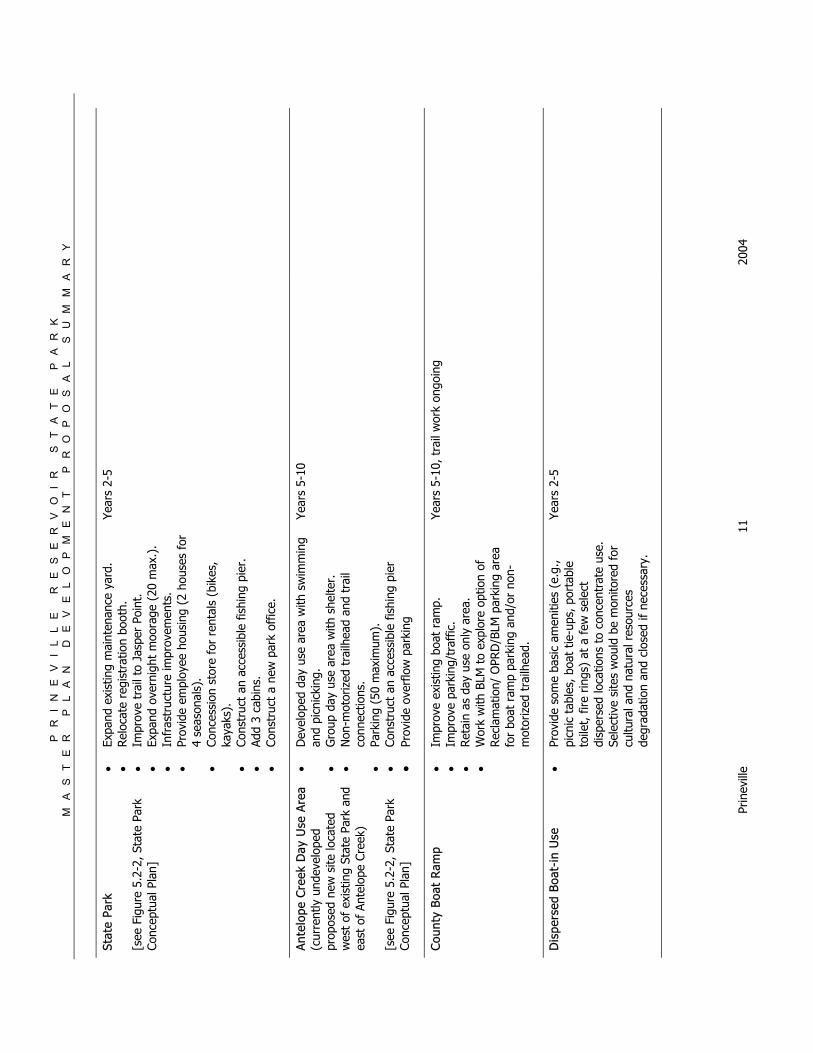
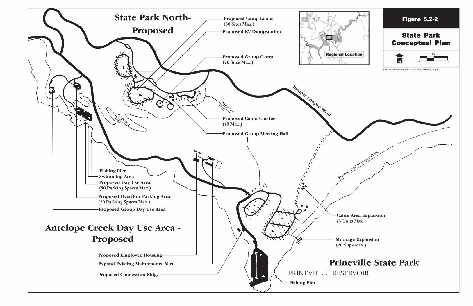
2. State Park North including Antelope Creek Day Use Area –Medium Priority
To the northwest of the existing campground in a currently undeveloped area OPRD is seeking to develop a new campground and associated day use area. The RMP refers to the this area as State Park North, due to its proximity to the existing campground and support facilities, and Antelope Creek Day Use Area. The proposed day use area is presently used as a primitive day use. OPRD will continue to coordinate with USBR and Crook County on a road plan for the north side of the reservoir. Proposed access points off of Juniper Canyon Road into the park will be coordinated with future development of access points onto private lands adjacent to the USBR boundaries. OPRD has ranked this project as medium priority because the proposed development would make use of existing facilities and infrastructure primarily due to the site’ s ideal location near existing roads, park maintenance facilities and the park development. Proposed development includes: Develop the Antelope Creek Day Use Area (a new site located west of the State Park and east of Antelope Creek). Provide for the following facilities: 1. Developed day use area with swimming and picnicking.
2. Group day use area with shelter.
3. Non-motorized trailhead and trail connections.
4. Parking (50 maximum).
5. Construct an accessible fishing pier.
6. Provide overflow parking.
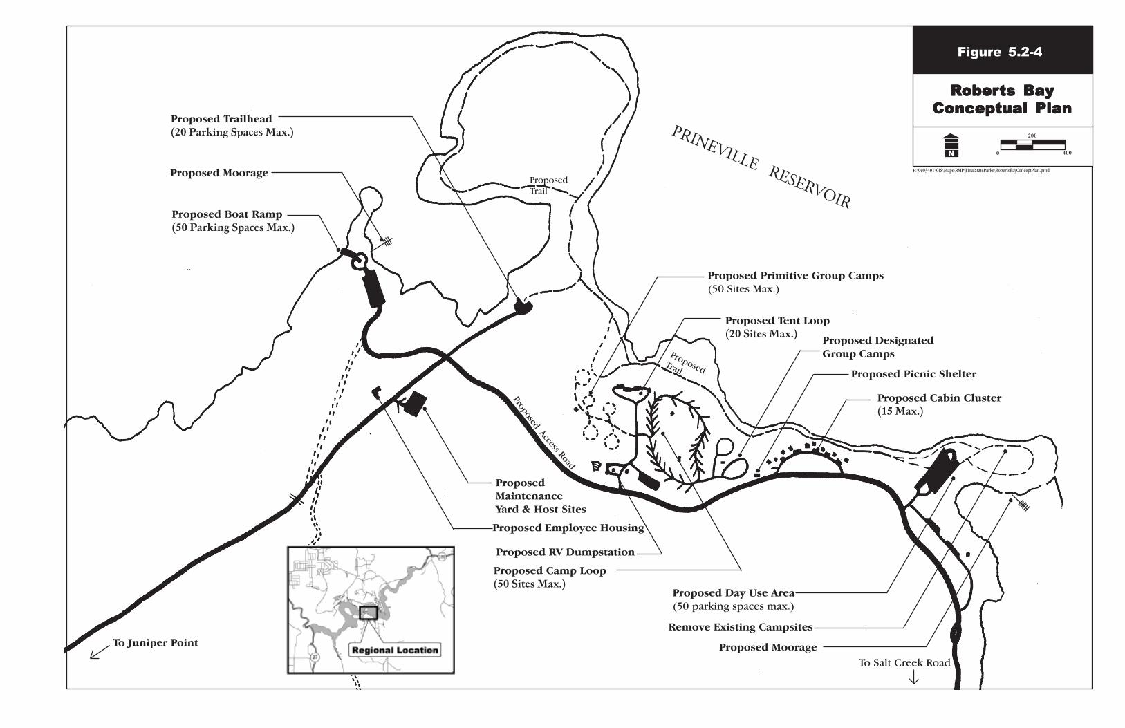
3. Roberts Bay development beyond basic recreation management – Low
Priority
Roberts Bay East is the most heavily used recreation area on the south shore and is the most popular dispersed recreation area on the reservoir. Features of this site include 12 picnic tables, 4 vault toilets—as well as additional portable toilets during the peak use season—and as many as 50 distinct dispersed campsites and numerous makeshift campsites with user-constructed fire rings. Trash cans are also provided during the peak use season. Twenty of the dispersed sites are on a small peninsula and have
P R I N E V I L L E R E S E R V O I R S T A T E P A R K M A S T E R P L A N D E V E L O P M E N T P R O P O S A L S U M M A R Y
Prineville 6 2004
gravel parking spurs and some shade. The remaining sites are scattered throughout the main use area along the western shoreline of Roberts Bay which is interspersed with some juniper trees that provide limited shade. However, much of the use of this site occurs directly on the shoreline and in the areas below the full pool level that are exposed as the summer progresses. Although the area lacks a formal boat launch, the gentle slope of the shoreline and lack of rocks or trees allows visitors to launch from many portions of the site. Roberts Bay West is a small designated dispersed site at the western end of the Roberts Bay area. Features of this site include an informal gravel/rock boat ramp, three picnic tables, and approximately ten dispersed campsites. Portable toilets are also provided at this site during the peak season and are highly visible from the water, resulting in heavy use from boaters in the area. To maintain order and initial management over sight of this site phase 1 development may occur earlier and will include the following actions.
1. Create designated use areas for the entire site including
designated camping areas.
2. Develop group camps as part of designated use areas including vault toilets.
3. Institute camp host(s).
4. Develop a day use area for picnicking and swimming with parking for up to 50 cars including vault toilets.
5. Develop trails and clear vegetation for emergency helicopter landing pad.
6. Consider vehicular restricted access to Roberts Bay West to encourage increased boat camper use. This will assist in fewer vehicular trips down Salt Creek Road.
7. Restrict all camping to those designated sites to allow for County enforcement of use within restricted areas.
OPRD will not develop phase II for larger more developed campground until the legal access, management and maintenance of Salt Creek Road is established and there is historical data of the use of the improved primitive Roberts Bay camp area. Observations of the issues that arise during the time period during the period of construction for Powder House Cove and the North Side expansion of the existing State Park will provide for possible solutions to the road issues and surrounding land use impacts on BLM and private lands.
P R I N E V I L L E R E S E R V O I R S T A T E P A R K M A S T E R P L A N D E V E L O P M E N T P R O P O S A L S U M M A R Y
Prineville 7 2004
Upon resolution of the access implementation Phase 2 camping development at Roberts Bay East by providing for the following facilities:
1. Create designated campsites (50 max.) with water, electricity, and toilet buildings with showers.
2. Develop primitive group camps (5 with 10 sites each) with only centralized water and toilets.
3. Create two group camps with group picnic shelter with water and power.
4. Develop a cabin cluster (15 max.).
5. Provide for an RV dump station.
6. Trails and trail connections.
7. Provide for additional host sites.
8. Create a camp talk area.
9. Build a camper registration building
10. Create a walk-in tent camp area with 20 sites.

P R I N E V I L L E R E S E R V O I R S T A T E P A R K M A S T E R P L A N D E V E L O P M E N T P R O P O S A L S U M M A R Y
Prineville 8 2004
PR
IN
EV
IL
LE
R
ES
ER
VO
IR
S
TA
TE
P
AR
K
M
AS
TE
R
PL
AN
D
EV
EL
OP
ME
NT
P
RO
PO
SA
L
SU
MM
AR
Y
Prin
evill
e 9
2004
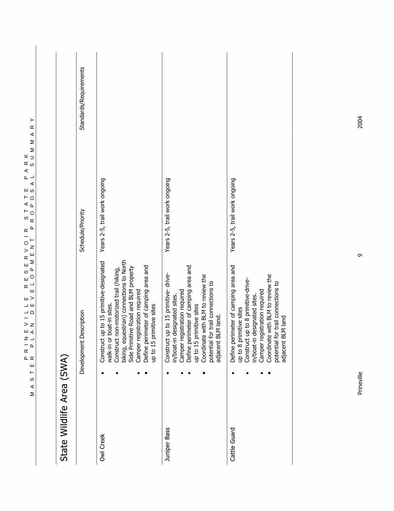
St
ate
Wild
life
Are
a (S
WA
)
D
evel
opm
ent
Des
crip
tion
Sche
dule
/Prio
rity
Stan
dard
s/Req
uire
men
ts
Ow
l Cre
ek
• Co
nstr
uct
up t
o 15
prim
itive
-des
igna
ted
wal
k-in
or
boat
-in s
ites.
•
Cons
truc
t no
n-m
otor
ized
tra
il (h
ikin
g,
biki
ng, e
ques
tria
n) c
onne
ctio
ns t
o N
orth
Si
de P
rimiti
ve R
oad
and
BLM
pro
pert
y
• Ca
mpe
r re
gist
ratio
n re
quire
d •
Def
ine
perim
eter
of
cam
ping
are
a an
d up
to
15 p
rimiti
ve s
ites
Year
s 2-
5, t
rail
wor
k on
goin
g
Juni
per
Bass
•
Cons
truc
t up
to
15 p
rimiti
ve-
driv
e-in
/boa
t-in
des
igna
ted
site
s.
• Ca
mpe
r re
gist
ratio
n re
quire
d
• D
efin
e pe
rimet
er o
f ca
mpi
ng a
rea
and
up t
o 15
prim
itive
site
s •
Coor
dina
te w
ith B
LM t
o re
view
the
po
tent
ial f
or t
rail
conn
ectio
ns t
o ad
jace
nt B
LM la
nd.
Year
s 2-
5, t
rail
wor
k on
goin
g
Cat
tle G
uard
•
Def
ine
perim
eter
of
cam
ping
are
a an
d up
to
8 pr
imiti
ve s
ites
•
Cons
truc
t up
to
8 pr
imiti
ve-d
rive-
in/b
oat-
in d
esig
nate
d si
tes.
•
Cam
per
regi
stra
tion
requ
ired
•
Coor
dina
te w
ith B
LM t
o re
view
the
po
tent
ial f
or t
rail
conn
ectio
ns t
o ad
jace
nt B
LM la
nd
Year
s 2-
5, t
rail
wor
k on
goin
g
PR
IN
EV
IL
LE
R
ES
ER
VO
IR
S
TA
TE
P
AR
K
M
AS
TE
R
PL
AN
D
EV
EL
OP
ME
NT
P
RO
PO
SA
L
SU
MM
AR
Y
Prin
evill
e 10
20
04
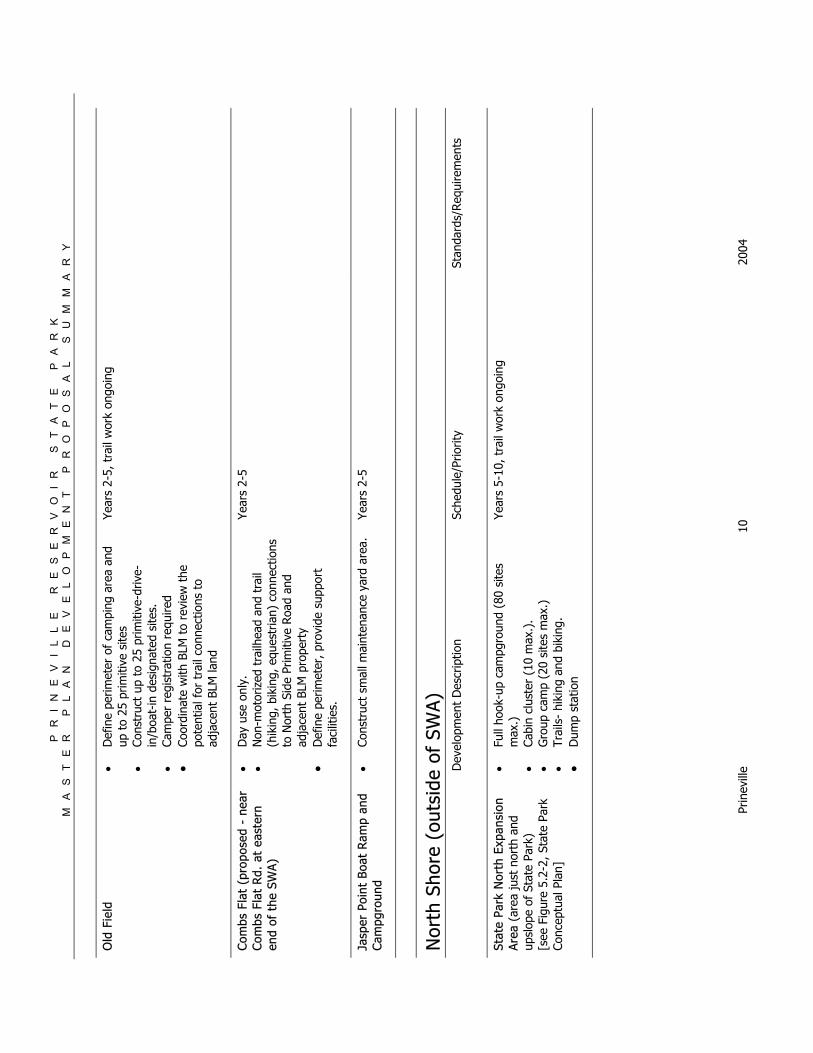
Old
Fie
ld
• D
efin
e pe
rimet
er o
f ca
mpi
ng a
rea
and
up t
o 25
prim
itive
site
s
• Co
nstr
uct
up t
o 25
prim
itive
-driv
e-in
/boa
t-in
des
igna
ted
site
s.
• Ca
mpe
r re
gist
ratio
n re
quire
d
• Co
ordi
nate
with
BLM
to
revi
ew t
he
pote
ntia
l for
tra
il co
nnec
tions
to
adja
cent
BLM
land
Year
s 2-
5, t
rail
wor
k on
goin
g
Com
bs F
lat
(pro
pose
d -
near
C
ombs
Fla
t R
d. a
t ea
ster
n en
d of
the
SW
A)
• D
ay u
se o
nly.
•
Non
-mot
oriz
ed t
railh
ead
and
trai
l (h
ikin
g, b
ikin
g, e
ques
tria
n) c
onne
ctio
ns
to N
orth
Sid
e Pr
imiti
ve R
oad
and
adja
cent
BLM
pro
pert
y •
Def
ine
perim
eter
, pro
vide
sup
port
fa
cilit
ies.
Year
s 2-
5
Jasp
er P
oint
Boa
t R
amp
and
Cam
pgro
und
• Co
nstr
uct
smal
l mai
nten
ance
yar
d ar
ea.
Year
s 2-
5
Nor
th S
hore
(ou
tsid
e of
SW
A)
D
evel
opm
ent
Des
crip
tion
Sche
dule
/Prio
rity
Stan
dard
s/Req
uire
men
ts
Stat
e Pa
rk N
orth
Exp
ansi
on
Are
a (a
rea
just
nor
th a
nd
upsl
ope
of S
tate
Par
k)
[see
Fig
ure
5.2-
2, S
tate
Par
k Co
ncep
tual
Pla
n]
• Fu
ll ho
ok-u
p ca
mpg
roun
d (8
0 si
tes
max
.)
• Ca
bin
clus
ter
(10
max
.).
• G
roup
cam
p (2
0 si
tes
max
.)
• Tr
ails
- hi
king
and
bik
ing.
•
Dum
p st
atio
n
Year
s 5-
10, t
rail
wor
k on
goin
g
PR
IN
EV
IL
LE
R
ES
ER
VO
IR
S
TA
TE
P
AR
K
M
AS
TE
R
PL
AN
D
EV
EL
OP
ME
NT
P
RO
PO
SA
L
SU
MM
AR
Y
Prin
evill
e 11
20
04
Stat
e Pa
rk
[see
Fig
ure
5.2-
2, S
tate
Par
k Co
ncep
tual
Pla
n]
• Ex
pand
exi
stin
g m
aint
enan
ce y
ard.
•
Rel
ocat
e re
gist
ratio
n bo
oth.
•
Impr
ove
trai
l to
Jasp
er P
oint
. •
Expa
nd o
vern
ight
moo
rage
(20
max
.).
• In
fras
truc
ture
impr
ovem
ents
. •
Prov
ide
empl
oyee
hou
sing
(2
hous
es f
or
4 se
ason
als)
. •
Conc
essi
on s
tore
for
ren
tals
(bi
kes,
ka
yaks
).
• Co
nstr
uct
an a
cces
sibl
e fis
hing
pie
r.
• Ad
d 3
cabi
ns.
• Co
nstr
uct
a ne
w p
ark
offic
e.
Year
s 2-
5
Ant
elop
e C
reek
Day
Use
Are
a (c
urre
ntly
und
evel
oped
pr
opos
ed n
ew s
ite lo
cate
d w
est
of e
xist
ing
Stat
e Pa
rk a
nd
east
of
Ante
lope
Cre
ek)
[see
Fig
ure
5.2-
2, S
tate
Par
k Co
ncep
tual
Pla
n]
• D
evel
oped
day
use
are
a w
ith s
wim
min
g an
d pi
cnic
king
. •
Gro
up d
ay u
se a
rea
with
she
lter.
•
Non
-mot
oriz
ed t
railh
ead
and
trai
l co
nnec
tions
. •
Park
ing
(50
max
imum
).
• Co
nstr
uct
an a
cces
sibl
e fis
hing
pie
r •
Prov
ide
over
flow
par
king
Year
s 5-
10
Cou
nty
Boat
Ram
p •
Impr
ove
exis
ting
boat
ram
p.
• Im
prov
e pa
rkin
g/tr
affic
. •
Ret
ain
as d
ay u
se o
nly
area
. •
Wor
k w
ith B
LM t
o ex
plor
e op
tion
of
Rec
lam
atio
n/ O
PRD
/BLM
par
king
are
a fo
r bo
at r
amp
park
ing
and/
or n
on-
mot
oriz
ed t
railh
ead.
Year
s 5-
10, t
rail
wor
k on
goin
g
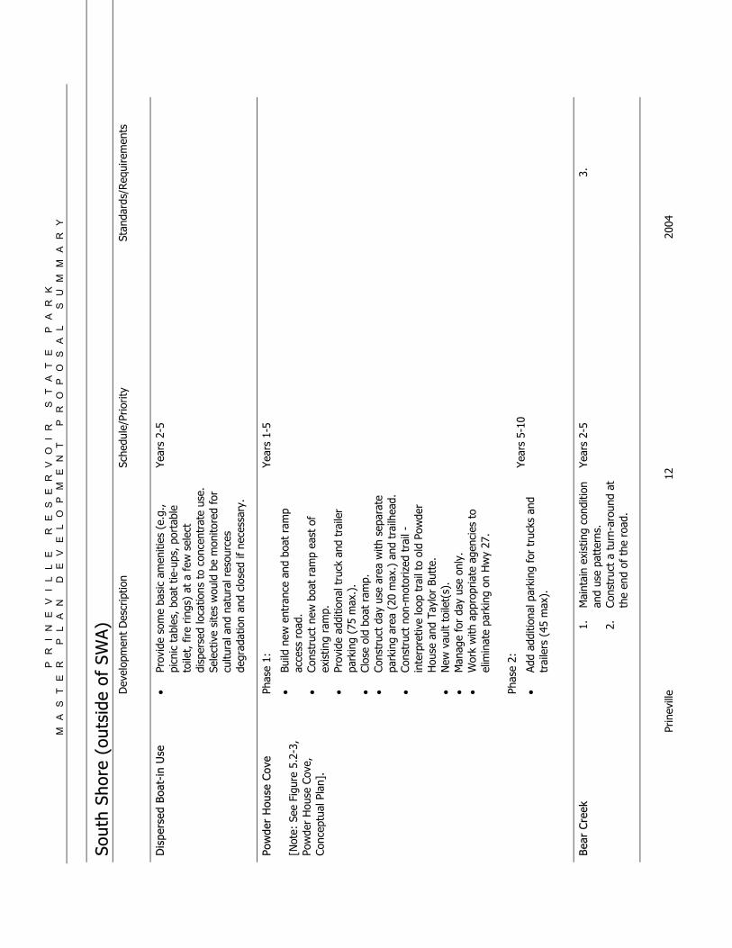
Dis
pers
ed B
oat-
in U
se
• Pr
ovid
e so
me
basi
c am
eniti
es (
e.g.
, pi
cnic
tab
les,
boa
t tie
-ups
, por
tabl
e to
ilet,
fire
rin
gs)
at a
few
sel
ect
disp
erse
d lo
catio
ns t
o co
ncen
trat
e us
e.
Sele
ctiv
e si
tes
wou
ld b
e m
onito
red
for
cultu
ral a
nd n
atur
al r
esou
rces
de
grad
atio
n an
d cl
osed
if n
eces
sary
.
Year
s 2-
5
PR
IN
EV
IL
LE
R
ES
ER
VO
IR
S
TA
TE
P
AR
K
M
AS
TE
R
PL
AN
D
EV
EL
OP
ME
NT
P
RO
PO
SA
L
SU
MM
AR
Y
Prin
evill
e 12
20
04
Sout
h Sh
ore
(out
side
of
SWA
)
Dev
elop
men
t D
escr
iptio
n Sc
hedu
le/P
riorit
y St
anda
rds/
Req
uire
men
ts
Dis
pers
ed B
oat-
in U
se
•
Prov
ide
som
e ba
sic
amen
ities
(e.
g.,
picn
ic t
able
s, b
oat
tie-u
ps, p
orta
ble
toile
t, f
ire r
ings
) at
a f
ew s
elec
t di
sper
sed
loca
tions
to
conc
entr
ate
use.
Se
lect
ive
site
s w
ould
be
mon
itore
d fo
r cu
ltura
l and
nat
ural
res
ourc
es
degr
adat
ion
and
clos
ed if
nec
essa
ry.
Year
s 2-
5
Pow
der
Hou
se C
ove
[Not
e: S
ee F
igur
e 5.
2-3,
Po
wde
r H
ouse
Cov
e,
Conc
eptu
al P
lan]
.
Phas
e 1:
• Bu
ild n
ew e
ntra
nce
and
boat
ram
p ac
cess
roa
d.
• Co
nstr
uct
new
boa
t ra
mp
east
of
exis
ting
ram
p.
• Pr
ovid
e ad
ditio
nal t
ruck
and
tra
iler
park
ing
(75
max
.).
• Cl
ose
old
boat
ram
p.
• Co
nstr
uct
day
use
area
with
sep
arat
e pa
rkin
g ar
ea (
20 m
ax.)
and
tra
ilhea
d.
• Co
nstr
uct
non-
mot
oriz
ed t
rail
- in
terp
retiv
e lo
op t
rail
to o
ld P
owde
r H
ouse
and
Tay
lor
Butt
e.
• N
ew v
ault
toile
t(s)
. •
Man
age
for
day
use
only
. •
Wor
k w
ith a
ppro
pria
te a
genc
ies
to
elim
inat
e pa
rkin
g on
Hw
y 27
. Ph
ase
2:
• Ad
d ad
ditio
nal p
arki
ng f
or t
ruck
s an
d tr
aile
rs (
45 m
ax).
Year
s 1-
5
Year
s 5-
10
Bear
Cre
ek
1.
Mai
ntai
n ex
istin
g co
nditi
on
and
use
patt
erns
. 2.
Co
nstr
uct
a tu
rn-a
roun
d at
th
e en
d of
the
roa
d.
Year
s 2-
5 3.
PR
IN
EV
IL
LE
R
ES
ER
VO
IR
S
TA
TE
P
AR
K
M
AS
TE
R
PL
AN
D
EV
EL
OP
ME
NT
P
RO
PO
SA
L
SU
MM
AR
Y
Prin
evill
e 13
20
04
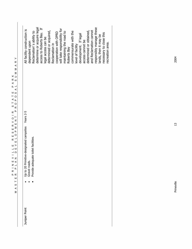
Juni
per
Poin
t
• U
p to
20
Prim
itive
-des
igna
ted
cam
psite
s •
Gra
vel r
oads
. •
Prov
ide
adeq
uate
toi
let
faci
litie
s.
Year
s 2-
5 Al
l fac
ility
con
stru
ctio
n is
de
pend
ent
upon
Rec
lam
atio
n’s
abili
ty t
o de
term
ine
or a
cqui
re le
gal
acce
ss t
o Ro
bert
s Ba
y. If
le
gal a
cces
s ca
n be
de
term
ined
or
acqu
ired,
Rec
lam
atio
n in
co
oper
atio
n w
ith O
PRD
w
ill t
ake
resp
onsi
bilit
y fo
r m
aint
aini
ng t
he r
oad
to
Rob
erts
Bay
co
mm
ensu
rate
with
the
le
vel o
f fa
cilit
y de
velo
pmen
t. If
lega
l ac
cess
can
not
be
dete
rmin
ed o
r ob
tain
ed,
and
Rec
lam
atio
n ca
nnot
re
spon
sibl
y m
anag
e th
ese
land
s, t
hen
it m
ay b
e ne
cess
ary
to c
lose
thi
s re
crea
tion
area
.
PR
IN
EV
IL
LE
R
ES
ER
VO
IR
S
TA
TE
P
AR
K
M
AS
TE
R
PL
AN
D
EV
EL
OP
ME
NT
P
RO
PO
SA
L
SU
MM
AR
Y
Prin
evill
e 14
20
04
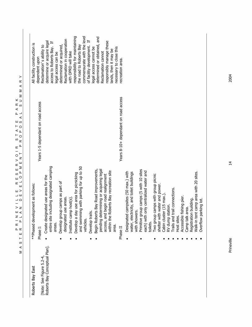
Rob
erts
Bay
Eas
t
[Not
e: S
ee F
igur
e 5.
2-4,
Rob
erts
Bay
Con
cept
ual P
lan]
.
**Ph
ased
dev
elop
men
t as
fol
low
s:
Phas
e I:
• Cr
eate
des
igna
ted
use
area
s fo
r th
e en
tire
site
incl
udin
g de
sign
ated
cam
ping
ar
eas.
• D
evel
op g
roup
cam
ps a
s pa
rt o
f de
sign
ated
use
are
as.
• In
stitu
te c
amp
host
(s).
•
Dev
elop
a d
ay u
se a
rea
for
picn
icki
ng
and
swim
min
g w
ith p
arki
ng f
or u
p to
50
vehi
cles
. •
Dev
elop
tra
ils.
• Be
gin
Rob
erts
Bay
Roa
d im
prov
emen
ts,
pend
ing
dete
rmin
ing
or a
cqui
ring
lega
l ac
cess
, and
beg
in r
oad
real
ignm
ent
with
in t
he R
ober
ts B
ay r
ecre
atio
n si
te
area
.
Phas
e II
• D
esig
nate
d ca
mps
ites
(50
max
.) w
ith
wat
er, e
lect
ricity
, and
toi
let
build
ings
w
ith s
how
ers.
•
Prim
itive
gro
up c
amps
(5
with
10
site
s ea
ch)
with
onl
y ce
ntra
lized
wat
er a
nd
toile
ts.
• Tw
o gr
oup
cam
ps w
ith g
roup
pic
nic
shel
ter
with
wat
er a
nd p
ower
. •
Cabi
n cl
uste
r (1
5 m
ax.)
. •
RV
dum
p st
atio
n.
• Tr
ails
and
tra
il co
nnec
tions
. •
Hos
t si
tes.
•
Acce
ssib
le f
ishi
ng p
ier.
•
Cam
p ta
lk a
rea.
•
Regi
stra
tion
build
ing.
•
Wal
k-in
ten
t ca
mp
area
with
20
site
s.
• O
verf
low
par
king
lot.
Year
s 1-
5 de
pend
ant
on r
oad
acce
ss
Year
s 8-
10+
dep
enda
nt o
n ro
ad a
cces
s
All f
acili
ty c
onst
ruct
ion
is
depe
nden
t up
on
Rec
lam
atio
n’s
abili
ty t
o de
term
ine
or a
cqui
re le
gal
acce
ss t
o Rob
erts
Bay
. If
le
gal a
cces
s ca
n be
de
term
ined
or
acqu
ired,
Rec
lam
atio
n in
coo
pera
tion
with
OPR
D w
ill t
ake
resp
onsi
bilit
y fo
r m
aint
aini
ng
the
road
to
Rob
erts
Bay
co
mm
ensu
rate
with
the
leve
l of
fac
ility
dev
elop
men
t.
If
lega
l acc
ess
cann
ot b
e de
term
ined
or
obta
ined
, and
Re
clam
atio
n ca
nnot
re
spon
sibl
y m
anag
e th
ese
land
s, t
hen
it m
ay b
e ne
cess
ary
to c
lose
thi
s re
crea
tion
area
.
PR
IN
EV
IL
LE
R
ES
ER
VO
IR
S
TA
TE
P
AR
K
M
AS
TE
R
PL
AN
D
EV
EL
OP
ME
NT
P
RO
PO
SA
L
SU
MM
AR
Y
Prin
evill
e 15
20
04
Rob
erts
Bay
Wes
t
[Not
e: S
ee F
igur
e 5.
2-4,
Rob
erts
Bay
Con
cept
ual P
lan]
.
• Bo
at r
amp
and
park
ing
area
, non
-m
otor
ized
tra
ilhea
d an
d tr
ail t
o is
land
, m
aint
enan
ce y
ard,
em
ploy
ee h
ousi
ng,
entr
ance
gat
e, a
nd h
ost
site
s.
Year
s 8-
10+
dep
enda
nt o
n ro
ad a
cces
s Al
l fac
ility
con
stru
ctio
n is
de
pend
ent
upon
Rec
lam
atio
n’s
abili
ty t
o de
term
ine
or a
cqui
re le
gal
acce
ss t
o Ro
bert
s Ba
y. If
le
gal a
cces
s ca
n be
de
term
ined
or
acqu
ired,
Rec
lam
atio
n in
co
oper
atio
n w
ith O
PRD
w
ill t
ake
resp
onsi
bilit
y fo
r m
aint
aini
ng t
he r
oad
to
Rob
erts
Bay
co
mm
ensu
rate
with
the
le
vel o
f fa
cilit
y de
velo
pmen
t. If
lega
l ac
cess
can
not
be
dete
rmin
ed o
r ob
tain
ed,
and
Rec
lam
atio
n ca
nnot
re
spon
sibl
y m
anag
e th
ese
land
s, t
hen
it m
ay b
e ne
cess
ary
to c
lose
thi
s re
crea
tion
area
.
PR
IN
EV
IL
LE
R
ES
ER
VO
IR
S
TA
TE
P
AR
K
M
AS
TE
R
PL
AN
D
EV
EL
OP
ME
NT
P
RO
PO
SA
L
SU
MM
AR
Y
Prin
evill
e 16
20
04
Expand Existing Maintenance Yard
Proposed Employee Housing
Proposed Group Camp(20 Sites Max.)
Proposed Group Meeting Hall
Proposed Cabin Cluster(10 Max.)
Proposed Camp Loops(80 Sites Max.)
Proposed Day Use Area(50 Parking Spaces Max.)
PRINEVILLE RESERVOIR
Proposed
Trail
Existing Trai
l to Ja
sper Point
Proposed Group Day Use Area
Proposed RV Dumpstation
Proposed Overflow Parking Area(20 Parking Spaces Max.)
Antelope Creek Day Use Area -Proposed
State Park North-
Proposed
Prineville State Park
Cabin Area Expansion(3 Units Max.)
Moorage Expansion(20 Slips Max.)
Fishing Pier
Fishing Pier
Proposed Concession Bldg.
Figure 5.2-2
StaStaStaStaState Pte Pte Pte Pte ParararararkkkkkConceptual PlanConceptual PlanConceptual PlanConceptual PlanConceptual Plan
N 0
200
400
Juniper Canyon RoadProposed
Trail
Swimming Area
P:\0e03401\GIS\Maps\RMP\FinalStateParks\StateParkConceptPlan.pmd
Tammy
15
PRINEVILLE RESERVOIR
Proposed Trail to Taylor Butte
Powder House Cove Boat Ramp and Parking Area
Proposed Parking Area(120 maximum parking spaces)
Proposed Boat Ramp
Existing HistoricPowder House
Figure 5.2-3
PPPPPooooowwwwwder Houseder Houseder Houseder Houseder HouseCoCoCoCoCovvvvveeeee
Conceptual PlanConceptual PlanConceptual PlanConceptual PlanConceptual Plan
N 0
100
200
Hw
y. 2
7
Pro
po
sed
Tra
il
Realign Entrance
Remove Existing Boat Ramp
Proposed Day Use Area/Trailhead(20 spaces)
P:\0e03401\GIS\Maps\RMP\FinalStateParks\powderhouseconceptplan.pmd
mackinnonl
Tammy
16
Proposed Boat Ramp(50 Parking Spaces Max.)
ProposedMaintenanceYard & Host Sites
Proposed Employee Housing
Proposed Trailhead(20 Parking Spaces Max.)
Proposed Tent Loop(20 Sites Max.)
Proposed DesignatedGroup Camps
Proposed Picnic Shelter
Proposed Cabin Cluster(15 Max.)
Proposed Camp Loop(50 Sites Max.)
Proposed RV Dumpstation
Figure 5.2-4
RRRRRoberoberoberoberoberts Bats Bats Bats Bats BayyyyyConceptual PlanConceptual PlanConceptual PlanConceptual PlanConceptual Plan
N
Proposed Day Use Area(50 parking spaces max.)
0
200
400
Proposed
PRINEVILLE RESERVOIR
Access Road
ProposedTrail
ProposedTrail
To Juniper Point
Remove Existing Campsites
To Salt Creek RoadProposed Moorage
Proposed Primitive Group Camps(50 Sites Max.)
Proposed Moorage P:\0e03401\GIS\Maps\RMP\FinalStateParks\RobertsBayConceptPlan.pmd
Tammy
Tammy
17