engage your community five principles for developing online learning communities
Principles of Human-Scale
Communities Comprehensive Report & Best Practices
Guide
Principles of human-scale communitiesNew Urbanism emerged over the past two decades in response to the sprawling placelessness of conventional American development.
Disenchantment with the character of the country's cities and suburbs had been fermenting for a long time. In the 1960s, Jane Jacobs published her powerful book The Death and Life of Great American Cities, and Peter Blake produced his scathing God's Own Junkyard. By the 1970s, as activists protested practices destructive to urban areas and countryside, the historic preservation movement and the environmental movement each gained a popular following. An intense focus on community design - its failures and the potential for better results - became one of the next phenomena in national life. The quest for a better human and built environment culminated, in the 1980s, in the birth of what is now called New Urbanism.
New Urbanism is an approach to design and development that can be applied at a variety of scales - from a single block to a metropolitan region. At the neighborhood level, New Urbanism is often referred to as Traditional Neighborhood Development (TND), because it revives ideas and practices that were at the heart of American community building from the 1600s until the Second World War - and largely abandoned during the pellmell expansion of the postwar decades.
At the metropolitan and state level, New Urbanism is closely associated with "smart growth" - the attempt, through government, to foster more compact, efficient, and appealing patterns of development. The planning ideas of New Urbanism are being advocated by citizens and officials who want local, regional, or state governments to do a more effective job of regulating development.
New Urbanism's principles are rooted in time-tested patterns of development. This is not to say that new urbanists simply copy patterns from the past. Although that is sometimes done (and is not as simple as its detractors think it is), far more often New Urbanism involves reinterpreting the old patterns, buildings, and spaces so that they will suit modem living requirements. New urbanists are not trying to discard the inventions of the past 100 years. The automobile and nearly everything that goes with it - parking, car dealerships, gas stations, and traffic capacity - can be found in
individuals and on communities. The response, therefore, is to search for solutions that allow the dynamic modem economy to function and that also answer the human need for a satisfying environment. As part of this endeavor, new urbanists have reimagined some aspects of automobileoriented society, proposed changes in how big-box stores address their surroundings, and devised new design ideas for other building types.
New Urbanism aims to build hamlets, neighborhoods, villages, towns, and cities rather than subdivisions, shopping centers, and office parks like those found in conventional suburban development (CSD). A fundamental goal is a proper balance between the needs of the auto-mobile and the needs of the pedestrian. Maximizing walkability is essential. Walkability is associated with pleasurable urban environments, compact development (which saves resources), and functional mass transit. Elements of the built environment that are inherently hostile to pedestrians - such as large surface parking lots and limited access highways - should be sited to minimize their negative impact on the walkable areas. Seven principles
What, then, are the principles that new urbanists follow as they set about building communities that are both modem and traditional - communities that maximize pedestrian comfort and at the same time accommodate the automobile? Seven principles have been identified by Richard Bernhardt, a leading new urbanist who heads the Nashville-Davidson County Planning Department in Tennessee.
1. The basic building block of a community is the neighborhood. A neighborhood standing alone can be a village or a small town. A cluster of neighborhoods forms a bigger town. Clusters of many neighborhoods make up a city.
2. The neighborhood is limited in physical size, with a well-defined edge and a center. The size of a neighborhood is usually based on the distance that a person can walk in five minutes from the center to the edge - a quarter-mile. Neighborhoods have a fine-grained mix of land uses, providing opportunities for young and old to find places to live, work, shop, and be entertained.
3. Corridors form the boundaries between
bination of all these things. In towns and cities, a neighborhood or parts of neighborhoods can form a district. Districts consist of streets or areas containing special activities, which get preferential treatment. A corridor may also be a district - as when a major shopping avenue runs between adjoining neighborhoods.
4. Human scale sets the standard for proportion in buildings. Buildings must be disciplined in how they relate to their lots if public space is to be successfully demarcated. Because the street is the preeminent form of public space, buildings are generally expected to honor and embellish the street. Buildings also define parks and squares, which are distributed throughout the neighborhood and are designed to be appropriate for rest, recreation, or special events.
5. Treating a range of transportation options as important is fundamental. For the last several decades transportation agencies have focused almost exclusively on optimizing the convenience of automobile travel, and have dealt with transit riders, pedestrians, and bicyclists as little more than an afterthought. We must give equal consideration to all modes of transportation to relieve congestion and to provide people with realistic choices.
6. The street pattern is conceived as a network, to create the greatest number of alternative routes from one part of the neighborhood to another. This has the effect of providing choices and relieving vehicular congestion. The streets form a hierarchy, from broad boulevards to narrow lanes and alleys.
7. Civic buildings (town halls, churches, schools, libraries, museums) belong on preferred sites such as squares or neighborhood centers, or where the view down a street terminates. Such placement helps turn civic buildings into
Andres Duany and Elizabeth Plater-Zyberk, two pioneers of New Urbanism who founded the Miami architecture and town planning firm Duany Plater-Zyberk & Co. (DPZ), identify the following characteristics of a neighborhood:
1. The neighborhood has a discernible center. This is often a square or a green, and sometimes is distinguished by a busy or memorable street comer. A transit stop would be located at this center.
2. Most of the dwellings are within a five-minute walk (averaging roughly a quarter mile) of the center.
3. A variety of dwelling types are available -usually freestanding houses, rowhouses, and apartments - so that younger and older people, singles and families, the poor and the wealthy may find places to live.
4. Shops and offices can be at the edge of the neighborhood, in sufficient variety to supply a household's weekly needs.
5. A small ancillary building is permitted within the backyard of each house. It may be used as a rental unit or place to work (such as an office or a craft workshop).
6. An elementary school is close enough so that most children can walk from their homes.
7. Small playgrounds are convenient to every dwelling - not more than a tenth of a mile away.
8. Streets within the neighborhood are a connected network which disperses traffic by providing a variety of pedestrian and vehicular routes to any destination.
9. The streets are relatively narrow and shaded by rows of trees. These features slow traffic, creating an environment suitable for pedestrians and
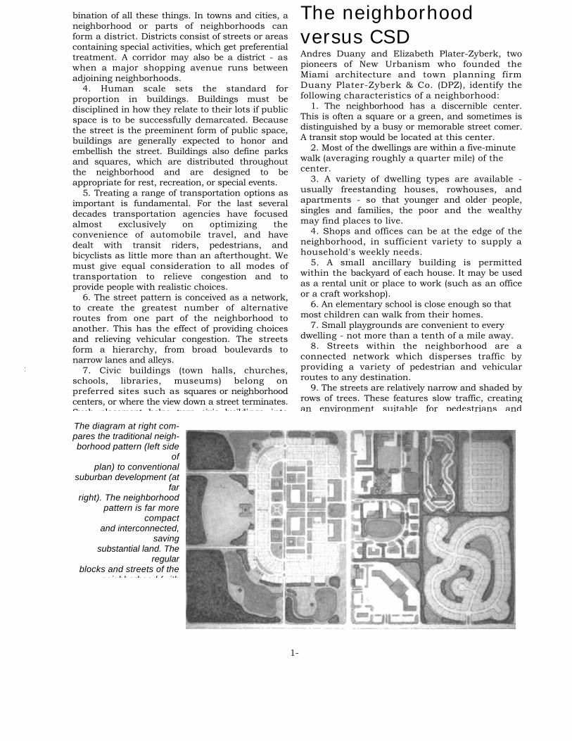
The neighborhood versus CSD
i
The diagram at right com-pares the traditional neigh-borhood pattern (left side
of plan) to conventional
suburban development (at far
right). The neighborhood pattern is far more
compact and interconnected,
saving substantial land. The
regular blocks and streets of the
neighborhood (with
1-

Principles of Human-Scale Communities close to the street, creating a well-defined outdoor
room. 11. Parking lots and garage doors rarely front the
street. Parking is relegated to the rear of buildings, usually reached by alleys.
12. Certain prominent sites at the termination of street vistas or in the neighborhood center are reserved for civic buildings. These provide sites for community meetings, education, religion, or cultural activities.
13. The neighborhood is organized to be self-governing. A formal association debates and decides matters of maintenance, security, and physical change. Taxation is the responsibility of the larger community. How suburbia compares
Here are the characteristics that Duany and PlaterZyberk attribute to CSD:
1. Development consists of housing subdivisions, shopping centers, business parks, stand-alone commercial stores, open space, and civic uses such as schools, libraries, and municipal buildings.
2. All uses are kept separate, in distinct pods. Even different housing types, such as townhouses, duplexes, apartment buildings, and single homes, are usually built in separate pods. Transportation between separate uses is generally by automobile.
3. The street pattern is dendritic, rather than interconnected. Housing subdivisions, shopping centers, and business parks feed into arterial roads that carry most of the traffic. To move between pods, one generally has to use an arterial road. Cul-de-sacs are common in residen-tial areas.
4. The development has no distinct center. 5. It is less compact than historic or
neotraditional neighborhoods. Because uses are kept separate and there is no distinct center, suburban development tends to spread out, hence the term "sprawl." The main selling point is privacy and security, so lots tend to be bigger.
6. Streets are designed on an automobile scale. Pavement is wide, and setbacks of buildings from the street are large. Infrastructure intended for the automobile is given the most prominent placement - such as garages, driveways, and parking lots close to the street. Arterial roads, which connect separate uses, are designed for rap-idly moving traffic These characteristics create
Comprehensive Report & Best Practices Guide
A figure/ground drawing shows an infill development (in black, designed by WRT/So/omon ETC), surrounded by the urban fabric of San Jose, CA. Note how the historic fabric and the new development define street walls. At the upper middle of the plan is a modern city hall by Richard Meier
Enclosure of the public realm New urbanists often talk about creating "outdoor rooms." In such places, buildings enclose streets and public spaces in a way that is spatially coherent and comfortable for humans. This enclosure is most pronounced in the most intensely urban environments - the downtowns of cities and the centers of towns.
Colin Rowe, the late head of the Cornell Urban Design Studio, popularized a methodology for designing and refining outdoor rooms. Rowe taught his students to make figure/ground drawings or "black plans." Daniel Solomon, one of the founders of the Congress for the New Urbanism, describes the process thus: "In this method of drawing a plan, buildings are depicted as solid black, and everything else is the white of the paper."
Rowe's methods were not new - they go back at least to Giovanni Battista Nolli's plan for Rome in 1748 -but they were an innovation in modem architecture. Solomon points out that Rowe's "black plans" revealed the folly of a lot of modern urban design, and pointed many new urbanists in the right direction. Today, black plans, or their equivalent, are an important aspect of new urbanists' work. Figure/ground drawings have aided the planning of new urban projects

1 R U R A L I I I I i I I I I 1 I 1 I 11 1 T R A N S E C T I I I 1 1 I I I I I I U R 8 A N 1
1-
T 4 20NERAL URBAN: T f, ZONE
N~pw
'IT 1 ZONERAL TL ZONEL
The urban-rural Transect.
The Transect form the basis for a new generation of zoning codes responsive to human-scale needs and desires.
Th f ll i ti l i th T t i detail
Neighborhoods and communities are complex organisms; they contain a variety of parts that must work together. As is the case with natural ecosystems, no two neighborhoods are exactly alike.
Naturalists use a concept called the transect to describe the characteristics of ecosystems and the transition from one ecosystem to another. Duany has applied this concept to human settlements, and in recent years this idea has permeated the thinking of new urbanists. The urbanrural Transect is divided into tiers, the principal tiers being ing Core, Center, General, Suburban, and Rural. (Rural is subdivided into Reserve and Preserve). The remaining category, District, applies to developments that do not readily fit into the other tiers; examples include power plants, airports, and college campuses. The Transect is useful for designing and developing what Duany calls "immersive environments": urban places in which the whole is greater than the sum of its parts.
DPZ describes the concept thus: "The Transect arranges in useful order the elements of urbanism by classifying them from rural to urban. Every urban element finds a place within its continuum. For example, a street is more urban than a road, a curb more urban than a swale, a brick wall more urban than a wooden one, and an allee of trees more urban than a cluster. Even the character of streetlights can be assigned in the Transect according to the fabrication from cast iron (most urban), extruded pipe, or wood posts (most rural)."
Duany notes that every settlement has its own Transect, which can be studied and mastered. Each differs, to a degree, from all other Transects. For example, all downtowns have unique characteristics. Yet all downtowns have commonalities as well. When judiciously followed, the guidelines inherent in the Transect can help planners and developers create stronger, better-functioning places.
The Transect is a powerful tool new urbanists can use to analyze and understand urban places - and ultimately to design new settlements that will
Core and Center These two parts of the community have the most
intense urban character and the greatest density. Core and center buildings are relatively large and are generally flexible in their uses. Many buildings mix different uses, with shops and businesses on the first floor, and offices or residential units above. Most buildings are attached, with their fronts aligned. Full four-way intersections with rectilinear trajectories (i.e., streets at right angles to each other) are common.
The Core, the most urban setting, is found in places such as the downtowns of major cities, where many buildings rise higher than four stories. The Center is a category that applies to smaller downtowns or main streets, where buildings top out at two to four stories.
The Core and Center are not necessarily situated in the geographic center of a neighborhood (or of a new urban development). Frequently they are on highly traveled streets - streets that in some instances form the boundaries separating two or more neighborhoods. The Core and Center are focal points of activity and energy, benefiting from substantial traffic - both pedestrian and automo-

Principles of Human-Scale Communities Comprehensive Report & Best Practices
Guide
General T4 of the Transect.
Center: T5 of ~ ~eti
/ 1
the Transect. Some businesses may locate in this tier-corner
stores and cafes, for instance. Churches, schools, and other civic buildings also may appear here. Buildings in the General tier are not as large as those in the Center or Core. Most roofs are pitched. Open space takes the form of parks and greens.
Setbacks generally range from 5 to 25 feet. Many houses have porches, and the porches should be allowed to encroach into the setback zone. Lot widths for townhouses generally range from 18 to 30 feet, and for single homes from 30 to 70 feet. Lot lengths generally range from 90 to 130 feet. Lot sizes range from 1,600 to 3,000 square feet for townhouses, to 2,500 to 10,000 square feet for single homes.
Alleys are the norm in the General tier. Some houses may be front-loaded, but the garage is located to the rear of the house if topography permits. Sidewalks should be at least five feet wide to allow two people to walk side by side. Thor-
hf i t tl f id ti l t t N t
Suburban (aka neighborhood edge)
Suburban: T3 of the Transect
The Suburban tier differs from conventional suburban development of the past 50 years. It hews closer to an Olmstedian aesthetic, or to the character of early 20thcentury US suburbs. Although the Suburban is the most residential tier, it can have some mix of uses - civic buildings such as churches, schools, and community centers, and occasional stand-alone stores are examples. The lots are larger, the streets more crooked, the curbs few. Plantings are informal. Setbacks from the street are larger in this tier, generally ranging from 20 to 30 feet. Porches are plentiful, and should be allowed to encroach on the setback. Lot widths usually range from 50 to 80 feet. Lots are
11 PS
Setbacks in the Core and Center are generally zero to 10 feet. (Mixed-use buildings with retail on the first floor are built right up to the sidewalk.) Sidewalks are wide, generally 6 to 20 feet (the more urban the environment, the wider the sidewalk). Lot sizes vary, from a width of about 18 feet for some townhouses, to many times that for a large office or mixed-use building. A minimum residential lot size might be 1,600 square feet for a townhouse. The percentage of the lot covered and the floor-to-area ratio are generally high in the Core and Center.
Open space takes the form of plazas and squares. Transit service is the most frequent at this end of the Transect. Housing mostly consists of apartments above retail; standalone apartment buildings; townhouses; and live/work units (townhouses designed so that one or more floors can accommodate business activities). Townhouses feature raised foundations, with stoops that often encroach on the sidewalk. By contrast, the first floor of a live/work unit is usually built at sidewalk grade, for ease of access.
In Core or Center areas, commercial buildings may be mixed-use structures containing retail on the first floor. But there are other possibilities, too, such as exclusively retail buildings, office buildings, and live/works. Even relatively large stores like supermarkets, and businesses ordinarily oriented to customers arriving by automobile, such as drug stores and video rental stores, are able to locate in a town center as long as they occupy buildings that possess urban traits.
In the Core, structured parking is the norm. In the Center, the middle of the block is often devoted to surface parking. On-street parking should be permitted throughout the Center and Core (and throughout the entire neighborhood). Thoroughfares generally are main streets, boulevards, and residential streets that have an urban character. Net residential densities generally range from 15 to more than 100 units/acre. General Urban
This area is primarily residential, but still l ti l b i h t Th t t h

110 to 140 feet- to accommodate a larger backyard. Lots generally range from 5,000 to 12,000 square feet.
The Suburban tier accommodates rear lanes, but it is also common to find front-loaded houses. (If the house is front-loaded, the garage should still be de-emphasized - set back from the front facade). Thoroughfares consist mostly of residential streets that have a rural character. Of all the neighborhood areas, density is least in the Suburban tier, ranging from 2 to 8 units per acre net.
Rural Reserve and Preserve
Beyond the neighborhood lie the rural Reserve and Preserve. The Reserve includes areas that can potentially be built upon, but where development is not currently encouraged. Such areas include privately owned farmland and forests outside of designated growth areas. Public infrastructure is sparse or nonexistent in the Reserve. The Reserve can be protected from development through mechanisms such as transfer of development rights, land banks, and agricultural zoning.
The Preserve includes areas designated to remain permanent open space. These include parklands, wilderness areas, farms that have sold their development rights, and areas of high environmental value (such as wetlands) that can withstand court challenges from developers. Districts
Districts are urbanized areas that specialize in a particular activity. Districts are justified only when their uses cannot be accommodated within the other Transect tiers. Districts may contain major transportation facilities such as airports and truck or bus depots; industrial areas; solid waste disposal and wastewater treatment facilities; hos-pitals; auto-oriented businesses like auto body shops; or even college campuses. Districts should, like neighborhoods, have a clear focus in their physical form. When possible and prudent, districts should be interconnected with adjacent neighborhoods to promote pedestrian access. Districts benefit from transit systems.
Although some are pedestrian-friendly (such as college campuses), Districts are the primary means new urbanists employ to accommodate uses that are inherently hostile to pedestrians. The idea is this: you can't eliminate uses that are incompatible with human-scale neighborhoods -but you can concentrate these uses to minimize their damage. You can also place Districts adjacent to walkable neighborhoods (if possible), lay them out in a modified grid, build sidewalks, and plant street trees. These design elements ensure that, in time, the District can be rebuilt as a high-quality urban environment. In the
activities on so-called B streets. Even within a high-quality street network, a B street can accommodate uses such as gas stations, muffler shops, and restaurants with drivethrough lanes. A pair of A streets should run parallel to the B street, on both sides of it, to maintain a walkable environment. B streets can be thought of as Districts that are one street wide.
The Charter of the New Urbanism The most comprehensive statement of the goals and aspirations of new urbanists, the Charter of the New Urbanism, was signed in 1996 by members of the Congress for the New Urbanism. Introduction
The Congress for the New Urbanism views disinvestment in central cities, the spread of placeless sprawl, increasing separation by race and income, environmental deterioration, loss of agricultural lands and wilderness, and the erosion of society's built heritage as one interre-lated community-building challenge.
We stand for the restoration of existing urban centers and towns within coherent metropolitan regions, the reconfiguration of sprawling suburbs into communities of real neighborhoods and diverse districts, the conser-vation of natural environments, and the preservation of our built legacy. We recognize that physical solutions by themselves will not solve social and economic problems, but neither can economic vitality, community stability, and environmental health be sustained without a coher-ent and supportive physical framework.
We advocate the restructuring of public policy and development practice to support the following principles: neighborhoods should be diverse in use and population; communities should be designed for the pedestrian and transit as well as the car; cities and towns should be shaped by physically defined and universally accessible public spaces and community institutions; urban places should be framed by architecture and landscape design that celebrate local history, climate, ecology, and building practice.
We represent a broad-based citizenry, composed of public and private sector leaders, community activists, and multidisciplinary professionals. We are committed to reestablishing the relationship between the art of building and the making of community, through citizen-based participatory planning and design.
We dedicate ourselves to reclaiming our homes, blocks, streets, parks, neighborhoods, districts, towns cities region and environment
1
Principles of Human-Scale Communities Comprehensive Report & Best Practices
Guide sheds, coastlines, farmlands, regional parks,
and river basins. The metropolis is made of multiple centers that are cities, towns, and villages, each with its own identifiable center and edges.
3. Many activities of daily living should occur within walking distance, allowing independence to those who do not drive, especially the elderly and the young. Interconnected networks of streets should be designed to encourage walking, reduce the number and length of automobile trips, and conserve energy.
4. Within neighborhoods, a broad range of housing types and price levels can bring people of diverse ages, races, and incomes into daily interaction, strengthening the personal and civic bonds essential to an authentic community.
5. Transit corridors, when properly planned and coordinated, can help organize metropolitan structure and revitalize urban centers. In contrast, highway corridors should not displace investment from existing centers.
6. Appropriate building densities and land uses should be within walking distance of transit stops, permitting public transit to become a viable alternative to the automobile.
7. Concentrations of civic, institutional, and commercial activity should be embedded in neighborhoods and districts, not isolated in remote, single-use complexes. Schools should be sized and located to enable children to walk or bicycle to them.
8. The economic health and harmonious evolution of neighborhoods, districts, and corridors can be improved through graphic urban design codes that serve as predictable guides for change.
2. The metropolitan region is a fundamental economic unit of the contemporary world. Governmental cooperation, public policy, physical planning and economic strategies must reflect this new reality.
3. The metropolis has a necessary and fragile relationship to its agrarian hinterland and natural landscapes. The relationship is environmental, economic, and cultural. Farmland and nature are as important to the me-tropolis as the garden is to the house.
4. Development patterns should not blur or eradicate the edges of the metropolis. Infill development within existing urban areas conserves environmental resources, economic investment, and social fabric, while reclaiming marginal and abandoned areas. Metropolitan regions should develop strategies to encourage such infill development over peripheral expansion.
5. Where appropriate, new development contiguous to urban boundaries should be organized as neighborhoods and districts, and be integrated with the existing urban pattem. Noncontiguous development should be organized as towns and villages with their own urban edges, and planned for a jobs/housing balance, not as bedroom suburbs.
6. The development and redevelopment of towns and cities should respect historical patterns, precedents, and boundaries.
7. Cities and towns should bring into proximity a broad spectrum of public and private uses to support a regional economy that benefits people of all incomes. Affordable housing should be distributed throughout the region to match job opportunities and to avoid concentrations of poverty.
8. The physical organization of the region should be supported by a framework of transportation alternatives. Transit, pedestrian, and bicycle systems should maximize access and mobility throughout the region while reducing dependence upon the automobile.
9. Revenues and resources can be shared more cooperatively among the municipalities and centers within regions to avoid destructive competition for tax base and to promote rational coordination of transportation, recreation, public services, housing, and community institutions.
The block, the street, and the building
1. A primary task of all urban architecture and landscape design is the physical definition of streets and public spaces as places of shared use.
2. Individual architectural projects should be seamlessly linked to their surroundings. This issue transcends style.
3. The revitalization of urban places depends on safety and security. The design of streets and buildings should reinforce safe environments, but not at the expense of accessibility and openness.
4. In the contemporary metropolis, development must adequately accommodate automobiles. It should do so in ways that respect the pedestrian and the form of public space.
5. Streets and squares should be safe, comfortable, and interesting to the pedestrian. Properly configured, they encourage walking and enable neighbors to know each other and protect their communities.
The neighborhood, the district, and the corridor 6. Architecture and landscape design should
grow from local climate, topography, history, and building practice.
1. The neighborhood, the district, and the corridor are the essential elements of development and redevelopment in the metropolis They form identifiable areas that
7. Civic buildings and public gathering places i i t t it t i f it

TRADITIONAL NEIGHBORHOOD DEVELOPMENT
School to be shared by adjacent neighborhood
Short face of
Roads connect edges wherever possible
Neighborhood shops & institutions at center Bus stops at
op
Mixed use streets anchored by retail at 100% coners
I
W.
Regional institutions at the edge
F-,/7/7
Parking lot designed as plaza
Workshops and offices along edges
Traditional Neighborhood Development: A diagram that updates the neighborhood unit and reconciles current models. See: C3.1. The school is not at the center but at an edge, as the playing fields would hinder pedestrian access to the center. The school at the edge can be shared by several neighborhoods, mitigating the problem created by the tendency of neighborhoods to age in cohorts generating large student age populations that then drop off sharply. There are few sites reserved for local institutions at the center and more for regional institutions at the edge. Ease of transportation has made membership in institutions a matter of proclivity rather than proximity. The shops at the busiest intersections have been modified to accommodate larger parking plazas for convenience retail and extended by an attached main street for destination and live-work retail.
More service alleys and lanes have been added to accommodate the increased parking requirements. The minor thoroughfares are connected with those outside the neighborhood in order to increase permeability and disperse traffic. This modification, however, increases the possibility of shortcuts. The thoroughfare types support a transect from rectilinear streets at the urban centerto curvilinear roads toward the rural edge. The traffic along the boulevards at the edges is more unpleasant than originally envisioned. Three mitigating strategies are proposed: the provision ofan endgrain of blocks at all edges, a green buffer shown along the bottom edge, and the location of resilient building types, such as office buildings, shown along the bottom edge. The traffic along the highway shown at the top is assumed to be hostile and therefore buffered within a parkway.
I The elements of a neighborhood
are described in the diagram and text at left, from the Lexicon of

OVERVIEW OF APPROPRIATE ELEMENTS FOR EACH ZONE
1 R U R A L 1 I I I I I I I I I I I I I I I I I I I I I I III I I I I I I I I I I I I 1 I U R B A N 1 J L
10 0
a a
,
L",
® EDGE ZONES ® GENERAL ZONES
m CENTER ZONES CD CORE ZONES
• Edge Zone: the least dense, most purely • General Zone: the sector that is mixed in residential sector of the neighborhood. The size function, but principally residential. It has a varies as a proportion of the overall area depend- generalized character, and is usually the largest
• Center Zone: the dense multifunctional • Core Zone: the most dense business, sersocial condenser ofa neighborhood. Itisusually vice, and institutional center. It is usually shared at a central location, within walking distance of by several neighborhoods. It always straddles the surrounding, primarily residential areas. thoroughfares at their most active intersection. It
is usually within walking distance of aLand use is restricted, combining residential Land use is limited, permitting the controlled Land use is open, encouraging the combination Land use is open, encouraging the combination with certain other uses only within the outbuild- combination ofresidential with other uses. of residential and other uses. of residential and other uses. There is usually a tng• mandatory retail frontage.
Buildings of the low density freestanding edge Buildings of the medium density freestanding Buildings of the higher density attached court- Buildings only ofthe high density attached courtyard type. side yard and edgeyard types. yard, rear yard, and also side yard types. yard and rear yard types.
Frontages which weakly define the public space Frontages which are variegated with medium Frontages which define continuous streetwalls Frontages which define continuous streetwalls with deep setbacks: common lawn and porch & setbacks: dooryard, and porch & fence. with shallow setbacks: arcade, shopfront, with shallow setbacks: arcade, shopfront, fence. stoop, and forecourt. stoop, and forecourt.
Streetscapes which create the most rural condi- Streetscapes which create a variety of condi- Streetscapes which create urban conditions: resi- Streetscapes which create the most urban conditions: parkway, road, and lane. tions: road, residential street, and avenue. dentia l s t ree t , commercial street, tions: commercial street, avenue, and boule
aveaue and boulevard vardThoroughfares are roads and drives. Buildings Thoroughfares are avenues, streets, and roads. Thoroughfares are avennes and streets. All Thoroughfares are streets and boulevards. may be served by rear lanes, though wider lots Most buildings are served by rear lanes. buildings are served by rear alleys. All buildings are served by rear alleys. may dispense with them.
Open space may be parks within the proximate Open space is organized as parks and greens. Open space is organized as plazas or squares. Open space is organized as plazas or squares. greenbelt.
m v r- ~
cD k n n.
O N
O y
tD DO 1
Q
C
Z3 QL
yO
o

Q. ^,, ^, y t
o ~ ~ ~ o -C3 in
d 2 SQUARE
A disadvantage is that discontinuous rear lot lines prevent double-loaded alleys and rear-access utilities. Despite these shortcomings, the square block is useful as a specialized type. The forced variety of platting assures a range of lot prices. When platted only at its perimeter with the center open (Figure 2), it can accommodate the high parking requirements of civic buildings. The open center may also be used as a common garden or a playground, insulated from traffic.
Q ~ ? t zr Q
cy
O y m tv M
CZ 2
4." O ~ cD t-.n
O cu CA p
The Square Block was an early model for planned settlements in America. It was sometimes associated with agricultural communities with four large lots per block, each with a house at its center. When the growth of the community produced additional subdivision, the replatting inevitably created irregular lots (Figure 1). While this may provide a useful variety, it is more often regarded as a nuisance by a building industry accustomed to standardized products.
l
cD O > j sy / O
Qn
v O
- ~-n o
0
0C'J p_
ZZ °o
,
C-3
? Figure
1 ELONGATED BLOCK Figure Q
r~n cri ~
?
C
y :;:-:7 Qcti k.
The Elongated Block is an evolution of the square block which overcomes some of its drawbacks. The elongated block eliminatestheuncontrollabievariable of lot depth, while maintaining the optionof altering the lotwidth. Elongated blocks provideeconomicaldoubleloaded alleys with short utility runs. The alley may be placed eccentrically, varying the depth of the lot (Figure3-1). By adjusting the block length, it is possible to reduce cross-streets at the rural edges and to add them at the urban centers. This adjustment alters the pedestrian permeability of the grid, and controls the ratio of street parking to the building capacity of the block.
The elongated block can bend somewhat along its length, giving a limited ability to shape space and to negotiate slopes (Figure 4). Unlike the square block, it provides two distinct types of frontage. With she short side or end grain assigned to the higher traffic thoroughfare, most buildings can front the quieter long side of the block (Figure 3-2). For commercial buildings, the end grain can be platted to take advantage of the traffic while the amount of parking behind is controlled by the variable depth (Figure 3-3).
y. Q
43
n Z3
a Q
1
~ O
O ~
O O~ ~
.
c~D
0
c~D =
CD cri
j
cb
4 Cb Q: a c~o t°
C
v Qzzr Z3 Q3
t_-, C.
cD O cb (Z)
Ctc y
21,
0 G
C 3
cD iy
IRREGULAR BLOCKThe Irregular Block is characterized by itsunlimited variations. The original organic blockwas created by the subdivision of land residualbetween well-worn paths. It was later rationalized by Sitte, Cullen, Krier,and Olmsted to achieve a controllable picturesqueeffect and to organically negotiate sloping terrain.Animportant technique in the layout of irregularblocks is that the frontages of adjacent blocks need not be parallel (Figure 5).The irregular block,despite its variety, generates certain recurring conditions which must be resolved by sophisticated platting. At shallow curves,
it is desirable to have the facades follow the frontage smoothly. This is achieved by maintaining the side lot lines perpendicular to the frontage line (Figure 6-1). It is important that the rear lot line be wide enough to permit vehicular access (Figure 6-2). At sharper curves, it is desirable to have the axis of a single lot bisect the acute angle (Figure 6-3). In the event of excessive block depth it is possible to access the interior of the block by means of a close (Figure 6-4). Syn.: organic block (note: discuss topography)
i
0 0Figure
3
n?~ . Q
cD • O O
O v • O p O Cb
o `-°, m ~ a
c °* ce
m O y
Figure 6

Principles of Human-Scale
Communities Comprehensive Report & Best Practices
Guide
A rendering of a suburban geriatric center, above left, is shown with its highly institutional feel. The building type is patterned after a hospital and is usually located in an area that is accessible by automobile only. An assisted living facility, above right, is conceived as a courtyard building in a neighborhood. This facility allows residents to move into a home which is still close to family and friends, and walkable to shops and entertainment. From the Fox Property Study plan by the Treasure Coast Regional Planning Council and architects Dover Correa Kohl Cockshutt Valle.
The church as automobile-oriented pod, below left, illustrates the conventionalsuburban approach to civic buildings. Even though the parking lot is only full a
small portion of the week, it must be large. Below right is a rendering of aneighborhood church served by on-street parking, bordering on a green. From
the Fox Property Study plan by the Treasure Coast Regional Planning Council andarchitects Dover Correa Kohl Cockshutt Valle.

Above left is a shopping center with a vast parking lot in front. Such centers, along with malls, big box stores, and other automobile-oriented businesses typically line arterial roads. The road is designed strictly for automobiles, yet performs poorly as a through street - as local and regional travelers compete for lanes. Above right is the same road designed as a walkable mixed-use downtown with shops, residences, workplaces, and parking on the interior of blocks. From the Fox Property Study plan by the Treasure Coast Regional Planning Council and archi-tects Dover Correa Kohl Cockshutt Valle.
Suburban stand-alone businesses, including "convenience" stores, fast-foodrestaurants, and banks, can only be reached by car (below left). At the heart of
historic neighborhoods, enterprises often thrive alongside houses in places like atown green (below right), helping to form beautiful and lively public places. From the
Fox Property Study plan by the Treasure Coast Regional Planning Council andarchitects Dover Correa Kohl Cockshutt Valle.
1-

Principles of Human-Scale Comprehensive Report & Best Practices Communities Guide
Pods of single-use housing, right, yieldanonymity. Buildings are objects in a
landscape. Neighborhoods with a mixture ofhousing types, below, have identity.
Buildings form public spaces. From the FoxProperty Study plan by the Treasure CoastRegional Planning Council and architects
Dover Correa Kohl Cockshutt Valle.
A
1%
I
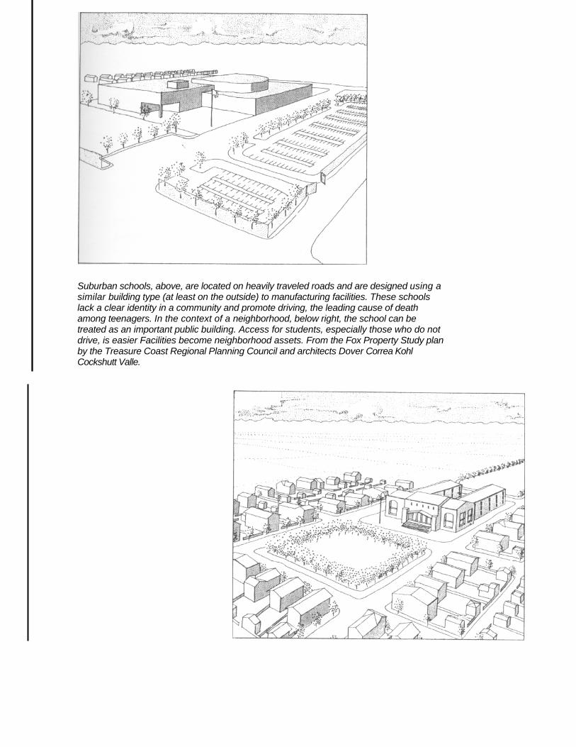
Suburban schools, above, are located on heavily traveled roads and are designed using a similar building type (at least on the outside) to manufacturing facilities. These schools lack a clear identity in a community and promote driving, the leading cause of death among teenagers. In the context of a neighborhood, below right, the school can be treated as an important public building. Access for students, especially those who do not drive, is easier Facilities become neighborhood assets. From the Fox Property Study plan by the Treasure Coast Regional Planning Council and architects Dover Correa Kohl Cockshutt Valle.