Prince William Sound Western Entrance - Quick Links · BookletChart Prince William Sound Western...
20
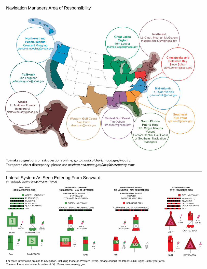
BookletChart ™ Prince William Sound – Western Entrance NOAA Chart 16701 A reduced-scale NOAA nautical chart for small boaters When possible, use the full-size NOAA chart for navigation. Included Area
Transcript of Prince William Sound Western Entrance - Quick Links · BookletChart Prince William Sound Western...

BookletChart™ Prince William Sound – Western Entrance NOAA Chart 16701
A reduced-scale NOAA nautical chart for small boaters When possible, use the full-size NOAA chart for navigation.
Included Area
2
Published by the National Oceanic and Atmospheric Administration
National Ocean Service Office of Coast Survey
www.NauticalCharts.NOAA.gov 888-990-NOAA
What are Nautical Charts?
Nautical charts are a fundamental tool of marine navigation. They show water depths, obstructions, buoys, other aids to navigation, and much more. The information is shown in a way that promotes safe and efficient navigation. Chart carriage is mandatory on the commercial ships that carry America’s commerce. They are also used on every Navy and Coast Guard ship, fishing and passenger vessels, and are widely carried by recreational boaters.
What is a BookletChart?
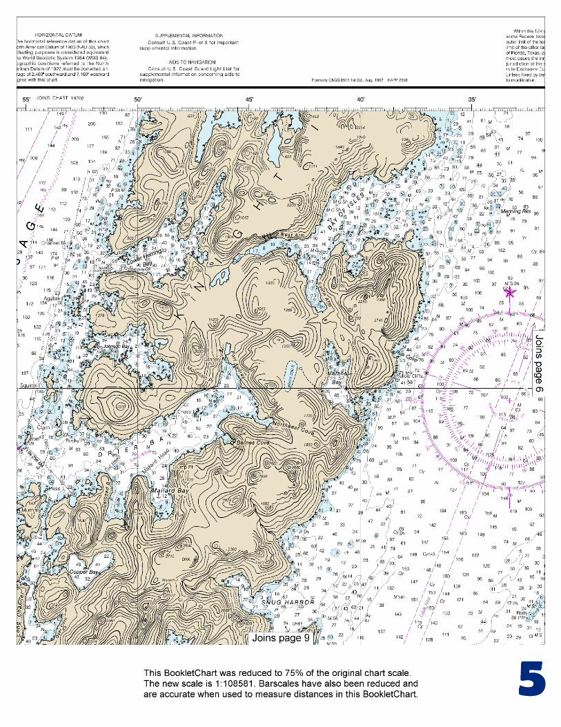
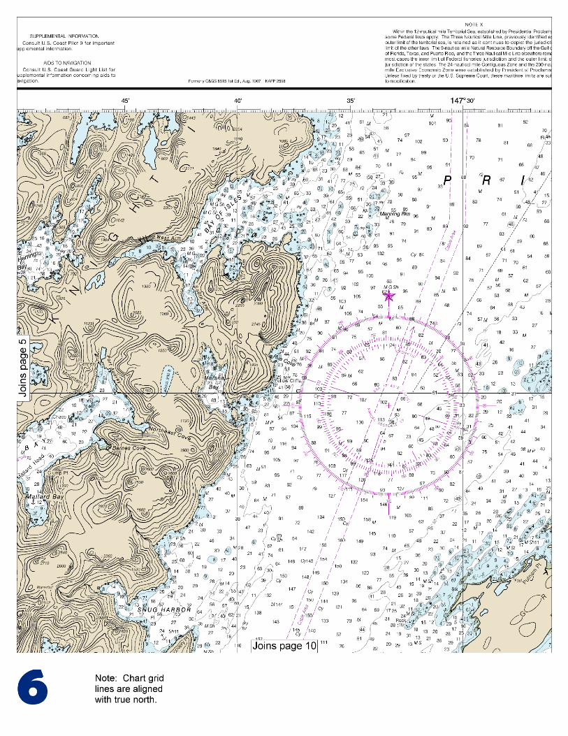
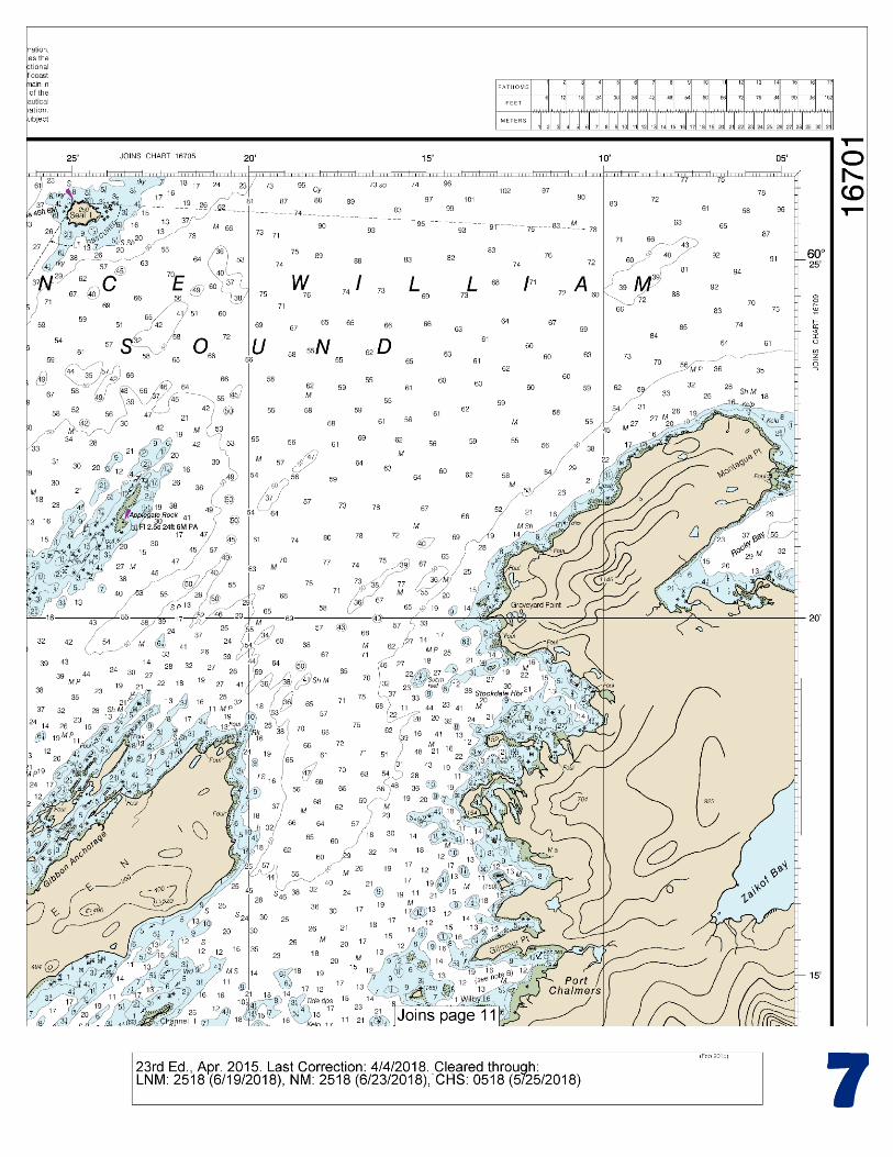
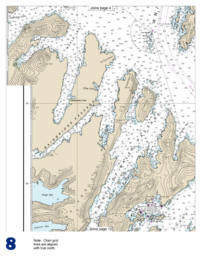
This BookletChart is made to help recreational boaters locate themselves on the water. It has been reduced in scale for convenience, but otherwise contains all the information of the full-scale nautical chart. The bar scales have also been reduced, and are accurate when used to measure distances in this BookletChart. See the Note at the bottom of page 5 for the reduction in scale applied to this chart.
Whenever possible, use the official, full scale NOAA nautical chart for navigation. Nautical chart sales agents are listed on the Internet at http://www.NauticalCharts.NOAA.gov.
This BookletChart does NOT fulfill chart carriage requirements for regulated commercial vessels under Titles 33 and 44 of the Code of Federal Regulations.
Notice to Mariners Correction Status
This BookletChart has been updated for chart corrections published in the U.S. Coast Guard Local Notice to Mariners, the National Geospatial Intelligence Agency Weekly Notice to Mariners, and, where applicable, the Canadian Coast Guard Notice to Mariners. Additional chart corrections have been made by NOAA in advance of their publication in a Notice to Mariners. The last Notices to Mariners applied to this chart are listed in the Note at the bottom of page 7. Coast Pilot excerpts are not being corrected.
For latest Coast Pilot excerpt visit the Office of Coast Survey website at http://www.nauticalcharts.noaa.gov/nsd/searchbychart.php?chart=16701.
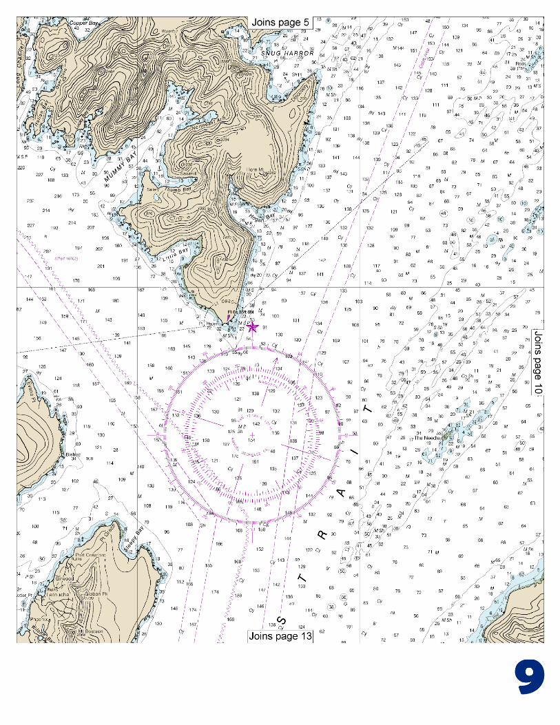
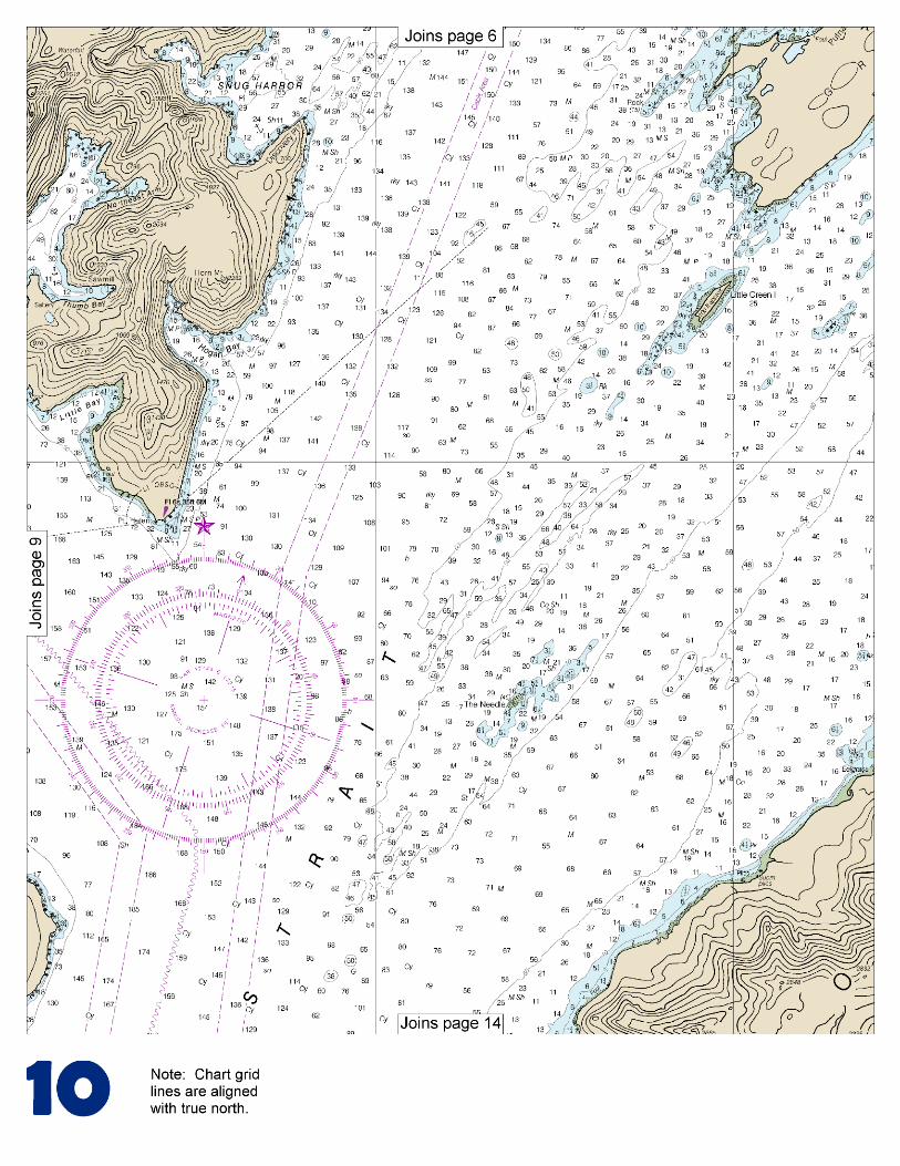
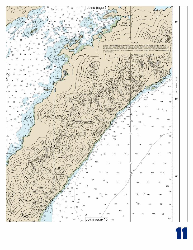
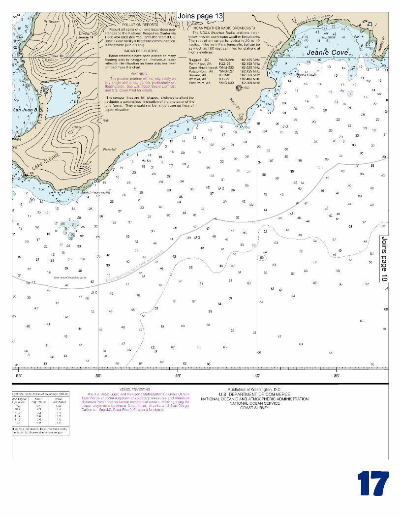
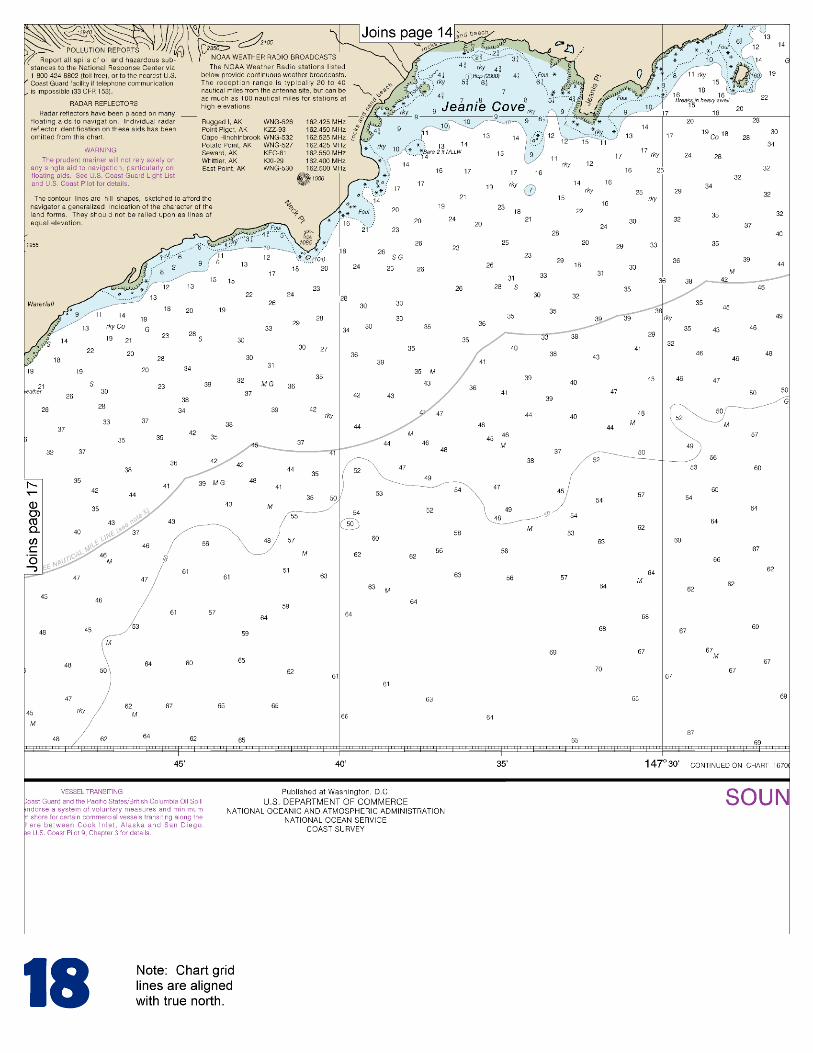
(Selected Excerpts from Coast Pilot) Montague Strait, between Montague Island on the E and Latouche and Knight Islands on the W, is the broadest of the passages W of Montague Island leading from the sea to Prince William Sound. The strait affords an unrestricted channel 4.5 miles wide. Below the N end of Latouche Island the strait is seldom used as vessels generally proceed via Elrington Passage. Above that point the regular steamer route to the E part of Prince William Sound is via the passage W
of The Needle, Green Island, and Seal Island, thence through the passage between Seal and Smith Islands. (See also chart 16705.) The March 1964 earthquake caused bottom uplift throughout
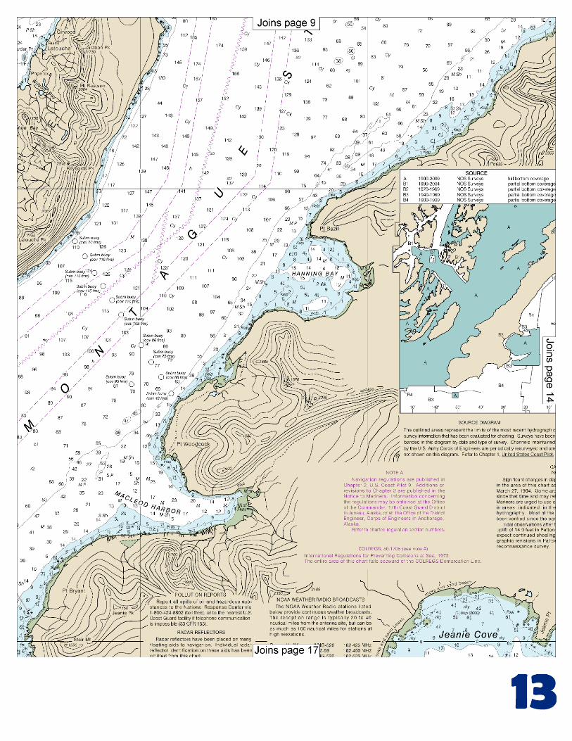
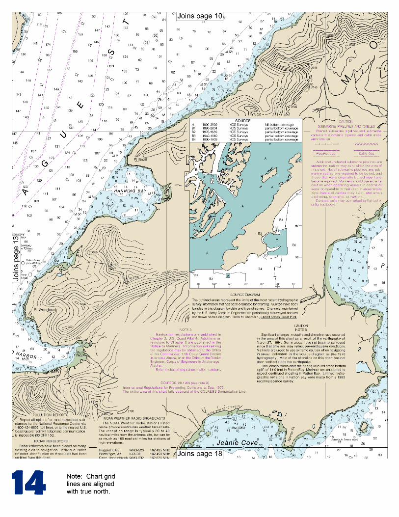
Montague Strait. Shoaling and other scattered dangers exist in the area, requiring mariners to navigate with caution. Full bottom coverage surveys of Montague Strait were completed by the NOAA Ship Rainier in 2000. Mariners are advised to consult the U.S. Coast Guard Local Notice to Mariners for the location of dangers. San Juan Bay, an open bight just N of Cape Cleare, has a sand beach at its head that is backed by a large tidal swamp that drains through a small stream. Landings in the bay are usually difficult because of the surf. Stair Mountain, just N of San Juan Bay, is a prominent conical-shaped 1,595-foot peak which shows unmistakably from the S and SW. The summit is bare and the slopes have a scattering growth of trees. Macleod Harbor, on the E side of Montague Strait, 6.5 miles N from Cape Cleare, is an excellent anchorage protected from all directions except the SW. Point Woodcock, on the N side of the entrance, is a rocky bluff about 50 feet high and wooded on top. The point is fringed by a rocky, kelp-covered reef. The S entrance point is gently rounding. The head of the harbor is marked by extensive mudflats. Large vessels entering Macleod Harbor favor the N shore and anchor in 12 to 14 fathoms, muddy bottom, about 0.3 mile off the shingle beach 1 mile from the head of the bay. In making this anchorage, care should be taken to avoid the mudflats which rise very sharply. Severe williwaws draw down through the harbor, but the holding ground is good and the anchorage is safe. Small craft find anchorage farther in close to the N shore and to the head of the bay in 4 to 10 fathoms, mud bottom. Hanning Bay, indenting the W side of Montague Island 13 miles N of Cape Cleare, is a good anchorage with E winds. Shoals to 2 fathoms extend about 0.5 mile from the S shore into the entrance to the bay and shoals to 4½ fathoms extend about 0.5 mile from the N shore into the entrance of the bay. Little Green Island, heavily wooded and about 100 feet high, is 6 miles NNE of The Needle. A fringe of rocks surrounds the island and a kelp-marked reef, baring at various stages of the tide, extends 1.1 miles SW off the S end of the island. A rock, covered 3½ fathoms, is 1.8 miles SW of the island, and two rocks with little kelp that uncover about 1.6 miles E of the island and close to the 50-fathom curve. A shoal area with depths of 3¾ to 9 fathoms is about 2 miles NE of the island. Green Island, between Knight Island and the N part of Montague Island, is wooded. The highest elevations are near the E side of the island, and slope gradually to the N and S ends. Very foul ground surrounds the island. A wooded islet, 100 feet high, several small islets, and numerous rock and shoal spots are along the NW shore of Green Island. A prominent outlying rock, 26 feet high, is 1.2 miles NW of Putnam Point. The W side of Green Island is cluttered with rocks and shoal areas. A rock, 15 feet high, at 60°14'55"N., 147°32'26"W., marks the westernmost danger in this area. Caution.–The area between Green Island and Montague Island has many rocks and shallow reefs. The area is foul and should be avoided. Ice.–All the bays in this vicinity are likely to freeze over in cold weather. The ice floes from Icy Bay at times make navigation difficult W of the Pleiades Islands and extend N into Dangerous Passage. The discharge is continuous but irregular in volume, and is mainly SE. When heavy it blocks the entrance to Whale Bay and passes S of the Pleiades Islands. Isolated bergs of considerable size frequently drift E as far as Latouche and are a menace to navigation. Ice floes have been known to pass S through Bainbridge Passage and then N into Prince of Wales Passage. No ice has been observed E of Delenia Island.
U.S. Coast Guard Rescue Coordination Center 24 hour Regional Contact for Emergencies
RCC Juneau Commander
17th CG District (907) 463-2000 Juneau, Alaska
G
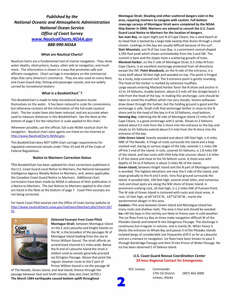
NOAA’s navigation managers serve as ambassadors to the maritime community. They help identify navigational challenges facing professional and recreational mariners, and provide NOAA resources and information for safe navigation. For additional information, please visit nauticalcharts.noaa.gov/service/navmanagers
To make suggestions or ask questions online, go to nauticalcharts.noaa.gov/inquiry. To report a chart discrepancy, please use ocsdata.ncd.noaa.gov/idrs/discrepancy.aspx.
Lateral System As Seen Entering From Seaward on navigable waters except Western Rivers
PORT SIDE
ODD NUMBERED AIDS
GREEN LIGHT ONLY
FLASHING (2)
PREFERRED CHANNEL
NO NUMBERS – MAY BE LETTERED
PREFERRED CHANNEL TO
STARBOARD
TOPMOST BAND GREEN
PREFERRED CHANNEL
NO NUMBERS – MAY BE LETTERED
PREFERRED CHANNEL
TO PORT
TOPMOST BAND RED
STARBOARD SIDE
EVEN NUMBERED AIDS
RED LIGHT ONLY
FLASHING (2)
FLASHING FLASHING
OCCULTING GREEN LIGHT ONLY RED LIGHT ONLY OCCULTING QUICK FLASHING QUICK FLASHING
ISO COMPOSITE GROUP FLASHING (2+1) COMPOSITE GROUP FLASHING (2+1) ISO
"1"
Fl G 6s
G "9"
Fl G 4s
GR "A"
Fl (2+1) G 6s
RG "B"
Fl (2+1) R 6s
"2"
Fl R 6s
8
R "8"
Fl R 4s
LIGHT
G
C "1"
LIGHTED BUOY
G
"5"
GR
"U"
GR
C "S"
RG
N "C"
RG
"G"
LIGHT
6
R
N "6"
LIGHTED BUOY
R
"2
"
CAN DAYBEACON
CAN NUN NUN
DAYBEACON
For more information on aids to navigation, including those on Western Rivers, please consult the latest USCG Light List for your area.
These volumes are available online at http://www.navcen.uscg.gov
Navigation Managers Area of Responsibility
Northeast
Lt. Meghan McGovern
Northwest and
Pacific Islands
Crescent Moegling
Great Lakes Region
Tom Loeper
Chesapeake and
Delaware Bay
Steve Soherr
California
Jeff Ferguson
[email protected] Mid-Atlantic
Lt. Ryan Wartick
Alaska
Lt. Timothy M. Smith
Western Gulf Coast
Alan Bunn
Central Gulf Coast
Tim Osborn
[email protected] South Florida
Puerto Rico
U.S. Virgin Islands
Michael Henderson
Southeast
Kyle Ward
2
2 C U 5
1

VHF Marine Radio channels for use on the waterways:Channel 6 – Inter-ship safety communications.Channel 9 – Communications between boats and ship-to-coast.Channel 13 – Navigation purposes at bridges, locks, and harbors.Channel 16 – Emergency, distress and safety calls to Coast Guard and others, and to initiate calls to other
vessels. Contact the other vessel, agree to another channel, and then switch.Channel 22A – Calls between the Coast Guard and the public. Severe weather warnings, hazards to navigation and safety warnings are broadcast here.Channels 68, 69, 71, 72 and 78A – Recreational boat channels.
Getting and Giving Help — Signal other boaters using visual distress signals (flares, orange flag, lights, arm signals); whistles; horns; and on your VHF radio. You are required by law to help boaters in trouble. Respond to distress signals, but do not endanger yourself.
EMERGENCY INFORMATION
Distress Call Procedures
• Make sure radio is on.• Select Channel 16.• Press/Hold the transmit button.• Clearly say: “MAYDAY, MAYDAY, MAYDAY.”• Also give: Vessel Name and/or Description;Position and/or Location; Nature of Emergency; Number of People on Board.• Release transmit button.• Wait for 10 seconds — If no responseRepeat MAYDAY call.
HAVE ALL PERSONS PUT ON LIFE JACKETS!
This Booklet chart has been designed for duplex printing (printed on front and back of one sheet). If a duplex option is not available on your printer, you may print each sheet and arrange them back-to-back to allow for the proper layout when viewing.
QR
Quick ReferencesNautical chart related products and information - http://www.nauticalcharts.noaa.gov
Interactive chart catalog - http://www.charts.noaa.gov/InteractiveCatalog/nrnc.shtmlReport a chart discrepancy - http://ocsdata.ncd.noaa.gov/idrs/discrepancy.aspx
Chart and chart related inquiries and comments - http://ocsdata.ncd.noaa.gov/idrs/inquiry.aspx?frompage=ContactUs
Chart updates (LNM and NM corrections) - http://www.nauticalcharts.noaa.gov/mcd/updates/LNM_NM.html
Coast Pilot online - http://www.nauticalcharts.noaa.gov/nsd/cpdownload.htm
Tides and Currents - http://tidesandcurrents.noaa.gov
Marine Forecasts - http://www.nws.noaa.gov/om/marine/home.htm
National Data Buoy Center - http://www.ndbc.noaa.gov/
NowCoast web portal for coastal conditions - http://www.nowcoast.noaa.gov/
National Weather Service - http://www.weather.gov/
National Hurrican Center - http://www.nhc.noaa.gov/
Pacific Tsunami Warning Center - http://ptwc.weather.gov/
Contact Us - http://www.nauticalcharts.noaa.gov/staff/contact.htm
NOAA’s Office of Coast Survey The Nation’s Chartmaker
For the latest news from Coast Survey, follow @NOAAcharts
NOAA Weather Radio All Hazards (NWR) is a nationwide network of radio stations broadcasting continuous weather information directly from the nearest National Weather Service office. NWR broadcasts official Weather Service warnings, watches, forecasts and other hazard information 24 hours a day, 7 days a week. http://www.nws.noaa.gov/nwr/