Prince William Sound Oil Spill Recovery
52
2007 Work Plan DRAFT Prince William Sound Oil Spill Recovery
Transcript of Prince William Sound Oil Spill Recovery
2007 Work Plan
DRAFT
Prince William Sound Oil Spill Recovery
Table of Contents
I. Purpose and organization of this document.................................................................5
II. OSRI Strategic Goals and FY07 Work Plan ..............................................................5
A. Goal #1 - Understand ..............................................................................................…..5
1. Physical science programs ...........................................................................................…6
Demonstration of the Alaska Ocean Observing System in Prince William Sound……….6
a. Meteorology ($40K)………………………………………………………………7
Meteorological and precipitation data for ocean circulation models and aviation safety………………………………………………………………………………7
Meteorological data for oil spill trajectory models and marine safety………...……9
b. Oceanography ($160K)…………………………………………………………11
Water exchange between PWS and the GOA and seasonal variations of hydrographic properties in central PWS…………………………………………11
PWSSC Oceanography research fellowship (Postdoctoral data analyst)……….…14
2. Biological science programs.. ........................................................................................15
a. Funding partnership with the North Pacific Research Board (NPRB) ($100K).15
FY06 Forage Fish project: Seasonal distribution, habitat use, and energy density of forage fish in the nearshore ecosystem of PWS………………………………..17
FY07 Request for Proposals: Tracking and Monitoring Marine Organisms Topic.18
b. PWSSC Research Fellowships ($80K)…………………………………………19
Copper River Delta Fellowship……………………………………………………20
Zooplankton Fellowship…………………………………………..……………….20
3. Socioeconomics program ………………………………………………..……………21 a. Funding partnership with the North Pacific Research Board (NPRB) ($25K)….21
4. Modeling………………………………………………………………………………21
a. Atmospheric circulation modeling ($60K)……………………………………...21
b. Synoptic wave modeling ($5K)…………………………………………………23
c. Regional Ocean Modeling System (ROMS) Modeling, Data Assimilation and Real-Time Forecasting ($60K)……………………………………….……….…26
5. Data management ($30K) ....................................................................................…..…29
6. Graduate Research Fellowships.....................................................................................30
a. Identifying Past Habitat of Herring in PWS; Seanbob Kelly……….………..….30
b. Princeton Oceanographic Modeling Study; Xinglong Wu ($25K)…………..….31
B. Goal #2 - Respond .......................................................................................................32 1. Technology research and development ……………………………………………….32
a. FY05-06 Cold Climate Partnership objectives and progress……………….…..32
FY06 Cold Climate Partnership project: Oil recovery with novel skimmer surfaces under cold climate conditions……………………………………………………35
b. Dissolution of Cold Climate Partnership and plans for FY07 ($170K)………...36 Joint Industry Program: Oil Spill Contingency for Arctic Ice-infested Waters …..37 Oil-Spill-Recovery Prize……………………………………..…………………….41
2. 2007 AOOS/OSRI Drifter Field Experiment ($25K)………………..………………..43
3. Graduate Research Fellowships.....................................................................................44 a. Surface Circulation in Prince William Sound; Jim Alanko ($25K)………….….45
C. Goal #3 - Inform ......................................................................................................…46 1. Education ($75K).....................................................................................................…..46
a. School Year Programs: Discovery Room, Outreach Discovery, Community Programs, $40K………………………………………………………………….46
b. Summer Programs: Forest to the Sea, Weekend Workshops, $15K……. ……..47 c. Coastal community outreach and education, $15K……………………………..47 d. High school student scholarships, $1K……………………………………..…..48 e. National Ocean Sciences Bowl, $4K………………………………………..…..48
2. Graduate Research Fellowships.....................................................................................48 a. Human Dietary Response to Climate Change and Resource Availability; Catherine
Foster ($25K)………………………………………………………………………49
3. Outreach…………………………………………………………………………………50
a. OSRI Advisory Board discretionary workshops ($45K total)………….……50 Ecological Risk Assessment Workshop through USCG, $0K…………..50 Oil-in-Ice Workshop organized by MMS, $10K………………………..50 Dispersants Working Group Workshop, $10K………………………….50 Cold Climate Spill Response Training Workshop, $15K……………….50
AOOS/OSRI Drifter Field Experiment planning workshop, $3.5K…….51 2007 Marine Symposium, $1.5K………………………………………..51 Alaska Forum on the Environment, $5K………………………….……..51 JIP Steering Committee Meeting and field trip, $0K……………………51
b. OSRI web page maintenance and upgrades ($5)…………………………….52
c. Annual Report ($15K) .................................................................................... 52
III. Other Programs.........................................................................................................52
A. Graduate Research Fellowships in FY07 ($75K)…..………………….…….52
B. Program Coordination ($110K)………………………………………..……52
C. Science and Technical Committee Meetings ($15K)…………………..……52
Prince William Sound Oil Spill Recovery Institute 2007 Work Plan
I. Purpose and organization of this document
This document describes the OSRI 2007 Work Plan in the context of the overall
Science Plan approved by the OSRI Board in February 2005 for fiscal years 2005 through
2010. The Science Plan should be referenced for detailed descriptions of the OSRI
Program, the planning process and supporting documents. The 2007 Work Plan
summarizes the status of projects funded by OSRI under the 2006 Work Plan and
provides descriptions of projects proposed for funding in the 2007 fiscal year beginning
October 1, 2006. The OSRI Science Plan and the 2006 OSRI Work Plan can be found on
the internet at: www.pws-osri.org.
II. OSRI Strategic Goals and FY06 Work Plan
The Advisory Board of OSRI and the Executive Committee of the Board of
Directors for the PWSSC conducted a strategic planning session in 2002. The purpose of
the planning session was to evaluate the past, the present, and plan for the future of OSRI
and the PWSSC through 2012. Four goals were identified as part of the strategic plan:
Understand, Respond, Inform, and Partner (see OSRI Science Plan). The fiscal year (FY)
2007 Work Plan has been placed in the context of these four goals.
A. Goal #1 (understand) Attain a four-dimensional interdisciplinary understanding of Prince William
Sound to enable detection and prediction of spill-related impacts and subsequent
recovery.
Real time physical observations on surface and subsurface current direction
and magnitude and biological observations on resources in the path of the spill are
absolutely essential to effective and timely oil spill response. Without a reliable
forecast of the direction and speed of a spill, and knowledge of the resources likely to
be impacted, even the best clean up technologies in the world may be misapplied.
Fiscal Year 2007 OSRI Work Plan- DRAFT 5
1. Physical science programs
A Demonstration of the Alaska Ocean Observing System in Prince William Sound
There are two primary goals of the Prince William Sound Observing System
(PWSOS). The first is to combine long-term monitoring with short-term hypothesis-
driven process studies to understand mechanisms underlying the regional ecosystem
dynamics. Understanding the circulation and the patterns of water exchange will
provide a solid scientific foundation for addressing fisheries and ecosystem
management needs related to long term oceanic and climatic variability. The second
goal is to provide information to the major user groups in PWS including the coastal
communities, oil and gas transportation industry (tanker traffic and oil spill response),
air taxis, commercial fishermen, recreational and commercial boaters, and Coast Guard
search and rescue operations. For example, the high-resolution wind, wave and ocean
current forecast products will provide improved information to recreational and
commercial vessel and aircraft operators and enhance the safety of oil tanker traffic in
PWS. The improved physical and ecological forecasting products will enable resources
managers (e.g., PWS hatchery and commercial fishing organizations) to make informed
and scientifically sound management decisions on food supply, predation, and human
activities such as commercial and recreational fishing.
Fiscal Year 2007 OSRI Work Plan- DRAFT 6
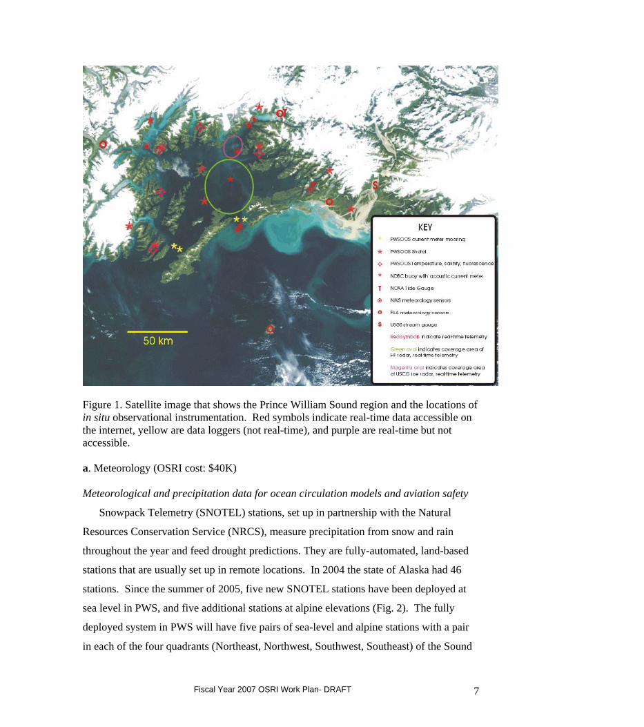
Figure 1. Satellite image that shows the Prince William Sound region and the locations of in situ observational instrumentation. Red symbols indicate real-time data accessible on the internet, yellow are data loggers (not real-time), and purple are real-time but not accessible. a. Meteorology (OSRI cost: $40K) Meteorological and precipitation data for ocean circulation models and aviation safety
Snowpack Telemetry (SNOTEL) stations, set up in partnership with the Natural
Resources Conservation Service (NRCS), measure precipitation from snow and rain
throughout the year and feed drought predictions. They are fully-automated, land-based
stations that are usually set up in remote locations. In 2004 the state of Alaska had 46
stations. Since the summer of 2005, five new SNOTEL stations have been deployed at
sea level in PWS, and five additional stations at alpine elevations (Fig. 2). The fully
deployed system in PWS will have five pairs of sea-level and alpine stations with a pair
in each of the four quadrants (Northeast, Northwest, Southwest, Southeast) of the Sound
Fiscal Year 2007 OSRI Work Plan- DRAFT 7
and another representing the central basin.
Each station in PWS measures wind speed and direction, air temperature, air pressure,
precipitation from rain and snow, and solar radiation. Four stations (one sea level station
in each quadrant of the sound) also have digital cameras that transmit pictures every
fifteen minutes to the internet so the actual weather conditions in each area can be seen.
Data transmitted by the weather stations will be accessible through the AOOS (aoos.org)
and PWSOS (pwsoos.org) web pages and archived at the University of Alaska Fairbanks.
PWS Quadrant
Site name Location Deployment date
SW Chenega Bay/Port San Juan
Sea level May/June 2005
Jackpot Cirque Alpine 2007 NW Esther Island Sea level May/June 2005 Pakenham Ridge/Port
Wells Alpine 2007
NE Tatitlek Sea level May/June 2005 Mineral Creek, Valdez Alpine Planned for fall 2006 SE Strawberry Reef/Copper
River Delta Sea level July 2006
Mt. Eyak Alpine August 2005 Central Basin Seal Island Sea level May/June 2005 Naked Island Alpine Planned for fall 2006 Hinchinbrook Entrance
Nuchek Sea level August 2005
The SNOTEL stations provide important information about the amount of freshwater
stored as snow in the watershed of Prince William Sound, an important driver of
summertime circulation in the Sound. Deployment of SNOTEL Stations was funded in
part by a combination of grants to the PWSSC from NOAA, EVOS and AOOS
(Congressional earmarks), and OSRI. Annual maintenance costs for all stations except
Fiscal Year 2007 OSRI Work Plan- DRAFT 8
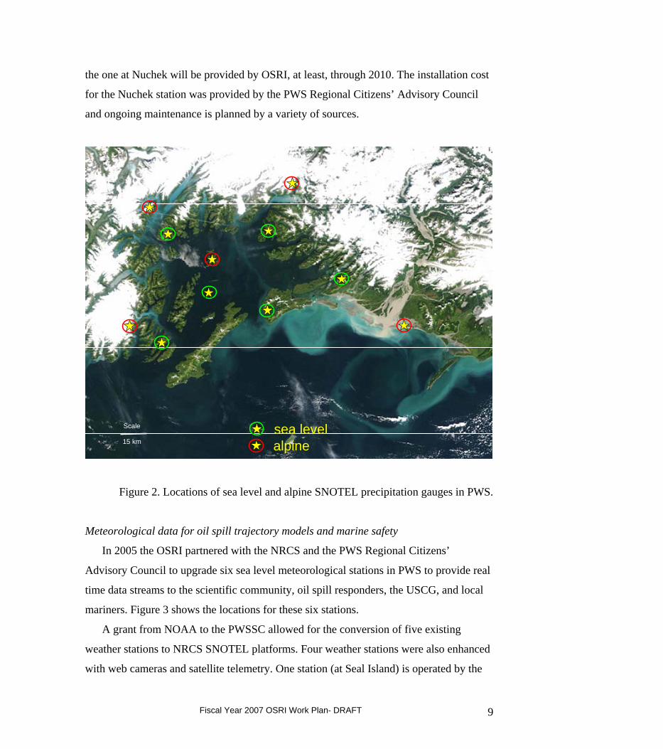
the one at Nuchek will be provided by OSRI, at least, through 2010. The installation cost
for the Nuchek station was provided by the PWS Regional Citizens’ Advisory Council
and ongoing maintenance is planned by a variety of sources.
15 km
Scale sea levelalpine15 km
Scale sea levelalpine
Figure 2. Locations of sea level and alpine SNOTEL precipitation gauges in PWS.
Meteorological data for oil spill trajectory models and marine safety
In 2005 the OSRI partnered with the NRCS and the PWS Regional Citizens’
Advisory Council to upgrade six sea level meteorological stations in PWS to provide real
time data streams to the scientific community, oil spill responders, the USCG, and local
mariners. Figure 3 shows the locations for these six stations.
A grant from NOAA to the PWSSC allowed for the conversion of five existing
weather stations to NRCS SNOTEL platforms. Four weather stations were also enhanced
with web cameras and satellite telemetry. One station (at Seal Island) is operated by the
Fiscal Year 2007 OSRI Work Plan- DRAFT 9
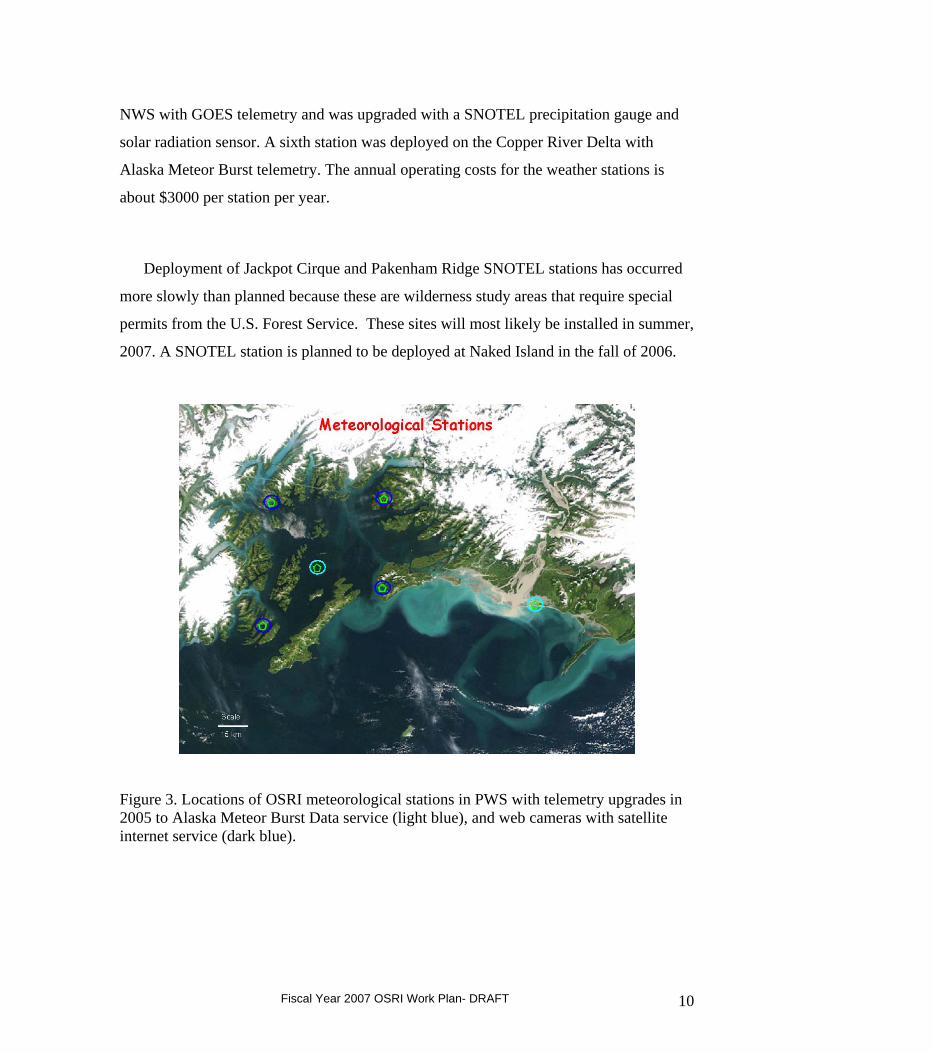
NWS with GOES telemetry and was upgraded with a SNOTEL precipitation gauge and
solar radiation sensor. A sixth station was deployed on the Copper River Delta with
Alaska Meteor Burst telemetry. The annual operating costs for the weather stations is
about $3000 per station per year.
Deployment of Jackpot Cirque and Pakenham Ridge SNOTEL stations has occurred
more slowly than planned because these are wilderness study areas that require special
permits from the U.S. Forest Service. These sites will most likely be installed in summer,
2007. A SNOTEL station is planned to be deployed at Naked Island in the fall of 2006.
Figure 3. Locations of OSRI meteorological stations in PWS with telemetry upgrades in 2005 to Alaska Meteor Burst Data service (light blue), and web cameras with satellite internet service (dark blue).
Fiscal Year 2007 OSRI Work Plan- DRAFT 10
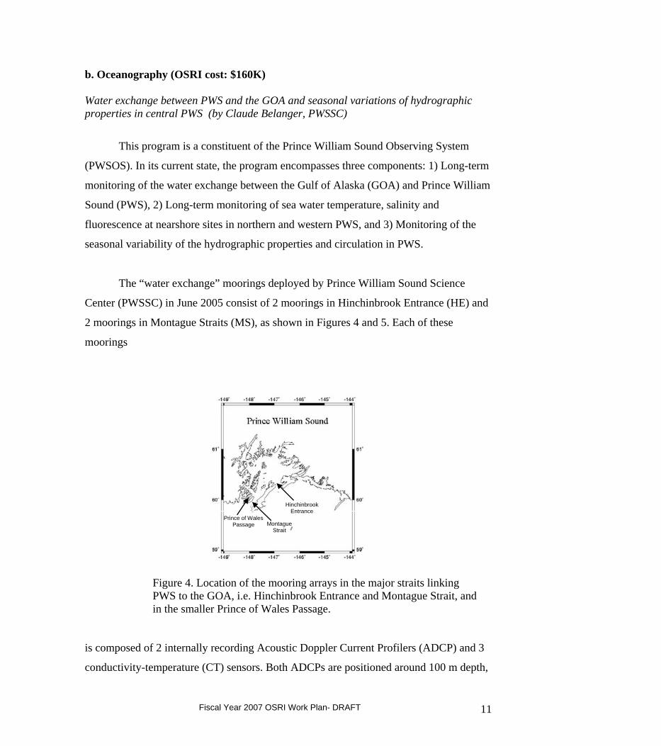
b. Oceanography (OSRI cost: $160K) Water exchange between PWS and the GOA and seasonal variations of hydrographic properties in central PWS (by Claude Belanger, PWSSC)
This program is a constituent of the Prince William Sound Observing System
(PWSOS). In its current state, the program encompasses three components: 1) Long-term
monitoring of the water exchange between the Gulf of Alaska (GOA) and Prince William
Sound (PWS), 2) Long-term monitoring of sea water temperature, salinity and
fluorescence at nearshore sites in northern and western PWS, and 3) Monitoring of the
seasonal variability of the hydrographic properties and circulation in PWS.
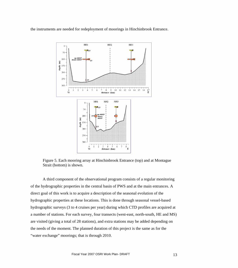
The “water exchange” moorings deployed by Prince William Sound Science
Center (PWSSC) in June 2005 consist of 2 moorings in Hinchinbrook Entrance (HE) and
2 moorings in Montague Straits (MS), as shown in Figures 4 and 5. Each of these
moorings
Hinchinbrook Entrance
Montague Strait
Prince of Wales Passage
Figure 4. Location of the mooring arrays in the major straits linking PWS to the GOA, i.e. Hinchinbrook Entrance and Montague Strait, and in the smaller Prince of Wales Passage.
is composed of 2 internally recording Acoustic Doppler Current Profilers (ADCP) and 3
conductivity-temperature (CT) sensors. Both ADCPs are positioned around 100 m depth,
Fiscal Year 2007 OSRI Work Plan- DRAFT 11
one upward-looking and one downward-looking. The CTDs are positioned at about 30 m,
100 m, and 10 m above the bottom. In addition, in 2006 the Seal Rocks NDBC buoy in
Hinchinbrook Entrance was equipped with a downward-looking ADCP and a near-
surface CT; this buoy is positioned roughly mid-way between the PWSSC moorings. The
move and upgrade of buoy 46061 in HE has been postponed to Spring 2007. The
deployment of an experimental buoy in MS will happen either during fall 2006 or spring
2007. An additional mooring was deployed in Prince of Wales pass in June 2005, with an
upward looking ADCP at 95 m depth. This mooring was recovered in May 2006 and no
re-deployment is planned.
The goal of this five-year observational program is to provide an improved
description of the flow through the straits connecting PWS with the GOA. This is seen as
a necessary step towards a better understanding of the relationship between circulation
variability and biological variability in PWS. This current meter mooring program
addresses the two limitations of the previous mooring programs (lateral variations not
accounted for and lack of data in the near surface part of the water column). The acquired
knowledge from this program should allow future monitoring of the exchange using a
single downward-looking ADCP at the NDBC buoys.
Installation costs for these moorings were supported by other entities, while OSRI
funds support most of the semi-annual servicing costs. The moorings will be in place
through 2010. During the October 2005 servicing, data were retrieved from the moorings
for the period of June-October, 2005. The moorings were then re-deployed. In April and
May 2006, the PWSSC was notified that the Hinchinbrook Entrance moorings had both
surfaced. The ADCP instruments were retrieved and data collected for six weeks and 3.5
months, respectively, from the two moorings. Three of the six CT instruments were also
retrieved, and data was acquired from, at least, one of these. The two moorings in
Montague Straight were successfully serviced in May, 2006. The two Hinchinbrook
Entrance moorings were redeployed in August, 2006, with plans for maintenance
servicing in October or November, 2006 and again in April or May, 2007. The Prince of
Wales Passage mooring was recovered in May 2006 and will not be redeployed because
Fiscal Year 2007 OSRI Work Plan- DRAFT 12
the instruments are needed for redeployment of moorings in Hinchinbrook Entrance.
Figure 5. Each mooring array at Hinchinbrook Entrance (top) and at Montague Strait (bottom) is shown.
A third component of the observational program consists of a regular monitoring
of the hydrographic properties in the central basin of PWS and at the main entrances. A
direct goal of this work is to acquire a description of the seasonal evolution of the
hydrographic properties at these locations. This is done through seasonal vessel-based
hydrographic surveys (3 to 4 cruises per year) during which CTD profiles are acquired at
a number of stations. For each survey, four transects (west-east, north-south, HE and MS)
are visited (giving a total of 28 stations), and extra stations may be added depending on
the needs of the moment. The planned duration of this project is the same as for the
“water exchange” moorings; that is through 2010.
Fiscal Year 2007 OSRI Work Plan- DRAFT 13
For the “water exchange” and “seasonal surveys” components of the program,
the data are being processed at PWSSC, archived at UAF, and posted on an internet
site maintained at the Alaska Experimental Forecast Facility (AEFF) in Anchorage.
There will be a monthly quality control at PWSSC and the quality controlled data will
be sent to replace the raw data. The data from these observational campaigns will be
downloadable and the diverse information relative to data acquisition and processing
will be provided in downloadable data reports.
Mooring maintenance through 2010 will be conducted about every six months with
funding from OSRI. The first two mooring periods are now completed. The first period
(Period A) went from mid-June to end of October 2005. The second period (Period B)
went from the end of October 2005 to late May 2006. The sampling strategy of sequential
six-to-eight month deployments is preferable to a single, yearlong deployment because
the risk of data loss due to instrument failure/loss is then diminished.
All level 1 mooring data (i.e. without quality control) will be posted on the web
within one month of instrument recovery. The NDBC will process and post ADCP and
CTD data from the surface buoy in real time. OSRI will fund the logistics costs and the
salary of a marine technician to aid with the maintenance and deployment of the
oceanographic moorings, instrument calibration, and data processing.
PWSSC oceanography research fellowship (Post doctoral data analyst); (OSRI cost:
$80K from the total $160 in Oceanography)
The intent of the OSRI Post doctoral positions is to 1) provide research staff to the
PWSSC; 2) to research diverse issues relevant to the OSRI mission; and 3) to maintain
the highest caliber of research possible. The term of the post doc positions are two years,
with possible one-year extensions if the project warrants the extra time. The intent is not
to support full time PWSSC staff, but staff can advise post docs and leverage other funds
to utilize the expertise of OSRI post docs for their projects. Post docs will be recruited
and hired by the PWSSC based on competitive ranking of criteria including but not
Fiscal Year 2007 OSRI Work Plan- DRAFT 14
limited to their task relevant expertise, education, experience, and recommendations from
previous employers
For the oceanography program, OSRI will fund a postdoctoral position to conduct
basic and applied research in Prince William Sound and the Gulf of Alaska utilizing the
ocean observing system to meet one or more of the OSRI research focus issues. The
general research focus will be on understanding the physical circulation and mixing of
PWS waters and how these affect oil spill trajectories in space and time. The research
area includes the Sound and the adjacent Gulf of Alaska. This position will be
responsible for two main categories of work: 1) participate in the research and monitoring
programs required by the OSRI grant, including hydrographic data acquisition and
analyses, drifter trajectory analyses, large scale field experiments, and publication in peer
reviewed journals (75%), and 2) assume a lead role in securing external funds to develop
process oriented studies to further our understanding of how PWS, the Gulf of Alaska,
and the surrounding watersheds interact (25%). Under the first category, this position will
be responsible for the routine seasonal (3 to 4 times per year) oceanographic transects
across Hinchinbrook Entrance and Montague Strait, as well as maintaining fixed
moorings and meteorological arrays, and telemetry networks as part of the PWS
Observing System. The position will also be required to participate in an integrated
science, education, and outreach program conducted by the education staff of the
PWSSC.
2. Biological science programs
a. Funding partnership with the North Pacific Research Board (NPRB) (OSRI cost:
$125K)
The NPRB and OSRI have science plans that encourage research partnerships. Section
4.2.3 of NPRB’s science plan directly responds to a strong recommendation of the
National Research Council to seek partnerships with other entities to support joint
research and funding of projects of mutual interest. Similarly, Section IV.A.5.b.i of
OSRI’s science plan identifies a potential partnership with NPRB to support ecological
research projects in arctic and sub-arctic climates, generally within the NPRB geographic
area of interest, but with particular emphasis on the Gulf of Alaska and Prince William
Fiscal Year 2007 OSRI Work Plan- DRAFT 15
Sound. Both organizations have a strong interest in ocean observing, habitat, ecological
and socioeconomic studies (see section 3). The NPRB and OSRI have science and
implementation plans that provide the foundation for defining research priorities of
mutual interest in any given year.
The NPRB and OSRI Science Plans have each committed $100K/yr for 5 yrs to
the partnership initiative. Therefore, projects can be up to five years with combined
OSRI-NPRB support of $200,000/year.
A workshop sponsored by the Alaska Ocean Observing System to identify
important ecological issues in the Gulf of Alaska was held in Cordova during the summer
of 2005. Groups representing marine birds, marine mammals, nearshore habitats, and
fishes, all emphasized the need for more information on forage fish and tracking and
monitoring of marine organisms. In FY06, a joint RFP between OSRI and the NPRB
was directed at more fully understanding the role of forage fish in the northern Gulf and
Prince William Sound ecosystems, physical and biological factors that cause fluctuations
in forage fish population size and/or range, and field operations that would aid in
developing strategies for filling information gaps, testing various techniques for
assessment, and examining food web relationships. Some important questions included:
how resilient is this ecosystem to changes in physical forcing and to alterations in upper
trophic level community composition; e.g., what are the relative roles of bottom-up and
top-down forcing in shaping this ecosystem; what are the major atmospheric and oceanic
mechanisms including exchanges between Prince William Sound and the adjacent shelf
and slope that affect northern GOA ecosystem structure and function? How do
fluctuations of strength and eddy behavior of the Alaska Coastal Current, together with
its role as a source of nutrients, impact ecosystem dynamics, including recruitment of
commercially fished species, distribution and abundance of forage fish species, and
therefore populations of upper trophic fish, seabird and marine mammal species? How
does habitat quality and interspecific competition influence commercial and forage
species production and distribution. Are the criteria for "good habitat" similar for all
forage species? Is there the potential for competition among forage fish species? Are
there interannual variations in habitat quality and fish production? What are the potential
effects of variations in fish production to other trophic levels, e.g., seabirds and marine
Fiscal Year 2007 OSRI Work Plan- DRAFT 16
mammals?
FY06 Forage Fish project: Seasonal distribution, habitat use, and energy density of forage fish in the nearshore ecosystem of PWS
A two-year project titled, “Seasonal Distribution, Habitat Use, and Energy
Density of Forage Fish in the Nearshore Ecosystem of Prince William Sound” by Scott
Johnson of the NOAA Auke Bay Laboratory was selected in 2006 for a year of funding
from each of the two organizations, OSRI and NPRB. OSRI contributed $75K from its
FY06 budget to this two year study, and NPRB will match these funds for the second
year of the Johnson project.
This study assesses the seasonal distribution, habitat use, relative abundance, diel
use, diet and energy density of forage fish in the nearshore ecosystem of western Prince
William Sound. Because nearshore habitats are vulnerable to human disturbance, such as
oil spills, a better understanding of how the nearshore environments support ecologically
important forage fish species is needed to help managers conserve forage fish populations
and protect essential habitats. This study will provide information about the dependence
and fidelity of particular forage fish species to different nearshore habitat types at
different life stages of forage fish. Taxa of interest to OSRI and NPRB include Pacific
herring (Clupea pallasii), Pacific sand lance (Ammodytes hexapterus), capelin (Mallotus
villosus), Pacific sandfish (Trichodon trichodon), and eulachon (Thaleichthys pacificus).
It will also fill knowledge gaps by assessing 1) seasonal and diel use of nearshore habitats
by forage fish, 2) quantity and quality of habitat, 3) relative fish abundance, and 4)
energy flux and relative growth of forage fishes in western Prince William Sound through
seasonal change. The study supplements an on-going Essential Fish Habitat (EFH)
project to ground-truth ShoreZone aerial mapping in western PWS in 2006.
Fiscal Year 2007 OSRI Work Plan- DRAFT 17
FY07 Request for Proposals: Tracking and Monitoring Marine Organisms Topic
Regarding funds allocated in FY07 to the NPRB-OSRI partnership ($200K,
$100K each from OSRI and NPRB) the OSRI STC and Work Plan committees concurred
to pursue Tracking and Monitoring of Marine Organisms as an RFP topic in FY07.
Exciting technologies have been developing for tracking and monitoring marine
organisms, such as the bioacoustic arrays deployed throughout the Pacific for salmon and
other marine organism studies in the Pacific Ocean Shelf Tracking (POST) project.
Transmitters can be turned on and off to conserve battery life up to a number of years. It
appears that there will be opportunities to track and monitor forage fish with this
technology, and that POST may be developing plans to deploy arrays in PWS in 2007.
OSRI committees agreed that interfacing with POST could yield large returns from our
rather small research fund investment. Tracking and monitoring marine organisms by
interfacing with innovative technologies such as those used in the POST project could
also help with AOOS modeling goals for real-time biology.
Available technologies are active (battery bearing) and passive (no batteries).
What are the advantages of active and passive devices for tracking and monitoring
marine organisms? Are there questions that can be answered by active technologies that
can't be addressed by passive technologies, and conversely? Some of the passive methods
have been around a long time, so how have they been used in PWS and what were the
results? Have active technologies been used in PWS and what were the results? Are there
important groups of species that can't be addressed by active or passive technologies due
to size, behavior, federal laws, etc.? To what species would each class (passive, active) of
technology be applicable, and are these species of interest to OSRI?
Some of the scientific questions relevant to OSRI revolve around distribution of
organisms that would be impacted by oil in the water, and especially by oil spill response
methods, such as use of dispersants. Studies on tracking and monitoring marine
Fiscal Year 2007 OSRI Work Plan- DRAFT 18
organisms should also utilize technology to interface with the Alaska Ocean Observing
System (AOOS) to implement their biological monitoring goal.
In FY07, NPRB and OSRI will each contribute $100K (total $200K) to pursue
Tracking and Monitoring of Marine Organisms and $25K each (total $50K) for
development of a PWS regional economic impact model as RFP topics (see section 3)
(Note: this is pending approval by both NPRB and OSRI).
b. PWSSC Research Fellowships (OSRI cost: $80K)
The intent of this research fellowship is to 1) provide research staff to the PWSSC; 2) to
research diverse issues relevant to the OSRI mission; and 3) to maintain the highest
caliber of science possible. The fellowship is intended as partial support for the
researcher who must also take a lead role in securing other funds to support process
oriented studies that further our understanding of PWS, the Gulf of Alaska and the
surrounding watersheds. In 2007, this fellowship is to be shared by two PWSSC
researchers for investigations described below. In future years, this fellowship will be
utilized to attract new research staff to the PWSSC.
Copper River Delta Fellowship, Dr. M. A. Bishop
Beginning in the spring of 2000, OSRI funded studies on the intertidal resources
of the Copper River Delta at risk to oil spills. In 2003, the research program was
expanded with new funding support from the Exxon Valdez Oil Spill Trustee Council’s
Gulf Ecosystem Monitoring program. The ultimate goal of the Copper River Delta
research is to understand the spatial and temporal dynamics of the biological community
of the Copper River Delta in order to predict how this community would respond to
anthropogenic (e.g., an oil spill) or naturally induced changes (e.g., climate change) in the
physical and chemical environment. The approach to achieve this goal has been to focus
on the central part of the food web (benthic invertebrates) and then to add components
that focus on higher (predators) and lower trophic levels (primary producers) as funding
allows. The FY06 OSRI funding represented the third and final year of this project. The
Fiscal Year 2007 OSRI Work Plan- DRAFT 19
PWSSC Research Fellowship in FY07 is intended to provide 3 months salary to the
principal investigator, Dr. Mary Anne Bishop, for the purpose of writing and submitting
at least two peer-reviewed publications using results from this project. For further
information on this project, see: http://www.pwssc.gen.ak.us/nearshore/MarineInvert-
Bishop.html
Zooplankton Fellowship; Dr. T. Kline
Dr. Kline has conducted zooplankton investigations in PWS and the Gulf of
Alaska for more than a decade. Recent results from his and other researchers’ work
indicate that the size and stable isotopic composition of Neocalanus populations may be a
strong indicator for determining the strength of pink salmon runs in the following year. In
FY2007, he will be continuing work to further our knowledge of the fundamental
processes driving the PWS ecosystem, develop a systematic method for sampling
Neocalanus and other zooplankton, to enable further hypotheses development, and
contribute to the PWSOS.
The proposed project will develop sampling strategies needed for effective
implementation of a zooplankton long-tem observational or monitoring program useful to
PWSOS. It will sample zooplankton according to life history stages, using a state-of-the-
art Hydrobios Multi-net. An immediate deliverable of this project will be measurements
of the Neocalanus population. A times series status of zooplankton will be developed and
posted at a website and will provide a context for comparisons. These comparisons are
expected to lead to more accurate predictions of pink salmon marine survival. The
PWSSC Research Fellowship in FY07 is intended to provide 3 months salary to the
principal investigator, Dr. Thomas C. Kline.
Fiscal Year 2007 OSRI Work Plan- DRAFT 20
3. Socioeconomics Program
a. Funding partnership with the North Pacific Research Board (NPRB
FY07 Request for Proposals: Socioeconomics Topic($25K)
For FY07, the Scientific and Technical Committee put forth the recommendation
to allocate the $25K remaining in OSRI’s budget from FY06 NPRB–OSRI partnership
funds to a new RFP focused on socioeconomics, such as creating an economic impact
model for marine resource dependent communities in Alaska. Both NPRB and OSRI
programs have a socioeconomic mandate; we are requesting NPRB to match funds for
this topic area resulting in a $50K RFP.
The coastal regions of Alaska are experiencing considerable environmental and
human-induced changes to marine and adjacent ecosystems, with potentially significant
effects on natural resources available for commercial, recreational or subsistence harvest
and other uses, as well as on the coastal economies, culture and social fabric. In order to
anticipate and plan for these changes, coastal communities and resource planners in
Alaska need to understand the size and directions of social, economic, and cultural
responses to ecosystem changes. As a first step, a specific need is a regional economic
impact model for estimating the impacts on particular communities and regions of
changes to the natural resource base of marine-resource dependent industries and
activities. The resulting model should incorporate both traditional and emerging sectors,
as well as consumptive and non-consumptive uses, and account for the geographic
characteristics of Alaska's coastal regions, as well as relate coastal communities to the
rest of the state economy.
4. Modeling a. Atmospheric circulation modeling (by Peter Olsson, AEFF) (OSRI cost: $60K, technician’s salary and computer costs for operational mode forecasts; targeted for participation in FY07 Drifter Experiment)
At the Alaska Experimental Forecast Facility (AEFF), a daily numerical weather
Fiscal Year 2007 OSRI Work Plan- DRAFT 21
forecast model— the Regional Atmospheric Modeling System (RAMS)— is operational
for the region of Prince William Sound (PWS). As is true of all weather forecast models,
this involves using a cluster of computers to solve a mathematical model approximating
how we think the atmosphere works. In fact this is the same thing that the National
Centers for Environmental Prediction (NCEP) does for the National Weather Service
(NWS). What is different with our project is that while NCEP does this for all of Alaska,
AEFF concentrates available computing power on the region of Prince William Sound.
This allows for a finer-scale grid spacing (4-km) than the NCEP models (12.5 km at
best). This finer grid-scale hopefully resolves smaller scale topographic effects that are
not in the NWS simulations, such as williwaws and blocking by smaller terrain features
In our study we exploit the capability in RAMS of grid nesting, in effect
telescoping down from a coarse grid-mesh grid that covers all of Alaska and surrounding
oceans, to an intermediate grid that covers all of southern Alaska and the Gulf of Alaska,
and ultimately down to the fine-mesh grid that covers PWS and its surrounding
terrain/ocean.
The model simulations produce hourly (or less if necessary) 3-d forecast fields of
a host of variables, including: temperature, pressure, winds (3-d), humidity, precipitation,
and cloudiness. This is just a small sampling of variables of most interest to the typical
user in PWS, a host of other 2- and 3-d variables are available and more can be calculated
from the raw output.
The model can also act as an integrator of data, by filling in the gaps or data
voids. Several weather stations have been deployed in the Sound and there are several
C-MAN stations and NDBC buoys in the Sound. Still there are several data-sparse
sections in a region where weather and wave conditions can vary dramatically over a
scale of 10 km or so. The model can act to fill in the gaps, acting as surrogate
observations in those places where direct observations do not exist. These are, of
course, predictions and so will never replace having an actual observation at a given
point in space and time
The RAMS output is currently available at the AOOS PWS web page:
http://ak.aoos.org/pws/
Fiscal Year 2007 OSRI Work Plan- DRAFT 22
To access the PWS RAMS images, choose the Forecasts selection from the menu
across the top of the page.
In FY07 we will concentrate on incorporating more of the data from the real-time
PWSOS meteorological observing system into the initial condition of the model. This
should give us more accuracy in the close time scale. We also intend to go to a two-a -
day forecast schedule, initializing forecasts at 0z and 12 Z, and integrating each forecast
out to 36 hours. Thus, any forecast values used by a spill responder will be no more than
12 hours ahead in time. This will increase the amount of model data but should not
present any special problems.
b. Synoptic wave modeling (by Vijay Panchang, TAMU) (OSRI cost: $5K, computer costs for operational mode forecasts; targeted for participation in FY07 Drifter Experiment)
The basic system has been developed to extend NOAA’s coarse grid forecasts into
the Prince William Sound area. We have developed the computer protocols to interface this
PWS domain to the outer-ocean NOAA predictions. We have established the procedures to
do this automatically. At intervals of 12 hours, wave spectral information from NOAA’s
predictions at grid-points on the local model boundary and NOAA’s windfields are
downloaded. With these inputs, the local model is run continuously, and the results are
posted on TAMUG website every 12 hours. The results are automatically archived. The
simulations include 12-hour hindcasts and 48-hour forecasts; an example wave height plot
is showed in Fig. 1. Model results are compared with field measurements to estimate the
reliability of the wave forecasting system. The current high-resolution (0.02 degree)
computational grid we use covers an area of from -149.0 to -144.0 degrees in longitude,
and from 59.0 to 61.5 degrees in latitude.
Fiscal Year 2007 OSRI Work Plan- DRAFT 23
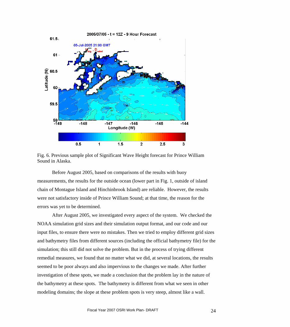
Fig. 6. Previous sample plot of Significant Wave Height forecast for Prince William Sound in Alaska.
Before August 2005, based on comparisons of the results with buoy
measurements, the results for the outside ocean (lower part in Fig. 1, outside of island
chain of Montague Island and Hinchinbrook Island) are reliable. However, the results
were not satisfactory inside of Prince William Sound; at that time, the reason for the
errors was yet to be determined.
After August 2005, we investigated every aspect of the system. We checked the
NOAA simulation grid sizes and their simulation output format, and our code and our
input files, to ensure there were no mistakes. Then we tried to employ different grid sizes
and bathymetry files from different sources (including the official bathymetry file) for the
simulation; this still did not solve the problem. But in the process of trying different
remedial measures, we found that no matter what we did, at several locations, the results
seemed to be poor always and also impervious to the changes we made. After further
investigation of these spots, we made a conclusion that the problem lay in the nature of
the bathymetry at these spots. The bathymetry is different from what we seen in other
modeling domains; the slope at these problem spots is very steep, almost like a wall.
Fiscal Year 2007 OSRI Work Plan- DRAFT 24

Obviously we had to make some changes to the bathymetry to get meaningful simulation
results, particularly at these spots.
When we used a different resolution of bathymetry file to make simulations, the
results were significantly improved; an example wave height plot is shown in Fig. 2. This
plot looks reasonable qualitatively for most of the domain, and we also compared the
results with buoy measurements. Based on the comparison between buoy measurements
and simulation results, we can conclude that for most areas of the domain the simulation
is good, although the bad spots are not totally eliminated.
Fig 7. Sample plot of Significant Wave Height forecast for Prince William Sound in Alaska.
In March 2006, we developed the protocols to make animations. Since then, at the
beginning of every month, we generate the animations of Significant Wave Height and
Peak Wave Period for the previous month. By observing the SWH animations, we think
there still are problems in the area near Port Wells and Port Valdez; and we think it is due
to the bathymetry data. We hope to obtain the official bathymetry soon.
Fiscal Year 2007 OSRI Work Plan- DRAFT 25
In April 2006, we started making calculations of wave steepness of the waves in
Prince William Sound. The calculation is based on the peak period at all locations in the
domain and corresponding water depth, which is used to estimate a representative
wavelength; steepness is defined as the ratio of the wave height to the wavelength. We
changed the system which is used to perform daily simulations for Prince William Sound.
Since early July, steepness animations were also provided in addition to monthly
significant wave height and peak period animations.
To summarize, our recent work has involved (1) Quality control of the results and
adjustments to improve the results; (2) comparison with measurements; (3) animation of
wave height, peak periods, and steepness predictions.
FUTURE WORK: We are working to add radiation stress calculations to our system. We
will contact the wind modeling group to get local wind forecast (instead of the NOAA
winds we are presently using). We expect the transition from NOAA winds to our UAF’s
local winds to be a significant effort. Also, we know there is problem existing in the
current bathymetry we are using, we are awaiting the release of the official bathymetry.
c. Regional Ocean Modeling System (ROMS) Modeling, Data Assimilation and Real-Time Forecasting (by Yi Chao, JPL, and Xavier Capet, UCLA) (OSRI cost: $60K, post doc salary and computer costs for operational mode forecasts) ; targeted for participation in FY07 Drifter Experiment)
A major goal of the observing system in PWS is to develop an operational system
that delivers information on physical and biological conditions in real-time to research
and application users. This information includes raw data on environmental conditions,
such as wind speed, air temperature, precipitation, ocean currents, ocean temperature, tide
height, and water salinity as well as modeled forecasts of anticipated conditions.
Forecasts for the atmospheric conditions in the Prince William Sound region have been
developed using a Regional Atmospheric Modeling System (RAMS) with a 4 km
resolution. The JPL/UCLA group now has the responsibility of developing a real-time
forecasting capability for oceanographic conditions. The JPL/UCLA group is applying
Fiscal Year 2007 OSRI Work Plan- DRAFT 26
the Regional Ocean Modeling System (ROMS) to PWSOS. A major new feature of
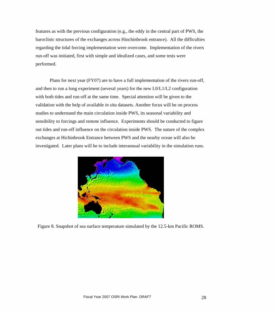
ROMS is the 3-dimensional variation (3DVAR) data assimilation system. A Pacific
basin-scale ROMS has been developed with a resolution of 12.5-km (Figure 8). The
Pacific basin-scale ROMS will provide the needed boundary conditions for the PWS
ROMS configurations, which consist of three nested ROMS domains (Figure 9) with 10-
km, 3.6-km, and 1.2-km over the Pacific Northeast, Gulf of Alaska, and PWS, (the latter
extends to the Copper River Delta to ensure that this important source of freshwater for
PWS is included at the finest scale). As an alternative for the Pacific domain, we will
have the option of using boundary data from oceanic data assimilation products, and our
current version uses reanalysis by the Simple Ocean Data Assimilation (SODA; Carton et
al., 2005).
The circulation in the sound is driven by an intricate mixture of buoyancy, wind,
tidal and remote forcing. A number of technical issues implementing these forcing
mechanisms have been overcome, and UCLA and JPL are currently in the early phase of
validation of all grid levels. The numerical solutions (1 year for the 3 grid levels) already
reproduce some interesting features. The eddy present in the central part of the Sound
during most of summer 2004 is also a robust feature in the model even when forced by
climatological monthly winds and in the absence of freshwater inputs. In addition, the
structure of the currents across the Hinchinbrook Entrance shows strong baroclinicity and
temporal variability in relation to the mesoscale activity present outside PWS on the
slope.
During the last year (FY06) the focus was on a variety of different tasks. Open
boundary sensitivity tests were conducted, mainly over the large L0 domain (Gulf of
Alaska). To do so, an alternative L0 domain was designed to figure out the best
configuration for the coastal currents. It appears that mean circulation characteristics are
more satisfactory using the new L0 domain. Consequently new L1 (3.6km) and L2
(1.2km) nested domains have been developed (Figure 9). New topography datasets (from
NOAA and OSRI) were merged to produce a more accurate topography for the PWS
domain. This dataset has been implemented in PWS nested domain L2. Topography for
domains L0 and L1 was also modified (GINA instead of Etopo2). This new L0/L1/L2
configuration was under climatological conditions, and we observed the same interesting
Fiscal Year 2007 OSRI Work Plan- DRAFT 27
features as with the previous configuration (e.g., the eddy in the central part of PWS, the
baroclinic structures of the exchanges across Hinchinbrook entrance). All the difficulties
regarding the tidal forcing implementation were overcome. Implementation of the rivers
run-off was initiated, first with simple and idealized cases, and some tests were
performed.
Plans for next year (FY07) are to have a full implementation of the rivers run-off,
and then to run a long experiment (several years) for the new L0/L1/L2 configuration
with both tides and run-off at the same time. Special attention will be given to the
validation with the help of available in situ datasets. Another focus will be on process
studies to understand the main circulation inside PWS, its seasonal variability and
sensibility to forcings and remote influence. Experiments should be conducted to figure
out tides and run-off influence on the circulation inside PWS. The nature of the complex
exchanges at Hichinbrook Entrance between PWS and the nearby ocean will also be
investigated. Later plans will be to include interannual variability in the simulation runs.
Figure 8. Snapshot of sea surface temperature simulated by the 12.5-km Pacific ROMS.
Fiscal Year 2007 OSRI Work Plan- DRAFT 28
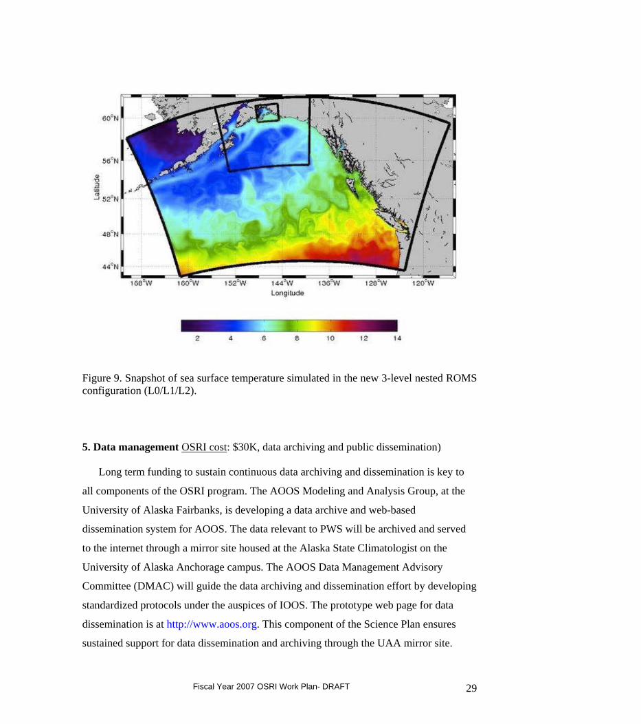
Figure 9. Snapshot of sea surface temperature simulated in the new 3-level nested ROMS configuration (L0/L1/L2).
5. Data management OSRI cost: $30K, data archiving and public dissemination)
Long term funding to sustain continuous data archiving and dissemination is key to
all components of the OSRI program. The AOOS Modeling and Analysis Group, at the
University of Alaska Fairbanks, is developing a data archive and web-based
dissemination system for AOOS. The data relevant to PWS will be archived and served
to the internet through a mirror site housed at the Alaska State Climatologist on the
University of Alaska Anchorage campus. The AOOS Data Management Advisory
Committee (DMAC) will guide the data archiving and dissemination effort by developing
standardized protocols under the auspices of IOOS. The prototype web page for data
dissemination is at http://www.aoos.org. This component of the Science Plan ensures
sustained support for data dissemination and archiving through the UAA mirror site.
Fiscal Year 2007 OSRI Work Plan- DRAFT 29

6. Graduate Research fellowships (2) (OSRI cost: $50K, two students at $25K per student per year)
OSRI funds are provided to support graduate student research projects that will
enhance scientific understanding of the marine ecosystem, provide information needed by
managers and decision-makers for oil spill response and recovery, and improve public
awareness and understanding of marine and estuarine ecosystems. The OSRI Graduate
Research Fellowship (GRF) Program offers qualified master's and doctoral students the
opportunity to address scientific questions of significance to high latitude cold climate
regions (see OSRI Science Plan). The result is high-quality research focused on
improving oil spill response and recovery issues.
a. Identifying Past Habitat. Abstract by Sean-Bob Kelly, project funded for FY05 and FY06, University of Alaska Fairbanks. Masters degree student.
The overall objective of this study is to identify past habitat use and essential
habitat of Pacific herring (Clupea pallasii) from Prince William Sound (PWS). My
specific objectives are to (1) use trace element signatures of core portions of herring
otoliths to identify individual spawning bays within PWS, (2) use trace element
signatures of edge portions of juvenile herring otoliths to identify individual rearing bays
within PWS, (3) use adult otoliths to identify bays that contribute a greater portion to the
herring population, and (4) use adult otoliths to identify past habitat use and temporal
changes.
My research focus fits within OSRI research focus area (#1), the observation and
modeling of the quantitative ecology of marine and estuarine habitats. Following the
Exxon Valdez oil spill in March 1989 and the decline of herring stocks in the 1990´s, the
need for quantitative analysis of essential fish habitat has become more critical to the
conservation of this important fisheries stock. Identification of essential fish habitats
(EFH) for various life stages of herring in PWS is necessary to examine the status and
recovery potential of the stock, which is a priority of fisheries managers. Identification of
habitat change since 1995, the oldest available samples, through 2006, the latest samples,
would be an indicator of the recovery of the herring populations in PWS. Herring
Fiscal Year 2007 OSRI Work Plan- DRAFT 30
spawning on documented oil-damaged habitat and surviving to recruitment is an
indication that those habitats have recovered. Otolith chemical analysis of regional
signatures enables my research to quantify ecological recovery status through shifts in
herring habitat usage over time.
Relevance to OSRI: Populations and habitats of valuable forage fish, such as Pacific
herring, are vulnerable to oil spills; therefore, it is important through this study to gain a
better understanding of their dependence on particular habitats to help managers conserve
forage fish populations and protect essential habitats.
b. Princeton Oceanographic Modeling Study: How Does a Semi-Enclosed Sea Respond to External and Internal Forcings? Abstract by Xinglong Wu, funded for 2005-2007 (through FY07), University of Miami. Ph.D. student.
The goal of the present study is to understand the response of Prince William
Sound (PWS) to such forcing as surface wind, atmospheric pressure, tides, buoyancy
flux, inflow and mass structures at open boundaries, and bottom topography and to
evaluate the relative roles played by these forcings in driving the synoptic and general
circulation in the Sound. Specifically, the following questions are expected to be
answered in the dissertation:
1. Why does a large cyclonic gyre occur in PWS in September with little year-to-
year variability, while in other seasons the circulation pattern in central PWS could be
transient in either the cyclonic or anti-cyclonic direction?
2. How does the seasonal inflow/outflow structure in Hinchinbrook Entrance (HE)
change the circulation in PWS? Considering the sills just outside the two main entrances
guarding the Sound from the NGOA coastal waters, and what controls the properties and
variability of the PWS deep water?
3. What is the nature and strength of the buoyancy-driven (thermohaline) circulation
in a small semi-enclosed sea such as PWS?
4. Associated with the complex bottom topography and density stratification in
PWS, what roles do the tides, including barotropic and baroclinic components, play in
influencing the general circulation? How much of the tidal energy is dissipated inside the
Fiscal Year 2007 OSRI Work Plan- DRAFT 31
Sound? What is the Sound’s annual tidal energy budget?
Relevance to OSRI: This study is relevant to OSRI’s goals because understanding
patterns of ocean circulation and surface currents should help predict conditions that
will determine the most appropriate response in the event of an oil spill.
B. Goal #2 Respond: Enhance the ability of oil spill responders to mitigate impacts of spills in Arctic and sub-Arctic marine environments.
1. Technology research and development
a. FY05-06 Cold Climate Partnership objectives and progress. Funding partners: Cooperative Institute for Coastal and Estuarine Environmental Technology (CICEET), Coastal Response Research Center (CRRC), Minerals Management Service (MMS).
In 2004, CRRC, CICEET and OSRI formed a partnership for the development
and application of new technologies, and/or innovative approaches using existing
technologies, to address issues related to oil spill response and restoration in cold climate
coastal marine areas and the Great Lakes. In 2005, MMS joined the partnership. The goal
for this collaboration was to allow the partners to take advantage of pooled funding and
resources, while supporting their individual missions. CRRC is a partnership between the
University of New Hampshire (UNH) and the National Oceanic and Atmospheric
Administration (NOAA); the goal of the Center is to reduce the consequences of spills
and other hazards threatening coastal environments and communities. Additional
information about this Center can be found at www.crrc.unh.edu. CICEET is also a
partnership between NOAA and UNH and was established as a national center for the
development and application of innovative environmental technologies for monitoring,
management and prevention of contamination in estuaries and coastal waters. Additional
information can be found on the CICEET website (http://ciceet.unh.edu). OSRI was
established to conduct research and educational and demonstration projects in order to
identify and develop the best available techniques, equipment and materials for dealing
with oil spills in Arctic and sub-arctic marine environments. Additional information
Fiscal Year 2007 OSRI Work Plan- DRAFT 32
about OSRI can be found at www.pws-osri.org. MMS is the Federal agency responsible
for managing the nation’s natural gas, oil and other mineral resources in Federal waters
offshore the U.S. Information on MMS can be found at www.mms.gov. A partnership
between these Centers should use the strengths and expertise of each and allow for the
solicitation and funding of a broad, integrated range of relevant research. The projects are
funded and administered by the individual partners; the results of the funded projects will
be disseminated by all of the partners.
The goals of this partnership for cold climate spill research are to:
1. Conduct research and development on new technologies for preventing,
responding to, and recovering from oil spills.
2. Identify and develop cost effective technology and methods for the restoration of
spill impacted habitats and ecosystems.
3. Facilitate and promote collaborative research and development and the exchange
of ideas to increase collective productivity and the application of the findings to improve
technological and operational activities in spill preparedness, response and restoration.
4. Involve students (undergraduate and graduate) to the extent practical in ongoing
research, testing, and demonstration activities.
CRRC, CICEET, MMS and OSRI collaborated in this effort in FY05 and FY06 to
conduct research and development on new technologies for responding to oil spills in
cold climate coastal marine areas and the Great Lakes. For the purpose of Cold Climate
Partnership RFPs, cold climate environments are defined as having average annual winter
(January, February and March) water temperatures less than or equal to 38° F.
Geographical areas of special interest include those subject to severe storms, large waves,
and prolonged winter weather, as these regions may develop extensive broken or
continuous ice. Research areas of special interest include developing techniques and
technologies to: detect oil in ice, remove oil from under ice or from broken ice, prevent
the spread of spilled oil in ice covered waters or in broken ice, improve the effectiveness
and efficiency of response operations, and to restore and recover impacted habitats and
ecosystems in cold climate environments.
Specific research areas of interest for this cold climate partnership include, but are
Fiscal Year 2007 OSRI Work Plan- DRAFT 33
not limited to:
1. Exposure and Injury Assessment Tools: Development of new, cost effective tools
that can be rapidly deployed, including technologies, methods, protocols and models and
their application for assessing the exposure and injury of marine resources to the presence
of oil in the water column, on or under ice, in and among broken ice, in sediments or in
organisms. A proposed tool should be simple, rapidly deployable, low cost, and easy to
use. A developed tool being applied to a cold climate must be suitable for
commercialization.
2. Data Development: Processes and Rates Affecting Oil: Data and information on
the short and long term processes and rates affecting the composition and properties of oil
as a function of three dimensional transport, and/or stranding in cold climates. The
proposed work may consider the interaction of oil and relevant habitat type (i.e., changes
in oil composition, toxicity and effects as a result of habitat type) as a part of this effort.
Habitat types must be those of cold climates, as defined above. The results of this work
must be quantitative and suitable for modeling.
3. Human Use Valuation of Ecosystems: Valuation or valuation methods for human
use of ecosystem components and attributes (e.g., subsistence fishing and hunting,
recreational boating and tourism) impacted by cold climate oil spills. The methods or
developed data must be suitable for quantifying lost or diminished use and provide
information to monitor the progress of restoration.
4. Habitat Recovery and Restoration Technologies: Efficient, effective technologies
to expedite the recovery and restoration of spill impacted habitats and organisms. The
project results must quantitatively demonstrate the effectiveness of the technology.
5. Oil Recovery and Spread Prevention: Development of new technologies or
operational methods to prevent the spread and/or improve the recovery of spilled oil
associated with ice or broken ice.
The partnership issued joint annual solicitations through the CRRC in FY05 and
FY06. In both these years, the partnership issued one solicitation and involved joint
marketing, joint review, but then separated funding by organizations for particular
projects. All parties would get credit for supporting the partnership. The level of
Fiscal Year 2007 OSRI Work Plan- DRAFT 34
funding agreed upon was $200K from CICEET, $100K from CRRC, $150K from OSRI,
and $100K from MMS. CRRC developed an online database and project archive for
public dissemination of projects and project results. The 2006 RFP is on the internet at:
www.crrc.unh.edu.
No projects were funded by OSRI or any of the partners through the Cold Climate
Partnership in FY05. In FY06, the only project funded is jointly funded by OSRI and
MMS. The one-year project is titled, “Oil Recovery with Novel Skimmer Surfaces
under Cold Climate Conditions” by Dr. Arturo Keller at the University of California,
Santa Barbara. OSRI is funding phase one, the laboratory bench scale phase, at
$81,626; while MMS is funding phase 2, the field scale phase at the experimental test
basin of the Cold Regions Research and Engineering Laboratory (CRREL), at $102,921.
The total cost of this project is $184,547.
FY06 Cold Climate Partnership Project: Oil Recovery with Novel Skimmer Surfaces
under Cold Climate Conditions, Abstract by Dr. Arturo Keller
Increasing oil exploration, production and transport in Arctic waters will increase the risk
of an oil spill occurring in cold and ice-infested waters. The mechanical oil spill recovery
equipment currently used in warmer waters was not designed to collect much more viscous
oils, or oil-ice mixtures. The presence of ice crystals in oil emulsions affects the adhesion
processes between an oil slick and the surface of an oleophilic skimmer and prevents oil from
being efficiently recovered. Novel drum skimmer surface geometry and materials, tailored to
the conditions present under cold climates, are expected to significantly increase the rate of
oil recovery, reducing cost and risk.
The objective of this project is to perform a comprehensive analysis of the adhesion
between oil or ice-in-oil mixtures and various surface patterns and materials, under cold
climate conditions. This knowledge will help develop and/or improve existing mechanical
response equipment that can be more efficiently used under these conditions. The novel
recovery surfaces that have recently proven to increase the recovery efficiency of a drum
skimmer up to 2 times in warm waters should be successfully used in the cold climate
Fiscal Year 2007 OSRI Work Plan- DRAFT 35
conditions, with some optimization of the geometry and materials, and lead to a significant
increase in oil recovery efficiency.
In the first phase of the project, laboratory bench-scale tests of different surface materials
and patterns will be conducted, to determine contact angle and amount of oil adhered at sub-
freezing conditions, with and without ice. The equipment for these tests is available, and was
successfully used to develop optimized drum skimmer recovery surfaces for warmer
temperatures (10-30 oC). These tests were validated with field-scale tests at Ohmsett in New
Jersey for this higher temperature range.
Based on the results of the proposed laboratory tests at subfreezing conditions, we will
select the materials and surface patterns with the highest oil recovery potential under cold
climate conditions, and perform field scale oil spill recovery test at the Cold Regions
Research and Engineering Laboratory with three different oils. This will provide us with
valuable information about the correlation between the laboratory tests and full scale
experiments, as well as demonstrate the potential of the proposed skimmer modifications
under conditions similar to response operations.
These objectives will serve to advance the goals of the partners of the RFP, by providing
important information for the improvement of cleanup of oil spills in cold climates. The
outcome of this project will significantly advance our understanding of the adhesion of oil
and oil emulsions (water containing and ice-containing) to recovery surface material under
cold climate conditions. This research will facilitate selection of materials and surface
configurations that result in significantly higher recovery rates of oil spills in cold and ice-
infested waters. This will ultimately lead to a faster oil spill cleanup and greater protection of
natural resources. We expect a high level of interest for the research results from
manufacturers of oil spill recovery equipment and oil spill responders. We have working
relationships with some manufacturers of oil skimmers, so the research is likely to be
incorporated into products in a short time frame (months).
b. Dissolution of Cold Climate Partnership and plans for FY07 (OSRI cost: $170K)
Given the small number of successful proposals funded during the past two years
of the Cold Climate Partnership relative to the large effort required to maintain the
partnership and run RFPs through the CRRC, the member organizations have opted to
Fiscal Year 2007 OSRI Work Plan- DRAFT 36
discontinue the partnership in FY07. Instead, the CRRC and MMS have released their
own RFPs related to oil spill response, and are accepting proposals relevant to cold
climate conditions, which if received, could be offered to OSRI for co-sponsorship.
OSRI has also been approached by the Charter for Development of the Alaskan North
Slope to consider co-sponsorship of oil spill response projects identified as priorities
under Section II.A.5, Arctic Spill Response Research and Development.
With $150K available to Goal #2, oil spill response, OSRI has elected to fund a portfolio
of initiatives at $50K each to the following:
(1) Co-sponsorship of a cold climate spill response project received by one of our
partners as described above; or, solidification of our own RFP;
(2) The Joint Industry Program: Oil Spill Contingency for Arctic and Ice-infested waters,
at the at the level of Minor Funder as described below;
(3) Seed money towards an oil-spill-recovery prize through the InnoCentive process as
described below.
JIP (Joint Industry Program): Oil Spill Contingency for Arctic and Ice-infested
Waters.
SINTEF has, on behalf of the oil companies ChevronTexaco, ConocoPhillips, Shell,
Statoil, TOTAL, and other prospective participants, performed a pre-project to prepare a
state-of-the-art report on oil spill contingency in Arctic and ice-infested waters which
identifies research and development needs in this area. Based on this, SINTEF,
international R&D partners and the oil companies have formulated a Joint Industry
Program (JIP) to advance Arctic oil spill contingency technology and knowledge.
The overall objective of this JIP is:
• Further development of tools and technologies for environmental beneficial oil spill
response
Fiscal Year 2007 OSRI Work Plan- DRAFT 37
strategies for ice-infested waters.
Program sub-objectives are:
• To improve our ability to protect the Arctic environment against oil spills resulting from
exploration, development, production and transportation activities.
• To provide improved basis for decision-making by responsible authorities:
• Advance the state-of-the-art in Arctic oil spill response:
o Address key problems/scenarios faced by program partners.
o Demonstrate workable response options for different ice conditions and oil types.
o Define limiting conditions for alternate response strategies.
o Investigate and develop improved response capabilities and strategies.
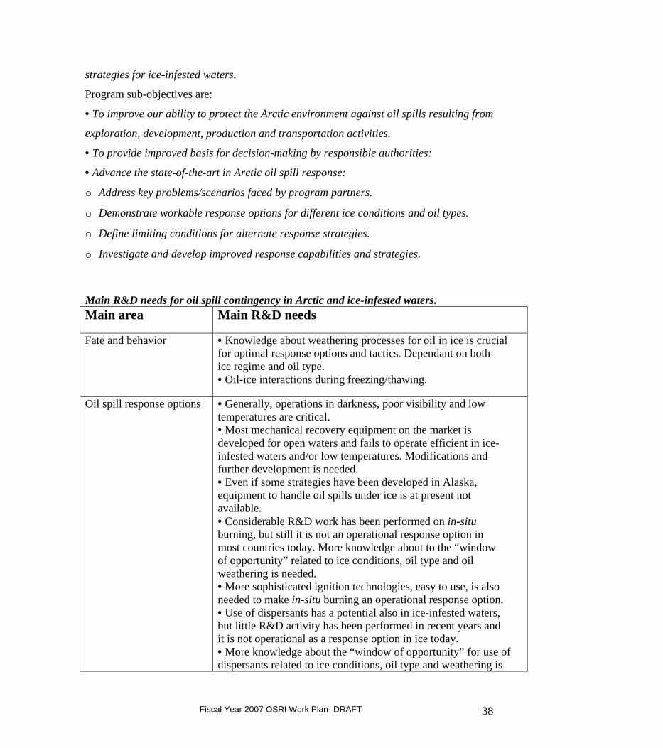
Main R&D needs for oil spill contingency in Arctic and ice-infested waters. Main area
Main R&D needs
Fate and behavior
• Knowledge about weathering processes for oil in ice is crucial for optimal response options and tactics. Dependant on both ice regime and oil type. • Oil-ice interactions during freezing/thawing.
Oil spill response options
• Generally, operations in darkness, poor visibility and low temperatures are critical. • Most mechanical recovery equipment on the market is developed for open waters and fails to operate efficient in ice-infested waters and/or low temperatures. Modifications and further development is needed. • Even if some strategies have been developed in Alaska, equipment to handle oil spills under ice is at present not available. • Considerable R&D work has been performed on in-situ burning, but still it is not an operational response option in most countries today. More knowledge about to the “window of opportunity” related to ice conditions, oil type and oil weathering is needed. • More sophisticated ignition technologies, easy to use, is also needed to make in-situ burning an operational response option. • Use of dispersants has a potential also in ice-infested waters, but little R&D activity has been performed in recent years and it is not operational as a response option in ice today. • More knowledge about the “window of opportunity” for use of dispersants related to ice conditions, oil type and weathering is
Fiscal Year 2007 OSRI Work Plan- DRAFT 38
needed. • Application technology is also a critical factor with respect to platform (e.g. helicopter and/or vessel), low temperatures and “winterization” of the equipment. • Remote areas, long distances and lack of infrastructure is a critical factor for all oil spill response in most circumpolar areas.
Monitoring and remote sensing
• While airborne microwave radars can be used to discover and track an oil spill in open waters, this system is not applicable for most oil in ice scenarios. However, recently developed systems from satellites may have a future potential. • There is a need for testing and development of monitoring and remote sensing systems to: o Detect and follow oil between ice floes and on ice. o Detect oil under ice. o Follow oil covered with snow or frozen in the ice over long time until the melting period.
Analyses and modeling of oil behavior in ice
• Risk assessment, oil spill response analysis and NEBA are normally required as a basis for an application for “license to operate”. In general, modeling tools developed to give the necessary input to these analyses for ice-infested waters are not available. • Modeling of oil weathering in the presence of sea ice remains at an ad hoc level. This is crucial input data to choice between response strategies and necessary analyses (e.g. risk assessment, NEBA etc.). • Significant advances in oil-ice interaction modeling will require that the oil behavior and fates, ice formation and drift, and hydrodynamic models be coordinated to take advantage of new knowledge in both ice cover and oil-ice interaction modeling.
Oil spill contingency guidelines and plans
• Oil spill contingency plans and guidelines for some circumpolar areas exist, but there is a large potential for improvement mainly based on response options and tactics input and more dedicated analyses.
Training and exercises – personnel requirements
• It is crucial for oil spill personnel to get acquainted with the conditions to meet in Arctic areas and to perform training and testing of different response equipment. Regular field exercises should be performed. • HSE considerations must have high priority in Arctic waters with low temperatures, danger for icing etc.
Fiscal Year 2007 OSRI Work Plan- DRAFT 39
Testing, development and verification in this JIP will take place at different levels:
• Small-scale (bench-scale) laboratory experiments. • Meso-scale basin experiments (e.g. SINTEF oil-in-ice basin and meso-scale flume basin
and S.L. Ross test basin). • Meso-scale field experiments at the fjord ice in Svea, Svalbard. • Large-scale field experiments in Canada and Norway.
Major funders: The participation fee (the total cost as described in the overall budget of
the JIP) will be divided equally between the major funders. Each major funder will
nominate one representative with one vote to the Steering Committee (SC). The leader of
the SC will be chosen among the major funders.
Minor funders: This will be participants contributing financially with less than the major
funders as well as in kind support like supply vessels during field experiments, different
types of technical expertise and support or other in-kind support. It is suggested that
minor funders will have the right to attend the Steering Committee meetings but without
voting rights. However, the final conditions for minor funders will be discussed in more
detail before approval by the SC.
Further information on the JIP, including Questions and Answers, State of the Art Report,
and the Joint Industry Program (JIP) Proposal can be found at http://www.pws-
osri.org/programs/project_list.shtml.
In FY07 OSRI will participate as a Minor Funder in the JIP, contributing $50K to the
R&D a specific topic and task from Table 6.1, p. 10 of SINTEF’s Proposal, JIP: Oil Spill
Contingency for Arctic and Ice-infested waters. Topics are listed below in this report.
The top three choices of topic ranked in order by members of the STC and FY07
Work Plan were 3) Mechanical recovery in arctic and ice-infested waters, 1) Fate &
Behavior of oil under arctic conditions, and 5) Monitoring and remote sensing.
OSRI has requested active involvement in the project planning, experimental design and
Fiscal Year 2007 OSRI Work Plan- DRAFT 40
experiment observation as much as possible, as well as serving a role on the steering
committee, and will allocate an additional $20K to this purpose.
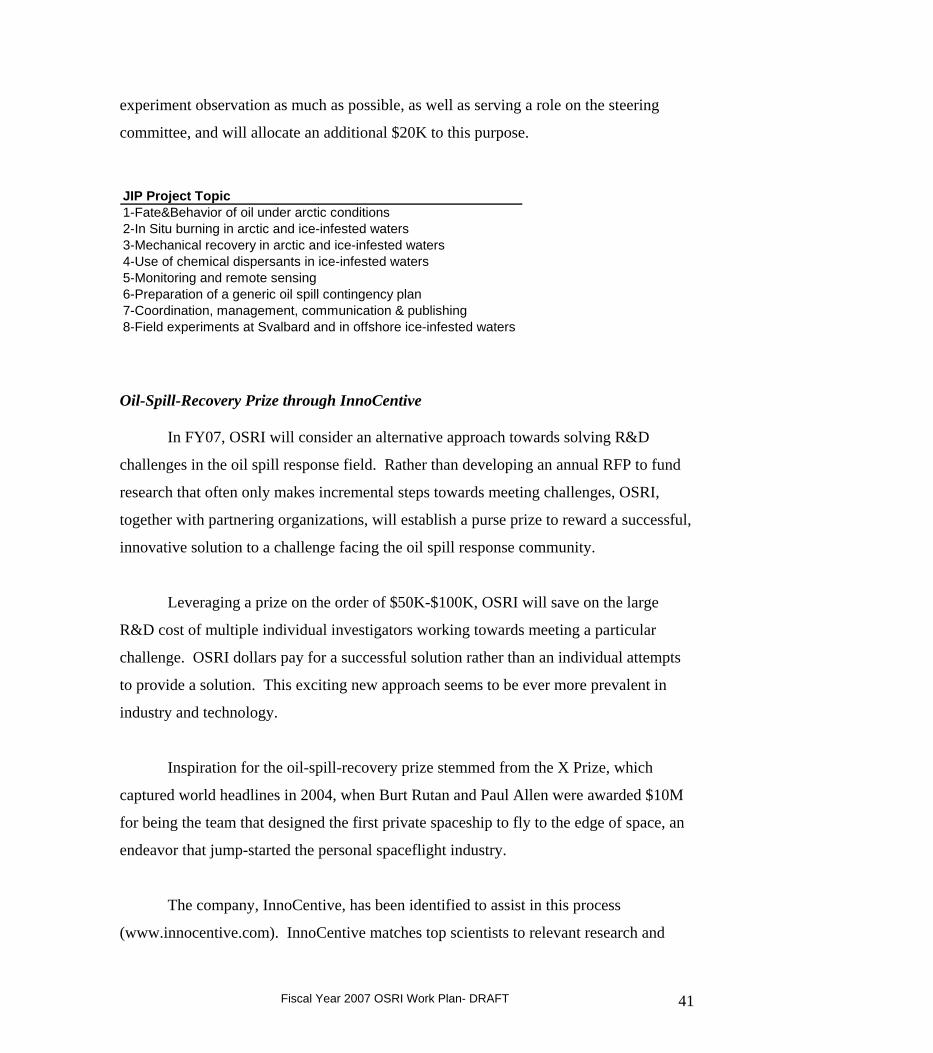
JIP Project Topic1-Fate&Behavior of oil under arctic conditions2-In Situ burning in arctic and ice-infested waters3-Mechanical recovery in arctic and ice-infested waters4-Use of chemical dispersants in ice-infested waters5-Monitoring and remote sensing6-Preparation of a generic oil spill contingency plan7-Coordination, management, communication & publishing8-Field experiments at Svalbard and in offshore ice-infested waters Oil-Spill-Recovery Prize through InnoCentive
In FY07, OSRI will consider an alternative approach towards solving R&D
challenges in the oil spill response field. Rather than developing an annual RFP to fund
research that often only makes incremental steps towards meeting challenges, OSRI,
together with partnering organizations, will establish a purse prize to reward a successful,
innovative solution to a challenge facing the oil spill response community.
Leveraging a prize on the order of $50K-$100K, OSRI will save on the large
R&D cost of multiple individual investigators working towards meeting a particular
challenge. OSRI dollars pay for a successful solution rather than an individual attempts
to provide a solution. This exciting new approach seems to be ever more prevalent in
industry and technology.
Inspiration for the oil-spill-recovery prize stemmed from the X Prize, which
captured world headlines in 2004, when Burt Rutan and Paul Allen were awarded $10M
for being the team that designed the first private spaceship to fly to the edge of space, an
endeavor that jump-started the personal spaceflight industry.
The company, InnoCentive, has been identified to assist in this process
(www.innocentive.com). InnoCentive matches top scientists to relevant research and
Fiscal Year 2007 OSRI Work Plan- DRAFT 41
development challenges facing leading companies around the globe. At InnoCentive
groups posing problems are called “Seekers” and individuals offering solutions are called
“Solvers”.
Here are some example problem statements suggested by OSRI STC and Board members, the Charter for Development, and the PWS RCAC. More elaborate problem statements developed for a subset of this list will be available at the September Board Meeting.
1. Making a dispersant which works in sub-arctic waters, is sufficiently non-toxic, and affordable. It will be important to define: (1) "works" (in tanks or at-sea; 50%, 90%, 99% of the oil dispersed; for how long), (2) "non-toxic" (acute or chronic, lethal or sub-lethal, individual or population level; that is just a start), and (3) "affordable" (what are the relative economics of prevention vs. recovery).
2. Developing a technology to quantify the effectiveness of dispersing oil
3. Development of an open water skimmer which works in rough seas & high winds.
4. Development of a technology that uses a material that can make the oil easier to
clean up and remove from the environment. There is a paucity of research in this area since EVOS.
5. Developing effective chemical herders (in ice conditions) to improve efficacy of
in situ burning
6. Developing technology for removing oil that is spilled in ice-infested waters.
7. A dome that is deployed from an oil spill response vessel to contain oil leaking upward from a submerged pipe. Ask ACS for more details. Build one or more domes with attachments. Deploy it in the field in shallow water without oil.
8. A procedure for de-icing rope mop skimmers.
9. A method for breaking the shear of very viscous oil. Apply one or more shear-
breaking means to batches of very viscous oil that would otherwise not flow to a pump intake. Measure the subsequent "fluidity." The subsequent flow rate must be adequate to feed a pump intake.
10. Clean up target for spills of salt water to snow-covered tundra.
11. Clean up targets for oil spills to snow-covered tundra.
Fiscal Year 2007 OSRI Work Plan- DRAFT 42
12. Sixteen examples of potential R&D projects listed in Section 4.1, Selected Priority Program Areas and Project Examples, in "Advancing Oil Spill Response in Ice-Covered Waters," by DF Dickins Associates Ltd. for OSRI and US ARC.
13. Plan an airboat having a hull that withstands the damaging effects of rough,
exposed ice. The vessel speed on water and on ice should be similar to existing airboats. The airboat's cargo load capacity should be similar to "freighter" airboats.
14. Design a small-vessel system to protect hull and propulsion system
while maneuvering against drift sea ice. The modification should be cheap and offer minimal constraints on vessel speed and maneuverability.
15. Write an industry standard protocol for measuring the "fluidity" of viscous oil
under a pressure head, as an alternative to ASTM D97 "pour point." The protocol should minimize and account for the effects of the container on yield stress.
In FY07, OSRI will commit $50K towards seeding this prize. PWS RCAC and the
Charter for Development of the North Slope will likely match the contribution with an
additional $50K each, for a total of $150K.
2. 2007 AOOS/OSRI Drifter Field Experiment
A planning meeting for this experiment is scheduled for October 11-12, 2006 in Seattle,
WA. There have been requests for partial travel support to attend the planning meeting,
for 4 months of salary for a coordinator for the experiment, and possibly some hardware
support. OSRI might contribute up to $25K for this experiment.
Objective: To quantitatively evaluate the performance of forecast models in Prince William
Sound including the RAMS atmospheric and ROMS ocean circulation models, the POM model at
RSMAS, the SWAN wave model, and the GNOME oil spill trajectory model.
Methods: Model performance evaluations will be based on comparisons with 1) observational
data collected during a four week field experiment in August 2007, and 2) model performance
during the 2004 experiment. The overarching questions are:
Fiscal Year 2007 OSRI Work Plan- DRAFT 43
a. How well are the models able to predict atmospheric and oceanic water properties, wave conditions, and circulation patterns in different areas of PWS?
b. Have the model forecasts for the central basin improved from those in 2004? c. What is the cost/benefit of the AOOS for oil spill trajectory modeling?
Observational data: The Alaska Ocean Observing System is now providing access to real-time
and historical observational data for PWS from one data portal. These data are available to the
developers of the atmospheric and ocean circulation models and the wave model to facilitate
model validation and correction. During the field experiment, drifting buoys will be repeatedly
deployed, retrieved, and redeployed during the two week period. There will be an emphasis on
model validation of surface and deeper currents in the central basin, so the majority of drifter
deployments will occur within the existing CODAR field of view. Additional deployments will
occur around the perimeter of the Sound to validate the velocity of surface currents forced
predominantly by fresh water runoff and track the fate of Lagrangian drifters that mimic Coast
Guard Search and Rescue targets as well as oil spill trajectories. Wave gauges will be deployed
at locations of specific interest to users such as the PWS RCAC.
Model performance evaluation: 1) Evaluate for product performance - Has the AOOS
demonstration project in PWS improved the ability of NOAA Hazmat models to forecast the
trajectory of Lagrangian drifter buoys? 2. Evaluation of data utilization by partnering
organizations – Does this data provide a useful service to other partnering organizations such as
the USCG SAROPS? 3. Evaluation of the mechanics of data transfer – Is relevant data readily
accessible between model developers and AOOS and from AOOS to NOAA Hazmat and other
data users? 4. Evaluate for improvements in the understanding of dispersion in Prince William
Sound – Has the development of the existing observational array and suite of models improved
our understanding of the circulation and mixing in PWS? 5. Evaluate for improvements to the
observing system - Do the models provide information on where new observation platforms are
needed and where existing observation platforms are redundant?
3. Graduate Research Fellowships (1) (OSRI cost: $25K, one student at $25K per student per year)
. The OSRI is focusing on research within high latitude areas at risk from oil and
gas activities. OSRI funds are provided to support graduate student research projects that
will design and/or develop technologies and techniques to aid in the response and
recovery of oil spills in high latitude cold climates, provide information needed by
Fiscal Year 2007 OSRI Work Plan- DRAFT 44
managers and decision-makers for oil spill response and recovery, and improve public
awareness and understanding of marine and estuarine ecosystems. The OSRI Graduate
Research Fellowship (GRF) Program offers qualified master's and doctoral students the
opportunity to address scientific questions of significance to high latitude cold climate
regions. The result is high-quality research focused on improving oil spill response and
recovery issues.
Under Goal#2 of the OSRI strategic plan, the suggested focus areas for
research projects funded by the OSRI fellowship program are:
• mechanisms for removing oil from water, sediments, and oil in and under ice
• quantifying the fate and effects of oil spills in high latitude cold climates
a. Surface circulation in Prince William Sound; Abstract by Jim Alanko (funded for 2005-2007, University of Alaska Fairbanks). Due to illness, this fellowship has been deferred during FY06 until FY07. Ph.D. student.
The temporal variability in Prince William Sound surface current patterns occurs
over interannual, seasonal, synoptic, and tidal time scales and the spatial variability
associated with these circulation patterns is significant. Yet the variability has been
under sampled in both time and space. I propose to use newly available High
Frequency radar technology to measure and analyze the surface currents of Prince
William Sound and provide the first comprehensive study of the variability of surface
circulation patterns. This technology will be used to provide hourly maps with spatial
resolutions of approximately 2 km. I will also investigate the relationship of the
surface current patterns to wind forcing, flow through Hinchinbrook Entrance and
Montague Strait, and tides. As part of this project, I will investigate the use of
surface current maps from High Frequency radar for trajectory analysis for oil spill
contingency planning and for use in search and rescue scenarios. This work will
address the research focus area specified in the GRF Program Description
“Observations and Modeling”: seasonal and interannual variation of oceanic or
atmospheric circulation, stratification, and mixing.
Relevance to OSRI: This study is relevant to OSRI’s goals in that it is utilizing
Fiscal Year 2007 OSRI Work Plan- DRAFT 45
CODAR technology to improve public awareness of surface currents in PWS, a key
environmental parameter not only for oceanographic modelers, but also for response
decision makers in the event of a spill.
C. Goal #3 (inform): Disseminate information and educate the public on the issues of
oil spill prevention, response, and impacts.
1. Education (Total OSRI cost: $75K)
OSRI intends to continue building upon the existing regional outreach programs. In
addition, within the next year, OSRI will seek out partnering opportunities to broaden the
geographic influence of the PWSSC education programs to state and national audiences
and share expertise among a consortium of other education and outreach institutions.
a. School Year Programs: Discovery Room, Outreach Discovery, Community Programs
-$40K
The Discovery Room and Outreach Discovery programs create the opportunity for
hands-on science in both classroom and outdoor settings. The Discovery Room enhances
the science curriculum for 200 Cordova students in kindergarten through sixth grade by
providing hands-on lessons and activities related to a yearly theme. In 2005, a Discovery
Room Scientist program was established that allows up to ten 4-6 grade students a month
to collect monthly data on a monitoring project related to the yearly theme. Outreach
Discovery takes Discovery Room lessons to the villages of Chenega Bay and Tatitlek.
These lessons greatly enhance the limited resources these schools have available for
science education. In 2007 educators will look to expand Outreach Discovery to the
communities of Valdez and Whittier. Community Programs serve adults and families in
Cordova and include field trips, lectures, and seminars. These programs are now run in
partnership with the Marine Advisory Program and PWS Audubon Society.
Fiscal Year 2007 OSRI Work Plan- DRAFT 46
b. Summer Programs: Forest to the Sea, Weekend Workshops -$15K
From the Forest to the Sea summer camp program provides the tools and guidance for
campers to understand the interdependence of all ecosystems. Hands-on education in the
outdoor classroom and scientific knowledge, combined with positive experiences in the
outdoors, builds a foundation for campers to grow into good environmental stewards and
wise decision-makers. While immersed in their surroundings, participants learn how
ecosystems are connected through interactive studies of the temperate rainforest, glacier,
wetlands, and ocean. In 2006 the second Youth Environmental Leadership Program will
take place and is designed to teach high school students how to identify environmental
problems in their communities and how to address these problems through personal
education and public outreach. This 10 day program focuses on the Copper River
Watershed and includes a 4 day rafting trip down the Copper River. These programs are
run in partnership with the US Forest Service and AK River Expeditions. In summer
2007, the partnership with AK River Expeditions will be expanded to include more
adventure-education programs that target students from outside Alaska.
c. Coastal community outreach and education -$15K
For 12 years the Prince William Sound Science Center has augmented local education
curriculum with hands-on science programs and, in addition to Cordova students, has
delivered these programs to Tatitlek and Chenega Bay. In order to expand the audiences
reached by Science Center education programs, the Center has created broader
partnerships with organizations like the Imaginarium and the Alaska Natural History
Institutes to create hands-on programs for youth and adults that reach audiences beyond
Cordova. The Science Center education staff has also taken the lead on coaching local
high school students to participate in the National Ocean Science Bowl (NOSB)
competition where students are able to learn and discuss important marine issues with
students from throughout the state. Coastal community outreach highlights from 2005-06
include taking the Cordova NOSB team to nationals in Monterey, CA, the completion of
the Marine Science program for K-12 grade created with the Imaginarium, helping to
coordinate the 2006 Copper River Wild! Salmon Festival that attracted many individuals
from out of town to come and visit Cordova, and weekend workshops for adults that tap
Fiscal Year 2007 OSRI Work Plan- DRAFT 47
into both local and visiting researchers and their current projects. We will continue to
explore ways of expanding our education programs, including utilizing the real time data
streams and model output from the PWSOS in the classroom, by forging partnerships
with other organizations outside of Cordova, including the Alaska SeaLife Center,
Kachemak Bay Marine Research Reserve and the Center for Alaskan Coastal Studies.
d. High school student scholarships -$1K
OSRI will provide institutional sponsorship for the annual Cordova Science Festival
by providing scholarships for winners of presentation categories, including posters,
demonstrations, and oral presentations.
e. National Ocean Sciences Bowl -$4K
OSRI will provide institutional sponsorship for the Alaska Tsunami Bowl, the
regional competition for the National Ocean Science Bowl. This program
encourages high school students to excel in math and science studies by involving
them in a quiz-bowl competition focused on ocean sciences.
2. Graduate Research Fellowships (1) (OSRI cost: $25K, one student at $25K per student per year)
Under Goal#3 of the OSRI strategic plan, the suggested focus areas for research
projects funded by the OSRI fellowship program are: Social science, education, and outreach; economic, sociological, and/or anthropological research applicable to the effects
of oil spills on coastal communities; application of ocean observing system products in coastal community education
programs.
OSRI funds are provided to support graduate projects that will better understand
the social and economic effects of oil spills on coastal communities, provide
information needed by managers and decision-makers for oil spill response and
recovery, and improve public awareness and understanding of marine and estuarine
ecosystems.
Fiscal Year 2007 OSRI Work Plan- DRAFT 48
a. Human Dietary Response to Climate Change and Resource Availability; Abstract by Catherine Foster (funded for FY05 and FY06, University of Washington). Ph.D. student.
This project will employ archaeological and paleoenvironmental data to assess the
effects of climate change on resource availability over the last 2200 years along the
northeastern Pacific Rim, and will test the effects of this availability on prehistoric
fisheries. It is well known that prehistoric fisheries along the northeastern Pacific Rim
depended heavily on salmon, and also that the resources in this region fluctuated both
temporally and spatially. Recent data produced by Dr. Bruce Finney (Finney et al. 2002)
show that salmon abundance fluctuated dramatically over the last 2200 years due to
climate change, and the research proposed here will assess the effects of these
fluctuations on human foraging strategies.
The proposed project will examine these issues in the context of foraging theory to
test whether people altered their foraging strategies to accommodate climate change and
resource fluctuation by moving their fisheries from the riverine to the marine
environment. To test this hypothesis, several lines of evidence will be utilized: a) stable
oxygen isotopes extracted from fish otoliths will be used to reconstruct the
paleoenvironment; b) archaeological faunal materials will be analyzed to test for changes
in foraging focus; and c) salmon abundance data from the last 2200 years will be used as
a control for the paleoenvironmental and archaeological data.
The significance of this project lies in its unique archaeological perspective, and the
potential of archaeological data to contribute to an understanding of the larger, long-term
processes affecting the marine environment, fish ecology, human-environmental
interaction and climate change, and Native Alaskan fisheries.
Relevance to OSRI: This project provides information on climate-driven variation in
fish populations and its effect on coastal communities during the past 2200 years.
Understanding natural sources of variation in marine resources is important for
comparison of the affects of anthropogenic disturbances, such as oil spills, on marine
resources of coastal communities.
Fiscal Year 2007 OSRI Work Plan- DRAFT 49
3. Outreach
a. OSRI Advisory Board discretionary workshops (OSRI cost: $45K)
These funds are for workshops or special projects at the discretion of the OSRI Advisory
Board. No workshops were held in FY06. Several workshops are being considered for
FY07 including:
(1) Ecological Risk Assessment Workshop to be hosted by the US Coast Guard to
evaluate which resources are most at risk in Alaska in the case of an oil spill. Participants
work together to discuss the effectiveness of different response options, and the
application of these response options to resources at risk under different spill scenarios.
A matrix with uncertainties about resources at risk is achieved that includes also
uncertainties about physical oceanography. Some of the decision making power that
comes out of such an exercise is the ability to answer questions such as, “What is the
recovery time of Oyster Catchers if they get hit by oil because we chose not to disperse
oil?”. OSRI would not need to contribute funds to this workshop because it is paid for by
the Coast Guard, who conducts these workshops nationwide; however, OSRI could
provide the impetus to get this workshop off the ground in Alaska.
(2) Oil-in-Ice workshop organized by MMS with co-sponsorship by OSRI and others.
co-sponsoring another in FY07. OSRI will contribute $10K to this workshop, which will
likely take place during April or May, 2007.
(3) The Dispersants Working Group, formed in response to the National Research
Council’s Oil Spill Dispersants Efficacy and Effects mandate, is planning a workshop or
symposium on dispersants in FY07 to bring together principle investigators on
dispersants research. The Working Group is looking to various member organizations to
co-sponsor the workshop. OSRI may support the workshop with $10K in FY07.
(4) Cold Climate Spill Response Training Workshop for Alaska to provide science of
oil spill training with cold climate emphasis to new responders; co-hosted by OSRI,
ADEC, NOAA, Alaska Clean Seas, PWS-RCAC, and others. There should also be a
component on spills in arctic freshwater in this workshop. OSRI support could be as
much as $15K.
Fiscal Year 2007 OSRI Work Plan- DRAFT 50
(5) 2007 AOOS/OSRI Drifter Field Experiment. OSRI will provide funds for the
planning meeting of the drifter experiment, which will be held Octobe 11-12, 2006 in
Seattle, WA. $3.5K has been allocated to support travel to the planning meeting as well
as 4 months salary for an experiment coordinator.
(6) 2007 Marine Symposium. Each January, researchers from throughout Alaska are
invited to participate in a 3-4 day conference. It is an excellent opportunity for
presentation of new results and networking. OSRI will contribute $1.5K to support this
workshop.
(7) Alaska Forum on the Environment. In 2007, the Annual Forum will be held
February 12-16, 2007, at the Egan Center, Anchorage. Topics of this year’s conference
will include Climate change, Federal facility environmental activities, Contaminated sites
and oil/hazardous substance releases, Rural and regional issues, Fish and wildlife,
resources and invasive species, Solid waste management, Environmental health and
contaminants, Energy resources and conservation, Mining projects, Environmental
engineering and science, Environmental regulations, Environmental Justice, Emergency
Response Management, Indian General Assistance Program Training, Restoration
Advisory Board Meeting, Environmental management systems, Coastal America Alaska
regional implementation, Environmental film festival, Hazwoper refresher training,
Statement of Cooperation Executive Steering Committee meeting. Member agencies
have been asked to allocate funds towards this workshop. OSRI will commit $5K to the
AFE in 2007 and are encouraged to attend the workshop with waived registration fees.
(8) Joint Industry Program Steering Committee Meeting & Field Trip in Alaska.
Steering committee meetings for the JIP will rotate around to various arctic and sub-
arctic regions affected by problems or threats of oil spills in icy waters. As one of the
organizations from Alaska, OSRI will help host the meeting to be held in Alaska if it
occurs in 2007. No additional funds have been requested for this meeting.
Fiscal Year 2007 OSRI Work Plan- DRAFT 51
b. OSRI web page maintenance and upgrades (OSRI cost: $5K, Support for upgrading
the OSRI web site and ongoing maintenance).
c. Annual report (OSRI cost: $15K). The OSRI will contract for a two-year FY05 and
FY06 Report that details the programmatic activities and provides a summary financial
status report. This report serves as a document of recording and evaluating the process of
the OSRI program.
III. Other Programs
A. Graduate Research Fellowships. In FY07 OSRI has funds to support up to three
new graduate research fellows. It has been suggested that two of the fellowships be
awarded to graduate-degree seeking students and that one fellowship be designated as a
‘development fellowship’ to sponsor a blue collar undergraduate- or associates-degree
student or intern for oil spill response equipment prototype design and construction. The
award would not necessarily follow the NSF model OSRI enforces for its current
fellowships and grants. Instead, funding might be best managed by a mechanism OSRI
would have to develop with a vocational educational organization, e.g. a University of
Alaska community college.
B. Program coordination (OSRI cost: $110K)
The position of OSRI Research Program Manager is a programmatic expense.
The total costs include salary, benefits, travel and equipment.
C. OSRI Science and Technical Committee meetings (OSRI Cost: $15K)
Funds are set aside to support the functions of the OSRI Science and Technical
Committee, and to support travel related expenses associated with OSRI partnerships
such as the JIP, NPRB, etc.
Fiscal Year 2007 OSRI Work Plan- DRAFT 52