Prince of Wales Islanddnr.alaska.gov/mlw/planning/areaplans/wales/amend/powiap_amend... · Prince...
117
Prince of Wales Island Area Plan Amendment (The Inclusion of the Southwest Prince of Wales Island Area) May 2008 Alaska Department of Natural Resources Division of Mining, Land & Water Resource Assessment & Development Section
Transcript of Prince of Wales Islanddnr.alaska.gov/mlw/planning/areaplans/wales/amend/powiap_amend... · Prince...
Prince of Wales Island
Area Plan Amendment
(The Inclusion of the
Southwest Prince of Wales Island Area)
May 2008
Alaska Department of Natural Resources
Division of Mining, Land & Water Resource Assessment & Development Section

FORMAL PLAN AMENDMENT
PRINCE OF WALES ISLAND AREA PLAN AMENDMENT
(THE INCLUSION OF THE SOUTHWEST
PRINCE OF WALES ISLAND AREA) Background: The Prince of Wales Island Area Plan (POWIAP) was first adopted in 1985 and then revised in 1998. The Southwest Prince of Wales Island Area Plan (SWAP) was developed in the late 1980’s and amended in 1988. This POWIAP amendment rescinds the SWAP and amends the POWIAP to include the area that was formally part of the SWAP. Since the adoption of the SWAP there have been fundamental changes that have affected the planning area. These include changes to the region’s economic base, the technology of timber harvest, the type and intensity of commercial fishing practices, and, very significantly, land status and land ownership. Over this period of time the region has become increasingly less dependent on timber harvest and there is little use of the A‐frame logging method. Large acreages of federal land have been conveyed under Alaska Native Claims Settlement Act (ANCSA) to the native corporations within the planning area. The U.S. Forest Service has revised the Tongass Land Management Plan, changing the patterns of desired land management and making many areas unavailable to logging that were previously authorized for this use. Commercial fisheries have also changed significantly, with declines in commercial crabbing and changes in the method of halibut harvest with the introduction of the Individual Fishing Quotas. These and other factors have changed the basic assumptions used in the preparation of the initial SWAP, making it much less useful as the basis for Department of Natural Resources (DNR) decision making and forcing its reevaluation. The Department recognizes the dynamic nature of economic conditions, policy, and technology change within regions and provides for the reevaluation of area plans on a 15 to 20 year cycle. The SWAP fits within this reevaluation planning horizon. Revision Structure: This Plan Amendment rescinds the current SWAP and revises the current POWIAP to include the planning area of the 1988 SWAP. The effect of this action will be to add four additional regional management units to those now described in Chapter 3 of the POWIAP, bringing the total number of management units now included in the POWIAP to 19. There are other changes as part of this amendment that must also be made to accommodate this structure, but they are relatively few in number and are mostly related to explaining the amendment process. In order to avoid reprinting the whole POWIAP but maintain a clear record of the changes that are being enacted, a separate, stand alone report has been prepared. This report constitutes the Plan Amendment and is attached.
1

Plan Revision: The plan revision rescinds the SWAP and amends the POWIAP through the addition of four regional management units. Each regional management unit contains a description of the area within the management unit as well as a description of the type and amount of state land and the overall plan management strategy for state lands. It is followed by a Resource Allocation Table that describes each state upland or tideland unit, identifies a plan designation, and describes management intent of these units. If there are specific management requirements affecting a unit, these are also described. In addition to this information, the Amendment contains an explanation of its relationship to the POWIAP and a description of the plan designations that are used in the Amendment since they differ from those used in the POWIAP. The plan designations used in this Amendment are those used by DNR in area plans developed since 2000. This Amendment does not, however, change or affect the management of units and or the area‐wide policies for the lands already contained within the 1998 POWIAP. The management direction in this Amendment including the revisions to chapter 2 of POWIAP shall only be applied to the Southwest Prince of Wales Island Area. Possible Courses of Action: There are three possible courses of action: these include not doing anything (do‐nothing alternative), revising the SWAP as a separate area plan, and incorporating the four additional management units into the current POWIAP.
• The do‐nothing alternative is not viable because of the changes that have occurred within the planning area related to the economy, timber harvest methods, the federal management plan for the Tongass National Forest, and the very considerable changes in land ownership since the initial preparation. These changes have undercut the basic assumptions used in initial plan preparation and the current SWAP is no longer useful to the Department as the basis for its decision making.
• While the SWAP could be revised as a separate plan, there are several reasons
why this is less than desirable. The current plan contains a large number of regional management units (large regional areas) and it is difficult to discern DNR’s overall management intent with so many regions. The basis for the determination of forestry and habitat units has also changed from that used in the 1980’s. Now more specific areas occupied by Log Transfer Facilities (LTF’s) and sensitive habitat resources are identified in DNR area plans as opposed to the large expanses of areas like those affected by the 1988 SWAP designations. The specific locations of these uses are now known with more precision.
2
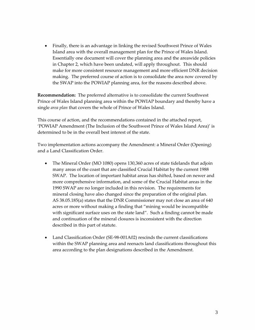
• Finally, there is an advantage in linking the revised Southwest Prince of Wales Island area with the overall management plan for the Prince of Wales Island. Essentially one document will cover the planning area and the areawide policies in Chapter 2, which have been undated, will apply throughout. This should make for more consistent resource management and more efficient DNR decision making. The preferred course of action is to consolidate the area now covered by the SWAP into the POWIAP planning area, for the reasons described above.
Recommendation: The preferred alternative is to consolidate the current Southwest Prince of Wales Island planning area within the POWIAP boundary and thereby have a single area plan that covers the whole of Prince of Wales Island. This course of action, and the recommendations contained in the attached report, ‘POWIAP Amendment (The Inclusion of the Southwest Prince of Wales Island Area)’ is determined to be in the overall best interest of the state. Two implementation actions accompany the Amendment: a Mineral Order (Opening) and a Land Classification Order.
• The Mineral Order (MO 1080) opens 130,360 acres of state tidelands that adjoin many areas of the coast that are classified Crucial Habitat by the current 1988 SWAP. The location of important habitat areas has shifted, based on newer and more comprehensive information, and some of the Crucial Habitat areas in the 1990 SWAP are no longer included in this revision. The requirements for mineral closing have also changed since the preparation of the original plan. AS 38.05.185(a) states that the DNR Commissioner may not close an area of 640 acres or more without making a finding that “mining would be incompatible with significant surface uses on the state land”. Such a finding cannot be made and continuation of the mineral closures is inconsistent with the direction described in this part of statute.
• Land Classification Order (SE‐98‐001A02) rescinds the current classifications
within the SWAP planning area and reenacts land classifications throughout this area according to the plan designations described in the Amendment.
3
Evaluation of AS 38.04.065(b) Requirements: This section of statute requires that certain factors be considered as part of a ‘plan revision’. A Plan Amendment is considered a type of plan revision. These requirements, and action considerations of the requirements, are described below.
• Multiple Use and Sustained Yield. The planning area was thoroughly evaluated for its multiple use values and the distribution of uses reflected in the recommended plan designations represents, to DNR, the best distribution of these values within the planning region. The selected management approach satisfies the consideration of sustained yield.
• Evaluation of physical, economic, and social factors. These factors were
considered in determining plan designations and management intent for each of the state land units. Extensive resource research of tideland and upland areas preceded the identification of plan designations. The economic factors influencing the planning area were also considered and played a large part in the assignment of plan designations. Social factors were identified in initial scoping meetings and were under further consideration during the public review process.
• Planning and classification for settlement. Because of the relatively few upland
parcels within the planning area, a comprehensive land disposal program cannot occur. However, these parcels were evaluated for their settlement potential and several parcels, or parts of these, were identified for remote settlement.
• Land inventory. A land inventory was prepared as part of the Amendment.
• Alternative present and future uses. State land units were evaluated for possible
present and future uses and were assigned plan designations based upon a consideration of how the parcel is used currently and its best future use. In general, areas were designated Forestry if there was a current authorization for a Log Transfer Facility or if a LTF is identified in the Memorandum of Understanding between the U.S. Forest Service and State of Alaska (ADL 107516). Areas were designated either Shoreline Development or Waterfront Development if the current use was residential or commercial/industrial or if adopted plans indicated the preference for such uses in the future. Areas were assigned Wildlife Habitat (and Harvest) if they demonstrated the presence of sensitive habitat resources that met the requirements of such uses in Chapter 2 of the POWIAP or were important for either commercial or personal use.
4
• Adjacent non-state lands. Land status information was reviewed during plan revision; most adjacent lands are either owned by native corporations/organizations or are within the Tongass National Forest.
• Potential conflicts between mining and surface uses. This potential conflict was evaluated and a Mineral Order (Opening) is recommended since inconsistencies between surface uses and mining could not be discerned in tideland areas now classified Wildlife Habitat.
• Public participation. The public was given the opportunity to comment on this amendment. Interdisciplinary considerations were evaluated in the preparation of plan designations. Agencies participated in the development of these designations and reviewed the initial designations.
Approval
I have reviewed the Plan Amendment and find that it is in the best interests of the state to proceed with the preferred alternative which is more specifically described in the report, Prince of Wales Island Area Plan Amendment (The Inclusion of the Southwest Prince of Wales Island Area). I hereby approve this Plan Amendment.
The date of issuance for this decision shall be May 29, 2008.
\,.. Tom Irwin, Commissioner DEPARTMENT OF NATURAL RESOURCES
5

Prince of Wales Island
Area Plan Amendment
(The Inclusion of the
Southwest Prince of Wales Island Area) The Report May 2008
Alaska Department of Natural Resources
Division of Mining, Land & Water Resource Assessment & Development Section
DEPARTMENT OF NATURAL RESOURCES
OFFICE OF THE COMMISSIONER
SARAH PALIN, GOVERNOR
o P.O. BOX 111000 JUNEAU, ALASKA 99811-1000 PHONE: (907) 465-2400 FAX: (907) 465-3886
o 550 WEST yTH AVENUE, SUITE 1400 ANCHORAGE, ALASKA 99501-3650
PHONE: (90Y) 269-8431 FAX. (907) 269-8918
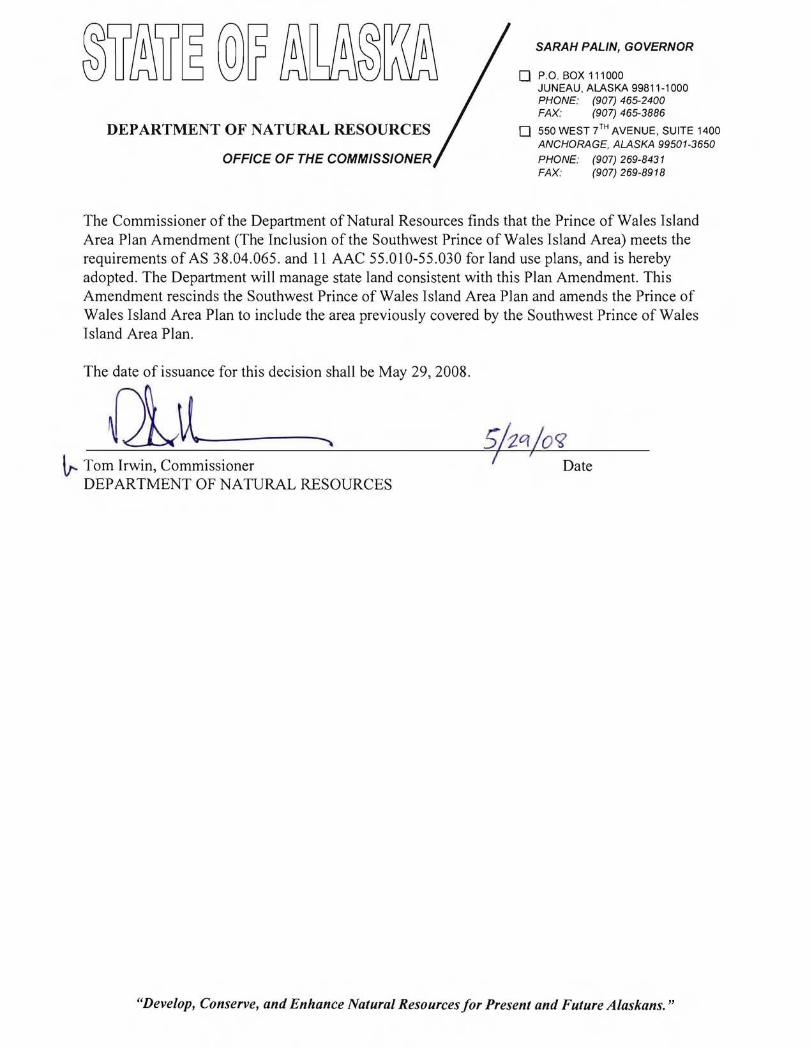
The Commissioner of the Department of Natural Resources finds that the Prince of Wales Island Area Plan Amendment (The Inclusion of the Southwest Prince of Wales Island Area) meets the requirements of AS 38.04.065. and II AAC 55.010-55.030 for land use plans, and is hereby adopted. The Department will manage state land consistent with this Plan Amendment. This Amendment rescinds the Southwest Prince of Wales Island Area Plan and amends the Prince of Wales Island Area Plan to include the area previously covered by the Southwest Prince of Wales Island Area Plan.
The date of issuance for this decision shall be May 29, 2008.
Ql~-~ ~ Tom Irwin, Commissioner
DEPARTMENT OF NATURAL RESOURCES
"Develop, Conserve, and Enhance Natural Resources for Present and Future Alaskans. "

TABLE OF CONTENTS
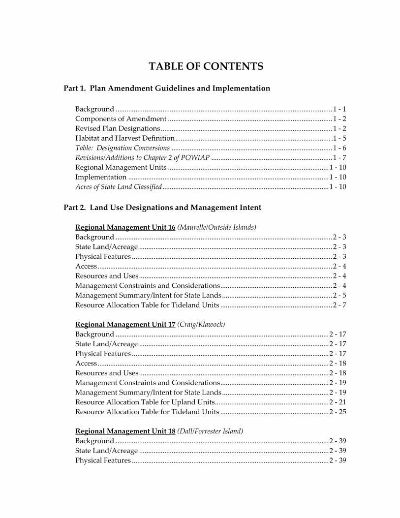
TABLE OF CONTENTS
Part 1. Plan Amendment Guidelines and Implementation
Background ........................................................................................................................1 ‐ 1 Components of Amendment ...........................................................................................1 ‐ 2 Revised Plan Designations...............................................................................................1 ‐ 2 Habitat and Harvest Definition...................................................................................... .1 ‐ 5 Table: Designation Conversions .........................................................................................1 ‐ 6 Revisions/Additions to Chapter 2 of POWIAP ...................................................................1 ‐ 7 Regional Management Units .........................................................................................1 ‐ 10 Implementation ...............................................................................................................1 ‐ 10 Acres of State Land Classified ............................................................................................1 ‐ 10
Part 2. Land Use Designations and Management Intent
Regional Management Unit 16 (Maurelle/Outside Islands) Background ........................................................................................................................2 ‐ 3 State Land/Acreage ...........................................................................................................2 ‐ 3 Physical Features ...............................................................................................................2 ‐ 3 Access..................................................................................................................................2 ‐ 4 Resources and Uses...........................................................................................................2 ‐ 4 Management Constraints and Considerations..............................................................2 ‐ 4 Management Summary/Intent for State Lands.............................................................2 ‐ 5 Resource Allocation Table for Tideland Units ..............................................................2 ‐ 7 Regional Management Unit 17 (Craig/Klawock) Background ......................................................................................................................2 ‐ 17 State Land/Acreage .........................................................................................................2 ‐ 17 Physical Features .............................................................................................................2 ‐ 17 Access................................................................................................................................2 ‐ 18 Resources and Uses.........................................................................................................2 ‐ 18 Management Constraints and Considerations............................................................2 ‐ 19 Management Summary/Intent for State Lands...........................................................2 ‐ 19 Resource Allocation Table for Upland Units...............................................................2 ‐ 21 Resource Allocation Table for Tideland Units ............................................................2 ‐ 25 Regional Management Unit 18 (Dall/Forrester Island) Background ......................................................................................................................2 ‐ 39 State Land/Acreage .........................................................................................................2 ‐ 39 Physical Features .............................................................................................................2 ‐ 39
Access.................................................................................................................................2 ‐ 40 Resources and Uses ........................................................................................................ 2 ‐ 40 Management Constraints and Considerations ........................................................... 2 ‐ 40 Management Summary/Intent for State Lands .......................................................... 2 ‐ 41 Resource Allocation Table for Upland Units .............................................................. 2 ‐ 43 Resource Allocation Table for Tideland Units............................................................ 2 ‐ 45 Regional Management Unit 19 (Hydaburg/Cordova Bay) Background...................................................................................................................... 2 ‐ 67 State Land/Acreage......................................................................................................... 2 ‐ 67 Physical Features............................................................................................................. 2 ‐ 67 Access ............................................................................................................................... 2 ‐ 68 Resources and Uses ........................................................................................................ 2 ‐ 68 Management Constraints and Considerations ........................................................... 2 ‐ 68 Management Summary/Intent for State Lands .......................................................... 2 ‐ 69 Resource Allocation Table for Upland Units .............................................................. 2 ‐ 71 Resource Allocation Table for Tideland Units............................................................ 2 ‐ 73
Appendices
Appendix A Land Classification Order SE‐98‐001A02...................................................................... A ‐ 1 Appendix B Mineral Order 1080...........................................................................................................B ‐ 1 Administrative Finding by the Commissioner .............................................................B ‐ 3
List of Maps
Map 1: Southwest Prince of Wales Island Area and Regional Management Units ........................................................................................................ 2 ‐ 1 Map 2: Regional Management Unit 16 ....................................................................... 2 ‐ 15 Map 3: Regional Management Unit 17 ....................................................................... 2 ‐ 37 Map 4: Regional Management Unit 18 (North)........................................................ 2 ‐ 63 Map 5: Regional Management Unit 18 (South) ........................................................ 2 ‐ 65 Map 6: Regional Management Unit 19 (North)........................................................ 2 ‐ 95 Map 7: Regional Management Unit 19 (South) ........................................................ 2 ‐ 97
PART 1
Plan Amendment Guidelines and Implementation Background...............................................................................................................................1 ‐ 1 Components of Amendment..................................................................................................1 ‐ 2 Revised Plan Designations .....................................................................................................1 ‐ 2 Habitat and Harvest Definition .............................................................................................1 ‐ 5 Designation Conversion Table....................................................................................................1 ‐ 6 Revisions/Additions to Chapter 2 of POWIAP....................................................................1 ‐ 7 Regional Management Units...........................................................................................….1 ‐ 10 Implementation ................................................................................................................... ...1 ‐ 10 Acres of State Land Classified..............................................................................................1 ‐ 10
Part 1: Plan Amendment Guidelines and Implementation
PRINCE OF WALES ISLAND AREA PLAN AMENDMENT
(INCLUSION OF THE SOUTHWEST PRINCE OF WALES ISLAND AREA)
Background: The Prince of Wales Island Area Plan (POWIAP) was adopted in 1985 and then revised in 1998. The Southwest Prince of Wales Island Area Plan (SWAP) was first adopted in 1985, and then amended in 1988 to incorporate proposed land selections and land relinquishments, and other changes developed through the POWIAP process. The POWIAP covers the entirety of the Prince of Wales Island area, with the exception of the southwest part of the island, which has, until this revision, been covered by a separate area plan, the SWAP. This Plan Amendment rescinds the 1988 SWAP and amends the current POWIAP to include the area previously covered by the SWAP. The effect of this action will be to include the entirety of the Prince of Wales Island under one area plan. A single plan makes sense since the island is generally uniform and a common management approach is desirable. Since the adoption of the SWAP there have been fundamental changes that have affected the planning area. These include changes to the region’s economic base, the technology of timber harvest, the type and intensity of commercial fishing practices, and, very significantly, land status and land ownership. Over this time the region has become increasingly less dependent on timber harvest and there is little use of the A‐frame logging method. Large acreages of federal land has been conveyed under Alaska Native Claims Settlement Act (ANCSA) to the native corporations within the planning area and the U.S. Forest Service has revised the Tongass Land Management Plan, changing the patterns of desired land management and making many areas unavailable to logging that were previously authorized for this use. Commercial fisheries have also changed significantly, with declines in commercial crabbing and changes in the method of halibut harvest with the introduction of the Individual Fishing Quotas. These and other factors have changed the basic assumptions used in the preparation of the initial SWAP, making it much less useful as the basis for Department of Natural Resources (DNR) decision making and forcing its reevaluation. The Department recognizes the dynamic nature of economic conditions, policy, and technology change within regions and provides for the reevaluation of area plans on a 15 to 20 year cycle. The SWAP fits within this reevaluation planning horizon. In order to avoid reprinting the whole POWIAP while maintaining a clear record of the changes that are being enacted, this stand‐alone document has been prepared. This document constitutes the Plan Amendment. Map 1 depicts the planning area; it coincides with the planning area of the former 1988 SWAP.
Prince of Wales Island May 2008 1 - 1 Area Plan Amendment
Part 1: Plan Amendment Guidelines and Implementation
Components of Amendment: This plan revision has been structured to use the pertinent parts of the current POWIAP where they remain applicable and augment Chapter 3 of the current POWIAP to add four additional regional management units, bringing to 19 the total number of such units in the POWIAP. The part of POWIAP which remains particularly relevant, and specifically applies to this Amendment, is Chapter 2 of the POWIAP. This Chapter provides area‐wide policies and management guidelines for the management of natural resources and typical uses within the planning area, including the area covered by this Amendment. This Amendment does not, however, change or affect the management of units and or the area‐wide policies for the lands already contained within the 1998 POWIAP. The management direction in this Amendment including the revisions to chapter 2 of POWIAP shall only be applied to the Southwest Prince of Wales Island Area covered by this Amendment. Revisions to chapter 2 area‐wide policies are contained on page 1‐6 of the Amendment under the heading Revisions to Chapter 2. The bulk of the information that follows focuses on the four additional regional management units. (See Part 2: Land Use Designations and Management Intent) Each is described in terms of its regional characteristics and overall management intent. This is followed by a Resource Allocation Table that, for each unit of state upland or tideland, identifies a plan designation, provides resource and related pertinent information, and identifies specific management intent. In certain instances the Resource Allocation Table also provides specific management guidelines and an identification of conditional and prohibited uses. Revised Plan Designations: This 2008 Amendment differs from the former SWAP and current POWIAP in the plan designations that are used and in the components of what constitutes crucial resources under the Habitat designation. Plan Designations. The following plan designations are used; their application to uplands and tidelands are also noted. These designations apply only to the Plan Amendment. They do not apply to the remainder of the POWIAP. Only those designations that are used in the Amendment are described.
1 - 2 May 2008 Prince of Wales Island Area Plan Amendment
Part 1: Plan Amendment Guidelines and Implementation
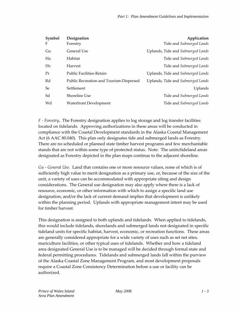
Symbol Designation Application F Forestry Tide and Submerged Lands
Gu General Use Uplands, Tide and Submerged Lands
Ha Habitat Tide and Submerged Lands
Hv Harvest Tide and Submerged Lands
Pr Public Facilities‐Retain Uplands, Tide and Submerged Lands
Rd Public Recreation and Tourism‐Dispersed Uplands, Tide and Submerged Lands
Se Settlement Uplands
Sd Shoreline Use Tide and Submerged Lands
Wd Waterfront Development Tide and Submerged Lands F ‐ Forestry. The Forestry designation applies to log storage and log transfer facilities located on tidelands. Approving authorizations in these areas will be conducted in compliance with the Coastal Development standards in the Alaska Coastal Management Act (6 AAC 80.040). This plan only designates tide and submerged lands as Forestry. There are no scheduled or planned state timber harvest programs and few merchantable stands that are not within some type of protected status. Note: The units/tideland areas designated as Forestry depicted in the plan maps continue to the adjacent shoreline. Gu ‐ General Use. Land that contains one or more resource values, none of which is of sufficiently high value to merit designation as a primary use, or, because of the size of the unit, a variety of uses can be accommodated with appropriate siting and design considerations. The General use designation may also apply where there is a lack of resource, economic, or other information with which to assign a specific land use designation, and/or the lack of current demand implies that development is unlikely within the planning period. Uplands with appropriate management intent may be used for timber harvest. This designation is assigned to both uplands and tidelands. When applied to tidelands, this would include tidelands, shorelands and submerged lands not designated in specific tideland units for specific habitat, harvest, economic, or recreation functions. These areas are generally considered appropriate for a wide variety of uses such as set net sites, mariculture facilities, or other typical uses of tidelands. Whether and how a tideland area designated General Use is to be managed will be decided through formal state and federal permitting procedures. Tidelands and submerged lands fall within the purview of the Alaska Coastal Zone Management Program, and most development proposals require a Coastal Zone Consistency Determination before a use or facility can be authorized.
Prince of Wales Island May 2008 1 - 3 Area Plan Amendment
Part 1: Plan Amendment Guidelines and Implementation
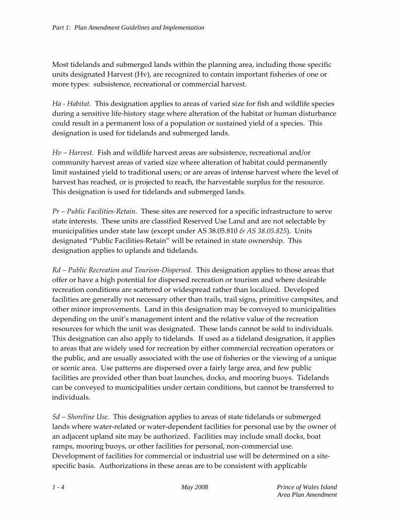
Most tidelands and submerged lands within the planning area, including those specific units designated Harvest (Hv), are recognized to contain important fisheries of one or more types: subsistence, recreational or commercial harvest. Ha ‐ Habitat. This designation applies to areas of varied size for fish and wildlife species during a sensitive life‐history stage where alteration of the habitat or human disturbance could result in a permanent loss of a population or sustained yield of a species. This designation is used for tidelands and submerged lands. Hv – Harvest. Fish and wildlife harvest areas are subsistence, recreational and/or community harvest areas of varied size where alteration of habitat could permanently limit sustained yield to traditional users; or are areas of intense harvest where the level of harvest has reached, or is projected to reach, the harvestable surplus for the resource. This designation is used for tidelands and submerged lands. Pr – Public Facilities‐Retain. These sites are reserved for a specific infrastructure to serve state interests. These units are classified Reserved Use Land and are not selectable by municipalities under state law (except under AS 38.05.810 & AS 38.05.825). Units designated “Public Facilities‐Retain” will be retained in state ownership. This designation applies to uplands and tidelands. Rd – Public Recreation and Tourism‐Dispersed. This designation applies to those areas that offer or have a high potential for dispersed recreation or tourism and where desirable recreation conditions are scattered or widespread rather than localized. Developed facilities are generally not necessary other than trails, trail signs, primitive campsites, and other minor improvements. Land in this designation may be conveyed to municipalities depending on the unit’s management intent and the relative value of the recreation resources for which the unit was designated. These lands cannot be sold to individuals. This designation can also apply to tidelands. If used as a tideland designation, it applies to areas that are widely used for recreation by either commercial recreation operators or the public, and are usually associated with the use of fisheries or the viewing of a unique or scenic area. Use patterns are dispersed over a fairly large area, and few public facilities are provided other than boat launches, docks, and mooring buoys. Tidelands can be conveyed to municipalities under certain conditions, but cannot be transferred to individuals. Sd – Shoreline Use. This designation applies to areas of state tidelands or submerged lands where water‐related or water‐dependent facilities for personal use by the owner of an adjacent upland site may be authorized. Facilities may include small docks, boat ramps, mooring buoys, or other facilities for personal, non‐commercial use. Development of facilities for commercial or industrial use will be determined on a site‐specific basis. Authorizations in these areas are to be consistent with applicable
1 - 4 May 2008 Prince of Wales Island Area Plan Amendment
Part 1: Plan Amendment Guidelines and Implementation
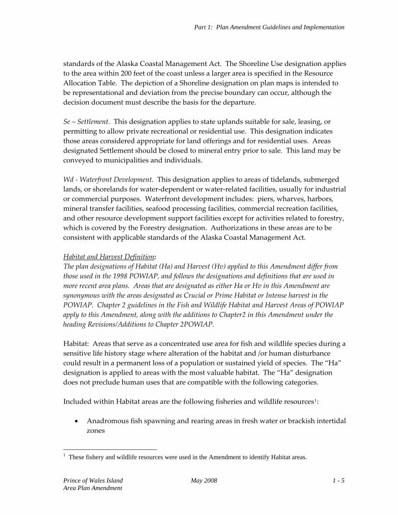
standards of the Alaska Coastal Management Act. The Shoreline Use designation applies to the area within 200 feet of the coast unless a larger area is specified in the Resource Allocation Table. The depiction of a Shoreline designation on plan maps is intended to be representational and deviation from the precise boundary can occur, although the decision document must describe the basis for the departure. Se – Settlement. This designation applies to state uplands suitable for sale, leasing, or permitting to allow private recreational or residential use. This designation indicates those areas considered appropriate for land offerings and for residential uses. Areas designated Settlement should be closed to mineral entry prior to sale. This land may be conveyed to municipalities and individuals. Wd ‐ Waterfront Development. This designation applies to areas of tidelands, submerged lands, or shorelands for water‐dependent or water‐related facilities, usually for industrial or commercial purposes. Waterfront development includes: piers, wharves, harbors, mineral transfer facilities, seafood processing facilities, commercial recreation facilities, and other resource development support facilities except for activities related to forestry, which is covered by the Forestry designation. Authorizations in these areas are to be consistent with applicable standards of the Alaska Coastal Management Act. Habitat and Harvest Definition: The plan designations of Habitat (Ha) and Harvest (Hv) applied to this Amendment differ from those used in the 1998 POWIAP, and follows the designations and definitions that are used in more recent area plans. Areas that are designated as either Ha or Hv in this Amendment are synonymous with the areas designated as Crucial or Prime Habitat or Intense harvest in the POWIAP. Chapter 2 guidelines in the Fish and Wildlife Habitat and Harvest Areas of POWIAP apply to this Amendment, along with the additions to Chapter2 in this Amendment under the heading Revisions/Additions to Chapter 2POWIAP. Habitat: Areas that serve as a concentrated use area for fish and wildlife species during a sensitive life history stage where alteration of the habitat and /or human disturbance could result in a permanent loss of a population or sustained yield of species. The “Ha” designation is applied to areas with the most valuable habitat. The “Ha” designation does not preclude human uses that are compatible with the following categories. Included within Habitat areas are the following fisheries and wildlife resources1:
• Anadromous fish spawning and rearing areas in fresh water or brackish intertidal
zones
1 These fishery and wildlife resources were used in the Amendment to identify Habitat areas.
Prince of Wales Island May 2008 1 - 5 Area Plan Amendment
Part 1: Plan Amendment Guidelines and Implementation
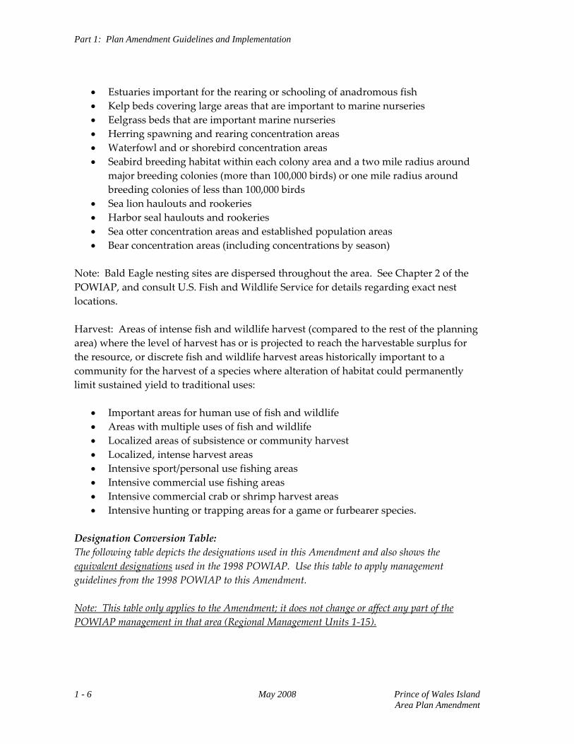
• Estuaries important for the rearing or schooling of anadromous fish • Kelp beds covering large areas that are important to marine nurseries • Eelgrass beds that are important marine nurseries • Herring spawning and rearing concentration areas • Waterfowl and or shorebird concentration areas • Seabird breeding habitat within each colony area and a two mile radius around
major breeding colonies (more than 100,000 birds) or one mile radius around breeding colonies of less than 100,000 birds
• Sea lion haulouts and rookeries • Harbor seal haulouts and rookeries • Sea otter concentration areas and established population areas • Bear concentration areas (including concentrations by season)
Note: Bald Eagle nesting sites are dispersed throughout the area. See Chapter 2 of the POWIAP, and consult U.S. Fish and Wildlife Service for details regarding exact nest locations. Harvest: Areas of intense fish and wildlife harvest (compared to the rest of the planning area) where the level of harvest has or is projected to reach the harvestable surplus for the resource, or discrete fish and wildlife harvest areas historically important to a community for the harvest of a species where alteration of habitat could permanently limit sustained yield to traditional uses:
• Important areas for human use of fish and wildlife • Areas with multiple uses of fish and wildlife • Localized areas of subsistence or community harvest • Localized, intense harvest areas • Intensive sport/personal use fishing areas • Intensive commercial use fishing areas • Intensive commercial crab or shrimp harvest areas • Intensive hunting or trapping areas for a game or furbearer species.
Designation Conversion Table: The following table depicts the designations used in this Amendment and also shows the equivalent designations used in the 1998 POWIAP. Use this table to apply management guidelines from the 1998 POWIAP to this Amendment. Note: This table only applies to the Amendment; it does not change or affect any part of the POWIAP management in that area (Regional Management Units 1‐15).
1 - 6 May 2008 Prince of Wales Island Area Plan Amendment
Part 1: Plan Amendment Guidelines and Implementation
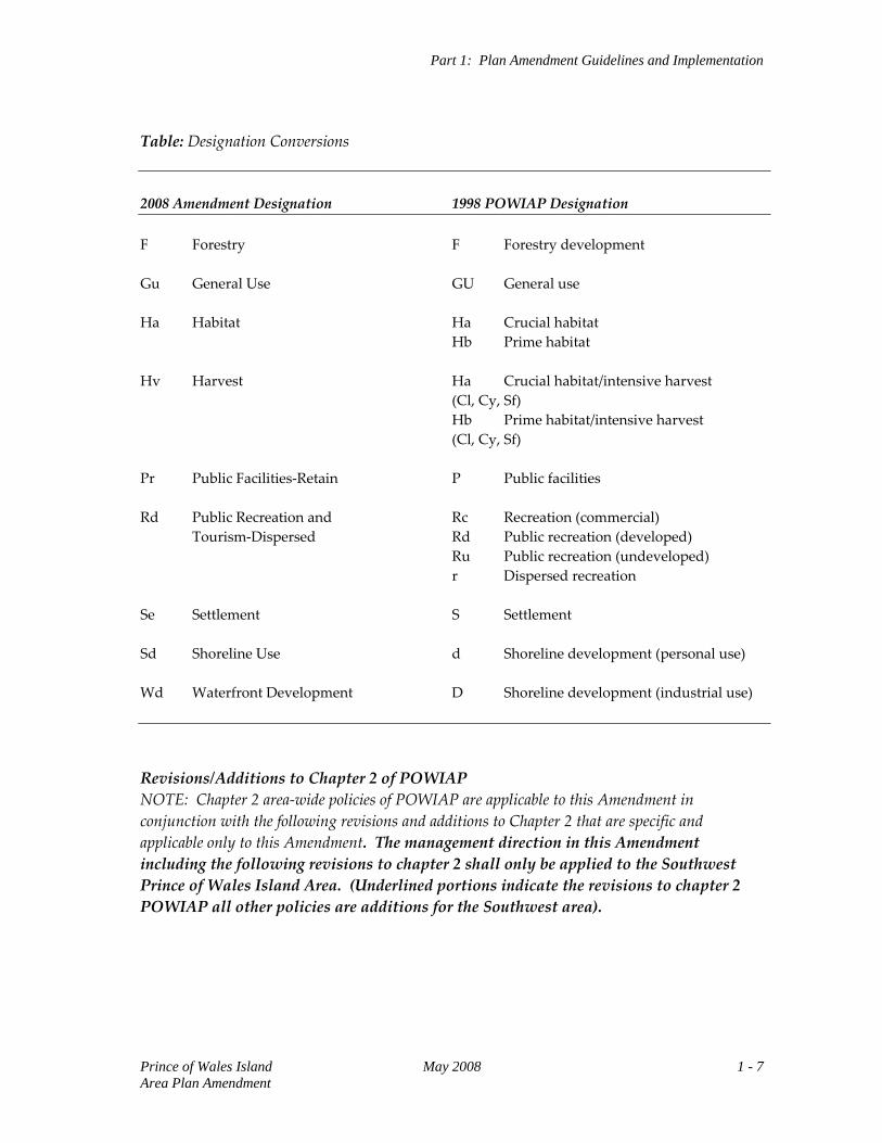
Table: Designation Conversions
2008 Amendment Designation 1998 POWIAP Designation F Forestry F Forestry development Gu General Use GU General use Ha Habitat Ha Crucial habitat Hb Prime habitat Hv Harvest Ha Crucial habitat/intensive harvest (Cl, Cy, Sf) Hb Prime habitat/intensive harvest (Cl, Cy, Sf) Pr Public Facilities‐Retain P Public facilities Rd Public Recreation and Rc Recreation (commercial) Tourism‐Dispersed Rd Public recreation (developed) Ru Public recreation (undeveloped) r Dispersed recreation Se Settlement S Settlement Sd Shoreline Use d Shoreline development (personal use) Wd Waterfront Development D Shoreline development (industrial use) Revisions/Additions to Chapter 2 of POWIAP NOTE: Chapter 2 area‐wide policies of POWIAP are applicable to this Amendment in conjunction with the following revisions and additions to Chapter 2 that are specific and applicable only to this Amendment. The management direction in this Amendment including the following revisions to chapter 2 shall only be applied to the Southwest Prince of Wales Island Area. (Underlined portions indicate the revisions to chapter 2 POWIAP all other policies are additions for the Southwest area).
Prince of Wales Island May 2008 1 - 7 Area Plan Amendment
Part 1: Plan Amendment Guidelines and Implementation
Fish and Wildlife Habitat and Harvest Areas I. MANAGEMENT GUIDELINES FOR HABITAT AREAS Activities in Important Waterfowl Habitat. In important waterfowl habitat, activities requiring a lease, permit, or development plan, and producing habitat disturbance or high levels of acoustical or visual disturbance from sources such as boat or vehicle traffic, vegetation clearing, construction, blasting, dredging, and seismic operations, will be avoided during sensitive periods such as nesting, staging, or brood‐rearing periods. Where it is not feasible and prudent to avoid such activities, other mitigation measures may be required to avoid significant adverse impacts. Consult with ADF&G to identify areas of important waterfowl in addition to those identified in the tidelands management units in this plan and to determine appropriate mitigation or avoidance measures. Anadromous Stream Mouths within Tidelands. Anadromous stream mouths identified in the ADF&G Catalogue of Waters Important for the Spawning, Rearing, or Migration of Anadromous Fishes and its associated Atlas shall be protected by a management zone. Only activities compatible with the protection or maintenance of anadromous habitats are to be authorized in a zone occurring within a 300 feet radius as measured from MHW at the mouth of these streams. Leases, disposals, and other authorizations should not be approved within this zone unless consultation with ADF&G determines that the proposal is compatible with the intent of protecting anadromous fish resources. Mapped Herring Spawning Areas. Herring spawning areas that are depicted on the planning maps shall be protected by a management zone. Consult ADF&G prior to authorization issuance to determine exact locations and if a potential authorization could adversely affect spawning management areas that encompass an area approximately 1500ft seaward of the coast, though may extend further. Authorizations that could adversely affect herring spawning areas are to be relocated or if no feasible alternative exists, stipulations are to be applied that minimize or mitigate adverse affects. Seabird Colonies and Marine Mammal Rookeries and Haulouts. Seabird colonies, sea lion, and harbor seal haulouts and rookeries shall not be physically altered. Structures or activities that would preclude or significantly interfere with the continued use of these areas should not be authorized and should be situated at least one‐half mile distant from haulouts or seabird colonies. Uses with high levels of acoustical or visual disturbance should not be allowed within: one mile of seabird colonies from April 1 through September 30; and one‐half mile of sea lion and harbor seal haulouts year round. Consult with the U.S. Fish and Wildlife Service, National Marine Fisheries Service, and ADF&G prior to granting authorizations to identify marine mammal haulout, rookery and seabird colony locations more specifically and to define minimum distance separation requirements and specific use restrictions. Consult the ‘Resources & Uses’ section of tideland management units in the Resource Allocation Tables to determine haulouts, rookeries, or seabird colonies likely to be present within areas of an identified tideland unit.
1 - 8 May 2008 Prince of Wales Island Area Plan Amendment
Part 1: Plan Amendment Guidelines and Implementation
Individual marine mammal haulouts and rookeries and seabird colonies not contained within state protected tideland areas2 are designated Habitat (Ha) and are to be managed according to Management Guideline B, ‘Allowing Uses in Fish and Wildlife Habitats (Ha)’ and the restrictions described above. II. MANAGEMENT GUIDELINES FOR HARVEST AREAS Avoidance of Conflicts with Traditional Users of Fish and Game. Where feasible and prudent, surface activities authorized under permit or lease are to avoid significant conflicts with local subsistence harvests and other traditional uses of fish and wildlife resources. Consult with ADF&G and local Fish and Game Advisory Committee to identify potential conflicts and determine seasonal or other restrictions. Floating Facilities MANAGEMENT GUIDELINES D. Sitting: Floathomes within or near Sensitive Uses, Habitats, or Resources. The following is added to the above management guideline in POWIAP (Chapter 2‐Page 11) Other areas that contain important habitat or resources described in the habitat definition that have protection language in the RAT’s and reside in other units, such as Gu will require consultation with ADF&G prior to any authorization issuance. Forestry MANAGEMENT GUIDELINES C. Log Transfer Facilities and Sort Yards. The following is added to the above management guideline in POWIAP (Chapter 2‐Page 15) They must also be consistent with General NPDES Permit No. AK‐G70‐1000, or successors to this General Permit, which establish specific standards for these types of facilities. Within the area of Regional Management Units 16‐19 (The Amendment), certain additional stipulations to the sitting of these facilities and Marine Access Points are pertinent. a. Log Transfer Facilities and Sort Yards. These management units are affected by the
Plan Amendment (2008) that revised the locations considered appropriate for these facilities, decreasing the size of areas previously classified Forestry and making them generally fit the probable site of a LTF. Since the location of these areas may change
2 The term ‘state protected areas’ includes state game refuges, state game sanctuaries, and state critical habitat areas.
Prince of Wales Island May 2008 1 - 9 Area Plan Amendment
Part 1: Plan Amendment Guidelines and Implementation
as a result of newer information and the adjudication process, the boundaries of areas designated Forestry are approximate and flexibility in the interpretation of these boundaries as part of an adjudicatory decision is considered appropriate. It is also intended that, even though an area may be designated Forestry on plan maps, future authorizations of these facilities are subject to a DNR best interest determination under AS 38.05.035(e) or to a decision under a similar authority and that these decisions may determine that a use is inappropriate at a particular site.
b. Marine Access Points. A Marine Access Point is a facility derived from a Memorandum of Understanding between the U.S. Forest Service and the State of Alaska3. These facilities are identified on plan maps as point locations. As such, they are “a facility that is constructed or may be constructed in marine or inland waters and is utilized for the purpose of providing public access to adjacent National Forest System lands and facilities. Such facilities may include docks, boat ramps, floats, buoys, anchors, breakwaters, boat haul outs, and similar improvements and facilities”.
Regional Management Units. The 2008 Amendment adds the following four regional management units to the 1998 POWIAP: Maurelle/Outside Islands, Craig/Klawock, Dall/Forrester Island, and Hydaburg/Cordova Bay. Map 1 depicts the boundaries of these regional management units. Further information on these regions follows, including plan designation, management intent, and management guideline information for specific management units with each region. The information that follows is to be consulted by DNR adjudicators in the granting of authorizations and in other forms of DNR decision‐making. Implementation. Associated with the 2008 Amendment are Mineral Order 1080 (Opening) and Land Classification Order SE‐98‐001A02. Mineral Order 1080 opens 136,360 acres of tidelands that had been previously closed to mineral entry. The Crucial Habitat designation, used as the basis for the mineral closure in the original SWAP, is not used in the 2008 Amendment. Moreover, the number and location of areas designated Habitat has changed from the 1988 SWAP. AS.38.05.300 and AS 38.05.185 requires that a finding be made that subsurface uses would be inconsistent with surface uses, and this requirement cannot be met. This statutory requirement was initiated in 1993, well after the approval of the original plan. The Land Classification Order (LCO SE‐98‐001A02) rescinds all previous land classifications in the planning area and creates land classifications consistent with the plan designations of this Amendment. Acres of State Land Classified The following tables identify acreages associated with the designations in this Amendment, Designations‐Conversions to Classifications and total acres of state lands classified.
3 State of Alaska Agreement No. ADL 107516.
1 - 10 May 2008 Prince of Wales Island Area Plan Amendment
Part 1: Plan Amendment Guidelines and Implementation
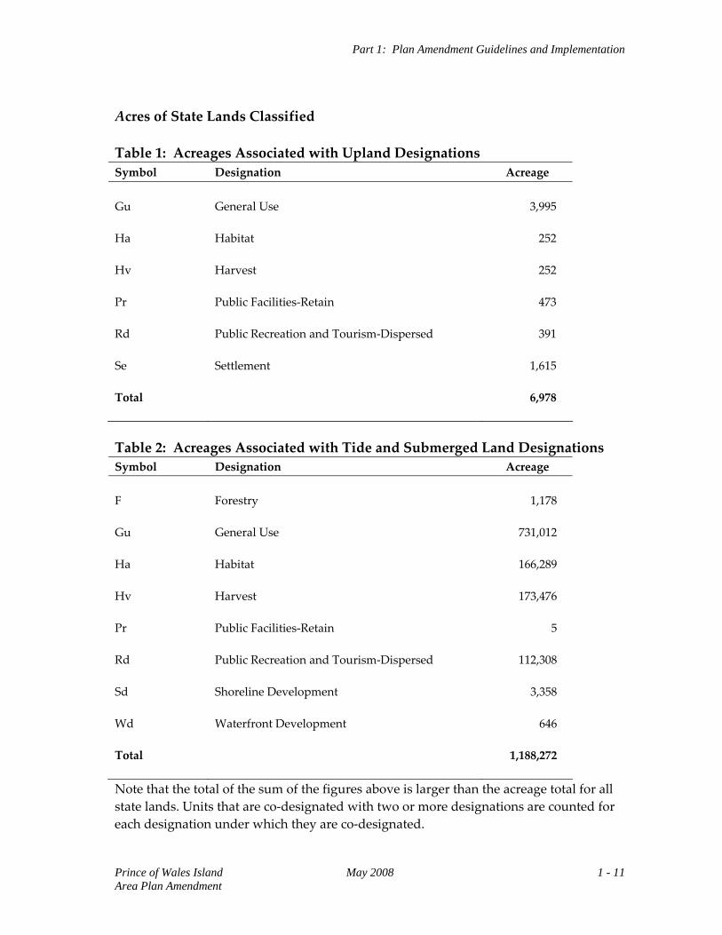
Acres of State Lands Classified Table 1: Acreages Associated with Upland Designations Symbol Designation Acreage Gu Ha Hv Pr Rd Se Total
General Use Habitat Harvest Public Facilities‐Retain Public Recreation and Tourism‐Dispersed Settlement
3,995 252 252 473 391 1,615 6,978
Table 2: Acreages Associated with Tide and Submerged Land Designations Symbol Designation Acreage F Gu Ha Hv Pr Rd Sd Wd Total
Forestry General Use Habitat Harvest Public Facilities‐Retain Public Recreation and Tourism‐Dispersed Shoreline Development Waterfront Development
1,178 731,012 166,289 173,476 5 112,308 3,358 646 1,188,272
Note that the total of the sum of the figures above is larger than the acreage total for all state lands. Units that are co‐designated with two or more designations are counted for each designation under which they are co‐designated.
Prince of Wales Island May 2008 1 - 11 Area Plan Amendment
Part 1: Plan Amendment Guidelines and Implementation
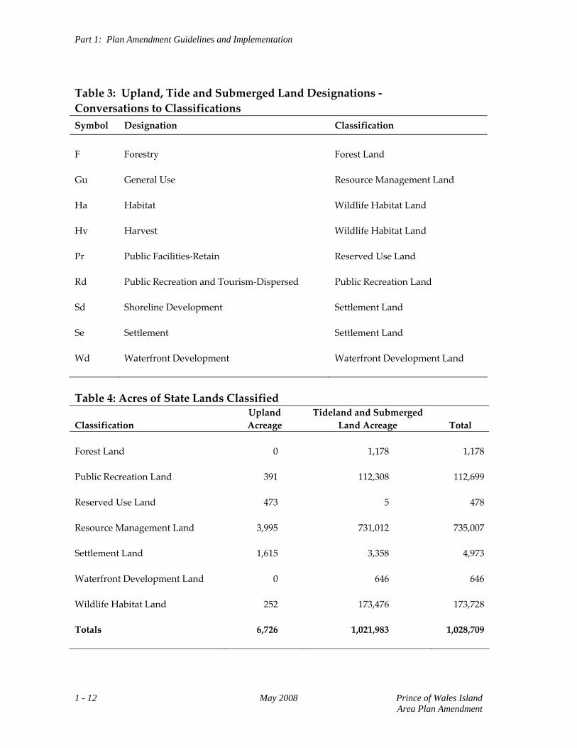
Table 3: Upland, Tide and Submerged Land Designations ‐ Conversations to Classifications Symbol Designation Classification
F Gu Ha Hv Pr Rd Sd Se Wd
Forestry General Use Habitat Harvest Public Facilities‐Retain Public Recreation and Tourism‐Dispersed Shoreline Development Settlement Waterfront Development
Forest Land Resource Management Land Wildlife Habitat Land Wildlife Habitat Land Reserved Use Land Public Recreation Land Settlement Land Settlement Land Waterfront Development Land
Table 4: Acres of State Lands Classified Classification
Upland Acreage
Tideland and Submerged Land Acreage
Total
Forest Land Public Recreation Land Reserved Use Land Resource Management Land Settlement Land Waterfront Development Land Wildlife Habitat Land Totals
0 391 473 3,995 1,615 0 252 6,726
1,178 112,308 5 731,012 3,358 646 173,476 1,021,983
1,178 112,699 478 735,007 4,973 646 173,728 1,028,709
1 - 12 May 2008 Prince of Wales Island Area Plan Amendment
PART 2
Land Use Designations and Management Intent
Map 1: Southwest Prince of Wales Island Planning Area and Regional Management Units ..............................................................................................................2 ‐ 1 Regional Management Unit 16 (Maurelle/Outside Islands) Background ........................................................................................................................2 ‐ 3 State Land/Acreage ...........................................................................................................2 ‐ 3 Physical Features ...............................................................................................................2 ‐ 3 Access..................................................................................................................................2 ‐ 4 Resources and Uses...........................................................................................................2 ‐ 4 Management Constraints and Considerations..............................................................2 ‐ 4 Management Summary/Intent for State Lands.............................................................2 ‐ 5 Resource Allocation Table forTideland Units ...............................................................2 ‐ 7 Map 2: Management Unit 16 ..............................................................................................2 ‐ 15 Regional Management Unit 17 (Craig/Klawock) Background ......................................................................................................................2 ‐ 17 State Land/Acreage .........................................................................................................2 ‐ 17 Physical Features .............................................................................................................2 ‐ 17 Access................................................................................................................................2 ‐ 18 Resources and Uses.........................................................................................................2 ‐ 18 Management Constraints and Considerations............................................................2 ‐ 19 Management Summary/Intent for State Lands...........................................................2 ‐ 19 Resource Allocation Table for Upland Units...............................................................2 ‐ 21 Resource Allocation Table for Tideland Units ............................................................2 ‐ 25 Map 3: Management Unit 17 ..............................................................................................2 ‐ 37 Regional Management Unit 18 (Dall/Forrester Island)
Background ......................................................................................................................2 ‐ 39 State Land/Acreage .........................................................................................................2 ‐ 39 Physical Features .............................................................................................................2 ‐ 39 Access................................................................................................................................2 ‐ 40 Resources and Uses.........................................................................................................2 ‐ 40
Management Constraints and Considerations ........................................................... 2 ‐ 40 Management Summary/Intent for State Lands .......................................................... 2 ‐ 41 Resource Allocation Table for Upland Units .............................................................. 2 ‐ 43 Resource Allocation Table for Tideland Units............................................................ 2 ‐ 45 Map 4: Management Unit 18 (North) ............................................................................... 2 ‐ 63 Map 5: Management Unit 18 (South) ............................................................................... 2 ‐ 65 Regional Management Unit 19 (Hydaburg/Cordova Bay) Background...................................................................................................................... 2 ‐ 67 State Land/Acreage......................................................................................................... 2 ‐ 67 Physical Features............................................................................................................. 2 ‐ 67 Access ............................................................................................................................... 2 ‐ 68 Resources and Uses ........................................................................................................ 2 ‐ 68 Management Constraints and Considerations ........................................................... 2 ‐ 68 Management Summary/Intent for State Lands .......................................................... 2 ‐ 69 Resource Allocation Table for Upland Units .............................................................. 2 ‐ 71 Resource Allocation Table for Tideland Units............................................................ 2 ‐ 73 Map 6: Management Unit 19 (North) ............................................................................... 2 ‐ 95 Map 7: Management Unit 19 (South) ............................................................................... 2 ‐ 97
Regional Management Unit 16 Maurelle/Outside Islands
MAP 1: Southwest Prince of Wales Island
Planning Area and Regional Management Units
Prince of Wales Island May 2008 2 - 1 Area Plan Amendment
Regional Management Unit 16 Maurelle/Outside Islands
REGIONAL MANAGEMENT UNIT 16 Maurelle/Outside Islands
Background The Maurelle‐Outside Islands Region consists of extensive areas of state tide and submerged lands. There are no state owned uplands. The region extends from the Maurelle Islands in the north to Cape Bartolome in the south and from Cape Addington (Noyes Island) in the west to the eastern side of San Fernando Island in the east. Most uplands within the region are Tongass National Forest and limited Native Corporation selected or owned lands exist on San Fernando, Noyes and Lulu Islands. Private upland and tidelands also exist in Steamboat Bay, Noyes Island. State Land/Acreage State land within the regional management unit consists entirely of tide and submerged lands. There are nine designated tideland units consisting of approximately 30,978 acres at various locations in the region. In addition to the specific tideland units, approximately 222,984 acres of state tide and submerged lands exist 3 miles seaward from mean high water. Physical Features In general, Noyes and Baker Island are characterized by rugged and mountainous terrain of less than 2000 feet; in contrast the Maurelle, San Fernando and Lulu Islands are characterized by relatively gentle sloping/mountainous terrain. Most of the western coastline of the Outside and Maurelle Islands consists of exposed rocky shores and wave‐cut platforms that have minimal protection from the Pacific Ocean. The inner protected shorelines consist mainly of gravel beaches and estuarine wetlands typically concentrated at the head of bays.
Prince of Wales Island May 2008 2 - 3 Area Plan Amendment
Regional Management Unit 16 Maurelle/Outside Islands
Access Access to the region is entirely by water or air, either by boat or floatplane typically departing from Klawock or Craig. “Hole in the Wall” located in the southern portion of the Maurelle Islands is recognized as an important commercial anchorage. Charter boats also frequent the area transporting locals and visitors typically from Craig for sport fishing and wildlife viewing purposes. Resources and Uses Uses: Commercial fishing is the predominant use of the tide and submerged lands within the region. Commercial fishery harvests include salmon, halibut, geoduck, sea cucumber, Dungeness crab, spawn‐on‐kelp and kelp. Charter sport fishing and wildlife viewing occurs within the region and a United States Forest Service (USFS) cabin located at Point Amargura provides recreation opportunities. Personal use harvests occur within the region especially on the northern and eastern side of San Fernando Island. Resources: The region contains productive and sensitive resources that are typically concentrated within the designated Habitat (Ha) or Harvest (Hv) tideland units. Marine mammal concentrations exist at the Maurelle Islands, Cape Addington, Cape Bartolome, Point Gorda and Portillo Channel. Historically documented herring spawning areas occur all around San Fernando Island and the eastern side of Lulu Island. The region also contains important seabird nesting colonies at Maurelle Islands and Cape Addington and waterfowl/shorebird spring and fall concentration areas at various locations. The region contains numerous bald eagle nesting sites concentrated around the Maurelle Islands and San Fernando Island and anadromous fish bearing streams are spread throughout the region. The Alaska Heritage Resources Survey (AHRS) reports prehistoric heritage sites in or around the region some of which occur in or adjacent to the tideland units. Management Constraints and Considerations The region is located within an unorganized borough, and there are no local comprehensive plans or zoning, and no district coastal plans affecting the area. Most of the adjacent uplands are part of the Tongass National Forest managed by the United States Forest Service (USFS) accordingly to the requirements of the Tongass National Forest Land and Resource Management Plan (TLMP). As per the TLMP the Maurelle Island group is designated Wilderness and the Outside Islands consisting of Noyles, Lulu and Baker Islands is designated LUD II.
2 - 4 May 2008 Prince of Wales Island Area Plan Amendment
Regional Management Unit 16 Maurelle/Outside Islands
Management Summary/Intent for State Lands Tidelands: Tideland areas within Region 16 contain important wildlife habitat and commercial and non‐commercial fishery harvest opportunities. Where these values are especially concentrated spatially the designation of either Habitat (Ha) or Harvest (Hv) is applied or where both resources exist, they are assigned a co‐designation of Habitat/Harvest (Ha Hv). Tidelands with these designations are to be managed so that the resources identified in the specific tideland unit within the Resource Allocation Table are to be maintained and protected. Tideland designated Habitat areas often consists of one or more of the following resources: estuarine wetlands, marine mammal concentrations, shorebirds and waterfowl concentrations, herring spawning areas, high density kelp beds or salmon rearing or spawning areas. Areas designated as Harvest are characterized by commercial salmon, geoduck, sea cucumber, Dungeness crab, kelp and spawn on kelp harvest concentration areas or intensive personal use areas. The remainder of the tidelands within the management region are designated as General Use (Gu), a multiple use designation. It is intended that the standard state/federal permitting procedures will be used to determine whether a particular use or facility is appropriate at a specific site in an area designated General Use.
Prince of Wales Island May 2008 2 - 5 Area Plan Amendment
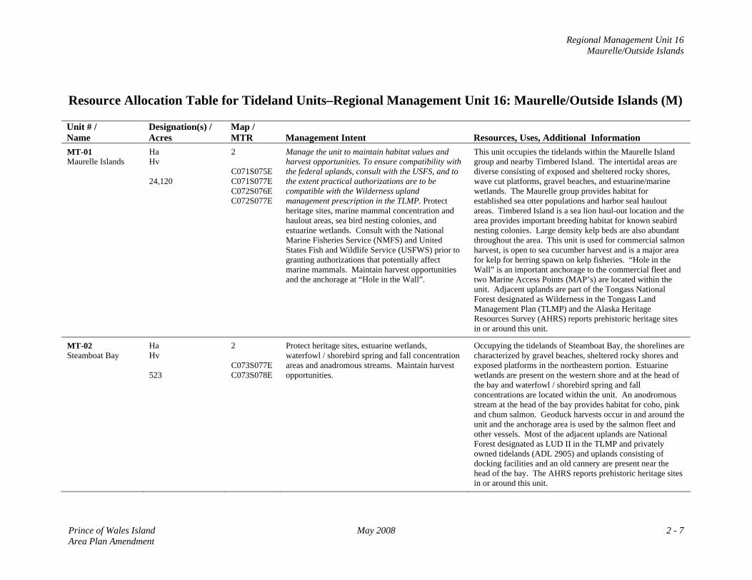
Regional Management Unit 16 Maurelle/Outside Islands
Resource Allocation Table for Tideland Units–Regional Management Unit 16: Maurelle/Outside Islands (M) Unit # / Name
Designation(s) / Acres
Map / MTR
Management Intent
Resources, Uses, Additional Information
MT-01 Maurelle Islands
Ha Hv 24,120
2 C071S075E C071S077E C072S076E C072S077E
Manage the unit to maintain habitat values and harvest opportunities. To ensure compatibility with the federal uplands, consult with the USFS, and to the extent practical authorizations are to be compatible with the Wilderness upland management prescription in the TLMP. Protect heritage sites, marine mammal concentration and haulout areas, sea bird nesting colonies, and estuarine wetlands. Consult with the National Marine Fisheries Service (NMFS) and United States Fish and Wildlife Service (USFWS) prior to granting authorizations that potentially affect marine mammals. Maintain harvest opportunities and the anchorage at “Hole in the Wall”.
This unit occupies the tidelands within the Maurelle Island group and nearby Timbered Island. The intertidal areas are diverse consisting of exposed and sheltered rocky shores, wave cut platforms, gravel beaches, and estuarine/marine wetlands. The Maurelle group provides habitat for established sea otter populations and harbor seal haulout areas. Timbered Island is a sea lion haul-out location and the area provides important breeding habitat for known seabird nesting colonies. Large density kelp beds are also abundant throughout the area. This unit is used for commercial salmon harvest, is open to sea cucumber harvest and is a major area for kelp for herring spawn on kelp fisheries. “Hole in the Wall” is an important anchorage to the commercial fleet and two Marine Access Points (MAP’s) are located within the unit. Adjacent uplands are part of the Tongass National Forest designated as Wilderness in the Tongass Land Management Plan (TLMP) and the Alaska Heritage Resources Survey (AHRS) reports prehistoric heritage sites in or around this unit.
MT-02 Steamboat Bay
Ha Hv 523
2 C073S077E C073S078E
Protect heritage sites, estuarine wetlands, waterfowl / shorebird spring and fall concentration areas and anadromous streams. Maintain harvest opportunities.
Occupying the tidelands of Steamboat Bay, the shorelines are characterized by gravel beaches, sheltered rocky shores and exposed platforms in the northeastern portion. Estuarine wetlands are present on the western shore and at the head of the bay and waterfowl / shorebird spring and fall concentrations are located within the unit. An anodromous stream at the head of the bay provides habitat for coho, pink and chum salmon. Geoduck harvests occur in and around the unit and the anchorage area is used by the salmon fleet and other vessels. Most of the adjacent uplands are National Forest designated as LUD II in the TLMP and privately owned tidelands (ADL 2905) and uplands consisting of docking facilities and an old cannery are present near the head of the bay. The AHRS reports prehistoric heritage sites in or around this unit.
Prince of Wales Island May 2008 2 - 7 Area Plan Amendment
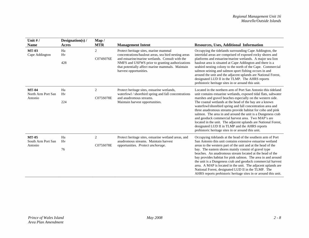
Regional Management Unit 16 Maurelle/Outside Islands
Unit # / Name
Designation(s) / Acres
Map / MTR
Management Intent
Resources, Uses, Additional Information
MT-03 Cape Addington
Ha Hv 428
2 C074S076E
Protect heritage sites, marine mammal concentrations/haulout areas, sea bird nesting areas and estuarine/marine wetlands. Consult with the NMFS and USFWS prior to granting authorizations that potentially affect marine mammals. Maintain harvest opportunities.
Occupying the tidelands surrounding Cape Addington, the intertidal areas are comprised of exposed rocky shores and platforms and estuarine/marine wetlands. A major sea lion haulout area is situated at Cape Addington and there is a seabird nesting colony to the north of the Cape. Commercial salmon seining and salmon sport fishing occurs in and around the unit and the adjacent uplands are National Forest, designated LUD II in the TLMP. The AHRS reports prehistoric heritage sites in or around this unit.
MT-04 North Arm Port San Antonio
Ha Hv 224
2 C075S078E
Protect heritage sites, estuarine wetlands, waterfowl / shorebird spring and fall concentrations and anadromous streams. Maintain harvest opportunities.
Located in the northern arm of Port San Antonio this tideland unit contains estuarine wetlands, exposed tidal flats, saltwater marshes and gravel beaches especially on the western side. The coastal wetlands at the head of the bay are a known waterfowl/shorebird spring and fall concentration area and three anadromous streams provide habitat for coho and pink salmon. The area in and around the unit is a Dungeness crab and geoduck commercial harvest area. Two MAP’s are located in the unit. The adjacent uplands are National Forest, designated LUD II in TLMP and the AHRS reports prehistoric heritage sites in or around this unit.
MT-05 South Arm Port San Antonio
Ha Hv 76
2 C075S078E
Protect heritage sites, estuarine wetland areas, and anadromous streams. Maintain harvest opportunities. Protect anchorage.
Occupying tidelands at the head of the southern arm of Port San Antonio this unit contains extensive estuarine wetland areas to the western part of the unit and at the head of the bay. The eastern shores mainly consist of gravel type beaches. An anadromous stream located at the head of the bay provides habitat for pink salmon. The area in and around the unit is a Dungeness crab and geoduck commercial harvest area. A MAP is located in the unit. The adjacent uplands are National Forest, designated LUD II in the TLMP. The AHRS reports prehistoric heritage sites in or around this unit.
Prince of Wales Island May 2008 2 - 8 Area Plan Amendment
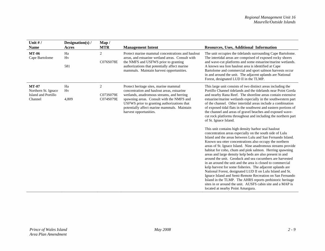
Regional Management Unit 16 Maurelle/Outside Islands
Unit # / Name
Designation(s) / Acres
Map / MTR
Management Intent
Resources, Uses, Additional Information
MT-06 Cape Bartolome
Ha Hv 581
2 C076S078E
Protect marine mammal concentrations and haulout areas, and estuarine wetland areas. Consult with the NMFS and USFWS prior to granting authorizations that potentially affect marine mammals. Maintain harvest opportunities.
The unit occupies the tidelands surrounding Cape Bartolome. The intertidal areas are comprised of exposed rocky shores and wave-cut platforms and some estuarine/marine wetlands. A known sea lion haulout area is identified at Cape Bartolome and commercial and sport salmon harvests occur in and around the unit. The adjacent uplands are National Forest, designated LUD II in the TLMP.
MT-07 Northern St. Ignace Island and Portillo Channel
Ha Hv 4,809
2 C073S079E C074S079E
Protect heritage sites, marine mammal concentration and haulout areas, estuarine wetlands, anadromous streams, and herring spawning areas. Consult with the NMFS and USFWS prior to granting authorizations that potentially affect marine mammals. Maintain harvest opportunities.
This large unit consists of two distinct areas including the Portillo Channel tidelands and the tidelands near Point Gorda and nearby Rana Reef. The shoreline areas contain extensive estuarine/marine wetlands especially in the southwestern part of the channel. Other intertidal areas include a combination of exposed tidal flats in the southwest and eastern portions of the channel and areas of gravel beaches and exposed wave-cut rock platforms throughout and including the northern part of St. Ignace Island. This unit contains high density harbor seal haulout concentration areas especially on the south side of Lulu Island and the areas between Lulu and San Fernando Island. Known sea otter concentrations also occupy the northern areas of St. Ignace Island. Nine anadromous streams provide habitat for coho, chum and pink salmon. Herring spawning areas and large density kelp beds are also present in and around the unit. Geoduck and sea cucumbers are harvested in an around the unit and the area is closed to commercial kelp harvest for some fisheries. The adjacent uplands are National Forest, designated LUD II on Lulu Island and St. Ignace Island and Semi-Remote Recreation on San Fernando Island in the TLMP. The AHRS reports prehistoric heritage sites in or around the unit. AUSFS cabin site and a MAP is located at nearby Point Amargura.
Prince of Wales Island May 2008 2 - 9 Area Plan Amendment
Regional Management Unit 16 Maurelle/Outside Islands
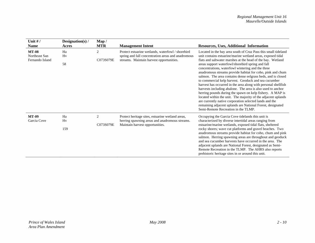
Unit # / Name
Designation(s) / Acres
Map / MTR
Management Intent
Resources, Uses, Additional Information
MT-08 Northeast San Fernando Island
Ha Hv 58
2 C073S079E
Protect estuarine wetlands, waterfowl / shorebird spring and fall concentration areas and anadromous streams. Maintain harvest opportunities.
Located in the bay area south of Cruz Pass this small tideland unit contains estuarine/marine wetland areas, exposed tidal flats and saltwater marshes at the head of the bay. Wetland areas support waterfowl/shorebird spring and fall concentrations, waterfowl wintering and the three anadromous streams provide habitat for coho, pink and chum salmon. The area contains dense eelgrass beds, and is closed to commercial kelp harvest. Geoduck and sea cucumber harvest has occurred in the area along with personal shellfish harvests including abalone. The area is also used to anchor herring pounds during the spawn on kelp fishery. A MAP is located within the unit. The majority of the adjacent uplands are currently native corporation selected lands and the remaining adjacent uplands are National Forest, designated Semi-Remote Recreation in the TLMP.
MT-09 Garcia Cove
Ha Hv 159
2 C073S079E
Protect heritage sites, estuarine wetland areas, herring spawning areas and anadromous streams. Maintain harvest opportunities.
Occupying the Garcia Cove tidelands this unit is characterized by diverse intertidal areas ranging from estuarine/marine wetlands, exposed tidal flats, sheltered rocky shores; wave cut platforms and gravel beaches. Two anadromous streams provide habitat for coho, chum and pink salmon. Herring spawning areas are throughout and geoduck and sea cucumber harvests have occurred in the area. The adjacent uplands are National Forest, designated as Semi-Remote Recreation in the TLMP. The AHRS also reports prehistoric heritage sites in or around this unit.
Prince of Wales Island May 2008 2 - 10 Area Plan Amendment
Regional Management Unit 16 Maurelle/Outside Islands
Unit # / Name
Designation(s) / Acres
Map / MTR
Management Intent
Resources, Uses, Additional Information
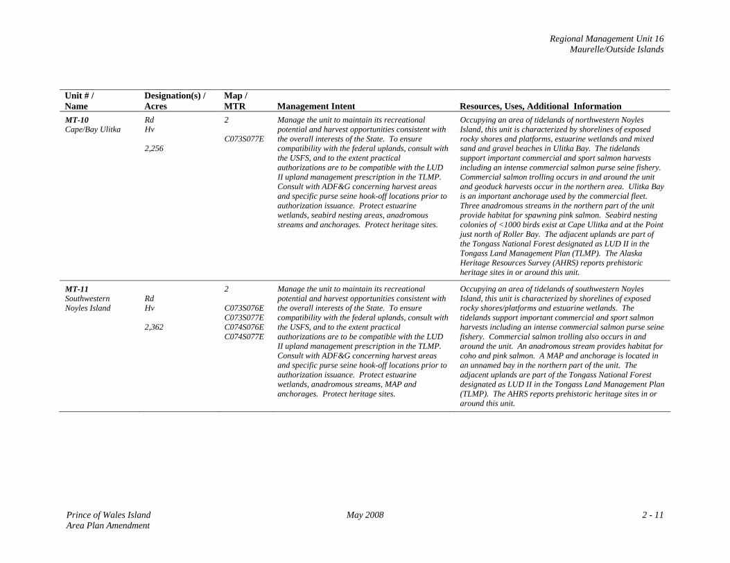
MT-10 Cape/Bay Ulitka
Rd Hv 2,256
2 C073S077E
Manage the unit to maintain its recreational potential and harvest opportunities consistent with the overall interests of the State. To ensure compatibility with the federal uplands, consult with the USFS, and to the extent practical authorizations are to be compatible with the LUD II upland management prescription in the TLMP. Consult with ADF&G concerning harvest areas and specific purse seine hook-off locations prior to authorization issuance. Protect estuarine wetlands, seabird nesting areas, anadromous streams and anchorages. Protect heritage sites.
Occupying an area of tidelands of northwestern Noyles Island, this unit is characterized by shorelines of exposed rocky shores and platforms, estuarine wetlands and mixed sand and gravel beaches in Ulitka Bay. The tidelands support important commercial and sport salmon harvests including an intense commercial salmon purse seine fishery. Commercial salmon trolling occurs in and around the unit and geoduck harvests occur in the northern area. Ulitka Bay is an important anchorage used by the commercial fleet. Three anadromous streams in the northern part of the unit provide habitat for spawning pink salmon. Seabird nesting colonies of <1000 birds exist at Cape Ulitka and at the Point just north of Roller Bay. The adjacent uplands are part of the Tongass National Forest designated as LUD II in the Tongass Land Management Plan (TLMP). The Alaska Heritage Resources Survey (AHRS) reports prehistoric heritage sites in or around this unit.
MT-11 Southwestern Noyles Island
Rd Hv 2,362
2 C073S076E C073S077E C074S076E C074S077E
Manage the unit to maintain its recreational potential and harvest opportunities consistent with the overall interests of the State. To ensure compatibility with the federal uplands, consult with the USFS, and to the extent practical authorizations are to be compatible with the LUD II upland management prescription in the TLMP. Consult with ADF&G concerning harvest areas and specific purse seine hook-off locations prior to authorization issuance. Protect estuarine wetlands, anadromous streams, MAP and anchorages. Protect heritage sites.
Occupying an area of tidelands of southwestern Noyles Island, this unit is characterized by shorelines of exposed rocky shores/platforms and estuarine wetlands. The tidelands support important commercial and sport salmon harvests including an intense commercial salmon purse seine fishery. Commercial salmon trolling also occurs in and around the unit. An anadromous stream provides habitat for coho and pink salmon. A MAP and anchorage is located in an unnamed bay in the northern part of the unit. The adjacent uplands are part of the Tongass National Forest designated as LUD II in the Tongass Land Management Plan (TLMP). The AHRS reports prehistoric heritage sites in or around this unit.
Prince of Wales Island May 2008 2 - 11 Area Plan Amendment
Regional Management Unit 16 Maurelle/Outside Islands
Unit # / Name
Designation(s) / Acres
Map / MTR
Management Intent
Resources, Uses, Additional Information
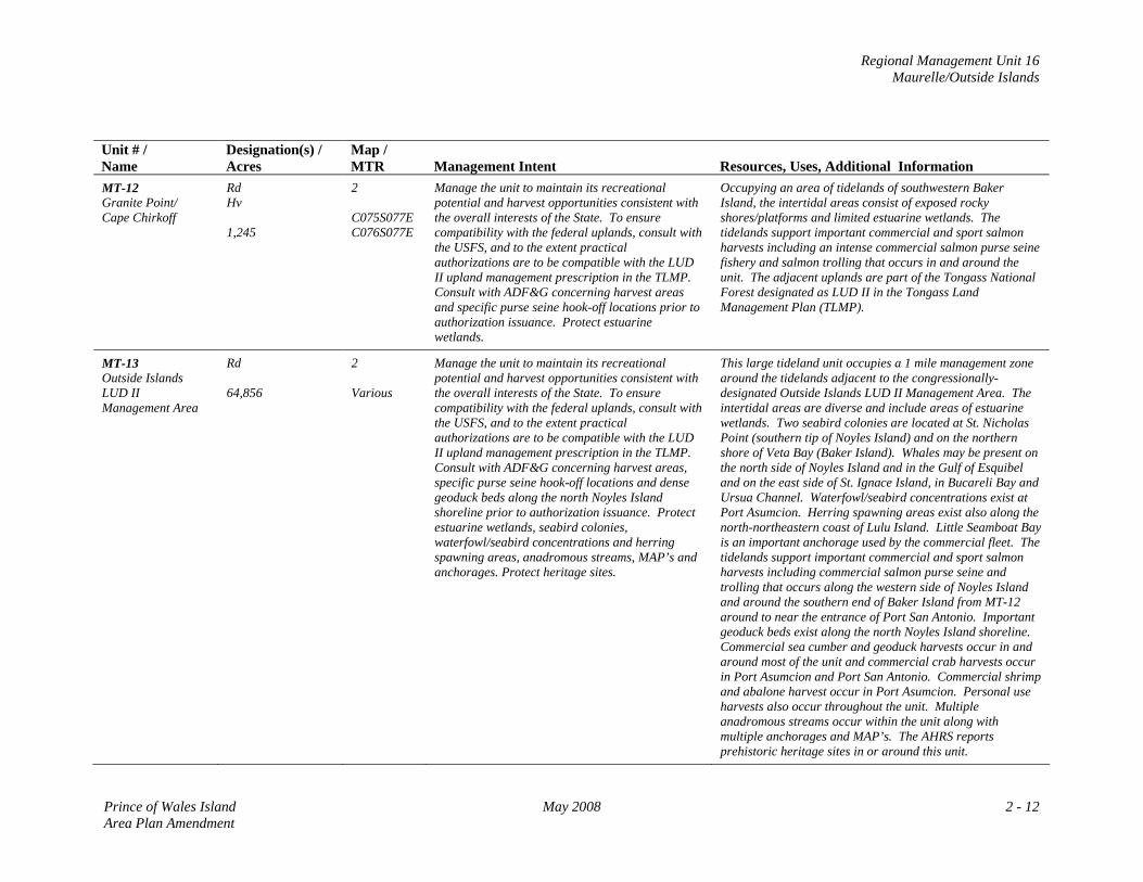
MT-12 Granite Point/ Cape Chirkoff
Rd Hv 1,245
2 C075S077E C076S077E
Manage the unit to maintain its recreational potential and harvest opportunities consistent with the overall interests of the State. To ensure compatibility with the federal uplands, consult with the USFS, and to the extent practical authorizations are to be compatible with the LUD II upland management prescription in the TLMP. Consult with ADF&G concerning harvest areas and specific purse seine hook-off locations prior to authorization issuance. Protect estuarine wetlands.
Occupying an area of tidelands of southwestern Baker Island, the intertidal areas consist of exposed rocky shores/platforms and limited estuarine wetlands. The tidelands support important commercial and sport salmon harvests including an intense commercial salmon purse seine fishery and salmon trolling that occurs in and around the unit. The adjacent uplands are part of the Tongass National Forest designated as LUD II in the Tongass Land Management Plan (TLMP).
MT-13 Outside Islands LUD II Management Area
Rd 64,856
2 Various
Manage the unit to maintain its recreational potential and harvest opportunities consistent with the overall interests of the State. To ensure compatibility with the federal uplands, consult with the USFS, and to the extent practical authorizations are to be compatible with the LUD II upland management prescription in the TLMP. Consult with ADF&G concerning harvest areas, specific purse seine hook-off locations and dense geoduck beds along the north Noyles Island shoreline prior to authorization issuance. Protect estuarine wetlands, seabird colonies, waterfowl/seabird concentrations and herring spawning areas, anadromous streams, MAP’s and anchorages. Protect heritage sites.
This large tideland unit occupies a 1 mile management zone around the tidelands adjacent to the congressionally-designated Outside Islands LUD II Management Area. The intertidal areas are diverse and include areas of estuarine wetlands. Two seabird colonies are located at St. Nicholas Point (southern tip of Noyles Island) and on the northern shore of Veta Bay (Baker Island). Whales may be present on the north side of Noyles Island and in the Gulf of Esquibel and on the east side of St. Ignace Island, in Bucareli Bay and Ursua Channel. Waterfowl/seabird concentrations exist at Port Asumcion. Herring spawning areas exist also along the north-northeastern coast of Lulu Island. Little Seamboat Bay is an important anchorage used by the commercial fleet. The tidelands support important commercial and sport salmon harvests including commercial salmon purse seine and trolling that occurs along the western side of Noyles Island and around the southern end of Baker Island from MT-12 around to near the entrance of Port San Antonio. Important geoduck beds exist along the north Noyles Island shoreline. Commercial sea cumber and geoduck harvests occur in and around most of the unit and commercial crab harvests occur in Port Asumcion and Port San Antonio. Commercial shrimp and abalone harvest occur in Port Asumcion. Personal use harvests also occur throughout the unit. Multiple anadromous streams occur within the unit along with multiple anchorages and MAP’s. The AHRS reports prehistoric heritage sites in or around this unit.
Prince of Wales Island May 2008 2 - 12 Area Plan Amendment
Regional Management Unit 16 Maurelle/Outside Islands
Unit # / Name
Designation(s) / Acres
Map / MTR
Management Intent
Resources, Uses, Additional Information
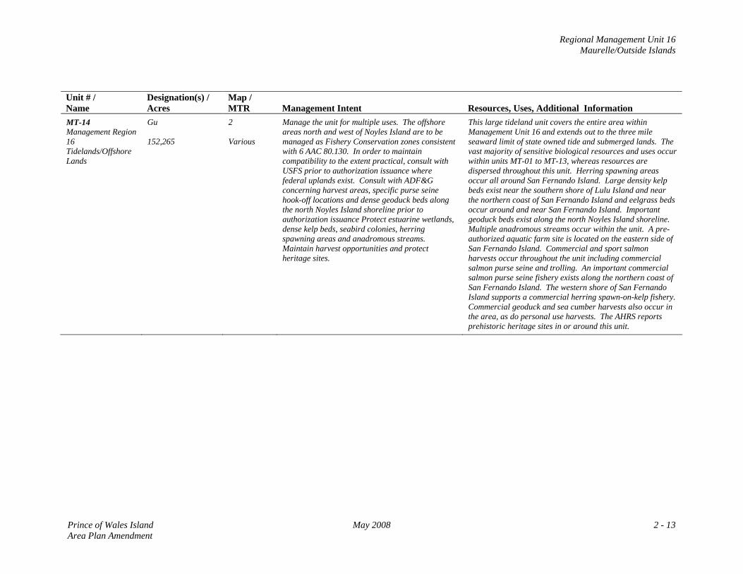
MT-14 Management Region 16 Tidelands/Offshore Lands
Gu 152,265
2 Various
Manage the unit for multiple uses. The offshore areas north and west of Noyles Island are to be managed as Fishery Conservation zones consistent with 6 AAC 80.130. In order to maintain compatibility to the extent practical, consult with USFS prior to authorization issuance where federal uplands exist. Consult with ADF&G concerning harvest areas, specific purse seine hook-off locations and dense geoduck beds along the north Noyles Island shoreline prior to authorization issuance Protect estuarine wetlands, dense kelp beds, seabird colonies, herring spawning areas and anadromous streams. Maintain harvest opportunities and protect heritage sites.
This large tideland unit covers the entire area within Management Unit 16 and extends out to the three mile seaward limit of state owned tide and submerged lands. The vast majority of sensitive biological resources and uses occur within units MT-01 to MT-13, whereas resources are dispersed throughout this unit. Herring spawning areas occur all around San Fernando Island. Large density kelp beds exist near the southern shore of Lulu Island and near the northern coast of San Fernando Island and eelgrass beds occur around and near San Fernando Island. Important geoduck beds exist along the north Noyles Island shoreline. Multiple anadromous streams occur within the unit. A pre-authorized aquatic farm site is located on the eastern side of San Fernando Island. Commercial and sport salmon harvests occur throughout the unit including commercial salmon purse seine and trolling. An important commercial salmon purse seine fishery exists along the northern coast of San Fernando Island. The western shore of San Fernando Island supports a commercial herring spawn-on-kelp fishery. Commercial geoduck and sea cumber harvests also occur in the area, as do personal use harvests. The AHRS reports prehistoric heritage sites in or around this unit.
Prince of Wales Island May 2008 2 - 13 Area Plan Amendment

Regional Management Unit 16 Maurelle/Outside Islands
MAP 2: Management Unit 16:
Maurelle/Outside Islands
Prince of Wales Island May 2008 2 - 15 Area Plan Amendment
Regional Management Unit 17 Craig/Klawock
REGIONAL MANAGEMENT UNIT 17 Craig/Klawock
Background The Craig/Klawock Region includes the area from Big Salt Lake in the north to Waterfall in the south, and from the Hydaburg Highway in the east to San Juan Bautista Island in the west. The cities of Craig and Klawock are the main population centers within the region, with a combined year‐round population of approximately 2,000 residents. Almost all of the uplands within the region are Native Corporation owned, with Tongass National Forest areas in the north, south and eastern parts of the region. State Land/Acreage State land within the region consists almost entirely of the tide and submerged lands with state uplands existing just north of Klawock. These state owned uplands include the Klawock airport containing aircraft/port facilities and consisting of approximately 473 acres. State selected uplands exist near the head of Trocadaro Bay consisting of approximately 1,829 acres. There are 27 designated tideland units consisting of approximately 36,674 acres at various locations. In addition to the specific tideland units, approximately 61,753 acres of state owned tide and submerged lands exist 3 miles seaward from mean high water. Physical Features Most of the uplands within the region are attached to the Prince of Wales Island mainland. The Craig area contains relatively steep mountainous terrain east of the city. The uplands adjacent to Port St. Nicholas are also relatively steep along with the uplands of San Juan Bautista Island. Most of the tideland waters in this region are more sheltered in nature from the Pacific Ocean elements in comparison to region 16. San Alberto Bay waters are relatively deep in parts and the area around and north of Klawock consist of a complex barrier of islands that provide more sheltered tidal environments. The tidal waters of the region are varied consisting of a combination of bays, ports, channels, inlets and lakes. The intertidal areas of the region consist of mainly gravel beaches and semi‐protected estuarine wetlands, with rocky shores and platforms around the islands of San Alberto Bay, Bucareli Bay and outer Trocadero Bay.
Prince of Wales Island May 2008 2 - 17 Area Plan Amendment
Regional Management Unit 17 Craig/Klawock
Access Access to the region is relatively good. Scheduled flight services depart daily (weather permitting) from Ketchikan International Airport and arrive at Klawock airport. The airport contains a 5000 ft asphalt runway that serves as the only airport on the entire Prince of Wales Island. Scheduled floatplane flights also depart from Ketchikan arriving in both Klawock and Craig. The inter‐island ferry authority conducts scheduled daily year‐round services from Ketchikan to Hollis. The region also contains several paved roads including the Craig‐Klawock Hollis Road, which serves these cities and ends at Port St. Nicholas. The Hydaburg Highway also serves to provide access to the southern part of the unit near Trocadero Bay. Charter boats transport locals and visitors mainly from Craig for sport fishing and wildlife viewing purposes. Resources and Uses Uses: Commercial fishing is the predominant use of the tide and submerged lands within the region. Commercial fishery harvests include salmon, halibut, geoduck, sea cucumber, Dungeness crab, spawn‐on‐kelp and kelp. Charter and personal sport fishing and wildlife viewing occurs within the region and personal use harvests also occurs throughout most of the tideland areas. The state uplands north of Klawock serve as an important air transportation facility servicing the entire island. The state selected uplands at the head of Trocadero Bay contain the Trocadero Trail and the Cable Creek Fish Pass along with picnic facilities used for recreation and wildlife viewing purposes. A number of state leased or permitted Log Transfer Facility (LTF) sites also exist around the Klawock area. Resources: This productive region contains a variety of sensitive resources that are typically concentrated within the designated Habitat (Ha) or Harvest (Hv) tideland units. Marine mammal concentrations exist around the Cruz/Rosary Island groups, the Klawock/Shinaku Inlets and Trocadero Bay. Historic herring spawning areas exist within the entire San Alberto Bay shallow/coastal areas and dense eelgrass and kelp beds occur throughout the region. Numerous anadromous fish bearing streams and Bald eagle nesting sites are spread throughout the region. Waterfowl/shorebird spring and fall concentration areas are prevalent throughout the region and Trumpeter swan wintering areas exist around the Big Salt Lake and the head waters of Klawock Lake. The AHRS reports prehistoric heritage sites in or around this region some of which occur in or adjacent to the upland and tideland units.
2 - 18 May 2008 Prince of Wales Island Area Plan Amendment
Regional Management Unit 17 Craig/Klawock
Management Constraints and Considerations This region is located within an unorganized borough. In 2007, the City of Craig amended the Craig Coastal Management Plan. The City has direct jurisdiction over all areas within the coastal management planning district and is subject to the enforceable policies of the Craig Coastal Management Plan. The City of Klawock situated approximately 7 road miles north of Craig owns and manages uplands and tidelands within the Klawock City boundaries. The City of Klawock is not currently a participating coastal district in the Alaska Coastal Management Program (ACMP). Most of the adjacent uplands within the region are owned and managed by Native Corporations. The remaining lands within the region are mainly Tongass National Forest managed by the USFS accordingly to the requirements of the TLMP. The region also contains other private lands. Management Summary/Intent for State Lands Uplands: The management of the state uplands at the Klawock Airport (C‐01) is to be consistent with the Department of Transportation and Public Facilities (DOTPF) as per (ADL 106068) management agreement. If conveyed to the state by the Bureau of Land Management (BLM) the state selection near Trocadero Bay is to be managed as two individual specific management units. The north‐western portion (C‐02) is to be managed for Public Recreation and Tourism‐Dispersed (Rd) with existing uses and accesses to facilities to be maintained. The remaining upland (C‐03) is designated as settlement (Se) and should be considered for disposal during the planning period. Tidelands: Tideland areas within regional management 17 contain important areas of wildlife habitat and commercial and non‐commercial fishery harvest opportunities. Where these values are especially spatially concentrated the designation of either Habitat (Ha) or Harvest (Hv) is applied or where both resources exist, they are assigned a co‐designation of Habitat/Harvest (Ha Hv). Tidelands with these designations are to be managed so that the resources identified in the specific tideland unit within the Resource Allocation Table are to be maintained and protected. Tidelands designated Habitat areas often consists of one or more of the following resources: estuarine wetlands, marine mammal concentrations, shorebirds/waterfowl and Trumpeter swan concentrations, herring spawning areas and high density eelgrass or kelp beds or salmon spawning or rearing areas. Areas designated as harvest are characterized by commercial salmon, geoduck, sea cucumber, Dungeness crab, kelp and spawn on kelp harvest concentration areas or intensive personal use harvest areas. Three areas identified in the Plan Map 3 are designated or pre‐authorized aquatic farm sites reflecting the 2003 State of Alaska Aquatic Farm Auction Booklet. These areas are to be
Prince of Wales Island May 2008 2 - 19 Area Plan Amendment
Regional Management Unit 17 Craig/Klawock
managed consistent with the booklet and with other state and federal requirements. Areas designated as Shoreline Use (Sd) are to be managed to accommodate marine structures and uses associated with residential development. Areas designated as Forestry (F) are to be managed consistent with the associated state or federal agreements/requirements, authorizations must follow state/federal permitting requirements. The remainder of the tidelands within the management region are designated as General Use, a multiple use designation. It is intended that the standard state/federal permitting procedures will be used to determine whether a particular use or facility is appropriate at a specific site in an area designated General Use.
2 - 20 May 2008 Prince of Wales Island Area Plan Amendment
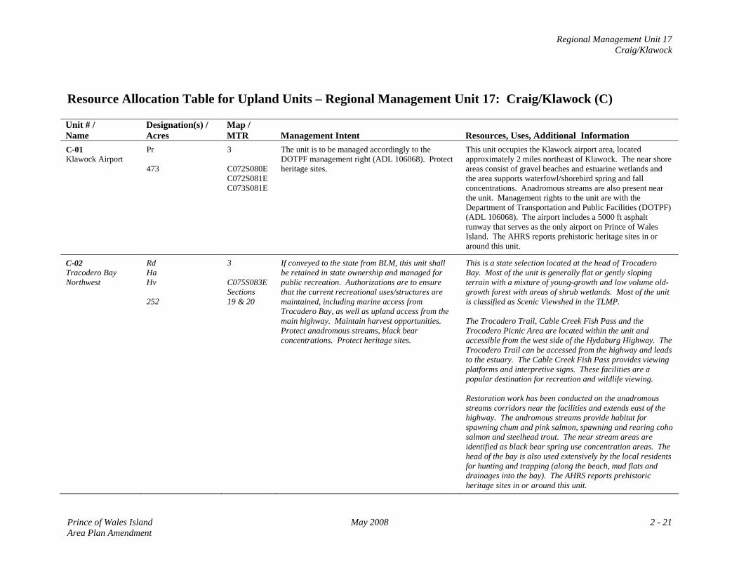
Regional Management Unit 17 Craig/Klawock
Resource Allocation Table for Upland Units – Regional Management Unit 17: Craig/Klawock (C) Unit # / Name
Designation(s) / Acres
Map / MTR
Management Intent
Resources, Uses, Additional Information
C-01 Klawock Airport
Pr 473
3 C072S080E C072S081E C073S081E
The unit is to be managed accordingly to the DOTPF management right (ADL 106068). Protect heritage sites.
This unit occupies the Klawock airport area, located approximately 2 miles northeast of Klawock. The near shore areas consist of gravel beaches and estuarine wetlands and the area supports waterfowl/shorebird spring and fall concentrations. Anadromous streams are also present near the unit. Management rights to the unit are with the Department of Transportation and Public Facilities (DOTPF) (ADL 106068). The airport includes a 5000 ft asphalt runway that serves as the only airport on Prince of Wales Island. The AHRS reports prehistoric heritage sites in or around this unit.
C-02 Tracodero Bay Northwest
Rd Ha Hv 252
3 C075S083E Sections 19 & 20
If conveyed to the state from BLM, this unit shall be retained in state ownership and managed for public recreation. Authorizations are to ensure that the current recreational uses/structures are maintained, including marine access from Trocadero Bay, as well as upland access from the main highway. Maintain harvest opportunities. Protect anadromous streams, black bear concentrations. Protect heritage sites.
This is a state selection located at the head of Trocadero Bay. Most of the unit is generally flat or gently sloping terrain with a mixture of young-growth and low volume old-growth forest with areas of shrub wetlands. Most of the unit is classified as Scenic Viewshed in the TLMP. The Trocadero Trail, Cable Creek Fish Pass and the Trocodero Picnic Area are located within the unit and accessible from the west side of the Hydaburg Highway. The Trocodero Trail can be accessed from the highway and leads to the estuary. The Cable Creek Fish Pass provides viewing platforms and interpretive signs. These facilities are a popular destination for recreation and wildlife viewing. Restoration work has been conducted on the anadromous streams corridors near the facilities and extends east of the highway. The andromous streams provide habitat for spawning chum and pink salmon, spawning and rearing coho salmon and steelhead trout. The near stream areas are identified as black bear spring use concentration areas. The head of the bay is also used extensively by the local residents for hunting and trapping (along the beach, mud flats and drainages into the bay). The AHRS reports prehistoric heritage sites in or around this unit.
Prince of Wales Island May 2008 2 - 21 Area Plan Amendment
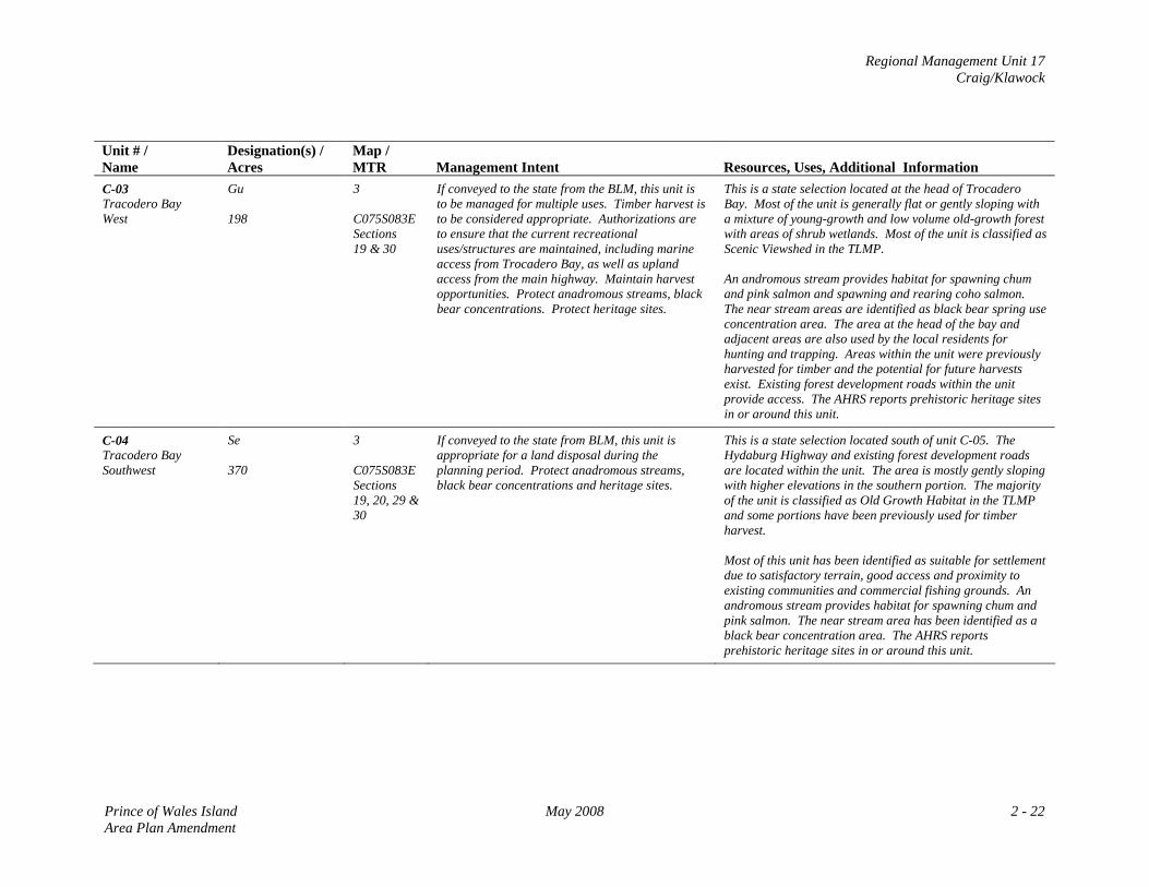
Regional Management Unit 17 Craig/Klawock
Unit # / Name
Designation(s) / Acres
Map / MTR
Management Intent
Resources, Uses, Additional Information
C-03 Tracodero Bay West
Gu 198
3 C075S083E Sections 19 & 30
If conveyed to the state from the BLM, this unit is to be managed for multiple uses. Timber harvest is to be considered appropriate. Authorizations are to ensure that the current recreational uses/structures are maintained, including marine access from Trocadero Bay, as well as upland access from the main highway. Maintain harvest opportunities. Protect anadromous streams, black bear concentrations. Protect heritage sites.
This is a state selection located at the head of Trocadero Bay. Most of the unit is generally flat or gently sloping with a mixture of young-growth and low volume old-growth forest with areas of shrub wetlands. Most of the unit is classified as Scenic Viewshed in the TLMP. An andromous stream provides habitat for spawning chum and pink salmon and spawning and rearing coho salmon. The near stream areas are identified as black bear spring use concentration area. The area at the head of the bay and adjacent areas are also used by the local residents for hunting and trapping. Areas within the unit were previously harvested for timber and the potential for future harvests exist. Existing forest development roads within the unit provide access. The AHRS reports prehistoric heritage sites in or around this unit.
C-04 Tracodero Bay Southwest
Se 370
3 C075S083E Sections 19, 20, 29 & 30
If conveyed to the state from BLM, this unit is appropriate for a land disposal during the planning period. Protect anadromous streams, black bear concentrations and heritage sites.
This is a state selection located south of unit C-05. The Hydaburg Highway and existing forest development roads are located within the unit. The area is mostly gently sloping with higher elevations in the southern portion. The majority of the unit is classified as Old Growth Habitat in the TLMP and some portions have been previously used for timber harvest. Most of this unit has been identified as suitable for settlement due to satisfactory terrain, good access and proximity to existing communities and commercial fishing grounds. An andromous stream provides habitat for spawning chum and pink salmon. The near stream area has been identified as a black bear concentration area. The AHRS reports prehistoric heritage sites in or around this unit.
Prince of Wales Island May 2008 2 - 22 Area Plan Amendment
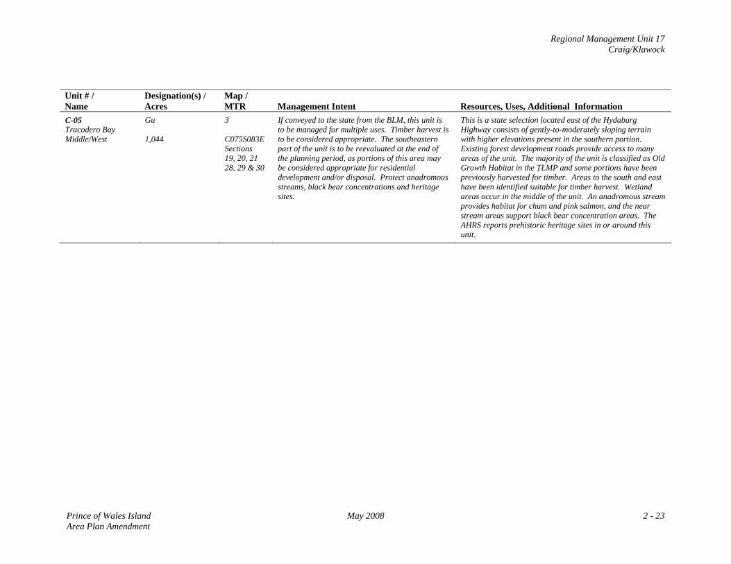
Regional Management Unit 17 Craig/Klawock
Unit # / Name
Designation(s) / Acres
Map / MTR
Management Intent
Resources, Uses, Additional Information
C-05 Tracodero Bay Middle/West
Gu 1,044
3 C075S083E Sections 19, 20, 21 28, 29 & 30
If conveyed to the state from the BLM, this unit is to be managed for multiple uses. Timber harvest is to be considered appropriate. The southeastern part of the unit is to be reevaluated at the end of the planning period, as portions of this area may be considered appropriate for residential development and/or disposal. Protect anadromous streams, black bear concentrations and heritage sites.
This is a state selection located east of the Hydaburg Highway consists of gently-to-moderately sloping terrain with higher elevations present in the southern portion. Existing forest development roads provide access to many areas of the unit. The majority of the unit is classified as Old Growth Habitat in the TLMP and some portions have been previously harvested for timber. Areas to the south and east have been identified suitable for timber harvest. Wetland areas occur in the middle of the unit. An anadromous stream provides habitat for chum and pink salmon, and the near stream areas support black bear concentration areas. The AHRS reports prehistoric heritage sites in or around this unit.
Prince of Wales Island May 2008 2 - 23 Area Plan Amendment
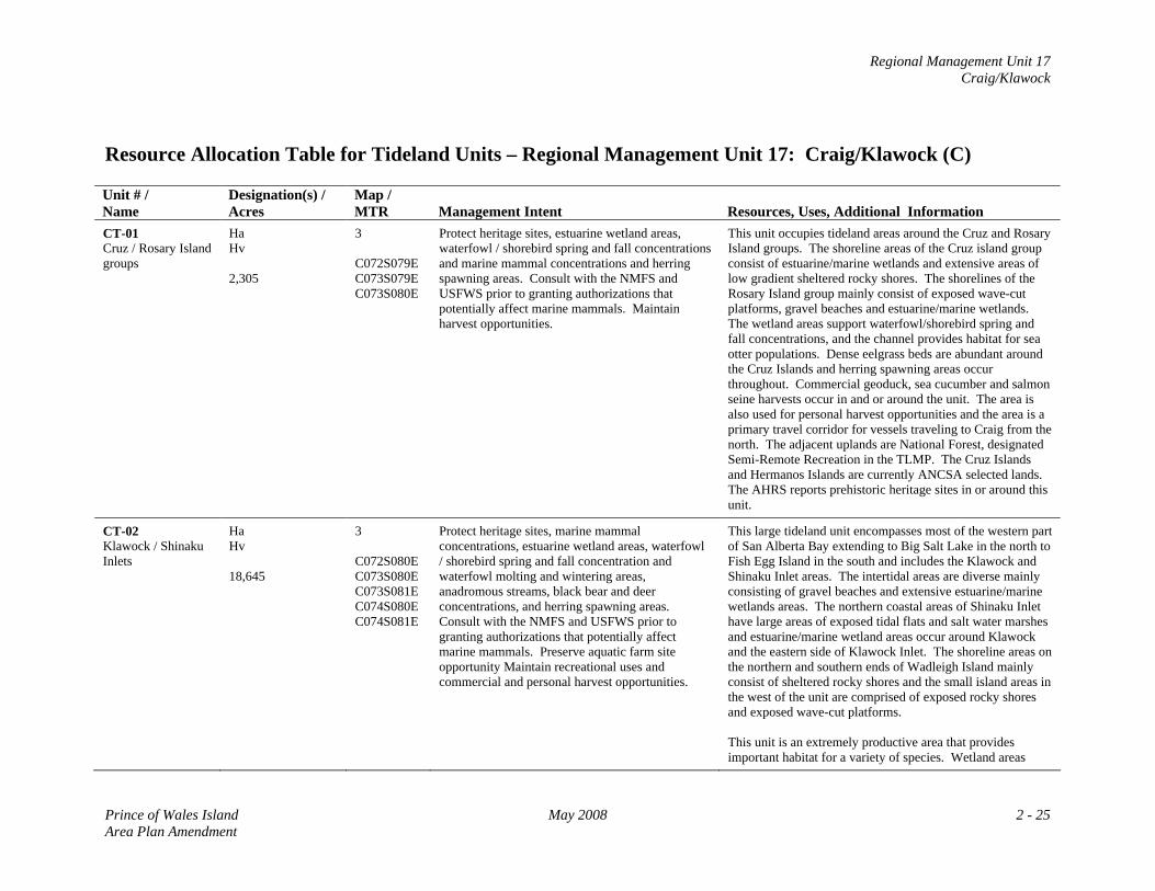
Regional Management Unit 17 Craig/Klawock
Resource Allocation Table for Tideland Units – Regional Management Unit 17: Craig/Klawock (C) Unit # / Name
Designation(s) / Acres
Map / MTR
Management Intent
Resources, Uses, Additional Information
CT-01 Cruz / Rosary Island groups
Ha Hv 2,305
3 C072S079E C073S079E C073S080E
Protect heritage sites, estuarine wetland areas, waterfowl / shorebird spring and fall concentrations and marine mammal concentrations and herring spawning areas. Consult with the NMFS and USFWS prior to granting authorizations that potentially affect marine mammals. Maintain harvest opportunities.
This unit occupies tideland areas around the Cruz and Rosary Island groups. The shoreline areas of the Cruz island group consist of estuarine/marine wetlands and extensive areas of low gradient sheltered rocky shores. The shorelines of the Rosary Island group mainly consist of exposed wave-cut platforms, gravel beaches and estuarine/marine wetlands. The wetland areas support waterfowl/shorebird spring and fall concentrations, and the channel provides habitat for sea otter populations. Dense eelgrass beds are abundant around the Cruz Islands and herring spawning areas occur throughout. Commercial geoduck, sea cucumber and salmon seine harvests occur in and or around the unit. The area is also used for personal harvest opportunities and the area is a primary travel corridor for vessels traveling to Craig from the north. The adjacent uplands are National Forest, designated Semi-Remote Recreation in the TLMP. The Cruz Islands and Hermanos Islands are currently ANCSA selected lands. The AHRS reports prehistoric heritage sites in or around this unit.
CT-02 Klawock / Shinaku Inlets
Ha Hv 18,645
3 C072S080E C073S080E C073S081E C074S080E C074S081E
Protect heritage sites, marine mammal concentrations, estuarine wetland areas, waterfowl / shorebird spring and fall concentration and waterfowl molting and wintering areas, anadromous streams, black bear and deer concentrations, and herring spawning areas. Consult with the NMFS and USFWS prior to granting authorizations that potentially affect marine mammals. Preserve aquatic farm site opportunity Maintain recreational uses and commercial and personal harvest opportunities.
This large tideland unit encompasses most of the western part of San Alberta Bay extending to Big Salt Lake in the north to Fish Egg Island in the south and includes the Klawock and Shinaku Inlet areas. The intertidal areas are diverse mainly consisting of gravel beaches and extensive estuarine/marine wetlands areas. The northern coastal areas of Shinaku Inlet have large areas of exposed tidal flats and salt water marshes and estuarine/marine wetland areas occur around Klawock and the eastern side of Klawock Inlet. The shoreline areas on the northern and southern ends of Wadleigh Island mainly consist of sheltered rocky shores and the small island areas in the west of the unit are comprised of exposed rocky shores and exposed wave-cut platforms. This unit is an extremely productive area that provides important habitat for a variety of species. Wetland areas
Prince of Wales Island May 2008 2 - 25 Area Plan Amendment
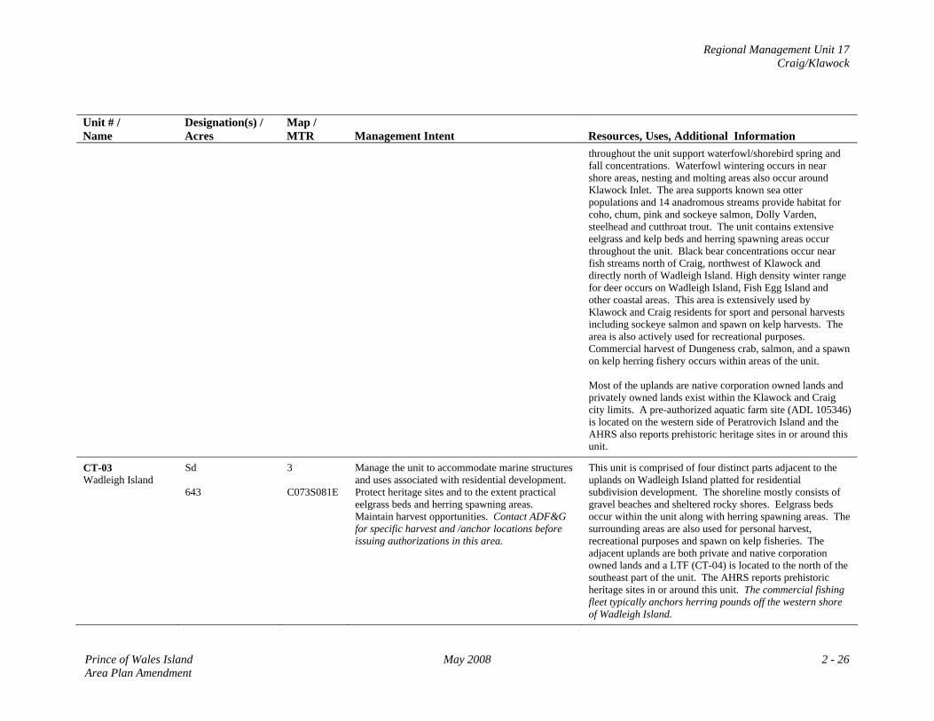
Regional Management Unit 17 Craig/Klawock
Unit # / Name
Designation(s) / Acres
Map / MTR
Management Intent
Resources, Uses, Additional Information throughout the unit support waterfowl/shorebird spring and fall concentrations. Waterfowl wintering occurs in near shore areas, nesting and molting areas also occur around Klawock Inlet. The area supports known sea otter populations and 14 anadromous streams provide habitat for coho, chum, pink and sockeye salmon, Dolly Varden, steelhead and cutthroat trout. The unit contains extensive eelgrass and kelp beds and herring spawning areas occur throughout the unit. Black bear concentrations occur near fish streams north of Craig, northwest of Klawock and directly north of Wadleigh Island. High density winter range for deer occurs on Wadleigh Island, Fish Egg Island and other coastal areas. This area is extensively used by Klawock and Craig residents for sport and personal harvests including sockeye salmon and spawn on kelp harvests. The area is also actively used for recreational purposes. Commercial harvest of Dungeness crab, salmon, and a spawn on kelp herring fishery occurs within areas of the unit. Most of the uplands are native corporation owned lands and privately owned lands exist within the Klawock and Craig city limits. A pre-authorized aquatic farm site (ADL 105346) is located on the western side of Peratrovich Island and the AHRS also reports prehistoric heritage sites in or around this unit.
CT-03 Wadleigh Island
Sd 643
3 C073S081E
Manage the unit to accommodate marine structures and uses associated with residential development. Protect heritage sites and to the extent practical eelgrass beds and herring spawning areas. Maintain harvest opportunities. Contact ADF&G for specific harvest and /anchor locations before issuing authorizations in this area.
This unit is comprised of four distinct parts adjacent to the uplands on Wadleigh Island platted for residential subdivision development. The shoreline mostly consists of gravel beaches and sheltered rocky shores. Eelgrass beds occur within the unit along with herring spawning areas. The surrounding areas are also used for personal harvest, recreational purposes and spawn on kelp fisheries. The adjacent uplands are both private and native corporation owned lands and a LTF (CT-04) is located to the north of the southeast part of the unit. The AHRS reports prehistoric heritage sites in or around this unit. The commercial fishing fleet typically anchors herring pounds off the western shore of Wadleigh Island.
Prince of Wales Island May 2008 2 - 26 Area Plan Amendment
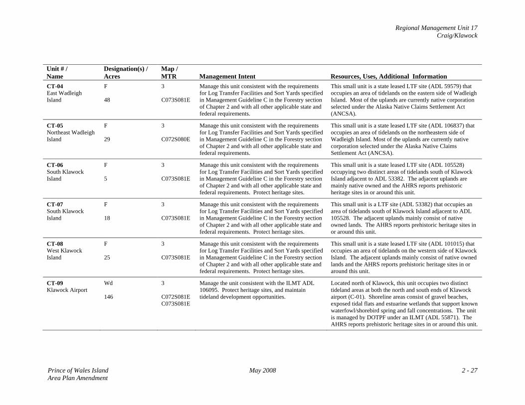
Regional Management Unit 17 Craig/Klawock
Unit # / Name
Designation(s) / Acres
Map / MTR
Management Intent
Resources, Uses, Additional Information
CT-04 East Wadleigh Island
F 48
3 C073S081E
Manage this unit consistent with the requirements for Log Transfer Facilities and Sort Yards specified in Management Guideline C in the Forestry section of Chapter 2 and with all other applicable state and federal requirements.
This small unit is a state leased LTF site (ADL 59579) that occupies an area of tidelands on the eastern side of Wadleigh Island. Most of the uplands are currently native corporation selected under the Alaska Native Claims Settlement Act (ANCSA).
CT-05 Northeast Wadleigh Island
F 29
3 C072S080E
Manage this unit consistent with the requirements for Log Transfer Facilities and Sort Yards specified in Management Guideline C in the Forestry section of Chapter 2 and with all other applicable state and federal requirements.
This small unit is a state leased LTF site (ADL 106837) that occupies an area of tidelands on the northeastern side of Wadleigh Island. Most of the uplands are currently native corporation selected under the Alaska Native Claims Settlement Act (ANCSA).
CT-06 South Klawock Island
F 5
3 C073S081E
Manage this unit consistent with the requirements for Log Transfer Facilities and Sort Yards specified in Management Guideline C in the Forestry section of Chapter 2 and with all other applicable state and federal requirements. Protect heritage sites.
This small unit is a state leased LTF site (ADL 105528) occupying two distinct areas of tidelands south of Klawock Island adjacent to ADL 53382. The adjacent uplands are mainly native owned and the AHRS reports prehistoric heritage sites in or around this unit.
CT-07 South Klawock Island
F 18
3 C073S081E
Manage this unit consistent with the requirements for Log Transfer Facilities and Sort Yards specified in Management Guideline C in the Forestry section of Chapter 2 and with all other applicable state and federal requirements. Protect heritage sites.
This small unit is a LTF site (ADL 53382) that occupies an area of tidelands south of Klawock Island adjacent to ADL 105528. The adjacent uplands mainly consist of native owned lands. The AHRS reports prehistoric heritage sites in or around this unit.
CT-08 West Klawock Island
F 25
3 C073S081E
Manage this unit consistent with the requirements for Log Transfer Facilities and Sort Yards specified in Management Guideline C in the Forestry section of Chapter 2 and with all other applicable state and federal requirements. Protect heritage sites.
This small unit is a state leased LTF site (ADL 101015) that occupies an area of tidelands on the western side of Klawock Island. The adjacent uplands mainly consist of native owned lands and the AHRS reports prehistoric heritage sites in or around this unit.
CT-09 Klawock Airport
Wd 146
3 C072S081E C073S081E
Manage the unit consistent with the ILMT ADL 106095. Protect heritage sites, and maintain tideland development opportunities.
Located north of Klawock, this unit occupies two distinct tideland areas at both the north and south ends of Klawock airport (C-01). Shoreline areas consist of gravel beaches, exposed tidal flats and estuarine wetlands that support known waterfowl/shorebird spring and fall concentrations. The unit is managed by DOTPF under an ILMT (ADL 55871). The AHRS reports prehistoric heritage sites in or around this unit.
Prince of Wales Island May 2008 2 - 27 Area Plan Amendment
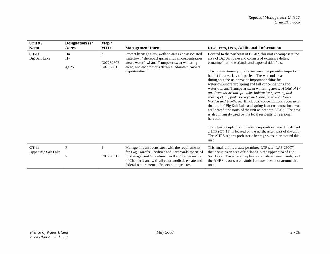
Regional Management Unit 17 Craig/Klawock
Unit # / Name
Designation(s) / Acres
Map / MTR
Management Intent
Resources, Uses, Additional Information
CT-10 Big Salt Lake
Ha Hv 4,625
3 C072S080E C072S081E
Protect heritage sites, wetland areas and associated waterfowl / shorebird spring and fall concentration areas, waterfowl and Trumpeter swan wintering areas, and anadromous streams. Maintain harvest opportunities.
Located to the northeast of CT-02, this unit encompasses the area of Big Salt Lake and consists of extensive deltas, estuarine/marine wetlands and exposed tidal flats. This is an extremely productive area that provides important habitat for a variety of species. The wetland areas throughout the unit provide important habitat for waterfowl/shorebird spring and fall concentrations and waterfowl and Trumpeter swan wintering areas. A total of 17 anadromous streams provides habitat for spawning and rearing chum, pink, sockeye and coho, as well as Dolly Varden and Steelhead. Black bear concentrations occur near the head of Big Salt Lake and spring bear concentration areas are located just south of the unit adjacent to CT-02. The area is also intensely used by the local residents for personal harvests. The adjacent uplands are native corporation owned lands and a LTF (CT-11) is located on the northeastern part of the unit. The AHRS reports prehistoric heritage sites in or around this unit.
CT-11 Upper Big Salt Lake
F 7
3 C072S081E
Manage this unit consistent with the requirements for Log Transfer Facilities and Sort Yards specified in Management Guideline C in the Forestry section of Chapter 2 and with all other applicable state and federal requirements. Protect heritage sites.
This small unit is a state permitted LTF site (LAS 23067) that occupies an area of tidelands in the upper area of Big Salt Lake. The adjacent uplands are native owned lands, and the AHRS reports prehistoric heritage sites in or around this unit.
Prince of Wales Island May 2008 2 - 28 Area Plan Amendment
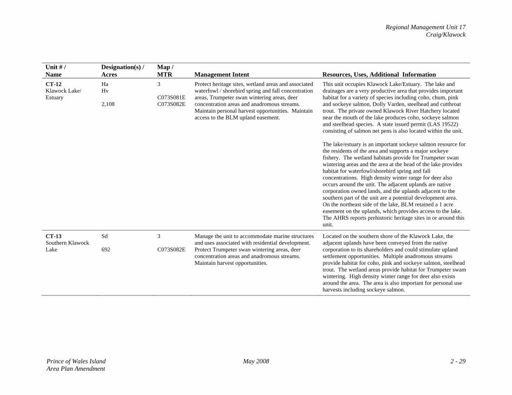
Regional Management Unit 17 Craig/Klawock
Unit # / Name
Designation(s) / Acres
Map / MTR
Management Intent
Resources, Uses, Additional Information
CT-12 Klawock Lake/ Estuary
Ha Hv 2,108
3 C073S081E C073S082E
Protect heritage sites, wetland areas and associated waterfowl / shorebird spring and fall concentration areas, Trumpeter swan wintering areas, deer concentration areas and anadromous streams. Maintain personal harvest opportunities. Maintain access to the BLM upland easement.
This unit occupies Klawock Lake/Estuary. The lake and drainages are a very productive area that provides important habitat for a variety of species including coho, chum, pink and sockeye salmon, Dolly Varden, steelhead and cutthroat trout. The private owned Klawock River Hatchery located near the mouth of the lake produces coho, sockeye salmon and steelhead species. A state issued permit (LAS 19522) consisting of salmon net pens is also located within the unit. The lake/estuary is an important sockeye salmon resource for the residents of the area and supports a major sockeye fishery. The wetland habitats provide for Trumpeter swan wintering areas and the area at the head of the lake provides habitat for waterfowl/shorebird spring and fall concentrations. High density winter range for deer also occurs around the unit. The adjacent uplands are native corporation owned lands, and the uplands adjacent to the southern part of the unit are a potential development area. On the northeast side of the lake, BLM retained a 1 acre easement on the uplands, which provides access to the lake. The AHRS reports prehistoric heritage sites in or around this unit.
CT-13 Southern Klawock Lake
Sd 692
3 C073S082E
Manage the unit to accommodate marine structures and uses associated with residential development. Protect Trumpeter swan wintering areas, deer concentration areas and anadromous streams. Maintain harvest opportunities.
Located on the southern shore of the Klawock Lake, the adjacent uplands have been conveyed from the native corporation to its shareholders and could stimulate upland settlement opportunities. Multiple anadromous streams provide habitat for coho, pink and sockeye salmon, steelhead trout. The wetland areas provide habitat for Trumpeter swam wintering. High density winter range for deer also exists around the area. The area is also important for personal use harvests including sockeye salmon.
Prince of Wales Island May 2008 2 - 29 Area Plan Amendment
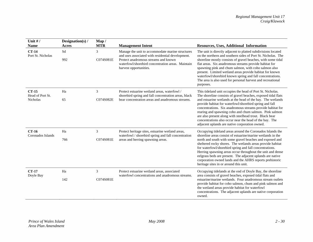
Regional Management Unit 17 Craig/Klawock
Unit # / Name
Designation(s) / Acres
Map / MTR
Management Intent
Resources, Uses, Additional Information
CT-14 Port St. Nicholas
Sd 992
3 C074S081E
Manage the unit to accommodate marine structures and uses associated with residential development. Protect anadromous streams and known waterfowl/shorebird concentration areas. Maintain harvest opportunities.
The unit is directly adjacent to platted subdivisions located on the northern and southern sides of Port St. Nicholas. The shoreline mostly consists of gravel beaches, with some tidal flat areas. Six anadromous streams provide habitat for spawning pink and chum salmon, with coho salmon also present. Limited wetland areas provide habitat for known waterfowl/shorebird known spring and fall concentrations. The area is also used for personal harvest and recreational purposes.
CT-15 Head of Port St. Nicholas
Ha 65
3 C074S082E
Protect estuarine wetland areas, waterfowl / shorebird spring and fall concentration areas, black bear concentration areas and anadromous streams.
This tideland unit occupies the head of Port St. Nicholas. The shoreline consists of gravel beaches, exposed tidal flats and estuarine wetlands at the head of the bay. The wetlands provide habitat for waterfowl/shorebird spring and fall concentrations. Six anadromous streams provide habitat for rearing and spawning coho and chum salmon. Pink salmon are also present along with steelhead trout. Black bear concentrations also occur near the head of the bay. The adjacent uplands are native corporation owned.
CT-16 Coronados Islands
Ha 766
3 C074S081E
Protect heritage sites, estuarine wetland areas, waterfowl / shorebird spring and fall concentration areas and herring spawning areas.
Occupying tideland areas around the Coronados Islands the shoreline areas consist of estuarine/marine wetlands in the north and south with some gravel beaches and exposed and sheltered rocky shores. The wetlands areas provide habitat for waterfowl/shorebird spring and fall concentrations. Herring spawning areas occur throughout the unit and dense eelgrass beds are present. The adjacent uplands are native corporation owned lands and the AHRS reports prehistoric heritage sites in or around this unit.
CT-17 Doyle Bay
Ha 142
3 C074S081E
Protect estuarine wetland areas, associated waterfowl concentrations and anadromous streams.
Occupying tidelands at the end of Doyle Bay, the shoreline area consists of gravel beaches, exposed tidal flats and estuarine/marine wetlands. Four anadromous stream outlets provide habitat for coho salmon, chum and pink salmon and the wetland areas provide habitat for waterfowl concentrations. The adjacent uplands are native corporation owned.
Prince of Wales Island May 2008 2 - 30 Area Plan Amendment
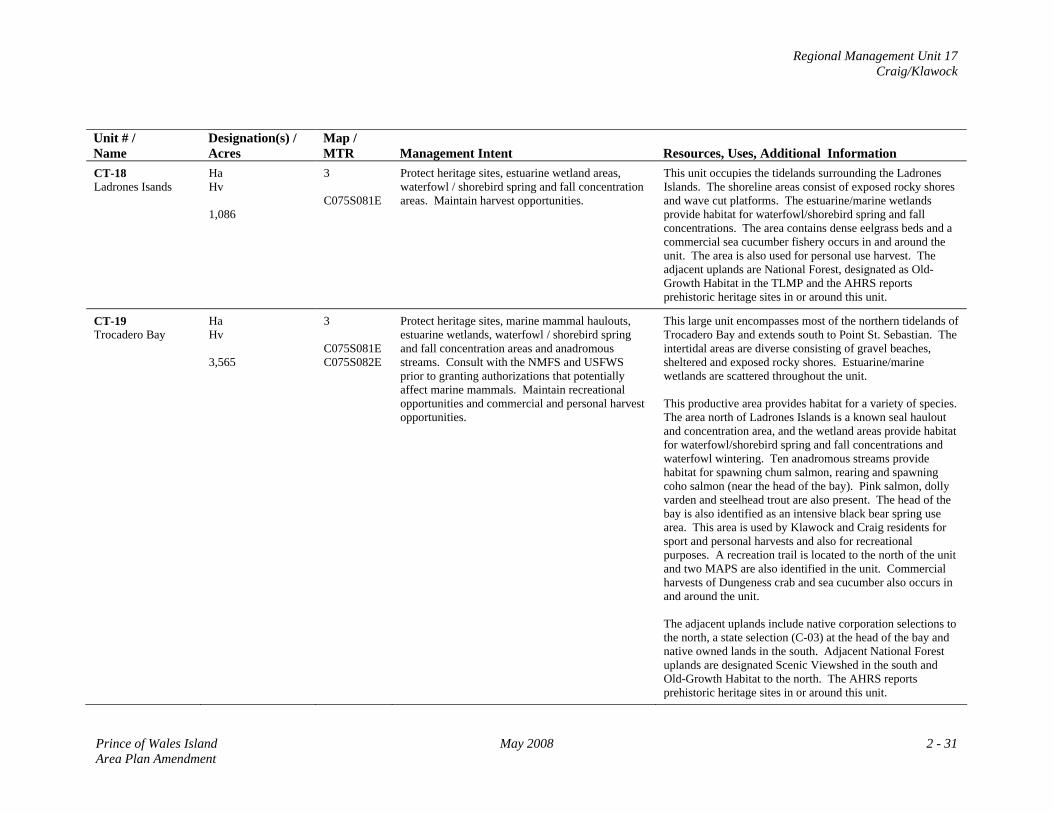
Regional Management Unit 17 Craig/Klawock
Unit # / Name
Designation(s) / Acres
Map / MTR
Management Intent
Resources, Uses, Additional Information
CT-18 Ladrones Isands
Ha Hv 1,086
3 C075S081E
Protect heritage sites, estuarine wetland areas, waterfowl / shorebird spring and fall concentration areas. Maintain harvest opportunities.
This unit occupies the tidelands surrounding the Ladrones Islands. The shoreline areas consist of exposed rocky shores and wave cut platforms. The estuarine/marine wetlands provide habitat for waterfowl/shorebird spring and fall concentrations. The area contains dense eelgrass beds and a commercial sea cucumber fishery occurs in and around the unit. The area is also used for personal use harvest. The adjacent uplands are National Forest, designated as Old-Growth Habitat in the TLMP and the AHRS reports prehistoric heritage sites in or around this unit.
CT-19 Trocadero Bay
Ha Hv 3,565
3 C075S081E C075S082E
Protect heritage sites, marine mammal haulouts, estuarine wetlands, waterfowl / shorebird spring and fall concentration areas and anadromous streams. Consult with the NMFS and USFWS prior to granting authorizations that potentially affect marine mammals. Maintain recreational opportunities and commercial and personal harvest opportunities.
This large unit encompasses most of the northern tidelands of Trocadero Bay and extends south to Point St. Sebastian. The intertidal areas are diverse consisting of gravel beaches, sheltered and exposed rocky shores. Estuarine/marine wetlands are scattered throughout the unit. This productive area provides habitat for a variety of species. The area north of Ladrones Islands is a known seal haulout and concentration area, and the wetland areas provide habitat for waterfowl/shorebird spring and fall concentrations and waterfowl wintering. Ten anadromous streams provide habitat for spawning chum salmon, rearing and spawning coho salmon (near the head of the bay). Pink salmon, dolly varden and steelhead trout are also present. The head of the bay is also identified as an intensive black bear spring use area. This area is used by Klawock and Craig residents for sport and personal harvests and also for recreational purposes. A recreation trail is located to the north of the unit and two MAPS are also identified in the unit. Commercial harvests of Dungeness crab and sea cucumber also occurs in and around the unit. The adjacent uplands include native corporation selections to the north, a state selection (C-03) at the head of the bay and native owned lands in the south. Adjacent National Forest uplands are designated Scenic Viewshed in the south and Old-Growth Habitat to the north. The AHRS reports prehistoric heritage sites in or around this unit.
Prince of Wales Island May 2008 2 - 31 Area Plan Amendment
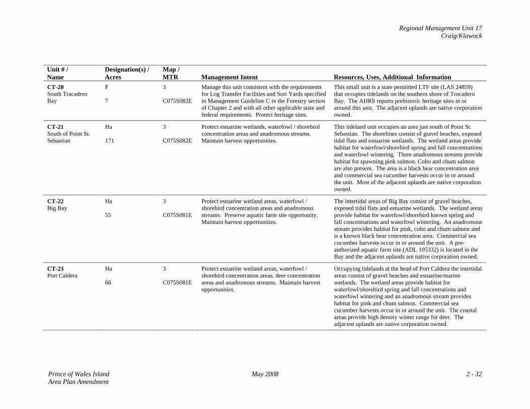
Regional Management Unit 17 Craig/Klawock
Unit # / Name
Designation(s) / Acres
Map / MTR
Management Intent
Resources, Uses, Additional Information
CT-20 South Tracadero Bay
F 7
3 C075S082E
Manage this unit consistent with the requirements for Log Transfer Facilities and Sort Yards specified in Management Guideline C in the Forestry section of Chapter 2 and with all other applicable state and federal requirements. Protect heritage sites.
This small unit is a state permitted LTF site (LAS 24859) that occupies tidelands on the southern shore of Trocadero Bay. The AHRS reports prehistoric heritage sites in or around this unit. The adjacent uplands are native corporation owned.
CT-21 South of Point St. Sebastian
Ha 171
3 C075S082E
Protect estuarine wetlands, waterfowl / shorebird concentration areas and anadromous streams. Maintain harvest opportunities.
This tideland unit occupies an area just south of Point St. Sebastian. The shorelines consist of gravel beaches, exposed tidal flats and estuarine wetlands. The wetland areas provide habitat for waterfowl/shorebird spring and fall concentrations and waterfowl wintering. Three anadromous streams provide habitat for spawning pink salmon. Coho and chum salmon are also present. The area is a black bear concentration area and commercial sea cucumber harvests occur in or around the unit. Most of the adjacent uplands are native corporation owned.
CT-22 Big Bay
Ha 55
3 C075S081E
Protect estuarine wetland areas, waterfowl / shorebird concentration areas and anadromous streams. Preserve aquatic farm site opportunity. Maintain harvest opportunities.
The intertidal areas of Big Bay consist of gravel beaches, exposed tidal flats and estuarine wetlands. The wetland areas provide habitat for waterfowl/shorebird known spring and fall concentrations and waterfowl wintering. An anadromous stream provides habitat for pink, coho and chum salmon and is a known black bear concentration area. Commercial sea cucumber harvests occur in or around the unit. A pre-authorized aquatic farm site (ADL 105332) is located in the Bay and the adjacent uplands are native corporation owned.
CT-23 Port Caldera
Ha 66
3 C075S081E
Protect estuarine wetland areas, waterfowl / shorebird concentration areas, deer concentration areas and anadromous streams. Maintain harvest opportunities.
Occupying tidelands at the head of Port Caldera the intertidal areas consist of gravel beaches and estuarine/marine wetlands. The wetland areas provide habitat for waterfowl/shorebird spring and fall concentrations and waterfowl wintering and an anadromous stream provides habitat for pink and chum salmon. Commercial sea cucumber harvests occur in or around the unit. The coastal areas provide high density winter range for deer. The adjacent uplands are native corporation owned.
Prince of Wales Island May 2008 2 - 32 Area Plan Amendment
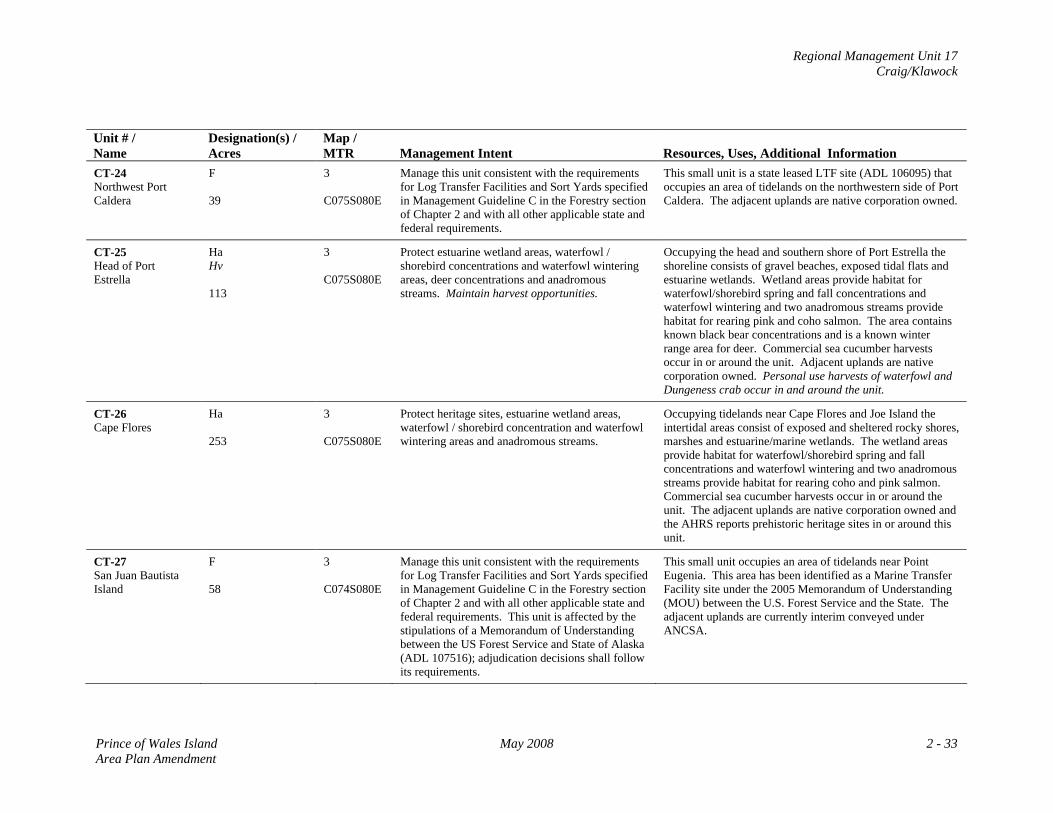
Regional Management Unit 17 Craig/Klawock
Unit # / Name
Designation(s) / Acres
Map / MTR
Management Intent
Resources, Uses, Additional Information
CT-24 Northwest Port Caldera
F 39
3 C075S080E
Manage this unit consistent with the requirements for Log Transfer Facilities and Sort Yards specified in Management Guideline C in the Forestry section of Chapter 2 and with all other applicable state and federal requirements.
This small unit is a state leased LTF site (ADL 106095) that occupies an area of tidelands on the northwestern side of Port Caldera. The adjacent uplands are native corporation owned.
CT-25 Head of Port Estrella
Ha Hv 113
3 C075S080E
Protect estuarine wetland areas, waterfowl / shorebird concentrations and waterfowl wintering areas, deer concentrations and anadromous streams. Maintain harvest opportunities.
Occupying the head and southern shore of Port Estrella the shoreline consists of gravel beaches, exposed tidal flats and estuarine wetlands. Wetland areas provide habitat for waterfowl/shorebird spring and fall concentrations and waterfowl wintering and two anadromous streams provide habitat for rearing pink and coho salmon. The area contains known black bear concentrations and is a known winter range area for deer. Commercial sea cucumber harvests occur in or around the unit. Adjacent uplands are native corporation owned. Personal use harvests of waterfowl and Dungeness crab occur in and around the unit.
CT-26 Cape Flores
Ha 253
3 C075S080E
Protect heritage sites, estuarine wetland areas, waterfowl / shorebird concentration and waterfowl wintering areas and anadromous streams.
Occupying tidelands near Cape Flores and Joe Island the intertidal areas consist of exposed and sheltered rocky shores, marshes and estuarine/marine wetlands. The wetland areas provide habitat for waterfowl/shorebird spring and fall concentrations and waterfowl wintering and two anadromous streams provide habitat for rearing coho and pink salmon. Commercial sea cucumber harvests occur in or around the unit. The adjacent uplands are native corporation owned and the AHRS reports prehistoric heritage sites in or around this unit.
CT-27 San Juan Bautista Island
F 58
3 C074S080E
Manage this unit consistent with the requirements for Log Transfer Facilities and Sort Yards specified in Management Guideline C in the Forestry section of Chapter 2 and with all other applicable state and federal requirements. This unit is affected by the stipulations of a Memorandum of Understanding between the US Forest Service and State of Alaska (ADL 107516); adjudication decisions shall follow its requirements.
This small unit occupies an area of tidelands near Point Eugenia. This area has been identified as a Marine Transfer Facility site under the 2005 Memorandum of Understanding (MOU) between the U.S. Forest Service and the State. The adjacent uplands are currently interim conveyed under ANCSA.
Prince of Wales Island May 2008 2 - 33 Area Plan Amendment
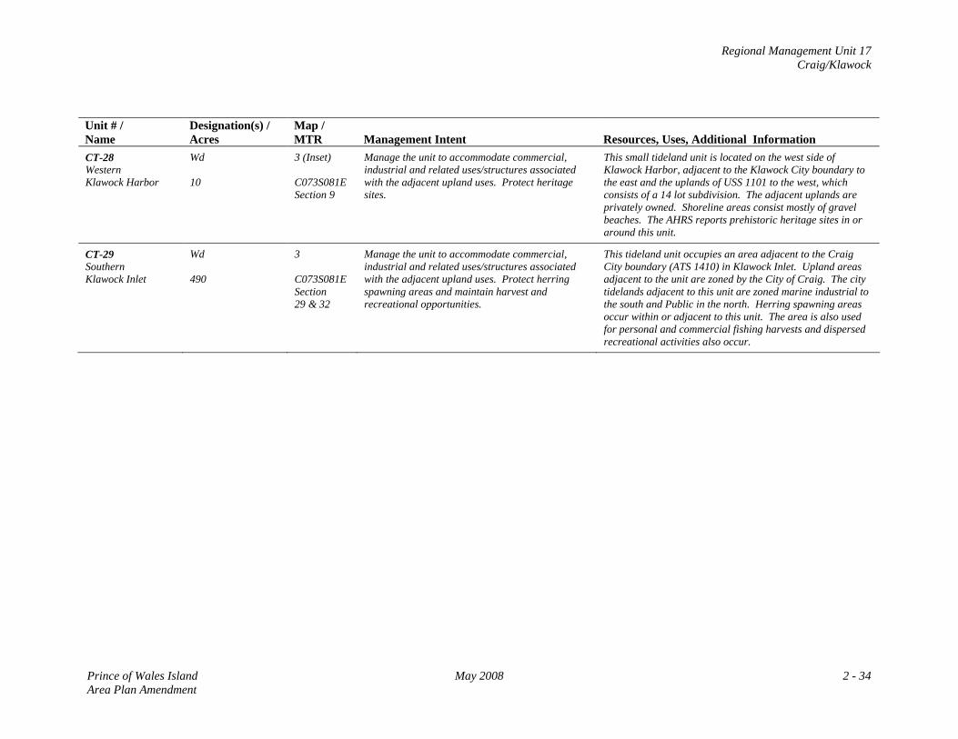
Regional Management Unit 17 Craig/Klawock
Unit # / Name
Designation(s) / Acres
Map / MTR
Management Intent
Resources, Uses, Additional Information
CT-28 Western Klawock Harbor
Wd 10
3 (Inset) C073S081E Section 9
Manage the unit to accommodate commercial, industrial and related uses/structures associated with the adjacent upland uses. Protect heritage sites.
This small tideland unit is located on the west side of Klawock Harbor, adjacent to the Klawock City boundary to the east and the uplands of USS 1101 to the west, which consists of a 14 lot subdivision. The adjacent uplands are privately owned. Shoreline areas consist mostly of gravel beaches. The AHRS reports prehistoric heritage sites in or around this unit.
CT-29 Southern Klawock Inlet
Wd 490
3 C073S081E Section 29 & 32
Manage the unit to accommodate commercial, industrial and related uses/structures associated with the adjacent upland uses. Protect herring spawning areas and maintain harvest and recreational opportunities.
This tideland unit occupies an area adjacent to the Craig City boundary (ATS 1410) in Klawock Inlet. Upland areas adjacent to the unit are zoned by the City of Craig. The city tidelands adjacent to this unit are zoned marine industrial to the south and Public in the north. Herring spawning areas occur within or adjacent to this unit. The area is also used for personal and commercial fishing harvests and dispersed recreational activities also occur.
Prince of Wales Island May 2008 2 - 34 Area Plan Amendment
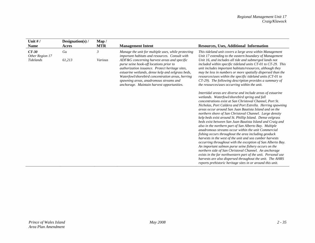
Regional Management Unit 17 Craig/Klawock
Unit # / Name
Designation(s) / Acres
Map / MTR
Management Intent
Resources, Uses, Additional Information
CT-30 Other Region 17 Tidelands
Gu 61,213
3 Various
Manage the unit for multiple uses, while protecting important habitats and resources. Consult with ADF&G concerning harvest areas and specific purse seine hook-off locations prior to authorization issuance. Protect heritage sites, estuarine wetlands, dense kelp and eelgrass beds, Waterfowl/shorebird concentration areas, herring spawning areas, anadromous streams and anchorage. Maintain harvest opportunities.
This tideland unit covers a large area within Management Unit 17 extending to the eastern boundary of Management Unit 16, and includes all tide and submerged lands not included within specific tideland units CT-01 to CT-29. This unit includes important habitats/resources, although they may be less in numbers or more spatially dispersed than the resources/uses within the specific tideland units (CT-01 to CT-29). The following description provides a summary of the resources/uses occurring within the unit. Intertidal areas are diverse and include areas of estuarine wetlands. Waterfowl/shorebird spring and fall concentrations exist at San Christoval Channel, Port St. Nicholas, Port Caldera and Port Estrella. Herring spawning areas occur around San Juan Bautista Island and on the northern shore of San Christoval Channel. Large density kelp beds exist around St. Phillip Island. Dense eelgrass beds exist between San Juan Bautista Island and Craig and also in the northern part of San Alberto Bay. Multiple anadromous streams occur within the unit Commercial fishing occurs throughout the area including geoduck harvests in the west of the unit and sea cumber harvests occurring throughout with the exception of San Alberto Bay. An important salmon purse seine fishery occurs on the northern side of San Christoval Channel. An anchorage exists in the far northwestern part of the unit. Personal use harvests are also dispersed throughout the unit. The AHRS reports prehistoric heritage sites in or around this unit.
Prince of Wales Island May 2008 2 - 35 Area Plan Amendment
Regional Management Unit 17 Craig/Klawock
MAP 3: Management Unit 17: Craig/Klawock
Prince of Wales Island May 2008 2 - 37 Area Plan Amendment
Regional Management Unit 18 Dall/Forrester Island
REGIONAL MANAGEMENT UNIT 18 Dall/Forrester Island
Background The Dall/Forrester Island Region is relatively large and extends from Suemez Island in the north to the southern part of Dall Island in the south, and from Forrester Island in the west to Long Island in the east. State uplands are limited, consisting of the uplands at Port Delores and a state upland selection is located near Hook Arm. State ownership almost entirely consists of tide and submerged lands with extensive tideland areas in the region. Most of the adjacent uplands in the region are Tongass National Forest and the uplands on Long Island and the eastern side of Dall Island are almost entirely Native Corporation owned. State Land/Acreage State uplands at Port Dolores consist of approximately 1193 acres. State selected uplands at Hook Arm consist of approximately 995 acres. State tidelands are extensive and there are 50 designated units consisting of approximately 59,085 acres at various locations mainly at the head of bays. In addition to the specific tideland units, approximately 361,659 acres of state owned tide and submerged lands exist 3 miles seaward from upland mean high water. Physical Features The regional uplands are generally characterized by rugged mountainous terrain of less than 3000 ft with steep slopes near the coastal waters with the exception of Long Island which has generally more flat to moderately sloping terrain. Dall Island consists of numerous bays, arms, coves and harbors that are spread throughout the entire coastline. The intertidal areas of the region consist mainly of a gravel beaches, estuarine wetlands and exposed rocky shores. Forrester Island and the western coastline of Dall Island is directly exposed to the Pacific Ocean, whereas the eastern side of Dall, Long Island and Soda Bay offer more semi‐protected environments. Relatively large upland areas around Soda Bay have been used for timber harvest.
Prince of Wales Island May 2008 2 - 39 Area Plan Amendment
Regional Management Unit 18 Dall/Forrester Island
Access Due to most of the region being remote and consisting of large sea‐divided islands, access is primarily by water or air, either by boat or floatplane typically departing from Klawock, Craig or Hydaburg. The Soda Bay area can be accessed via the Hydaburg Highway and then by the Soda Bay Trail. Charter boats seasonally transport locals and visitors from Craig, Klawock and Hydaburg for sport fishing and wildlife viewing. Resources and Uses Uses: With few exceptions, the majority of the coastline and the tide and submerged lands are used for some form of personal or commercial harvest at some point of the year. The region contains areas of cultural and historical importance, especially for the Haida community that have used and occupied areas within the region for several hundred years. On an annual weight‐yield basis commercial fishing is the predominant use of the tide and submerged lands and occurs throughout most of the area. Commercial fishery harvests include salmon, halibut, geoduck, sea cucumber, Dungeness crab, Red Urchins and shrimp. Especially for the residents of Hydaburg, subsistence activities remain an important use of the tide and submerged lands throughout a large part of the region especially around Mears passage, Soda Bay and Long Island. Charter sport fishing and wildlife viewing also occurs within the region. A USFS cabin located at Essowah Lake on Dall Island provides public recreation opportunities. Resources: The region contains a variety of sensitive resources that are typically concentrated within the designated Habitat (Ha) or Harvest (Hv) tideland units. Marine mammal concentrations exist at Forrester Island, Mears Passage, Sakie Point and Grand Island. The region contains several seabird nesting colonies around Mears Passage, Suemez and Forrester Island and waterfowl/shorebird spring and fall concentration and wintering areas at various locations throughout the area. The region also contains numerous bald eagle nesting sites spread throughout the region, although they are less prevalent on the exposed western shore of Dall Island. Anadromous streams are spread throughout the entire region. The AHRS reports prehistoric heritage sites in or around the region, some of which occur in or around the upland and tideland units. Management Constraints and Considerations The region is located within an unorganized borough, and there are no local comprehensive plans or zoning, and no district coastal plans affecting the area. Most of the adjacent uplands are part of the Tongass National Forest managed by the USFS accordingly to the requirements of the TLMP. The area of Forrester Island is designated Wilderness in the TLMP.
2 - 40 May 2008 Prince of Wales Island Area Plan Amendment
Regional Management Unit 18 Dall/Forrester Island
Management Summary/Intent for State Lands Uplands: The state uplands at Port Dolores and Hook Arm are to be conveyed to the University of Alaska (UA) consistent with the requirement of AS 14.40.365(a). All actions must be consistent with this statute and the requirement of Department Order 148. Tidelands: Specific tideland areas within the region contain important wildlife habitat and commercial and non‐commercial fishery harvest opportunities. Where these values are especially concentrated spatially, these tideland areas are designated Habitat (Ha) or Harvest (Hv). Where both resources exist, they are often assigned a co‐designation of Habitat/Harvest. Tidelands designated Habitat often consist of one or more of the following resources: estuarine wetlands, marine mammal concentrations, shorebirds/waterfowl spring and fall concentrations, or nesting colonies, waterfowl wintering areas, and high density eelgrass or kelp beds. Areas designated as Harvest are characterized by harvests of salmon, halibut, geoduck, sea cucumber, Dungeness crab, Red Urchins and shrimp and are to be managed to maintain those harvest resources. Tidelands with these designations are to be managed so that the resources identified in the specific tideland unit within the Resource Allocation Table are to be maintained and protected. Forrester Island tidelands are to be managed consistent with requirements of the State Game Refuge. Areas designated as Forestry (F) are to be managed consistent with the associated state or federal agreements/requirements, authorizations must follow state/federal permitting requirements. The Essowah Lakes unit (DT‐31) is to be managed for its habitat and recreational opportunities. Access is to be maintained to and throughout this area and authorizations are to be compatible with the current uses. The remainder of the tidelands within the management region are designated General Use (Gu), a multiple use designation. It is intended that standard state/federal permitting process will be used to determine whether a particular use or facility is appropriate at specific sites in the areas designated General Use.
Prince of Wales Island May 2008 2 - 41 Area Plan Amendment
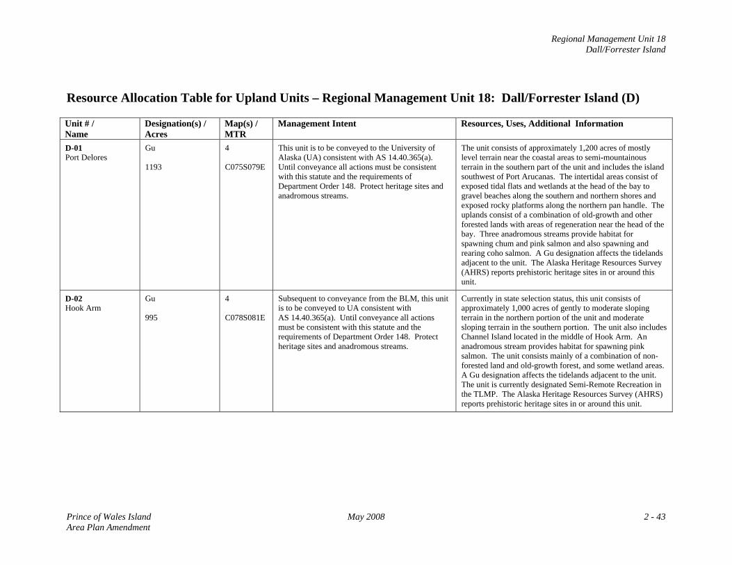
Regional Management Unit 18 Dall/Forrester Island
Resource Allocation Table for Upland Units – Regional Management Unit 18: Dall/Forrester Island (D) Unit # / Name
Designation(s) / Acres
Map(s) / MTR
Management Intent Resources, Uses, Additional Information
D-01 Port Delores
Gu 1193
4 C075S079E
This unit is to be conveyed to the University of Alaska (UA) consistent with AS 14.40.365(a). Until conveyance all actions must be consistent with this statute and the requirements of Department Order 148. Protect heritage sites and anadromous streams.
The unit consists of approximately 1,200 acres of mostly level terrain near the coastal areas to semi-mountainous terrain in the southern part of the unit and includes the island southwest of Port Arucanas. The intertidal areas consist of exposed tidal flats and wetlands at the head of the bay to gravel beaches along the southern and northern shores and exposed rocky platforms along the northern pan handle. The uplands consist of a combination of old-growth and other forested lands with areas of regeneration near the head of the bay. Three anadromous streams provide habitat for spawning chum and pink salmon and also spawning and rearing coho salmon. A Gu designation affects the tidelands adjacent to the unit. The Alaska Heritage Resources Survey (AHRS) reports prehistoric heritage sites in or around this unit.
D-02 Hook Arm
Gu 995
4 C078S081E
Subsequent to conveyance from the BLM, this unit is to be conveyed to UA consistent with AS 14.40.365(a). Until conveyance all actions must be consistent with this statute and the requirements of Department Order 148. Protect heritage sites and anadromous streams.
Currently in state selection status, this unit consists of approximately 1,000 acres of gently to moderate sloping terrain in the northern portion of the unit and moderate sloping terrain in the southern portion. The unit also includes Channel Island located in the middle of Hook Arm. An anadromous stream provides habitat for spawning pink salmon. The unit consists mainly of a combination of non-forested land and old-growth forest, and some wetland areas. A Gu designation affects the tidelands adjacent to the unit. The unit is currently designated Semi-Remote Recreation in the TLMP. The Alaska Heritage Resources Survey (AHRS) reports prehistoric heritage sites in or around this unit.
Prince of Wales Island May 2008 2 - 43 Area Plan Amendment
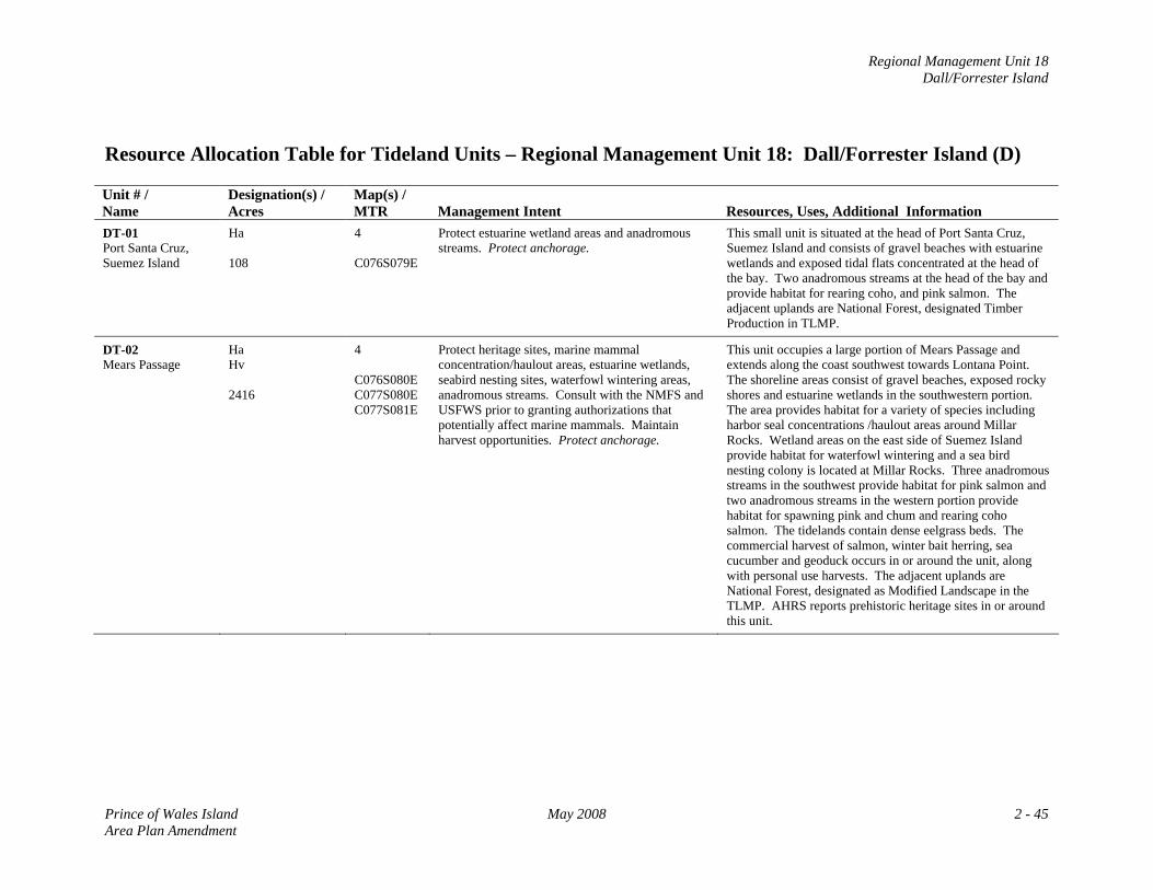
Regional Management Unit 18 Dall/Forrester Island
Resource Allocation Table for Tideland Units – Regional Management Unit 18: Dall/Forrester Island (D) Unit # / Name
Designation(s) / Acres
Map(s) / MTR
Management Intent
Resources, Uses, Additional Information
DT-01 Port Santa Cruz, Suemez Island
Ha 108
4 C076S079E
Protect estuarine wetland areas and anadromous streams. Protect anchorage.
This small unit is situated at the head of Port Santa Cruz, Suemez Island and consists of gravel beaches with estuarine wetlands and exposed tidal flats concentrated at the head of the bay. Two anadromous streams at the head of the bay and provide habitat for rearing coho, and pink salmon. The adjacent uplands are National Forest, designated Timber Production in TLMP.
DT-02 Mears Passage
Ha Hv 2416
4 C076S080E C077S080E C077S081E
Protect heritage sites, marine mammal concentration/haulout areas, estuarine wetlands, seabird nesting sites, waterfowl wintering areas, anadromous streams. Consult with the NMFS and USFWS prior to granting authorizations that potentially affect marine mammals. Maintain harvest opportunities. Protect anchorage.
This unit occupies a large portion of Mears Passage and extends along the coast southwest towards Lontana Point. The shoreline areas consist of gravel beaches, exposed rocky shores and estuarine wetlands in the southwestern portion. The area provides habitat for a variety of species including harbor seal concentrations /haulout areas around Millar Rocks. Wetland areas on the east side of Suemez Island provide habitat for waterfowl wintering and a sea bird nesting colony is located at Millar Rocks. Three anadromous streams in the southwest provide habitat for pink salmon and two anadromous streams in the western portion provide habitat for spawning pink and chum and rearing coho salmon. The tidelands contain dense eelgrass beds. The commercial harvest of salmon, winter bait herring, sea cucumber and geoduck occurs in or around the unit, along with personal use harvests. The adjacent uplands are National Forest, designated as Modified Landscape in the TLMP. AHRS reports prehistoric heritage sites in or around this unit.
Prince of Wales Island May 2008 2 - 45 Area Plan Amendment
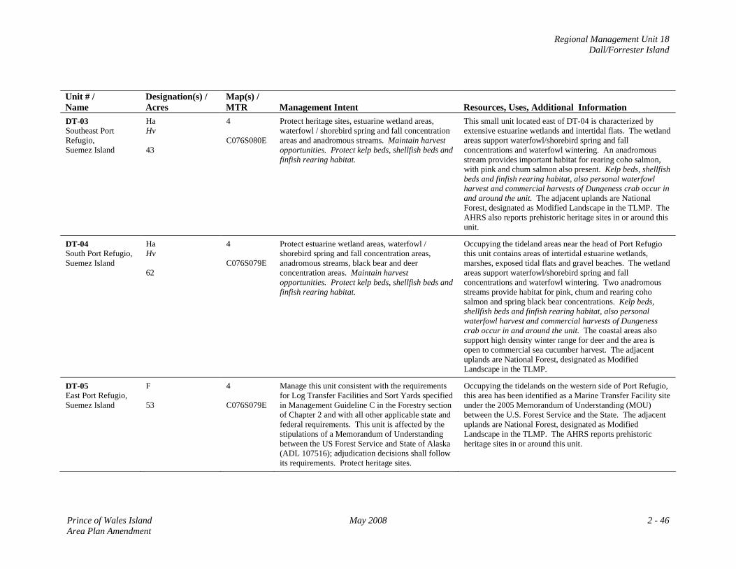
Regional Management Unit 18 Dall/Forrester Island
Unit # / Name
Designation(s) / Acres
Map(s) / MTR
Management Intent
Resources, Uses, Additional Information
DT-03 Southeast Port Refugio, Suemez Island
Ha Hv 43
4 C076S080E
Protect heritage sites, estuarine wetland areas, waterfowl / shorebird spring and fall concentration areas and anadromous streams. Maintain harvest opportunities. Protect kelp beds, shellfish beds and finfish rearing habitat.
This small unit located east of DT-04 is characterized by extensive estuarine wetlands and intertidal flats. The wetland areas support waterfowl/shorebird spring and fall concentrations and waterfowl wintering. An anadromous stream provides important habitat for rearing coho salmon, with pink and chum salmon also present. Kelp beds, shellfish beds and finfish rearing habitat, also personal waterfowl harvest and commercial harvests of Dungeness crab occur in and around the unit. The adjacent uplands are National Forest, designated as Modified Landscape in the TLMP. The AHRS also reports prehistoric heritage sites in or around this unit.
DT-04 South Port Refugio, Suemez Island
Ha Hv 62
4 C076S079E
Protect estuarine wetland areas, waterfowl / shorebird spring and fall concentration areas, anadromous streams, black bear and deer concentration areas. Maintain harvest opportunities. Protect kelp beds, shellfish beds and finfish rearing habitat.
Occupying the tideland areas near the head of Port Refugio this unit contains areas of intertidal estuarine wetlands, marshes, exposed tidal flats and gravel beaches. The wetland areas support waterfowl/shorebird spring and fall concentrations and waterfowl wintering. Two anadromous streams provide habitat for pink, chum and rearing coho salmon and spring black bear concentrations. Kelp beds, shellfish beds and finfish rearing habitat, also personal waterfowl harvest and commercial harvests of Dungeness crab occur in and around the unit. The coastal areas also support high density winter range for deer and the area is open to commercial sea cucumber harvest. The adjacent uplands are National Forest, designated as Modified Landscape in the TLMP.
DT-05 East Port Refugio, Suemez Island
F 53
4 C076S079E
Manage this unit consistent with the requirements for Log Transfer Facilities and Sort Yards specified in Management Guideline C in the Forestry section of Chapter 2 and with all other applicable state and federal requirements. This unit is affected by the stipulations of a Memorandum of Understanding between the US Forest Service and State of Alaska (ADL 107516); adjudication decisions shall follow its requirements. Protect heritage sites.
Occupying the tidelands on the western side of Port Refugio, this area has been identified as a Marine Transfer Facility site under the 2005 Memorandum of Understanding (MOU) between the U.S. Forest Service and the State. The adjacent uplands are National Forest, designated as Modified Landscape in the TLMP. The AHRS reports prehistoric heritage sites in or around this unit.
Prince of Wales Island May 2008 2 - 46 Area Plan Amendment
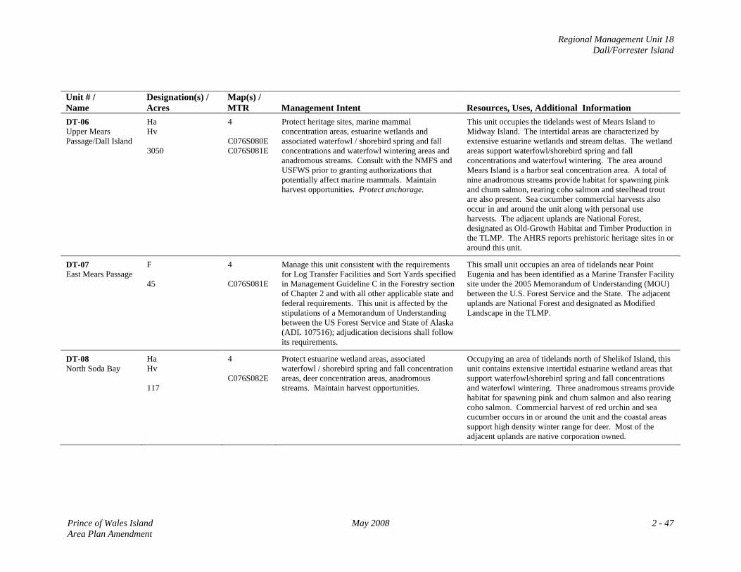
Regional Management Unit 18 Dall/Forrester Island
Unit # / Name
Designation(s) / Acres
Map(s) / MTR
Management Intent
Resources, Uses, Additional Information
DT-06 Upper Mears Passage/Dall Island
Ha Hv 3050
4 C076S080E C076S081E
Protect heritage sites, marine mammal concentration areas, estuarine wetlands and associated waterfowl / shorebird spring and fall concentrations and waterfowl wintering areas and anadromous streams. Consult with the NMFS and USFWS prior to granting authorizations that potentially affect marine mammals. Maintain harvest opportunities. Protect anchorage.
This unit occupies the tidelands west of Mears Island to Midway Island. The intertidal areas are characterized by extensive estuarine wetlands and stream deltas. The wetland areas support waterfowl/shorebird spring and fall concentrations and waterfowl wintering. The area around Mears Island is a harbor seal concentration area. A total of nine anadromous streams provide habitat for spawning pink and chum salmon, rearing coho salmon and steelhead trout are also present. Sea cucumber commercial harvests also occur in and around the unit along with personal use harvests. The adjacent uplands are National Forest, designated as Old-Growth Habitat and Timber Production in the TLMP. The AHRS reports prehistoric heritage sites in or around this unit.
DT-07 East Mears Passage
F 45
4 C076S081E
Manage this unit consistent with the requirements for Log Transfer Facilities and Sort Yards specified in Management Guideline C in the Forestry section of Chapter 2 and with all other applicable state and federal requirements. This unit is affected by the stipulations of a Memorandum of Understanding between the US Forest Service and State of Alaska (ADL 107516); adjudication decisions shall follow its requirements.
This small unit occupies an area of tidelands near Point Eugenia and has been identified as a Marine Transfer Facility site under the 2005 Memorandum of Understanding (MOU) between the U.S. Forest Service and the State. The adjacent uplands are National Forest and designated as Modified Landscape in the TLMP.
DT-08 North Soda Bay
Ha Hv 117
4 C076S082E
Protect estuarine wetland areas, associated waterfowl / shorebird spring and fall concentration areas, deer concentration areas, anadromous streams. Maintain harvest opportunities.
Occupying an area of tidelands north of Shelikof Island, this unit contains extensive intertidal estuarine wetland areas that support waterfowl/shorebird spring and fall concentrations and waterfowl wintering. Three anadromous streams provide habitat for spawning pink and chum salmon and also rearing coho salmon. Commercial harvest of red urchin and sea cucumber occurs in or around the unit and the coastal areas support high density winter range for deer. Most of the adjacent uplands are native corporation owned.
Prince of Wales Island May 2008 2 - 47 Area Plan Amendment
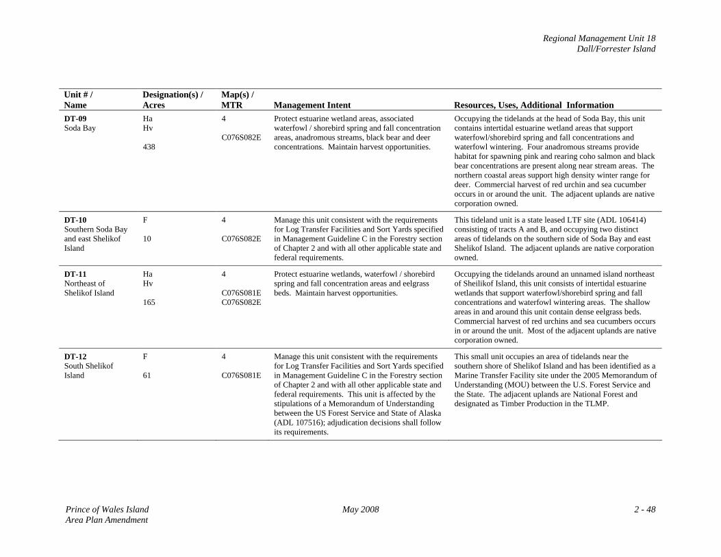
Regional Management Unit 18 Dall/Forrester Island
Unit # / Name
Designation(s) / Acres
Map(s) / MTR
Management Intent
Resources, Uses, Additional Information
DT-09 Soda Bay
Ha Hv 438
4 C076S082E
Protect estuarine wetland areas, associated waterfowl / shorebird spring and fall concentration areas, anadromous streams, black bear and deer concentrations. Maintain harvest opportunities.
Occupying the tidelands at the head of Soda Bay, this unit contains intertidal estuarine wetland areas that support waterfowl/shorebird spring and fall concentrations and waterfowl wintering. Four anadromous streams provide habitat for spawning pink and rearing coho salmon and black bear concentrations are present along near stream areas. The northern coastal areas support high density winter range for deer. Commercial harvest of red urchin and sea cucumber occurs in or around the unit. The adjacent uplands are native corporation owned.
DT-10 Southern Soda Bay and east Shelikof Island
F 10
4 C076S082E
Manage this unit consistent with the requirements for Log Transfer Facilities and Sort Yards specified in Management Guideline C in the Forestry section of Chapter 2 and with all other applicable state and federal requirements.
This tideland unit is a state leased LTF site (ADL 106414) consisting of tracts A and B, and occupying two distinct areas of tidelands on the southern side of Soda Bay and east Shelikof Island. The adjacent uplands are native corporation owned.
DT-11 Northeast of Shelikof Island
Ha Hv 165
4 C076S081E C076S082E
Protect estuarine wetlands, waterfowl / shorebird spring and fall concentration areas and eelgrass beds. Maintain harvest opportunities.
Occupying the tidelands around an unnamed island northeast of Sheilikof Island, this unit consists of intertidal estuarine wetlands that support waterfowl/shorebird spring and fall concentrations and waterfowl wintering areas. The shallow areas in and around this unit contain dense eelgrass beds. Commercial harvest of red urchins and sea cucumbers occurs in or around the unit. Most of the adjacent uplands are native corporation owned.
DT-12 South Shelikof Island
F 61
4 C076S081E
Manage this unit consistent with the requirements for Log Transfer Facilities and Sort Yards specified in Management Guideline C in the Forestry section of Chapter 2 and with all other applicable state and federal requirements. This unit is affected by the stipulations of a Memorandum of Understanding between the US Forest Service and State of Alaska (ADL 107516); adjudication decisions shall follow its requirements.
This small unit occupies an area of tidelands near the southern shore of Shelikof Island and has been identified as a Marine Transfer Facility site under the 2005 Memorandum of Understanding (MOU) between the U.S. Forest Service and the State. The adjacent uplands are National Forest and designated as Timber Production in the TLMP.
Prince of Wales Island May 2008 2 - 48 Area Plan Amendment
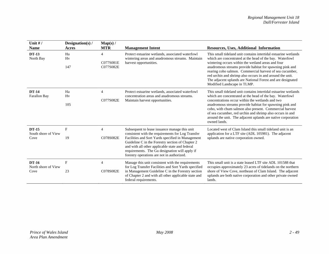
Regional Management Unit 18 Dall/Forrester Island
Unit # / Name
Designation(s) / Acres
Map(s) / MTR
Management Intent
Resources, Uses, Additional Information
DT-13 North Bay
Ha Hv 147
4 C077S081E C077S082E
Protect estuarine wetlands, associated waterfowl wintering areas and anadromous streams. Maintain harvest opportunities.
This small tideland unit contains intertidal estuarine wetlands which are concentrated at the head of the bay. Waterfowl wintering occurs within the wetland areas and four anadromous streams provide habitat for spawning pink and rearing coho salmon. Commercial harvest of sea cucumber, red urchin and shrimp also occurs in and around the unit. The adjacent uplands are National Forest and are designated Modified Landscape in TLMP.
DT-14 Farallon Bay
Ha Hv 105
4 C077S082E
Protect estuarine wetlands, associated waterfowl concentration areas and anadromous streams. Maintain harvest opportunities.
This small tideland unit contains intertidal estuarine wetlands which are concentrated at the head of the bay. Waterfowl concentrations occur within the wetlands and two anadromous streams provide habitat for spawning pink and coho, with chum salmon also present. Commercial harvest of sea cucumber, red urchin and shrimp also occurs in and around the unit. The adjacent uplands are native corporation owned lands.
DT-15 South shore of View Cove
F 19
4 C078S082E
Subsequent to lease issuance manage this unit consistent with the requirements for Log Transfer Facilities and Sort Yards specified in Management Guideline C in the Forestry section of Chapter 2 and with all other applicable state and federal requirements. The Gu designation will apply if forestry operations are not in authorized.
Located west of Clam Island this small tideland unit is an application for a LTF site (ADL 105981). The adjacent uplands are native corporation owned.
DT-16 North shore of View Cove
F 23
4 C078S082E
Manage this unit consistent with the requirements for Log Transfer Facilities and Sort Yards specified in Management Guideline C in the Forestry section of Chapter 2 and with all other applicable state and federal requirements.
This small unit is a state leased LTF site ADL 101588 that occupies approximately 23 acres of tidelands on the northern shore of View Cove, northeast of Clam Island. The adjacent uplands are both native corporation and other private owned lands.
Prince of Wales Island May 2008 2 - 49 Area Plan Amendment
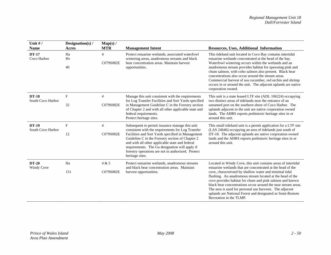
Regional Management Unit 18 Dall/Forrester Island
Unit # / Name
Designation(s) / Acres
Map(s) / MTR
Management Intent
Resources, Uses, Additional Information
DT-17 Coco Harbor
Ha Hv 40
4 C079S082E
Protect estuarine wetlands, associated waterfowl wintering areas, anadromous streams and black bear concentration areas. Maintain harvest opportunities.
This tideland unit located in Coco Bay contains intertidal estuarine wetlands concentrated at the head of the bay. Waterfowl wintering occurs within the wetlands and an anadromous stream provides habitat for spawning pink and chum salmon, with coho salmon also present. Black bear concentrations also occur around the stream areas. Commercial harvest of sea cucumber, red urchin and shrimp occurs in or around the unit. The adjacent uplands are native corporation owned.
DT-18 South Coco Harbor
F 32
4 C079S082E
Manage this unit consistent with the requirements for Log Transfer Facilities and Sort Yards specified in Management Guideline C in the Forestry section of Chapter 2 and with all other applicable state and federal requirements. Protect heritage sites.
This unit is a state leased LTF site (ADL 106224) occupying two distinct areas of tidelands near the entrance of an unnamed port on the southern shore of Coco Harbor. The uplands adjacent to the unit are native corporation owned lands. The AHRS reports prehistoric heritage sites in or around this unit.
DT-19 South Coco Harbor
F 12
4 C079S082E
Subsequent to permit issuance manage this unit consistent with the requirements for Log Transfer Facilities and Sort Yards specified in Management Guideline C in the Forestry section of Chapter 2 and with all other applicable state and federal requirements. The Gu designation will apply if forestry operations are not in authorized. Protect heritage sites.
This small tideland unit is a permit application for a LTF site (LAS 24646) occupying an area of tidelands just south of DT-18. The adjacent uplands are native corporation owned lands and the AHRS reports prehistoric heritage sites in or around this unit.
DT-20 Windy Cove
Ha 151
4 & 5 C079S082E
Protect estuarine wetlands, anadromous streams and black bear concentration areas. Maintain harvest opportunities.
Located in Windy Cove, this unit contains areas of intertidal estuarine wetlands that are concentrated at the head of the cove, characterized by shallow water and minimal tidal flushing. An anadromous stream located at the head of the cove provides habitat for chum and pink salmon and known black bear concentrations occur around the near stream areas. The area is used for personal use harvests. The adjacent uplands are National Forest and designated as Semi-Remote Recreation in the TLMP.
Prince of Wales Island May 2008 2 - 50 Area Plan Amendment
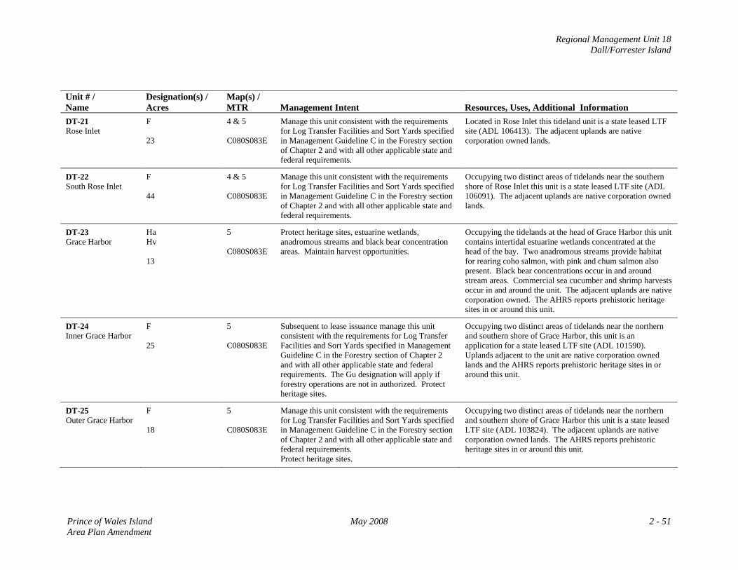
Regional Management Unit 18 Dall/Forrester Island
Unit # / Name
Designation(s) / Acres
Map(s) / MTR
Management Intent
Resources, Uses, Additional Information
DT-21 Rose Inlet
F 23
4 & 5 C080S083E
Manage this unit consistent with the requirements for Log Transfer Facilities and Sort Yards specified in Management Guideline C in the Forestry section of Chapter 2 and with all other applicable state and federal requirements.
Located in Rose Inlet this tideland unit is a state leased LTF site (ADL 106413). The adjacent uplands are native corporation owned lands.
DT-22 South Rose Inlet
F 44
4 & 5 C080S083E
Manage this unit consistent with the requirements for Log Transfer Facilities and Sort Yards specified in Management Guideline C in the Forestry section of Chapter 2 and with all other applicable state and federal requirements.
Occupying two distinct areas of tidelands near the southern shore of Rose Inlet this unit is a state leased LTF site (ADL 106091). The adjacent uplands are native corporation owned lands.
DT-23 Grace Harbor
Ha Hv 13
5 C080S083E
Protect heritage sites, estuarine wetlands, anadromous streams and black bear concentration areas. Maintain harvest opportunities.
Occupying the tidelands at the head of Grace Harbor this unit contains intertidal estuarine wetlands concentrated at the head of the bay. Two anadromous streams provide habitat for rearing coho salmon, with pink and chum salmon also present. Black bear concentrations occur in and around stream areas. Commercial sea cucumber and shrimp harvests occur in and around the unit. The adjacent uplands are native corporation owned. The AHRS reports prehistoric heritage sites in or around this unit.
DT-24 Inner Grace Harbor
F 25
5 C080S083E
Subsequent to lease issuance manage this unit consistent with the requirements for Log Transfer Facilities and Sort Yards specified in Management Guideline C in the Forestry section of Chapter 2 and with all other applicable state and federal requirements. The Gu designation will apply if forestry operations are not in authorized. Protect heritage sites.
Occupying two distinct areas of tidelands near the northern and southern shore of Grace Harbor, this unit is an application for a state leased LTF site (ADL 101590). Uplands adjacent to the unit are native corporation owned lands and the AHRS reports prehistoric heritage sites in or around this unit.
DT-25 Outer Grace Harbor
F 18
5 C080S083E
Manage this unit consistent with the requirements for Log Transfer Facilities and Sort Yards specified in Management Guideline C in the Forestry section of Chapter 2 and with all other applicable state and federal requirements. Protect heritage sites.
Occupying two distinct areas of tidelands near the northern and southern shore of Grace Harbor this unit is a state leased LTF site (ADL 103824). The adjacent uplands are native corporation owned lands. The AHRS reports prehistoric heritage sites in or around this unit.
Prince of Wales Island May 2008 2 - 51 Area Plan Amendment
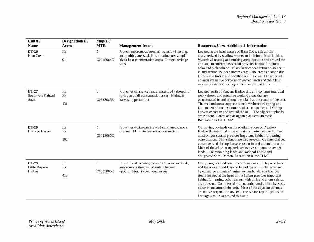
Regional Management Unit 18 Dall/Forrester Island
Unit # / Name
Designation(s) / Acres
Map(s) / MTR
Management Intent
Resources, Uses, Additional Information
DT-26 Ham Cove
Ha 91
5 C081S084E
Protect anadromous streams, waterfowl nesting, and molting areas, shellfish rearing areas, and black bear concentration areas. Protect heritage sites.
Located at the head waters of Ham Cove, this unit is characterized by shallow waters and minimal tidal flushing. Waterfowl nesting and molting areas occur in and around the unit and an andromous stream provides habitat for chum, coho and pink salmon. Black bear concentrations also occur in and around the near stream areas. The area is historically known as a finfish and shellfish rearing area. The adjacent uplands are native corporation owned lands and the AHRS reports prehistoric heritage sites in or around this unit.
DT-27 Southwest Kaigani Strait
Ha Hv 431
5 C082S085E
Protect estuarine wetlands, waterfowl / shorebird spring and fall concentration areas. Maintain harvest opportunities.
Located north of Kaigani Harbor this unit contains intertidal rocky shores and estuarine wetland areas that are concentrated in and around the island at the center of the unit. The wetland areas support waterfowl/shorebird spring and fall concentrations. Commercial sea cucumber and shrimp harvest occurs in and around the unit. The adjacent uplands are National Forest and designated as Semi-Remote Recreation in the TLMP.
DT-28 Datzkoo Harbor
Ha Hv 162
5 C082S085E
Protect estuarine/marine wetlands, anadromous streams. Maintain harvest opportunities.
Occupying tidelands on the southern shore of Datzkoo Harbor the intertidal areas contain estuarine wetlands. Two anadromous steams provides important habitat for rearing coho salmon. Pink salmon are also present. Commercial sea cucumber and shrimp harvests occur in and around the unit. Most of the adjacent uplands are native corporation owned lands. The remaining lands are National Forest and designated Semi-Remote Recreation in the TLMP.
DT-29 Little Daykoo Harbor
Ha Hv 413
5 C083S085E
Protect heritage sites, estuarine/marine wetlands, anadromous streams. Maintain harvest opportunities. Protect anchorage.
Occupying tidelands on the northern shore of Daykoo Harbor and the area around Daykoo Island the unit is characterized by extensive estuarine/marine wetlands. An anadromous steam located at the head of the harbor provides important habitat for rearing coho salmon, with pink and chum salmon also present. Commercial sea cucumber and shrimp harvests occur in and around the unit. Most of the adjacent uplands are native corporation owned. The AHRS reports prehistoric heritage sites in or around this unit.
Prince of Wales Island May 2008 2 - 52 Area Plan Amendment
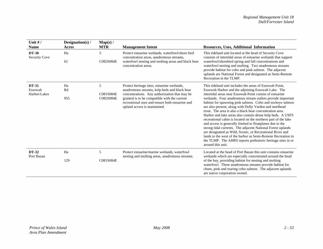
Regional Management Unit 18 Dall/Forrester Island
Unit # / Name
Designation(s) / Acres
Map(s) / MTR
Management Intent
Resources, Uses, Additional Information
DT-30 Security Cove
Ha 62
5 C082S084E
Protect estuarine wetlands, waterfowl/shore bird concentration areas, anadromous streams, waterfowl nesting and molting areas and black bear concentration areas.
This tideland unit located at the head of Security Cove consists of intertidal areas of estuarine wetlands that support waterfowl/shorebird spring and fall concentrations and waterfowl nesting and molting. Two anadromous streams provide habitat for coho and pink salmon. The adjacent uplands are National Forest and designated as Semi-Remote Recreation in the TLMP.
DT-31 Essowah Harbor/Lakes
Ha Rd 955
5 C081S084E C082S084E
Protect heritage sites, estuarine wetlands, anadromous streams, kelp beds and black bear concentrations. Any authorization that may be granted is to be compatible with the current recreational uses and ensure both estuarine and upland access is maintained.
This tideland unit includes the areas of Essowah Point, Essowah Harbor and the adjoining Essowah Lake. The intertidal areas near Essowah Point consist of estuarine wetlands. Four anadromous stream outlets provide important habitat for spawning pink salmon. Coho and sockeye salmon are also present, along with Dolly Varden and steelhead trout. The area is also a black bear concentration area. Harbor and lake areas also contain dense kelp beds. A USFS recreational cabin is located on the northern part of the lake and access is generally limited to floatplanes due to the strong tidal currents. The adjacent National Forest uplands are designated as Wild, Scenic, or Recreational River and lands to the west of the harbor as Semi-Remote Recreation in the TLMP. The AHRS reports prehistoric heritage sites in or around this unit.
DT-32 Port Bazan
Ha 129
5 C081S084E
Protect estuarine/marine wetlands, waterfowl nesting and molting areas, anadromous streams.
Located at the head of Port Bazan this unit contains estuarine wetlands which are especially concentrated around the head of the bay, providing habitat for nesting and molting waterfowl. Three anadromous streams provide habitat for chum, pink and rearing coho salmon. The adjacent uplands are native corporation owned.
Prince of Wales Island May 2008 2 - 53 Area Plan Amendment
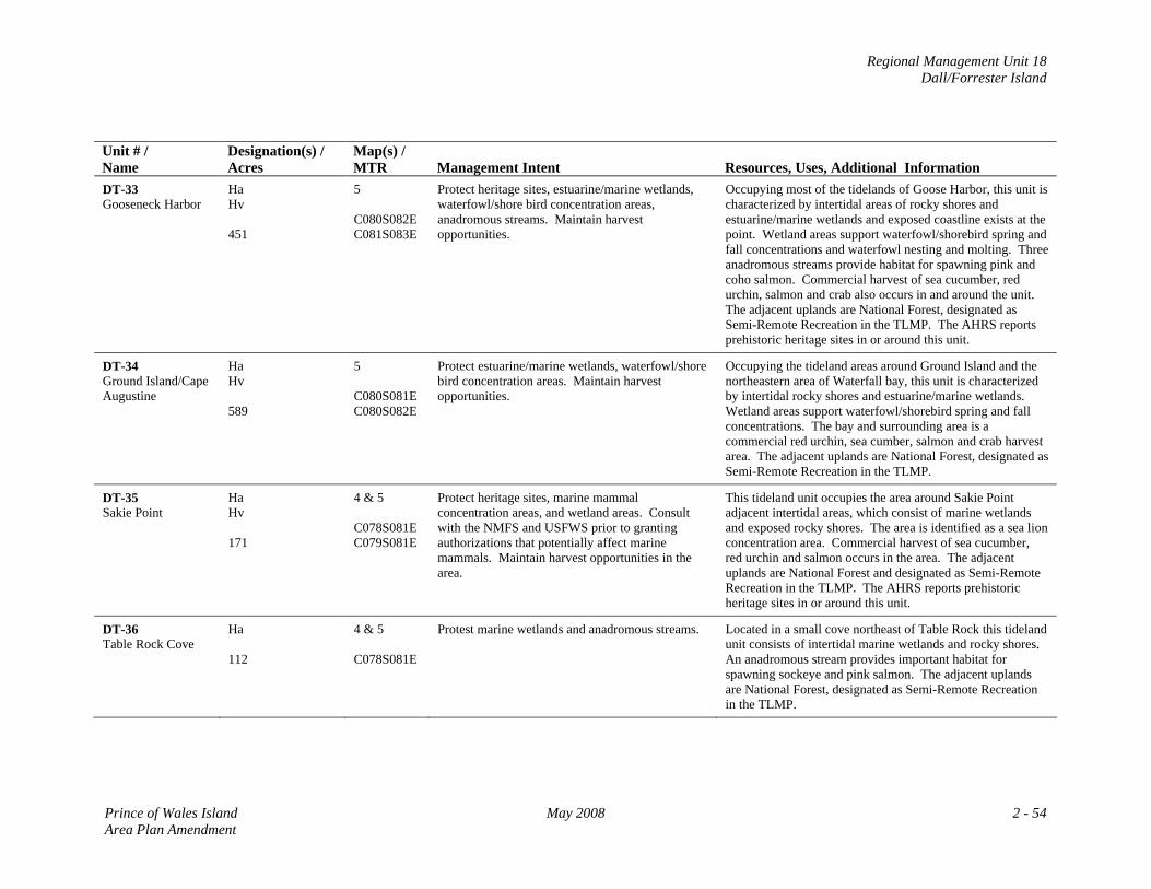
Regional Management Unit 18 Dall/Forrester Island
Unit # / Name
Designation(s) / Acres
Map(s) / MTR
Management Intent
Resources, Uses, Additional Information
DT-33 Gooseneck Harbor
Ha Hv 451
5 C080S082E C081S083E
Protect heritage sites, estuarine/marine wetlands, waterfowl/shore bird concentration areas, anadromous streams. Maintain harvest opportunities.
Occupying most of the tidelands of Goose Harbor, this unit is characterized by intertidal areas of rocky shores and estuarine/marine wetlands and exposed coastline exists at the point. Wetland areas support waterfowl/shorebird spring and fall concentrations and waterfowl nesting and molting. Three anadromous streams provide habitat for spawning pink and coho salmon. Commercial harvest of sea cucumber, red urchin, salmon and crab also occurs in and around the unit. The adjacent uplands are National Forest, designated as Semi-Remote Recreation in the TLMP. The AHRS reports prehistoric heritage sites in or around this unit.
DT-34 Ground Island/Cape Augustine
Ha Hv 589
5 C080S081E C080S082E
Protect estuarine/marine wetlands, waterfowl/shore bird concentration areas. Maintain harvest opportunities.
Occupying the tideland areas around Ground Island and the northeastern area of Waterfall bay, this unit is characterized by intertidal rocky shores and estuarine/marine wetlands. Wetland areas support waterfowl/shorebird spring and fall concentrations. The bay and surrounding area is a commercial red urchin, sea cumber, salmon and crab harvest area. The adjacent uplands are National Forest, designated as Semi-Remote Recreation in the TLMP.
DT-35 Sakie Point
Ha Hv 171
4 & 5 C078S081E C079S081E
Protect heritage sites, marine mammal concentration areas, and wetland areas. Consult with the NMFS and USFWS prior to granting authorizations that potentially affect marine mammals. Maintain harvest opportunities in the area.
This tideland unit occupies the area around Sakie Point adjacent intertidal areas, which consist of marine wetlands and exposed rocky shores. The area is identified as a sea lion concentration area. Commercial harvest of sea cucumber, red urchin and salmon occurs in the area. The adjacent uplands are National Forest and designated as Semi-Remote Recreation in the TLMP. The AHRS reports prehistoric heritage sites in or around this unit.
DT-36 Table Rock Cove
Ha 112
4 & 5 C078S081E
Protest marine wetlands and anadromous streams. Located in a small cove northeast of Table Rock this tideland unit consists of intertidal marine wetlands and rocky shores. An anadromous stream provides important habitat for spawning sockeye and pink salmon. The adjacent uplands are National Forest, designated as Semi-Remote Recreation in the TLMP.
Prince of Wales Island May 2008 2 - 54 Area Plan Amendment
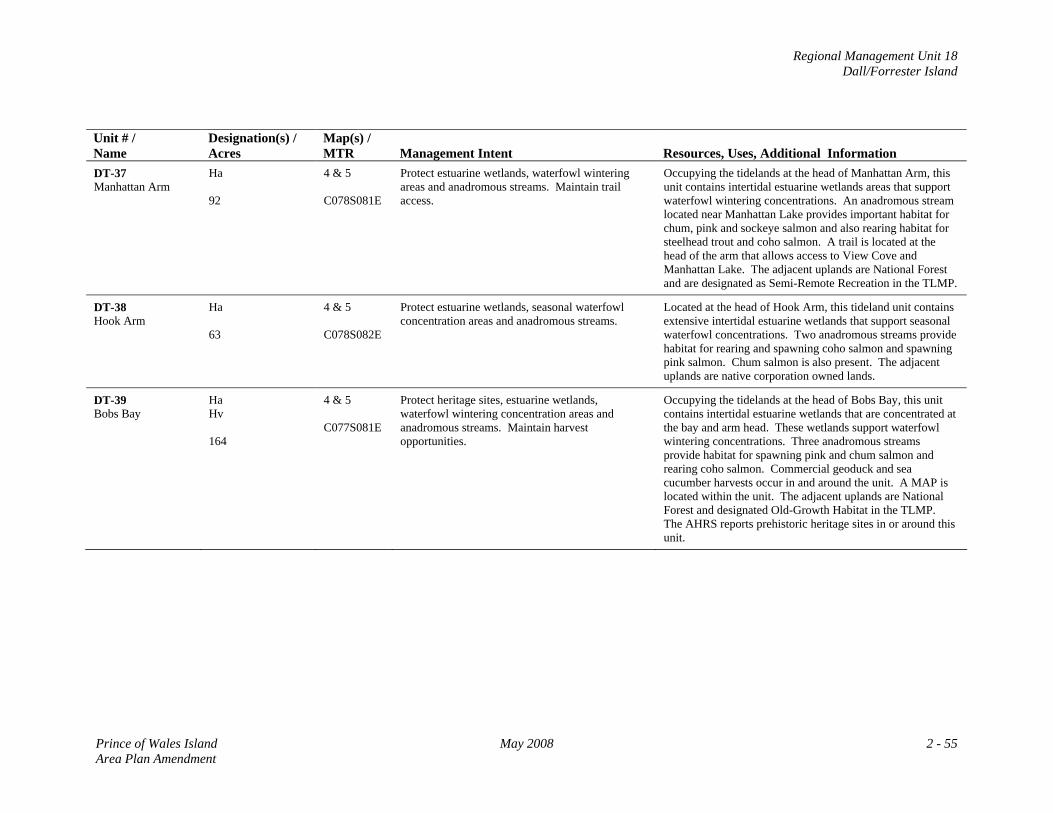
Regional Management Unit 18 Dall/Forrester Island
Unit # / Name
Designation(s) / Acres
Map(s) / MTR
Management Intent
Resources, Uses, Additional Information
DT-37 Manhattan Arm
Ha 92
4 & 5 C078S081E
Protect estuarine wetlands, waterfowl wintering areas and anadromous streams. Maintain trail access.
Occupying the tidelands at the head of Manhattan Arm, this unit contains intertidal estuarine wetlands areas that support waterfowl wintering concentrations. An anadromous stream located near Manhattan Lake provides important habitat for chum, pink and sockeye salmon and also rearing habitat for steelhead trout and coho salmon. A trail is located at the head of the arm that allows access to View Cove and Manhattan Lake. The adjacent uplands are National Forest and are designated as Semi-Remote Recreation in the TLMP.
DT-38 Hook Arm
Ha 63
4 & 5 C078S082E
Protect estuarine wetlands, seasonal waterfowl concentration areas and anadromous streams.
Located at the head of Hook Arm, this tideland unit contains extensive intertidal estuarine wetlands that support seasonal waterfowl concentrations. Two anadromous streams provide habitat for rearing and spawning coho salmon and spawning pink salmon. Chum salmon is also present. The adjacent uplands are native corporation owned lands.
DT-39 Bobs Bay
Ha Hv 164
4 & 5 C077S081E
Protect heritage sites, estuarine wetlands, waterfowl wintering concentration areas and anadromous streams. Maintain harvest opportunities.
Occupying the tidelands at the head of Bobs Bay, this unit contains intertidal estuarine wetlands that are concentrated at the bay and arm head. These wetlands support waterfowl wintering concentrations. Three anadromous streams provide habitat for spawning pink and chum salmon and rearing coho salmon. Commercial geoduck and sea cucumber harvests occur in and around the unit. A MAP is located within the unit. The adjacent uplands are National Forest and designated Old-Growth Habitat in the TLMP. The AHRS reports prehistoric heritage sites in or around this unit.
Prince of Wales Island May 2008 2 - 55 Area Plan Amendment
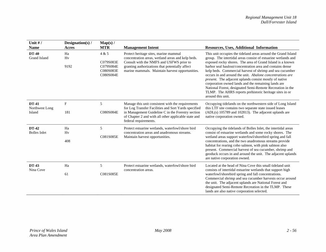
Regional Management Unit 18 Dall/Forrester Island
Unit # / Name
Designation(s) / Acres
Map(s) / MTR
Management Intent
Resources, Uses, Additional Information
DT-40 Grand Island
Ha Hv 9192
4 & 5 C079S083E C079S084E C080S083E C080S084E
Protect heritage sites, marine mammal concentration areas, wetland areas and kelp beds. Consult with the NMFS and USFWS prior to granting authorizations that potentially affect marine mammals. Maintain harvest opportunities.
This unit occupies the tideland areas around the Grand Island group. The intertidal areas consist of estuarine wetlands and exposed rocky shores. The area of Grand Island is a known harbor seal haulout/concentration area and contains dense kelp beds. Commercial harvest of shrimp and sea cucumber occurs in and around the unit. Abalone concentrations are present. The adjacent uplands consist mostly of native corporation owned lands and the remaining lands are National Forest, designated Semi-Remote Recreation in the TLMP. The AHRS reports prehistoric heritage sites in or around this unit.
DT-41 Northwest Long Island
F 181
5 C080S084E
Manage this unit consistent with the requirements for Log Transfer Facilities and Sort Yards specified in Management Guideline C in the Forestry section of Chapter 2 and with all other applicable state and federal requirements.
Occupying tidelands on the northwestern side of Long Island this LTF site contains two separate state issued leases (ADL(s) 105789 and 102813). The adjacent uplands are native corporation owned.
DT-42 Bolles Inlet
Ha Hv 408
5 C081S085E
Protect estuarine wetlands, waterfowl/shore bird concentration areas and anadromous streams. Maintain harvest opportunities.
Occupying the tidelands of Bolles Inlet, the intertidal areas consist of estuarine wetlands and some rocky shores. The wetland areas support waterfowl/shorebird spring and fall concentrations, and the two anadromous streams provide habitat for rearing coho salmon, with pink salmon also present. Commercial harvest of sea cucumber, shrimp and geoduck occurs in and around the unit. The adjacent uplands are native corporation owned.
DT-43 Nina Cove
Ha 61
5 C081S085E
Protect estuarine wetlands, waterfowl/shore bird concentration areas.
Located at the head of Nina Cove this small tideland unit consists of intertidal estuarine wetlands that support high waterfowl/shorebird spring and fall concentrations. Commercial shrimp and sea cucumber harvests occur around the unit. The adjacent uplands are National Forest and designated Semi-Remote Recreation in the TLMP. These lands are also native corporation selected.
Prince of Wales Island May 2008 2 - 56 Area Plan Amendment
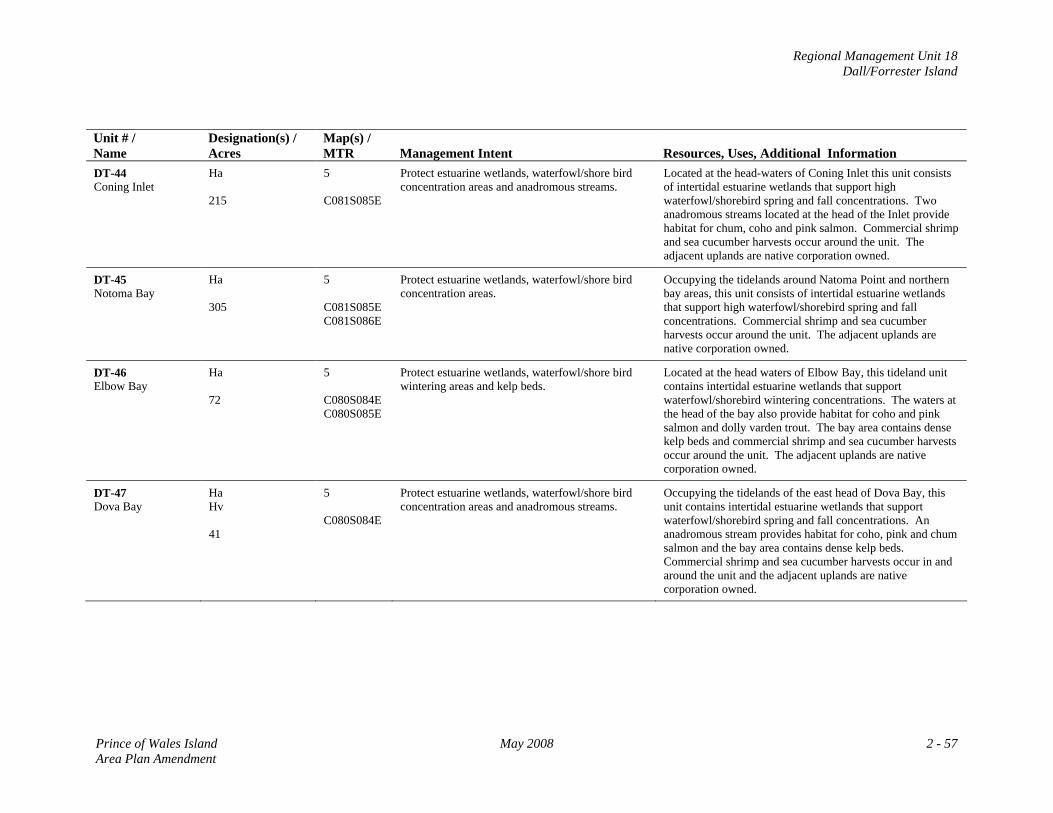
Regional Management Unit 18 Dall/Forrester Island
Unit # / Name
Designation(s) / Acres
Map(s) / MTR
Management Intent
Resources, Uses, Additional Information
DT-44 Coning Inlet
Ha 215
5 C081S085E
Protect estuarine wetlands, waterfowl/shore bird concentration areas and anadromous streams.
Located at the head-waters of Coning Inlet this unit consists of intertidal estuarine wetlands that support high waterfowl/shorebird spring and fall concentrations. Two anadromous streams located at the head of the Inlet provide habitat for chum, coho and pink salmon. Commercial shrimp and sea cucumber harvests occur around the unit. The adjacent uplands are native corporation owned.
DT-45 Notoma Bay
Ha 305
5 C081S085E C081S086E
Protect estuarine wetlands, waterfowl/shore bird concentration areas.
Occupying the tidelands around Natoma Point and northern bay areas, this unit consists of intertidal estuarine wetlands that support high waterfowl/shorebird spring and fall concentrations. Commercial shrimp and sea cucumber harvests occur around the unit. The adjacent uplands are native corporation owned.
DT-46 Elbow Bay
Ha 72
5 C080S084E C080S085E
Protect estuarine wetlands, waterfowl/shore bird wintering areas and kelp beds.
Located at the head waters of Elbow Bay, this tideland unit contains intertidal estuarine wetlands that support waterfowl/shorebird wintering concentrations. The waters at the head of the bay also provide habitat for coho and pink salmon and dolly varden trout. The bay area contains dense kelp beds and commercial shrimp and sea cucumber harvests occur around the unit. The adjacent uplands are native corporation owned.
DT-47 Dova Bay
Ha Hv 41
5 C080S084E
Protect estuarine wetlands, waterfowl/shore bird concentration areas and anadromous streams.
Occupying the tidelands of the east head of Dova Bay, this unit contains intertidal estuarine wetlands that support waterfowl/shorebird spring and fall concentrations. An anadromous stream provides habitat for coho, pink and chum salmon and the bay area contains dense kelp beds. Commercial shrimp and sea cucumber harvests occur in and around the unit and the adjacent uplands are native corporation owned.
Prince of Wales Island May 2008 2 - 57 Area Plan Amendment
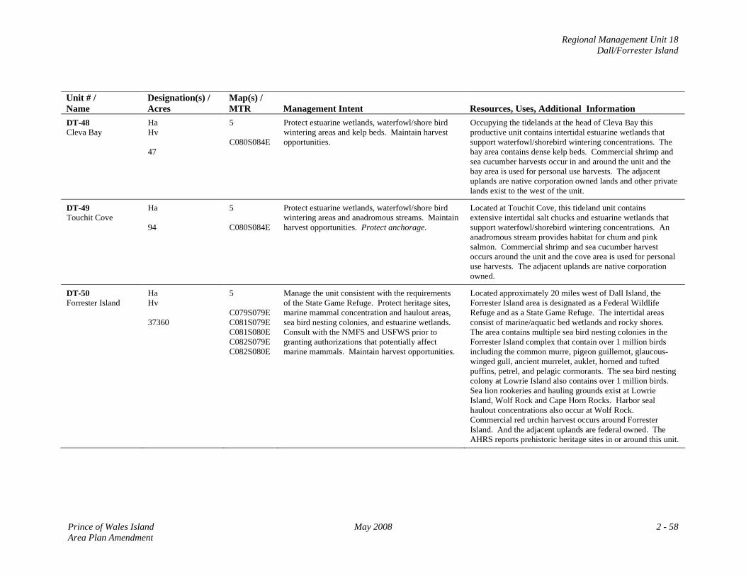
Regional Management Unit 18 Dall/Forrester Island
Unit # / Name
Designation(s) / Acres
Map(s) / MTR
Management Intent
Resources, Uses, Additional Information
DT-48 Cleva Bay
Ha Hv 47
5 C080S084E
Protect estuarine wetlands, waterfowl/shore bird wintering areas and kelp beds. Maintain harvest opportunities.
Occupying the tidelands at the head of Cleva Bay this productive unit contains intertidal estuarine wetlands that support waterfowl/shorebird wintering concentrations. The bay area contains dense kelp beds. Commercial shrimp and sea cucumber harvests occur in and around the unit and the bay area is used for personal use harvests. The adjacent uplands are native corporation owned lands and other private lands exist to the west of the unit.
DT-49 Touchit Cove
Ha 94
5 C080S084E
Protect estuarine wetlands, waterfowl/shore bird wintering areas and anadromous streams. Maintain harvest opportunities. Protect anchorage.
Located at Touchit Cove, this tideland unit contains extensive intertidal salt chucks and estuarine wetlands that support waterfowl/shorebird wintering concentrations. An anadromous stream provides habitat for chum and pink salmon. Commercial shrimp and sea cucumber harvest occurs around the unit and the cove area is used for personal use harvests. The adjacent uplands are native corporation owned.
DT-50 Forrester Island
Ha Hv 37360
5 C079S079E C081S079E C081S080E C082S079E C082S080E
Manage the unit consistent with the requirements of the State Game Refuge. Protect heritage sites, marine mammal concentration and haulout areas, sea bird nesting colonies, and estuarine wetlands. Consult with the NMFS and USFWS prior to granting authorizations that potentially affect marine mammals. Maintain harvest opportunities.
Located approximately 20 miles west of Dall Island, the Forrester Island area is designated as a Federal Wildlife Refuge and as a State Game Refuge. The intertidal areas consist of marine/aquatic bed wetlands and rocky shores. The area contains multiple sea bird nesting colonies in the Forrester Island complex that contain over 1 million birds including the common murre, pigeon guillemot, glaucous-winged gull, ancient murrelet, auklet, horned and tufted puffins, petrel, and pelagic cormorants. The sea bird nesting colony at Lowrie Island also contains over 1 million birds. Sea lion rookeries and hauling grounds exist at Lowrie Island, Wolf Rock and Cape Horn Rocks. Harbor seal haulout concentrations also occur at Wolf Rock. Commercial red urchin harvest occurs around Forrester Island. And the adjacent uplands are federal owned. The AHRS reports prehistoric heritage sites in or around this unit.
Prince of Wales Island May 2008 2 - 58 Area Plan Amendment
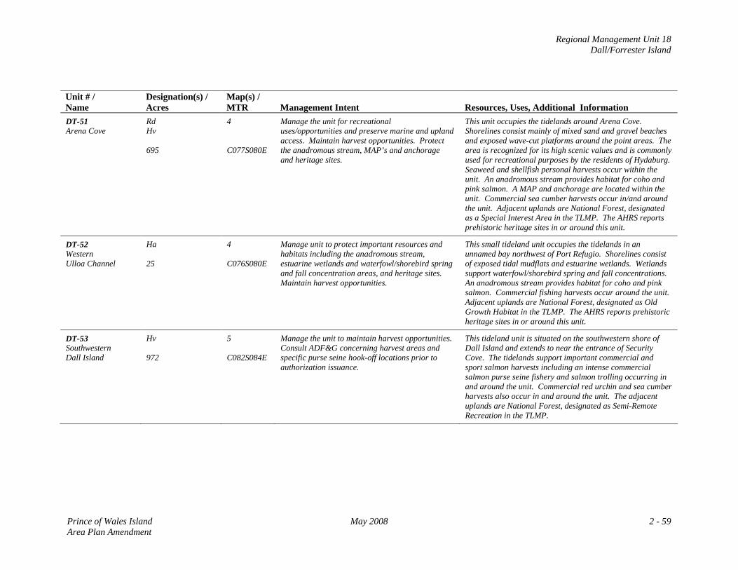
Regional Management Unit 18 Dall/Forrester Island
Unit # / Name
Designation(s) / Acres
Map(s) / MTR
Management Intent
Resources, Uses, Additional Information
DT-51 Arena Cove
Rd Hv 695
4 C077S080E
Manage the unit for recreational uses/opportunities and preserve marine and upland access. Maintain harvest opportunities. Protect the anadromous stream, MAP’s and anchorage and heritage sites.
This unit occupies the tidelands around Arena Cove. Shorelines consist mainly of mixed sand and gravel beaches and exposed wave-cut platforms around the point areas. The area is recognized for its high scenic values and is commonly used for recreational purposes by the residents of Hydaburg. Seaweed and shellfish personal harvests occur within the unit. An anadromous stream provides habitat for coho and pink salmon. A MAP and anchorage are located within the unit. Commercial sea cumber harvests occur in/and around the unit. Adjacent uplands are National Forest, designated as a Special Interest Area in the TLMP. The AHRS reports prehistoric heritage sites in or around this unit.
DT-52 Western Ulloa Channel
Ha 25
4 C076S080E
Manage unit to protect important resources and habitats including the anadromous stream, estuarine wetlands and waterfowl/shorebird spring and fall concentration areas, and heritage sites. Maintain harvest opportunities.
This small tideland unit occupies the tidelands in an unnamed bay northwest of Port Refugio. Shorelines consist of exposed tidal mudflats and estuarine wetlands. Wetlands support waterfowl/shorebird spring and fall concentrations. An anadromous stream provides habitat for coho and pink salmon. Commercial fishing harvests occur around the unit. Adjacent uplands are National Forest, designated as Old Growth Habitat in the TLMP. The AHRS reports prehistoric heritage sites in or around this unit.
DT-53 Southwestern Dall Island
Hv 972
5 C082S084E
Manage the unit to maintain harvest opportunities. Consult ADF&G concerning harvest areas and specific purse seine hook-off locations prior to authorization issuance.
This tideland unit is situated on the southwestern shore of Dall Island and extends to near the entrance of Security Cove. The tidelands support important commercial and sport salmon harvests including an intense commercial salmon purse seine fishery and salmon trolling occurring in and around the unit. Commercial red urchin and sea cumber harvests also occur in and around the unit. The adjacent uplands are National Forest, designated as Semi-Remote Recreation in the TLMP.
Prince of Wales Island May 2008 2 - 59 Area Plan Amendment
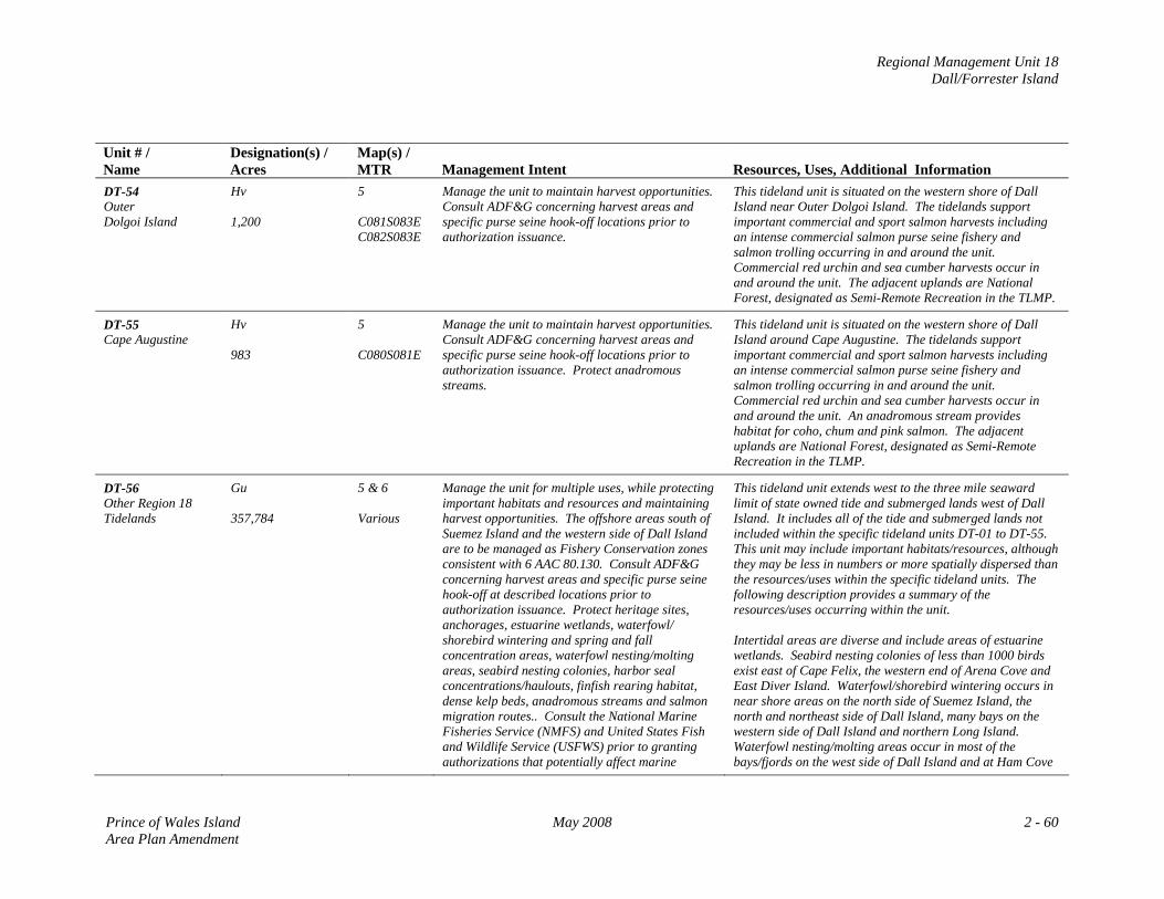
Regional Management Unit 18 Dall/Forrester Island
Unit # / Name
Designation(s) / Acres
Map(s) / MTR
Management Intent
Resources, Uses, Additional Information
DT-54 Outer Dolgoi Island
Hv 1,200
5 C081S083E C082S083E
Manage the unit to maintain harvest opportunities. Consult ADF&G concerning harvest areas and specific purse seine hook-off locations prior to authorization issuance.
This tideland unit is situated on the western shore of Dall Island near Outer Dolgoi Island. The tidelands support important commercial and sport salmon harvests including an intense commercial salmon purse seine fishery and salmon trolling occurring in and around the unit. Commercial red urchin and sea cumber harvests occur in and around the unit. The adjacent uplands are National Forest, designated as Semi-Remote Recreation in the TLMP.
DT-55 Cape Augustine
Hv 983
5 C080S081E
Manage the unit to maintain harvest opportunities. Consult ADF&G concerning harvest areas and specific purse seine hook-off locations prior to authorization issuance. Protect anadromous streams.
This tideland unit is situated on the western shore of Dall Island around Cape Augustine. The tidelands support important commercial and sport salmon harvests including an intense commercial salmon purse seine fishery and salmon trolling occurring in and around the unit. Commercial red urchin and sea cumber harvests occur in and around the unit. An anadromous stream provides habitat for coho, chum and pink salmon. The adjacent uplands are National Forest, designated as Semi-Remote Recreation in the TLMP.
DT-56 Other Region 18 Tidelands
Gu 357,784
5 & 6 Various
Manage the unit for multiple uses, while protecting important habitats and resources and maintaining harvest opportunities. The offshore areas south of Suemez Island and the western side of Dall Island are to be managed as Fishery Conservation zones consistent with 6 AAC 80.130. Consult ADF&G concerning harvest areas and specific purse seine hook-off at described locations prior to authorization issuance. Protect heritage sites, anchorages, estuarine wetlands, waterfowl/ shorebird wintering and spring and fall concentration areas, waterfowl nesting/molting areas, seabird nesting colonies, harbor seal concentrations/haulouts, finfish rearing habitat, dense kelp beds, anadromous streams and salmon migration routes.. Consult the National Marine Fisheries Service (NMFS) and United States Fish and Wildlife Service (USFWS) prior to granting authorizations that potentially affect marine
This tideland unit extends west to the three mile seaward limit of state owned tide and submerged lands west of Dall Island. It includes all of the tide and submerged lands not included within the specific tideland units DT-01 to DT-55. This unit may include important habitats/resources, although they may be less in numbers or more spatially dispersed than the resources/uses within the specific tideland units. The following description provides a summary of the resources/uses occurring within the unit. Intertidal areas are diverse and include areas of estuarine wetlands. Seabird nesting colonies of less than 1000 birds exist east of Cape Felix, the western end of Arena Cove and East Diver Island. Waterfowl/shorebird wintering occurs in near shore areas on the north side of Suemez Island, the north and northeast side of Dall Island, many bays on the western side of Dall Island and northern Long Island. Waterfowl nesting/molting areas occur in most of the bays/fjords on the west side of Dall Island and at Ham Cove
Prince of Wales Island May 2008 2 - 60 Area Plan Amendment
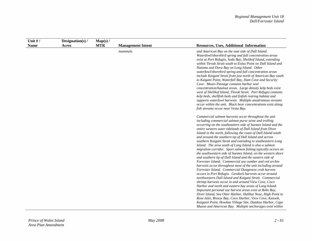
Regional Management Unit 18 Dall/Forrester Island
Unit # / Name
Designation(s) / Acres
Map(s) / MTR
Management Intent
Resources, Uses, Additional Information
mammals. and American Bay on the east side of Dall Island. Waterfowl/shorebird spring and fall concentration areas exist at Port Refugio, Soda Bay, Shelikof Island, extending within Tlevak Strait south to Eolus Point on Dall Island and Natoma and Dova Bay on Long Island. Other waterfowl/shorebird spring and fall concentration areas include Kaigani Strait from just north of American Bay south to Kaigani Point, Waterfall Bay, Ham Cove and Security Cove. Mears Passage contains harbor seal concentration/haulout areas. Large density kelp beds exist west of Shelikof Island, Tlevak Strait. Port Refugio contains kelp beds, shellfish beds and finfish rearing habitat and supports waterfowl harvests. Multiple anadromous streams occur within the unit. Black bear concentrations exist along fish streams occur near Vesta Bay. Commercial salmon harvests occur throughout the unit including commercial salmon purse seine and trolling occurring on the southeastern side of Suemez Island and the entire western outer tidelands of Dall Island from Diver Island in the north, following the coast of Dall Island south and around the southern tip of Dall Island and across southern Kaigani Strait and extending to southeastern Long Island. The area south of Long Island is also a salmon migration corridor. Sport salmon fishing typically occurs on the southwestern side of Suemez Island, on the western shore and southern tip of Dall Island and the eastern side of Forrester Island. Commercial sea cumber and red urchin harvests occur throughout most of the unit including around Forrester Island. Commercial Dungeness crab harvest occurs in Port Refugio. Geoduck harvests occur around northwestern Dall Island and Kaigani Strait. Commercial shrimp harvests occur in and around View Cove, Coco Harbor and north and eastern bay areas of Long Island. Important personal use harvest areas exist at Bobs Bay, Diver Island, Sea Otter Harbor, Halibut Nose, High Point to Rose Inlet, Breezy Bay, Coco Harbor, View Cove, Kasook, Kaiganii Point, Howkan Village Site, Datzkoo Harbor, Cape Muzon and American Bay. Multiple anchorages exist within
Prince of Wales Island May 2008 2 - 61 Area Plan Amendment
Regional Management Unit 18 Dall/Forrester Island
Unit # / Name
Designation(s) / Acres
Map(s) / MTR
Management Intent
Resources, Uses, Additional Information the unit. The AHRS reports prehistoric heritage sites in or around this unit.
Prince of Wales Island May 2008 2 - 62 Area Plan Amendment

Regional Management Unit 18 Dall/Forrester Island
MAP 4: Management Unit 18: Dall/Forrester Island
Prince of Wales Island May 2008 2 - 63 Area Plan Amendment
Regional Management Unit 18 Dall/Forrester Island
MAP 5: Management Unit 18: Dall/Forrester Island
Prince of Wales Island May 2008 2 - 65 Area Plan Amendment
Regional Management Unit 19 Hydaburg/Cordova Bay
REGIONAL MANAGEMENT UNIT 19 Hydaburg/Cordova Bay
Background The Hydaburg/Cordova Bay regional management unit is relatively large and extends from Natzuhini Bay in the north to the southern tip of Prince of Wales Island in the south, and from McFarland Islands in the west to Klakas Inlet in the east. No state owned uplands exist, although state selected uplands are located at Dunbar Inlet and Mabel Bay. State ownership consists entirely of tide and submerged lands with extensive tideland areas existing within the region. Native Corporation owned and selected uplands exist throughout most of the northern part of the management unit. Most of the uplands in the southern portion of the unit are Tongass National Forest with some Native Corporation lands existing around the Kassa Inlet area. State Land/Acreage No state owned uplands exist within the regional management unit. State selected uplands are located at Dunbar Inlet (also Native Corporation selected) and Mabel Bay consisting of approximately 1,949 acres. State tidelands are extensive and consist of 59 designated units consisting of approximately 46,076 acres primarily at the head of bays and inlets. In addition to the specific tideland units, approximately 199,300 acres of state owned tide and submerged lands exist 3 miles seaward from upland mean high water. Physical Features Most of the uplands within the region are on the Prince of Wales Island mainland and are generally characterized by rugged mountainous terrain of less than 3500 ft with some steep slopes near the coastal Inlet waters. The area south of Biscuit Lagoon is generally more flat consisting of moderate sloping terrain. The region consists of bay and strait type waters, and numerous inlet waters that dominate the northeastern part of the region. Intertidal areas are mainly gravel beaches, estuarine wetlands and exposed rocky shores. Areas of the region especially in the north are more protected from the Pacific Ocean elements due to many barrier type islands and upland Points.
Prince of Wales Island May 2008 2 - 67 Area Plan Amendment
Regional Management Unit 19 Hydaburg/Cordova Bay
Access Access to most of the region is entirely by water or air, either by boat or floatplane typically departing from Klawock, Craig or Hydaburg. Scheduled floatplane flights depart from Ketchikan arriving at Hydaburg. The inter‐island ferry authority conducts scheduled daily year‐round services from Ketchikan to Hollis. From Hollis the Hydaburg Highway provides access to the City of Hydaburg, although the main road ends just south of the city. Boats frequent the area transporting visitors and locals mainly from Hydaburg for sport fishing, wildlife viewing and other personal uses. Resources and Uses Uses: With few exceptions, the entirety of the coastline and the tide and submerged lands is used for some form of personal or commercial harvest at some point of the year. The region contains areas of cultural and historical importance, especially for the Haida community that have used and occupied areas of the region for several hundred years. On an annual weight‐yield basis commercial fishing is the predominant use of the tide and submerged lands and occurs throughout most of the area. Commercial fishery harvests include salmon, halibut, geoduck, sea cucumber, Dungeness crab, Red Urchins and shrimp. Especially for the residents of Hydaburg, subsistence activities remain an important use of the tide and submerged lands throughout most of the region especially in the northern areas of the region around Natzuhini Bay, Sukkwan Island and Strait, Hetta Inlet, Nutkwa Inlet, Keete Inlet and Mabel Bay. Charter sport fishing and wildlife viewing also occurs within the region. A USFS cabin located at Josephine Lake on Prince of Wales Island provides public recreation opportunities. Management Constraints and Considerations The region is located within an unorganized borough, and there are no local comprehensive plans or zoning, and no district coastal plans affecting the area. Most of the adjacent uplands are part of the Tongass National Forest managed by the USFS accordingly to the requirements of the TLMP. In the TLMP the uplands around Nutkwa Lagoon are designated LUD II and most of the upland area south of the Nutkwa LUD II is the South Prince of Wales Wilderness area.
2 - 68 May 2008 Prince of Wales Island Area Plan Amendment
Regional Management Unit 19 Hydaburg/Cordova Bay
Management Summary /Intent for State Lands Uplands: If conveyed to the state from the BLM the state selected uplands at Dunbar Inlet are to be managed as two distinct units. The western unit (H‐01) designated Settlement (Se) should be considered for disposal during the planning period and the eastern unit (H‐02) is to be managed consistent with the General Use (Gu) designation. These uplands are however, also Native Corporation selected. The state selected uplands at Mabel bay if conveyed from the BLM will be managed as three separate units. The uplands of H‐03 designated Settlement (Se) should be considered for disposal during the planning period. Unit H‐04 is to be managed consistent with the General Use (Gu) designation and H‐05 designated as Public Recreation and Tourism‐dispersed (Rd) is to be managed for recreational opportunities that are compatible with both H‐03 and H‐04 uses. See Resource Allocation Table for management requirements. Tidelands: Specific tideland areas within the region contain important wildlife habitat and commercial and non‐commercial fishery harvest opportunities. Where these values are especially concentrated spatially, these tideland areas are designated Habitat (Ha) or Harvest (Hv). Where both resources exist, they are often assigned a co‐designation of Habitat/Harvest. Tidelands designated Habitat (Ha) often consist of one or more of the following resources: estuarine wetlands, marine mammal concentrations, shorebirds/waterfowl spring and fall concentrations or nesting colonies, waterfowl wintering areas, and high density eelgrass or kelp beds. Areas designated as Harvest (Hv) are characterized by harvests of salmon, halibut, sea cucumber, Dungeness crab, Red Urchins and shrimp and are to be managed to maintain those harvest resources. Tidelands with these designations are to be managed so that the resources identified in the specific tideland unit within the Resource Allocation Table are to be maintained and protected. Areas designated as Forestry (F) are to be managed consistent with the associated state or federal agreements/requirements, authorizations must follow state/federal permitting requirements. Specific management units designated as Shoreline Use (Sd) are to be managed to accommodate marine structures and uses associated with residential development as per the Resource Allocation Table. The remainder of the tidelands within the management region are designated General Use (Gu), a multiple use designation. It is intended that standard state/federal permitting process will be used to determine whether a particular use or facility is appropriate at specific sites in the areas designated General Use.
Prince of Wales Island May 2008 2 - 69 Area Plan Amendment
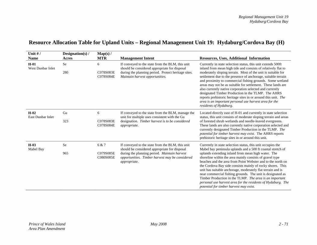
Regional Management Unit 19 Hydaburg/Cordova Bay
Resource Allocation Table for Upland Units – Regional Management Unit 19: Hydaburg/Cordova Bay (H) Unit # / Name
Designation(s) / Acres
Map(s) / MTR
Management Intent
Resources, Uses, Additional Information
H-01 West Dunbar Inlet
Se 280
6 C078S083E C078S084E
If conveyed to the state from the BLM, this unit should be considered appropriate for disposal during the planning period. Protect heritage sites. Maintain harvest opportunities.
Currently in state selection status, this unit extends 500ft inland from mean high tide and consists of relatively flat to moderately sloping terrain. Most of the unit is suitable for settlement due to the presence of anchorage, suitable terrain and proximity to commercial fishing grounds. Some wetland areas may not be as suitable for settlement. These lands are also currently native corporation selected and currently designated Timber Production in the TLMP. The AHRS reports prehistoric heritage sites in or around this unit. The area is an important personal use harvest area for the residents of Hydaburg.
H-02 East Dunbar Inlet
Gu 323
6 C078S083E C078S084E
If conveyed to the state from the BLM, manage the unit for multiple uses consistent with the Gu designation. Timber harvest is to be considered appropriate.
Located directly east of H-01 and currently in state selection status, this unit consists of moderate sloping terrain and areas of forested shrub wetlands and needle-leaved evergreens. These lands are also currently native corporation selected and currently designated Timber Production in the TLMP. The potential for timber harvest may exist. The AHRS reports prehistoric heritage sites in or around this unit.
H-03 Mabel Bay
Se 965
6 & 7 C079S085E C080S085E
If conveyed to the state from the BLM, this unit should be considered appropriate for disposal during the planning period. Maintain harvest opportunities. Timber harvest may be considered appropriate.
Currently in state selection status, this unit occupies the Mabel bay peninsula uplands and a 500 ft coastal stretch of uplands extending inland from mean high water. The shoreline within the area mainly consists of gravel type beaches and the area from Point Webster and to the north on the Cordova Bay side consists mainly of rocky shores. This unit has suitable anchorage, moderately flat terrain and is near commercial fishing grounds. The unit is designated as Timber Production in the TLMP. The area is an important personal use harvest area for the residents of Hydaburg. The potential for timber harvest may exist.
Prince of Wales Island May 2008 2 - 71 Area Plan Amendment
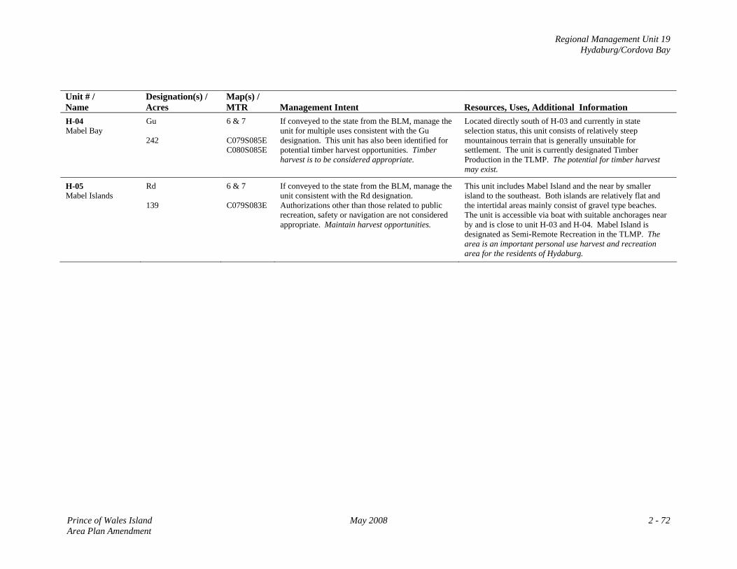
Regional Management Unit 19 Hydaburg/Cordova Bay
Unit # / Name
Designation(s) / Acres
Map(s) / MTR
Management Intent
Resources, Uses, Additional Information
H-04 Mabel Bay
Gu 242
6 & 7 C079S085E C080S085E
If conveyed to the state from the BLM, manage the unit for multiple uses consistent with the Gu designation. This unit has also been identified for potential timber harvest opportunities. Timber harvest is to be considered appropriate.
Located directly south of H-03 and currently in state selection status, this unit consists of relatively steep mountainous terrain that is generally unsuitable for settlement. The unit is currently designated Timber Production in the TLMP. The potential for timber harvest may exist.
H-05 Mabel Islands
Rd 139
6 & 7 C079S083E
If conveyed to the state from the BLM, manage the unit consistent with the Rd designation. Authorizations other than those related to public recreation, safety or navigation are not considered appropriate. Maintain harvest opportunities.
This unit includes Mabel Island and the near by smaller island to the southeast. Both islands are relatively flat and the intertidal areas mainly consist of gravel type beaches. The unit is accessible via boat with suitable anchorages near by and is close to unit H-03 and H-04. Mabel Island is designated as Semi-Remote Recreation in the TLMP. The area is an important personal use harvest and recreation area for the residents of Hydaburg.
Prince of Wales Island May 2008 2 - 72 Area Plan Amendment
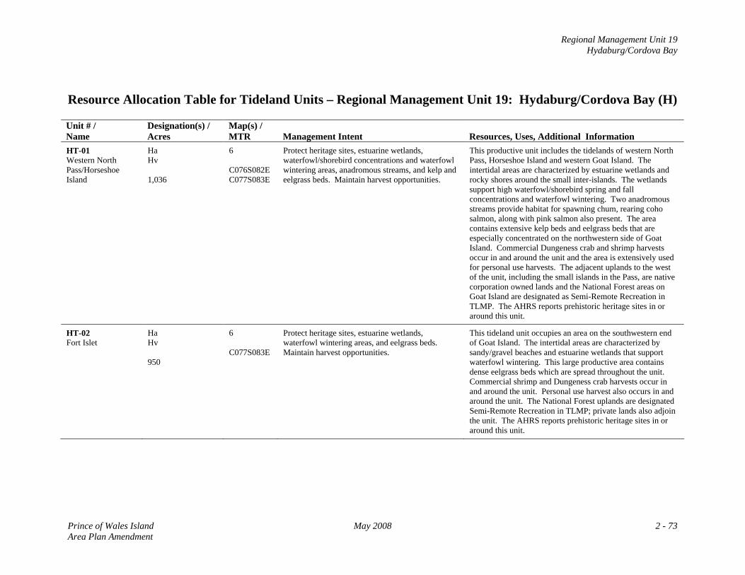
Regional Management Unit 19 Hydaburg/Cordova Bay
Resource Allocation Table for Tideland Units – Regional Management Unit 19: Hydaburg/Cordova Bay (H) Unit # / Name
Designation(s) / Acres
Map(s) / MTR
Management Intent
Resources, Uses, Additional Information
HT-01 Western North Pass/Horseshoe Island
Ha Hv 1,036
6 C076S082E C077S083E
Protect heritage sites, estuarine wetlands, waterfowl/shorebird concentrations and waterfowl wintering areas, anadromous streams, and kelp and eelgrass beds. Maintain harvest opportunities.
This productive unit includes the tidelands of western North Pass, Horseshoe Island and western Goat Island. The intertidal areas are characterized by estuarine wetlands and rocky shores around the small inter-islands. The wetlands support high waterfowl/shorebird spring and fall concentrations and waterfowl wintering. Two anadromous streams provide habitat for spawning chum, rearing coho salmon, along with pink salmon also present. The area contains extensive kelp beds and eelgrass beds that are especially concentrated on the northwestern side of Goat Island. Commercial Dungeness crab and shrimp harvests occur in and around the unit and the area is extensively used for personal use harvests. The adjacent uplands to the west of the unit, including the small islands in the Pass, are native corporation owned lands and the National Forest areas on Goat Island are designated as Semi-Remote Recreation in TLMP. The AHRS reports prehistoric heritage sites in or around this unit.
HT-02 Fort Islet
Ha Hv 950
6 C077S083E
Protect heritage sites, estuarine wetlands, waterfowl wintering areas, and eelgrass beds. Maintain harvest opportunities.
This tideland unit occupies an area on the southwestern end of Goat Island. The intertidal areas are characterized by sandy/gravel beaches and estuarine wetlands that support waterfowl wintering. This large productive area contains dense eelgrass beds which are spread throughout the unit. Commercial shrimp and Dungeness crab harvests occur in and around the unit. Personal use harvest also occurs in and around the unit. The National Forest uplands are designated Semi-Remote Recreation in TLMP; private lands also adjoin the unit. The AHRS reports prehistoric heritage sites in or around this unit.
Prince of Wales Island May 2008 2 - 73 Area Plan Amendment
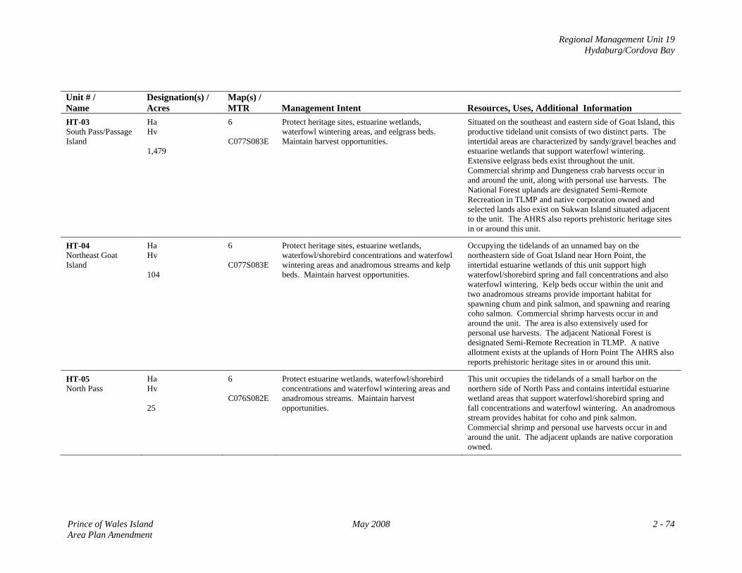
Regional Management Unit 19 Hydaburg/Cordova Bay
Unit # / Name
Designation(s) / Acres
Map(s) / MTR
Management Intent
Resources, Uses, Additional Information
HT-03 South Pass/Passage Island
Ha Hv 1,479
6 C077S083E
Protect heritage sites, estuarine wetlands, waterfowl wintering areas, and eelgrass beds. Maintain harvest opportunities.
Situated on the southeast and eastern side of Goat Island, this productive tideland unit consists of two distinct parts. The intertidal areas are characterized by sandy/gravel beaches and estuarine wetlands that support waterfowl wintering. Extensive eelgrass beds exist throughout the unit. Commercial shrimp and Dungeness crab harvests occur in and around the unit, along with personal use harvests. The National Forest uplands are designated Semi-Remote Recreation in TLMP and native corporation owned and selected lands also exist on Sukwan Island situated adjacent to the unit. The AHRS also reports prehistoric heritage sites in or around this unit.
HT-04 Northeast Goat Island
Ha Hv 104
6 C077S083E
Protect heritage sites, estuarine wetlands, waterfowl/shorebird concentrations and waterfowl wintering areas and anadromous streams and kelp beds. Maintain harvest opportunities.
Occupying the tidelands of an unnamed bay on the northeastern side of Goat Island near Horn Point, the intertidal estuarine wetlands of this unit support high waterfowl/shorebird spring and fall concentrations and also waterfowl wintering. Kelp beds occur within the unit and two anadromous streams provide important habitat for spawning chum and pink salmon, and spawning and rearing coho salmon. Commercial shrimp harvests occur in and around the unit. The area is also extensively used for personal use harvests. The adjacent National Forest is designated Semi-Remote Recreation in TLMP. A native allotment exists at the uplands of Horn Point The AHRS also reports prehistoric heritage sites in or around this unit.
HT-05 North Pass
Ha Hv 25
6 C076S082E
Protect estuarine wetlands, waterfowl/shorebird concentrations and waterfowl wintering areas and anadromous streams. Maintain harvest opportunities.
This unit occupies the tidelands of a small harbor on the northern side of North Pass and contains intertidal estuarine wetland areas that support waterfowl/shorebird spring and fall concentrations and waterfowl wintering. An anadromous stream provides habitat for coho and pink salmon. Commercial shrimp and personal use harvests occur in and around the unit. The adjacent uplands are native corporation owned.
Prince of Wales Island May 2008 2 - 74 Area Plan Amendment
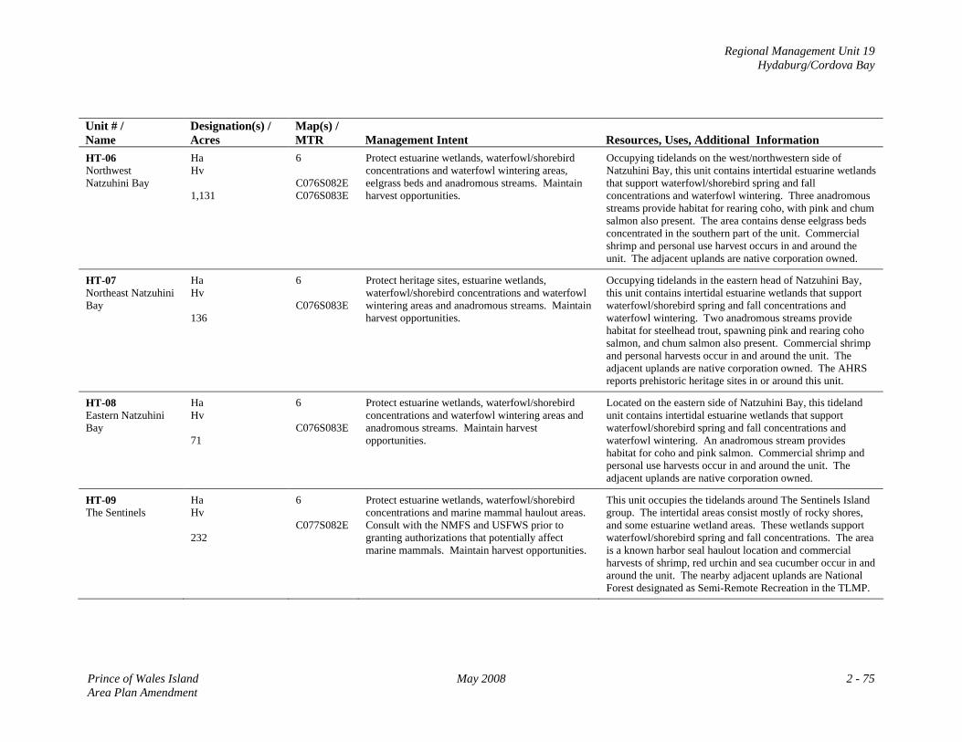
Regional Management Unit 19 Hydaburg/Cordova Bay
Unit # / Name
Designation(s) / Acres
Map(s) / MTR
Management Intent
Resources, Uses, Additional Information
HT-06 Northwest Natzuhini Bay
Ha Hv 1,131
6 C076S082E C076S083E
Protect estuarine wetlands, waterfowl/shorebird concentrations and waterfowl wintering areas, eelgrass beds and anadromous streams. Maintain harvest opportunities.
Occupying tidelands on the west/northwestern side of Natzuhini Bay, this unit contains intertidal estuarine wetlands that support waterfowl/shorebird spring and fall concentrations and waterfowl wintering. Three anadromous streams provide habitat for rearing coho, with pink and chum salmon also present. The area contains dense eelgrass beds concentrated in the southern part of the unit. Commercial shrimp and personal use harvest occurs in and around the unit. The adjacent uplands are native corporation owned.
HT-07 Northeast Natzuhini Bay
Ha Hv 136
6 C076S083E
Protect heritage sites, estuarine wetlands, waterfowl/shorebird concentrations and waterfowl wintering areas and anadromous streams. Maintain harvest opportunities.
Occupying tidelands in the eastern head of Natzuhini Bay, this unit contains intertidal estuarine wetlands that support waterfowl/shorebird spring and fall concentrations and waterfowl wintering. Two anadromous streams provide habitat for steelhead trout, spawning pink and rearing coho salmon, and chum salmon also present. Commercial shrimp and personal harvests occur in and around the unit. The adjacent uplands are native corporation owned. The AHRS reports prehistoric heritage sites in or around this unit.
HT-08 Eastern Natzuhini Bay
Ha Hv 71
6 C076S083E
Protect estuarine wetlands, waterfowl/shorebird concentrations and waterfowl wintering areas and anadromous streams. Maintain harvest opportunities.
Located on the eastern side of Natzuhini Bay, this tideland unit contains intertidal estuarine wetlands that support waterfowl/shorebird spring and fall concentrations and waterfowl wintering. An anadromous stream provides habitat for coho and pink salmon. Commercial shrimp and personal use harvests occur in and around the unit. The adjacent uplands are native corporation owned.
HT-09 The Sentinels
Ha Hv 232
6 C077S082E
Protect estuarine wetlands, waterfowl/shorebird concentrations and marine mammal haulout areas. Consult with the NMFS and USFWS prior to granting authorizations that potentially affect marine mammals. Maintain harvest opportunities.
This unit occupies the tidelands around The Sentinels Island group. The intertidal areas consist mostly of rocky shores, and some estuarine wetland areas. These wetlands support waterfowl/shorebird spring and fall concentrations. The area is a known harbor seal haulout location and commercial harvests of shrimp, red urchin and sea cucumber occur in and around the unit. The nearby adjacent uplands are National Forest designated as Semi-Remote Recreation in the TLMP.
Prince of Wales Island May 2008 2 - 75 Area Plan Amendment
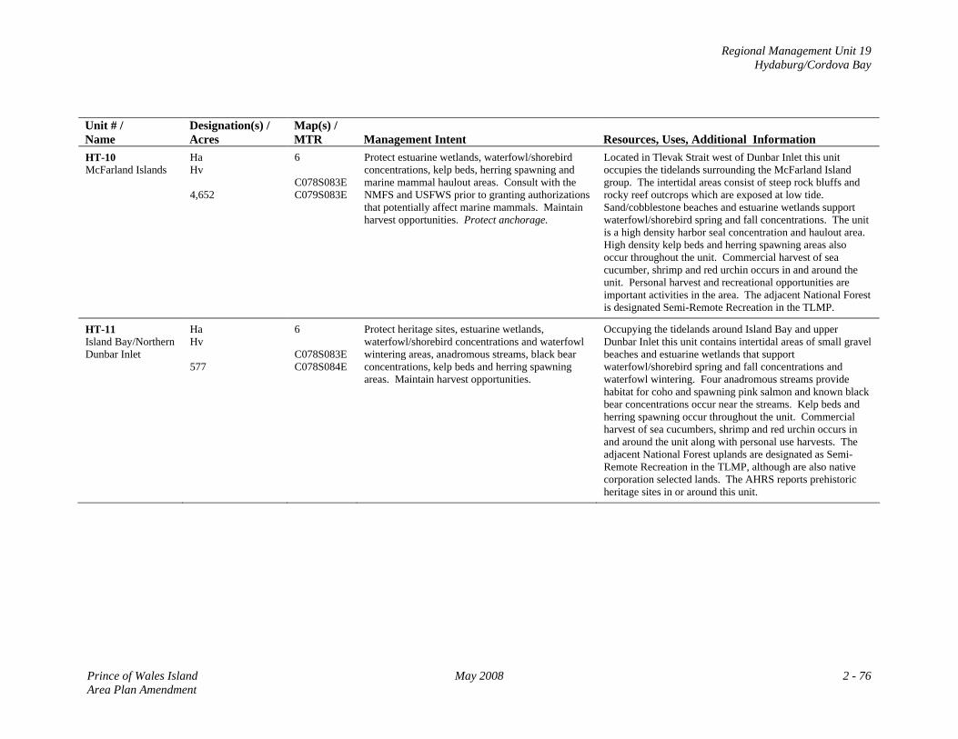
Regional Management Unit 19 Hydaburg/Cordova Bay
Unit # / Name
Designation(s) / Acres
Map(s) / MTR
Management Intent
Resources, Uses, Additional Information
HT-10 McFarland Islands
Ha Hv 4,652
6 C078S083E C079S083E
Protect estuarine wetlands, waterfowl/shorebird concentrations, kelp beds, herring spawning and marine mammal haulout areas. Consult with the NMFS and USFWS prior to granting authorizations that potentially affect marine mammals. Maintain harvest opportunities. Protect anchorage.
Located in Tlevak Strait west of Dunbar Inlet this unit occupies the tidelands surrounding the McFarland Island group. The intertidal areas consist of steep rock bluffs and rocky reef outcrops which are exposed at low tide. Sand/cobblestone beaches and estuarine wetlands support waterfowl/shorebird spring and fall concentrations. The unit is a high density harbor seal concentration and haulout area. High density kelp beds and herring spawning areas also occur throughout the unit. Commercial harvest of sea cucumber, shrimp and red urchin occurs in and around the unit. Personal harvest and recreational opportunities are important activities in the area. The adjacent National Forest is designated Semi-Remote Recreation in the TLMP.
HT-11 Island Bay/Northern Dunbar Inlet
Ha Hv 577
6 C078S083E C078S084E
Protect heritage sites, estuarine wetlands, waterfowl/shorebird concentrations and waterfowl wintering areas, anadromous streams, black bear concentrations, kelp beds and herring spawning areas. Maintain harvest opportunities.
Occupying the tidelands around Island Bay and upper Dunbar Inlet this unit contains intertidal areas of small gravel beaches and estuarine wetlands that support waterfowl/shorebird spring and fall concentrations and waterfowl wintering. Four anadromous streams provide habitat for coho and spawning pink salmon and known black bear concentrations occur near the streams. Kelp beds and herring spawning occur throughout the unit. Commercial harvest of sea cucumbers, shrimp and red urchin occurs in and around the unit along with personal use harvests. The adjacent National Forest uplands are designated as Semi-Remote Recreation in the TLMP, although are also native corporation selected lands. The AHRS reports prehistoric heritage sites in or around this unit.
Prince of Wales Island May 2008 2 - 76 Area Plan Amendment
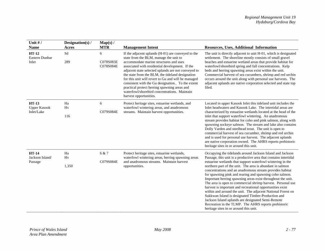
Regional Management Unit 19 Hydaburg/Cordova Bay
Unit # / Name
Designation(s) / Acres
Map(s) / MTR
Management Intent
Resources, Uses, Additional Information
HT-12 Eastern Dunbar Inlet
Sd 289
6 C078S083E C078S084E
If the adjacent uplands (H-01) are conveyed to the state from the BLM, manage the unit to accommodate marine structures and uses associated with residential development. If the adjacent state selected uplands are not conveyed to the state from the BLM, the tideland designation for this unit will revert to Gu and will be managed consistent with the Gu designation.. To the extent practical protect herring spawning areas and waterfowl/shorebird concentrations. Maintain harvest opportunities.
The unit is directly adjacent to unit H-01, which is designated settlement. The shoreline mostly consists of small gravel beaches and estuarine wetland areas that provide habitat for waterfowl/shorebird spring and fall concentrations. Kelp beds and herring spawning areas exist within the unit. Commercial harvest of sea cucumbers, shrimp and red urchin occurs around the unit along with personal use harvests. The adjacent uplands are native corporation selected and state top filed.
HT-13 Upper Kasook Inlet/Lake
Ha Hv 116
6 C079S084E
Protect heritage sites, estuarine wetlands, and waterfowl wintering areas, and anadromous streams. Maintain harvest opportunities.
Located in upper Kasook Inlet this tideland unit includes the Inlet headwaters and Kasook Lake. The intertidal areas are characterized by estuarine wetlands located at the head of the inlet that support waterfowl wintering. An anadromous stream provides habitat for coho and pink salmon, along with spawning sockeye salmon. The stream and lake also contains Dolly Varden and steelhead trout. The unit is open to commercial harvest of sea cucumber, shrimp and red urchin and is used for personal use harvest. The adjacent uplands are native corporation owned. The AHRS reports prehistoric heritage sites in or around this unit.
HT-14 Jackson Island/ Passage
Ha Hv 1,350
6 & 7 C079S084E
Protect heritage sites, estuarine wetlands, waterfowl wintering areas, herring spawning areas and anadromous streams. Maintain harvest opportunities.
Occupying the tidelands around Jackson Island and Jackson Passage, this unit is a productive area that contains intertidal estuarine wetlands that support waterfowl wintering in the northern part of the unit. The area is abundant in salmon concentrations and an anadromous stream provides habitat for spawning pink and rearing and spawning coho salmon. Important herring spawning areas exist throughout the unit. The area is open to commercial shrimp harvest. Personal use harvest is important and recreational opportunities exist within and around the unit. The adjacent National Forest on Sukkwan Island is designated Timber-Production and Jackson Island uplands are designated Semi-Remote Recreation in the TLMP. The AHRS reports prehistoric heritage sites in or around this unit.
Prince of Wales Island May 2008 2 - 77 Area Plan Amendment
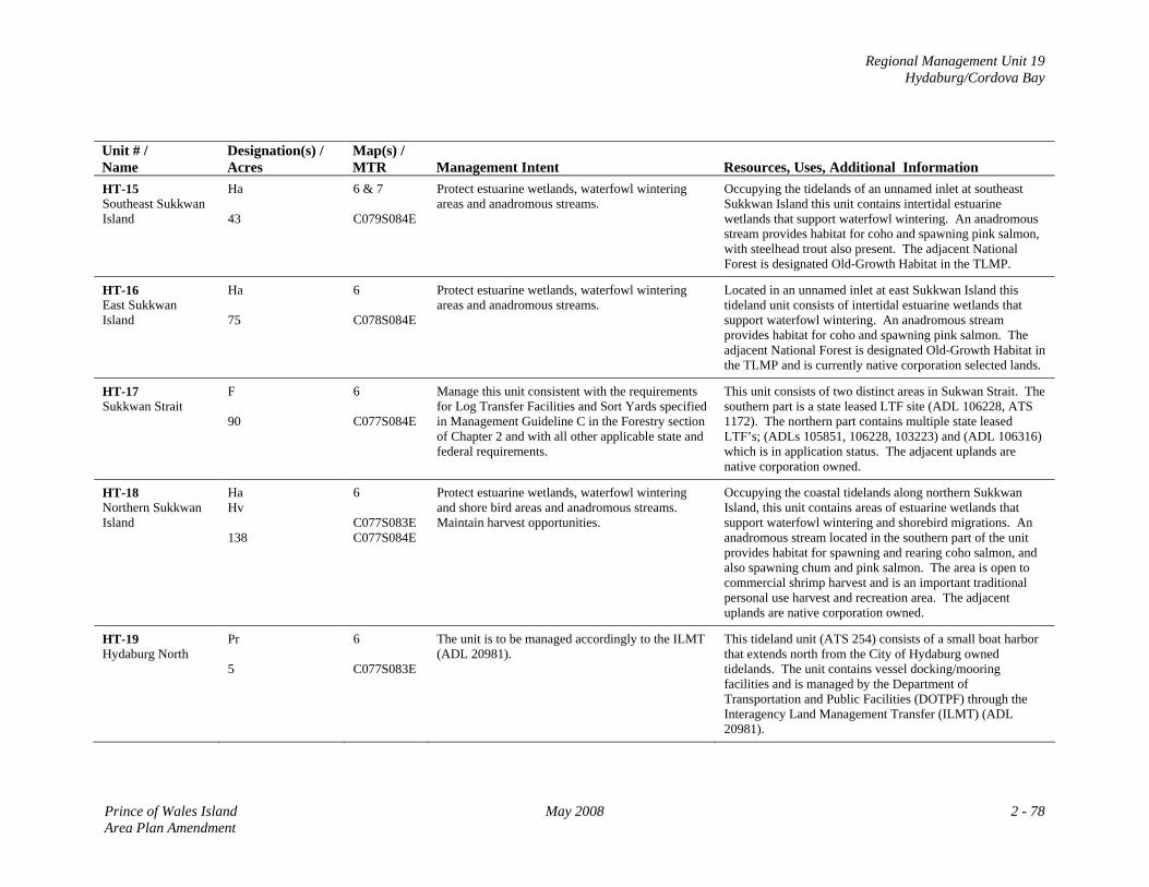
Regional Management Unit 19 Hydaburg/Cordova Bay
Unit # / Name
Designation(s) / Acres
Map(s) / MTR
Management Intent
Resources, Uses, Additional Information
HT-15 Southeast Sukkwan Island
Ha 43
6 & 7 C079S084E
Protect estuarine wetlands, waterfowl wintering areas and anadromous streams.
Occupying the tidelands of an unnamed inlet at southeast Sukkwan Island this unit contains intertidal estuarine wetlands that support waterfowl wintering. An anadromous stream provides habitat for coho and spawning pink salmon, with steelhead trout also present. The adjacent National Forest is designated Old-Growth Habitat in the TLMP.
HT-16 East Sukkwan Island
Ha 75
6 C078S084E
Protect estuarine wetlands, waterfowl wintering areas and anadromous streams.
Located in an unnamed inlet at east Sukkwan Island this tideland unit consists of intertidal estuarine wetlands that support waterfowl wintering. An anadromous stream provides habitat for coho and spawning pink salmon. The adjacent National Forest is designated Old-Growth Habitat in the TLMP and is currently native corporation selected lands.
HT-17 Sukkwan Strait
F 90
6 C077S084E
Manage this unit consistent with the requirements for Log Transfer Facilities and Sort Yards specified in Management Guideline C in the Forestry section of Chapter 2 and with all other applicable state and federal requirements.
This unit consists of two distinct areas in Sukwan Strait. The southern part is a state leased LTF site (ADL 106228, ATS 1172). The northern part contains multiple state leased LTF’s; (ADLs 105851, 106228, 103223) and (ADL 106316) which is in application status. The adjacent uplands are native corporation owned.
HT-18 Northern Sukkwan Island
Ha Hv 138
6 C077S083E C077S084E
Protect estuarine wetlands, waterfowl wintering and shore bird areas and anadromous streams. Maintain harvest opportunities.
Occupying the coastal tidelands along northern Sukkwan Island, this unit contains areas of estuarine wetlands that support waterfowl wintering and shorebird migrations. An anadromous stream located in the southern part of the unit provides habitat for spawning and rearing coho salmon, and also spawning chum and pink salmon. The area is open to commercial shrimp harvest and is an important traditional personal use harvest and recreation area. The adjacent uplands are native corporation owned.
HT-19 Hydaburg North
Pr 5
6 C077S083E
The unit is to be managed accordingly to the ILMT (ADL 20981).
This tideland unit (ATS 254) consists of a small boat harbor that extends north from the City of Hydaburg owned tidelands. The unit contains vessel docking/mooring facilities and is managed by the Department of Transportation and Public Facilities (DOTPF) through the Interagency Land Management Transfer (ILMT) (ADL 20981).
Prince of Wales Island May 2008 2 - 78 Area Plan Amendment
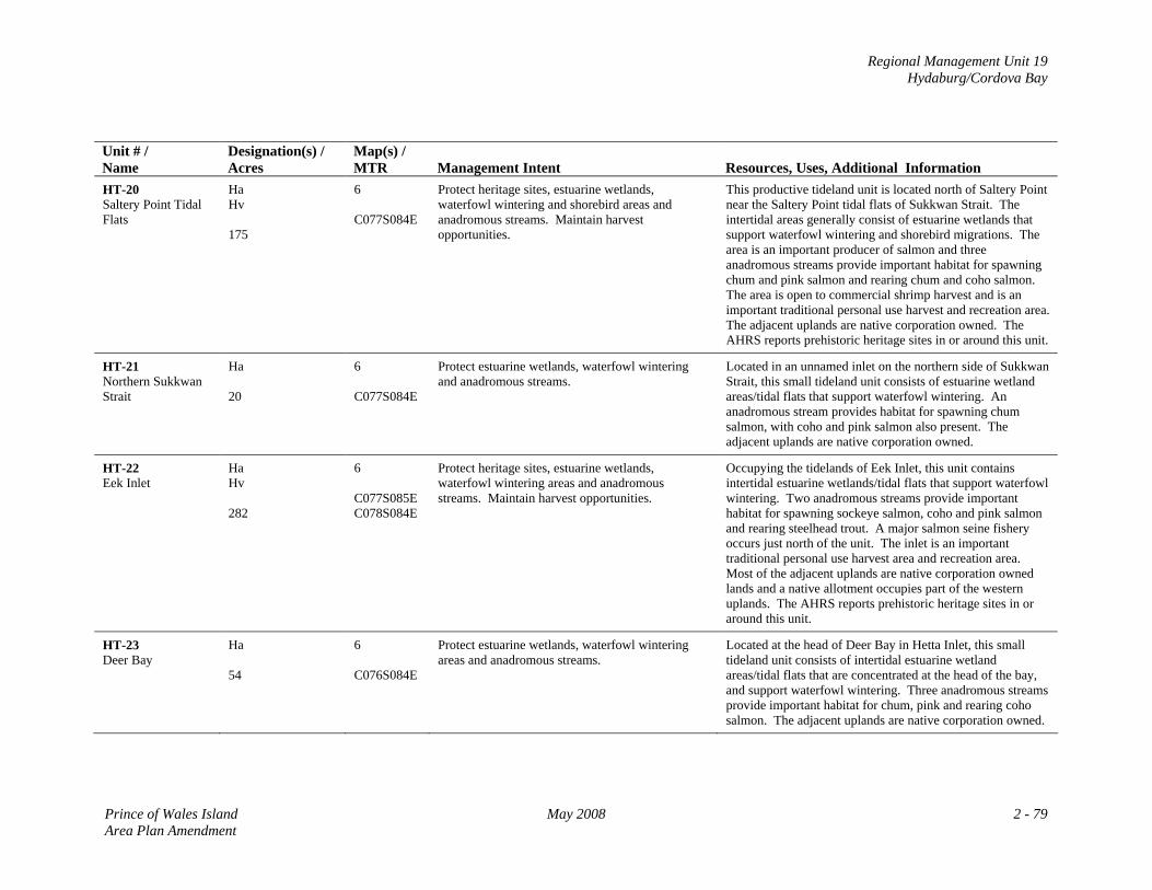
Regional Management Unit 19 Hydaburg/Cordova Bay
Unit # / Name
Designation(s) / Acres
Map(s) / MTR
Management Intent
Resources, Uses, Additional Information
HT-20 Saltery Point Tidal Flats
Ha Hv 175
6 C077S084E
Protect heritage sites, estuarine wetlands, waterfowl wintering and shorebird areas and anadromous streams. Maintain harvest opportunities.
This productive tideland unit is located north of Saltery Point near the Saltery Point tidal flats of Sukkwan Strait. The intertidal areas generally consist of estuarine wetlands that support waterfowl wintering and shorebird migrations. The area is an important producer of salmon and three anadromous streams provide important habitat for spawning chum and pink salmon and rearing chum and coho salmon. The area is open to commercial shrimp harvest and is an important traditional personal use harvest and recreation area. The adjacent uplands are native corporation owned. The AHRS reports prehistoric heritage sites in or around this unit.
HT-21 Northern Sukkwan Strait
Ha 20
6 C077S084E
Protect estuarine wetlands, waterfowl wintering and anadromous streams.
Located in an unnamed inlet on the northern side of Sukkwan Strait, this small tideland unit consists of estuarine wetland areas/tidal flats that support waterfowl wintering. An anadromous stream provides habitat for spawning chum salmon, with coho and pink salmon also present. The adjacent uplands are native corporation owned.
HT-22 Eek Inlet
Ha Hv 282
6 C077S085E C078S084E
Protect heritage sites, estuarine wetlands, waterfowl wintering areas and anadromous streams. Maintain harvest opportunities.
Occupying the tidelands of Eek Inlet, this unit contains intertidal estuarine wetlands/tidal flats that support waterfowl wintering. Two anadromous streams provide important habitat for spawning sockeye salmon, coho and pink salmon and rearing steelhead trout. A major salmon seine fishery occurs just north of the unit. The inlet is an important traditional personal use harvest area and recreation area. Most of the adjacent uplands are native corporation owned lands and a native allotment occupies part of the western uplands. The AHRS reports prehistoric heritage sites in or around this unit.
HT-23 Deer Bay
Ha 54
6 C076S084E
Protect estuarine wetlands, waterfowl wintering areas and anadromous streams.
Located at the head of Deer Bay in Hetta Inlet, this small tideland unit consists of intertidal estuarine wetland areas/tidal flats that are concentrated at the head of the bay, and support waterfowl wintering. Three anadromous streams provide important habitat for chum, pink and rearing coho salmon. The adjacent uplands are native corporation owned.
Prince of Wales Island May 2008 2 - 79 Area Plan Amendment
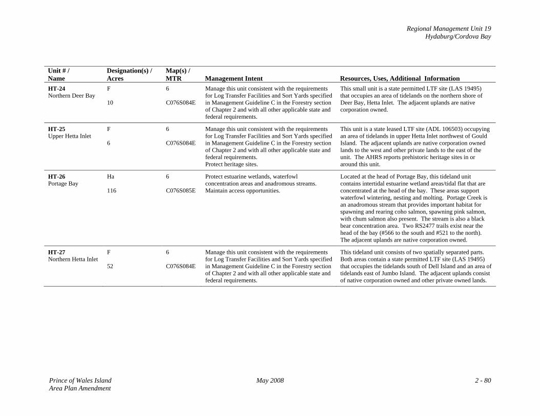
Regional Management Unit 19 Hydaburg/Cordova Bay
Unit # / Name
Designation(s) / Acres
Map(s) / MTR
Management Intent
Resources, Uses, Additional Information
HT-24 Northern Deer Bay
F 10
6 C076S084E
Manage this unit consistent with the requirements for Log Transfer Facilities and Sort Yards specified in Management Guideline C in the Forestry section of Chapter 2 and with all other applicable state and federal requirements.
This small unit is a state permitted LTF site (LAS 19495) that occupies an area of tidelands on the northern shore of Deer Bay, Hetta Inlet. The adjacent uplands are native corporation owned.
HT-25 Upper Hetta Inlet
F 6
6 C076S084E
Manage this unit consistent with the requirements for Log Transfer Facilities and Sort Yards specified in Management Guideline C in the Forestry section of Chapter 2 and with all other applicable state and federal requirements. Protect heritage sites.
This unit is a state leased LTF site (ADL 106503) occupying an area of tidelands in upper Hetta Inlet northwest of Gould Island. The adjacent uplands are native corporation owned lands to the west and other private lands to the east of the unit. The AHRS reports prehistoric heritage sites in or around this unit.
HT-26 Portage Bay
Ha 116
6 C076S085E
Protect estuarine wetlands, waterfowl concentration areas and anadromous streams. Maintain access opportunities.
Located at the head of Portage Bay, this tideland unit contains intertidal estuarine wetland areas/tidal flat that are concentrated at the head of the bay. These areas support waterfowl wintering, nesting and molting. Portage Creek is an anadromous stream that provides important habitat for spawning and rearing coho salmon, spawning pink salmon, with chum salmon also present. The stream is also a black bear concentration area. Two RS2477 trails exist near the head of the bay (#566 to the south and #521 to the north). The adjacent uplands are native corporation owned.
HT-27 Northern Hetta Inlet
F 52
6 C076S084E
Manage this unit consistent with the requirements for Log Transfer Facilities and Sort Yards specified in Management Guideline C in the Forestry section of Chapter 2 and with all other applicable state and federal requirements.
This tideland unit consists of two spatially separated parts. Both areas contain a state permitted LTF site (LAS 19495) that occupies the tidelands south of Dell Island and an area of tidelands east of Jumbo Island. The adjacent uplands consist of native corporation owned and other private owned lands.
Prince of Wales Island May 2008 2 - 80 Area Plan Amendment
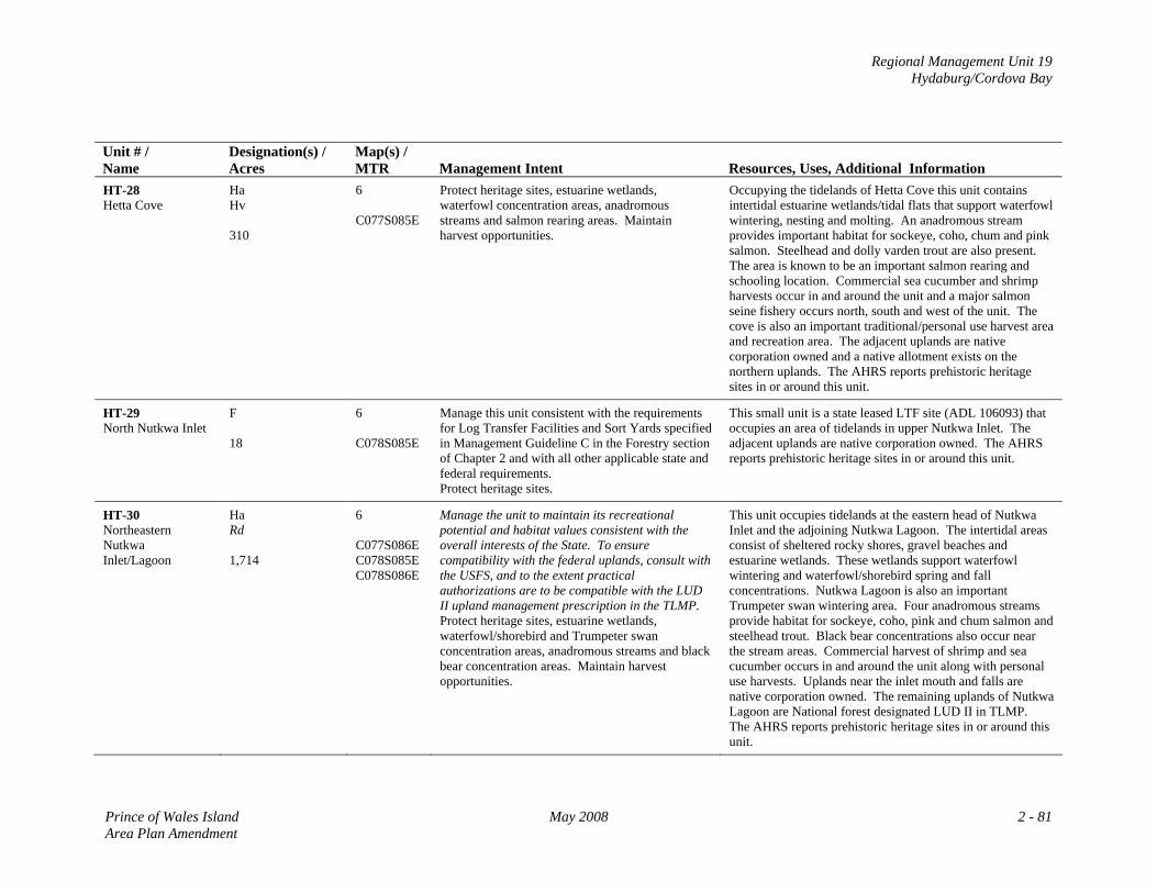
Regional Management Unit 19 Hydaburg/Cordova Bay
Unit # / Name
Designation(s) / Acres
Map(s) / MTR
Management Intent
Resources, Uses, Additional Information
HT-28 Hetta Cove
Ha Hv 310
6 C077S085E
Protect heritage sites, estuarine wetlands, waterfowl concentration areas, anadromous streams and salmon rearing areas. Maintain harvest opportunities.
Occupying the tidelands of Hetta Cove this unit contains intertidal estuarine wetlands/tidal flats that support waterfowl wintering, nesting and molting. An anadromous stream provides important habitat for sockeye, coho, chum and pink salmon. Steelhead and dolly varden trout are also present. The area is known to be an important salmon rearing and schooling location. Commercial sea cucumber and shrimp harvests occur in and around the unit and a major salmon seine fishery occurs north, south and west of the unit. The cove is also an important traditional/personal use harvest area and recreation area. The adjacent uplands are native corporation owned and a native allotment exists on the northern uplands. The AHRS reports prehistoric heritage sites in or around this unit.
HT-29 North Nutkwa Inlet
F 18
6 C078S085E
Manage this unit consistent with the requirements for Log Transfer Facilities and Sort Yards specified in Management Guideline C in the Forestry section of Chapter 2 and with all other applicable state and federal requirements. Protect heritage sites.
This small unit is a state leased LTF site (ADL 106093) that occupies an area of tidelands in upper Nutkwa Inlet. The adjacent uplands are native corporation owned. The AHRS reports prehistoric heritage sites in or around this unit.
HT-30 Northeastern Nutkwa Inlet/Lagoon
Ha Rd 1,714
6 C077S086E C078S085E C078S086E
Manage the unit to maintain its recreational potential and habitat values consistent with the overall interests of the State. To ensure compatibility with the federal uplands, consult with the USFS, and to the extent practical authorizations are to be compatible with the LUD II upland management prescription in the TLMP. Protect heritage sites, estuarine wetlands, waterfowl/shorebird and Trumpeter swan concentration areas, anadromous streams and black bear concentration areas. Maintain harvest opportunities.
This unit occupies tidelands at the eastern head of Nutkwa Inlet and the adjoining Nutkwa Lagoon. The intertidal areas consist of sheltered rocky shores, gravel beaches and estuarine wetlands. These wetlands support waterfowl wintering and waterfowl/shorebird spring and fall concentrations. Nutkwa Lagoon is also an important Trumpeter swan wintering area. Four anadromous streams provide habitat for sockeye, coho, pink and chum salmon and steelhead trout. Black bear concentrations also occur near the stream areas. Commercial harvest of shrimp and sea cucumber occurs in and around the unit along with personal use harvests. Uplands near the inlet mouth and falls are native corporation owned. The remaining uplands of Nutkwa Lagoon are National forest designated LUD II in TLMP. The AHRS reports prehistoric heritage sites in or around this unit.
Prince of Wales Island May 2008 2 - 81 Area Plan Amendment
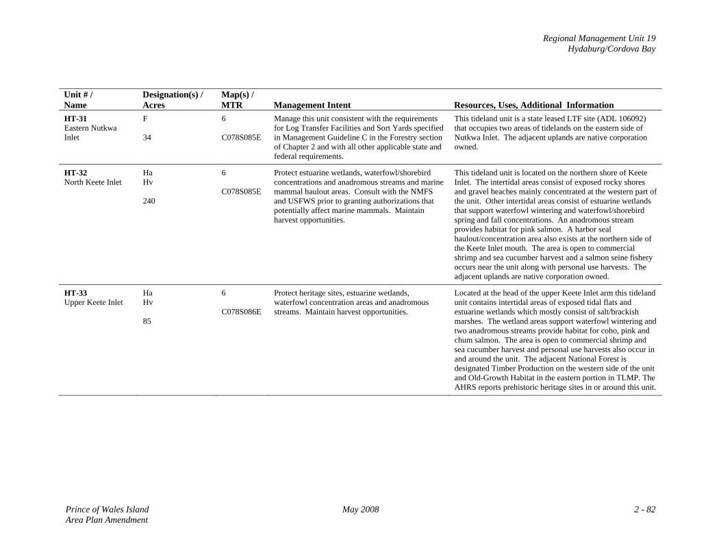
Regional Management Unit 19 Hydaburg/Cordova Bay
Unit # / Name
Designation(s) / Acres
Map(s) / MTR
Management Intent
Resources, Uses, Additional Information
HT-31 Eastern Nutkwa Inlet
F 34
6 C078S085E
Manage this unit consistent with the requirements for Log Transfer Facilities and Sort Yards specified in Management Guideline C in the Forestry section of Chapter 2 and with all other applicable state and federal requirements.
This tideland unit is a state leased LTF site (ADL 106092) that occupies two areas of tidelands on the eastern side of Nutkwa Inlet. The adjacent uplands are native corporation owned.
HT-32 North Keete Inlet
Ha Hv 240
6 C078S085E
Protect estuarine wetlands, waterfowl/shorebird concentrations and anadromous streams and marine mammal haulout areas. Consult with the NMFS and USFWS prior to granting authorizations that potentially affect marine mammals. Maintain harvest opportunities.
This tideland unit is located on the northern shore of Keete Inlet. The intertidal areas consist of exposed rocky shores and gravel beaches mainly concentrated at the western part of the unit. Other intertidal areas consist of estuarine wetlands that support waterfowl wintering and waterfowl/shorebird spring and fall concentrations. An anadromous stream provides habitat for pink salmon. A harbor seal haulout/concentration area also exists at the northern side of the Keete Inlet mouth. The area is open to commercial shrimp and sea cucumber harvest and a salmon seine fishery occurs near the unit along with personal use harvests. The adjacent uplands are native corporation owned.
HT-33 Upper Keete Inlet
Ha Hv 85
6 C078S086E
Protect heritage sites, estuarine wetlands, waterfowl concentration areas and anadromous streams. Maintain harvest opportunities.
Located at the head of the upper Keete Inlet arm this tideland unit contains intertidal areas of exposed tidal flats and estuarine wetlands which mostly consist of salt/brackish marshes. The wetland areas support waterfowl wintering and two anadromous streams provide habitat for coho, pink and chum salmon. The area is open to commercial shrimp and sea cucumber harvest and personal use harvests also occur in and around the unit. The adjacent National Forest is designated Timber Production on the western side of the unit and Old-Growth Habitat in the eastern portion in TLMP. The AHRS reports prehistoric heritage sites in or around this unit.
Prince of Wales Island May 2008 2 - 82 Area Plan Amendment
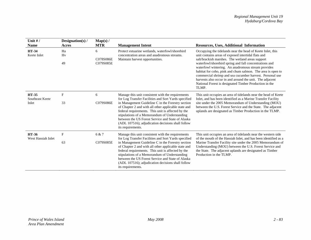
Regional Management Unit 19 Hydaburg/Cordova Bay
Unit # / Name
Designation(s) / Acres
Map(s) / MTR
Management Intent
Resources, Uses, Additional Information
HT-34 Keete Inlet
Ha Hv 49
6 C078S086E C079S085E
Protect estuarine wetlands, waterfowl/shorebird concentration areas and anadromous streams. Maintain harvest opportunities.
Occupying the tidelands near the head of Keete Inlet, this unit contains areas of exposed intertidal flats and salt/brackish marshes. The wetland areas support waterfowl/shorebird spring and fall concentrations and waterfowl wintering. An anadromous stream provides habitat for coho, pink and chum salmon. The area is open to commercial shrimp and sea cucumber harvest. Personal use harvests also occur in and around the unit. The adjacent National Forest is designated Timber Production in the TLMP.
HT-35 Southeast Keete Inlet
F 33
6 C079S086E
Manage this unit consistent with the requirements for Log Transfer Facilities and Sort Yards specified in Management Guideline C in the Forestry section of Chapter 2 and with all other applicable state and federal requirements. This unit is affected by the stipulations of a Memorandum of Understanding between the US Forest Service and State of Alaska (ADL 107516); adjudication decisions shall follow its requirements.
This unit occupies an area of tidelands near the head of Keete Inlet, and has been identified as a Marine Transfer Facility site under the 2005 Memorandum of Understanding (MOU) between the U.S. Forest Service and the State. The adjacent uplands are designated as Timber Production in the TLMP.
HT-36 West Hassiah Inlet
F 63
6 & 7 C079S085E
Manage this unit consistent with the requirements for Log Transfer Facilities and Sort Yards specified in Management Guideline C in the Forestry section of Chapter 2 and with all other applicable state and federal requirements. This unit is affected by the stipulations of a Memorandum of Understanding between the US Forest Service and State of Alaska (ADL 107516); adjudication decisions shall follow its requirements.
This unit occupies an area of tidelands near the western side of the mouth of the Hassiah Inlet, and has been identified as a Marine Transfer Facility site under the 2005 Memorandum of Understanding (MOU) between the U.S. Forest Service and the State. The adjacent uplands are designated as Timber Production in the TLMP.
Prince of Wales Island May 2008 2 - 83 Area Plan Amendment
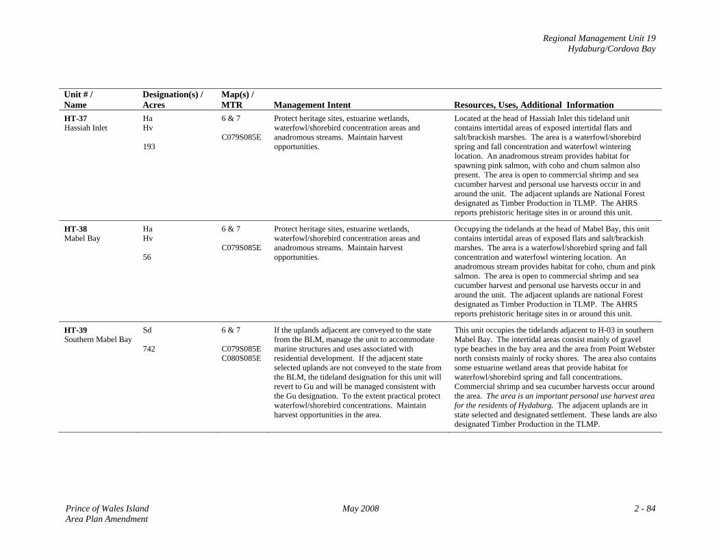
Regional Management Unit 19 Hydaburg/Cordova Bay
Unit # / Name
Designation(s) / Acres
Map(s) / MTR
Management Intent
Resources, Uses, Additional Information
HT-37 Hassiah Inlet
Ha Hv 193
6 & 7 C079S085E
Protect heritage sites, estuarine wetlands, waterfowl/shorebird concentration areas and anadromous streams. Maintain harvest opportunities.
Located at the head of Hassiah Inlet this tideland unit contains intertidal areas of exposed intertidal flats and salt/brackish marshes. The area is a waterfowl/shorebird spring and fall concentration and waterfowl wintering location. An anadromous stream provides habitat for spawning pink salmon, with coho and chum salmon also present. The area is open to commercial shrimp and sea cucumber harvest and personal use harvests occur in and around the unit. The adjacent uplands are National Forest designated as Timber Production in TLMP. The AHRS reports prehistoric heritage sites in or around this unit.
HT-38 Mabel Bay
Ha Hv 56
6 & 7 C079S085E
Protect heritage sites, estuarine wetlands, waterfowl/shorebird concentration areas and anadromous streams. Maintain harvest opportunities.
Occupying the tidelands at the head of Mabel Bay, this unit contains intertidal areas of exposed flats and salt/brackish marshes. The area is a waterfowl/shorebird spring and fall concentration and waterfowl wintering location. An anadromous stream provides habitat for coho, chum and pink salmon. The area is open to commercial shrimp and sea cucumber harvest and personal use harvests occur in and around the unit. The adjacent uplands are national Forest designated as Timber Production in TLMP. The AHRS reports prehistoric heritage sites in or around this unit.
HT-39 Southern Mabel Bay
Sd 742
6 & 7 C079S085E C080S085E
If the uplands adjacent are conveyed to the state from the BLM, manage the unit to accommodate marine structures and uses associated with residential development. If the adjacent state selected uplands are not conveyed to the state from the BLM, the tideland designation for this unit will revert to Gu and will be managed consistent with the Gu designation. To the extent practical protect waterfowl/shorebird concentrations. Maintain harvest opportunities in the area.
This unit occupies the tidelands adjacent to H-03 in southern Mabel Bay. The intertidal areas consist mainly of gravel type beaches in the bay area and the area from Point Webster north consists mainly of rocky shores. The area also contains some estuarine wetland areas that provide habitat for waterfowl/shorebird spring and fall concentrations. Commercial shrimp and sea cucumber harvests occur around the area. The area is an important personal use harvest area for the residents of Hydaburg. The adjacent uplands are in state selected and designated settlement. These lands are also designated Timber Production in the TLMP.
Prince of Wales Island May 2008 2 - 84 Area Plan Amendment
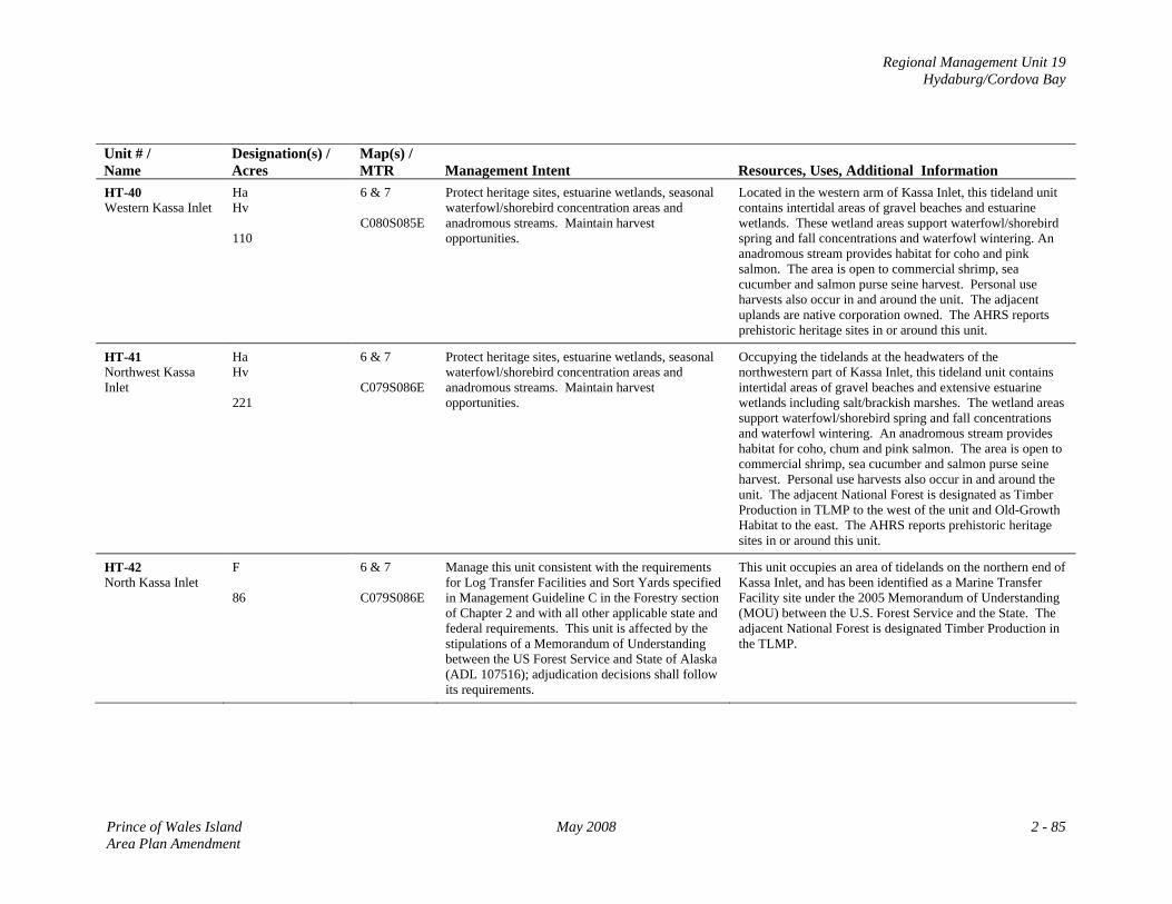
Regional Management Unit 19 Hydaburg/Cordova Bay
Unit # / Name
Designation(s) / Acres
Map(s) / MTR
Management Intent
Resources, Uses, Additional Information
HT-40 Western Kassa Inlet
Ha Hv 110
6 & 7 C080S085E
Protect heritage sites, estuarine wetlands, seasonal waterfowl/shorebird concentration areas and anadromous streams. Maintain harvest opportunities.
Located in the western arm of Kassa Inlet, this tideland unit contains intertidal areas of gravel beaches and estuarine wetlands. These wetland areas support waterfowl/shorebird spring and fall concentrations and waterfowl wintering. An anadromous stream provides habitat for coho and pink salmon. The area is open to commercial shrimp, sea cucumber and salmon purse seine harvest. Personal use harvests also occur in and around the unit. The adjacent uplands are native corporation owned. The AHRS reports prehistoric heritage sites in or around this unit.
HT-41 Northwest Kassa Inlet
Ha Hv 221
6 & 7 C079S086E
Protect heritage sites, estuarine wetlands, seasonal waterfowl/shorebird concentration areas and anadromous streams. Maintain harvest opportunities.
Occupying the tidelands at the headwaters of the northwestern part of Kassa Inlet, this tideland unit contains intertidal areas of gravel beaches and extensive estuarine wetlands including salt/brackish marshes. The wetland areas support waterfowl/shorebird spring and fall concentrations and waterfowl wintering. An anadromous stream provides habitat for coho, chum and pink salmon. The area is open to commercial shrimp, sea cucumber and salmon purse seine harvest. Personal use harvests also occur in and around the unit. The adjacent National Forest is designated as Timber Production in TLMP to the west of the unit and Old-Growth Habitat to the east. The AHRS reports prehistoric heritage sites in or around this unit.
HT-42 North Kassa Inlet
F 86
6 & 7 C079S086E
Manage this unit consistent with the requirements for Log Transfer Facilities and Sort Yards specified in Management Guideline C in the Forestry section of Chapter 2 and with all other applicable state and federal requirements. This unit is affected by the stipulations of a Memorandum of Understanding between the US Forest Service and State of Alaska (ADL 107516); adjudication decisions shall follow its requirements.
This unit occupies an area of tidelands on the northern end of Kassa Inlet, and has been identified as a Marine Transfer Facility site under the 2005 Memorandum of Understanding (MOU) between the U.S. Forest Service and the State. The adjacent National Forest is designated Timber Production in the TLMP.
Prince of Wales Island May 2008 2 - 85 Area Plan Amendment
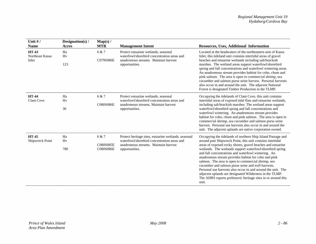
Regional Management Unit 19 Hydaburg/Cordova Bay
Unit # / Name
Designation(s) / Acres
Map(s) / MTR
Management Intent
Resources, Uses, Additional Information
HT-43 Northeast Kassa Inlet
Ha Hv 123
6 & 7 C079S086E
Protect estuarine wetlands, seasonal waterfowl/shorebird concentration areas and anadromous streams. Maintain harvest opportunities.
Located at the headwaters of the northeastern arm of Kassa Inlet, this tideland unit contains intertidal areas of gravel beaches and estuarine wetlands including salt/brackish marshes. The wetland areas support waterfowl/shorebird spring and fall concentrations and waterfowl wintering areas. An anadromous stream provides habitat for coho, chum and pink salmon. The area is open to commercial shrimp, sea cucumber and salmon purse seine harvest. Personal harvests also occur in and around the unit. The adjacent National Forest is designated Timber Production in the TLMP.
HT-44 Clam Cove
Ha Hv 36
6 & 7 C080S086E
Protect estuarine wetlands, seasonal waterfowl/shorebird concentration areas and anadromous streams. Maintain harvest opportunities.
Occupying the tidelands of Clam Cove, this unit contains intertidal areas of exposed tidal flats and estuarine wetlands, including salt/brackish marshes. The wetland areas support waterfowl/shorebird spring and fall concentrations and waterfowl wintering. An anadromous stream provides habitat for coho, chum and pink salmon. The area is open to commercial shrimp, sea cucumber and salmon purse seine harvest. Personal use harvests also occur in and around the unit. The adjacent uplands are native corporation owned.
HT-45 Shipwreck Point
Ha Hv 780
6 & 7 C080S085E C080S086E
Protect heritage sites, estuarine wetlands, seasonal waterfowl/shorebird concentration areas and anadromous streams. Maintain harvest opportunities.
Occupying the tidelands of northern Ship Island Passage and around past Shipwreck Point, this unit contains intertidal areas of exposed rocky shores, gravel beaches and estuarine wetlands. The wetlands support waterfowl/shorebird spring and fall concentrations and waterfowl wintering. An anadromous stream provides habitat for coho and pink salmon. The area is open to commercial shrimp, sea cucumber and salmon purse seine and troll harvests. Personal use harvests also occur in and around the unit. The adjacent uplands are designated Wilderness in the TLMP. The AHRS reports prehistoric heritage sites in or around this unit.
Prince of Wales Island May 2008 2 - 86 Area Plan Amendment
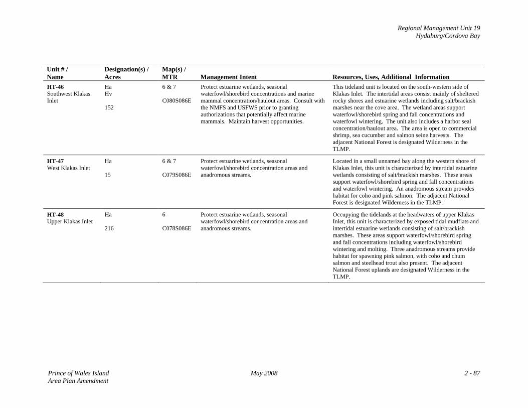
Regional Management Unit 19 Hydaburg/Cordova Bay
Unit # / Name
Designation(s) / Acres
Map(s) / MTR
Management Intent
Resources, Uses, Additional Information
HT-46 Southwest Klakas Inlet
Ha Hv 152
6 & 7 C080S086E
Protect estuarine wetlands, seasonal waterfowl/shorebird concentrations and marine mammal concentration/haulout areas. Consult with the NMFS and USFWS prior to granting authorizations that potentially affect marine mammals. Maintain harvest opportunities.
This tideland unit is located on the south-western side of Klakas Inlet. The intertidal areas consist mainly of sheltered rocky shores and estuarine wetlands including salt/brackish marshes near the cove area. The wetland areas support waterfowl/shorebird spring and fall concentrations and waterfowl wintering. The unit also includes a harbor seal concentration/haulout area. The area is open to commercial shrimp, sea cucumber and salmon seine harvests. The adjacent National Forest is designated Wilderness in the TLMP.
HT-47 West Klakas Inlet
Ha 15
6 & 7 C079S086E
Protect estuarine wetlands, seasonal waterfowl/shorebird concentration areas and anadromous streams.
Located in a small unnamed bay along the western shore of Klakas Inlet, this unit is characterized by intertidal estuarine wetlands consisting of salt/brackish marshes. These areas support waterfowl/shorebird spring and fall concentrations and waterfowl wintering. An anadromous stream provides habitat for coho and pink salmon. The adjacent National Forest is designated Wilderness in the TLMP.
HT-48 Upper Klakas Inlet
Ha 216
6 C078S086E
Protect estuarine wetlands, seasonal waterfowl/shorebird concentration areas and anadromous streams.
Occupying the tidelands at the headwaters of upper Klakas Inlet, this unit is characterized by exposed tidal mudflats and intertidal estuarine wetlands consisting of salt/brackish marshes. These areas support waterfowl/shorebird spring and fall concentrations including waterfowl/shorebird wintering and molting. Three anadromous streams provide habitat for spawning pink salmon, with coho and chum salmon and steelhead trout also present. The adjacent National Forest uplands are designated Wilderness in the TLMP.
Prince of Wales Island May 2008 2 - 87 Area Plan Amendment
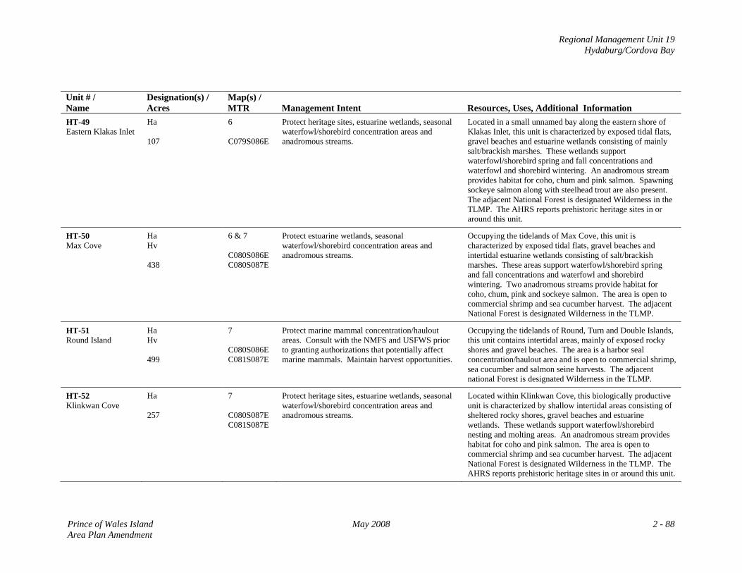
Regional Management Unit 19 Hydaburg/Cordova Bay
Unit # / Name
Designation(s) / Acres
Map(s) / MTR
Management Intent
Resources, Uses, Additional Information
HT-49 Eastern Klakas Inlet
Ha 107
6 C079S086E
Protect heritage sites, estuarine wetlands, seasonal waterfowl/shorebird concentration areas and anadromous streams.
Located in a small unnamed bay along the eastern shore of Klakas Inlet, this unit is characterized by exposed tidal flats, gravel beaches and estuarine wetlands consisting of mainly salt/brackish marshes. These wetlands support waterfowl/shorebird spring and fall concentrations and waterfowl and shorebird wintering. An anadromous stream provides habitat for coho, chum and pink salmon. Spawning sockeye salmon along with steelhead trout are also present. The adjacent National Forest is designated Wilderness in the TLMP. The AHRS reports prehistoric heritage sites in or around this unit.
HT-50 Max Cove
Ha Hv 438
6 & 7 C080S086E C080S087E
Protect estuarine wetlands, seasonal waterfowl/shorebird concentration areas and anadromous streams.
Occupying the tidelands of Max Cove, this unit is characterized by exposed tidal flats, gravel beaches and intertidal estuarine wetlands consisting of salt/brackish marshes. These areas support waterfowl/shorebird spring and fall concentrations and waterfowl and shorebird wintering. Two anadromous streams provide habitat for coho, chum, pink and sockeye salmon. The area is open to commercial shrimp and sea cucumber harvest. The adjacent National Forest is designated Wilderness in the TLMP.
HT-51 Round Island
Ha Hv 499
7 C080S086E C081S087E
Protect marine mammal concentration/haulout areas. Consult with the NMFS and USFWS prior to granting authorizations that potentially affect marine mammals. Maintain harvest opportunities.
Occupying the tidelands of Round, Turn and Double Islands, this unit contains intertidal areas, mainly of exposed rocky shores and gravel beaches. The area is a harbor seal concentration/haulout area and is open to commercial shrimp, sea cucumber and salmon seine harvests. The adjacent national Forest is designated Wilderness in the TLMP.
HT-52 Klinkwan Cove
Ha 257
7 C080S087E C081S087E
Protect heritage sites, estuarine wetlands, seasonal waterfowl/shorebird concentration areas and anadromous streams.
Located within Klinkwan Cove, this biologically productive unit is characterized by shallow intertidal areas consisting of sheltered rocky shores, gravel beaches and estuarine wetlands. These wetlands support waterfowl/shorebird nesting and molting areas. An anadromous stream provides habitat for coho and pink salmon. The area is open to commercial shrimp and sea cucumber harvest. The adjacent National Forest is designated Wilderness in the TLMP. The AHRS reports prehistoric heritage sites in or around this unit.
Prince of Wales Island May 2008 2 - 88 Area Plan Amendment
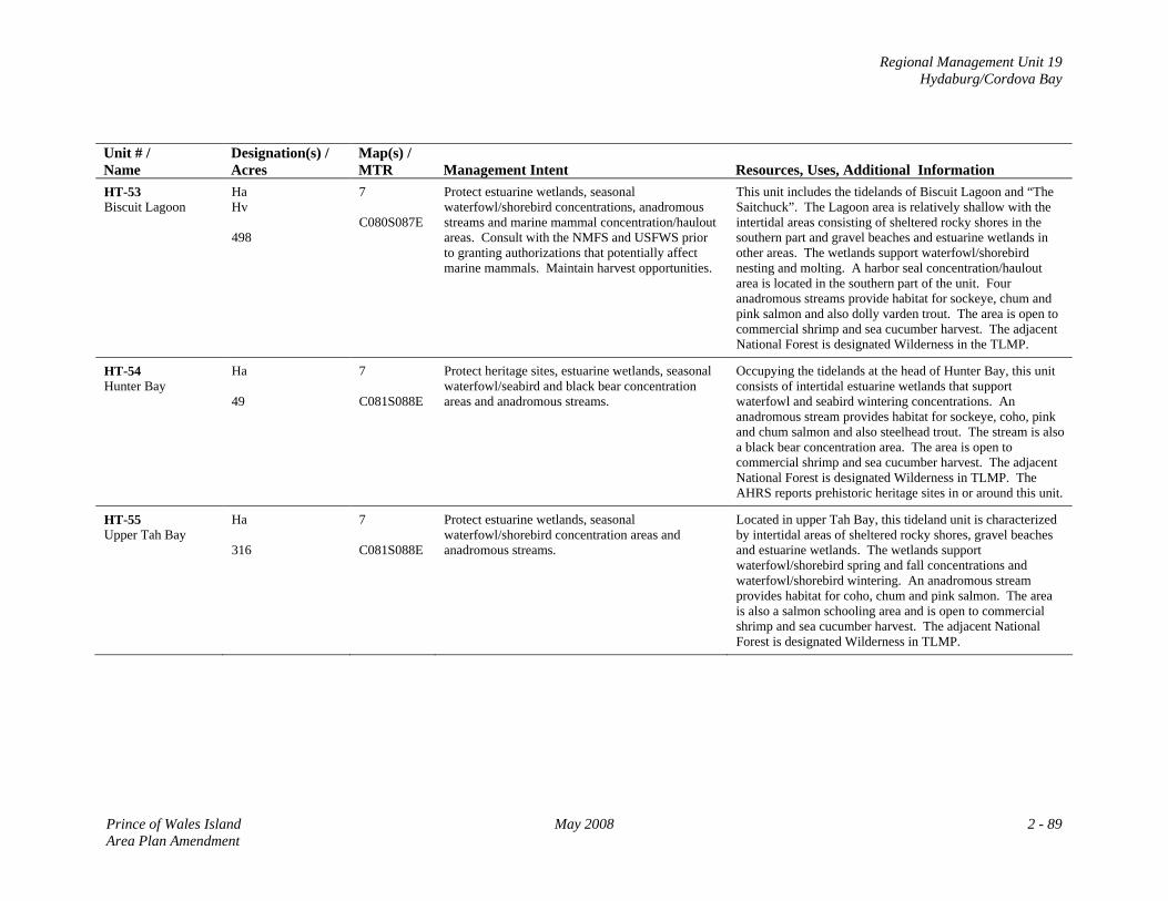
Regional Management Unit 19 Hydaburg/Cordova Bay
Unit # / Name
Designation(s) / Acres
Map(s) / MTR
Management Intent
Resources, Uses, Additional Information
HT-53 Biscuit Lagoon
Ha Hv 498
7 C080S087E
Protect estuarine wetlands, seasonal waterfowl/shorebird concentrations, anadromous streams and marine mammal concentration/haulout areas. Consult with the NMFS and USFWS prior to granting authorizations that potentially affect marine mammals. Maintain harvest opportunities.
This unit includes the tidelands of Biscuit Lagoon and “The Saitchuck”. The Lagoon area is relatively shallow with the intertidal areas consisting of sheltered rocky shores in the southern part and gravel beaches and estuarine wetlands in other areas. The wetlands support waterfowl/shorebird nesting and molting. A harbor seal concentration/haulout area is located in the southern part of the unit. Four anadromous streams provide habitat for sockeye, chum and pink salmon and also dolly varden trout. The area is open to commercial shrimp and sea cucumber harvest. The adjacent National Forest is designated Wilderness in the TLMP.
HT-54 Hunter Bay
Ha 49
7 C081S088E
Protect heritage sites, estuarine wetlands, seasonal waterfowl/seabird and black bear concentration areas and anadromous streams.
Occupying the tidelands at the head of Hunter Bay, this unit consists of intertidal estuarine wetlands that support waterfowl and seabird wintering concentrations. An anadromous stream provides habitat for sockeye, coho, pink and chum salmon and also steelhead trout. The stream is also a black bear concentration area. The area is open to commercial shrimp and sea cucumber harvest. The adjacent National Forest is designated Wilderness in TLMP. The AHRS reports prehistoric heritage sites in or around this unit.
HT-55 Upper Tah Bay
Ha 316
7 C081S088E
Protect estuarine wetlands, seasonal waterfowl/shorebird concentration areas and anadromous streams.
Located in upper Tah Bay, this tideland unit is characterized by intertidal areas of sheltered rocky shores, gravel beaches and estuarine wetlands. The wetlands support waterfowl/shorebird spring and fall concentrations and waterfowl/shorebird wintering. An anadromous stream provides habitat for coho, chum and pink salmon. The area is also a salmon schooling area and is open to commercial shrimp and sea cucumber harvest. The adjacent National Forest is designated Wilderness in TLMP.
Prince of Wales Island May 2008 2 - 89 Area Plan Amendment
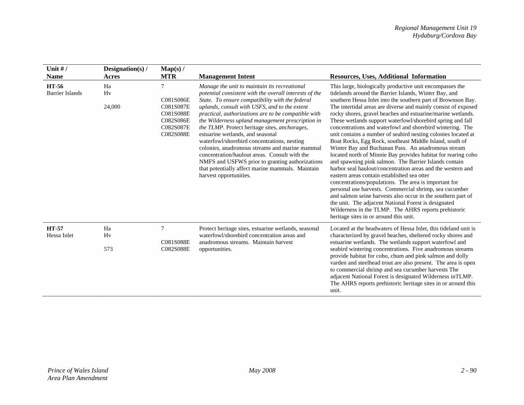
Regional Management Unit 19 Hydaburg/Cordova Bay
Unit # / Name
Designation(s) / Acres
Map(s) / MTR
Management Intent
Resources, Uses, Additional Information
HT-56 Barrier Islands
Ha Hv 24,000
7 C081S086E C081S087E C081S088E C082S086E C082S087E C082S088E
Manage the unit to maintain its recreational potential consistent with the overall interests of the State. To ensure compatibility with the federal uplands, consult with USFS, and to the extent practical, authorizations are to be compatible with the Wilderness upland management prescription in the TLMP. Protect heritage sites, anchorages, estuarine wetlands, and seasonal waterfowl/shorebird concentrations, nesting colonies, anadromous streams and marine mammal concentration/haulout areas. Consult with the NMFS and USFWS prior to granting authorizations that potentially affect marine mammals. Maintain harvest opportunities.
This large, biologically productive unit encompasses the tidelands around the Barrier Islands, Winter Bay, and southern Hessa Inlet into the southern part of Brownson Bay. The intertidal areas are diverse and mainly consist of exposed rocky shores, gravel beaches and estuarine/marine wetlands. These wetlands support waterfowl/shorebird spring and fall concentrations and waterfowl and shorebird wintering. The unit contains a number of seabird nesting colonies located at Boat Rocks, Egg Rock, southeast Middle Island, south of Winter Bay and Buchanan Pass. An anadromous stream located north of Minnie Bay provides habitat for rearing coho and spawning pink salmon. The Barrier Islands contain harbor seal haulout/concentration areas and the western and eastern areas contain established sea otter concentrations/populations. The area is important for personal use harvests. Commercial shrimp, sea cucumber and salmon seine harvests also occur in the southern part of the unit. The adjacent National Forest is designated Wilderness in the TLMP. The AHRS reports prehistoric heritage sites in or around this unit.
HT-57 Hessa Inlet
Ha Hv 573
7 C081S088E C082S088E
Protect heritage sites, estuarine wetlands, seasonal waterfowl/shorebird concentration areas and anadromous streams. Maintain harvest opportunities.
Located at the headwaters of Hessa Inlet, this tideland unit is characterized by gravel beaches, sheltered rocky shores and estuarine wetlands. The wetlands support waterfowl and seabird wintering concentrations. Five anadromous streams provide habitat for coho, chum and pink salmon and dolly varden and steelhead trout are also present. The area is open to commercial shrimp and sea cucumber harvests The adjacent National Forest is designated Wilderness inTLMP. The AHRS reports prehistoric heritage sites in or around this unit.
Prince of Wales Island May 2008 2 - 90 Area Plan Amendment
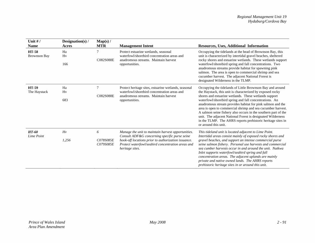
Regional Management Unit 19 Hydaburg/Cordova Bay
Unit # / Name
Designation(s) / Acres
Map(s) / MTR
Management Intent
Resources, Uses, Additional Information
HT-58 Brownson Bay
Ha Hv 166
7 C082S088E
Protect estuarine wetlands, seasonal waterfowl/shorebird concentration areas and anadromous streams. Maintain harvest opportunities.
Occupying the tidelands at the head of Brownson Bay, this unit is characterized by intertidal gravel beaches, sheltered rocky shores and estuarine wetlands. These wetlands support waterfowl/shorebird spring and fall concentrations. Two anadromous streams provide habitat for spawning pink salmon. The area is open to commercial shrimp and sea cucumber harvest. The adjacent National Forest is designated Wilderness in the TLMP.
HT-59 The Haystack
Ha Hv 683
7 C082S088E
Protect heritage sites, estuarine wetlands, seasonal waterfowl/shorebird concentration areas and anadromous streams. Maintain harvest opportunities.
Occupying the tidelands of Little Brownson Bay and around the Haystack, this unit is characterized by exposed rocky shores and estuarine wetlands. These wetlands support waterfowl/shorebird spring and fall concentrations. An anadromous stream provides habitat for pink salmon and the area is open to commercial shrimp and sea cucumber harvest. A salmon seine fishery also occurs in the southern part of the unit. The adjacent National Forest is designated Wilderness in the TLMP. The AHRS reports prehistoric heritage sites in or around this unit.
HT-60 Lime Point
Hv 1,256
6 C078S085E C079S085E
Manage the unit to maintain harvest opportunities. Consult ADF&G concerning specific purse seine hook-off locations prior to authorization issuance. Protect waterfowl/seabird concentration areas and heritage sites.
This tideland unit is located adjacent to Lime Point. Intertidal areas consist mainly of exposed rocky shores and gravel beaches, and support an intense commercial purse seine salmon fishery. Personal use harvests and commercial sea cumber harvests occur in and around the unit. Nutkwa Inlet supports waterfowl/seabird spring and fall concentration areas. The adjacent uplands are mainly private and native owned lands. The AHRS reports prehistoric heritage sites in or around this unit.
Prince of Wales Island May 2008 2 - 91 Area Plan Amendment
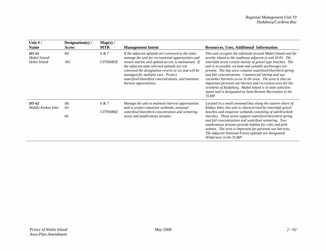
Regional Management Unit 19 Hydaburg/Cordova Bay
Unit # / Name
Designation(s) / Acres
Map(s) / MTR
Management Intent
Resources, Uses, Additional Information
HT-61 Mabel Island/ Helen Island
Rd 302
6 & 7 C079S085E
If the adjacent uplands are conveyed to the state, manage the unit for recreational opportunities and ensure marine and upland access is maintained. If the adjacent state selected uplands are not conveyed the designation reverts to Gu and will be managed for multiple uses. Protect waterfowl/shorebird concentrations, and maintain harvest opportunities.
This unit occupies the tidelands around Mabel Island and the nearby island to the southeast adjacent to unit H-05. The intertidal areas consist mainly of gravel type beaches. The unit is accessible via boat and suitable anchorages are present. The bay area contains waterfowl/shorebird spring and fall concentrations. Commercial shrimp and sea cucumber harvests occur in the area. The area is also an important personal use harvest and recreation area for the residents of Hydaburg. Mabel Island is in state selection status and is designated as Semi-Remote Recreation in the TLMP.
HT-62 Middle Klakas Inlet
Ha Hv 66
6 & 7 C079S086E
Manage the unit to maintain harvest opportunities and to protect estuarine wetlands, seasonal waterfowl/shorebird concentration and wintering areas and anadromous streams.
Located in a small unnamed bay along the eastern shore of Klakas Inlet, this unit is characterized by intertidal gravel beaches and estuarine wetlands consisting of salt/brackish marshes. These areas support waterfowl/shorebird spring and fall concentrations and waterfowl wintering. Two anadromous streams provide habitat for coho and pink salmon. The area is important for personal use harvests. The adjacent National Forest uplands are designated Wilderness in the TLMP.
Prince of Wales Island May 2008 2 - 92 Area Plan Amendment
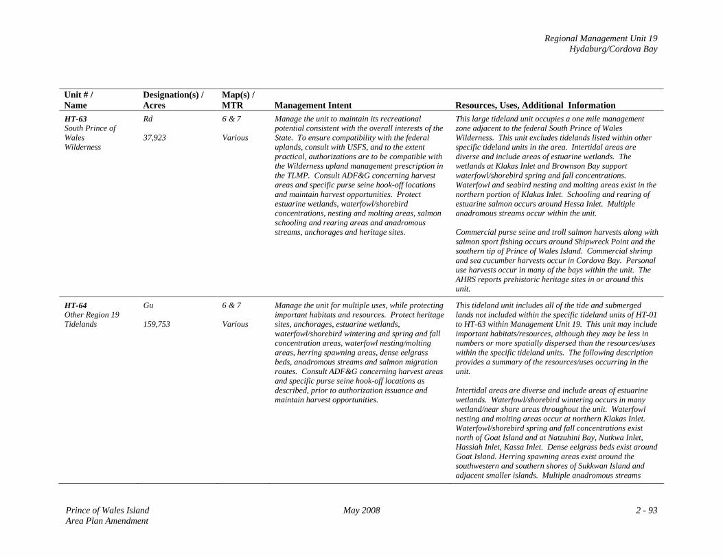
Regional Management Unit 19 Hydaburg/Cordova Bay
Unit # / Name
Designation(s) / Acres
Map(s) / MTR
Management Intent
Resources, Uses, Additional Information
HT-63 South Prince of Wales Wilderness
Rd 37,923
6 & 7 Various
Manage the unit to maintain its recreational potential consistent with the overall interests of the State. To ensure compatibility with the federal uplands, consult with USFS, and to the extent practical, authorizations are to be compatible with the Wilderness upland management prescription in the TLMP. Consult ADF&G concerning harvest areas and specific purse seine hook-off locations and maintain harvest opportunities. Protect estuarine wetlands, waterfowl/shorebird concentrations, nesting and molting areas, salmon schooling and rearing areas and anadromous streams, anchorages and heritage sites.
This large tideland unit occupies a one mile management zone adjacent to the federal South Prince of Wales Wilderness. This unit excludes tidelands listed within other specific tideland units in the area. Intertidal areas are diverse and include areas of estuarine wetlands. The wetlands at Klakas Inlet and Brownson Bay support waterfowl/shorebird spring and fall concentrations. Waterfowl and seabird nesting and molting areas exist in the northern portion of Klakas Inlet. Schooling and rearing of estuarine salmon occurs around Hessa Inlet. Multiple anadromous streams occur within the unit. Commercial purse seine and troll salmon harvests along with salmon sport fishing occurs around Shipwreck Point and the southern tip of Prince of Wales Island. Commercial shrimp and sea cucumber harvests occur in Cordova Bay. Personal use harvests occur in many of the bays within the unit. The AHRS reports prehistoric heritage sites in or around this unit.
HT-64 Other Region 19 Tidelands
Gu 159,753
6 & 7 Various
Manage the unit for multiple uses, while protecting important habitats and resources. Protect heritage sites, anchorages, estuarine wetlands, waterfowl/shorebird wintering and spring and fall concentration areas, waterfowl nesting/molting areas, herring spawning areas, dense eelgrass beds, anadromous streams and salmon migration routes. Consult ADF&G concerning harvest areas and specific purse seine hook-off locations as described, prior to authorization issuance and maintain harvest opportunities.
This tideland unit includes all of the tide and submerged lands not included within the specific tideland units of HT-01 to HT-63 within Management Unit 19. This unit may include important habitats/resources, although they may be less in numbers or more spatially dispersed than the resources/uses within the specific tideland units. The following description provides a summary of the resources/uses occurring in the unit. Intertidal areas are diverse and include areas of estuarine wetlands. Waterfowl/shorebird wintering occurs in many wetland/near shore areas throughout the unit. Waterfowl nesting and molting areas occur at northern Klakas Inlet. Waterfowl/shorebird spring and fall concentrations exist north of Goat Island and at Natzuhini Bay, Nutkwa Inlet, Hassiah Inlet, Kassa Inlet. Dense eelgrass beds exist around Goat Island. Herring spawning areas exist around the southwestern and southern shores of Sukkwan Island and adjacent smaller islands. Multiple anadromous streams
Prince of Wales Island May 2008 2 - 93 Area Plan Amendment
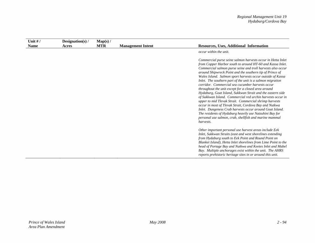
Regional Management Unit 19 Hydaburg/Cordova Bay
Unit # / Name
Designation(s) / Acres
Map(s) / MTR
Management Intent
Resources, Uses, Additional Information occur within the unit. Commercial purse seine salmon harvests occur in Hetta Inlet from Copper Harbor south to around HT-60 and Kassa Inlet. Commercial salmon purse seine and troll harvests also occur around Shipwreck Point and the southern tip of Prince of Wales Island. Salmon sport harvests occur outside of Kassa Inlet. The southern part of the unit is a salmon migration corridor. Commercial sea cucumber harvests occur throughout the unit except for a closed area around Hydaburg, Goat Island, Sukkwan Strait and the eastern side of Sukkwan Island. Commercial red urchin harvests occur in upper to mid Tlevak Strait. Commercial shrimp harvests occur in most of Tlevak Strait, Cordova Bay and Nutkwa Inlet. Dungeness Crab harvests occur around Goat Island. The residents of Hydaburg heavily use Natzuhini Bay for personal use salmon, crab, shellfish and marine mammal harvests. Other important personal use harvest areas include Eek Inlet, Sukkwan Straits (east and west shorelines extending from Hydaburg south to Eek Point and Round Point on Blanket Island), Hetta Inlet shorelines from Lime Point to the head of Portage Bay and Nutkwa and Keetes Inlet and Mabel Bay. Multiple anchorages exist within the unit. The AHRS reports prehistoric heritage sites in or around this unit.
Prince of Wales Island May 2008 2 - 94 Area Plan Amendment

Regional Management Unit 19 Hydaburg/Cordova Bay
MAP 6: Management Unit 19: Hydaburg/Cordova Bay
Prince of Wales Island May 2008 2 - 95 Area Plan Amendment
Regional Management Unit 19 Hydaburg/Cordova Bay
MAP 7: Management Unit 19: Hydaburg/Cordova Bay
Prince of Wales Island May 2008 2 - 97 Area Plan Amendment

APPENDIX A
Land Classification Order
SE‐98‐001A02
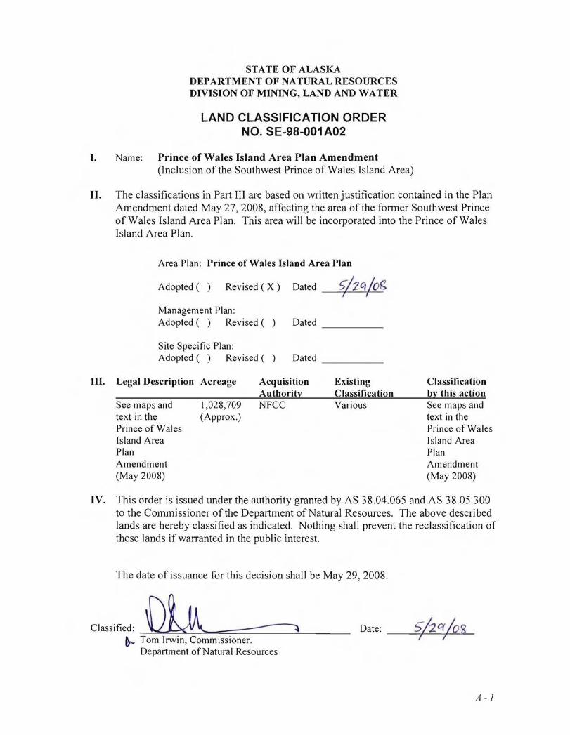
STATE OF ALASKA DEPARTMENT OF NATURAL RESOURCES DIVISION OF MINING, LAND AND WATER
LAND CLASSIFICATION ORDER NO. SE-98-001 A02
I. Name: Prince of Wales Island Area Plan Amendment (Inclusion of the Southwest Prince of Wales Island Area)
II. The classifications in Part III are based on written justification contained in the Plan Amendment dated May 27, 2008, affecting the area of the former Southwest Prince of Wales Island Area Plan. This area will be incorporated into the Prince of Wales Island Area Plan.
Area Plan: Prince of Wales Island Area Plan
Adopted () Revised ( X ) Dated
Management Plan: Adopted () Revised () Dated _
Site Specific Plan: Adopted () Revised () Dated _
III. Legal Description Acreage
See maps and text in the Prince of Wales Island Area Plan Amendment (May 2008)
1,028,709 (Approx.)
Acquisition Authority NFCC
Existing Classification Various
Classification by this action See maps and text in the Prince of Wales Island Area Plan Amendment (May 2008)
IV. This order is issued under the authority granted by AS 38.04.065 and AS 38.05.300 to the Commissioner of the Department of Natural Resources. The above described lands are hereby classified as indicated. Nothing shall prevent the reclassification of these lands if warranted in the public interest.
The date of issuance for this decision shall be May 29, 2008.
Classified: Date:DU ----------. ~ Tom Irwin, Commissioner.
Department of Natural Resources
__-+---"---+--=-->"'-
A - J

APPENDIX B
Mineral Order 1080
Administrative Finding by the Commissioner
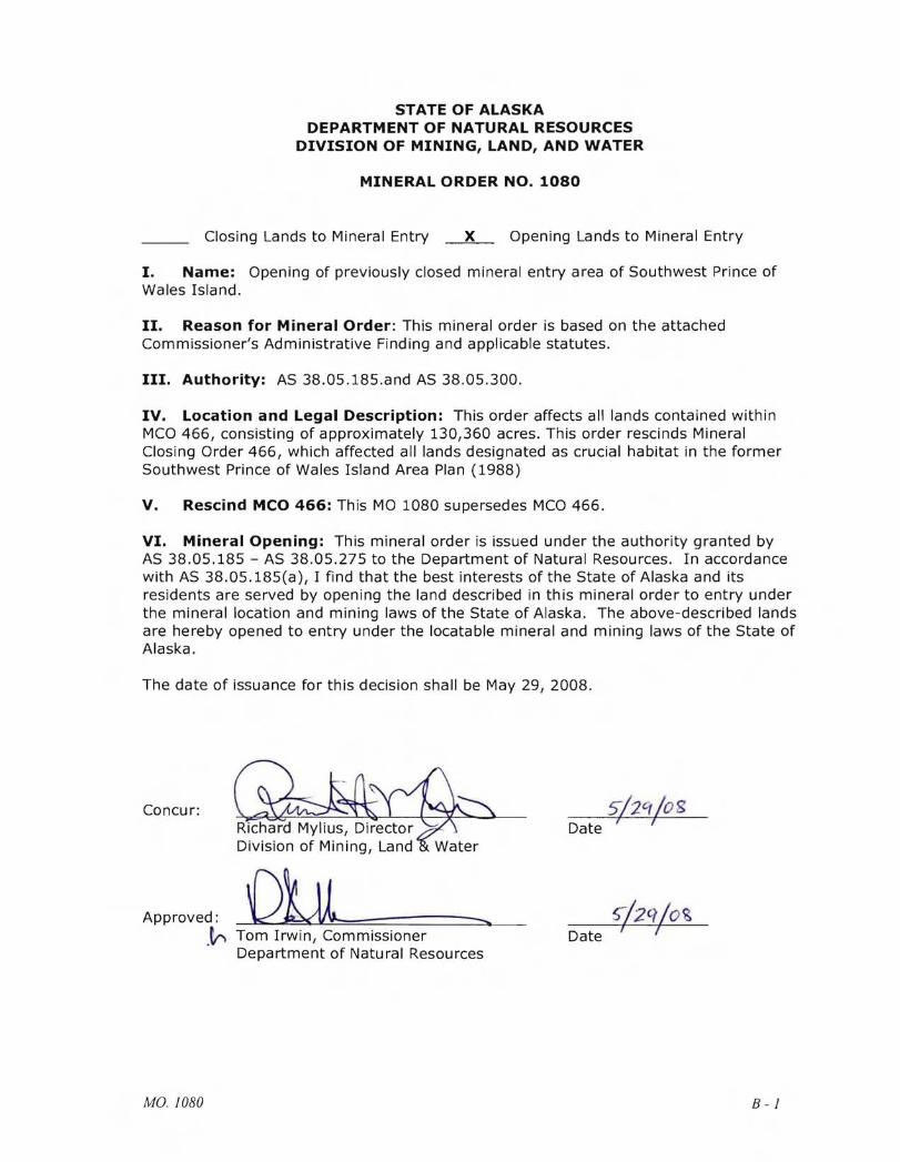
STATE OF ALASKA DEPARTMENT OF NATURAL RESOURCES
DIVISION OF MINING, LAND, AND WATER
MINERAL ORDER NO. 1080
Closing Lands to Mineral Entry x Opening Lands to Mineral Entry
I. Name: Opening of previously closed mineral entry area of Southwest Prince of Wales Island.
II. Reason for Mineral Order: This mineral order is based on the attached Commissioner's Administrative Finding and applicable statutes.
III. Authority: AS 38.05.185.and AS 38.05.300.
IV. Location and Legal Description: This order affects all lands contained within MCO 466, consisting of approXimately 130,360 acres. This order rescinds Mineral Closing Order 466, which affected all lands designated as crucial habitat in the former Southwest Prince of Wales Island Area Plan (1988)
V. Rescind MCO 466: This MO 1080 supersedes MCO 466.
VI. Mineral Opening: This mineral order is issued under the authority granted by AS 38.05.185 - AS 38.05.275 to the Department of Natural Resources. In accordance with AS 38.05.185(a), I find that the best interests of the State of Alaska and its residents are served by opening the land described in this mineral order to entry under the mineral location and mining laws of the State of Alaska. The above-described lands are hereby opened to entry under the locatable mineral and mining laws of the State of Alaska.
The date of issuance for this decision shall be May 29, 2008.
Concur:
Approved:
Richard Mylius, Director Division of Mining, Land
Tom Irwin, Commissioner Date.~ Department of Natural Resources
MO 1080 B-1
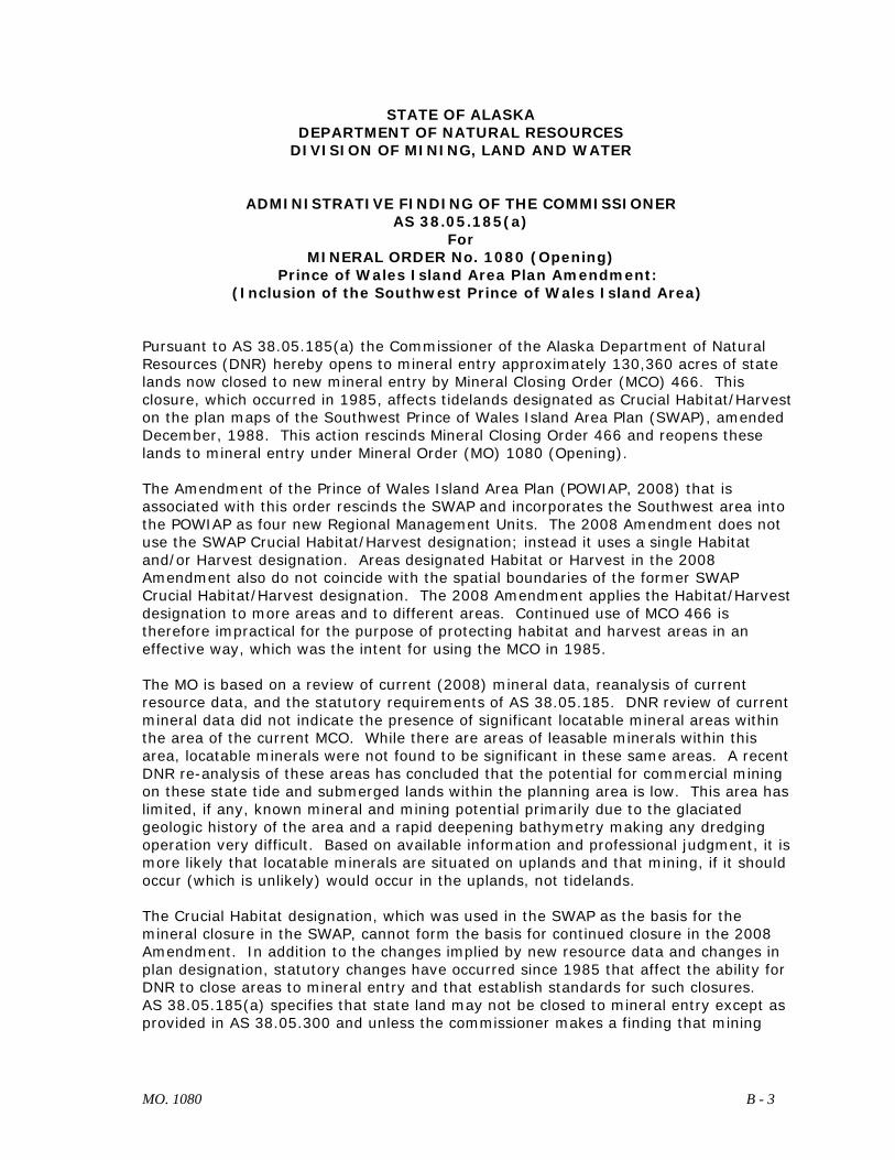
STATE OF ALASKA DEPARTMENT OF NATURAL RESOURCES
DIVISION OF MINING, LAND AND WATER
ADMINISTRATIVE FINDING OF THE COMMISSIONER AS 38.05.185(a)
For MINERAL ORDER No. 1080 (Opening)
Prince of Wales Island Area Plan Amendment: (Inclusion of the Southwest Prince of Wales Island Area)
Pursuant to AS 38.05.185(a) the Commissioner of the Alaska Department of Natural Resources (DNR) hereby opens to mineral entry approximately 130,360 acres of state lands now closed to new mineral entry by Mineral Closing Order (MCO) 466. This closure, which occurred in 1985, affects tidelands designated as Crucial Habitat/Harvest on the plan maps of the Southwest Prince of Wales Island Area Plan (SWAP), amended December, 1988. This action rescinds Mineral Closing Order 466 and reopens these lands to mineral entry under Mineral Order (MO) 1080 (Opening). The Amendment of the Prince of Wales Island Area Plan (POWIAP, 2008) that is associated with this order rescinds the SWAP and incorporates the Southwest area into the POWIAP as four new Regional Management Units. The 2008 Amendment does not use the SWAP Crucial Habitat/Harvest designation; instead it uses a single Habitat and/or Harvest designation. Areas designated Habitat or Harvest in the 2008 Amendment also do not coincide with the spatial boundaries of the former SWAP Crucial Habitat/Harvest designation. The 2008 Amendment applies the Habitat/Harvest designation to more areas and to different areas. Continued use of MCO 466 is therefore impractical for the purpose of protecting habitat and harvest areas in an effective way, which was the intent for using the MCO in 1985. The MO is based on a review of current (2008) mineral data, reanalysis of current resource data, and the statutory requirements of AS 38.05.185. DNR review of current mineral data did not indicate the presence of significant locatable mineral areas within the area of the current MCO. While there are areas of leasable minerals within this area, locatable minerals were not found to be significant in these same areas. A recent DNR re-analysis of these areas has concluded that the potential for commercial mining on these state tide and submerged lands within the planning area is low. This area has limited, if any, known mineral and mining potential primarily due to the glaciated geologic history of the area and a rapid deepening bathymetry making any dredging operation very difficult. Based on available information and professional judgment, it is more likely that locatable minerals are situated on uplands and that mining, if it should occur (which is unlikely) would occur in the uplands, not tidelands. The Crucial Habitat designation, which was used in the SWAP as the basis for the mineral closure in the SWAP, cannot form the basis for continued closure in the 2008 Amendment. In addition to the changes implied by new resource data and changes in plan designation, statutory changes have occurred since 1985 that affect the ability for DNR to close areas to mineral entry and that establish standards for such closures. AS 38.05.185(a) specifies that state land may not be closed to mineral entry except as provided in AS 38.05.300 and unless the commissioner makes a finding that mining
MO. 1080 B - 3
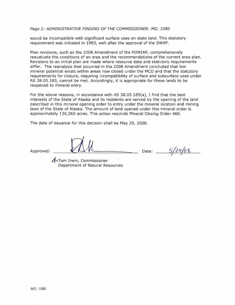
Page 2: ADMINISTRATIVE FINDING OF THE COMMISSIONER: MO. 1080
would be incompatible with significant surface uses on state land. This statutory requirement was initiated in 1993, well after the approval of the SWAP.
Plan revisions, such as the 2008 Amendment of the POWIAP, comprehensively reevaluate the conditions of an area and the recommendations of the current area plan. Revisions to an initial plan are made where resource data and statutory requirements differ. The reanalysis that occurred in the 2008 Amendment concluded that low mineral potential exists within areas now closed under the I"1CO and that the statutory requirements for closure, requiring incompatibility of surface and subsurface uses under AS 38.05.185, cannot be met. Accordingly, it is appropriate for these lands to be reopened to mineral entry.
For the above reasons, in accordance with AS 38.05.185(a), I find that the best interests of the State of Alaska and its residents are served by the opening of the land described in this mineral opening order to entry under the mineral location and mining laws of the State of Alaska. The amount of land opened under this mineral order is approximately 130,360 acres. This action rescinds Mineral Closing Order 466.
The date of issuance for this decision shall be May 29, 2008.
Approved: Date:
~Tom Irwin, Commissioner Department of Natural Resources
MO 1080