What would cause Europeans to explore? Prince Henry the Navigator.
Contents
1 Introduction....................................................................................................................................... 3 1.1 Objectives.................................................................................................................................... 3 1.2 Heritage Requirements ................................................................................................................... 4 1.3 Affordable Housing Requirements................................................................................................... 5
2 Site Context....................................................................................................................................... 6 2.1 Regional and Local Context ........................................................................................................ 6 2.2 Precincts...................................................................................................................................... 7 2.3 Transport Links and Access........................................................................................................ 7 2.4 Views and Vistas......................................................................................................................... 8 2.5 Landscape................................................................................................................................... 8 2.6 Heritage Context ......................................................................................................................... 9 2.7 Archaeological Context ............................................................................................................. 11 2.8 Built Form.................................................................................................................................. 13 2.9 Sustainable Design ................................................................................................................... 14 2.10 Desired Future Character.......................................................................................................... 15
3 Subdivision and Amalgamation.................................................................................................... 25
4 Building and Site Design ............................................................................................................... 26 4.1 Building Envelope ..................................................................................................................... 26 4.2 Height ........................................................................................................................................ 27 4.3 Building Depth........................................................................................................................... 28 4.4 Density ...................................................................................................................................... 28 4.5 Setbacks.................................................................................................................................... 29 4.6 Building Articulation................................................................................................................... 29 4.7 Landscaped and Private Open Space ...................................................................................... 30 4.8 Landscape Design and Biodiversity.......................................................................................... 33 4.9 Development Adjacent to Watercourses................................................................................... 34 4.10 Activity Strip............................................................................................................................... 35 4.11 Solar Access ............................................................................................................................. 36 4.12 Acoustic Privacy........................................................................................................................ 37 4.13 Visual Privacy............................................................................................................................ 39 4.14 Dwelling Layout and Mix ........................................................................................................... 40 4.15 Roof Design............................................................................................................................... 42 4.16 Fences....................................................................................................................................... 43 4.17 Safety and Security ................................................................................................................... 44 4.18 Materials and Finishes .............................................................................................................. 45 4.19 Signs ......................................................................................................................................... 46
5 Sustainable Design ........................................................................................................................ 47 5.1 Total Water Cycle Management ............................................................................................... 47 5.2 Bushfire Risk Management ....................................................................................................... 49 5.3 Contaminated Land................................................................................................................... 49
6 Precinct Specific Controls............................................................................................................. 50 6.1 Precinct P1................................................................................................................................ 51 6.2 Precinct P2................................................................................................................................ 59 6.3 Precinct P3................................................................................................................................ 64 6.4 Precinct P4................................................................................................................................ 70 6.5 Precinct P5................................................................................................................................ 76
Prince Henry site, Little Bay E4
Prince Henry Site, Little Bay __________________________________________________________________________________
RANDWICK COMPREHENSIVE DEVELOPMENT CONTROL PLAN 2013 2
E4
6.6 Historic Precinct ........................................................................................................................ 79
Appendices ............................................................................................................................................ 87 Appendix A: Recommended List of Suitable Native Species............................................................ 87 Appendix B: Bushfire Risk Management Report (2001).................................................................... 88 Appendix C: Map Extracts from the Archaeological Management Plan (AMP) and the Conservation Management Plan (CMP) .................................................................................................................... 91 Appendix D: Total Water Cycle Strategy – Prince Henry Site........................................................... 94 Appendix E: Watercourse Categories and Riparian Land Widths..................................................... 96 Appendix F: Specific Elements Conservation Policies (SECP)......................................................... 97
Prince Henry Site, Little Bay __________________________________________________________________________________
RANDWICK COMPREHENSIVE DEVELOPMENT CONTROL PLAN 2013 3
E4
1 Introduction This section provides a framework for the redevelopment of land at the Prince Henry Hospital site at Little Bay (see Figure AA). It provides controls to guide the built form, environmental and amenity standards, and requirements for appropriate heritage protection for the site. The following documents may be relevant:
Prince Henry Master Plan adopted with variations May 2003 and subsequent amendments. The principles of the master plan are reflected in this Section;
The Prince Henry Site, Little Bay – Conservation
Management Plan (CMP) prepared by Godden Mackay Logan, May 2002 (amended February 2003), and any subsequent amendments endorsed by the NSW Heritage Council;
The Prince Henry Site, Little Bay – Archaeological
Management Plan (AMP) prepared by Godden Mackay Logan, August 2002;
Any Specific Elements Conservation Policy (SECP) for the
site, as required by the CMP (see Appendix F);
The Bushland Plan of Management (POM) and the Little Bay Geological Reserve Plan of Management (POM); and
This section of the DCP should be read in conjunction with:
Part A - Introduction and Part B - General Controls; and Other sections of the DCP for specific development types,
locations or sites, if relevant to the DA. To the extent of any inconsistency between this section and any other DCP sections, this section will prevail. 1.1 Objectives The objectives of this section are:
To create a sustainable neighbourhood that integrates new and existing development.
To ensure design reflects the site’s unique location and
characteristics.
To conserve the heritage significance of the Prince Henry site and the natural and cultural elements that contribute to the significance of the site and its setting.
To protect the visual amenity and scenic value of the
coastline.
To ensure development reflects the principles of the

Prince Henry Site, Little Bay __________________________________________________________________________________
RANDWICK COMPREHENSIVE DEVELOPMENT CONTROL PLAN 2013 4
E4
adopted master plan for the site.
To ensure development demonstrates architectural merit and incorporates high quality materials and finishes.
To ensure development promotes and incorporates the
principles of ecologically sustainable development (ESD).
To provide for a mix of land uses and dwelling types.
To provide for housing choice to accommodate the needs of current and future households and affordability.
To protect and enhance remnant native vegetation, habitat
corridors, riparian buffers and wetland area. 1.2 Heritage Requirements Most DAs for development within the Prince Henry site will constitute Integrated Development, due to the site’s listing on the NSW State Heritage Register, and sometimes because approvals may be required under other Acts. Applicants should check with Council to determine Integrated Development requirements prior to lodging any DA. A Heritage Impact Statement (HIS) prepared by a suitably qualified professional must be included with any DA, together with a Specific Elements Conservation Policy (SECP) (where applicable). Applicants should refer to the Conservation Management Plan (CMP), the Archaeological Management Plan (AMP) and any relevant Specific Elements Conservation Management Policy (SECP) when preparing a DA. Key requirements identified in these plans/policies are noted below: Built and Landscape Elements
Significant built and landscape items and elements should be retained, conserved, managed and interpreted in accordance with the detailed policies in the Conservation Management Plan (CMP) and any relevant Specific Elements Conservation Policy (SECP) as well as the requirements of the NSW Heritage Act 1977.
Aboriginal Archaeology
Identified and potential Aboriginal archaeological objects and sites are to be conserved and managed in accordance with the Archaeological Management Plan (AMP) and the requirements of the NSW National Parks and Wildlife Act 1974.
Damage or destruction of any Aboriginal object or place is
only permitted where a permit or consent has been issued by the Director of the National Parks and Wildlife Service (NPWS), Office of Environment and Heritage.
Any proposals affecting known or discovered Aboriginal
objects or places on the Prince Henry site or proposals
Prince Henry Site, Little Bay __________________________________________________________________________________
RANDWICK COMPREHENSIVE DEVELOPMENT CONTROL PLAN 2013 5
E4
that will disturb the ground within identified Aboriginal Archaeological Zones must be referred to the La Perouse Local Aboriginal Land Council (LPLALC).
Prepare an Aboriginal Heritage assessment if required
(see Section 2.7). Historical Archaeology
Identified and potential archaeological relics and sites are to be conserved and managed in accordance with the Archaeological Management Plan (AMP) and the requirements of the NSW Heritage Act.
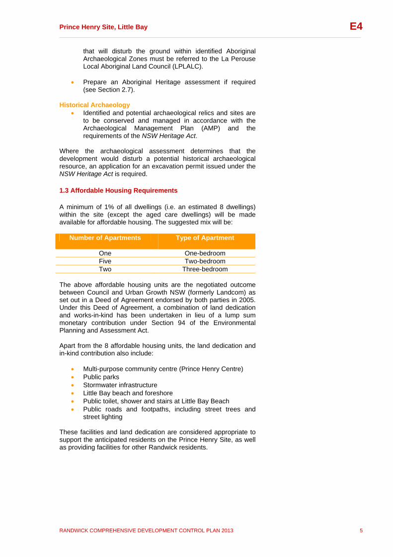
Where the archaeological assessment determines that the development would disturb a potential historical archaeological resource, an application for an excavation permit issued under the NSW Heritage Act is required. 1.3 Affordable Housing Requirements A minimum of 1% of all dwellings (i.e. an estimated 8 dwellings) within the site (except the aged care dwellings) will be made available for affordable housing. The suggested mix will be:
Number of Apartments Type of Apartment
One One-bedroom Five Two-bedroom Two Three-bedroom
The above affordable housing units are the negotiated outcome between Council and Urban Growth NSW (formerly Landcom) as set out in a Deed of Agreement endorsed by both parties in 2005. Under this Deed of Agreement, a combination of land dedication and works-in-kind has been undertaken in lieu of a lump sum monetary contribution under Section 94 of the Environmental Planning and Assessment Act. Apart from the 8 affordable housing units, the land dedication and in-kind contribution also include:
Multi-purpose community centre (Prince Henry Centre) Public parks Stormwater infrastructure Little Bay beach and foreshore Public toilet, shower and stairs at Little Bay Beach Public roads and footpaths, including street trees and
street lighting These facilities and land dedication are considered appropriate to support the anticipated residents on the Prince Henry Site, as well as providing facilities for other Randwick residents.

Prince Henry Site, Little Bay __________________________________________________________________________________
RANDWICK COMPREHENSIVE DEVELOPMENT CONTROL PLAN 2013 6
E4
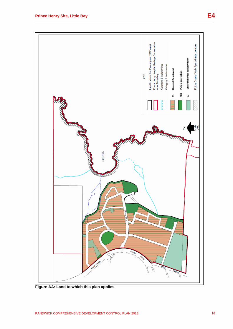
2 Site Context This subsection outlines the context and key features of the Prince Henry site as well as the key design principles for the DCP area. 2.1 Regional and Local Context The Prince Henry site is located on Anzac Parade at Little Bay, at the southern end of the Randwick Local Government Area and the Eastern Beaches. The Prince Henry DCP area is part of the broader Prince Henry site. The DCP area is bound by the residential development site at 1406-1408 Anzac Parade to the north, The Coast Golf Course and Little Bay beach to the east, the Spinal Injuries Australia and Golf Driving Range to the south, St Michaels Golf Course to the south-east, and Anzac Parade to the west. The Little Bay-La Perouse area is characterised by detached dwellings in a mix of styles, with some Department of Housing apartment buildings. The DCP area has a rich Aboriginal and European history. From 1881-1934 this area was occupied by the Coast Hospital, built for the isolation and treatment of infectious diseases. Apart from archaeological evidence, the main evidence of this phase that remains within the DCP area includes Pine Avenue (including alignment, pine trees and sandstone kerbing) and the Artisans Cottages and associated water reservoir. 1915-1934 saw the expansion of the Coast Hospital, which included the construction of the Flowers Wards. The Flowers Wards and all other mentioned aspects remain within the DCP area today and are to be adapted for residential and community re-use. In November 1934 it was announced that the Coast Hospital was to be renamed the ‘Prince Henry Hospital’ in honour of Prince Henry, the Duke of Gloucester, who had recently visited Sydney. The period from 1935-1959 saw the hospital’s capacity increased and the construction of more new buildings. From the 1960s to 2002 saw the role of the Prince Henry Hospital as a general and major teaching hospital established and consolidated. The Interdenominational Australian Nurses War Memorial Chapel is one of the key buildings from this phase that will be retained within the DCP area. Aboriginal occupation of this area pre-dates European settlement by many years. Evidence of Aboriginal occupation prior to the establishment of the Coast Hospital in 1881, includes a diverse collection of middens, open campsites, rock engravings, axe grinding grooves and a possible fish trap and an ochre source. The majority of identified sites lie outside the DCP area, however there is potential for previously unidentified artefacts and significant sites to lie within the DCP area. The Prince Henry Hospital Site (including the DCP area) is listed on the NSW State Heritage Register.

Prince Henry Site, Little Bay __________________________________________________________________________________
RANDWICK COMPREHENSIVE DEVELOPMENT CONTROL PLAN 2013 7
E4
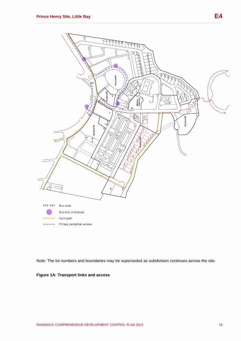
2.2 Precincts The Prince Henry Site is divided into 6 precincts for the purpose of this DCP. These precincts are shown on Figure 1. The Historic Precinct runs through the core of the DCP area. This precinct contains most of the buildings and landscape items of heritage significance, however the whole of the former Prince Henry Hospital site is a highly significant cultural landscape and other precincts contain items of heritage significance. Precincts P1, P3 and P4 provide for a mix of residential densities. Precinct P2 is located on the corner of Pine Avenue and Anzac Parade, the main entry to the site. This mixed use precinct comprises local neighbourhood scale shops, such as a supermarket, and commercial uses, with residential uses above. Precinct P5 is located at the eastern end of Pine Avenue on the eastern edge of the DCP area. This precinct contains a Community Centre that serves the needs of the incoming residents as well as the wider community. Subsection 6 contains performance criteria and controls that are specific to each of these precincts. These precinct specific requirements provide an additional layer of detail to the general controls contained in the rest of this section (subsections 1 – 5). To the extent of any inconsistencies between the general and precinct specific controls the precinct specific controls prevail. 2.3 Transport Links and Access Anzac Parade links the DCP area to the remainder of Randwick City via various vehicular access points. The DCP area is currently served by State Transit Authority bus routes that run along Anzac Parade. Figure 1A shows an indicative bus route and bus stops through the DCP area. It is proposed to make provision for a cycleway along Anzac Parade, connecting the DCP area to its surrounds, including the national park to the south. As shown on Figure 1A, the cycle way will run along Jennifer Street / Harvey Street within the DCP area and along the buffer strip between the DCP area and the golf course, providing a dedicated shared cycle/pedestrian link from Anzac Parade to the eastern end of Pine Avenue. Roads within the DCP area will have a low speed environment, and will also be suitable for cycling. The DCP area has a connective and convenient street layout for both vehicles and pedestrians. In addition, there are a number of pedestrian paths providing further links (Figure 1A). Key principles include:
To promote the use of alternative modes of transport to the car, including walking, cycling and public transport (bus)
To promote safe and convenient movement throughout the
DCP area.
Prince Henry Site, Little Bay __________________________________________________________________________________
RANDWICK COMPREHENSIVE DEVELOPMENT CONTROL PLAN 2013 8
E4
2.4 Views and Vistas Figure 2 shows the key views to and from the DCP area, and as well as views of heritage significance identified in the Conservation Management Plan (CMP). Key views include views of the ocean and coastline, views of heritage buildings, and views along significant streets within the site. Any DA will need to demonstrate that these views and vistas are retained or enhanced. Key principles include:
maintain and enhance significant views and vistas throughout the site.
buildings are to be designed to maximise view sharing.
to ensure the visual amenity of the coast is protected.
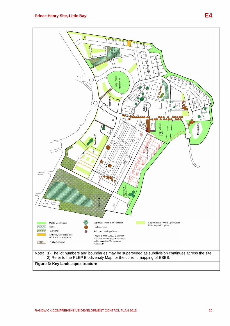
Refer to Subsection 6 for detailed objectives and controls. 2.5 Landscape The Prince Henry DCP area has an open, green and uncluttered landscape quality that contributes to the setting of its heritage buildings, while retaining ocean and coastal views. Figure 3 shows the key landscape elements of the DCP area. There are two main areas of remnant bushland, both of which contain Eastern Suburbs Banksia Scrub (ESBS), an endangered ecological community. There is also a stand of ESBS near the former Matron Dickson building (Mayo Street / Pavilion Drive) and smaller pockets of bushland elsewhere in the DCP area. The DCP area also contains an array of culturally significant plantings, which are predominantly located within the Historic Precinct. These are identified on Figure 3 together with the key public open spaces within the DCP area. Open spaces within the DCP area have generally been located to form links with other open spaces and plantings where possible. A landscaped buffer runs along the eastern edge of the DCP area, between the residential area and the Coast Golf Course. The buffer plays a number of important roles including creation of habitat, water management, safety (separation of residential and golf course uses) and public recreation (southern half of buffer only). South of Pine Avenue, the buffer is approximately 18 metres wide and is publicly accessible via a shared pedestrian/cycle path that connects to Pine Avenue and Harvey Street. North of Pine Avenue, the buffer is approximately 10 metres wide. The topography in this area is much steeper and this part of the buffer will not have pedestrian access. Two small parks adjacent to this part of the buffer and located at the end of key view corridors will ensure views across the vegetated buffer to the coast are maintained as publicly accessible views. Figure 4 identifies the significant landscape curtilages around heritage buildings.
Prince Henry Site, Little Bay __________________________________________________________________________________
RANDWICK COMPREHENSIVE DEVELOPMENT CONTROL PLAN 2013 9
E4
The DCP area has a predominantly easterly aspect, exposed to breezes from the north-east, east and south. These breezes are typically cooling in summer; however in winter protection from southerly wind is desirable. Key landscape design principles include:
buildings are to be designed so they do not dominate the landscape and are consistent with the Prince Henry DCP area’s character of “buildings within an open landscape setting dominated by sky and sea”
locate private communal open spaces so they form visual
links with other open spaces on the site
use local native species and species that recognise the DCP area’s coastal location and that complement existing significant and heritage plantings (where appropriate to the heritage context) within the DCP area
characterise open space by high quality landscape design
that emphasises principles of sustainability and functionality
conserve and enhance bushland areas through planting of
non-invasive indigenous vegetation in areas adjacent to remnant bushland
create a landscape that contributes to the built
environment by providing climate amelioration and functional space appropriate to the needs of residents
repair and maintain significant riparian land
establish and maintain biological linkages between areas
of remnant native vegetation
create a vegetated link via suitably designed landscaping along the southern boundary of the DCP area, providing a connection between the Jennifer Street remnant bushland and the golf course buffer
promote biological diversity and use of local native plants
from locally provenanced seed where appropriate Refer to Subsections 4.7 and 4.8 for detailed objectives and controls on landscape design. 2.6 Heritage Context The Prince Henry site (of which the Prince Henry DCP area is part) is listed on the NSW State Heritage Register as an item of State heritage significance. RLEP also identifies the former Prince Henry Hospital site as a conservation area. Schedule 5 of RLEP contains a list of heritage items and archaeological sites. Figure 4 shows built and landscape heritage items, the extent of the Little Bay Geological site within the DCP area, key views identified as having heritage significance, the historic precinct

Prince Henry Site, Little Bay __________________________________________________________________________________
RANDWICK COMPREHENSIVE DEVELOPMENT CONTROL PLAN 2013 10
E4
boundary, and parts of the Prince Henry Conservation Area boundary. The Little Bay Geological site is a site of national significance and provides evidence of topography, relative sea level, vertical land movements and coastal landscape prior to the formation of Sydney Harbour and other coastal valleys (refer to the CMP, and Little Bay Geological Site SECP and Plan of Management). The different types of elements of heritage significance occurring within the Prince Henry Site are summarised below:
Elements of Built significance including, but not limited to, the entrance gateposts, the Clocktower, Henry’s Trading Post, the Matron Dickson building and the Flowers Wards. Refer to Figure 4 for a list of items within the DCP area, and refer to the CMP for items beyond the DCP area.
Elements of Landscape significance including, but not
limited to, a number of natural and cultural plantings such as indigenous vegetation and several species of palms, banksias and Norfolk Island Pines, road alignments, rock outcrops and the Male Lazaret. Refer to Figure 4 for a list of items within the DCP area, and refer to the CMP for items beyond the DCP area.
Elements of Aboriginal significance on the site include
open and sheltered shell middens, axe-grinding grooves and rock engravings, pathways, a possible fish trap and ochre source. The Prince Henry DCP area may contain further undetected Aboriginal archaeological sites relating to both prehistoric and post-contact periods of occupation (refer to Appendix C).
Elements of Historical Archaeological significance
within the DCP area include, but are not limited to subsurface features/deposits, rock cut features associated with former activities on the site (i.e. graffiti, drainage, coastal defences etc), and sites of former structures associated with the Coast and Prince Henry Hospitals (e.g. lazarets, mortuary buildings) (refer to Appendix C).
Moveable items of potential heritage significance are identified in the Conservation Management Plan, the Archaeological Management Plan, any relevant Specific Elements Conservation Policy and the Museum Plan. Subsection 1.3 outlines the heritage requirements for Development Applications. In preparing development applications, applicants should refer to the following documents prepared by Godden Mackay Logan Heritage Consultants:
Prince Henry Site, Little Bay – Conservation Management Plan (CMP), May 2002 (amended February 2003), and any subsequent amendments endorsed by the NSW Heritage Council;
Prince Henry Site, Little Bay – Archaeological
Management Plan (AMP), August 2002, and any
Prince Henry Site, Little Bay __________________________________________________________________________________
RANDWICK COMPREHENSIVE DEVELOPMENT CONTROL PLAN 2013 11
E4
subsequent amendments endorsed by the NSW Heritage Council; and
any relevant Specific Elements Conservation Policy
(SECP). The Conservation Management Plan for the site identifies a number of heritage principles for the Prince Henry site. These key heritage principles include:
Conserve, manage and interpret the site as an item (place) of State significance;
Recognise the importance of the site as a whole, in
addition to the values of individual components (such as natural and cultural landscape values, built and landscape heritage elements, and geological and archaeological features);
Respect and recapture as much as possible the qualities
of the site that contributed to the village atmosphere valued by the community, including significant buildings and landscape features, and the character established by generally low-scaled buildings in an open setting;
Ensure that new development respects, enhances and
contributes to the heritage significance of the site and its setting;
Restore and reconstruct built and landscape elements that
contribute to the significance of the site and its setting;
New buildings, infill development and alterations/additions to heritage items are to respect the design and scale of existing heritage buildings and elements on the Prince Henry Site;
Significant and heritage trees are to be protected during
construction;
New planting should retain and enhance the open landscape character of the site.
Refer to Subsection 1.3 for detailed objectives and controls. 2.7 Archaeological Context Figure 5 illustrates the Prince Henry site’s aboriginal and historical archaeological features for the DCP area. This aboriginal archaeological resource has high educational, cultural and scientific significance. Three levels of Aboriginal Archaeological Sensitivity have been identified within the Prince Henry site:
Aboriginal Archaeological Sensitivity Zone 1 (Very High) – this includes the golf course and beach (mostly outside the DCP area, with the exception of a small part of Precinct P1);
Prince Henry Site, Little Bay __________________________________________________________________________________
RANDWICK COMPREHENSIVE DEVELOPMENT CONTROL PLAN 2013 12
E4
Aboriginal Archaeological Sensitivity Zone 2 (High) – this
includes locations within the built areas of the site (DCP area); and
Aboriginal Archaeological Sensitivity Zone 3 (High) – this
comprises the large area of remnant bushland in the south western corner of the Prince Henry site. This bushland will be retained and will not be directly affected by the redevelopment of the site.
For the full extent of aboriginal and historical archaeological items, including items located beyond the DCP area, refer to the Archaeological Management Plan (AMP). Extract maps from these plans are also attached as Appendix C. Subsection 2.6 contains key principles for the management of heritage sites. In addition to these principles, key archaeological principles include:
To conserve, manage and interpret identified and potential Aboriginal relics and sites in accordance with the AMP and the requirements of the NSW National Parks and Wildlife Act; and
Development should be planned to minimise impacts on
areas of Aboriginal heritage significance and should seek to enhance the values of these areas.
National Parks and Wildlife Service (NPWS) recommends that an Aboriginal heritage assessment be prepared for land under the following circumstances:
the NSW NPWS Aboriginal Sites Register identifies sites in or near the development area, which could potentially be affected during or after the development;
the proposed development is likely to have an impact on
areas of bushland or undisturbed ground;
the proposed development is likely to have an impact on areas containing sandstone outcrops, rock shelters, old growth trees, sand bodies and ground adjacent to watercourses, lakes and swamps; and
the proposed development is likely to have an impact on
an area of importance to the Aboriginal community not included in the above (e.g. story places, missions etc).
Refer to Subsection 6 for precinct-specific objectives and controls.
Prince Henry Site, Little Bay __________________________________________________________________________________
RANDWICK COMPREHENSIVE DEVELOPMENT CONTROL PLAN 2013 13
E4
2.8 Built Form The built form controls for the DCP area reflect the master plan principles and the site’s unique features, opportunities and constraints identified in the master plan site analysis. This section provides an overview of the rationale on which the built form controls shown in Figures 6 and 7 are based, and the site’s desired future character and new development. Existing road alignments within the Prince Henry DCP area have been retained where possible. New roads and paths have been designed to complement the existing road network. Pine Avenue is the main entry to the DCP area, forming a central tree lined axis along one of the key vistas. The DCP area’s key facilities will be located along Pine Avenue, with shops and offices at the Anzac Parade (western) end, and a community centre and path to Little Bay beach at the eastern end of Pine Avenue. Pine Avenue contains a number of significant built and landscape heritage items, including the Clocktower, entrance gateposts and the Interdenominational Australian Nurses War Memorial Chapel. Much of the DCP area slopes away from Anzac Parade down towards the coast. The gradient of the land varies across the DCP area, and the built form controls reflect this. The tallest buildings (5 storeys and 4 storeys with loft) are to be located along Anzac Parade and at the southern end of the site, to maintain views and minimise the impact of new development on the heritage buildings. The built form controls require a consistent setback along and strong address to Anzac Parade to strengthen its townscape qualities. The built form controls also facilitate an appropriate transition in height and scale across the DCP area to facilitate the integration of new development with existing heritage buildings. The future built form of the site will be characterised by simple block building forms, which reflect the existing rectilinear building forms, and reinforces the street pattern. The new buildings and the adaptive re-use of retained heritage buildings will provide for a diversity of households. Consistent with the master plan, the built form controls make provision for a range of dwelling types including detached housing, terrace and courtyard housing, garden apartments, apartment buildings of 4 to 5 storeys, apartments for older persons, and a residential aged care facility. There are a number of community groups who will remain on site. The open landscape character is to be maintained through buildings that do not dominate the open, coastal landscape setting of the DCP area and surrounds.
Applicants should refer to the Archaeological Management Plan (AMP) prepared by Godden Mackay Logan Heritage Consultants for requirements and procedures, and should liaise with NSW NPWS to ascertain whether an Aboriginal Heritage Assessment is required.
Prince Henry Site, Little Bay __________________________________________________________________________________
RANDWICK COMPREHENSIVE DEVELOPMENT CONTROL PLAN 2013 14
E4
Key built form and urban design principles include:
Create new residential and community precincts within an area of great natural beauty and heritage significance;
Strengthen the townscape qualities of the Anzac Parade
boundary of the DCP area through consistent building setbacks and strong building address to Anzac Parade;
Integrate the new community with the existing community;
New buildings are to comprise simple, block forms which
do not dominate the site’s open landscape setting;
Encourage a strong sense of continuity through retention of significant built and landscape heritage elements;
Maximise physical and social connection to the
surrounding community;
Provide safe access to local open spaces, recreation areas, community facilities, and public transport; and
Reinforce safe and convenient pedestrian, cycle and
vehicular access for both able and disabled persons throughout open space and public domain.
Refer to Subsections 4 and 6 for detailed objectives and controls. 2.9 Sustainable Design The Prince Henry DCP area and surrounds is a unique environment and it is important to ensure development occurring within the DCP area complements and enhances the site’s unique coastal location. It is also important that development minimises adverse impacts on the environment, particularly given proximity to the ocean, remnant bushland, the Little Bay Geological Site, wetland, and the watercourses to the north, north-east and east of the DCP area. Key sustainability principles include:
Incorporate the principles of ESD in all design.
Maximise the opportunities for sustainable development, such as renewable energy use, energy smart features and water sensitive urban design through innovative design.
Minimise the ecological footprint of development and
impacts on the environment.
Design sites to optimise the microclimate (i.e. utilising cooling summer breezes, protection from cool winter
Loft means a space within the roof of a dwelling or of a building containing a dwelling, that is open to and part of the dwelling immediately below.

Prince Henry Site, Little Bay __________________________________________________________________________________
RANDWICK COMPREHENSIVE DEVELOPMENT CONTROL PLAN 2013 15
E4
winds).
Protect the local occurrence of endangered, threatened or protected native species listed under the Threatened Species Conservation Act 1995 and National Park and Wildlife Act 1974.
Protect and enhance vegetated riparian corridors, wetland
buffers, remnant vegetation and biological linkages between remnants.
Optimise the community services provided.
Minimise impact of noise from roads, open spaces and
parking areas.
Satisfy BASIX requirements for residential development. Refer to Subsection 5 for detailed sustainability objectives and controls. 2.10 Desired Future Character The desired future character for the redevelopment of the Prince Henry site (DCP area) can be summarised as:
development that reflects the DCP area’s open, coastal location, and that does not dominate the landscape;
development that is well integrated with surrounding
development;
development that seeks to minimise impact on the environment and which is environmentally sustainable;
development which maintains an appropriate setting for
the heritage elements to be retained, and which is appropriate in bulk, scale and form and recognises and builds upon the existing character;
development that presents a strong, consistent edge to
Anzac Parade, softened by substantial planting, with height and scale of development then gradually decreasing towards the coast;
development that comprises a variety of dwelling types,
including affordable housing, characterised by high quality, sustainable design;
development that includes a mix of residential, open
space, community, and neighbourhood scale retail; and
development that provides significant views and vistas throughout the site, towards the coast.
Prince Henry Site, Little Bay __________________________________________________________________________________
RANDWICK COMPREHENSIVE DEVELOPMENT CONTROL PLAN 2013 16
E4
Figure AA: Land to which this plan applies
R1
Gen
era
l Res
ide
nti
al
RE
1
Pu
blic
rec
reat
ion
E2
En
viro
nm
enta
l co
nse
rvat
ion

Prince Henry Site, Little Bay __________________________________________________________________________________
RANDWICK COMPREHENSIVE DEVELOPMENT CONTROL PLAN 2013 17
E4
Note: The lot numbers and boundaries may be superseded as subdivision continues across the site.
Figure 1: Key plan precinct and lot numbers
Prince Henry Site, Little Bay __________________________________________________________________________________
RANDWICK COMPREHENSIVE DEVELOPMENT CONTROL PLAN 2013 18
E4
Note: The lot numbers and boundaries may be superseded as subdivision continues across the site.
Figure 1A: Transport links and access

Prince Henry Site, Little Bay __________________________________________________________________________________
RANDWICK COMPREHENSIVE DEVELOPMENT CONTROL PLAN 2013 19
E4
Note: The lot numbers and boundaries may be superseded as subdivision continues across the site.
Figure 2: Views and vistas
Prince Henry Site, Little Bay __________________________________________________________________________________
RANDWICK COMPREHENSIVE DEVELOPMENT CONTROL PLAN 2013 20
E4
Note: 1) The lot numbers and boundaries may be superseded as subdivision continues across the site. 2) Refer to the RLEP Biodiversity Map for the current mapping of ESBS.
Figure 3: Key landscape structure

Prince Henry Site, Little Bay __________________________________________________________________________________
RANDWICK COMPREHENSIVE DEVELOPMENT CONTROL PLAN 2013 21
E4
Note: 1) The lot numbers and boundaries may be superseded as subdivision continues across the site.
Figure 4: Built and landscape heritage

Prince Henry Site, Little Bay __________________________________________________________________________________
RANDWICK COMPREHENSIVE DEVELOPMENT CONTROL PLAN 2013 22
E4
Note: The lot numbers and boundaries may be superseded as subdivision continues across the site. Figure 5: Identified aboriginal and historical archaeology

Prince Henry Site, Little Bay __________________________________________________________________________________
RANDWICK COMPREHENSIVE DEVELOPMENT CONTROL PLAN 2013 23
E4
Note: The lot numbers and boundaries may be superseded as subdivision continues across the site.
1.3
:1
Prince Henry Site, Little Bay __________________________________________________________________________________
RANDWICK COMPREHENSIVE DEVELOPMENT CONTROL PLAN 2013 24
E4
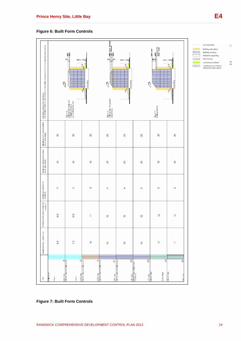
Figure 6: Built Form Controls
Figure 7: Built Form Controls
1.3:
1 m
ax
Prince Henry Site, Little Bay __________________________________________________________________________________
RANDWICK COMPREHENSIVE DEVELOPMENT CONTROL PLAN 2013 25
E4
3 Subdivision and Amalgamation Objectives
To provide a range and mix of lot sizes with areas and dimensions suitable for the permitted land uses and a variety of building types.
To enable lot sizes that facilitate housing diversity and
choice.
To promote and facilitate ecologically sustainable development and micro climate management by providing lots that are appropriately oriented.
To ensure that all lots have a primary street frontage.
To arrange lots in a manner that facilitates personal and
property safety and security.
To ensure lots have total areas and dimensions that allow dwellings, ancillary buildings, private outdoor open space, landscaped areas, and vehicle access and parking to be located and constructed appropriately, and significant built and landscape elements to be retained within an appropriate setting.
Controls
i) Lots with direct vehicle access to car parking areas from a public road are to have a minimum width of 9 metres (this control does not apply if parking access is not on the primary street frontage).
ii) All lots are to provide frontages oriented to streets and
public open spaces to provide a clear address so that personal and property security, deterrence of crime and vandalism, and surveillance of footpaths and public open space is facilitated.
iii) Lots are to be oriented so that dwellings can take
advantage of micro climatic benefits and can have dimensions that allow adequate on-site solar access and access to breezes.
iv) Lots are to be designed to maximise efficiency in house
design and useable external areas by having a regular shape.

Prince Henry Site, Little Bay __________________________________________________________________________________
RANDWICK COMPREHENSIVE DEVELOPMENT CONTROL PLAN 2013 26
E4
4 Building and Site Design This subsection contains objectives and controls for building and site design. These apply to all development on the Prince Henry site. Building height, density (FSR) and landscaped open space requirements are contained in the Built Form Control Table (Figures 6 and 7). These requirements are explained in more detail in the following sections, as well as other general requirements. Subsection 6 contains detailed objectives and controls that apply to specific precincts within the site, in addition to these general controls. 4.1 Building Envelope Explanation The proportion of a building envelope that a building can occupy is detailed in the building density controls in Subsection 4.4. The building envelopes shown in this section illustrate the absolute maximum envelope allowed on a site, within which all other criteria in this DCP must also be satisfied. Maximum building envelopes may not always be able to be achieved as requirements such as minimum landscaped open space, solar access, overshadowing, and other individual site constraints may reduce the building envelope. Where there is inconsistency between building envelope and minimum landscaped open space requirements, minimum landscaped open space requirements prevail. The building envelopes vary across the Prince Henry site. These envelopes have been designed in response to topography, heritage items, landscape elements, street pattern and width, all of which vary across the site. Objectives
To provide a built form that respects the site’s characteristics and its neighbours including existing significant heritage items and the natural environment.
To ensure that the distribution of built form responds to the
site topography, attributes, and heritage significance.
To define building bulk, height and scale of development across the site.
To ensure building scale is suited to the scale of the street.
Controls
i) New buildings must comply with the requirements in the Built Form Control Table (Figures 6-7) and the building envelopes indicated in the Precinct Controls in Subsection 6.
Refer to Subsection 6 for the specific building envelopes for each precinct within the site. Refer to Subsection 4.7 Landscaped Open Space and Private Open Space for landscaping requirements.
Prince Henry Site, Little Bay __________________________________________________________________________________
RANDWICK COMPREHENSIVE DEVELOPMENT CONTROL PLAN 2013 27
E4
4.2 Height Explanation Building heights on the Prince Henry site generally decrease in scale towards the coast, in response to site topography, and to encourage views from both public and private viewpoints. Heights also vary across the site to respect the scale of existing heritage items. The maximum building heights (in both metres and number of storeys) are shown on Figures 6 and 7. More detailed height requirements for each precinct are contained in Subsection 6. In some cases where there are potential view loss or overshadowing impacts, the maximum building heights may not be able to be achieved. It is important that each site analysis correctly identifies these issues, and demonstrates how they are addressed by the proposed building design. Objectives
To ensure building height relates to the context of the building, including street type, surrounding buildings, heritage items, landscape, and views.
To minimise the impact of development on heritage items
and remnant bushland by providing for appropriate building heights in adjacent areas.
To ensure reasonable daylight and solar access to all
development and the public domain. Controls
i) The external wall height of a building must not exceed the maximum wall height for that lot indicated in the Built Form Control Table (Figures 6-7).
ii) The number of storeys in any building must not exceed the
number of storeys indicated in the relevant Precinct Control diagram in Subsection 6. The controls provide for a loft in certain situations. This provision is not to be construed as a means to gaining additional storeys in the building.
iii) A minimum floor to ceiling height of 2.7 metres is required
for all habitable rooms in new buildings and the extension to the Delaney Building (existing heritage buildings are excluded). Minimum floor to ceiling height of 3 metres is to be provided for the ground and first floor levels of buildings on Lots 18 and 19 (neighbourhood centre, mixed use development).
iv) Where fill is required, it must not be introduced to
artificially elevate (or excavate) the site for other than essential recontouring to establish suitable grades for access, landscape, infrastructure/services and drainage.
Prince Henry Site, Little Bay __________________________________________________________________________________
RANDWICK COMPREHENSIVE DEVELOPMENT CONTROL PLAN 2013 28
E4
4.3 Building Depth Explanation Building depth is the horizontal cross section dimension of a building. It generally refers to the dimension measured from front to back (from the street side to the inside of the block). The depth of a building will have a significant impact on the amenity of the building for its occupants. Buildings with slim floor plans and dual aspect apartments provide better sunlight and daylight access and natural ventilation than deep floor plans or single aspect apartments. Subsection 6 contains building depths on a precinct by precinct basis, designed in response to site conditions. Objectives
To ensure that the bulk of the development is in scale with its surrounds.
To encourage dual aspect apartments with good amenity in terms of sun access and natural ventilation.
Controls
i) Building depth is to be consistent with the requirements specified in Subsection 6 – Precinct Controls of this section.
ii) Building depths must provide for dual aspect apartments, allowing optimal natural ventilation of apartments.
4.4 Density Explanation Building density is defined by maximum floor space ratio (FSR). The maximum allowable FSR varies across the site, in response to site topography, potential views, preferred building types, and relationship to heritage buildings and open space. In some instances it may not be possible to achieve the maximum allowable FSR for a particular site, due to potential impacts on views, overshadowing, minimum landscaped open space requirements, and other design considerations. Objectives
To ensure development scale is compatible with the surrounding built form and minimise the impact of building bulk on existing buildings in the locality, open spaces and streetscape.
To encourage a mix of dwelling sizes and types. Controls
i) The maximum floor space ratio for a building must not exceed the floor space ratio indicated for that Lot in the Built Form Control Table (Figures 6-7).
Note: Where there is any inconsistency between maximum allowable FSR and minimum landscaped open space requirements, the minimum landscaped open space requirements prevail
Prince Henry Site, Little Bay __________________________________________________________________________________
RANDWICK COMPREHENSIVE DEVELOPMENT CONTROL PLAN 2013 29
E4
4.5 Setbacks Objectives
To minimise the impact of development on adjoining land and to ensure adequate separation between buildings.
To provide strong street edges in the activity strips.
To provide adequate space for landscaping, visual and acoustic privacy, and solar access.
To encourage the retention of significant views. Controls
i) Building setbacks must comply with the setbacks contained in the precinct controls in Subsection 6.
ii) New buildings are to be sited so that they maintain significant views as identified in Subsection 2 and to maintain an open landscape setting.
iii) New buildings are to be sited and designed to form a strong, predominantly continuous built edge to the primary street frontage and public parks and pathways. Where an allotment has frontage to two or more streets (or vehicular thoroughfares), the primary street frontage is the widest, public street adjoining that allotment. Where an allotment has frontage to a street and public park or pathway, a strong, built edge is to be provided to both/all.
4.6 Building Articulation Explanation Buildings can be articulated through the use of architectural elements such as balconies, entries, bay windows, sun shading devices, privacy screens and similar architectural elements. Objectives
To promote building facades that make a positive contribution to the design character of the street.
To promote high quality architectural design.
To promote integration of buildings and private open space.
Controls
i) Building articulation is to be consistent with the articulation areas identified in the precinct specific controls in Subsection 6.
ii) Building articulation must not extend forward of the identified building articulation area.
iii) Building articulation should respond to the environmental conditions of the site including orientation, breezes and privacy.

Prince Henry Site, Little Bay __________________________________________________________________________________
RANDWICK COMPREHENSIVE DEVELOPMENT CONTROL PLAN 2013 30
E4
iv) The maximum unarticulated building length is 9 metres along the primary street frontage and 10 metres along the secondary street frontages.
v) Buildings are to be aligned predominantly parallel to the street and provide a clear street address.
vi) Building entries are to address the primary street frontage and should form an integral part of the façade.
vii) All facades, including rear facades, must include windows.
viii) Residential flat developments must provide street entrances to at least 50% of the units that face the street or public open space.
ix) A minimum of 30% and a maximum of 60% of the building articulation area for the building may be used.
x) Up to 30% of the building articulation of any floor on any façade may comprise lifts, stairwells and associated lobby space.
xi) Up to 20% of the articulation of any floor on any façade may comprise glazed stairwells and lobby space in order to allow such vertical elements to establish the major rhythm of façade compositions and to function as lanterns along the streets at night.
xii) Large areas of glazing should be modulated by louvres, fins or the like.
xiii) Windows and other glazing must be set back from the structure by a minimum of 80mm.
xiv) Predominantly clear glazed shopfronts are to be provided to ground floor local shops.
xv) Grilles and transparent security shutters are to have a minimum of 70% transparency. Solid roller shutters, screens or grills on shopfronts and dwellings are not appropriate.
4.7 Landscaped and Private Open Space Explanation This subsection contains the landscaped open space requirements, minimum private open space dimensions (including balconies), and the location of private spaces. The RLEP contains a definition for “landscaped area”, which means a part of the site used for growing plants, grasses and trees, but does not include any building, structure or hard paved area. The previous definition for “landscaped area” contained in the superseded Randwick LEP 1998 (Consolidation) carried a different but broader meaning encompassing open space areas that are capable of supporting recreation activities and landscape planting. This definition was adopted in the former Prince Henry Site DCP and was the basis of a key control for regulating the amount of built up areas within a development site.

Prince Henry Site, Little Bay __________________________________________________________________________________
RANDWICK COMPREHENSIVE DEVELOPMENT CONTROL PLAN 2013 31
E4
The concept of this former “landscaped area” control has been carried forward and translated in the Comprehensive DCP. However, in order to avoid confusion with the current terms used in the RLEP, the control is now entitled “landscaped open space”. Under this subsection of the DCP, landscaped open space includes communal (in the case of residential flat and multi-dwelling housing development), and private open space. Landscaped open space requirements ensure adequate spaces between buildings. Generous landscaped open space should be provided between buildings to retain the Prince Henry site’s original character of buildings in a strong, open landscaped setting. The landscaped open space requirements ensure that this character is carried through to new development on the site, as well as ensuring private open spaces are adequate in size and provide amenity for residents. Landscaped open space incorporates landscaped areas (as defined in the RLEP), as well as other paved open spaces within the development. Refer to the definition below: It is also important to ensure that private and communal open spaces are sustainable in design. Subsection 4.8 contains requirements to ensure development incorporates sustainable landscape design and irrigation practices. Objectives
To locate buildings so that the provision and use of outdoor areas is maximised;
To provide adequate space for landscaping, visual and acoustic privacy, sunlight penetration and private open space;
To ensure that all residents have access to useable and well designed private open space;
To ensure that new landscaping does not visually dominate significant built and landscape heritage items, or obscure key views.
Controls a) General Requirements
i) A Landscape Plan, prepared by a suitably qualified professional, must be submitted as part of any development application.
Definition: “Landscaped Opens Space” means the part of a site area which is used, or capable of being used, for outdoor recreation or garden uses (such as lawns, gardens, unroofed swimming pools, clothes drying areas, barbeque areas, footpaths and the like) and includes landscaped podium areas and water tanks located at the ground level. It does not include areas used for parking, driveways, balconies, rooftop gardens or areas used for garbage or recycling material storage or sorting.
Note: Where there is any inconsistency between minimum landscaped open space and the maximum FSR requirements, the minimum landscaped open space requirements prevail
Prince Henry Site, Little Bay __________________________________________________________________________________
RANDWICK COMPREHENSIVE DEVELOPMENT CONTROL PLAN 2013 32
E4
ii) Landscaped open space on each site must not be less than the minimum percentage indicated in the Built Form Control table (Figures 6-7).
iii) Permeable surfaces on each site must not be less than the minimum percentage indicated in the Built Form Control table (Figures 6-7).
b) Detached Dwellings; Terrace and Courtyard Housing (i.e. attached dwellings or multi-dwelling housing)
iv) Detached dwellings are to have a minimum contiguous private open space area of 60m2; and terrace and courtyard houses (i.e. attached dwellings or multi-dwelling housing) are to have a minimum contiguous private open space area of 45m2.
v) The minimum dimension of private open space for detached dwellings, and terrace and courtyard houses (i.e. attached dwellings or multi-dwelling housing) is 4m and the maximum gradient permitted is 1 in 10.
vi) The private open space areas should be directly accessible from a living area and preferably be north facing.
c) Apartments (i.e. residential flats)
vii) Each apartment (i.e. residential flat) should have at least one balcony or courtyard area directly accessible from the living area of the dwelling.
viii) The minimum balcony depth for new buildings must be 2.4m.
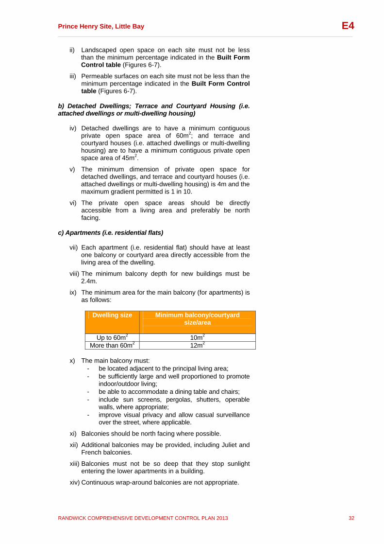
ix) The minimum area for the main balcony (for apartments) is as follows:
Dwelling size Minimum balcony/courtyard
size/area
Up to 60m2 10m2 More than 60m2 12m2
x) The main balcony must:
- be located adjacent to the principal living area; - be sufficiently large and well proportioned to promote
indoor/outdoor living; - be able to accommodate a dining table and chairs; - include sun screens, pergolas, shutters, operable
walls, where appropriate; - improve visual privacy and allow casual surveillance
over the street, where applicable.
xi) Balconies should be north facing where possible.
xii) Additional balconies may be provided, including Juliet and French balconies.
xiii) Balconies must not be so deep that they stop sunlight entering the lower apartments in a building.
xiv) Continuous wrap-around balconies are not appropriate.
Prince Henry Site, Little Bay __________________________________________________________________________________
RANDWICK COMPREHENSIVE DEVELOPMENT CONTROL PLAN 2013 33
E4
xv) For the adaptive re-use of heritage buildings for residential development, applicants should refer to the Conservation Management Plan (CMP) and the relevant Specific Elements Conservation Policy (SECP) for guidance on the provision of private open space for these dwellings.
4.8 Landscape Design and Biodiversity Explanation Landscape design and practices play an important role in designing for microclimate, the efficiency of water consumption and infiltration, protecting and conserving plant species, and providing habitat. Landscaping should be designed to serve multiple functions and should be an integral part of site design. The use of local native plant species is encouraged as they require less water and are suited to the coastal microclimate of the Prince Henry site. Irrigation practices can also be made more water efficient, for example, by using a drip irrigation system rather than sprinklers. Permeable surfaces are an important way of reducing the impact that development has on natural water flows and processes. These surfaces include garden areas, lawn, gravel and semi porous paving. Biodiversity refers to protecting and conserving the biological diversity of species, as well as the diversity of species within ecological communities. There are a number of landscape elements (refer to Subsection 2) in certain areas of the Prince Henry site. It is important that new landscaping design does not detract from the heritage significance of these landscape elements. Objectives
To promote sustainable landscape design and irrigation practices.
To ensure landscape design takes into account the site’s microclimate.
To protect, improve and enhance the natural environment of the site, including remnant native vegetation, biological links between remnants and buffer areas.
To regenerate and conserve the local threatened ecological communities.
To provide landscape design consistent with any relevant Specific Elements Conservation Policy (SECP).
Controls
i) Landscaping must include a predominance of: - native plant species (refer to Appendix A for guidance); - species that are drought resistant, and require minimal
watering once established, or species with water needs that match rainfall and drainage conditions;

Prince Henry Site, Little Bay __________________________________________________________________________________
RANDWICK COMPREHENSIVE DEVELOPMENT CONTROL PLAN 2013 34
E4
- water conserving landscape practices/designs, including plant selection, mulching, hydro zoning and multi storey planting;
- native ground covers and grasses in garden beds and path surrounds (turf is to be confined to useable outdoor areas);
- where applicable, landscaping must be consistent with any relevant Specific Elements Conservation Policy (SECP) or Plan of Management (POM).
Landscape plans are to demonstrate how and where these species/features have been incorporated in to the landscape design.
ii) Landscape plans are to demonstrate how the proposed design responds to the site’s microclimate to ensure that species survive and provide protection from wind and sun.
iii) A minimum of one large tree of sufficient height and canopy spread at maturity to effectively screen or soften buildings or other structures must be provided on each dwelling house site, and clearly marked on the Landscape Plan submitted with the DA. Additional large trees are to be provided where multi unit development is proposed.
iv) Trees and shrubs are to be selected and positioned to maximise solar penetration in winter and minimise it in summer (e.g. deciduous plants on the north side of private open space).
v) Pergolas and awnings should be located to shade external areas and control sunlight into buildings.
vi) Landscape areas are to be contoured to encourage stormwater runoff to infiltrate to ground.
vii) Garden irrigation and watering systems are to be connected to rainwater storage facilities, where applicable.
viii) Avoid planting that may obscure building entries or the surveillance of the street and pedestrian paths.
ix) Minimise the impact of driveways through materials selection and appropriate screen planting.
x) Garden structures such as gazebos, clothes lines, play equipment, swimming pools, and spa baths, are not permitted in front gardens. These structures and paved areas must be sited to avoid damage to existing trees and their root systems.
xi) Landscaped open space must include a space dedicated to on-site composting of a size relevant to the number of dwellings and the landscaped area it contains.
4.9 Development Adjacent to Watercourses Explanation Four watercourses have been mapped on the Prince Henry site, see figure AA. Inappropriate development in, on, or adjacent to these watercourses will be detrimental to its ecological function.
Prince Henry Site, Little Bay __________________________________________________________________________________
RANDWICK COMPREHENSIVE DEVELOPMENT CONTROL PLAN 2013 35
E4
Objectives
To ensure appropriate measures have been identified for ongoing protection, conservation and management to enhance the watercourse or wetland and its riparian land over time;
To ensure riparian land width maximises and enhances its potential as a habitat corridor;
To ensure riparian land width retains and incorporates within it, wherever possible, existing areas of remnant native vegetation; and
To ensure the provision of public access is to be located and designed to minimise disturbance of the habitat corridor and existing native vegetation.
Controls
i) Landscape plans are to demonstrate how the above objectives have been incorporated into the landscape design.
ii) Riparian land widths are to be provided in accordance with Appendix E.
4.10 Activity Strip Explanation An activity strip identifies location suitable for non-residential uses permitted by the RLEP, such as shops, a medical centre or restaurants. Activity strips within the Prince Henry site are marked on Figure 6 in this section, and permits these non-residential uses on ground and first floor in identified locations. Objectives
To enable certain non-residential uses permitted by RLEP, such as shops, medical centre or restaurants, on land marked as an activity strip within Figure 6
To encourage neighbourhood convenience type retail use with active frontages
To ensure non residential use of land does not have an adverse effect on residential amenity
To provide for local scale businesses and services only, which primarily serve the local community
Controls
i) The non-residential use of a building is limited to the ground and first floor areas of a building on a site marked with an activity strip on Figure 6.
ii) The first and ground floors in the Precinct P2 activity strip are to have minimum floor to ceiling heights of 3 metres.

Prince Henry Site, Little Bay __________________________________________________________________________________
RANDWICK COMPREHENSIVE DEVELOPMENT CONTROL PLAN 2013 36
E4
iii) In the Precinct P2 activity strip, buildings are to present active frontages to the street or pedestrian path at ground floor level. Blank and unarticulated facades are not to be provided to street and pedestrian frontages.
iv) A small to medium size supermarket (between 1,500m² - 2,500m²) may be permitted within Precinct P2 subject to: - supporting economic analysis which, at minimum,
addresses the sustainability of the proposed supermarket size in relation to economic feasibility and impact on other nearby centres, and measures to integrate this proposed development with the B1 Neighbourhood Centre land opposite the Prince Henry site on the western side of Anzac Parade;
- the provision of active facades to all street and pedestrian path frontages (i.e. where an activity strip is identified in Figure 6) within Precinct P2;
- the design consistent with all heritage and other objectives and design principles set out in Subsection 2.
v) Awnings over a public footway are to be: - a minimum clear height of 3 metres above the
footpath - a depth of 2 metres where non-residential uses adjoin - not less than 600mm from the edge of the road/kerb.
4.11 Solar Access Explanation Solar access forms an integral part of the design process. Buildings should be sited and designed to provide adequate daylight and sunlight access to habitable rooms and private and communal open space areas. Good solar design improves amenity and energy efficiency. Objectives
To ensure adequate access to sunlight is provided to adjoining properties and the public domain.
To ensure reasonable solar access is provided to solar energy collectors.
To encourage passive solar design that minimises energy consumption.
To reduce the need for mechanical heating and cooling, and artificial lighting.
Controls
i) Shadow diagrams, including elevations showing shadow impacts on any walls (and windows) of adjoining development and any remnant bushland, must be submitted with the development application for all new buildings of two or more storeys. Any adverse overshadowing impact may require a reduction in the height of the proposed development.
Prince Henry Site, Little Bay __________________________________________________________________________________
RANDWICK COMPREHENSIVE DEVELOPMENT CONTROL PLAN 2013 37
E4
ii) Dwelling orientation, siting, layout and landscaping are to ensure solar access to living areas and private open space, and maximise use of cooling breezes.
iii) The principal living room/s of a new dwelling must be designed to achieve not less than three (3) hours of sunlight between 9am and 3pm on 21 June.
iv) Residential re-use of existing heritage buildings should demonstrate that a reasonable level of solar access is provided, where it cannot meet the minimum requirements specified above.
v) Sunlight access to at least 50% of the primary private and communal open space area of adjoining properties must be achieved for at least three (3) hours between 9am and 3pm on 21 June.
vi) The development is to maximise north facing roofs on new buildings. The roof areas shall be of an appropriate size, orientation and pitch, suitable for the installation of solar collectors.
4.12 Acoustic Privacy Explanation Acoustic privacy is a measure of sound insulation between dwellings and between external and internal spaces. Acoustic privacy is particularly important for the amenity of apartments in residential flat buildings and mixed use developments. Designing for acoustic privacy relates to the location and separation of buildings and the arrangement of apartments and internal spaces within apartments. Objectives
To ensure a high level of amenity by protecting the privacy of residential dwellings within residential flat buildings, attached dwellings and multi-dwelling housing, both within the dwellings and in private open spaces.
To ensure that dwellings close to noise sources such as roads are sited and designed to provide a comfortable living and sleeping environment.
Controls
i) A noise and vibration assessment report is to be submitted with development applications involving residential flat buildings, attached dwellings and multi-dwelling housing, addressing appropriate measures to minimise potential noise and vibration impacts for any proposed development. This assessment is to:
- be prepared having regard to the NSW Environmental Protection Authority’s Industrial Noise Policy, the NSW Environmental Protection Authority’s Noise Control Manual (or relevant update) and relevant Australian Standards;
- incorporate external noise sources (such as traffic, plant & equipment) and internal noise sources (such

Prince Henry Site, Little Bay __________________________________________________________________________________
RANDWICK COMPREHENSIVE DEVELOPMENT CONTROL PLAN 2013 38
E4
as mechanical ventilation); - specify if the findings and recommendations can be
achieved and demonstrate how such can be achieved.
ii) All residential flat buildings, attached dwellings and multi-dwelling housing are to be constructed so as to achieve the following internal acoustic amenity criteria, when tested in accordance with Australian Standard AS2107: 2000 (or updated version);
- In naturally ventilated residential units; the repeatable maximum LAeq (1hour) should not exceed: 35 dB(A) between 10.00 pm and 7.00 am in
sleeping areas when the windows are closed; 45 dB(A) in sleeping areas when windows are
open (24 hours); 45 dB(A) in living areas (24 hours) when the
windows are closed, and 55 dB(A) in living areas (24 hours) when the
windows are open
- Where natural ventilation cannot be achieved, in residential units provided with mechanical ventilation, air conditioning or other complying means of ventilation (in accordance with the ventilation requirements of the Building Code Of Australia), when doors and windows are shut, the repeatable maximum LAeq (1hour) should not exceed:
38 dB(A) between 10.00 pm and 7.00 am in sleeping areas;
46 dB(A) in living areas (24 hours); 45 dB(A) in sleeping areas between 7.00 am and
10.00 pm
iii) The site and building layout are to maximise acoustic privacy by providing adequate building separation within the development and from neighbouring buildings. All development should comply with Subsection 4.5 Setbacks.
iv) Developments are to be designed to minimise noise transition between apartments by: - locating busy, noisy areas next to each other and
quieter areas next to other quiet areas, for example, living rooms next to living rooms, bedrooms with bedrooms
- using storage or circulation zones within the apartment to buffer noise from adjacent apartments, mechanical services or corridors and lobby areas
- minimising the amount of party (shared) walls with other apartments.
v) Noise transmission is to be reduced from common corridors or outside the building by providing seals at entry doors.
vi) Any conflicts between noise, outlook and views are to be resolved using design measures such as operable screening and the like.
Prince Henry Site, Little Bay __________________________________________________________________________________
RANDWICK COMPREHENSIVE DEVELOPMENT CONTROL PLAN 2013 39
E4
4.13 Visual Privacy Explanation Visual privacy plays a significant role in the perceived level of enjoyment of living in an urban environment. It is important to ensure residents have a reasonable level of privacy without compromising views, outlook, ventilation or solar access. Visual privacy is influenced by topography, site configuration, scale of the proposed development, dwelling layout and relationship to adjoining development. Objectives
To maximise outlook and views from habitable rooms and private open spaces without compromising visual privacy.
To ensure that new development respects the existing level of privacy of adjoining and nearby properties and minimises adverse privacy impacts.
Controls
i) Direct overlooking of main internal living areas and private open spaces of other dwellings is to be minimised by building layout, location and design of windows and balconies, screening devices, landscape elements or remoteness. Effectively locating windows and balconies to avoid overlooking is preferred to screening devices, high sills or obscured glass. Where these are used, they should be integrated with the building design and have minimal impact on residents’ or neighbours’ amenity.
ii) Habitable room windows with a direct outlook to the habitable room windows of any floor above ground floor in an adjacent dwelling within 12m:
- are to be offset from the edge of one window to the edge of the other by a distance sufficient to limit views into the adjacent windows;
- have an appropriate permanent privacy screening; - have sill heights of 1.6m above floor level; or - have fixed obscure glazing in any part of the
window below 1.6m above floor level.
iii) The outlook from windows, balconies, stairs, landings, terraces and decks or other private or communal areas within a development is to be screened where a direct view is available into the private open space of an existing or other proposed dwelling. If screening is used, site lines are to be provided in development application plans and sections to demonstrate its effectiveness. No screening is required where:
- windows are in bathrooms, toilets, laundries, storage rooms or other non-habitable rooms and they have translucent glazing or sill heights of at least 1.6m
- windows are in habitable rooms and they have sill heights of 1.6m or more above floor level or translucent glazing to any part of a window less that 1.6m above floor level
Prince Henry Site, Little Bay __________________________________________________________________________________
RANDWICK COMPREHENSIVE DEVELOPMENT CONTROL PLAN 2013 40
E4
iv) Windows and balconies of an upper-level dwelling are to be designed to prevent overlooking of more than 50% of the private open space of a lower-level dwelling directly below and within the same development.
v) Direct views may be obscured by solid translucent screens, perforated panels, trellises or the like which have a maximum of 25% openings, and which are:
- permanent and fixed; - of durable materials; - designed and painted or coloured to blend in with
the development. 4.14 Dwelling Layout and Mix Explanation Dwelling layout has a significant influence on environmental sustainability and residential amenity. This is particularly important for apartments, and dwellings on small lots. An efficient layout should minimise circulation space and should allow flexible furniture arrangements. A mix of housing and apartment types provides housing choice and accommodates a range of household types. This assists in integrating new development with the existing community. Maximising opportunity for natural ventilation is an important part of building design. Building orientation, dwelling layout and external building facades are key elements in achieving optimal natural ventilation. Designing for natural ventilation enhances building sustainability by responding to the local climate and reducing the need for mechanical ventilation. The building envelopes in Subsection 6 have been designed to encourage dual aspect apartments (including cross-through and cross over apartments) through slim building depths. Objectives
To ensure dwelling layouts are efficient and provide high standards of residential amenity.
To maximise the environmental performance of apartments and dwellings.
To provide a diversity of housing types which cater for different household requirements now and in the future.
To encourage optimal natural ventilation through dual aspect apartments.
To reduce energy consumption by minimising the need for mechanical ventilation, particularly air conditioning.
Controls
i) Dwelling layouts are to respond to the natural environment and optimise site opportunities by:
- locating primary open space adjacent to the main living area
- orienting main living spaces towards the primary outlook and aspect
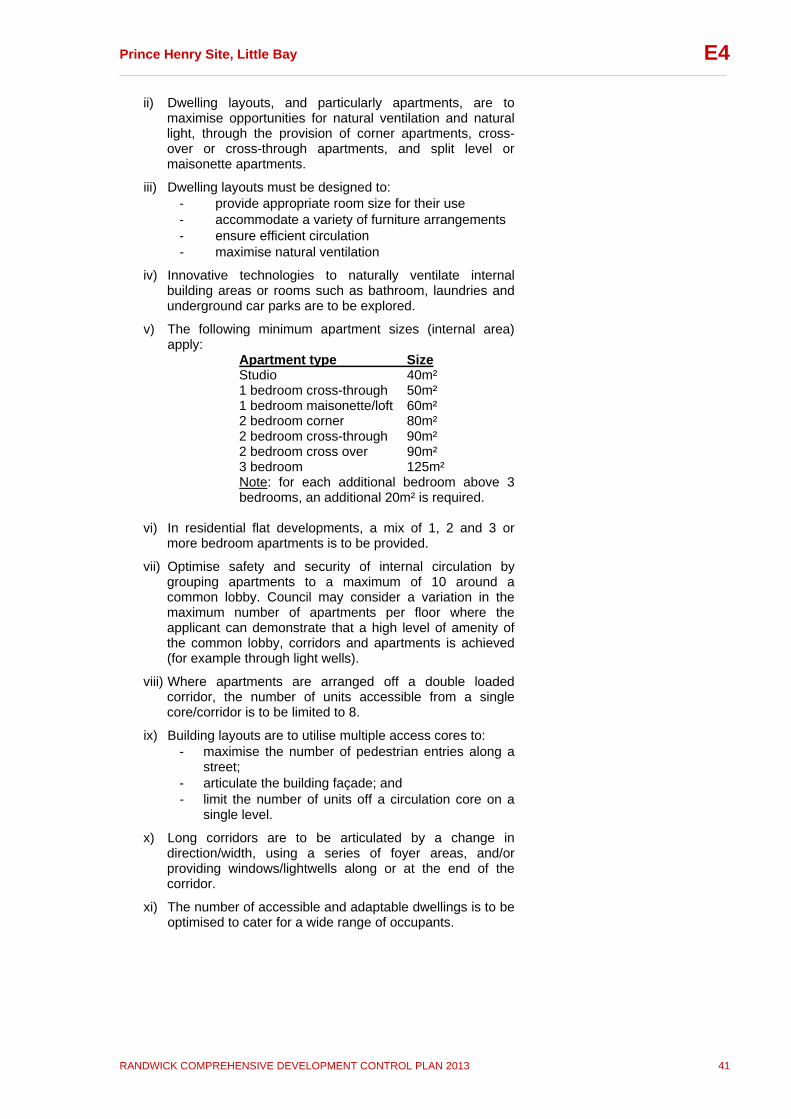
Prince Henry Site, Little Bay __________________________________________________________________________________
RANDWICK COMPREHENSIVE DEVELOPMENT CONTROL PLAN 2013 41
E4
ii) Dwelling layouts, and particularly apartments, are to maximise opportunities for natural ventilation and natural light, through the provision of corner apartments, cross-over or cross-through apartments, and split level or maisonette apartments.
iii) Dwelling layouts must be designed to: - provide appropriate room size for their use - accommodate a variety of furniture arrangements - ensure efficient circulation - maximise natural ventilation
iv) Innovative technologies to naturally ventilate internal building areas or rooms such as bathroom, laundries and underground car parks are to be explored.
v) The following minimum apartment sizes (internal area) apply:
Apartment type Size Studio 40m² 1 bedroom cross-through 50m² 1 bedroom maisonette/loft 60m² 2 bedroom corner 80m² 2 bedroom cross-through 90m² 2 bedroom cross over 90m² 3 bedroom 125m² Note: for each additional bedroom above 3 bedrooms, an additional 20m² is required.
vi) In residential flat developments, a mix of 1, 2 and 3 or
more bedroom apartments is to be provided.
vii) Optimise safety and security of internal circulation by grouping apartments to a maximum of 10 around a common lobby. Council may consider a variation in the maximum number of apartments per floor where the applicant can demonstrate that a high level of amenity of the common lobby, corridors and apartments is achieved (for example through light wells).
viii) Where apartments are arranged off a double loaded corridor, the number of units accessible from a single core/corridor is to be limited to 8.
ix) Building layouts are to utilise multiple access cores to: - maximise the number of pedestrian entries along a
street; - articulate the building façade; and - limit the number of units off a circulation core on a
single level.
x) Long corridors are to be articulated by a change in direction/width, using a series of foyer areas, and/or providing windows/lightwells along or at the end of the corridor.
xi) The number of accessible and adaptable dwellings is to be optimised to cater for a wide range of occupants.

Prince Henry Site, Little Bay __________________________________________________________________________________
RANDWICK COMPREHENSIVE DEVELOPMENT CONTROL PLAN 2013 42
E4
4.15 Roof Design Explanation Roof forms vary with building type and architectural style and can include hip, gable, flat and profiled roofs and articulated parapets. Roof design should consider the context of surrounding development and should add interest to the building. Objectives
To encourage roof design which creates a distinctive silhouette to buildings, while minimising building height and bulk.
To encourage roof design which can accommodate open space and photovoltaic cells.
To encourage roof forms with low pitches and skillions to create a contemporary coastal character.
Controls
i) Roof design should minimise bulk and overshadowing.
ii) Roof design must relate to the size and scale of proposed development. Domestic roof forms may not be appropriate on larger buildings.
iii) The profile and silhouette of parapets, eaves and roof top elements must be considered in the roof design.
iv) Roof materials should respond to those of surrounding buildings and the identified precinct character.
v) Roof terraces and roof gardens are encouraged where the privacy of adjoining properties can be maintained.
vi) Trafficable flat roofs must be paved or finished with gravel ballasts. Large flat roof areas should not be covered with metal decking or exposed membrane roof systems.
vii) Lightweight pergolas, sun screens, privacy screens and planters are permitted on the roof, provided they do not increase the bulk of the building and do not significantly affect the views enjoyed by neighbouring properties.
viii) Roof top solar heating panels should be installed so as not to be visible from the street.
ix) All new service elements such as aerials, vent pipes, hot water services, solar collectors, plant equipment, air-conditioning units, telecommunications and satellite equipment and the like are to be integrated into the design of the building and concealed from public view.
x) Lift over-runs and service plant equipment must be contained within roof structures and within the maximum building height stipulated by the precinct controls.
xi) Where gable or hipped roofs are proposed, the angle of the pitch should be compatible with adjacent/nearby heritage buildings, and shall have a minimum pitch of 30º and a maximum pitch of 36 o.
Prince Henry Site, Little Bay __________________________________________________________________________________
RANDWICK COMPREHENSIVE DEVELOPMENT CONTROL PLAN 2013 43
E4
xii) Eaves and overhangs must be provided to pitched roofs to maximise building performance and response to climatic conditions.
xiii) Rooftop signs are not permitted. 4.16 Fences Explanation The design of fences has an impact on the amenity of the public domain and the real and perceived security of residents. It is important that the type and style of fencing on the Prince Henry site is consistent with the principle of buildings in a landscape setting, and continuing the character of the existing heritage buildings on site. Large, blank spaces are to be avoided as they detract from the streetscape and reduce safety through decreased passive surveillance of the street. For development within or adjacent to the Historic Precinct, Applicants should refer to the Conservation Management Plan (CMP) and any relevant Specific Elements Conservation Policy (SECP) for any special fencing style or material requirements. Objectives
To define the edges between public and private land.
To provide privacy and security.
To contribute positively to the public domain. Controls
i) Solid front fences facing the street are to be no higher than 1.2 metres. For residential flat buildings, multi-dwelling housing and attached dwellings, this may be increased to 1.8m where the fence has openings that make it at least 50% transparent, provided that this does not adversely affect the setting of the heritage buildings and the open character of the site.
ii) Side boundary fences are to have a maximum height of 1.8 metres
iii) Fencing should be integrated with the building and landscape design through the use of compatible materials and detailing.
iv) Fencing should return to the building line on side boundaries.
v) Sheet metal and wire fences are not appropriate.
vi) Preferred materials include masonry, and steel palisade fencing (paint finish).
vii) The use of landscaping to soften the appearance and articulate fences is encouraged.
viii) Consistent low fencing, 700mm high, is to be provided along the Anzac Parade frontage of the site.
Prince Henry Site, Little Bay __________________________________________________________________________________
RANDWICK COMPREHENSIVE DEVELOPMENT CONTROL PLAN 2013 44
E4
ix) For residential flat buildings and multi-dwelling housing, fencing with a maximum height of 1.5 metres may be used to separate communal open space from private open space (at ground level). Fencing is to be articulated, and is to incorporate landscaping where appropriate.
4.17 Safety and Security Explanation Safety and security refers to formal and informal measures that protect properties, residents and visitors. Developments should provide safe ground level entry and exit and enable casual surveillance. Objectives
To encourage building design that provides casual surveillance of streets and open space areas.
To provide a safe and secure living environment for residents and visitors.
To promote the design of buildings and open space areas which encourage community safety and reduce the opportunity for crime.
Controls
i) A formal crime risk assessment, consistent with the Department of Planning and Infrastructure Crime Prevention and the Assessment of Development Applications guidelines (or any update), is to be carried out for all residential developments of 20 or more new dwellings.
ii) Buildings must be designed to enable occupants to overlook streets and public open spaces to provide casual surveillance. Opportunities for casual surveillance should be provided by:
- orienting living areas so they have views over public or communal open spaces
- providing clear lines of sight between building entrances and the street
- footpaths, landscaped areas, and driveways must provide opportunities for surveillance and allow safe movement of residents around the site.
iii) Opportunities for concealment are to be minimised by: - avoiding blind or dark alcoves near lifts and
stairwells - providing well lit routes throughout the development - ensuring car parking areas, pathways, and common
areas of residential flat and multi-dwelling housing developments are adequately lit at all times.
iv) High walls and planting around residential buildings and parking areas, which could obstruct views into developments, are to be avoided.
v) Entrances to dwellings and buildings must be clearly visible from the street.

Prince Henry Site, Little Bay __________________________________________________________________________________
RANDWICK COMPREHENSIVE DEVELOPMENT CONTROL PLAN 2013 45
E4
vi) Community buildings and public open space areas are to be provided with sufficient lighting and security.
vii) Dwellings that face the street must allow for casual surveillance of footpaths and driveways.
viii) The demarcation between public, communal and private areas in a development is to be clearly recognisable.
ix) Shared entries should serve a limited number of dwellings and be able to be locked.
x) Large expanses of wall and fences which may attract graffiti are to be avoided.
4.18 Materials and Finishes Explanation The selection of materials and finishes for development on the Prince Henry site is important for a number of reasons. As the site occupies a prominent position on the coast and is exposed to extreme weather conditions, the selection of building materials and finishes will play an important part in the appearance and longevity of the development. The selection of materials and colours used on site is also important because of the site’s heritage significance. For development within and adjacent to the Historic Precinct, Applicants should refer to the Conservation Management Plan (CMP) and any relevant Specific Elements Conservation Policy (SECP) for any specific requirements for materials and finishes. Materials and finishes selected should be consistent with the site’s coast location, and should contribute to the coastal character of the site. It is also important to consider environmental impacts of materials in terms of their whole life cycle (including their manufacture and disposal) when selecting construction and building materials, fittings, fixtures and appliances. Objectives
To select colours and materials that aesthetically relate to the coastal environment and respect the heritage significance of the site.
To ensure building materials are chosen that can withstand climatic extremes.
To ensure that new buildings relate sympathetically to neighbouring significant heritage buildings.
To encourage the use of recycled and environmentally responsible materials.
Controls
i) A sample board, showing colours and finishes is to be submitted with the development application.
ii) Face brickwork must be limited to smooth face bricks, which range in colour from the cream of the sand-lime
Prince Henry Site, Little Bay __________________________________________________________________________________
RANDWICK COMPREHENSIVE DEVELOPMENT CONTROL PLAN 2013 46
E4
bricks of the Flower Wards to the red of the Heffron Building.
iii) Mottled and highly textured bricks are not appropriate.
iv) Acceptable wall materials include natural stones, integrally coloured or painted render, face brickwork, timber, painted or coated sheet metals or composite panels, and naturally finished metals such as copper and zinc.
v) Where sandstone is proposed as a wall material, a thickness of 75mm to 100mm is required. Adhesive fixing is not appropriate.
vi) Acceptable roofing materials include sheet metal (zinc, copper, aluminium, colour-coated steel), terracotta tiles and slate. Acceptable colours for tiles and colour-coated metals are greys, neutral greens, and terracotta tones.
vii) Materials that provide surface relief and articulation are encouraged.
viii) Changes of colour and texture should be used to complement façade articulation.
ix) Applicants should refer to any relevant Specific Elements Conservation Policy (SECP) for any requirements for new development within or adjacent to the historic precinct (refer to Appendix F).
x) Consider a colour palette for new buildings which includes: Walls: - Neutral colours with low chroma values (such as
colours similar to those of natural soils and stones and indigenous plant materials)
- Sandstone - Greys - Low to medium reflectance Accent colours: - Different colours may be used for trims on a limited
number of elements, such as external articulation elements.
- White, black. - Bright, primary and secondary colours.
xi) Where floodlighting is proposed, it must not have any adverse impact on neighbouring properties, and must not provide an excessive upward component of light when mounted in a horizontal position.
4.19 Signs Explanation Appropriate signage is required for all uses to ensure the heritage significance of the site is retained and the desired future character is achieved. Objectives
To ensure signage on all buildings is consistent with the desired future character of the Prince Henry Site.
To ensure signage respects the heritage significance of the Prince Henry Site.
Prince Henry Site, Little Bay __________________________________________________________________________________
RANDWICK COMPREHENSIVE DEVELOPMENT CONTROL PLAN 2013 47
E4
Controls
i) Signage is to comply with F2: Outdoor Advertising of this DCP in so far as it respects the heritage significance of the Prince Henry Site and is consistent with its desired future character.
ii) Signage for retail, commercial and community group uses must be contained within the building envelope.
iii) Roof signage is not appropriate.
iv) Commercial signage on local shops is to be limited to identification signs. These may be located on shop front windows, above entrances or suspended under colonnades or awnings.
5 Sustainable Design 5.1 Total Water Cycle Management Explanation Water is a precious resource. Total water cycle management seeks to minimise impacts on the water cycle and sustainably maximise the use and reuse potential of available water sources by maximising stormwater infiltration, reducing stormwater discharge, protecting stormwater quality and facilitating water reuse. Buildings can contribute to environmental sustainability by integrating measures for improved water efficiency. Landscaping is also a key factor as the types of surfaces and plants used in a development influence water demands, runoff and infiltration. A total water cycle strategy (Appendix D) has been prepared for the whole Prince Henry site. This subsection of the DCP deals with water cycle management at the lot, building and individual dwelling scale. Applicants need to demonstrate how the proposed development is consistent with the total water cycle strategy for the Prince Henry Site.
a) and b) of this subsection currently apply to all development within the Prince Henry site, except for BASIX affected developments.
c) – Stormwater applies to all development within the Prince Henry DCP area. Objectives
To reduce consumption of potable water and encourage water reuse on site.
To encourage the use of rainwater tanks in accordance with Section B3 of this DCP (excluding BASIX affected developments).
To improve stormwater quality and minimise impacts on aquatic receiving environments.

Prince Henry Site, Little Bay __________________________________________________________________________________
RANDWICK COMPREHENSIVE DEVELOPMENT CONTROL PLAN 2013 48
E4
To ensure stormwater does not cause flooding or damage to any properties, remnant bushland, or public open space.
To minimise the discharge of sediment and other pollutants during and post construction.
To promote and encourage the replication of the natural stormwater cycle including infiltration and water quality treatment.
Controls a) General
i) Development applications (excluding BASIX affected developments) are to include a report demonstrating how the proposed development is consistent with the Total Water Cycle Strategy (or any update) (see Appendix D) for the Prince Henry site. DA plans and Statements of Environmental Effects are to: - contain details, including but not limited to, estimated
water usage of the proposed development; and - demonstrate how the proposal addresses the
estimated water usage and the controls outlined in the following subsections.
ii) All developments (excluding BASIX affected developments) are to include a Stormwater Management Plan which demonstrates compliance with the objectives and the proposed method of stormwater management, re-use and disposal.
iii) Water efficient plumbing fixtures are to be incorporated into building design including, but not limited to, dual flush toilets and AAA rated taps and shower heads.
iv) In-sink food and waste disposal systems are not to be installed.
v) Water efficient local plant species should be used in landscaped areas.
b) Rainwater Tanks
i) Installation of rainwater tanks (excluding BASIX affected developments) is to be generally in accordance with Section B3 of this DCP and relevant Australian Standards.
c) Stormwater (applies to all development including BASIX affected developments)
i) All stormwater must be taken through a sediment / silt arrestor pit (or alternative Council-approved pollutant trap) prior to being discharged from the site. Applicants are advised to contact Council’s Drainage Engineer to obtain a copy of Council’s standard sediment / silt arrestor pit detail.
ii) Where possible, at least two thirds of the area occupied by car parks, car parking spaces, driveways, courtyards, pathways or similar must be laid with permeable paving (areas above underground car parking areas and underground car parking areas and driveway ramps steeper than 1 in 10 are excluded from the calculation for this requirement).
iii) Piped stormwater systems shall be designed for a minimum 20 year ARI storm event and provision shall be

Prince Henry Site, Little Bay __________________________________________________________________________________
RANDWICK COMPREHENSIVE DEVELOPMENT CONTROL PLAN 2013 49
E4
made for safe overland flow for stormwater runoff up to the 100 year ARI storm.
iv) All habitable and storage areas (including garages and car parking areas) shall be raised a minimum of 300mm above the 1 in 100 year flood levels/overland flow depths (or suitably waterproofed up to this same level).
v) All site stormwater (in excess of that being retained on the development site for re-use) shall be discharged by: gravity to the street drainage systems; and/or as otherwise approved by Council in accordance with
the Total Water Cycle Strategy for the site (refer to Appendix D).
5.2 Bushfire Risk Management Explanation There are two areas of remnant bushland within and surrounding the Prince Henry site, identified in Section 2.5 and Figure 3 of this Section. They are not classified as Bushfire Prone Land under the Rural Fires Act 1997. To manage bushfire risk, the then NSW Fire Brigades (currently Fire and Rescue NSW) nominated Asset Protection Zones (APZ) for development in the vicinity of these bushland areas, which are generally reflected in the site’s infrastructure design by way of buffers established by dedicated roads, paths and building setbacks. The requirements of the NSW Fire Brigades Bushfire Hazards Section are contained in Appendix B. A key requirement is the provision of an Asset Protection Zone between the bushland and any development. An Asset Protection Zone is an area of land that is not built upon, and is measured from the edge of the identified bushland to the edge of the building. It can include roads and private open space. In addition to the general provisions below, detailed requirements are included in the precinct specific controls in Subsection 6. Objectives
To minimise the risk of fire spread from the bushland areas and impacts on development within the Prince Henry site.
To ensure development is in accordance with the requirements of Fire and Rescue NSW Bushfire Hazard Section.
Controls
i) All new development is to be consistent with the requirements of Fire and Rescue NSW Bushfire Hazard Section (refer also to Precinct Controls in Subsection 6).
5.3 Contaminated Land Explanation Based on detailed investigations for the Prince Henry Site, a staged remediation program was undertaken. Individual sites within the staged remediation program must be validated by the

Prince Henry Site, Little Bay __________________________________________________________________________________
RANDWICK COMPREHENSIVE DEVELOPMENT CONTROL PLAN 2013 50
E4
Site Auditor as being fit for the purpose for which they are proposed, prior to the commencement of development works. Objectives
To ensure that any contaminated land, after remediation, is suitable for the purpose for which development is proposed to be carried out.
To ensure that contaminated land is remediated prior to use.
Controls
i) The development site must be investigated, remediated, validated and certified prior to development in accordance with: - NSW Contaminated Land Management Act 1997; - EPA’s “Guidelines for Consultants Reporting on
Contaminated Sites” 1997, and “Guidelines for the NSW Site Auditor Scheme” 1998 (or updated version);
- State Environmental Planning Policy 55 Remediation of Land; and
- Randwick City Council’s Contaminated Land Policy.
6 Precinct Specific Controls This section contains precinct specific controls. These controls apply in addition to the general controls contained in the remainder of this Section. To the extent of any inconsistencies between the general and precinct specific requirements, the precinct specific requirements prevail. Each precinct section comprises:
objectives; statement of desired character; precinct specific controls (text and Precinct Control
diagram); and indicative cross section(s).
Building height, FSR and minimum landscaped open space requirements are set out in the Built Form Control table (Figures 6 and 7). The relevant figures for the Precincts are located at the end of this section. Note that the figures show proposed lot numbering and boundaries that may be subject to change with subdivision applications. Nevertheless the specified controls will continue to apply. The figures do not show road details (including footpaths, verges, road lanes or parking) for clarity.
Note: Applicants must demonstrate that the site analysis submitted as part of any DA, addresses the key principles outlined in Subsection 2

Prince Henry Site, Little Bay __________________________________________________________________________________
RANDWICK COMPREHENSIVE DEVELOPMENT CONTROL PLAN 2013 51
E4
6.1 Precinct P1 Precinct P1 is located in the north and north-western corner of the DCP area and is directly accessible from Anzac Parade. Key features within this precinct are the Northern Bushland Park and MaCartney Oval, located in the centre of the precinct, and the part of the Little Bay Geological site and Potential Ochre site located within the DCP area, along the northern boundary of the precinct. This precinct also contains the two northern road accesses to the site (i.e. Gubbuteh Road and Jenner Street). Precinct Objectives
To achieve a distinctive built form and strong streetscape character along Anzac Parade with buildings framing the entrance road to the precinct.
To protect remnant bushland and the significant features
of the Little Bay Geological site and potential ochre site.
To reinforce the curved form of MaCartney Oval via a strong, consistent built edge.
To ensure a consistent built edge along park and street
frontages.
To encourage a mix of housing types within the precinct whilst maximising view sharing.
To provide a north-south biological link along the eastern
edge of this precinct (forming part of a larger link across the Prince Henry site).
Desired Character This precinct will contain a mix of residential buildings focused around MaCartney Oval and the Northern Bushland Park and towards the ocean views. The Northern Bushland comprises an area of Eastern Suburbs Banksia Scrub (ESBS), an endangered ecological community that occurs on the Prince Henry site in a number of locations. Building height and density will vary across the precinct, ranging from four storey envelopes suited to residential flat buildings along the western, Anzac Parade frontage, through to two storey envelopes suited to medium density attached dwellings and multi-dwelling housing (such as terrace and courtyard houses) towards the centre of the precinct. The building envelopes along the northern and eastern boundaries of the precinct suit low density detached and semi-detached housing. Development of this scale will retain a sense of openness, a significant characteristic of the site, and views and vistas to the ocean from all parts of the site. Building envelopes in the central part of the precinct will provide a transition in density and scale between the taller four storey envelopes along Anzac Parade and the two storey envelopes along the northern and eastern edges of this precinct.

Prince Henry Site, Little Bay __________________________________________________________________________________
RANDWICK COMPREHENSIVE DEVELOPMENT CONTROL PLAN 2013 52
E4
Building siting and design will maximise view-sharing opportunities. View corridors will offer visual and physical links between communal and private open space. The building envelopes have been designed so that where possible, communal open spaces are located adjacent to the remnant bushland or opposite other communal open spaces to create a feeling of a larger landscaped area and ensure that the landscape is not dominated by buildings. The detached dwelling allotments are located along the site’s northern and north-eastern boundary and adjacent to the golf course, which will create a feeling of open space that is more extensive than the private open space of each individual allotment. A former oval on site has been incorporated into a similar scale open space (MaCartney Oval), with a pedestrian connection to the local shops in Precinct P2. Pedestrian paths also run along the edges of the Northern Bushland Park, linking it to Anzac Parade. Low fencing and substantial landscaping along the Anzac Parade boundary will provide a green corridor along Anzac Parade. Little Bay Geological site and Potential Ochre site The Little Bay Geological site (which extends across the northern boundary of the Prince Henry site onto adjacent land) is a site of national significance. It provides evidence of topography, relative sea level, vertical land movements and coastal landscape prior to the formation of Sydney Harbour and other coastal valleys. The Little Bay Geological site has been divided into three management areas (the Critical Exposure Area, the Cleared Area and the Palaeovalley Area) which also extend across the northern boundary of the Prince Henry DCP site onto adjacent land. The Critical Exposure Area includes outcrops of exposed rock, clay shale and gully-fill sands. The part of the Critical Exposure Area within the Prince Henry site (and within this precinct) is to be retained (exposed) to form the ‘Geological Reserve’. The Cleared Area within the Prince Henry site (and this precinct) will be largely filled over to protect its significant surfaces. The Potential Ochre site, which has been identified as a potentially significant Aboriginal site, also extends across the northern boundary of the Prince Henry site onto adjacent land. Although largely underground within the Prince Henry site (and within this precinct), the Potential Ochre site is exposed within the Geological Reserve (Critical exposure area) which will remain exposed to allow for interpretation. Those areas of the Little Bay Geological site and the Potential Ochre site within the Prince Henry site are to be managed together with those areas on adjacent lands. Controls In addition to the general controls contained in this Section the following controls also apply to development within this precinct.

Prince Henry Site, Little Bay __________________________________________________________________________________
RANDWICK COMPREHENSIVE DEVELOPMENT CONTROL PLAN 2013 53
E4
Built Form i. Building height, FSR and landscaped open space for all lots in
Precinct P1 are to comply with the controls set out in the Built Form Control Table (Figures 6 and 7). Note: 1. Maximum height and FSR may not be able to be achieved in
all instances, however the requirements for minimum landscaped open space must be achieved in all instances.
2. Lofts are permitted in identified locations. These locations have been identified to enable a diversity of housing types whilst minimising the impact of development on the existing heritage buildings in the adjacent Historic Precinct.
ii. Maximum building envelope depth for apartment buildings (3-4
storeys) is 13 metres. Note: building envelope excludes building articulation depth.
iii. All new buildings are to have a parallel alignment to the primary street frontage.
iv. New buildings are to be sited and designed to form a strong, predominantly continuous built edge to the primary street frontage and public parks and pathways, namely Anzac Parade, Gubbuteh Road, Jenner Street, Lister Avenue and Mayo Street, and MaCartney Oval and connecting path to the corner of Anzac Parade and Pine Avenue.
v. Buildings are to be articulated along the facades identified on Figure 8 - Precinct P1-1.
- minimum articulation depth 2m Note: buildings should be appropriately articulated using a combination of measures. Refer to Subsection 4.6 Building Articulation for further details.
vi. The following minimum setbacks apply to all buildings in Precinct P1, unless otherwise specified in Figure 8:
- front setback 3m - side setback (detached dwelling houses) 1.5m - side setback (where side property boundary adjoins a road
or public pedestrian path) 3m - side setback (where side property boundary adjoins the
Little Bay Geological Site – Critical Exposure Area) 2m - rear setback (dwelling houses along northern site boundary
and adjoining golf course) 8m Note: side and rear setbacks for detached dwelling houses have been designed to maximise opportunities for view sharing.
vii. Buildings along Anzac Parade (four storey, plus loft in identified locations) are to provide a built form consistent in height and scale along Anzac Parade, and are to frame the entrance roads to the precinct. The building envelope for Lot 1-2 should provide for a landscaped area at the rear, to allow views northwards to the ocean.
viii.
All development is to maximise the opportunity for view sharing. Maximum building height and FSR for detached dwelling houses may not be achieved where views (from private and public open spaces) would be unreasonably obstructed. View analysis details are to be included as part of the site analysis submitted at DA stage.
Prince Henry Site, Little Bay __________________________________________________________________________________
RANDWICK COMPREHENSIVE DEVELOPMENT CONTROL PLAN 2013 54
E4
ix. All buildings are to be setback 7m from the Anzac Parade property boundary and should form a strong, consistent built edge along Anzac Parade.
x. Buildings adjacent to Anzac Parade are to incorporate a 3m landscaped strip (as part of the 7m setback) and low fencing (700mm high), with both fencing and landscaping contributing to privacy, a high level of amenity and a consistent streetscape.
xi. Buildings surrounding MaCartney Oval are to follow the street and park alignment and reinforce its curved form.
xii. Development in Lot E1 is to match the front building alignment of the adjacent heritage building (former Institute of Tropical Medicine).
Landscaping xiii. Landscape planting on sites adjacent to the Northern Bushland
Parkmust not impact on the environmental processes of the remnant stands of Eastern Suburbs Banksia Scrub in the Northern Bushland Park.
xiv. Buildings surrounding the Northern Bushland Park must demonstrate no adverse overshadowing impacts on this bushland.
xv. Landscaping, paths, driveways and the like, adjacent to the Northern Bushland Park, are to be designed to ensure no stormwater run off into the remnant bushland areas.
xvi. Landscaping plans must demonstrate that species planted will not result in any adverse weed invasion or overshadowing of this bushland.
xvii. An asset protection zone of 6m (minimum) should be provided between new buildings and any remnant vegetation in the Northern Bushland Park (Figure 8) consistent with the requirements of Fire and Rescue NSW, Bushfire Hazards Section (See Appendix B). As shown on Figure 8, this asset protection zone should take the form of publicly accessible paths and private driveways.
Heritage xviii. All development must be in accordance with the Conservation
Management Plan, Archaeological Management Plan and any relevant Specific Elements Conservation Policy and must demonstrate that:
new buildings maintain an appropriate setting for the former Matron Dickson Nurses Home, the Artisans Cottages, Institute of Tropical Medicine and former Motor Garage (all located in the adjacent Historic Precinct – see Figure 18);
the Critical Exposure Area of the Little Bay Geological Site (which also contains the exposed part of the Potential Ochre Site) is to be retained intact, and new development is to be designed to minimise impacts on this area;
new development on lots within the Cleared Area of the Little Bay Geological Site and within the boundaries of the Potential Ochre site is designed so that non-essential excavation or scouring of significant rock surfaces is
Prince Henry Site, Little Bay __________________________________________________________________________________
RANDWICK COMPREHENSIVE DEVELOPMENT CONTROL PLAN 2013 55
E4
avoided; the number and size of footings on the exposed rock
surfaces within the Cleared Area and Potential Ochre site are minimised;
ground level adjustments within the Cleared Area and extent of the Potential Ochre site are made by fill, not excavation; and
excavation within the possible extent of the Palaeovalley Area should not be below RL 26 unless endorsed by Randwick City Council and the NSW Office of Environment and Heritage.
xix. Car parking for development within the Cleared Area and/or
Potential Ochre site must be provided above ground to prevent any damage to their significant features.
xx. Development must demonstrate consideration of the Bushland Plan of Management (POM), and the Little Bay Geological Reserve Plan of Management (POM). In particular, development must meet the objectives of these POMs.

Prince Henry Site, Little Bay __________________________________________________________________________________
RANDWICK COMPREHENSIVE DEVELOPMENT CONTROL PLAN 2013 56
E4
Note: The lot numbers and boundaries may be superseded as subdivision continues across the site. Figure 8: Precinct P1-1
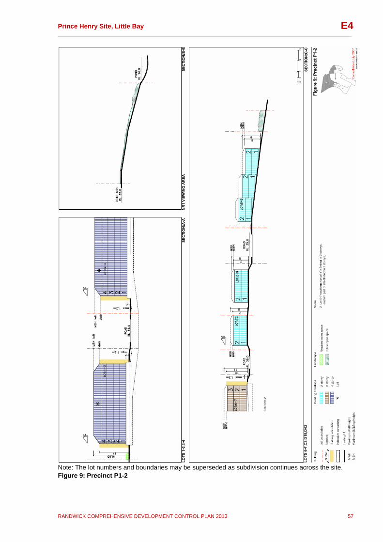
Prince Henry Site, Little Bay __________________________________________________________________________________
RANDWICK COMPREHENSIVE DEVELOPMENT CONTROL PLAN 2013 57
E4
Note: The lot numbers and boundaries may be superseded as subdivision continues across the site. Figure 9: Precinct P1-2

Prince Henry Site, Little Bay __________________________________________________________________________________
RANDWICK COMPREHENSIVE DEVELOPMENT CONTROL PLAN 2013 58
E4
Note: The lot numbers and boundaries may be superseded as subdivision continues across the site. Figure 9A: Precinct P1-3
Prince Henry Site, Little Bay __________________________________________________________________________________
RANDWICK COMPREHENSIVE DEVELOPMENT CONTROL PLAN 2013 59
E4
6.2 Precinct P2 Precinct P2 is located adjacent to Anzac Parade at the Pine Avenue entrance to the DCP area. Key features within this Precinct are Pine Avenue, which is the main entrance to the Prince Henry site. Significant historic elements including the entrance gateposts to the former hospital and the alignment of Pine Avenue form part of the adjoining historic precinct (which encompasses the majority of significant historic elements within the central part of the DCP area); however these elements have an important relationship with the development of Precinct P2. Key views include the view along Pine Avenue, and the view towards the former Pathology Department Building, the Clocktower and Flowers Wards and beyond. Precinct Objectives
To create a local neighbourhood centre that provides for the needs of new residents and the existing community in the locality.
To reinforce Pine Avenue as the gateway to the Prince
Henry site.
To create a strong, consistent built edge along Anzac Parade.
To ensure new development maintains views along Pine
Avenue to the Entrance Gates, Gateposts, Gatehouse, Flowers Wards, Clocktower and beyond.
To encourage a mix of neighbourhood scale retail,
commercial and residential uses that will create a vibrant and attractive local neighbourhood centre.
Desired Character This precinct will contain a neighbourhood centre located at the Pine Avenue entrance to the site. The centre will contain a mix of retail, commercial and community uses, including a potential medical centre and potential supermarket, with apartments above. The centre will serve the adjoining neighbourhoods. Building height within the precinct is generally four storeys, with a component in Lot 19 stepping down to three storeys opposite Flowers Ward 1 to create a transition in scale between development fronting Anzac Parade and the adjoining Historic Precinct to the east. Buildings are to provide a strong built edge to Anzac Parade, and active frontages are encouraged along all streets and public paths where activity strips are identified within this precinct (refer to Figure 6). Buildings along Pine Avenue will provide a strong, consistent alignment to reinforce the historic alignment and significance of Pine Avenue. Colonnades and broad pavements will extend along Pine Avenue at ground level, providing sheltered outdoor areas for social interaction.

Prince Henry Site, Little Bay __________________________________________________________________________________
RANDWICK COMPREHENSIVE DEVELOPMENT CONTROL PLAN 2013 60
E4
A public path provides a direct pedestrian and visual link between the neighbourhood centre/Anzac Parade and MaCartney Oval and the northern part of the site. A small parking area for the neighbourhood centre will be clearly separated from resident parking (to be located underground). The neighbourhood centre parking is provided at-grade (to maximise accessibility for less mobile people) in well landscaped car park(s), which will be screened from surrounding buildings and roads by the neighbourhood centre buildings. At grade car park(s) will be designed to maximise opportunities for water sensitive urban design (e.g. stormwater collection and re-use). Controls In addition to the general controls contained in this Section, the following controls also apply to development within this precinct: Built Form i. Building height, FSR and landscaped open space for all lots in
Precinct P2 are to comply with the controls set out in the Built Form Control Table (Figures 6 and 7). Note: Maximum height and FSR may not be able to be achieved in all instances; however the requirements for minimum landscaped open space must be achieved in all instances.
ii. Development is to comply with the setbacks shown on Figure 10 Precinct P2-1.
iii. New buildings are to present a strong built edge to Anzac Parade and Pine Avenue.
iv. The preferred design solution for the corner of Anzac Parade/Pine Avenue corner of Lot 19 is a strong built corner and entry to the site, which follows the building envelope edge shown in Figure 10. Alternative design solutions (such as a landscaped plaza) may be considered, subject to the applicant demonstrating that this solution meets the objectives of this Section and is a preferable design solution to the preferred option outlined above.
v. Building depth is to maximise opportunities for cross ventilation and dual aspect apartments.
vi. Active frontages are to be provided along Pine Avenue, Anzac Parade, and the southern side of Lot 18.
vii. Lot 18 is to provide an active frontage which maximises outlook over the pathway (which links the corner of Pine Avenue/Anzac Parade to McCartney Oval) to maximise pedestrian amenity and safety (see Figure 10 for setback requirements).
viii. All buildings are to be setback 7m from the Anzac Parade property boundary to form a strong, consistent built edge along Anzac Parade.
ix. Development in Lots 18 and 19 is to match the building

Prince Henry Site, Little Bay __________________________________________________________________________________
RANDWICK COMPREHENSIVE DEVELOPMENT CONTROL PLAN 2013 61
E4
alignment of the adjacent heritage buildings, as shown on Figure 10.
x. Awnings over a public footway are to be: a minimum clear height of 3m above the footpath not less that 600mm from the edge of the road/kerb.
Landscaping xi. Details of the proposed landscaping along the Anzac Parade
and Pine Avenue frontage (including paving materials and planting) are to be submitted at DA stage.
xii. Landscaped roof terraces may be used to provide communal open space for the residential levels of the buildings.
xiii. At-grade car parking is to be well landscaped and is to maximise opportunities for deep soil areas and effective water cycle management.
Heritage xiv. All development must be in accordance with the Conservation
Management Plan, Archaeological Management Plan and any relevant Specific Elements Conservation Policy and must demonstrate that:
New buildings maintain an appropriate setting for the Historic Precinct, particularly significant buildings and landscape features in the vicinity such as the Gateposts and Gatehouse, former Pathology Department Building, as well as views along Pine Avenue to the Clocktower, former Flowers Wards and beyond (see also Section 2.4 Views and Vistas).

Prince Henry Site, Little Bay __________________________________________________________________________________
RANDWICK COMPREHENSIVE DEVELOPMENT CONTROL PLAN 2013 62
E4
Note: The lot numbers and boundaries may be superseded as subdivision continues across the site. Figure 10: Precinct P2-1
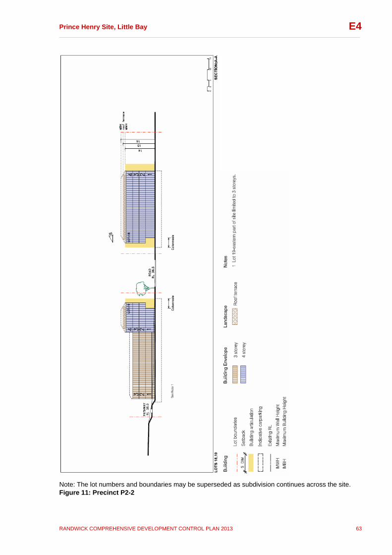
Prince Henry Site, Little Bay __________________________________________________________________________________
RANDWICK COMPREHENSIVE DEVELOPMENT CONTROL PLAN 2013 63
E4
Note: The lot numbers and boundaries may be superseded as subdivision continues across the site. Figure 11: Precinct P2-2
Prince Henry Site, Little Bay __________________________________________________________________________________
RANDWICK COMPREHENSIVE DEVELOPMENT CONTROL PLAN 2013 64
E4
6.3 Precinct P3 Precinct P3 is located in the south western corner of the DCP area. It is bounded by the neighbourhood centre precinct to the north, the Historic Precinct and Brodie Avenue to the east, Anzac Parade to the west and remnant bushland to the south. A key feature of the precinct is its elevated location. The precinct contains a small number of significant landscape elements, such as sandstone outcrops and the entrance gates to the former Chief Executive Officer’s (CEO) residence, which are to be incorporated within new development. Precinct Objectives
To achieve a transition in scale from the neighbourhood centre precinct to lower scale development to the east.
To achieve a strong landscape edge along Anzac Parade.
To protect remnant bushland and significant landscape
features.
To ensure that the bulk, scale and design of new development complement adjacent heritage buildings.
To encourage simple, rectilinear block building forms
which relate to the adjacent Flowers Wards.
To encourage a mix of housing types. Desired Character Development within this precinct will comprise aged care accommodation, residential development and a women’s health facility. These three different types of development are proposed to be quite separate entities, and require visual separation via landscaping to act as a buffer between uses, to ensure appropriate levels of privacy. A key design objective for this precinct is to ensure outlooks from future buildings are to trees rather than adjacent buildings. This precinct contains significant rock outcrops and a number of significant trees. These landscape elements have been a key influence on building envelope design, indicative lot subdivision and indicative vehicular entry point location within this precinct, to ensure future development does not affect these elements. The built form controls of this precinct generally continue the pattern of Precincts P1 and P2, with the tallest building envelopes located along Anzac Parade and stepping down to the adjacent bushland (south of this precinct). The building envelopes also step down in height towards Brodie Avenue, to result in a built form compatible in scale with the adjacent buildings in the historic precinct. Buildings are to be well set back from Brodie Avenue so as not to compete visually with the former Flowers Wards opposite, and to conserve the sandstone rock cuttings and outcrops (identified in
Prince Henry Site, Little Bay __________________________________________________________________________________
RANDWICK COMPREHENSIVE DEVELOPMENT CONTROL PLAN 2013 65
E4
Figure 12, Precinct P3-1 Plan as LE-15). Buildings should have simple, rectilinear forms to relate to the historic Flowers Wards. The women’s health facility, Jarrah House, located in the south western corner of this precinct, will be low scale and will be visually separated from the rest of the site, by screen planting, with separate access from Anzac Parade. This facility will have direct vehicular access from Anzac Parade. This is the only direct access appropriate along Anzac Parade (in addition to the 3 main access roads to the Prince Henry site: Jenner Street; Pine Avenue; and Jennifer Street / Harvey Street). The landscape design of the aged care accommodation is to incorporate the entrance gates to the former CEO’s Residence. The tallest building (5 storeys) is located along the southern edge of this precinct, adjacent to the Delaney Building, which is in the historic precinct. This building is required to be of an alignment, scale and form that avoids adverse impacts on the remnant bushland to the south and respects the nearby heritage buildings to the north and east, including the Flowers Wards and the Heffron and Delaney Buildings. This site (Lot 31) has been amalgamated with the site of the Delaney Building (Lot 32) to make more effective use of floor space and to facilitate a shared parking arrangement. Low fencing and substantial landscaping along the site’s Anzac Parade edge will provide a green corridor along Anzac Parade. Controls In addition to the general controls contained in this Section the following controls also apply to development within this precinct: Built Form i. Building height, FSR and landscaped open space for all lots in
Precinct P3 are to comply with the controls set out in the Built Form Control Table (Figures 6 and 7).
Note: 1. Maximum height and FSR may not be able to be achieved in all
instances; however the requirements for minimum landscaped open space must be achieved in all instances.
2. Lofts are permitted in identified locations. These locations have been identified to minimise the impact of development on the existing heritage buildings in the adjacent Historic Precinct.
3. The attached houses on Lots 22-30 will be a maximum of 2 storeys (with roof terraces) at the northernmost block and the centre block and a maximum of 3 storeys (with roof terraces) at the southernmost block, as identified on Figure 12, Precinct P3-1.
ii. The following minimum building setbacks apply, unless otherwise
specified in Figure 12: Anzac Parade property boundary 7m Brodie Avenue property boundary 7m Note: a large setback to Brodie Avenue is required to accommodate a change in ground level and to ensure landscape elements (rock cuttings and outcrops) are adequately protected.
Prince Henry Site, Little Bay __________________________________________________________________________________
RANDWICK COMPREHENSIVE DEVELOPMENT CONTROL PLAN 2013 66
E4
iii. Buildings adjacent to Anzac Parade are to be aligned and designed to
give an attractive edge and address to Anzac Parade.
iv.
Residential building setback areas facing Anzac Parade are to incorporate a 3m landscaped strip (as part of the 7m setback) and low fencing, with both fencing and landscaping contributing to privacy and a high level of amenity.
v. Development in Lot 20 is to match the building alignment of existing heritage buildings (in the adjacent Historic Precinct), as identified on Figure 12.
vi. Development in Lot 22-30 will have a setback of 9m from Brodie Avenue at the northernmost block to protect the rock ledge and the setting of the Flowers Wards. The setback at the centre and southernmost blocks will be 3m to allow for a landscaped strip to define Brodie Avenue, as identified on Figure 12.
Landscaping vii. Landscaping plans for lots adjacent to remnant bushland must
demonstrate that species planted will not result in any weed invasion or overshadowing of this bushland.
viii.
An asset protection zone of 8m (minimum) is to be provided between new buildings and any remnant bushland consistent with the requirements of Fire and Rescue NSW, Bushfire Hazards section (see Subsection 5.2 and Appendix B).
ix. Buildings adjacent to the southern bushland must demonstrate no adverse overshadowing impacts on this bushland.
x Landscaping, paths, driveways and the like, adjacent to the southern bushland are to be designed to ensure no stormwater run off into the remnant bushland areas.
xi. Development must demonstrate consideration of the Bushland Plan of Management (POM). In particular, development must meet the objectives of this POM.
Heritage xii. All development must be in accordance with the Conservation
Management Plan, the Archaeological Management Plan and any relevant Specific Elements Conservation Policy and must demonstrate that: New buildings maintain an appropriate setting for the Historic
Precinct including significant buildings and landscape features in the vicinity such as the Flowers Wards, Henry’s Trading Post, Heffron House and the Delaney Building (see Figures 18-19);
The entrance gates to the former CEO’s Residence are to be incorporated into the landscaping for the Aged Care facility.
significant landscape heritage elements such as outcropping sandstone adjoining the Historic Precinct are conserved and incorporated into the landscape design for new development; and
landscaping in this precinct complements that in the adjoining Historic Precinct.
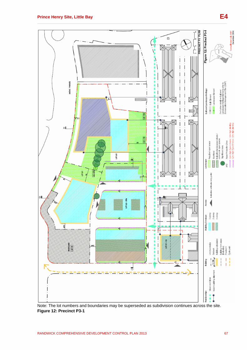
Prince Henry Site, Little Bay __________________________________________________________________________________
RANDWICK COMPREHENSIVE DEVELOPMENT CONTROL PLAN 2013 67
E4
Note: The lot numbers and boundaries may be superseded as subdivision continues across the site. Figure 12: Precinct P3-1
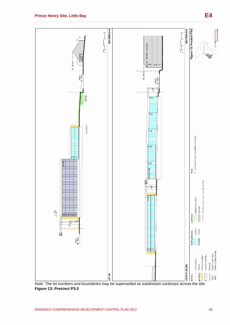
Prince Henry Site, Little Bay __________________________________________________________________________________
RANDWICK COMPREHENSIVE DEVELOPMENT CONTROL PLAN 2013 68
E4
Note: The lot numbers and boundaries may be superseded as subdivision continues across the site. Figure 13: Precinct P3-2
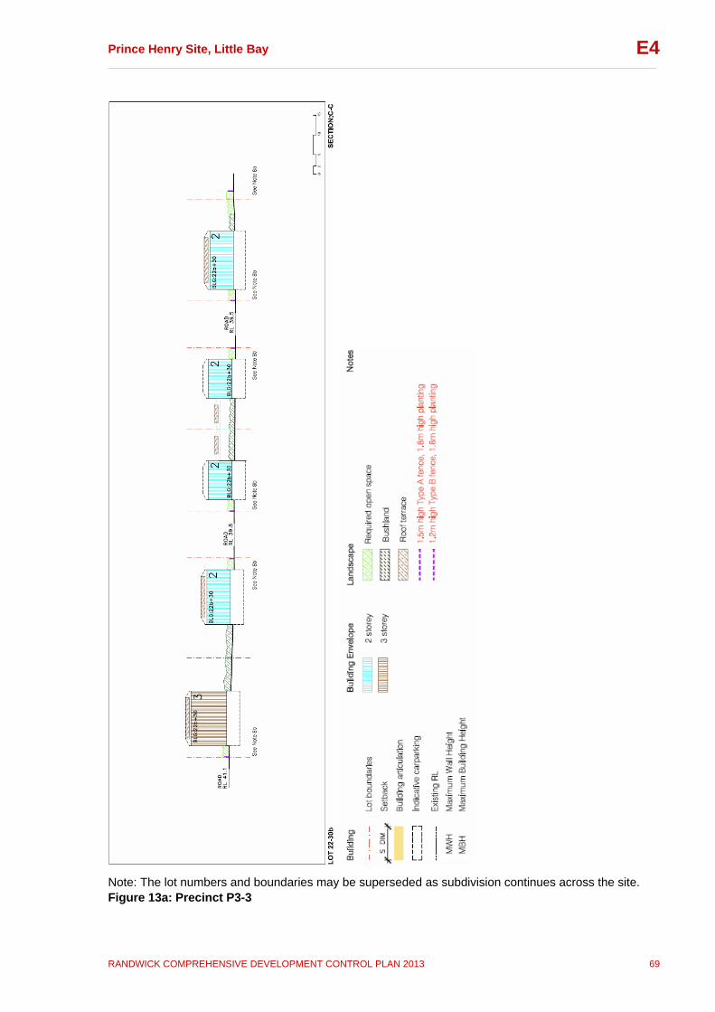
Prince Henry Site, Little Bay __________________________________________________________________________________
RANDWICK COMPREHENSIVE DEVELOPMENT CONTROL PLAN 2013 69
E4
Note: The lot numbers and boundaries may be superseded as subdivision continues across the site. Figure 13a: Precinct P3-3
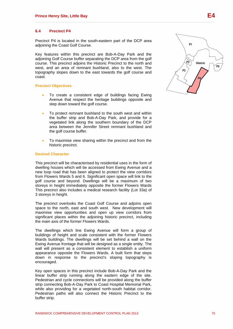
Prince Henry Site, Little Bay __________________________________________________________________________________
RANDWICK COMPREHENSIVE DEVELOPMENT CONTROL PLAN 2013 70
E4
6.4 Precinct P4 Precinct P4 is located in the south-eastern part of the DCP area adjoining the Coast Golf Course. Key features within this precinct are Bob-A-Day Park and the adjoining Golf Course buffer separating the DCP area from the golf course. This precinct adjoins the Historic Precinct to the north and west, and an area of remnant bushland, also to the west. The topography slopes down to the east towards the golf course and coast. Precinct Objectives
To create a consistent edge of buildings facing Ewing Avenue that respect the heritage buildings opposite and step down toward the golf course.
To protect remnant bushland to the south west and within
the buffer strip and Bob-A-Day Park, and provide for a vegetated link along the southern boundary of the DCP area between the Jennifer Street remnant bushland and the golf course buffer.
To maximise view sharing within the precinct and from the
historic precinct. Desired Character This precinct will be characterised by residential uses in the form of dwelling houses which will be accessed from Ewing Avenue and a new loop road that has been aligned to protect the view corridors from Flowers Wards 5 and 6. Significant open space will link to the golf course and beyond. Dwellings will be a maximum of two storeys in height immediately opposite the former Flowers Wards This precinct also includes a medical research facility (Lot 33a) of 3 storeys in height. The precinct overlooks the Coast Golf Course and adjoins open space to the north, east and south west. New development will maximise view opportunities and open up view corridors from significant places within the adjoining historic precinct, including the main axis of the former Flowers Wards. The dwellings which line Ewing Avenue will form a group of buildings of height and scale consistent with the former Flowers Wards buildings. The dwellings will be set behind a wall on the Ewing Avenue frontage that will be designed as a single entity. The wall will present as a consistent element to establish a uniform appearance opposite the Flowers Wards. A built form that steps down in response to the precinct’s sloping topography is encouraged. Key open spaces in this precinct include Bob-A-Day Park and the linear buffer strip running along the eastern edge of the site. Pedestrian and cycle connections will be provided along the buffer strip connecting Bob-A-Day Park to Coast Hospital Memorial Park, while also providing for a vegetated north-south habitat corridor. Pedestrian paths will also connect the Historic Precinct to the buffer strip.
Prince Henry Site, Little Bay __________________________________________________________________________________
RANDWICK COMPREHENSIVE DEVELOPMENT CONTROL PLAN 2013 71
E4
Controls In addition to the general controls contained in this Section the following controls also apply to development within this precinct: Built Form i. Building height, FSR and landscaped open space for all lots in
Precinct P4 are to comply with the controls set out in the Built Form Control Table (Figures 6 and 7). 1.Maximum height and FSR may not be able to be achieved in
all instances; however the requirements for minimum landscaped open space must be achieved in all instances.
2. The ten detached dwelling lots (D46-D50, D56-D60) directly opposite the Flowers Wards may achieve a maximum FSR of 0.75:1 in order to strengthen the built form adjacent to the heritage buildings. All other detached dwellings may achieve a maximum FSR of 0.5:1 consistent with similar dwelling houses in Precinct P1.
ii. The following minimum building setbacks apply, unless
otherwise specified in Figure 14: Setback from Ewing Avenue: 3m Side setback (where property boundary adjoins a road or pedestrian path or park: 4.5m Rear setback and/or setback from boundary adjoining remnant bushland: 8m
iii. New buildings facing Ewing Avenue are to create a strong built edge of setback, scale and height and to be consistent with the scale and form of the historic Flowers Wards.
iv. Buildings in Lots 33a and 33b are to be articulated along the facades identified in Figure 14 Precinct P4-1. Minimum articulation depth required is 2m.
v. Buildings in Lots 33a & 33b and D66 & D68 are to address the park with articulated facades including windows that overlook the park.
vi. Development in Lots D66 and D68 is to match the building alignment of the Flowers Wards opposite, indicated on Figure 14.
vii.
All development is to maximise the opportunity for view sharing. Maximum building height and FSR for detached dwellings may not be achieved where views (from private and public open spaces) would be unreasonably obstructed. View analysis details are to be included as part of the site analysis.
viii. Demonstrate that building design does not obstruct views along Ewing Avenue and along the axis with the Flowers Wards.
Landscaping ix. Planting is to comprise local native species, primarily low in
mature height, to maintain views and vistas of Little Bay and

Prince Henry Site, Little Bay __________________________________________________________________________________
RANDWICK COMPREHENSIVE DEVELOPMENT CONTROL PLAN 2013 72
E4
the adjoining coastal scenery from both the private and public domain.
x. Landscape Plans for lots adjacent to remnant bushland and the buffer strip are to demonstrate that species planted will not result in any weed invasion or overshadowing of indigenous vegetation.
xi. Lots 33a and 33b are to comprise suitably designed
landscaping along their southern boundaries to provide a continuous, vegetated link along the southern boundary of the DCP area, between the Jennifer Street remnant bushland and the golf course buffer.
xii. An asset protection zone of 8m is to be provided between new buildings and remnant bushland or the buffer strip, and the golf course consistent with the requirements of Fire and Rescue NSW, Bushfire Hazard section (see Subsection 5.2 and Appendix B).
xiii. Landscaping, paths, driveways and the like, adjacent to the southern bushland are to be designed to ensure no stormwater run off into the remnant bushland areas.
xiv. Development must demonstrate consideration of the Bushland Plan of Management (POM). In particular, development must meet the objectives of this POM.
Heritage xv. All development must be in accordance with the Conservation
Management Plan (CMP), Archaeological Management Plan (AMP) and any relevant Specific Elements Conservation Policy (SECP) and must demonstrate that:
new buildings maintain an appropriate setting for the Historic Precinct including significant buildings and landscape features in the vicinity such as the Flowers Wards and the Heffron and Delaney Buildings;
view corridors from the central axes of Flowers Wards 5 and 6 are recovered and maintained; and
the significant quarried sandstone pieces will be conserved and incorporated into the landscaping for Bob-A-Day Park.
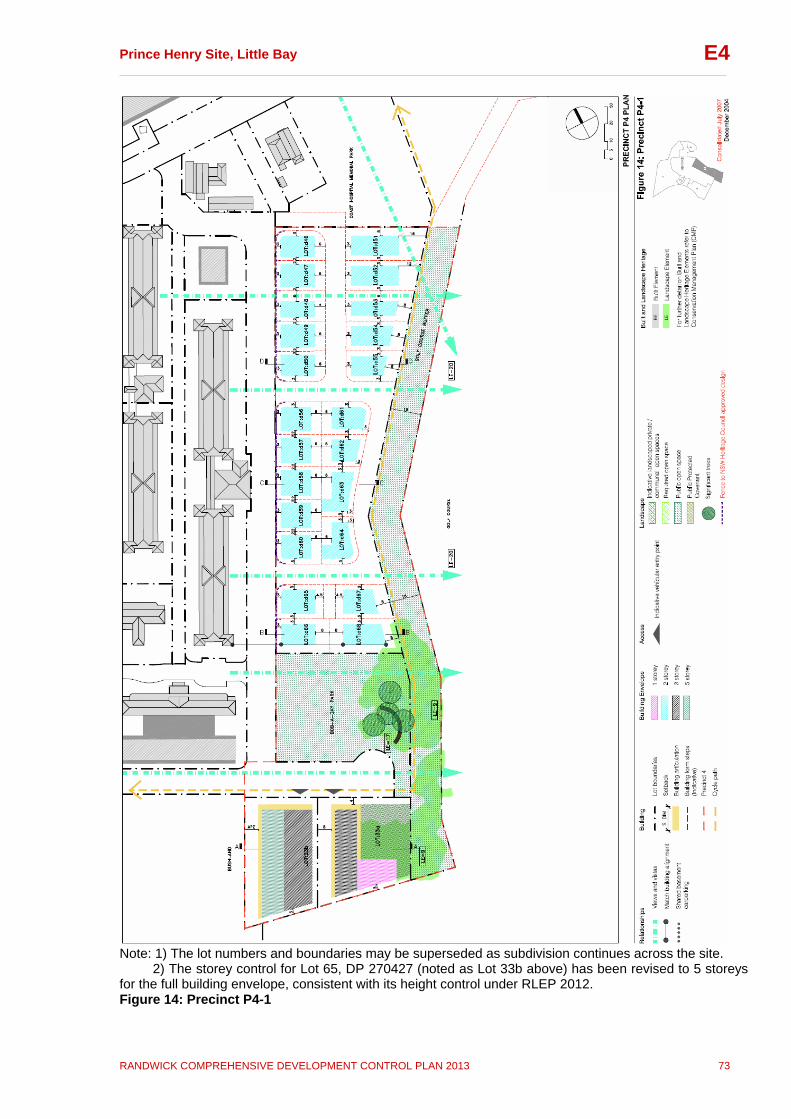
Prince Henry Site, Little Bay __________________________________________________________________________________
RANDWICK COMPREHENSIVE DEVELOPMENT CONTROL PLAN 2013 73
E4
Note: 1) The lot numbers and boundaries may be superseded as subdivision continues across the site. 2) The storey control for Lot 65, DP 270427 (noted as Lot 33b above) has been revised to 5 storeys for the full building envelope, consistent with its height control under RLEP 2012. Figure 14: Precinct P4-1
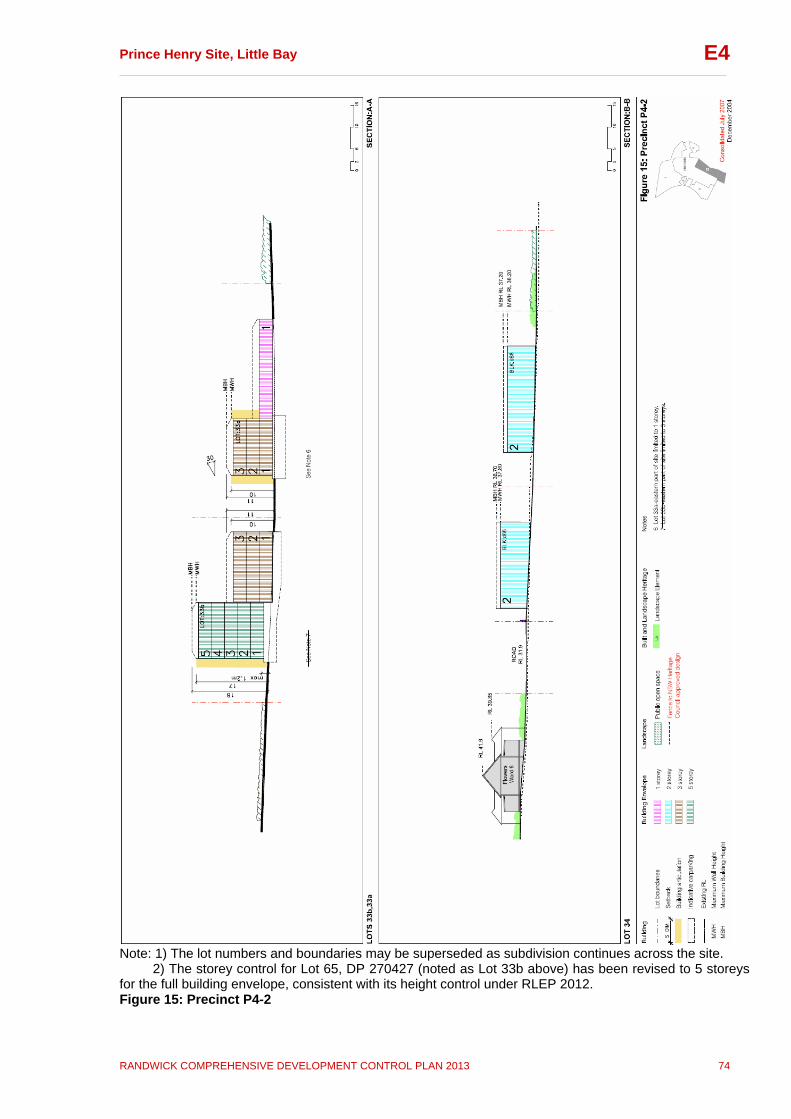
Prince Henry Site, Little Bay __________________________________________________________________________________
RANDWICK COMPREHENSIVE DEVELOPMENT CONTROL PLAN 2013 74
E4
Note: 1) The lot numbers and boundaries may be superseded as subdivision continues across the site. 2) The storey control for Lot 65, DP 270427 (noted as Lot 33b above) has been revised to 5 storeys for the full building envelope, consistent with its height control under RLEP 2012. Figure 15: Precinct P4-2

Prince Henry Site, Little Bay __________________________________________________________________________________
RANDWICK COMPREHENSIVE DEVELOPMENT CONTROL PLAN 2013 75
E4
Note: The lot numbers and boundaries may be superseded as subdivision continues across the site. Figure 16: Precinct P4-3
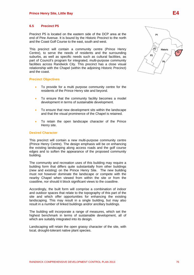
Prince Henry Site, Little Bay __________________________________________________________________________________
RANDWICK COMPREHENSIVE DEVELOPMENT CONTROL PLAN 2013 76
E4
6.5 Precinct P5 Precinct P5 is located on the eastern side of the DCP area at the end of Pine Avenue. It is bound by the Historic Precinct to the north and the Coast Golf Course to the east, south and west. This precinct will contain a community centre (Prince Henry Centre), to serve the needs of residents and the surrounding suburbs, as well as specific needs such as cultural facilities, as part of Council’s program for integrated, multi-purpose community facilities across Randwick City. This precinct has a close visual relationship with the Chapel (within the adjoining Historic Precinct) and the coast. Precinct Objectives
To provide for a multi purpose community centre for the residents of the Prince Henry site and beyond.
To ensure that the community facility becomes a model
development in terms of sustainable development.
To ensure that new development sits within the landscape and that the visual prominence of the Chapel is retained.
To retain the open landscape character of the Prince
Henry site. Desired Character This precinct will contain a new multi-purpose community centre (Prince Henry Centre). The design emphasis will be on enhancing the existing landscaping along access roads and the golf course edges and to soften the appearance of the proposed community building. The community and recreation uses of this building may require a building form that differs quite substantially from other buildings (new and existing) on the Prince Henry Site. The new building must not however dominate the landscape or compete with the nearby Chapel when viewed from within the site or from the coastline, nor should it block significant views to the coastline. Accordingly, the built form will comprise a combination of indoor and outdoor spaces that relate to the topography of this part of the site and which offer opportunities for enhancing the existing landscaping. This may result in a single building, but may also result in a number of linked buildings and/or ancillary buildings. The building will incorporate a range of measures, which set the highest benchmark in terms of sustainable development, all of which are suitably integrated into its design. Landscaping will retain the open grassy character of the site, with local, drought-tolerant native plant species.
Prince Henry Site, Little Bay __________________________________________________________________________________
RANDWICK COMPREHENSIVE DEVELOPMENT CONTROL PLAN 2013 77
E4
Controls In addition to the general controls contained in this Section the following controls also apply to development within this precinct: Built Form i. Building heights, FSR and landscaped open space are to
comply with the Built Form Control Table (Figures 6 and 7). Note: Maximum height and FSR may not be able to be achieved in all instances; however the requirements for minimum landscaped open space must be achieved in all instances.
ii. Development is to comply with the minimum setbacks and alignments shown in Figure 17 Precinct P5.
iii. The building envelope in Figure 17 is indicative only, and may vary subject to compliance with these controls at DA stage.
iv. Building frontages are to be aligned with street frontages.
v. New buildings should be of a scale that does not dominate the landscape or visually compete with the Australian Nurses War Memorial Chapel. Refer to Figure 17 for building alignment requirements.
vi. A full range of passive and active sustainable design measures are to be incorporated into the community facility building to maximise opportunities for renewable energy use and minimise demand for water and other finite resources.
vii. The development of the Community Centre is to be in accordance with the Developer Agreement.
Landscaping viii. Significant landscape elements such as cultural plantings are
to be conserved. Landscaping in this precinct should complement that in the adjoining Historic Precinct.
Heritage ix. All development must be in accordance with the Conservation
Management Plan, Archaeological Management Plan and any relevant Specific Elements Conservation Policy and must demonstrate that:
the new building(s) maintain an appropriate setting for the Historic Precinct including significant buildings and landscape features in the vicinity, including the Interdenominational Nurses War Memorial Chapel, and Pine Avenue; and
excavation in the possible extent of the palaeovalley area should not go below RL 26 unless endorsed by Randwick Council and the NSW Office of Environment and Heritage.

Prince Henry Site, Little Bay __________________________________________________________________________________
RANDWICK COMPREHENSIVE DEVELOPMENT CONTROL PLAN 2013 78
E4
Figure 17: Precinct P5
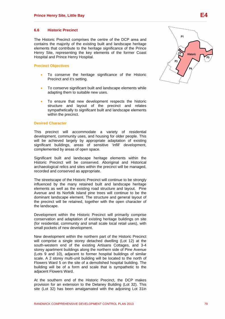
Prince Henry Site, Little Bay __________________________________________________________________________________
RANDWICK COMPREHENSIVE DEVELOPMENT CONTROL PLAN 2013 79
E4
6.6 Historic Precinct The Historic Precinct comprises the centre of the DCP area and contains the majority of the existing built and landscape heritage elements that contribute to the heritage significance of the Prince Henry Site, representing the key elements of the former Coast Hospital and Prince Henry Hospital. Precinct Objectives
To conserve the heritage significance of the Historic Precinct and it’s setting.
To conserve significant built and landscape elements while
adapting them to suitable new uses.
To ensure that new development respects the historic structure and layout of the precinct and relates sympathetically to significant built and landscape elements within the precinct.
Desired Character This precinct will accommodate a variety of residential development, community uses, and housing for older people. This will be achieved largely by appropriate adaptation of existing significant buildings, areas of sensitive ‘infill’ development, complemented by areas of open space. Significant built and landscape heritage elements within the Historic Precinct will be conserved. Aboriginal and Historical archaeological relics and sites within the precinct will be managed, recorded and conserved as appropriate. The streetscape of the Historic Precinct will continue to be strongly influenced by the many retained built and landscape heritage elements as well as the existing road structure and layout. Pine Avenue and its Norfolk Island pine trees will continue to be the dominant landscape element. The structure and general layout of the precinct will be retained, together with the open character of the landscape. Development within the Historic Precinct will primarily comprise conservation and adaptation of existing heritage buildings on site (for residential, community and small scale local retail uses), with small pockets of new development. New development within the northern part of the Historic Precinct will comprise a single storey detached dwelling (Lot 12) at the south-western end of the existing Artisans Cottages, and 3-4 storey apartment buildings along the northern side of Pine Avenue (Lots 9 and 10), adjacent to former hospital buildings of similar scale. A 2 storey multi-unit building will be located to the north of Flowers Ward 5 on the site of a demolished hospital building. The building will be of a form and scale that is sympathetic to the adjacent Flowers Ward. At the southern end of the Historic Precinct, the DCP makes provision for an extension to the Delaney Building (Lot 32). This site (Lot 32) has been amalgamated with the adjoining Lot 31in
Prince Henry Site, Little Bay __________________________________________________________________________________
RANDWICK COMPREHENSIVE DEVELOPMENT CONTROL PLAN 2013 80
E4
Precinct P3 to make more effective use of floor space and to facilitate a shared parking arrangement. The minimum landscaped open space requirements for this lot are lower due to its proximity to Bob-A-Day Park and the remnant bushland at the southern end of the DCP area. The remnant bushland will provide a “green outlook” for residential development on this Lot, giving the perception of substantial open space, while Bob-A-Day Park will provide accessible open space for passive and small scale active recreation. The existing Delaney building influences the south-facing location of the extension allowed and the location of open space on this lot, which is atypical and does not establish a precedent for other lots. It is important that new development complements the established character of the precinct by having a compatible scale and architectural character, and through careful consideration of the spaces between buildings. Controls In addition to the general controls contained in this Section the following controls also apply to development within this precinct: Built Form i. Building height, FSR and landscaped open space for all lots in
the Historic Precinct are to comply with the controls set out in the Built Form Control Table (Figures 6 and 7). 1.Maximum height and FSR may not be able to be achieved
in all instances; however the requirements for minimum landscaped open space must be achieved in all instances.
ii. The maximum height of the extension to the Delaney Building
(Lot 32) must not exceed the existing ridge height of the Delaney Building (see Figure 20), with a minimum floor to ceiling height of 2.7 metres for all floors.
iii. New developments are to be in accordance with the policies contained within the Conservation Management Plan (CMP), Archaeological Management Plan (AMP), and any relevant Specific Elements Conservation Policies (SECP).
iv. Development is to comply with the setbacks and ‘match building alignment’ controls identified on Figures 18-19.
v. Development is to demonstrate that views (both from the private and public domain) identified on Figures 18-19 are maintained. Details of the view analysis are to be included at DA stage.
vi.
New buildings should respect the blocky rectilinear form of the most significant buildings such as the Flowers Wards and the Matron Dickson Nurses Home without mimicking their character or appearance.
vii. New buildings should be designed so they are appropriate in terms of their character, scale, massing, materials and details, setback and orientation to the existing buildings and spaces within the Historic Precinct.
Landscaping
Prince Henry Site, Little Bay __________________________________________________________________________________
RANDWICK COMPREHENSIVE DEVELOPMENT CONTROL PLAN 2013 81
E4
viii. Landscape planting is to complement and not compete with the highly significant plantings of Norfolk Island Pine trees along Pine Avenue.
ix. The historically open character of the landscape in the precinct should be retained.
x. New planting should be in accordance with the suggested species list included as Appendix A.
Heritage xi. All development must be in accordance with the
Conservation Management Plan (CMP), Archaeological Management Plan (AMP), and any relevant Specific Elements Conservation Policy (SECP), and must demonstrate that:
historic and visual relationships of buildings and groupings of buildings are retained;
the symmetry and axial siting of the Flowers Wards and Heffron and Delaney buildings are respected and reinforced;
view corridors from the Flowers Wards and the visual link from the Avenue of Coral Trees to the former Matron Dickson Nurses Home are opened up (Figure 4);
the visual prominence of the Clock Tower and the Chapel as viewed from Pine Avenue is maintained;
new buildings along Pine Avenue follow the road alignment and the alignment of the early road from Pine Avenue to the former Institute of Tropical Medicine;
that adequate curtilages and settings are defined, protected and maintained around significant buildings, groups of buildings and spaces;
that a consistent approach to the conservation of the Flowers Wards and their settings is maintained; and
excavation of the palaeovalley should not go below RL 26 unless endorsed by Randwick City Council and the NSW Office of Environment and Heritage.
Parking xii. Where surface parking is provided within private lots within
this precinct, it is not to detract from the setting of significant buildings.

Prince Henry Site, Little Bay __________________________________________________________________________________
RANDWICK COMPREHENSIVE DEVELOPMENT CONTROL PLAN 2013 82
E4
Note: The lot numbers and boundaries may be superseded as subdivision continues across the site. Figure 18: P Historic-1

Prince Henry Site, Little Bay __________________________________________________________________________________
RANDWICK COMPREHENSIVE DEVELOPMENT CONTROL PLAN 2013 83
E4
Note: The lot numbers and boundaries may be superseded as subdivision continues across the site. Figure 19: P Historic-2
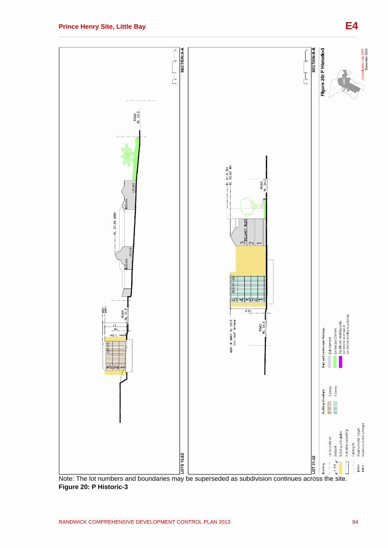
Prince Henry Site, Little Bay __________________________________________________________________________________
RANDWICK COMPREHENSIVE DEVELOPMENT CONTROL PLAN 2013 84
E4
Note: The lot numbers and boundaries may be superseded as subdivision continues across the site. Figure 20: P Historic-3

Prince Henry Site, Little Bay __________________________________________________________________________________
RANDWICK COMPREHENSIVE DEVELOPMENT CONTROL PLAN 2013 85
E4
Note: The lot numbers and boundaries may be superseded as subdivision continues across the site. Figure 21: P Historic-4
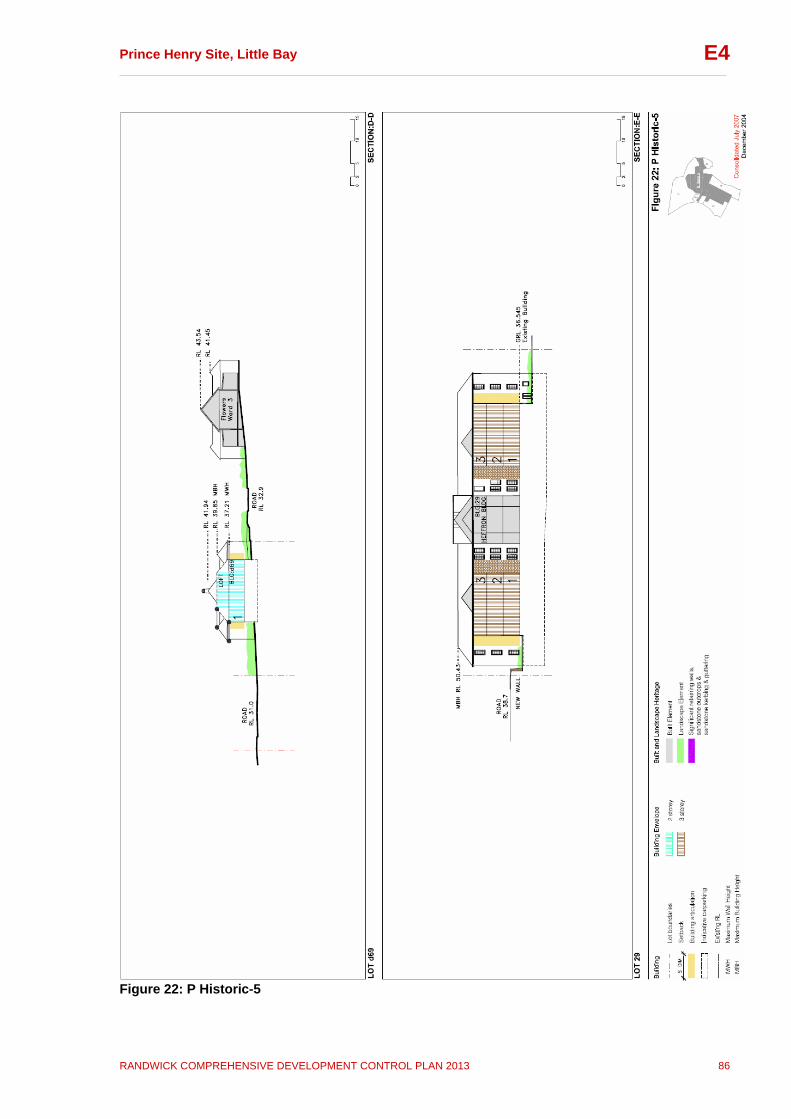
Prince Henry Site, Little Bay __________________________________________________________________________________
RANDWICK COMPREHENSIVE DEVELOPMENT CONTROL PLAN 2013 86
E4
Figure 22: P Historic-5

Prince Henry Site, Little Bay __________________________________________________________________________________
RANDWICK COMPREHENSIVE DEVELOPMENT CONTROL PLAN 2013 87
E4
Appendices Appendix A: Recommended List of Suitable Native Species for the Prince Henry Hospital Redevelopment Site Trees: Banksia integrifolia Casuarina glauca Eucalyptus piperita Eucalyptus robusta Eucalyptus sieberi Eucalyptus obstans Angophora costata Melalueca armillaris Shrubs: Baeckea imbricata Banksia marginata Banksia spinulosa Callistemon hybrids Correa alba Grevillea hybrids Westringia fruticosa Hakea gibbosa Groundcovers: Carpobrotus glaucescens Chrysocephalum apiculatum Dianella congesta Grevillea hybrids Isolepis nodosa Themeda australis Brachychome multifida Lomandra tanika Hibbertia scandens The species in this list are suitable for dry, windy, coastal sites with nutrient-poor soils. They require relatively little maintenance. The trees and shrubs do not have fleshy fruits, so as not to promote the spread of larger, more aggressive birds, which may result in the loss of smaller native species. The list has also been compiled to address the provenance issue, as it relates to loss of genetic biodiversity, due to use of non-local provenance planting material. Hence, only a few native species present in bushland in the vicinity of the Prince Henry site have been chosen for this list.

Prince Henry Site, Little Bay __________________________________________________________________________________
RANDWICK COMPREHENSIVE DEVELOPMENT CONTROL PLAN 2013 88
E4
Appendix B: Bushfire Risk Management Report (2001) NSW Fire Brigades (currently Fire and Rescue NSW), Specialised State Operations, Bushfire / Natural Hazards Section

Prince Henry Site, Little Bay __________________________________________________________________________________
RANDWICK COMPREHENSIVE DEVELOPMENT CONTROL PLAN 2013 89
E4
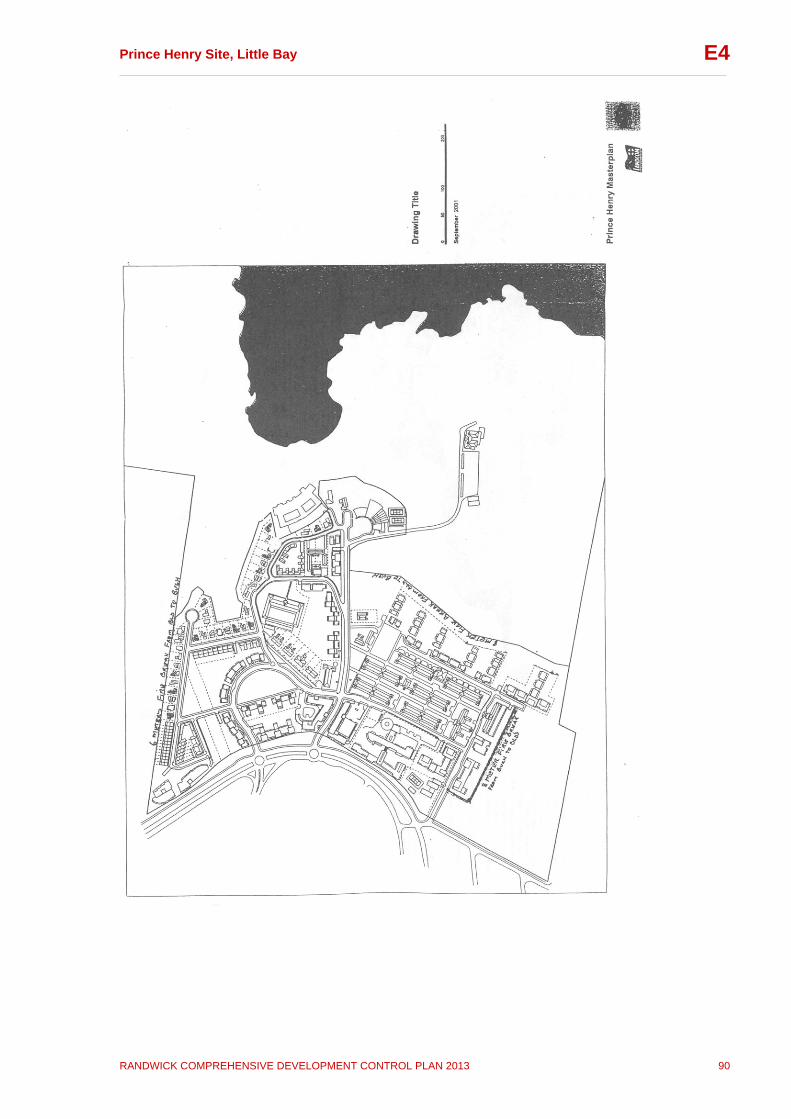
Prince Henry Site, Little Bay __________________________________________________________________________________
RANDWICK COMPREHENSIVE DEVELOPMENT CONTROL PLAN 2013 90
E4

Prince Henry Site, Little Bay __________________________________________________________________________________
RANDWICK COMPREHENSIVE DEVELOPMENT CONTROL PLAN 2013 91
E4
Appendix C: Map Extracts from the Archaeological Management Plan (AMP) and the Conservation Management Plan (CMP)
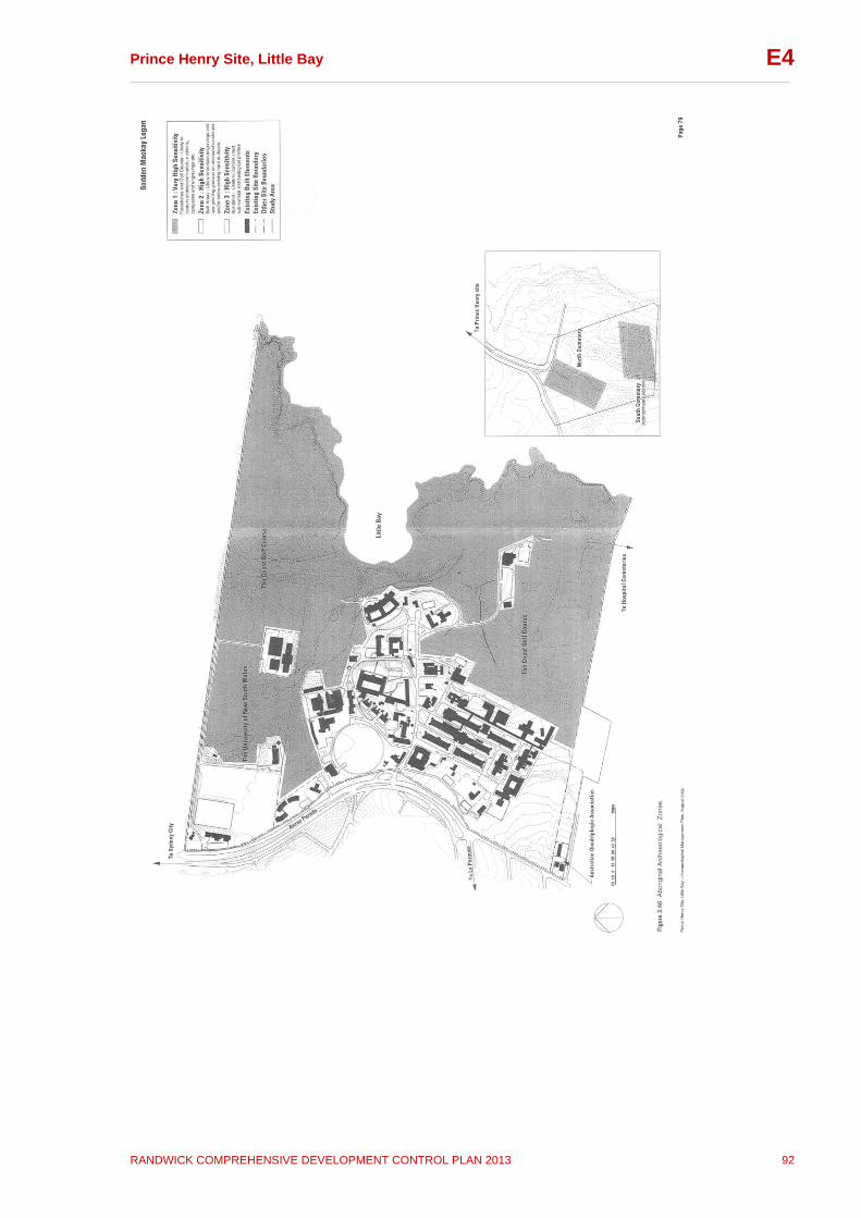
Prince Henry Site, Little Bay __________________________________________________________________________________
RANDWICK COMPREHENSIVE DEVELOPMENT CONTROL PLAN 2013 92
E4
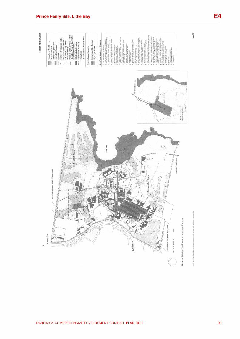
Prince Henry Site, Little Bay __________________________________________________________________________________
RANDWICK COMPREHENSIVE DEVELOPMENT CONTROL PLAN 2013 93
E4
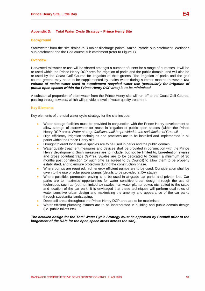
Prince Henry Site, Little Bay __________________________________________________________________________________
RANDWICK COMPREHENSIVE DEVELOPMENT CONTROL PLAN 2013 94
E4
Appendix D: Total Water Cycle Strategy – Prince Henry Site Background Stormwater from the site drains to 3 major discharge points: Anzac Parade sub-catchment, Wetlands sub-catchment and the Golf course sub catchment (refer to Figure 1). Overview Harvested rainwater re-use will be shared amongst a number of users for a range of purposes. It will be re-used within the Prince Henry DCP area for irrigation of parks and the public domain, and will also be re-used by the Coast Golf Course for irrigation of their greens. The irrigation of parks and the golf course greens may need to be supplemented by mains water during summer months, however, the volume of mains water used to supplement recycled water use (particularly for irrigation of public open spaces within the Prince Henry DCP area) is to be minimised. A substantial proportion of stormwater from the Prince Henry site will run off to the Coast Golf Course, passing through swales, which will provide a level of water quality treatment. Key Elements Key elements of the total water cycle strategy for the site include:
Water storage facilities must be provided in conjunction with the Prince Henry development to allow storage of stormwater for reuse in irrigation of public open spaces (within the Prince Henry DCP area). Water storage facilities shall be provided to the satisfaction of Council.
High efficiency irrigation techniques and practices are to be installed and implemented in all parks within the Prince Henry site.
Drought tolerant local native species are to be used in parks and the public domain. Water quality treatment measures and devices shall be provided in conjunction with the Prince
Henry development. Such measures are to include, but not be limited to, bio-retention swales and gross pollutant traps (GPTs). Swales are to be dedicated to Council a minimum of 36 months post construction (or such time as agreed to by Council) to allow them to be properly established, and to ensure protection during the construction phase.
Where pumps are required, high energy efficient pumps are to be used. Consideration shall be given to the use of solar power pumps (details to be provided at DA stage).
Where possible, permeable paving is to be used in at-grade car parks and private lots, Car parks are to maximise opportunities for water sensitive urban design through the use of techniques such as (but not limited to) swales, rainwater planter boxes etc, suited to the scale and location of the car park. It is envisaged that these techniques will perform dual roles of water sensitive urban design and maximising the amenity and appearance of the car parks through substantial landscaping.
Deep soil areas throughout the Prince Henry DCP area are to be maximised. Water efficient plumbing fixtures are to be incorporated in building and public domain design
(i.e. public toilets etc). The detailed design for the Total Water Cycle Strategy must be approved by Council prior to the lodgement of the DA/s for the open space areas across the site).
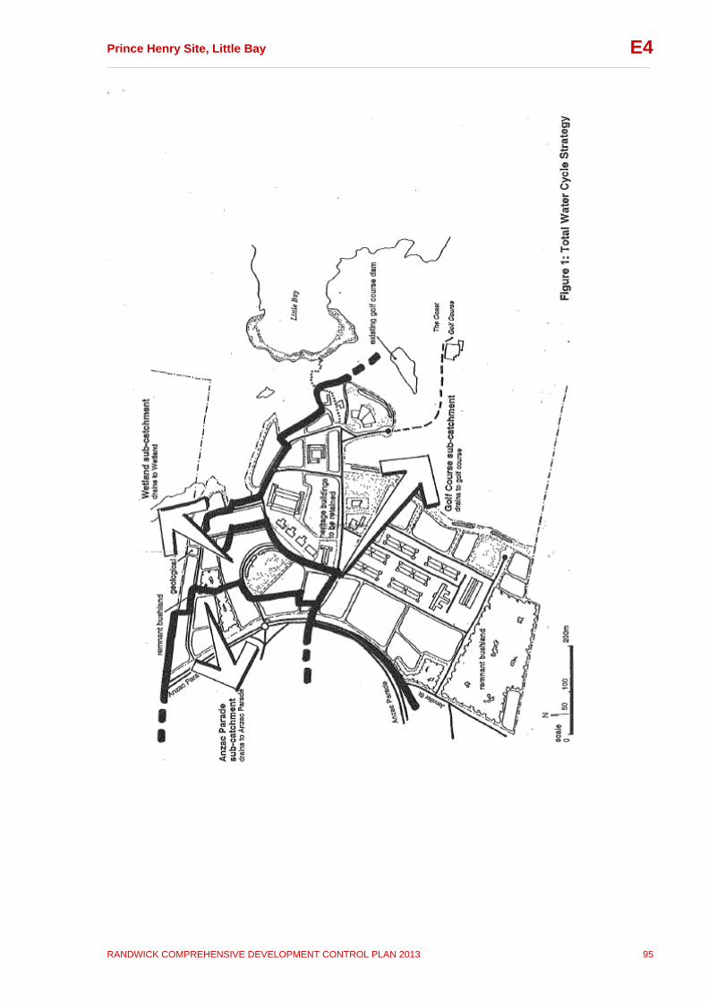
Prince Henry Site, Little Bay __________________________________________________________________________________
RANDWICK COMPREHENSIVE DEVELOPMENT CONTROL PLAN 2013 95
E4

Prince Henry Site, Little Bay __________________________________________________________________________________
RANDWICK COMPREHENSIVE DEVELOPMENT CONTROL PLAN 2013 96
E4
Appendix E: Watercourse Categories and Riparian Land Widths There are 4 watercourses within the Coast Golf Course, adjacent to the Prince Henry DCP area, known as: - The northern watercourse; - The central watercourses (comprises 2 watercourses / arms);
and - The southern watercourse. The Department of Planning and Infrastructure has identified two watercourse categories on the Coast Golf Course as follows: - the northern and southern watercourses: Category 2 - the central watercourses: Category 3 The riparian land widths for these categories are as follows: Category 2 watercourse: a minimum riparian land width of 20 metres on each side of the bank (measured from top of bank), or to the extent of significant remnant native vegetation which ever is the widest, to provide terrestrial and aquatic habitat, bank stability and to protect water quality Category 3 watercourse: a minimum riparian land width of 10 metres on each side of the bank (measured from top of bank), to provide terrestrial and aquatic habitat, bank stability and to protect water quality

Prince Henry Site, Little Bay __________________________________________________________________________________
RANDWICK COMPREHENSIVE DEVELOPMENT CONTROL PLAN 2013 97
E4
Appendix F: Specific Elements Conservation Policies (SECP) No. Specific Elements Conservation
Policy Notes
B-01 B-02
Entrance Group Entrance Gates and Gateposts Entrance Gatehouse
SECP completed in November 2004.
B-04 B-29 B-32 B-67
Pine Avenue Group War Memorial Clock Tower Former Water Reservoir Former Water Tower Wishing Well
SECP completed in May 2006.
B-09 Henry’s Trading Post SECP completed in August 2003.
B-16 Matron Dickson Nurses Home SECP completed in May 2006.
B-17 B-29
Pathology Department Building and Water Reservoir Former Pathology Department Building Former Water Reservoir
SECP completed in April 2005.
B-19
Former Nurses Lecture Hall Store and Social Work Department (Former Nurses Dining Hall/Lecture Hall)
SECP completed in August 2004.
B-20 L-34
Former Motor Garage and Retaining Walls Storage Shed/Former Motor Garage Significant Retaining Walls
SECP completed in April 2004.
B-35 Interdenominational Australian Nurses War Memorial Chapel
SECP completed in October 2006.
B-37 Coast Golf Course Clubhouse (Former Coast Hospital Laundry)
Outside DCP area.
B-42 BJ Heffron House (A Block)
SECP completed in June 2008.
B-43 Delaney Building (B Block)
SECP completed in June 2008.
B-44 Pine Cottage
SECP completed in July 2007.
B-45 Artisans’ Cottages No 4 and No 5 SECP completed in April 2005.
B-46 Artisans’ Cottages No 6 and No 7 SECP completed in April 2005.
B-47 Artisans’ Cottages No 8 and No 9
Demolished.
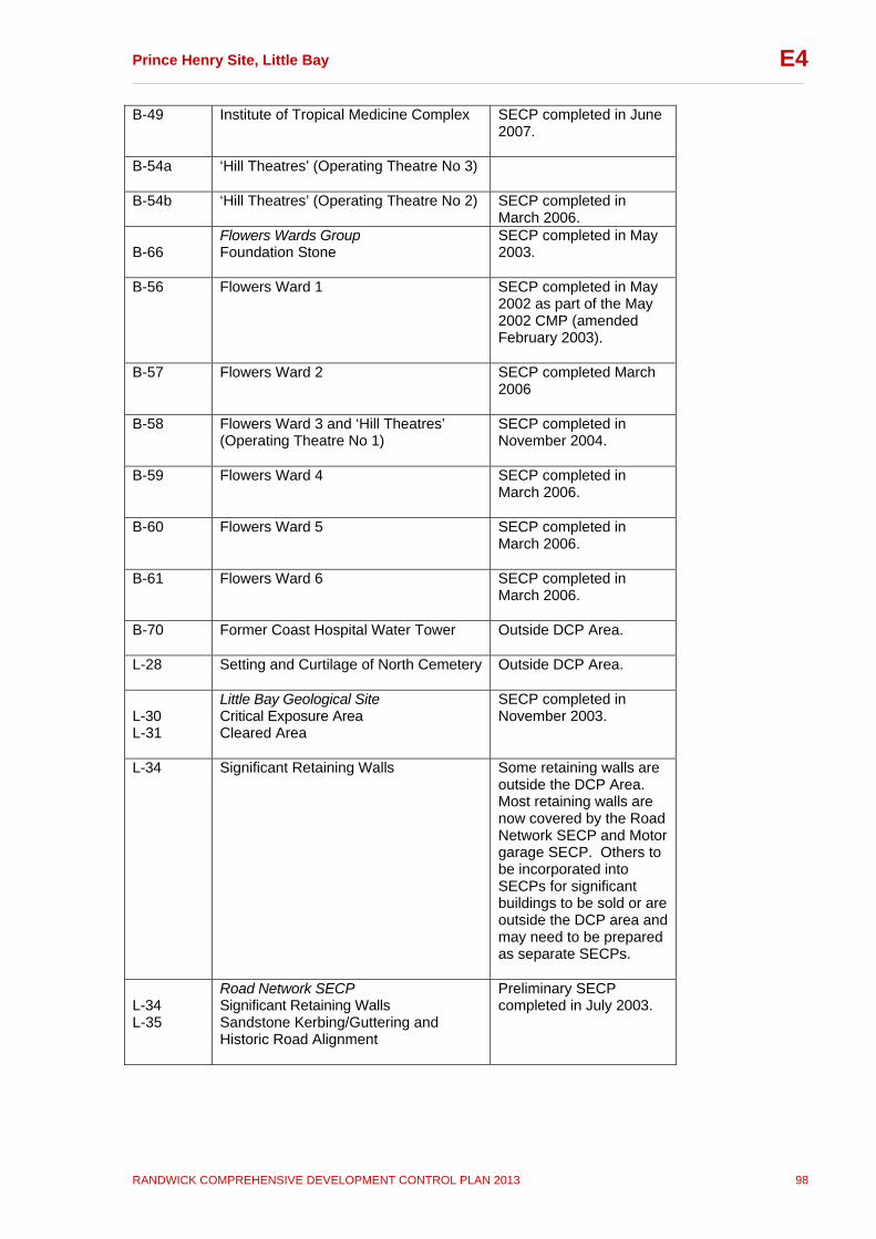
Prince Henry Site, Little Bay __________________________________________________________________________________
RANDWICK COMPREHENSIVE DEVELOPMENT CONTROL PLAN 2013 98
E4
B-49 Institute of Tropical Medicine Complex SECP completed in June 2007.
B-54a ‘Hill Theatres’ (Operating Theatre No 3)
B-54b ‘Hill Theatres’ (Operating Theatre No 2)
SECP completed in March 2006.
B-66
Flowers Wards Group Foundation Stone
SECP completed in May 2003.
B-56 Flowers Ward 1 SECP completed in May 2002 as part of the May 2002 CMP (amended February 2003).
B-57 Flowers Ward 2
SECP completed March 2006
B-58 Flowers Ward 3 and ‘Hill Theatres’ (Operating Theatre No 1)
SECP completed in November 2004.
B-59 Flowers Ward 4
SECP completed in March 2006.
B-60 Flowers Ward 5
SECP completed in March 2006.
B-61 Flowers Ward 6 SECP completed in March 2006.
B-70 Former Coast Hospital Water Tower
Outside DCP Area.
L-28 Setting and Curtilage of North Cemetery
Outside DCP Area.
L-30 L-31
Little Bay Geological Site Critical Exposure Area Cleared Area
SECP completed in November 2003.
L-34 Significant Retaining Walls Some retaining walls are outside the DCP Area. Most retaining walls are now covered by the Road Network SECP and Motor garage SECP. Others to be incorporated into SECPs for significant buildings to be sold or are outside the DCP area and may need to be prepared as separate SECPs.
L-34 L-35
Road Network SECP Significant Retaining Walls Sandstone Kerbing/Guttering and Historic Road Alignment
Preliminary SECP completed in July 2003.