Prepared for: The Boeing Company · RBSL risk-based screening level RCRA Resource Conservation and...
29
SCO/APPENDIX_U_TEXT_V05.DOC Report Group 5 – Central Portion of Areas III and IV RCRA Facility Investigation Report Santa Susana Field Laboratory Ventura County, California Volume XI – Group 5 Debris Survey Appendix U Prepared for: The Boeing Company November 2008 DRAFT IN PROGRESS Jill Bensen Program Manager Michael O. Bower, P.E. John Lovenburg, P.G. Project Manager Senior Reviewer
Transcript of Prepared for: The Boeing Company · RBSL risk-based screening level RCRA Resource Conservation and...

SCO/APPENDIX_U_TEXT_V05.DOC
R e p o r t
Group 5 – Central Portion of Areas III and IV RCRA Facility Investigation Report
Santa Susana Field Laboratory Ventura County, California
Volume XI – Group 5 Debris Survey
Appendix U
Prepared for:
The Boeing Company
November 2008
DRAFT IN PROGRESS Jill Bensen Program Manager Michael O. Bower, P.E. John Lovenburg, P.G. Project Manager Senior Reviewer

SCO/APPENDIX_U_TEXT_V05.DOC I
Contents
Section Page Appendix U...................................................................................................................................U.1-1
U.1 Introduction.........................................................................................................U.1-1 U.2 Purpose and Scope .............................................................................................U.2-1 U.3 Methodology.......................................................................................................U.3-1 U.4 Sampling ..............................................................................................................U.4-1
U.4.1 Sampling Decision Rationale for Containers ..................................U.4-1 U.4.2 Soil Piles with Intermixed Debris .....................................................U.4-1 U.4.3 Laboratory Analyses ..........................................................................U.4-2
U.5 Sampling Results ................................................................................................U.5-1
Tables U.4-1 Group 5 Debris Location Evaluation
Figures U.3-1 Debris Sampling Locations – Group 5
Attachments U-1 Photograph Log (Electronic Copies) U-2 Data Quality, Validation and Laboratory Reports (Electronic Copies) U-3 Agency Correspondence (Electronic Copies)


SCO/APPENDIX_U_TEXT_V05.DOC III
Acronyms and Abbreviations
bgs below ground surface
Boeing The Boeing Company
DOE United States Department of Energy
DTSC Department of Toxic Substances Control
GPS global positioning system
MWH MWH Americas, Inc.
NASA National Aeronautics and Space Administration
PAH polyaromatic hydrocarbon
PCB polychlorinated biphenyl
RBSL risk-based screening level
RCRA Resource Conservation and Recovery Act
RFI Resource Conservation and Recovery Act Facility Investigation
SSFL Santa Susana Field Laboratory
TPH total petroleum hydrocarbon
VOC volatile organic compound


WORKING DRAFT
SCO/APPENDIX_U_TEXT_V05.DOC U.1-1
Appendix U
U.1 Introduction Appendix U presents the results of the Group 5 debris survey activities performed in 2008 at the Santa Susana Field Laboratory (SSFL) in Ventura County, California. CH2M HILL has prepared this report for The Boeing Company (Boeing) and the United States Department of Energy (DOE). The project was performed to support the Resource Conservation and Recovery Act (RCRA) Facility Investigation (RFI) Program at SSFL.
The debris survey included the entire SSFL and was performed as a joint effort by CH2M HILL and MWH. Each consultant performed the survey activities for select RFI groups, as summarized below:
• CH2M HILL: Groups 1B, 2, 3, 4, 5, 7, 9, and 10 • MWH: Groups 1A, 6, and 8
The information presented in Appendix U is limited to Group 5. Debris survey information for the other groups will be provided in their respective group reports.


WORKING DRAFT U.2 PURPOSE AND SCOPE
SCO/APPENDIX_U_TEXT_V05.DOC U.2-1
U.2 Purpose and Scope The purpose of the debris survey was to conduct systematic visual inspections of the SSFL for surficial evidence of solid waste disposal (referred to herein as debris areas) and sampling for chemical analytes at the debris areas. Types of solid wastes that were targeted as part of this survey included, but were not limited to, the following:
• Containers, including cans, bottles, drums, and tanks.
• Soil piles with intermixed debris, including concrete, asphalt, metal or wood debris.
• Hummocky terrain areas that may indicate historic dumping of soil. Note that some areas at SSFL, particularly in the undeveloped portions of the facility, have evidence of soil mounding that appears to be associated with firebreak grading performed during recent wildfire events (e.g., the 2005 Topanga Fire). These areas are typically not identified as debris areas.
• Building demolition debris, including pieces of broken concrete or asphalt pavement. Note that small, scattered pieces of concrete and/or asphalt unassociated with a debris or soil pile are not typically identified as debris areas.
• Wood debris and pipe segments, including metal, transite, clay, and plastic.
• Skeet target (clay pigeon) fragments.
• Miscellaneous other non-household-type debris.
This debris survey was not intended to address the following types of features:
• Household-type debris (e.g., food containers)
• Features consisting solely of nonhazardous items such as concrete, asphalt, and rebar and other inert metal piles(i.e., items are not intermixed with soil).
• Areas with materials of known origin and quality (i.e., no hazardous substances present), or material stockpile areas that are being actively managed.
• Areas with buried debris potentially present, but with no indications on the ground surface based on visual inspection.
Debris identified as potentially hazardous or as being a potential source of contamination will be considered for further evaluation in the RFI sampling programs. Specific recommendations for further evaluation, including sampling as appropriate, are discussed in Section U.4.
Note that household-type debris (such as food containers and other nonhazardous waste-related items) was not targeted in the debris survey. As a general site-wide housekeeping effort, however, the debris survey crews collected small volumes of household-type waste where encountered, which was subsequently disposed of offsite with the regular municipal wastes generated at SSFL.


WORKING DRAFT U.3 METHODOLOGY
SCO/APPENDIX_U_TEXT_V05.DOC U.3-1
U.3 Methodology The debris survey was conducted as a pedestrian survey inspection of the visible ground surface. Prior to conducting fieldwork, the survey crews reviewed information relevant to the survey task (such as previous SSFL debris area survey reports and other relevant historical documents, and aerial photographs). The field survey teams consisted of two individuals: one consultant staff and one SSFL facility maintenance staff (subcontracted by Boeing).
The survey crews followed predetermined transects approximately 50 feet apart and visually scanned the ground surface for evidence of debris. Closer transect spacing was used, as appropriate, based on ground conditions encountered. For example, closer attention was given to densely vegetated areas and drainages to achieve thorough visual inspection. Survey teams utilized global positioning system (GPS) equipment to accurately navigate within the survey area and record the location of debris sites that were documented. A map grid system was also developed to aid in tracking geographic information (refer to Figure 1).
Some areas of the SSFL could not be safely accessed due to the presence of steep terrain and rock outcrops. During the survey, inaccessible areas were visually inspected (typically using binoculars) from the nearest vantage point and documented accordingly.
The locations and descriptions of the debris sites were documented using hand-held GPS units that were preprogrammed with data dictionaries to enable efficient data collection. The units also allowed keyed entry of debris descriptions that were not included in the data dictionary. Debris sites that were approximately 100 square feet or less in size (that is, less than approximately 10 feet by 10 feet) were recorded with a single set of GPS coordinates. Debris areas larger than 100 square feet were documented with the GPS unit by recording the visible surface perimeter of the debris site. Figure U.3-1 presents the debris locations identified.
Digital cameras were used to photograph each debris area identified. Generally, a minimum of two digital photographs, one showing a close-up of the debris and another showing the larger debris site area, were collected for each site. Representative photographs of each container were typically obtained. Attachment U-1 presents the photographic logs from debris sampling locations.


WORKING DRAFT U.4 SAMPLING
SCO/APPENDIX_U_TEXT_V05.DOC U.4-1
U.4 Sampling Based on field observations collected during the debris survey, each debris area was evaluated to determine whether further evaluation as part of the RFI was warranted (that is, sampling and analysis). Table U.4-1 presents sampling determinations for each debris area identified in accordance with the rationale described in subsections U.4.1 and U.4.2.
U.4.1 Sampling Decision Rationale for Containers • If the container volume could have contained no more than 1 gallon, no sampling was
performed. This decision might be modified based on surrounding site chemical use and professional judgment.
• If more than one small (for example, less than 1 gallon) container was present within an approximate 20-foot by 20-foot area, samples were collected at a minimum of one location within the area.
• If the cumulative container volume was greater than 55 gallons, typically samples were collected at two locations—the container(s) location and one location downslope . The additional sampling location was recommended to account for potential liquid migration associated with larger volumes potentially involved. The number and position of the sample locations might be adjusted based on site-specific characteristics and professional judgment.
• At each identified sampling location:
− Soil vapor samples were collected at 5 and 10 feet below ground surface (bgs) (as permitted by bedrock depth).
− Soil samples were collected at 0 to 1, 5 to 6, and 9 to 10 feet bgs (as permitted by bedrock depth); the 10-foot-bgs sample was held and analyzed only if the 6-foot-bgs sample had background exceedances of metals and/or dioxins, as well as an exceedance of risk-based screening levels (RBSLs). Analysis of volatile organic compounds (VOCs) in soil was performed only if VOCs were detected in soil vapor. If no soil vapor sampling was possible due to shallow bedrock, soil VOC samples were collected from the shallow sampling depth.
U.4.2 Soil Piles with Intermixed Debris • If the debris pile size was less than 5 cubic yards (approximate volume), no sampling
was performed. Sampling might be performed if evidence of a release (for example, soil staining) is present, or if warranted based on surrounding site chemical use and professional judgment. For example, if wood or metal debris (stainless steel tubing and pipes, for example) is present, sampling might be performed.
• If the debris pile size was greater than 5 cubic yards but less than 50 cubic yards (approximate volume), one soil sample was collected from the interior portion of the debris pile (in other words, grab samples were not collected from the surface of debris pile) with a hand auger or exploratory trenching.

WORKING DRAFT U.4 SAMPLING
U.4-2 SCO/APPENDIX_U_TEXT_V05.DOC
• If the debris pile size was greater than 50 cubic yards (approximate volume), exploratory trenching was performed to assess the potential for presence of buried debris (such as containers). Grab samples were collected from the walls of trenches (that is, from materials at the interior portion of the pile), and samples were targeted toward areas within the trench that exhibited evidence of staining, odors, or other visual evidence of hazardous substances.
U.4.3 Laboratory Analyses Soil samples were analyzed for the RFI screening suite: VOCs, polyaromatic hydrocarbons (PAHs), total petroleum hydrocarbons (TPHs), and metals. Analysis of additional chemicals might be included based on surrounding site chemical use, results of sampling in nearby operational areas, and professional judgment. For example:
• If electrical equipment or light ballasts that might have contained fluid are present, analysis for polychlorinated biphenyls (PCBs) is included.
WORKING DRAFT U.5 SAMPLING RESULTS
SCO/APPENDIX_U_TEXT_V05.DOC U.5-1
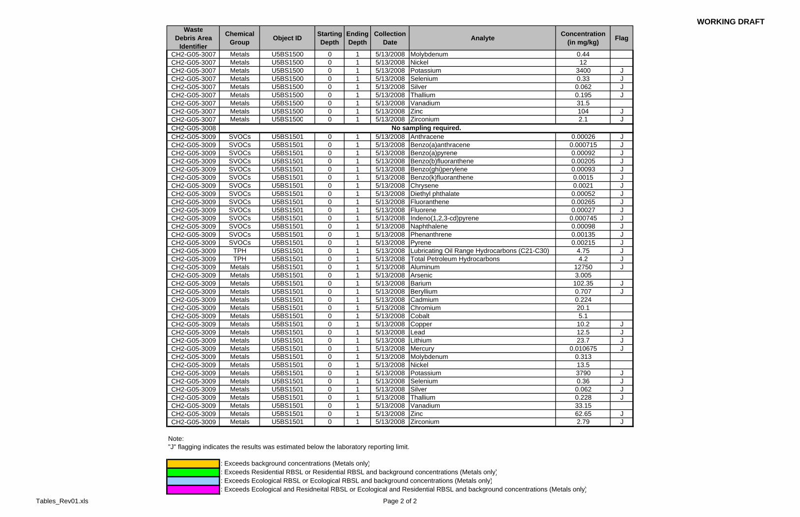
U.5 Sampling Results All sampling location with the exception of debris locations 1001, 3007, and 3009 were contained with the investigation boundaries of one of the 17 RFI sites. The results of current and historic surveys within RFI site investigation boundaries, are presented in the appropriate site reports (Appendices D through T where applicable). Since debris locations 1001, 3007, and 3009 lie outside of site investigative boundaries, the dateable results are presented in this section and in Table 5-1.
A sample collected from debris location 1001 contained detectable concentrations of semi-volatile organic compounds (SVOCs), total petroleum hydrocarbons (TPH), and total metals. Only aluminum was detected above it background concentration (20,000 mg/kg) and its Ecological RBSL (12 mg/kg) at a concentration of 21,000 mg/kg in surficial soil (0-1 feet bgs). The concentrations of aluminum may be consistent with naturally occurring concentrations in the soil in the Santa Susana Formation. All other detectable results were below screening levels. A sample collected from debris location 3007 contained detectable concentrations of SVOCs, TPH, and total metals. All the detectable results were below screening levels. A sample collected from debris location 3009 contained detectable concentrations of SVOCs, TPH, and total metals. All the detectable results were below screening levels. No further action is recommended at debris locations 1001, 3007, or 3009.


WORKING DRAFT U.5 SAMPLING RESULTS
SCO/APPENDIX_U_TEXT_V05.DOC U.5-1


WORKING DRAFT
SCO/APPENDIX_U_TEXT_V05.DOC
Tables


WORKING DRAFTTable U.4-1Group 5 Debris Location EvaluationAppendix U - Waste Debris Survey
Northing EastingCH2-G05-1000 1/31/2008 STL-IV: Three-foot long
punctured metal cylinder.360 265065.608 1785716.271 Not removed Yes 1 Direct Push soil
sample. Soil vapor was not able to be
installed due to shallow bedrock.
Screening Suite
Located in valley south of STL-IV. Adjacent to rock outcrops. Likely only thin soil layer present. Position sample at feature on downslope side.
CH2-G05-1001 2/1/2008 Unaffiliated Area: Rusted 2.5-gallon metal bucket (filled with rainwater) with wire handle.
< 100 265124.191 1783919.226 Not removed Yes 1 Direct PushSV + SS
Screening Suite
Position sample at feature on downslope side.
CH2-G05-1002 2/5/2008 STL-IV: Small soil pile intermixed with asphalt.
< 100 264972.839 1785575.106 Not removed No 0 N/A N/A Pile appears to be < 5 cubic yards (minimum size threshold) and limited to soil and asphalt.
CH2-G05-1004 2/5/2008 Pond Dredge Area: Soil pile intermixed with steel mesh coated with crumbling concrete.
< 100 265736.092 1783937.496 Not removed No 0 N/A N/A Debris area was located within Pond Dredge RFI site. Proposed RFI sampling location PDBS1009 located within approximately 5 feet of debris area; therefore, no additional sampling for this feature was proposed. Note that additional evaluation of debris presence in Pond Dredge site was performed as part of the Pond Dredge RFI evaluation.
CH2-G05-2001 1/31/2008 STL-IV: Several soil piles intermixed with concrete and asphalt.
48,119 265158.887 1785330.035 Not removed Yes 4 Explor. trenching w/grab sampling; possibly only grab sampling at some
locations
Screening Suite
Various soil piles and hummocky areas were present in this area west of STL-IV (west of road).
CH2-G05-2002 2/1/2008 Building 100 Trench: Three large soil piles intermixed with concrete, asphalt and scrap metal.
3,645 266521.891 1784303.392 Removed on April 17-18, 2008
No 0 N/A N/A South Pile: Estimated as 35-40 CY; primarily concrete demolition debris with some soil intermixed; some concrete from a parking lot; small foam pieces intermixed.Central Pile: Estimated as 50 CY; primarily asphalt demolition debris with some soil intermixed; small foam pieces intermixed.North Pile: Estimated as 40-50 CY; smaller pieces of asphalt and concrete; more soil present than at other piles to south.
CH2-G05-2003 2/1/2008 PDU: Soil pile intermixed with concrete, asphalt, and scrap metal.
< 100 266557.369 1784028.328 Not removed Yes 1 4-pt composite sample from debris
surface
Screening Suite
Debris likely resulted from previous building demolition activities in vicinity. Located west of Building 4006 (approx. 50 west of Location PUBX1000D).
CH2-G05-2004 2/4/2008 DOE LF1: Soil pile intermixed with asphalt.
< 100 267729.799 1785855.908 Not removed Yes 1 Explor. trenching w/grab sampling
Screening Suite
Debris appeared to be asphalt at the surface of the pile with soil beneath and was located near existing roadway.
SamplingProposed?
Number ofSamplingLocations
Coordinates1
Comments/Sampling RationaleSampling Analytes
WasteDebris Area
IdentifierDate of
Discovery Status2RFI Site and Description
EstimatedDebris
Area Size (sq. ft.)
Tables_Rev01.xls Page 1 of 3

WORKING DRAFT
Northing EastingSampling
Proposed?
Number ofSamplingLocations
Coordinates1
Comments/Sampling RationaleSampling Analytes
WasteDebris Area
IdentifierDate of
Discovery Status2RFI Site and Description
EstimatedDebris
Area Size (sq. ft.)
CH2-G05-3001 1/31/2008 STL-IV: Soil pile intermixed with 1/8-inch diameter stainless tubing, screws, asphalt, ceramics, steel cable and plastic.
< 100 265654.333 1785353.940 Not removed Yes 1 Explor. trenching w/grab sampling
Screening Suite
Located west of STL-IV along southern side of drainage channel leading from NW (possible DOE LF 3); drainage channel converts to below-grade pipe conveyance at road. Soil debris identified at this location may have been sediment historically removed from the drainage channel.Recommended trenching near west side of pile - more soil present and the stainless steel tube.Note: DOE LF3 is upgradient of area; chemicals of interest for this site consistent with standard screening suite.
CH2-G05-3002 1/31/2008 STL-IV: Soil pile intermixed with concrete, asphalt, and threaded metal rod.
< 100 265704.098 1785362.892 Not removed Yes 1 Explor. trenching w/grab sampling
Screening Suite
Located north of Debris ID 3001 (above), on north side of drainage channel. Likely source of debris was the same as 3001 (channel dredge material). Debris could not be inspected on 4/15/08 due to heavy vegetation present. Note: DOE LF3 is upgradient of area; chemicals of interest for this site consistent with standard screening suite.
CH2-G05-3003 1/31/2008 STL-IV: Soil piles intermixed with concrete, asphalt, and one piece of concrete board.
1000 265046.413 1785409.144 Not removed Yes 2 Explor. trenching w/grab sampling
Screening Suite
Located south of STL-IV along eastern side of road. Consists of various soil piles/hummocks. Proposed E-W oriented exploratory trenching at approximate 20-25 ft spacing.
CH2-G05-3004 1/31/2008 STL-IV: One approximately 10-oz. glass jar filled with white gel inside, brick, and a short length of small diameter stainless steel tubing.
< 100 265141.122 1785683.237 Not removed Yes 1 Direct Push soil sample. Soil vapor was not able to be
installed due to shallow bedrock.
Screening Suite
Container was less than minimum container threshold (1 gallon) and was closed-topped; however, materials were present in container and were unknown. Additionally, there was a piece of stainless steel tubing present. Sampling was proposed to demonstrate no releases occurred.
CH2-G05-3005 2/1/2008 DOE LF3: Large soil piles intermixed with asphalt and concrete.
4,205 266227.139 1785034.199 Not removed Yes 2 Explor. trenching w/grab sampling
Screening Suite
Various low-lying soil piles/hummocky areas were present.
CH2-G05-3007 2/1/2008 Unaffiliated Area: Soil pile intermixed with concrete, asphalt and gravel. Many galvanized pipes of various length and diameter, pieces of concrete and asphalt, and street lamp.
< 100 267057.559 1786215.126 Not removed Yes 1 Direct PushSV + SS
Screening Suite
+ PCBs
Positioned boring between pipe debris area and adjacent street lamp. Included PCBs in soil sampling suite due to street lamp present (high-intensity discharge [HID] light ballasts contain PCBs).
CH2-G05-3008 2/1/2008 DOE LF1: Metal bars, cable, screws, metal stands, electrical insulator, unmarked approximately 125-ml glass bottle (empty). The metal pieces, cable, and insulator appear to be associated with a nearby inactive power pole.
< 100 267005.030 1786209.693 Not removed No 0 N/A N/A Container was less than minimum container threshold (1 gallon) and empty; other debris does not appear to present a hazardous substance release threat. Therefore, no sampling was proposed.
Tables_Rev01.xls Page 2 of 3

WORKING DRAFT
Northing EastingSampling
Proposed?
Number ofSamplingLocations
Coordinates1
Comments/Sampling RationaleSampling Analytes
WasteDebris Area
IdentifierDate of
Discovery Status2RFI Site and Description
EstimatedDebris
Area Size (sq. ft.)
CH2-G05-3009 2/1/2008 Unaffiliated Area: One rusted, square, 2-gallon container with rusted top and filled with soil.
< 100 267082.300 1786244.553 Not removed Yes 1 Direct Push soil sample. Soil vapor was not able to be
installed due to shallow bedrock.
Screening Suite
Located adjacent to rock outcrops, so likely only thin soil layer present.
CH2-G05-3010 2/4/2008 DOE LF1: One approximately 250-ml glass bottle containing gel residue.
< 100 267630.699 1786670.184 Not removed No 0 N/A N/A Container was less than minimum container threshold (1 gallon). Located adjacent on rock outcrops, so very little soil was present. Based on container size (small) and site conditions (atop rock outcrops), no sampling was recommended.
CH2-G05-3011 2/4/2008 RFI Group 6: Soil pile intermixed with asphalt and concrete pushed up against rocky outcrop. Potentially from old foundation.
1,449 267857.981 1786773.647 Not removed No 0 N/A N/A Feature traverses the Groups 5 and 6 boundaries. It appeared that the debris likely resulted from previous former Bldg 064 demolition activities and was agreed to be evaluated with Group 6.
CH2-G05-3012 2/4/2008 SE Drum Yard: 5-gallon metal bucket (appears to contain hardened residual paint), two 1.5-inch diameter solid metal bar and barbed wire in a ditch.
< 100 267160.979 1786823.903 Not removed Yes 1 Direct Push soil sample. Soil vapor was not able to be
installed due to shallow bedrock.
Screening Suite
Container exceeded minimum volume threshold. Current contents were limited to dried, hardened paint residue; lid is in tact; container is rusted by no evidence of damage or holes. Sampling needed to verify no releases occurred. Positioned boring at feature (as near the container location as possible given accessibility issues associated with adjacent-located ditch).
Notes:This table does not include debris areas that were identified in previous waste debris surveys.Photographs of the waste debris areas are attached and are labeled by the Waste Debris Area Identifier provided in this table. 1 Northing and Easting coordinates are in State Plane Zone 5, NAD 27. Coordinates are provided for the approximate center point of identified waste debris features.2 Status of debris areas as of March 2008.ft - footml - milliliteroz - ouncesq ft - square feet
Sampling Notes:Screening Suite: VOCs, SVOCs, TPH, metalsSV = soil vapor (5 and 10 feet bgs unless otherwise noted)SS = shallow soil (0, 5, 10 feet bgs unless otherwise noted)
Tables_Rev01.xls Page 3 of 3

WORKING DRAFTTable U.5-1Debris Sampling Detected Data ResultsAppendix U - Waste Debris Survey
WasteDebris Area
Identifier
Chemical Group Object ID Starting
DepthEnding Depth
Collection Date Analyte Concentration
(in mg/kg) Flag
CH2-G05-1001 SVOCs U5BS1503 0 1 5/13/2008 Benzo(b)fluoranthene 0.00019 JCH2-G05-1001 SVOCs U5BS1503 0 1 5/13/2008 Chrysene 0.00025 JCH2-G05-1001 SVOCs U5BS1503 0 1 5/13/2008 Diethyl phthalate 0.00036 JCH2-G05-1001 SVOCs U5BS1503 0 1 5/13/2008 Naphthalene 0.001 JCH2-G05-1001 TPH U5BS1503 0 1 5/13/2008 Lubricating Oil Range Hydrocarbons (C21-C30) 3.2 JCH2-G05-1001 Metals U5BS1503 0 1 5/13/2008 Aluminum 21600 JCH2-G05-1001 Metals U5BS1503 0 1 5/13/2008 Arsenic 3.175CH2-G05-1001 Metals U5BS1503 0 1 5/13/2008 Barium 99 JCH2-G05-1001 Metals U5BS1503 0 1 5/13/2008 Beryllium 0.997 JCH2-G05-1001 Metals U5BS1503 0 1 5/13/2008 Boron 6.6CH2-G05-1001 Metals U5BS1503 0 1 5/13/2008 Cadmium 0.2425CH2-G05-1001 Metals U5BS1503 0 1 5/13/2008 Chromium 28.75CH2-G05-1001 Metals U5BS1503 0 1 5/13/2008 Cobalt 9.415CH2-G05-1001 Metals U5BS1503 0 1 5/13/2008 Copper 16.55 JCH2-G05-1001 Metals U5BS1503 0 1 5/13/2008 Lead 12.55 JCH2-G05-1001 Metals U5BS1503 0 1 5/13/2008 Lithium 28.65 JCH2-G05-1001 Metals U5BS1503 0 1 5/13/2008 Mercury 0.015 JCH2-G05-1001 Metals U5BS1503 0 1 5/13/2008 Molybdenum 0.16CH2-G05-1001 Metals U5BS1503 0 1 5/13/2008 Nickel 17.55CH2-G05-1001 Metals U5BS1503 0 1 5/13/2008 Potassium 4900 JCH2-G05-1001 Metals U5BS1503 0 1 5/13/2008 Selenium 0.5815 JCH2-G05-1001 Metals U5BS1503 0 1 5/13/2008 Silver 0.044 JCH2-G05-1001 Metals U5BS1503 0 1 5/13/2008 Sodium 198.5CH2-G05-1001 Metals U5BS1503 0 1 5/13/2008 Thallium 0.3045CH2-G05-1001 Metals U5BS1503 0 1 5/13/2008 Vanadium 53.1CH2-G05-1001 Metals U5BS1503 0 1 5/13/2008 Zinc 77.25 JCH2-G05-1001 Metals U5BS1503 0 1 5/13/2008 Zirconium 6.56 JCH2-G05-3007 SVOCs U5BS1500 0 1 5/13/2008 Anthracene 0.00023 JCH2-G05-3007 SVOCs U5BS1500 0 1 5/13/2008 Benzo(a)anthracene 0.00114 JCH2-G05-3007 SVOCs U5BS1500 0 1 5/13/2008 Benzo(a)pyrene 0.00127 JCH2-G05-3007 SVOCs U5BS1500 0 1 5/13/2008 Benzo(b)fluoranthene 0.0029 JCH2-G05-3007 SVOCs U5BS1500 0 1 5/13/2008 Benzo(ghi)perylene 0.001605 JCH2-G05-3007 SVOCs U5BS1500 0 1 5/13/2008 Chrysene 0.0027 JCH2-G05-3007 SVOCs U5BS1500 0 1 5/13/2008 Diethyl phthalate 0.00215 JCH2-G05-3007 SVOCs U5BS1500 0 1 5/13/2008 Fluoranthene 0.00375 JCH2-G05-3007 SVOCs U5BS1500 0 1 5/13/2008 Indeno(1,2,3-cd)pyrene 0.00097 JCH2-G05-3007 SVOCs U5BS1500 0 1 5/13/2008 Phenanthrene 0.001355 JCH2-G05-3007 SVOCs U5BS1500 0 1 5/13/2008 Pyrene 0.00315 JCH2-G05-3007 TPH U5BS1500 0 1 5/13/2008 Lubricating Oil Range Hydrocarbons (C21-C30) 6.2 JCH2-G05-3007 Metals U5BS1500 0 1 5/13/2008 Aluminum 11000 JCH2-G05-3007 Metals U5BS1500 0 1 5/13/2008 Arsenic 2.45CH2-G05-3007 Metals U5BS1500 0 1 5/13/2008 Barium 100 JCH2-G05-3007 Metals U5BS1500 0 1 5/13/2008 Beryllium 0.85CH2-G05-3007 Metals U5BS1500 0 1 5/13/2008 Cadmium 0.28CH2-G05-3007 Metals U5BS1500 0 1 5/13/2008 Chromium 18CH2-G05-3007 Metals U5BS1500 0 1 5/13/2008 Cobalt 5.35CH2-G05-3007 Metals U5BS1500 0 1 5/13/2008 Copper 8.95 JCH2-G05-3007 Metals U5BS1500 0 1 5/13/2008 Lead 14.5 JCH2-G05-3007 Metals U5BS1500 0 1 5/13/2008 Lithium 21.5 JCH2-G05-3007 Metals U5BS1500 0 1 5/13/2008 Mercury 0.019 J
Tables_Rev01.xls Page 1 of 2
WORKING DRAFTWaste
Debris AreaIdentifier
Chemical Group Object ID Starting
DepthEnding Depth
Collection Date Analyte Concentration
(in mg/kg) Flag
CH2-G05-3007 Metals U5BS1500 0 1 5/13/2008 Molybdenum 0.44CH2-G05-3007 Metals U5BS1500 0 1 5/13/2008 Nickel 12CH2-G05-3007 Metals U5BS1500 0 1 5/13/2008 Potassium 3400 JCH2-G05-3007 Metals U5BS1500 0 1 5/13/2008 Selenium 0.33 JCH2-G05-3007 Metals U5BS1500 0 1 5/13/2008 Silver 0.062 JCH2-G05-3007 Metals U5BS1500 0 1 5/13/2008 Thallium 0.195 JCH2-G05-3007 Metals U5BS1500 0 1 5/13/2008 Vanadium 31.5CH2-G05-3007 Metals U5BS1500 0 1 5/13/2008 Zinc 104 JCH2-G05-3007 Metals U5BS1500 0 1 5/13/2008 Zirconium 2.1 JCH2-G05-3008CH2-G05-3009 SVOCs U5BS1501 0 1 5/13/2008 Anthracene 0.00026 JCH2-G05-3009 SVOCs U5BS1501 0 1 5/13/2008 Benzo(a)anthracene 0.000715 JCH2-G05-3009 SVOCs U5BS1501 0 1 5/13/2008 Benzo(a)pyrene 0.00092 JCH2-G05-3009 SVOCs U5BS1501 0 1 5/13/2008 Benzo(b)fluoranthene 0.00205 JCH2-G05-3009 SVOCs U5BS1501 0 1 5/13/2008 Benzo(ghi)perylene 0.00093 JCH2-G05-3009 SVOCs U5BS1501 0 1 5/13/2008 Benzo(k)fluoranthene 0.0015 JCH2-G05-3009 SVOCs U5BS1501 0 1 5/13/2008 Chrysene 0.0021 JCH2-G05-3009 SVOCs U5BS1501 0 1 5/13/2008 Diethyl phthalate 0.00052 JCH2-G05-3009 SVOCs U5BS1501 0 1 5/13/2008 Fluoranthene 0.00265 JCH2-G05-3009 SVOCs U5BS1501 0 1 5/13/2008 Fluorene 0.00027 JCH2-G05-3009 SVOCs U5BS1501 0 1 5/13/2008 Indeno(1,2,3-cd)pyrene 0.000745 JCH2-G05-3009 SVOCs U5BS1501 0 1 5/13/2008 Naphthalene 0.00098 JCH2-G05-3009 SVOCs U5BS1501 0 1 5/13/2008 Phenanthrene 0.00135 JCH2-G05-3009 SVOCs U5BS1501 0 1 5/13/2008 Pyrene 0.00215 JCH2-G05-3009 TPH U5BS1501 0 1 5/13/2008 Lubricating Oil Range Hydrocarbons (C21-C30) 4.75 JCH2-G05-3009 TPH U5BS1501 0 1 5/13/2008 Total Petroleum Hydrocarbons 4.2 JCH2-G05-3009 Metals U5BS1501 0 1 5/13/2008 Aluminum 12750 JCH2-G05-3009 Metals U5BS1501 0 1 5/13/2008 Arsenic 3.005CH2-G05-3009 Metals U5BS1501 0 1 5/13/2008 Barium 102.35 JCH2-G05-3009 Metals U5BS1501 0 1 5/13/2008 Beryllium 0.707 JCH2-G05-3009 Metals U5BS1501 0 1 5/13/2008 Cadmium 0.224CH2-G05-3009 Metals U5BS1501 0 1 5/13/2008 Chromium 20.1CH2-G05-3009 Metals U5BS1501 0 1 5/13/2008 Cobalt 5.1CH2-G05-3009 Metals U5BS1501 0 1 5/13/2008 Copper 10.2 JCH2-G05-3009 Metals U5BS1501 0 1 5/13/2008 Lead 12.5 JCH2-G05-3009 Metals U5BS1501 0 1 5/13/2008 Lithium 23.7 JCH2-G05-3009 Metals U5BS1501 0 1 5/13/2008 Mercury 0.010675 JCH2-G05-3009 Metals U5BS1501 0 1 5/13/2008 Molybdenum 0.313CH2-G05-3009 Metals U5BS1501 0 1 5/13/2008 Nickel 13.5CH2-G05-3009 Metals U5BS1501 0 1 5/13/2008 Potassium 3790 JCH2-G05-3009 Metals U5BS1501 0 1 5/13/2008 Selenium 0.36 JCH2-G05-3009 Metals U5BS1501 0 1 5/13/2008 Silver 0.062 JCH2-G05-3009 Metals U5BS1501 0 1 5/13/2008 Thallium 0.228 JCH2-G05-3009 Metals U5BS1501 0 1 5/13/2008 Vanadium 33.15CH2-G05-3009 Metals U5BS1501 0 1 5/13/2008 Zinc 62.65 JCH2-G05-3009 Metals U5BS1501 0 1 5/13/2008 Zirconium 2.79 J
Note:"J" flagging indicates the results was estimated below the laboratory reporting limit.
: Exceeds background concentrations (Metals only): Exceeds Residential RBSL or Residential RBSL and background concentrations (Metals only): Exceeds Ecological RBSL or Ecological RBSL and background concentrations (Metals only): Exceeds Ecological and Residneital RBSL or Ecological and Residential RBSL and background concentrations (Metals only)
No sampling required.
Tables_Rev01.xls Page 2 of 2

WORKING DRAFT
SCO/APPENDIX_U_TEXT_V05.DOC
Figures


SANTA SUSANA FIELD LABORATORYIFigureU.3-1
B R A N D E I S - B A R D I N I N S T I T U T E
R U N K L EC A N Y O N
P R O P E R T Y
G ST
11 ST
H STJ ST
SKYLINE DR
G ST
L ST
10 ST
17ST
DELTA RD
E ST
G ST
F ST
EST
TEST
AREA RD
F ST
BST
24 ST
12TH ST
G ST
20 ST
24 ST
10ST
8 ST
10 ST
23 ST
22 ST
24 ST
22 ST
RFIGroup
5
RFIGroup
6
RFIGroup
9
RFIGroup7
RFIGroup
4
RFIGroup
3
RFIGroup
8
RFIGroup
7
BorrowPit
4024
4055
4056
40134023
4020
4009
4487
4483
4462
4486
4626 4057
40264356
4006
4641
4011
4038
4003
4027
4005
30032001
3011
3005
1000
B29
HWMF
DOE LF 2
DOE LF 1
BoeingLF
DOELF 3
Building56 Landfil
FSDF
ESADA
CocaPLF
Compound A
STPPond
Delta
R-2 PondsSTL-IV
CDFFPond
Dredge
RIHLEEL
B100Metals Clarifier ECL
Silvernale
SE DrumSNAP
HMSA
PDU
SPA
RMHF
NCYSRE OCY
2003
1002
1001
2004
3007 3008
30013002
3010
3004
3009 3012
1 inch equals 300 feetFeet
0 300 600
Debris Sampling Locations - Group 5
Document: \\..MapFiles\RFI_5\RFI_Report\RFIGrp5_Debris_BL.mxd
Basemap Legend
Building - ExistingBuilding - RemovedBuilding - NotYet Determined
StreamsPond
Administrative AreaRFI Group Boundary
Property Boundary
RFI Site Boundary
Road - AsphaltRoads - DirtRocks
Surface Drainage DivideWaste Debris Area*
Note: * This figure displays the last four digits of the waste debris identifier listed in Table F-1
WORKING DRAFTDate: October 8, 2008

WORKING DRAFT
SCO/APPENDIX_U_TEXT_V05.DOC
Attachments