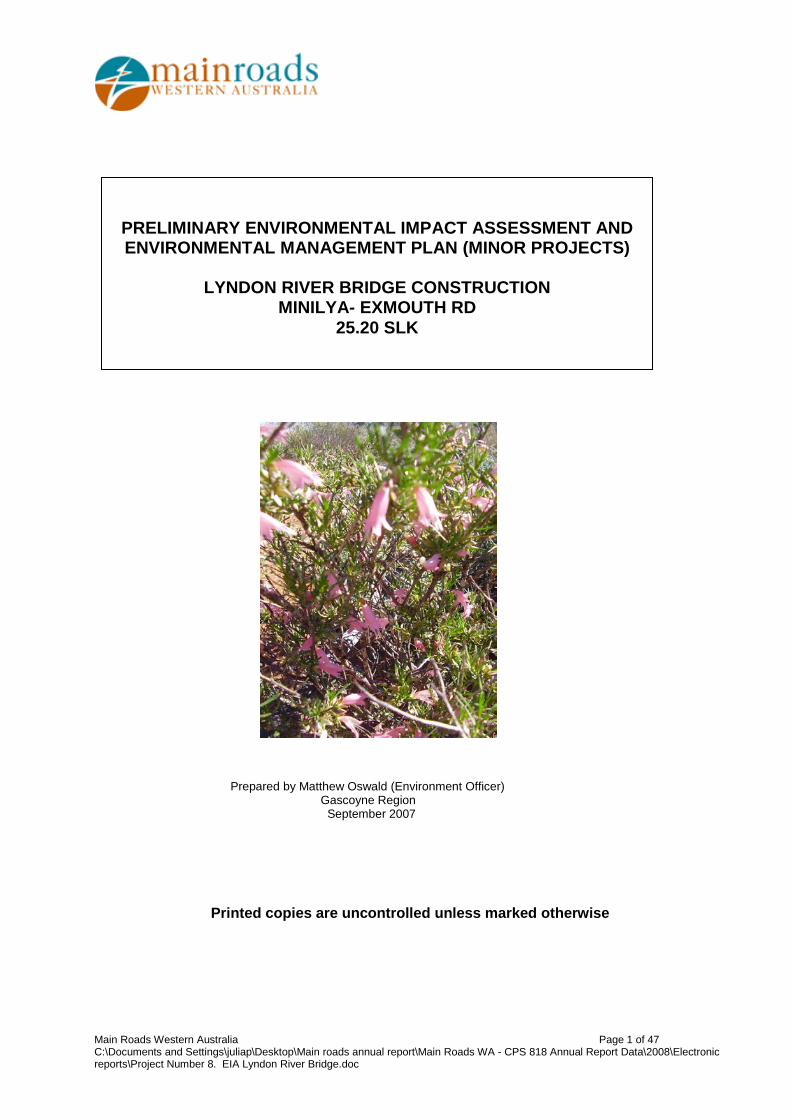
PRELIMINARY ENVIRONMENTAL IMPACT … Prepared by Matthew Oswald (Environment Officer) Gascoyne...
47
Prepared by Matthew Oswald (Environment Officer) Gascoyne Region September 2007 Printed copies are uncontrolled unless marked otherwise PRELIMINARY ENVIRONMENTAL IMPACT ASSESSMENT AND ENVIRONMENTAL MANAGEMENT PLAN (MINOR PROJECTS) LYNDON RIVER BRIDGE CONSTRUCTION MINILYA- EXMOUTH RD 25.20 SLK Main Roads Western Australia Page 1 of 47 C:\Documents and Settings\juliap\Desktop\Main roads annual report\Main Roads WA - CPS 818 Annual Report Data\2008\Electronic reports\Project Number 8. EIA Lyndon River Bridge.doc
Transcript of PRELIMINARY ENVIRONMENTAL IMPACT … Prepared by Matthew Oswald (Environment Officer) Gascoyne...
Prepared by Matthew Oswald (Environment Officer) Gascoyne Region September 2007
Printed copies are uncontrolled unless marked otherwise
PRELIMINARY ENVIRONMENTAL IMPACT ASSESSMENT AND ENVIRONMENTAL MANAGEMENT PLAN (MINOR PROJECTS)
LYNDON RIVER BRIDGE CONSTRUCTION
MINILYA- EXMOUTH RD 25.20 SLK
Main Roads Western Australia Page 1 of 47 C:\Documents and Settings\juliap\Desktop\Main roads annual report\Main Roads WA - CPS 818 Annual Report Data\2008\Electronic reports\Project Number 8. EIA Lyndon River Bridge.doc

CONTENTS
1 INTRODUCTION ....................................................................................................... 3 2 DESCRIPTION OF THE PROJECT .......................................................................... 3
2.1 PROJECT LOCATION .................................................................................................. 4 3 METHODOLOGY ...................................................................................................... 7
3.1 PRELIMINARY DESKTOP STUDY ............................................................................ 7 4 COMMONWEALTH REFERRAL .............................................................................. 8
4.1 SITE INVESTIGATION ............................................................................................ 8 5 EXISTING ENVIRONMENT ....................................................................................... 8
5.1 DESCRIPTION ...................................................................................................... 8 5.2 SITE INVESTIGATION ............................................................................................ 9
6 CLEARING OF NATIVE VEGETATION .................................................................. 10 6.1 ASSESSMENT AGAINST CLEARING PRINCIPLES .................................................... 10 6.2 ENVIRONMENTALLY SENSITIVE AREA (ESA) ........................................................ 10
7 ASSESSMENT OF ASPECTS AND IMPACTS ....................................................... 11 8 DECISION TO REFER ............................................................................................ 12 9 STAKEHOLDER CONSULTATION ........................................................................ 12 10 ENVIRONMENTAL MANAGEMENT PLAN ........................................................ 13
10.1 COMMUNICATION PLAN ...................................................................................... 13 11 MONITORING ..................................................................................................... 14 12 CONTINGENCY MEASURES ............................................................................. 14 13 AUDITING ........................................................................................................... 14 14 REFERENCES .................................................................................................... 14 APPENDIX A LOW IMPACT ENVIRONMENTAL SCREENING CHECKLIST ............... 17 APPENDIX B DEC’S THREATENED FLORA AND FAUNA DATABASE SEARCHES 19 APPENDIX C AUSTRALIAN HERITAGE PLACES INVENTORY, HERITAGE COUNCIL OF WESTERN AUSTRALIA AND THE MUNICIPAL HERITAGE INVENTORY DATABASE SEARCHES .................................................................................................................... 25 APPENDIX D DEPARTMENT OF INDIGENOUS AFFAIRS DATABASE SEARCH ...... 28 APPENDIX E WAPC’S ACID SULFATE SOILS SELF ASSESSMENT FORM ............. 30 APPENDIX F DEPARTMENT OF THE ENVIRONMENT AND HERITAGE DATABASE SEARCH ......................................................................................................................... 32 APPENDIX G SITE PHOTOS ........................................................................................ 40 APPENDIX H VEGETATION CLEARING ASSESSMENT REPORT ............................. 44
Main Roads Western Australia Page 2 of 47 C:\Documents and Settings\juliap\Desktop\Main roads annual report\Main Roads WA - CPS 818 Annual Report Data\2008\Electronic reports\Project Number 8. EIA Lyndon River Bridge.doc

PRELIMINARY ENVIRONMENTAL IMPACT ASSESSMENT AND ENVIRONMENTAL
MANAGEMENT PLAN (MINOR PROJECTS)
LYNDON RIVER BRIDGE
1 INTRODUCTION
The Minilya-Exmouth Road (H048) connects the towns of Coral Bay and Exmouth with North West Coastal Highway (NWCH) at Minilya to the South and via Burkett Rd to the East. The road primarily services pastoral, fishing and tourist industries as well as community access. Whilst historically this road functioned as a link for the pastoral industry and defence facilities at Exmouth, over the past 10 years, there has been a significant increase in tourist traffic utilising the Minilya-Exmouth Road to visit tourist facilities within this area. These include the Ningaloo Reef and its unique marine life, spectacular coastlines, Cape Range National Park, Yardie Creek Gorge and the popular holiday location of Coral Bay. Significant tourism, residential and fishing developments are now underway or proposed in the short term to increase the facilities available. This includes the construction of the Exmouth Marina Stage 2 development, a 4.5 star hotel at Exmouth, and numerous tourist accommodation developments at Coral Bay. The Lyndon River crossing on the Minilya – Exmouth Road is a low-level floodway, which is subject to regular closure in wet years. This link on the Minilya - Exmouth Road has been impassable due to water over the road for 90 days since 1992 giving an average of 7 road closure days per year. The most significant closure periods being for 25 days in 1999 and 32 days in 2000. While an alternative route exists, via Burkett Road, the long periods of closure have caused concern for the local communities and the tourist operators. The alternative route is not weather proof due to low-level floodways. The need to replace the floodway with a bridge has been recognised for sometime now. Evangelisti & Associates conducted a waterways analysis in 1995 that confirmed the need for a bridge. In 1995 the bridge construction project was planned for 2001/2002 and by 2000 the requested funds for the project had been moved to 2005/2006. Funding is now requested in 2008/2009. The works will occur within the Shire of Exmouth. As per Main Roads’ Environmental Assessment and Approval process, the Low Impact Environmental Screening Checklist has been completed for the proposal, refer to Appendix A. As the proposed works involves the clearing of native vegetation the preparation of a project specific Preliminary Environmental Impact Assessment (PEIA) and Environmental Management Plan (EMP) are required. This report fulfils this requirement. 2 DESCRIPTION OF THE PROJECT
The objective of this project is to reduce the flood impact on Service Delivery on this route due to the road being overtopped by the Lyndon River and the subsequent closures that follow this. After the bridge installation, it is anticipated that road closures on the Minilya – Exmouth Road will reduce to 1 day per year on average, and thereby improving the Level of Service to commercial traffic, tourists, pastoral stations, mines, Defence establishments and communities located in the region. The project proposal is to construct a 90m long two-lane bridge (5 x 18m spans), 400m-relief floodway and 1.36km of road approaches to replace the existing low level crossing. Main Roads Western Australia Page 3 of 47 C:\Documents and Settings\juliap\Desktop\Main roads annual report\Main Roads WA - CPS 818 Annual Report Data\2008\Electronic reports\Project Number 8. EIA Lyndon River Bridge.doc

In order to construct this bridge approximately 45 000 cubic meters of fill material is required. This material will be sourced from either Section 19/256 or Section 19/257. 2.1 Project Location The location and boundaries of the study area is shown in Figures 1 and 2 below.
Main Roads Western Australia Page 4 of 47 C:\Documents and Settings\juliap\Desktop\Main roads annual report\Main Roads WA - CPS 818 Annual Report Data\2008\Electronic reports\Project Number 8. EIA Lyndon River Bridge.doc

175 SLK
D
C B
A
Figure 1 – Project Location Map
Project Location
Main Roads Western Australia Page 5 of 47 C:\Documents and Settings\juliap\Desktop\Main roads annual report\Main Roads WA - CPS 818 Annual Report Data\2008\Electronic reports\Project Number 8. EIA Lyndon River Bridge.doc

Figure 2 –Map showing location of proposed bridge and Section 19’s (Material Extraction Sites)
Minilya-Exmouth Road
Lyndon River
25 SLK
24 SLK
26 SLK
Warroora East Road Rest Area
Section 19/256
Section 19/257
Bridge Construction
Main Roads Western Australia Page 6 of 47 C:\Documents and Settings\juliap\Desktop\Main roads annual report\Main Roads WA - CPS 818 Annual Report Data\2008\Electronic reports\Project Number 8. EIA Lyndon River Bridge.doc

3 METHODOLOGY
3.1 Preliminary Desktop Study A preliminary assessment of the project area and its potential constraints was undertaken by reviewing a number of government agency managed databases (and consulting where necessary).
3.1.1 Wetlands The locations of wetlands within the project area was determined using the Commonwealth Department of the Environmental and Heritage (DEH) mapping tool and Department of Environment and Conservation (DEC) Geographic Data Atlas mapping tool (http://www.deh.gov.au/water/wetlands/database/index.html). 3.1.2 Threatened Flora, Fauna and Communities, Conservation Reserves and ESAs DEC’s database was searched for known populations of threatened flora, fauna and Threatened Ecological Communities (TECs) and conservation reserves (http://portal.environment.wa.gov.au/portal/page?_pageid=53,2569721&_dad=portal&_schema=PORTAL), refer to Appendix B. 3.1.3 Air Quality The need for a local air quality assessment was determined using the criteria outlined in the MRWA environmental guideline, Air Quality. 3.1.4 Heritage Non-indigenous heritage was examined utilising the Australian Heritage Places Inventory (http://www.heritage.gov.au), Heritage Council of Western Australia (http://register.heritage.wa.gov.au/) and the Shire of Exmouth’s Municipal Heritage Inventory, refer to Appendix C. 3.1.5 Aboriginal Heritage A Search of the Department of Indigenous Affairs’ (DIA’s) (http://www.dia.wa.gov.au/Heritage/SitesSurveysSearch.aspx) database was undertaken to determine whether the project area contains any sites of Aboriginal heritage, refer to Appendix D. 3.1.6 Sensitive Water Resources The Commonwealth Department of the Environmental and Heritage (DEH) mapping tool and Department of Environment and Conservation (DEC) Geographic Data Atlas mapping tool was used to determine whether the project area supported, or was adjacent to, any significant lakes, rivers or wetlands or proclaimed areas. 3.1.7 Contaminated Sites The reserve has been in Main Roads continual control; therefore no further work will be required. 3.1.8 Acid Sulfate Soils The Western Australian Planning Commission’s (WAPC’c) acid sulfate soils maps were reviewed and the self assessment done (http://www.wapc.wa.gov.au/Publications/213.aspx) to determine what level of risk the project area is exposed to, refer to Appendix E.
44
D C
B
Main Roads Western Australia Page 7 of 47 C:\Documents and Settings\juliap\Desktop\Main roads annual report\Main Roads WA - CPS 818 Annual Report Data\2008\Electronic reports\Project Number 8. EIA Lyndon River Bridge.doc
3.1.9 Weeds An onsite investigation of the project areas was undertaken to determine whether there are any known populations of declared plants or significant weeds in or adjacent to the project area. 3.1.10 Dieback Project receives <400 mm of rain so determined not to be an issue. 4 COMMONWEALTH REFERRAL
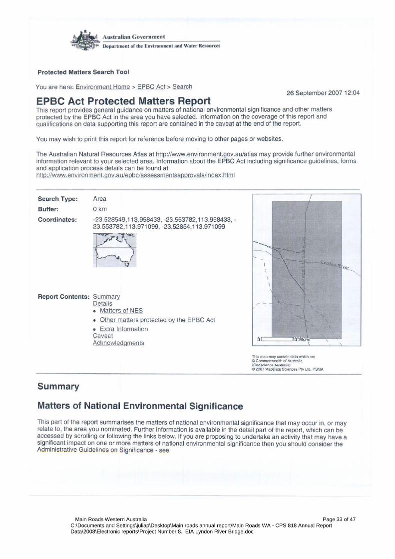
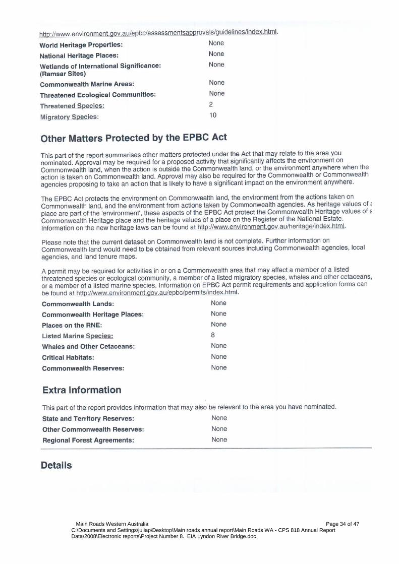
The decision whether to refer the project to the Commonwealth’s DEH was based upon whether the project would impact upon matters of national significance, e.g. World Heritage properties, protected wetlands and migratory species, Commonwealth marine areas, threatened species or communities or nuclear actions (refer to the Commonwealth webpage www.deh.gov.au/epbc/assessmentsapprovals/index.html for further information and the search tool page at http://www.deh.gov.au/erin/ert/epbc/imap/map.html), refer to Appendix F. 4.1 Site Investigation A site visit was carried out by Anil Phal (Materials Manager) and Matthew Oswald (Graduate Environment Officer) on 26/07/07 to examine the general features of the area. The broad vegetation types in the vicinity of the project area were identified. Other issues that were considered included topography, the impacts on creek lines, property access and the potential for noise and vibration impacts (dilapidation). Site photos were taken and are included in Appendix G. 5 EXISTING ENVIRONMENT
5.1 Description The proposed works are within Vegetation Association 345 which is described as Mosaic: Shrublands; Acacia sclerosperma & A. victoriae patchy scrub, barren / Succulent steppe; saltbush & bluebush. According to the Native Vegetation Association Data (DEC & DAF) this vegetation association is well represented in the region with 100% remaining. The condition of the vegetation is best described as good, but somewhat degraded due to the grazing of cattle and goats. The following lists of species were observed at the proposed material pits: Acacia ancistrocarpa Acacia bivenosa Acacia gregorii Acacia inaequilatera Acacia linophylla Acacia murryana Acacia sclerosperma Acacia subtesserogona Acacia tetragonopylla Acacia victoriae Alectryon oleifolius Aristida contorta Baeckea cryptandroides Brackycome ciliocarpa Brachysema aphyllum Main Roads Western Australia Page 8 of 47 C:\Documents and Settings\juliap\Desktop\Main roads annual report\Main Roads WA - CPS 818 Annual Report Data\2008\Electronic reports\Project Number 8. EIA Lyndon River Bridge.doc

Cenchrus ciliaris Cephalipterum drummondii Clerodendrum floribundum Corchorus walcotti Cullen martinii Eremophila latrobei Eremophila platycalyx Eremophila pterocarpa Eucalyptus vitrix Exocarpus aphyllus Halosarcia doleiformis Hakea preissii Heterodendrum oleaefolium Maireana tomentosa Muehlenbeckia cunninghamii Plectrachne schinzii Solanum lasiophyllum Stylobasium spathulatum Thryptomene baeckeacea Tribulus platypterus Triodia basedowii The clearing of mature trees will be avoided where possible. There is no declared rare or threatened flora within the works area. A weed identified within the site was Buffel Grass (Cenchrus ciliaris) 5.2 Site Investigation Site Investigation Description/Comment Total area (ha) of native vegetation to be cleared
Bridge Construction = 2 (ha) Section 19/256 = 4.5 (ha) Section 19/257 = 4.5 (ha)
Total area (ha) of other vegetation, including regrowth, landscape areas, to be cleared
0
Weeds present Buffel Grass Drainage areas or wetlands present None Adjacent land uses Pastoral
Main Roads Western Australia Page 9 of 47 C:\Documents and Settings\juliap\Desktop\Main roads annual report\Main Roads WA - CPS 818 Annual Report Data\2008\Electronic reports\Project Number 8. EIA Lyndon River Bridge.doc

6 CLEARING OF NATIVE VEGETATION
Native vegetation describes all indigenous aquatic and terrestrial vegetation (living or dead). The term does not include vegetation that was intentionally sown, planted or propagated unless it was required under a statutory condition. Apart from activities that are exempt under the clearing regulations, such as clearing vegetation that is less than 10 years old for maintenance, typically all Main Roads clearing will be undertaken using its Statewide Project Purpose Permit. 6.1 Assessment against Clearing Principles In assessing whether the project is likely to have a significant impact on the environment, the project has been assessed against the DEC’s 10 principles of clearing, refer to Appendix H. The project will not be at variance with the DEC’s 10 clearing principles. 6.2 Environmentally Sensitive Area (ESA) Clearing within an Environmentally Sensitive Area (ESA)
Yes/No
Comments
Does the area to be cleared occur within an ESA where the vegetation is in good or better condition?
No
Main Roads Western Australia Page 10 of 47 C:\Documents and Settings\juliap\Desktop\Main roads annual report\Main Roads WA - CPS 818 Annual Report Data\2008\Electronic reports\Project Number 8. EIA Lyndon River Bridge.doc

7 ASSESSMENT OF ASPECTS AND IMPACTS
Table 1: Aspects and Impacts – Material Pit Extension – 175 SLK – Minilya Exmouth Road Aspect Evaluation of Potential Impacts Air quality Not relevant to the proposed works. Local air quality assessment is not required for the
project area since: • residential and other sensitive receptors are not within 200 meters of the road centre.
Dust Likely to be a minor issue during earthworks. No sensitive receptors near the work sites.
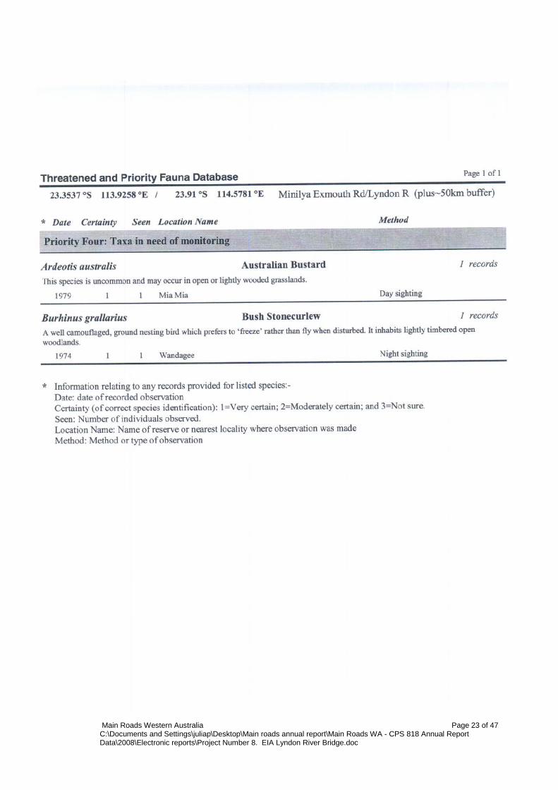
Fauna No significant fauna issues associated with any of the proposed works. DEC website search resulted in the, Australian Bustard and Bush Stonecurlew as possibly occurring within the project area. These species were not observed within the project area. Given the small area of clearing and the mobile nature of the species, no impacts are expected. No Matters of National Environmental Significance as protected under EPBC Act (1999) will be impacted. The Mulgara was listed as possibly occurring within the area, but given the highly mobile nature of the species no impacts are expected.
Vegetation – clearing
• Approximately 11 hectares of native vegetation will be cleared for the construction of the bridge and the sourcing of materials.
• The project will involve temporary clearing and therefore will require a revegetation plan.
• The condition of the native vegetation to be cleared is good. • The native vegetation to be cleared is well represented regionally • The native vegetation to be cleared does not occur within an ESA. • The native vegetation to be cleared will be done so using the purpose permit.
Vegetation – TECs/DRF
There were no search results from the DEC for threatened flora or declared rare flora within the project location. There were several priority species that resulted from the WA Herberium search, but none of those species are expected to be impacted upon, based upon the field flora survey. The search under Matters of National Environmental Significance as protected under EPBC Act (1999) did result in Pityrodia augustensis (Mt Augustus Foxglove) for the project; however based upon site visit and conformation from the DEC FloraBase Database, this species will not be impacted. Know specimens have been collected and recorded further in the interior of the region and its distribution does not occur so close to the coast.
Vegetation – weeds
The only weed species observed throughout the project areas was Cenchrus ciliaris (Buffel Grass) which is now widespread throughout the northern regions.
Vegetation – dieback
Not an issue given the project area receives less than 400 mm of average annual rainfall and is above the 26˚ parallel.
Reserves / Conservation areas
There are no conservation areas or reserves adjacent to the project area.
Heritage (non-indigenous)
A search of the Australian Heritage Places Inventory, Heritage Council of Western Australia and the Shire of Carnarvon’s Municipal Heritage Inventory on-line databases has indicated that there are no heritage significance listed sites present in the currently proposed works areas.
Aboriginal heritage
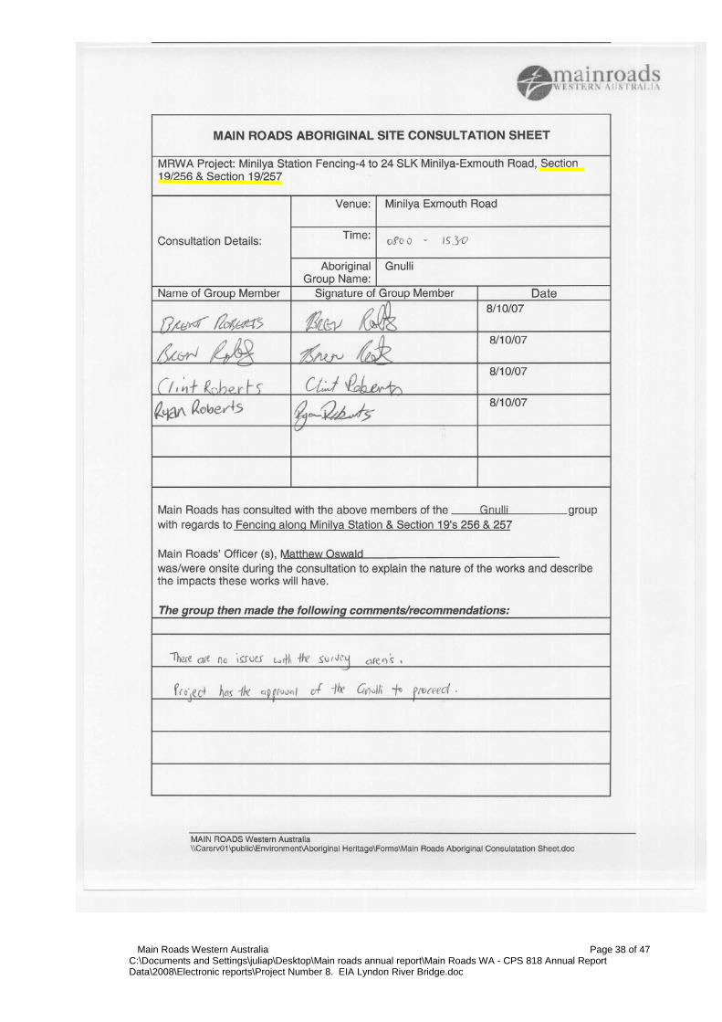
A search of DIA database identified no known sites of Aboriginal heritage significance within the vicinity of the project area.
Surface water/drainage
On-site visit and DEH search confirmed that the proposed works will not interrupt any natural drainage and surface run-off patterns.
Wetlands There are no wetlands within the vicinity of the project areas.
Main Roads Western Australia Page 11 of 47 C:\Documents and Settings\juliap\Desktop\Main roads annual report\Main Roads WA - CPS 818 Annual Report Data\2008\Electronic reports\Project Number 8. EIA Lyndon River Bridge.doc

Table 1: Aspects and Impacts – Material Pit Extension – 175 SLK – Minilya Exmouth Road Aspect Evaluation of Potential Impacts Groundwater No dewatering nor drainage modifications are required, hence no change to groundwater
level or quality.
Noise and vibration
There are no sensitive local receivers near the project areas.
Visual amenity The proposed works will result in minor and short-term visual impacts during construction. Suitable site completion treatments, including rehabilitation, will result in an improvement in local visual amenity.
Public safety and risk
Provided traffic management and signage to Main Roads standards is employed, none of the proposed works present any significant hazards to public safety.
Hazardous substances
Not relevant to the proposed works.
Contamination Given the relatively superficial nature of the required earthworks, there appears to be no risk of any significant contamination issues.
Salinity Given the nature and scale of the project the impact is not relevant.
Acid Sulfate Soils
The WAPC’s self-assessment (Planning Bulletin 64) indicates that no further soil investigation is required for the project.
Statutory Land Use Planning
Main Roads Gascoyne Region has material areas registered with the Department of Industry and Resources as a Section 19. Theses areas are therefore vested with MRWA.
8 DECISION TO REFER
Given the scale of the project, the low significance of its impacts to the surrounding environment and the environmental management measures proposed, the project does not require referral to the WA Environmental Protection Authority or the Commonwealth Department of the Environment and Heritage. 9 STAKEHOLDER CONSULTATION
Name Agency Date Comments Bridgitte Long (Flora) DEC 27/09/07 Kellie Mantle (Fauna) DEC 28/09/07
Main Roads Western Australia Page 12 of 47 C:\Documents and Settings\juliap\Desktop\Main roads annual report\Main Roads WA - CPS 818 Annual Report Data\2008\Electronic reports\Project Number 8. EIA Lyndon River Bridge.doc

10 ENVIRONMENTAL MANAGEMENT PLAN
This section of the report (the EMP) has been developed for the project area following the completion of the above sections. The main aim of this EMP is to provide a management plan to assist in minimising the environmental impacts of the activities associated with the proposed works and identify who is responsible for the implementation of the management strategies. This EMP will only address the actions already listed as well as any site-specific issues that were identified during the PEIA. The project specific management measures identified within this EMP are in addition to the standard specifications used for Category 2 projects. The environmental management measures/conditions in Main Road’s Specifications 203, 204, 301, 302 and 304 are still to be followed where applicable. The areas that require special management will be addressed in terms of:
• the timing of the various management actions; • the topic (e.g. vegetation); • the objectives for each area; • the actions that are necessary to minimise the impact; • the responsible party for implementing the action; and • whether the action arose from external advice or is a Main Roads requirement.
10.1 Communication Plan Environmental issues specific to the project will be communicated as: Method Frequency Participants Reference Record Project Site
Induction Prior to Work All personnel and subcontractors
EMP and Contractor Environmental Policy
Induction Meeting
Authority Consultation
Department of Environment and Conservation
As required Main Roads’ Project Manager and Contractor Project Manager
- Minutes of meeting
10.1.1 External Communication and Complaints A complaints register shall be maintained by the contractor. All complaints received shall be forwarded to the Main Roads’ Project Manager for action. Serious complaints shall be investigated within 24 hours of the complaint being received.
Main Roads Western Australia Page 13 of 47 C:\Documents and Settings\juliap\Desktop\Main roads annual report\Main Roads WA - CPS 818 Annual Report Data\2008\Electronic reports\Project Number 8. EIA Lyndon River Bridge.doc
11 MONITORING
After project completion, revegetated areas will be inspected every six months for the first two years to ensure weed spread or establishment has not occurred and to measure the effectiveness of revegetation works. Monitoring of the weeds identified in the project area will comprise the use of input criteria listed below. Criterion Target After three
months After one year
After three years
Mean weed foliage cover (%).
<20 <20 <20 <20
12 CONTINGENCY MEASURES
Given the scale and nature of the project, no contingency measures are identified as the inherent environmental risks are small. 13 AUDITING
Given the scale and nature of the project, there is no requirement for auditing the implementation of the EMP as the environmental risks are small. 14 REFERENCES
Mitchell, A. A. and Wilcox, D. G. (1994) Arid Shrubland Plants of Western Australia, Second and Enlarged Edition. University of Western Australia Press, Nedlands, Western Australia. ISBN 1-874460-22-X.
Main Roads Western Australia Page 14 of 47 C:\Documents and Settings\juliap\Desktop\Main roads annual report\Main Roads WA - CPS 818 Annual Report Data\2008\Electronic reports\Project Number 8. EIA Lyndon River Bridge.doc

ENVIRONMENTAL MANAGEMENT PLAN Timing Topic Objective Action Responsible Party Advice All phases of Construction
Vegetation Clearing - Record-keeping
All projects should maintain the required records relating to clearing native vegetation under the purpose permit.
Clearing: • a copy of the PEIA & EMP (Minor projects) for small
projects; • a map showing the location where the clearing occurred,
recorded in an ESRI Shapefile; • the size of the area cleared (in hectares); and • the dates on which the clearing was done.
Project Manager DEC
Revegetation and rehabilitation of areas: • a copy of each Revegetation Plan; • a map showing the location of any area revegetated and
rehabilitated recorded in an ESRI Shapefile; • a description of the revegetation and rehabilitation
activities undertaken; and • the size of the area revegetated and rehabilitated (in
hectares).
Project Manager DEC
Pre-Construction Vegetation - Clearing
Ensure that the overall objectives of the alignment and construction works are compatible with maintaining and, where possible, enhancing the biological integrity of the surrounding environment and minimising vegetation loss and degradation; and Ensure the retention of as many habitat trees, shrubs and vegetated corridors for fauna as possible, particularly where associated with riparian zones.
Selection of designs/locations that minimise adverse impacts on the biological environment.
Project Manager Main Roads
Construction works to be undertaken in summer to reduce the potential for soil erosion and drainage line siltation due to vegetation removal and heavy rains.
Project Manager Main Roads
Control/spray weeds species within the project area prior to construction to limit the amount of propagative material that may be spread during disturbance.
Contractor Main Roads
Any stockpiled vegetation from clearing works shall not be burnt. This vegetation shall be used during any rehabilitation works and either chipped or replaced according to the EMP.
Contractor Main Roads
Construction
Noise, Vibration and Dust
Ensure that the construction of the proposal does not become a nuisance to the public.
Access to private property and appropriate traffic management measures should be planned and implemented prior to the construction of works.
Contractor Main Roads
Works associated with the construction of the development should not prevent public access along the adjacent reserve. Public access should be maintained along the reserve at all times.
Contractor Main Roads
Any complaints regarding dust will be attended to as soon as possible.
Contractor/Project Manager
Main Roads
Where it is found that trucks leaving the site are carrying excessive material onto sealed surfaces, these areas will be swept to reduce dust generation and maintain traffic safety.
Contractor Main Roads
Main Roads Western Australia Page 15 of 47 C:\Documents and Settings\juliap\Desktop\Main roads annual report\Main Roads WA - CPS 818 Annual Report Data\2008\Electronic reports\Project Number 8. EIA Lyndon River Bridge.doc
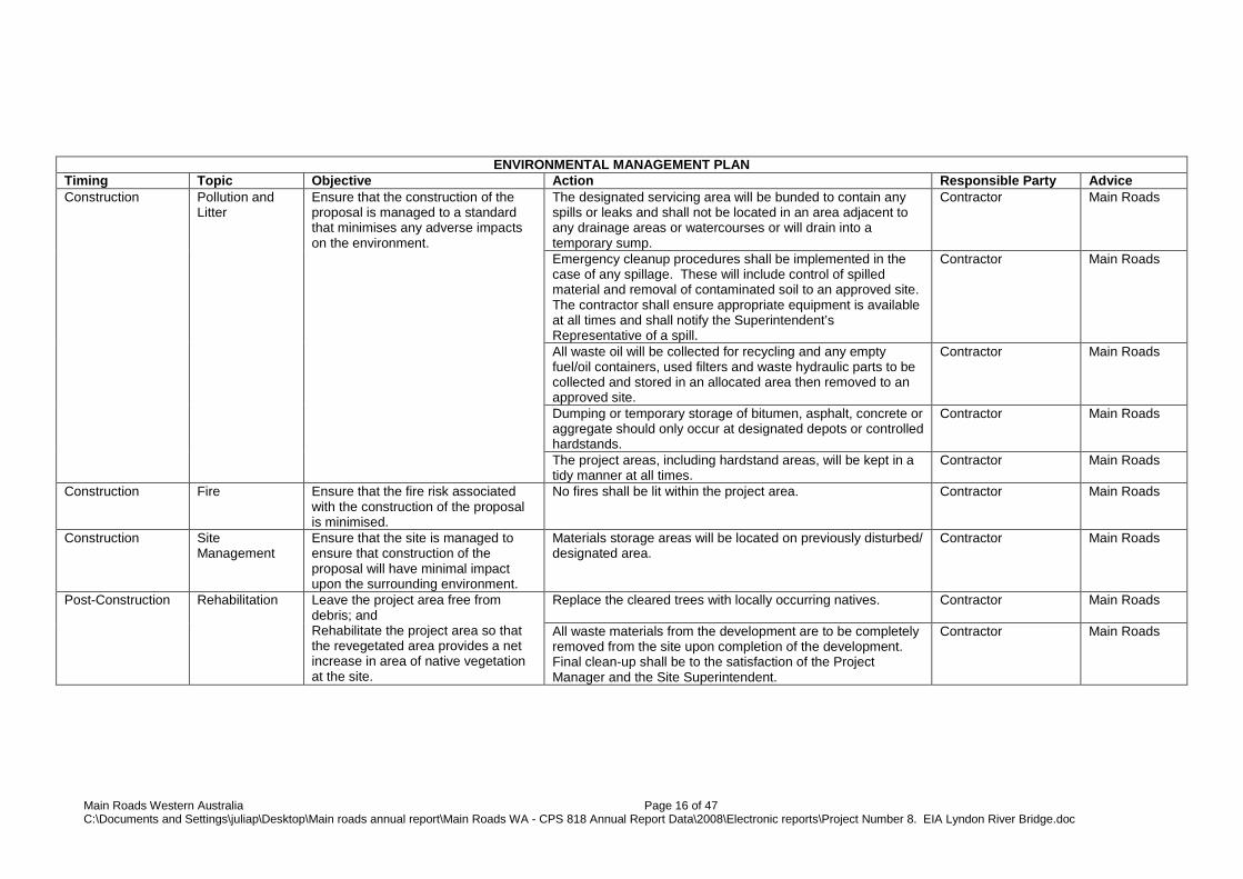
ENVIRONMENTAL MANAGEMENT PLAN Timing Topic Objective Action Responsible Party Advice Construction Pollution and
Litter Ensure that the construction of the proposal is managed to a standard that minimises any adverse impacts on the environment.
The designated servicing area will be bunded to contain any spills or leaks and shall not be located in an area adjacent to any drainage areas or watercourses or will drain into a temporary sump.
Contractor Main Roads
Emergency cleanup procedures shall be implemented in the case of any spillage. These will include control of spilled material and removal of contaminated soil to an approved site. The contractor shall ensure appropriate equipment is available at all times and shall notify the Superintendent’s Representative of a spill.
Contractor Main Roads
All waste oil will be collected for recycling and any empty fuel/oil containers, used filters and waste hydraulic parts to be collected and stored in an allocated area then removed to an approved site.
Contractor Main Roads
Dumping or temporary storage of bitumen, asphalt, concrete or aggregate should only occur at designated depots or controlled hardstands.
Contractor Main Roads
The project areas, including hardstand areas, will be kept in a tidy manner at all times.
Contractor Main Roads
Construction
Fire Ensure that the fire risk associated with the construction of the proposal is minimised.
No fires shall be lit within the project area. Contractor Main Roads
Construction
Site Management
Ensure that the site is managed to ensure that construction of the proposal will have minimal impact upon the surrounding environment.
Materials storage areas will be located on previously disturbed/ designated area.
Contractor Main Roads
Post-Construction Rehabilitation Leave the project area free from debris; and Rehabilitate the project area so that the revegetated area provides a net increase in area of native vegetation at the site.
Replace the cleared trees with locally occurring natives. Contractor
Main Roads
All waste materials from the development are to be completely removed from the site upon completion of the development. Final clean-up shall be to the satisfaction of the Project Manager and the Site Superintendent.
Contractor
Main Roads
Main Roads Western Australia Page 16 of 47 C:\Documents and Settings\juliap\Desktop\Main roads annual report\Main Roads WA - CPS 818 Annual Report Data\2008\Electronic reports\Project Number 8. EIA Lyndon River Bridge.doc

Appendix A
Low Impact Environmental Screening Checklist
Main Roads Western Australia Page 17 of 47 C:\Documents and Settings\juliap\Desktop\Main roads annual report\Main Roads WA - CPS 818 Annual Report Data\2008\Electronic reports\Project Number 8. EIA Lyndon River Bridge.doc

Main Roads Western Australia Page 18 of 47 C:\Documents and Settings\juliap\Desktop\Main roads annual report\Main Roads WA - CPS 818 Annual Report Data\2008\Electronic reports\Project Number 8. EIA Lyndon River Bridge.doc

Appendix B
DEC’s Threatened Flora and Fauna Database Searches
Main Roads Western Australia Page 19 of 47 C:\Documents and Settings\juliap\Desktop\Main roads annual report\Main Roads WA - CPS 818 Annual Report Data\2008\Electronic reports\Project Number 8. EIA Lyndon River Bridge.doc

Main Roads Western Australia Page 20 of 47 C:\Documents and Settings\juliap\Desktop\Main roads annual report\Main Roads WA - CPS 818 Annual Report Data\2008\Electronic reports\Project Number 8. EIA Lyndon River Bridge.doc

Main Roads Western Australia Page 21 of 47 C:\Documents and Settings\juliap\Desktop\Main roads annual report\Main Roads WA - CPS 818 Annual Report Data\2008\Electronic reports\Project Number 8. EIA Lyndon River Bridge.doc

Main Roads Western Australia Page 22 of 47 C:\Documents and Settings\juliap\Desktop\Main roads annual report\Main Roads WA - CPS 818 Annual Report Data\2008\Electronic reports\Project Number 8. EIA Lyndon River Bridge.doc
Main Roads Western Australia Page 23 of 47 C:\Documents and Settings\juliap\Desktop\Main roads annual report\Main Roads WA - CPS 818 Annual Report Data\2008\Electronic reports\Project Number 8. EIA Lyndon River Bridge.doc

Main Roads Western Australia Page 24 of 47 C:\Documents and Settings\juliap\Desktop\Main roads annual report\Main Roads WA - CPS 818 Annual Report Data\2008\Electronic reports\Project Number 8. EIA Lyndon River Bridge.doc

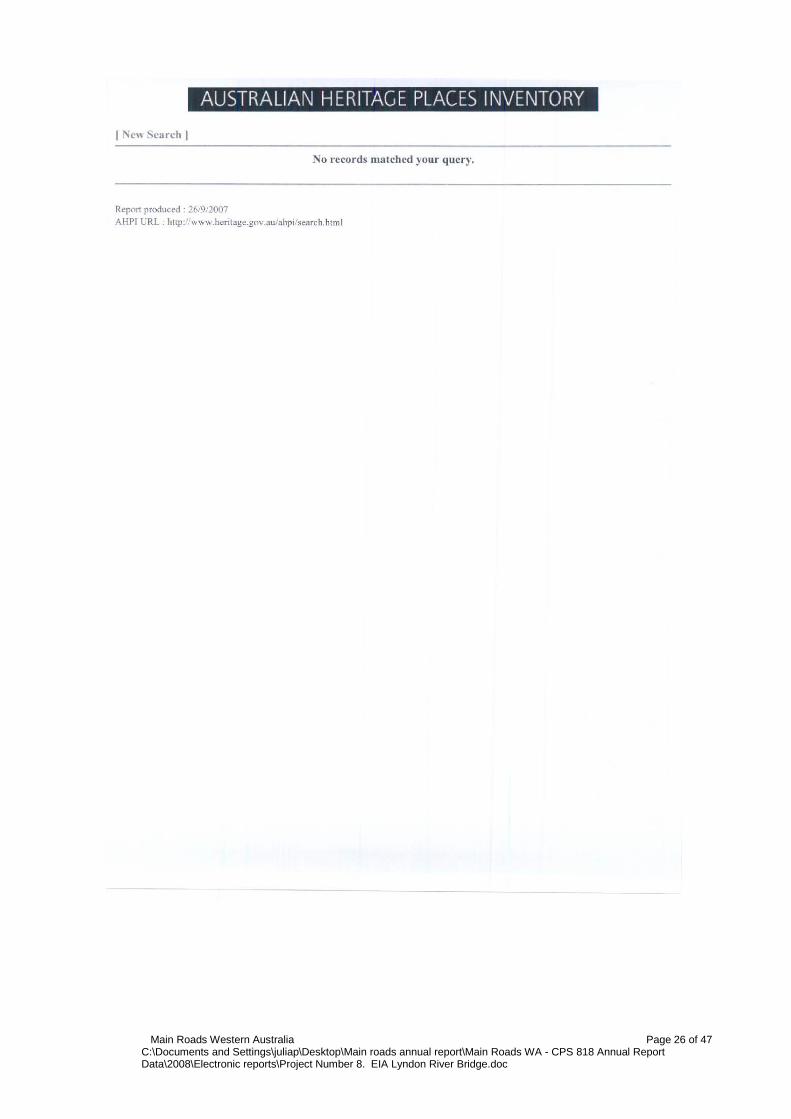
Appendix C
Australian Heritage Places Inventory, Heritage Council of Western Australia and the Municipal Heritage Inventory
Database Searches
Main Roads Western Australia Page 25 of 47 C:\Documents and Settings\juliap\Desktop\Main roads annual report\Main Roads WA - CPS 818 Annual Report Data\2008\Electronic reports\Project Number 8. EIA Lyndon River Bridge.doc
Main Roads Western Australia Page 26 of 47 C:\Documents and Settings\juliap\Desktop\Main roads annual report\Main Roads WA - CPS 818 Annual Report Data\2008\Electronic reports\Project Number 8. EIA Lyndon River Bridge.doc

Main Roads Western Australia Page 27 of 47 C:\Documents and Settings\juliap\Desktop\Main roads annual report\Main Roads WA - CPS 818 Annual Report Data\2008\Electronic reports\Project Number 8. EIA Lyndon River Bridge.doc

Appendix D
Department of Indigenous Affairs Database Search
Main Roads Western Australia Page 28 of 47 C:\Documents and Settings\juliap\Desktop\Main roads annual report\Main Roads WA - CPS 818 Annual Report Data\2008\Electronic reports\Project Number 8. EIA Lyndon River Bridge.doc

Main Roads Western Australia Page 29 of 47 C:\Documents and Settings\juliap\Desktop\Main roads annual report\Main Roads WA - CPS 818 Annual Report Data\2008\Electronic reports\Project Number 8. EIA Lyndon River Bridge.doc

Appendix E
WAPC’s Acid Sulfate Soils Self Assessment Form
Main Roads Western Australia Page 30 of 47 C:\Documents and Settings\juliap\Desktop\Main roads annual report\Main Roads WA - CPS 818 Annual Report Data\2008\Electronic reports\Project Number 8. EIA Lyndon River Bridge.doc

Main Roads Western Australia Page 31 of 47 C:\Documents and Settings\juliap\Desktop\Main roads annual report\Main Roads WA - CPS 818 Annual Report Data\2008\Electronic reports\Project Number 8. EIA Lyndon River Bridge.doc
Appendix F
Department of the Environment and Heritage Database Search & Heritage Survey
Main Roads Western Australia Page 32 of 47 C:\Documents and Settings\juliap\Desktop\Main roads annual report\Main Roads WA - CPS 818 Annual Report Data\2008\Electronic reports\Project Number 8. EIA Lyndon River Bridge.doc
Main Roads Western Australia Page 33 of 47 C:\Documents and Settings\juliap\Desktop\Main roads annual report\Main Roads WA - CPS 818 Annual Report Data\2008\Electronic reports\Project Number 8. EIA Lyndon River Bridge.doc
Main Roads Western Australia Page 34 of 47 C:\Documents and Settings\juliap\Desktop\Main roads annual report\Main Roads WA - CPS 818 Annual Report Data\2008\Electronic reports\Project Number 8. EIA Lyndon River Bridge.doc

Main Roads Western Australia Page 35 of 47 C:\Documents and Settings\juliap\Desktop\Main roads annual report\Main Roads WA - CPS 818 Annual Report Data\2008\Electronic reports\Project Number 8. EIA Lyndon River Bridge.doc

Main Roads Western Australia Page 36 of 47 C:\Documents and Settings\juliap\Desktop\Main roads annual report\Main Roads WA - CPS 818 Annual Report Data\2008\Electronic reports\Project Number 8. EIA Lyndon River Bridge.doc

Main Roads Western Australia Page 37 of 47 C:\Documents and Settings\juliap\Desktop\Main roads annual report\Main Roads WA - CPS 818 Annual Report Data\2008\Electronic reports\Project Number 8. EIA Lyndon River Bridge.doc
Main Roads Western Australia Page 38 of 47 C:\Documents and Settings\juliap\Desktop\Main roads annual report\Main Roads WA - CPS 818 Annual Report Data\2008\Electronic reports\Project Number 8. EIA Lyndon River Bridge.doc

Main Roads Western Australia Page 39 of 47 C:\Documents and Settings\juliap\Desktop\Main roads annual report\Main Roads WA - CPS 818 Annual Report Data\2008\Electronic reports\Project Number 8. EIA Lyndon River Bridge.doc

Appendix G
Site Photos
Main Roads Western Australia Page 40 of 47 C:\Documents and Settings\juliap\Desktop\Main roads annual report\Main Roads WA - CPS 818 Annual Report Data\2008\Electronic reports\Project Number 8. EIA Lyndon River Bridge.doc
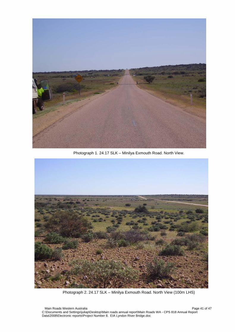
Photograph 1. 24.17 SLK – Minilya Exmouth Road. North View.
Photograph 2. 24.17 SLK – Minilya Exmouth Road. North View (100m LHS)
Main Roads Western Australia Page 41 of 47 C:\Documents and Settings\juliap\Desktop\Main roads annual report\Main Roads WA - CPS 818 Annual Report Data\2008\Electronic reports\Project Number 8. EIA Lyndon River Bridge.doc

Photograph 3. 24.17 SLK – Minilya Exmouth Road. North View (100m RHS)
Photograph 4. 26.26 SLK – Minilya Exmouth Road. LHS. South View.
Main Roads Western Australia Page 42 of 47 C:\Documents and Settings\juliap\Desktop\Main roads annual report\Main Roads WA - CPS 818 Annual Report Data\2008\Electronic reports\Project Number 8. EIA Lyndon River Bridge.doc
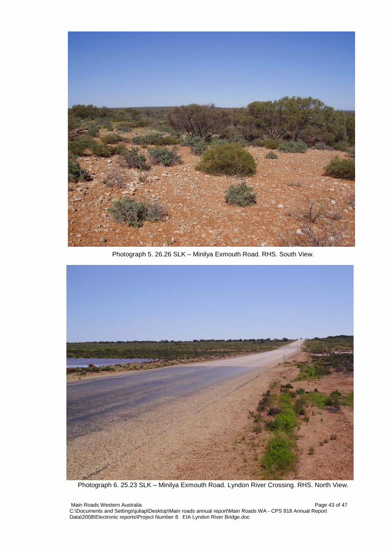
Photograph 5. 26.26 SLK – Minilya Exmouth Road. RHS. South View.
Photograph 6. 25.23 SLK – Minilya Exmouth Road. Lyndon River Crossing. RHS. North View. Main Roads Western Australia Page 43 of 47 C:\Documents and Settings\juliap\Desktop\Main roads annual report\Main Roads WA - CPS 818 Annual Report Data\2008\Electronic reports\Project Number 8. EIA Lyndon River Bridge.doc

Appendix H
Vegetation Clearing Assessment Report
Main Roads Western Australia Page 44 of 47 C:\Documents and Settings\juliap\Desktop\Main roads annual report\Main Roads WA - CPS 818 Annual Report Data\2008\Electronic reports\Project Number 8. EIA Lyndon River Bridge.doc

MRWA Vegetation Clearing Assessment Report This report has been prepared to assist MRWA in addressing condition 7 “Assessment of Clearing Impacts” under Clearing Permit CPS 818/3. For guidance on how to complete the form, refer to DEC completed reports (active permits) at http://203.20.251.100/cps_reports/. AREA UNDER ASSESSMENT DETAILS Proponent details Proponent’s name: MRWA Gascoyne Region Contacts: Name: Matthew Oswald Phone: (08) 9941 0713 Fax: (08) 9941 0701 Email: [email protected]
Property details Property: Lyndon River Bridge – Minilya Exmouth Road 25.20 SLK ,Section 19/256 & Section 19/257 Colloquial name:
Area under assessment Clearing Area (ha) No. Trees Method of Clearing For the purpose of:
Construction & Site Plan Attached
~11 0 Mechanical Road Building Materials
� Yes � No
Avoidance/Minimise clearing How have the clearing impacts been minimised? Areas for extension have been carefully selected based upon preliminary material investigation.
BACKGROUND The proposed works are within Vegetation Association 345 which is described as Mosaic: Shrublands; Acacia sclerosperma & A. victoriae patchy scrub, barren / Succulent steppe; saltbush & bluebush. According to the Native Vegetation Association Data (DEC & DAF) this vegetation association is well represented in the region with 100% remaining. The condition of the vegetation is best described as good, but somewhat degraded due to the grazing of cattle and goats. Site Visit Undertaken � Yes � No
Fauna / Flora Survey Undertaken � Yes � No
Site Report Attached � Yes � No
Fauna / Flora Survey Report Attached � Yes � No
Site Photos Attached � Yes � No
Other Relevant References Attached � Yes � No
Vegetation Complex Clearing Description Vegetation Condition Comment 98
Mechanical Good
ASSESSMENT OF APPLICATION AGAINST CLEARING PRINCIPLES
(a) Native vegetation should not be cleared if it comprises a high level of biological diversity. Comments Proposal is not at variance to this Principle The area under application predominantly consists of grasses and a few scattered shrubs. The condition of the vegetation is
somewhat degraded and does not represent a high level of biodiversity. This proposal is therefore not at variance with this Principle.
Methodology Site visit (26/07/07) GIS Databases: - Interim Biogeographic Regionalisation of Australia – 23/09/07.
(b) Native vegetation should not be cleared if it comprises the whole or a part of, or is necessary for the maintenance of, a significant habitat for fauna indigenous to Western Australia.
Comments Proposal is not at variance to this Principle The area under application predominantly consists of grasses and a few scattered shrubs. The condition of the vegetation is
somewhat degraded and does not represent a significant habitat for fauna. The DEC search resulted in Australian Bustard and Bush Stonecurlew as possibly occurring within the project area. Due to the relatively small clearing area necessary for
Main Roads Western Australia Page 45 of 47 C:\Documents and Settings\juliap\Desktop\Main roads annual report\Main Roads WA - CPS 818 Annual Report Data\2008\Electronic reports\Project Number 8. EIA Lyndon River Bridge.doc
the Bridge construction and material extraction, impact to fauna species will be marginal. This proposal is therefore not at variance with this Principle.
Methodology Site visit (26/07/07) DEC advice – 28/09/07
(c) Native vegetation should not be cleared if it includes, or is necessary for the continued
existence of, rare flora. Comments Proposal is not likely to be at variance to this Principle DEC Threatened Flora Database search was conducted and no rare flora was known to exist within the project areas. Also
based upon a site visit, no rare flora species were identified. It is therefore unlikely that the vegetation under application is necessary for significant flora. This proposal is therefore not at variance with this Principle.
Methodology Site visit (24/07/07) GIS Databases: - Declared Rare and Priority Flora list – DEC 28/09/07
(d) Native vegetation should not be cleared if it comprises the whole or a part of, or is necessary
for the maintenance of a threatened ecological community. Comments Proposal is not at variance to this Principle There are no records of Threatened Ecological Communities (TEC’S) for the area under application. This proposal is
therefore not at variance with this Principle.
Methodology GIS Databases: - Threatened Ecological Communities – DEC 25/09/07
(e) Native vegetation should not be cleared if it is significant as a remnant of native vegetation in
an area that has been extensively cleared. Comments Proposal is not at variance to this Principle The project area occurs within Vegetation Association 662 of which 100% of the pre-European extent remains. This
vegetation association is therefore of ‘least concern’ for biodiversity conservation. This proposal is therefore not at variance with this Principle.
Methodology GIS Databases: - Interim Biogeographic Reginalisation of Australia – 25/09/07 - Pre-European Vegetaion
(f) Native vegetation should not be cleared if it is growing in, or in association with, an
environment associated with a watercourse or wetland. Comments Proposal is likely not be at variance to this Principle The area under application does not consist of a wetland, however clearing will occur within a watercourse in order to
construct the bridge. Riparian vegetation associated with the water course consists mainly of Samphire (Haloscarcia doleiformis) which is wide spread throughout the project area and its distribution is associate more with the surrounding saline soils than the watercourse itself. The Lydon river is an intermittant watercourse that does not hold water all year round, and normally only runs after heavy downfalls associated with cyclonic activity. Clearing will be kept to a minimal in order to reduce any environemntal impacts. Clearing width will be no more than 50 meters on either side of the existing seal. This proposal is therefore likely to not be at variance with this Principle.
Methodology Site visit (26/07/07) DEC’s web based Geographic Data Atlas mapping tool GIS Databaes: - Hydrography, linear - Hydrographic Catchments – Catchments
(g) Native vegetation should not be cleared if the clearing of the vegetation is likely to cause
appreciable land degradation. Comments Proposal is not at variance to this Principle The area under application consists of clayey soils. Given the small clearing footprint and that the vegetation consists mainly
of grasses and a few scattered shrubs (with 100% of pre-European vegetation remaining), the proposal is not at variance with this principle.
Methodology Site visit (26/07/07) GIS Databases:
Main Roads Western Australia Page 46 of 47 C:\Documents and Settings\juliap\Desktop\Main roads annual report\Main Roads WA - CPS 818 Annual Report Data\2008\Electronic reports\Project Number 8. EIA Lyndon River Bridge.doc

- Acid Sulphate Soil risk map
(h) Native vegetation should not be cleared if the clearing of the vegetation is likely to have an
impact on the environmental values of any adjacent or nearby conservation area. Comments Proposal is not at variance to this Principle The proposed project is not near any conservation areas and therefore is not at variance with this Principle.
Methodology Site Visit (26/07/07)
DEC’s web based Geographic Data Atlas mapping tool
(i) Native vegetation should not be cleared if the clearing of the vegetation is likely to cause deterioration in the quality of surface or underground water.
Comments Proposal is not at variance to this Principle
The area under application only receives approximately 300mm of annual rainfall. Due to the low rainfall rate, this proposal will not cause deterioration in the quality of surface or under ground water and therefore not a variance to this Principle.
Methodology Site Visit (26/07/07) DEC’s web based Geographic Data Atlas mapping tool Rainfall, Mean Annual – BOM 25/09/07
(j) Native vegetation should not be cleared if clearing the vegetation is likely to cause, or
exacerbate, the incidence or intensity of flooding. Comments Proposal is not at variance to this Principle
The soil consists of clayey soils. In addition the area under application only receives approximately 300mm of annual rainfall. Due to the nature of the soil and the low rainfall rate, these proposals will not exacerbate the incidence of flooding and therefore is not at variance with this Principle.
Methodology Site Visit (26/07/07) Rainfall, Mean Annual – BOM 25/09/07
Planning instrument, Native Title, RIWI Act Licence, EP Act Licence, Works Approval, Previous
EPA decision or other matter. Comments
There is no further requirement for a RIWI Act Licence, Works Approval or EP Act Licence for the area under application.
Methodology
SUBMISSIONS If required have submissions been requested and addressed Submission Requested from Request Sent (Date) Submission Received
(Date) Issues Raised / Comments Made
ASSESSOR’S RECOMMENDATIONS
OFFICER PREPARING REPORT Matthew Oswald (Graduate Environment Officer) Gascoyne Regional Office MRWA Phone 08 9941 0713 Date 02/09/07
Main Roads Western Australia Page 47 of 47 C:\Documents and Settings\juliap\Desktop\Main roads annual report\Main Roads WA - CPS 818 Annual Report Data\2008\Electronic reports\Project Number 8. EIA Lyndon River Bridge.doc