PRELIMINARY ENVIRONMENTAL IMPACT ASSESSMENT Gibb … · • Major cut to fill earthworks to improve...
54
Prepared by: Main Roads Western Australia Kimberley Region Wodehouse Street Derby 6728 Date: December 2007 PRELIMINARY ENVIRONMENTAL IMPACT ASSESSMENT Gibb River Road Road Train Improvements Stage 2 Pentecost Range SLK 573.21 – 577.00 MAIN ROADS Western Australia 1 of 54
Transcript of PRELIMINARY ENVIRONMENTAL IMPACT ASSESSMENT Gibb … · • Major cut to fill earthworks to improve...

Prepared by: Main Roads Western Australia Kimberley Region Wodehouse Street Derby 6728 Date: December 2007
PRELIMINARY ENVIRONMENTAL IMPACT
ASSESSMENT Gibb River Road
Road Train Improvements Stage 2 Pentecost Range SLK 573.21 – 577.00
MAIN ROADS Western Australia 1 of 54

Table of Contents
1. INTRODUCTION ................................................................................................................... 3
2. BACKGROUND .................................................................................................................... 3
3. DESCRIPTION OF THE PROJECT ...................................................................................... 4 3.1 METHODOLOGY ............................................................................................................... 8
3.1.1 Preliminary Desktop Study ...................................................................................... 8 3.1.2 Site Investigation ..................................................................................................... 9
4. EXISTING ENVIRONMENT .................................................................................................. 9
5. CLEARING OF NATIVE VEGETATION .............................................................................. 10
6. ASSESSMENT OF ASPECTS AND IMPACTS .................................................................. 14
7. DECISION TO REFER ........................................................................................................ 15
8. ENVIRONMENTAL MANAGEMENT PLAN ........................................................................ 16
9. REFERENCES .................................................................................................................... 22
APPENDIX A LOW IMPACT SCREENING CHECKLIST ......................................................... 23
APPENDIX B WETLANDS AND WATERCOURSES WITHIN THE PROJECT AREA ............. 25
APPENDIX C DEPARTMENT OF ENVIRONMENT AND CONSERVATION THREATENED FLORA AND FAUNA DATABASE SEARCHES ........................................................................ 27
APPENDIX D AUSTRALIAN HERITAGE PLACES INVENTORY, HERITAGE COUNCIL OF WESTERN AUSTRALIA AND THE MUNICIPAL HERITAGE INVENTORY DATABASE SEARCHES ............................................................................................................................... 32
APPENDIX E DEPARTMENT OF INDIGENOUS AFFAIRS DATABASE SEARCH ................. 35
APPENDIX F DEPARTMENT OF WATER SENSITIVE WATER RESOURCES DATABASE SEARCH .................................................................................................................................... 38
APPENDIX G WAPC’S ACID SULFATE SOILS MAPPING ..................................................... 41
APPENDIX H DEPARTMENT OF AGRICULTURE AND FOOD ADVICE ON DECLARED WEEDS ...................................................................................................................................... 44
APPENDIX I DEPARTMENT OF ENVIRONMENT AND WATER RESOURCES ...................... 46
MAIN ROADS Western Australia 2 of 54

GIBB RIVER ROAD ROAD TRAIN IMPROVEMENTS STAGE 2 PENTECOST RANGE SLK 573.21 – 577.00
PRELIMINARY ENVIRONMENTAL IMPACT ASSESSMENT
1. INTRODUCTION
Main Roads Kimberley region proposes to upgrade the Pentecost Range section of the Gibb River Road (SLK 573.21 – 577.00). The proposed works will involve:
• Improvement of formation and drainage, improvement to minor horizontal alignments (SLK 573.21 – 575.30);
• Improvement of vertical alignment, the road profile will be raised over minor run-off gullies and small culverts are to be installed (SLK 575.30 – 576.00); and,
• Major cut to fill earthworks to improve both vertical and horizontal alignment (SLK 576.00 – 577.00).
The proposed works are located within the Shire of Wyndham-East Kimberley.
2. BACKGROUND
The Gibb River Road runs approximately 650km between Derby and intersects with the Great Northern Highway between Wyndham and Kununurra. The original Gibb River Road, predominantly built of gravel, provided road user access to remote Kimberley stations and served as an access point for vehicles travelling to Kalumburu on the Kalumburu Road. Of late, the Gibb River Road has developed into one of the Kimberley’s premier wilderness tourist attractions. During the dry season the average daily traffic (ADT) increases to approximately 140 vehicles per day, with approximately 95% being light vehicles, some with caravans and trailers. The gravel road has a derestricted speed zone and flooding can cause washouts and other road hazards on parts of the road. Upgrading of the road will enhance road user accessibility and provide significant improvement to traffic safety. As per Main Roads’ Environmental Assessment and Approval process, the Low Impact Environmental Screening Checklist has been completed for the proposal, refer Appendix A. As the project will involve ground disturbance and clearing of native vegetation the project will require further environmental investigations such as the preparation of a project specific Preliminary Environmental Impact Assessment. This report fulfils this requirement.
MAIN ROADS Western Australia 3 of 54

3. DESCRIPTION OF THE PROJECT
Pentecost Range road realignment SLK 573.21 to 577.00, Gibb River Road The scope of works for this section involves a road realignment of approximately 3.8 km, cleared to a width of minimum 15 metres up to a maximum of 100 meters. The section is broken in to three subsections: SLK 573.21 to 575.00, clearing width 20 m from existing alignment – The scope of works for this section involves improvement of minor horizontal alignments, improved formation and drainage. This section is to be constructed to an unsealed standard with a finished pavement width of 8 m.
SLK 575.00 to 576.00, clearing width 15 m from existing alignment – The scope of works for the above section will involve improvement to the vertical alignment. The road profile will be raised over minor run off gullies and small culverts will be installed. No deviation from the existing alignment will occur – the existing road profile will be widened and pavement will be finished to bitumen seal.
SLK 576.00 to 577.00, clearing width 50 m – 100 m from existing alignment – Major cut to fill earthworks shall be used to improve both vertical and horizontal alignment. This will involve substantial widening and lifting of the embankment and constructing pavement for bitumen seal. This section of road will require the installation of two medium size culverts to improve drainage.
Borrow and gravel is to be sourced from existing pits and insitu cut from the batter works. Rock for protection of the road formation will be extracted from a quarry area. Figures 1 and 2 show the location and boundaries of the proposed works. The areas required to be cleared are as follows: SLK 573.21 to 575.00, 1.79 km x 20m 3.58 ha SLK 575.00 to 576.00, 1 km x 15m 1.5 ha
SLK 576.00 to 577.00, 1 km x 50 m – 100 m 10 ha (as an upper limit)
Rock extraction from quarry 10 ha
At the most, a total of approximately 25 ha will be permanently cleared for construction works, which are expected to commence June 2008. The rock quarry will be fenced off and signage installed.
MAIN ROADS Western Australia 4 of 54

Figure 1…Location and boundaries of the proposed works along Pentecost Range, Gibb River Road (SLK 573.21 – 577.00)
Clearing = 15 ha
MAIN ROADS Western Australia 5 of 54

Figure 2…Pentecost Range Materials Investigation Area
1. E0378581 N8254317 2. E0378763 N8254827 3. E0378962 N8255018 4. E0379473 N8254338 5. E0378814 N8253953
5
4
3
2
1
SLK 573.21
SLK 577.00
N Clearing = 10 ha
MAIN ROADS Western Australia 6 of 54

Image 1…Typical vegetation that will be cleared for the proposal
Image 2…Typical vegetation that will be cleared for the proposal
MAIN ROADS Western Australia 7 of 54

3.1 Methodology
3.1.1 Preliminary Desktop Study
An assessment of the project area and its potential constraints was undertaken by reviewing a number of government agency managed databases. Wetlands The locations of wetlands and ESAs within the project area were determined using the Department of Environment and Conservation (DEC) Environmentally Sensitive Area (ESA) mapping tool (http://portal.environment.wa.gov.au/portal/page?_pageid=53,2569721&_dad=portal&_schema=PORTAL), refer Appendix B, and by seeking advice from the regional DoW officer, refer Appendix F. Threatened Flora, Fauna and Communities, Conservation Reserves and ESAs DEC database was searched for known populations of threatened flora, fauna and Threatened Ecological Communities (TECs) and conservation reserves, refer Appendix C. Air Quality The need for a local air quality assessment was determined using the criteria outlined in the MRWA environmental guideline, Air Quality. Heritage Non-indigenous heritage was examined utilising the Australian Heritage Places Inventory (http://www.heritage.gov.au), Heritage Council of Western Australia (http://register.heritage.wa.gov.au/) and the Broome Shire Municipal Heritage Inventory refer Appendix D. Aboriginal Heritage A Search of the Department of Indigenous Affairs’ (DIA’s) (http://www.dia.wa.gov.au/Heritage/SitesSurveysSearch.aspx) database was undertaken to determine whether the project area contains any sites of Aboriginal heritage, refer Appendix E. Sensitive Water Resources The Water Information Officer of the Department of Water’s (DoW’s) regional office was consulted on sensitive water resources (including Public Drinking Water Source Areas) to determine whether the project area supported, or was adjacent to, any significant lakes, rivers or wetlands or proclaimed areas, refer Appendix F. Contaminated Sites There are no known previous land use activities on or adjacent to the project area that have the potential to create contamination, eg petrol station. Acid Sulfate Soils The Western Australian Planning Commission’s acid sulfate soils maps were reviewed and the self assessment done (http://www.wapc.wa.gov.au/Publications/213.aspx) to determine what level of risk the project area is exposed to, refer Appendix G.
MAIN ROADS Western Australia 8 of 54
Weeds Consultation was undertaken with the Department of Agriculture and Food to determine whether there are any known populations of declared plants or significant weeds in or adjacent to the project area, refer Appendix H. Dieback Dieback is not an issue in the area where proposed works are expected to be undertaken. Commonwealth Referral The decision to refer the project to the Commonwealths Department of Environment and Heritage (DEH) was based upon whether the project was going to impact upon matters of national significance, eg World Heritage properties, protected wetlands and migratory species, Commonwealth marine areas, threatened species or communities or nuclear actions (refer to the Commonwealth webpage www.deh.gov.au/epbc/assessmentsapprovals/index.html for further information and the search tool page at http://www.deh.gov.au/erin/ert/epbc/imap/map.html), refer Appendix I. 3.1.2 Site Investigation
A site visit was carried out by Project Manager Neville Walters and Environment Officer Marni Baetge on 30/11/07 to examine the general features of the area. The broad vegetation types in the vicinity of the project areas were identified. Other issues that were considered included topography, the impacts on creek lines, property access and the potential for noise and vibration impacts (dilapidation). 4. EXISTING ENVIRONMENT
The proposed works along the Gibb River Road are located in the Central Kimberley Region within the Fitzgerald Botanical District. The Fitzgerald Botanical District is broadly characterised by the occurrence of ‘curly spinifex’ (Plectrachne pungens) communities which cover 70% of the area (Beard, 1979). Vegetation data that has been developed between DEC and the Development Assessment Forum (DAF) indicated that vegetation within the three project areas is as follows: Road realignment and upgrade works (SLK 573.21 – 577.00) and rock quarry:
• Grasslands, curly spinifex, low tree savanna woodland; gnaingar (Eucalyptus phoenicea) & Eucalyptus ferrruginea over Triodia pungens. This vegetation association is well represented throughout the region with 100% remaining.
No declared weeds or serious environmental weeds were detected in the project area.
MAIN ROADS Western Australia 9 of 54

5. CLEARING OF NATIVE VEGETATION
Under the amended Environmental Protection Act 1986 (EP Act) clearing of native vegetation must be under the authority of a clearing permit. In assessing whether the project is likely to have a significant impact on the environment, the project has been assessed against the DEC’s 10 principles of clearing, see report below.
MRWA Vegetation Clearing Assessment Report This guideline has been prepared to assist MRWA in addressing condition 7 “Assessment of Clearing Impacts” under Clearing Permit CPS 818/4. For guidance on how to complete the form, refer to DEC completed reports (active permits) at http://203.20.251.100/cps_reports/. Area Under Assessment Details Proponent details Proponent’s name: Main Roads Western Australia Contacts: Name: Marni Baetge Phone: 08 9158 4318 Fax: 08 9158 4334 Email: [email protected] Property details Property: Indigenous Land Corporation Colloquial name: Pentecost Range road realignment SLK 573.21 to 577.00 Area under assessment Clearing Area (ha) No. Trees Method of Clearing For the purpose of: Site Plan
Attached 25 ha Several Mechanical Road Upgrade � Yes �No Avoidance/Minimise clearing How have the clearing impacts been minimised? All clearing associated with construction works and installing culvert/s shall be kept to an absolute minimum. Mature and selected trees shall be conserved as far as practicable to provide for faunal habitat and Aboriginal values. The Contractor shall take all precautions necessary to prevent damage to growing trees and shrubs outside the designated areas and to selected trees within areas designated for clearing. Background Existing environment and information Description of the native vegetation under application (suggestion: To determine Vegetation Condition use - Keighery, B.J. (1994) Bushland Plant Survey: A Guide to Plant Community Survey for the Community. Wildflower Society of WA (Inc). Nedlands, Western Australia.) Site Visit Undertaken � Yes � No
Fauna / Flora Survey Undertaken � Yes � No
Site Report Attached � Yes � No
Fauna / Flora Survey Report Attached � Yes � No
Site Photos Attached � Yes � No
Other Relevant References Attached � Yes � No
Vegetation Complex 75
Clearing Description Mechanical
Vegetation Condition Good
MAIN ROADS Western Australia 10 of 54

Assessment of application against Clearing Principles (a) Native vegetation should not be cleared if it comprises a high level of biological diversity. Comments The area proposed to be cleared is highly homogenous and the condition of vegetation is somewhat
degraded. Diversity will not be compromised and therefore the proposal is not at variance with this Principle.
Methodology Site visit (30/11/07) Vegetation data developed between DEC and the Development Assessment Forum (DAF)
(b) Native vegetation should not be cleared if it comprises the whole or a part of, or is necessary for the maintenance of, a significant habitat for fauna indigenous to Western Australia.
Comments The EPBC Act Protected Matters Report listed a number of threatened, migratory and marine species potentially occurring in the project area. A search of the DEC threatened and priority fauna database also identified a number of fauna species within the area where construction is proposed. A habitat assessment was carried out in November 2007 to determine if it was likely that any of the threatened species would be utilising the areas that will be impacted on as a consequence of the proposed works. No specific habitats identified during the assessment appear to be spatially restricted to the area of impact or to be supporting important populations of significant species of fauna communities. Proposed works will have at worst a short term effect on any fauna species utilising this habitat. This proposal is therefore not at variance to this Principle.
Methodology Site visit (30/11/07) EPBC Act Protected Matters Report database DEC threatened and priority fauna database
(c) Native vegetation should not be cleared if it includes, or is necessary for the continued
existence of, rare flora. Comments DEC Threatened Flora Database search indicated that no known Declared Rare or Priority Flora are
within close proximity to the project area. Therefore, the proposal is not at variance to this Principle.
Methodology Site visit (30/11/07) DEC Threatened Flora Database
(d) Native vegetation should not be cleared if it comprises the whole or a part of, or is necessary for the maintenance of a threatened ecological community.
Comments The proposal is not at variance to this Principle as no Threatened Ecological Communities (TEC’s) have been identified within the project area.
Methodology Site visit (30/11/07)
DEC Threatened Flora Database
(e) Native vegetation should not be cleared if it is significant as a remnant of native vegetation in an area that has been extensively cleared.
Comments The vegetation types under application are representative of Beard Vegetation Associations 75 Methodology
(Hopkins et al. 2001) of which there is at least 100% extent remaining (Shepherd et al. 2001). Beard Vegetation Association is of ‘least concern’ for biodiversity conservation and therefore this proposal is not at variance with this Principle. GIS Databases: - Interim Biogeographic Regionalisation of Australia – 20/11/07 - Pre-European Vegetation
(f) Native vegetation should not be cleared if it is growing in, or in association with, an
environment associated with a watercourse or wetland. Comments The area under application does not consist of a watercourse or wetland. This proposal is therefore not
at variance with this Principle.
Methodology Site visit (30/11/07) DEC’s web based Geographic Data Atlas mapping tool
MAIN ROADS Western Australia 11 of 54

(g) Native vegetation should not be cleared if the clearing of the vegetation is likely to cause appreciable land degradation.
Comments The clearing of remnant vegetation will possibly cause some alterations to the health of adjacent lands, such as through weed dispersal. The proposal is not likely to be at variance to this Principle as impacts will be minimised to that which is essential.
Methodology Site visit (30/11/07)
(h) Native vegetation should not be cleared if the clearing of the vegetation is likely to have an impact on the environmental values of any adjacent or nearby conservation area.
Comments The proposal is not at variance with this Principle as remnant native vegetation in the project area is not associated with any adjacent or nearby conservation areas.
Methodology
Site visit (30/11/07) DEC’s web based Geographic Data Atlas mapping tool
(i) Native vegetation should not be cleared if the clearing of the vegetation is likely to
cause deterioration in the quality of surface or underground water. Comments The potential clearing of remnant native vegetation is considered unlikely to cause deterioration in the
quality of surface or underground waters. Therefore, clearing is not likely to be at variance with this Principle.
Methodology Site visit (30/11/07) DEC’s web based Geographic Data Atlas mapping tool
(j) Native vegetation should not be cleared if clearing the vegetation is likely to cause, or exacerbate, the incidence or intensity of flooding.
Comments Methodology
The proposal is not at variance with this Principle as clearing of native vegetation for this project is not considered to be likely to cause or exacerbate the incidence or intensity of flooding. Proposed upgrading should aim to minimise changes to natural flows and reduce the impact of flooding and channel erosion. Site visit (30/11/07)
Planning instrument, Native Title, RIWI Act Licence, EP Act Licence, Works Approval,
Previous EPA decision or other matter. Comments There is no further requirement for a RIWI Act Licence, Works Approval or EP Act Licence for the area
under application.
Submissions If required have submissions been requested and addressed Submission Requested from
Request Sent (Date)
Submission Received (Date)
Issues Raised / Comments Made
Assessor’s recommendations
List of Principles seriously at variance, at variance or maybe at variance
Recommendation No Revegetation Management Plan. Environmental Management Plan will be developed and implemented to manage impact of the proposed works
References OFFICER PREPARING REPORT Marni Baetge (Graduate Environment Officer) Kimberley Regional Office MRWA Phone 08 9158 4318 Date 5/12/2007
MAIN ROADS Western Australia 12 of 54

Upgrade works along the Gibb River Road are expected to involve clearing of, at the most, approximately 25 hectares of vegetation. Basecourse material for construction of the proposed works will be sourced from existing pits and insitu cut from the batter works. Therefore, no additional clearing will be required for borrow or gravel pits or associated access tracks. Rock for protection of the road will be extracted from a quarry area – this area will be fenced off and signage installed once extraction of material is complete. All vegetation to be impacted is well represented in the region and no Declared Rare Flora or Priority Flora has been recorded at either three areas where proposed works are expected to take place. All clearing associated with construction works shall be kept to an absolute minimum. Mature and selected trees shall be conserved as far as practicable to provide for faunal habitat and environmental integrity. The Contractor shall take all precautions necessary to prevent damage to growing trees and shrubs outside the designated areas and to selected trees within areas designated for clearing. Prior to clearing the Contractor shall mark out clearing limits and certify to MRWA that the clearing areas are clearly defined. All clearing shall comply with Specification 301: Clearing. The removal and re-spread of topsoil shall be undertaken in accordance with Specification 302: Earthworks.
MAIN ROADS Western Australia 13 of 54

6. ASSESSMENT OF ASPECTS AND IMPACTS Table 1: Aspects and Impacts – Gibb River Road, Pentecost Range Improvement Works Aspect Evaluation of Potential Impacts Air quality Not relevant to the proposed works. Local air quality assessment is not required
for the project since: • the predicted traffic flow is less than 15,000 vehicles per day; • residential and other sensitive receptors are not within 200 meters of the
road centre
Dust Likely to be a minor issue during earthworks. Standard dust control measures shall be undertaken to minimise dust production during construction.
Fauna The EPBC Act Protected Matters Report listed a number of threatened, migratory and marine species potentially occurring in the general areas of each of the project sites (Appendix I). However, subsequent consultation with DEC confirmed that the Red Goshawk, Bush Stone curlew, Purple-crown Fairy-wren, and the Prymnbriarens nimberlinus potentially inhabit the project areas. Assessment of the two sites identified that the vegetation to be cleared for the proposed works is not likely to support important populations of significant species of fauna communities. The presence of similar habitat in adjacent areas will enable fauna to relocate if necessary.
Vegetation – clearing
At the most, a total of 25 hectares of vegetation is expected to be cleared using the purpose permit. The vegetation type expected to be impacted by the proposed works is well represented throughout the region.
Vegetation – TECs/DRF
No known occurrences of Threatened Ecological Communities, Declared Rare or Priority Flora were recorded in the project area.
Vegetation – weeds
No declared weeds or serious environmental weeds were identified in the project areas.
Vegetation – dieback
Not an issue given that the project area lies within the Kimberley Region.
Reserves / Conservation areas
No reserves or conservation areas are expected to be impacted by the proposed works.
Heritage (non-indigenous)
A search of the Australian Heritage Places Inventory and Heritage Council of Western Australia databases has indicated that there are no heritage significant listed sites present in the proposed works areas.
Aboriginal heritage
A search of the DIA database identified no sites of Aboriginal heritage significance in either of the project areas. However, since some of the project area may not have been surveyed, the Kununurra Kimberley Land Council has been consulted. If any issues relating to Aboriginal heritage arise, these issues will be managed separately before any construction work proceeds.
Surface water/drainage
Consultation with DoW has confirmed that the proposed works will not disturb or interrupt any natural drainage and surface run-off patterns (Appendix F).
Wetlands No wetlands will be impacted by the proposed works.
Groundwater A search of the DoW Geographic Data Atlas indicated that the study areas are not within any Gazetted Public Drinking Water Source Areas. However, they do lie within the Canning-Kimberley Groundwater Area which covers the entire Kimberley sub-region. No dewatering or drainage modifications are required, hence no change to groundwater level or quality.
MAIN ROADS Western Australia 14 of 54

Table 1: Aspects and Impacts – Gibb River Road, Pentecost Range Improvement Works Aspect Evaluation of Potential Impacts Noise and vibration
No major sensitive local receivers. Construction works would not be expected to significantly contribute to noise levels at the nearest sensitive receivers, provided works are limited to normal working hours. The requirements of the Shire of Broome must be met in respect of noise management and construction working hours.
Visual amenity The proposed works will result in minor and short-term visual impacts during construction. Suitable site completion treatments, including landscape planting and rehabilitation, could result in an improvement in local visual amenity.
Public safety and risk
Provided traffic management and signage to Main Roads standards is employed, none of the proposed works present any significant hazards to public safety. The proposed works will serve to enhance public safety by improving road conditions during flooding events.
Hazardous substances
Not relevant to the proposed works.
Contamination There are no known previous land use activities on or adjacent to the project area that have the potential to create contamination, eg petrol station.
Salinity There were no visual signs of salinity observed in the project area.
Acid Sulfate Soils
The WAPC’s self-assessment (Planning Bulletin 64) indicates that no further soil investigation is required for the project.
Statutory Land Use Planning
As the proposed works is entirely within the existing road reserve, no further amendments would be required to the Local Government Planning Scheme or Region Scheme.
7. DECISION TO REFER
Given the scale of the project, the low significance of its impacts to the surrounding environment and the environmental management measures proposed, the project does not require referral to the WA Environmental Protection Authority or the Commonwealth Department of the Environment and Heritage.
MAIN ROADS Western Australia 15 of 54

8. ENVIRONMENTAL MANAGEMENT PLAN
This section of the report (the EMP) has been developed for the project area following the completion of the above sections. The main aims of this EMP is to provide a management plan to assist in minimising the environmental impacts of the activities associated with the proposed works and identify who is responsible for the implementation of the management strategies. This EMP will only address the actions already listed as well as any site-specific issues that were identified during the Environmental Review. The environmental management measures/conditions in Main Road’s Specifications 203, 204, 301, 302 and 304 will be followed where applicable. The areas that require special management will be addressed in terms of:
• area of management (eg vegetation); • the timing of the various management requirements; • the management objectives for each area; • the management strategies that are necessary to minimise the impact; • the person/s responsible for implementing the management action; and • on whose advise or Main Roads requirement.
MAIN ROADS Western Australia 16 of 54

ENVIRONMENTAL MANAGEMENT PLAN
Area of management
Timing Management objective Management Strategy Responsibility Whose advice
Induction Pre- Construction
Inform all personnel of the management actions/strategies required of them
Develop and implement a communication plan including response to complaints, liaising/reporting to government agencies, engagement with the community and others when work is performed, with specific reference to nuisance issues such as noise, dust and lighting spill
Project Manager Main Roads
Vegetation Clearing - Record-keeping
All phases of Construction
All projects should maintain the required records relating to clearing native vegetation under the purpose permit
Clearing: • a copy of the PEIA & EMP (Minor projects) for
small projects; • a map showing the location where the clearing
occurred, recorded in an ESRI Shapefile; • the size of the area cleared (in hectares); • the dates on which the clearing was done.
Environment Officer
DEC
Vegetation - Clearing
Pre-Construction
Ensure that the overall objectives of the alignment and construction works are compatible with maintaining and, where possible, enhancing the biological integrity of the surrounding environment and minimising vegetation loss and degradation
Selection of designs/locations that minimise adverse impacts on the biological environment Construction works to be undertaken in the dry season to reduce the potential for soil erosion and drainage line siltation due to vegetation removal and heavy rains Any stockpiled vegetation from clearing works shall not be burnt. This vegetation shall be used during any rehabilitation works and either chipped or replaced according to the EMP All clearing shall be done in accordance with Main Roads Specification: • 301: Clearing
Project Manager Main Roads
MAIN ROADS Western Australia 17 of 54

ENVIRONMENTAL MANAGEMENT PLAN Area of management
Timing Management objective Management Strategy Responsibility Whose advice
Weeds Construction Prevent and reduce the introduction and spread of weeds
Control any weed species, if present, within the project area prior to construction to limit the amount of propagative material that may be spread during disturbance Ensure all machinery/vehicles are clean prior to entering the works area. If a new weed infection is identified within the area, measures to reduce its spread should be established such as vehicle wash/brush-down points Main Roads Specifications applicable: • 204: Environment • 301: Clearing
Project Manager
Main Roads
Water Courses and Surface Drainage
Pre-Construction/ Construction
Maintain the hydrological regime that exists prior to the construction of the proposal and prevent erosion in areas subject to flooding
Areas subject to erosion as a result of clearing shall be stabilised and designed to minimise rainfall/runoff impacts Works should minimise vegetation and soil disturbance to prevent soil movement. Finished works should be left in a stable condition to minimise the risk of scouring If washdown facilities or chemical storage takes place on site, best management practices will be utilised in accordance with DEC’s Water Quality Protection Notes, Mechanical Equipment Washdown to minimise impact on water resources Stormwater drainage shall be treated and disposed of in accordance with DEC requirements
Project Manager
Main Roads
MAIN ROADS Western Australia 18 of 54

ENVIRONMENTAL MANAGEMENT PLAN Area of management
Timing Management objective Management Strategy Responsibility Whose advice
Ensure Main Roads design is followed. Main Roads Specifications applicable: • 402: Surface Drains • 405: Drainage Structures
Visual Amenity
Pre-Construction
Ensure that the road blends in with the surrounding environment
Ensure that the road blends in with the surrounding environment
Project Manager Main Roads
Noise, Vibration and Dust
Construction Ensure that the construction of the proposal does not become a nuisance to the public
Access to private property and appropriate traffic management measures should be planned and implemented prior to the construction of works Works associated with the construction of the development should not prevent public access along the adjacent reserve. Public access should be maintained along the reserve at all times Any complaints regarding dust will be attended to as soon as possible Where it is found that trucks leaving the site are carrying excessive material onto sealed surfaces, these areas will be swept to reduce dust generation and maintain traffic safety Watering shall be used as a mitigation measure to protect loose surfaces
Project Manager Main Roads
MAIN ROADS Western Australia 19 of 54

ENVIRONMENTAL MANAGEMENT PLAN Area of management
Timing Management objective Management Strategy Responsibility Whose advice
Pollution and Litter
Construction Ensure that the construction of the proposal is managed to a standard that minimises any adverse impacts on the environment
Emergency cleanup procedures shall be implemented in the case of any spillage. These will include control of spilled material and removal of contaminated soil to an approved site The Contractor shall ensure appropriate equipment is available at all times to control any spills and shall notify the Project Manager as soon as possible following a spill All waste oil will be collected for recycling and any empty fuel/oil containers, used filters and waste hydraulic parts to be collected and stored in an allocated area then removed to an approved site Dumping or temporary storage of bitumen, asphalt, concrete or aggregate should only occur at designated depots or controlled hardstands The project areas, including hardstand areas, will be kept in a tidy manner at all times. All litter on the project will be placed into lidded bins and disposed of at an approved landfill
Project Manager Main Roads
Fire
Construction Ensure that the fire risk associated with the construction of the proposal is minimised
A water tanker will be on site at all times No fires shall be lit within the project area
Project Manager Main Roads
MAIN ROADS Western Australia 20 of 54

ENVIRONMENTAL MANAGEMENT PLAN Area of management
Timing Management objective Management Strategy Responsibility Whose advice
Aboriginal Heritage
Construction Ensure that there is no unauthorised disturbance to Aboriginal heritage sites during construction
If any materials of significance to Aboriginal people are discovered, works will immediately cease within 100m of the material and the site will be examined by a qualified archaeologist The DIA will be notified in the event of any significant Aboriginal Heritage discovery If skeletal material is uncovered during works the WA Police Service will also be advised immediately
Project Manager DIA
Rehabilitation Post-Construction
Leave the project area free from debris
All waste materials from the development are to be completely removed from the site upon completion of the development. Final clean-up shall be to the satisfaction of the Project Manager and the Site Superintendent
Project Manager Main Roads
MAIN ROADS Western Australia 21 of 54

9. REFERENCES
Beard, J.S. (1979). Vegetation Survey of Western Australia: Kimberley. University of Western Australia Press, Perth.
MAIN ROADS Western Australia 22 of 54

Appendix A
Low Impact Screening Checklist
MAIN ROADS Western Australia 23 of 54

MAIN ROADS Western Australia 24 of 54

Appendix B
Wetlands and Watercourses within the Project Area
MAIN ROADS Western Australia 25 of 54

Results from DEC’s Native Vegetation Map Viewer, November 2007
MAIN ROADS Western Australia 26 of 54

Appendix C
Department of Environment and Conservation Threatened Flora and Fauna Database Searches
Road Realignment
Access Track
Road Realignment
Access Track
Six Mile Crossing
Culvert location
MAIN ROADS Western Australia 27 of 54

Results from ArcView GIS – Threatened Ecological Communities, Declared Rare and Priority Flora
MAIN ROADS Western Australia 28 of 54

CORRESPONDENCE WITH DEC REGARDING THREATENED FLORA IN PROJECT AREA Hi Marni Attached are results for additional search area in Pentecost Range ( plus ~10km buffer). It mostly overlaps with previous results anyway. Regards Kellie Kellie Mantle Species and Communities Branch Department of Environment and Conservation Phone (08) 93340579 Fax (08) 93340278
From: BAETGE Marni (GEnv) [mailto:[email protected]] Sent: Monday, 26 November 2007 4:13 PM To: Mantle, Kellie Subject: RE: Threatened Fauna - Gibb River Rd Upgrade Stage 2 Hi Kellie, Sorry about this, but an additional materials investigation area for this project has been identified. Could you please determine whether any threatened fauna exist within the area defined on the attached map? Thanks and regards, Marni Baetge Environment Officer MAIN ROADS Western Australia Kimberley Region Ph: (08) 9158 4318 Mobile: 0427 474 965 [email protected]
From: Mantle, Kellie [mailto:[email protected]] Sent: Monday, 26 November 2007 3:45 PM To: BAETGE Marni (GEnv) Subject: RE: Threatened Fauna - Gibb River Rd Upgrade Stage 2 Hi Marni Please find attached the results of the threatened and priority fauna database search for the Pentecost Range section of the Gibb River Rd (plus~10km buffer). Let me know if you have any questions about the information supplied. Regards Kellie Kellie Mantle MAIN ROADS Western Australia 29 of 54

Species and Communities Branch Department of Environment and Conservation Phone (08) 93340579 Fax (08) 93340278
From: BAETGE Marni (GEnv) [mailto:[email protected]] Sent: Friday, 23 November 2007 3:13 PM To: Mantle, Kellie Subject: Threatened Fauna - Gibb River Rd Upgrade Stage 2 Hi Kellie, Main Roads Kimberley is proposing to upgrade 3.8 km of the Pentecost Range section of the Gibb River Road. The proposed works will involve improvement to road formation and drainage, enhancing road user accessibility and significantly improving traffic safety. The attached map shows the location and boundaries of the proposed works. The works start at coordinates E0370726 N 8255042 and finish at E0372764 N8256467 (MGA Z52). Could you please determine if any threatened fauna exist in the project area and if so please name each species. Thanks and regards, Marni Baetge Environment Officer Main Roads Western Australia Kimberley Region Ph: (08) 9158 4318 Fax: (08) 9158 4334 [email protected]
MAIN ROADS Western Australia 30 of 54

MAIN ROADS Western Australia 31 of 54

Appendix D
Australian Heritage Places Inventory, Heritage Council of Western Australia and the Municipal Heritage Inventory
Database Searches
MAIN ROADS Western Australia 32 of 54

MAIN ROADS Western Australia 33 of 54

MAIN ROADS Western Australia 34 of 54

Appendix E
Department of Indigenous Affairs Database Search
MAIN ROADS Western Australia 35 of 54

Pentecost Range road realignment, Gibb River Road SLK 573.21 to 577.00.
MAIN ROADS Western Australia 36 of 54

Pentecost Range Materials Investigation Area.MAIN ROADS Western Australia 37 of 54

Appendix F
Department of Water Sensitive Water Resources Database Search
MAIN ROADS Western Australia 38 of 54

MAIN ROADS Western Australia 39 of 54

MAIN ROADS Western Australia 40 of 54

Appendix G
WAPC’s Acid Sulfate Soils Mapping
MAIN ROADS Western Australia 41 of 54

MAIN ROADS Western Australia 42 of 54

MAIN ROADS Western Australia 43 of 54

Appendix H
Department of Agriculture and Food Advice on Declared Weeds
MAIN ROADS Western Australia 44 of 54

Hi Marni No declared plants or serious environmental weeds seem to be present at the Pentecost Range section of the Gibb River Road or at the location where rock is to be extracted. Regards Mick Everett Department of Agriculture PO Box 278 DERBY WA 6728 Phone (08) 91910328 Mobile 0404904971 Fax (08)91910334 email [email protected]
From: BAETGE Marni (GEnv) [mailto:[email protected]] Sent: Friday, 23 November 2007 3:07 PM To: Everett, Mick Subject: Declared and Environmental Weeds - Gibb River Road Stage 2 Improvement Works Mick, Main Roads Kimberley is proposing to upgrade 3.8 km of the Pentecost Range section of the Gibb River Road. The proposed works will involve improvement to road formation and drainage, enhancing road user accessibility and significantly improving traffic safety. The attached maps show the location and boundaries of the proposed works and the materials investigation areas. Could you please determine if any declared and/or environmental weeds exist within the project area and if so please name each species. Thanks and regards, Marni Baetge Environment Officer Main Roads Western Australia Kimberley Region Ph: (08) 9158 4318 Fax: (08) 9158 4334 [email protected]
MAIN ROADS Western Australia 45 of 54

Appendix I
Department of Environment and Water Resources
MAIN ROADS Western Australia 46 of 54

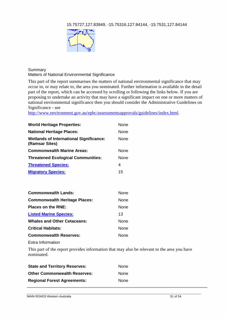
DEWR DATABASE SEACH – PENTECOST RANGE IMPROVEMENT WORKS
Summary
Matters of National Environmental Significance This part of the report summarises the matters of national environmental significance that may occur in, or may relate to, the area you nominated. Further information is available in the detail part of the report, which can be accessed by scrolling or following the links below. If you are proposing to undertake an activity that may have a significant impact on one or more matters of national environmental significance then you should consider the Administrative Guidelines on Significance - see http://www.environment.gov.au/epbc/assessmentsapprovals/guidelines/index.html
World Heritage Properties: None National Heritage Places: None Wetlands of International Significance: (Ramsar Sites)
None
Commonwealth Marine Areas: None Threatened Ecological Communities: None Threatened Species: 4 Migratory Species: 15
MAIN ROADS Western Australia 47 of 54

Details Matters of National Environmental Significance Threatened Species [ Dataset Information ] Status Type of Presence Birds Erythrotriorchis radiatus * Red Goshawk
Vulnerable Species or species habitat likely to occur within area
Erythrura gouldiae * Gouldian Finch
Endangered Species or species habitat may occur within area
Malurus coronatus coronatus* Purple-crowned Fairy-wren (western)
Vulnerable Species or species habitat likely to occur within area
Sharks Pristis microdon * Freshwater Sawfish
Vulnerable Species or species habitat likely to occur within area
Migratory Species [ Dataset Information ] Status Type of Presence Migratory Terrestrial Species Birds Coracina tenuirostris melvillensis Melville Cicadabird
Migratory Species or species habitat may occur within area
Erythrura gouldiae Gouldian Finch
Migratory Species or species habitat may occur within area
Haliaeetus leucogaster White-bellied Sea-Eagle
Migratory Species or species habitat likely to occur within area
Hirundo rustica Barn Swallow
Migratory Species or species habitat may occur within area
Merops ornatus * Rainbow Bee-eater
Migratory Species or species habitat may occur within area
Rhipidura rufifrons Rufous Fantail
Migratory Species or species habitat may occur within area
Migratory Wetland Species Birds Ardea alba Great Egret, White Egret
Migratory Species or species habitat may occur within area
Ardea ibis Cattle Egret
Migratory Species or species habitat may occur within area
Charadrius veredus Oriental Plover, Oriental Dotterel
Migratory Species or species habitat may occur within area
Glareola maldivarum Oriental Pratincole
Migratory Species or species habitat may occur within area
Numenius minutus Little Curlew, Little Whimbrel
Migratory Species or species habitat may occur within area
MAIN ROADS Western Australia 48 of 54

Migratory Marine Birds Apus pacificus Fork-tailed Swift
Migratory Species or species habitat may occur within area
Ardea alba Great Egret, White Egret
Migratory Species or species habitat may occur within area
Ardea ibis Cattle Egret
Migratory Species or species habitat may occur within area
Migratory Marine Species Reptiles Crocodylus porosus Estuarine Crocodile, Salt-water Crocodile
Migratory Species or species habitat likely to occur within area
Other Matters Protected by the EPBC Act Listed Marine Species [ Dataset Information ] Status Type of Presence Birds Anseranas semipalmata Magpie Goose
Listed - overfly marine area
Species or species habitat may occur within area
Apus pacificus Fork-tailed Swift
Listed - overfly marine area
Species or species habitat may occur within area
Ardea alba Great Egret, White Egret
Listed - overfly marine area
Species or species habitat may occur within area
Ardea ibis Cattle Egret
Listed - overfly marine area
Species or species habitat may occur within area
Charadrius veredus Oriental Plover, Oriental Dotterel
Listed - overfly marine area
Species or species habitat may occur within area
Glareola maldivarum Oriental Pratincole
Listed - overfly marine area
Species or species habitat may occur within area
Haliaeetus leucogaster White-bellied Sea-Eagle
Listed Species or species habitat likely to occur within area
MAIN ROADS Western Australia 49 of 54

Hirundo rustica Barn Swallow
Listed - overfly marine area
Species or species habitat may occur within area
Merops ornatus * Rainbow Bee-eater
Listed - overfly marine area
Species or species habitat may occur within area
Numenius minutus Little Curlew, Little Whimbrel
Listed - overfly marine area
Species or species habitat may occur within area
Rhipidura rufifrons Rufous Fantail
Listed - overfly marine area
Species or species habitat may occur within area
Reptiles Crocodylus johnstoni Freshwater Crocodile
Listed Species or species habitat may occur within area
Crocodylus porosus Estuarine Crocodile, Salt-water Crocodile
Listed Species or species habitat likely to occur within area
PENTECOST RANGE MATERIALS INVESTIGATION AREA
This map may contain data which are © Commonwealth of Australia (Geoscience Australia) © 2007 MapData Sciences Pty Ltd, PSMA
Search Type: Line Buffer: 0 km Coordinates: -15.75273,127.84165, -15.76095,127.85117, -15.76419,127.84208, -
MAIN ROADS Western Australia 50 of 54
15.75727,127.83949, -15.75316,127.84144, -15.7531,127.84144
Summary Matters of National Environmental Significance This part of the report summarises the matters of national environmental significance that may occur in, or may relate to, the area you nominated. Further information is available in the detail part of the report, which can be accessed by scrolling or following the links below. If you are proposing to undertake an activity that may have a significant impact on one or more matters of national environmental significance then you should consider the Administrative Guidelines on Significance - see http://www.environment.gov.au/epbc/assessmentsapprovals/guidelines/index.html.
World Heritage Properties: None National Heritage Places: None Wetlands of International Significance: (Ramsar Sites)
None
Commonwealth Marine Areas: None Threatened Ecological Communities: None Threatened Species: 4 Migratory Species: 15
Commonwealth Lands: None Commonwealth Heritage Places: None Places on the RNE: None Listed Marine Species: 13 Whales and Other Cetaceans: None Critical Habitats: None Commonwealth Reserves: None Extra Information This part of the report provides information that may also be relevant to the area you have nominated.
State and Territory Reserves: None Other Commonwealth Reserves: None Regional Forest Agreements: None
MAIN ROADS Western Australia 51 of 54

Details Matters of National Environmental Significance Threatened Species [ Dataset Information ] Status Type of Presence Birds Erythrotriorchis radiatus * Red Goshawk
Vulnerable Species or species habitat likely to occur within area
Erythrura gouldiae * Gouldian Finch
Endangered Species or species habitat may occur within area
Malurus coronatus coronatus* Purple-crowned Fairy-wren (western)
Vulnerable Species or species habitat likely to occur within area
Sharks Pristis microdon * Freshwater Sawfish
Vulnerable Species or species habitat likely to occur within area
Migratory Species [ Dataset Information ] Status Type of Presence Migratory Terrestrial Species Birds Coracina tenuirostris melvillensis Melville Cicadabird
Migratory Species or species habitat may occur within area
Erythrura gouldiae Gouldian Finch
Migratory Species or species habitat may occur within area
Haliaeetus leucogaster White-bellied Sea-Eagle
Migratory Species or species habitat likely to occur within area
Hirundo rustica Barn Swallow
Migratory Species or species habitat may occur within area
Merops ornatus * Rainbow Bee-eater
Migratory Species or species habitat may occur within area
Rhipidura rufifrons Rufous Fantail
Migratory Species or species habitat may occur within area
Migratory Wetland Species Birds Ardea alba Great Egret, White Egret
Migratory Species or species habitat may occur within area
Ardea ibis Cattle Egret
Migratory Species or species habitat may occur within area
Charadrius veredus Oriental Plover, Oriental Dotterel
Migratory Species or species habitat may occur within area
Glareola maldivarum Oriental Pratincole
Migratory Species or species habitat may occur within area
Numenius minutus Little Curlew, Little Whimbrel
Migratory Species or species habitat may occur within area
Migratory Marine Birds Apus pacificus Fork-tailed Swift
Migratory Species or species habitat may occur within area
MAIN ROADS Western Australia 52 of 54

Ardea alba Great Egret, White Egret
Migratory Species or species habitat may occur within area
Ardea ibis Cattle Egret
Migratory Species or species habitat may occur within area
Migratory Marine Species Reptiles Crocodylus porosus Estuarine Crocodile, Salt-water Crocodile
Migratory Species or species habitat likely to occur within area
Other Matters Protected by the EPBC Act Listed Marine Species [ Dataset Information ] Status Type of Presence Birds Anseranas semipalmata Magpie Goose
Listed - overfly marine area
Species or species habitat may occur within area
Apus pacificus Fork-tailed Swift
Listed - overfly marine area
Species or species habitat may occur within area
Ardea alba Great Egret, White Egret
Listed - overfly marine area
Species or species habitat may occur within area
Ardea ibis Cattle Egret
Listed - overfly marine area
Species or species habitat may occur within area
Charadrius veredus Oriental Plover, Oriental Dotterel
Listed - overfly marine area
Species or species habitat may occur within area
Glareola maldivarum Oriental Pratincole
Listed - overfly marine area
Species or species habitat may occur within area
Haliaeetus leucogaster White-bellied Sea-Eagle
Listed Species or species habitat likely to occur within area
Hirundo rustica Barn Swallow
Listed - overfly marine area
Species or species habitat may occur within area
Merops ornatus * Rainbow Bee-eater
Listed - overfly marine area
Species or species habitat may occur within area
Numenius minutus Little Curlew, Little Whimbrel
Listed - overfly marine
Species or species habitat may occur within area
MAIN ROADS Western Australia 53 of 54

area Rhipidura rufifrons Rufous Fantail
Listed - overfly marine area
Species or species habitat may occur within area
Reptiles Crocodylus johnstoni Freshwater Crocodile
Listed Species or species habitat may occur within area
Crocodylus porosus Estuarine Crocodile, Salt-water Crocodile
Listed Species or species habitat likely to occur within area
MAIN ROADS Western Australia 54 of 54