Prehistoric Quarrying and Stone Tool Production at … Quarrying and Stone Tool Production at El...
14
Pacific Coast Archaeological Society Quarterly, Volume 39, Numbers 2 & 3 Prehistoric Quarrying and Stone Tool Production at El Pulguero, Baja California Sur, Mexico Harumi Fujita and Gema Poyatos de Paz Abstract This brief article is intended to acquaint the reader with a field survey we conducted in 1997 at the archaeological site of El Pulguero, Baja California Sur. El Pulguero reveals evidence of a sophisticated lithic procurement and production system, incorporating 29 rhyolite quarries and 22 discrete tool-processing areas that lack signs of human habitation. The discovery of numerous preforms suggests that ancient peoples mined the quarries, carrying large primary flakes and/or incomplete artifacts off-site for finishing into smaller implements. Some of the distinctive biface artifacts associated with Las Palmas lithic assemblages ultimately may derive from El Pulguero. Data from this study reinforce the notion that settlement patterning during the late prehistoric period was more varied than previously assumed, consisting of a broad range of task-specific sites, including quarries and lithic workshops. Introduction El Pulguero is an expansive archaeological site that comprises 29 rhyolite and basalt quarries and 22 tool-processing areas. Discovered in 1980 by García Uranga and Mora Echeverría (1981), the horizontal extent of the deposit remained undefined until 1997, when the authors, under the auspices of the Instituto Nacional de Antropología e Historia (INAH), reconnoitered the territory from Tecolote Beach west to Las Cruces, including Cerralvo Island (Fujita 1998). The objectives of this study were (1) to systematically survey and inventory archaeological sites in the region; (2) to update inventory forms on previously recorded sites; (3) to assess the condition of known sites and evaluate current threats; and (4) to make recommendations regarding the management of archaeological sites in the survey zone (Fig. 1). This investigation was prompted by the growing concern among INAH authorities, professional archaeologists, and the lay public that unbridled economic development in Baja California Sur will ravage the region’s heritage resources. During the course of our reconnaissance, we inspected scores of ephemeral desert campsites, extensive coastal middens, and quarries, such as El Pulguero. Sixteen previously undocumented quarries were identified in the core of El Pulguero, and 13 more were recorded in peripheral areas. Moreover, the presence of two multi-component shell middens in the vicinity of El Pulguero suggests an unexpectedly complex regional settlement pattern. The El Pulguero archaeological site, officially recorded as A-16 El Pulguero Suroeste, is located approximately 25 kilometers north of La Paz; it is roughly one-to-four kilometers east of Tecolote Beach and about three-to-five kilometers northeast of Puerto Balandra. The site is bordered to the north
Transcript of Prehistoric Quarrying and Stone Tool Production at … Quarrying and Stone Tool Production at El...

Pacific Coast Archaeological Society Quarterly, Volume 39, Numbers 2 & 3
Prehistoric Quarrying and
Stone Tool Production at El
Pulguero, Baja California Sur,
Mexico
Harumi Fujita and Gema Poyatos de Paz
Abstract
This brief article is intended to acquaint the reader with a field survey we conducted in 1997 at the archaeological site of El Pulguero, Baja California Sur. El Pulguero reveals evidence of a sophisticated lithic procurement and production system, incorporating 29 rhyolite quarries and 22 discrete tool-processing areas that lack signs of human habitation. The discovery of numerous preforms suggests that ancient peoples mined the quarries, carrying large primary flakes and/or incomplete artifacts off-site for finishing into smaller implements. Some of the distinctive biface artifacts associated with Las Palmas lithic assemblages ultimately may derive from El Pulguero. Data from this study reinforce the notion that settlement patterning during the late prehistoric period was more varied than previously assumed, consisting of a broad range of task-specific sites, including quarries and lithic workshops.
Introduction
El Pulguero is an expansive archaeological site that comprises 29 rhyolite and basalt quarries and 22 tool-processing areas. Discovered in 1980 by García Uranga and Mora Echeverría (1981), the horizontal extent of the deposit remained undefined until 1997, when the authors, under the auspices of the Instituto Nacional de Antropología e Historia (INAH), reconnoitered the territory from Tecolote Beach west to Las Cruces, including Cerralvo Island (Fujita 1998). The objectives of this study were (1) to systematically survey and inventory
archaeological sites in the region; (2) to update inventory forms on previously recorded sites; (3) to assess the condition of known sites and evaluate current threats; and (4) to make recommendations regarding the management of archaeological sites in the survey zone (Fig. 1). This investigation was prompted by the growing concern among INAH authorities, professional archaeologists, and the lay public that unbridled economic development in Baja California Sur will ravage the region’s heritage resources. During the course of our reconnaissance, we inspected scores of ephemeral desert campsites, extensive coastal middens, and quarries, such as El Pulguero. Sixteen previously undocumented quarries were identified in the core of El Pulguero, and 13 more were recorded in peripheral areas. Moreover, the presence of two multi-component shell middens in the vicinity of El Pulguero suggests an unexpectedly complex regional settlement pattern.
The El Pulguero archaeological site, officially recorded as A-16 El Pulguero Suroeste, is located approximately 25 kilometers north of La Paz; it is roughly one-to-four kilometers east of Tecolote Beach and about three-to-five kilometers northeast of Puerto Balandra. The site is bordered to the north

PCAS Quarterly, 39 (2 & 3)
Fujita and Poyatos de Paz24
by the Gulf of California, to the south by a series of low-lying hills and the Sierra Riolítica (350 meter elevation), to the west by Cerro Azabache (45 meter elevation), and to the east by an alluvial fan that feeds the Gulf of California. The site is roughly 3.3 kilometers east to west with a maximum north to south extent of 1.3 kilometers. A-16 El Pulguero Suroeste was largely intact in 1997. However, brief visits between 2000 and 2005 revealed that on-going regional development threatens to degrade this unique cultural landscape.
The local terrain is characterized by vertical outcrops and assorted-sized boulders and cobbles of high-quality rhyolite (Hammond 1954:47). Rhyolite nodules range in size from small pebbles and large cobbles to boulders, weighing several hundred pounds. To date, prehistoric rhyolite quarries and workshops in the vicinity of A-16 El Pulguero Suroeste have been recorded by Massey (1955), Kowta (1968), and Fujita (2003).
Massey (1955:212) identified a rhyolite quarry at Pichilingue (BC 70), comprising flakes and large roughly-shaped biface blanks. At the time of his writing (some 52 years ago) Massey (1955:212) stated that
BC 70 is outlined by flakes and artifacts… On the surface of the site there is a considerable variety of large bifacially flaked tool forms. These particular artifacts occur rarely on other sites; therefore it seems reasonable to suppose that these large forms are in reality blanks for the manufacture of other tools.
Nearly 15 years later, Kowta undertook a comprehensive survey of the region reported by Massey (1955). In a brief consideration of the region’s ancient lithic industry, Kowta (1968:27) noted three additional quarry sites, including BCK-8, BCK-46, and BCK-52. BCK-46 best typified a prehistoric quarry in the Cape Region;
Fig. 1. Location of archaeological sites mentioned in the text: (1) A-20 Las Pilitas #3 (2) A-16 El Pulguero Suroeste (3) A-15 Ensenada El Pulguero #2 (4) BC 70 (Pichilingue) (5) A-104 Loma El Barríl (6) A-56 Cerro de la Calavera #1 (7) A-83 Cañada Marina Palmira #2 (8) A-55 El Conchalito.

PCAS Quarterly, 39 (2 & 3)
Prehistoric Quarrying and Tool Manufacturing at El Pulguero, Baja California Sur 25
it lacked shell and consisted of numerous blade blanks, relatively few finished blades, and sundry core choppers and scraping tools. Most recently, Fujita (2003) identified two rhyolite quarries and workshops south of the Sierra Riolítica near Cerro de la Calavera; large preforms (roughly shaped on both faces) were noted at A-83 Cañada Marina Palmira #2; and a combination of preforms and finished artifacts (e.g., biface knives and two lanceolate-shaped projectile points) were observed on the surface of A-104 Loma El Barríl. (Note: During the 1950s and 1960s, the pioneers of Baja California Sur archaeology assigned a specific number to each site they recorded in the course of their research, attempting to avoid confusion between localities. Thus, Massey recorded BC 1 to BC 118, while Kowta inventoried BCK-1 to BCK-76. In the late 1990s, INAH investigator Harumi Fujita [1999] began the systematic documentation of archaeological sites in the Cape Region, utilizing a standardized nomenclature. Detailed reporting of each site includes an alpha-numeric designation and a descriptive moniker, representing a geographical area or local nickname. Example: A-16 El Pulguero Suroeste).
Site Description and Survey Data
A-16 El Pulguero Suroeste encompasses an estimated area of five square kilometers, constituting a constellation of specialized task localities exploited by human foragers to process lithic materials. No evidence of food processing or consumption was noted. In fact, El Pulguero represents one of the largest and most intensively used quarries yet found in the Cape Region of Baja California Sur. After the initial walkover, a number of logistical problems were evident. In particular, the size of the site and the expansive distribution of surface materials posed a challenge to our three-member crew. Considerable discussion ensued,
leading to the formulation of a data collection strategy; our goal was to record discrete lithic activity areas by means of a visual aggregate flake analysis. We attempted to estimate the relative density of flakes within areas of one square meter, which we termed observation units. Low density observation units contained 50-100 flakes; medium density observation units subsumed 100-500 flakes, and high density observation units were characterized by 500-1000 flakes.
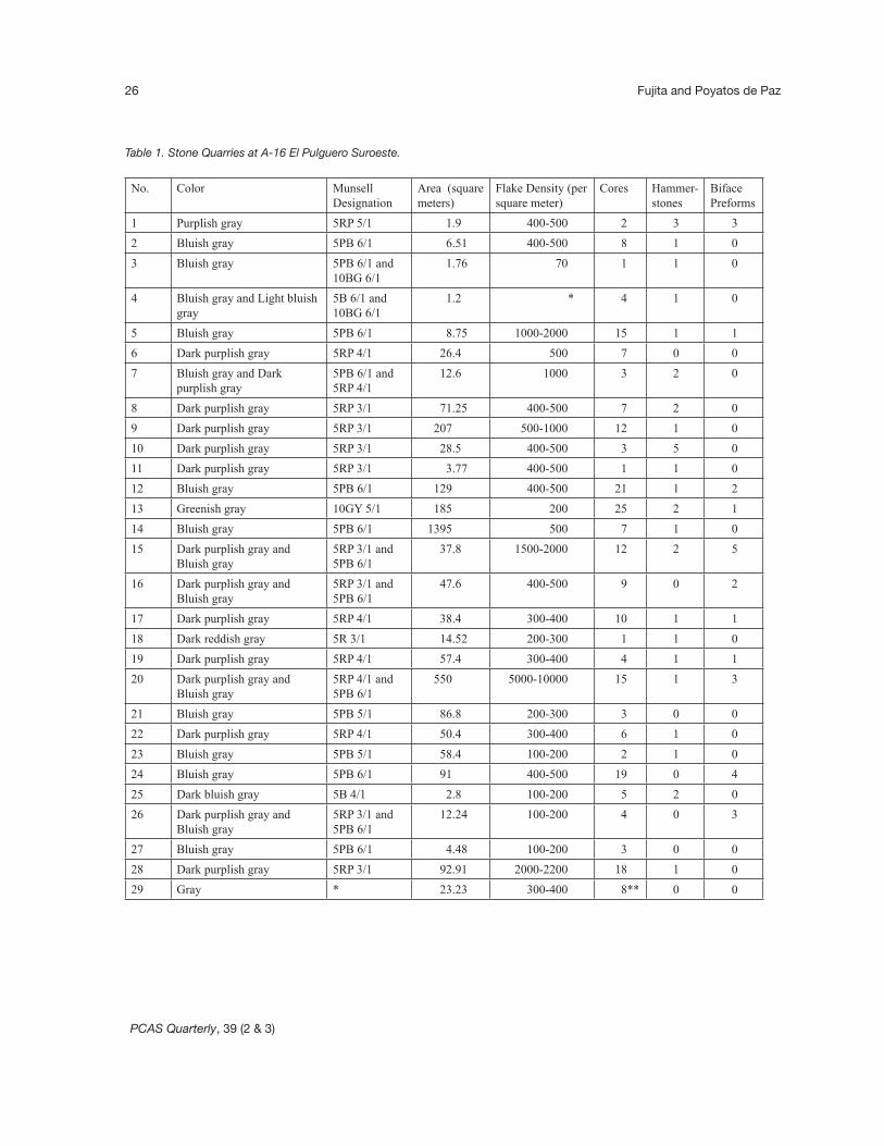
A-16 El Pulguero Suroeste quarries vary in size from about 1.2 square meters (Quarry 1) to roughly 1,400 square meters (Quarry 14), with a mean average area of about 32 square meters; the site’s quarries exhibit a fairly redundant artifact assemblage: cores, hammerstones, primary decortication flakes, and preforms or blanks (Table 1). In several instances (e.g., Quarry numbers 2, 5, 7, 8, 9, 10, 11, and 28), hammers and primary flakes were found in direct association with cores, cobbles, and boulders, exhibiting negative scars. These data provide evidence of primary reduction activity. In general, the site lacks evidence of biface finishing and tool maintenance. Eleven quarries revealed 26 unfinished bifacially flaked preforms, averaging about 18.5 centimeters long by 9.2 centimeters wide by 4.2 centimeters thick. No pressure retouch marks were observed on the edges of the preforms, nor did we observe small trim flakes, which are generally less than one centimeter in length and width. Hammerstones, blocks, and shatter (chunky pieces that are generated during the early stages of biface shaping) also were observed at A-16 El Pulguero Suroeste (Fig. 2(A) and Fig. 2(B)).
Evidence of intensive core reduction and the initial stages of tool processing were observed in an area, measuring 700 east to west by 450 meters north to south (315,000 square meters); here, the survey
PCAS Quarterly, 39 (2 & 3)
Fujita and Poyatos de Paz26
No. Color Munsell Designation
Area (square meters)
Flake Density (per square meter)
Cores Hammer-stones
Biface Preforms
1 Purplish gray 5RP 5/1 1.9 400-500 2 3 3
2 Bluish gray 5PB 6/1 6.51 400-500 8 1 0
3 Bluish gray 5PB 6/1 and 10BG 6/1
1.76 70 1 1 0
4 Bluish gray and Light bluish gray
5B 6/1 and 10BG 6/1
1.2 * 4 1 0
5 Bluish gray 5PB 6/1 8.75 1000-2000 15 1 1
6 Dark purplish gray 5RP 4/1 26.4 500 7 0 0
7 Bluish gray and Dark purplish gray
5PB 6/1 and 5RP 4/1
12.6 1000 3 2 0
8 Dark purplish gray 5RP 3/1 71.25 400-500 7 2 0
9 Dark purplish gray 5RP 3/1 207 500-1000 12 1 0
10 Dark purplish gray 5RP 3/1 28.5 400-500 3 5 0
11 Dark purplish gray 5RP 3/1 3.77 400-500 1 1 0
12 Bluish gray 5PB 6/1 129 400-500 21 1 2
13 Greenish gray 10GY 5/1 185 200 25 2 1
14 Bluish gray 5PB 6/1 1395 500 7 1 0
15 Dark purplish gray and Bluish gray
5RP 3/1 and 5PB 6/1
37.8 1500-2000 12 2 5
16 Dark purplish gray and Bluish gray
5RP 3/1 and 5PB 6/1
47.6 400-500 9 0 2
17 Dark purplish gray 5RP 4/1 38.4 300-400 10 1 1
18 Dark reddish gray 5R 3/1 14.52 200-300 1 1 0
19 Dark purplish gray 5RP 4/1 57.4 300-400 4 1 1
20 Dark purplish gray and Bluish gray
5RP 4/1 and 5PB 6/1
550 5000-10000 15 1 3
21 Bluish gray 5PB 5/1 86.8 200-300 3 0 0
22 Dark purplish gray 5RP 4/1 50.4 300-400 6 1 0
23 Bluish gray 5PB 5/1 58.4 100-200 2 1 0
24 Bluish gray 5PB 6/1 91 400-500 19 0 4
25 Dark bluish gray 5B 4/1 2.8 100-200 5 2 0
26 Dark purplish gray and Bluish gray
5RP 3/1 and 5PB 6/1
12.24 100-200 4 0 3
27 Bluish gray 5PB 6/1 4.48 100-200 3 0 0
28 Dark purplish gray 5RP 3/1 92.91 2000-2200 18 1 0
29 Gray * 23.23 300-400 8** 0 0
Table 1. Stone Quarries at A-16 El Pulguero Suroeste.

PCAS Quarterly, 39 (2 & 3)
Prehistoric Quarrying and Tool Manufacturing at El Pulguero, Baja California Sur 27
crew noted countless flakes (Fig. 3 and Fig. 4). The estimated number of flakes observed in 20 discrete loci ranged from 500 in Flake Concentration A, C-F, H, N-Q, and T to 10,000 specimens in Flake Concentration M; on average, the workshops exhibited about 500-1000 flakes (Fig. 5(A) and Fig. 5(B); Table 2). Flake concentrations at A-
16 El Pulguero Suroeste ranged in size from 1.2 square meters to 1,398 square meters. Neither trim flakes, representing the final phases of tool production or tool maintenance (e.g., shaping and thinning of bifaces and unifaces), nor utilized flakes were observed. Of particular note were the 23 elongated biface tools (Table 3; Fig. 6A and
Fig. 2(A). Evidence of stone quarrying at A-16 El Pulguero Suroeste: two boulder cores, and primary flakes at Workshop 28. Photo taken by Harumi Fujita.
Fig. 2(B). Evidence of stone quarrying at A-16 El Pulguero Suroeste: hammerstone at Workshop 28. Scale measures 20 centimeters. Photo taken by Harumi Fujita.

PCAS Quarterly, 39 (2 & 3)
Fujita and Poyatos de Paz28
Fig. 4. Detail map of northeast section of A-16 El Pulguero Suroeste, highlighting the relationship between quarry and tool processing locations. (Numbers cor-respond to workshops; letters designate concentrations of flakes and core tools).
Fig. 3. Distribution of lithic workshops at A-16 El Pulguero Suroeste. (Numbers correspond to workshops; letters designate concentrations of flakes and core tools). Note: Cerro Azabache is associated with Workshop 29.

PCAS Quarterly, 39 (2 & 3)
Prehistoric Quarrying and Tool Manufacturing at El Pulguero, Baja California Sur 29
Fig. 5(A). Note Workshop 15 biface is right in the foreground of photograph. Photo taken by Harumi Fujita.
Fig. 5(B). A surface concentra-tion of tools, cobble cores, and debitage at Workshop 12. Photo taken by Harumi Fujita.
6B, and Fig. 7A and 7B), resembling artifacts from inland (A-55 El Conchalito [Fujita 1995:18], A56 Cerro de la Calavera #1, and BC 70 [Massey 1955:212-214]) and island sites (J-67 La Ballena #1 on Espíritu Santo Island [Fujita 1997, 1999] and K-5 Las Garcitas on Cerralvo Island [Fujita 1998:32]).
Mining and Processing Stone at A-16 El Pulguero Suroeste
Most of the behavioral data inferred from our research at A-16 El Pulguero Suroeste relates to mining, core reduction, and the initial stages of toolmaking. The lithic data base is overwhelmingly

PCAS Quarterly, 39 (2 & 3)
Fujita and Poyatos de Paz30
Flake Concentration
Color Munsell Designation Area (square meters) Flake Estimates (per square meter)
A Bluish gray 5PB 6/1 * 500-1000
B * * 45 *
C Bluish gray 5PB 6/1 60 500-1000
D Bluish gray 5PB 6/1 4.5 500-1000
E Bluish gray 5PB 6/1 150 500-1000
F Dark purplish gray 5RP 3/1 * 500-1000
G Bluish gray 5PB 6/1 100 1000-5000
H Dark purplish gray and Bluish gray
5RP 3/1 and 5PB 6/1 800 500-1000
I Bluish gray 5PB 6/1 15 *
J * * 40 *
K * * 72 *
L Dark purplish gray and Bluish gray
5RP 3/1 and 5PB 6/1 600 1000-5000
M Dark purplish gray 5RP 3/1 400 5000-10000
N Dark purplish gray 5RP 3/1 300 500-1000
O Dark purplish gray 5RP 3/1 * 500-1000
P Bluish gray 5PB 6/1 * 500-1000
Q Dark purplish gray 5RP 3/1 * 500-1000
R Bluish gray 5PB 6/1 60,000 1000-5000
S Bluish gray 5PB 6/1 900 *
T Bluish gray 5PB 6/1 450 500-1000
* = no data available
Table 2. Flake Concentrations at A-16 El Pulguero Suroeste.
Fig. 6(A). Dorsal (A) view of specimen A16-12, an elongated biface of bluish gray rhyolite. Scale in centimeters. Photo taken by Harumi Fujita.

PCAS Quarterly, 39 (2 & 3)
Prehistoric Quarrying and Tool Manufacturing at El Pulguero, Baja California Sur 31
Catalog Number Morphology Color Munsell Length Width Thickness (centimeters)
Material Location
A16-1 C Purplish gray 5RP 5/1 19.8 x 10 x 3.5 Rhyolite Quarry 15
A16-2 C Bluish gray 5PB 6/1 14 x 10 x 6 Rhyolite Isolate
A16-3 C Bluish gray 5PB 6/1 24.2 x 9.5 x 4 Rhyolite Quarry 12
A16-4 F Purplish gray 5RP 5/1 12 x 10 x 5.5 Rhyolite FC L
A16-7 C** Bluish gray 5PB 6/1 16.5 x 7 x 3 Rhyolite Quarry 24
A16-8 C Bluish gray 5PB 6/1 18.5 x 9.5 x 4 Rhyolite Quarry 19
A16-9 C Bluish gray 5PB 6/1 * x 8.5 x 2.4 Rhyolite Quarry 14
A16-10 C Bluish gray 5PB 6/1 29.5 x 11 x 4.5 Rhyolite Quarry 1
A16-11 C Purplish gray 5RP 5/1 14.6 x 8.5 x 2.8 Rhyolite Quarry 16
A16-12 C Purplish gray 5RP 5/1 15.5 x 9.5 x 6.4 Rhyolite FC L
A16-13 C Purplish gray 5RP 5/1 23 x 8.5 x 2.8 Rhyolite Quarry 15
A16-14 C Bluish gray 5PB 6/1 25 x 12 x 5 Rhyolite Isolate
A16-18 C Gray * 15 x 7.2 x 4.3 Limestone Quarry 13
A16-22 C Purplish gray 5RP 5/1 13 x 7.5 x 3.5 Rhyolite Isolate
* = no data available; ** Artifact A16-10 consists of two cross-fitted fragments; FC = flake concentration.
Table 3. A-16 El Pulguero Suroeste Biface Artifacts.
Fig. 6(B). Ventral view of specimen A16-12, an elongated biface of bluish gray rhyolite. Scale in centimeters. Photo taken by Harumi Fujita.
PCAS Quarterly, 39 (2 & 3)
Fujita and Poyatos de Paz32
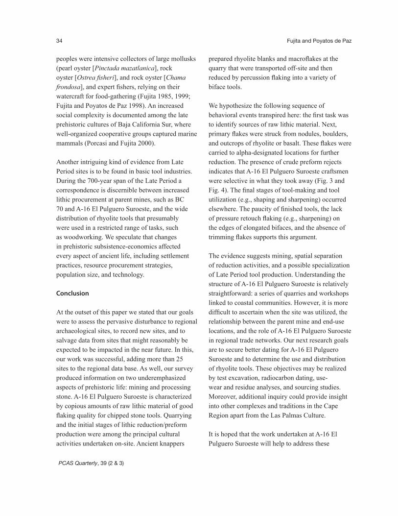
dominated by rhyolite, constituting abundant rock fragments, flakes struck from cores, cobbles, boulders, and outcrops. Low density concentrations of flakes may have been the result of limited manufacturing activities by individuals. Denser concentrations of flakes and tools possibly represent collective activities (Binford 1988:200). The end-use of A-16 El Pulguero Suroeste preforms and bifaces is unresolved. Presently, we have no factual data, indicating the function of these specimens. An early mention of comparable examples was made by Massey (1955:212). In his discussion of
chipped stone artifacts from BC 70, Massey posited that expendable biface tools were used to dislodge oysters and shellfish, clinging to rocks. Such comments are stimulating, but unfortunately at the present time we cannot state with certainty how these artifacts functioned. We surmise that rhyolite bifaces could have been used to clear vegetation, such as corcho (Erythrina flabelliformis), cardón cactus, (Pachycereus pringlei), or red mangrove (Rhizophora mangle), and/or to fashion objects of wood and bone, including rafts, paddles, harpoons, dart-throwers, spears, lozenge-shaped boards, awls,
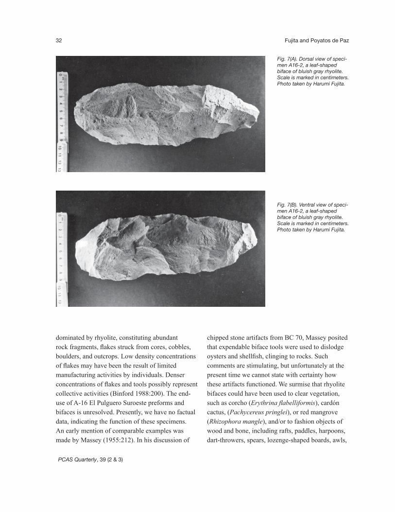
Fig. 7(A). Dorsal view of speci-men A16-2, a leaf-shaped biface of bluish gray rhyolite. Scale is marked in centimeters. Photo taken by Harumi Fujita.
Fig. 7(B). Ventral view of speci-men A16-2, a leaf-shaped biface of bluish gray rhyolite.Scale is marked in centimeters. Photo taken by Harumi Fujita.

PCAS Quarterly, 39 (2 & 3)
Prehistoric Quarrying and Tool Manufacturing at El Pulguero, Baja California Sur 33
cooking implements, or spatulas. The discovery of A-16 El Pulguero Suroeste preforms has left a number of ideas for future work, including sourcing studies to assist in determining the regional distribution of biface artifacts. Work in this area, combined with use-wear and residue analyses, would help increase our understanding of where these tools were used and how they functioned in prehistory.
A-16 El Pulguero Suroeste and Regional Chronology
The bulk of the El Pulguero artifact assemblage constitutes non-diagnostic lithic debitage, such as generic flakes and chunks of rhyolite and basalt. There are also numerous simple tools such as core rejects, hammers, bifaces, and biface preforms that cannot be assigned to any particular time period. While we assume that A-16 El Pulguero Suroeste was principally utilized between approximately AD 1000 and 1700 AD, this should not be taken to suggest that site occupation was limited to the Late Period. Radiocarbon determinations are not yet available for A-16 El Pulguero Suroeste. It is hoped that future excavations will contribute these important data, expanding our knowledge about the age of the site. However, direct lines of chronometric evidence from archaeological sites in our study area can be brought to bear on the potential duration of human occupation at A-16 El Pulguero Suroeste.
Two shell samples collected by Harumi Fujita were submitted to the INAH radiocarbon dating laboratory in Mexico City with the aim of establishing a framework for a regional chronology. On the basis of shells recovered from the upper strata of the Puerto Balandra midden (7855 ± 77 BP, INAH Sample 266) and from the lower strata of the Puerto Balandra cave (5008 ± 85 BP, INAH Sample 2020), it is estimated that the region was settled by
6000 BC (Fujita 1985). Cultural deposits from these strata produced an assortment of basalt cores, waste flakes, and grinding stones, suggesting ephemeral site occupation and casual tool use.
Although data pertinent to the initial human occupation of this territory are relatively scant the final complex of settlement in the Cape Region is associated with the enigmatic Las Palmas peoples (Carmean and Molto 1991; Massey 1955; Molto and Fujita 1995). Some debate exists as to the introduction of this cultural manifestation. However, analogous chronometric data from several INAH-sponsored field projects marks the onset of Las Palmas occupation at around AD 1000. A rock oyster shell (INAH Sample 1966) recovered at 45 centimeters below surface from the A-15 El Pulguero #2 site correlates to 1965 ± 76 BP. Based on the work of Hughen et al. (2004) and Stuiver and Reimer (1993), this marine shell was calibrated at 2[sigma], ranging from cal AD 780 to AD 1160 or AD 984 as the most likely age of deposition. This sample was taken from the bottom of a thick stratum of rock oyster shells, representing the start of intensive human occupation at A-15 El Pulguero #2. Another radiocarbon date (INAH Sample 269) was collected from the upper stratum of A-20 Las Pilitas #3; this marine shell was calibrated at 2[sigma], ranging from cal AD 1702 to AD 1951, or AD 1718 as the most likely age of deposition. These dates are in basic agreement with others reported elsewhere in the Cape Region, indicating that the Las Palmas Culture is best placed chronologically between AD 1000 and 1700 AD (cf. Stewart, Molto, and Reimer 1998).
Current archaeological research in the Cape Region indicates an observable shift from a generalized hunter-gatherer economy to one that exhibited a preference for specific natural resources. Highly mobile Late Period groups exploited maritime and terrestrial resources extensively. Las Palmas
PCAS Quarterly, 39 (2 & 3)
Fujita and Poyatos de Paz34
peoples were intensive collectors of large mollusks (pearl oyster [Pinctada mazatlanica], rock oyster [Ostrea fisheri], and rock oyster [Chama frondosa], and expert fishers, relying on their watercraft for food-gathering (Fujita 1985, 1999; Fujita and Poyatos de Paz 1998). An increased social complexity is documented among the late prehistoric cultures of Baja California Sur, where well-organized cooperative groups captured marine mammals (Porcasi and Fujita 2000).
Another intriguing kind of evidence from Late Period sites is to be found in basic tool industries. During the 700-year span of the Late Period a correspondence is discernible between increased lithic procurement at parent mines, such as BC 70 and A-16 El Pulguero Suroeste, and the wide distribution of rhyolite tools that presumably were used in a restricted range of tasks, such as woodworking. We speculate that changes in prehistoric subsistence-economics affected every aspect of ancient life, including settlement practices, resource procurement strategies, population size, and technology.
Conclusion
At the outset of this paper we stated that our goals were to assess the pervasive disturbance to regional archaeological sites, to record new sites, and to salvage data from sites that might reasonably be expected to be impacted in the near future. In this, our work was successful, adding more than 25 sites to the regional data base. As well, our survey produced information on two underemphasized aspects of prehistoric life: mining and processing stone. A-16 El Pulguero Suroeste is characterized by copious amounts of raw lithic material of good flaking quality for chipped stone tools. Quarrying and the initial stages of lithic reduction/preform production were among the principal cultural activities undertaken on-site. Ancient knappers
prepared rhyolite blanks and macroflakes at the quarry that were transported off-site and then reduced by percussion flaking into a variety of biface tools.
We hypothesize the following sequence of behavioral events transpired here: the first task was to identify sources of raw lithic material. Next, primary flakes were struck from nodules, boulders, and outcrops of rhyolite or basalt. These flakes were carried to alpha-designated locations for further reduction. The presence of crude preform rejects indicates that A-16 El Pulguero Suroeste craftsmen were selective in what they took away (Fig. 3 and Fig. 4). The final stages of tool-making and tool utilization (e.g., shaping and sharpening) occurred elsewhere. The paucity of finished tools, the lack of pressure retouch flaking (e.g., sharpening) on the edges of elongated bifaces, and the absence of trimming flakes supports this argument.
The evidence suggests mining, spatial separation of reduction activities, and a possible specialization of Late Period tool production. Understanding the structure of A-16 El Pulguero Suroeste is relatively straightforward: a series of quarries and workshops linked to coastal communities. However, it is more difficult to ascertain when the site was utilized, the relationship between the parent mine and end-use locations, and the role of A-16 El Pulguero Suroeste in regional trade networks. Our next research goals are to secure better dating for A-16 El Pulguero Suroeste and to determine the use and distribution of rhyolite tools. These objectives may be realized by test excavation, radiocarbon dating, use-wear and residue analyses, and sourcing studies. Moreover, additional inquiry could provide insight into other complexes and traditions in the Cape Region apart from the Las Palmas Culture.
It is hoped that the work undertaken at A-16 El Pulguero Suroeste will help to address these
PCAS Quarterly, 39 (2 & 3)
Prehistoric Quarrying and Tool Manufacturing at El Pulguero, Baja California Sur 35
problems as well as to place specialized task sites in a regional light, revealing how geography and/or natural resources affected ancient settlement systems throughout the Cape Region of Baja California Sur. This paper, therefore, is the first of a series which we hope to devote to these general topics. All indications point to an increasing value of this region as a valid research area, and A-16 El Pulguero Suroeste is an excellent location at which to initiate these investigations.
Acknowledgements
We extend our deepest gratitude to many people who have contributed to our research. We are grateful to Matthew A. Boxt (CSUN) for his instructive comments on this paper. Colleagues in Japan, Yasushi Kosugi (Hokkaido University), Kenichiro Koshida (Cultural Legacy Center, Hokkaido), and Osamu Takahashi (Chitose Board of Education, Hokkaido), graciously shared with us their boundless enthusiasm and knowledge of stone tool technology. Rusty van Rossmann aided greatly in the preparation of figures 1, 3, and 4. Thanks are also due to Jesús Mora Echeverría (INAH) for inviting Fujita to work at El Pulguero in 1981.
References Cited
Binford, Lewis1988 En busca del pasado: Descifrando el
registro arqueológico. Ed. Crítica, Grupo Editorial Grijalbo. Barcelona.
Carmean, Kelli, and J. Eldon Molto1991 The Las Palmas Burial Tradition of
the Cape Region, Baja California Sur: Some New Research Questions. Pacific Coast Archaeological Society Quarterly 27(4):24-39.
.
Fujita, Harumi1985 Recolección de moluscos entre los
indígenas de Baja California: Análisis etnohistórico y arqueológico. Unpublished thesis, Escuela Nacional de Antropología e Historia. México City.
1995 Prehistoric Coastal Adaptations in the Cape Region, Baja California Sur. Pacific Coast Archaeological Society Quarterly 31(1 & 2):4-19.
1997 Informe de la séptima temporada de campo del Proyecto Identificación y Catalogación de los Sitios Arqueológicos del Área del Cabo, B.C.S., Archivo Técnico, Instituto Nacional de Antropología e Historia. México, City.
1998 Informe de la octava temporada de campo del Proyecto Identificación y Catalogación de los Sitios Arqueológicos del Área del Cabo, B.C.S. Archivo Técnico, del Instituto Nacional de Antropología e Historia. México, City.
1999 Informe final de la primera fase del Proyecto Identificación y Catalogación de los Sitios Arqueológicos del Área del Cabo, B.C.S. Archivo Técnico del Instituto Nacional de Antropología e Historia. México, City.
2003 Informe de la 9a temporada de campo del Proyecto Identificación y Catalogación de los Sitios Arqueológicos del Área del Cabo, B.C.S. Archivo Técnico del Instituto Nacional de Antropología e Historia. México, City.
Fujita, Harumi, and Gema Poyatos de Paz1998 Settlement Patterns on Espíritu Santo
Island, Baja California Sur. Pacific Coast Archaeological Society Quarterly 34(4):67-105.
.
PCAS Quarterly, 39 (2 & 3)
Fujita and Poyatos de Paz36
García Uranga, Baudelina, and Jesús Mora Echeverría
1981 Informe sobre los trabajos correspondientes a la segunda temporada de campo en la península de Baja California, México. Archivo Técnico, Instituto Nacional de Antropología e Historia. México, City.
Hammond, Edwin H.1954 A Geomorphic Study of the Cape Region
of Baja California. University of California Publications in Geography 10:45-112.
Hughen, K.A., M.G.L. Baillie, E. Bard, A. Bayliss, J.W. Beck, P.G. Blackwell, C.E. Buck, G.S. Burr, K.B. Cutler, P.E. Damon, R.L. Edwards, R.G. Fairbanks, M. Friedrich, T.P. Guilderson, C. Herring, B. Kromer, F.G. McCormac, S.W. Manning, C.B. Ramsey, P.J. Reimer, R.W. Reimer, S. Remmele, J.R. Southon, M. Stuiver, S. Talamo, F.W. Taylor, J. van der Plicht, and C.E. Weyhenmeyer
2004 Marine04 Marine Radiocarbon Age Calibration, 0-26 cal kyr BP. Radiocarbon 46(3):1059-1086.
Kowta, Makoto 1968 An Archaeological Survey in the Region of
La Paz Bay, Baja California, and Problems of Guaicurian Prehistory. A Preliminary Report to the National Science Foundation (Grant No. GS-1565), Washington, D.C.
Massey, William C.1955 Culture History in the Cape Region of
Baja California. Unpublished Ph.D. Dissertation, Department of Anthropology, University of California, Berkeley.
.Molto, J. Eldon, and Harumi Fujita1995 La Matancita: A Las Palmas Mortuary
Site from the West Cape Region of Baja California Sur, Mexico. Pacific Coast Archaeological Society Quarterly 31(1 & 2):20-55.
Porcasi, Judith F., and Harumi Fujita2000 The Dolphin Hunters: a Specialized
Prehistoric Maritime Adaptation in the Southern California Channel Islands and Baja California. American Antiquity 65:543-566.
Stewart, Joe D., J. Eldon Molto, and Paula Reimer1998 The Chronology of Las Palmas Culture:
New Radiocarbon Dates on Non-human Terrestrial Materials from William Massey’s Cave Burial Sites. Pacific Coast Archaeological Society Quarterly 34(4): 1-19.
Stuiver M. and P.J. Reimer 1993 Extended 14C data base and revised
CALIB 3.0 14C Age calibration program Radiocarbon 35 (1) 215-230.