
Plasmodiophora brassicae - host and environment interactions

Prehistoric Human-Environment Interactions in the Southern Maya Lowlands: The Holmul Region Case
Final Report to the National Science Foundation
2010
Submitted by:
Francisco Estrada-Belli and David Wahl

2
Introduction Dramatic population changes evident in the Lowland Maya archaeological record have led scholars to speculate on the possible role of environmental degradation and climate change. As a result, several paleoecological and geochemical studies have been carried out in the Maya area which indicate that agriculture and urbanization may have caused significant forest clearance and soil erosion (Beach et al., 2006; Binford et al., 1987; Deevey et al., 1979; Dunning et al., 2002; Hansen et al., 2002; Jacob and Hallmark, 1996; Wahl et al., 2007). Studies also indicate that the late Holocene was characterized by centennial to millennial scale climatic variability (Curtis et al., 1996; Hodell et al., 1995; Hodell et al., 2001; Hodell et al., 2005b; Medina-Elizalde et al., 2010). These findings reinforce theories that natural or anthropogenically induced environmental change contributed to large population declines in the southern Maya lowlands at the end of the Preclassic (~A.D. 200) and Classic (~A.D. 900) periods. However, a full picture of the chronology and causes of environmental change during the Maya period has not emerged. Many records are insecurely dated, lacking from key cultural areas, or of low resolution. Dating problems have led to ambiguities regarding the timing of major shifts in proxy data (Brenner et al., 2002; Leyden, 2002; Vaughan et al., 1985). The result is a variety of interpretations on the impact of observed environmental changes from one site to another. Recently, the use of AMS radiocarbon has begun to constrain the timing of events and allow for more secure comparisons (Curtis et al., 1998; Mueller et al., 2010; Rosenmeier et al., 2002; Wahl et al., 2006). In spite of this, the paucity of sensitive paleoclimate records from the southern Maya lowlands has made it difficult to fully examine the theory that drought in the Late Classic resulted in widespread abandonment (Gill, 2000). Moreover, the Maya lowlands is an extremely heterogeneous region, with distinct prehistoric cultural landscapes and local adaptations to specific environmental conditions. Examination of these landscapes on a case-by-case basis will provide the foundation for drawing broader conclusions about the dynamic human/environment relationship. The purpose of this study is to provide a detailed record of human occupation and environmental change from the Holmul region. This region lies in the southeast of the Maya lowlands. It includes the large Preclassic ceremonial center of Cival and the Classic period center of Holmul (Figure 1). Archaeological evidence suggests local site abandonments correlate to broader, regional abandonments (Late Preclassic and Late Classic). To date, no environmental studies have been carried out in the region, thus providing an opportunity to improve the spatial resolution of paleoenvironmental research in the southern Maya lowlands and investigate the possible correlation between environmental change and site abandonments. Through examination of proxy data extracted from stratigraphic sediments correlated with extensive site surveys in the Holmul region, this project is designed to answer the following research questions: 1) What is the occupational/agricultural sequence in this area during the Holocene? a) When does human occupation and maize agriculture first appear?
b) Was farming an important subsistence strategy during the pre-ceramic period (pre-1000 B.C.)? c) Was the shift of ritual activity and power from Cival to Holmul associated

3
with abandonment/population decline?
2) What impact did human occupation have on the environment and how was local economy/settlement affected? a) Was the abandonment of Cival (A.D. 150-250) and/or Holmul (A.D. 900)
associated with environmental stress (deforestation, sedimentation of bajos, loss of topsoil)? b) Is there evidence for intensive agriculture associated with local bajos and, if so, did deforestation and ensuing erosion affect their productivity?
3) How has climate varied during the late Holocene? a) What was the climate of this region during the period of prehistoric occupation? b) Is there evidence of variability during the two major episodes of collapse (A.D. 150-250 at Cival and ~ A.D. 900 at Holmul)? Previous studies in the Maya Lowlands show environmental change in both the Preclassic and Classic periods that is associated with cultural transition and site abandonment. Specifically, evidence of large-scale erosion into low-lying bajos during the Late Preclassic is found across the southern Maya lowlands (Beach et al., 2006; Dunning et al., 2002; Hansen et al., 2002). Pollen studies show that this erosion was likely a result of deforestation that began in the Middle Preclassic and intensified as populations grew (Curtis et al., 1998; Jacob and Hallmark, 1996; Wahl et al., 2007). The dramatic ecological and hydrological shifts that occurred would have impacted local populations. Indeed, many sites in the Mirador Basin were abandoned at this time, which has led to the suggestion that subsistence strategies utilizing wetland soils may have begun to fail as a result of deforestation and erosion (Hansen et al., 2002). The Late Preclassic abandonment (as well as other abandonments, at the end of the Middle Preclassic and Late Classic periods) shows up clearly in pollen studies in the Mirador Basin as a dramatic decrease in weedy taxa coupled with a resurgence of forest taxa (Wahl et al., 2007). Erosion is attenuated during these periods of abandonment. Not all regions that exhibit evidence of extensive prehistoric erosion were abandoned, however, and more data is needed to test the hypothesis that environmental degradation played an important role in site abandonment. Records of regional climate variability show periods of increased aridity coinciding with population decline in the Late Classic, leading scholars to theorize that drought may have been a factor in widespread abandonment of the southern Lowlands (Curtis et al., 1996; Haug et al., 2003; Hodell et al., 1995; Hodell et al., 2001). Although the drought hypothesis is widely accepted, it is not without its problems. Specifically, it is based on studies from the northern lowlands, an area that experienced population growth during the Classic collapse. Moreover, the northern Lowlands are drier today than the Peten. This apparent paradox has not been resolved (Dahlin, 2002; Robichaux, 2002). Paleoclimate records from the southern Lowlands are needed to validate previous findings and address this apparent paradox. This study seeks to address models that suggest environmental degradation and/or climate change had an effect on the cultural trajectory of the region. By using a wide array of proxy indicators, we can differentiate between ecological responses to human
4
impacts versus climate change. Evidence of environmental change that is not only connected to local demographic shifts, but also temporally correlated to similar evidence from disjunct locations across the Maya Lowlands, offers strong support to these models. Thus, the data presented in this report builds upon previous paleoenvironmental work in the Maya Lowlands in order to identify whether large-scale processes, across a wider section of the southern lowlands, affected local settlement patterns. Physical Setting This study focuses on the area surrounding the Preclassic period center of Cival and the Classic period center of Holmul in northeastern Petén, Guatemala (Figure 1). These sites are located in a karstic basin along the middle course of the Holmul River. This basin is bound on its north, west, and southwest sides, by a 200-m high escarpment bisected by several canyons and streams. The easternmost and southernmost portions of the region are characterized by hilly terrain delineating a basin though which various streams flow in a north-northeast direction. At the center of this basin is a small hilly upland plateau surrounded by wetlands and bisected by the Holmul River. Approximately two-thirds of the study area’s 100 km2 is occupied by seasonally flooded low-lying wooded swamps (bajos). The modern climate is characterized as tropical monsoon, with ~2000 mm of annual precipitation distributed over ten months. Rainfall is concentrated in the months of June, September/October and December/January. During the wet season, large parts of the bajos become inundated, although the water rarely rises above 1 m. Drainages receive high-energy flow for short periods of 2-3 weeks during the wettest periods and are often completely dry in the dry season. Variation of forest cover and ecotones is shown in the LANDSAT 7 image (Figure 2) as differences in tones and textures. Vegetation ranges from dense closed-canopy forest in the upland areas to shrubs and grasses in the lowest areas (Fedick and Ford, 1990; Lundell, 1937). Dominant arboreal species in the well-drained uplands include ramon (Brosimum alicastrum), cedar (Cedrela spp.), ficus (Ficus glaucensces), chico zapote (Manilkara zapota) and mahogany (Swietenia macrophylla) (Ford, 1986; Figure 2, green-blue areas). Patches of palm trees such as corozo (Orbignya cohune), escoba (Cryosophila argentea) and guano palm (Sabal spp.) are common in the transitional zones between uplands and bajos, particularly in connection with water courses (Figure 2, light green areas). The bajos contain a variety of ecotones. Less frequently inundated areas are dominated by leguminous scrub species, including the palo tinto (Haematoxylum campechianum). These areas are locally known as tintal bajos and are shown in Figure 2 as areas of dark magenta mixed with blue. The lowest lying seasonally and perennially inundated areas (locally known as civales) support open herbaceous vegetation comprised of grasses, rushes and sedges (Figure 2, light magenta areas). Riparian forests containing a mix of palms, upland trees and thorny bamboo groves are common along the watercourses (Figure 2, vibrant green areas). Cultural Background Extensive archaeological investigations have been carried out in the region since 2000 (Estrada-Belli, 2001a, 2001b, 2002a, 2002b, 2003, 2004, 2005, 2006a, 2006b; Estrada-Belli et al., 2003a, 2003b, 2004). Archaeological surveys centered on the central upland plateau have located numerous sites of all sizes, including the large Classic period city of Holmul and the Late Preclassic period center of Cival. Both are located in elevated areas
5
near the Holmul River. The landscape near Cival is largely dominated by seasonal swamps, and, in many respects, is similar to Preclassic sites elsewhere in the southern Lowlands (i.e., the Mirador Basin, Uaxactun, and San Bartolo). The environment of Holmul and other minor centers around it, on the other hand, is similar to that of (most) other Classic period sites in the southern Lowlands such as Tikal, Caracol, Naranjo, Rio Azul and La Milpa, among others, in that it is located on the highest elevation of upland ridges in connections with well-drained soils. The archaeological record currently available for these sites shows great depth and early development of complexity that correlates with cultural developments in the Mirador Basin and the central Petén region. Mapping and excavations carried out at Cival since 2001 have revealed a long occupation history beginning in the Middle Preclassic period ca. 1,000 B.C. The site’s central plazas were first built with massive infilling and leveling of the natural hilltop. By the end of the Late Preclassic period the ceremonial area was larger than 1 km2 (Estrada-Belli, 2005, 2006b). Cival’s main plaza consists of an 18-m high pyramid on the west side and a low elongated platform on the east side, with smaller buildings to the north and south. This “E-Group” architectural configuration is typical of Preclassic sites in Petén (Estrada-Belli et al., 2003a; Fialko, 1988). Five tall pyramids are situated on the north, west, south and east sides of the ceremonial center. The tallest building is a west-facing 20-m high platform supporting a triadic group of temples (Group 1) located to the east of the E-Group plaza. Excavations in the E-Group plaza, along the main axis of its eastern platform have recovered a number of important ritual deposits. The most striking (and earliest) is an offering of jade celts and jars contained in a k’an-cross-shaped pit, which dates to the Middle Preclassic period (680-550 B.C. 1-sigma calibrated; 2520 ± 40 14C yr B.P.; Estrada-Belli, 2006b). A carved stela found in this location dates to the beginning of the Late Preclassic period and represents one of the earliest examples of ruler portraits in the Maya Lowlands (Estrada-Belli et al., 2003a). In addition, during the Late Preclassic period the triadic group was built and expanded on five consecutive occasions, utilizing massive amounts of material and labor. The penultimate phase of construction of the Triadic Group’s eastern temple, dates to ca. 260-160 B.C. (1 sigma calibrated; 2170 ± 40 14C yr B.P) and is characterized by large high-relief stucco masks of a primordial sky/rain deity (Estrada-Belli, 2006b). Surprisingly, this temple, and much of the public architecture at the site, was not remodeled after ca. A.D. 150. The scale and symbolism associated with public architecture, ritual offerings and stelae suggests that complex social institutions were in place at Cival since the Middle Preclassic period and increased in size and complexity until reaching a climax in the Late Preclassic period (Estrada-Belli et al., 2003a; Estrada-Belli, 2006b). Following this, the ceremonial center was enclosed by a low stone wall and largely abandoned by A.D. 250, perhaps the result of a war event. A small population continued to occupy elite buildings during the first part of the Early Classic period without engaging in major construction projects until the site was completely abandoned by circa A.D. 350 (Estrada-Belli, 2006a). Archaeological and paleoenvironmental data collected in the Mirador Basin indicate widespread deforestation, erosion and altered hydrology during periods of peak population (Jacob, 1995; Wahl et al., 2007). As a result scholars have suggested the region was abandoned during the Terminal Preclassic, in part, because of diminishing wetland resources and failing subsistence strategies (Hansen et al., 2002). The existence

6
of defensive works at El Mirador, as at Cival and other Preclassic sites, suggests that warfare may have been extensive at this time as well. Analysis of satellite imagery and preliminary field reconnaissance suggest the residential area of Cival may have been nucleated on a small upland ridge up to a distance of 1.5 km from the plazas (Figure 2, yellow-and-red areas). Beyond this distance to the north and west the ground quickly becomes flat and marshy and the imagery’s spectral signature corresponding to ruined buildings underneath the forest canopy fades out (Estrada-Belli and Koch, 2006). This type of environment was likely less populated and may have been intensively farmed using drained or ditched field strategies (Culbert et al., 1996; Culbert et al., 1997; Kunen et al., 2000; Pohl, 1990; Puleston, 1977; Turner and Harrison, 1983). To the east across the Holmul River, other areas of settlement likely exist undetected on the upland terrain. Immediately to the south of Cival’s ceremonial plaza (0.5 km) is a large round cival that appears to be connected with the course of the Holmul River by a natural channel. Upland terrain rings the edges of this cival and may also have supported dense settlement associated with the Preclassic ceremonial center. On the south side of the cival, a Preclassic ceremonial group with two large platforms containing pyramids up to 15-m in height was mapped in 2005. It is likely that additional Preclassic period settlement exists along the upland ridge beyond this point. In addition to Cival, evidence of Preclassic occupation has been found at various sites within the Holmul study area. These include Holmul and the smaller sites of T’ot and K’o, to the southwest and southeast, respectively. Holmul appears to have been a minor ceremonial center during the Preclassic period, based on evidence from one temple structure, Building B of Group II. The earliest ceramics date the first occupation in this location to around 1,000 B.C. as at Cival (Estrada-Belli, 2006a; Neivens de Estrada, 2006) and are similar to the earliest ceramics found at a handful of southern lowland sites such as Tikal, Seibal, Altar de Sacrificios and the Belize River Valley (Eb/Xe/Real Xe/Cunil complexes; (Adams, 1971; Clark and Cheetam, 2002; Culbert, 1993; Laporte and Fialko, 1993; Willey, 1970). During the Terminal Preclassic period elite tombs were placed within the same temple (Estrada-Belli, 2005, 2006a; Neivens de Estrada, 2006). Similarly, excavations at T’ot and K’o document a surge in public construction during the Late Preclassic period, marked by raising of plaza levels and the erection of temple buildings followed by less ambitious building efforts in the Classic period. Both sites are at the edge of the highland plateau with easy access to nearby wetlands and permanent water sources. K’o, in particular, is situated high above a series of aguadas connected to a branch of the Holmul river draining into Laguna Yaloch to the east. Although available evidence indicates that the bulk of public construction dates to the Late Preclassic Period, unlike Cival each of these sites continued to be occupied without interruption through the Terminal Classic period. Similar to most other sites of the Southern Lowlands, these sites were abruptly abandoned at the end of the Classic period. Archaeological mapping and reconnaissance conducted at Holmul and nearby sites suggest that the upland areas were densely occupied within a large radius of the ceremonial centers during the Late Classic period (A.D. 600-900). A 200-m wide mapped transect west from the Holmul plaza has documented continuous settlement up to a

7
distance of 4.5 km from the main plaza. Similarly, a transect to the east-southeast revealed continuous settlement from Holmul to K’o (Estrada-Belli, 2002b; Gardella, 2004; Tomasic, 2006). The extensive local wetlands, however, remain largely unexplored and little is known about prehistoric settlement and agricultural strategies used in these features. Available evidence from the central area of Cival clearly indicates abandonment of the ritual core and surrounding settlement at the onset of the Classic period. The subsequent surge in population and ceremonial activity documented at Holmul may be related to the abandonment of the Cival area. It is unclear, however, what caused the Cival abandonment and the resulting long-term shift from an economy largely based on wetland soils to one largely based on upland soils. Evidence from the Mirador Basin and Belize suggests similar shifts may have been prompted by environmental change (Dunning et al., 2002; Hansen et al., 2002; Jacob, 1995); alternatively, they may have resulted from regional socio-political changes. If local settlement shifts were due to environmental causes, evidence of altered hydrology, soil fertility and vegetation cover will presumably be present in the sediment record and, moreover, correlate temporally with site abandonments. Precise timing of major shifts in sediment proxy data in conjunction with settlement surveys enable us to examine the applicability of broader models that suggest human induced environmental degradation had negative consequences for prehistoric populations. Methods This project couples high-resolution paleoenvironmental data with extensive nearby archaeological surveys to more fully understand the effects prehistoric land-use and climate variability in the Holmul region of the southern Maya lowlands. Analyses include pollen, macroscopic charcoal, stable isotope, loss-on-ignition and magnetic susceptibility. A series of transects near the coring locations were surveyed and all superficial cultural material noted. The resulting data has been incorporated into a GIS database of the Holmul region. Analysis of site survey results is used to enhance interpretation of the sediment proxy data. Paleoenvironmental Methods: Stratigraphic sedimentary sequences were collected from three depositional basins (Figures 1 and 3): Laguna Yaloch, Laguna Ek’Naab, and Cival. Laguna Yaloch (17º18’35’N, 89º10’29”W) is a shallow closed-basin lake ~13 km east of Holmul. It is bounded on its north side by a relatively steep scarp that rises 100 meters above the lake. An extensive seasonal wetland borders the lake to the south and west. Eleocharis sp dominates the lower marsh, nearest the lake. With increased distance from the lake, grading to higher elevation, comes an increased presence of Graminoids. Other infrequent herbaceous taxa noted on the savanna include ferns and asters. Near the savanna/forest border, the herbaceous component is nearly entirely comprised of grasses. Occasional woody taxa found on the savanna include Crescentia cujete, Byrsonima crassifolia, Acoelorrhaphe wrightii, Cecropia sp, and Ceiba sp. The trunks of many of these trees are scarred by fire, and local workers informed us that the savanna is usually burned during the dry season. A total of 3.97 meters of sediment were recovered from Laguna Yaloch using a 5-cm Livingstone piston corer modified to accept butyrate tube liners. The cores were

8
recovered in ~80-cm increments. A replicate core, offset by 40 cm, was taken to ensure complete stratigraphic recovery. Water depth at time of coring was 1.15 m. Cival is a seasonal herbaceous wetland located 0.5 km to the west of the Preclassic center also named Cival. A soil pit was placed near its center (17º21.303”N, 89º15.107”W) from which sidewall and soil core samples were taken. Overlapping cores were taken in 67 cm increments using a 1-inch diameter soil probe, reaching a depth of 4.56 m. Sidewall samples were taken in 5 cm increments from the upper 1.2 m. Laguna Ek’Naab (17º25.303’N, 89º14.201”W) is a shallow lake situated at the base of a NE-SW trending scarp. The lake is currently surrounded by a ring of sawgrass approximately 45 m thick. Laguna Ek’Naab is hydrologically open, with a creek draining to the west-southwest that eventually converges with the Holmul River. A total of 5.13 meters of sediment were recovered using a 5-cm Livingstone piston corer modified to accept butyrate tube liners. Due to the stiff nature of the sediment, cores were recovered in short 40-cm increments. A replicate core, offset by 20 cm, was taken to ensure complete stratigraphic recovery. Unfortunately, the upper section of the sediment column between 25 and 65 was not preserved intact and, thus, the upper 65 cm are excluded from the results presented here. We intend to return to Ek’Naab to retrieve a continuous core of the upper 65 cm. Whole core magnetic susceptibility was measured in 1-cm increments using a Bartington MS2C Sensor. Due to the extremely low magnetic values, each core was measured twice and the results averaged together. Cores were then split longitudinally and imaged using a GEOTEK Multi-Sensor Core Logger (MSCL). Sediment water content of was determined by drying 1.25 cc samples at 100º C. Combustion of dried samples at 550º and 1000º C determined total organic matter, carbonate, and non-carbonate inorganic (alumino-silicate) content (Dean, 1974). Samples of macroscopic organic matter were isolated from the sediment matrix for AMS radiocarbon determination. A total of 20 samples were analyzed: ten from Laguna Yaloch, nine from Laguna Ek’Naab, and one from Cival. In order to avoid hard-water error (Deevey et al., 1954), samples were limited to organisms that fixed atmospheric carbon and consisted of macroscopic plant material, wood, seeds, and insects fragments. Except when sample size was too small to provide a split, δ13C was also measured and corrected for prior to calibration; a value of -25‰ was assumed for samples that were not analyzed for 13C. Radiocarbon years were calibrated to calendar years using IntCal09 on Calib 6.0 (Reimer et al., 2009). The assigned age for each sample is derived from the medium probability (as provided by Calib), rounded to the nearest 10 year. Age-depth models were constructed by interpolating sedimentation rates using a linear fit between dated horizons. Isotopic composition of C was measured on sediment organic matter (SOM) from the Laguna Yaloch core using a VG Optima Mass Spectrometer. Samples were pretreated with a 2N solution of HCl to remove inorganic carbon (Meyers and Teranes, 2001). Percent C and N were measured on all samples analyzed for isotopic composition using an inline Fisons EA1500 Elemental Analyzer. Isotopic results are presented in delta notation as per mil (‰) relative to V-PDB standard.

9
Pollen was extracted using standard acetolysis processing (Faegri and Iverson, 1989) and sample residue was mounted in silicon oil. Known quantities of exotic Lycopodium spores were added prior to digestion to allow for the calculation of pollen concentration and influx rates (Stockmarr, 1971). Pollen grains and fern spores were identified to the lowest possible taxonomic level using the UC Berkeley Museum of Paleontology’s collection of over 10,000 modern pollen samples, reference material collected in the field, and published pollen keys (Colinvaux et al., 1999; Hansen, 1990a; Horn, 1983; Roubik and Moreno, 1991). A minimum of 350 pollen grains were counted at 400x magnification. To increase objectivity, the corresponding depth of each pollen sample was not known at the time of counting. Pollen and spores are plotted as a percentage of the total pollen and spores counted, rather than separating terrestrial from aquatic taxa. The reason for this stems from the fact that many taxa traditionally considered aquatic are found growing in terrestrial habitats near Laguna Yaloch and, therefore, cannot be classified as representing the aquatic habitat. Macroscopic charcoal was extracted from contiguous 2.5cc samples taken at 1cm intervals over the entire length of the Laguna Yaloch core. Samples were soaked in 3% (NaPO3)6 for a minimum of 24 hours, before wet sieving at 125 µm (Whitlock and Larsen, 2001). The remaining fraction was then soaked for 1 hour in 6% NaOCl in order to digest any remaining non-charcoal and partially burned organic matter (Ali et al., 2009). Samples were then rinsed onto a 125 µm sieve, washed into 4 inch diameter single use Petri dishes, and dried at 50° C over night. Counts were made using a binocular scope at 10-15x magnifications. Charcoal counts were converted to concentration (particles / cm3) and, using calculated sedimentation rates, influx (particles/cm2/ year). Site Survey Methods: The standard methods for mapping of lowland Maya settlement uses transect lines radiating from the site center. These transects are 200 to 500 meters wide and often follow the cardinal directions for ease of orientation. They provide a measure of the extent, density and chronology of prehistoric settlement and land use (Puleston, 1971; Tourtellot, 1988). Although settlement samples acquired through transects normally violate the assumption of randomness, they are well suited to delineate settlement continuity, density and variability at selected distances from the center. Moreover, transects are able to clarify the complex relationship between settlement and environment in transitional ecotones. When transects are correlated to the cardinal directions and/or when settlement is sparsely distributed, however, they often fail to generate reliable data regarding variability of settlement types and environmental zones. In order to overcome the limitations and adverse effects of transect mapping, the Holmul Archaeological Project devised a multi-step GPS-based survey method. Infra-red (LANDSAT) satellite imagery is analyzed to select areas of potential ancient settlement presence as well as landscape features such as water sources, hilly ground, etc. that are significant to human-environment interactions. Previous studies have shown that use of image classification in the forested Peten region can lead to prediction of Maya settlement with 70-90% accuracy (Estrada-Belli and Koch, 2007; Saturno et al., 2007). Tracts of land with high potential for ancient settlement are selected for mapping by way of hiking routes that lead to the target points. The mapping crews inspect target points as well as areas between them for relevant features. Once settlement features are located, a control point is created using GPS and the feature is mapped to scale with tape and compass on gridded paper.

10
Field maps are digitized and integrated with the GIS database as feature-specific layers (e.g. settlement, reservoir, dams, creeks, etc.). In addition, surface artifact samples are collected from each settlement feature for chronological placement. Finally, mapped settlement and landscape features can be quantitatively analyzed as GIS layers, and matched to satellite imagery to assess the prediction’s accuracy (Estrada-Belli, 2004; Estrada-Belli and Koch, 2007).
Results Paleoenvironmental Results: Laguna Yaloch Results of the AMS radiocarbon analyses show the core spans the period from ~3,150 cal yr B.P. to present. (Figure 4; Table 1). Core stratigraphy and proxy data show dramatic changes throughout and the record has been divided, based on distinct changes in stratigraphy and analytical results, into 6 zones (Figures 5-10):
Zone 6 (4.00-3.43 m; 3,150- 2,950 cal yr B.P.): The basal sediment of the core is comprised of homogenous, heavy inorganic clay. Magnetic susceptibility and bulk density are at their highest values in this interval, and alumino-silicates are the dominant component of the sediment matrix (>80%). Total organic matter and CaCO3 percentages are relatively low throughout the zone. Sedimentation rate is high during this period, extrapolated from the lowest radiocarbon date to the bottom of the core at 3.5 cm/yr. Pollen abundances are dominated by grasses (Poaceae), which reach their highest values for the entire core at 68% of the total. Urticales and Melastomataceae-Combretaceae (M-C) abundances are low throughout zone 6, averaging 4% and 6% of the total, respectively. C:N ratios of organic carbon are below 10 for most of the zone, before rising near the transition to zone 5. δ13CSOM values are relatively light, ranging from -28.30 to -25.41‰. Charcoal concentration and influx are low throughout.
Zone 5 (3.43-2.00 m; 2,950-2,260 cal yr B.P.): The transition to zone 5 is marked by a distinct change in core lithology. Most notably, the H2O content increases dramatically from an average of 43% in zone 6 to 66% in zone 5. Although the constituents of the sediment matrix do not vary across this zone boundary, the texture of the sediment changes from a dry, crumbly clay in zone 6 to a sticky, smooth homogenous clay in zone 5. The change in water content is evidenced by a decrease in bulk density. Magnetic susceptibility values decrease in concert with bulk density. Alumino-silicate content reaches the highest values of the entire core (90.5%) at 2.01 m. δ13CSOM values increase in zone 5, while C:N ratios, although variable, remain at around 10 . Charcoal influx increases at the base of zone 5 and remain relatively elevated from 3.43 to 2.76 m (
€
x = 7.59), followed by decreased values for the remainder of zone 5 (
€
x = 2.23). Poaceae pollen decreases dramatically throughout zone 5; abundances drop from >56% in zone 6 to ~15% near the zone boundary, then further to ~3.5% for the remainder of zone 5. M-C, Byrsonima, Asteraceae, Pinus, Quercus, and Mimosa pollen abundances increase in zone 5. The earliest Zea pollen in the core is in zone 5 at 2.76 m (2800 cal yr B.P.). Urticales pollen remains at stable, low values throughout.

11
Zone 4 (2.00-1.32 m; 2,260-1,550 cal yr B.P.): An initial decrease in alumino-silicate content indicates the beginning of zone 4. Values decrease 13% between 2.01 and 1.96 m, while total organic matter and CaCO3 increase 7% and 6% respectively. The decrease in clay at the zone boundary is reflected in bulk density and magnetic susceptibility. Following this initial decline, clay content, bulk density and magnetic susceptibility values increase throughout zone 4. Charcoal influx is low throughout zone 4. C:N ratios increase in zone 4, maintaining relatively high values from 1.91 to 1.63 m, decreasing briefly, then rising dramatically from 1.54 to the boundary with zone 3 above. δ13CSOM values increase overall through zone 4. The most notable change in the pollen spectra is the nearly coeval rise in Potamogeton and Typha abundances at the base of zone 4; both then decrease at 1.49 m. Pollen from both taxa was nearly completely absent in zones 5 and 6. M-C and Byrsonima pollen decrease into zone 4 to consistently low percentages, save for one data point (1.76 m) with relatively high M-C pollen. Zea pollen is intermittently present through the zone. Asteraceae (including Ambrosia) and, to a lesser degree, Poaceae, pollen abundances increase steadily in zone 4. Mimosa pollen percentages decrease from the previous zone, yet remain elevated relative to the other zones in the core. Zone 3 (1.32-0.68 m; 1,550-1,180 cal yr B.P.): Nearly all data sets exhibit dramatic changes at the onset of zone 3. Core stratigraphy shifts from homogenous inorganic sticky clay to a dark organic rich clay. This change is quantified in the LOI results; total organic matter increases from an average of 12.5% in zone 4 to 33.5% in zone 3. Alumino-silicate content drops in concert with increased organics, and decreases in bulk density and magnetic susceptibility reflect the changing composition of the sediment matrix. δ13CSOM values are stable and relatively light through zone 3. Charcoal influx shows an abrupt and dramatic rise at the transition to zone 3. Values rise from near zero values in zone 4 to a broad peak of high values from 1.28 to 1.07 m. Within this peak are the highest values of the entire record (>80 particles/cm2/yr). From 1.07 to 0.68 m, the remainder of zone 3, charcoal influx values remain consistently higher than all other zones. Pollen from Cyperaceae and Nymphaea (water-lily) both increase starkly at the transition to zone 3. Within the Cyperaceae curve, Cladium (sawgrass) pollen becomes a consistent component of the spectra in this zone. Poaceae and Asteraceae pollen abundances both increase in zone 3 as well, with Ambrosia pollen accounting for most of the Asteraceae increase. Zea pollen is present in one level of zone 3 (0.86 m). Urticales and M-C pollen abundances are at the lowest recorded for the entire record. Arecaceae pollen appears at the base of zone 3, having been extremely rare or absent in lower zones. Monolete fern spores also increase into zone 3 from very low values in prior zones. Mimosa and Cecropia pollen decrease significantly from previous levels.
Zone 2 (0.68-0.43 m; 1,180-1,035 cal yr B.P.): The boundary between zones 2 and 3 derives from coeval changes in nearly all of the proxy data. Sediment CaCO3 increases in zone 2 to a broad distinct peak, ultimately comprising 55% of the matrix. Bulk density increases with CaCO3, while magnetic susceptibility shows a small peak at 0.52 m. A peak of heavier carbon isotopes in zone 2

12
parallels the increase in carbonate content. δ13CSOM values climb to -19.95‰ at 0.52 m. Influx of charcoal particles drops to sustained low values, averaging 4 particles/cm2/yr in zone 2. Abundances of several pollen taxa shift in concert with other proxy data in this interval. Most notably, Cyperaceae and Nymphaea pollen drop steeply; water-lily pollen is completely absent at 0.51 m, the only such level in the record. Cladium pollen percentages are at their lowest at the same level, save for one sample at the bottom of the core, where there was no Cladium present. Typha pollen also drops out of the record at 0.52 and 0.46 m. Asteraceae (Ambrosia in particular), Arecaceae, Sesuvium-type, Potamogeton, and Quercus all increase through zone 2. Zea pollen was not encountered.
Zone 1 (0.43-0.00 m; 1,035 cal yr B.P. - present): The uppermost section of the core, zone 1, is characterized by highly organic sediment. Total organic matter in zone 1 averages 54%, and increase from 16.3% and 33.4% in zones 2 and 3 respectively. CaCO3 content drops precipitously from peak levels of zone 2 to sustained, low levels in zone 1. Decreased alumino-silicate content is reflected in bulk density and magnetic susceptibility values. δ13CSOM becomes lighter in zone 1, dropping to the lowest values of the entire record (-28.87‰). The sedimentation rate slows down dramatically at the transition to zone 1, from 3.9 yr/cm in the previous zone to 22.5 cm/yr. The youngest radiocarbon determination, at 11 cm below the sediment water interface, indicates yet another decrease in sedimentation rate, down to 40.5 yr/cm for the uppermost sediment of the core. Charcoal influx decreases into zone 1 and continues to drop steadily toward the top of the core. Pollen from forest taxa (Urticales and M-C) increases steadily starting around 0.36 m. The rise in zone 1 is the only noticeable shift in Urticales pollen abundances through the entire record. M-C pollen percentages were greater in zone 5 and attenuated through zones 4, 3, and 2 prior to increasing in zone 1. Poaceae and Asteraceae pollen decreases into zone 1 and remains low throughout. Zea pollen is present at 0.38 m; it was not found above this level. Abundances of extra-local pollen types, namely Pinus and Quercus, decrease in zone 1. Amaranthaceae pollen and trilete spores exhibit peak abundances at 0.38 and 0.36 m respectively. Arecaceae pollen abundances are similar to zones 2 and 3 in the lower section of zone 1, then decreases to near zero above 0.31 m. Cyperaceae and Nymphaea pollen increase at the transition to zone 1, returning to abundances similar to zone 3. Potamogeton pollen declines into zone 1, and drops out of the record above 0.36 m, save for one grain at 0.16 m. Typha abundances peak briefly at 0.38 m before dropping to consistently low values. Carbon:Nitrogen Ratios The salient feature of the C:N curve shown in Figure 6 is the sustained high values above 150 cm, through zones 3, 2 and 1. The C:N data presented here are comprised of results from two separate analytical sessions: 20 samples from throughout the length of the core were analyzed in one session and 74 samples in another session. Results from samples below 150 cm in one analysis show systematically higher values than similar samples in the other analysis (Figure 11). Although this difference may reflect changing conditions within the lake, the systematic nature of the offset implies an analytical error. The larger data set has been used for the current discussion and further analyses will be conducted to
13
test the results. As such, interpretations related to Laguna Yaloch C:N ratio contained in this report are qualified as preliminary. Laguna Ek’Naab Results of the AMS radiocarbon analyses show the core spans the period from ~2575 cal yr B.P. to present. (Figure 4; Table 2). For the purpose of discussion, the record has been subjectively divided into five zones (Figures 12-14): Zone 5 (5.14-3.99 m; 2,580- 1,955 cal yr B.P.): The sediment in zone 5 is characterized by relatively high magnetic susceptibility values, which decrease throughout the zone. Clay content (alumino-silicates) are at their highest values near the base of the zone (5.06 m, 92%) and, similar to magnetic susceptibility, decrease through the zone. Both exhibit a distinct peak of high values ~4.05 m before decreasing dramatically at the transition to zone 4. CaCO3 percentages increase steadily through the zone before reversing, likely in response to increased Al-Si values; total organic matter maintains stable, low values (
€
x = 6.32) for the entire zone. δ13CSOM values are at their heaviest in zone 5, attaining their heaviest values of the whole record (-20.01‰) at 4.07 m. C:N ratios exhibit a wide range of values (10.08-23.29), but are generally low throughout with punctuated increases between 4.82 and 4.39 m. Zone 4 (3.99-2.80 m; 1,950- 1,600 cal yr B.P.): The transition to zone 4 is marked by an abrupt shift to elevated CaCO3 content in the sediment matrix, from 13.5% to 65.6%. As total organic matter remains low in zone 4 (indeed, throughout the entire core), this nearly fivefold increase in carbonate is reflected by a comparable decrease in alumino-silicates. Carbonate values peak between 3.99 and 3.87 m before decreasing in an equally abrupt fashion to 43.8%. Carbonate banding is clearly visible in the sediment core these horizons. Above 3.87 m, CaCO3 content rises overall throughout the remainder of zone 4. Magnetic susceptibility decreases slightly through zone, while bulk density rises. δ13CSOM are relatively complacent in zone 4, hovering around the zonal mean of -25.54‰. C:N values are generally low, save for a peak rising to 19.91 at 3.00 m. Zone 3 (2.80-2.45 m; 1,600- 1,535 cal yr B.P.): Zone 3 consists of a somewhat short interval of sediment dominated by carbonate banding. The high carbonate content and coarse banding is clearly visible in both the core images and the loss on ignition data. CaCO3 increases from 46.5% to 78.2% between 2.80 and 2.76 m and averages 75.8% for the entire zone. Magnetic susceptibility values are attenuated and alumino-silicate content is at its lowest through this zone. Bulk density values are elevated. There are no δ13CSOM or C:N data points in zone 3. Zone 2 (2.45-1.61 m; 1,535- 1,430 cal yr B.P.): Following elevated values in zone 3, CaCO3 content and bulk density drop abruptly and maintain relatively low values throughout zone 2. CaCO3 values decrease from 82.2% to 37.8% between 2.45 and 2.41 m, stabilize somewhat between 2.41 and 2.00 m (
€
x = 48.0%), then decrease again to ~10% in the upper section of zone 2. Alumino-silicate content almost mirrors CaCO3 values, increasing stepwise through the zone, nearly reaching the highest values of the entire record (82.3%) at 1.80 m. Magnetic susceptibility values track the alumino-silicate values and rise to a broad peak between 1.99 and 1.64 m. Bulk density is low throughout the zone. δ13CSOM shows little

14
variability (
€
x = -25.61‰) and C:N values exhibit two distinct peaks, one at 2.33 m (20.62) and one at 1.88 m (17.39). Zone 1 (1.61-0.65 m; 1,430- 1,220 cal yr B.P.): Zone 1, the upper section of analyzed core material, is similar to zone 3 in that it is primarily comprised of CaCO3 (
€
x = 65.0%). Total organic matter is at its lowest values of the entire core and alumino-silicates are reduced throughout, ultimately reaching their lowest value (11.92%). Bulk density rises in zone 1, tracking with CaCO3, while magnetic susceptibility drops overall. δ13CSOM maintains values similar to zone 2 before becoming steadily lighter above 1.19 m. C:N values rise at the same horizon, increasing from ~10 to >15. The uppermost 0.68 m of the zone contains a distinct shift to organic rich sediment, which, although there is a gap in core recovery from 0.65-0.25 m, appears to persist to the sediment-water interface. Cival Sediment from the Cival soil core samples were analyzed for loss on ignition, bulk density, pollen and charcoal (Figure 15). A radiocarbon determination from 0.49 cm below the soil surface indicated the sample was modern. The sample (unidentified plant material) was likely either a root from a recent plant that had reached to depth or material that was carried to lower strata via annual shrink/swell of the soil. It is unlikely that the modern sedimentation rate is on the order of 1 cm/yr given the low topography, local vegetation cover, and lack of recently eroded surfaces nearby. No further attempts at obtaining age control on the Cival sediment sequence was made, primarily due to a lack of fossil preservation in the soil, which precluded further analyses. The residue from pollen extractions was barren of pollen; fossil charcoal was similarly absent. Annual wet/dry conditions and associated gilgai processes often result in physical weathering of fossil material, eventually destroying it altogether. Due to the above-mentioned issues with chronology and microfossil preservation, the following discussion will be limited to the two lacustrine sediment cores. Site Survey Results: During the 2007 and 2008 field seasons an east-west transect and a continuous area (maximum radius of 3.7 km from the Cival center) were surveyed. Topography of the area mapped varies significantly, and vegetation ranges from upland forest to low-lying scrub and eventually grading into tintal bajo wetland vegetation. The built area of the ceremonial center of Cival was found to extend beyond the main hill onto adjacent hills to the north and west. The northern hill is connected to the western end of the main hill by a leveled land bridge. It was occupied by an astronomically oriented E-Group plaza and enclosed by a wall feature that also surrounds the main hill. The western hill is separated from the main hill by a small drainage and lies outside the main hill’s wall feature. Two artificial reservoirs located on the western margin of the main hill are connected to one another and to a drainage that discharges their overflow towards the northeast into the Holmul River. The land bridge feature between the main hill and the northern hill was found to have been modified in ancient times to serve as a check dam for the reservoirs’ overflow. In time of abundant precipitation, the whole upstream area would form a great reservoir; in times of less rain, water would collect in the deep parts of the smaller reservoirs. These

15
earthworks date to the Late Preclassic period and represent the earliest documented example of water management systems in a Maya Lowland ceremonial center. In addition, the eastern flanks of the main and northern hills were modified into a system of terraces onto which residential and ceremonial structures were built. The western survey transect intersected many upland hills and low-lying ecotones but, surprisingly, only traversed a small number of human settlement and land use features. Areas surveyed by GPS-led crews to the north, south and east, however, were found to be densely settled. The southern transect provided a cross-section of the monumental terraces of the southern flank of the main hill and of an adjacent drainage connecting the Cival wetland (now dry) to the Holmul River. The detailed map of this feature revealed that the gradient of the drainage is towards the lake such that in time of flooding water from the river flows into the lake, and not vice versa (Figure 16). This confirms our earlier assumption that the lake may have served as a clean water reservoir for the inhabitants of Cival for much of the year. GPS-guided crews following a Landsat imagery target selection strategy surveyed areas up to a distance of 3.7 km from the Cival center. In this zone, a total of 191 locations were found to have some type of ancient settlement feature. These ranged from large house-group platforms to low-lying isolated structures (Figures 17 and 18). Datable ceramics were recovered from 80 % of structure groups. The totality of these was found to have been occupied during the Late Preclassic period. A small percentage (30-40%) was occupied in the Middle Preclassic and Early Classic periods. A very small percentage of locations were occupied in the Late Classic period. The late occupation was found to include major masonry architecture widely dispersed in Cival’s outer periphery. As such, they appear to represent a dispersed rural elite population probably attached to other nearby Classic period ceremonial nuclei such as Holmul or Witzna’.
The Middle Preclassic period occupation in the residential zone was also found to be widely dispersed, favoring the upland areas and isolated hills around Cival with access to the best combination of upland and low-lying terrain, particularly the hill surrounding a vast cival to the north of the ceremonial center. The marginal areas, with access to less desirable soil quality, were eventually occupied by the Late Preclassic population. This pattern of settlement development represents a departure from the expected pattern of growth outward from a nucleated early settlement. It underscores early inhabitants’ preference for the best soil/terrain combination within a thinly settled landscape around a non-urbanized ceremonial nucleus. These findings have important implications regarding our understanding of early Lowland Maya settlement patterns (i.e., non-nucleated) as well as the initial role of ceremonial “centers” as foci of political/ritual interaction in widely dispersed communities. The observed dispersed distribution of early settlement around the ceremonial center does not lend support to previously widely accepted assumptions about the nucleated nature of early Maya settlement. At K’o, one transect bisected the environmental zones surrounding the main ceremonial area. The eastern transect (1 km x 200m) investigated the transition from high karstic upland terrain, down the escarpment and into the Bajo Jobal near Laguna Yaloch. Only

16
one residential group was found along this transect. This was located at the edge of the escarpment, overlooking the Jobal bajo below and near an aguada. In form and number of structures this was among the largest and more complex residential groups within the K’o’ residential area. An excavation in its eastern structure documented an initial occupation in the early Middle Preclassic period. During the 2009 field season the area surrounding the minor ceremonial center of Hamontun was surveyed (Figure 19). This site is located in the upland zone between Cival and K’o. Much of the terrain is bisected by streams and arroyos originating near Hamontun that flow westward into the Holmul River. The survey teams led by Antolin Velazquez and Jason Paling covered an area of 3 km in radius from the Hamontun plaza using the ad-hoc GPS-based methodology described above in the Cival and K’o survey sections. In some instances, isolated locations up to a distance of 5 km with potential for settlement were inspected. A total of 233 locations were found to be occupied, with significant settlement features ranging from major plaza-centers to small, isolated house platforms. All settlement features and underlying topography were mapped and incorporated into the regional GIS dataset. Surface ceramic samples were collected whenever possible to aid chronological placement of settlement features. Of note among the settlement features of Hamontun are two large Preclassic E-group style ceremonial groups (Figure 20). The first (HAM09 Group 19) is located a mere 1 km west of the Hamontun main plazas. The second, (Sisia’ group) is located on the west side of the Holmul River, 3 km northeast of Holmul. In addition to the E-Group plaza, HAM09 Group 19 includes one major platform to the north, a second one to the east, and other minor buildings and platforms. Given its complexity and location, HAM09 Group 19 appears to have been part of a large Late Preclassic period ceremonial area that extended for more than 1 km E-W from the main plaza groups. The Hamontun center itself is composed of four plaza groups, all of which were occupied by Late Preclassic ceremonial buildings. Plaza 1 was found to be residential in nature during the Preclassic period and later transformed into an acropolis platform supporting a row of elite vaulted buildings on the west and north sides during the Late Classic period. Plaza 1, with the adjacent Plaza 2 ball-court was the only area of the Hamontun ceremonial core that was re-occupied in the Late Classic period. Plaza 3 contains three temple-pyramid structures from the Late Preclassic period. Finally, Plaza 4 was occupied by residential platforms and one small temple-mound dating to the Late Preclassic period. A reservoir adjacent to Plaza 4, fed by a nearby spring, likely provided an ample supply of drinking water to the local population. The residential features mapped reveal a very dense pattern of settlement around the Hamontun ceremonial core. Overall, the Hamontun zone appears to have been the most densely occupied area in the Holmul region during the Late Preclassic and Late Classic periods. This perhaps results from the prevalence of well-drained soils, upland ridges and abundant water sources in the area that, together, are well-suited to human settlement. Of note here is the greater correspondence of image-based settlement predictions (targets) and mapped settlement in this area. The high percentage of success in target validation (derived from Landsat images) in this area (90-95%) is probably due to the favorable

17
combination of vegetation and limestone surface material peculiar to this upland terrain zone, as well as the timing of the image acquisition (March 2001). The Preclassic period settlement data from Cival and K’o complements the Classic period settlement data recorded at Holmul in previous years. It comprises a comprehensive dataset of settlement and topography for the area between Laguna Yaloch to the south and Laguna Ek’Naab to the north (Figure 1). As such, it allows a good basis for correlating the paleoenvironmental record reflected in the sediment cores with human activities and assessing prehistoric environmental impacts of human activity. The combined paleoenvironmental and archaeological settlement data included in this study represent one of the most comprehensive and fine-grained datasets available for the Preclassic period. These data provide an invaluable tool for evaluating long-term human-environment interactions, especially during the early phases of development of Lowland Maya civilization. Discussion The two sediment stratigraphies comprise a record of the late Holocene: Laguna Yaloch sediment dates to the Early Preclassic, around 3150 BP* (1200 BC) and Laguna Ek’Naab to the Middle Preclassic at 2580 BP (630 BC). The heavy, sticky clays at the base of the Laguna Yaloch core stopped the hand operated coring operation due to sediment sticking in the barrel. It is likely that the sediment sequence, and therefore the age of the lake, is greater, though more robust coring equipment will be necessary to retrieve longer cores. Well-preserved pollen in the basal clays suggests perennial saturation of the sediment, an additional indication of a longer sequence in the lake basin. Similarly, the sediment sequence at Laguna Ek’Naab likely extends longer than the 5.14 m retrieved as time, rather than equipment, was the limiting factor. Unfortunately, the relatively short temporal record contained in these sediment cores precludes our ability to address research questions focused on arrival and impacts of early agriculture in the region. The high sedimentation rate, however, offers the opportunity for high-resolution analyses through the time interval spanned by the sediment cores. Forest Cover The pollen record from Laguna Yaloch replicates a trend that has been found across the region: attenuated forest taxa values during the period of prehistoric Maya settlement followed by a distinct increase in the early Postclassic. Palynological studies in the Maya lowlands that date to the early Holocene, and therefore contain a pollen sequence that predates the arrival of agriculturalists, show variable timing in the initial onset of forest taxa decline, ranging from ~5600-3000 BP; many exhibit an initial or accelerated decline between 3500-3000 BP (Anselmetti et al., 2007; Dunning et al., 1998; Islebe et al., 1996; Jones, 1991; Leyden et al., 1998; Leyden, 2002; Rosenmeier et al., 2002; Wahl et al., 2006). At Laguna Yaloch, the two major pollen groups that represent arboreal taxa, Urticales and M-C, show lower abundances through the entire period of prehistoric settlement (Figure 8). Urticales pollen is low throughout, averaging 5.1% from 3000-1000 BP. M-C pollen begins to decline somewhat later, ~2340 BP, exhibiting low values (save for one level at 1990 BP) until 1000 BP. Thus, data from the basal levels of the
* Unless otherwise noted, all BP ages in the discussion refer to calibrated years before present, where present is A.D. 1950.
18
core suggest that, similar to much of the southern Maya lowlands, the landscape around Laguna Yaloch was relatively open by ~3000 BP. Although we are unable to ascertain when (indeed, if) forest was initially opened in the area, the pollen data suggest that vegetation remained relatively open and/or disturbed during the period of prehistoric settlement. Evidence for this comes primarily through ancillary arboreal pollen data (Figures 8 and 9). Pinus (pine) and Quercus (oak) pollen, undoubtedly originating in Belize, is at higher abundances through this time. In the lowland tropics, increased deposition of pollen types capable of long distance dispersal is often attributable to a diminished filtering effect of the canopy via deforestation. The Laguna Yaloch record shows Byrsonima (nance), a savanna type found in Peten (as well as the pine-oak savannas of Belize), also exhibits an out of phase relationship with forest taxa pollen. Cecropia and Mimosa, secondary forest elements, follow the same trend. Changes in pollen abundances from weedy herbaceous taxa, particularly Poaceae (grasses), Asteraceae (sunflower family, asters) and Amaranthaceae (goosefoot family), are often used to indicate forest disturbance and/or agricultural activity in the lowland tropics. Indeed, decreased forest taxa pollen in the Preclassic and Classic periods at Laguna Yaloch is accompanied by elevated pollen abundances of grasses and asters (Figure 8). Zea pollen, a strong indicator of nearby agricultural activity, is sporadically present throughout the period of prehistoric settlement. Amaranthaceae pollen rises to an abrupt peak at the transition to zone 1, just before forest taxa pollen increases (and coincident with the last occurrence of Zea pollen in the record). The relationship between these disturbance taxa and upland forest is somewhat complicated at Laguna Yaloch, however. The lake is currently surrounded by a relatively large seasonally flooded herbaceous wetland that includes grasses and asters. Changing lake levels undoubtedly affects pollen abundances from these herbaceous taxa. One way to discern the relative importance of local (i.e., littoral) versus extra-local (i.e., upland) input of pollen from weedy annuals is to assess how they behave relative to other wetland indicators. Figure 8 shows coherence between Poaceae and Cyperaceae (sedges, including Cladium), suggesting that input of grass pollen is largely coming from the nearby marsh. The extremely high levels of grass pollen in the lower levels of the pollen sequence (56 and 68%) diverge from sedge pollen and, in fact, reach abundances recorded in modern neotropical savannas (Bhattacharya et al., submitted; Bush, 2002). These data may indicate a more savanna-like environment near the lake prior to 3000 BP. Asteraceae and Amaranthaceae pollen show little correlation with either grasses or sedges, appearing to represent an upland signal. Much of the Asteraceae abundance in the Classic period is comprised of ragweed (Ambrosia), a common agricultural weed. The strong correlation between Ambrosia and Zea pollen throughout the pollen sequence exemplifies this relationship. It appears that Asteraceae pollen is a more useful indicator of agricultural activity at Laguna Yaloch than Poaceae. Rapidly increasing forest taxa pollen percentages at the end of the late Classic period, beginning ~950 BP (A.D. 1000), reach levels equal to mean values for the Postclassic period in ~160 years (Figure 8). Rapid afforestation in the Postclassic period has been recorded elsewhere in the southern Maya lowlands (Mueller et al., 2010; Wahl et al., 2006; Wahl et al., in prep), and is likely tied to the coeval widespread abandonment that occurred at the end of the Classic period. Forest regeneration appears to have occurred

19
relatively quickly once anthropogenic pressures ceased in the region. Our conclusion that human activity is the primary driver of Maya lowland vegetation change in the late Holocene is drawn from the timing of observed changes. The time transgressive nature of mid-Holocene forest decline (from widespread pollen data) is strong evidence against climatic forcing. If decreasing precipitation was responsible for opening the forest in the Maya lowlands, one would expect temporal coherence in the signal across the region. As discussed above, this is not the case, though vegetation records showing forest decline and ecological disturbance do tend to align between 3500-3000 BP. There is evidence for drier conditions in the circum-Caribbean around 3200 cal yr BP (Haug et al., 2001; Hodell et al., 1991), though the temporal covariance of Zea and environmental change leaves little doubt that the signal, by this time, is primarily driven by human activity. Finally, the relatively time-synchronous afforestation of the Maya lowlands at the end of the Classic period once again connects prehistoric populations to forest cover rather than climate. Development of Surrounding Wetland at Laguna Yaloch The major transition from zone 4 to zone 3 at Laguna Yaloch ~1550 BP is noticeable in much of the proxy data (Figure 10). Lithologic shifts include a dramatic decrease in clay input with a concurrent increase in organic matter. Grass, sedge, and water lily (Nymphaea) pollen percentages rise significantly across this transition. Charcoal concentration and influx also exhibit a dramatic increase. C:N ratios (from the larger data set, Figure 11) make a stepwise shift to higher values. Together, these data suggest a shallowing of the lake at this time. The ratio of carbon to nitrogen (C:N) in sedimentary organic matter reflects the source material contributing carbon to the sediment matrix (Meyers and Ishiwatari, 1993; Meyers, 1997; Meyers and Teranes, 2001). Values below 10 are produced when lacustrine algae is the primary contributor and indicate the presence of a relatively deep-water lake; values above 15 indicate input from terrestrial plants, suggesting a shallow near shore environment. Lacustrine sediment usually contains organic matter from both sources with C:N ratios shifting along the spectrum through time. The lower C:N values from 3000 to 1600 BP indicate that the organic matter in the sediment was largely composed of autochthonous material, with relatively little terrestrial carbon reaching this part of the basin. These values may reflect the presence of a deeper lake occupying the basin at this time. Given the low topography and extensive herbaceous wetland presently surrounding the lake, the implication here is important. If water levels were even 2-3 meters higher than present, the surface area of Laguna Yaloch would have been orders of magnitude larger than it is today. Beginning around 1700 BP, C:N values start to rise and stabilize around 1550 BP, coincident with the drop in clay deposition. High C:N values persist to the present. Increased input of terrestrial carbon from 1550 to present suggests the coring site was, as it is today, in relatively shallow water. Elevated organic content, drop in clay input, and elevated C:N values may reflect the establishment of the surrounding wetland between 1700 and 1550 BP. Available data do not provide conclusive evidence for the cause of this transition. It is likely that persistent erosional input of upland clay had an impact on local hydrology, slowly silting in the

20
basin. The pollen data suggest a tipping point may have been reached when herbaceous plants could establish themselves in the littoral zone, modifying the environment and facilitating the expansion of terrestrial vegetation onto a shallow shelf. Sediment property data from Laguna Ek’Naab show a shift to increased clay input and C:N values at 1550 BP as well (Figure 14), suggesting that the cause may lie outside of strictly local processes at Laguna Yaloch. Fire History The charcoal record from Laguna Yaloch represents the highest resolution fire reconstruction from the Maya lowlands to date. Both empirical (Brubaker et al., 2009; Clark and Royall, 1995; Higuera et al., 2005; Higuera et al., 2010; Lynch et al., 2004) and theoretical (Clark, 1988; Higuera et al., 2007; Peters and Higuera, 2007) studies have shown charcoal particles of the size fraction presented in this report provide an accurate record of fire events ranging from 500m to 10 km from the lake. The Laguna Yaloch concentration and influx values generally track each other, indicating that shifts in the influx rate of charcoal are not driven solely by constraints in age-control. The relationship between modern burning and modern charcoal influx offers insight into how source area is reflected in the record. The charcoal content in the upper centimeter of sediment at Laguna Yaloch represents the last ~40 years. According to local loggers living at Laguna Yaloch in 2005, the wetland surrounding the lake burns annually. The composition of the present day plant community reflects this impact; woody vegetation on the wetland is characterized by pioneering, fire tolerant species, and fire scars were present on nearly all individuals observed during the 2005 field season (Figure 21). The baseline data in the upper cm of sediment represent charcoal input resulting primarily from fires on the local wetland. Given the local topography, it is probable the elevated levels of charcoal input observed in the prehistoric period represent a signal of burning in the uplands surrounding the lake. The charcoal record from Laguna Ek’Naab is forthcoming, and, once completed, will help to refine our understanding of local vs. regional signals in charcoal records from small to mid-sized lakes in the Maya lowlands. Changes in charcoal deposition rates suggest dramatically different fire regimes near Laguna Yaloch over the past 3150 years. Influx data show low but persistent burning in the early Middle Preclassic followed by a near absence of fire for the rest of the Preclassic and early Classic periods. Values rise dramatically at the zone 4/3 boundary, reaching significantly higher levels rapidly after 1550 BP. The highest sustained charcoal influx (
€
x = 56.94/yr) for the entire record is present in the Early Classic period from ~1550 until ~1480 BP (AD 400-480). Influx then drops by more than 50%, but still remains relatively high (
€
x = 21.55/yr) for the rest of the Classic period. Charcoal is nearly absent during the Terminal Classic; influx then rises to a brief, dramatic peak around 1020 BP before dropping to relatively low levels (
€
x = 9.62/yr) during the Postclassic period. During the Colonial period charcoal influx drops by a factor of 3 (
€
x = 2.69/yr). Since the basal sediment of the Laguna Yaloch core terminates in the Middle Preclassic period, it is difficult to assess whether burning was important during initial settlement. A longer charcoal and pollen record from Cob Swamp (Belize) shows a dramatic increase in charcoal associated with the onset of forest decline in the Archaic period, around 5000 BP (Pohl et al., 1996). Elevated charcoal values decline into the Preclassic period,

21
however, and data from the upper portion of the Cob Swamp core is quite similar to those found at Laguna Yaloch. The Cob Swamp forest taxa pollen and charcoal deposition both remain low into the Middle Preclassic period and beyond, followed by a large, resurgent peak of charcoal in the upper section. Unfortunately the age for the upper section of the Cob Swamp core is poorly constrained and it is difficult to compare the records beyond simply noting similar trends in the data. Although the early chronology is problematic, pollen and charcoal data from Laguna Las Pozas (southwestern Peten) also indicate a significant increase in charcoal associated with initial forest decline followed by decreased charcoal deposition in the Maya period (Johnston et al., 2001). The extremely low charcoal deposition rates during the Preclassic period are of particular interest. There is ample evidence of nearby human activity;
• Settlement data indicate significant populations at Cival, K’o and Hamontun during the Preclassic period
• Zea pollen s present as early at 2800 BP and persists throughout the Late Preclassic period
• High sedimentation rates and elevated clay input indicate increased erosion during this period.
Given the current understanding of Maya agricultural systems, we would expect to see contemporaneous use of frequent, extensive burning, yet charcoal influx values are consistently low compared to the Classic period. As noted in the previous paragraph, the Cob Swamp data also show attenuated charcoal coupled with low forest taxa pollen abundances in the Preclassic period, so this trend is not unique. While no direct evidence exists, one possible explanation is that Preclassic agricultural strategies around Laguna Yaloch focused on intensive methods (raised/ditched fields) as opposed to swidden techniques. It appears fire was much more common and/or local during the Classic Period than any other period of the record. Though the settlement history for the Holmul region shows demographic shifts coincident with the Preclassic/Classic transition, major site centers maintained similar proximity to Laguna Yaloch. Large shifts in the charcoal influx data are correlated with dramatic changes in core lithology, suggesting a connection with changes in land use practices in the watershed. The baseline of modern charcoal deposition records annual fires on the seasonal wetland surrounding Laguna Yaloch as well as some input from burning to the east in Belize (currently the nearest fields are ~4.5 km from Laguna Yaloch). The high influx rates during the Classic period, significantly above modern levels, suggest widespread burning of upland areas surrounding the lake. The negligible change in forest taxa pollen during the Classic period reflects the more regional extent of the forest taxa pollen signal. Forthcoming high-resolution macroscopic charcoal records from the southern Maya lowlands will enable us to further discern local vs. regional burning as well as how fire relates to forest cover, agricultural activity and climate. Climate The carbonate horizon that comprises zone 2 at Laguna Yaloch is of particular interest because it correlates temporally with evidence of drought in the northern Maya lowlands (Curtis et al., 1996; Hodell et al., 1995; Hodell et al., 2001; Hodell et al., 2005a). Carbonate content in alkaline lakes comes primarily from two sources: it is washed in with surrounding soils and carried in aqueous solution as dissolved inorganic carbon.

22
CaCO3 precipitation from the water column, and subsequent incorporation into the sediment matrix, can result from evaporative precipitation (usually, but not limited to, closed basin systems) and/or biogenic precipitation related to photosynthetic induced changes in pH (via CO2 depletion) near aquatic vegetation and algae. The latter process can be strongly influenced by turbidity and available nutrients, both of which are affected by nearby human activity. Although there is no sign of desiccation in the sediment during this period, the proxy evidence suggests that lowered lake levels were responsible for carbonate deposition at Laguna Yaloch. The decreased abundance of the aquatic taxa, particularly Cyperaceae, Cladium, Nymphaea, and Typha, through zone 2 suggests a drop in lake level. Three of the rare/extra-local pollen types increase through this zone: Quercus, Arecaceae and Sesuvium-type. Increased oak pollen without a large shift in forest canopy may reflect increased expanding oak savannas to the east, possibly tied to drier conditions. Likewise, as many Arecaceae (palm) species are drought tolerant (Knox, 2005), increased Arecaceae pollen would not be surprising if drier conditions drew down lake levels. Finally, Sesuvium, a halophytic herb typically found in salt marshes (Lonard and Judd, 1997), exhibits increased abundances through zone 2; higher salinities may have provided a competitive advantage for this plant during this period. It is worth noting that the ID on this pollen type is currently tentative. The genus is present in Guatemala, and Yucatan in general (Lundell, 1934; Standley and Steyermark, 1946), though botanical descriptions are limited to coastal environments; more in-depth vegetation analysis near Laguna Yaloch will be needed to confirm this interpretation. δ13CSOM values become heavier during zone 2 and it appears that allochtonous organic matter is driving the signal. The alternative interpretation of increased lacustrine algae as the source of heavy carbon isotopes appears unlikely. If nutrient loading, replete with algal blooms, pH changes and biogenic carbonate precipitation, was involved, there would be a significant shift to lower C:N values. Moreover, Typha is well adapted to eutrophic conditions (Rejmankova et al., 1996) and would likely increase in abundance, rather than decrease. Therefore it appears that the relatively heavy δ13CSOM signal is reflecting an increase in nearby C4 vegetation. Drier conditions and/or increased agricultural activity could lead to a relative increase in C4 herbs, either of which may be responsible. More pollen levels need to be analyzed through zone 2 to look carefully for evidence of nearby agriculture. Overall, the data from Laguna Yaloch suggest lowered lake levels leading to evaporative precipitation of carbonate in zone 2. Unfortunately we are unable to look to the Laguna Ek'Naab sediment for comparison, as a hiatus of sediment recovery spans this period. The possibility that climatic drying caused the carbonate horizon, deposited from around 1200-1000 BP, is supported by comparing the Laguna Yaloch record with regional paleoclimate records (Figure 22). Oxygen isotopes, bulk density, and evaporative precipitation of gypsum from lake sediments in the northern Maya lowlands (Figure 3) have been used to reconstruct regional climate variability of the late Holocene (Curtis et al., 1996; Hodell et al., 1995; Hodell et al., 2005a). These records, from three disjunct sites across the Yucatan peninsula, suggest consistently drier conditions during the Terminal Classic Period (~1200-1000 BP). The timing of this dry period is important because it coincides, roughly, with widespread abandonment of the southern Maya lowlands.

23
Settlement and Abandonment The combined archaeological and paleoenvironmental data show evidence of settlement in the Holmul region from the Middle Preclassic through the Terminal Classic periods. Attenuated forest cover and high levels of clay input at the base of the Laguna Yaloch core suggest that settlement predates the current paleoenvironmental record. The first appearance of Zea pollen at 2800 BP provides the earliest direct evidence for agriculture in the region and is in accordance with the findings of an early Middle Preclassic residential complex near Laguna Yaloch. Following its initial appearance, Zea pollen is intermittently present throughout the Preclassic and Classic periods. High clay and magnetic susceptibility values in zones 6-4 indicate significant erosion during the Preclassic period. This thick clay horizon is analogous to the “Maya Clay” found elsewhere in depositional environments in the Maya lowlands. Similarly high clay and magnetic susceptibility values in the Laguna Ek’Naab sediment indicate erosive input in prehistory as well. Though we currently lack data from the Postclassic and Colonial periods at Laguna Ek’Naab, the sedimentation rate clearly drops dramatically at some point above 1200 BP, and the high organic content of the uppermost recovered sediment (0-25 cm) shows a distinct shift away from clay input. Of note in both cores is the higher level of upland clay input during the Preclassic period relative to the Classic period. High rates of erosion in the Early and Middle Preclassic have been observed elsewhere in the southern Maya lowlands (Beach et al., 2009; Dunning et al., 2002; Hansen et al., 2002; Jacob, 1995; Wahl et al., 2007), and may be connected to a greater abundance of easily eroded material present at the time of initial settlement. Neither sediment cores show a clear signal of the Preclassic abandonment apparent at many sites in the Maya lowlands (Estrada-Belli, 2005; Hansen, 1990b; Howell and Copeland, 1989) though there is some evidence of changes in local land use near the end of the Preclassic period. At Laguna Yaloch, Zea pollen drops out of the record between ~1875 and 1575 BP (AD 75-375). Urticales pollen abundances rise slightly at this time as well, hinting at forest recovery. Many other proxies, however, remain constant at this time, making it difficult to conclude that the area near the lake underwent an abandonment. Clay input and magnetic susceptibility values at Laguna Ek’Naab rise through the Preclassic period to a peak before declining rapidly around 1950 BP (AD 0). δ13CSOM values, also rise to a peak of heavy values ~2000 BP (50 BC) before dropping to sustained lighter values that persist until ~1765 (AD 185). More analyses are needed to explore whether or not these changes in proxy data at both Laguna Yaloch and Laguna Ek’Naab are indicative of demographic shifts associated with a wider Preclassic abandonment. Results show evidence of anthropogenic activity near Laguna Yaloch during the Classic period. Elevated disturbance taxa, continued (though lowered) clay input, extremely high sedimentation rates, and persistently low forest taxa all point to human impacts. The high charcoal concentrations and influx at this time most likely reflect anthropogenic burning. During the middle Classic period, Zea pollen is scarce and δ13CSOM values are relatively light, perhaps suggesting less pressure. The temporal association between apparent drought conditions in the Late Classic period and widespread abandonment in the southern Maya lowlands has led some to suggest a
24
causal relationship (Gill, 2000; Haug et al., 2003; Hodell et al., 1995; Hodell et al., 2005a). The data from Laguna Yaloch is of great interest, as they present enticing evidence of drier conditions in the southern Maya lowlands during the Late Classic. Moreover, the multi-proxy approach used here allows us to compare the climate signal with evidence of local human activity in order to more fully understand causal relationships. As mentioned above, more levels need to be analyzed for pollen in zone 2 to have a clear picture of local agricultural activity during this period. The lack of Zea pollen in the three levels that fall within this zone is suggestive of abandonment, though the absence of Zea pollen is not conclusive evidence for the absence of nearby agriculture. Forest taxa pollen percentages remain low throughout this period, which would indicate persistent population pressure. Although anomalously dry conditions may have suppressed forest recovery, the continuity of low forest taxa pollen abundances from zone 6 to zone 2 makes such an interpretation tenuous. Peak Asteraceae and Ambrosia values point to sustained agricultural activity, as do the heavy δ13CSOM values. The near complete absence of charcoal deposition in zone 2, however, does indicate less burning. The pollen record at Laguna Yaloch sheds light on any connection between drought and settlement in the region. Here we see the last occurrence of Zea pollen followed by forest regeneration after amelioration of Late Classic dry conditions. If we assume the forest taxa signal is somewhat regional, it appears that local populations persisted through the dry phase, only to decline after wetter conditions returned. Population decline may well have been underway during the dry phase, with smaller groups living near the lake after a collapse of the political infrastructure. It is clear, however, that permanent abandonment did occur, and the evidence shows that it happened after the anomalously dry conditions of the Late Classic. Conclusions This project has established a chronology of environmental change and human settlement in the Holmul region of the southern Maya lowlands. The use of multiple lines of evidence with firm chronological control clarified the timing of major cultural events, furthering our understanding of prehistoric human/environment interactions in a lowland tropical environment. The novel approach of combining environmental proxy data with nearby settlement surveys creates a robust interpretive capability. Our findings support and build upon the archaeological record in the Holmul region and, in a broader context, the southern Maya lowlands. While we cannot speak to the timing and extent of initial impacts associated with the arrival of agriculture in the area, the data produced here provide a youngest date for anthropogenically induced environmental change. Evidence of ecological disturbance at the base of the Laguna Yaloch core shows impacts from nearby populations as early as the Middle Preclassic period. The presence of Zea pollen at ~850 BC provides the earliest direct evidence of agriculture in the area. The last appearance of Zea pollen, drop in disturbance taxa and rapid increase in forest taxa indicate local abandonment occurred ~ AD 1000. The archaeological survey of Cival, concomitant with nearby paleoenvironmental research, produced the first opportunity to observe Preclassic settlement and land use patterns in the Maya Lowlands without the overburden of Classic period architecture.

25
Our data show for the first time that initial occupation in the Cival landscape was not a nucleated village on the hill of the ceremonial center-to-be, as may have been reasonably expected. Instead, the first inhabitants of the Cival community (~ 800 BC) lived on hill-top farmsteads widely dispersed in a 3.7 km radius around the main hill. Construction of the first ceremonial plaza was contemporary with the first farming occupation and is not a result of gradual population increase. This pattern has important implications for our understanding of the formation of Maya civilization. Based on the distribution of early settlement units, we infer that the clayey soils at the edge of seasonal wetlands were the primary focus of farming and other economic activities of the earliest inhabitants. Major investment in draining and/or raising fields or terracing was not encountered, contrary to expectations based on previous wetland surveys in Belize and northern Guatemala. Instead, our study of the local hydrology suggest that farmers may have been able reap the benefits of multiple harvests by simply timing their crops with seasonal floods. The dispersed settlement of the Middle Preclassic period transitioned into a thickly settled landscape during the Late Preclassic period. At this time, settlement units of all sizes and complexity dotted the landscape, similar to the pattern of elite land tenure observed at Classic period sites such as Seibal, Tikal and La Milpa. These data increasingly emphasize the complex pattern of resource management surrounding Preclassic ceremonial centers. The subsequent Classic period occupation in the area was low-density until final abandonment ~AD 1000. Evidence for anomalously dry conditions from ~AD 775-920 at Laguna Yaloch correspond with similar evidence from studies in the northern Maya lowlands. Our multi-proxy approach enables us to assess how this climate event may have affected local populations. Higher sampling resolution for pollen is necessary to discern whether or not people were living near the lake through this period. Our findings do show, however, the presence of nearby burning and agriculture after a return to moister conditions, and that abandonment of the area did not occur during the dry phase in the Late Classic. While these results do not necessarily rule out the possibility that drought played a role in the breakdown of the socio-economic functioning of Classic period Maya society, they do raise questions about correlations between drought and abandonment in the southern Maya lowlands. We have produced the highest resolution fire history in the Maya lowlands, with sub-decadal resolution for most of the last 3150 years. Charcoal analysis shows that fire was less important in the Preclassic period than the Classic period. Changes in settlement patterns do not appear to be driving the signal, raising the possibility that a shift in agricultural strategies may be responsible. Baseline data from modern samples indicates that burning in the Classic period was predominantly in the uplands surrounding Laguna Yaloch. Future work on a series of cores from across Peten will help constrain the nature of the charcoal signal at Laguna Yaloch (i.e., local vs. regional). Finally, this study has provided training and mentorship to undergraduate and graduate students in Archaeology and Geography. Two undergraduates benefited as paid technicians and were trained in nearly all aspects of the sediment core analyses that were carried out during this study. One of them went on to pursue a PhD in Geography at the

26
University of Wisconsin-Madison. Two Guatemalan undergraduate students were trained in settlement survey methods and GIS. One of them is completing a Licenciatura thesis at Universidad San Carlos, Guatemala based on analysis of Cival settlement generated by this research.

Acknowledgements The present research was possible thanks to permissions granted by the Ministry of Culture and Sports of Guatemala and the supervision of the Inspectorate of Prehispanic Monuments of the Instituto de Antropologia e Historia of Guatmala to whom we are grateful. Funding was provided by an NSF-BCS Archaeology Program award #0647034 and additional support by Vanderbilt University and National Geographic in 2007 and 2008. We are grateful to Lysanna Anderson for her analysis on charcoal from our lake samples. Marco Gross and Inma Salcines of the Rio Mopan Lodge in Melchor de Mencos Peten provided crucial logistical support in the field. Several graduate and undergraduate students contributed to the completion of the study. Over 60 field assistants were employed for the 2007 and 2008 two-month field seasons. We thank the project participants and field assistants for their arduous work for the success of this research.

27
References Adams, R. E. W. (1971). The Ceramics of Altar de Sacrificios. Papers of the Peabody
Museum of Archaeology and Ethnology 63(1). Ali, A. A., Higuera, P. E., Bergeron, Y., and Carcaillet, C. (2009). Comparing fire-history
interpretations based on area, number and estimated volume of macroscopic charcoal in lake sediments. Quaternary Research 72(3), 462-468.
Anselmetti, F., Hodell, D., Ariztegui, D., Brenner, M., and Rosenmeier, M. (2007). Quantification of soil erosion rates related to ancient Maya deforestation. Geology 35(10), 915.
Beach, T., Dunning, N. P., Luzzadder-Beach, S., and Cook, D. E. (2006). Impacts of the ancient Maya on soils and soil erosion in the central Maya Lowlands. Catena 65, 166-178.
Beach, T., Luzzadder-Beach, S., Dunning, N., Jones, J., Lohse, J., Guderjan, T., Bozarth, S., Millspaugh, S., and Bhattacharya, T. (2009). A review of human and natural changes in Maya Lowland wetlands over the Holocene. Quaternary Science Reviews 28(17-18), 1710-1724.
Bhattacharya, T., Beach, T., and Wahl, D. B. (submitted). An Analysis of Modern Pollen Rain from the Maya Lowlands. Review of Palaeobotany and Palynology, 1-43.
Binford, M. W., Brenner, M., Whitmore, T. J., Higuera-Gundy, A., Deevey, E. S., and Leyden, B. W. (1987). Ecosystems, paleoecology and human disturbance in subtropical and tropical America. Quaternary Science Reviews 6, 115-128.
Brenner, M., Rosenmeier, M. F., Hodell, D. A., and Curtis, J. H. (2002). Paleolimnology of the Maya Lowlands: Long-term perspectives on interactions among climate, environment, and humans. Ancient Mesoamerica 13, 141-157.
Brubaker, L., Higuera, P., Rupp, T., Olson, M., Anderson, P., and Hu, F. (2009). Linking sediment-charcoal records and ecological modeling to understand causes of fire-regime change in boreal forests. Ecology 90(7), 1788-1801.
Bush, M. (2002). On the interpretation of fossil Poaceae pollen in the lowland humid neotropics. Palaeogeography, Palaeoclimatology, Palaeoecology 177, 5-17.
Clark, J., and Royall, P. (1995). Particle-size evidence for source areas of charcoal accumulation in late Holocene sediments of eastern North American lakes. Quaternary Research 43(1), 80-89.
Clark, J. E., and Cheetam, D. (2002). Mesoamerica's tribal foundations. In "The Archaeology of Tribal Societies." (W. Parkinson, Ed.). International Monographs in Prehistory, Vol. 15. University of Michigan Press, Ann Arbor.
Clark, J. S. (1988). Particle Motion and the Theory of Charcoal Analysis: Source Area, Transport, Deposition, and Sampling. Quaternary Research 30, 67-80.
Colinvaux, P., De Oliveira, P., and Patiño, J. (1999). "Amazon pollen manual and atlas." CRC.
Culbert, T. P. (1993). The Ceramics of Tikal: Vessels from the Burials, Caches, and Problematical Deposits. Tikal Report, No. 35, Part A. University Museum Monograph 81Philadelphia.
Culbert, T. P., Fialko, V., McKee, B. R., Grazioso, L., and Kunen, J. L. (1997). Investigación arqueológica en el Bajo la Justa: La temporada de 1996. In "X Simposio de Investigaciones Arqueológicas en Guatemala." (J. P. Laporte, and H. L. Escobedo, Eds.), pp. 367-372, Guatemala Museo Nacional de Antropología e Etnología. Guatemala City, Guatemala.

28
Culbert, T. P., Levy, L., McKee, B. R., and Kunen, J. L. (1996). Investigaciónes arqueológicas en el Bajo la Justa entre Yaxhá y Nakum. In "IX Simposio de Investigaciones Arqueológicas en Guatemala." (J. P. Laporte, and H. L. Escobedo, Eds.), pp. 51-57, Guatemala Museo Nacional de Antropología e Etnología. Guatemala City, Guatemala.
Curtis, J. H., Brenner, M., Hodell, D. A., Balser, R. A., Islebe, G. A., and Hooghiemstra, H. (1998). A multi-proxy study of Holocene environmental change in the Maya Lowlands of Peten, Guatemala. Journal of Paleolimnology 19(2), 139-159.
Curtis, J. H., Hodell, D. A., and Brenner, M. (1996). Climate Variability on the Yucatan Peninsula (Mexico) during the Past 3500 Years, and Implications for Maya Cultural Evolution. Quaternary Research 46, 37-47.
Dahlin, B. H. (2002). Climate Change and the End of the Classic Period in Yucatan: Resolving a paradox. Ancient Mesoamerica 13, 327-340.
Dean, W. E. (1974). Determination of Carbonate and Organic Matter in Calcareous Sediments and Sedimentary Rocks by Loss on Ignition. Journal of Sedimentary Petrology 44(1), 242-248.
Deevey, E. d. S., Rice, D. S., Rice, P. M., Vaughan, H. H., Brenner, M., and Flannery, M. S. (1979). Mayan Urbanism: Impact on a Tropical Karst Environment. Science 206, 298-306.
Deevey, E. S., Gross, M. S., Hutchinson, G. E., and Kraybill, H. L. (1954). The Natural C-14 Contents of Materials from Hard-Water Lakes. Proceedings of the National Academy of Sciences 40, 285-288.
Dunning, N., Rue, D. J., Beach, T., Covich, A., and Traverse, A. (1998). Human-Environment Interactions in a Tropical Watershed: The Paleoecology of Laguna Tamarindito, El Peten, Guatemala. Journal of Field Archaeology 25, 139-151.
Dunning, N. P., Luzzadder-Beach, S., Beach, T., Jones, J. G., Scarborough, V., and Culbert, T. P. (2002). Arising from the Bajos: The Evolution of a Neotropical Landscape and the Rise of the Maya Civilization. Annals Of The Association Of American Geographers 92(2), 267-283.
Estrada-Belli, F. (2001a). Investigaciones arqueológicas en la region de Holmul, Petén, Guatemala. Informe preliminar de la temporada 2001. Vanderbilt University, Vanderbilt. http://www.vanderbilt.edu/estrada-belli/holmul/reports/
Estrada-Belli, F. (2001b). Maya kingship at Holmul, Guatemala. Antiquity 75(290), 685-686.
Estrada-Belli, F. (2002a). Anatomía de una ciudad Maya: Holmul. Resultados de Investigaciones arqueológicas en 2000 y 2001. Mexicon XXIV(5), 107-112.
Estrada-Belli, F. (2002b). Investigaciones arqueológicas en la region de Holmul, Petén, Guatemala. Informe preliminar de la temporada 2002. Vanderbilt University, Vanderbilt. http://www.vanderbilt.edu/estrada-belli/holmul/reports/
Estrada-Belli, F. (2003). Investigaciones arqueológicas en la region de Holmul, Petén, Guatemala. Informe preliminar de la temporada 2003. Vanderbilt University, Vanderbilt. http://www.vanderbilt.edu/estrada-belli/holmul/reports/
Estrada-Belli, F. (2004). Investigaciones arqueológicas en la region de Holmul, Petén, Guatemala. Informe preliminar de la temporada 2004. Vanderbilt University, Vanderbilt. http://www.vanderbilt.edu/estrada-belli/holmul/reports/
Estrada-Belli, F. (2005). Cival, La Sufricaya and Holmul: The long history of Maya political power and settlement in the Holmul region. In "Archaeology in the Eastern Maya Lowlands: Papers of the 2004 Belize Archaeology Symposium." (J. Awe, J. Morriz, and J. S., Eds.). Institute of Archaeology, Belmopan, Belize.

29
Estrada-Belli, F. (2006a). Investigaciones arqueológicas en la region de Holmul, Petén, Guatemala. Informe preliminar de la temporada 2005. Vanderbilt University, Vanderbilt. http://www.vanderbilt.edu/estrada-belli/holmul/reports/
Estrada-Belli, F. (2006b). Lightning sky, rain, and the maize god: the ideology of Preclassic Maya rulers at Cival, Peten, Guatemala. Ancient Mesoamerica 17(1), 57-78.
Estrada-Belli, F., Grube, N., Wolf, M., Gardella, K., and Guerra-Librero, C. L. (2003a). Preclassic Maya monuments and temples at Cival, PetÈn, Guatemala. Antiquity 77(296).
Estrada-Belli, F., Jeremy, B., Morgan, M., and Chavez, A. (2003b). Symbols of early Maya kingship at Cival, Petén Guatemala. Antiquity 77(298).
Estrada-Belli, F., and Koch, M. (2007). Remote Sensing and GIS Analysis of a Maya City and Its Landscape: Holmul, Guatemala. In "Remote Sensing in Archaeology." (J. R. Wiseman, and F. El-Baz, Eds.), pp. 263-282. Springer, New York.
Estrada-Belli, F., Valle, J., Hewitson, C., Wolf, M., Bauer, J., Morgan, M., Carlos Perez, J., Doyle, J., Barrios, E., Chavez, A., and Neivens, N. (2004). Teledetección, patrón de asentamiento e historia en Holmul, Petén. In "XVII Simposio de Investigaciones Arqueológicas de Guatemala." (J. P. Laporte, H. L. Escobedo, and B. Arroyo, Eds.), pp. 73-84, Museo Nacional de Arqueología y Etnología, Guatemala City, Guatemala.
Faegri, K., and Iverson, J. (1989). "Textbook of pollen analysis." Wiley, New York. Fedick, S. L., and Ford, A. (1990). The prehistoric agricultural landscape of the central
Maya lowlands: an examination of local variability in a regional context. World Archaeology 22(1), 18-23.
Fialko, V. (1988). Mundo Perdido, Tikal: Un ejemplo de Complejos de Conmemoración Astronómica. Mayab 4, 13-21.
Ford, A. (1986). Population Growth and Social Complexity: An Examination of Settlement and Environment in the Central Maya Lowlands. Anthropological Research Papers, no 35. Arizona State University, Tempe.
Gardella, K. (2004). The Settlement Survey at Holmul: Mapping the Community and its Landscape. Paper presented at the 69th Annual Meeting of the Society for American Archaeology. Montreal, Canada. April 4, 2004
Gill, R. B. (2000). "The Great Maya Droughts: Water, Life, and Death." University of New Mexico Press, Albuquerque.
Hansen, B. C. S. (1990a). Pollen Stratigraphy of Laguna de Cocos. In "Ancient Maya Wetland Agriculture: Excavations on Albion Island, Northern Belize." (M. D. Pohl, Ed.), pp. 155-186. Westview Press, San Francisco.
Hansen, R. D. (1990b). "Excavations in the Tigre Complex, El Mirador, Peten, Guatemala." Papers of the New World Archaeological Foundation, Provo, Utah.
Hansen, R. D., Bozarth, S., Jacob, J., Wahl, D., and Schreiner, T. (2002). Climatic and Environmental Variability in the Rise of Maya Civilization: A preliminary perspective from the northern Peten. Ancient Mesoamerica 13, 273-295.
Haug, G. H., Gunther, D., Peterson, L. C., Sigman, D. M., Hughen, K. A., and Aeschlimann, B. (2003). Climate and the Collapse of Maya Civilization. Science 299(5613), 1731-1735.
Haug, G. H., Hughen, K. A., Sigman, D. M., Peterson, L. C., and Röhl, U. (2001). Southward Migration of the Intertropical Convergence Zone Through the Holocene. Science 293, 1304-1308.
30
Higuera, P., Peters, M., Brubaker, L., and Gavin, D. (2007). Understanding the origin and analysis of sediment-charcoal records with a simulation model. Quaternary Science Reviews 26(13-14), 1790-1809.
Higuera, P., Sprugel, D., and Brubaker, L. (2005). Reconstructing fire regimes with charcoal from small-hollow sediments: a calibration with tree-ring records of fire. The Holocene 15(2), 238.
Higuera, P., Whitlock, C., and Gage, J. (2010). Linking tree-ring and sediment-charcoal records to reconstruct fire occurrence and area burned in subalpine forests of Yellowstone National Park, USA. The Holocene, 1-15.
Hodell, D. A., Brenner, M., and Curtis, J. H. (2005a). Terminal Classic drought in the northern Maya lowlands inferred from multiple sediment cores in Lake Chichancanab (Mexico). Quaternary Science Reviews 26(12-13), 1413-1427.
Hodell, D. A., Brenner, M., Curtis, J. H., and Guilderson, T. (2001). Solar forcing of drought frequency in the Maya lowlands. Science 292(5520), 1367-1370.
Hodell, D. A., Brenner, M., Curtis, J. H., Medina-González, R., Ildefonso-Chan, E., Albornaz-Pat, A., and Guilderson, T. (2005b). Climate Change on the Yucatan Peninsula during the Little Ice Age. Quaternary Research 63, 109-121.
Hodell, D. A., Curtis, J. H., and Brenner, M. (1995). Possible role of climate in the collapse of Classic Maya civilization. Nature 375, 391-394.
Hodell, D. A., Curtis, J. H., Jones, G. A., Higuera-Gundy, A., Brenner, M., Binford, M. W., and Dorsey, K. T. (1991). Reconstruction of Caribbean climate change over the past 10,500 years. Nature 352, 790-793.
Horn, S. P. (1983). "Late quaternary vegetation change in western Costa Rica: pollen evidence from deep sea drilling project site 565." Unpublished M.A. thesis, University of California, Berkeley.
Howell, W. K., and Copeland, D. R. E. (1989). "Excavations at El Mirador, Peten, Guatemala: The Danta and Monos Complexes." Papers of the New World Archaeological Foundation, Provo, Utah.
Islebe, G. A., Hooghiemstra, H., Brenner, M., Curtis, J., H., and Hodell, D. A. (1996). A Holocene vegetation history from lowland Guatemala. The Holocene 6(3), 265-271.
Jacob, J. S. (1995). Archaeological Pedology in the Maya Lowlands. In "Pedological Perspectives in Archaeological Research." (M. E. Collins, B. J. Carter, B. G. Gladfelter, and R. J. Southard, Eds.), pp. 51-80. SSSA Special Publication. Soil Science Society of America, Inc., Madison.
Jacob, J. S., and Hallmark, C. T. (1996). Holocene stratigraphy of Cobweb Swamp, a Maya wetland in northern Belize. Geological Society of America Bulletin 108(7), 883-891.
Johnston, K. J., Breckenridge, A. J., and Hansen, B. C. (2001). Paleoecological Evidence of an Early Postclassic Occupation in the Southwestern Maya Lowlands: Laguna Las Pozas, Guatemala. Latin American Antiquity 12(2), 149-166.
Jones, J. G. (1991). "Pollen evidence of prehistoric forest modification and Maya cultivation in Belize." Unpublished PhD Dissertation thesis, Texas A&M.
Knox, G. (2005). Drought-Tolerant Plants for North and Central Florida. Water, Water, Everywhere? U. o. F. C. E. Service, Quincy, FL.
Kunen, J. L., Culbert, T. P., Fialko, V., McKee, B. R., and Grazioso, L. (2000). Bajo Communities: A Case Study from the Central Peten. Culture & Agriculture 22(3), 15-31.

31
Laporte, J. P., and Fialko, V. (1993). Análisis Cerámico de Tres Depositos Problematicos de Fase Eb, Mundo Perdido, Tikal. In "Tikal y Uaxactún en el Preclásico." (J. P. Laporte, and J. A. Valdés, Eds.). Universidad Nacional Autonoma de Mexico, Mexico, D.F.
Leyden, B. W. (2002). Pollen Evidence For Climatic Variability and Cultural Disturbance in the Maya Lowlands. Ancient Mesoamerica 13, 85-101.
Leyden, B. W., Brenner, M., and Dahlin, B. H. (1998). Cultural and Climatic History of Cobá, a Lowland Maya City in Quintana Roo, Mexico. Quaternary Research 49, 111-122.
Lonard, R. I., and Judd, F. W. (1997). The Biological Flora of Coastal Dunes and Wetlands. Sesuvium portulacastrum (L.) L. Journal of Coastal Research 13(1), 96-104.
Lundell, C. L. (1934). Preliminary Sketch of the Phytogeography of the Yucatan Peninsula. In "Carnegie Institution of Washington, Publication 436, Contribution No. 12." Washington D.C.
Lundell, C. L. (1937). The Vegetation of Peten. In "Carnegie Institution of Washington, Publication 478." pp. 244, Washington D.C.
Lynch, J., Clark, J., and Stocks, B. (2004). Charcoal production, dispersal, and deposition from the Fort Providence experimental fire: interpreting fire regimes from charcoal records in boreal forests. Canadian Journal of Forest Research 34(8), 1642-1656.
Medina-Elizalde, M., Burns, S. J., Lea, D. W., Asmerom, Y., von Gunten, L., Polyak, V., Vuille, M., and Karmalkar, A. (2010). High resolution stalagmite climate record from the Yucatán Peninsula spanning the Maya terminal classic period. Earth and Planetary Science Letters 298(1-2), 255-262.
Meyers, P. A. (1997). Organic geochemical proxies of paleoceanographic, paleolimnologic, and paleoclimatic processes. Organic Geochemistry 27(5/6), 213-250.
Meyers, P. A., and Ishiwatari, R. (1993). Lacustrine organic geochemistry--an overview of indicators of organic matter sources and diagenesis in lake sediments. Organic Geochemistry 20(7), 867-900.
Meyers, P. A., and Teranes, J. L. (2001). Sediment Organic Matter. In "Tracking Environmental Change Using Lake Sediments. Volume 2: Physical and Geochemical Methods." (W. M. Last, and J. P. Smol, Eds.), pp. 239-269. Kluwer Academic Publishers, Dordrecht, The Netherlands.
Mueller, A., Islebe, G., Anselmetti, F., Ariztegui, D., Brenner, M., Hodell, D., Hajdas, I., Hamann, Y., Haug, G., and Kennett, D. (2010). Recovery of the forest ecosystem in the tropical lowlands of northern Guatemala after disintegration of Classic Maya polities. Geology 38(6), 523.
Neivens de Estrada, N. (2006). Edificio B, Grupo II, Holmul, 2005. In "Investigaciones Arqueológicas en la región de Holmul, Petén, Guatemala. Informe preliminar de la temporada 2005." (F. Estrada-Belli, Ed.), pp. 22-27. Vanderbilt University, Vanderbilt. http://www.vaderbilt.edu/estrada-belli/holmul/reports
Peters, M., and Higuera, P. (2007). Quantifying the source area of macroscopic charcoal with a particle dispersal model. Quaternary Research 67(2), 304-310.
Pohl, M. D. (1990). "Ancient Maya Wetland Agriculture: Excavations on Albion Island, Northern Belize." Westview Press, Boulder, CO.

32
Pohl, M. D., Pope, K. O., Jones, J. G., Jacob, J. S., Piperno, D. R., deFrance, S. D., Lentz, D. L., Gifford, J. A., Danforth, M. E., and Josserand, J. K. (1996). Early Agriculture in the Maya Lowlands. Latin American Antiquity 7(4), 355-372.
Puleston, D. E. (1971). An Experimental Approach to the Function of Classic Maya Chultuns. American Antiquity 36(3), 322-335.
Puleston, D. E. (1977). The Art and Archaeology of Hydraulic Agriculture in the Maya Lowlands. In "Social Process in Maya Prehistory: Studies in Honor of Sir Eric Thompson." (N. Hammond, Ed.), pp. 449-469. Academic Press, London.
Reimer, P. J., Baillie, M. G. L., Bard, E., Bayliss, A., Beck, J. W., Blackwell, P. G., Ramsey, C. B., Buck, C. E., Burr, G. S., Edwards, R. L., Friedrich, M., Grootes, P. M., Guilderson, T. P., Hajdas, I., Heaton, T. J., Hogg, A. G., Hughen, K. A., Kaiser, K. F., Kromer, B., McCormac, F. G., Manning, S. W., Reimer, R. W., Richards, D. A., Southan, J. R., Talamo, S., Turney, C. S. M., van der Plicht, J., and Weyhenmeyer, C. E. (2009). IntCal09 and Marine09 radiocarbon age calibration curves, 0-50,000 years cal BP. Radiocarbon 51(4), 1111-1150.
Rejmankova, E., Pope, K. O., Post, R., and Maltby, E. (1996). Herbaceous Wetlands of the Yucatan Peninsula: Communities at Extreme Ends of Environmental Gradients. Int. Revue ges. Hydrobiol. 81(2), 223-252.
Robichaux, H. R. (2002). On the Compatibility of Epigraphic, Geographic, and Archaeological Data, with a Drought-Based Explanation for the Classic Maya Collapse. Ancient Mesoamerica 13, 341-345.
Rosenmeier, M. F., Hodell, D. A., Brenner, M., Curtis, J. H., and Guilderson, T. P. (2002). A 4000-Year Lacustrine Record of Environmental Change in the Southern Maya Lowlands, Petén. Quaternary Research 57, 183-190.
Roubik, D. W., and Moreno, J. E. (1991). "Pollen and Spores of Barro Colorado Island." Missouri Botanical Garden, St. Louis.
Saturno, W., Sever, T. L., Irwin, D. E., Howell, B. F., and Garrison, T. G. (2007). Putting Us on the Map: Remote Sensing Investigation of the Ancient Maya Landscape. In "Remote Sensing in Archaeology." (J. R. Wiseman, and F. El-Baz, Eds.), pp. 137-160. Springer, New York.
Standley, P. C., and Steyermark, J. A. (1946). "Flora of Guatemala (Part V)." Stockmarr, J. (1971). Tablets with spores used in absolute pollen analysis. Pollen et
Spores 13, 615-621. Tomasic, J. (2006). Investigaciones Arqueológicas en K'o de 2005. In "Investigaciones
arqueológicas en la region de Holmul, Petén, Guatemala. Informe preliminar de la temporada 2005." (F. Estrada-Belli, Ed.), pp. 121-152. Vanderbilt University, Vanderbilt. http://www.vanderbilt.edu/estrada-belli/holmul/reports
Tourtellot, G. (1988). 5 Developmental Cycles of Households and Houses at Seibal. In "Household and Community in the Mesoamerican Past." pp. 97-120. University of New Mexico Press, Albuquerque, NM.
Turner, B. L., and Harrison, P. D. (1983). "Pulltrouser Swamp: ancient Maya habitat, agriculture, and settlement in northern Belize." University of Texas Press, Austin, Texas.
Vaughan, H. H., Deevey, E. S., and Garrett-Jones, S. E. (1985). Pollen Stratigraphy of Two Cores from the Peten Lake District, with an Appendix on Two Deep-water Cores. In "Prehistoric Lowland Maya Environment and Subsistence Economy." (M. Pohl, Ed.), pp. 73-89. Harvard University Press, Cambridge.

33
Wahl, D., Byrne, R., Schreiner, T., and Hansen, R. (2006). Holocene vegetation change in the northern Peten and its implications for Maya prehistory. Quaternary Research 65, 380-389.
Wahl, D., Byrne, R., Schreiner, T., and Hansen, R. (2007). A Late Holocene Record of Settlement and Abandonment in the Mirador Basin, Peten, Guatemala. The Holocene 17(6), 813-820.
Wahl, D. B., Hansen, R. D., and Byrne, R. (in prep). Holocene Climate Variability and Anthropogenic Impacts from Lago Paixban, a Perennial Wetland in Peten, Guatemala. 1-43.
Whitlock, C., and Larsen, C. (2001). Charcoal as a Fire Proxy. In "Tracking Environmental Change Using Lake Sediments. Volume 3: Terrestrial, Algal, and Siliceous Indicators." (J. P. Smol, H. J. B. Birks, and W. M. Last, Eds.), pp. 75-97. Kluwer Academic Press, Dordrecht, The Netherlands.
Willey, G. R. (1970). Type Descriptions of the Ceramics of the Real Xe Complex, Seibal, Peten, Guatemala. In "Monographs and Papers in Maya Archaeology." (W. R. Bullard, Jr., Ed.), pp. 313-355. Papers of the Peabody Museum of Archaeology and Ethnology 61(1). Harvard University, Cambridge.
List of Figures
1. Topography of the Holmul region in Northeastern Petén, Guatemala derived from NASA’s AIRSAR topographic mission of 1999 (courtesy of NASA). Numbers identify major and minor centers: 1. Holmul, 2. Cival, 3. Hamontun, 4. Hahakab, 5. T’ot, 6. La Sufricaya 7. Riverona, 8. K’o, 9. Witz Na.
2. Diversity of ecotones and topographic features in the Holmul region as visible
LANDSAT ETM+ image taken March 2001. False color composite with bands 7 (R), 5 (G), and 2 (B). Areas in magenta represent more flood prone areas of the bajos, yellow-green areas correspond with upland forest, light blue area are mixed palm and riverine ecotones. Triangles identify GPS locations of ancient settlement.
3. Map of Yucatan Peninsula, showing coring sites (in red) and location of selected
paleoenvironmental studies cited in the text. LY-Laguna Yaloch; LEN-Laguna Ek’Naab; CIV-Cival; LPI-Lago Peten Itza; LPA-Lago Puerto Arturo; AZ-Aguada Zacatal; PXB-Lago Paixban; LC-Lago Chichancanab; PL-Punta Laguna.
4. Age-depth plots for Laguna Yaloch and Laguna Ek’Naab. Error bars represent 2-
σ range.
5. Digital imagery, loss on ignition, H2O content, bulk density and magnetic susceptibility profiles from the Laguna Yaloch core.
6. Digital imagery, carbon isotopes and C:N ratios from the Laguna Yaloch core.
7. Digital imagery, charcoal concentrations and charcoal influx from the Laguna
Yaloch core.
8. Percentage diagram of selected pollen taxa from Laguna Yaloch. Ambrosia and Cladium percentages are shown as a white inlay on the Asteraceae and Cyperaceae profiles respectively. The Poaceae profile is truncated on the lower two levels, where it reaches 56% and 68%. Note scale changes on x-axes.
9. Pollen percentage diagram of extra-local and rare/less common pollen types from
the Laguna Yaloch sediment core. Note x-axis scale changes
10. Diagram showing percent abundances of selected pollen profiles plotted with δ13CSOM, loss on ignition, charcoal influx and sedimentation rates from Laguna Yaloch. Note x-axis scale changes in pollen data.
11. C:N ratio plots from Laguna Yaloch showing disparate results from separate
analytical runs.

12. Digital imagery, loss on ignition, H2O content, bulk density and magnetic susceptibility profiles from the Laguna Ek’Naab core.
13. Digital imagery, carbon isotopes and C:N ratios from the Laguna Ek’Naab core.
14. Loss on ignition, carbon isotopes, C:N ratios and magnetic susceptibility profiles
from Laguna Ek’Naab plotted against cal yr BP.
15. Loss on ignition and bulk density profiles from the Cival core.
16. Map showing mapped settlement surrounding Cival and GIS-generated drainage streams (seasonal) flowing into the Cival wetland. Topographic data courtesy of NASA (1999 AIRSAR mission).
17. Satellite image enhancement of the Cival area showing vegetation diversity
signatures in relation to mapped (pre-2007 season) and predicted settlement (Lansat ETM+ [3/2001] false color composite R:band7, G:band5, B: band 2) Color legend: white Cival and Holmul mapped settlements (pre-2007); dark blue: high forest+settlement signature; green-light blue: mixed palm forest; yellow: riparian palm + scrub forest; magenta; wetland grasses and scrub.
18. Satellite image enhancement of the Cival area showing vegetation signatures
predicting settlement presence (blue pixels) in relation to settlement locations mapped in 2007-2008 seasons (green triangles). Color legend: white: Cival and Holmul mapped settlements (pre-2007); dark blue: high forest+settlement signature; green-light blue: mixed palm forest; yellow: riparian palm + scrub forest; magenta; wetland grasses and scrub.
19. Settlement map of Hamontun (2009 season) showing ceremonial and residential
architecture. 20. Map of two Late Preclassic ceremonial centers in the vicinity of Holmul and
Hamontun featuring E-Group plazas and elite platforms of similar dimensions.
21. Fire scarring of woody taxa (Crescentia cujete and Acoelorrhaphe wrightii shown here) on the periphery of the wetland surrounding Laguna Yaloch.
22. Paleolimnological evidence from Laguna Yaloch and other sites in the Maya
Lowlands indicating dry conditions at the end of the Late Classic period. Tables:
1. Radiocarbon Dates for Laguna Yaloch. 2. Radiocarbon Dates for Laguna Ek'Naab.

Figure 1
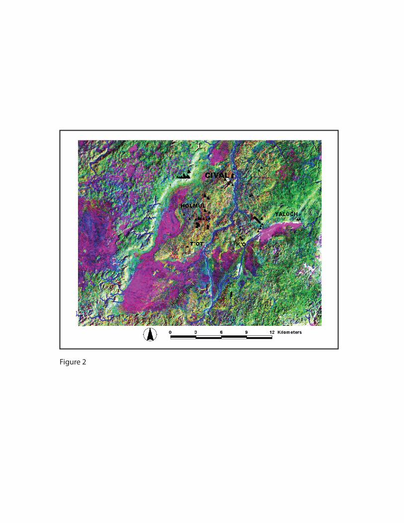
Figure 2

LPA
NorthernLowlands
SouthernLowlands
92° 88°
20°
G u l fo
fM
exi c
o
Car
i bb
e an
S ea
0 100 km
*
LC*
PL*
*AZ
*LY*
PXB
LPI**LEN
*CIV
Figure 3

0 500 1000 1500 2000 2500 3000 3500
0
100
200
300
400
0 500 1000 1500 2000 2500 3000
0
100
200
300
400
500
Dep
th in
cm
Cal yr B.P.
Laguna Yaloch
Laguna Ek’Naab
Figure 4
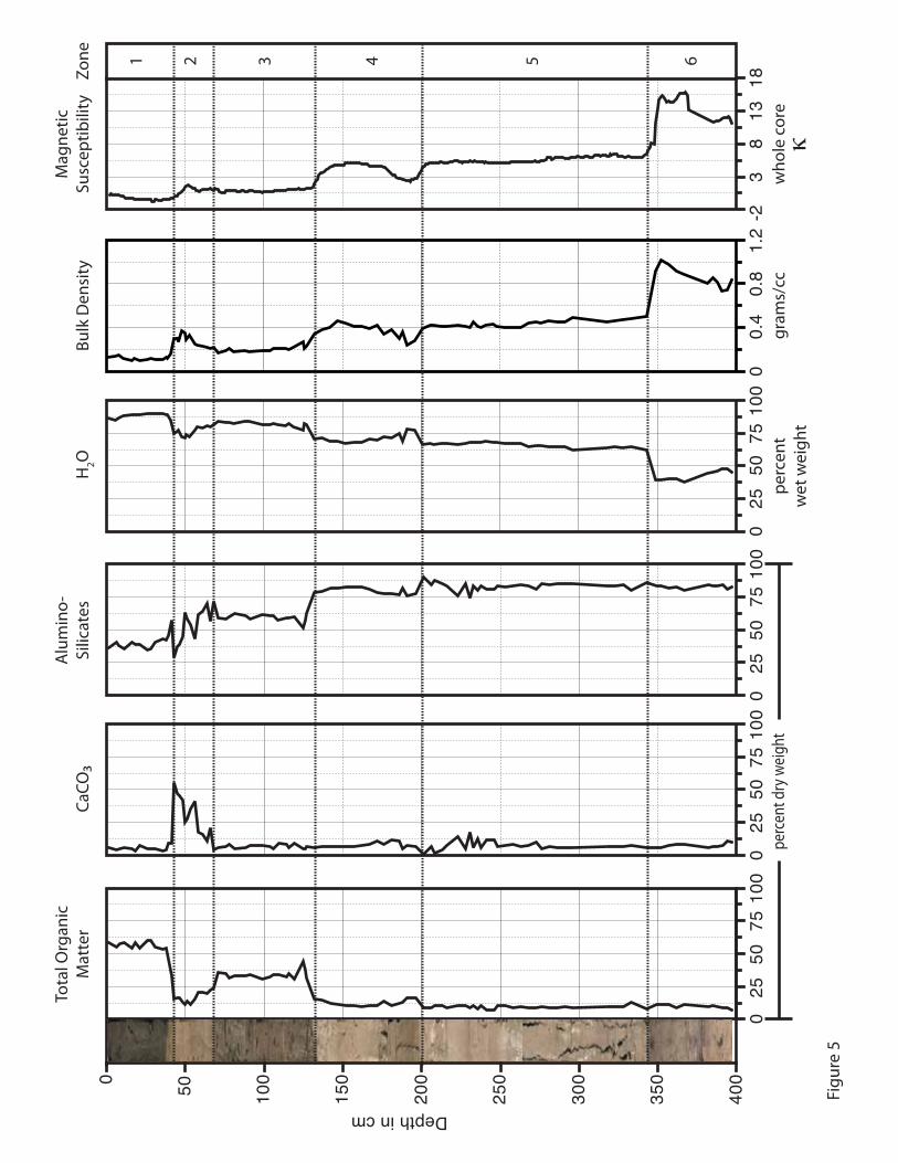
0 50 100
150
200
250
300
350
400
Depth in cm
Figu
re 5
00.
40.
81.
2-2
38
1318
025
5075
100
025
5075
100
025
5075
100
025
5075
100
Zone 1 2 3 4 5 6
Tota
l Org
anic
Mat
ter
CaCO
Alu
min
o-Si
licat
esM
agne
ticSu
scep
tibili
tyBu
lk D
ensi
ty
gram
s/cc
who
le c
ore
κpe
rcen
t dry
wei
ght
H2O
perc
ent
wet
wei
ght
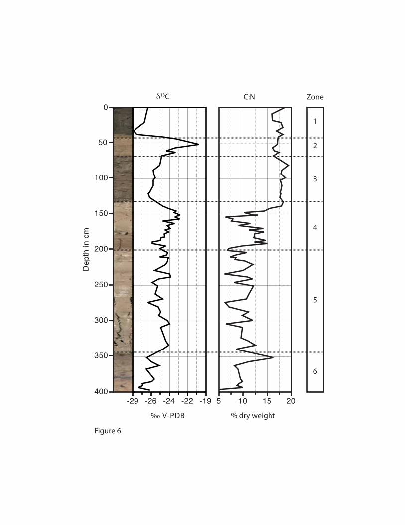
Zone
1
2
3
4
5
6
0
50
100
150
200
250
300
350
400
Dep
th in
cm
Figure 6
δ13C C:N
-29 -26 -24 -22 -19
‰ V-PDB
5 10 15 20
% dry weight

0
50
100
150
200
250
300
350
400
Dep
th in
cm
Figure 7
fragments/cc fragments/cm2/yr
Charcoal
0 200 400 600 0 30 60 90
Zone
1
2
3
4
5
6

020
40
0
200
400
600
800
1000
1200
1400
1600
1800
2000
2200
2400
2600
2800
3000
3200
015
300
48
06
120
2040
015
300
2550
03
60
48
00.
20.
50
714
Zone 1 2 3 4 5 6
Figu
re 8
URTICALES
M-C
Byrsonim
a
POACEAE
CYPERACEAE
(Cladium Inlay)
Zea
ASTERACEAE
(Ambrosia
Inlay) AMARANTHACEAE
Nymphaea
Typha
Potamogeton
Perc
ent T
otal
Pol
len
and
Spor
es
Cal yr B.P.
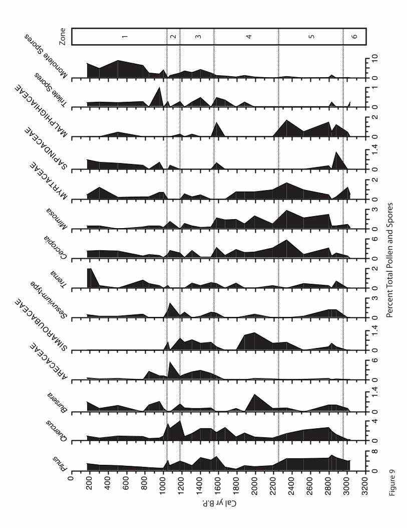
08
0
200
400
600
800
1000
1200
1400
1600
1800
2000
2200
2400
2600
2800
3000
3200
04
01.
40
60
1.4
03
02
06
03
02
01.
40
20
10
10
Zone 1 2 3 4 5 6
Pinus
Quercu
sBurs
era
ARECACEAE
SAPINDACEAE
Trema
Cecrop
ia
SIMAROUBACEAE
Sesuv
ium-ty
pe
Trilete
Spores
MALPHIGHIA
CEAE
MYRTACEAE
Monole
te Spo
res
Mimos
a
Perc
ent T
otal
Pol
len
and
Spor
es
Cal yr B.P. Figu
re 9

Cal yr B.P.
Zone 1 2 3 4 5 6
perc
ent t
otal
pol
len
and
spor
es‰
V-P
DB
% d
ry w
eigh
tfr
agm
ents
/cm
2 /yr
year
s/cm
040
0
200
400
600
800
1000
1200
1400
1600
1800
2000
2200
2400
2600
2800
3000
3200
012
014
00.
50
300
60
500
8-2
9-1
90
6030
100
045
Figu
re 1
0URTICALES
POACEAE
CYPERACEAE
Zea
ASTERACEAE
Nymphaea
Typha
Potamogeton
δ13C
CaCO
Alu
min
o-Si
licat
esC
harc
oal
090
Sed.
Rate
070
TOM

5 10 15 20
0
50
100
150
200
250
300
350
400
Dep
th in
cm
C:N
Figure 11
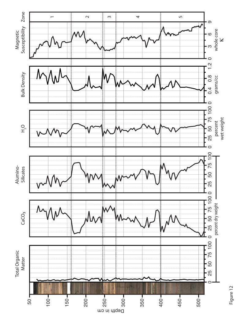
03
69
025
5075
100
025
5075
100
025
5075
100
00.
40.
81.
20
2550
7510
0
50 100
150
200
250
300
350
400
450
500
Zone 1 2 3 4 5
Tota
l Org
anic
Mat
ter
CaCO
Alu
min
o-Si
licat
esM
agne
ticSu
scep
tibili
tyBu
lk D
ensi
ty
gram
s/cc
who
le c
ore
κpe
rcen
t dry
wei
ght
H2O
perc
ent
wet
wei
ght
Depth in cm
Figu
re 1
2

Zone
1
2
3
4
5
Dep
th in
cm
Figure 13
50
100
150
200
250
300
350
400
450
500
δ13C C:N
‰ V-PDB % dry weight
8 16 24-30 -24 -18

Zone
1
2
3
4
5
Cal
yr B
P
Figure 14
Total OrganicMatter
0 8 16
CaCO
0 40 80percent dry weight
Alumino-Silicates
50 75 100
MagneticSusceptibility
whole coreκ
0 5 10
δ13C C:N
‰ V-PDB-30 -24 -18
1200
1300
1400
1500
1600
1700
1800
1900
2000
2100
2200
2300
2400
2500
26005 15 25

00.
40.
81.
21.
60
2550
7510
00
2550
7510
00
2550
7510
0
0 50 100
150
200
250
300
350
400
450
Depth in cm
Tota
l Org
anic
Mat
ter
CaCO
Alu
min
o-Si
licat
esBu
lk D
ensi
ty
gram
s/cc
perc
ent d
ry w
eigh
t
Figu
re 1
5

Figure 16
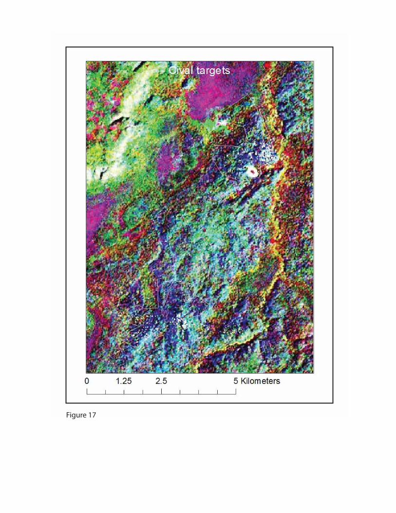
Figure 17
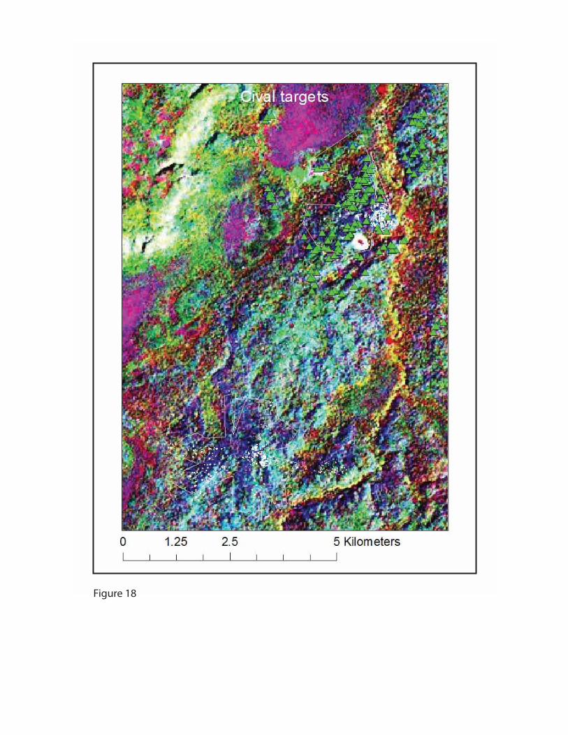
Figure 18

Figure 19

Figu
re 2
0
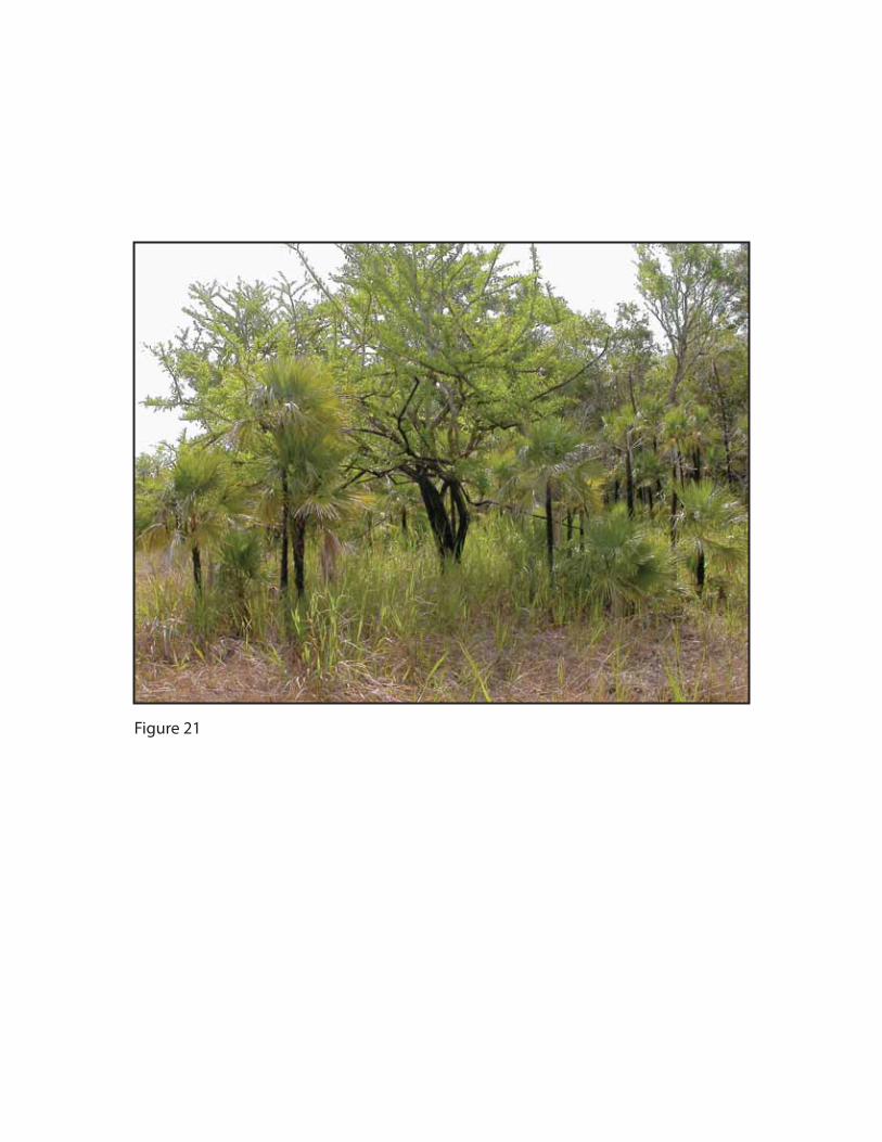
Figure 21
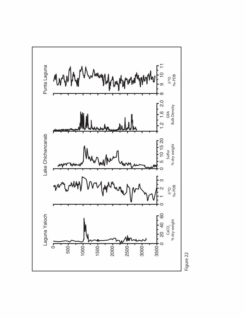
CaCO
3%
dry
wei
ght
020
4060
0
500
1000
1500
2000
2500
3000
3500
Lagu
na Y
aloc
h
89
1011
Punt
a La
guna
Lake
Chi
chan
cana
b
01
23
1.2
1.6
2.0
05
1015
20δ18
O‰
PD
Bδ18
O‰
PD
B
Sulfu
r%
dry
wei
ght
GRA
Bulk
Den
sity
Figu
re 2
2

Table 1: AMS Radiocarbon dates from Laguna Yaloch. Samples that were not analyzed for 13C were assigned an assumed value of -25‰.
Radiocarbon Age Range Median Calendar Age 2 Age Year
Depth (cm) Lab No. 13C 14C yr. B.P. (cal yr. B.P.) (cal yr. B.P.) (A.D./B.C) 11 CAMS148151 -25‰ 320 ±35 305-475 390 A.D. 1560 38 WW7098 -25‰ 1120 ±35 938-1167 1020 A.D. 930 52 WW6555 -26‰ 1152 ±35 979-1173 1075 A.D. 875
100 WW7655 -28.19‰ 1520 ±25 1344-1516 1400 A.D. 550 107 WW6551 -25‰ 1603 ±36 1404-1563 1480 A.D. 470 142 WW7099 -15.24‰ 1670 ±30 1520-1692 1575 A.D. 375 199 WW6553 -25‰ 2258 ±37 2155-2346 2235 285 B.C. 259 WW7100 -25‰ 2660 ±40 2739-2849 2775 825 B.C. 333 WW6552 -25‰ 2801 ±41 2785-3000 2905 955 B.C. 358 WW7765 -29.07‰ 2865 ±25 2887-3072 2985 1035 B.C.
Table 2: AMS Radiocarbon dates from Laguna Ek’Naab. Samples that were not analyzed for 13C were assigned an assumed value of -25‰.
Radiocarbon Age Range Median Calendar Age 2 Age Year
Depth (cm) Lab No. 13C 14C yr. B.P. (cal yr. B.P.) (cal yr. B.P.) (A.D./B.C) 71 WW7015 -25‰ 1295 ±40 1096-1299 1235 A.D. 715 85 WW7660 -28.86‰ 1290 ±25 1178-1283 1240 A.D. 710
140 WW7097 -25‰ 1520 ±40 1333-1520 1405 A.D. 545 233 WW7016 -27.34‰ 1625 ±30 1414-1597 1520 A.D. 430 275 WW7017 -11.43‰ 1670 ±30 1520-1692 1575 A.D. 375 314 WW7661 -25‰ 1825 ±30 1636-1828 1765 A.D. 185 363 WW7662 -26.53‰ 1860 ±25 1724-1868 1795 A.D. 155 390 WW7663 -25.95‰ 1955 ±30 1827-1952 1905 A.D. 45 425 WW7018 -28‰ 2120 ±30 1999-2293 2095 145 B.C.