Preface - Kerala · The Park is accessible from Kochi (Kerala) and Coimbatore (Tamil Nadu)...
142
2 Preface The High Ranges was a fascination for the visitors from colonial ages, which ultimately resulted in plantation agriculture in the area in early 1900. The colonial planters, who were also keen hunters, managed the day present Eravikulam National Park as a game preserve. By the imperatives of land reforms, the Government of Kerala took over the land in 1971. The faunal and floral value of the unique mountain shola grassland ecosystem culminated in the declaration of the area as a sanctuary in the year 1975 and as the first National Park of Kerala in 1978. The unique piece of least disturbed shola grassland holds the largest viable population of endemic and endangered Nilgiri tahr in the world along with the rich and unique floral and faunal wealth. The area receiving high rainfall is hydrologically important for the local dependents and those down stream in Kerala and Tamilnadu. The periodic gregarious flowering of Neelakurunji in the mountain grass lands and the close quarter sighting of the Nilgiri tahr popularised it as an important tourist destination in the High Ranges. The increased visitation to the Park, prevalence of illicit activities and the changes in management policies lead to the introduction of eco development programs in the Park. The management of the park and the massive inflow of visitors with the participation of local dependents and NGOs and positive interference in the lively hood of local people has created a successful model in PA management. The plan provide for strengthening the eco development activities to conserve the unique shola grassland ecosystem along with its rich floral and faunal wealth with focus on information dissemination and awareness creation. Various workshops involving forest officials, scientists, professionals and local people were conducted for the preparation of this Plan. It is prepared as per the guidelines of the Ministry of Environment and Forests and approved by the Chief Wildlife Warden of the State. All the future management activities would be carried out only as per the prescriptions of this approved Management Plan. Munnar 15-03- 2012 P.U. Saju Wildlife Warden Munnar Wildlife Division
Transcript of Preface - Kerala · The Park is accessible from Kochi (Kerala) and Coimbatore (Tamil Nadu)...
2
Preface The High Ranges was a fascination for the visitors from colonial ages, which
ultimately resulted in plantation agriculture in the area in early 1900. The colonial
planters, who were also keen hunters, managed the day present Eravikulam National
Park as a game preserve. By the imperatives of land reforms, the Government of Kerala
took over the land in 1971. The faunal and floral value of the unique mountain shola
grassland ecosystem culminated in the declaration of the area as a sanctuary in the year
1975 and as the first National Park of Kerala in 1978.
The unique piece of least disturbed shola grassland holds the largest viable
population of endemic and endangered Nilgiri tahr in the world along with the rich and
unique floral and faunal wealth. The area receiving high rainfall is hydrologically
important for the local dependents and those down stream in Kerala and Tamilnadu. The
periodic gregarious flowering of Neelakurunji in the mountain grass lands and the close
quarter sighting of the Nilgiri tahr popularised it as an important tourist destination in
the High Ranges.
The increased visitation to the Park, prevalence of illicit activities and the changes
in management policies lead to the introduction of eco development programs in the
Park. The management of the park and the massive inflow of visitors with the
participation of local dependents and NGOs and positive interference in the lively hood of
local people has created a successful model in PA management. The plan provide for
strengthening the eco development activities to conserve the unique shola grassland
ecosystem along with its rich floral and faunal wealth with focus on information
dissemination and awareness creation.
Various workshops involving forest officials, scientists, professionals and local
people were conducted for the preparation of this Plan. It is prepared as per the
guidelines of the Ministry of Environment and Forests and approved by the Chief Wildlife
Warden of the State. All the future management activities would be carried out only as
per the prescriptions of this approved Management Plan.
Munnar 15-03- 2012
P.U. Saju Wildlife Warden
Munnar Wildlife Division
3
Acknowledgement
I wish to express my deep gratitude to Sri Rajaraja Varma PCCF and HoFF, Sri. V.
Gopinathan IFS, P.C.C.F and the Chief Wildlife Warden, Sri. R.R.Shukla IFS, Addl. P.C.C.F,
Sri. K.V. Subramaniam IFS , Field Director (Project Tiger), Sri. O.P.Kaler IFS, CCF (Wildlife),
Palakkad and Sri. Bennichan Thomas IFS, C.C.F (HRC), who were very generous with their
valuable insights and guidance for the preparation of this Plan.
I am also thankful to A.P. Sunil Babu, D.F.O, Flying Squad, Punalur, Sri. Roy. P.
Thomas D.C.F (Vig.), Ms. K. Geetha, Dy. Director (Wildlife Education), N. Radhakrishnan ,
Dy. Director (Wildlife Education) and Dr. M. Balasubramaniam, Conservation Biologist,
Periyar Foundation, Dr. Veeramani, Ecologist, Periyar Foundation who were closely and
deeply associated with the preparation of the Plan.
A special word of thanks is due to the officials and various stakeholders who
participated in the meetings and workshops organised by the Forest Department and
enriched the Plan with their ideas and knowledge.
My acknowledgements would be incomplete without mentioning the contributions
of Sri. James Zacharias, Dr. P.S. Easa and Dr. Jomy Augustine at various stages of
preparation of the Plan. I extent my sincere thanks to all of them.
I also deeply acknowledge my gratitude to Sri. Aneesh C.P, Assistant Wildlife
warden, Eravikulam National Park and the field staff for their active involvement though
out the process of preparation of this Management Plan.
P.U. Saju Wildlife Warden,
Munnar Wildlife Division
4
CONTENTS
PART TITLE PAGES
PART- I THE PROTECTED AREA: THE EXISTING SITUATAION 8
CHAPTER - 1 INTRODUCTION TO THE AREA 9-20
1.1 Name, location, constitution and extent 10
1.2 Approach and access 10
1.3 Statement of significance 14
1.4 Values of the park 18
Flagship species in Eravikulam National Park 20
CHAPTER - 2 BACKGROUND INFORMATION AND ATTRIBUTES 21-37
2.1 Boundaries 22
2.2 Geology rock and soil 23
2.3 Terrain 24
2.4 Climate 24
2.5 Water sources 28
2.6 Range of wildlife, status, distribution and habitat 28
CHAPTER - 3 HISTORY OF MANAGEMENT AND PRESENT PRACTICES 38-67
3.1 General 39
3.2 Review of past management plans 40
3.3 Timber operation 42
3.4 Non wood forest produce collection 43
3.5 Leases 43
3.6 Other programmes and activities 43
3.7 Forest protection 48
3.8 Eco tourism 55
3.9 Research monitoring and training 58
3.10 Wildlife conservation strategies & evaluation 60
3.11 Administrative setup 60
3.12 Infrastructure facilities 61
3.13 Communication 64
3.14 Summary of threats to wildlife 64
CHAPTER – 4 THE PROTECTED AREA AND THE INTERFACE LAND USE SITUATION
68-75
4.1 The existing situation in the zone of influence 69
4.2 The development programme and conservation issues 73
PART- II PROPOSED MANAGEMENT 76
CHAPTER-5 PLAN OBJECTIVES AND PROBLEMS 78-85
5.1 Objectives of management 79
5
CHAPTER-6 STRATEGIES- BOUNDARIES, ZONATION, ZONE PLANS AND THEME PLANS
86-119
6.1 Boundaries 87
6.2 Zonation 88
6.3 Zone plans 89
6.3.1 Core zone 89
6.3.2 Buffer zone 91
6.3.3 Proposed additional area 92
6.3.4 Ecosensitive Zone 94
6.4 Theme plans 95
6.4.1 Theme plan for protection 95
6.4.2 Theme plan for fire protection 109
6.4.3 Theme plan of water resource management 118
CHAPTER-7 TOURISM, INTERPRETATION AND CONSERVATION EDUCATION
120-127
7.1 Strategies for environmental conservation awareness 122
7.2 Facilitating nature based regulated tourism 124
7.3 New eco tourism proposals 126
CHAPTER-8 ECO DEVELOMENT 128-134
8.1 Strategies 130
8.2 Activities 131
8.3 Regulating and control over grazing, fire wood and NTFP collection and transportation of goods through tourism zone
132
CHAPTER-9 RESEARCH, MONITORING AND TRAINING 135-139
9.1 Research 136
9.2 Monitoring 137
9.3 Training 138
9.4 Vaccination and health monitoring 138
9.5 Weather and vegetation monitoring 138
CHAPTER-10 ORGANISATION AND ADMINISTRATION 140-142
10.1 Structure 141
10.2 Responsibilities 141
CHAPTER-11 THE BUDGET 143-148
MAPS 1. Location map of Eravikulam National Park 11
2. Map of Eravikulam National Park 12
3. Toposheet of Eravikulam National Park 13
4. Eravikulam National Park ( Google earth map ) 15
5. Contoor map of Eravikulam National Park 25
6. Drainage map of Eravikulam National Park 29
7. Vegitation map of Eravikulam National Park 32
6
8. Census block map of Eravikulam National Park 46
9. Buildings in Eravikulam National Park 61
10. Tibal settlements in Eravikulam National Park 72
11. Management zones of Eravikulam National Park 90
12. Proposed additional area of Eravikulam National Park 93
13. Proposed reorganization plan 98
14. Prposed controlled burning regime 115
FIGURES 1. Nilgiri tahr 20
2. Neela Kurunji 20
3. Camera trap pictures 37
TABLES 1. Rainfall around Eravikulam National Park 26
2. Monthwise rainfall at Rajamala 2007-08 to 2009-10 26
3. Temperature 27
4. Details of EDC in Eravikulam National Park 44
5. Population of tahr in past census 45
6. Census block count 47
7. Population estimation of major mammals in the
forest of Kerala 47
8. Population estimation of Wild elephants in the
elephant reserve of Kerala 48
9. Details of hunting cases 2001 - 2010 50
10. Details of poaching cases 50
11. Details of illicit cutting of trees and transport of
sandal 2001-2010 51
12. Details of Ganja transportation cases 2001 - 2010 52
13. Details of fire incidents 2001 - 2011 53
14. Visitors and income details 56
15. Visitors details – Rajamala and Lakkom 2004-05 to
2010-11 57
16. Monthwise visitors and income – Rajamala 2010 -
2011 57
17. Monthwise visitors and income at Lakkom 2010-11 58
18. Details of Nature Camps 58
19. Staff strength in Eravikulam National Park 60
20. Buildings in Eravikulam National Park 62
21. Details of trekpath 63
22. Details of settlements 71
23. List of trekpath in Eravikulam National Park 105
24. Staff strength proposed in Eravikulam National Park 107
25. List of fireline in Eravikulam National Park 111
7
ANNEXURES Annexure- 1
Sanctuary Notification 149-150
Annexure- 2
National Park Notification 151-153
Annexure- 3
Chattamunnar Forest Station Notification 154-156
Annexure- 4
Rajamala Check Post Notification 157
Annexure- 5
Check list of the plants of the Grass lands in Eravikulam National Park
158-172
Check list of pteridophytes 166
Check list of Bryophytes (Mosses and Liverworts) 167
Check list of soil fungal flora of shola forests and grass lands 170
Annexure- 6
Check list of Mammals 173-174
Annexure- 7
Check list of Birds 175-177
Annexure- 8
Check list of Reptiles 178
Annexure- 9
Check list of Amphibians 179
Annexure- 10
Check list of Fishes 180
Annexure- 11
Check list of Butterflies 181-183
Annexure – 12
Control forms 184-197
Bibliography 198-205
8
PART - I THE PROTECTED AREA
THE EXISTING SITUATION
9
CHAPTER 1
INTRODUCTION TO THE AREA
10
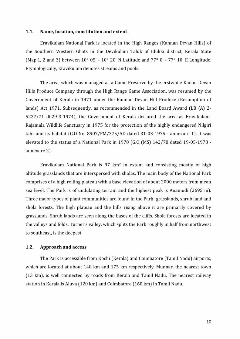
1.1. Name, location, constitution and extent
Eravikulam National Park is located in the High Ranges (Kannan Devan Hills) of
the Southern Western Ghats in the Devikulam Taluk of Idukki district, Kerala State
(Map.1, 2 and 3) between 10º 05' - 10º 20' N Latitude and 77º 0' - 77º 10' E Longitude.
Etymologically, Eravikulam denotes streams and pools.
The area, which was managed as a Game Preserve by the erstwhile Kanan Devan
Hills Produce Company through the High Range Game Association, was resumed by the
Government of Kerala in 1971 under the Kannan Devan Hill Produce (Resumption of
lands) Act 1971. Subsequently, as recommended in the Land Board Award (LB (A) 2-
5227/71 dt.29-3-1974), the Government of Kerala declared the area as Eravikulam-
Rajamala Wildlife Sanctuary in 1975 for the protection of the highly endangered Nilgiri
tahr and its habitat (G.O No. 8907/FM/375/AD dated 31-03-1975 - annexure 1). It was
elevated to the status of a National Park in 1978 (G.O (MS) 142/78 dated 19-05-1978 -
annexure 2).
Eravikulam National Park is 97 km2 in extent and consisting mostly of high
altitude grasslands that are interspersed with sholas. The main body of the National Park
comprises of a high rolling plateau with a base elevation of about 2000 meters from mean
sea level. The Park is of undulating terrain and the highest peak is Anamudi (2695 m).
Three major types of plant communities are found in the Park- grasslands, shrub land and
shola forests. The high plateau and the hills rising above it are primarily covered by
grasslands. Shrub lands are seen along the bases of the cliffs. Shola forests are located in
the valleys and folds. Turner’s valley, which splits the Park roughly in half from northwest
to southeast, is the deepest.
1.2. Approach and access
The Park is accessible from Kochi (Kerala) and Coimbatore (Tamil Nadu) airports,
which are located at about 148 km and 175 km respectively. Munnar, the nearest town
(13 km), is well connected by roads from Kerala and Tamil Nadu. The nearest railway
station in Kerala is Aluva (120 km) and Coimbatore (160 km) in Tamil Nadu.
11
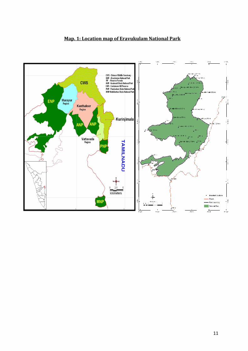
Map. 1: Location map of Eravukulam National Park
12
Map.2 : Map of Eravikulam National Park
13
Map.3 : Topo sheet of Eravikulam National Park and adjoining PAs
14
The motorable roads inside the Park includes the one that passes through the southern
extremity, inside the tourism and awareness zone (Rajamala), to the Rajamallay tea estate
and the one in the Lakkom Muthuvakudy in the southern boundary which is connected to
Lakkom in the Munnar – Udumalpet road by a road that passes through the tea estate
owned by KDHP Company. All other movements inside the Park are on foot along trails
and footpaths.
1.3. Statement of Significance
The Park holds the largest viable population of the endangered Nilgiri tahr
(Nilagiritragus hylocrius) and is a famous habitat of Neelakurinji (Strobilanthus
kunthianum), which blooms once in 12 years. Apart from tahr, the Park is the abode of
other little known fauna such as Nilgiri marten (endemic), ruddy mongoose, small clawed
otter, dusky striped squirrel etc. The Anamudy peak area is also habitat of a unique frog
Roarchestes resplendens. The Park represents the largest and least disturbed stretch of
unique montane shola-grassland vegetation in the Western Ghats. Similar ecosystems like
Nilgiris, Anamalais and Palanis were severely manipulated to raise plantations. Even in
the High Ranges, the Tertian and Karimkulam plateau were planted up. The National Park
is regionally important as a catchment area for both east (tributaries of River Pambar)
and west (tributaries of Rivers Periyar and Chalakkudy) flowing rivers. Locally, it is
important for maintaining the climate and providing drinking water to the surrounding
estates and for irrigation in parts of Aanjanad Valley.
The highest peak in peninsular India, Anamudi (2695 m), is situated in this Park.
The sharp escarpments and cliffs on all sides of the Park make this area an isolated table
land that is responsible for the unique microclimate. The unsuitability of soil for
agriculture, inaccessibility and extreme climate has helped the land remain free from
human developmental onslaught. Although the area of the Park falls latitudinally in the
tropics, it exhibit extra tropical climate due to the altitudinal influence. This change in the
bioclimate and geological stability enhances the endemic values of the area. High
elevations of the Western Ghats are considered botanically rich areas in India. There are
many temperate species like Mahonia leschnaultti, Rhododendron arboreum, Gaultheria
fragrantissima, Berberis tinctoria etc., rare orchids like Brachycorythis wightii, Habenarea
flabelliformis etc.
15
Map.4 : Eravikulam National Park (Google earth image)
16
medicinal plants like Drosera peltata and wild varieties of cultivated plants like Piper
schmidtti and Elateria cardamomum which add to the conservation significance.
The cultural values of the Park are significant to the local and indigenous people,
especially the Muthuvans. They inhabit the fringes of the Park and have traditionally
been associated with the high country.
The Park is an example of institutionalized joint management as the long
established links, with the High Range Wildlife and Environment Preservation
Association (HRWEPA), who were earlier managing the Park as a Game Reserve, is still
vibrant. Eravikulam National Park is the prime attraction in Munnar, which has become
one of the most sought after tourist destinations in the whole of India. Its aesthetic
grandeur and the possibility of seeing the endangered Tahr at close quarters at
Rajamala and the water fall at Lakkom attract more than 5,00,000 visitors annually. The
Park, in continuity with the neighboring Chinnar Wildlife Sanctuary, Anamudy Shola
National Park, Pampadum Shola National Park, Kurinjimala Sanctuary and Anamalai
tiger Reserve forms largest conservation landscapes in the Western Ghats. As the only
remaining viable island of shola – grassland complex, this Park provides ample
academic opportunities for studying the biodiversity of montane vegetation and the
ecologic riddles associated with the ecosystem. It can also serve as a field laboratory for
activities like conservation education, research and monitoring and participatory
management.
1.3.1. The Nilgiri Tahr
The Nilgiri tahr, (Nilagiritragus hylocrius Ropiquet and Hassanin, 2005) is an
endangered caprid listed in Schedule I of Indian Wildlife (Protection) Act 1972 and
categorised as ‘endangered’ by the IUCN. It is endemic to the hill ranges of the Western
Ghats of Southern peninsular India, in pockets where a suitable mosaic of montane
grasslands and rugged terrain exist. Tahr is closely related to the Himalayan tahr
(Hemitragus jemlahicus C.H Smith, 1826) which occurs along the southern flanks of the
Himalayas and the Arabian tahr (Arabitragus jayakari Ropiquet and Hassanin, 2005),
which inhibits the arid mountains of Sultanate of Oman.
An estimated 700-800 Nilgiri tahr inhabit Eravikulam National Park, making it
the largest wild population in the world. The tahr generally inhabits the fringes of the
17
grassy plateau and move on to the steep slabs and cliffs bordering it. They occasionally
visit the shrub lands along the base of the cliffs. Tahr avoids sholas, but sometime forage
along their periphery.
Nilgiri tahr in Eravikulam National Park occurs in two types of groups, the mixed
groups and all male groups. The mixed group consists primarily of adult females and
their sub adult offsprings. Adult males join these groups during the rut and keep away
at other times of the year. The male group consists of adult males of various classes. The
maximum size of the mixed group is 150 animals and that of all male groups is 20
individuals. The usual number of young one produced is one although twins may
occasionally occur. The rutting season occurs during monsoon (July and August) and the
main birth season is January to mid February. Estimated gestation period is nearly 179
days. The predators of Nilgiri tahr in Eravikulam National Park include tiger, leopard,
wild dog and jackal (C G Rice, 1984). However Easa (1995), through scat analyses,
recorded only one incident of tahr predation by leopard indicating almost nil predation
by other animals.
Nilgiri tahr commences feeding at the break of day and feed until late in the
evening. They feed and rest intermittently; the rest intervals becoming longer as the day
advances, until they become active again towards the evening. The tahr was observed to
feed primarily on 19 speciesd of grasses, 12 species of shrubs along with a lichen and
fresh shoots of dwarf bamboo. Chrysopogan zeylanicus from the major food species
followed by Eulalia phaeothrix, Aruwdinella ciliat, Sehima nervosum and Ischaemum
indicum iridicum ( Easa P.S, Sivaram M, KFRD research report No 242). Nights are spent
on the cliffs or as close to them as possible. In undisturbed areas however, they often
bed down in the open, away from the cliffs.
1.3.1.1. Male Nilgiri Tahr
A fully grown male Nilgiri tahr, known as saddle back, stands about 100 cm at the
shoulder and weighs about 100 Kg. The overall colouring is deep chocolate brown. This
is particularly dark; almost black on the front of the fore and hind legs, the shoulder, the
side of the abdomen, side of the face and the front of the muzzle. These contrast sharply
with white facial stripe which drops from the forehead towards the corners of the
mouth just anterior to the eyes, the white carpal patches on the front and outside of the
18
forelegs and the silvery saddle. The side of the neck where it meets the shoulder is also
sometimes lightened, as is the flank posterior to the saddle and an area around the eye.
Long black hairs form a mane and mid dorsal stripe.
The horns (in both sexes) curve uniformally back, and have no twist. The tips
diverge slightly due to the plane of the horn being divergent from the body axis
posteriorly and tilted slightly so as to converge dorsally. The inside surface is nearly flat
and the back and outside are rounded. There is a distinct rib where the inside and front
of the horns meet, and the horn surface is covered with numerous fine crenulations
amidst the slightly more evident annual rings. The horns of males are heavier and
longer than those of the females reaching a maximum length of about 40 cm. The rutting
season occurs during monsoon (July & August) and the main birth season was during
January to mid February. Estimated gestation period is nearby 179 days (Rice 1984).
1.3.1.2. Female Nilgiri Tahr
Female Nilgiri tahr is shorter and slighter than their male counterparts. In
contrast to the striking pelage of the male, the female is almost uniformly gray. The
carpal patch is black against the light background. The facial markings are present but
only faintly, and the area around the eye and the cheek below it are brown. The mane
and mid-dorsal stripe are much less conspicuous. The horns are slimmer and shorter,
reaching a maximum length of about 26 cm.
1.4. Values of the Park 1.4.1. Value related to flora
An abode of a number of Kurinji species, especially Nilkurinji, that blooms once in 12 years.
Exceptional ecosystem diversity consisting of shola forests, grasslands, hill forests, evergreen forests, shrub lands and moist deciduous forests.
Largest stretch of undisturbed shola grassland eco system in Western Ghats.
Exceptional species diversity in the shola forests and grasslands.
Significant population of endemic shola and grassland species.
Ideal place for “insitu” germ plasm conservation of rare and threatened species.
National Park harbors a number of Medicinal Plants.
19
1.4.2. Values related to fauna
Largest viable population of Nilgiri tahr in the world.
Good population of mammals, birds, butterflies, amphibians etc with high degree of endemism.
1.4.3. Values related to watershed
The catchment area of three important rivers, Periyar, Chalakudiyar and
Pambar.
Important source of potable water for the local dependent population and population down stream.
Irrigation water for the tea estates nearby and the agricultural land down stream.
1.4.4. Values related to education and research
Great opportunity for education and research due to rich and diverse ecosystems, plants and animals.
Ample scope for studying people’s participation in conservation and management.
1.4.5. Aesthetic values
Value related to eco-tourism.
Major destination due to the scenic beauty,unique ecosystems and life forms. Ample scope for nature photography.
1.4.6. Socio-Economic value
Livelihood for hundreds of local dependent population directly and indirectly.
The long standing relationship between the earlier managers of the Park, the High Range Wildlife and Environment Preservation Association and the local Muthuvan tribes is an ideal model in conservation initiatives.
1.4.7. Cultural Value
The Muthuvan are the local, indigenous people. They inhabit the fringes of the Park and have traditionally been associated with the management of the Park. The Park plays a significant role in sustaining them and their culture.
20
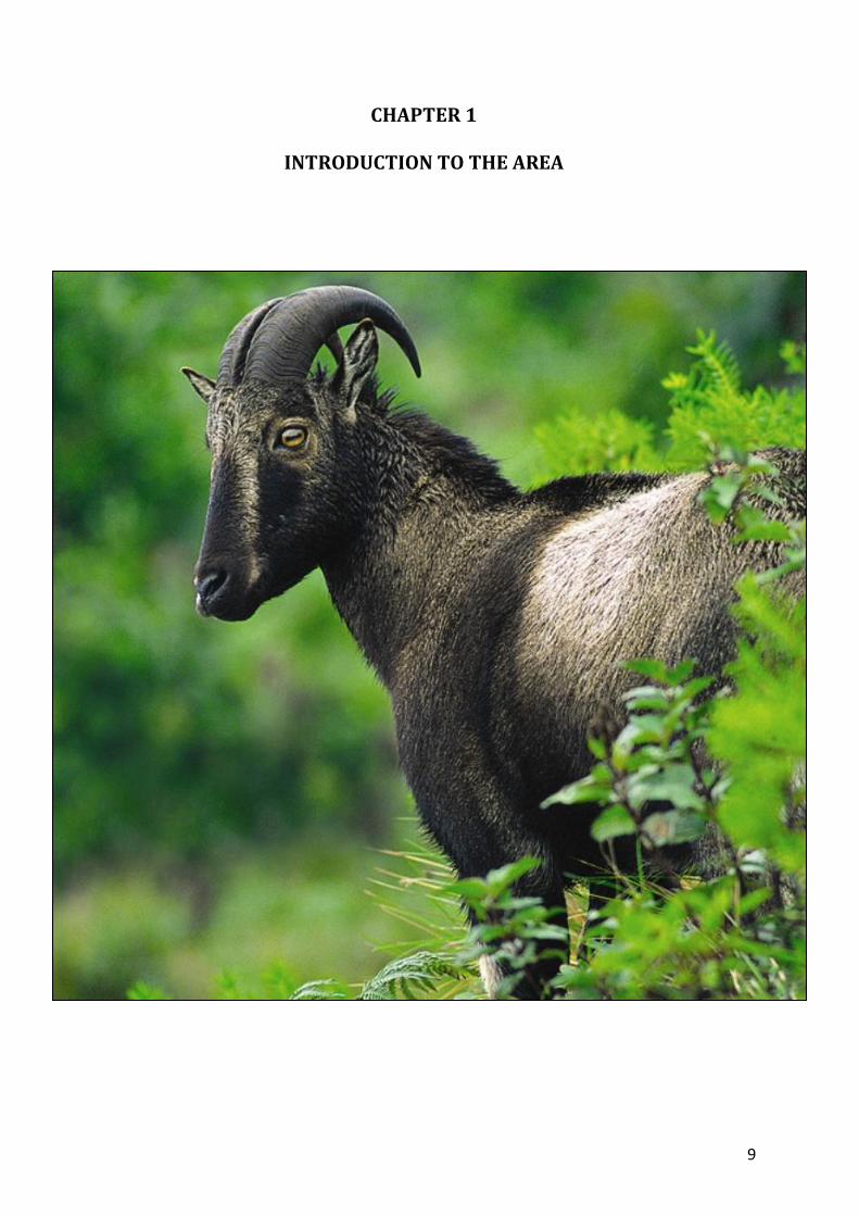
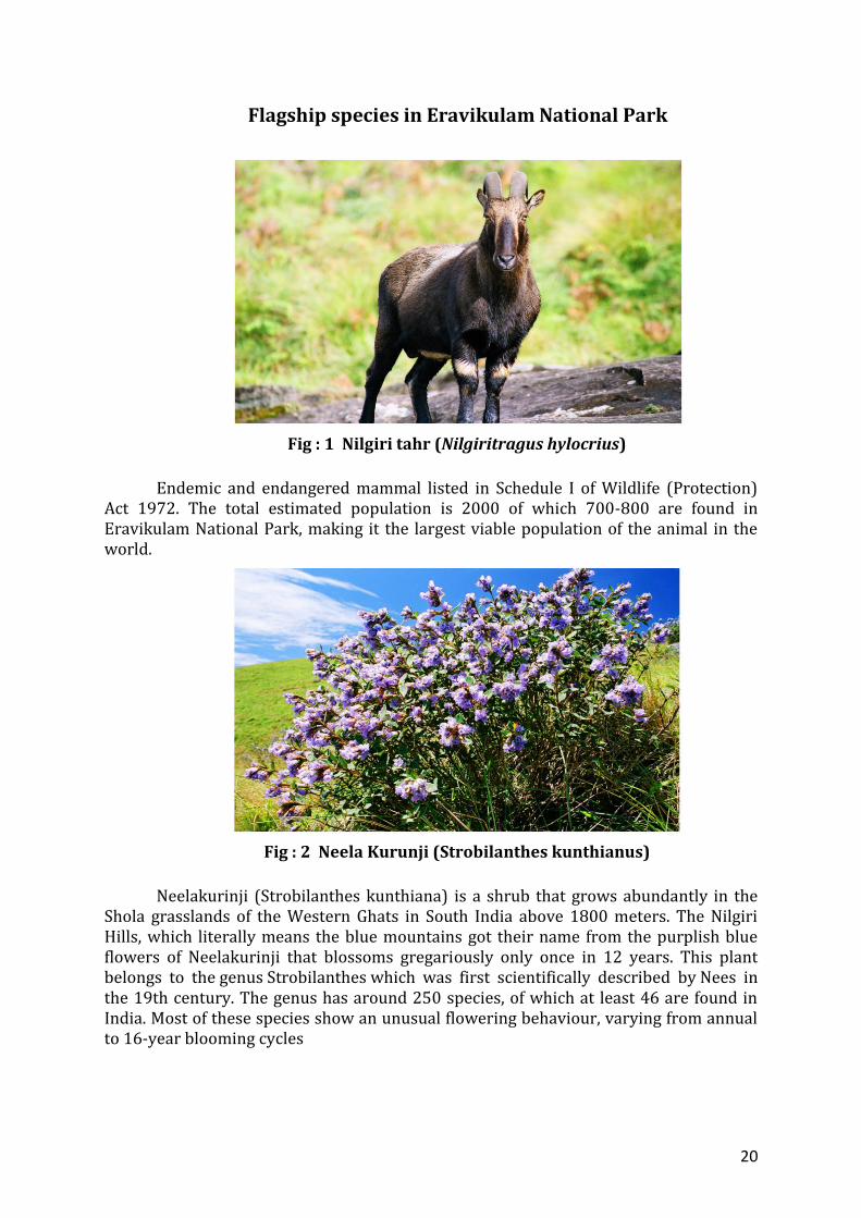
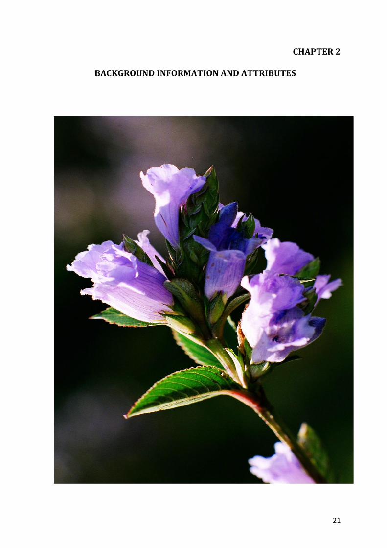
Flagship species in Eravikulam National Park
Fig : 1 Nilgiri tahr (Nilgiritragus hylocrius)
Endemic and endangered mammal listed in Schedule I of Wildlife (Protection)
Act 1972. The total estimated population is 2000 of which 700-800 are found in Eravikulam National Park, making it the largest viable population of the animal in the world.
Fig : 2 Neela Kurunji (Strobilanthes kunthianus)
Neelakurinji (Strobilanthes kunthiana) is a shrub that grows abundantly in the
Shola grasslands of the Western Ghats in South India above 1800 meters. The Nilgiri Hills, which literally means the blue mountains got their name from the purplish blue flowers of Neelakurinji that blossoms gregariously only once in 12 years. This plant belongs to the genus Strobilanthes which was first scientifically described by Nees in the 19th century. The genus has around 250 species, of which at least 46 are found in India. Most of these species show an unusual flowering behaviour, varying from annual to 16-year blooming cycles
21
CHAPTER 2
BACKGROUND INFORMATION AND ATTRIBUTES
22
2.1. Boundaries 2.1.1. Legal Boundaries Corporate estates, reserved forests and Protected Areas bound the Park on all sides. The
boundary description is as follows:
North: The boundary commence from the point where the Kannan Devan Hills Produce
Village boundary meets the interstate boundary between Kerala and Tamil Nadu at
point 5540’ (1689m). From that point the boundary runs along the interstate boundary
passing through peaks with altitude of 3984' (1214 m), 5011' (1527 m), 5885' (1794 m)
and 7388' (2252 m) to Perattumala 7033' (2144 m). Thence turning southeast the
boundary reaches Kumarikkal Mala 8275' (2522 m).
East: The boundary follows the Kannan Devan Hill Produce Village boundary along the
ridge through Kattumalai 8373’ (2552m) and then to Perumalmalai 7736' (2355 m) till
it reaches Tirumudi 5676' (1830 m).
South: The boundary follows the western boundary of Chattamunnar Estate (Thalayar
group), northern boundaries of Vaguvurrai and Nayamakkadu Estate to meet the
Kannan Devan Hill Produce Village boundary about 3 Km south west of Rajamala peak
7209' (2197 m).
West: The boundary follows the Kannan Devan Hill Produce Village boundary to
Rajamala 7209’ (2197 m) and then turning north-east, the boundary reaches
Sambamalai 7581' (2311 m) and thence to Bhimamalai 4719' (1438 m) and from there
turns in a north east direction to Kolukkumalai, 7137' (2175 m) and thence proceeds in
north direction to the starting point at 5540' (1689 m) passing through Erumamalai,
7496' (2284 m) and Erumapetti malai, 6999' (2133 m).
The boundary notification is vague at some points where the distinction between
National Park and tea estates is not clear enough. The southern boundary with the tea
estates still remains vague at few points. For the rest of the Park, the boundaries are
clear and demarcated. On the south boundary between Lakkom Kudy and
Chattamunnar, a small area (about 5 ha) has been under occupation. There is no reliable
record regarding the time of occupation.
23
2.1.2. Internal Boundaries
The boundary of the Lakkom Muthuvan settlement situated inside the Park on
the southern periphery is demarcated with kayyala. The individual right over land is
already settled as per Forest Rights Act. The Park is under a single Forest Station with
head quarters at Lakkom and there is no internal demarcation.
2.1.3. Ecological Boundaries The notification follows the ridges as the boundary and the ecological boundaries
of the Park extend into the Anamalai Tiger Reserve in Tamilnadu, Chinnar Wildlife
Sanctuary under Munnar Wildlife Division and Koodakkad proposed reserve under
Marayur division in the north, Koodakkad proposed reserves under Marayur Division in
the east, the grasslands of KDHP company, Mankulam Division and Munnar division in
south and Anaimudi reserve forest under Munnar Division in the west. These areas are
vital as fawning and escape cover for a species like tahr.
2.2. Geology, rock and soil The underlying rocks in the area are of Archaean igneous origin, consisting of
granite and gneiss. The crystalline rocks consist of minerals such as silica, feldspars,
muscovite and biotitic with small amounts of accessory ferro-magnesium minerals. The
soil is basically a relic of a much thicker soil cover that developed formerly under
pseudo-dynamic conditions prevailing from late Jurassic to early Tertiary times. It is
composed of different layers, black to dark gray in colour, granular, friable, sandy loam
interspersed with a little gravel. The soil is rich in organic matter. Soil is sandy-clay with
sand (79.43 – 94.14 %), silt (1.43 – 11.00 %), clay (2.71 – 5.57 %) and some gravel,
altogether approximately 30-100 cm in depth. Soil depth is more in valleys, bogs and
shola margins when compared with that of slopes and crests. The soil moisture in the
month of May ranges from 12.30 to 39.97 % in different landscape units. The chemical
composition of the soil shows a high percentage of organic carbon (18 % in grass lands
and 22.5 % in shola) and nitrogen (0.7 % in grass land and 1.2 % in shola), which
indicates the low decomposition of organic matter due to cool climate conditions. The
soil is acidic with pH ranging from 4.13 – 5.34 in different landscape units.
24
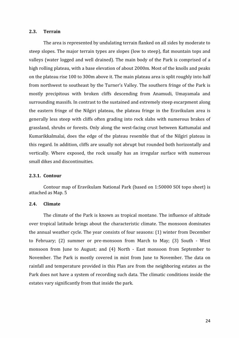
2.3. Terrain The area is represented by undulating terrain flanked on all sides by moderate to
steep slopes. The major terrain types are slopes (low to steep), flat mountain tops and
valleys (water logged and well drained). The main body of the Park is comprised of a
high rolling plateau, with a base elevation of about 2000m. Most of the knolls and peaks
on the plateau rise 100 to 300m above it. The main plateau area is split roughly into half
from northwest to southeast by the Turner’s Valley. The southern fringe of the Park is
mostly precipitous with broken cliffs descending from Anamudi, Umayamala and
surrounding massifs. In contrast to the sustained and extremely steep escarpment along
the eastern fringe of the Nilgiri plateau, the plateau fringe in the Eravikulam area is
generally less steep with cliffs often grading into rock slabs with numerous brakes of
grassland, shrubs or forests. Only along the west-facing crust between Kattumalai and
Kumarikkalmalai, does the edge of the plateau resemble that of the Nilgiri plateau in
this regard. In addition, cliffs are usually not abrupt but rounded both horizontally and
vertically. Where exposed, the rock usually has an irregular surface with numerous
small dikes and discontinuities.
2.3.1. Contour Contour map of Eravikulam National Park (based on 1:50000 SOI topo sheet) is attached as Map. 5
2.4. Climate The climate of the Park is known as tropical montane. The influence of altitude
over tropical latitude brings about the characteristic climate. The monsoon dominates
the annual weather cycle. The year consists of four seasons: (1) winter from December
to February; (2) summer or pre-monsoon from March to May; (3) South - West
monsoon from June to August; and (4) North - East monsoon from September to
November. The Park is mostly covered in mist from June to November. The data on
rainfall and temperature provided in this Plan are from the neighboring estates as the
Park does not have a system of recording such data. The climatic conditions inside the
estates vary significantly from that inside the park.
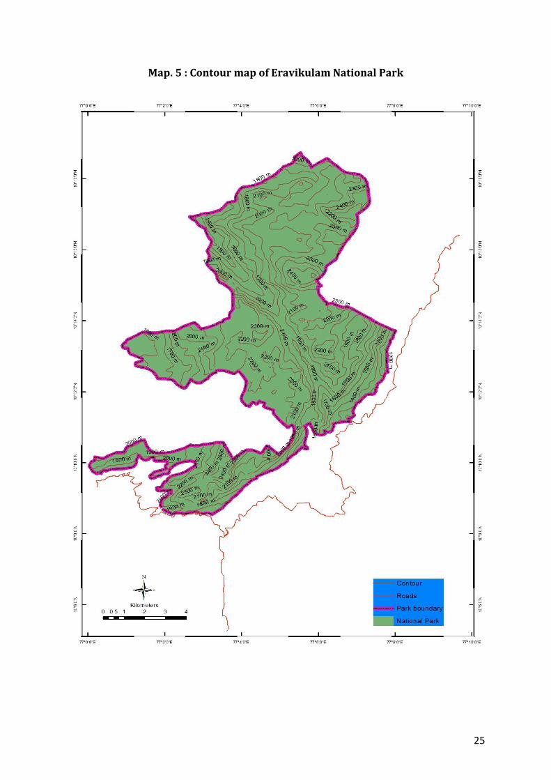
25
Map. 5 : Contour map of Eravikulam National Park
26
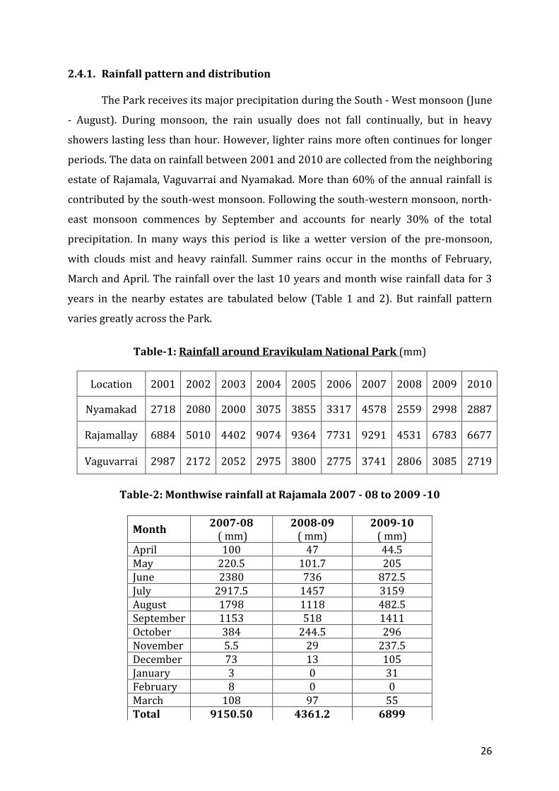
2.4.1. Rainfall pattern and distribution The Park receives its major precipitation during the South - West monsoon (June
- August). During monsoon, the rain usually does not fall continually, but in heavy
showers lasting less than hour. However, lighter rains more often continues for longer
periods. The data on rainfall between 2001 and 2010 are collected from the neighboring
estate of Rajamala, Vaguvarrai and Nyamakad. More than 60% of the annual rainfall is
contributed by the south-west monsoon. Following the south-western monsoon, north-
east monsoon commences by September and accounts for nearly 30% of the total
precipitation. In many ways this period is like a wetter version of the pre-monsoon,
with clouds mist and heavy rainfall. Summer rains occur in the months of February,
March and April. The rainfall over the last 10 years and month wise rainfall data for 3
years in the nearby estates are tabulated below (Table 1 and 2). But rainfall pattern
varies greatly across the Park.
Table-1: Rainfall around Eravikulam National Park (mm)
Location 2001 2002 2003 2004 2005 2006 2007 2008 2009 2010
Nyamakad 2718 2080 2000 3075 3855 3317 4578 2559 2998 2887
Rajamallay 6884 5010 4402 9074 9364 7731 9291 4531 6783 6677
Vaguvarrai 2987 2172 2052 2975 3800 2775 3741 2806 3085 2719
Table-2: Monthwise rainfall at Rajamala 2007 - 08 to 2009 -10
Month 2007-08
( mm) 2008-09
( mm) 2009-10
( mm) April 100 47 44.5 May 220.5 101.7 205 June 2380 736 872.5 July 2917.5 1457 3159 August 1798 1118 482.5 September 1153 518 1411 October 384 244.5 296 November 5.5 29 237.5 December 73 13 105 January 3 0 31 February 8 0 0 March 108 97 55 Total 9150.50 4361.2 6899

27
2.4.2. Temperature, a summary of year round pattern The mean daily maximum temperature rises during January - May, but drops
abruptly with the onset of monsoon in June. The lack of penetration of solar radiation
accounts for the maximum temperatures being the lowest during the monsoon, after
which they rise again slightly. The lowest minimum temperatures however are during
the winter months. The winter starts by December and lasts until February. Frost is a
frequent phenomenon during winter nights. The nights are clear and through radiant
heat loss the surface temperature at times reaches freezing point. The day temperature
during this period goes to 23 - 250 C. At Rajamala the monthly mean minimum
temperature recorded was 6.250 C in January and the mean maximum was 24.390 C in
February. The Table 3 shows month wise mean maximum and minimum temperature
recorded at Rajamala tea estate.
Table 3 Temperature
Month 2007 2008 2009
Min 0 C Max 0 C Min 0 C Max 0 C Min 0 C Max 0 C
January 6.25 22.7 9.93 22.64 10.25 22.87
February 8.25 22.50 12.64 23.17 12.25 24.39 March 11.25 22.67 10.83 23.06 13.77 14.06 April 13.40 23.30 13.60 22.33 14.06 24.03 May 14.38 23.25 13.64 22.58 15.51 24.35 June 13.67 22.96 13.86 22.46 14.00 23.00 July 13.67 22.61 14.06 22.61 14.00 20.00
August 13.86 22.86 14.22 23.09 14.81 22.65 September 13.43 23.36 12.80 22.10 14.76 22.86
October 13.35 23.06 9.93 22.58 14.03 23.22 November 11.06 22.30 12.00 21.86 13.00 24.00
December 10.45 20.45 8.96 22.12 10.00 24.00
Mean 11.91 22.67 12.20 22.55 13.37 22.45
2.4.3. Humidity
Humidity varies with season. During monsoon it is as high as 83–100%. The
winter days are marked by very low humidity 59-62% that further declines with high
wind velocity.
28
2.4.4. Wind speeds During south - west monsoon, winds are consistently from the west and strong,
at times reaching an estimated 80 km/hr. Low velocity winds occur during north - east
monsoon and in the winter season. During February - March, dry winds blow from the
east, growing stronger at times.
2.5. Water sources
Many streams criss-cross the landscape. Almost all the streams are perennial.
They merge together to form tributaries of Periyar and Chalakudiyar in the west and
river Pambar in the east. The lake at Bheemanauda is an artificial one created before the
formation of the National Park.
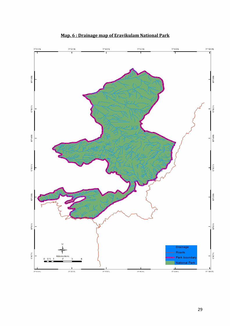
2.5.1. Drainage The drainage map of Eravikulam National Park (Map. 6) was generated digitally
using SOI topo sheet and watershed atlas map of Kerala State Land Use Board.
2.6. Range of wildlife, status, distribution and habitat
The shola-grassland complex of the Park provides a wide range of habitats to
many mammals, reptiles, birds, amphibians and a large group of invertibrates. 49
species of mammals, 132 species of birds, 20 species of amphibian and 101 species of
butterflies, thirteen species of reptiles and four species of fishes have been recorded
from the Park. The introduced fish, rainbow trout (Salmo gairdneir) is the dominant fish
species in the streams and water bodies. The sholas are generally confined to the
valleys, glens, hollows and depressions. They are evergreen forests characterized by
stunted trees with dense crown, thick, more or less closed canopy and small coriacious
leaves. Species like tiger, leopards, gaur and elephant frequently move across the
boarder into the neighboring estates, sanctuaries and reserved forests. They generally
prefer the proximity of sholas as they provide the much needed cover. But tahrs always
prefer the open grasslands proximate to cliffs. The Park boundary passes through the
centre of its vital habitat along the edge of the plateau. Elephant movements within the
National Park are seasonal. Fire is an important factor that influences animal
movements. The post-birth period population of Nilgiri tahr in the Park is estimated to
be about 700-800. The population of tahr as per the 2011 census is 831.
29
Map. 6 : Drainage map of Eravikulam National Park
30
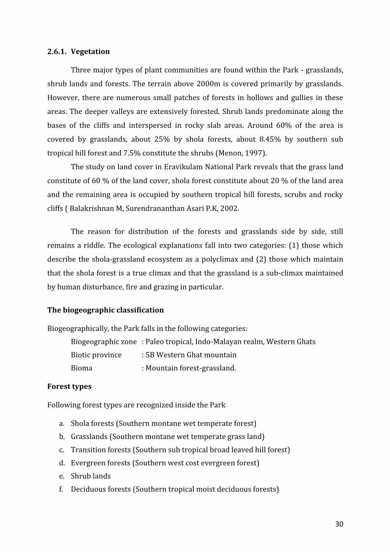
2.6.1. Vegetation
Three major types of plant communities are found within the Park - grasslands,
shrub lands and forests. The terrain above 2000m is covered primarily by grasslands.
However, there are numerous small patches of forests in hollows and gullies in these
areas. The deeper valleys are extensively forested. Shrub lands predominate along the
bases of the cliffs and interspersed in rocky slab areas. Around 60% of the area is
covered by grasslands, about 25% by shola forests, about 8.45% by southern sub
tropical hill forest and 7.5% constitute the shrubs (Menon, 1997).
The study on land cover in Eravikulam National Park reveals that the grass land
constitute of 60 % of the land cover, shola forest constitute about 20 % of the land area
and the remaining area is occupied by southern tropical hill forests, scrubs and rocky
cliffs ( Balakrishnan M, Surendrananthan Asari P.K, 2002.
The reason for distribution of the forests and grasslands side by side, still
remains a riddle. The ecological explanations fall into two categories: (1) those which
describe the shola-grassland ecosystem as a polyclimax and (2) those which maintain
that the shola forest is a true climax and that the grassland is a sub-climax maintained
by human disturbance, fire and grazing in particular.
The biogeographic classification Biogeographically, the Park falls in the following categories:
Biogeographic zone : Paleo tropical, Indo-Malayan realm, Western Ghats
Biotic province : 5B Western Ghat mountain
Bioma : Mountain forest-grassland. Forest types Following forest types are recognized inside the Park
a. Shola forests (Southern montane wet temperate forest)
b. Grasslands (Southern montane wet temperate grass land)
c. Transition forests (Southern sub tropical broad leaved hill forest)
d. Evergreen forests (Southern west cost evergreen forest)
e. Shrub lands
f. Deciduous forests (Southern tropical moist deciduous forests)
31
The two distinct physiognomic units of vegetation found within the Park are
the grasslands and shola forests. These forests are classified as southern montane wet
temperate forests. The forests on the plateau occupy glens, hollows or valleys. Broadly,
the shola vegetation also includes the subtropical broad leaved hill forests that merge
into the evergreen forests at a lower altitude. Grasslands, sholas, shrub lands and
subtropical broad-leaved hill forests are the major land cover types. A small portion of
the Park has southern west coast evergreen forests on its western side and moist
deciduous forests on the east.
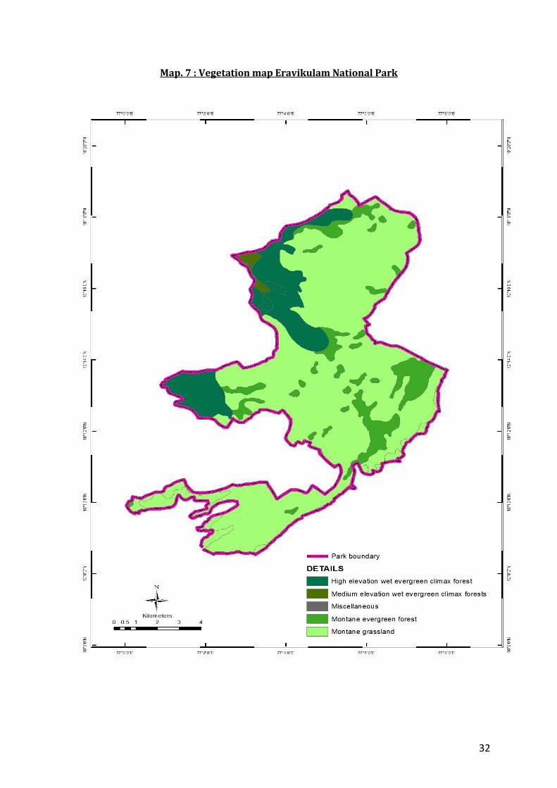
Vegetation mapping
Around 60% of the area is covered by grasslands, about 25% by shola forests,
about 8.45% by southern sub tropical hill forest and 7.5% constitute the shrubs (Menon
ARR, 1997). Vegetation map of Eravikulam Natimal Park is attached as Map. 7.
2.6.2 Flora
The Park is floristically rich due to its characteristic climatic condition. 803 taxa
(76 Peridophytes and 727 Angiosperms) were collected and described from the Park.
They belong to 332 genera representing 134 families. Dicotyledons dominated with 505
species belonging to 240 genera and 90 families. Monocotyledons were represented by
222 species under 92 genera and 16 families. 10 dominant families with respect to
species richness are Poaceae ( 105 species and 39 genera ), Orchidaceae ( 66 species
and 23 genera ), Asteraceae ( 48 species and 24 genera ), Rubiaceae ( 43 species and 17
genera ), Balsaminaceae ( 39 species and 1 genus ), Acanthaceae ( 31 species and 7
genera ), Papilionaceae ( 26 species and 12 genera ), Lauraceae ( 32 species and 6
genera ), Melastomataceae ( 18 species and 4 genera ), Lamiceae ( 17 species and 7
genera ). Fern groups here are endemic and comprises of 76 species under 35 genera
and 28 families. Nearly 190 species are Western Ghat endemics, and 89 among these are
placed under various threat categories. During the study 36 species of Impatients were
collected in and around the park of which 18 are locally endemic and not seen
anywhere in the Western Ghats.
32
Map. 7 : Vegetation map Eravikulam National Park
33
They harbour 15 species of Arisaema which are confined to this area alone and 2
species of Ophiorrhiza which was recollected after 68 year. Other endemics of this
region are, Anaphalis barnesii, Begonia aliciae, Didymocarpus mcrostachya, Habenaria
flabelliformis etc. (Floristic studies on Eravikulam National Park Biju S.D. TBGRI, Palode
2004)
The characteristics and species found in various forest types in the Park are
Shola forests
The hill forests are locally known as ‘sholas’, the Tamil term for forest. The shola
forests in the upper plateau are dense and floristically rich with many endemic and rare
species. The trees in the sholas form a continuous canopy usually not exceeding 10-
15m. There is no marked differentiation into canopy layers. The tree bark is covered
with lichens, orchids, mosses and climbers. The crowns are generally rounded and
dense.
Common tree species in the shola forests are Pithecellobium subcoriaceum, Ixora
notoniana, Syzygium arnottianum, Ilex denticulata, I. wightiana, Michaelia nilagirica,
Elaeocarpus recurvatus, Microtropis ramiflora, Actinodaphne bourdellonii, and Symplocos
pendula. The edges of the shola are marked by trees such as Rhododendron
arboreumvar. nilagiricum, Ternstroemia japonica, Ligustrum perrottettii, Turpinia
cochinchinensis,Mahonia leshenaultii, Rhodomyrtus tomentosa, Berberis tinctoria,
Vaccinium neilgherrense etc. and herbs and shrubs include Gaultheria fragrantissima,
Moonia heterophylla, Jasminum bignoneacium, Smithia blanda, Valeriana hookeriana and
a few species of Strobilanthes. The undergrowth in the shola is represented by
Strobilanthes sp., Impatiens phoenicea, I. coelotropis, Psychotria congesta, Viola patrinii, V.
serpens, Asplenium sp., and Arundinaria densifolia. Epiphytic orchids in the sholas include
Aerides ringens, Coelogyne nervosa, C. mossiae, Eria dalzelli, E. pauciflora, and
Schoenorchis filiformis. The common climbers are Piper schmidtii, Rubia cordifolia, and
Connarus wightii. Rapanea capillata, Vaccinium leschenaultii, Impatiens tangachee,
Sonerila grandiflora, Osmunda regalis and Eurya japonica are usually found along
streams.
Broad-leaved forests are found on the slopes descending from the plateau. The
dominant tree species found in the broad-leaved forests are Pittosporum tetraspermum,
Elaeocarpus munroii, Apollonias arnotti, Symplocos spicata, Gomphandra coriacea,
Garcinia gummi-gutta, Litsea coreacea, Prunus ceylanica and Photinia notoniana. Major
34
shrubs include Begonia subpeltata, Osbeckia lineolata, Polygala arillata, Strobilanthes
homotropus, Maesa perrottetiana etc.
Grass lands
About 80% of the Park is occupied by grasslands. They cover the plateau and
descending slopes. Three hundred and eight species are recorded from the grasslands
out of which 51 are endemic to the montane grasslands of the Western Ghats
(Karunakaran P V., Rawath G S et al. 1998).
The major grass species in the grasslands are Andropogon lividus, Arundinella
vaginata, Digitaria wallichiana and Arundinella mesophylla. Chrysopogon zeylanicus and
Sehima nervosum dominate these plateau and slopes, whereas in the cattle grazed areas,
unpalatable Cymbopogon flexuosus is frequent. Chrysopogon zeylanicus the dominant
grass species is found at Rajamala, down slopes of Anamudi and Poovar. Sehima
nervosum community is more prevalent throughout the plateau. Moist valleys are
characterized by Garnotia sps. Other dominant grasses are Eulalia phaeothrix,
Andropogon lividus, Arundinella purpurea, Agrostis peninsularis, Ischaemum indicum,
Heteropogon contortus and Tripogon bromodies.
The common herbs and shrubs in the grasslands include Anaphalis lawii, A.
bourneii, A. meeboldii, Swertia corymbosa, Polygala japonica, Curculigo orchioides,
Micromeria biflora, Bupleurum distichophyllum, Crotalaria fysonii, C. ovalifolia,
Ranunculus reniformis, Hedyotis swertiodes, Senecio lavandulaefolius, Parnassia
mysorense, Pedicularis zeylanica, Wahlenbergia gracilifolia, Impatiens pandata, I.
modesta, Phlebophyllum kunthianum, Hypericum mysorense, Pteridium aquilinum,
Ageratina adenophora, Gaultheria fragrantissima etc. The water logged areas are
dominated by species such as Eriocaulon robustum, E. collinum, and E. geofreyii.
The summit of the Anaimudi is vegetated with patches of stunted Arundinaria
densifolia and Gaultheria fragrantissima (wintergreen), Anaphalis sp., Impatiens and
some species of Eniocaulon.
The detailed list is attached as annexure 5
35
Shrub lands The shrub lands in the Park form a stable vegetative association occurring on
steep slopes below cliffs and interspersed among rock slabs. The dominant shrub
present on the bouldery slopes is Strobilanthus kunthianum, (Neelakurinji). This
endemic species blooms once in twelve years. Other species include Ageratina
adenophora, Gaultheria fragrantissima, Hypericum mysorense etc. Shrubby species
predominate near tea estates and bouldery slopes.
Deciduous forests A small portion on the eastern periphery of the Park lying close to Talliar estate
has deciduous forests with trees like rosewood, Pterocarpus etc. The undergrowth is
predominantly Lantana.
Tropical evergreen forests
On the western side of the Park where the hill forests merge into the Anaimudi
Reserve, a small segment of the Park exhibits characteristics of tropical evergreen
forests. The trees are tall and lofty with typical species like Mesua ferrea, Cullenia excelsa
and Palaquim ellipticum.
2.6.2. Animals
The type of animals found in a given area is the function of its existing plant
communities which in turn are governed by geo-morphology of soil, climate and rainfall
conditions. Seventeen mammals, 11 birds and 10 butterflies are Western Ghat
endemics. Mammals like Nilgiri tahr, Nilgiri marten and birds like white bellied shorting
and Kerala laughing thrush have closely related species in the Himalayas. Roarchestes
resplendens, a frog has been found only near the Anamudy peak.
A total of 85 species of butterflies, 81 species of birds ( 45 confined to shola
forest and 16 migratory ) 21 species of mammals, 22 species of amphibians and 33
species of reptiles are reported ( Balakrishnan M, Surendrananthan Asari P.K, 2002)
36
Mammals
There are 49 species of mammals recorded from the Park ( Fauna of Eravikulam
National Park, Zoological Survey of India, Faunal Conservation Series 13, 2002 and
management plan of Eravikulam National Park 2002 to 2011) of which 17 are endemic
to the Western Ghats. The list is attached as annexure 6.
Reptiles
Thriteen species of reptiles which include five Lizards and eight snakes are
reported. Ten out of thirteen species are endemic to Western Ghats (Fauna of
Eravikulam National Park, Zoological Survey of India, Faunal Conservation Series 13,
2002). Detailed list attached as annexure 7.
Avifauna A total 132 species of birds have been identified in the Eravikulam National Park
of which 11 are endemic to Western Ghats. The list is attached as annexure 8.
Fishes
Four species of fishes are reported from the Park (Fauna of Eravikulam National
Park, Zoological Survey of India, Faunal Conservation Series 13, 2002). Detailed list
attached as annexure 9.
Butterflies
A total number 101 species of butterflies have been identified in the Eravikulam
National Park of which 11 are endemic to Western Ghats. The list is attached as
annexure 10.
Amphibians A total number of 20 amphibians are reported from the Park of which 17 are
endemic to Western Ghats (Fauna of Eravikulam National Park, Zoological Survey of India,
Faunal Conservation Series 13, 2002). The list is attached as annexure 11.
37
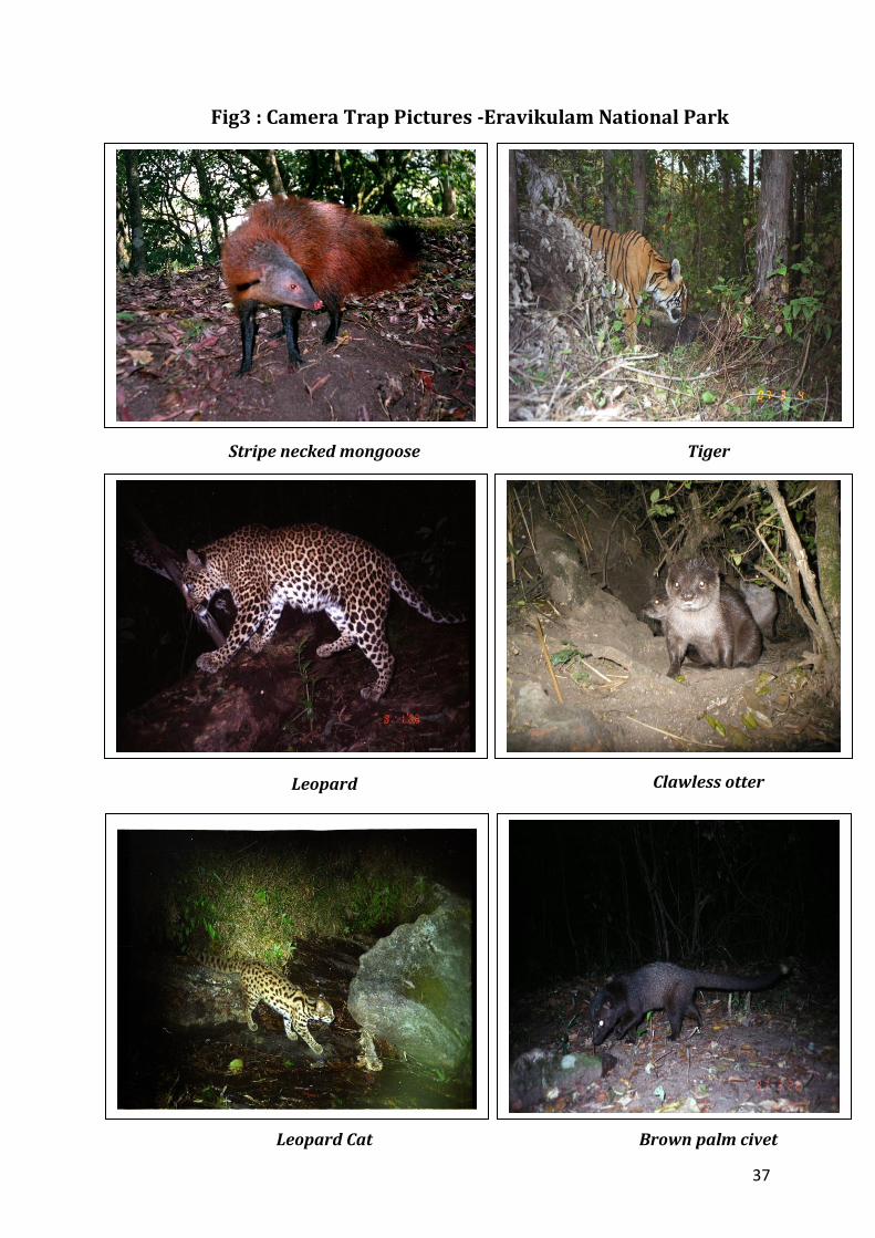
Fig3 : Camera Trap Pictures -Eravikulam National Park
Stripe necked mongoose Tiger
Leopard Clawless otter
Leopard Cat Brown palm civet
38
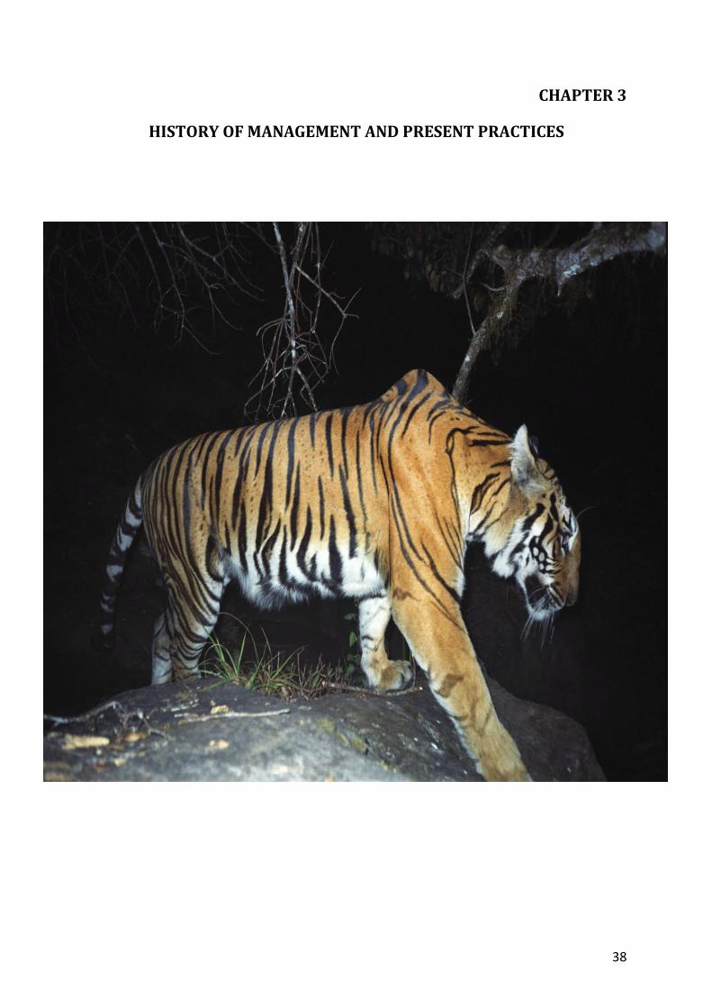
CHAPTER 3
HISTORY OF MANAGEMENT AND PRESENT PRACTICES
39
3.1. General
Eravikulam National Park was managed as a Game Reserve by the Kannan Devan
Hill Produce Company till 1971. The responsibility for the management and protection
of the area was vested with the High Range Game Preservation Association, a pioneer
non-governmental organization in this area, which was formed in 1928. Due to the
unique land features, climate and remoteness, this high land attracted the attention of
many hunters, naturalists, and scientists. One of the early European explorers was Col.
Douglas Hamilton who described the beauty and grandeur of this area in 1854. Modern
settlements began with the establishment of North Travancore Plantation and
Agricultural Society in 1879. J.D. Munro, on a hunting expedition in 1877, recognized the
possibilities of raising plantations in these ranges and acquired about 227 sq. miles
(581.12 sq. km) of land on concession from Poonjat Raja, chief of the local kingdom.
Later, the land was distributed among the members of the Society, and cultivation of
various plantation crops like coffee and cinchona were tried. It was realized later, that
tea was the most suitable crop for this area. The first tea in the High Ranges was planted
by Sharp in 1890. Passing through the stress and strain of raising plantations, the
members of the Society merged and a majority of the estates were transferred to James-
Finlay, a European company. Later, extensive cultivation of tea and eucalyptus was
carried out by clearing natural vegetation. Apart from cultivation, the English game
hunters among the old planters had taken interest in hunting activities and set aside
some areas for recreation. The present day Eravikulam National Park was one such
area. The game included Nilgiri tahr, sambar, barking deer, gaur, wild boar, leopard and
tiger. The area also offered excellent opportunity for angling of rainbow trout (Salmo
gairdnerii) which was introduced from Scotland. The High Range Game Preservation
Association was the regulatory body, which used to manage such activities with the help
of Muthuvan tribals who were employed by them as game watchers. The managers of
the nearby estates were appointed as Wardens for managing the various recreational
and game areas.
The imperatives of land reforms led to the enactment of the Kannan Devan Hills
(Resumption of Lands) Act 1971, by which all lands that were not under cultivation by
the company were vested with the Government of Kerala. The Government’s intention
was to distribute this land for agricultural purposes. The area under the Park was
40
initially earmarked for cattle farming. But because of the timely intervention by an
interested group consisting of planters, bureaucrats, naturalists and scientists, the
Government of Kerala declared the area as Eravikulam-Rajamallay Wildlife Sanctuary in
1975(GO No. 8907/FM/375/AD dated 31-03-1957) for the protection of the Nilgiri tahr
and its habitat. Subsequently, in 1978 it was upgraded to a Sanctuary (GO(MS)142/78
dated 19-05-1978). The Park was managed as a range under the Munnar Division and in
1984 it was brought under the Wildlife Warden, Idukki. In the year 1996, a separate
division named Eravikulam National Park Division was formed in the year 1996 with
head quarters at Munnar. Now Eravikulam National Park is one of the six protected
areas under the division, now known as Wildlife Division, Munnar. Over the years, the
management of the Company changed hands and with the increase in awareness, the
game association has redefined its objectives to become High Range Wildlife and
Environmental Preservation Association (HRWEPA). The Association now joins hands
with the Forest Department in managing the Park.
The tourism zone of Eravikulam National Park is known for the close quarter
sighting of Nilgiri tahr (Nilgiritragus hylocrius) and massive flowering of Neelakurinji
(Strobilanthus kunthianum), an endemic shrub that flowers once in 12 years. It is the
massive flowering of Neelakurinji and the heavy flow of visitors to the National Park in
2006, helped in the introduction of the present visitor management system. Before this,
the light vehicles of the visitors were allowed up to the tourism zone, causing blockades,
pollution, littering etc in the tourism zone and adjoining areas. The introduction of
participatory management and the explosion of visitors to the National Park have
brought about paradigm shift in the Park management. Now all the management
activities including the visitor management and protection including fire protection, is
carried out with the help of seven EDCs in the Park. This has helped a lot in the
management as evident from the reduction in the illegal activities in and around the
Park over the last 5 years.
3.2. Review of Past Management Plans
The first management plan for Eravikulam National Park was for the period
1990-2000.The objectives were the protection, conservation of the ecosystem,
conservation education, research, monitoring and tourism management. The stress was
41
for protection and habitat management. The Park area was divided into core, buffer and
tourism zones. There was no systematic patrolling in the interior araea and the
infrastructure available for protection was limited. Protection problems were minimum
and 8 permenent muthuvan watchers were used for perambulation. The relationship
with the local people, tribal dependents and NGOs was minimum.The only habitat
management activity was fire protection. Controlled burning was attempted during
early periods but completely stopped later on. Visitors to Rajamala were controlled at
Rajamala Forest Chechkpost. Visitor’s vehicles were allowed to go upto the
interpretation centre at Rajamala, from where they were allowed to go on foot along the
main road. There was no systematic visitor management or infrastructure other than
the interpretation centre at Rajamala for visitor management. Research and monitoring
were not systemstic or as per the management plan.
An interim management plan was in place for the period 2000-2003. The last
management plan was for the period 2002-2011. The stress in the plan was for
conservation, habitat management, visitor management, conservation education,
ecodevelopment and participatory management.
1. The zonation was modified to core zone, tourism zone and ecodevelopment zone
to limit the disturbance by visitors to the PA and to stress on conservation,
ecodevelopment and participatory management.
2. The staff strength was increased and the entire PA was brought under a single
forest station to help protection and management.
3. The consolidation of the boundaries with the tea estates was achieved during the
period.
4. Infrastructure for protection such as the protection camps in the Park and the
camping facilities in the tribal settlements were created during the plan period. A
systematic patrolling of the Park areas was also introduced. This has improved
the protection and is very much as evident from the reduction in the illicit
activities in the Park and adjoining areas.
5. The communication and infrastructure facilities were improved during the plan
period. The number of wireless, walkie-talkies and vehicles were increased to
help protection.
42
6. Ecodevelopement committees were formed in all the tribal settlement within the
Park and in three settlements along the western boundary to help in protection,
visitor management and conservation.
7. The association with the HRWEPA was revitalised and association is still strong.
This has been a great help for Park management, especially tourism
management.
8. The systematic fire management, with the help of local dependents communities,
especially tribal people was taken up during the plan period. The practice of
controlled burning of grass lands was also implemented during the period.
9. The explosion of visitors to the National Park over the years has increased the
pressure in the Park management in the form of visitor management. Seven EDC,
four tribal and three professional, were formed during the period. A systematic
visitor management was started. Six mini buses for the transportation of visitors
form 5th mile to Tourism zone were introduced. The infrastructure for parking of
vehicle, amenities for the visitors etc. at 5th mile and Rajamala was created
during the period. The water fall at Lakkom beside the Chattamunnar Forest
Station was explored during the plan period. As part of creating awareness
among stake holders and other interested groups, nature awareness camps and
awareness program were conducted during the plan period. This has helped lot
in the information dissemination and creating interest among local public but a
systematic information dessimination still lacking.
10. The systematic annual tahr census was started during the period and now it is a
continuous process.
11. Research and monitoring were not systemstic or as per the management plan.
12. The eco development activities were strengthened during the plan period and
this has helped in improving the relationship with the local dependents,
especially tribals. The potential has not been exploited to the full extent
3.3. Timber operations
Timber operations and firewood harvest are not practiced in the Park.
43
3.4. Non wood forest produce collection
There is marginal collection of firewood and grass by the inhabitants of tribal
settlements situated in the Park and inhabitants from the nearby estates. The
Muthuvans collect honey from the Park. The extent of collection is not yet studied and
impact not understood.
3.5. Leases
The Park is completely under the management of the Forest Department. No
portion of the Park is leased to any organizations.
3.6. Other programmes and activities 3.6.1 Eco-development programme
Eco-development programme is implemented in the Lakkomkudy tribal
settlement located inside the Park and in the Parappayar, Parakkudy, Nooradikudy
Muthuvan settlement which are on the fringe of the National Park. The association
between HRWEPA and the National Park, which begin since the inception of the Park,
still continues. With the formation of professional EDCs, the programme now covers the
members of these EDCs namely Watchers, Vendors and Drivers EDC.
The sudden bloom of tourists which started with the massive flowering of
Neelakurinji during 1994, increased during the flowering in 2006. Now the average
visitation at Rajamala during the last 3 years has been around 4, 00,000. In order to deal
with the massive flow of the visitors, in addition to the existing 5 EDCs namely Watchers
EDC, Lakkomkudy EDC, Parappayarkudy EDC, Parakudy EDC and Nooradykudy EDC,
two professional EDCs, namely Vendors EDC and Drivers EDC, were constituted and the
present visitor management system was introduced in 2006. Now all the private
vehicles are stopped at the entrance of the Park and the visitors are carried in mini
buses owned by Anamudy Forest Development Agency (AFDA) and operated by the
EDCs. For the amenities of the visitors, cafeteria, amenity centre, enquiry counter,
interpretation centre, toilets etc are managed by the EDC members. The system is able
to tackle the heavy visitation to the National Park successfully.
44
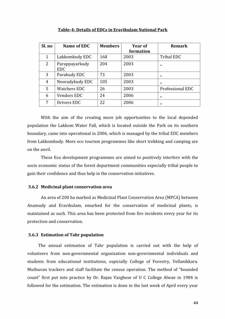
Table-4: Details of EDCs in Eravikulam National Park
Sl. no Name of EDC Members Year of formation
Remark
1 Lakkomkudy EDC 168 2003 Tribal EDC
2 Parappayarkudy EDC
204 2003 ,,
3 Parakudy EDC 73 2003 ,,
4 Nooradykudy EDC 105 2003 ,,
5 Watchers EDC 26 2003 Professional EDC
6 Vendors EDC 24 2006 ,,
7 Drivers EDC 22 2006 ,,
With the aim of the creating more job opportunities to the local depended
population the Lakkom Water Fall, which is located outside the Park on its southern
boundary, came into operational in 2006, which is managed by the tribal EDC members
from Lakkomkudy. More eco tourism programmes like short trekking and camping are
on the anvil.
These Eco development programmes are aimed to positively interfere with the
socio economic status of the forest department communities especially tribal people to
gain their confidence and thus help in the conservation initiatives.
3.6.2 Medicinal plant conservation area An area of 200 ha marked as Medicinal Plant Conservation Area (MPCA) between
Anamudy and Eravikulam, emarked for the conservation of medicinal plants, is
maintained as such. This area has been protected from fire incidents every year for its
protection and conservation.
3.6.3 Estimation of Tahr population The annual estimation of Tahr population is carried out with the help of
volunteers from non-governmental organization non-governmental individuals and
students from educational institutions, espicially College of Forestry, Vellanikkara.
Muthuvan trackers and staff facilitate the census operation. The method of “bounded
count” first put into practice by Dr. Rajan Varghese of U C College Alwae in 1984 is
followed for the estimation. The estimation is done in the last week of April every year
45
for covering the new borns and the fair climate during the period. The total area of the
Park is divided into 13 blocks (map attached as Map. 8) for the census. A group
consisting of volunteers, students, staff and muthuvan trackers will be deployed in each
block for the census. The whole exercise lasts for seven days. The first day involves the
training and the transportation of the groups into the base camps in the field. From
second day onwards, counting is done in the field in all the 13 blocks simultaneously for
five days. Details like the population size, structure, location, time etc are recorded
during the field work. The last day involves the compilation of the data.
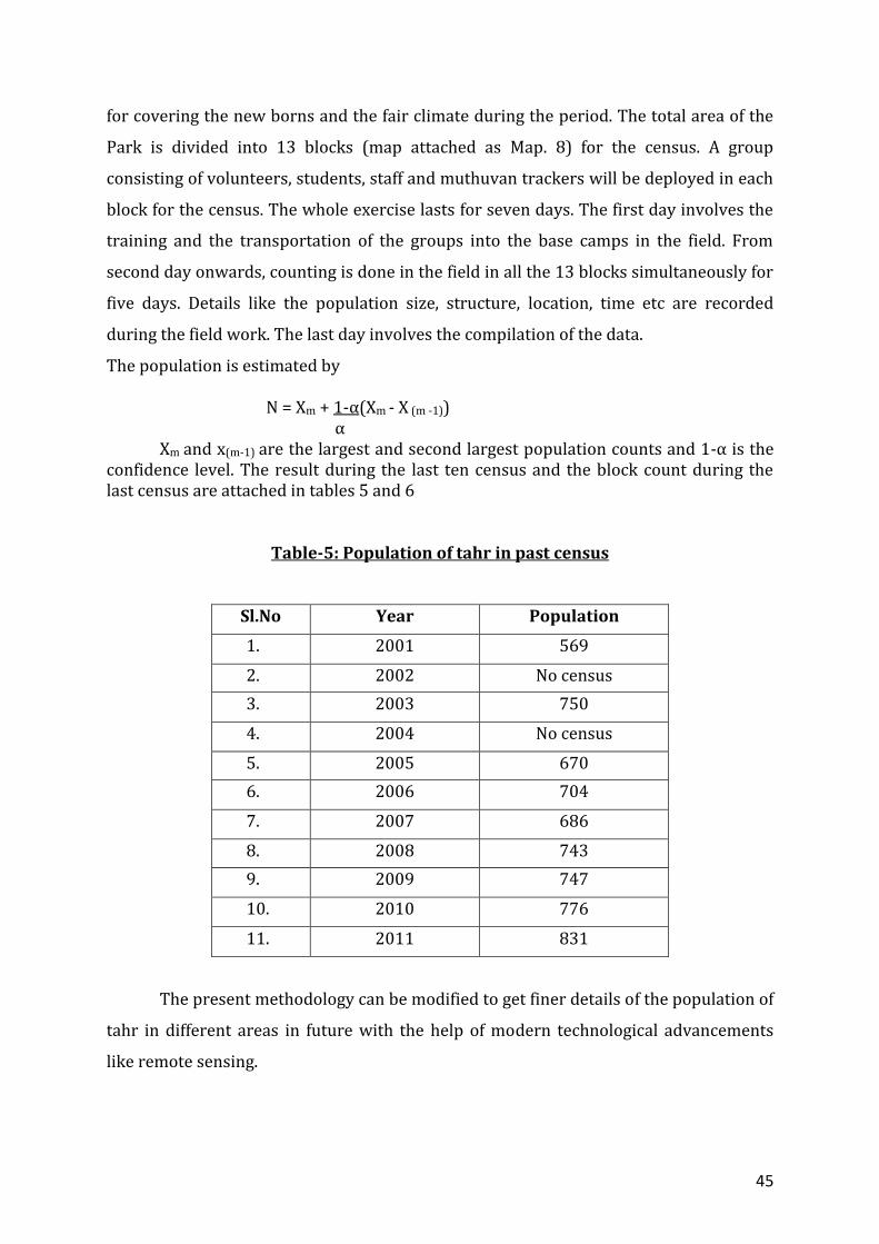
The population is estimated by N = Xm + 1-α(Xm - X (m -1)) α
Xm and x(m-1) are the largest and second largest population counts and 1-α is the confidence level. The result during the last ten census and the block count during the last census are attached in tables 5 and 6
Table-5: Population of tahr in past census
Sl.No Year Population
1. 2001 569
2. 2002 No census
3. 2003 750
4. 2004 No census
5. 2005 670
6. 2006 704
7. 2007 686
8. 2008 743
9. 2009 747
10. 2010 776
11. 2011 831
The present methodology can be modified to get finer details of the population of
tahr in different areas in future with the help of modern technological advancements
like remote sensing.

46
Map.8 : Census block map

47
Table- 6: Census block count 2011.
Block no Name of Block Day I Day II Day III Day IV Day V
1 Naikollimala 126 84 109 141 96
2 Meenthotty 43 38 81 79 61
3 Anamudy 101 85 71 101 98
4 Karikombumala 12 26 39 0 6
5 Kolukkan 0 18 16 41 24
6 Erumamala 74 88 80 76 68
7 Eravikulam 98 89 93 50 82
8 Perumalmala 88 19 78 18 63
9 Thirumala / Thirumudy
15 2 15 6 17
10 Lakkom Kudy 38 42 39 41 36
11 Vembanthanny 118 88 91 137 86
12 Kumarickal 15 23 14 5 12
13 Poovar 35 0 20 28 20
Total 763 602 746 723 669
3.6.4. Animal and Elephant Population Estimations
Population estimation of major mammals, as part State-wide estimation, has
been carried out during 2002 during the plan period. The density of major animals
found in Eravikulam National Park is given in the Table 7. In addition, population of
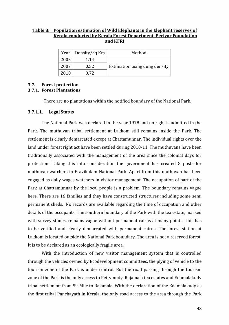
elephants was estimated during 2005, 2007 and 2010. The density of elephants
estimated using dung density is also given in Table 8. The information is for Munnar
Wildlife Divison as a whole and hence applicable to Eravikulam National Park as well.
Table 7 : Population estimation of major mammals in the Forests of Kerala
conducted in 2002 by Kerala Forest Department and KFRI
Species Density/Sq.Km Method
Elephant 0.29
Block Count
Gaur 0.45
Sambhar 0.11
Spotted Deer 0.43
Wild boar 0.75
Malabar Giant Squirrel
0.03
48
Table 8: Population estimation of Wild Elephants in the Elephant reserves of Kerala conducted by Kerala Forest Department, Periyar Foundation
and KFRI
Year Density/Sq.Km Method
2005 1.14
Estimation using dung density 2007 0.52
2010 0.72
3.7. Forest protection 3.7.1. Forest Plantations
There are no plantations within the notified boundary of the National Park.
3.7.1.1. Legal Status The National Park was declared in the year 1978 and no right is admitted in the
Park. The muthuvan tribal settlement at Lakkom still remains inside the Park. The
settlement is clearly demarcated except at Chattamunnar. The individual rights over the
land under forest right act have been settled during 2010-11. The muthuvans have been
traditionally associated with the management of the area since the colonial days for
protection. Taking this into consideration the government has created 8 posts for
muthuvan watchers in Eravikulam National Park. Apart from this muthuvan has been
engaged as daily wages watchers in visitor management. The occupation of part of the
Park at Chattamunnar by the local people is a problem. The boundary remains vague
here. There are 16 families and they have constructed structures including some semi
permanent sheds. No records are available regarding the time of occupation and other
details of the occupants. The southern boundary of the Park with the tea estate, marked
with survey stones, remains vague without permanent cairns at many points. This has
to be verified and clearly demarcated with permanent cairns. The forest station at
Lakkom is located outside the National Park boundary. The area is not a reserved forest.
It is to be declared as an ecologically fragile area.
With the introduction of new visitor management system that is controlled
through the vehicles owned by Ecodevelopment committees, the plying of vehicle to the
tourism zone of the Park is under control. But the road passing through the tourism
zone of the Park is the only access to Pettymudy, Rajamala tea estates and Edamalakudy
tribal settlement from 5th Mile to Rajamala. With the declaration of the Edamalakudy as
the first tribal Panchayath in Kerala, the only road access to the area through the Park
49
will have increased vehicular transit, which could negatively affect the management of
the Park.This has to be continuously monitored and adverse impacts suitably tackled.
The present boundary notification of the park mainly follow the hill points and
hence leave out many grass lands of KDHP Company, Munnar division, Marayur division
and Mankulam division that are genuine habitats of Nilgiri tahr. These areas have to be
added to the National Park in order to extent the legal protection to Tahr in the area and
also for habitat.
The presence of the police wireless station in the grasslands adjoing the Tourism
zone in the habitat of tahr population in the Tourism zone has been a disturbance to
them due to the frequent commutation of Police vehicles through the tourism zone,
construction of more and more buildings in the important tahr habitat, littering of the
area and feeding of animals, affecting the behaviour of the animals and chances of
spread of diseases to animals.This problem needs to be addressed.
3.7.2. Illegal activities 3.7.2.1. Hunting
Prior to declaration as a sanctuary, the English game hunters among the old
planters had taken keen interest in hunting activities apart from tea plantation
activities. The Park was the hunting preserve of the planters. Hunting records provide
an idea about the abundance of animals such as Nilgiri tahr, sambar, barking deer, gaur,
wild boar, leopard and tiger. The area also offered excellent opportunity for angling of
rainbow trout which was introduced from Scotland. There are 3 hunting cases reported
during the Plan period and the details attached as table 9. The chance for hunting is
more along the tea estate boundaries. To facilitate such activities they set fire to the
fringes of the Park. Constant vigil needs to be given to prevent such instances. The
Pallanad, Coffee store and Chattamunnar areas, Rajamala, Pettymudy tea estates and the
grass lands adjoining Rajamala tourism zone that extend to the Kadalar and grassland
that extending to the Pettymudy area in the southern boundary are having chances of
hunting. There were no hunting cases after 2005 and the practice is under control now.
50
Table-9: Details of hunting cases 2001-2010
Sl No.
Mahazer Date Common Name
No. of Accused
1 24.02.2002 Tahr 9
2 10.05.2002 Tahr 2
3 29.06.2003 Tahr 4
3.7.2.2. Poaching
The chance for poaching is more along the estate boundaries. To facilitate such
activities the likely poachers set fire to the fringes of the Park. Constant vigil needs to be
exercised to prevent such instances. The Pallanad, Coffee store, Chattamunnar, the
boundaries with the tea estate and the grass lands adjoining Rajamala tourism zone that
extend to the Kadalar and grassland that extending to the Pettymudy area in the
southern boundary are more prone to poaching. There were two poaching cases during
the present plan period and the details attached as table 10. Thre were no poaching
cases after 2005 and the practice is under control now.
Table-10: Details of poaching cases 2001-2010
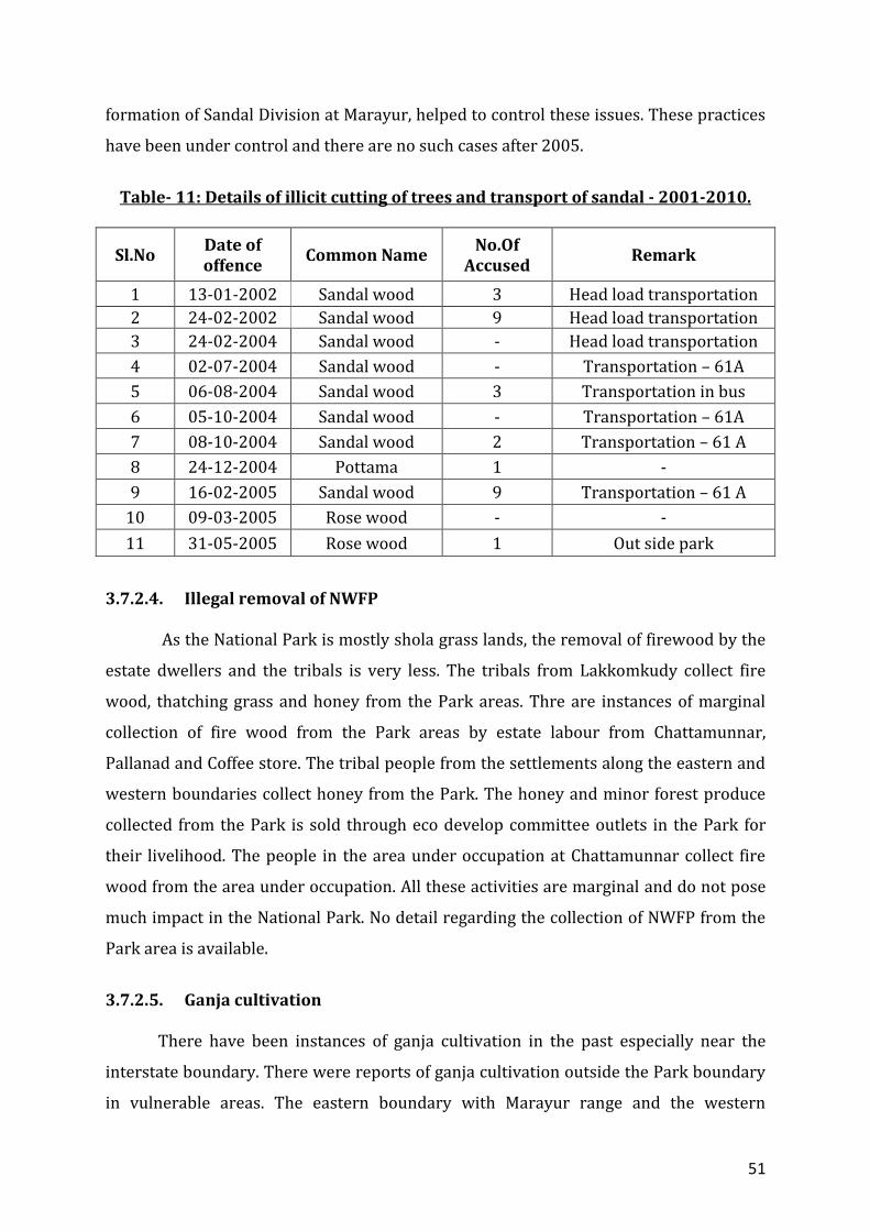
3.7.2.3. Illegal cutting of trees
Species of timber value like rosewood occur only in a small portion at
Chattamunnar on the eastern fringe of the Park, bordering Talliar estate above Coffee
Store. A few cases of illegal cutting of trees had occurred in the past. Head load
transportation of sandal smuggled from Marayur area by armed gangs and
transportation of ganja through the Park were serious protection problem during the
past. Inorder to facilitate this they used to set fire to the Park areas at Chinnapoovar,
Kumarikkal, Perumalmala, Nayoli etc. Effective protection camp at vulnerable points,
with the active involvement of eco development committees, along the fringes and the
Sl No. Date of offence
Common Name
No. of Accused
Remarks
1 04.02.2005 Pangolin 4 -
2 26.04.2005 Nilgiri Langur - Outside the park
51
formation of Sandal Division at Marayur, helped to control these issues. These practices
have been under control and there are no such cases after 2005.
Table- 11: Details of illicit cutting of trees and transport of sandal - 2001-2010.
Sl.No Date of offence
Common Name No.Of
Accused Remark
1 13-01-2002 Sandal wood 3 Head load transportation
2 24-02-2002 Sandal wood 9 Head load transportation
3 24-02-2004 Sandal wood - Head load transportation
4 02-07-2004 Sandal wood - Transportation – 61A
5 06-08-2004 Sandal wood 3 Transportation in bus
6 05-10-2004 Sandal wood - Transportation – 61A
7 08-10-2004 Sandal wood 2 Transportation – 61 A
8 24-12-2004 Pottama 1 -
9 16-02-2005 Sandal wood 9 Transportation – 61 A
10 09-03-2005 Rose wood - -
11 31-05-2005 Rose wood 1 Out side park
3.7.2.4. Illegal removal of NWFP
As the National Park is mostly shola grass lands, the removal of firewood by the
estate dwellers and the tribals is very less. The tribals from Lakkomkudy collect fire
wood, thatching grass and honey from the Park areas. Thre are instances of marginal
collection of fire wood from the Park areas by estate labour from Chattamunnar,
Pallanad and Coffee store. The tribal people from the settlements along the eastern and
western boundaries collect honey from the Park. The honey and minor forest produce
collected from the Park is sold through eco develop committee outlets in the Park for
their livelihood. The people in the area under occupation at Chattamunnar collect fire
wood from the area under occupation. All these activities are marginal and do not pose
much impact in the National Park. No detail regarding the collection of NWFP from the
Park area is available.
3.7.2.5. Ganja cultivation
There have been instances of ganja cultivation in the past especially near the
interstate boundary. There were reports of ganja cultivation outside the Park boundary
in vulnerable areas. The eastern boundary with Marayur range and the western
52
boundary with Munnar range are ganja prone areas. This calls for constant vigil on the
part of the Park management in these areas. There are no instances of ganja cultivation
in the Park areas during the plan period due to the regular patrolling and ganja raids.
Thre were instances of transportation of ganja through the National Park from Marayur
to Mankulam areas and the details attached as table 12. Thre are no such cases after
2005.
Table-12: Details of ganja trasportation cases 2001-2010
Sl.No Date of offence
Common Name No.Of
Accused Value Remark
1 04.02.2004 Ganja 1 11,000/- -
2 22.07.2005 Ganja 3 2,60,000/- -
3 23.11.2005 Ganja 7 1,65,000/- Outside the
park
3.7.2.6. Encroachment
The right of tribals over land at Lakkomkudy is settled as per Forest Rights Act
and the boundary is demarcated with kayyala. But it requires repair at some places .The
boundary at Chattamunnar area is vague and 16 families have occupied about 5 Ha of
land prior to this plan, without any rights. The legality of the occupation has to be
verified. The boundary with KDHP, demarcated with survey stones and rock marks, is
vague at many points, especially along the southern boundary. The boundary has to be
clearly demarcated with permanent cairns.
3.7.2.7. Live stock grazing
There are few cattle in Lakkomkudy. They graze their cattle in the settlement
and nearby areas of the Park. Grazing of cattle occurs in areas adjoining Chattamunnar,
Coffee store and Palland. Vaccination is done for all the cattle in the Lakkomkudy and all
the areas surrounding the Park including the settlements adjoining the eastern
boundary and all the tea estates adjoining southern boundary every year to prevent the
spread of diseases. This need to be continued and grazing in the Park areas need to be
stopped completely.
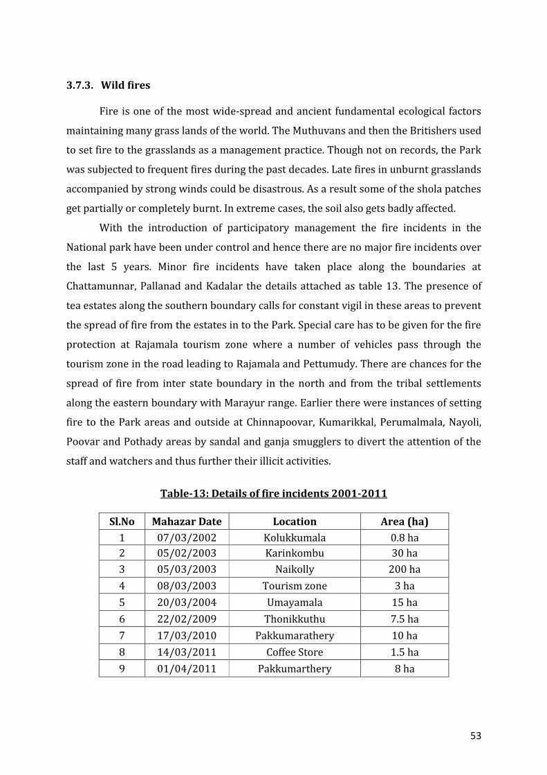
53
3.7.3. Wild fires
Fire is one of the most wide-spread and ancient fundamental ecological factors
maintaining many grass lands of the world. The Muthuvans and then the Britishers used
to set fire to the grasslands as a management practice. Though not on records, the Park
was subjected to frequent fires during the past decades. Late fires in unburnt grasslands
accompanied by strong winds could be disastrous. As a result some of the shola patches
get partially or completely burnt. In extreme cases, the soil also gets badly affected.
With the introduction of participatory management the fire incidents in the
National park have been under control and hence there are no major fire incidents over
the last 5 years. Minor fire incidents have taken place along the boundaries at
Chattamunnar, Pallanad and Kadalar the details attached as table 13. The presence of
tea estates along the southern boundary calls for constant vigil in these areas to prevent
the spread of fire from the estates in to the Park. Special care has to be given for the fire
protection at Rajamala tourism zone where a number of vehicles pass through the
tourism zone in the road leading to Rajamala and Pettumudy. There are chances for the
spread of fire from inter state boundary in the north and from the tribal settlements
along the eastern boundary with Marayur range. Earlier there were instances of setting
fire to the Park areas and outside at Chinnapoovar, Kumarikkal, Perumalmala, Nayoli,
Poovar and Pothady areas by sandal and ganja smugglers to divert the attention of the
staff and watchers and thus further their illicit activities.
Table-13: Details of fire incidents 2001-2011
Sl.No Mahazar Date Location Area (ha)
1 07/03/2002 Kolukkumala 0.8 ha
2 05/02/2003 Karinkombu 30 ha
3 05/03/2003 Naikolly 200 ha
4 08/03/2003 Tourism zone 3 ha
5 20/03/2004 Umayamala 15 ha
6 22/02/2009 Thonikkuthu 7.5 ha
7 17/03/2010 Pakkumarathery 10 ha
8 14/03/2011 Coffee Store 1.5 ha
9 01/04/2011 Pakkumarthery 8 ha
54
3.7.4. Insect attacks and pathological problems
Insect attacks and pathlogical problems are not reported from the Park areas.
3.7.5. Wildlife Health
The Rajamallay group of tahr, due to constant interaction with humans, is known
to be affected by worms of Amphistoma sp and Fasciola sp ( Report of analysis by Govt
Vet Surgeon, Munnar, 2011) The presence of cattle along the fringe poses the threat of
outbreak of rinderpest and foot and mouth disease. Vaccination is being carried out in
these areas every year.
3.7.6. Inter agency Programmes and Problems:
The operation of governmental and non governmental agencies in the National
Park areas is limited. The developmental activity carried out by the local self
governmental organistions is the only programme in this category. The participation of
the National Park in the formulation of these programmes is limited and there has been
some conflict during the implementation of these programmes. The co-operation with
the tea estates which occupies the southern boundary of the Park especially the
Thalayar group is limited. Enhancing the co-operation with the estate management will
help in the better management of the Park.
The co-operation of High Range Wildlife and Environment Preservation
Association (HRWEPA) in the visitor management activities in the National park is
crucial. The co-operation extended by HRWEPA for the infrastructural development for
visitor management has helped in the successful management of huge inflow of visitor
to the National Park. The entire infrastructure at 5th Mile entrance to the tourism zone
of the Park is done with the co-operation of HRWEPA and KDHP. Their co-opration will
be crucial in the future development at Lakkom waterfall managed by the Lakkomkudy
EDC.
The annual census operation is carried out with the help of experts, KFRI,
College of Forestry, non-governmental organizations and non-governmental individuals.
Their co-operation has been of great help in successful implementation of the census
operation in the Park.

55
3.8. Ecotourism 3.8.1. Visitor Management From less than a thousand during the eighties, the number of visitors has risen to
around 4.5 lakh during the kurinji flowering in 2006 and the average number of visitor
during the last 3 years has been around 4 lakhs annually. In anticipation of the boom of
visitors during 2006 in connection with the Kurinji flowering, the present visitor
management system was introduced with the help of eco development committees of
local dependent population. In addition to the existing 5 EDCs, 2 professional EDCs of
local dependent drivers and vendors were formed. All the private vehicles were stopped
at 5th mile, 4 km away from the tourism zone of the park and a departmental system for
transportation of visitor was introduced with the help of eco-development committees.
The members of Drivers EDC are engaged for plying the six buses owned by the EDCs
used for the transportation of visitors to the Park. The members of Vendors EDC are
engaged for managing the vending outlets in the tourism zone and Fifth Mile, the
entrance to the National Park. Additional members of tribal EDCs were trained in visitor
management and used for the visitor management in the tourism zone.
Visitors, taken to the tourism zone in the departmental system, are allowed to
walk 1 km along a black topped road in the tourism zone where they may get an
opportunity for a close look of Nilgiri tahr which is very much habituated to human
presence. The check post operating at Rajamala regulates the entry and exit of vehicles
to and from the tourism zone. An Interpretation Centre “Story of the Park” is provided
inside the National Park at Rajamala, where a few exhibits are displayed to educate and
explain the importance of the protected area and its biodiversity. `The enquiry counter
at 5th Mile provides information on the protected areas and ecotourism programmes
under Wildlife Division Munnar in general and on Eravikulam National Park in
particular.
The members of drivers EDC who operates the vehicles and the watchers
engaged in the tourism zone helps in the interpretation and guidance to the visitors. For
the visitors amenity facilities like Cafeteria, Amenity Centre, Ecoshop, Toilets etc are
maintained at 5th mile, the entrance to the Park and in the Tourism Zone. The activities
of the EDCs are managed by Anamudy Forest Development Agency, under Wildlife
Division, Munnar. The revenue collected from the visitors as entry fee goes to the
Government and rest of the collections including the bus charges, collection from the
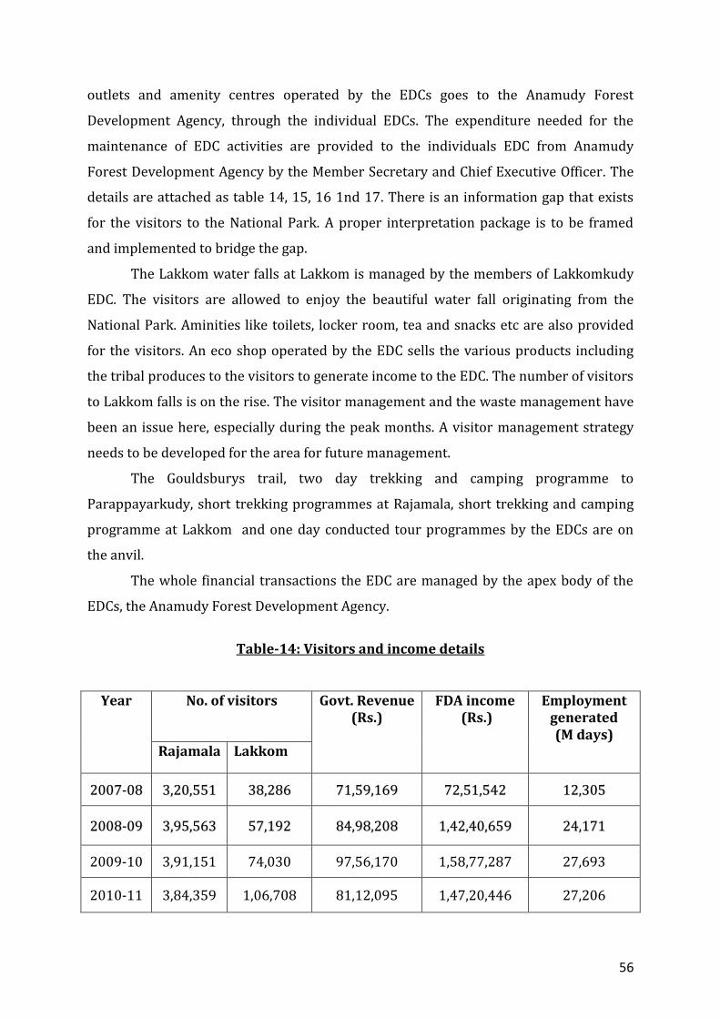
56
outlets and amenity centres operated by the EDCs goes to the Anamudy Forest
Development Agency, through the individual EDCs. The expenditure needed for the
maintenance of EDC activities are provided to the individuals EDC from Anamudy
Forest Development Agency by the Member Secretary and Chief Executive Officer. The
details are attached as table 14, 15, 16 1nd 17. There is an information gap that exists
for the visitors to the National Park. A proper interpretation package is to be framed
and implemented to bridge the gap.
The Lakkom water falls at Lakkom is managed by the members of Lakkomkudy
EDC. The visitors are allowed to enjoy the beautiful water fall originating from the
National Park. Aminities like toilets, locker room, tea and snacks etc are also provided
for the visitors. An eco shop operated by the EDC sells the various products including
the tribal produces to the visitors to generate income to the EDC. The number of visitors
to Lakkom falls is on the rise. The visitor management and the waste management have
been an issue here, especially during the peak months. A visitor management strategy
needs to be developed for the area for future management.
The Gouldsburys trail, two day trekking and camping programme to
Parappayarkudy, short trekking programmes at Rajamala, short trekking and camping
programme at Lakkom and one day conducted tour programmes by the EDCs are on
the anvil.
The whole financial transactions the EDC are managed by the apex body of the
EDCs, the Anamudy Forest Development Agency.
Table-14: Visitors and income details
Year
No. of visitors Govt. Revenue (Rs.)
FDA income (Rs.)
Employment generated (M days)
Rajamala Lakkom
22000077--0088 33,,2200,,555511 3388,,228866 7711,,5599,,116699 7722,,5511,,554422 1122,,330055
22000088--0099 33,,9955,,556633 5577,,119922 8844,,9988,,220088 11,,4422,,4400,,665599 2244,,117711
2009-10 3,91,151 74,030 97,56,170 1,58,77,287 27,693
2010-11 3,84,359 1,06,708 81,12,095 1,47,20,446 27,206
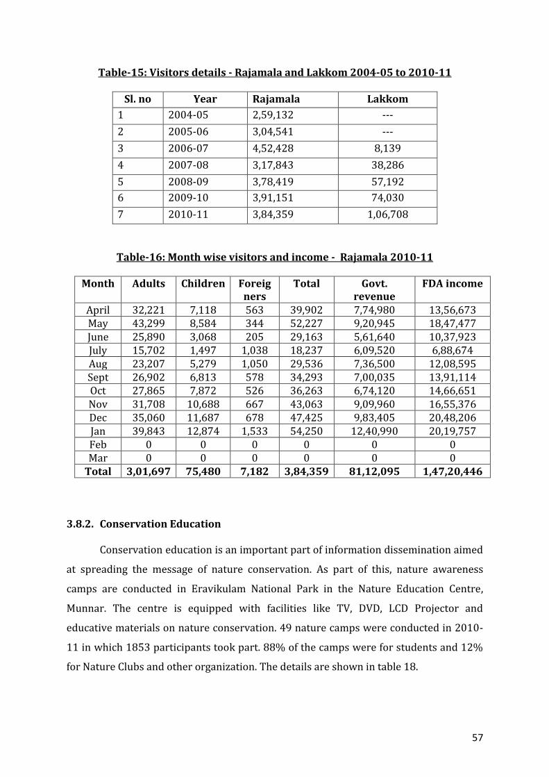
57
Table-15: Visitors details - Rajamala and Lakkom 2004-05 to 2010-11
Sl. no Year Rajamala Lakkom
1 2004-05 2,59,132 ---
2 2005-06 3,04,541 ---
3 2006-07 4,52,428 8,139
4 2007-08 3,17,843 38,286
5 2008-09 3,78,419 57,192
6 2009-10 3,91,151 74,030
7 2010-11 3,84,359 1,06,708
Table-16: Month wise visitors and income - Rajamala 2010-11
Month Adults Children Foreig ners
Total Govt. revenue
FDA income
April 32,221 7,118 563 39,902 7,74,980 13,56,673 May 43,299 8,584 344 52,227 9,20,945 18,47,477 June 25,890 3,068 205 29,163 5,61,640 10,37,923 July 15,702 1,497 1,038 18,237 6,09,520 6,88,674 Aug 23,207 5,279 1,050 29,536 7,36,500 12,08,595 Sept 26,902 6,813 578 34,293 7,00,035 13,91,114 Oct 27,865 7,872 526 36,263 6,74,120 14,66,651 Nov 31,708 10,688 667 43,063 9,09,960 16,55,376 Dec 35,060 11,687 678 47,425 9,83,405 20,48,206 Jan 39,843 12,874 1,533 54,250 12,40,990 20,19,757 Feb 0 0 0 0 0 0 Mar 0 0 0 0 0 0
Total 3,01,697 75,480 7,182 3,84,359 81,12,095 1,47,20,446
3.8.2. Conservation Education Conservation education is an important part of information dissemination aimed
at spreading the message of nature conservation. As part of this, nature awareness
camps are conducted in Eravikulam National Park in the Nature Education Centre,
Munnar. The centre is equipped with facilities like TV, DVD, LCD Projector and
educative materials on nature conservation. 49 nature camps were conducted in 2010-
11 in which 1853 participants took part. 88% of the camps were for students and 12%
for Nature Clubs and other organization. The details are shown in table 18.
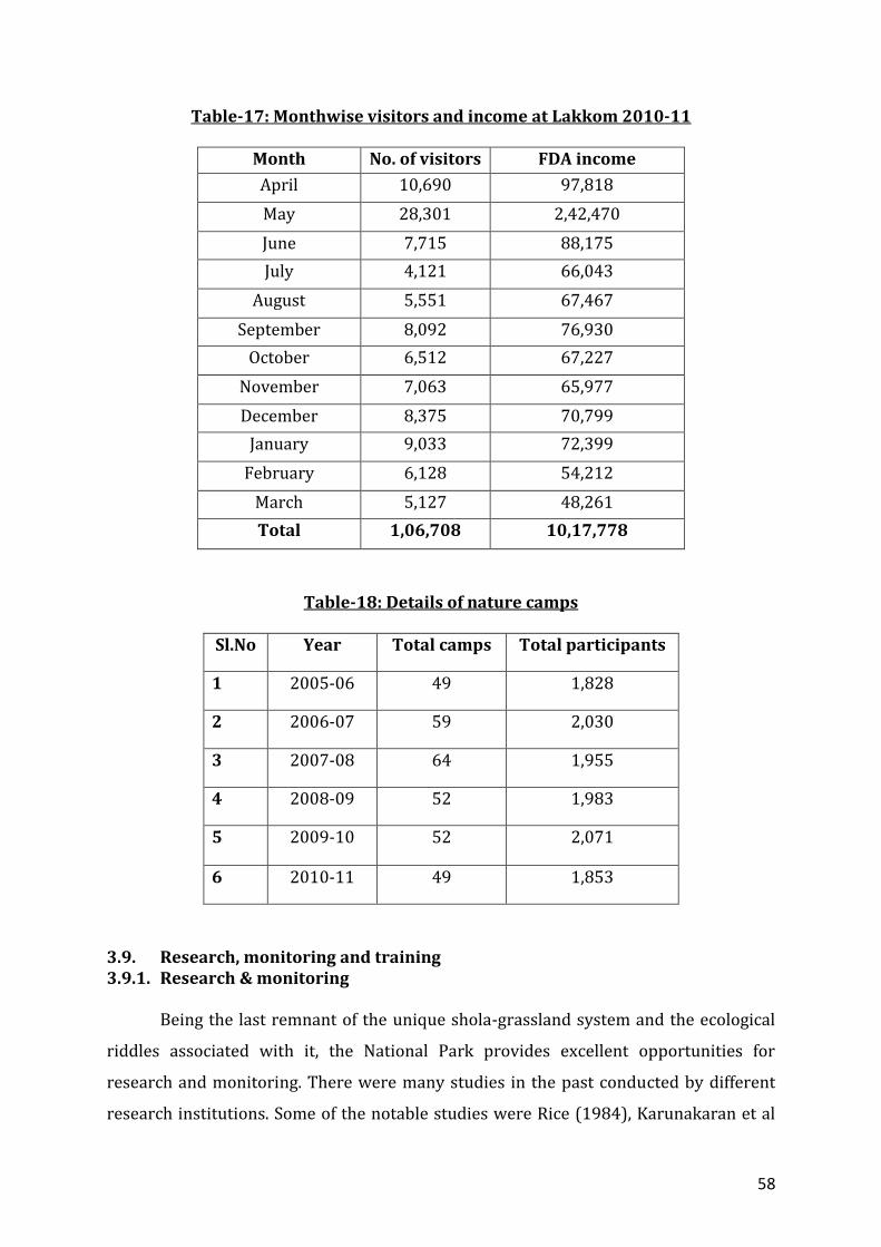
58
Table-17: Monthwise visitors and income at Lakkom 2010-11
Month No. of visitors FDA income
April 10,690 97,818
May 28,301 2,42,470
June 7,715 88,175
July 4,121 66,043
August 5,551 67,467
September 8,092 76,930
October 6,512 67,227
November 7,063 65,977
December 8,375 70,799
January 9,033 72,399
February 6,128 54,212
March 5,127 48,261
Total 1,06,708 10,17,778
Table-18: Details of nature camps
Sl.No Year Total camps Total participants
1 2005-06 49 1,828
2 2006-07 59 2,030
3 2007-08 64 1,955
4 2008-09 52 1,983
5 2009-10 52 2,071
6 2010-11 49 1,853
3.9. Research, monitoring and training 3.9.1. Research & monitoring
Being the last remnant of the unique shola-grassland system and the ecological
riddles associated with it, the National Park provides excellent opportunities for
research and monitoring. There were many studies in the past conducted by different
research institutions. Some of the notable studies were Rice (1984), Karunakaran et al
59
(1998), Madhusudan (1995), Easa (1996), Menon(1997) etc. In 1984, Union Christian
College, Alwaye initiated the first systematic Tahr survey which is being carried out
annually ever since. Census of birds is conducted periodically. All these studies and
census emphasize the need for continuous monitoring of vegetation and animal
population in the area. The study of bio diversity of the shola forest is to be carried out
to asses the biodiversity value of this eco system. Apart from this, it was felt that a long
term monitoring on the effects of burning should be studied. Every year, the Park is
conducting nature education camps for school/college students and interested NGOs as
part of its extension programmes. There is no institutionalized training programme as
such for the Park staff.
Areas needing emphasis in research and monitoring is included in the relevant
paregraphs of the plan.
3.9.2. Training The National park holds the largest viable population of Nilgiri Tahr and is the
largest stretch of the least disturbed shola grassland ecosystem in the Western Ghats.
The management is taken up through the eco development committees of local
dependents and involves a number of extension activities including nature awareness
programmes. Being unique ecosystem, increasing number of visitors, the participatory
mode of management and constant interaction with people from different strata in the
society, the staff and EDC members are in need of training on various aspects of
management to deal with different the situations.
3.9.3. Census Eravikulam National Park is the largest and least disturbed shola grassland
ecosystem in Western Ghats. This sustains the largest viable population of endemic and
endangered Nilgiri tahr. In order to estimate the population of Tahr in Eravikulam
National Park, annual tahr censes is conducted in the National park every year as
described in para 3.6.3
The details of population estimation details of other animals are given in para
3.6.4.
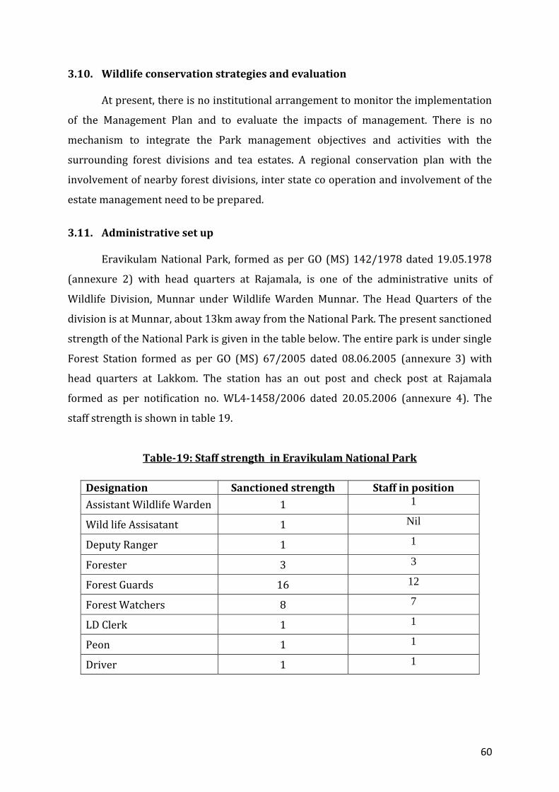
60
3.10. Wildlife conservation strategies and evaluation
At present, there is no institutional arrangement to monitor the implementation
of the Management Plan and to evaluate the impacts of management. There is no
mechanism to integrate the Park management objectives and activities with the
surrounding forest divisions and tea estates. A regional conservation plan with the
involvement of nearby forest divisions, inter state co operation and involvement of the
estate management need to be prepared.
3.11. Administrative set up
Eravikulam National Park, formed as per GO (MS) 142/1978 dated 19.05.1978
(annexure 2) with head quarters at Rajamala, is one of the administrative units of
Wildlife Division, Munnar under Wildlife Warden Munnar. The Head Quarters of the
division is at Munnar, about 13km away from the National Park. The present sanctioned
strength of the National Park is given in the table below. The entire park is under single
Forest Station formed as per GO (MS) 67/2005 dated 08.06.2005 (annexure 3) with
head quarters at Lakkom. The station has an out post and check post at Rajamala
formed as per notification no. WL4-1458/2006 dated 20.05.2006 (annexure 4). The
staff strength is shown in table 19.
Table-19: Staff strength in Eravikulam National Park
Designation Sanctioned strength Staff in position
Assistant Wildlife Warden 1 1
Wild life Assisatant 1 Nil
Deputy Ranger 1 1
Forester 3 3
Forest Guards 16 12
Forest Watchers 8 7
LD Clerk 1 1
Peon 1 1
Driver 1 1

61
Eight permanent muthuvan watchers were appointed in the Park in 2006 as per
GO.MS.418/76/AD dated 09.12.76 and GO (MS) No.47/94/F&WLD dated 16.08.94. One
forester, nine forest guards and two permenant watchers are retained at Rajamala out
post for tourism zone management.The EDC members and fringe area people are being
engaged on daily wage basis for additional support in tourism management and
protection.
3.12. Infrastructure facilities
Map. 9 : Buildings in Eravikulam National Park
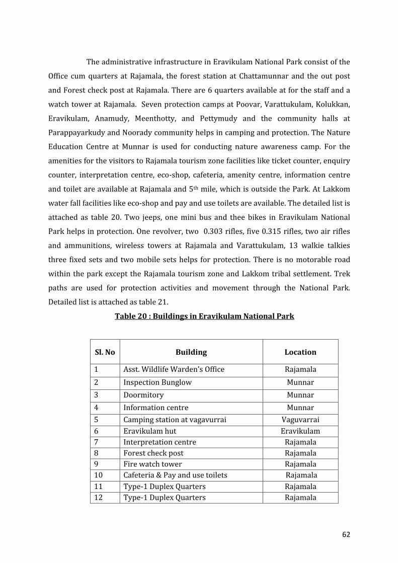
62
The administrative infrastructure in Eravikulam National Park consist of the
Office cum quarters at Rajamala, the forest station at Chattamunnar and the out post
and Forest check post at Rajamala. There are 6 quarters available at for the staff and a
watch tower at Rajamala. Seven protection camps at Poovar, Varattukulam, Kolukkan,
Eravikulam, Anamudy, Meenthotty, and Pettymudy and the community halls at
Parappayarkudy and Noorady community helps in camping and protection. The Nature
Education Centre at Munnar is used for conducting nature awareness camp. For the
amenities for the visitors to Rajamala tourism zone facilities like ticket counter, enquiry
counter, interpretation centre, eco-shop, cafeteria, amenity centre, information centre
and toilet are available at Rajamala and 5th mile, which is outside the Park. At Lakkom
water fall facilities like eco-shop and pay and use toilets are available. The detailed list is
attached as table 20. Two jeeps, one mini bus and thee bikes in Eravikulam National
Park helps in protection. One revolver, two 0.303 rifles, five 0.315 rifles, two air rifles
and ammunitions, wireless towers at Rajamala and Varattukulam, 13 walkie talkies
three fixed sets and two mobile sets helps for protection. There is no motorable road
within the park except the Rajamala tourism zone and Lakkom tribal settlement. Trek
paths are used for protection activities and movement through the National Park.
Detailed list is attached as table 21.
Table 20 : Buildings in Eravikulam National Park
Sl. No Building Location
1 Asst. Wildlife Warden’s Office Rajamala
2 Inspection Bunglow Munnar
3 Doormitory Munnar
4 Information centre Munnar
5 Camping station at vagavurrai Vaguvarrai
6 Eravikulam hut Eravikulam
7 Interpretation centre Rajamala
8 Forest check post Rajamala
9 Fire watch tower Rajamala
10 Cafeteria & Pay and use toilets Rajamala
11 Type-1 Duplex Quarters Rajamala
12 Type-1 Duplex Quarters Rajamala
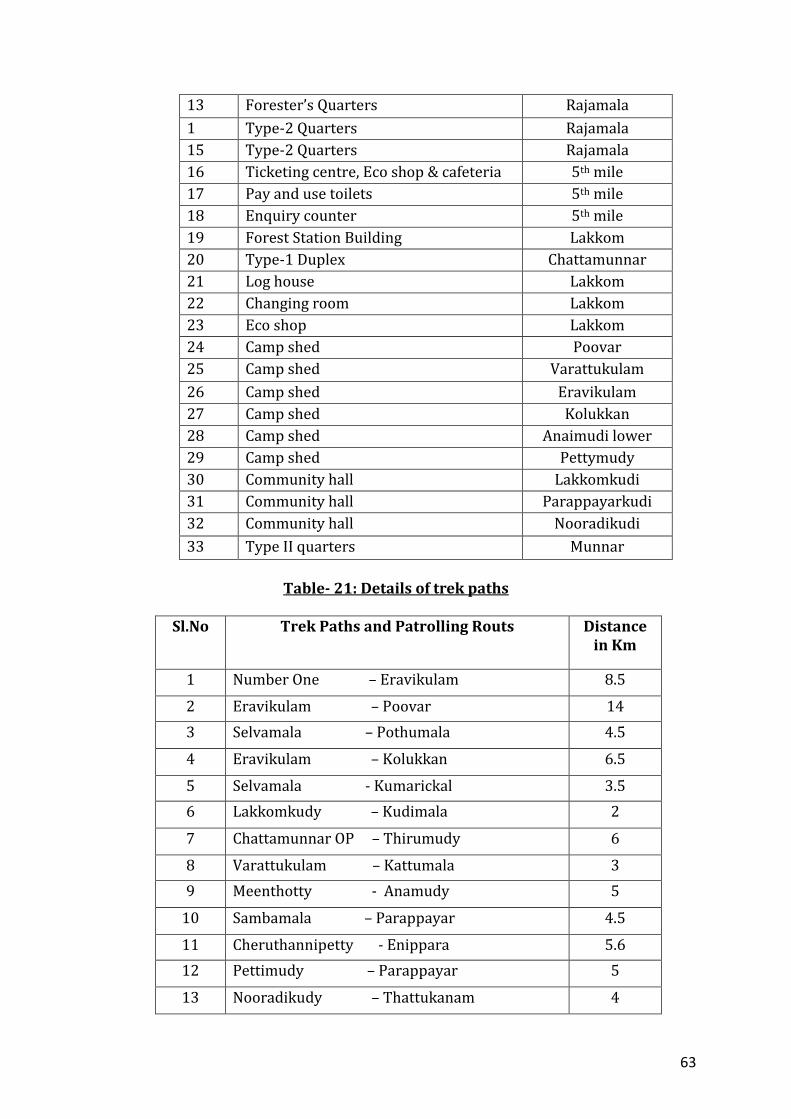
63
13 Forester’s Quarters Rajamala
1 Type-2 Quarters Rajamala
15 Type-2 Quarters Rajamala
16 Ticketing centre, Eco shop & cafeteria 5th mile
17 Pay and use toilets 5th mile
18 Enquiry counter 5th mile
19 Forest Station Building Lakkom
20 Type-1 Duplex Chattamunnar
21 Log house Lakkom
22 Changing room Lakkom
23 Eco shop Lakkom
24 Camp shed Poovar
25 Camp shed Varattukulam
26 Camp shed Eravikulam
27 Camp shed Kolukkan
28 Camp shed Anaimudi lower
29 Camp shed Pettymudy
30 Community hall Lakkomkudi
31 Community hall Parappayarkudi
32 Community hall Nooradikudi
33 Type II quarters Munnar
Table- 21: Details of trek paths
Sl.No Trek Paths and Patrolling Routs Distance
in Km
1 Number One – Eravikulam 8.5
2 Eravikulam – Poovar 14
3 Selvamala – Pothumala 4.5
4 Eravikulam – Kolukkan 6.5
5 Selvamala - Kumarickal 3.5
6 Lakkomkudy – Kudimala 2
7 Chattamunnar OP – Thirumudy 6
8 Varattukulam – Kattumala 3
9 Meenthotty - Anamudy 5
10 Sambamala – Parappayar 4.5
11 Cheruthannipetty - Enippara 5.6
12 Pettimudy – Parappayar 5
13 Nooradikudy – Thattukanam 4
64
14 Nooradikudy – Chembikavala 5
15 Oralipara – Erumapetty 1.1
16 Chattamunnar – Log House 0.5
Total 78.7
3.13. Communication
The National Park is located 13 km away from Munnar. The head quarters of the
National Park at Rajamala and the Wildlife Warden’s office are having both telephonic,
wireless and internet facilities. Deparment has issued Mobile SIM for the staff from
Guards to Assistant Wildlife Warden. Being high altitude montane shola-grasslands, the
mobile connectivity in the PA is limited to Rajamama, Vaguvarai, Chattamunnar,
Kattumalai and Kunarikkal. As the park is surrounded by forests north, east and west,
the chance of increasing the mobile connectivity in the PA is limited. Hence the wireless
connectivity with the interiog areas of the PA is to be improved. The Forest Station at
Chattamunnar and Outpost at Rajamala are having wireless communication facilities.
The wireless tower at Varattukulam facilitates the communication with the filed. The
National Park is having it’s own website www.eravikulam.org.
Wildlife Warden Assistant Wildlife Warden The Wildlife Warden Assistant Wildlife Warden, Wildlife Division, Eravikulam National Park, Munnar, Rajamala, Idukki District, Munnar. Kerala. Idukki District, Kerala. Pin-685612. Pin-685612. Tel: 91-4865-231587 (Office) Tel: 91-4865-208255 (Office) Mob: 9447979093 Mob: 8547603200 E-mail: [email protected] E-mail:[email protected]
3.14. Summary of threats to wildlife 3.14.1. Invasive alien species
The National Park is surrounded on the southern sides by tea estates owned by
Thalayar group and KDHP Comapny. These estates use eucalyptus and wattle as fuel
wood. At many points along these boundaries the remnants of old eucalyptus and wattle
plantations still remain. There is every chance that these species spread into the
65
National Park. There should a systematic removal of these exotic species to avoid
spread of the same into the National Park areas in the future.
3.14.2. Grazing
There is marginal grazing in and around Lakkom tribal settlement, Palland,
Coffee store and Chattamunnar area along the boundary of the National Park. There are
96 cattle in total in these areas. The people from Chattamunnar, Pallanad and Coffee
Store attempt to set fire the Park areas to make available fresh grass. The grazing needs
to be completely stopped by exploring alternate options.
3.14.3. Ganja Cultivation
There are no cases of ganja cultivation is the Park areas during the plan period.
But there were instances of transportation of ganja through the Park areas from
Marayoor. Even now there are chances for the same in the remote areas along the
interstate boundary and the boundary with Maryoor and Munnar divisions. Constant
vigil is needed in these areas.
3.14.4. Hunting and poaching
There have been no cases of hunting or poaching in the Park areas over the last 5
years. But the presence of human settlements along the boundaries and tea estates
makes the areas vulnerable for hunting or poaching including tahr along the Park
boundaries having human habitation.
3.14.5. Fire
Fire is the single and most important threat to the shola grassland ecosystem.
Though there are no major fire incident over the last 5 years, taking into consideration
of the present situation is the National Park, there is every chance for spread of fire into
the Park from the estates and human habitations along the southern, eastern and
weastern boundaries. There should be great vigilance on the part of Park management
to prevent such instances. There are chances of spread of fire from interstate boarder
especially during dry years. The tourism zone is highly vulnerable due to the constant
human and vehicular movement during the dry season. Earlier there were instances of
setting fire the Park areas and outside at Chinnapoovar, Kumarikkal, Perumalmala,
66
Nayoli, Poovar and Pothady areas by sandal and ganja smugglers to divert the attention
of the staff and watchers and thus further their illicit activities.
3.14.6. Human Wildlife Conflict
The tribal settlement inside the National Park at Lakkom, the three settlements
along the western boundary of the National Park and the human habitation at Coffee
Store and Palland are affected by the wildlife from the National Park. Main crop is the
Lakkomkudy tribal settlement is lemon grass which is not affected by Wildlife. But other
crops like tubers, vegetables etc are damaged by sambar, wild boar etc. There were
instances of cattle lifting by tigers from these areas.
Parappayar, Parakkudy and Nooradykudy are badly affected by the wild animals.
The main crop in these settlements is cardamom. This crop is extensively damaged by
elephants. There were cultivation of crops like ragi, rice etc in these settlements
especially Nooradykudy in the past. This has been stopped mainly due to the attack of
gaur and elephants. Chembukulamkudy, a part of Nooradykudy, has been completely
abandoned due to the attack of wild animals. The movements between these
settlements are at times badly affected by the wildlife.
3.14.7. Soil erosion
The shola grass land ecosystem is very sensitive. The trek paths and patrolling
routes are subjected to severe soil erosion due to exposure of soil to heavy rainfall in
Eravikulam National Park. The sectioning of trek paths and patrolling routes is not done
and the damaged portions are recouped using indigenous materials and preparing cross
drains. Land slips have occurred in the Park during heavy rainfall years. Such areas are
to be recouped using brushwood structures and gully plugging using indigenous
materials.
3.14.8. Encroachment
The right of tribals over land at Lakkomkudy is settled as per forest rights act
and the boundary is demarcated with kayyala. But it requires repair at some places .The
boundary at Chattamunnar area is vague and about 16 families have occupied about 5
Ha of land prior to this plan, without any rights. The legality of the occupation has to be
verified. The boundary with KDHP is demarcated with survey stones and rock marks
67
and is vague at many points in the southern boundary. The boundary has to be clearly
demarcated with permanent cairns.
3.14.9. Wildlife disease
The Rajamallay groups of Tahr, due to constant interaction with humans, are
known to be affected by worms of Amphistoma sp and Fasciola sp (Analysis report by
Govt Vet Surgeon, Munnar, 2011). The presence of cattle on the fringe poses the threat
of outbreak of rinderpest and foot and mouth disease. Vaccination is being carried out
every year in these areas.
3.14.10 Firewood and NWFP collection
As the National Park is a grass land ecosystem, the removal of firewood by the
estate dwellers and the tribals is very less. The tribal community collects fire wood,
thatching grass and NTFP, mainly honey, from the Park and adjoining areas. Thre are
instances of marginal collection of fire wood from the park areas by esate labourers
from Chattamunnar, Pallanad and Coffee store. The honey collected from the Park and
adjoining areas is sold through eco develop committees for their livelihood. The people
in the area under occupation at Chattamunnar collect fire wood from the area under
occupation. All these activities are marginal and do not pose much impact in the
National Park.
3.14.11. Road through Tourism zone and police wireless station
The only motorable road through the National Park passes through the tourism
zone of the park connecting, the Munnar- Udumalpet road to Pettymudy. This is the only
route available for the inhabitants at Rajamala, Pettymudy and tribal people from
Edamalakudy, the largest tribal settlement in Kerala. With the declaration of
Edamalakudy as the first tribal Panchayath in Kerala, there is every chance that the
National Park will have an increased vehicular transit. The vehicular movement should
be controlled with the help of local dependents through FDA. The chance for providing
alternate route to Pettymudy is to be explored.
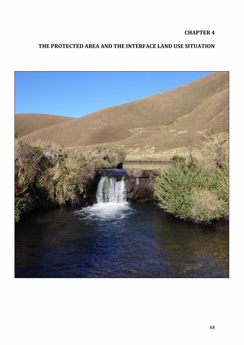
68
CHAPTER 4
THE PROTECTED AREA AND THE INTERFACE LAND USE SITUATION
69
4.1. The existing situation in the zone of influence
There is only one muthuvan settlement, Lukkom kudy inside the park located
on the southern boundary. There is an old occupation of about 5 Ha at Chattamunnar
near the Lakkomkudy in the southern boundary of the Park, which has no records
regarding the time of occupation.
The three settlements at Parappayarkudy, Parakudy and Nooradikudy along
the western boundary of the Park are part of Edamalakudy, the first Tribal Panchayath
in Kerala. The area is under Munnar range of Munnar Division. There are a number of
tribal settlements in Koodakkad proposed reserve under Marayur Sandal Division along
the eastern boundary of the National Park.
The Lakkomkudy Muthuvan tribal settlement located inside the Park is having an area
of 44.088 Ha (as per survey in 2010 under Forest Rights Act), which is clearly
demarcated with Kayyala. The rights over the land as per Forest Rights Act is settled
and title issued to 45 families. Muthuvans are hill cultivators belonging to Madurai of
Tamilnadu and migrated to High Ranges in the 14th Centaury. They were practicing
shifting cultivation. But now they have started settled agriculture. The people from
Lakkomkudy basically depend on agriculture and the employment in the National Park
for their sustenance. Their association with the Park started from the colonial period
and still continues. They mainly cultivate the Lemon Grass, Cardamom as cash crops.
They also cultivate vegetables and tuber crops for their own consumption. They rear
cattle in limited numbers and are grazed in the settlements and the nearby National
Park areas. They collect NTFP mainly honey, limited quantity of fire wood and thatching
grass from the Park areas. They depend on the Park for drinking water and irrigation.
As an endorsement for the close association of the muthuvans with the park, 8
muthuvan watchers were made permanent, of which 6 are from Lakkomkudy. The daily
waged mazdoor from this tribal settlement are employed in the visitor management,
interior protection and fire protection in the National Park. Their land holding is limited
and more opportunities need to be created for the people from the Lakkomkudy to
make available sustainable income for them.
Three Muthuvan tribal settlements namely Parappayarkudy, Parakkudy and
Nooradykudy on the western boundary of the Park have been involved in the
management of the Park for nearly one decade. Details of tribal settlements are shown
70
in table 22 and Fig. 10. They depend on agriculture for their sustenance. These three
settlements Parappayarkudy, Parakudy and Nooradykudy, located along the western
boundary of the Park, are basically cut away from the outside world for want of
infrastructure facilities. They are 5-13 km away from the nearby motorable road at
Pettymudy. Parakudy consist of Chennayparakudy, Parakudy and Perunkadavukudy.
Nooradykudy consist of Chembukulamkudy and Nooradykudy. Chembukulamkudy is
now abandonment due to severe crop damages by wild animals. The eco development
committees formed in these settlements of have a great influence in their attitude. Many
people from the settlements were involved in ganja cultivation, hunting and smuggling
of sandal before the formation of the EDCs. Now they help for the visitor management
and protection activities of the Park. The people in these settlements depend on
agriculture for their income generation. Cardamom is the main crop. They also cultivate
food crops like ragi, vegetables and tuber crops for own consumption. Severe pest and
disease problems to cardamom during the last 5 years have negatively influenced their
income generation. All the settlements depend on the National Park for the drinking
water. These settlements, though located outside the National Park, have been actively
involved in the management of the Park. Two of them were employed as a permanent
watcher and 17 have been employed on daily wages in the visitor management and
protection activities in the National Park. As the settlements are located deep inside the
forest areas, there is enough scope for enhancing their co- operation by implementing
eco development programmes aimed at improving their standard of living to ensure
sustainable income and improvement of infrastructural facilities in the settlements.
The people from tribal settlements along the eastern boundary of the National
Park in the Marayoor Range under the Marayoor Sandal Division collect drinking water
and NTFP especially honey from the National Park. But their co-operation is limited to
engaging few of them during the fire season. There are chances for the spread of fire
from these settlements to the Park areas, the help for the transportation of illegal
materials like sandal and ganja through the Park areas and engage in ganja cultivation
and hunting. Hence increasing the co-operation with the tribal settlement is highly
essential for the long term protection of the Park.
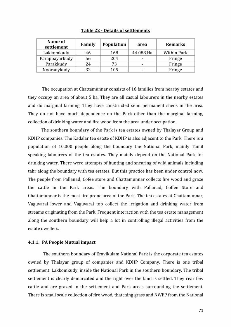
71
Table 22 - Details of settlements
Name of settlement
Family Population area Remarks
Lakkomkudy 46 168 44.088 Ha Within Park Parappayarkudy 56 204 - Fringe
Parakkudy 24 73 - Fringe Nooradykudy 32 105 - Fringe
The occupation at Chattamunnar consists of 16 families from nearby estates and
they occupy an area of about 5 ha. They are all casual labourers in the nearby estates
and do marginal farming. They have constructed semi permanent sheds in the area.
They do not have much dependence on the Park other than the marginal farming,
collection of drinking water and fire wood from the area under occupation.
The southern boundary of the Park is tea estates owned by Thalayar Group and
KDHP companies. The Kadalar tea estste of KDHP is also adjacent to the Park. There is a
population of 10,000 people along the boundary the National Park, mainly Tamil
speaking labourers of the tea estates. They mainly depend on the National Park for
drinking water. There were attempts of hunting and snearing of wild animals including
tahr along the boundary with tea estates. But this practice has been under control now.
The people from Pallanad, Cofee store and Chattamunnar collects fire wood and graze
the cattle in the Park areas. The boundary with Pallanad, Coffee Store and
Chattamunnar is the most fire prone area of the Park. The tea estates at Chattamunnar,
Vaguvarai lower and Vaguvarai top collect the irrigation and drinking water from
streams originating from the Park. Frequent interaction with the tea estate management
along the southern boundary will help a lot in controlling illegal activities from the
estate dwellers.
4.1.1. PA People Mutual impact
The southern boundary of Eravikulam National Park is the corporate tea estates
owned by Thalayar group of companies and KDHP Company. There is one tribal
settlement, Lakkomkudy, inside the National Park in the southern boundary. The tribal
settlement is clearly demarcated and the right over the land is settled. They rear few
cattle and are grazed in the settlement and Park areas surrounding the settlement.
There is small scale collection of fire wood, thatching grass and NWFP from the National
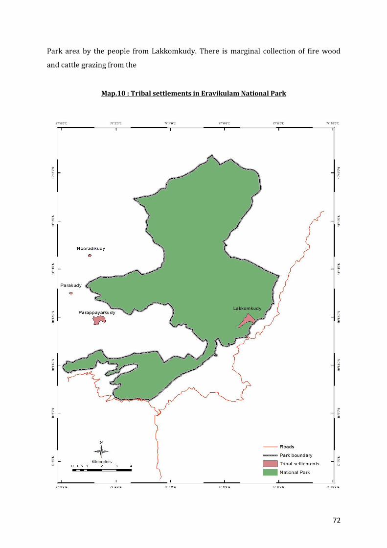
72
Park area by the people from Lakkomkudy. There is marginal collection of fire wood
and cattle grazing from the
Map.10 : Tribal settlements in Eravikulam National Park
73
estates people along the boundary at Chattamunnar, Coffee store and Pallanad. The
settlements outside the National Park in the western boundary, Parappayar, Parakkudy
and Nooradykudy under Munnar Division and the settlements in Koodakkad proposed
reserve under Marayoor Division depends the National Park for NWFP, especially
honey. The impact of the collection of fire wood, NWFP etc. is negligible as the activities
are marginal.
The people in the area under occupation at Chattamunnar do marginal farming
in the area and collect fire wood from the area. This does not have much impact on the
National Park.
There were cases of attempt to hunt the animals especially by noosing by the
estate labourers at Chattamunnar, Pallanad, Vaguvarrai, Kadalar, Rajamala and
Pettymudy. Now the practice is controlled. There are frequent fire incidents in the Park
areas adjoining Chattamunnar, Coffee Store and Pallanad areas. This has been a problem
during the fire season.
All the people surrounding the National Park including the tribal settlements and
the tea estates at Chattamunnar, Vaguvarai lower and Vaguvarai top collect the
irrigation and drinking water from streams originating from the Park.
The crop damage by wild animals and cattle lifting has been reported from
Lakkomkudy, Pallanad, Coffee store, Parappayar, Parakkudy and Nooradykudy. At times
this negatively effect on their sustenance and this need to be addressed.
The road that passes through the tourism zone of the National Park is used by
tribal people from Edamalakudy, estate laborers and staff from Pettymudy and
Rajamala estates of KDHP Company. This and the police wireless station located in the
grass lands adjoining the National Park have been negatively affecting the tahr
population in the tourism zone of the park.
4.2. The development programmes and conservation issues 4.2.1. An evaluation of Government and nongovernmental agencies Different governmental agencies especially local self government operates in all
the settlements, area under occupation at Chattamunnar and tea estates along the
southern boundary without intimating the Park management. There in no participation
of the Park management in the planning of these programmes by line departments. This
has caused some issues during the implementation of the developmental processes
74
programmes. As far as possible these activities are to be carried out through the EDCs
operating in the area.
4.2.2. The interplay of market forces and their impact The income generated from agricultural operations in Lakkomkudy tribal
settlement is very less as the area of the settlement is less. This limits the income
generation potential and forces the people to depend on external agents for financial
help during emergencies. The EDC at Lakkomkudy is very active and is able to positively
interface in the socio-economic situation in the settlement. The EDC helps in the
collection and marketing of the produces from the settlements, helping them to get good
and steady price for their produce. The Park is able to generate employment
opportunities for the people from the settlement by involving them in the Park
management including visitor management, fire management activities and other
protection programmes. More opportunities need to be made available for them
through ecotourism and ecodevelopment to make the people self reliant.
The tribal settlements at Parappayar, Parakkudy and Nooradykudy, they mainly
depend on cultivation of cardamom for their sustenance. The pest and disease problems
are very high in the crop for the last 5 years and this has negatively affected their
income generation. This situation has forced them to depend on external forces during
crisis situation. More need to be done to take these people away from the situation by
interfering in increasing the income generation from agriculture, marketing of the
produce in developing alternate income generation opportunities and ecotourism
programmes. Crop damage by wild animal is a serious issue especially in Nooradykudy.
Positive intervention is needed in this regard.
4.2.2.1 Eco development initiatives Eco development committees are operational in all the four tribal settlements.
But the activities are very limited in comparison to the situation in the settlements.
More opportunities needed to be provided for them to ensure sustainable livelihood for
the inhabitants of Lakkomkudy through eco development initiatives.
Parappayar, Parakkudy and Nooradykudy are having many limitations due to the
inaccessibility to these settlements. Positive interventions are needed for increasing the
accessibility to these settlements, to enhance the agricultural production, help in
75
marketing of the produce. The socio-economic situation is to be improved by making
available educational, medical and infrastructure facilities in the settlements.
In addition to the four tribal EDCs, there are three professional EDCs namely
Watchers EDC, Vendors EDC and Drivers EDC. The members are mainly local
dependents from the nearby tea estates. Being widely distributed, there are no
community oriented programmes for these EDCs. Specific programmes that benefit for
the whole community need to be formulated to benefit the members of these EDCs.
The programmes should be formulated during the revision of the micro plans of
the EDCs taking into consideration of the nature of the tribal EDCs and professional
EDCs.
All the people surrounding the National Park including the tribal settlements and
the tea estates at Chattamunnar, Vaguvarai lower and Vaguvarai top collect the
irrigation and drinking water from streams originating from the Park. For this they have
constructed some structures in the Park before the declaration of the Park. These
structures need periodic repair and maintanace. The possibility of shifting these
structures outside the Park or repairing the through FDA should be explored.
There has not been much interaction between the tribal settlements in the
Koodakkad proposed reserve along the eastern boundary and local people at
Chattamunnar, Coffee Store and Pallanad situated along the southern boundary. The
chance for closer interaction like the formation of EDCs / work in association with the
VSS need to be explored to have a closer relation with the Park management to gain
their confidence and reducing the negative impacts on the Park. As a follow up the
chance for the introduction of eco development activities can be explored.

76
PART - II PROPOSED MANAGEMENT
77
Vision
“Conservation of the largest viable population of endemic
and endangered Nilgiri tahr and the unique shola grassland
ecosystem with the help of local community”
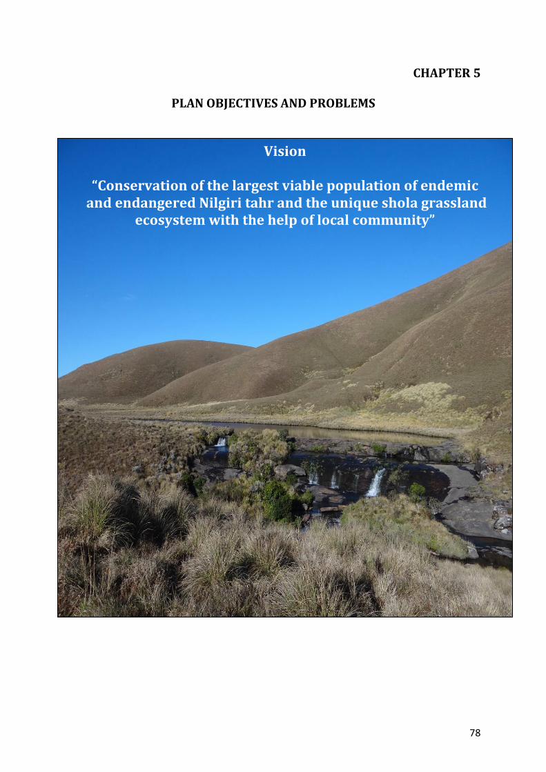
78
CHAPTER 5
PLAN OBJECTIVES AND PROBLEMS
Vision
“Conservation of the largest viable population of endemic and endangered Nilgiri tahr and the unique shola grassland
ecosystem with the help of local community”

79
5.1. Objectives of Management
1. To conserve the unique and endangered shola-grassland ecosystem
2. To conserve the largest known population of Nilgiri Tahr
3. To include critical and contiguous areas found outside PA but within the high
range landscape unit
4. To ensure sustaining and enhancing ecosystem services of the PA
5. To manage the watershed and habitat to conserve the shola-grassland ecosystem and for
the benefit of local dependant communities.
6. To create awareness among public, visitors and stakeholder through
strengthened education and interpretation programmes
7. To prepare and implement visitor management plan by assessing the carrying
capacity of visitation
8. To Strengthen PA-People relation especially Muduvans, NGOs and other
stakeholders in the management
9. To generate data for future management and planning through scientific studies
to achieve the above objectives
5.2. Problems/constraints in achieving the objectives of management
Objective 1: To conserve the unique and endangered shola-grassland ecosystem
Constraints Strategies Desiccation changing the local climate Landscape level management involving tea
estates and territorial divisions Ecological boundaries technically outside
Addition of more areas KDH Company to prepare a management
plan which dovetails with ENP management plan
Vagueness of boundaries and lack of proper demarcation
Proper demarcation of the boundaries
Habitat degradation due to unmanaged fires
Preparation of fire management plan controlled burning regimes (previous
practice to be followed) Extent of burning to be limited to the actual
areas grazed by tahr (rotation of burning once in three years)
Develop a protocol for scientific monitoring of effects of controlled burning,
study and document impact of burning as per the protocol
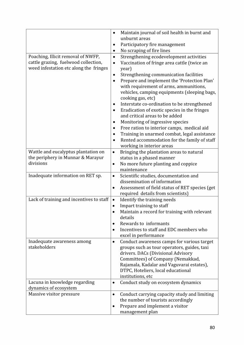
80
Maintain journal of soil health in burnt and unburnt areas
Participatory fire management No scraping of fire lines
Poaching, Illicit removal of NWFP, cattle grazing, fuelwood collection, weed infestation etc along the fringes
Strengthening ecodevelopment activities Vaccination of fringe area cattle (twice an
year) Strengthening communication facilities Prepare and implement the ‘Protection Plan’
with requirement of arms, ammunitions, vehicles, camping equipments (sleeping bags, cooking gas, etc)
Interstate co-ordination to be strengthened Eradication of exotic species in the fringes
and critical areas to be added Monitoring of ingressive species Free ration to interior camps, medical aid Training in unarmed combat, legal assistance Rented accommodation for the family of staff
working in interior areas Wattle and eucalyptus plantation on the periphery in Munnar & Marayur divisions
Bringing the plantation areas to natural status in a phased manner
No more future planting and coppice maintenance
Inadequate information on RET sp. Scientific studies, documentation and dissemination of information
Assessment of field status of RET species (get required details from scientists)
Lack of training and incentives to staff Identify the training needs Impart training to staff Maintain a record for training with relevant
details Rewards to informants Incentives to staff and EDC members who
excel in performance Inadequate awareness among stakeholders
Conduct awareness camps for various target groups such as tour operators, guides, taxi drivers. DACs (Divisional Advisory Committees) of Company (Nemakkad, Rajamala, Kadalar and Vaguvarai estates), DTPC, Hoteliers, local educational institutions, etc
Lacuna in knowledge regarding dynamics of ecosystem
Conduct study on ecosystem dynamics
Massive visitor pressure
Conduct carrying capacity study and limiting the number of tourists accordingly
Prepare and implement a visitor management plan
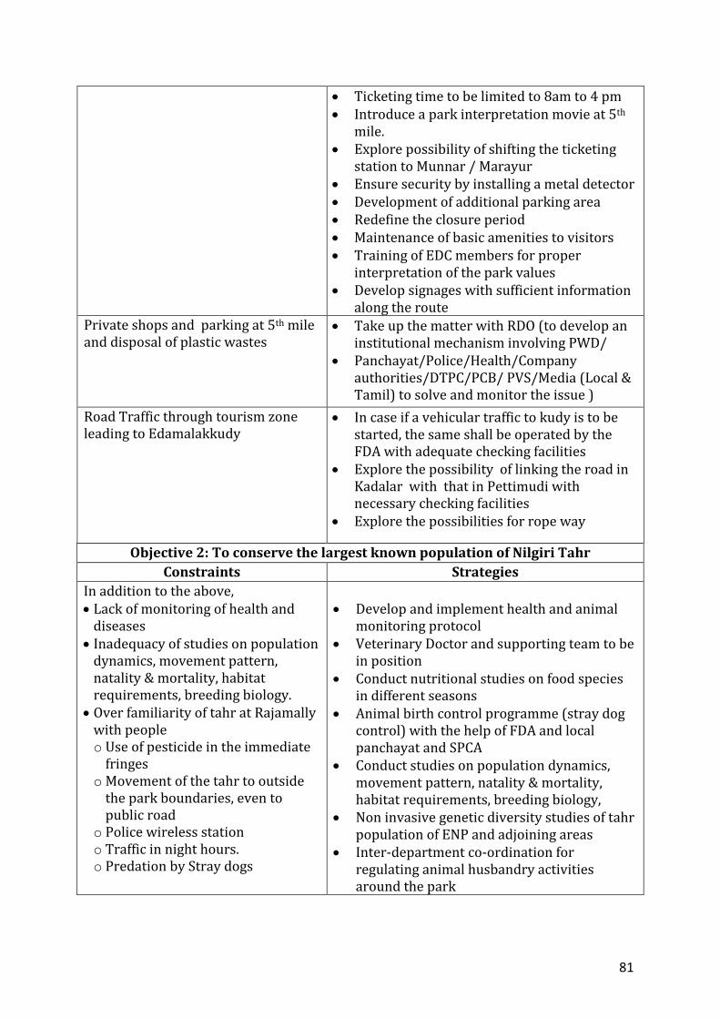
81
Ticketing time to be limited to 8am to 4 pm Introduce a park interpretation movie at 5th
mile. Explore possibility of shifting the ticketing
station to Munnar / Marayur Ensure security by installing a metal detector Development of additional parking area Redefine the closure period Maintenance of basic amenities to visitors Training of EDC members for proper
interpretation of the park values Develop signages with sufficient information
along the route Private shops and parking at 5th mile and disposal of plastic wastes
Take up the matter with RDO (to develop an institutional mechanism involving PWD/
Panchayat/Police/Health/Company authorities/DTPC/PCB/ PVS/Media (Local & Tamil) to solve and monitor the issue )
Road Traffic through tourism zone leading to Edamalakkudy
In case if a vehicular traffic to kudy is to be started, the same shall be operated by the FDA with adequate checking facilities
Explore the possibility of linking the road in Kadalar with that in Pettimudi with necessary checking facilities
Explore the possibilities for rope way
Objective 2: To conserve the largest known population of Nilgiri Tahr
Constraints Strategies
In addition to the above, Lack of monitoring of health and
diseases Inadequacy of studies on population
dynamics, movement pattern, natality & mortality, habitat requirements, breeding biology.
Over familiarity of tahr at Rajamally with people o Use of pesticide in the immediate
fringes o Movement of the tahr to outside
the park boundaries, even to public road
o Police wireless station o Traffic in night hours. o Predation by Stray dogs
Develop and implement health and animal
monitoring protocol Veterinary Doctor and supporting team to be
in position Conduct nutritional studies on food species
in different seasons Animal birth control programme (stray dog
control) with the help of FDA and local panchayat and SPCA
Conduct studies on population dynamics, movement pattern, natality & mortality, habitat requirements, breeding biology,
Non invasive genetic diversity studies of tahr population of ENP and adjoining areas
Inter-department co-ordination for regulating animal husbandry activities around the park
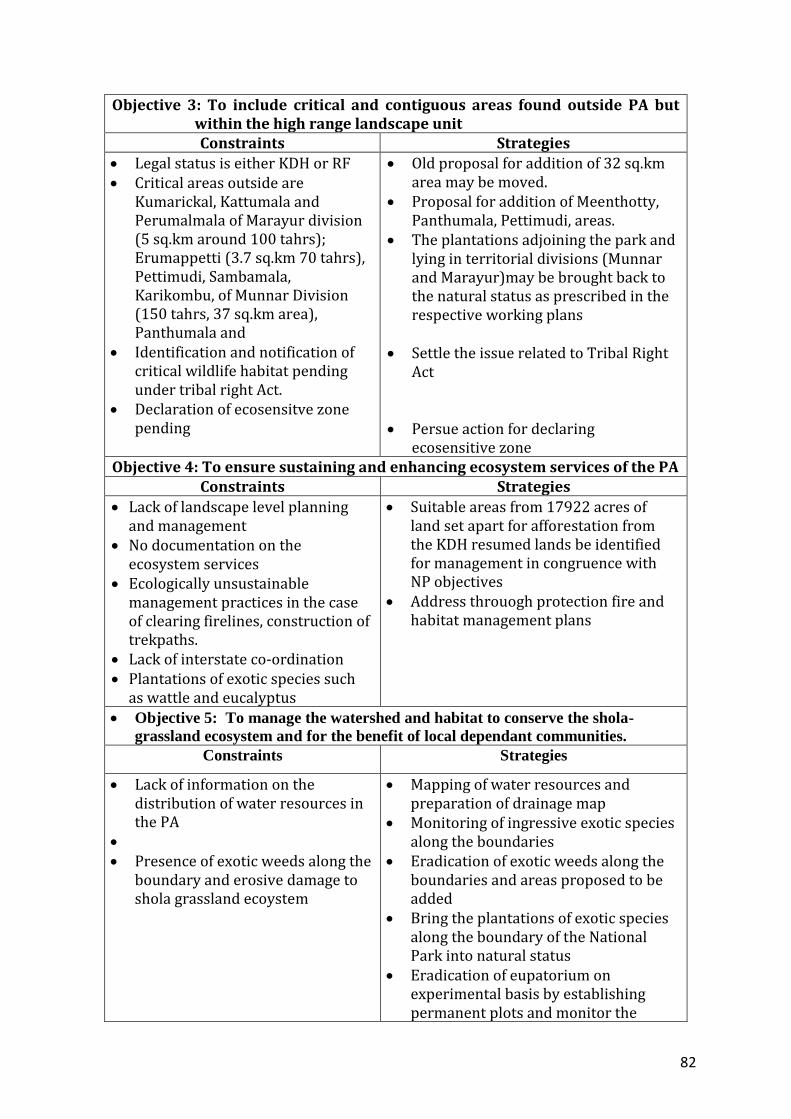
82
Objective 3: To include critical and contiguous areas found outside PA but within the high range landscape unit Constraints Strategies
Legal status is either KDH or RF Critical areas outside are
Kumarickal, Kattumala and Perumalmala of Marayur division (5 sq.km around 100 tahrs); Erumappetti (3.7 sq.km 70 tahrs), Pettimudi, Sambamala, Karikombu, of Munnar Division (150 tahrs, 37 sq.km area), Panthumala and
Identification and notification of critical wildlife habitat pending under tribal right Act.
Declaration of ecosensitve zone pending
Old proposal for addition of 32 sq.km area may be moved.
Proposal for addition of Meenthotty, Panthumala, Pettimudi, areas.
The plantations adjoining the park and lying in territorial divisions (Munnar and Marayur)may be brought back to the natural status as prescribed in the respective working plans
Settle the issue related to Tribal Right
Act Persue action for declaring
ecosensitive zone Objective 4: To ensure sustaining and enhancing ecosystem services of the PA
Constraints Strategies
Lack of landscape level planning and management
No documentation on the ecosystem services
Ecologically unsustainable management practices in the case of clearing firelines, construction of trekpaths.
Lack of interstate co-ordination Plantations of exotic species such
as wattle and eucalyptus
Suitable areas from 17922 acres of land set apart for afforestation from the KDH resumed lands be identified for management in congruence with NP objectives
Address throuogh protection fire and habitat management plans
Objective 5: To manage the watershed and habitat to conserve the shola-
grassland ecosystem and for the benefit of local dependant communities. Constraints Strategies
Lack of information on the distribution of water resources in the PA
Presence of exotic weeds along the
boundary and erosive damage to shola grassland ecoystem
Mapping of water resources and preparation of drainage map
Monitoring of ingressive exotic species along the boundaries
Eradication of exotic weeds along the boundaries and areas proposed to be added
Bring the plantations of exotic species along the boundary of the National Park into natural status
Eradication of eupatorium on experimental basis by establishing permanent plots and monitor the
83
changes Controlling the erosion and repair
damaged trek paths and land slips in grasslands and shola forests as needed
Objective 6: To create awareness among public, visitors and stakeholder through strengthened education and interpretation programmes
Constraints Strategies
No interpretation and education plan
inadequate interpretation facilities No nature education officer and
support staff
Develop a plan for education and interpretation in the park and implement
Develop and maintain interpretation facilities
Propose for Nature Education Officer and support staff through FDA
Objective 7: To prepare and implement visitor management plan by assessing the carrying capacity of visitation
Constraints Strategies
No carrying capacity study is done so far
No visitor management plan No ecotourism officer and
support staff No system of waste disposal Inadequate parking space Entry fee is not rolled back to
PA No eco-development
surcharge is realized from tourist
Lack of proper awareness among tourists, tour operators, taxi-auto drivers, hoteliers, local people and staff about management of the Park
Lack of information about the negative impact of tourism on tourism zone
Inadequate co-ordination between departments
Closure period not specified Teasing/ feeding of tahrs by
visitors Inadequate system on
feedback from visitors
All the constraint were already proposed under other objectives
84
Objective 8: To Strengthen PA-People relation especially Muduvans, NGOs and other stakeholders in the management
Constraints Strategies
Community rights not settled Zone of influence not
demarcated Microplanning support team
and experts not in place Capacity of EDCs weak No quantification of the
resource dependency
The practice of annual joint boundary verification with HRWEPA and Mudhuvan tribes discontinued
Slackening of relationship with company managers
Fringe area EDCs /VSS –
structural limitaitons (Munnar/Marayur / Mankulam/Anamudi FDAs)
Insufficient permanent Mudhuvan watchers and staff for the additional proposed areas
Inadequate co-operation from Panchayats and other line departments.
Inadequate drinking water facilities (tribal settlements)
Inadequate knowledge among
staff about PFM Problems of movement (from
settlement- Parakudy, Nooradikudy, Parappayarkudy) during rainy season
Means of livelihood –tribal EDCs
Facilitate settlement of community rights Participatory study to identify & demarcate zone
of influence Establish a MIST / Ecologist & Sociologist under
FDA Capacity enhancement of EDCs through training Address while revisiting microplans (fix time
frame for revisit) Monitor the resource dependency periodically Restore the system of annual boundary checking
(to be done during closure period every year –WLW to ensure ) (The same is to be incorporated in the management plan for the company)
Nemakkad, Gundumala, Thalayar estates – ensure frequent interaction between the company & park management. (The same is to be incorporated in the management plan for the company)
Develop structures for implementation - by CEOs
Propose for appointment of permanent Muduvan watchers after studying the requirement
Propose for additional staff strength Liaison with the Panchayats and line
departments through FDA Create awareness about FDA to LSGs/Line
departments Address while revisiting of microplans Address through FDA Monitoring by MIST/Ecologist/Sociologist Impart training Address while revisiting of microplans Address through FDA
Address while revisiting of microplans Address through FDA / Line departments / Address through ecotourism packages Develop vegetative barriers – study and
implement
85
Man wildlife conflict – (animals: elephant, gaur, wild boar) (crops: ragi, tapioca, corn) (damages to property) (cattle lifting by tiger )
Rocky areas – stone packing may be explored Ensure timely payment of compensation
(through FDA) Awareness creation Rescue / translocation of diseased /problematic
animals (procure tranquilizing equipments, squeeze cages, nets, etc)
Strengthen veterinary facilities Training of professionals /staff / EDC members
in rescue operations Address through ecotourism packages
Objective 9: To generate data for future management and planning through scientific studies to achieve the above objectives
Constraints Strategies
Inadequate information of meteorological data
Inadequate studies on wildlife and their habitat
Inadequate information on shola ecology including plant-animal interactions
Inadequate documentation of historic materials and tribal knowledge about park.
lack of information about the long term dynamics of the grassland shola ecosystem
Lack of information about the effects of fire
Inadequate data on impact of tourism Inadequate data on eco-development activities Inadequate information on the impact of tea
plantations on the park
Installation of meteorological stations at Rajamala, Eravikulam and Poovar
Conduct studies on wildlife and their habitat
Conduct study on shola ecology
Document historic materials and tribal knowledge about the Park
Establish permanent plots and study vegetation dynamics
Propose study to generate information on the effect of fire
Propose carrying capacity study Propose study to generation
information of ecodevelopment initiatitves and its impact
Identification and documentation of high altitude grass, herb and shrub species
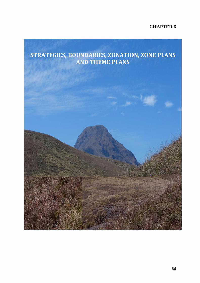
86
CHAPTER 6
STRATEGIES, BOUNDARIES, ZONATION, ZONE PLANS AND THEME PLANS
87
6.1. Boundaries 6.1.1. Legal Boundary
As per the notification, the Park boundary mainly follows the ridges and the
description is as follows:
North: The boundary commence from the point where the Kannan Devan Hills
Produce Village boundary meets the interstate boundary between Kerala and
Tamilnadu at point 5540’ (1689m). From that point the boundary runs along the
interstate boundary passing through peaks with altitude of 3984' (1214 m), 5011'
(1527 m), 5885' (1794 m) and 7388' (2252 m) to Perattumala 7033' (2144 m). Thence
turning southeast the boundary reaches Kumarickal Mala 8275' (2522 m).
East: The boundary follows the Kannan Devan Hill Produce Village boundary along the
ridge through Kattumala 8373’ (2552m) and then to Perumalmala 7736' (2355 m) till it
reaches Thirumudi 5676' (1830 m).
South: The boundary follows the western boundary of Chattamunnar Estate (Thalayar
group), northern boundaries of Vaguvarrai and Nyamakad Estate to meet the Kannan
Devan Hill Produce Village boundary about 3 Km south west of Rajamala peak 7209'
(2197 m).
West: The boundary follows the Kannan Devan Hill Produce Village boundary to
Rajamala 7209’ (2197 m) and then turning north-east, the boundary reaches
Sampamala 7581' (2311 m) and thence to Bhimamala 4719' (1438 m) and from there
turns in a north east direction to Kolukkumalai, 7137' (2175 m) and thence proceeds in
north direction to the starting point at 5540' (1689 m) passing through Erumamalai,
7496' (2284 m) and Erumapetty malai, 6999' (2133 m).
The notification of the Natinal Park is given in Annexure 1 6.1.2. Ecological Boundaries
Since the notification follows the ridges as the boundary, the ecological
boundaries of the Park extend into the Anamalai Tiger Reserve in Tamilnadu, Chinnar
Wildlife Sanctuary under Wildlife Division, Munnar and Koodakkad proposed reserve,
under Marayur Division in the north, Koodakkad proposed reserves under Marayur
88
Division in the east, the grasslands of KDHP company, Mankulam Division and Munnar
division in south and Anaimudi Reserved Forest under Munnar Division in the west.
These areas are vital as fawning and escape cover for a species like tahr. The proposals
for inclusion of these areas have not been fruitful. The National Park is also part of the
Anamudi Elephant Reserve.
These ecological continuities is to be added to the National Park to extend the
legal protection to the tahr population in the area and for the landscape. Tea estate
forms the boundary of the Park in the southern side. These estates adjoining the Park
have to be managed by plans that dovetail with the management of Eravikulam National
Park. A landscape level management, with the National Park as the focus, that involves
the tea estate and the territorial divisions, is necessary for ensuring complete protection
of the tahr habitats.
6.1.3. Internal Boundaries
There is no internal demarcation in the Park.
6.2. Zonation The PA was divided into various zones to provide a geographical framework for
management, indicate management priorities in different parts of the Park, indicate the
types and levels of use appropriate throughout the Park, assist in minimizing existing
and potential conflicts between uses and activities and the protection of Park values and
to provide a basis for assessing the suitability of future activities and development
proposals.
In order to achieve the objective, the National Park and its adjoining areas are
proposed to be managed as the following zones:
A. Within PA
1. Core zone 2. Buffer zone
Tourism and awareness zone Eco-Development zone
B. Outside PA
1. Proposed additional area 2. Eco-sensitive zone
89
The total extent of the Park as per the notification is 97 km2. Of this an extent of
about 1 km2 on the southern side of the Park is being used for tourism and awareness
and this constitute the tourism and awareness zone of the park. In addition,
Lakkamkudy tribal settlement with an extent of 44.088 ha is located on the southern
boundary of the PA. The settlement area with 200 m impact zone in the surrounding
region of the settlement is the ecodevelopment zone. These areas together form the
buffer zone of the Park. The rest of the area 95.18 km2 constitute the core area of the
Park.
Since many shola grasslands outside the Park are important for the tahr
population in the Park (as detailed in section 6.3.3.), those areas are proposed to be
added into the Park and constitute the proposed additional area.. The proposed
additional area will be managed in tune with the management prescriptions for buffer
zone of the Park in all respects.
In addition, some of the critical habitats in the surrounding of the PA are
proposed to be declared as eco-sensitive zone.
6.3. Zone Plans 6.3.1. Core zone
The core zone is an inviolate area where human interventions are strictly
restricted. The whole areas except the buffer zone, which consists of the tourism and
awareness zone and the eco-development zone, constitute the core zone of the Park.
The total area of core zone is 95.18 km2 (Map. 11). The focus of management is the
conservation of the largest viable population Nilgiri tahr in the world along with the
largest stretch of unique shola grassland eco-system in Western Ghats for ecological and
environmental benefits. In the core zone, the following activities will be allowed to be
implemented during the plan period:
Protection from illegal activities and other specific issues in the core as detailed
in the Theme Plan for ‘Protection’ in section 6.4.1
Fire protection activities including controlled burning and participatory fire
management as given in Theme Plan for ‘Fire Protection’ under section 6.4.2
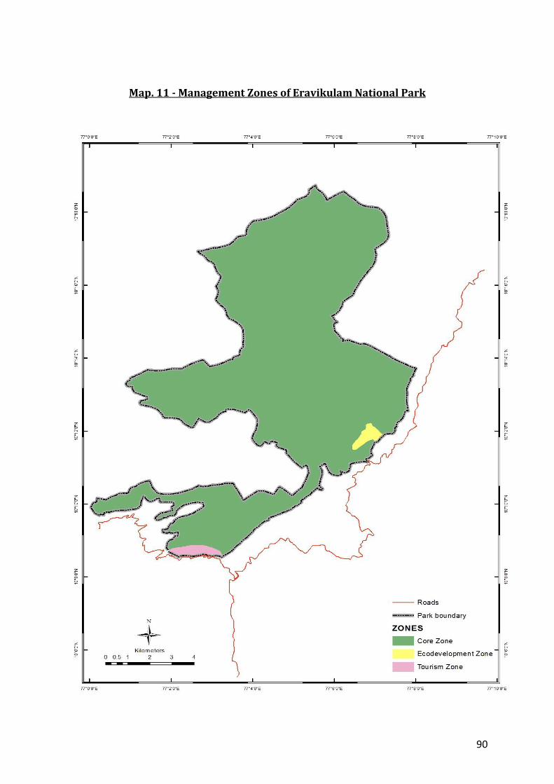
90
Map. 11 - Management Zones of Eravikulam National Park
91
Activities as proposed in Theme Plan for ‘Watershed and habitat management’
under section 6.4.3.
Research, monitoring, scientific studies to facilitate improved protection and
management of core zone (Chapter 9).
6.3.2. Buffer zone
Buffer zone of the Park consists of the tourism zone and the ecodevelopment
zone. The total area of the buffer is 1.82 Km2 of which 1 km2 is the tourism and
awareness zone and 0.82 km2 is the ecodevelopment zone.
6.3.2.1. Tourism and awareness zone
The tourism and awareness zone, overlapping with the buffer zone, consists of
the areas on either side of the road from 5th mile to Rajamala along with the ridge
between the Kadalar and Nyamakad estates. Thus the total extent of the tourism zone is
about 1 km2 (Map 11). The tourism and awareness zone will be managed with focus on
visitor management; nature-based regulated ecotourism programmes and promote
environmental conservation awareness. All the activities in this zone will strictly be
implemented as described in the chapter on ‘Tourism, Interpretation and Conservation
Edcuation’ (Chatper 7).
6.3.2.2. Ecodevelopment zone
The ecodeveopment zone, overlapping with the buffer zone, consists of the
Lakkomkudy tribal settlement located inside the Park with an extent of 44.088 ha and
the impact zone around the settlement (37.912 ha @ 200 m from the periphery of the
settlement). Thus the total extent of the ecodevelopment zone is about 0.82 km2
(Map. 11).
The activities undertaken in the eco development zone will be aimed at ensuring
sustainable livelihood for the dependent tribal people without hampering the
management objectives, exploring the opportunities including ecotourism programme
in the ecodevelopment zone and proposed additional area, based on approved micro
plan. The tribal settlements adjoining the National Park along the western boundary
and part of proposed additional area, namely Parappayarkudy, Parakudy and
92
Nooradykudy and the impact zone of 200 m along the boundary, will also be managed in
the same lines as the eco development zone. The ecodevelopment zone will be
intensively managed with the activities proposed in Chapter 8 for ensuring sustainable
livelihood of the local tribal community without hampering the ecosystem and
management objectives.
6.3.3. Proposed additional area The National Park notification mainly follows ridges as the boundary and hence
many important shola grass lands, which are used by the tahr population in the Park, lie
outside the Park boundary. These critical areas outside the park Kumarickal, Kattumala
and Perumalmala in Marayoor division (5 km2 of grass lands), adjoining Erumapetty,
Sambanmala, Karikombu, Pettymudy areas (25 km2 of shola grasslands on the right
hand side of the trekpath from Pettymudy to Noorady) of Anamudy RF in Munnar
Division, adjoining Anamudy peak (2 km2 of shola forest) in the southern boundary in
Munnar Division, adjoining Rajamala peak at Pettymudy (5 km2 of shola grasslands) in
Munnar Division, around 3.5 km2 of shola grasslands area belonging to Mankulam
Division adjoining tourism zone Rajamala in the southern boundary and 1.3 km2 area of
KDHP Company adjoining the tourism zone and Meenthotty (shola grasslands). A
proposal is already in place which was prepared as per the recommendation of the State
Board for Wildlife, for the addition of 32 km2 is to be added to the National Park as
buffer. The rest areas (9.8 km2) will be surveyed and added to the Park.
Once the proposed additional area is added to the National Park, the area will be
managed as buffer zone of the National Park. The tribal settlements in the proposed
additional area along with 200 m impact zone will be treatedas the ecodevelopment
zone. Till then, these areas shall be managed as per the following prescriptions to the
extent possible.
Protection from illegal activities and other specific issues as detailed in the
Theme Plan for ‘Protection’ in section 6.4.1
Controlled burning works in selected areas to make available fresh grass for the
herbivores following the protocol for controlled burning.
93
Map. 12 - Proposed additional area of Eravikulam National Park

99
6.4.1.3. Protection Camps 6.4.1.3.1. Existing anti-poaching camps At present there are 7 protection (anti-poaching) camps at Poovar,
Varattukulam, Kolukkan, Eravikulam, Anamudy, Meenthotty and Pettymudy in the
National Park for anti-poaching activities. The semi present structures at Varattukulam,
Kolukkan, Eravikulam and Meenthotty will be converted to permanent structures to
help the stay during the extreme weather conditions. All the camps will be maintained
periodically to be on good conditions.
6.4.1.3.2. Proposed anti-poaching camps
In addition to the above camps, the following anti-poaching camps are proposed
to be constructed for strengthening protection. All basic amenities for the stay are also
proposed to be developed during the plan period.
Anti-poaching camp shed will be constructed in critical location along the interstate
boundary especially at Podumala- Chinnpoovar for enhancing protection.
While adding the adjoining areas as buffer zone, new structures will be constructed
in Koodakad proposed reserve, Parakudy and Pettymudy - No.1 for protection.
EDC members and local dependents will be engaged as daily waged watchers in
all the existing and proposed anti-poaching camps for helping in protection. These new
camps near the tribal settlements will be permanently manned with the help of local
tribal people. All these camps will also be maintained periodically.
6.4.1.4. Patrolling schedule
No part other than the tourism zone and Lakkom tribal settlement are accessible
by vehicle. The whole movement inside the Park is on foot and regular perambulation of
the Park areas is the only way for protection. Of the seven protection camps at Poovar,
Varattukulam, Kolukkan, Eravikulam, Anamudy, Meenthotty and Pettymudy, the former
two are important in protection aspect. The perambulation procedure is as follows.
The Assistant Wildlife Warden will divide areas into patrolling units and
communicate the perambulation schedule to the staff on monthly basis for
implementation.

100
Camping for 4-5 day duration will be regularly carried out at Poovar and
Varattukulam. At least 3 to 4 camps will be arranged in these areas each month to
ensure proper protection.
In other camps at Kolukkan, Eravikulam, Anamudy, Meenthotty and Pettymudy,
camps of 3-4 day duration will be carried out. 2-3 camps will be arranged in these
areas during a month.
Camping and perambulation is to be done every month in Parappayar, Parakkudy
and Nooradykudy to ensure protection and keep the boundaries free from illicit
activities. This will also help in eco development initiatives and prevent the external
interference in tribal settlements, especially in the light of latest challenges in the
form of terrorism and nexalitism.
The ganja combing operation will be carried out during these perambulations.
Additional perambulations will be done in the areas adjoining the Park in the
northern, eastern and western boundaries, where there are chances of ganja
cultivation.
The boundaries with the tea estates at Chattamunnar, Vaguvarai, Kadalar, Rajamala
and Pettymudy will be regularly combed for nooses and illicit distillation of liquor.
The camps at Poovar, Varattukulam, Kolukkan and Eravikulam will be managed by
the staff at Chattamunnar and the camps at Anamudy, Meenthotty and Pettymudy
will be managed by staff at Rajamala. The Forester at Chattamunnar will organise
the perambulation at Poovar, Varattukulam, Kolukkan and Eravikulam. The Forester
at Rajamala will organise camps at Anamudy, Meenthotty, Pettymudy and at
Parappayar, Parakkudy and Nooradykudy. The Deputy Rangers will oversee the
implementation of protection plan in Eravikulam National Park in areas under their
jurisdiction. The staff incharge of respective EDC will take care of areas adjoining the
Tribal Settlements at Parappayar, Parakkudy and Nooradykudy with the help of EDC
members.
Continuous camping will be done in fire season along with EDC members in these
camps to prevent and detect fire incidents. Free ration, fuel, camping accessories,
solar equipment, etc will be provided for the camping in the field.
While adding proposed additional areas as buffer to the Park, perambulation plan
will be extended to those areas.

101
In the light of latest challenges like terrorism, protection will be followed
scrupulously in all interior areas.
The Assistant Wildlife Warden and Wildlife Warden will also join for patrolling and
make frequent surprise checks.
Frequent special ganja raids may also be arranged by the Wildlife Warden / Asst.
Wildlife Warden.
The staff will maintain the movement register and wildlife monitoring register
which will be subject to frequent inspection by Assistant Wildlife Warden and
Wildlife Warden.
6.4.1.5. Interstate coordination
The PA shares a total length of 9 kms of interstate boundary with Tamilnadu. In
addition to perambulation and monitoring of the region, frequent sharing of
information between the officials of neighboring forest divisions within and outside the
State are necessary. It is proposed to conduct meeting at the Range Officers level once a
month. In addition, the existing approved protocol for interstate meeting will strictly be
followed.
6.4.1.6. Strategies for Specific Issues 6.4.1.6.1. Stray dogs
The problem due to stray dogs, disturbing the wildlife, has been noticed from
Rajamala, Pettimudy, Nyamakadu and Vaguvarai tea estate. Measures will be taken to
control the stray dogs with the help of estate management, local Panchayath, SPCA and
Animal Husbandry Department through FDA.
6.4.1.6.2. Presence of shola grass lands outside the Park.
This issue is addressed in section 6.3.4 by proposing to add these areas to the Park.
6.4.1.6.3. Police Wireless Tower at Rajamala
At many points the shola grasslands extend outside the Park boundaries. The
grasslands adjoining the tourism zone Rajamala is important for the tahr population in
the area. The Police wireless station at Rajamala is located in the grasslands belonging
to KDHP Company, adjoining the tourism zone. This grassland is the only corridor

102
connecting the tourism zone to the grasslands of Mankulam Division in the Panthumala
– Pettymudy area. This causes disturbance to the Tahr population due to dumping of
waste, feeding of animals and hindering the movement of animals. This can cause
behavioral changes in animals and there is chance of spread of diseases to the animals.
New structures are constructed in the area without taking into consideration of its
ecological importance. The present enclosure around the wireless station will be
maintained periodically. No new structures should be allowed to be constructed in the
area. The possiblity of relocation of the wireless tower from the tahr habitat will also be
explored during the plan period.
6.4.1.6.4. Presence of tea estates along the boundaries
The southern boundary of the National Park is occupied by tea estates belonging
to KDHP Company and Thalayar Group. They follow inorganic method of cultivation,
using a number of pesticides and chemicals. The effect of these practices on the National
Park is not known. They have cultivated fuel wood crops like eucalyptus and wattle
along the boundaries which slowly spreads in to the National Park areas. This practice
has to be controlled in consultation with the estates management. The presence of cattle
in these estates along the boundary is a potential threat for the spread of diseases to the
wildlife including tahr that occasionally moves into these estates. The animal husbandry
activities in these areas are to be regulated in co-operation with the company
managements and animal husbandry department. The movement of tahr in to the
estates is to be controlled with the help of estate management, EDCs and local
dependents. The fire incidents in the Park start mainly from the tea estates along the
boundary. There are chances of attempt of poaching, snaring, ganja cultivation and illicit
brewing by the people from the estates. The frequent interaction with the estate
management, staff and labourers will help in curbing these illicit practices by the people
from these tea estates. The chance of management of nearby estates in a system that
dovetails with the management of Eravikulam National Park, with the National Park as a
focus and the chance of changing the inorganic method of cultivation in the estates, in
tune with the Park management, need to be explored. The tea estates at Rajamala and
Pettymudy use the road passing through the tourism zone of Park for transportation.
The possibility of providing alternate route, including rope ways, to the estates will be
explored to stop the increasing vehicular traffic through the tourism zone.

103
6.4.1.6.5. Fire
This issue is also dealt separately under theme plan for ‘Fire Protection’. 6.4.1.7. Infrastructure Development 6.4.1.7.2. Administrative building
The Office and quarters of the Wildlife Warden is located at Munnar. The Office
and quarters of Asst. Wildlife Warden is located at Rajamala in the Tourism Zone of
Eravikulam National Park. Office and quarters of the Deputy Ranger is located at
Chattamunnar. The staffs of Rajamala outpost are located at Rajamala. The Nature
Education Centre, Munnar and the Interpretation Centre, Munnar helps in nature
education, protection and management. The Old quarters Vaguvarrai and the heritage
building, the Hut at Eravikulam, help in protection. Built in 1928, the Hut at Eravikulam
is one of the few remaining colonial fishing bases. This structure is to be protected and
maintained perfectly. Accommodation available for the staff at Rajamala and
Chattamunnar is not sufficient. It is proposed to construct ecofriendly accommodation
facilities for staff at Chattamunnar and a Forest Station building at Rajamala. It is also
proposed to make available facilities like coats, tables, chairs, camping accessories etc.
for the Chattamunnar Forest Station and Rajamala outpost.
The existing and proposed official and residential buildings will be maintained as
and when required. The basic amenities such as lighting, drinking water, etc will be
improved in these buildings. A library in each station/section headquarters will also be
developed.
6.4.1.7.3. Improvement of facilities in existing camping stations
All basic amenities including solar lighting system, solar fencing, wind energy
mills field cots, drinking water, etc. will be provided for improving camping facilities.
Camping accessories like sleeping bags, tents, cooking accessories, free rations and fuel
will be provided for efficient protection of the areas.
6.4.1.7.3 Check posts
The tribal people from Edamalakudy, the estate labourers and staff of Rajamala
and Pettymudy estates of KDHP Company and Government officials to Rajamala,
Pettymudy and Edamalakudy pass through the 5th mile - Rajamala road that passed
104
through the tourism zone of the National Park. The check post located at Rajamala
controls the vehicular and human movement in the route. A chain gates is proposed at
5th mile entrance of the Park.
The main trek path through the National Park starts at No.1 field of Vaguvarrai
lower tea estate of KDHP Company. A chain gate is proposed at the entrance of the trek
path from No. 1 field. Chain gate is also proposed in the entrance to the Lakkomkudy
from Vaguvarrai tea estate.
6.4.1.7.4. Roads
The following roads are passing through Eravikulam National Park. 1. Rajamala check post- Last point of tourism zone - 2.00Km 2. Vaguvarrai tea estate - Lakkomkudy - 0.30 Km The first road is black topped passing through the tourism zone and the second
road is concrete road passing to the Lakkomkudy tribal settlement.
The following roads outside the National Park are also under the National Park.
1. PWD rest house – Forest IB, Munnar - 300m 2. Road to Office of Asst. Wildlife Warden, Rajamala - 400m 3. Road at the parking area in 5th mile - 250m
The road from 5th Mile to forest check post, Rajamala is owned by the KDHP
company. But the road is used for the commutation of visitors to the Tourism Zone and
back. This road is not under the control of the Park.
It is proposed to periodically maintain all the roads including the one from 5th
Mile to forest check post Rajamala. New roads will be constructed based on necessity
and observations.
6.4.1.7.5. Trekpaths
The entire movement in the National Park other than the tourism zone is on foot.
The list of trek paths in Eravikulam National Park is given in the Table 23.
105
Table 23: List of trek paths in Eravikulam National Park
Sl. No. Name Distance (Km.)
1 Number One – Eravikulam 8.5 2 Eravikulam – Poovar 14.0
3 Selvamala – Pothumala 4.5 4 Eravikulam – Kolukkan 6.5 5 Selvamala - Kumarickal 3.5 6 Lakkomkudy – Kudimala 2.0 7 Chattamunnar OP – Thirumudy 6.0 8 Varattukulam – Kattumala 3.0 9 Meenthotty - Anamudy 5.0
10 Sambamala – Parappayar 4.5 11 Cheruthannipetty - Enippara 5.6 12 Pettimudy – Parappayar 5.0
13 Nooradikudy – Thattukanam 4.0 14 Nooradikudy – Chembikavala 5.0 15 Oralipara – Erumapetty 1.1 16 Chattamunnar – Log House 0.5
Total 78.7
The trek paths in the core area the National Park should be taken up annually.
Only clearing of vegetation should be done in the core area. Plugging of eroded areas
with locally available materials, to prevent degradation and construction of Iron bridges
across streams, in order to facilitate the movement during rainy season, can be done.
Construction of new trek paths can be done in proposed additional area to facilitate
movement.
The Wildlife Warden may review and study the necessity of maintaining
important trek paths in the checklist mentioned above. As far as possible, the trek paths
through the sholas may not be maintained.
6.4.1.7.6. Communication facilities
There are 2 Wireless Towers at Rajamala and Varattukulam in Eravikulam
National Park. There are 3 main sets, 2 mobile sets and 13 wacky talkies. It is proposed
to construct two wireless towers at Chattamunnar and Poovar to strengthen the
communication with the field. The repair, maintenance and replacement of wireless,
wacky talkies and communication equipment will be done periodically. If more
infrastructures are needed, especially in the proposed additional area, to ensure
106
complete coverage of the PA, it can be done based on observations. All the field staff up
to the Forest Guard are provided with SIM cards by the department. But the mobile
phone coverage in the PA is limited. The dependable mode of communication will be the
wireless.
The advanced methods of surveillance and monitoring include remote cameras,
installation of Radio Frequency Identification (RFID) and monitoring through wireless
or satellites. These techniques shall be explored and adopted for enhancing protection.
6.4.1.7.7. Vehicle
At present there are 2 Jeeps, 1 Mini bus and 3 Motor bikes in Eravikulam
National Park for protection. One more jeep for the proposed Rajamala station, repair
and maintenance of the existing vehicles and timely replacement of damaged vehicles
are proposed.
6.4.1.7.8. Arms and ammunition
At present the Park is having 1 Revolver, 2nos-.303 Rifles, 5nos-.315 Rifles, 2 Air
Guns and ammunition for the protection. It is proposed to repair and maintain the
present arms and replace the damaged ones with quality products. Once the new station
is created, the present arms will be shared and used in the stations.
6.4.1.7.9. Deployment of staff
The present staff strength is not sufficient to manage the PA as the ecotourism
and ecodevelopment activities are on the rise. The inflow of visitors is on the rise and
the challenges are increasing every year. Addition of more area as buffer zone will make
the protection very difficult with the existing staff strength. Hence, additional staffs are
proposed to deal with the situation. It is proposed to appoint one Deputy Ranger, three
forester, sixteen forest guards, one driver and four permanent muthuvan watchers in
addition to the existing staff strength for the new forest station at Rajalmala. The
present strength of Chattamunnar Forest Station will be retained at Chattamunnar. All
vacant positions should be filled up regularly. The number of staff and watchers
required for effective patrolling and protection of PA are detailed in the following table.
107
Table 24 – Staff Strength (Proposed)
6.4.1.7.10. Capacity Building
Training will be given to patrolling staff in unarmed combat, survival skills, usage
of fire arms, first aid, swimming, driving etc. with the assistance of Police. Training will
also be given in the preparation of offence reports. Selected staff will be trained as
‘handlers’ as part of intelligence gathering. Police should be approached for giving short
term trainings on intelligence gathering at regular intervals. Exposure training to staff
in identification of plants and animals will be periodically provided to staff working in
the PA as part of building their capacity.
In addition to the above, local persons from the tribal communities with aptitude
will be identified and trained in basics of wildlife crime detection. Detailed training
requirements are provided in Chapter 9.
6.4.1.7.11. Intelligence Gathering and Coordination
The Wildlife Warden, Assistant Wildlife warden and staff will develop liaison
with NGOs, peoples’ representatives, EDC members, Tribal Heads, interstate officers,
Crime Control bureau officials, in sharing information. The informants may be paid
suitably. The Wildlife Warden may move proposal for fixing the rewards to the
informants depending on the type of crime and information. Legal support will be made
available as required. The Wildlife Warden will review and monitor the implementation
of the protection plan.
Designation Sanctioned
strength Present strength
Proposed strength
Additional reqirement
Asst Wildlife Warden
1 1 1 0
Wildlife Assistant 1 Nil 1 0
Deputy Ranger 1 1 2 1
Forester 3 3 6 3
Fores Guards 16 12 32 16
Forest Watchers 8 7 12 4
LD Clerk 1 1 1 0
Peon 1 1 1 0 Driver 1 1 2 1
108
The Assistant Wildlife Warden will also collect credible information through
confidential channels employing agents or sources. Confidential sources and agents will
be identified, trained and placed in position to get confidential information.
A system of regular interaction with Tamil Nadu forest department and adjoining
divisions and joint combing operation in the interstate boundary with Tamil Nadu
Forest Department Staff and Marayoor and Munnar division staff is proposed for
protection.
6.4.1.7.12. Joint Patrolling and Meetings
Joint patrolling and meetings of various levels of officials will be held with the
adjoining forest divisions within Kerala and Tamil Nadu side. This will be ensured by
the Wildlife Warden and Assistant Wildlife Warden.
Regular meeting with the stakeholders including KDHP Company will help in
improving the relationship and protection activities in the Park.
6.4.1.7.13. Exchange of Crime Dossiers
The Wildlife Warden /DFOs will exchange the crime dossiers with police to
update and review with District Superintendent of Police at least once in six months.
The information will also be shared with adjacent Forest Divisions in Tamil Nadu to
ensure effective protection.
6.4.1.7.14. Review of protection issues
Based on the threats and protection issues, threat perception and vulnerability of
various regions in the PA will be developed.
6.4.1.7.15. Maintenance of Records
Registers will be maintained in the camping stations to monitor the movement of
patrolling teams. The Deputy Rangers will inspect the registers once in 15 days, the
Assistant Wildlife Warden once is a month and the Wildlife Warden once in 3 months to
ensure effective protection. Following records will be maintained by Wildlife Warden,
Assistant Wildlife Warden and Section staff.
Records of vehicles passing through check posts.
Offence Registers at Division/Range/Station.

109
Arms and ammunition Register (Range/Station)
Records of dossiers of habitual/ incorrigible offenders in the Range.
Regular supervision schedule for ROs.
Records of surprise visit by Senior Officers (Field Director, Project Tiger
and Wildlife Warden).
Staff in each Section will maintain
Movement Register
Wildlife sighting/daily monitoring/observation Register (Wildlife
Journal)
6.4.1.7.16. Equipment / Field Gears
It is proposed to procure field equipment such as Tents, Compass, GPS,
Binoculars, Range finder, Digital camera, Rain Gauge, Thermometer, Hygrometer,
Camera trap, field kits, etc. for all camping stations manned. In addition the watchers
will be provided with field uniform once a year during the plan period.
6.4.1.7.17. Staff welfare activities
The Wildlife Warden will have meetings with the staff and include the staff
amenities items in the APO funded by Government of India. At present the Govt. of India
is providing staff welfare inputs like residential accommodation for the children of
frontline staff in nearby town/villages, supply of kerosene, medicine, field kit, mosquito
net, torch, etc. The staff who excel in performances will be rewarded accordingly. Camp
food shall be provided to staff and watchers stationed at interior camps. The possibility
of receiving assistance from eminent NGOs for protection like supply of field kits,
sleeping bags, tents, training, legal assistance and awareness programmes will be
explored. The staff working in the National Park may be given Project Allowance as
allowed in Project Tiger areas.
6.4.2. Theme Plan for Fire Protection
Forest fire is the single and most destructive factor that challenges the protection
of the fragile shola grass lands eco system in Eravikulam National Park. Fire
management plan will be prepared every year considering the history of fire incidents
and prevailing situations. The existing roads, trek path, rivers etc. has to be considered
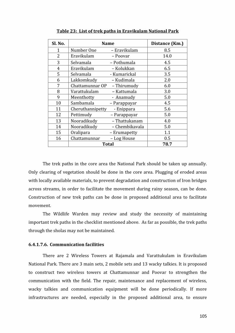
110
while preparing the fire management plan. In order to protect the Park from forest fire,
the following strategies are proposed.
6.4.2.1. Fire Management Plans
Fire protection measures will be taken in accordance with approved fire
management plans.
6.4.2.1.1. General guidelines for preparation and Implementation of Fire
Management Plan
Identify the cause and consequences of fire at PA level.
Prioritize and map fire prone areas based on local knowledge.
Prepare plans on annual basis.
Provide adequate training to fire-fighting squad in fighting fires and self-
defense.
Develop infrastructure by procuring necessary equipment and materials
required for fire protection based on annual assessment.
Develop proper monitoring protocols.
Ensure timely implementation of interventions.
Maintain fire records at Range and Division level.
Report incidences of fire to Wildlife Warden and Field Director for evaluation
and further action.
Document the results of fire protection measures taken annually.
6.4.2.2. Fire Management Strategies
Following are general guidelines for implementation of fire protection measures
in Eravikulam National Park:
6.4.2.2.1 Fire lines The Wildlife Warden will maintain the following fire lines in the fire prone areas.
111
Table 25: List of fire line in Eravikulam National Park
Sl. No.
Name of fire line Length (Km)
1. Rajamala Check Post- Kadalar 3.50
2. Rajamala Check Post- Chandanakadavu 3.50
3. Kolukkan- Cheruthannypetty 7.50
4. Kolukkan- Erumapetty 7.00
5. Cheruthannypetty- Sampamala 2.00
6. Methurunda- Neerar 2.00
7. Anamudy- Thookkupalam 8.50
8. Chinnanamudy- Velavar Kovil 1.00
9. Kudimala- Varattukulam 2.50
10. Kattumala- Perumalmala 2.50 11. Kattumala- Kumarickal 5.00
12. Chinnapoovar- Kumarickal 2.50
13. Podumala- Chinnapoovar 2.00
14. Perumalamala- Undakkal 4.00
15. Podumala –Neerar 3.50
16. Vembanthanny – Nedumkurukku 4.00
17. Rajamala Check Post- Meenthotty 7.50
18. Enippara- Pettymudy 5.00
19. Bheemanoda- Kallupalm 4.00
20. Onamthery – Vattachidhambu 3.50
21. Pallanadu- Thookkupalam 8.00
22. Around MPCA area 8.50
23. Meenthotty – Junda No.1 11.00
24. Lakkomkudy- Pakkumarathery 4.00
25. Kolukkan shed –Thattukanam 3.00
26. Erumapetty – Methurunda 5.00
27. Kolukkan shed – Poosanampara 4.00
28. Kolukkan shed – Sambamala 8.00
Total 132.50 km
In addition fire lines will be created around shola forests to protect the sholas
and regeneration of Kurinji species in case of necessity. This needs to be done in years
immediately after the massive flowering of Kurinji in the sholas to protect the flowering
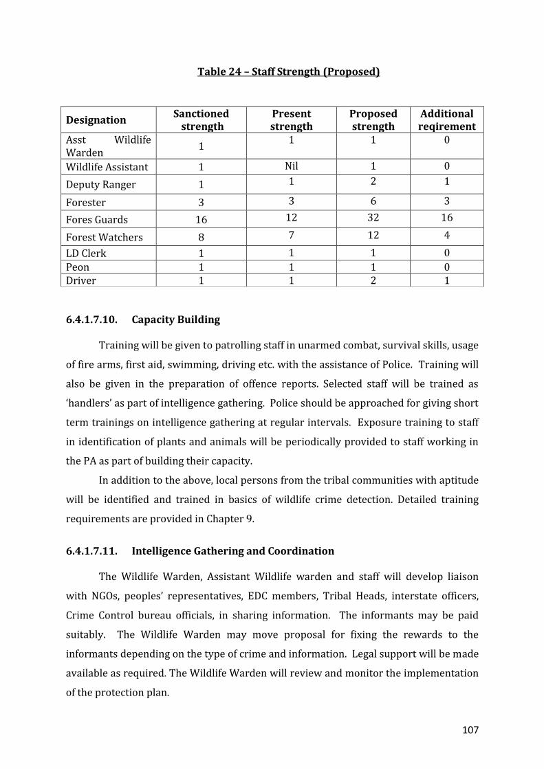
112
and seeds and in subsequent years, the regeneration from fire. This is also important as
massive quantity of fuel wood will be available in the shoals in years following the
massive flowering of Kurinji. All the fire incidents will be properly recorded for future
management. New fire lines will be approved as per necessity by the Wildlife Warden.
In case of addition of more area to the National Park, fire lines will be created in these
areas.
The following rules will be followed in creating the fire lines in the Park.
No scrapping should be done in the grasslands and core areas of the park for
preparation of fire lines.
No fire line should be taken on the edge of the shola forest. The fire line around
the shola should be taken giving reasonable space of 10 meters for the extension
of shola forest.
Clearing and maintenance of fire lines should be carried out as per the FSR and
prescribed in the section 6.4.2.2.1.
Scraping of grasses in the grasslands and around shola patches as fire protection
measures should be avoided. The grass will be cut and burnt without scraping.
Preparation and implementation of fire management in association with the EDC.
Controlled / cool burning of grasslands to help in fire protection and making
available palatable grass for herbivores as per protocol.
6.4.2.2.2. Camps for fire-fighting gangs
The existing protection camps at Poovar, Varattukulam, Eravikulam, Kolukkan,
Anamudy, Meenthotty and Pettymudy will be used for the camping of fire
watchers and fire protection committee members during fire season. In addition,
temporary structures will be constructed at Mesthirikattu, Pakkumaratherry,
Podumala and Kumarickal to detect and prevent the spread of fire from the
human habitation around the National Park. In case of addition of new areas to
the Park, temporary structures can be constructed in the area during fire season.
A group of watchers will be maintained in Rajamala tourism zone in order to
prevent fire incidents in this highly sensitive area, which is frequented by
113
vehicles and local people to Rajamala, Pettymudy and Edamalakkudy. They will
be camping throughout in the temporary shed in the Rajamala tourism zone.
The Wildlife Warden will ensure the engagement of fire gangs from the fringe
area people in sensitive areas around the Park. Priority will be given to provide
livelihood and employment to resource dependent local communities.
6.4.2.2.3. Fire watch towers
The existing fire watch tower at Rajamala will be made use of during fire season.
The fires watch tower will be maintained periodically.
6.4.2.2.4. Controlled pre-burning
Controlled burning is the most important activity in connection with the fire
management in the Park. Early controlled burning of grass land is carried out to
facilitate growth of fresh grass to make available nutritious food for the young tahr
calves and other herbivores during dry season and also to help in fire protection. The
aim is to create a mosaic of burnt and unburnt patches. This helps to prevent the
animals from venturing outside the Park in search of burnt grass and getting poached.
This also helps in avoiding severe and irreversible damage due to late fires. Late fires
accompanied by strong winds can cause irreversible damage to the grasslands. No
burning should be done in areas like MPCA and other ecologically important areas.
Controlled burning needs expertise, extra care and attention. The Muthuvans are
experts in this activity. While doing, the following guidelines have to be strictly adhered
to:
Burning should be completed by the end of January itself when the grass is still
green. Pre flushing of birds and small animals to be done.
As far as possible the activity has to be carried out by the Muthuuvans.
Burning has to be carried out in areas utilized by tahr and other herbivores,
around sholas in the unburnt areas, along MPCA boundary and the grassy
stretches on the Park boundary.
Fire will be set only after taking fire lines around the prescribed burning
regime set apart to prevent spreading of fire to surrounding forests.
114
Burning has to be carried out early in the morning and late in the evening only.
Night burning will cause damage to insects and birds that would otherwise
move away.
Before burning, target area should be flushed to drive out animals and birds.
Simultaneous setting of fires on all sides of the block should be avoided.
Fire should be set opposite to the wind direction to control speed/ velocity and
intensity.
On hill slopes, fire is to be set from top down direction for better control.
Controlled burning should be carried out only in the presence of staff.
Necessary fire-fighting equipments should be procured in advance. Staff and
labourers involved for burning should be trained in using fire-fighting
instruments.
The area burnt has to be marked on a large scale map, GPS documented and
kept as permanent record. The area has to be monitored regularly, right from
the date of burning.
Burning should not be done in areas where the Neelakurinji has come into
bloom in the previous year.
When burning is carried out around a shola, it is always ideal not to burn the
tall grasses found on the edge of the shola that may provide micro environment
for shola regeneration. Outside this edge, a 10m wide belt can be burned
during the first year. Next year burning should be further outside this strip.
If small patch of grassland is interspersed between two sholas, this patch
should not be burnt because succession may bring back sholas at such sites.
In order to have a mosaic of burnt and unburnt areas, the grassland areas are
divided into 50 ha grids and controlled burning regime is proposed (Map. 14). The grids
with ‘1’ will be burnt during the first year and ‘2’ and ‘3’ will be burnt during the
subsequent years on rotation basis. Hence the entire grassland will be practiced with
controlled burning in rotations of 3 years. Since grazing pressure is more in the burnt
areas, the extent of grassland to be burnt should be large enough to sustain the grazing
115
Map. 14 : Proposed controlled burning regime
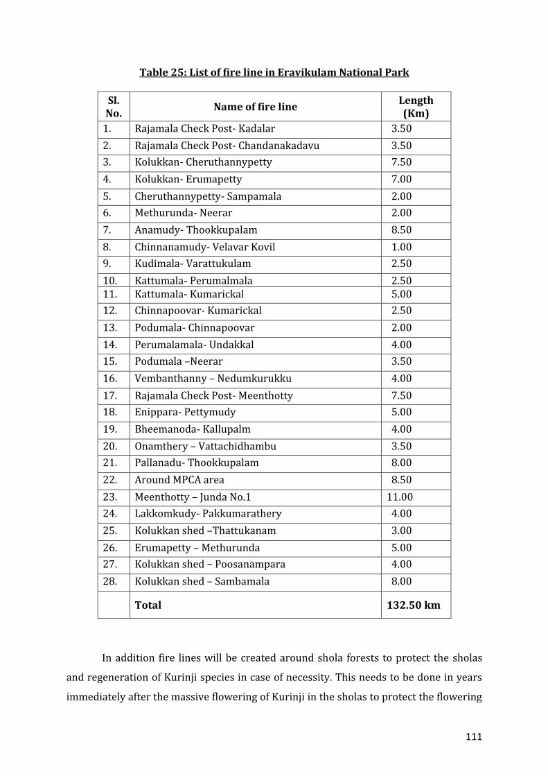
116
pressure. The size can vary from 5 ha to 50 ha depending upon the animal density,
extend of grasslands, and fire prone nature of the area. While burning the grasslands in
the grids the natural features such as streams, nullahs, roads, trek paths, etc will be
identified for delineating the boundary for burning. The grass cut while clearing lines is
to be burnt within the block. Experiment with mechanized precutting to cool burning,
repeated mechanized cutting and natural decay in critical areas such as water sources,
bird ground nesting areas etc.This system will act as a guide during the first year of the
plan period and necessary changes can be made during the subsequent years.
6.4.2.2.5. Deploying fire-gangs
Fire gangs will be engaged throughout the season for efficient fire protection
activities. In addition to the existing daily waged mazdoors and EDC members, a
minimum of 10 members preferably from the tribal and local dependents will be
engaged during the fire season every year. The number of persons engaged for this
purpose will be decided based on the intensity of fire and severity of drought. In case of
necessity fire gangs may be deployed in April – May depending on the intensity of
drought.
6.4.2.2.6. Participatory Fire Management
Participatory fire management shall be based on the guidelines circulated by the
Principal Chief Conservator of Forests in Circular No. E&TW1-2002/08 dated
14.11.2008 (Appendix 7.2).
The members of Lakkomkudy, Parappayar, Parakkudy, Nooradykudy and
Watchers EDC will be involved in participatory fire management. A micro plan will be
prepared for each EDC detailing the extent of area, people involved, benefit sharing etc
in every fire season. The area for fire management will be identified and allotted to the
EDC based on its geographic location. Funds for the prescribed operations will be
placed in the EDC account on the basis of a MoU. Participatory Fire Management Plan
will include the causes/sources of fire, preventive measures and conditions specified in
line with the circular issued by KFD. The plan will be signed by a member of the EDC
subgroup, President and Ex-Officio Secretary/Staff in-charge of the Section. Plan will be
approved by the Range Officer. People along the boundary will also be engaged as fire
117
gangs in vulnerable areas. The members of professional EDCs may be engaged during
fire season to provide firsthand information for them on the Park and its management.
6.4.2.3. Awareness and Training
Awareness campaigns are essential for preventing fire. Wildlife Warden will
arrange awareness and training for the staff, EDC members and local dependent before
the fire season every year. Awareness campaigns may be arranged for fringe area
people, tribal settlements, tea estates, school, colleges, taxi drivers and people’s
representatives on the impact of fires on forests. This may be done by mass involvement
of people in procession, talks, information display boards, banners, street play etc. EDC-
based awareness campaigns highlighting fire preventive and containment measures
among children and youth in the localities will be held during the fire season. Creative
programmes in this regard will also be developed.
6.4.2.4 Training programmes
Training programmes for staff, watchers and other members of the community
involved in fire protection will be organized.
6.4.2.4. Fire watchtowers and communication network
The present infrastructure and communication facilities will be made use of in
fire protection to prevent the fire incidents and to mobilize additional forces in case of
necessity.
6.4.2.5. Firefighting equipment
The equipments like gum boots, fire resistant suit etc may be procured and made
available to the fire management groups.
The Wildlife Warden may review the fire plan every year after the fire season.
The gap in fire protection may be identified and suitable proposals may be made in the
ensuing year to make Park totally free from fire.
118
6.4.2.7. Impact Monitoring
Incidents of fire will be documented and reported promptly to the Field Director
and Chief Wildlife Warden. Controlled pre-burning areas will be maped and GPS
documented to assess their impact and streamline future activities.
The Wildlife Warden will review the fire plan every year after the fire season.
The gap in fire protection will be identified and suitable proposals may be made in the
ensuing year to make the Park totally fire free.
6.4.3. Theme Plan for Watershed and habitat management 6.4.3.1. Watershed management
Eravikulam National Park receives sufficient rainfall during South-West and North
-East monsoons. A number of streams and natural water bodies are available
throughout the National Park. Plenty of water is available for the animals throughout
the year. Activities like creation water holes and gully plugging would damage several
endangered and endemic flora and fauna in and around streams and sholas. Activities
like construction of check dams, creation of water holes, gully plugging, retaining
structures preferably vegetative barriers, etc will be made based on field observation.
To know the distribution of water resources and to fulfill the needs of local people, the
following strategy and activities are proposed:
• Mapping of water sources – water holes, check dams, streams and other
natural sources with seasonality.
• Preparation of drainage map and vegetation map.
6.4.3.2 Habitat Management
As part of habitat management in the National Park following prescription will
be followed during the plan period.
Monitoring of ingressive exotic species along the boundaries.
Eradication of exotic weeds along the boundaries and areas proposed to be
added by cutting and uprooting repeatedly to prevent the spread into the
National Park, if possible with the help of EDCs and local communities.

119
Bring the plantations of exotic species along the boundary of the National Park
belonging to Munnar and Marayoor divisions into natural status in a phased
manner as per the working plan of the respective divisions.
Future planting and coppice maintenance of exotic species along the boundary of
the Park in Munnar and Marayur divisions may be streamlined for wildlife
management after discussion and dialogue with the managers of adjoining forest
divisions.
Eradication of Eupatorium on experimental basis by establishing permanent
plots and monitor the changes.
Controlling the erosion and repair damaged trek paths and land slips in
grasslands and shola forests as needed.
Removal of exotic species in areas belonging to KDHP Company, especially
adjoining Tourism Zone, in consultation with the company to facilitate the
regeneration of natural forests.
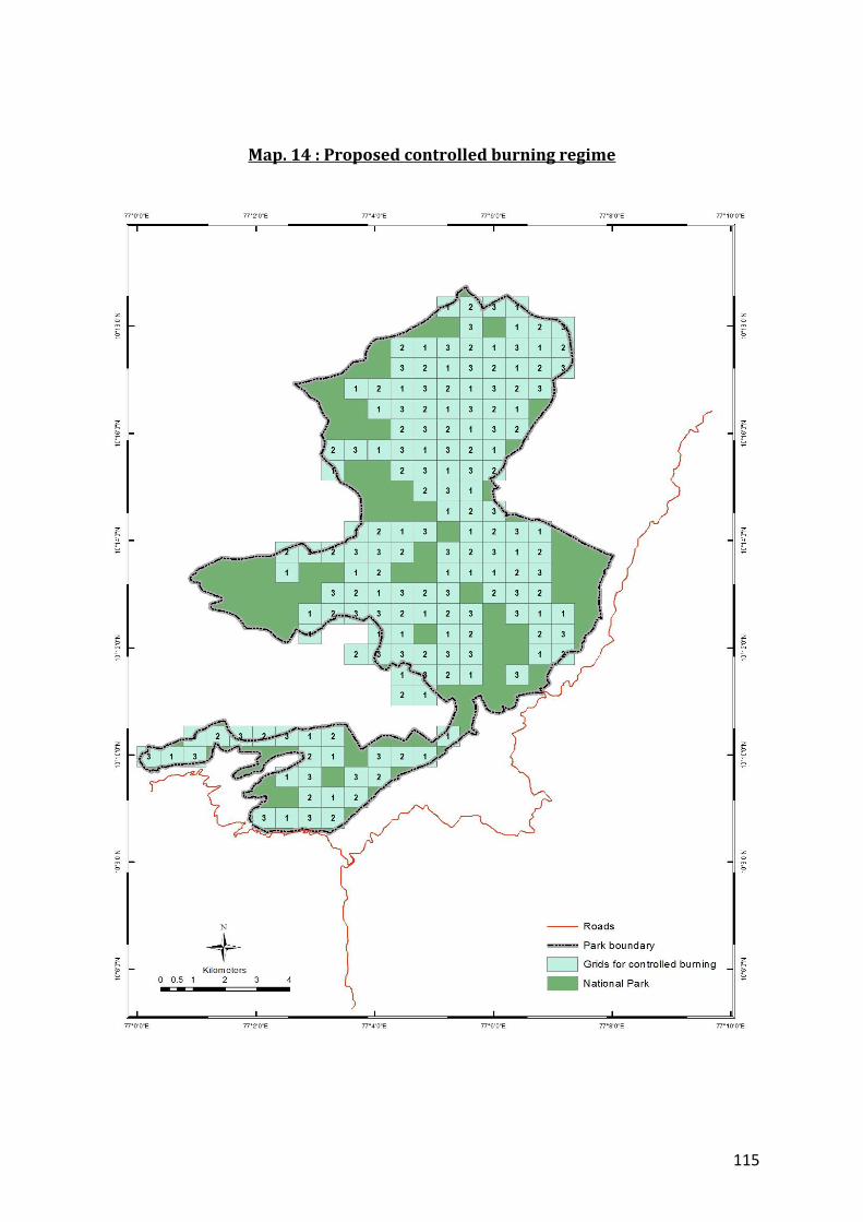
120
CHAPTER 7
TOURISM, INTERPRETATION AND CONSERVATION EDUCATION
121
Eravikulam National Park has been an important tourist destination in Kerala. From a
few hundreds during the end of 1980s, the number of visitors has gone up to 5,00,000
which includes Indians as well as foreigners.
Visitor management system was initiated in the Park in 1996. Since then, the
visitors were controlled at Rajamala Forest Check Post, from where they were allowed
to go by vehicle only up to the interpretation center, “Story of the Park” and then on foot
along the main road. The main attraction of area was the near assured sighting of Tahr
at touchable distance.
Most of the visitors were picnickers and not supportive of conservation. Daily
waged watchers kept constant vigil to dissuade visitors from littering, trespassing,
disturbing animals, plucking flowers, shouting etc.
The gregarious flowering of Kurinji (Strobilanthus kunthianum) in 1994, which
gained wide publicity, was the main boost for increasing the visitors to the National
Park. The visitor management system was continued up to 2006. In anticipation of the
massive flowering of Kurinji in 2006, the present visitor management system was
introduced with the help of local depended communities. All the private vehicles which
were earlier allowed to carry the visitors up to the tourism and awareness zone were
stopped at 5th Mile in the Munnar – Udumalpet road.
Six mini buses were purchased for the transportation of visitors and two new
professional EDCs, the Drivers EDC and Venders EDC, were formed with the help of local
depended communities. Ticketing counter was started at 5th Mile and visitors are
transported in the six buses owned and operated by the EDCs from 5th mile to the
tourism and awareness zone, which is 4km away from the ticketing counter. The
visitors are allowed to walk 1 km along the tarred road in the tourism and awareness
zone during which they could see the Nilgiri tahr, enjoy the picturesque landscape and
shola grassland eco system.
The interpretation centre, “Story of the Park” provides information on the Park,
its importance and biodiversity value. Facilities like parking area, cafeteria, enquiry
counter, toilet etc are operated by the EDC members at 5th Mile for the amenities of the
visitors. Facilities like eco-shop, amenity center, toilet etc are managed, in addition to
122
the interpretation centre, in the tourism and awareness zone by the EDC members. The
members of ‘Drivers EDC’ operate the buses owned by the EDCs. The members of
‘Watchers EDC’ and ‘Tribal EDCs’ are engaged in the tourism and awareness zone to
control the visitors and to keep area free from litter. They members of Driver and
Watchers EDC act as guides to bridge the information gap.
Lakkom water fall, a picturesque waterfall in the tributary to river Pambar,
which originate from Eravikulam National Park, was opened to the visitors in 2006. This
is managed by the Lakkomkudy EDC, one of the four tribal EDCs under the Park.
More than one lakh people visit the area in a year. User fee is collected for entry
into the area. Facilities like eco shop, toilets, locker, short trekking and camping
programmes etc are operated by the EDC members for the visitor’s. Massive flow of
visitors during peak season and the increasing number of street vendors (unauthorized
occupiers of the PWD road) have been a problem here. Some visitors even abuse the
area. The waste generated is very high and these issues need to be tackled with the help
of local dependents, Grama Panchayath, NGOs and Government bodies to keep the area
free from litter and ecofriendly.
Nature awareness programmes are conducted for the students, clubs, and other
interested group is the main activity related to conservation education in the
Eravikulam National Park. The facilities available for the programme are:
1. Nature Education Center, Munnar
2. Information Center, Munnar
3. ‘Story of the Park’ - an Interpretation Centre, Rajamala
In addition to the above routine awareness programmes are arranged in
connection with the wildlife week, fire season etc to create awareness among local
dependent communities and also to help in information dissemination. All The activities
including the nature education programmes are managed with the help of EDCs of local
dependents.
7.1. Strategies for environmental conservation awareness
1. Conduct nature awareness camps for schools, colleges, nature clubs, NGOs and
other interested groups.
123
2. Give priority to the Education Institutions and organization around the National
Park in awareness programmes.
3. Device and conduct awareness programmes for target group such as tour
operator, guides, taxi drivers, Divisional Advisory Committee of the tea estates,
DTPC etc to create awareness on nature conservation and also to help in visitor
management.
4. Upgrade the existing information centre “Story of the Park” at Rajamala and
information centre at Munnar.
5. Develop education and awareness materials like leaflets, brochures, pamphlets,
posters etc for various target groups.
6. Organise extension programmes in the tribal settlements, tea estates and local
area with the help of EDCs, VSS, NGOs and estate management.
7. Impart training for the staff and EDC members engaged in awareness
programmes.
8. Make available the service of Wildlife Assistant / Deputy Director for visitor
management and conservation education.
9. Appoint Nature Education Officer and wildlife educationist on contract basis
through FDA.
10. Engage trained resource persons to help information dissemination and visitor
management.
11. Making available facilities like LCDs, computers, sound systems etc and
maintenance of existing facilities.
12. Maintenance of existing facilities of nature education and interpretation.
13. Conduct study tour for staff and EDC members to other PAs.
14. Develop information centre, nature education centre, orientation centre,
interpretation centre, conference hall, library, toilet block, landscaping, parking,
etc in a centralized location (prerably at 5th mile) by availing land from HRWEPA.
124
7.2. Facilitating Nature-based regulated tourism
The following ecotourism programmes are being implemented in Eravikulam
National Park:
1. Visit to Rajamala tourism and awareness zone.
2. Visit to Lakkom water falls
3. Trekking at Rajamala and trekking and camping at Lakkom water fall.
As part of the regulated ecotourism, the following activities shall be taken up
during the plan period.
i. Engaging EDC members of local dependent communities for managing the
ecotourism programmes.
ii. Prepare implement visitor management plan for tourism and awareness
zone, Lakkom water fall and other ecotourism programmes.
iii. Prepare site specific micro plans for ecotourism packages for the buffer zone,
eco development zone and proposed additional area with base line
information for ensuring sustainable livelihood for local dependents and
conduct annual impact assessment through participatory process.
iv. Monitor the implementation and revise the visitor management plan once in
2 years.
v. Develop and implement interpretation packages as part of visitor
management plan for all ecotourism programmes.
vi. Introduce Park interpretation movie at 5th mile.
vii. Conduct periodic impact assessment of tourism areas once in 5 years with
the help of scientific community.
viii. Develop and implement system for collection of feedback from visitors to the
Park with the help of EDC members and volunteers.
ix. Limit ticketing time to the tourism zone to 8 am – 4pm.
x. Redefine closure period based on studies.
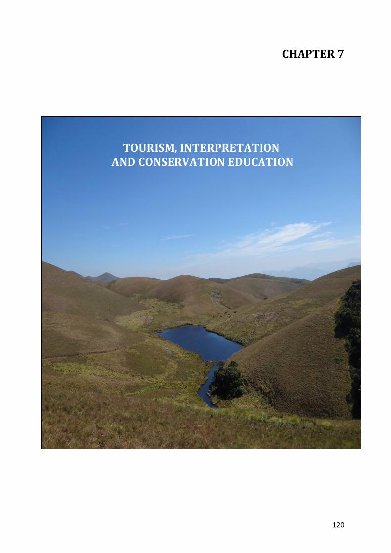
125
xi. Development of additional parking area at 5th mile and Lakkom for visitor’s
amenity.
xii. Create and maintain of basic amenities to visitors in the tourism areas at
Rajamala, 5th mile, Lakkom water fall and for ecotourism programmes based
on approved microplan or visitor management plan.
xiii. Online booking for the visitors to Eravikulam National Park.
xiv. Commence alternate ticket station at Munnar / Marayoor to help the visitors.
xv. Ensure security by installing metal detector and other facilities at 5th mile
Rajamala and Lakkom water falls.
xvi. Explore the possibility of imposing fine for littering, plucking of flowers,
teasing of animals etc. in the Park based on Government orders.
xvii. Capacity building and training to EDC members and staff on human
behaviour, identification of flora and fauna, visitor management,
interpretation of Park values etc.
xviii. Conduct carrying capacity study and regulate the visitors to the tourism and
awareness zone and Lakkom waterfalls and other eco-tourism programmes.
xix. Upgrade the existing web site of the National Park for information
dissemination.
xx. Explore the possibility of rolling back the entrance fee to the PA for
ecotourism and Park management activities.
xxi. Develop visitor management strategy to deal with the Kurinji flowering in
2018. The possibility of diverting the visitors to Kurunjimala Sanctuary in
Wildlife Division to be explored.
xxii. Conduct review/ seminar / workshop annually on tourism programmes and
publish the annual report through FDA.
xxiii. Explore the possibility of imposing eco development surcharge for
ecotourism programme.
xxiv. Design and implement strategies to reduce interaction of Rajamala tahr with
the visitors.
126
xxv. Develop theme based information displays in the tourism and awareness
zone, 5th mile, Lakkom waterfalls and other strategic locations.
xxvi. Tackle the issue of private shops, parking and waste management at 5th mile
Lakkom water fall and other ecotourism centers with the help of EDCs/ RDO
/ PWD / Line Departments / Police / Media / NGOs etc.
xxvii. Conduct meeting with line departments once in 6 months to help in visitor
management activities.
xxviii. Preparation and timely revision of the micro plans for the EDCs and visitor
management plans.
xxix. No vehicle other than those operated by the EDCs to be used for the
transportation of visitors to the the Park.
xxx. Control and monitor the vehicular traffic through the tourism and awareness
zone especially during night hours. The vehicular traffic from 10 pm to 6 am
should be strictly controlled and speed limited to 30 km/ hour or as per
prevailing rules from time to time.
xxxi. If vehicular transport is to be started from 5th Mile to Edamalakudy through
tourism zone it will be started by the FDA with adequate checking facility.
xxxii. Make available more information to the visitors on the Park, Tahr, Kurinji etc
to visitors by making available literatures and publications by establishing a
museum in the tourism zone.
xxxiii. Closure of the park for a period by two months between January and March
depending on the beginning of the calving period. A week’s notice will be
given by the Wildlife Warden before closure.
xxxiv. The revenue generated from ecotourism and visitor management will be
recycled to the FDA for Park management and village ecodevelopment.
7.3. New ecotourism proposals The Park manager will initiate the following proposals during the plan period.
127
i. Conducted tour package from Munnar to the adjoining landscapes. For
this the Wildlife Warden will purchase a bus. The conducted tour will be
organized through FDA, Anamudi.
ii. Protection and education oriented limited trekking, trekking and camping programmes to the buffer areas and proposed additional area based on approved microplans.
128
CHAPTER 8
ECODEVELOPMENT
129
The major problem related to people PA interface is making available sustainable
livelihood for the depend communities, especially the tribal people at Lakkomkudy,
Parappayar, Parakkudy and Nooradykudy. There is marginal collection of firewood, by
the people from Lakkomkudy settlement, Chattamunnar occupation and from the Tea
Estates along the boundaries at Chattamunnar, Coffee Store and Pallanad. Marginal
grazing (96 cattles) also occurs at Lakkomkudy, Pallanadu, Coffee Store and
Chattamunnar areas. NWFP, mainly honey, is collected by people from Lakkomkudy,
Parappayar, Parakkudy, Nooradykudy and settlements along eastern boundary in
Koodakad proposed reserve. The extent of NWFP collection is not yet studied and
impact not understood. There are many constraints for the people living in these tribal
settlements. The Lakkomkudy, having limited area under their possession, lacks
livelihood opportunities. They are mainly dependent on marginal agriculture in the
settlement and the employment in the Park for their sustenance. They need to be
provided with alternative income generation opportunities. The people from
Parappayar, Parakkudy and Nooradykudy are practically cut away from the outside
world for want of infrastructure facilities. They depend on agriculture for their
sustenance. The agricultural practices in these settlements need to be maintained as
ecologically viable, marketing opportunity should be made available and the middle
man exploitation stopped. They should be provided with more opportunities in visitor
management and ecotourism to generate employment opportunities. In order to
enhance the cooperation from the local people at Chattamunnar, Coffee Store and
Pallanadu and the tribal settlements along the eastern boundary in the Koodakkadu
proposed reserve constant interaction, awareness programme etc to be conducted
along with exploring opportunities for positives intervention in their socio economic
status, in order to gain their confidence thus helping in the management of the Park. The
possibility for the formation of new EDCs/ work in association with the present VSSs in
these areas to be explored during the plan period.
The professional EDCs in Eravikulam National Park, the main stay in the visitor
management, are able to successfully tackle the visitor flow to the tourism zone of
Eravikulam National Park. These EDCs consist of members of local community,
especially from the tea estates, surrounding the National Park. As the members of
Drivers EDC and Vendors EDC were not directly dependent on the park for their
130
sustenance, there is a gap in the conservation initiative on the part of members of these
EDCs. They have to be more integrated in the conservation initiatives in the Park by
constant interaction, trainings and awareness programmes. Being widely distributed,
they are not in a position to avail common beneficial programmes like the tribal
settlement. Hence, in order to ensure their welfare, appropriate programmes will be
designed in consultation with the members, which will ensure the socio economic
progress of the members and families of the professional EDCs.
All the people surrounding the National Park including the tribal settlements and
the tea estates at Chattamunnar, Vaguvarai lower and Vaguvarai top depend on streams
originating from the Park for their irrigation and drinking water needs. For this they
have constructed some structures within the Park before the declaration of the Park.
These structures need periodic maintenance. The possibility of repairing them through
FDA/EDC to be explored.
The eco development need of the people is to be studied with the help of experts.
Help of Government agencies like Tribal department, Agriculture department,
Agriculture University, education and research institution and NGOs is to be made
available in order to fulfill the eco development needs and thus achieving Park
management objectives.
8.1. Strategies
To strengthen the People-PA interface, the following strategies and activities are
proposed:
1. Improve people-PA relationship through eco development.
2. Strengthen the ecodevelopment initiatives and form a MIST (microplanning
Implementation Support Team)
3. Engage ecologist and sociologist under FDA
4. Facilitate Forest Rights Settlement including community rights in all the
settlements.
5. Facilitate certification and organic farming in the tribal settlements.
6. Utilise all available funds for ecodevelopment and Park Welfare Fund.
131
7. Develop and improve inter wing and inter department co-operation.
8.2. Activities
1. Identify the eco development needs through micro planning and studies.
2. Strengthen the Eco development activities with the help of EDCs.
3. Make available sustainable livelihood to people in tribal settlements by exploring
available opportunities in visitor management, ecotourism programmes and
alternate income generation opportunities, if needed in association with line
departments/FDA.
4. Make available educational, social and medical assistance to tribal EDCs by
making available infrastructure, conducting medical camps, providing financial
assistances etc with the help of line departments/FDA.
5. Enhance the infrastructure facilities in the tribal settlement especially
Parappayarkudy, Parakkudy and Nooradykudy in order to improve their socio
economic status through FDA / line departments.
6. Assist the tribal people in enhancing the income from agriculture, NWFP
collection etc by helping in processing and marketing of the produce.
7. Identify and implement schemes for improving the health, socio economic and
educational status in the tribal settlements, professional EDC and family of
professional EDCs.
8. Development of appropriate barriers to prevent wildlife entering the farmlands
(elephant proof trench, solar power fence etc) at Lakkomkudy, Parappayarkudy,
Parakkudy, Nooradykudy etc.
9. Timely assessment of wildlife damages and payment of compensation.
10. Institution of crop insurance.
11. Settle the rights including community rights in settlements as per Forest Rights
Act.
12. Capacity enhancement of EDCs through trainings.
13. Conduct socio economic survey of the dependent communities periodically.
132
14. Implementation of Eco development programmes in fringe areas in association
with Munnar and Marayoor FDAs.
15. Seek funds from various sources (Local bodies / other line departments/ Govt. of
India) through FDA for eco development programme.
16. Initiate steps for the organic certification of crops produced in the tribal
settlements.
17. Imparting training to staff on micro planning, eco development concept,
ecotourism etc including visit to other protected areas in the State and outside.
18. Awareness creation on human-wildlife conflict.
19. Preparation and timely revision of micro plans of the EDCs.
20. Integrate local people from Rajamala, Pettymudy and tribal settlements in
Edamalakudy to device methodologies for tackling the vehicular and human
movement through the Tourism and awareness zone without affecting the Tahr
population.
21. Facilitate the use of potable and irrigation water for local dependents, tea estates
and tribal people. Explore possibility of shifting them to outside the Park. If
needed, maintain the same through EDCs/FDA.
22. Explore the possibility of marketing the tribal produces through the outlets in
Eravikulam National Park.
23. Ensure the participation of Park management in planning and implementation of
projects by the line departments in the eco development zone and proposed
additional area.
8.3. Strategies for specific issues 8.3.1. Grazing
Study and monitor the number of cattle, extent and impact of grazing in Park
areas.
Reduce number of cattle by providing alternate livelihood and encouraging
stall feeding.
Ensure vaccination of cattle annually.
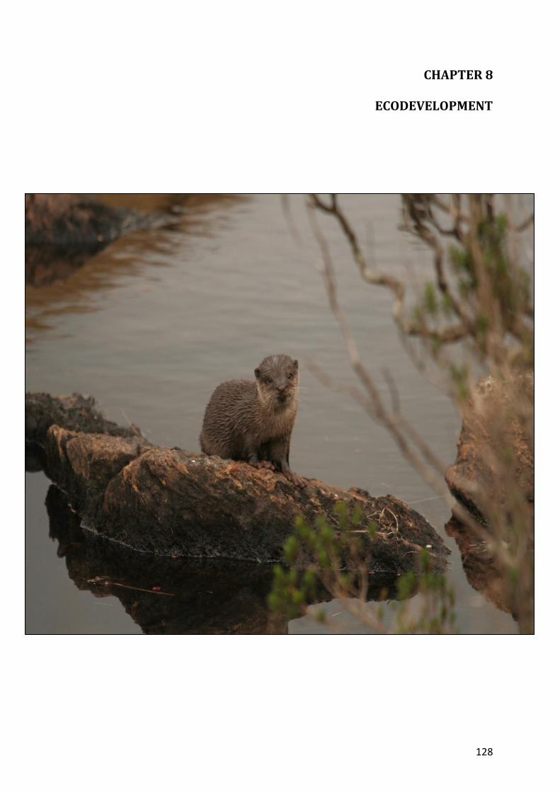
133
Enhance the cooperation with line departments in regulating animal
husbandry activities around the Park.
8.3.2. Firewood collection
Study extent and impact of firewood collection.
Encourage fuel wood cultivation of indigenous species in the tribal
settlements and areas outside the Park to meet the fuel requirement.
Providing energy saving devices, supply of gas connection on subsidized rate
by the department and explore the possibility of alternate fuel sources.
8.3.3. NWFP collection Study extent and impact of NWFP collection.
Define zone of collection through participatory process and frame access
rules for sustainable/ scientific collection
Provide training to EDC members on scientific/ sustainable collection of
NWFP resources and value addition
Monitor the resource dependency periodically.
Propose alternate livelihood to prevent unscientific/ unsustainable collection
of NWFP.
Encourage regeneration of NWFP and medicinal plant species placed in RED
Data Book
Promote planting of selected endemic NWFP species in the homesteads and
in the impact zone (ecodevelopment zone) in the surrounding area of tribal
settlements.
8.3.4. Strategies for alternate income to dependent community
Explore the potential of ecotourism programmes to improve the employment
generation for the local dependent communities.
Explore the possibility of enhancing opportunities in visitor management
activities to create more employment for the local dependents.
134
Explore the possibility of capacity building for the dependent people
especially tribals in production and marketing of consumable handicrafts etc
through the outlets in the Park.
135
CHAPTER 9
RESEARCH, MONITORING AND TRAINING
136
Although the Park was declared in the year 1978 not much study has been done
regarding various aspects of the Park and the Tahr population. The following research,
monitoring and training programmes are proposed during the plan period.
9.1. Research
a) Scientific study and documentation including the field status of RET species
in the Park including Roachestes replendens and dissemination of
information.
b) Conduct studies on population dynamics, movement pattern, natality,
mortality, habitat requirements and breeding biology of Nilgiri Tahr.
c) Non-invasive genetic diversity study of tahr population in Eravikulam
National Park and adjoining areas.
d) Participatory study to identify and demarcate zone of influence in the Park
like grazing, fire wood collection and NWFP collection.
e) Conduct study and evolve scientific / sustainable method for NWFP
collection.
f) Study the extent and impact of wildlife damage, crops involved and device
methods for prevention.
g) Study the socio economic and ecological impact of tourism over the entire
landscape with the Park as the focus.
h) Study the intrusion, regeneration and extent of exotics species around the
Park and device methods for its phased removal.
i) Study and survey the important areas in the adjoining Forest Divisions to be
added to the National Park as buffer zone.
j) Conduct study on the ecology and eco system dynamics of shola grass lands.
k) Conduct nutritional studies on food species of tahr in different season.
l) Study the impact of tea plantations and pesticides on the Park.
m) Identification and documentation of high altitude grass, herb and shrub
species.
137
n) Conduct study on the elusive cat “Pohayan”
o) Study the effect of fire on shola grass land eco system.
p) Study the effect of controlled burning by monitoring the burnt and unburnt
areas including soil health.
q) Study and document traditional knowledge of indigenous communities and
historic materials about the park.
r) Conduct study on wildlife and their habitat in Eravikulam National Park.
s) Study the shola ecology and plant animal interaction.
9.2. Monitoring
a) Develop protocol for monitoring health of animals, especially the tahr in the
tourism and awareness zone, and monitoring health of the animals as per
protocol.
b) Monitor resource dependency of local people once in 5 years.
c) Monitoring of weather parameters by installing weather stations at Rajamala,
Eravikulam and Poovar.
d) Monitor the vehicular movement through the tourism zone to assess the
impact on environment and tahr population in the area.
e) Monitoring of visitors to tourism zone.
f) Develop protocol for scientific monitoring of the effects of controlled burning
and document as per protocol.
g) Maintain journal of soil health in burned and unburned areas.
h) Conduct annual tahr census as per prescription and if possible by exploring
new methods.
i) Conduct animal, butterflies and bird census once in 5 years.
j) Promote conservation activities of NGOs like HRWEPA in the estates for
Monitoring wildlife.
138
9.3. Training a) Training for staff and EDC members on intelligence gathering, identifying
wildlife article, collection and handling of biological materials, identification
of flora and fauna, wildlife census techniques, animal health monitoring,
weapon handling, modern fire fighting methods, participatory forest
management, unarmed combat, acts and rules etc.
b) Provide training to EDC members on scientific/ sustainable collection of
NWFP and value addition
c) Training for staff and EDC members in rescue operations.
d) Maintain record of all training with relevant details.
e) Train EDC members on microplanning of PFM accounting and management.
9.4. Vaccination and health monitoring
Annual and periodic monitoring of animals through direct sightings and
checking droppings shall be carried out with the support of veterinary officers and
researchers and effective follow up steps will be persued on emergencies.
The Park is surrounded by tea estates in its southern boundary. There is one
tribal settlement inside the Park namely Lakkomkudy. A totals of 96 cattle are their
immediate boundary and inside the National Park. In addition there are a number of
cattle in the tea estates and also in Koodakkad Proposed Reserve adjoining the Park.
The monitoring if these cattle and periodic vaccination in association with the local
vetinary department, tea estate management and EDC / VSS will be done to detect and
prevent the spread of diseases from the cattle to wild life. The fringe cattle shall be
monitored and periodically vaccinated for contagious diseases.
9.5. Weather and vegetation monitoring
Study (Ravindranath N.H et al., 2006) predicts that the forest eco system will be
badly affected by the process of global warming in the years to come. Hence it is highly
necessary that the weather data in Eravikulam National Park is collected and analysed
to know the changes in climatic factors and correlate with the vegetation changes. The
following activities are proposed in this regard:

139
• Installation of additional automated meteorological stations for regular
recording of weather data at Rajamala, Eravikulam and Poovar.
• Establishment of permanent plots and long-term monitoring of the vegetation
changes in the sholas and grasslands.
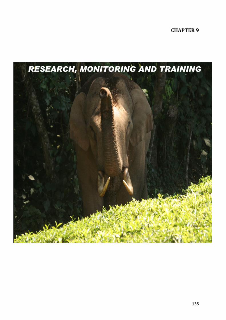
140
CHAPTER 10
ORGANISATION AND ADMINISTRATION
141
10.1. Structure
The organizational structure of the Park is as shown below:
10.2. Responsibilities
10.2.1. The Eravikulam National Park will be headed by the Wildlife Warden who will
have overall responsibility for the implementation of the Management Plan. The
Wildlife Warden will develop a pocket field guide with schedule of operations for
the implementation of management plan and supply it to Assistant Wildlife
Warden, Deputy Ranger and staff.
10.2.2. The Wildlife Warden will make arrangements to supply the following control
forms (Annexure 11) to the Assistant Wildlife Warden, Deputy Ranger and
Foresters and compile the information about the Park.
10.2.3. The Wildlife Warden, Munnar shall prepare Annual Plan of Operations and
Schedule of Operations every year in the first quarter of each year for the
subsequent financial year.
Field Director
WildlifeWarden Munnar
Assistant Wildlife Warden, Eravikulam National Park.
Deputy Ranger, Chattamunnar Forest Station
Forester,Forest Guards and Forest Watchers Rajamala out post.
Forester, Forest Guards and Forest Watchers ChattamunnarForest Station.
142
10.2.4. The Wildlife Warden shall not deviate from the Management Plan prescriptions
without the prior permission in writing of the Chief Wildlife Warden.
10.2.5. The Wildlife Warden shall also take action for reviewing the Management Plan
after five years

143
CHAPTER 11
THE BUDGET