Precise Point Positioning with the BeiDou Navigation Satellite System
17
Sensors 2014, 14, 927-943; doi:10.3390/s140100927 sensors ISSN 1424-8220 www.mdpi.com/journal/sensors Article Precise Point Positioning with the BeiDou Navigation Satellite System Min Li, Lizhong Qu *, Qile Zhao, Jing Guo, Xing Su and Xiaotao Li GNSS Research Center, Wuhan University, No.129 Luoyu Road, Wuhan 430079, China; E-Mails: [email protected] (M.L.); [email protected] (Q.Z.); [email protected] (J.G.); [email protected] (X.S.); [email protected] (X.L.) * Author to whom correspondence should be addressed; E-Mail: [email protected]; Tel.: +86-150-714-110-60; Fax: +86-276-877-8971. Received: 28 November 2013; in revised form: 23 December 2013 / Accepted: 31 December 2013 / Published: 8 January 2014 Abstract: By the end of 2012, China had launched 16 BeiDou-2 navigation satellites that include six GEOs, five IGSOs and five MEOs. This has provided initial navigation and precise pointing services ability in the Asia-Pacific regions. In order to assess the navigation and positioning performance of the BeiDou-2 system, Wuhan University has built up a network of BeiDou Experimental Tracking Stations (BETS) around the World. The Position and Navigation Data Analyst (PANDA) software was modified to determine the orbits of BeiDou satellites and provide precise orbit and satellite clock bias products from the BeiDou satellite system for user applications. This article uses the BeiDou/GPS observations of the BeiDou Experimental Tracking Stations to realize the BeiDou and BeiDou/GPS static and kinematic precise point positioning (PPP). The result indicates that the precision of BeiDou static and kinematic PPP reaches centimeter level. The precision of BeiDou/GPS kinematic PPP solutions is improved significantly compared to that of BeiDou-only or GPS-only kinematic PPP solutions. The PPP convergence time also decreases with the use of combined BeiDou/GPS systems. Keywords: BeiDou navigation satellite system; Position and Navigation Data Analyst (PANDA); BeiDou Experimental Tracking Stations (BETS); Precise Point Positioning (PPP) OPEN ACCESS
Transcript of Precise Point Positioning with the BeiDou Navigation Satellite System
Sensors 2014, 14, 927-943; doi:10.3390/s140100927
sensors ISSN 1424-8220
www.mdpi.com/journal/sensors
Article
Precise Point Positioning with the BeiDou Navigation Satellite System
Min Li, Lizhong Qu *, Qile Zhao, Jing Guo, Xing Su and Xiaotao Li
GNSS Research Center, Wuhan University, No.129 Luoyu Road, Wuhan 430079, China;
E-Mails: [email protected] (M.L.); [email protected] (Q.Z.); [email protected] (J.G.);
[email protected] (X.S.); [email protected] (X.L.)
* Author to whom correspondence should be addressed; E-Mail: [email protected];
Tel.: +86-150-714-110-60; Fax: +86-276-877-8971.
Received: 28 November 2013; in revised form: 23 December 2013 / Accepted: 31 December 2013 /
Published: 8 January 2014
Abstract: By the end of 2012, China had launched 16 BeiDou-2 navigation satellites that
include six GEOs, five IGSOs and five MEOs. This has provided initial navigation and
precise pointing services ability in the Asia-Pacific regions. In order to assess the
navigation and positioning performance of the BeiDou-2 system, Wuhan University has
built up a network of BeiDou Experimental Tracking Stations (BETS) around the World.
The Position and Navigation Data Analyst (PANDA) software was modified to determine
the orbits of BeiDou satellites and provide precise orbit and satellite clock bias products
from the BeiDou satellite system for user applications. This article uses the BeiDou/GPS
observations of the BeiDou Experimental Tracking Stations to realize the BeiDou and
BeiDou/GPS static and kinematic precise point positioning (PPP). The result indicates that
the precision of BeiDou static and kinematic PPP reaches centimeter level. The precision
of BeiDou/GPS kinematic PPP solutions is improved significantly compared to that of
BeiDou-only or GPS-only kinematic PPP solutions. The PPP convergence time also
decreases with the use of combined BeiDou/GPS systems.
Keywords: BeiDou navigation satellite system; Position and Navigation Data Analyst
(PANDA); BeiDou Experimental Tracking Stations (BETS); Precise Point Positioning (PPP)
OPEN ACCESS
Sensors 2014, 14 928
1. Introduction
As a global navigation satellite system (GNSS) compatible with other worldwide navigation
satellite systems, the BeiDou System (BDS) was independently established and operated by China.
High accuracy and high reliability positioning, navigation and timing (PNT) services are expected to
be provided to all kinds of users in any time, all-weather and anywhere in the World by 2020. Until the
end of 2012, the constellation of BeiDou regional navigation satellite system consists of
16 satellites including six GEOs, five IGSOs and five MEOs with 14 satellites including five GEOs,
five IGSOs and four MEOs operating well. The test version of Interface Control Document (ICD) for
the signal-in-space of the BeiDou system was announced on December 27, 2011. This indicated that
the BeiDou system started to provide Initial Operational Service. The formal version of ICD was
announced and the Full Operational Service was provided for China and its surrounding areas on
December 27, 2012. This indicated that the regional navigation satellite system had been set up.
Domestic and foreign enterprises are being encouraged to participate in the research and development
of BeiDou system application terminals (see http://www.BeiDou.gov.cn).
Since M01, the first satellite of BeiDou-2 system, was successfully launched, there have been
various research projects studying the signal structure, the precise orbit determination of BeiDou
satellites and the precise positioning performances. The signals of M01 have been tracked and the
structure of the pseudo-random noise (PRN) code in the E2 (B1), E5b (B2), and E6 (B3) frequency
bands has been analyzed [1,2]. The signal power of BeiDou M01 satellite has been found larger than
that of GPS satellites and the GIOVE-B satellite of Galileo. Based on the “BETS” and the PANDA
software, the precise orbit determination of the BeiDou satellites and PPP by using the precise orbit
and satellite clock bias products have been investigated. The RMS values of the overlap differences in
the radial component reached 10 cm and the daily static PPP BeiDou solutions showed an accuracy of
2 cm in horizontal components and 7 cm in the vertical component [3]. Satellite Laser Ranging (SLR)
tracking data have been used to determine the orbit of BeiDou M01 with 7 days arc length. The RMS
values of the 3-D overlap error varied from 11 to 50 cm in the selected periods [4]. The performances
of the static and kinematic precise relative positioning have been also analyzed. The precision of static
precise relative positioning solutions reached millimeter level and the kinematic solutions reached
centimeter level [5]. It should be mentioned that the positioning results above were acquired when
there were just six BeiDou satellites. With the increasing number of satellites, more research is being
conducted on the BeiDou system. As a result of the fewer tracking stations and the lower precision of
BeiDou orbit and clock biases product, the biases in the horizontal and vertical components of static
PPP reached 12 cm [6]. The German Research Center for Geosciences (GFZ)’s EPOS-RT software
package obtained similar results to those of the PANDA software [7]. A BeiDou PPP based on the
products from a small network of six stations also provided an accuracy of several centimeters
compared to the GPS-only results [8]. To improve the satellite orbits of the BeiDou regional system,
the impact of the tracking geometry, the involvement of MEOs and the effect of integer ambiguity
resolution were analyzed as well [9]. Meanwhile, the capacity of the BeiDou system for tropospheric
remote sensing was also assessed. The experiment showed that the derived Zenith Tropospheric Delay
(ZTD) was close to GPS ZTD estimated using different software packages [10].
Sensors 2014, 14 929
The improvement of performance of a single Global Navigation Satellite System (GNSS) mainly
depends on increasing the number of navigation satellites, optimizing the spatial geometric
configuration and improving of the accuracy of the system’s spatial signals, including the
improvement of the accuracy of the precise orbit and satellite clock biases, whereas, the fusion of
multiple GNSSs can significantly increase the number of observed satellites, optimize the spatial
geometry and improve continuity and reliability of positioning [11]. However, in the past the data
processing of multi-GNSS focused on the fusion of GPS and GLONASS [11–14]. By processing the
simulated data, the contribution of the BeiDou navigation satellite system to global PNT users has
been analyzed in [15], which demonstrated that the introduction of the BeiDou system could benefit
significantly the satellite visibility and the dilution of precision for global users. Research on the
BeiDou positioning and combined BeiDou/GPS positioning will obviously benefit the application and
popularization of the BeiDou system. With the orbit and satellite clock biases derived based on a small
network of six stations distributed in Asia-Pacific area, a centimeter level PPP was realized by
combined BeiDou and GPS data [16]. The impact of “inter-satellite-type-bias” (ISTB) was also
analyzed when multiple GNSS receivers were used to determine the carrier’s attitude [17]. In this
contribution, we also adapted the PANDA software developed by Wuhan University to process the
BeiDou/GPS observations of “BETS” in the modes of BeiDou static and kinematic PPP, GPS static
and kinematic PPP and BeiDou/GPS static and kinematic PPP.
2. Quality Analysis of BeiDou Measurements
In order to obtain the precise orbits and satellite clock biases of BeiDou satellites to assess the
performance of precise positioning, since 2011 Wuhan University has established a continuous
worldwide observation reference network, called the BeiDou Experimental Tracking Stations (BETS),
which includes nine tracking stations in China and six tracking stations abroad. All the stations are
equipped with UB240-CORS receivers produced by the Beijing Unicore Communication Company,
which can acquire the pseudo-range and phase observations of dual frequencies and dual systems. The
Unicore UA240 dual-frequency dual-system high gain antenna is used in the network. The accuracy of
phase observations can reach millimeter level [6]. The GEO C02 and MEO C30 did not work and were
discarded [18]. The MEO C13 and C14 are not included as they were still under in-orbit testing. The
GEO C15 was also under in-orbit testing and is planned to replace C02. Hence, 11 BeiDou satellites
were employed for data processing in this contribution. They were four GEOs including C01, C03,
C04 and C05, five IGSOs including C06–C10 and two MEOs including C11 and C12. Figure 1 shows
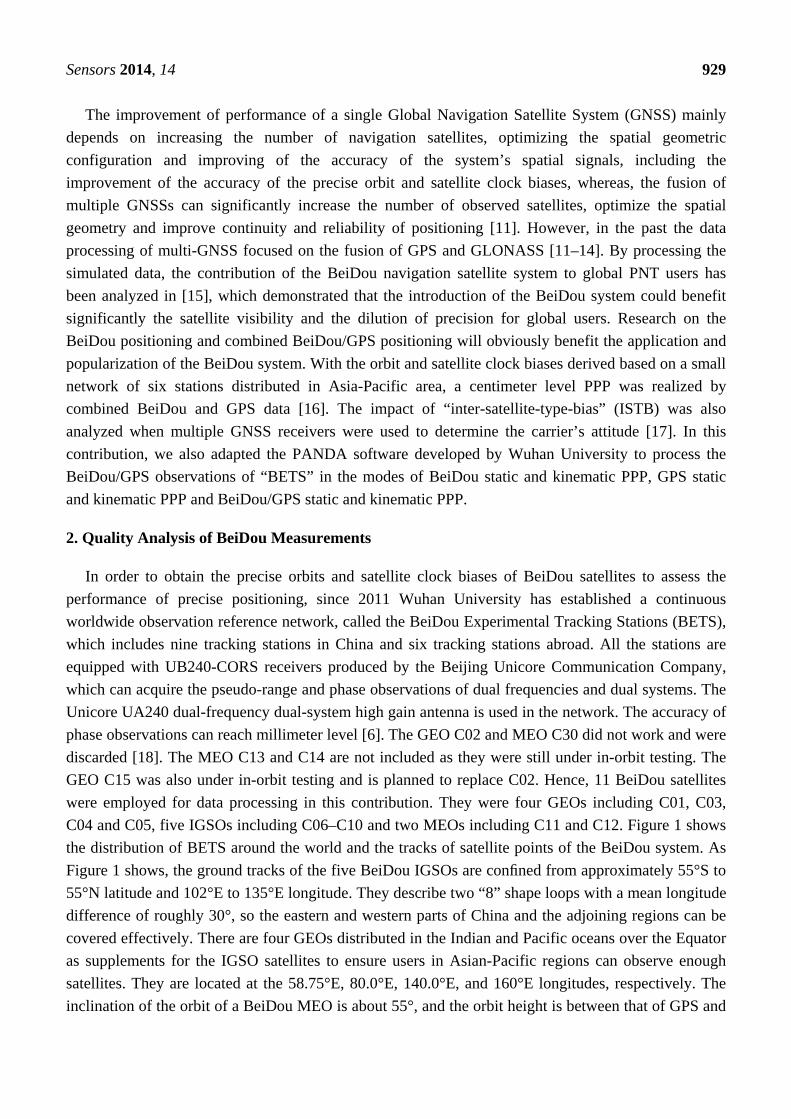
the distribution of BETS around the world and the tracks of satellite points of the BeiDou system. As
Figure 1 shows, the ground tracks of the five BeiDou IGSOs are confined from approximately 55°S to
55°N latitude and 102°E to 135°E longitude. They describe two “8” shape loops with a mean longitude
difference of roughly 30°, so the eastern and western parts of China and the adjoining regions can be
covered effectively. There are four GEOs distributed in the Indian and Pacific oceans over the Equator
as supplements for the IGSO satellites to ensure users in Asian-Pacific regions can observe enough
satellites. They are located at the 58.75°E, 80.0°E, 140.0°E, and 160°E longitudes, respectively. The
inclination of the orbit of a BeiDou MEO is about 55°, and the orbit height is between that of GPS and
Sensors 2014, 14 930
Galileo satellites [19]. The revolution period is about 773 minutes, leading to 1.86 revolutions per day.
The ground track of the satellite repeats every seven days [4].
Figure 1. The distribution of “BETS” and the tracks of the sub-satellite points of four
GEO, five IGSO and two MEO BeiDou Satellites.
2.1. Satellite Visibility
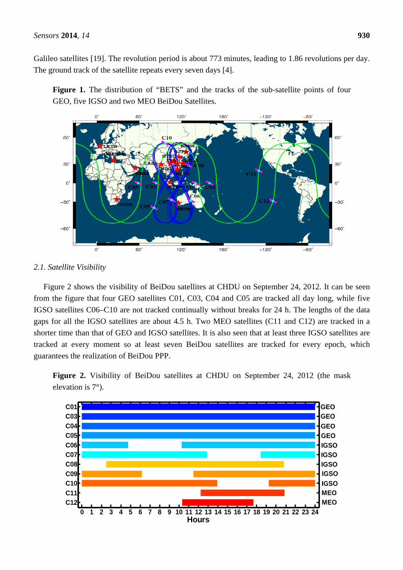
Figure 2 shows the visibility of BeiDou satellites at CHDU on September 24, 2012. It can be seen
from the figure that four GEO satellites C01, C03, C04 and C05 are tracked all day long, while five
IGSO satellites C06–C10 are not tracked continually without breaks for 24 h. The lengths of the data
gaps for all the IGSO satellites are about 4.5 h. Two MEO satellites (C11 and C12) are tracked in a
shorter time than that of GEO and IGSO satellites. It is also seen that at least three IGSO satellites are
tracked at every moment so at least seven BeiDou satellites are tracked for every epoch, which
guarantees the realization of BeiDou PPP.
Figure 2. Visibility of BeiDou satellites at CHDU on September 24, 2012 (the mask
elevation is 7°).
0 1 2 3 4 5 6 7 8 9 10 11 12 13 14 15 16 17 18 19 20 21 22 23 24C12C11
C10C09
C08
C07C06
C05
C04
C03C01
Hours
IGSOIGSO
IGSO
IGSOMEOMEO
IGSO
GEOGEO
GEO
GEO
Sensors 2014, 14 931
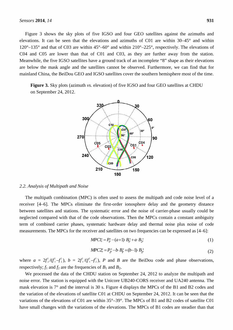
Figure 3 shows the sky plots of five IGSO and four GEO satellites against the azimuths and
elevations. It can be seen that the elevations and azimuths of C01 are within 30–45° and within
120°–135° and that of C03 are within 45°–60° and within 210°–225°, respectively. The elevations of
C04 and C05 are lower than that of C01 and C03, as they are further away from the station.
Meanwhile, the five IGSO satellites have a ground track of an incomplete “8” shape as their elevations
are below the mask angle and the satellites cannot be observed. Furthermore, we can find that for
mainland China, the BeiDou GEO and IGSO satellites cover the southern hemisphere most of the time.
Figure 3. Sky plots (azimuth vs. elevation) of five IGSO and four GEO satellites at CHDU
on September 24, 2012.
2.2. Analysis of Multipath and Noise
The multipath combination (MPC) is often used to assess the multipath and code noise level of a
receiver [4–6]. The MPCs eliminate the first-order ionosphere delay and the geometry distance
between satellites and stations. The systematic error and the noise of carrier-phase usually could be
neglected compared with that of the code observations. Then the MPCs contain a constant ambiguity
term of combined carrier phases, systematic hardware delay and thermal noise plus noise of code
measurements. The MPCs for the receiver and satellites on two frequencies can be expressed as [4–6]:
1 1 21 ( 1)s s s sr r r rMPC P a B a B (1)
2 1 22 ( 1)s s s sr r r rMPC P b B b B (2)
where a = 2f 2 2 /(f 2
1 –f 2 2 ), b = 2f 2
1 /(f 2 1 –f 2
2 ), P and B are the BeiDou code and phase observations,
respectively; f1 and f2 are the frequencies of B1 and B2.
We processed the data of the CHDU station on September 24, 2012 to analyze the multipath and
noise error. The station is equipped with the Unicore UB240-CORS receiver and UA240 antenna. The
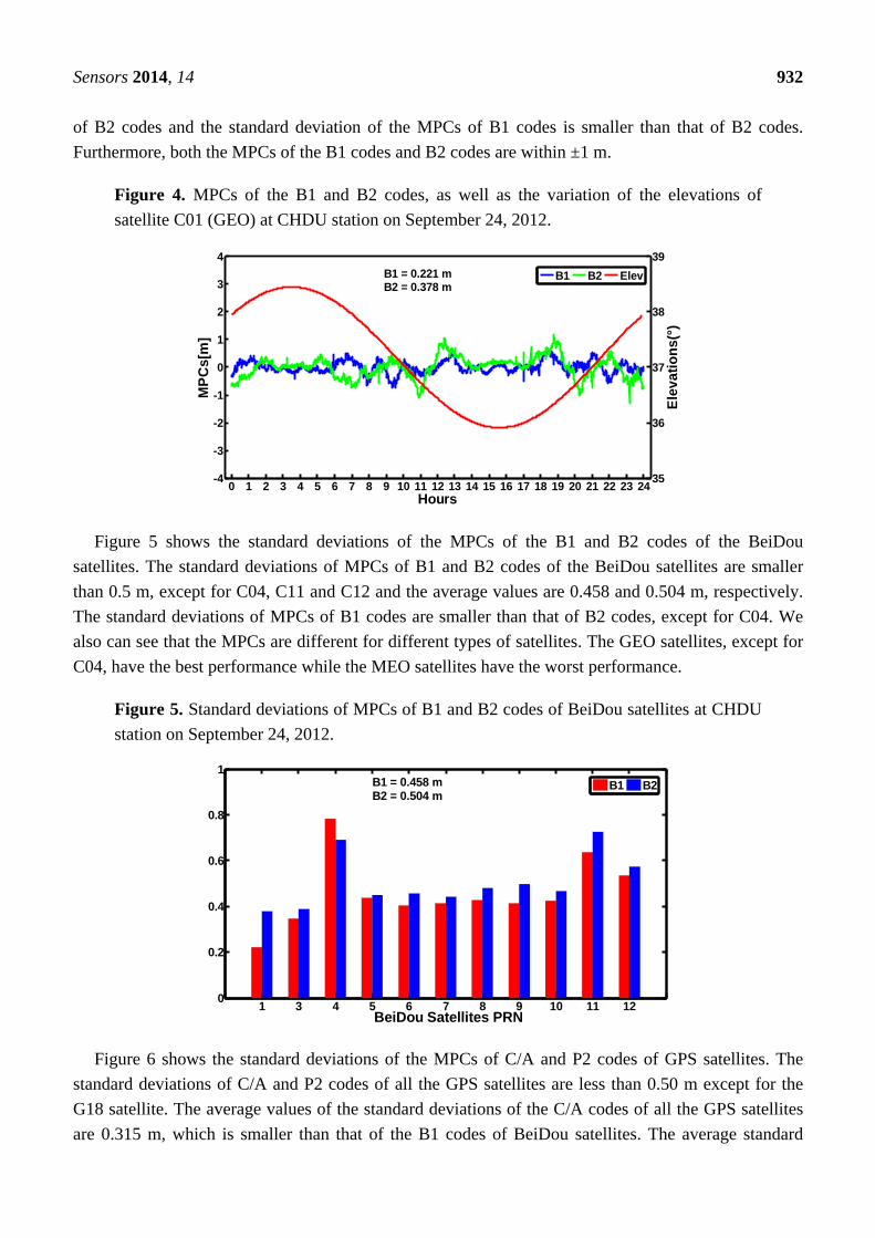
mask elevation is 7° and the interval is 30 s. Figure 4 displays the MPCs of the B1 and B2 codes and
the variation of the elevations of satellite C01 at CHDU on September 24, 2012. It can be seen that the
variations of the elevations of C01 are within 35°–39°. The MPCs of B1 and B2 codes of satellite C01
have small changes with the variations of the elevations. The MPCs of B1 codes are steadier than that
Sensors 2014, 14 932
of B2 codes and the standard deviation of the MPCs of B1 codes is smaller than that of B2 codes.
Furthermore, both the MPCs of the B1 codes and B2 codes are within ±1 m.
Figure 4. MPCs of the B1 and B2 codes, as well as the variation of the elevations of
satellite C01 (GEO) at CHDU station on September 24, 2012.
0 1 2 3 4 5 6 7 8 9 10 11 12 13 14 15 16 17 18 19 20 21 22 23 24-4
-3
-2
-1
0
1
2
3
4
MP
Cs[
m]
Hours
35
36
37
38
39
Ele
vati
on
s(°)
B1 B2 ElevB1 = 0.221 m B2 = 0.378 m
Figure 5 shows the standard deviations of the MPCs of the B1 and B2 codes of the BeiDou
satellites. The standard deviations of MPCs of B1 and B2 codes of the BeiDou satellites are smaller
than 0.5 m, except for C04, C11 and C12 and the average values are 0.458 and 0.504 m, respectively.
The standard deviations of MPCs of B1 codes are smaller than that of B2 codes, except for C04. We
also can see that the MPCs are different for different types of satellites. The GEO satellites, except for
C04, have the best performance while the MEO satellites have the worst performance.
Figure 5. Standard deviations of MPCs of B1 and B2 codes of BeiDou satellites at CHDU
station on September 24, 2012.
1 3 4 5 6 7 8 9 10 11 120
0.2
0.4
0.6
0.8
1
BeiDou Satellites PRN
B1 B2B1 = 0.458 mB2 = 0.504 m
Figure 6 shows the standard deviations of the MPCs of C/A and P2 codes of GPS satellites. The
standard deviations of C/A and P2 codes of all the GPS satellites are less than 0.50 m except for the
G18 satellite. The average values of the standard deviations of the C/A codes of all the GPS satellites
are 0.315 m, which is smaller than that of the B1 codes of BeiDou satellites. The average standard
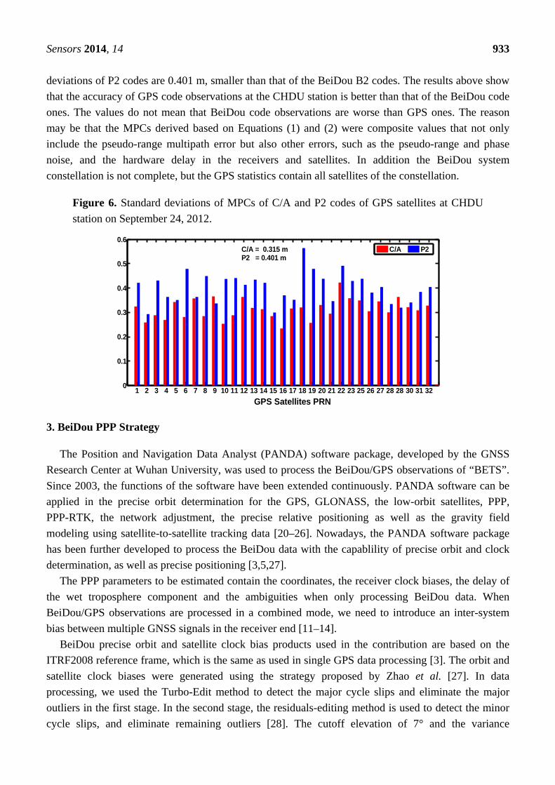
Sensors 2014, 14 933
deviations of P2 codes are 0.401 m, smaller than that of the BeiDou B2 codes. The results above show
that the accuracy of GPS code observations at the CHDU station is better than that of the BeiDou code
ones. The values do not mean that BeiDou code observations are worse than GPS ones. The reason
may be that the MPCs derived based on Equations (1) and (2) were composite values that not only
include the pseudo-range multipath error but also other errors, such as the pseudo-range and phase
noise, and the hardware delay in the receivers and satellites. In addition the BeiDou system
constellation is not complete, but the GPS statistics contain all satellites of the constellation.
Figure 6. Standard deviations of MPCs of C/A and P2 codes of GPS satellites at CHDU
station on September 24, 2012.
1 2 3 4 5 6 7 8 9 10 11 12 13 14 15 16 17 18 19 20 21 22 23 25 26 27 28 28 30 31 320
0.1
0.2
0.3
0.4
0.5
0.6
GPS Satellites PRN
C/A P2C/A = 0.315 mP2 = 0.401 m
3. BeiDou PPP Strategy
The Position and Navigation Data Analyst (PANDA) software package, developed by the GNSS
Research Center at Wuhan University, was used to process the BeiDou/GPS observations of “BETS”.
Since 2003, the functions of the software have been extended continuously. PANDA software can be
applied in the precise orbit determination for the GPS, GLONASS, the low-orbit satellites, PPP,
PPP-RTK, the network adjustment, the precise relative positioning as well as the gravity field
modeling using satellite-to-satellite tracking data [20–26]. Nowadays, the PANDA software package
has been further developed to process the BeiDou data with the capablility of precise orbit and clock
determination, as well as precise positioning [3,5,27].
The PPP parameters to be estimated contain the coordinates, the receiver clock biases, the delay of
the wet troposphere component and the ambiguities when only processing BeiDou data. When
BeiDou/GPS observations are processed in a combined mode, we need to introduce an inter-system
bias between multiple GNSS signals in the receiver end [11–14].
BeiDou precise orbit and satellite clock bias products used in the contribution are based on the
ITRF2008 reference frame, which is the same as used in single GPS data processing [3]. The orbit and
satellite clock biases were generated using the strategy proposed by Zhao et al. [27]. In data
processing, we used the Turbo-Edit method to detect the major cycle slips and eliminate the major
outliers in the first stage. In the second stage, the residuals-editing method is used to detect the minor
cycle slips, and eliminate remaining outliers [28]. The cutoff elevation of 7° and the variance
Sensors 2014, 14 934
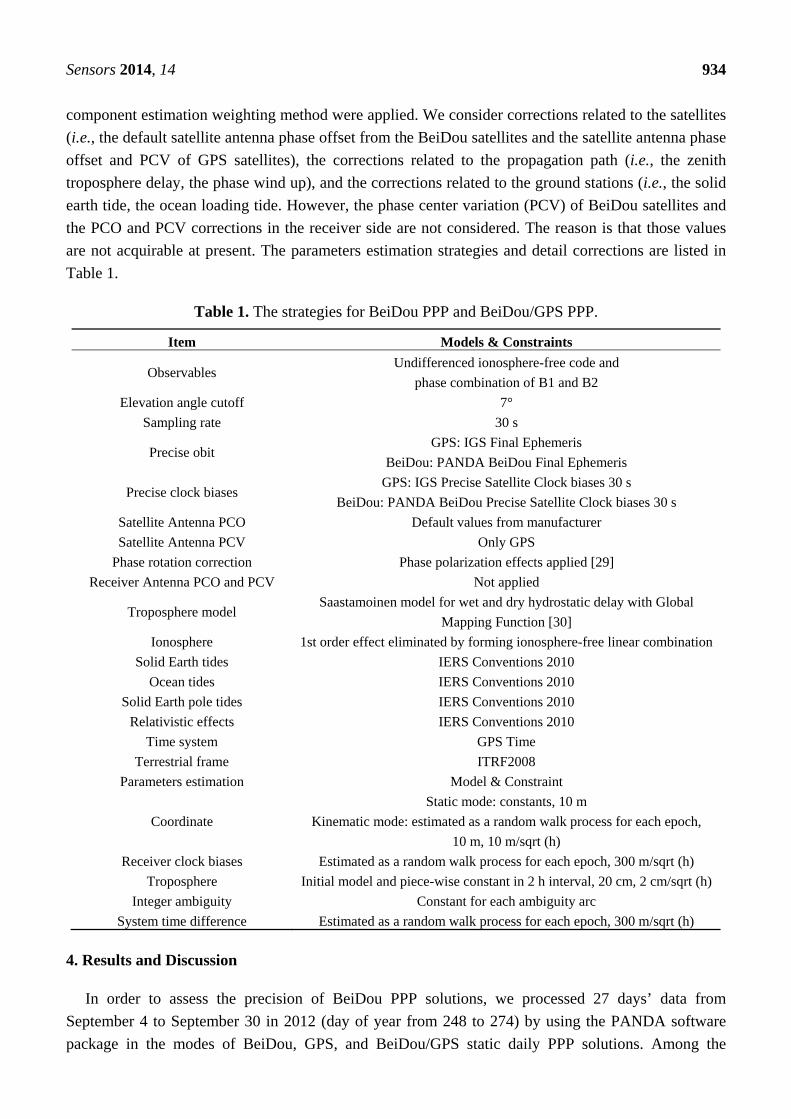
component estimation weighting method were applied. We consider corrections related to the satellites
(i.e., the default satellite antenna phase offset from the BeiDou satellites and the satellite antenna phase
offset and PCV of GPS satellites), the corrections related to the propagation path (i.e., the zenith
troposphere delay, the phase wind up), and the corrections related to the ground stations (i.e., the solid
earth tide, the ocean loading tide. However, the phase center variation (PCV) of BeiDou satellites and
the PCO and PCV corrections in the receiver side are not considered. The reason is that those values
are not acquirable at present. The parameters estimation strategies and detail corrections are listed in
Table 1.
Table 1. The strategies for BeiDou PPP and BeiDou/GPS PPP.
Item Models & Constraints
Observables Undifferenced ionosphere-free code and
phase combination of B1 and B2
Elevation angle cutoff 7°
Sampling rate 30 s
Precise obit GPS: IGS Final Ephemeris
BeiDou: PANDA BeiDou Final Ephemeris
Precise clock biases GPS: IGS Precise Satellite Clock biases 30 s
BeiDou: PANDA BeiDou Precise Satellite Clock biases 30 s
Satellite Antenna PCO Default values from manufacturer
Satellite Antenna PCV Only GPS
Phase rotation correction Phase polarization effects applied [29]
Receiver Antenna PCO and PCV Not applied
Troposphere model Saastamoinen model for wet and dry hydrostatic delay with Global
Mapping Function [30]
Ionosphere 1st order effect eliminated by forming ionosphere-free linear combination
Solid Earth tides IERS Conventions 2010
Ocean tides IERS Conventions 2010
Solid Earth pole tides IERS Conventions 2010
Relativistic effects
Time system
IERS Conventions 2010
GPS Time
Terrestrial frame ITRF2008
Parameters estimation Model & Constraint
Coordinate
Static mode: constants, 10 m
Kinematic mode: estimated as a random walk process for each epoch,
10 m, 10 m/sqrt (h)
Receiver clock biases Estimated as a random walk process for each epoch, 300 m/sqrt (h)
Troposphere Initial model and piece-wise constant in 2 h interval, 20 cm, 2 cm/sqrt (h)
Integer ambiguity Constant for each ambiguity arc
System time difference Estimated as a random walk process for each epoch, 300 m/sqrt (h)
4. Results and Discussion
In order to assess the precision of BeiDou PPP solutions, we processed 27 days’ data from
September 4 to September 30 in 2012 (day of year from 248 to 274) by using the PANDA software
package in the modes of BeiDou, GPS, and BeiDou/GPS static daily PPP solutions. Among the
Sensors 2014, 14 935
stations used below in Table 2, CHDU was not used for orbit and clock determination, so the solutions
are independent.
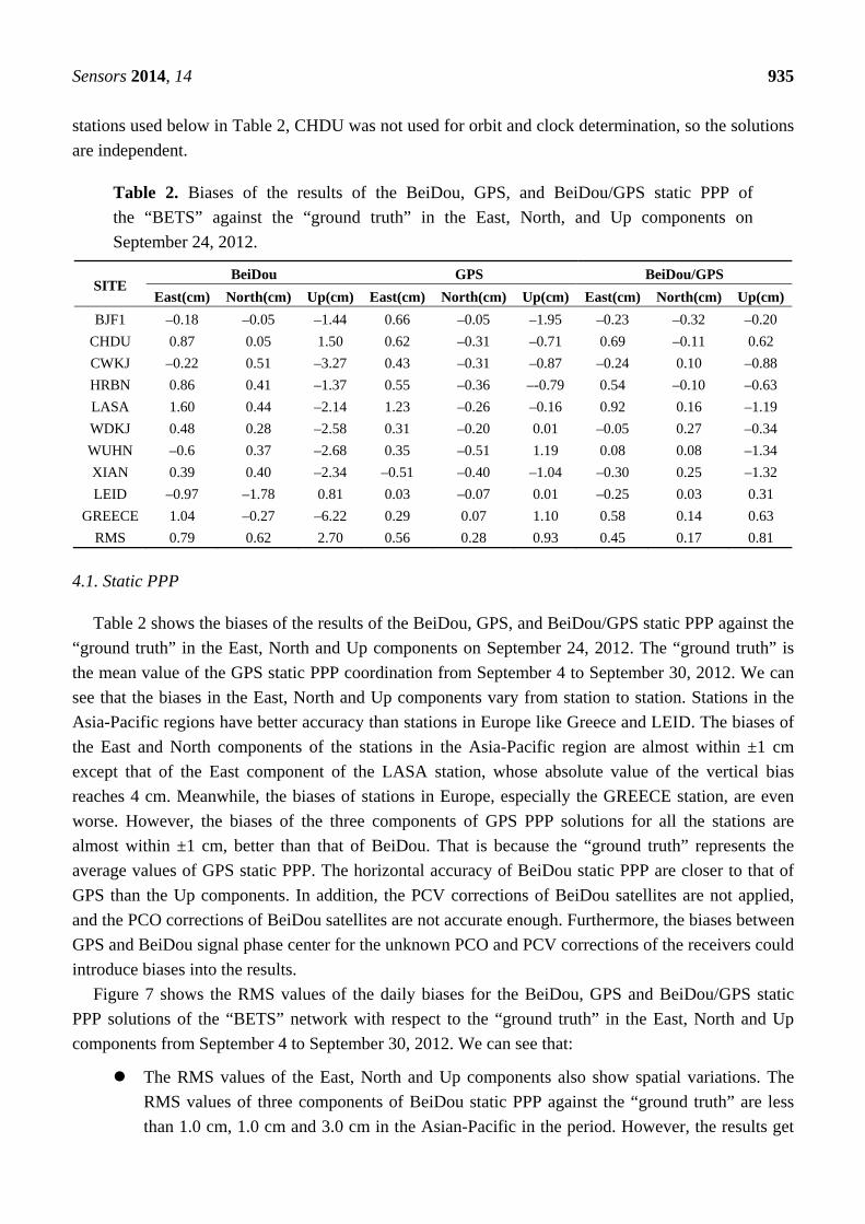
Table 2. Biases of the results of the BeiDou, GPS, and BeiDou/GPS static PPP of
the “BETS” against the “ground truth” in the East, North, and Up components on
September 24, 2012.
SITE BeiDou GPS BeiDou/GPS
East(cm) North(cm) Up(cm) East(cm) North(cm) Up(cm) East(cm) North(cm) Up(cm)
BJF1 –0.18 –0.05 –1.44 0.66 –0.05 –1.95 –0.23 –0.32 –0.20
CHDU 0.87 0.05 1.50 0.62 –0.31 –0.71 0.69 –0.11 0.62
CWKJ –0.22 0.51 –3.27 0.43 –0.31 –0.87 –0.24 0.10 –0.88
HRBN 0.86 0.41 –1.37 0.55 –0.36 –-0.79 0.54 –0.10 –0.63
LASA 1.60 0.44 –2.14 1.23 –0.26 –0.16 0.92 0.16 –1.19
WDKJ 0.48 0.28 –2.58 0.31 –0.20 0.01 –0.05 0.27 –0.34
WUHN –0.6 0.37 –2.68 0.35 –0.51 1.19 0.08 0.08 –1.34
XIAN 0.39 0.40 –2.34 –0.51 –0.40 –1.04 –0.30 0.25 –1.32
LEID –0.97 –1.78 0.81 0.03 –0.07 0.01 –0.25 0.03 0.31
GREECE 1.04 –0.27 –6.22 0.29 0.07 1.10 0.58 0.14 0.63
RMS 0.79 0.62 2.70 0.56 0.28 0.93 0.45 0.17 0.81
4.1. Static PPP
Table 2 shows the biases of the results of the BeiDou, GPS, and BeiDou/GPS static PPP against the
“ground truth” in the East, North and Up components on September 24, 2012. The “ground truth” is
the mean value of the GPS static PPP coordination from September 4 to September 30, 2012. We can
see that the biases in the East, North and Up components vary from station to station. Stations in the
Asia-Pacific regions have better accuracy than stations in Europe like Greece and LEID. The biases of
the East and North components of the stations in the Asia-Pacific region are almost within ±1 cm
except that of the East component of the LASA station, whose absolute value of the vertical bias
reaches 4 cm. Meanwhile, the biases of stations in Europe, especially the GREECE station, are even
worse. However, the biases of the three components of GPS PPP solutions for all the stations are
almost within ±1 cm, better than that of BeiDou. That is because the “ground truth” represents the
average values of GPS static PPP. The horizontal accuracy of BeiDou static PPP are closer to that of
GPS than the Up components. In addition, the PCV corrections of BeiDou satellites are not applied,
and the PCO corrections of BeiDou satellites are not accurate enough. Furthermore, the biases between
GPS and BeiDou signal phase center for the unknown PCO and PCV corrections of the receivers could
introduce biases into the results.
Figure 7 shows the RMS values of the daily biases for the BeiDou, GPS and BeiDou/GPS static
PPP solutions of the “BETS” network with respect to the “ground truth” in the East, North and Up
components from September 4 to September 30, 2012. We can see that:
The RMS values of the East, North and Up components also show spatial variations. The
RMS values of three components of BeiDou static PPP against the “ground truth” are less
than 1.0 cm, 1.0 cm and 3.0 cm in the Asian-Pacific in the period. However, the results get
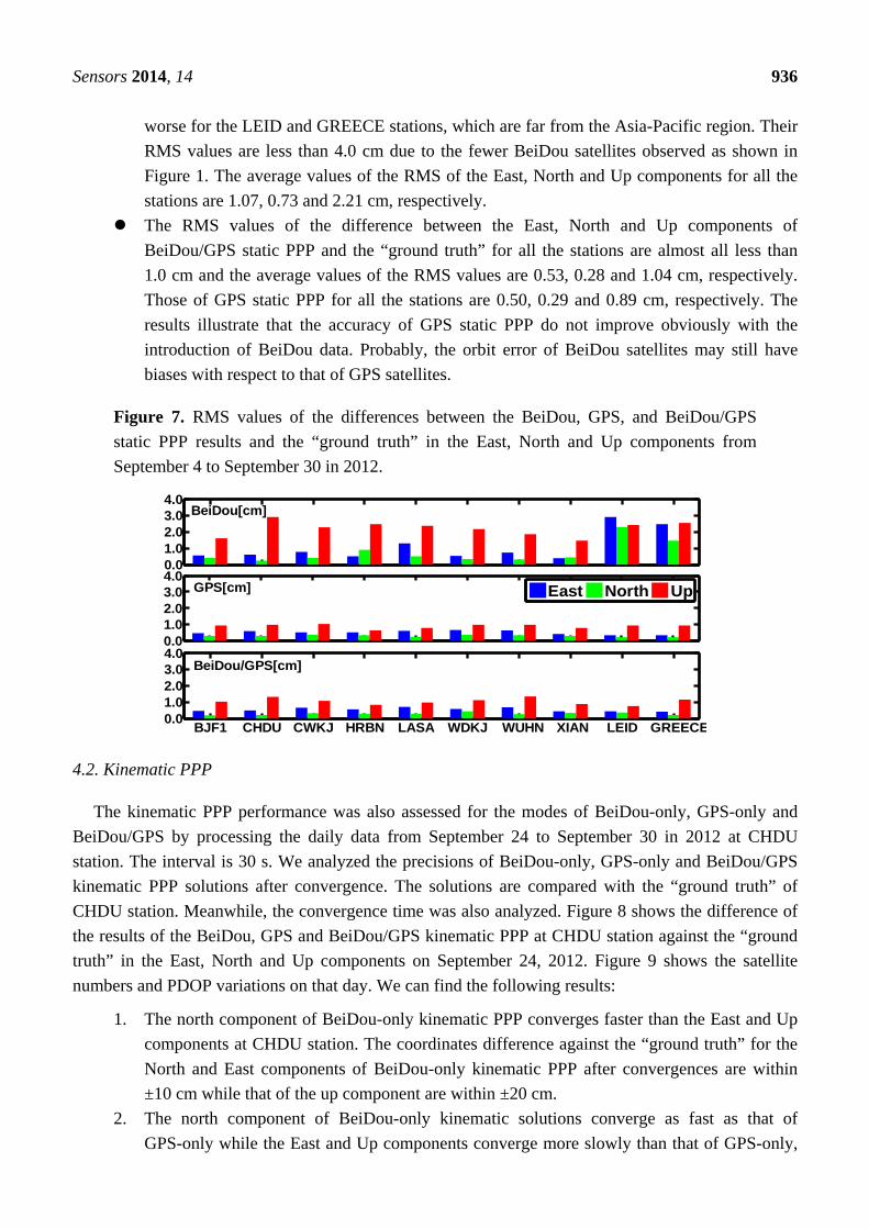
Sensors 2014, 14 936
worse for the LEID and GREECE stations, which are far from the Asia-Pacific region. Their
RMS values are less than 4.0 cm due to the fewer BeiDou satellites observed as shown in
Figure 1. The average values of the RMS of the East, North and Up components for all the
stations are 1.07, 0.73 and 2.21 cm, respectively.
The RMS values of the difference between the East, North and Up components of
BeiDou/GPS static PPP and the “ground truth” for all the stations are almost all less than
1.0 cm and the average values of the RMS values are 0.53, 0.28 and 1.04 cm, respectively.
Those of GPS static PPP for all the stations are 0.50, 0.29 and 0.89 cm, respectively. The
results illustrate that the accuracy of GPS static PPP do not improve obviously with the
introduction of BeiDou data. Probably, the orbit error of BeiDou satellites may still have
biases with respect to that of GPS satellites.
Figure 7. RMS values of the differences between the BeiDou, GPS, and BeiDou/GPS
static PPP results and the “ground truth” in the East, North and Up components from
September 4 to September 30 in 2012.
0.01.02.03.04.0
0.01.02.03.04.0
BJF1 CHDU CWKJ HRBN LASA WDKJ WUHN XIAN LEID GREECE0.01.02.03.04.0
East North Up
BeiDou/GPS[cm]
BeiDou[cm]
GPS[cm]
4.2. Kinematic PPP
The kinematic PPP performance was also assessed for the modes of BeiDou-only, GPS-only and
BeiDou/GPS by processing the daily data from September 24 to September 30 in 2012 at CHDU
station. The interval is 30 s. We analyzed the precisions of BeiDou-only, GPS-only and BeiDou/GPS
kinematic PPP solutions after convergence. The solutions are compared with the “ground truth” of
CHDU station. Meanwhile, the convergence time was also analyzed. Figure 8 shows the difference of
the results of the BeiDou, GPS and BeiDou/GPS kinematic PPP at CHDU station against the “ground
truth” in the East, North and Up components on September 24, 2012. Figure 9 shows the satellite
numbers and PDOP variations on that day. We can find the following results:
1. The north component of BeiDou-only kinematic PPP converges faster than the East and Up
components at CHDU station. The coordinates difference against the “ground truth” for the
North and East components of BeiDou-only kinematic PPP after convergences are within
±10 cm while that of the up component are within ±20 cm.
2. The north component of BeiDou-only kinematic solutions converge as fast as that of
GPS-only while the East and Up components converge more slowly than that of GPS-only,
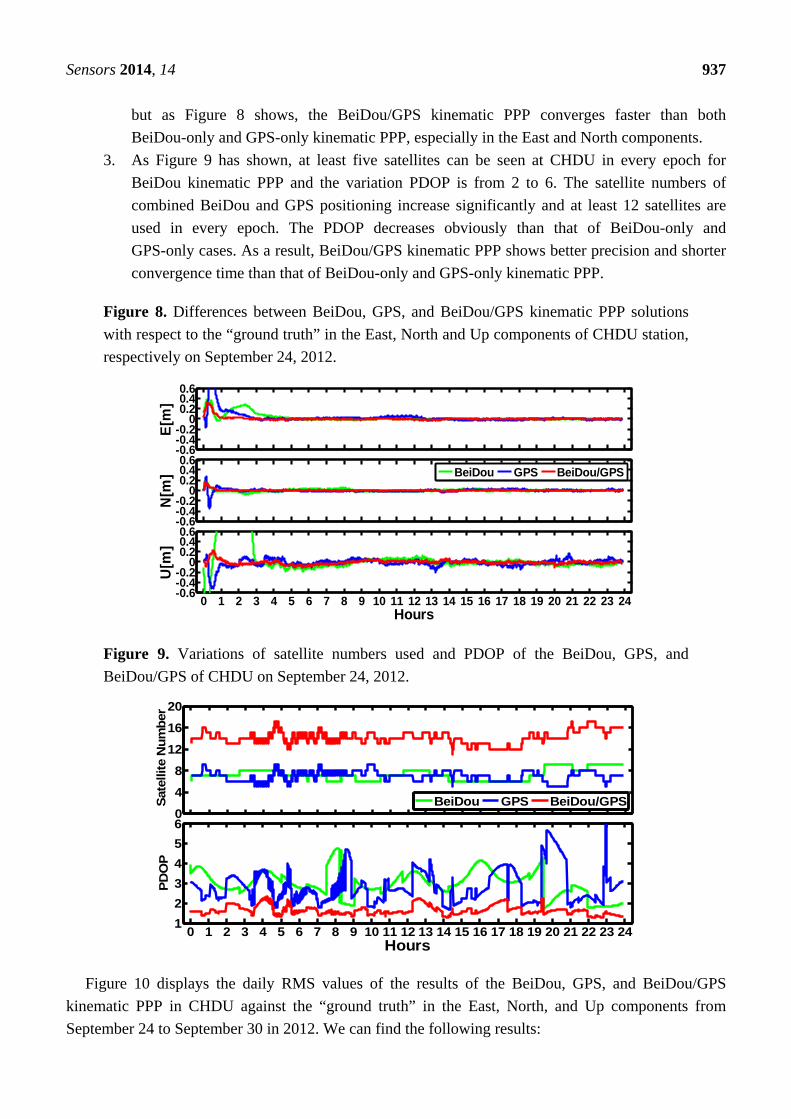
Sensors 2014, 14 937
but as Figure 8 shows, the BeiDou/GPS kinematic PPP converges faster than both
BeiDou-only and GPS-only kinematic PPP, especially in the East and North components.
3. As Figure 9 has shown, at least five satellites can be seen at CHDU in every epoch for
BeiDou kinematic PPP and the variation PDOP is from 2 to 6. The satellite numbers of
combined BeiDou and GPS positioning increase significantly and at least 12 satellites are
used in every epoch. The PDOP decreases obviously than that of BeiDou-only and
GPS-only cases. As a result, BeiDou/GPS kinematic PPP shows better precision and shorter
convergence time than that of BeiDou-only and GPS-only kinematic PPP.
Figure 8. Differences between BeiDou, GPS, and BeiDou/GPS kinematic PPP solutions
with respect to the “ground truth” in the East, North and Up components of CHDU station,
respectively on September 24, 2012.
-0.6-0.4-0.2
00.20.40.6
E[m
]
-0.6-0.4-0.2
00.20.40.6
N[m
]
0 1 2 3 4 5 6 7 8 9 10 11 12 13 14 15 16 17 18 19 20 21 22 23 24-0.6-0.4-0.2
00.20.40.6
U[m
]
Hours
BeiDou GPS BeiDou/GPS
Figure 9. Variations of satellite numbers used and PDOP of the BeiDou, GPS, and
BeiDou/GPS of CHDU on September 24, 2012.
0
4
8
12
16
20
Sat
ellit
e N
um
ber
0 1 2 3 4 5 6 7 8 9 10 11 12 13 14 15 16 17 18 19 20 21 22 23 241
2
3
4
5
6
PD
OP
Hours
BeiDou GPS BeiDou/GPS
Figure 10 displays the daily RMS values of the results of the BeiDou, GPS, and BeiDou/GPS
kinematic PPP in CHDU against the “ground truth” in the East, North, and Up components from
September 24 to September 30 in 2012. We can find the following results:
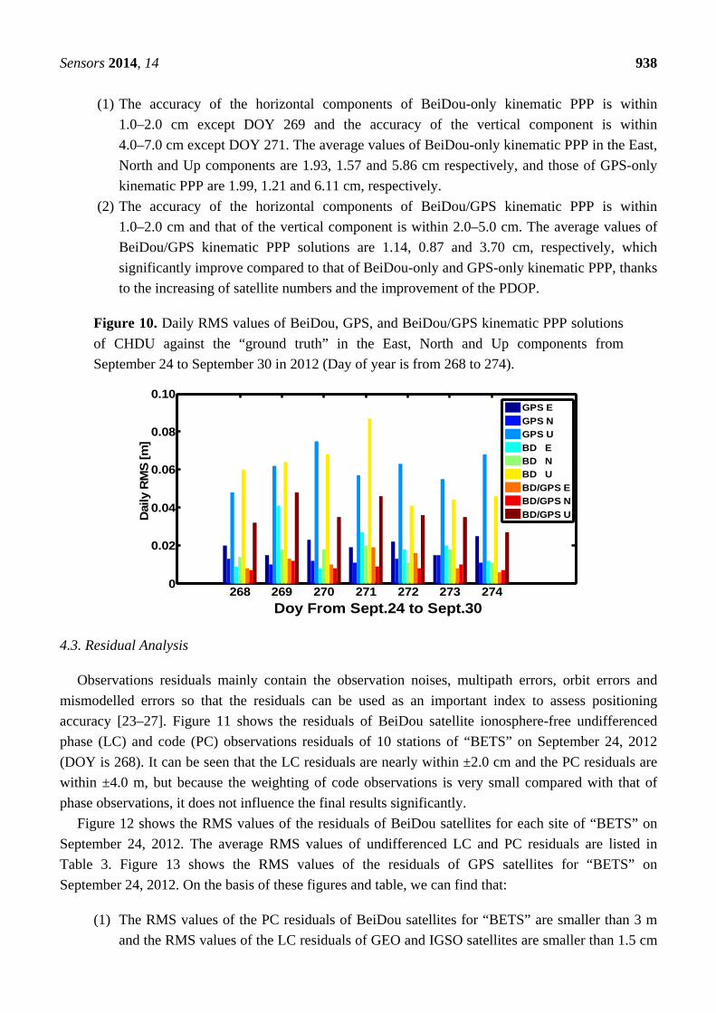
Sensors 2014, 14 938
(1) The accuracy of the horizontal components of BeiDou-only kinematic PPP is within
1.0–2.0 cm except DOY 269 and the accuracy of the vertical component is within
4.0–7.0 cm except DOY 271. The average values of BeiDou-only kinematic PPP in the East,
North and Up components are 1.93, 1.57 and 5.86 cm respectively, and those of GPS-only
kinematic PPP are 1.99, 1.21 and 6.11 cm, respectively.
(2) The accuracy of the horizontal components of BeiDou/GPS kinematic PPP is within
1.0–2.0 cm and that of the vertical component is within 2.0–5.0 cm. The average values of
BeiDou/GPS kinematic PPP solutions are 1.14, 0.87 and 3.70 cm, respectively, which
significantly improve compared to that of BeiDou-only and GPS-only kinematic PPP, thanks
to the increasing of satellite numbers and the improvement of the PDOP.
Figure 10. Daily RMS values of BeiDou, GPS, and BeiDou/GPS kinematic PPP solutions
of CHDU against the “ground truth” in the East, North and Up components from
September 24 to September 30 in 2012 (Day of year is from 268 to 274).
268 269 270 271 272 273 2740
0.02
0.04
0.06
0.08
0.10
Doy From Sept.24 to Sept.30
Dai
ly R
MS
[m
]
GPS E
GPS N
GPS U
BD E
BD N
BD U
BD/GPS E
BD/GPS N
BD/GPS U
4.3. Residual Analysis
Observations residuals mainly contain the observation noises, multipath errors, orbit errors and
mismodelled errors so that the residuals can be used as an important index to assess positioning
accuracy [23–27]. Figure 11 shows the residuals of BeiDou satellite ionosphere-free undifferenced
phase (LC) and code (PC) observations residuals of 10 stations of “BETS” on September 24, 2012
(DOY is 268). It can be seen that the LC residuals are nearly within ±2.0 cm and the PC residuals are
within ±4.0 m, but because the weighting of code observations is very small compared with that of
phase observations, it does not influence the final results significantly.
Figure 12 shows the RMS values of the residuals of BeiDou satellites for each site of “BETS” on
September 24, 2012. The average RMS values of undifferenced LC and PC residuals are listed in
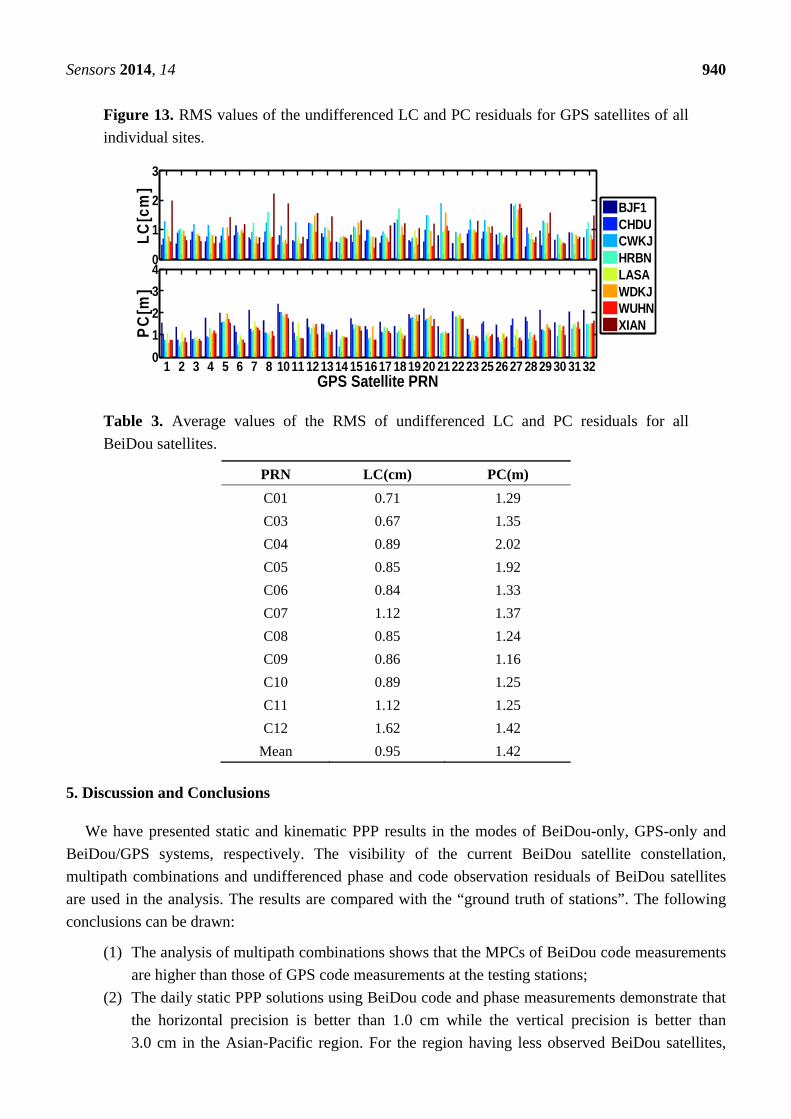
Table 3. Figure 13 shows the RMS values of the residuals of GPS satellites for “BETS” on
September 24, 2012. On the basis of these figures and table, we can find that:
(1) The RMS values of the PC residuals of BeiDou satellites for “BETS” are smaller than 3 m
and the RMS values of the LC residuals of GEO and IGSO satellites are smaller than 1.5 cm
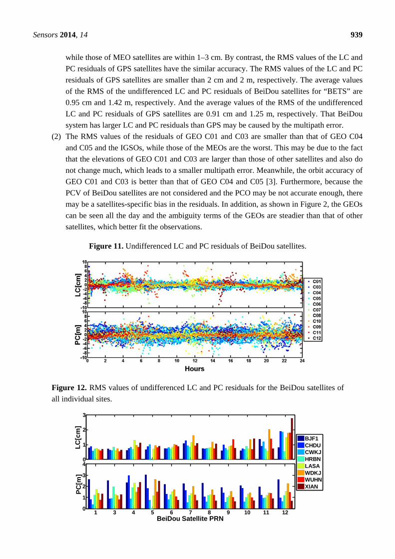
Sensors 2014, 14 939
while those of MEO satellites are within 1–3 cm. By contrast, the RMS values of the LC and
PC residuals of GPS satellites have the similar accuracy. The RMS values of the LC and PC
residuals of GPS satellites are smaller than 2 cm and 2 m, respectively. The average values
of the RMS of the undifferenced LC and PC residuals of BeiDou satellites for “BETS” are
0.95 cm and 1.42 m, respectively. And the average values of the RMS of the undifferenced
LC and PC residuals of GPS satellites are 0.91 cm and 1.25 m, respectively. That BeiDou
system has larger LC and PC residuals than GPS may be caused by the multipath error.
(2) The RMS values of the residuals of GEO C01 and C03 are smaller than that of GEO C04
and C05 and the IGSOs, while those of the MEOs are the worst. This may be due to the fact
that the elevations of GEO C01 and C03 are larger than those of other satellites and also do
not change much, which leads to a smaller multipath error. Meanwhile, the orbit accuracy of
GEO C01 and C03 is better than that of GEO C04 and C05 [3]. Furthermore, because the
PCV of BeiDou satellites are not considered and the PCO may be not accurate enough, there
may be a satellites-specific bias in the residuals. In addition, as shown in Figure 2, the GEOs
can be seen all the day and the ambiguity terms of the GEOs are steadier than that of other
satellites, which better fit the observations.
Figure 11. Undifferenced LC and PC residuals of BeiDou satellites.
Figure 12. RMS values of undifferenced LC and PC residuals for the BeiDou satellites of
all individual sites.
0
1
2
3
LC
[cm
]
1 3 4 5 6 7 8 9 10 11 120
1
2
3
4
BeiDou Satellite PRN
PC
[m]
BJF1CHDUCWKJHRBNLASAWDKJWUHNXIAN
Sensors 2014, 14 940
Figure 13. RMS values of the undifferenced LC and PC residuals for GPS satellites of all
individual sites.
0
1
2
3
LC
[cm
]
1 2 3 4 5 6 7 8 10 11 1213 14 151617 181920 212223 25 26 27 28 29 30 31 320
1
2
3
4
GPS Satellite PRN
PC
[m]
BJF1CHDUCWKJHRBNLASAWDKJWUHNXIAN
Table 3. Average values of the RMS of undifferenced LC and PC residuals for all
BeiDou satellites.
PRN LC(cm) PC(m)
C01 0.71 1.29
C03 0.67 1.35
C04 0.89 2.02
C05 0.85 1.92
C06 0.84 1.33
C07 1.12 1.37
C08 0.85 1.24
C09 0.86 1.16
C10 0.89 1.25
C11 1.12 1.25
C12 1.62 1.42
Mean 0.95 1.42
5. Discussion and Conclusions
We have presented static and kinematic PPP results in the modes of BeiDou-only, GPS-only and
BeiDou/GPS systems, respectively. The visibility of the current BeiDou satellite constellation,
multipath combinations and undifferenced phase and code observation residuals of BeiDou satellites
are used in the analysis. The results are compared with the “ground truth of stations”. The following
conclusions can be drawn:
(1) The analysis of multipath combinations shows that the MPCs of BeiDou code measurements
are higher than those of GPS code measurements at the testing stations;
(2) The daily static PPP solutions using BeiDou code and phase measurements demonstrate that
the horizontal precision is better than 1.0 cm while the vertical precision is better than
3.0 cm in the Asian-Pacific region. For the region having less observed BeiDou satellites,
Sensors 2014, 14 941
the horizontal precision of BeiDou-only PPP solutions reaches 3.0 cm. The horizontal
precision of BeiDou-only kinematic PPP solutions is better than 3.0 cm and the vertical
precision is better than 6.0 cm, which is close to that of GPS-only kinematic PPP. The
convergence time of BeiDou-only kinematic PPP is longer than that of GPS-only
kinematic PPP;
(3) The daily static PPP solutions using BeiDou/GPS code and phase measurements
demonstrate that the horizontal and vertical precisions are better than 1.0 cm, which is close
to those of GPS-only static PPP. The horizontal precision of kinematic BeiDou/GPS PPP
solutions is better than 2.0 cm while the vertical precision is better than 5.0 cm. The results
improve significantly compared to that of BeiDou-only and GPS-only kinematic PPP. The
convergence time of BeiDou/GPS kinematic PPP is also shorter than that of BeiDou-only
and GPS-only kinematic PPP. The East and North components converge faster than the Up
component. And less than 1 hour is used in all the components;
(4) The analysis on the residuals shows that BeiDou undifferenced LC and PC residuals vary
with orbital characteristics. The BeiDou code and phase residuals are higher than the GPS
ones, which may be due to the multipath error.
Finally, it should be pointed out that the performance evaluation of BeiDou PPP is for preliminary
results since the BeiDou constellation is not yet completed. Furthermore, as the number and proper
distribution of the ground tracking stations increase, the accuracy of satellite orbit and clock biases will
also improve greatly [31]. The precision of BeiDou positioning may be significantly improved in the
future. Moreover, the determination and optimization of the phase center corrections in the satellites
and receiver terminals may also benefit the performance of BeiDou positioning.
Acknowledgments
This work was supported by the GNSS Research Center at Wuhan University and the National
Natural Science foundation of China (No. 41204029; No. 41231174), the Outstanding Youth Paper
foundation of CSNC (CSNC2012-QY-1) and the “111 Project” of China (No. B07037). The authors
are thankful to Xianglin Liu, who considerably revised the paper. In addition all the reviewers are
appreciated for their comments and suggestions, which significantly improved our manuscript.
Conflicts of Interest
The authors declare no conflict of interest.
References
1. Greilie, T.; Ghion, A.; Dantepal, J.; Ries, L.; DeLatour, A.; Issler, J.A. Compass Signal Structure
and First Measurements. In Proceedings of the 20th International Technical Meeting of the
Institute of Navigation (ION-GNSS 2007), Fort Worth, TX, USA, 25–28 September 2007.
2. Gao, G.; Chen, A.; Lo, S.; Lorenzo, D.; Walter, T.; Enge, P. Compass-M1 broadcast codes in E2,
E5b and E6 frequency bands. IEEE J. Sel. Top. Signal Process. 2009, 3, 599–612.
Sensors 2014, 14 942
3. Shi, C.; Zhao, Q.; Li, M.; Tang, W.; Hu, Z.; Lou, Y.; Zhang, H.; Niu, X.; Liu, J. Precise orbit
determination of BeiDou Satellites with precise positioning. Sci. China Earth Sci. 2012, 55,
1079–1086.
4. Hauschild, A.; Montenbruck, O.; Sleewaegen, J.; Huisman, L.; Teunissen, P. Characterization of
Compass M-1 signals. GPS Sol. 2012, 16, 117–126.
5. Shi, C.; Zhao, Q.; Hu, Z.; Liu, J. Precise relative positioning using real tracking data from
COMPASS GEO and IGSO satellites. GPS Sol. 2012, 17, 103–119.
6. Montenbruck, O.; Hauschild, A.; Steigenberger, P.; Hugentobler, U; Teunissen, P.; Nakamura, S.
Initial assessment of the COMPASS/BeiDou-2 regional navigation satellite system. GPS Sol.
2012, 17, 211–222.
7. Ge, M.; Zhang, H.; Jia, X.; Song, S.; Wickert, J. What is Achievable with the Current COMPASS
Constellation? In Proceedings of the 25th International Technical Meeting of the Satellite
Division of the Institute of Navigation (ION GNSS 2012), Nashville, TN, USA, 17–21
September 2012.
8. He, L.; Ge, M.; Wang, J.; Wickert, J.; Schuh, H. Experimental study on the precise orbit
determination of the BeiDou navigation satellite system. Sensors 2013, 13, 2911–2928.
9. Steigenberger, P.; Hugentobler, U.; Hauschild, A.; Montenbruck, O. Orbit and clock analysis of
Compass GEO and IGSO satellites. J. Geod. 2013, 87, 515–525.
10. Xu, A.; Xu, Z.; Ge, M.; Xu, X.; Zhu, H.; Sui, X. Estimating zenith tropospheric delays from
BeiDou navigation satellite system observations. Sensors 2013, 13, 4514–4526.
11. Cai, C.; Gao, Y. Precise point positioning using combined GPS and GLONASS observations.
J. Glo. Pos. Syst. 2007, 6, 13–22.
12. Meng, X.; Guo, J. The Research on combined GPS and GLONASS precise point positioning.
Wuhan Univ. J. Inf. Sci. 2010, 35, 1409–1413.
13. Cai, C.; Gao, Y. Modeling and assessment of combined GPS/GLONASS precise point
positioning. GPS Sol. 2012, 17, 223–236.
14. Defraigne, P.; Baire, Q. Combining GPS and GLONASS for time and frequency transfer. Adv.
Space Res. 2011, 47, 265–275.
15. Yang, Y.; Li, J.; Xu, J.; Tang, J.; Guo, H.; He, H. Contribution of the Compass satellite navigation
system to global PNT users. Chin. Sci. Bull. 2011, 56, 2813–2819.
16. Li, W.; Teunissen, P.; Zhang, B.; Verhagen, S. Precise Point Positioning Using GPS and Compass
Observations. In China Satellite Navigation Conference (CSNC) 2013 Proceedings; Springer:
Berlin/Heidelberg, Germany, 2013; pp. 367–378.
17. Nadarajah, N.; Teunissen, P.J.G.; Raziq, N. BeiDou inter-satellite-type bias evaluation and
calibration for mixed receiver attitude determination. Sensors 2013, 13, 9435–9463.
18. Flohrer, T. Classification of Geosynchronous Objects. In GEN-DB-LOG-00086-OPS-GR;
European Space Agency: Darmstadt, Germany, 2012.
19. China Satellite Navigation Office. BeiDou Navigation Satellite System Signal in Space Interface
Control Document Open Service Signal B1I (Version 1.0), 2012. Available online:
http://www.beidou.gov.cn/attach/2012/12/27/201212275f2be9ad57af4cd09c634b08d7bc599e.pdf
(accessed on 27 December 2012).
Sensors 2014, 14 943
20. Liu, J.; Ge, M. PANDA software and its preliminary result of positioning and orbit determination.
Wuhan Univ. J. Nat. Sci. 2003, 8, 603–609.
21. Zhao, Q. Research on Precise Orbit Determination Theory and Software of both GPS Navigation
Constellation and LEO Satellites. Ph.D. Dissertation (in Chinese with an abstract in English),
School of Geodesy and Geomatics, Wuhan University, Wuhan, China, 2004.
22. Shi, C.; Zhao, Q.; Geng, J.; Lou, Y.; Ge, M.; Liu, J. Recent Development of PANDA Software in
GNSS Data Processing. In Proceedings of International Conference on Earth Observation Data
Processing and Analysis (ICEODPA), Wuhan, China, 28–30 December 2008.
23. Li, M.; Zhao, Q.; Ge, M. Simulation research on precise orbit determination for GIOVE-A.
Wuhan Univ. J. Geo. Inf. Sci. 2008, 33, 200–205.
24. Zhao, Q.; Liu, J.; Ge, M.; Shi, C. Applications of square-root information filtering and smoothing
on orbit determination of LEO satellites with on-board GPS data. Wuhan Univ. J. Geo. Inf. Sci.
2006, 31, 12–15.
25. Li, M.; Shi, C.; Zhao, Q.; Liu, J. Multi-GNSS precision orbit determination. Acta Geod. Cartogr.
Sin. 2011, 40, 26–30.
26. Li, M. Research on Multi-GNSS Precise Orbit Determination Theory and Application. Ph.D.
Thesis, School of Geodesy and Geomatics, Wuhan University, Wuhan, China, 2011.
27. Zhao, Q.; Guo, J.; Li, M.; Qu, L.; Hu, Z.; Shi, C.; Liu, J. Initial results of precise orbit and clock
determination for COMPASS navigation satellite system. J. Geod. 2013, 5, 475–486.
28. Blewitt, G. An automatic editing algorithm for GPS data. Geophys. Res. Lett. 1990, 17, 199–202.
29. Wu, J.; Wu, S.; Hajj, G.; Bertiger, W.; Lichten, S. Effects of antenna orientation on GPS carrier
phase. Astrodynamics 1992, 1, 1647–1660.
30. Niell, A.E. Global mapping functions for the atmosphere delay at radio wavelengths. J. Geophys.
Res. 1996, 101, 3227–3246.
31. Geng, J.; Teferle, F.N.; Meng, X.; Dodson, A.H. Kinematic precise point positioning at remote
marine platforms. GPS Sol. 2010, 4, 343–350.
© 2014 by the authors; licensee MDPI, Basel, Switzerland. This article is an open access article
distributed under the terms and conditions of the Creative Commons Attribution license
(http://creativecommons.org/licenses/by/3.0/).