Precipitate’s IP Survey Indicates Strong Chargeability ...
5
Page 1 of 3 Precipitate’s IP Survey Indicates Strong Chargeability Highs Extend to depth below Surface Gold Anomalies Vancouver, B.C. – April 8, 2014 - Precipitate Gold Corp. (the “Company” or “Precipitate”) (TSXV: PRG) is pleased to announce the results of its recently completed induced polarization (“IP”) geophysical survey at the Ginger Ridge Zone within the Company’s Juan de Herrera concession in the Dominican Republic. The Ginger Ridge IP geophysical survey was conducted on five parallel grid lines at 200 metre intervals centred over the middle of the zone’s gold-silver geochemical anomaly. The geophysical survey covered approximately 800 metres strike length within the central core of the 2,000 metre long surface gold anomaly and achieved the following noteworthy results: contiguous chargeability and resistivity highs coincident with surface gold anomalies identified across the entire strike of the 800 metre survey grid; marked chargeability high starting at surface coincident with previously reported surface trench sampling results of 32.5 metres of 1.0 g/t gold and 18 g/t silver; strongest chargeability readings (up to 10 mv/v) reported from the northernmost line (L1000), leaving the anomaly open to the northwest; entire chargeability anomaly remains open along strike to northwest and southeast and to depth below the estimated survey depth limit of 200 metres; and sufficient technical data has now been compiled to commence planning for an initial diamond drill program See the accompanying figures and the Company’s website for additional compilation illustrations. Jeffrey Wilson, Company President & CEO stated, “We are very pleased with the Ginger Ridge IP results as they provide precisely the kind of geophysical data we were hoping to attain. The strong correlation between surface gold and silver sample results and underlying chargeability anomalies increases our confidence in Ginger Ridge’s potential. Given the successful precedent established by others in the region in applying this technology, the results of our survey provide compelling targets for drill testing. It’s additionally encouraging that the most noteworthy geophysical anomalies at Ginger Ridge, in terms of chargeability and resistivity, are very near bedrock surface and remain open along strike and at depth, providing potential for future expansion through additional IP and/or drilling. In short, we’re excited that the results of this geophysical survey have provided significant technical assistance in delineating targets for a first phase drill program, currently being planned.” TSX VENTURE: PRG | www.precipitategold.com Suite 1410 – 650 W. Georgia St., Vancouver BC, V6B 4N8 [email protected] Toll free: 855 558 0335 Direct: 604 558 0335
Transcript of Precipitate’s IP Survey Indicates Strong Chargeability ...

Page 1 of 3
Precipitate’s IP Survey Indicates Strong Chargeability Highs Extend to
depth below Surface Gold Anomalies
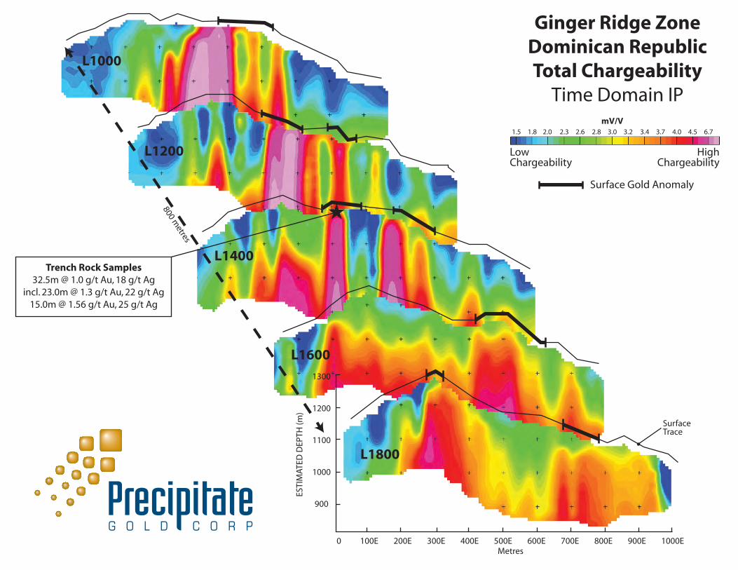
Vancouver, B.C. – April 8, 2014 - Precipitate Gold Corp. (the “Company” or “Precipitate”) (TSXV: PRG) is pleased to announce the results of its recently completed induced polarization (“IP”) geophysical survey at the Ginger Ridge Zone within the Company’s Juan de Herrera concession in the Dominican Republic. The Ginger Ridge IP geophysical survey was conducted on five parallel grid lines at 200 metre intervals centred over the middle of the zone’s gold-silver geochemical anomaly. The geophysical survey covered approximately 800 metres strike length within the central core of the 2,000 metre long surface gold anomaly and achieved the following noteworthy results:
contiguous chargeability and resistivity highs coincident with surface gold anomalies identified across the entire strike of the 800 metre survey grid;
marked chargeability high starting at surface coincident with previously reported surface trench sampling results of 32.5 metres of 1.0 g/t gold and 18 g/t silver;
strongest chargeability readings (up to 10 mv/v) reported from the northernmost line (L1000), leaving the anomaly open to the northwest;
entire chargeability anomaly remains open along strike to northwest and southeast and to depth below the estimated survey depth limit of 200 metres; and
sufficient technical data has now been compiled to commence planning for an initial diamond drill program
See the accompanying figures and the Company’s website for additional compilation illustrations.
Jeffrey Wilson, Company President & CEO stated, “We are very pleased with the Ginger Ridge IP results as they provide precisely the kind of geophysical data we were hoping to attain. The strong correlation between surface gold and silver sample results and underlying chargeability anomalies increases our confidence in Ginger Ridge’s potential. Given the successful precedent established by others in the region in applying this technology, the results of our survey provide compelling targets for drill testing. It’s additionally encouraging that the most noteworthy geophysical anomalies at Ginger Ridge, in terms of chargeability and resistivity, are very near bedrock surface and remain open along strike and at depth, providing potential for future expansion through additional IP and/or drilling. In short, we’re excited that the results of this geophysical survey have provided significant technical assistance in delineating targets for a first phase drill program, currently being planned.”
TSX VENTURE: PRG | www.precipitategold.com Suite 1410 – 650 W. Georgia St., Vancouver BC, V6B 4N8
[email protected] Toll free: 855 558 0335
Direct: 604 558 0335

Page 2 of 3
The Ginger Ridge IP geophysical survey covers an area measuring about 1,000m by 800m and is aligned over the central portion of the multi-element surface geochemical anomaly, which drapes over the northeast facing slope of Ginger Ridge. Elevated chargeability readings correlate well with the surface trace of the northwest trending gold-in-soil anomalies, likely marking zones of increased sulphide concentrations within the host Tireo volcanic rocks. Significantly, the survey identified a marked chargeability high on line 1400 which correlates well with the previously reported surface rock chip channel sampling results of 32.5 metres of 1.0 g/t gold and 18 g/t silver; including 23.0 metres of 1.3 g/t gold and 22 g/t silver. Moving from north to south, elevated chargeability readings start at bedrock surface and are strongest on the northernmost line 1000 (up to 10mv/v), then over the 800 metre long survey extent tend to project deeper to the southeast and have a reduced relative strength at the southernmost survey line 1800 (up to 4.5 mv/v). Importantly, the primary elevated chargeability anomalies remain open on strike, both to the northwest and southeast and also at depth. Together, the resistivity and chargeability readings appear to map major rock types and structures. On the western side of the survey area, a regionally mapped thrust fault is inferred to dip vertically to steeply to the northeast, marking the structural contact between older limestone rocks and the overlying gold-silver enriched Tireo volcanic lithologies. The induced polarization/resistivity survey was conducted by Insight Geophysics Inc. of Oakville Ontario. The survey used a 10 kW Time Domain IP system using the Elrec Pro receiver with an “n” spacing equal to 25 metres, which provided quality subsurface resolution for each Insight section array. Michael Moore, VP Exploration of the Company and Qualified Person for purposes of National Instrument 43-101 has reviewed the technical information in this news release. About Precipitate Gold: Precipitate Gold Corp. is a mineral exploration company focused on exploring and advancing its mineral property interests in the Tireo Gold Trend of the Dominican Republic and Sonora State, Mexico. The Company also maintains assets in northern British Columbia and southeast Yukon Territory and is actively evaluating additional high-impact property acquisitions with the potential to expand the Company's portfolio and increase shareholder value. Additional information can be viewed at the Company’s website www.precipitategold.com. On Behalf of the Board of Directors of Precipitate Gold Corp.,
“Jeffrey Wilson”
President & CEO
For further information, please contact: Jeffrey Wilson, President & CEO Tel: 604-558-0338 Toll Free: 855-558-0335 [email protected] Neither the TSX Venture Exchange nor its Regulation Service Provider (as that term is defined in the policies of the TSX Venture Exchange) accepts responsibility for the adequacy or accuracy of this release. This press release may contain "forward-looking information" within the meaning of applicable Canadian securities legislation. All statements, other than statements of historical fact, included herein are forward looking information. Generally, forward-looking information may be identified by the

Page 3 of 3
use of forward-looking terminology such as "plans", "expects" or "does not expect", "proposed", "is expected", "budget", "scheduled", "estimates", "forecasts", "intends", "anticipates" or "does not anticipate", or "believes", or variations of such words and phrases, or by the use of words or phrases which state that certain actions, events or results may, could, would, or might occur or be achieved. This forward-looking information reflects Precipitate Gold Corp.’s (“Precipitate” or the “Company”) current beliefs and is based on information currently available to Company and on assumptions it believes are reasonable. Forward-looking information is subject to known and unknown risks, uncertainties and other factors that may cause the actual results, level of activity, performance or achievements of Precipitate to be materially different from those expressed or implied by such forward-looking information. Such risks and other factors may include, but are not limited to: the exploration concessions may not be granted on terms acceptable to the Company, or at all; general business, economic, competitive, political and social uncertainties; the concessions acquired by the Company may not have attributes similar to those of surrounding properties; delay or failure to receive governmental or regulatory approvals; changes in legislation, including environmental legislation affecting mining; timing and availability of external financing on acceptable terms; conclusions of economic evaluations; and lack of qualified, skilled labour or loss of key individuals. Although Precipitate has attempted to identify important factors that could cause actual results to differ materially from those contained in forward-looking information, there may be other factors that cause results not to be as anticipated, estimated or intended. Accordingly, readers should not place undue reliance on forward-looking information. Precipitate does not undertake to update any forward-looking information, except in accordance with applicable securities laws.
1300
1200
1100
1000
900
SurfaceTrace
L1800
L1600
L1400
L1200
L1000
ESTI
MAT
ED D
EPTH
(m)
0 100E 200E 300E 400E 500E 600E 700E 800E 900E 1000EMetres
Ginger Ridge ZoneDominican RepublicTotal Chargeability
Time Domain IPmV/V
1.5 1.8 2.0 2.3 2.6 2.8 3.0 3.2 3.4 3.7 4.0 4.5 6.7
Trench Rock Samples32.5m @ 1.0 g/t Au, 18 g/t Ag
incl. 23.0m @ 1.3 g/t Au, 22 g/t Ag15.0m @ 1.56 g/t Au, 25 g/t Ag
★800 metres
Surface Gold Anomaly
LowChargeability
HighChargeability

13
001
200
1000
11
00
13
00
12
00
0
ArroyoNaraj ito
Arroyo
deFransuá
1085
407458
732
303
351
394531
408
1435
442
997
1226
955
1822
7
6
10
93
28
16
6
39
16
10
9
8
8
7
9
16
419
13
7
8
10
9
60
9
7
10
12
6
7
13
11
10
11
7
6
9
9
14
10
57
37
9
8
7
38
34
21
15
94
115
6199
33
1343
489
69
7
12
26
10
61810
8
6
1313
8
93722
23
19
54309
12
812
3222
572167
2657
11
187
7
11
7
10
10
17
152
861
468
18
6
734
1521
9
16
2010
913
11
9
25
124975
960
7
106
14054
82
126
2230
57
2719
10370
55
619
1116
47
17
15
6
6
1650
42
51
625646
34
7
7
7
10
12
47
4035
8
911
14
7
7
12
10
8
6
6
15.9
9.8
12.4
4.1
16.9
269500 m269000 m268500 m268000 m267500 m267000 m
269500 m269000 m268500 m268000 m267500 m267000 m
2096000 m
2095500 m
2095000 m
2094500 m
Sediments
Sediments
Tireovolcanics
Tireo volcanics
inferred thrust fault
path
path
path
path
flycamp
32.5m @
(incl. 23.0 1.3 g/t Au, 22 g/t Ag)
1.0 g/t Au, 18 g/t Ag
15.0m @1.56 g/t Au, 25 g/t Ag
5.5m @0.70 g/t Au, 20 g/t Ag
Rock Trench Samples
0.30 g/t Au
1.1 g/t Au
1.0 g/t Au & 36 g/t Ag
silicified - pyritic volcanicsup to 0.4 g/t Au
1.1 g/t Au
1.4 g/t Au
0.4 g/t Au
0.7 g/t Au
Ginger Ridge ZoneJuan de Herrera
Dominican Republic
GOLD & IP GeophysicsCompilation
500 m
April 07, 2014
Gold (ppb)
Au anomaly >70 percentile
Soil
< 6
6
10
32
> 56
Silt %-tile
< 70
>70
>80
>90
>95
< 4
4
7
13
> 16
Rock
< 242
> 1432
242
728
1191
IP Geophyics
Chargeability High
Resistivity High
strong
strong
medium
medium
weak
weak
L10
L10
L12
L12
L14
L14
L16
L16
L18
L18