PRE-FEASIBILITY REPORT -...
13
1 PRE-FEASIBILITY REPORT On REMOVAL OF SAND FROM SAND BAR “ SB-GA-1” OVER AN EXTENT OF 3.8 Ha., GANGAVALI RIVER, ANKOLA TALUK, UTTARA KANNADA DISTRICT Submitted by DEPUTY COMMISSIONER/CHAIRMAN DISTRICT SAND MONITORING COMMITTEE(CRZ) UTTARA KANNDA DISTRICT, KARWAR- 581301 KARNATAKA STATE
Transcript of PRE-FEASIBILITY REPORT -...
1
PRE-FEASIBILITY REPORT
On
REMOVAL OF SAND FROM SAND BAR “ SB-GA-1” OVER AN EXTENT OF 3.8 Ha., GANGAVALI RIVER, ANKOLA TALUK,
UTTARA KANNADA DISTRICT
Submitted by
DEPUTY COMMISSIONER/CHAIRMAN
DISTRICT SAND MONITORING COMMITTEE(CRZ) UTTARA KANNDA DISTRICT, KARWAR- 581301 KARNATAKA STATE
2
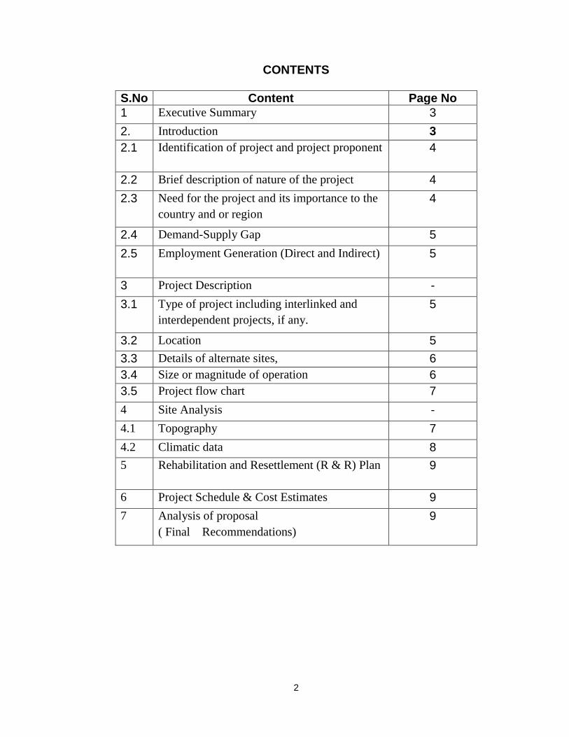
CONTENTS
S.No Content Page No
1 Executive Summary 3
2. Introduction 3
2.1 Identification of project and project proponent 4
2.2 Brief description of nature of the project 4
2.3 Need for the project and its importance to the
country and or region
4
2.4 Demand-Supply Gap 5
2.5 Employment Generation (Direct and Indirect) 5
3 Project Description -
3.1 Type of project including interlinked and
interdependent projects, if any.
5
3.2 Location 5
3.3 Details of alternate sites, 6
3.4 Size or magnitude of operation 6
3.5 Project flow chart 7
4 Site Analysis -
4.1 Topography 7
4.2 Climatic data 8
5 Rehabilitation and Resettlement (R & R) Plan 9
6 Project Schedule & Cost Estimates 9
7 Analysis of proposal
( Final Recommendations)
9
3
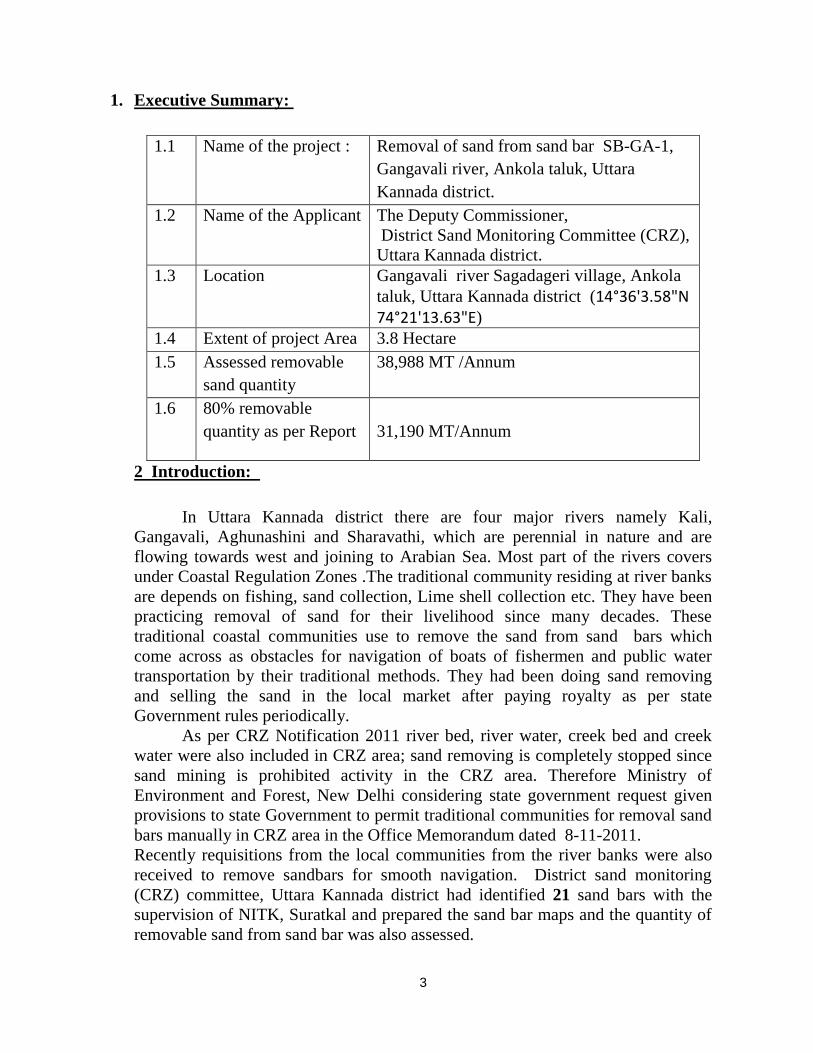
1. Executive Summary:
1.1 Name of the project : Removal of sand from sand bar SB-GA-1,
Gangavali river, Ankola taluk, Uttara
Kannada district.
1.2 Name of the Applicant The Deputy Commissioner,
District Sand Monitoring Committee (CRZ),
Uttara Kannada district.
1.3 Location Gangavali river Sagadageri village, Ankola
taluk, Uttara Kannada district (14°36'3.58"N 74°21'13.63"E)
1.4 Extent of project Area 3.8 Hectare
1.5 Assessed removable
sand quantity
38,988 MT /Annum
1.6 80% removable
quantity as per Report
31,190 MT/Annum
2 Introduction:
In Uttara Kannada district there are four major rivers namely Kali,
Gangavali, Aghunashini and Sharavathi, which are perennial in nature and are
flowing towards west and joining to Arabian Sea. Most part of the rivers covers
under Coastal Regulation Zones .The traditional community residing at river banks
are depends on fishing, sand collection, Lime shell collection etc. They have been
practicing removal of sand for their livelihood since many decades. These
traditional coastal communities use to remove the sand from sand bars which
come across as obstacles for navigation of boats of fishermen and public water
transportation by their traditional methods. They had been doing sand removing
and selling the sand in the local market after paying royalty as per state
Government rules periodically.
As per CRZ Notification 2011 river bed, river water, creek bed and creek
water were also included in CRZ area; sand removing is completely stopped since
sand mining is prohibited activity in the CRZ area. Therefore Ministry of
Environment and Forest, New Delhi considering state government request given
provisions to state Government to permit traditional communities for removal sand
bars manually in CRZ area in the Office Memorandum dated 8-11-2011.
Recently requisitions from the local communities from the river banks were also
received to remove sandbars for smooth navigation. District sand monitoring
(CRZ) committee, Uttara Kannada district had identified 21 sand bars with the
supervision of NITK, Suratkal and prepared the sand bar maps and the quantity of
removable sand from sand bar was also assessed.
4
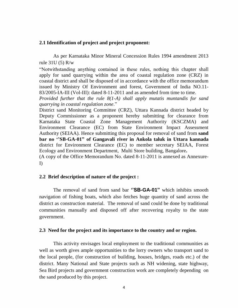
2.1 Identification of project and project proponent:
As per Karnataka Minor Mineral Concession Rules 1994 amendment 2013
rule 31U (5) R/w
“Notwithstanding anything contained in these rules, nothing this chapter shall
apply for sand quarrying within the area of coastal regulation zone (CRZ) in
coastal district and shall be disposed of in accordance with the office memorandum
issued by Ministry Of Environment and forest, Government of India NO.11-
83/2005-IA-III (Vol-III): dated 8-11-2011 and as amended from time to time.
Provided further that the rule 8(1-A) shall apply mutatis muntandis for sand
quarrying in coastal regulation zone.”
District sand Monitoring Committee (CRZ), Uttara Kannada district headed by
Deputy Commissioner as a proponent hereby submitting for clearance from
Karnataka State Coastal Zone Management Authority (KSCZMA) and
Environment Clearance (EC) from State Environment Impact Assessment
Authority (SEIAA). Hence submitting this proposal for removal of sand from sand
bar no ‘’SB-GA-01” of Gangavali river in Ankola taluk in Uttara kannada district for Environment Clearance (EC) to member secretary SEIAA, Forest
Ecology and Environment Department, Multi Store building, Bangalore.
(A copy of the Office Memorandum No. dated 8-11-2011 is annexed as Annexure-
I)
2.2 Brief description of nature of the project :
The removal of sand from sand bar ‘’SB-GA-01” which inhibits smooth
navigation of fishing boats, which also fetches huge quantity of sand across the
district as construction material. The removal of sand could be done by traditional
communities manually and disposed off after recovering royalty to the state
government.
2.3 Need for the project and its importance to the country and or region.
This activity envisages local employment to the traditional communities as
well as worth gives ample opportunities to the lorry owners who transport sand to
the local people, (for construction of building, houses, bridges, roads etc.) of the
district. Many National and State projects such as NH widening, state highway,
Sea Bird projects and government construction work are completely depending on
the sand produced by this project.
5
2.4 Demand-Supply Gap.
Since the beginning of the civilization Gangavali river sand has being
utilized for construction of the houses. The prohibition on the sand mining in CRZ
area (as per CRZ notification-2011) creates acute shortage of sand in the district.
By this project we envisage to meet the local demand of the sand in the district.
2.5. Employment Generation (Direct and Indirect):
This project involves local traditional community in removing of sand
manually with local small boats and local equipments like bamboo, shovel, and
baskets etc. which provides ample employment to the local community. The local
people who are registered by the Committee (constituted as per OM dated- 8-11-
2011) will sell the sand in local market. And transportation of the sand by Lorry
owners where loading and unloading of sand will be done manually, requires
labors, drivers and cleaner etc.
The sand which used for construction of houses, buildings, and road and
bridges etc. all work are also labor oriented (skilled-unskilled). In between this
activity indirectly enhances hotel, restaurant Tea-shop, and puncher-shop
businesses which also require skilled-unskilled labors.
3. Project Description:
3.1 Type of project including interlinked and interdependent projects, if
any.
As many Government projects like- widening of National Highways, road,
bridge government building constructions work awarded in the district requires
river sand as raw material, all projects will be hampered due to non availability of
sand as long as this project get started.
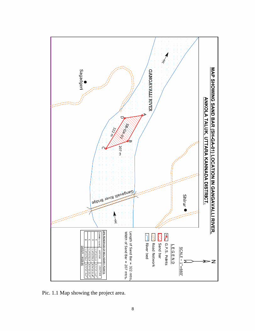
3.2 Location :
Ankola town is located west coast part of Karnataka state, India and the
river Gangavli originates from Western Ghats in the district and runs for 183 km
and meets Arabian Sea in the heart of the town. The sand bar ‘’SB-GA-01”
location is as follows:
6
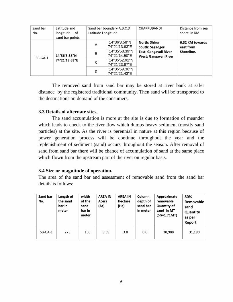
Sand bar No.
Latitude and longitude of sand bar points
Sand bar boundary A,B,C,D Latitude Longitude
CHAKKUBANDI Distance from sea shore in KM
SB-GA-1 14°36'3.58"N 74°21'13.63"E
A 14°36'3.58"N 74°21'13.63"E
North: Shirur South: Sagadgeri East: Gangavali River West: Gangavali River
6.32 KM towards east from Shoreline. B
14°35'58.39"N 74°21'14.50"E
C 14°35'52.92"N 74°21'23.67"E
D 14°35'59.36"N 74°21'21.43"E
The removed sand from sand bar may be stored at river bank at safer
distance by the registered traditional community. Then sand will be transported to
the destinations on demand of the consumers.
3.3 Details of alternate sites,
The sand accumulation is more at the site is due to formation of meander
which leads to check to the river flow which dumps heavy sediment (mostly sand
particles) at the site. As the river is perennial in nature at this region because of
power generation process will be continue throughout the year and the
replenishment of sediment (sand) occurs throughout the season. After removal of
sand from sand bar there will be chance of accumulation of sand at the same place
which flown from the upstream part of the river on regular basis.
3.4 Size or magnitude of operation.
The area of the sand bar and assessment of removable sand from the sand bar
details is follows:
Sand bar No.
Length of the sand bar in meter
width of the sand bar in meter
AREA IN Acers (Ac)
AREA IN Hectare (Ha)
Column depth of sand bar in meter
Approximate removable Quantity of sand in MT (SG=1.71MT)
80% Removable sand Quantity as per Report
SB-GA-1
275 138 9.39 3.8 0.6 38,988 31,190

7
3.5 Project flow chart :
Identification of Sand Bar
Approval from statutory Bodies
(Seven member Committee, NITK, DCZMA, KSCZMA and SEIAA)
Short-term permit to the traditional community
(1 year validity by collecting advance royalty)
Removal of Sand from sand bar
(Traditional method)
Disposal of the sand from storage point
(With valid online Mineral dispatch permit on royalty basis)
Transportation of sand to end-users
(By convenient vehicle)
4. Site Analysis:
4.1 Topography :
The sand bar is well located within the Gangavali river, the sand bar developed
at the meander. The accumulation of sand at the site may forms land if the removal
of sand is not done in course of time and which could be called “delta” at the river
mouth of Gangavali river.
8
Pic. 1.1 Map showing the project area.
/4'4.2 Climatic data:Ankola lies on a coastal strip knou'n as rhe Monsoon Coast.Ankolahas hotsummers from \{arch to May qhere the temperature may reach 3T oC.
The Arabian Sea is r arm throughout the year. winters from December to Februaryare 'en mild (lJ'C and 32 "C). The u,indl,monsoon period fi.ont June toSeptember has an ar-erase rainlall of over 400 centimeters ( 160 in).
This project in'ol'es remo'al of assessed quantity of sand fronr the identifiedsand bar onl'uhich is became hurdle to the fishing boats. Hence it doesn't requirean' Rehabilitation and Resettlement (R&R) plan. There u'ill be no solid waste
-generation from this activit-v as entire sediment could be used for construction inone or the other u'av.
Proiect Schedule & Cost Estimates:
Tltis project requires maximutn period ofuhich can be sell in the local market. theCommunity) u'ould take all the expendituresfrom the sand bar.
t\\'o )'ear and as it produces sand
beneficiary (registered traditionalraiich occurs for removal of sand
Analysis of proposal (Final Recommendations) :
The project envisages the removal of sand fronr Sand Bar SB_GA_01 b1, theregistered traditional communit,v, primarily helps fisherman to move their fishingboats in the river and the removed sand could be sellat the local market by thetraditional communitv u'hich emphasis li'elihood to the tr.aditional communit.v asq-ell as it pro'ides anrple employnre't u ithin the communitl, and other people ofthe district also get benefit out of it as many people invol'es in transpofiation ofsand(truck ou'ners) provides employment to the drivers. cleaners and plenry ofu'ork in the field of constmction of houses, road. bridge and other governnrentu'orks.
fJh-'t*ion".1"hairmanVonitoring Commiltee(CRZ)
D.pDistric
-IJannda District, Karwar
Proposal of “Removal of sand from Sand Bar SB-GA-1 of Gangavali river in Ankola
taluk of Uttara Kannada District” for Environment Clearance (EC) from SEIAA,
Bangalore.
Preamble:
In Uttara Kannada district there are four major rivers namely Kali, Gangavali,
Aghunashini and Sharavathi, which are perennial in nature and are flowing towards west and
joining to Arabian Sea. Most part of the rivers covered under Coastal Regulation Zones .The
traditional community residing at river banks are depends on fishing, sand collection, Lime shell
collection etc.,. They have been practicing removal of sand for their livelihood since many
decades. These traditional coastal communities use to remove the sand from sand bars which
come across as obstacles for navigation of boats of fishermen and public water transportation
by their traditional methods. They had been doing sand removing and selling the sand in the
local market after paying royalty as per state Government rules periodically.
As per CRZ Notification 2011 river bed, river water, creek bed and creek water were
also included in CRZ area; sand removing is completely stopped since sand mining is prohibited
activity in the CRZ area. Therefore Ministry of Environment and Forest, New Delhi considering
state government request given provisions to state Government to permit traditional
communities for removal sand bars manually in CRZ area in the Office Memorandum dated
8-11-2011.
Recently requisitions from the local communities from the river banks were also
received to remove sandbars for smooth navigation. District sand monitoring (CRZ) committee,
Uttara Kannada district had identified 21 sand bars with the supervision of NITK, Suratkal and
prepared the sand bar maps and the quantity of removable sand from sand bar was also
assessed.
As per Karnataka Minor Mineral Concession Rules 1994 amendment 2013 rule 31U (5)
R/w “Notwithstanding anything contained in these rules, nothing this chapter shall apply for
sand quarrying within the area of coastal regulation zone (CRZ) in coastal district and shall be
disposed of in accordance with the office memorandum issued by Ministry Of Environment and
forest, Govt of India NO.11-83/2005-IA-III (Vol-III): dated 8-11-2011 and as amended from time
to time.
Provided further that the rule 8(1-A) shall apply mutatis muntandis for sand quarrying in
coastal regulation zone.”
District sand Monitoring Committee (CRZ), Uttara Kannada district headed by
Deputy Commissioner as a proponent had submitted a proposal for CRZ clearance to
Karnataka State Coastal Zone Management Authority (KSCZMA). And in pursuance
with rules the Chairman is hereby submitting the project “Removal of sand from Sand
Bar SB-GA-1 of Gangavali river in Ankola taluk of Uttara Kannada District” for
Environment Clearance (EC) to Member secretary, SEIAA, Forest Ecology and
Environment Department, Multi Store building, Bangalore.
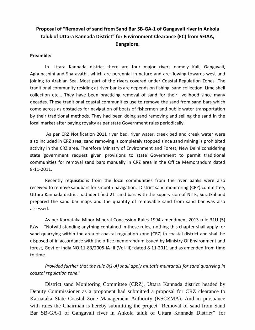
A. Location of the sand bar:
Uttara Kannada District is located N-W part of Karnataka state falls in between Latitude:
14° -15° N and longitude of 74°-75°. The District has four major estuaries viz. Kali, Gangavali,
Aghanashini, and Sharavathi. The Kali estuary is located in the northern most part of the
district, the Bedthi or Gangavali about 35 km south from Kali river-mouth, the Aghanashini or
Tadri estuary, about 12 km south of Gangavali, and the Sharavathi estuary is about 28 km south
of the Aghanashini estuarine mouth.
The sand bar “SB-GA-1” is located in Gangavali river bed of Ankola taluk.
Gangavalli River is one of the many small rivers that originates and flows entirely within the
western part of state of Karnataka in India. Gangavalli River (also called Bedthi River) originates
from the Western Ghats at two places; one is near Someswara temple, south of Dharwad and
another is near Hubli, both join near Kalghatgi, Dharwad district. The total length of the river is
around 183 km, This river has a catchment area of 3,574 km2 and it has no dam or hydel power
station. It joins the Arabian Sea at Gangavali near Ankola taluk.
The GPS location and chakkubandi details as follows:
Sand bar No.
Latitude and longitude of sand bar points
Sand bar boundary A,B,C,D Latitude Longitude
CHAKKUBANDI Distance from sea shore in KM
SB-GA-1 14°36'3.58"N 74°21'13.63"E
A 14°36'3.58"N 74°21'13.63"E
North: Shirur South: Sagadgeri East: Gangavali River West: Gangavali River
6.32 KM towards east from Shoreline.
B 14°35'58.39"N 74°21'14.50"E
C 14°35'52.92"N 74°21'23.67"E
D 14°35'59.36"N 74°21'21.43"E
B. Removable sand Assessment:
A team of officers consisting of Dept of Mines and Geology, Revenue Dept, PWD Dept,
KSPCB and CRZ officials had joint inspections of the sand bars using CRZ maps along with the
traditional community people by traversing in the Gangavali river courses and identified sand
bar “SB-GA-1”. While identification of sand bar ecologically sensitive area and fish breeding
areas (CRZ-I) were excluded. Identified area has been marked in maps. Assessment of
removable sand was made by considering 0.5 meter thickness of the sand bar, but NITK
Surathkal in its report has made the point that it’s better to take 0.6 meter depth for removal
purposed as the rivers getting replenishment on all the days of the year and it is assessed
accordingly.
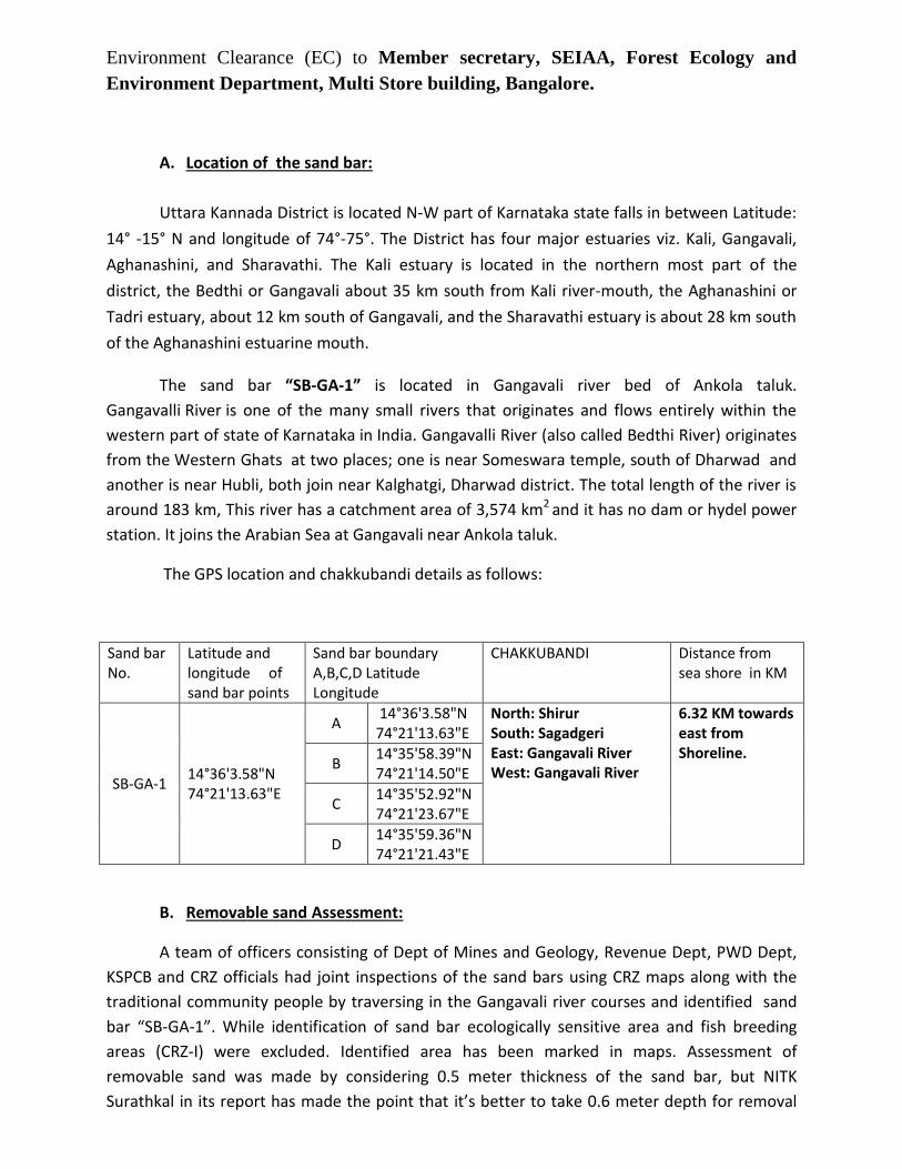
The sand bar assessment details is as follows:
Sand bar No.
Length of the sand bar in meter
width of the sand bar in meter
AREA IN Acers (Ac)
AREA IN Hectare (Ha)
Column depth of sand bar in meter
Approximate removable Quantity of sand in MT (SG=1.71MT)
80% Removable sand Quantity as per Report
SB-GA-1
275 138 9.39 3.8 0.6 38,988 31,190
C. Methodology of Removal of sand: Non-mechanized dinghies or small boats are being used for removal of sand by
traditional coastal community without using any machinery by using bamboo poles, baskets/buckets by human beings. The removal of sand is completely manual by human efforts by hands and collected in baskets or by bamboos scoping and collected inside the mesh. Then loaded in the nadadoni. The collected sand will be stocked at river bank owned by traditional communities /port land (dakke). The removal of sand will be continuing till the completion of specified quantity which enables the smooth navigation at the demarcated place. During removal of sand following condition will be followed by the registered traditional communities:
1. Sand should not be removed depth beyond average bed level.
2. If bank or bed erosion takes place sand should not be removed.
3. Sand removal from the river bed other than the identified sand bar is prohibited.
4. Sand should not be removed near any vegetation or Mangroves growth.
5. Use of any mechanical methods for removal of sand is strictly prohibited.
6. If any damages to ecological system and the environment are observed, removal of sand
should be stopped.
7. Only day time (6am to 6pm) sand may be removed.
8. No instruments/materials should be left behind in the river course.
9. Minimum distance of 2 meter should be maintained from river bank for stocking of
sand.
10. In order to safe guard the river banks and roads sand removing/transportation along
the river banks should be prohibited in monsoon season i.e. June 15 to August-30.

Sand is the one of the essential commodity comes under non specified minor mineral categorytermed as " Ordinary Sand " in schedule-2 of Karnataka minor mineral concession rules 1994 towhich Government of Karnataka has fixed Rs. 60/- per metric ton. In Uttara Kannada district forconstruction of houses, other building, bridges and roads people of the district and neighboringdistricts are depends on these river (Kali, Gangavali, Aghunashini and sharavathi )sand onlysince many decades. Hence District sand Monitoring (cRZ) committee has decided to disposethe sand through registered traditional community people by collecting Royalty and otherstatutory taxes through Dept of Mines and Geology. sand will be transported by using validmineral dispatch permits (MDP) in order to regulate illegal sand transportation/mining activityin CRZ and non CRZ areas from the respective rivers.
E. Enclosures:
1) Form-1 & prefeasibility report.2) Sand bar maps and Assessment details chart.3) Report on sand bar removar from rivers of Uttara Kannada District preparedby Prof. AmaiMahesha, ph. D. (Water Resource), professor, Department of AppliedMechanics & Hydraulics, NITK Surathkal.4) DD No. Rs 10,000/-
Commissioner /ChairmanMonitoring Committee (CRZ)
Kannada District, Karwar