PRE-FEASIBILITY REPORT OF SEDAM LIMESTONE...
39
PRE-FEASIBILITY REPORT OF SEDAM LIMESTONE MINES (AREA: 995.97 HA) BIRANAHALLI, AREBOMMANAHALLI, TARANAHALLI, KONKANAHALLI AND SHETTIHUDA (SEDAM) VILLAGES, SEDAM TALUK, KALABURAGI (GULBARGA) DISTRICT KARNATAKA. FOR 4.00 MILLION TONNES PER ANNUM (MTPA) OF LIMESTONE , SHALE & CLAY PRODUCTION CAPTIVE LIMESTONE MINE OF Dalmia Cement (Bharat) Limited Hansalaya, 11 th & 12 th Floor,15, Barakhamba Road, New Delhi – 110001. April 2016
Transcript of PRE-FEASIBILITY REPORT OF SEDAM LIMESTONE...

PRE-FEASIBILITY REPORT
OF
SEDAM LIMESTONE MINES(AREA: 995.97 HA)
BIRANAHALLI, AREBOMMANAHALLI, TARANAHALLI, KONKANAHALLIAND SHETTIHUDA (SEDAM) VILLAGES, SEDAM TALUK, KALABURAGI
(GULBARGA) DISTRICT KARNATAKA.
FOR
4.00 MILLION TONNES PER ANNUM (MTPA) OFLIMESTONE , SHALE & CLAY PRODUCTION
CAPTIVE LIMESTONE MINEOF
Dalmia Cement (Bharat) LimitedHansalaya, 11th & 12th Floor,15, Barakhamba Road,
New Delhi – 110001.April 2016

TABLE OF CONTENTS
1. Executive summary2. Introduction of the project/ Background information3 Project Description.4 Site Analysis5. Planning Brief.6 Proposed Infrastructure7. Rehabilitation and Resettlement (R & R) Plan.8. Project Schedule & Cost Estimates9. Analysis of Proposal (Final Recommendations).

CHAPTER – 1EXECUTIVE SUMMARY
1. Executive Summary
M/s Dalmia Cement (Bharat) Limited (DCBL) is proposing to set upa 4.00 million tonnes per annum of Greenfield cement plant (2.6million tonnes of Clinker production) along with Captive Power Plantof 40 MW located near to Konkanhalli - Hosahalli village in SedamTaluka, District Kalaburagi (Gulbarga), Karnataka. EnvironmentalClearance has been obtained from MoEF & CC F. No. J-11011/118/2007- IA II (I) dtd. 24th June 2008 for the plant.
The entire quantity of limestone, the principle raw material for cementmanufacturing, is proposed to be met from the applied mining leasearea located in Konkanahalli, Arebommanahalli, Biranahalli,Taranahalli and Shettihuda villages of Sedam Taluk, DistrictKalaburagi (Gulbarga), Karnataka.
Limestone mine spreads over an area of 995.97 Ha. As per the initialexploration carried out, the total minable reserves is estimated to beabout 124.8 million tonnes which will last for 34 years with proposedproduction capacity of 4.00 Million Tonnes Per Annum (MTPA) fromthe fifth year onwards. The life of the mine may increase after furtherexploration of the balance area.
Opencast conventional Mechanized Method of Mining will be adopted.The excavated limestone will be transported by dumpers to crusherand crushed limestone will be transported to cement plant by closedbelt conveyor.
The waste and top soil will be removed and dumped separately. Part ofthe top soil shall be used for afforestation during the conceptualperiod. Waste will be dumped at earmarked locations in the mine area.Mined out area will not be back filled as bottom of limestone is not yetproved at certain places. The company has proposed core drilling toprove the bottom of the limestone and also in the unexplored areas.Hence refilling is not proposed. Total mined out area will be left aswater reservoir. Garland drains will be made all along the periphery ofdump sites to prevent the water carrying the wash-offs from thedumps entering into the mines.

Conceptually, an area of 235.30 Ha will be used for mining out ofwhich an area of 202.08 Ha at the bottom will be left as waterreservoir. An area of about 200 Ha will be used for dumping of waste& top soil and will be stabilized by suitable afforestation techniques,42.71 Ha will be used for Mineral Storage/Sub grade, 2.70 Ha areawill be used for roads, 2.60 Ha area for infrastructure, 3.00 Ha areafor crusher and 194.97 Ha area for green belt along safety zone andmine periphery. The rest 313.44 Ha area will remain undisturbed
Total water requirement is 70 m3/day for domestic, workshop, greenbelt & dust suppression of the mines. DCBL has obtained permissionto draw 3,100KLD water from Kagina River for the associated CementPlant, water for the mine shall be sourced from same. Later, after thedevelopment of the mine Pits, the rain water harvested in the mine pit,will augment the water requirement from the plant.
The capital Investment Cost is estimated as Rs. 165 Crores. All theinfrastructural facilities will be provided at the site.
CHAPTER – 2INTRODUCTION OF THE PROJECT /
BACKGROUND INFORMATION
2.0 Introduction of the Project / Background information
i. Identification of project and project proponent. In case of miningproject, a copy of mining lease / letter of intent should be given.
PROJECT: M/s Dalmia Cement (Bharat) Limited (DCBL) isproposing to set up a 4.00 million tonnes per annum of Greenfieldcement plant (2.6 million tonnes of Clinker production) along withCaptive Power Plant of 40 MW near to Konkanhalli - Hosahalli villagein Sedam Taluka, District Kalaburagi (Gulbarga), Karnataka.Environmental Clearance has been obtained from MoEF & CC F. No.J-11011/118/2007- IA II (I) dtd. 24th June 2008 for the plant.
Limestone, the principle raw material for cement manufacturing, isproposed to be met from the applied mining lease which extends overan area of 995.97 Ha located in Konkanahalli, Arebommanahalli,Biranahalli, Taranahalli and Shettihuda villages of Sedam Taluk,District Kalaburagi (Gulbarga), Karnataka.
The present proposal is for obtaining Environmental Clearance for 4.0MTPA limestone production from mining lease area of 995.97 Ha fromMinistry of Environment, Forests & Climate Change (MoEF&CC) under1(a), I category of EIA notification SO1533 dated 14th Sep. 2006 andsubsequent amendments.
Letter of Intention (LOI) was obtained for Limestone, Clay, Shale &associated minerals for the proposed mine lease of 995.97 ha videletter No. 736AML 08-09/158 (Enclosed as Annexure -1) dated08/04/2009. Draft Mining plan is prepared.
PROJECT PROPONENT:
Dalmia Cement is one of the leading cement producers of India. Thegroup was founded in 1935. First Cement Plant of DCBL wasestablished in 1939 at Dalmiapuram, Tamil Nadu, thus enjoying aheritage of over 77 years of expertise and experience.

The Group currently has cement plants in Tamil Nadu(Dalmiapuram & Ariyalur), Andhra Pradesh (Kadapa), andMeghalaya (Thangskai) Karnataka (Belgaum), Jharkhand (Bokaro),Assam (Umrangso & Lanka), Odisha (Rajgangpur & Kapilas) andWest Bangal (Midnapur).
The Group now controls a cement capacity of 24 million tonnes &has a strong presence in Southern, Eastern & North East Regionsof the Country.
A multi-spectrum Cement player and a pioneer in super specialtycements used for Oil wells, Railway sleepers and Air strips.
DCBL prides itself on having been at the forefront of pioneeringand introducing many new technologies, which exist today, whichare followed by others in the industry.
Our operating mines at various locations have also been appraised atvarious levels and awarded recognitions. Some of them are listedbelow:-
A National Award for Environmental Excellence in Limestone Minesin Indian Cement Industries by National Council for Cement andBuilding Materials in the year 2000-01.
TamilNadu: First prize in overall performance by DGMS toDalmiapuram Mines for year 2014-15
TamilNadu: Amalgamated PNR Mines has won Overall First Prize inConventional Category in Mines Environment and MineralConservation Week (MEMC) organized in Tamil Nadu from 08.02.16to 14.02.16 by MEMC Council under aegis of Indian Bureau ofMines (IBM).
Meghalaya: Adhunik Cement Limestone mine : 1st Place in OverallMines Performance by DGMS, Guwahati region including 9 otherawards in various categories of 2012-13
Meghalaya: 2nd prize in Overall Performance and 6 other prizes indifferent categories in XIIIth North East Mettaliferous Mines SafetyWeek 2015-16 competition.
Odisha: OCL, Rajgangpur, Odisha: Six Awards in various categoriesto Lanjiberna Limestone & Dolomite Mines in 52nd Annual MinesSafety Week-2014.
Odisha:OCL, Rajgangpur: Pollution Control Appreciation Award bythe State Pollution Control Board on their 32nd Foundation day atBhubaneswar on 14th Sept. 2015 in recognition of effective

pollution control measures and sound environment managementpractices.
Andhra Pradesh: Six Awards in various categories to Kadapa-Nawabpet- Talamanchipatnam Mines in 52nd Annual Mines SafetyWeek-2014.
Apart of above, the group has bagged various National Awards like:
National award for energy efficiency in Indian Cement industry byNational Council for Cement and Building Materials in the year1999 & 2002.
National Energy Conservation Award By Bureau Of EnergyEfficiency, Ministry Of Power, New Delhi In 2001 & 2002.
Chosen by Confederation of Indian Industry (CII) as a model plantfor energy efficiency in the year 2003.
A National award for second best environmental excellence in plantoperation in Indian cement industries (2003-04) by NCCBM.
Best Energy Efficient Unit Award - By CII In The Year 2012-2013 Green award- by govt. of Tamilnadu in the year 2012-13 Manufacturing Today Award For Excellence In Human Resources-
by ITP Publishing India In The Year 2012-13 CII-ITC Sustainability Awards –by CII in the Year 2012-13. Dalmia Cement Ariyalur Plant, Honored with Federation of Indian
Chambers of Commerce and Industry ‘Safety Systems ExcellenceAwards 2014 for the Manufacturing Sector’
DBL has bagged 4 awards “Best Corporate Social ResponsibilityPractices, Talent Management, Managing Health at work,Excellence in training” from WHO-2015
Ariyalur Plant has bagged the “All India First” on “Safety Award”conducted by FICCI for the Large Scale Manufacturing Sector-2015.
Dalmia Cement, Kadapa Unit bagged CSR and Environment GoldAward from Greentech Foundation-2015.
Dalmia Cement (Bharat) Ltd. won Golden Peacock Award for CSR2015
ii. BRIEF DESCRIPTION OF NATURE OF THE PROJECT
The proposed project is a limestone mine spread over an area of995.97 Ha with mineable reserves of about 124.8 million tonnes toproduce 4.0 MTPA of Limestone at Biranahalli, Arebommanahalli,

Taranahalli, Konkanahalli And Shettihuda (Sedam) Villages, SedamTaluk, Kalaburagi (Gulbarga) District (Karnataka).
The mining of the deposit is proposed to be worked by deep holedrilling & blasting with fully mechanized open cast conventionalmethod.
iii. Need for the project and its importance to the country and orregion.
Cement industry is one of the main beneficiaries of the infrastructureboom. While on the one hand several big and small cement companiesare actively considering expansion plans in anticipation of furthergrowth in demand for cement, on the other, a phase of acquisitionsand mergers among the existing players is also going on.
Weaker sections’ housing, construction of public toilets, schools inrural area apart from several private and public infrastructure projectsapart from concrete roles will also give tremendous boost to thecement consumption in the state.
As per the industry sources, demand has mainly come from theconstruction sector with the three main cities in the South -Bangalore, Chennai and Hyderabad - witnessing hectic constructionactivity be it for the information technology sector, shopping malls orintegrated townships. The growth in demand has prompted manycement industries to consider expanding their capacities, both inpresent locations and in Greenfield locations.
The chemical characteristics of limestone extracted from this mine donot warrant any mineral beneficiation, since the quality of limestoneproduced from this mine is suitable for cement.
To meet the limestone requirement of the plant, DCBL been issued LOIfor the subject mine, and it aims to produce 4.00 MTPA of limestonefrom this mine.
iv. Demand– supply Gap
Since Limestone is the main raw material for cement production, thedemand is always there with that of cement. Moreover, the subject

mine produces good grade limestone leading to conservation ofmineral resources.
The cement market has grown due to the central governmentliberalization policies and impetus for development of infrastructurewith new schemes for housing, road projects.
v. Imports Vs Indigenous production.
The limestone produced from DCBL is meant for the captiveconsumption in the cement plant.
vi. Export possibility.
No exports of limestone are proposed.
vii. Domestic / export markets
The limestone produced from mine is meant for the captiveconsumption in the cement plant.
viii. Employment generation (direct and indirect) due to the project.
Two shift operations are proposed to meet the productionrequirements.As this will be the green field project by DCBL, so the employment ofthe technical personnel will be required for plant and mines. Thelocality of the area will be benefited for the employment directly andindirectly. The mine is proposed to be operated by fully mechanisedconventional method. Total direct employment envisaged from theproposed mine is about 93 persons. The requirement of the personnelfor mines have been given in below table
Sl. No. Designations Nos.1 Agent 12 Mines Manager 2
3Dy. Mines Manager including planningsection
2
4 Asst. Mines Manager 35 Mining Engineer 16 Auto Engineer 4

Sl. No. Designations Nos.7 Geologist including planning section 28 Draughtsman 19 Surveyor 1
Sub Total 17Supervisory Staff
1 Mines Foreman 42 Mining Mate 43 Electrical Foreman 14 Mechanical Foreman 1
Sub Total 10Highly skilled
1 Heavy Equipment Operators 30Sub Total 30
Skilled1 Drillers 42 Blaster 2
Sub Total 6Semi Skilled
1 Electrician 22 Clerk 13 Fitter 1
Sub Total 4Garage
1 Mechanic 32 Filter 23 Auto Electrician 14 Welder 25 Khalasi 66 Helper 6
Sub Total 18Unskilled
1 Mazdoor 7
2 Watchman/ Peon 1
Sub Total 8Total employment 93
The proposed project is a captive source of limestone requirement ofthe interlinked Greenfield cement plant. Total direct employmentenvisaged from the cement plant is about 400.In addition there would

be a lot of indirect employment opportunities to the skilled & unskilledarising due to the proposed project.
The establishment of the cement plant and proposed captive minewould aid in the overall social and economic development of theregion. The plant and mine, in addition to direct employment, wouldalso provide indirect employment opportunities to many more people,in the form of contractual jobs/works in business opportunities,service facilities, canteen, horticulture, house-keeping, buildingmaintenance, rental vehicles and grocery shops & utility stores etc.beside a large force for cement sales, transport of cementadditives/correctives, fuel & fly ash etc. This will upgrade theeconomic status of the region and people living therein.

CHAPTER – 3PROJECT DESCRIPTION
3.0 Project Description
i. Type of project including interlinked and interdependent projects, ifany.
The proposed project is a Limestone, Clay & Shale mine extendingover an area of 995.97 ha with production capacity of 4.00 MTPA.
M/s Dalmia Cement (Bharat) Limited (DCBL) is proposing to set upa 4.00 million tonnes per annum of Greenfield cement plant (2.6million tonnes of Clinker production) along with Captive Power Plantof 40 MW near to Konkanhalli - Hosahalli Village in Sedam Taluka,Gulbarga District, Karnataka. Environmental Clearance has beenobtained from MoEF & CC F. No. J-11011/118/2007- IA II (I) dtd. 24th
June 2008 for the plant.
The limestone requirements for the cement plant is proposed to be metfrom the proposed mine lease having mineable reserves of 124.8million tonnes with life of 34 years as per exploration carried out. Thelife of the mine may increase after further exploration.
Status of the interlinked/interdependent projects:-S.No. Project Location Capacity Approvals1. Greenfield
cementplant
Konkanhalli -Hosahalli villagein SedamTaluka, DistrictGulbarga,Karnataka.
4 MTPACementCPP-40MW
EC obtained fromMOEF & CCConsent forestablishmentobtained fromKSPCB
It is categorized as Category A Project under Schedule 1(a) as themining lease area is more than 50 ha hence it necessitates obtainingPrior Environment Clearance from Ministry of Environment, Forest &Climate Change (MoEF&CC).

3.1 Location (map showing general location, specific location, andproject boundary & project site layout) with coordinates.
The mine lease area is a part of the Survey of India ToposheetNo.56/G/4&8. The site falls between North Latitude 17°11'17"N -17°13'00"N and East Longitude 77°12'00"E - 77°16'00"E with analtitude of 401 - 424m above MSL. Proposed ML area located atBeeranahalli, Arebammanahalli, Konkanahalli, Taranahalli & SedamVillages, Sedam Taluk, Kalaburagi (Gulburga) District, Karnataka.
The location map of the Mining Lease Area is shown in Fig – 1.
Nearest railway line connecting Wadi– Tandur of South CentralRailway line is located at a distance of 1.3 km towards SE directionfrom the site. Kagina River is at a distance of about 0.4-1.0 km inNorthern direction. Bima River is at a distance of 4.6 km in Westerndirection. Key map showing the location of various features aroundthe Mining Lease Area is shown in Fig – 2.
The National Highway (NH-9) connecting Hyderabad – Solapur islocated at a distance of about 58.5 km in NNE direction & the StateHighway (SH-10) connecting Sedam - Malkhed is located at a distanceof about 0.2 km in Southern direction, The nearest railway station islocated at Sedam RS which is 2.5 km in ESE direction.All distances are redially from mining lease boundary.

LEGEND
RAILWAY TRACK
ROAD
DISTRICT BOUNDARY
MAJOR ROAD
TALUK HEAD QUARTER
DISTRICT HEAD QUARTER
TOWN
MINING LEASE AREA
LOCATION MAP
INDIA
KARNATAKA
FIG - 1
KANNADUTTAR
TUMKUR
DEVANGERE
CHAMRAJNAGARMYSORE
MANDYA
CHITRADURGA
KODAGU
CHIKMANGALUR
KANNADDAKSHIN
SHIMOGA
UDUPI
HASSAN BANGALORE
TUMKUR KOLAR
BELLARY
GULBARGA
HAVERI
GADAG
BAGALKOT
DHARWAD
BELGAUM
KOPPAL
BIJAPUR
RAICHUR
BIDAR
GULBARGA
MINING LEASE AREA
Yadgir
Sedam
Shoapur
Jevargi
Aland
GULBARGA
Chitapur
Chincholi
Shahpur
Afzalpur
Kembhavi
Kakkera
BazurgMalla
Hattigudur Ajalapur
Kodekal
Narayanpur
Tintani
Hunasagi
Agni
Devapur
Sagar
Kadechur
WadageraSaidapur
Tumkur
Nandepalli
HalligeriKhanapur
Ijeri
Gugi
Yerddrami
AralagundiNalwar
Andola
Sirwal
Doranahalli
Yaragol
Handarki
Gurmatkal
Gajarkot(Kotaraki)
Korla
AdkiMudhol
Kalgi
Nirgunda
TingliKogna
RatkalSulahper
SargapurMahagaon
SonathKinhi
Kamlapur
Narona
BodhanSalgar Ambalga
Khajuri
NelogiFirozabad
GoburBuzurg
FarhatabadGangapur Malkhaid
Shahabad
Wadi
Bhosga
Neeloor
NimbargaKulali
MadanaHipparga
MannurKarjgiMarhal
Atanur
TOURIST PLACE
STREAMS
RIVER


There are no wild life sanctuaries, national parks, elephant/tigerreserves within 10-km radius of the study area. Nearest wild lifesanctuary is Chincholi Wild life sanctuary – 45.0 km --NE direction
Nearest Settlements from the Mining Lease Area
Beeranahalli – 0.2 km – N Arebammanahalli – 0.1 km –N Taranhalli – 0.5 km – E Settihuda – 0.1 km –WKonakanhalli – 0.7 km –S Sedam – 2.5 km - ESEHoshahali 1.83-km S
Salient locational features of Mining Lease Area are given in Table – 1and Fig - 3 shows the study area of 10 km radius around the MiningLease Area.
3.0 Details of alternate sites considered and the basis of selecting theproposed site, particularly the environmental considerations goneinto should be highlighted.
The mine is site specific, with the mineral presence, hence alternatesite was not considered.
4.0 Size or magnitude of operation.
Mine area is 995.97 Ha. The proposed rate of production of limestoneis 4.00 Million TPA. The Year wise generation of ROM, topsoil andwaste is given below Table
Subgrade material will not be generated during plan period
S.No Year
Limestone Waste Top soil Total
Waste Ore :OB(Tonnes
)(Tonnes
)(Tonnes
)(Tonnes
)1 I Year 1001975 198022 104695 302718 1: 0.302 II Year 2001882 342859 201616 544475 1: 0.273 III Year 2502783 436129 304990 741119 1: 0.304 IV Year 2998433 498039 275582 773621 1: 0.265 V Year 4000481 598676 281757 880433 1: 0.22
Total 12505554
2073724
1168641
3242365
1:0.26


5.0 Project description with process details (a schematic diagram/ flowchart showing the project layout, components of the project etc.should be given)
• The proposed method of working is opencast fully mechanizedconventional method including drilling, blasting, loading andtransportation.
• For drilling, latest hydraulic drills will be used in combinationwith the diesel-operated compressors. The diameter of drill holewill be of 150 mm diameter. The bench height will be maintainedwith a maximum height of about 9 m to match the maximumreach of the loading machine. The average width of the limestonebench will be more than the height of the bench.
• Necessary permission will be obtained from DGMS to have higherbenches if necessary.
• An overall pit slope has been planned to be maintained at lessthan 450.
• Deephole blasting will be carried out with slurry explosives andANFO. Electric delay detonators with detonating fuse will be usedfor charging of holes with explosives. As and when the necessityarises, advanced technology of Non-electric initiation system ofblasting with shock tube detonators in combination with noiseless trunk delays will also be used.
• No secondary blasting will be done. Rock Breaker will be used forbreaking the secondary boulders
Ben
chH
eigh
t(m
)H
ole
Dep
th(m
)Sp
acin
g (m
)B
urde
n(m
)V
olum
e (m
)Yi
eld
per
hole
(T)
Yiel
dpe
rm
eter
(T)C
harg
e/
hole
Kgs
P.F
stem
min
gN
o: O
fde
ck%
of
AN
FO
Limestone9 10 3 4 108 270 30 45 6.0 2.5 - 3.33
• Excavator of 3.7-4.5 CuM bucket capacity will be used for loadingthe material in to the dumpers.
• The loaded material shall be transported using 40 tonnes Dumpersto crusher.

MINING METHODOLOGY(OPEN CAST MECHANISED MINING)
i. Raw material required along with estimated quantity, likelysource, marketing area of final product/s, mode of transport ofraw material and finished product.
Being mining project no raw material is required, however explosivesfor blasting and fuel/diesel for HEMM will be required duringoperation.
ii. Resource optimization / recycling and reuse envisaged in theproject, if any, should be briefly outlined.
The Top soil and waste generated during the life of mine will beseparately dumped at the designated place on the western and easternside within the mine lease.
• The top soil dumps stacked temporarily will be rehandled and usedfor afforestation purpose during conceptual period.
• Subgrade (Upper Flaggy) limestone (4.21 MT during plan period)may be used by judicial blending, thereby accomplish resource

optimization. Flaggy limestone which cannot be blended will bestacked in view of mineral conservation.
• Total mined out area will be left as water reservoir.
iii. Availability of water its source, energy /power requirement
About 70 m3/day of water is required for domestic, workshop, greenbelt & dust suppression of the mines. DCBL has obtained permissionto draw 3,100 KLD water from Kagina River for the associated CementPlant, water for mining shall be sourced from same. Later, after thedevelopment of the mine Pits, the rain water harvested in the mine pit,will augment the water requirement from the plant.
The power required for illumination will be supplied from cementplant/CPP/Grid.
iv. Quantity of wastes to be generated (liquid and solid) andscheme for their management / disposal.
• The details of proposed dump during present plan period are givenbelow.
Sl.No Dump ID
Quantity
(Mill.T)
DIMENSION (In Meters)RL StatusLENGT
HWIDTH
HEIGHT
1Top soilDump
1.168 403 314 7 411 to 418 Proposed
2 Waste dump 2.073 618 333 7 418 to 425 Proposed
• The total quantity of Top soil and waste generated during the life ofmine are about 8.12 million tonnes and about 30.16 million tonnesrespectively which will be separately dumped at the designatedplace on the western and eastern side within the mine lease.
• The top soil dumps stacked temporarily will be rehandled and usedfor afforestation purpose during conceptual period.
Planperiod
Limestone Waste Top soil
Side burdenDevelopment
Waste
TotalWaste
(Tonnes)
(Tonnes)
(Tonnes)
(Tonnes) (Tonnes)Tota
l125055
5420737
24116864
1Nil 324236
5
• An area of about 200 Ha will be utilized for top soil stacking, wastedumping and 42.71 Ha will be utilized for Sub grade stackingduring the Conceptual period.
• No dust generation from the dump happens due to high specificgravity of the waste material and regular water spray. The properterracing will be done along dump slopes to provide better slopestability and planted with grasses, legumes etc. to arrest soilerosion to a great extent. Garland drains will be made all along theperiphery of dump sites to prevent the water carrying the wash-offsfrom the dumps entering into the mines.
• Mined out area will not be back filled during the present plan periodas well as during conceptual plan period too, as bottom oflimestone is not yet proved at certain places. The company hasproposed core drilling to prove the bottom of the limestone and alsoin the unexplored areas. Hence refilling is not proposed. Totalmined out area will be left as water reservoir.
Wastewater generated from domestic use will be treated in septic tankfollowed by soak pit. The waste water shall be passed through oil andgrease trap before discharging for greenbelt development/ dustsuppression.
CHAPTER – 4SITE ANALYSIS
4.0 Site Analysis
i. Connectivity.
The National Highway (NH-9) connecting Hyderabad – Solapur islocated at a distance of about 58.5 km in NNE direction & The StateHighway (SH-10) connecting Sedam - Malkhed is located at a distanceof about 0.2 km (radially) in Southern direction, The nearest railwaystation is located at Sedam RS which is 2.5 km (radially) in ESEdirection. The nearest International airport is Hyderabad at a distanceof 122 km (radially).
Infrastructural facilities like Rest Shelter, canteen facility,Horticulturist office, Guesthouse, Environment Management Cell, PostOffice, Telephone, Police outpost and Primary Health Center etc. willbe common with the proposed cement plant.
ii. Land form, land use and land ownership.
The entire area is a private agriculture land and no forest land isinvolved. Two minor seasonal nallas flow through the lease area.
A village road and electricity transmission line of 11KV is passingthrough the mine lease which may be diverted in due course of miningfor mineral conservation and sustainable mining after obtainingpermission from competent authority.
DCBL has already purchased 476 acres of land and duly registered inML applied and plant areas. Besides agreements made with pattadarsfor 68 acres after paying advance amount.
Topography
• The Mining Lease area, under reference is a relatively flat terrainwith a very gently slope towards West side.
• Natural ground slope is gently sloping in the western part of thelease area.
• The general elevation of the area ranges from 401 m to 424 mabove MSL.

Surface plan of the Mining lease area is enclosed as Fig – 4.
Fig – 4 SURFACE PLAN

iii. Existing land use pattern (agriculture, non-agriculture, forest,water bodies (including area under CRZ), shortest distances fromthe periphery of the project to periphery of the forests, nationalpark, wild life sanctuary, eco sensitive areas, water bodies(distance from the HFL of the river), CRZ, in case of notifiedindustrial area, a copy of the Gazette notification should be given.
The entire area is a private agriculture land. There is no forest land inand around the applied Mining Lease area
No sensitive areas like National parks and Wild life Sanctuary andreserved forests are located within 10 km of the mine area.Kagina River is at a distance of about 0.4-1.0 km (radially) inNorthern direction from ML boundary. Bhima River is at a distance of4.6 km (radially) in Western direction from ML boundary.
Existing infrastructure
None except a village road and electricity transmission line of 11KVwhich are passing through the mine lease and may be diverted in duecourse of mining for mineral conservation and sustainable mining.
iv. Soil classification
The top soil is black in colour, fine to medium grained, friable andsticky when wet and is 0.5 -3.0 m thick. The quantity of soil generatedevery year will be stored as soil bund at designated place and will beused for plantation.
v. Climatic data from secondary sources
In order to study the regional micrometeorology, secondary datacollected from the nearest Indian Meteorological Department (IMD)station at Kalaburagi (Gulbarga) has been used. Summary of the sameis given below:-
In general the climate of this area is dry. Summer starts from mid ofFebruary and continues upto first week of June, when the monsoonbreaks. The monsoon continues till the end of October. Winter isbetween November and middle of February. The peak of summer is inMay. The maximum temperature is about 46 degree Celsius (114.80
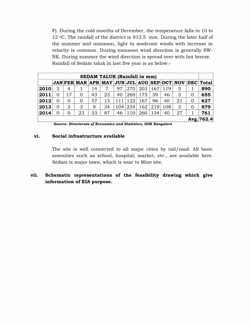
F). During the cold months of December, the temperature falls to 10 to12 oC. The rainfall of the district is 812.5 mm. During the later half ofthe summer and monsoon, light to moderate winds with increase invelocity is common. During monsoon wind direction is generally SW-NE. During summer the wind direction is spread over with hot breeze.Rainfall of Sedam taluk in last five year is as below:-
SEDAM TALUK (Rainfall in mm)JAN FEB MAR APR MAY JUN JUL AUG SEP OCT NOV DEC Total
2010 2 4 1 14 7 97 270 203 167 119 5 1 8902011 0 17 0 43 23 40 269 175 39 46 3 0 6552012 0 0 0 57 13 111 122 167 96 40 21 0 6272013 0 3 3 9 34 104 234 162 219 108 3 0 8792014 0 0 23 33 87 46 110 260 134 40 27 1 761
Avg.762.4Source: Directorate of Economics and Statistics, GOK Bangalore
vi. Social infrastructure available
The site is well connected to all major cities by rail/road. All basicamenities such as school, hospital, market, etc., are available here.Sedam is major town, which is near to Mine site.
vii. Schematic representations of the feasibility drawing which giveinformation of EIA purpose.

CHAPTER – 5PLANINIG BRIEF
5.0 Planning Brief
i. Planning concept (type of industries, facilities, transportationetc.,) town and country planning/development authorityclassification
DCBL proposes to set up a cement plant and the applied mine is acaptive source of major raw material (limestone). The surroundingregion of the project will be upgraded along with the implementationand operation of the project. All facilities such as transportation,communication etc. will be upgraded along with the implementationand operation of the project.
ii. Population projection
About 93 personnel of various skills will be deployed directly for theproposed mining. They will be mostly from nearby villages, only fewpeople coming from distant places shall be accommodated at thecolony proposed to be constructed within the plant premises. Inaddition to direct employment, many indirect employmentopportunities is envisaged to many more people, in the form ofcontractual jobs/works in business opportunities, service facilities,canteen, horticulture, house-keeping, building maintenance, rentalvehicles and grocery shops & utility stores etc. Moreover, employmentopportunities are created due to opening of sale depots, transport ofother raw materials, fuel, fly-ash & cement etc. This will upgrade theeconomic status of the region and people living therein.Because of local employment prospects, as above, migration of peoplefrom the nearby villages is minimized. However, for the sake ofpopulation projection, on the assumption that 50% of the populationof the employed are from distant places and shall reside in the plantcolony. The colony shall be equipped with all necessary infrastructurefacilities and shall not pose any significant additional burden on theexisting infrastructure facilities of the area. In addition, the existinginfrastructure facilities of the area, shall also be enhanced andstrengthened by various activities under socio-economic developmentprogram proposed by company.

Details of population as per 2011 census, in the immediate vicinity ofthe proposed project and population is projected by assumingGeometrical Progression method for post project scenario.
Assumption: - Incremental growth in population because of theproposed project considering the influx of people for employment andother allied services from distant places may be about 200 considering4 person per family. Facilities for employees shall be provided in thecolony whereas other migrants may settle in nearby villages.
The population at the end of nth decade ‘Pn’ can be estimated as perGeometrical Progression method:Pn = P (1+ IG/100) nWhere, IG = geometric mean (%)P = Present populationN = no. of decades.
Name Level Population(as per 2001
census)
Population(as per 2011
census)Taranhalli Village 616 691Arebommanhalli Village 806 848Beeranhalli Village 1146 1315Konkanhalli Village 1023 1004Hoshalli Village 689 704Neelhalli Village 954 1064
Total 5234 5626Population projectionYear 2001 2011 2021 2031 2041Population 5234 5626 6248 6717 7221Geometrical increase Rate of growth: 0.075
iii.Land use planning (breakup along with greenbelt etc.,)
The total lease area is 995.97 Ha out which 682.53 Ha will be utilizedand the rest 313.44 Ha will remain undisturbed.
Conceptually, an area of 235.30 Ha will be used for mining out of whichan area of 202.08 Ha at the bottom will be left as water reservoir. Anarea of about 200 Ha will be used for dumping of waste & top soil andwill be stabilized by suitable afforestation techniques, 42.71 Ha will beused for Mineral Storage/Sub grade, 2.70 Ha area will be used for roads,
2.60 ha area for infrastructure, 3.00 Ha area for crusher and 194.97 Haarea for green belt along safety zone and mine periphery. The rest 313.44Ha area will remain undisturbed
iv. Assessment of infrastructure demand (physical & social)
With the setup of the project, there will be requirement of varioussocial & physical infrastructure because of influx of people. Atownship will be constructed in plant premises for residence ofemployees. Infrastructural facilities will be common with the cementplant.Apart from the jobs, the company will provide medical and educationalfacilities to the employees which can also be availed by the peoplearound the plant. Adequate recreational facilities for the staff of thecompany and the local people will be created in the township.
v. Amenities / Facilities.
Infrastructural facilities will be common with the cement plant likeRest Shelter, canteen facility, Horticulturist office, Guesthouse,Environment Management Cell, Post Office, Telephone, Police outpostand Primary Health Center etc. The mine office with first aid rooms,rest shelters, toilets, tool/store room, Potable water for consumption,,Power supply, Workshop store etc., are proposed in the subjectedmining lease area.

CHAPTER – 6PROPOSED INFRASTRUCTURE
6.0 Proposed infrastructure
i. Industrial area (processing area)
Crusher will be located within the applied lease area.
All the services like site office, first aid station, rest shelter, drinkingwater, sanitation facilities and other amenities will be provided at themine site. The details are discussed in the following paras.
• Well-maintained office room for mine officials• Workshop will be provided in the mine lease.• Stores with essential spares for HEMM will be located within the
mining lease area.• First aid room at the mines site office, first aid boxes at rest
shelter and close to the workings will be provided. All thepersonnel engaged in the mining activity will be trained in firstaid.
The following site facilities shall be provided.
• Neat/clean and cool water for drinking will be provided at therest shelter for the workers.
• Workers and staff, accommodation will be created near to themine site.
• Water for drinking and domestic consumption at the mine willbe supplied from the cement plant.
• Fire tending arrangement will be provided at the mines siteoffice, with different types of extinguishers to deal will all kindsof fire like electrical, maintenance workshop and HEMMoperations.
• The vulnerable areas will be provided with fire alarms. Keypersons will be trained in firefighting.

ii. Residential area (non-processing area)
No residential area is proposed at mine. However, the operationalworkers will be accommodated in the residential colony which will bedeveloped in the plant premises.
iii. Greenbelt
Green belt over an area of 194.97 Ha will be developed along safetyzone and mine periphery. Besides this, an area of about 200 Ha ofdump area will be afforested with suitable afforestation techniques. Itis proposed to plant the Neem, Acacia nilotica, Agave Americana,Aglaia elaeagnoidea, Apluda mutica etc species in consultation withlocal Forest officials
iv. Social infrastructure
The mining activity carried out in the area will have a positive socio-economic impact upon the nearby human settlement as indirectemployment potential will be created due to mining and alliedactivities in the area. Apart from these, the company promotes healthand education awareness in the area time to time by organizing healthand education camps. The company will also take up various activitiesfor upliftment of the social infrastructure in consultation with localcommunities and regulatory bodies.
In addition DCBL will take various social welfare programmes in thesurrounding villages. The focus areas include:
Economic development (Self Help Groups) Drinking Water Sanitation Health & Hygiene Education & vocational training etc.
v. Connectivity (traffic and transportation road/ rail/ metro/water ways etc.,)
Road:
The deposit is well approachable by single lane asphalted road fromShettihuda to Arebommanhalli which is well connected with StateHighway No.10 which is about 0.2 km from the ML.
Railway Line
Sedam is the nearest railway station located at about 2.5 km towardsESE.
vi. Drinking water management (source & supply of water)
DCBL has obtained permission to draw 3,100 KLD water from KaginaRiver for the use of cement plant and allied activities.About 70 m3/day of water is required for domestic, workshop, greenbelt & dust suppression of the mines. Water will be taken from cementplant which will in turn withdraw water from Kagina river. Later, afterthe development of the mine Pits, the rain water harvested in the minepit, will augment the water requirement from the plant.
vii. Sewerage system
Domestic waste water from mines office will be treated in septic tankfollowed by soak pit.
viii. Industrial waste management
Not Applicable
ix. Solid waste management
The total quantity of Top soil and waste generated during the life ofmine is about 8.12 million tonnes and about 30.16 million tonnesrespectively which will be separately dumped on designated places onwestern and eastern side in the mine lease
Top soil will be utilized for filling up in the low lying area and partquantity will be dumped along the lease boundary for plantation.

Further an area of about 200 Ha will be utilized for top soil stacking,waste dumping and 42.71 Ha will be utilized for Sub grade stacking atthe Conceptual period.
Dust generation from the dump will not be happened due to highspecific gravity of the waste material and regular water spray. Theproper terracing will be done along dump slopes to provide betterslope stability and planted with grasses, legumes etc. to arrest soilerosion to a great extent. Garland drains will be made all along theperiphery of dump sites to prevent the water carrying the wash-offsfrom the dumps entering into the mines.
x. Power requirement & supply / source.
About 0.5 MW power shall be required for illumination and otheractivities which shall be met from the interlinked cement plant/CPP &Grid. Provision of D.G. Set is also envisaged for emergency power.

CHAPTER – 7REHABILITATION AND RESETTLEMENT (R & R) PLAN
7.0 Rehabilitation and resettlement (R & R) Plan
i. Policy to be adopted (central / state) in respect of the projectaffected persons including home oustees, land oustees andlandless labourers (a brief out line to be given).
The mine area does not cover any habitation. Hence the miningactivities do not involve any displacement of human settlement. Nopublic buildings, places, monuments etc., exist within the lease areaor in the vicinity. The mining operations will not disturb/relocate anyvillage. However, the land oustees will be enumerated andcompensation will be paid as per the Govt. Policy.Land prices were jointly fixed by DCBL under the leadership of Localeminent people of the society, local party leaders, & otherrepresentatives from land owners and accordingly lands were and willbe purchased with the knowledge of all concerned and in line with thedifferent policies & acts issued from time to time, DCBL agreed to paysignificantly higher price than the market rate prevailing at the time.Besides, the company will formulate and implement different plansunder which benefits will be given to land oustees on priority and alsoextended to other local residents of the surrounding villages such asdirect employment, other income generating activities directly andindirectly, contracts and other tangible benefits under the followingheads:-
A. Vocational Training for Youths/Self EmploymentB. Educational FacilitiesC. Medical FacilitiesD. Welfare Scheme for the People of the Local AreaE. Infrastructure Facility Development of the AreaF. Community Development/Social welfare Schemes

CHAPTER – 8PROJECT SCHEDULE & COST ESTIMATES
8.0 Project schedule & Cost Estimates
i. Likely date of start of construction and likely date ofcompletion (time schedule for the project to be given).
The mine is scheduled to be executed by February 2017 after gettingEC, CTE and all other regulatory clearances. Life of the mine @ 4.00million tonnes per annum for the mineable reserves of 124.8 milliontonnes would be 34 years. The life of the mine may increase afterfurther exploration.
ii. Estimated project cost along with analysis in terms ofeconomic viability of the project.
The estimated project cost is about Rs. 165 Crores including landcost.

CHAPTER – 9ANALYSIS OF PROPOSAL (FINAL RECOMMENDATIONS)
9.0 Analysis of proposal (Final Recommendations)
i. Financial and social benefits with special emphasis on the benefitto the local people including tribal population, if any, in the area.
Economic development of the region depends largely upon the natureof activities undertaken in the surrounding region. Corporatedevelopment invariably contributes towards acceleration of theprocess of socio-economic upliftment of the rural society by meansof employment, health & study programme, medical camps etc.,
Employment: As this will be the green field project by DCBL, so theemployment of the technical personnel will be required for plant andmines. The locals of the area will be benefited for the employmentdirectly and indirectly. The mine is proposed to be operated by fullymechanised conventional method. Total direct employment envisagedfrom the proposed mine is about 93 persons.
Further, there would be a lot of indirect employment opportunitiesarising due to the proposed cement project.
The establishment of the cement plant and proposed captive minewould aid in the overall social and economic development of theregion. The plant and mine, in addition to direct employment, wouldalso provide indirect employment opportunities to many more people,in the form of contractual jobs/works in business opportunities,service facilities, canteen, horticulture, house-keeping, buildingmaintenance, rental vehicles and grocery shops & utility stores etc.Moreover, employment opportunities are created due to opening ofsale depots, transport of other raw materials, fuel, fly-ash & cementetc. This will upgrade the economic status of the region and peopleliving therein.
Medical facilities: Medical facilities will be provided for employee aswell as people of nearby villages.

Educational facilities: Basic educational and vocational trainingfacilities will be provided for the children of employees as well asvillagers from nearby villages.
Infrastructure facilities: Approach roads will be developed at parwith plants roads

TABLE - 1SALIENT FEATURES OF THE MINING LEASE AREA
Feature DetailsAltitude 401-424 m above msl
Longitude & Latitude North Latitude : 17°11'17"N - 17°13'00"East Longitude : 77°12'00"E - 77°16'00"
Village, Tehsil,District, State
Beeranahalli, Arebammanahalli, Konkanahalli,Taranahalli & Sedam Villages, Sedam Taluk, Kalaburagi(Gulburga) District, Karnataka.
Max. Temp. 0C 45.5
Min. Temp. 0C 6.1Relative Humidity % 23 - 82Annual rainfall 812.5 mmIMD STATION Hyderabad/GulbargaDistrict Head Quarters Bidar – 83.5km - NNELand Availability 995.97 haTopography Gently UndulatedSoil Type Sandy loam
Nearest River Kagna River - 0.2 km - NBenithora River -4.6 km – W
Nearest Highway
National Highway (NH-9) connecting Hyderabad – Solapur– 58.5 km – NNE direction.State Highway (SH-10) connecting Sedam - Malkhed - 0.2km – S direction.
Nearest Railwaystation Sedam RS – 2.5km - ESE
Nearest National Parks Chincholi Wild life sanctuary – 45.0 km - NE
Nearest Industries Vasavadatta Cement Factory – 3.6 km – SERajashree Cement Limited – 7.8 km – SW
Inter State Boundary Karnataka - Telangana– 12.3 km – E
Nearest Village
Beeranahalli – 0.2 km – NArebammanahalli – 0.1 km –NTaranhalli – 0.5 km – ESettihudo – 0.1 km –WKonakanhalli – 0.7 km –S
Nearest Air portBegumpet Airport – 130.0 km - ENEShamshabad International Airport – 122.0 km – EBelgaum AirPort – 316.0 km – SW
Nearest Forest None Within 10km radius
Historical places None within 10 km* All distances mentioned in the above table are aerial distances.

Annexure – 1