pppppppppppppppppppppppppppppppppppppppppppppppppp...
22
• • • • • PART 3 REGIONAL AND DISTRICT RULES»Chapter K: Precinct rules»6 South» 6.25 Takanini The activities, controls and assessment criteria in the relevant underlying zones and Aucklandwide rules apply in the following precinct and subprecincts unless otherwise specified. Refer to Takanini Precinct Plan 1 for the location and extent of the precinct and subprecincts. Introduction The underlying zones for the subprecincts are: subprecinct A Light Industry, Mixed Housing and Public Open Space Informal Recreation zones subprecinct B Local Centre zone subprecinct C Mixed Use zone subprecinct D Mixed Housing zone subprecinct E Single House zone. The Papakura Military Camp encompasses LOT 1 DP 329779 SECS 14 SO 317074, PT LOT 1 DP 168748 SECS 34 SO 70474 and PT LOT 1 DP 170957 1. Activity table The activities in the relevant underlying zones apply in the Takanini precinct unless otherwise specified in the activity table below. Activity Sub precinct A Sub precinct B Sub precinct C Sub precinct D Sub precinct E Any activity with vehicle access from road frontages marked as vehicle access restriction in Takanini Precinct Plan 1 RD NA RD RD RD Development The modification of the indicative overland flowpaths depicted on Takanini Precinct Plan 1 RD NA NA NA NA A framework plan, amendments to an approved framework plan, or a replacement framework plan complying with clause 3 below, provided that in sub precinct B the total GFA for commercial activities in the subprecinct will not exceed 10,000m 2 NA RD NA RD RD A framework plan, amendments to an approved framework plan, or a replacement framework plan not complying with clause 3 below, or that would result in a total GFA for commercial activities in excess of 10,000m 2 in subprecinct B NA NC NA NC NC Any development in compliance with an approved framework plan NA RD NA RD RD Any development not in compliance with an approved framework plan, or prior to the approval of a framework plan NA NC NA NC NC Commerce The Proposed Auckland Unitary Plan (notified 30 September 2013) Page 1 of 22 ████████████ ████████████ ████████████ ████████████ ████████████ ████████████ ████████████ ████████████ ████████████ ████████████ ████████████ ████████████ ████████████ ████████████ ████████████ ████████████ ██████████████████████████████████████████████████ ██████████████████████████████████████████████████
-
Upload
trannguyet -
Category
Documents
-
view
218 -
download
0
Transcript of pppppppppppppppppppppppppppppppppppppppppppppppppp...
•
•
•
•
•
PART 3 REGIONAL AND DISTRICT RULES»Chapter K: Precinct rules»6 South»
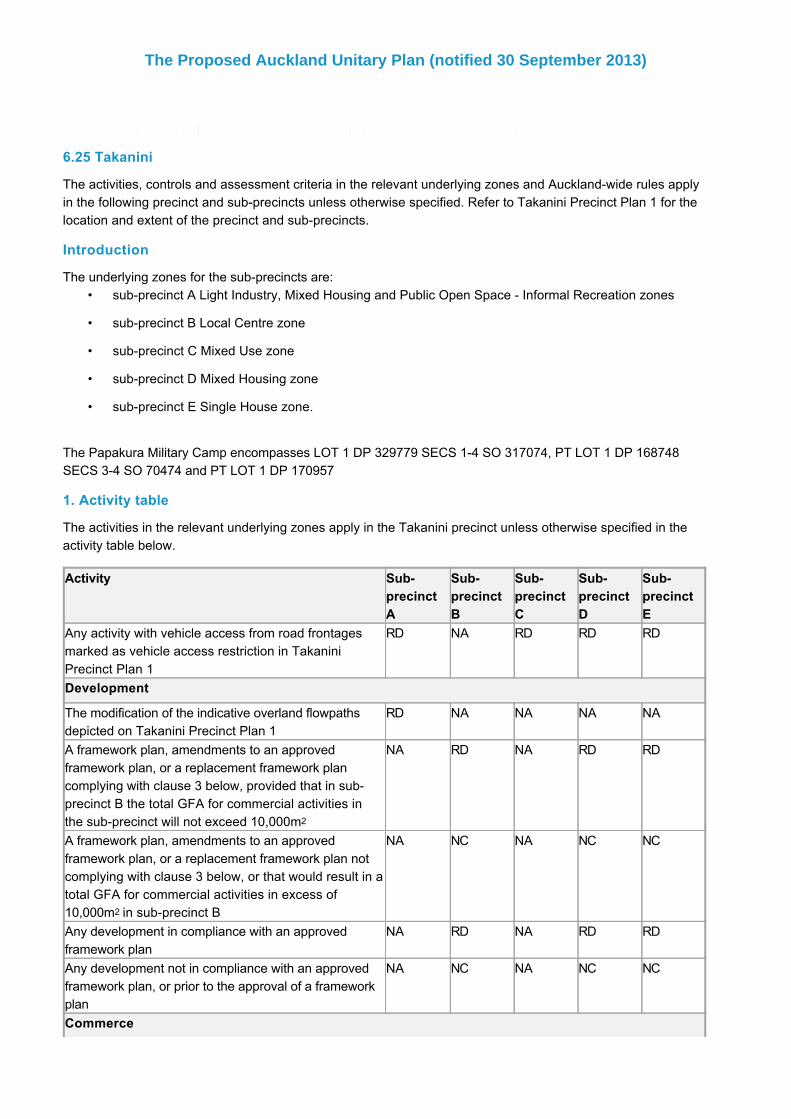
6.25 Takanini
The activities, controls and assessment criteria in the relevant underlying zones and Aucklandwide rules applyin the following precinct and subprecincts unless otherwise specified. Refer to Takanini Precinct Plan 1 for thelocation and extent of the precinct and subprecincts.
Introduction
The underlying zones for the subprecincts are:subprecinct A Light Industry, Mixed Housing and Public Open Space Informal Recreation zones
subprecinct B Local Centre zone
subprecinct C Mixed Use zone
subprecinct D Mixed Housing zone
subprecinct E Single House zone.
The Papakura Military Camp encompasses LOT 1 DP 329779 SECS 14 SO 317074, PT LOT 1 DP 168748SECS 34 SO 70474 and PT LOT 1 DP 170957
1. Activity table
The activities in the relevant underlying zones apply in the Takanini precinct unless otherwise specified in theactivity table below.
Activity SubprecinctA
SubprecinctB
SubprecinctC
SubprecinctD
SubprecinctE
Any activity with vehicle access from road frontagesmarked as vehicle access restriction in TakaniniPrecinct Plan 1
RD NA RD RD RD
Development
The modification of the indicative overland flowpathsdepicted on Takanini Precinct Plan 1
RD NA NA NA NA
A framework plan, amendments to an approvedframework plan, or a replacement framework plancomplying with clause 3 below, provided that in subprecinct B the total GFA for commercial activities inthe subprecinct will not exceed 10,000m2
NA RD NA RD RD
A framework plan, amendments to an approvedframework plan, or a replacement framework plan notcomplying with clause 3 below, or that would result in atotal GFA for commercial activities in excess of10,000m2 in subprecinct B
NA NC NA NC NC
Any development in compliance with an approvedframework plan
NA RD NA RD RD
Any development not in compliance with an approvedframework plan, or prior to the approval of a frameworkplan
NA NC NA NC NC
Commerce
The Proposed Auckland Unitary Plan (notified 30 September 2013)
Page 1 of 22

One supermarket up to 3500m2 GFA NA C NA NA NA
One service station NA C NC NA NA
Retail greater than 450m2 per site NA NC NA NA NA
Commercial activities that will result in the cumulativetotal GFA for the subprecinct exceeding 10,000m2
NA NC NA NA NA
In Area 1 of subprecinct C (Takanini Precinct Plan 3),retail greater than 1000m2 GFA per premise, notexceeding a total GFA for Area 1 of 11,000m2
NA NA P NA NA
In Area 1 of subprecinct C (Takanini Precinct Plan 3),retail greater than 1000m2 GFA per premise in Area 1of subprecinct C, exceeding a total GFA for Area 1 of11,000m2
NA NA NC NA NA
Retail greater than 1000m2 GFA per premise,exceeding a total GFA for the subprecinct of 11,000m2
NA NA NC NA NA
Retail no greater than 3,500m2 GFA in Area 2 of subprecinct C (Takanini Precinct Plan 3) provided that themaximum GFA of any individual retail activity withinArea 2 shall be limited to 250m2, but with theexception of one individual retail activity of up to 1,000m2
NA NA P NA NA
Retail in Area 2 of subprecinct C (Takanini PrecinctPlan 3) which: a. provides retail greater than 3,500m2 GFA, orb. involves individual retail activity exceeding the 250m2
limit, orc. otherwise does not fall within the exception for oneindividual retail activity of up to 1,000 m2
NA NA NC NA NA
Retail within 10m of the Arion Road frontage with aGFA not exceeding 250m2 per premise
NA NA P NA NA
Retail within 10m of the Arion Road frontage with aGFA exceeding 250m2 per premise
NA NA NC NA NA
Subdivision
Subdivision that is in compliance with TakaniniPrecinct Plan 1, and (in subprecinct A) TakaniniPrecinct Plan 2
RD NA NA RD RD
Subdivision not in compliance with Takanini PrecinctPlan 1, or (in subprecinct A) Takanini Precinct Plan 2
NC NA NA NC NC
A framework plan, amendments to an approvedframework plan, or a replacement framework plancomplying with clause 3 below
NA RD NA RD RD
A framework plan, amendments to an approvedframework plan, or a replacement framework plan notcomplying with clause 3 below
NA NC NA NC NC
Any subdivision in compliance with an approvedframework plan
NA RD NA RD RD
Any subdivision not in compliance with an approvedframework plan, or prior to the approval of a frameworkplan
NA NC NA NC NC
2. Notification
The Proposed Auckland Unitary Plan (notified 30 September 2013)
Page 2 of 22

1. Council will consider restricted discretionary resource consent applications for framework plans for subprecincts B, D and E (including amendments to any approved framework plan or replacementframework plans) without the need for public notification. However, limited notification may beundertaken, including notice being given to any owner of land within the subprecinct(s) who has notprovided their written approval.
The Proposed Auckland Unitary Plan (notified 30 September 2013)
Page 3 of 22

1.
a.
b.
c.i.
ii.
iii.
d.i.
ii.
iii.
iv.
e.i.
ii.
iii.
1.
2.
a.
b.
3.
1.
2.
3. Framework Plans
A resource consent application for a framework plan, amendments to a framework plan, or areplacement framework plan must:
apply only to land within subprecinct B, D or E that the applicant is the owner of, or to sites inmultiple ownership where the landowners in either of those subprecincts make a joint application.
implement Takanini Precinct Plan 1.
comply with:the general rules and information requirements applying to framework plans specified atclause 2.6 General Provisions
the special information requirements for framework plans specified in clause 2.7.3 GeneralProvisions
any relevant controls in this precinct.
in respect of development, seek consent for the following land uses:the design and location of roads
the layout of buildings
the location of public open space
landscaping.
in respect of subdivision, demonstrate:in geotechnical terms, that it will create sites suitable for the development of a permittedactivity or an activity for which resource consent has been obtained
that it will be consistent with the recommendations of the approved Stormwater CatchmentManagement Plan for the area, or an approved discharge consent
in relation to subprecinct B, that direct vehicle access to any new site from the proposedeastwest link road between Porchester and Takanini School Roads, or from PorchesterRoad itself can be provided for.
4. Development controls
The development controls in the relevant underlying zones apply in the Takanini precinct and subprecinctsunless otherwise specified below.
4.1 Building height
Buildings within subprecinct B must not exceed 12m in height.
Within the Papakura Military Camp Height Restriction Area development must comply with thefollowing controls:
Buildings must not exceed 9 metres in height
The maximum upperfloor floorlevel of any building shall be 3.8 metres above natural ground level(the surveyed Reduced Level predevelopment).
Any development within the Papakura Military Camp Height Restriction Area that cannot comply withthe above clause is a noncomplying activity.
4.2 Yards
Subprecinct E – landscape strip
Each new site adjacent to PapakuraClevedon Road in subprecinct E must provide in compliance with
The Proposed Auckland Unitary Plan (notified 30 September 2013)
Page 4 of 22
3.a.
b.
c.
d.
1.
2.
1.a.
b.
c.
d.
2.
3.
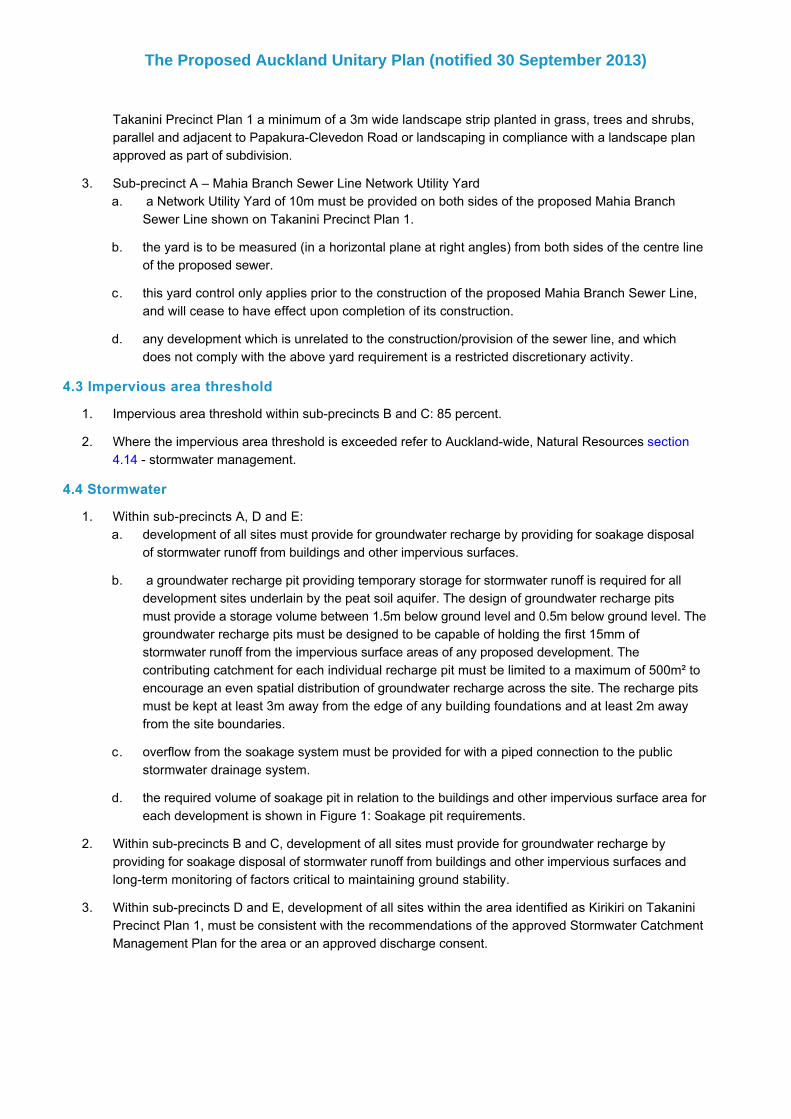
Takanini Precinct Plan 1 a minimum of a 3m wide landscape strip planted in grass, trees and shrubs,parallel and adjacent to PapakuraClevedon Road or landscaping in compliance with a landscape planapproved as part of subdivision.
Subprecinct A – Mahia Branch Sewer Line Network Utility Yard a Network Utility Yard of 10m must be provided on both sides of the proposed Mahia BranchSewer Line shown on Takanini Precinct Plan 1.
the yard is to be measured (in a horizontal plane at right angles) from both sides of the centre lineof the proposed sewer.
this yard control only applies prior to the construction of the proposed Mahia Branch Sewer Line,and will cease to have effect upon completion of its construction.
any development which is unrelated to the construction/provision of the sewer line, and whichdoes not comply with the above yard requirement is a restricted discretionary activity.
4.3 Impervious area threshold
Impervious area threshold within subprecincts B and C: 85 percent.
Where the impervious area threshold is exceeded refer to Aucklandwide, Natural Resources section4.14 stormwater management.
4.4 Stormwater
Within subprecincts A, D and E:development of all sites must provide for groundwater recharge by providing for soakage disposalof stormwater runoff from buildings and other impervious surfaces.
a groundwater recharge pit providing temporary storage for stormwater runoff is required for alldevelopment sites underlain by the peat soil aquifer. The design of groundwater recharge pitsmust provide a storage volume between 1.5m below ground level and 0.5m below ground level. Thegroundwater recharge pits must be designed to be capable of holding the first 15mm ofstormwater runoff from the impervious surface areas of any proposed development. Thecontributing catchment for each individual recharge pit must be limited to a maximum of 500m² toencourage an even spatial distribution of groundwater recharge across the site. The recharge pitsmust be kept at least 3m away from the edge of any building foundations and at least 2m awayfrom the site boundaries.
overflow from the soakage system must be provided for with a piped connection to the publicstormwater drainage system.
the required volume of soakage pit in relation to the buildings and other impervious surface area foreach development is shown in Figure 1: Soakage pit requirements.
Within subprecincts B and C, development of all sites must provide for groundwater recharge byproviding for soakage disposal of stormwater runoff from buildings and other impervious surfaces andlongterm monitoring of factors critical to maintaining ground stability.
Within subprecincts D and E, development of all sites within the area identified as Kirikiri on TakaniniPrecinct Plan 1, must be consistent with the recommendations of the approved Stormwater CatchmentManagement Plan for the area or an approved discharge consent.
The Proposed Auckland Unitary Plan (notified 30 September 2013)
Page 5 of 22

1.
a.
b.
c.
2.
3.
1.
Figure 1: Soakage pit requirements
4.5 Fences
The following controls apply to the land adjoining Transpower’s Electricity Substation shown in TakaniniPrecinct Plan 1 as subject to environmental noise constraints:
a solid fence is to be erected and maintained along the full length of the common boundary withTranspower’s Electricity Substation at 65 Airfield Road and the land shown in Takanini PrecinctPlan 1.
the fence is to be a minimum standard of 1.8m in height, without gaps and of a minimumthickness of either 20mm boarded and battened timber, or 9mm fibre cement, or other materialhaving equivalent acoustic performance.
evidence that the fence has been erected and maintained is to be provided to (and required by)council prior to the grant of any building consent for any building containing a habitable room.
Any development not complying with the above clause is a noncomplying activity.
Fences on the PapakuraClevedon Road boundary must be constructed of visually permeable materialsand must not exceed 1.8m in height.
4.6 Noise
The following controls apply to the land adjoining Transpower’s Electricity Substation shown in TakaniniPrecinct Plan 1 as subject to environmental noise constraints:
The Proposed Auckland Unitary Plan (notified 30 September 2013)
Page 6 of 22

a.
b.
c.
d.
2.
1.
2.
1.a.
b.
c.
d.
All buildings with habitable rooms are to be designed and constructed so that the noise level in allhabitable rooms must not exceed a level of 30dBA L10 (includes 5 decibel adjustment for tonalcomponent as provided for in New Zealand Standard NZS6802:1991 “Assessment ofEnvironmental Sound”), with any required ventilation system (including windows) in operation. Allmeasures to achieve this standard are to meet the provisions of the New Zealand Building Code.
At the time of lodging a Building Consent Application with the Council, a certificate from a suitablequalified and experienced acoustic consultant is to be provided to the Council stating that, inrespect of all habitable rooms, the buildings will achieve the acoustic performance specified insubclause a. above. If that certificate states that the building will achieve the acousticperformance without any special modifications, the certificate may also state that further testingunder subclause c. below is not required.
Prior to occupation of habitable rooms, representative testing of the rooms is to be undertaken bya suitably qualified and experienced acoustic consultant to confirm that the design criterion of30dBA L10 is being met (unless it has been certified under subclause b. above that further testingis not required), with any required ventilation system (including windows) in operation. Noise levelsfrom any mechanical ventilation system shall be measured at least 1m away from any diffuser.
Where the results of any testing carried out in the preceding condition demonstrates that the30dBA L10 criterion is not achieved, remedial action must be undertaken such that the criterion ismet and compliance subsequently is to be certified in compliance with subclause c. above prior tothe occupation of the building or the transfer of ownership of the building, whichever occurs first.
Any development not complying with the above clause is a noncomplying activity.
4.7 Landscaping and planting in subprecinct A
Development in subprecinct A must comply with the landscape plan in Takanini Precinct Plan 2.
Any development not complying with the above clause is a noncomplying activity.
5. Subdivision controls
The subdivision controls in the Auckland wide rules – subdivision apply in the Takanini precinct and subprecincts unless otherwise specified below.
Subprecinct A – Mahia Branch Sewer Line Network Utility Yarda Network Utility Yard of 10m must be provided on both sides of the proposed Mahia BranchSewer Line shown on Takanini Precinct Plan 1.
the yard is to be measured (in a horizontal plane at right angles) from both sides of the centre lineof the proposed sewer.
this yard control only applies prior to the construction of the proposed Mahia Branch Sewer Line,and will cease to have effect upon completion of its construction.
any part of a proposed lot (other than a lot created for a road, service lane, or reserve) that isunrelated to the construction/provision of the sewer line, and which lies partly or wholly within theMahia Branch Sewer Line Network Utility Yard is a restricted discretionary activity.
The Proposed Auckland Unitary Plan (notified 30 September 2013)
Page 7 of 22

1.
1.
2.a.
b.
3.a.
i.
ii.
iii.
iv.
4.a.
5.a.
6. Assessment Controlled activities
6.1 Matters of controlThe council will reserve its control over the matters below for the activities listed as controlled in theprecinct activity table:
Table 1
Activity/Mattersof control
Intensity andscale
Traffic Noise, lightingand hours ofoperation
Design of carparking, accessand servicing
Pedestrianaccess andvehicle linkages
One supermarketup to 3500m2
GFA
X X X X X
One servicestation
X X X X
6.2 Assessment criteriaIn addition to the assessment criteria for supermarkets and service stations in clauses 6 and 8 of the Businesszone rules, the following assessment criteria apply.
Intensity and scale of the activity
The intensity and scale of the land use activity, in particular, the number of people involved and traffic generatedby the activity, should be compatible with the planned future form and character of the surrounding area.
TrafficThe expected traffic generated by the activity should not create adverse effects on the surroundingtransport network, particularly at peak times. Adverse effects may be mitigated by upgrades toroad and intersection design, but activities likely to generate high volumes of traffic are notencouraged on local roads.
The potential conflict between circulating service traffic, heavy traffic movements, general traffic,pedestrians and cyclists should be managed.
Noise, lighting and hours of operationNoise and lighting from the activity should not adversely affect the amenity of surroundingresidential properties. In determining this, consideration will be given to the location of anypotentially noisy activities and any proposed measures to mitigate noise including:
locating noisy activities away from neighbouring residential boundaries
screening or other design features
the proposed hours of operation
the times of goods deliveries.
Design of car parking, access and servicingThe assessment criteria in clause 3.3 of the Aucklandwide Transport rules apply.
Pedestrian access and vehicle linkagesThe site design should provide for pedestrian access and vehicle linkages between thesupermarket, its car parking and the balance of the subprecinct.
7. Assessment Restricted discretionary activities
7.1 Matters of discretionThe council will restrict its discretion to the matters below for the restricted discretionary activities in theprecinct activity table, in addition to any matters specified for the activity in the underlying zones or Aucklandwide rules:
The Proposed Auckland Unitary Plan (notified 30 September 2013)
Page 8 of 22

1.a.
2.a.
3.a.
b.
c.
d.
e.
f.
g.
h.
i.
4.a.
b.
c.
d.
e.
f.
g.
5.a.
6.a.
7.a.
b.
8.a.
9.
Vehicle access restrictionthe matters in clause 3.4.1 Aucklandwide Transport rules.
Modification of indicative flow pathsdesign, location and operation of overland flowpaths.
Framework plans within subprecinct B that set out:layout and design of streets in the subprecinct
location of main retail streets in the Local Centre zone and the identification of key frontageswhere verandahs will be provided
location of activities
location of public open space and design principles
landscaping
relationship of buildings, open space, streets and the ability to accommodate land uses providedfor in the underlying zoning
staging of development and subdivision
the provision of infrastructure
the general matters of discretion for framework plans in clause 2.6.5 General Provisions alsoapply.
Framework plans within subprecincts D and E that set out:layout and design of streets in the subprecinct
location of public open space and design principles
landscaping
relationship of buildings, open space, streets and the ability to accommodate land uses providedfor in the underlying zoning
staging of development and subdivision
the provision of infrastructure
the general matters of discretion for framework plans in clause 2.6.5 General Provisions alsoapply.
Subdivision in compliance with Takanini Precinct Plan 1geotechnical.
Subdivision in compliance with Takanini Precinct Plan 2 (for subprecinct A)landscaping and planting.
Subdivision in compliance with an approved framework plan in subprecincts B, D and Egeotechnical
stormwater and catchment management.
Subdivision in compliance with an approved framework plan in subprecinct Bvehicle access.
Development in compliance with an approved framework plan
When considering a restricted discretionary resource consent application for development that complies with anapproved framework plan, the council will restrict its discretion to the matters set out for the activity in the
The Proposed Auckland Unitary Plan (notified 30 September 2013)
Page 9 of 22

1.a.
2.a.
b.
c.
d.
e.
3.a.
i.
•
•
•
•
ii.
•
iii.•
•
iv.•
underlying zone, precinct or Aucklandwide rules.
7.2 Assessment criteriaThe following assessment criteria apply in addition to the criteria specified for the relevant restricteddiscretionary activities in the underlying zone or Aucklandwide rules:
Vehicle access restrictionrefer to the assessment criteria in clause 5.2.6 Aucklandwide (Infrastructure) Transport.
Modification of indicative flowpathsthe overland flowpaths should be capable of adequately accommodating events up to the 1 in 100year ARI in compliance with the Catchment Management Plan.
any modification(s) to the indicative overland flowpaths should have a less than minor impact onthe downstream and upstream properties in terms of increased flood hazards and erosionpotential.
sites in the upstream and downstream catchment should have the ability to continue to provide forthe overland flowpaths in terms of reasonable engineering efforts, constructability and ease ofmaintenance and operation of the overland flowpaths.
activities should not obstruct the overland flowpaths.
any modification(s) to the general alignment of the overland flowpaths should be limited to theboundaries of the properties included in the resource consent application.
Framework plans in subprecinct B which provide for the following:layout and design of streets in the subprecinct
any potential conflict between circulating service traffic, heavy traffic movements, generaltraffic, pedestrians and cyclists should be managed through the layout and design of streets.
provide for safe pedestrian and vehicular access
ensure adequate connections are provided to adjoining land, particularly the eastwestlink road that will bisect the subprecinct to connect Porchester Road
facilitate the creation of a strip shopping environment in the Local Centre zone
facilitate the efficient provision of public transport services within the subprecinct andaccommodate bus stops.
Location of main retail streets in the Local Centre zone and the identification of key frontages whereverandahs will be provided
The location of the main retail streets should facilitate the creation of convenient and safepedestrian environments with high amenity values.
Location of activitiesThe interrelationship between commercial activities and residential activities within the subprecinct and the adjoining land should avoid conflict between activities.
The mix of activities should achieve a compact retail, commercial and community focused centrethat will provide for the daytoday needs of residents in subprecinct D.
Location of public open space and designProvision should be made for high quality public open space, including communal open spaces,seating areas, or similar facilities that enhance the community focus of the subprecinct.
visibility and accessibility of public open space
integration with surrounding development
appropriate sizing and features to meet community and neighbourhood needs Landscaping
The Proposed Auckland Unitary Plan (notified 30 September 2013)
Page 10 of 22

v.•
•
•
•
vi.
•
•
•
•
vii.
viii.•
•
ix.•
4.a.
i.
ii.
b.i.
ii.•
•
maintenance requirements.
LandscapingThe landscaping concept plan should be designed to create visual interest and contribute to theamenities of the area.
The landscaping should be integrated throughout the subprecinct and complement thelandscaping in the surrounding subprecinct D and Bruce Pulman Park.
The species proposed should take into account the longterm maintenance requirements andrelationship to infrastructure.
The landscaping should provide for both winter sun and summer shade.
Relationship of buildings, open space, streets and the ability to accommodate land uses provided for inthe underlying zoning
The street layout should create sites that can accommodate land uses provided for in theunderlying zoning and subprecinct.
The layout of buildings should meet relevant land use and development controls.
A coherent spatial structure should be formed by the relationship of buildings to the street, and,one building to another, and to the street
Consideration should be given to Crime Prevention Through Environmental Design (CPTED)principles, particularly for the design of streets, car parks, public open space and indicativebuilding layouts.
Staging of development and subdivisionThe potential adverse effects of any staging of subdivision and/or development should besatisfactorily avoided, remedied or mitigated.
Provision of infrastructureThe design of water, wastewater and stormwater services should be adequate to service the futuredevelopment in the subprecinct.
Stormwater management should meet the requirements of the stormwater catchmentmanagement plan and network discharge consent.
Generalthe general assessment criteria for framework plans in clause 2.6.6 of the General Provisionsalso apply.
Framework plans within subprecincts D and E:Layout and design of streets in the subprecinct
Street layout and design should provide for safe pedestrian and vehicle access.
Street layout should facilitate the efficient provision of public transport services within thesubprecinct and accommodate bus stops.
Location of public open space and designProvision should be made for high quality public open space, including communal openspaces, seating areas, or similar facilities that enhance the community focus of the subprecinct.
The design principles for public open space should adequately address the following matters:visibility and accessibility of public open space
integration with surrounding development
The Proposed Auckland Unitary Plan (notified 30 September 2013)
Page 11 of 22

•
•
iii.•
•
•
•
iv.
•
•
•
v.•
vi.
vii.•
5.a.
i.
6.a.
i.•
•
•
•
appropriate sizing and features to meet community and neighbourhood needs
maintenance requirements.
LandscapingThe landscaping concept plan should be designed to create visual interest and contribute to theamenities of the area.
The landscaping should be integrated throughout the subprecinct and complement thelandscaping in the adjacent mixed housing suburban and public open space zones.
The species proposed should take into account the longterm maintenance requirements andrelationship to infrastructure.
The landscaping should provide for both winter sun and summer shade.
Relationship of buildings, open space, streets and the ability to accommodate land uses provided for inthe underlying zoning
The street layout should create sites that can accommodate land uses provided for in theunderlying zoning and subprecinct.
The indicative layout of buildings should meet relevant land use and development controls.
A coherent spatial structure should be formed by the relationship of buildings to the street, and,one building to another, and to the street
Staging of development and subdivisionThe potential adverse effects of any staging of subdivision and/or development should besatisfactorily avoided, remedied or mitigated.
Provision of infrastructure The design of water, wastewater and stormwater services should be adequate to service the futuredevelopment in the subprecinct.
Stormwater management should meet the requirements of the stormwater catchmentmanagement plan and network discharge consent.
Generalthe general assessment criteria for framework plans in clause 2.6.6 General Provisions alsoapply.
Subdivision in compliance with Takanini Precinct Plan 1Geotechnical
It should be demonstrated that the subdivision will create sites that are suitable for thedevelopment of a permitted activity or an activity for which resource consent has beenobtained.
Subdivision in compliance with Takanini Precinct Plan 2 (for subprecinct A)Landscaping and planting
The following matters should be addressed:Provision of footpaths on each side of any proposed street, connecting with widerwalking and cycling networks;
Provision of cycle lanes where provided for as part of the Papakura Walking and CycleNetwork;
Provision of street lighting;
Provision of trees and other vegetation within the public realm, which assist to adddefinition and amenity value to the area;
The Proposed Auckland Unitary Plan (notified 30 September 2013)
Page 12 of 22
•
•
•
•
7.a.
i.
ii.•
8.a.
i.
Location of main pedestrian entries and openings within industrial buildings to belocated so as to be clearly visible from public streets, particular where a finer grainresidential character exists on the other road side;
The extent to which existing trees are incorporated into any proposed development orsubdivision to either enhance the amenity of the site and/or not compromise theamenity of the surrounding area;
Where the interface is with the open space surrounding Papakura Stream, demonstratea programme for establishment of native species forming a strong connection with thestormwater basin and aiding in visual mitigation of proposed built form;
Have regard to any landscape concept plans for adjoining land.
Subdivision in compliance with any approved framework plan in subprecincts B and EGeotechnical
It should be demonstrated that the subdivision will create sites that are suitable for thedevelopment of a permitted activity or an activity for which resource consent has beenobtained.
Stormwater catchment managementIt should be demonstrated that the subdivision will be consistent with the recommendations of theapproved Stormwater Catchment Management Plan for the area, or an approved dischargeconsent.
Subdivision in compliance with any approved framework plan in subprecinct BVehicle access
Direct vehicle access to any new site from the proposed eastwest link road betweenPorchester Road and Takanini School Road, or from Porchester Road itself, should beconsistent with an approved framework plan.
8. Assessment Development control infringements
8.1 Matters of discretionIn addition to the matters set out in clause 2.3 General Provisions and the specific matters set out for theinfringement in the relevant underlying zone, the council will restrict its discretion to the matters below for therelevant development or subdivision control infringement.
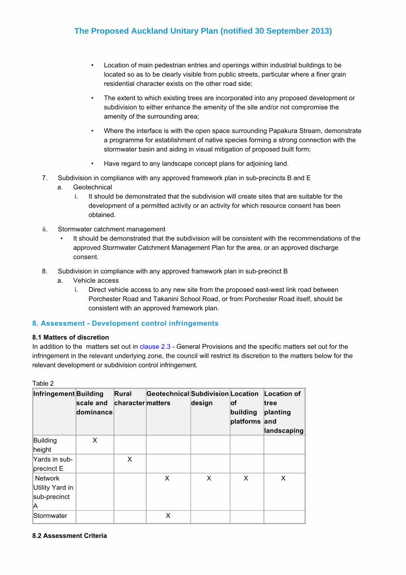
Table 2
Infringement Buildingscale anddominance
Ruralcharacter
Geotechnicalmatters
Subdivisiondesign
Locationofbuildingplatforms
Location oftreeplantingandlandscaping
Buildingheight
X
Yards in subprecinct E
X
NetworkUtility Yard insubprecinctA
X X X X
Stormwater X
8.2 Assessment Criteria
The Proposed Auckland Unitary Plan (notified 30 September 2013)
Page 13 of 22

1.a.
i.
ii.
b.
c.
2.a.
i.
ii.
iii.
iv.
b.
i.
ii.
c.
d.
3.a.
i.
ii.
b.i.
In addition to the general assessment criteria in clause 2.3 General Provisions and the specific assessmentcriteria for the infringement in the relevant underlying zone, the council will consider the relevant assessmentcriteria below for the infringement listed.
Building scale and dominanceThe height, location and design of the building should allow reasonable sunlight and daylightaccess to:
adjoining sites, particularly those with residential uses
streets and public open spaces.
The building should demonstrate that the additional height is appropriate in the location andmakes a positive contribution to the streetscape.
The building should not be visually dominating when viewed from the street, neighbouring sites,public open spaces and distant locations.
Rural characterDevelopment that does not comply with the yards will need to demonstrate that:
The landscaping should be designed to create visual interest and contribute to the amenity ofthe area
The landscaping should be integrated throughout the subprecinct and complement thelandscaping in the adjacent mixed housing and public open space zones
The species proposed should take into account the longterm maintenance requirements andrelationship to infrastructure.
The landscaping should provide for both winter sun and summer shade.
Development that does not comply with the landscaping control will need to demonstrate, whereappropriate, that the proposed planting regime will, when mature will be of sufficient height, widthand density to:
Fully block the proposed visually permeable, close boarded, solid or overheight fence fromview from Papakura Clevedon Road; and
Screen any other development from view from Papakura Clevedon Road.
The maturity of the plants when planted and their respective growth rates which will determine thelength of time that the proposed planting will take to reach a sufficient height, width and density inclause (a) above.
Development that does not comply with the fence control will need to demonstrate that theconstruction timeframes for the proposed visually impermeable, closed boarded, solid or overheight fence will allow the fence to be fully blocked by the proposed planting prior to completion.
Geotechnical mattersStormwater
The specific soakage technique(s) proposed and corresponding design parameters must besupported by a detailed site specific stormwater and geotechnical investigation.
The long term effects on the building foundations in close proximity to soakage areas shouldbe less than minor.
Network Utility Yard in subprecinct AThe effect of the proposed activity on the geotechnical conditions of land within the NetworkUtility Yard to the extent that it compromises the ability to construct, operate or maintain theMahia Branch Sewer Line, taking into account the potential for ground instability, settlementand altering groundwater recharge.
The Proposed Auckland Unitary Plan (notified 30 September 2013)
Page 14 of 22

4.a.
5.a.
6.a.
i.
ii.
iii.
1.a.
i.•
•
•
•
•
•
•
ii.
2.a.
3.a.
i.
ii.
Subdivision designThe subdivision design, including the layout of lots and the location of roads, service lanes, andreserves, should recognise and provide for the construction, operation or future maintenance of theMahia Branch Sewer Line.
Note: this will normally be effected by easement on the title to the land through which the line passes.
Location of building platformsThe horizontal separation between the outer walls of the building, the building platforms andcurtilage to the building should be sufficient to enable the construction, operation or futuremaintenance of the Mahia Branch Sewer Line.
Location of proposed tree planting and other landscapingThe separation between the location of proposed trees or other landscaping and the proposedMahia Branch Sewer Line should be sufficient to enable the construction, operation or futuremaintenance of the Sewer Line, taking into account:
the likely mature size and spread or drip line of the roots of the trees
their potential to interfere with the proposed Sewer Line
the appropriateness of locating trees elsewhere.
9. Special information requirements
Within subprecinct A, an application for subdivision must be accompanied by:A site specific geotechnical investigation report, prepared by a suitably qualified geotechnicalengineer, confirming that the land will be suitable for development. The report must:
Make recommendations for future site development in respect of the following matters:consolidation settlement
differential settlement
foundation bearing pressure
maintaining groundwater equilibrium
service lines.
Include a site specific groundwater recharge system design prepared by a suitably qualifiedstormwater engineer.
recommend appropriate specific structural and civil engineering design measures to beundertaken. These measures shall make provision for site specific geotechnical andgroundwater recharge requirements, for example foundation design and preloading, ifrequired.
A landscape concept plan for streets and public open space.
An application for infringement of the stormwater development control must be accompanied by:A site specific stormwater and geotechnical investigation report, prepared by a suitably qualifiedengineer, which identifies the proposed soakage technique(s) and corresponding designparameters.
Within subprecinct B an application for development must be accompanied by:A geotechnical investigation report, prepared by a suitably qualified geotechnical engineer, whichis specific to the proposal and site and that:
demonstrates the land is suitable for the proposed development
identifies how longterm stability will be monitored.
The Proposed Auckland Unitary Plan (notified 30 September 2013)
Page 15 of 22

b.
4.a.
b.
c.
d.
e.
f.
g.
h.
5.a.
i.
ii.
iii.
b.
6.a.
i.
ii.
7.a.
i.
ii.
iii.
8.a.
i.
An assessment and plans demonstrating consistency with any approved framework plan.
Within subprecinct B, an application for a framework plan must be accompanied by:An infrastructure assessment which demonstrates how compliance with an approved stormwatercatchment management plan or discharge consent will be achieved and demonstrates adequateprovision can be made for water, wastewater andstormwater reticulation.
The indicative location of activities, including a supermarket, retail activities, residential activitiesand shared parking.
The location and design of all streets, that lie within or are required to access the subprecinctand including details provision for public transport, pedestrians, cycles and servicing.
The location of main retail streets in the Local Centre zone and the identification of key frontageswhere verandahs will be provided.
The location of public open space and design principles.
A landscaping concept plan.
The indicative location of buildings and design guidelines.
Details of the staging, if any, of subdivision and development.
Within subprecinct B, an application for subdivision must be accompanied by:A geotechnical report, prepared by a suitably qualified geotechnical engineer, confirming that thesubdivided sites will be suitable for development. The geotechnical report must makerecommendations for future site development and monitoring in respect of the following matters:
Consolidation settlement, including longterm monitoring of factors critical to maintainingground stability
Differential settlement
Foundation bearing pressure
An assessment and plans demonstrating consistency with any approved framework plan.
Within subprecinct C, an application for development must be accompanied by:A geotechnical investigation report, prepared by a suitably qualified geotechnical engineer, whichis specific to the proposal and site and that:
Demonstrates the land is suitable for the proposed development
Identifies how longterm stability will be monitored.
Within subprecinct C, an application for subdivision must be accompanied by:A geotechnical report, prepared by a suitably qualified geotechnical engineer, confirming that thesubdivided sites will be suitable for development. The geotechnical report must makerecommendations for future site development and monitoring in respect of the following matters:
Consolidation settlement, including longterm monitoring of factors critical to maintainingground stability
Differential settlement
Foundation bearing pressure.
Within subprecinct D, an application for subdivision must be accompanied by:A site specific geotechnical investigation report, prepared by a suitably qualified geotechnicalengineer, confirming that the land will be suitable for development. The geotechnical investigationreport must:
Make recommendations for future site development in respect of the following matters:
The Proposed Auckland Unitary Plan (notified 30 September 2013)
Page 16 of 22

•
•
•
•
•
•
•
9.
a.
10.a.
b.
c.
d.
e.
f.
g.
11.a.
i.•
•
•
•
•
•
consolidation settlement
differential settlement
foundation bearing pressure
maintaining groundwater equilibrium
service lines.
Include a site specific groundwater recharge system design prepared by a suitably qualifiedstormwater engineer.
Recommend appropriate specific structural and civil engineering design measures to beundertaken. These measures shall make provision for site specific geotechnical andgroundwater recharge requirements, for example foundation design and preloading, ifrequired.
Within subprecinct D, an application for infringement of the stormwater development control must beaccompanied by:
A site specific stormwater and geotechnical investigation report, prepared by a suitably qualifiedengineer, which identifies the proposed soakage technique(s) and corresponding designparameters.
Within subprecinct E, an application for a framework plan must be accompanied by:An infrastructure assessment which demonstrates how compliance with an approved stormwatercatchment management plan or discharge consent will be achieved and demonstrates adequateprovision can be made for water, wastewater andstormwater reticulation.
The location and design of all streets, that lie within or are required to access the subprecinctand including details provision for public transport, pedestrians, cycles and servicing.
The location of public open space and design principles.
A landscaping concept plan.
The indicative location of buildings and design guidelines.
Details of the staging, if any, of subdivision and development.
A soil report that set out the results of soil sampling and testing to verify the presence (orotherwise) of contaminants associated with rural service activity, horticultural use or othercontaminating land uses together with recommendations as to (if required) appropriate remedialworks.
Within subprecinct E, an application for subdivision must be accompanied by:A site specific geotechnical investigation report, prepared by a suitably qualified geotechnicalengineer, confirming that the land will be suitable for development. The geotechnical investigationreport must:
Make recommendations for future site development in respect of the following matters:consolidation settlement
differential settlement
foundation bearing pressure
maintaining groundwater equilibrium
service lines.
Include a site specific groundwater recharge system design prepared by a suitably qualified
The Proposed Auckland Unitary Plan (notified 30 September 2013)
Page 17 of 22

•
•
12.
a.
13.
a.i.
ii.
iii.
iv.
v.
•
•
•
•
ii.
stormwater engineer.
Recommend appropriate specific structural and civil engineering design measures to beundertaken. These measures must make provision for site specific geotechnical andgroundwater recharge requirements, for example foundation design and preloading, ifrequired.
Include an assessment and plans demonstrating consistency with any approved frameworkplan.
Within subprecinct E, an application for infringement of the stormwater development control must beaccompanied by:
A site specific stormwater and geotechnical investigation report, prepared by a suitably qualifiedengineer, which identifies the proposed soakage technique(s) and corresponding designparameters.
Within subprecinct E, an application for subdivision in the area identified as Kirikiri on TakaniniPrecinct Plan 1 must be accompanied by:
A landscape plan that:Identifies the location of new vegetation and any existing vegetation to be retained, providesdetails about the species, height, width and density at maturity, growth rates, compatibilitywith site conditions and maturity on planting.
Identifies the location of new fences and any existing fences to be retained, including detailsabout the construction materials, form and height of fences.
Sets out planting and fence construction timeframes and how they relate to each other.
Identifies the significant elements of existing amenity values and character and demonstratehow these are to be maintained and integrated with any new landscaping.
The landscape plan must also identify appropriate types and locations, and timing of plantingand fence construction to:
ensure a consistent landscaping theme along the length of Papakura Clevedon Road
create a planted landscape buffer between the Kirikiri Structure Plan, PapakuraClevedon Road, and the adjacent rural zone as a transition between urban and ruraldevelopment
maintain identified significant elements of existing amenity values and character
ensure that any proposed visually impermeable, close boarded, solid or over heightfences are fully blocked from view from Papakura Clevedon Road by proposed plantingprior to the completion of the fencing.
An assessment and plans demonstrating consistency with any approved framework plan.
The Proposed Auckland Unitary Plan (notified 30 September 2013)
Page 18 of 22
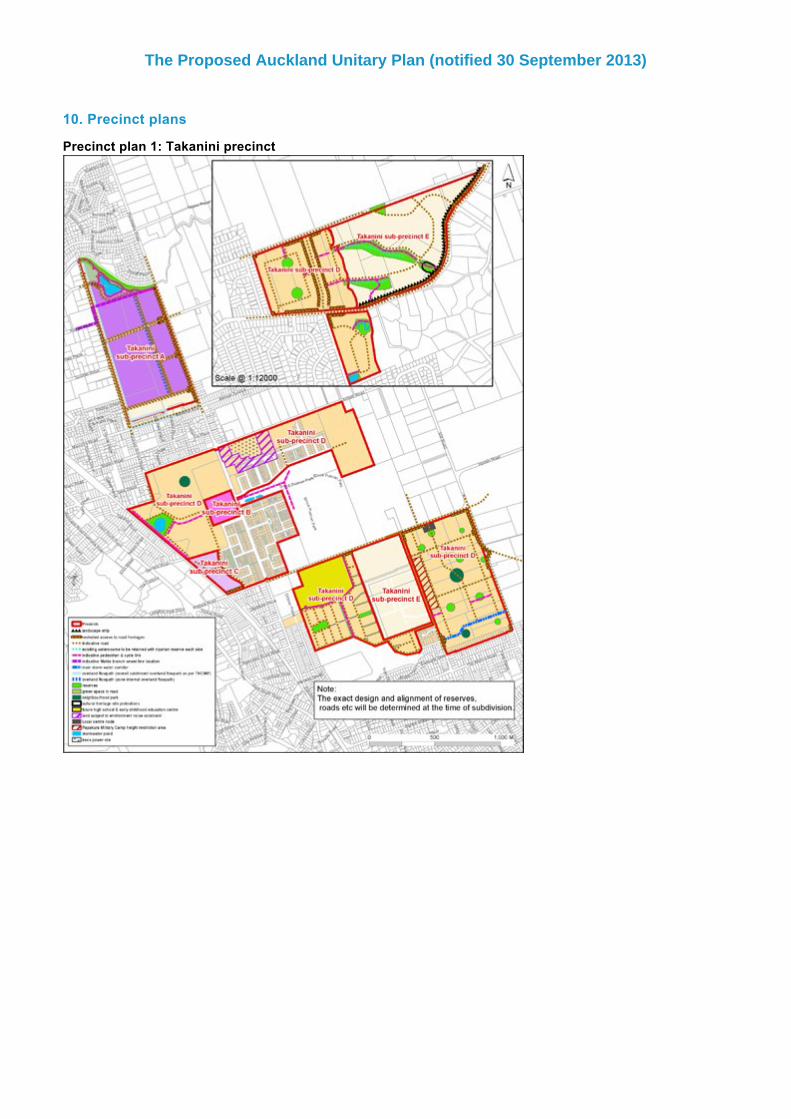
10. Precinct plans
Precinct plan 1: Takanini precinct
The Proposed Auckland Unitary Plan (notified 30 September 2013)
Page 19 of 22

Precinct plan 2: Takanini subprecinct A landscape plan
The Proposed Auckland Unitary Plan (notified 30 September 2013)
Page 20 of 22

Precinct plan 3: Takanini subprecinct C areas
The Proposed Auckland Unitary Plan (notified 30 September 2013)
Page 21 of 22

The Proposed Auckland Unitary Plan (notified 30 September 2013)
Page 22 of 22