PPHR V15- Volume 3 (C-E)_Part3
132
Residence, Coach House & Stables Identifier unknown Formerly 39 Dalgety St Address ST. KILDA Description Style : Arts and Crafts One storey residence, coach house and stables Significance A good example of late Federation period villa design in the Arts and Crafts style and in relatively intact condition. The simple rendered chimney shafts, restrained decoration and flat roofed dormer windows are indicative of the style. The mitred hips of the slate roof create a crisp visual effect and enhance the restrained decorative treatment. The timber front fence is a recent addition to the complex. Its elaborate character and excessive height are out of character with the house. Refer to Lewis, p.108 for the description and statement of significance for rear stable block. (Robert Peck Von Hartel Trethowan City of St Kilda, Twentieth Century Architectural Study,1992) "Significance……the stables at the rear are particularly important due to their complex and intricate form and detail….." (Nigel Lewis & Associates, St Kilda Conservation Study, Area One, Final report, 1982) Designer unknown Category Residential:detached Constructed c. 1914 Other Studies Nigel Lewis and Associates, St. Kilda Conservation Study, 1982 Primary Source Robert Peck von Hartel Trethowan, St Kilda 20th century Architectural Study Vol. 3, 1992 History see Significance Thematic Context Princes St Burnett St Dalgety St 884 (Mapped as a Significant heritage property.) City of Port Phillip Heritage Review Citation No: Amendment C 29 Comment HO5 Heritage Precinct Overlay Heritage Overlay(s)
-
Upload
port-phillip -
Category
Documents
-
view
220 -
download
2
description
Â
Transcript of PPHR V15- Volume 3 (C-E)_Part3

Residence, Coach House & StablesIdentifier unknownFormerly
39 Dalgety StAddress ST. KILDA
Description
Style : Arts and CraftsOne storey residence, coach house and stables
SignificanceA good example of late Federation period villa design in the Arts and Crafts style and in relatively intact condition. The simple rendered chimney shafts, restrained decoration and flat roofed dormer windows are indicative of the style. The mitred hips of the slate roof create a crisp visual effect and enhance the restrained decorative treatment. The timber front fence is a recent addition to the complex. Its elaborate character and excessive height are out of character with the house. Refer to Lewis, p.108 for the description and statement of significance for rear stable block.(Robert Peck Von Hartel Trethowan City of St Kilda, Twentieth Century Architectural Study,1992)
"Significance……the stables at the rear are particularly important due to their complex and intricate form and detail….."(Nigel Lewis & Associates, St Kilda Conservation Study, Area One, Final report, 1982)
Designer unknown
Category Residential:detached
Constructed c. 1914
Other StudiesNigel Lewis and Associates, St. Kilda Conservation Study, 1982
Primary SourceRobert Peck von Hartel Trethowan, St Kilda 20th century Architectural Study Vol. 3, 1992
History see Significance
Thematic Context
Princes St
Burnett
St
Dalgety
St
884
(Mapped as a Significant heritage property.)
City of Port Phillip Heritage Review Citation No:
Amendment C 29
Comment
HO5Heritage Precinct OverlayHeritage Overlay(s)

RecommendationsA Ward, Port Phillip Heritage Review, 1998recommended inclusions:Schedule to the Heritage Overlay Table in the City of Port Phillip Planning Scheme
References
unknown
unknown
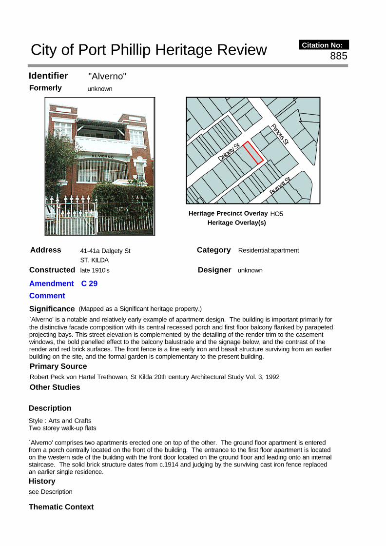
"Alverno"Identifier unknownFormerly
41-41a Dalgety StAddress ST. KILDA
Description
Style : Arts and CraftsTwo storey walk-up flats
`Alverno' comprises two apartments erected one on top of the other. The ground floor apartment is entered from a porch centrally located on the front of the building. The entrance to the first floor apartment is located on the western side of the building with the front door located on the ground floor and leading onto an internal staircase. The solid brick structure dates from c.1914 and judging by the surviving cast iron fence replaced an earlier single residence.
Significance`Alverno' is a notable and relatively early example of apartment design. The building is important primarily for the distinctive facade composition with its central recessed porch and first floor balcony flanked by parapeted projecting bays. This street elevation is complemented by the detailing of the render trim to the casement windows, the bold panelled effect to the balcony balustrade and the signage below, and the contrast of the render and red brick surfaces. The front fence is a fine early iron and basalt structure surviving from an earlier building on the site, and the formal garden is complementary to the present building.
Designer unknown
Category Residential:apartment
Constructed late 1910's
Other Studies
Primary SourceRobert Peck von Hartel Trethowan, St Kilda 20th century Architectural Study Vol. 3, 1992
History see Description
Thematic Context
Princes St
Burnett
St
Dalgety
St
885
(Mapped as a Significant heritage property.)
City of Port Phillip Heritage Review Citation No:
Amendment C 29
Comment
HO5Heritage Precinct OverlayHeritage Overlay(s)

RecommendationsA Ward, Port Phillip Heritage Review, 1998recommended inclusions:Schedule to the Heritage Overlay Table in the City of Port Phillip Planning Scheme
References
unknown
unknown

"Dalgety Court"Identifier unknownFormerly
43 Dalgety StAddress ST. KILDA
SignificanceThe St Kilda City Council building permit records dating from the late 1910s show that Howard R. Lawson, architect and developer, prepared a large number of designs for flat developments in various parts of St Kilda, all in a similar Arts and Crafts style. This spate of building applications, often with a number of applications made on the same day, is of particular historical interest, as it marks one of the earliest concerted moves to flat development in St Kilda and heralds trends in the later development of the city. Furthermore, the resulting buildings are among St Kilda's earliest flat buildings and form a cohesive corpus of work. 43 Dalgety Street of 1919 is among these works, and is a three storey complex of two bedroom apartments. The complex is of additional interest for the fact that only six of the proposed nine apartments were initially completed on the western section of the site. A further three apartments were constructed to a different design in c.1936. As such the buildings are a notable example of staged apartment construction. The earlier flats are good examples of this period of Lawson's work, and adopt a fine facade composition with a tall piered balcony projecting from and contrasted against (with its deep shadows and slender lines) a taller and more robust solid masonry wall. Other similar contemporary examples include 29 to 33 Robe Street and 11 Wimmera Place, (1917, also by H R Lawson). In this example the complex is enlivened by a striking single storey projecting entrance porch with massive brick piers buttressed by the entrance stairs and a deeply projecting roof. The vivid leadlighting decorating the porch's side lights, depicting lake scenes, contributes to the character of the building. With its projecting balcony wing the 1936 addition respectfully adopts the general composition of the earlier building, and this similarity of form makes all the more apparent the stylistic development that had occurred in the intervening years. The new building substitutes square corner windows for the picturesque bays of the earlier design, reflecting in a stylistic sense the characteristics of the Functionalist style, while continuing the parapet line of the earlier building. `Dalgety Court' relates in scale design and detail to its two nearest neighbours `San Diego' to the east (a more extreme example of modern movement style) and `Alverno' to the west with its twin towers mimicked shallowly in the skyline of `Dalgety Court' to form a distinctive group of apartments. The building complex has not been dramatically altered since completion. The balconies have been glazed spoiling the open shadowed effect of the verandahs on the top floor.
Designer Howard R. Lawson
Category Residential:apartment
Constructed 1920-1936
Princes St
Dalgety
St
Burnett
St
886
(Mapped as a Significant heritage property.)
City of Port Phillip Heritage Review Citation No:
Amendment C 29
Comment
HO5Heritage Precinct OverlayHeritage Overlay(s)
Description
Style : Arts and CraftsThree storey walk-up flatsOriginal owner: Swinburn
Drawings in the St Kilda City Council collection indicate that Howard R. Lawson, architect, prepared drawings in November 1919 for a three storey complex of two bedroom apartments on this site. Only six of the proposed apartments were initially completed on the western section of the site. A further three apartments to a different design were constructed on the remaining site area c. 1936. As such the buildings are notable examples of staged apartment construction. The earlier flats adopt a fine facade composition. Other similar contemporary examples include 23-33 Robe Street and 11 Wimmera Place (1917, also by H. Lawson). In this example, the complex is enlivened by a striking single storey projecting entrance porch with massive brick piers buttressed by the entrance stairs and a deeply projecting roof. Interesting leadlight schemes decorate the porch's side lights. With its projecting balcony, the 1936 addition respectfully adopts the general composition of the earlier building, cleverly substituting the picturesque bay windows of the earlier section with square corner windows which, in a stylistic sense, reflect the characteristics of modern movement and continue the original parapet line. `Dalgety Court' relates well to its two nearest neighbours `San Diego' to the east (a more extreme example of modern movement style) and `Alverno' to the west with its twin towers mimicked shallowly in the skyline of `Dalgety Court') to form a distinctive group of apartments. The building complex has not been drastically altered since completion. The balconies, as in so many flat examples, have been glazed, spoiling the open shadowed effect of the verandahs on the top floor.
Dalgety Court is a notable example of staged construction.
RecommendationsA Ward, Port Phillip Heritage Review, 1998recommended inclusions:Schedule to the Heritage Overlay Table in the City of Port Phillip Planning Scheme
References
NOTESSt K.C.C. building approval No. 4032 (or 4039?), St Kilda C.C. building approval No. 9414 (no architect named)
Other Studies
Primary SourceRobert Peck von Hartel Trethowan, St Kilda 20th century Architectural Study Vol. 3, 1992
History
unknown
see Description
Thematic Context

"Lurnea"Identifier unknownFormerly
50(ex 48a) Dalgety StAddress ST. KILDA
Description Two storey walk-up flats
SignificanceA representative example of an early walk up flat block. This building is significant primarily for the articulation of its form, with strongly projecting bays enclosing a small courtyard and further broken up visually by a series of stairs, verandahs and porches. The building is detailed in a simplified arts and crafts style, with deep overhanging eaves, bell cast timber shingle work and multi pane sash windows. The complex is substantially intact.
RecommendationsA Ward, Port Phillip Heritage Review, 1998recommended inclusions:Schedule to the Heritage Overlay Table in the City of Port Phillip Planning Scheme
Designer unknown
Category Residential:apartment
Constructed c1920
Other Studies
Primary SourceRobert Peck von Hartel Trethowan, St Kilda 20th century Architectural Study Vol. 3, 1992
History
unknown
see Description
Thematic Context
Princes St
Burnett
St
Dalgety
St
887
(Mapped as a Significant heritage property.)
City of Port Phillip Heritage Review Citation No:
Amendment C 29
Comment
HO5Heritage Precinct OverlayHeritage Overlay(s)

References
unknown

St Kilda CemeteryIdentifier unknownFormerly
Dandenong RdAddress ST. KILDA
Description
PERIOD OF USE1855 - 1900, 1928 - ? in current use.LATER ALTERATIONS
SignificanceCULTURAL SIGNIFICANCESt. Kilda Cemetery is one of Melbourne's oldest cemeteries and is closely associated with the settlement of greater Melbourne, being the principal cemetery during the 19th century south of the Yarra River. There are a large number of important memorials and the graves generally have a high level of intactness. The tall fences along the street frontage and the size of the cemetery make it a local landmark. St. Kilda Cemetery is particularly associated with the history and settlement of St. Kilda.
EXTENT OF SIGNIFICANCEEntire cemetery.
SURROUNDING ELEMENTS OF. SIGNIFICANCEEstablished plane trees along part of the Dandenong Road and Alexandra Street frontages.
OTHER EVALUATIONSL.P. Planning (landscape architects), National Estate Cemetery Study, c. 1980 recommended second category out of four of significance.
Designer unknown
Category Public
Constructed 1855
Other Studies
Primary SourceDavid Bick in conjunction with Wilson Sayer Core Pty. Ltd., St. Kilda Conservation Study Area 2 Vol. 1, 1984
Shi
rley
Gr
Ale
xand
ra
St
Alma Rd
Alma Rd
Dandenong Rd
Murchison St
Hot
ham
St
320City of Port Phillip Heritage Review Citation No:
Amendment C 29
Comment
NoneHeritage Precinct OverlayHeritage Overlay(s)

Southern entrance gates have gum trees etc. planted in front of them. Vardy shows a building, presumably a keeper's lodge, at the Dandenong Road entrance and presumably its site is now the memorial lawn. New flat roofed toilet /administration building.DESCRIPTIONSt. Kilda Cemetery is fenced by solid brick walls on the side (east and west) frontages with iron palisade fences to the entry (north and south) frontages. The entry gates are set in a wide semi-ellipse and the stone posts are finely carved. The cemetery is divided into denominational areas, each showing a diversity in types of monuments, as does the cemetery generally. One grave has three large iron crosses.CONDITIONThis cemetery is in good condition and well kept. The memorials are in mostly good condition and vandalism has been minimal generally.ORIGINAL USECemetery.PRESENT USEContinuing use.OTHERAvenue planting of exotic trees in the streets around the cemetery would materially enhance the surrounding environment as well as the cemetery itself. Three of the four surrounding streets are main roads in St. Kilda. This section of Dandenong Road is one of Melbourne's great boulevards.INTACTNESS (February, 1984)The graves generally and the surrounding fences are intact. A memorial lawn has been established along part of the Dandenong Road frontage, with a flat roofed toilet /administration block on the other side of the main gate.
RecommendationsA Ward, Port Phillip Heritage Review, 1998recommended inclusions:National Estate RegisterSchedule to the Heritage Overlay Table in the City of Port Phillip Planning Scheme
References
BIBLIOGRAPHY
1. H.B. Foot surveyor, 'Plan of Portions Marked in the Parish of Prahran', 1853, Crown Lands and Survey Department, in Public Records Office, Laverton, shows denominational layout -Appendix.
2. John Butler Cooper, 'The History of St. Kilda' from its first settlement to a city and after 1840 - 1930, City of St. Kilda, Melbourne, 1931, vol. 1, pp. 35-38
L.P. Planning, 'National Estate Cemetery Study', unpublished, Melbourne, c. 1980.
3. J.E.S. Vardy, Plan of the Borough of St. Kilda compiled under the direction of the Borough Council, Harnel and Ferguson, Melbourne, 1873, map no. 3 North Ward - Appendix.
History
unknown
St. Kilda Cemetery was opened on the 9th of June, 1855(2) and originally extended from Hotham Street to Orrong Road, being reduced to its present 20 acres later(2). The deed of grant from the Government to the Trustees was issued on the 7th of February, 1861 and the cemetery continued in use throughout the 19th century, despite some local objectors(2). On the 31st of December, 1900, the cemetery was closed as all the land had been used. It was reopened in 1928 to allow the Trustees to raise funds for maintenance(2).
Thematic Context

Ardoch Education VillageIdentifier Residence, FlatsFormerly
220-238 Dandenong RdAddress ST. KILDA
Description
SignificanceThis is a highly significant group of buildings, a former flat development influenced by the English Arts and Crafts `garden suburb' of the late nineteenth century. Its importance lies in the application of the garden suburb concept to a flat development. It is lent further significance by its size and the intactness of its buildings. Where other mansion grounds were so often simply subdivided for speculative development on an ad hoc basis, this development shows a sophisticated approach to creating a coherent residential environment. Central to the concept is the highly legible placement of individual buildings around an expansive central green. Its roots in the Arts and Crafts Movement are clearly expressed in the distinguished Arts and Crafts style architecture of its nine individual buildings. Largely because the design requires that the buildings be seen as three dimensional objects picturesquely placed within the overall setting, a rich variety of variants within a walk up flat type has been developed to suit particular siting conditions. Of these, the large pavilion-like flat block placed to terminate the visual axis of the central green is particularly noteworthy for its scale and form of its bold roof and spreading symmetry. On the other hand, as the four smaller blocks are not tied to any formal axis and are sited to be viewed obliquely, their massing is compact, asymmetrical and picturesque. This conception of flat buildings as free standing pavilions in open space sets the Ardoch flats apart from similar flats of the period. The contrast of red brick and roughcast is skilfully employed throughout the complex and has great visual impact. The intactness of all its building materials and finishes further enhances its aesthetic appeal. The conversion of the complex to an educational campus in 1976 continues the tradition of bold planning ideas which distinguish Ardoch's history.
Designer unknown
Category School
Constructed pre 1873-1928
Other Studies
Primary SourceRobert Peck von Hartel Trethowan, St Kilda 20th century Architectural Study Vol. 3, 1992
Johnson St
Pill
ey
St
Wes
tbur
y
St
Dandenong Rd
403
(Mapped as a Significant heritage property.)
City of Port Phillip Heritage Review Citation No:
Amendment C 29
Comment
NoneHeritage Precinct OverlayHeritage Overlay(s) HO104

Style : Arts and CraftsSchool complex, former flats, former residenceOriginal owner: A.M. Younger (1922)
This complex was built in the substantial grounds of the two storey Victorian residence, `Ardoch', which has existed on the site since before 1873. The configuration of the house and land can be traced through the Vardy map of 1873 and the MMBW maps of the 1890s. The redevelopment of the property into a `village' of individual two storey flat blocks dates from the late 1910s and the 1920s. Its component buildings comprise the plain rendered Victorian mansion with its extensions toward Dandenong Rd (the present Building 10), a large red brick and roughcast rendered block with symmetrical octagonal corner towers facing Dandenong Rd (Building 1), a series of roughcast rendered blocks arranged in a broad arc, ranging in size from eight apartment units (Building 5), six units (Building 2), four units (Building 4), to two units (Buildings 6, 7, 8 and 9), and a central red brick block originally of six units. The interior buildings are congregated around an attractive open grassed common surrounded by mature trees. The principal protagonist in the development of the Ardoch complex appears to be A.M. Younger, who is recorded as the property owner in building works dating from the early 1920s. Later in the decade the property appears to have been owned by Dr Armstrong, who developed further flats in 1928. No architect is recorded for any of the building works. However, the buildings have such a strong uniformity in style and quality that a single designer, probably with the same builder, seems likely to have (been) responsible. The complex is now owned by the Education Department of Victoria and serves as the Ardoch High School, the South Central Region Offices, and as offices of a number of the Department's Programs.
RecommendationsA Ward, Port Phillip Heritage Review, 1998recommended inclusions:Victorian Heritage RegisterNational Estate RegisterSchedule to the Heritage Overlay Table in the City of Port Phillip Planning Scheme
References
NOTESSt Kilda Building Approval No. 4309, March 1920; proposed alterations to `Ardoch' for A.M. Younger, no date, no architect; one drawing showing new walls, new wing. St Kilda Building Approval No. 4990, 25.9.22; flats for and built by A.M. Younger. St Kilda Building Approval No. 7127, 1928; proposed flats at `Ardoch' for Dr. Armstrong by A. Clissold, builder; the building is very similar to No. 4990. St Kilda Building Approval No. 7128, 1928; proposed store rooms, Ardoch Mansions. The architect appears to also have designed `Mimi' at 20 Eildon Road.
History
unknown
see Description
Thematic Context

FlatsIdentifier unknownFormerly
304 Dandenong RdAddress ST. KILDA
Description
Three storey walk-up flatsOriginal owner: Mrs Holdsworthy
SignificanceA representative and late example of the work of architect A W Plaisted, a specialist in flat design. The building is a rare example of a three storey flat block in a Neo Georgian style. The elaborate detailing of the cream brickwork, wrought ironwork, door surrounds, cornices and columns is its most significant aesthetic feature. The main facade of the building originally faced onto Shirley Grove, but its impact has now been diminished by the interposition of a later block of flats.
RecommendationsA Ward, Port Phillip Heritage Review, 1998recommended inclusions:Schedule to the Heritage Overlay Table in the City of Port Phillip Planning Scheme
Designer Arthur W. Plaisted
Category Residential:apartment
Constructed 1939
Other Studies
Primary SourceRobert Peck von Hartel Trethowan, St Kilda 20th century Architectural Study Vol. 3, 1992
History
unknown
see Significance
Thematic Context
Shi
rley
Gr
Ale
xand
ra S
t
Dandenong Rd
889
(Mapped as a Significant heritage property.)
City of Port Phillip Heritage Review Citation No:
Amendment C 29
Comment
HO6Heritage Precinct OverlayHeritage Overlay(s)

References
NOTESSt Kilda C. C. Building Approval No. 10437.

St. Mary's Church complexIdentifier unknownFormerly
208 Dandenong RdAddress ST. KILDA EAST
Description
SignificanceVictorian Heritage Register: "This Gothic Revival church was designed by the noted architect William Wardell (1823-1899) and built between 1859 and 1871. The church is of bluestone with freestone dressings. A feature of the front elevation is the dressed bluestone belfry which surmounts the composition; steep sided capping reflects that of the nave roof. The church also features raised lancet windows and steeped buttresses. St. Mary's has been described as William Wardell's most complete Australian parish church and comprises a long nave and aisles, and lopsided chancel under an unbroken roof ridge, side chapels and sacristies. The church is notable for its wealth of internal fittings. St. Mary's Church is of architectural and historic importance for the following reasons:- As one of the most important works of the noted architect William Wardell.- As Wardell's first church in Victoria and his most complete Australian parish building. - As an important Victorian period church in the Gothic Revival manner. - For the quality of its internal design features and detailing.- As the first Roman Catholic Church consecrated in Victoria." The presbytery is contributory. The St. Mary's School is historically and aesthetically important. Its historical importance (Criterion A) is derived from its capacity to represent the Catholic Church's commitment to education at the time and long after the Education Act of 1873. It is aesthetically important (Criterion E) as an imposing public building on the Dandenong Road and as a sophisticated expression of the Queen Anne style as it was applied to a public building soon after Federation, the ornamentation, arrangement of the parts and stylistic references being important elements.
Designer William Wardell
Category Church
Constructed 1859
Other Studies
Primary SourceAndrew Ward, City of Port Phillip Heritage Review, 1998
Wes
tbur
y S
t
Dandenong Rd
2104
(Mapped as a Significant heritage property.)
City of Port Phillip Heritage Review Citation No:
Amendment C 29
Comment
NoneHeritage Precinct OverlayHeritage Overlay(s) HO103

The elements of this complex include St. Mary's Church and presbytery and the St. Mary's School. The church is a Gothic Revival building in bluestone with sandstone dressings and is distinguished by the emphasis given to the vertical in the proportions of its façade and as a consequence the nave. The façade gable end is surmounted by a bellcote and there are flanking aisles that visually strengthen the dominance of the nave. There is an absence of excessive ornamentation characteristic of both the work of William Wardell and the period. There is an apsidal chancel under an unbroken roof ridge with side chapels and sacristies. Inside, the stained glass windows are the work of Mayer, Zettler, and Mathieson and Gibson with chancel stencils and guilding by Lyon, Cottier and Wells. The presbytery is a conservative stuccoed two storeyed mid Victorian building adopting Gothic Revival proportions (not inspected). The school is a prominent two storeyed Queen Anne building in red brick with cement dressings and terra cotta spandrels to the archway over the recessed central porch. The façade is symmetrical with faceted buttresses demonstrating its link with the Gothic Revival and there are Dutch Renaissance influenced gables in the Queen Anne manner with emphasis given to the central bay. Enrichment is in cast cement and terra cotta. Condition: Sound. Integrity: High.History
8. Developing cultural institutions and ways of life. 8.6. Worshipping. 8.6.3. Making places for worship. 6. Educating. 6.2. Establishing schools.
According to Ebsworth's "Pioneer Catholic Victoria" St.Kilda East's first St.Mary's church was "in the early English style of Gothic architecture", designed by Dowden and Ross. The foundation stone was laid on 22 January 1854 and the church was opened on 4 June 1854. No description of it remains however Cooper in "The History of St.Kilda" mentioned the erection of a "small brick church, which was used also as a Roman Catholic school, in Dandenong Road, capable of seating 250 persons at a cost of over 4000 pounds". The resident clergyman Rev.P.W.Niall described the building as a "schoolhouse and master's dwelling", perhaps to muster financial aid from the Denominational Schools Board. The building is shown on James Kearney's plan of "Melbourne and its Suburbs" in 1855, set at the rear of the block that was the church reserve, there being ample room for future development closer to Dandenong Road.
Within a few years, the defective materials and workmanship of the church/school necessitated its replacement. By then, a larger church was also required so Patrick Scanlan was commissioned to design a new building. In 1858, Scanlan called for tenders, a separate tender being put out for the nave in November of that year. However according to "Pioneer Catholic Victoria", "the great architect, W.W. Wardell arrived in the Colony and was invited to submit an alternative design". It was adopted and on 28 February 1859, the foundation stone was laid. William Wilkinson Wardell was the government architect in the late 1850's, "appointed to the office of Inspecting Clerk of Works of the Colony". His design was for a bluestone chapel with freestone dressings, the nave was 64 feet long and 44 feet wide and the chancel was 20 feet deep with side chapels and sacristy. Due to lack of funds, the building however was not completed until 1864, the dedication service taking place on 31 July. Additions were carried out in 1869, again to the design of Wardell, which extended the nave to 136 feet. A Sacred Heart chapel was built off the west aisle, together with two sacristies.Meanwhile, a presbytery had been built beside the new church, completed in 1867 and duly occupied by Fr.James Francis Corbett who had been at St.Mary's since September 1863.
Even though attendance figures at the school had fallen somewhat, the steady development of the "aristocratic neighbourhood" about St. Mary's soon made extension of the church a necessity and work resumed in 1869. The larger church, now having a nave of 136 feet was blessed by Bishop Goold in November 1871. One large pipe organ was installed in 1873. Later that year seven Presentation Sisters arrived in Melbourne to take over the school. In 1874 they took charge of the girl's primary school and started a high school of 23 pupils. Later that year the new convent and school was blessed by Archibishop Goold.
By 1879 the number of female students had more than doubled. Today the Windsor Convent community is responsible for the primary schools in six different parishes in Melbourne, while ten other foundations claim Windsor as their mother.
In July 1878 three Christian Brothers arrived in Melbourne and after a series of events accepted an invitation to take over the boys school. They saw a remarkable increase in students also, rising from 145 in 1876 to 292 three years later.
In 1902 the foundation stone was laid for the St. Mary's School designed by architects John Rigg and Godfrey and Spowers.
Thematic Context

RecommendationsA Ward, Port Phillip Heritage Review, 1998recommended inclusions:Victorian Heritage Register (Church only, already on Register)National Estate RegisterSchedule to the Heritage Overlay Table in the City of Port Phillip Planning Scheme
References
Heritage Victoria File no. 86 2583 0 Miles Lewis (ed): "Victorian Churches Their origins, their story and their architecture" National Trust of Australia (Victoria), 1991, p.84. Rev. Walter Ebsworth, "Pioneer Catholic Victoria", The Polding Press, Melbourne, 1973, pp. 464-474.

Shops and FlatsIdentifier unknownFormerly
254-256 Dandenong RdAddress ST. KILDA EAST
Description
Three storey shops and flats
SignificanceA notable 1920s conversion of a three storey Victorian residence into apartments. The juxtaposition of sharply defined volumes creating a stepped composition to Dandenong Road, the crowning of these by a strong, reeded Art Deco derived cornice and the inclusion of shops in the ground floor of the complex together create one of St Kilda's most distinctive and bizarre compositions. Recent alterations, including the painting of the render finish and the addition in red brick of an additional shop have down graded the appearance of the buildings, nevertheless they are an unusual example of the distinctive St Kilda building type involving the conversion of an earlier building.
Recommendations
Designer unknown
Category Commercial: residential
Constructed c. 1870, c. 1920
Other Studies
Primary SourceRobert Peck von Hartel Trethowan, St Kilda 20th century Architectural Study Vol. 3, 1992
History
unknown
see Significance
Thematic Context
Johnson St Hot
ham
St
Pill
ey S
t
Dandenong Rd
888
(Mapped as a Significant heritage property.)
City of Port Phillip Heritage Review Citation No:
Amendment C 29
Comment
HO6Heritage Precinct OverlayHeritage Overlay(s)

A Ward, Port Phillip Heritage Review, 1998recommended inclusions:Schedule to the Heritage Overlay Table in the City of Port Phillip Planning Scheme
References
unknown

"Broxted" (Wando Grove Group)Identifier unknownFormerly
342 Dandenong RdAddress ST. KILDA EAST
Description
Style : Arts and CraftsTwo storey flats, former residenceBuilder: H R LawsonOriginal Owner: H R Lawson
A late arts and crafts style house, later converted to flats. The house was originally owned by architect and developer Howard R Lawson whose numerous and often distinguished flat developments both in the region of
SignificanceBroxted is of interest architecturally and forms part of the Wando Grove group, substantial houses all built around the same time and showing a variety of architectural composition and detailing, as well as planning. This house especially illustrates the transition in architectural style from the Edwardian era of the 1900's and 1910's to the 1920's. Details such as the leadlight windows, outside light, lettering and timber brackets are more reminiscent of the earlier decades whilst the overall mass of the building relates more to that of 1920's houses. Architect and developer Howard R. Lawson built Broxted as his own house. The building permit application drawing shows that the overall massing was resolved then, but the detailing as built is quite different, providing an interesting insight into Lawson's development of the design.The divided stair with two lower flights is an unusual feature for a building of this time.
(David Bick, St. Kilda Conservation Study, 1985)
Designer Howard R. Lawson
Category Residential:detached
Constructed 1918
Other StudiesDavid Bick in conjunction with Wilson Sayer Core Pty. Ltd., St. Kilda Conservation Study Area 2 Vol. 1, 1984
Primary SourceRobert Peck von Hartel Trethowan, St Kilda 20th century Architectural Study Vol. 3, 1992
Orr
ong
R
d
Wando
Gr
Dandenong Rd
321
(Mapped as a Significant heritage property.)
City of Port Phillip Heritage Review Citation No:
Amendment C 29
Comment
HO6Heritage Precinct OverlayHeritage Overlay(s)

Dandenong Road and elsewhere in St Kilda helped reshape the identity of many areas of the suburb during the period 1910 to 1930. The house is currently owned by the City of St Kilda and managed by the St Kilda Housing Association. The building displays aspects of American, or, more specifically, prairie influence in the sweep of eaves, window treatments and fence design, though not the bold eaves bracketing. The building is also notable for its diagonal siting and is complemented by houses at numbers 344 and 346 Dandenong Road. (Robert Peck Von Hartel Trethowan City of St Kilda, Twentieth Century Architectural Study,1992)
RecommendationsA Ward, Port Phillip Heritage Review, 1998recommended inclusions:Schedule to the Heritage Overlay Table in the City of Port Phillip Planning Scheme
References
NOTESSt K C C permit No. 3563, issued 4/4/1918
BIBLIOGRAPHYCity of St. Kilda building permit records, no. 3563 granted 4/4/1918, includes drawing.
History
unknown
see Description
Thematic Context

Residence (Wando Grove Group)Identifier unknownFormerly
344 Dandenong RdAddress ST. KILDA EAST
Description see Significance
SignificancePart of the Wando Grove group of substantial houses built during the same period and of varied form and detail, this building is also of note for its external design and internal features. Most distinctive of the latter is the fireplace with its carved aboriginal figures, kookaburra and motto, dated 1919. Other internal features are the hall leadlight window and the first floor bedroom cupboard with a leadlight window to outside set in it.
RecommendationsA Ward, Port Phillip Heritage Review, 1998recommended inclusions:Schedule to the Heritage Overlay Table in the City of Port Phillip Planning Scheme
Designer unknown
Category Residential:detached
Constructed 1919
Other Studies
Primary SourceDavid Bick in conjunction with Wilson Sayer Core Pty. Ltd., St. Kilda Conservation Study Area 2 Vol. 1, 1984
History
unknown
see Significance
Thematic Context
Orr
ong
R
d
Wando
Gr
Dandenong Rd
322
(Mapped as a Significant heritage property.)
City of Port Phillip Heritage Review Citation No:
Amendment C 29
Comment
HO6Heritage Precinct OverlayHeritage Overlay(s)

References
unknown

"Montalto"Identifier unknownFormerly
197 Danks StAddress SOUTH MELBOURNE
Description Original Use: ResidenceDate of Construction: 1876 (1)
By 1876 Thomas and Alfred Ford, a local doctor and a dentist, had sold sixty-six feet of vacant land on Allotment 15 to Thomas Abercrombie Mouatt (2), a ‘gentleman’. Mouatt soon erected a ten-roomed brick mansion, known as ‘Montalto’ having an initial N.A.V. the following year of £80 (3).
Mouatt’s involvement with the district, through his association with the Emerald Hill municipality, was considerable. In 1854 he helped form the Emerald Hill Local Committee, whose aim was to ‘watch over the general interests of the locality' (4), and he acted as its first chairman (5). In 1855 he was listed as a Justice of the Peace (6) and although he still owned 197 Danks Street (7) his ‘private residence’ was given as 107 Collins Street East (8). Mouatt was last listed as the owner of ‘Montalto’ in 1898 (9) and in the following year, James Alston, a manufacturer (10) was listed in the Rate Books as the owner and occupier of the property, by then described as being of eight rooms (11).
Significance‘Montalto’ is of significance as the house built by T.S. Mouatt, an influential resident in the establishment of Emerald Hill. It is also of significance as the predominant residence in the area south-east of Kerferd Road and Beaconsfield Parade, standing in contrast to the age and scale of the surrounding housing stock. Its design has an opulence that could have been expected a decade later.
Designer unknown
Category Residential:detached
Constructed 1876
Other Studies
Primary SourceAllom Lovell Sanderson Pty. Ltd., South Melb Conservation study vol. 2, 1987
Page St
Boyd
St
Kerfe
rd Rd
Danks St
1007
(Mapped as a Significant heritage property.)
City of Port Phillip Heritage Review Citation No:
Amendment C 29
Comment
HO3Heritage Precinct OverlayHeritage Overlay(s)

In 1917 the Carmelites established their Mount Carmel Boys’ School in Middle Park, staffed by the Christian Brothers and beginning in the former ‘Alston’ mansion (12). By 1925 more spacious premises were acquired (13) and the school moved out (14). The building is now owned by the Hare Krishna movement.
‘Montalto’ is one of the few substantial Victorian houses in South Melbourne outside the main boulevards such as St Kilda, Queens or Albert Roads. In Danks Street it is not only far larger than the surrounding buildings but also earlier than most. It is an opulent two storeyed rendered mansion. The front façade is asymmetrical, having a first floor colonnade set above a ground floor loggia that is countered by a projecting window unit housing a cluster of three windows at each level. These windows are flanked by pilasters and at each level they are surmounted by a pediment: a treatment repeated above each window within the colonnade. The house has a parapet decorated with an Italianate balustrade and appears, externally, to be substantially intact.
RecommendationsA Ward, Port Phillip Heritage Review, 1998recommended inclusions:National Estate RegisterSchedule to the Heritage Overlay Table in the City of Port Phillip Planning Scheme
References
1 City of South Melbourne Rate Books, 1875-18772 ibid. 3 ibid., 1876/774 ‘Report of the Emerald Hill Local Committee, 7 July 1854’, quoted in C. Daley, 'History of South Melbourne', p.425 ibid., p.446 Melbourne Directory 1855, p. 2937 City of South Melbourne Rate Books, 1884/858 Melbourne Directory, op.cit., p.10869 City of South Melbourne Rate Books, 1897/9810 P. Milner, Some Significant Industrial Sites in South Melbourne, October 1986, prepared for the National Trust of Australia (Victoria)11 City of South Melbourne Rate Books, 1899/190012 P. Chandler, 'The Carmelites in Australia: A Brief History', 1981, p.2213 ibid., 1931-3214 Christian Brothers Archives
History
unknown
see Description
Thematic Context

HouseIdentifier unknownFormerly
370 Danks StAddress SOUTH MELBOURNE
Description
Original Use: House
Built within an area that has predominantly Edwardian houses, 370 Danks Street stands apart, with particularly fine and intact detailing. It is a small, single storeyed tuckpointed brick house with a terracotta tile roof with decorative ridge tiles and finials in a manner typical of the period. The front façade is dominated by a projecting window unit under which is a facetted bay window, while the front entrance has an unusual deep, narrow, gabled entrance porch. One of the outstanding features of the house is the extent and intact nature of the leadlight glazing that spans over the bay window, front porch, front door and three of the side windows (two double hung and one a fixed oculus window). In addition, the sinuous timber brackets to the front porch, the fretwork in its gable, the intact black and white tessellated floor to the porch, the original fence with red brick combined with cast iron panels, and the original timber gate, all add greatly to the whole. While the front façade is intact, one opening along the north side has been altered and so too the rear of the house.
Significance370 Danks Street is of significance as the most extensively and finely detailed and decorated small Edwardian house in South Melbourne. Located in an area recognised for its concentration of small Edwardian buildings, this house is very much in keeping with the surrounding building stock, however its degree of embellishment, unusual porch arrangement and outstandingly intact state, set it apart.
Designer unknown
Category Residential:detached
Constructed c. 1905
Other Studies
Primary SourceAllom Lovell Sanderson Pty. Ltd., South Melb Conservation study vol. 2, 1987
Mc G
rego
r StBeaconsfield Pde
Arm
stron
g St
Danks St
1015
(Mapped as a Significant heritage property.)
City of Port Phillip Heritage Review Citation No:
Amendment C 29
Comment
HO3Heritage Precinct OverlayHeritage Overlay(s)

RecommendationsA Ward, Port Phillip Heritage Review, 1998recommended inclusions:Schedule to the Heritage Overlay Table in the City of Port Phillip Planning Scheme
References
unknown
History
unknown
see Description
Thematic Context

ResidenceIdentifier unknownFormerly
3 Deakin StAddress ST. KILDA
Description
The residence, 3 Deakin Street, St Kilda was erected c.1910 and is an exuberant example of an Australian Federation style one-storey house. The red brick building incorporates bays of windows, both curved and octagonal, and the slate roof displays terracotta ridging and finials. Subsidiary gables are half timbered, one forming the entrance porch incorporating lattice fretwork, curved timber and turned timber supports. Tall red brick chimneys rise above roof level and the feature of the residence is a square belvedere which is situated at roof level. This accessible open-sided tower has a pyramidal roof, timber balustrading and fretwork identical in design to that on the entrance porch below. The complex, asymmetrical form of the building is typical of the period.
IntactnessThis residence is substantially intact, with minor alterations including the replacement of some panes of leaded glass.
SignificanceThis intact example of Australian Federation architecture is particularly significant due to the unusual belvedere which crowns the composition.
Designer unknown
Category Residential:detached
Constructed c.1910
Other Studies
Primary SourceNigel Lewis and Associates, St. Kilda Conservation Study, 1982
History see Description
Loch St
Park St
York St
Canterbury Rd
Deakin St
Deakin
St
91
(Mapped as a Significant heritage property.)
City of Port Phillip Heritage Review Citation No:
Amendment C 29
Comment
HO3Heritage Precinct OverlayHeritage Overlay(s)

RecommendationsA Ward, Port Phillip Heritage Review, 1998recommended inclusions:Schedule to the Heritage Overlay Table in the City of Port Phillip Planning Scheme
References
unknown
unknown
Thematic Context

Residence:"Hereford"Identifier unknownFormerly
4 Deakin StAddress ST. KILDA
Description A representative asymmetrical timber late Victorian cottage having rusticated boards to the façade, bullnosed verandah with turned timber posts and later frieze. The frieze to the eaves is bracketed and there is a corrugated iron clad hipped roof and lean to section at the rear. There is a bracketed hood to the main front window and metal hoods to the side windows.
Condition: Sound. Integrity: Medium to High, recent front fence, crimped wire side fence to right of way.
Significance"Hereford" at no. 4 Deakin Street, St. Kilda, was built in 1883 for Maria Little. It is historically and aesthetically representative of the earliest phase in the subdivision and settlement of the coastal margin bounded on its east side by the Albert Park reserve. It is important (Criteria A and E) in these respects for its contribution to the cultural values of the Area.
Designer unknown
Category Residential:detached
Constructed 1883
Other Studies
Primary SourceAndrew Ward, City of Port Phillip Heritage Review, 1998
History In 1875 Council was supportive of the subdivision of the vacant land south-west of the St. Kilda railway line. Ferrars Street had been extended as Canterbury Road to St. Kilda in 1876 with land sales following soon afterwards. With the departure of the Army from the Middle Park area in 1879 the beach became available as a recreational rersort leading to the development of housing blocks in the locale during the 1880s and up until the Depression of 1892. Park Street and Cowderoy streets had been laid outin the 1870s with Deakin Street being formed c.1882.
Park St
York St
Cowd
eroy
St
Loch St
Deakin St
2192
(Mapped as a Significant heritage property.)
City of Port Phillip Heritage Review Citation No:
Amendment C 29
Comment
HO3Heritage Precinct OverlayHeritage Overlay(s)

RecommendationsA Ward, Port Phillip Heritage Review, 1998recommended inclusions:Schedule to the Heritage Overlay Table in the City of Port Phillip Planning Scheme
References
St.Kilda Rate Books (West Ward): 1855-65, 1870-73, 1880-81, 1900-01.Sands and McDougall directories: 1890, 1910, 1920, 1930.MMBW litho plan no.35, dated c.1896 and 1935.Com.H.L.Cox R.N. surveyor, Hobson Bay and River Yarra, 1866. SLV Maps, 821.09 A.J. 1866, Cox.J.Noone, Building Allotments West St.Kilda & Emerald Hill, 18 August 1873, Department of Lands and Survey, Melbourne. SLV Maps, Vale Collection, Book 4A, p.131.
4. Building settlements, towns and cities: 4.1.2. Making suburbs (St. Kilda). Nineteenth century suburban expansion.
By February 1883, no.4 Deakin Street had been built . It was described as a 4 roomed house with kitchen and was rated to Cowderoy Street, that part being identified as Deakin Street the following year. It was a timber house owned by its occupier Maria Little who continued there in 1890.
By the turn of the century, the railway employee William McAvoy had bought the house for his residence. By then it had been extended to six rooms and was named "Hereford" . McAvoy was not the occupant in 1910, there being a George Hoare in residence at that time however by 1920, McAvoy had returned, continuing there in 1930 .
Thematic Context

ResidenceIdentifier unknownFormerly
16 Deakin StAddress ST. KILDA
Description
Style : Arts and CraftsOne storey residence
SignificanceA small Victorian house notable for its extraordinary street facade, probably altered to its present form around 1920. A semi cylindrical bay window with a bizarre conical hat of bell cast timber shingling is superimposed on a flat front wall, cut off crisply at the top in Jacobean curves. The strength of the composition is compounded by the overscaled proportions of its elements, and their close proximity to the footpath. As such, the building has a presence in the streetscape that belies its small size.
RecommendationsNil
Designer unknown
Category Residential:detached
Constructed 1890s-c1920
Other Studies
Primary SourceRobert Peck von Hartel Trethowan, St Kilda 20th century Architectural Study Vol. 3, 1992
History
unknown
see Description
Thematic Context
Loch StYork St
Canterbury Rd
Deakin S
t
Deakin St
891
(Mapped as a Contributory heritage property.)
City of Port Phillip Heritage Review Citation No:
Amendment C 29
Comment
HO3Heritage Precinct OverlayHeritage Overlay(s)

References
unknown

FlatsIdentifier unknownFormerly
23 Dickens StAddress ST. KILDA
Description
Style : MediterraneanTwo storey walk-up flats
SignificanceNumber 23 Dickens Street is significant as a powerfully composed example of the Interwar Mediterranean style. The impact of the design is enhanced by the play of solid and void across the facade of the building, though this has been compromised by the infilling of the upper north-west loggia. The original front fence and the complementary hedge contribute to the building's significance, and it forms a pair with the strong forms of the contemporary Functionalist flat block at number 25.
RecommendationsA Ward, Port Phillip Heritage Review, 1998recommended inclusions:Schedule to the Heritage Overlay Table in the City of Port Phillip Planning Scheme
Designer I.G. Anderson
Category Residential:apartment
Constructed 1938
Other Studies
Primary SourceRobert Peck von Hartel Trethowan, St Kilda 20th century Architectural Study Vol. 3, 1992
History
unknown
see Description
Thematic Context
2081
(Mapped as a Significant heritage property.)
City of Port Phillip Heritage Review Citation No:
Amendment C 32
Comment Map corrected
HO7Heritage Precinct OverlayHeritage Overlay(s)

References
unknown

FlatsIdentifier unknownFormerly
25 Dickens StAddress ST. KILDA
Description
Style : FunctionalistResidential, Flats
SignificanceA stylish and powerful example of the Interwar Functionalist style, this flat block is significant for the vigour of its massing, and fine brickwork detailing. The strong interplay between the horizontally banded curved corners of the building, executed in render finishes, and the deeply modelled vertically striated brickwork of the chimney to the north facade make for a convincing composition that tends towards the stylism of Art Deco. The original front fence contributes to the significance of the building, which forms a pair with number 23.
RecommendationsA Ward, Port Phillip Heritage Review, 1998recommended inclusions:Schedule to the Heritage Overlay Table in the City of Port Phillip Planning Scheme
Designer unknown
Category Residential:apartment
Constructed c. 1930
Other Studies
Primary SourceRobert Peck von Hartel Trethowan, St Kilda 20th century Architectural Study Vol. 3, 1992
History
unknown
see Description
Thematic Context
894City of Port Phillip Heritage Review Citation No:
Amendment C 32
Comment Map corrected
HO7Heritage Precinct OverlayHeritage Overlay(s)

References
unknown

HouseIdentifier unknownFormerly
70 Dickens StAddress ELWOOD
Description
A double fronted villa World War 2 era showing the influence of the Streamlined Moderne in its "waterfall front" treatment, emphasis on horizontality in the use of cement facings in conjunction with dark bricks and the arrangement of glazing bars. The port hole window is also a characteristic motif. Condition: Sound. Integrity: High, including low front fence and gates.
SignificanceThe house at no. 70 Dickens Street, Elwood is aesthetically important (Criterion E) as a locally unusual (Criterion B) house designed in the Streamlined Moderne manner, exhibiting the hall marks of the style and being in the vanguard of its development.
Designer unknown
Category Residential:detached
Constructed 1939
Other Studies
Primary SourceAndrew Ward, City of Port Phillip Heritage Review, 1998
History Dickens Street extended west as far as Mitford Street in 1866. From Mitford Street it became a fair weather track across the northern stretches of the Elwood Swamp. By 1879, the street extended to the Bay, however the area remained relatively undeveloped until the twentieth century.
In 1915, Charles Herschell, a commercial traveller, owned a six roomed wood house on the north side of Dickens Street between Marine Parade and Baker Street. The street number at the time was 76.
The house was subsequently owned by Emily Vincent who sold it to Rudolf and Clarissa Dettmer in 1938. The Dettmers demolished the house and in 1939, erected a brick house on the site. It had five rooms and an NAV of 105 pounds. By then, the street number had been changed to 70.
Baker S
t
Marine Ave
Dickens St
Marine P
de
Hood S
t
28
(Mapped as a Significant heritage property.)
City of Port Phillip Heritage Review Citation No:
Amendment C 29
Comment
NoneHeritage Precinct OverlayHeritage Overlay(s) HO105
RecommendationsRecommended for inclusion in the Schedule to the Heritage Overlay Table in the City of Port Phillip Planning Scheme.
References
St. Kilda Rate Books: 1915-17, 1920-21, 1930-31, 1935-41, 1945-46, 1960-61. VPRS 8816/P1, PROV.MMBW litho plan no.48, undated.H.L.Cox, “Hobson Bay and River Yarra”, 1866. SLV, Map Section.
4. Building settlements, towns and cities. 4.1.2 Making suburbs.
The Dettmers continued as owner/occupants in 1960 at which time the house was described as “brick, five rooms, population 4, NAV 325 pounds”.
Thematic Context

"Glenronald"Identifier unknownFormerly
75 Dickens StAddress ELWOOD
Description Style : MediterraneanTwo storey walk-up flats
SignificanceA small two storey block of flats significant primarily because of its prominence in this area of recessive single storey buildings. The contrast of scale with the adjacent building stock and its siting hard upon the corner makes Glenronald a `sentinel' building in the area. It is notable for its Spanish Mission motifs, accentuated by the contrast of the white painted render against its crisp decorative brickwork and its external staircases abutting the footpath. It is in an excellent state of intactness.
RecommendationsA Ward, Port Phillip Heritage Review, 1998recommended inclusions:Schedule to the Heritage Overlay Table in the City of Port Phillip Planning Scheme
Designer unknown
Category Residential:apartment
Constructed late 1920's
Other Studies
Primary SourceRobert Peck von Hartel Trethowan, St Kilda 20th century Architectural Study Vol. 3, 1992
History
unknown
see Description
Thematic Context
Pozieres Ave
Dickens St
Marine P
de
Hood S
t
895
(Mapped as a Significant heritage property.)
City of Port Phillip Heritage Review Citation No:
Amendment C 29
Comment
NoneHeritage Precinct OverlayHeritage Overlay(s) HO106

References
unknown

FlatsIdentifier unknownFormerly
1a Dickens StAddress ST. KILDA
Description Style : Art DecoThree storey walk-up flats
SignificanceThis building is of significance as a good example of the exuberant Art Deco style applied to a 1930s block of flats. The elements of the building that contribute to this character are the cantilevered curvilinear concrete balconies and canopies, slim steel windows with horizontal mullions creating banded effects, and the contrast of smooth rendered finishes and the narrow Roman brickwork of the entrance stair tower. These narrow bricks are part of a play of balance of horizontal and vertical elements in the composition of the building. The horizontal aspects of the composition are reinforced by the curved corner of the building, in conjunction with the balconies and corner windows, while significant vertical elements of the design are the chimney to the east wall and the entrance stair tower. The low existing hedge is appropriate to the period and style of the building, and though the bluestone pitcher fence is appropriate in scale, the materials used detract from the building. The building forms part of a complimentary group of three flat blocks of similar scale which mark the entrance to Dickens Street from Brighton Road which includes 47A Brighton Road and 2 Dickens Street.
Designer unknown
Category Residential:apartment
Constructed early 1930's
Other Studies
Primary SourceRobert Peck von Hartel Trethowan, St Kilda 20th century Architectural Study Vol. 3, 1992
History see Description
Thematic Context
Cha
pel S
t
Dickens
St
Dickens St
Brighton Rd
892
(Mapped as a Significant heritage property.)
City of Port Phillip Heritage Review Citation No:
Amendment C 29
Comment
HO7Heritage Precinct OverlayHeritage Overlay(s)

RecommendationsA Ward, Port Phillip Heritage Review, 1998recommended inclusions:Schedule to the Heritage Overlay Table in the City of Port Phillip Planning Scheme
References
unknown
unknown

ResidenceIdentifier unknownFormerly
6 Dickens StAddress ST. KILDA
Description DATE OF CONSTRUCTION1891/92 (most probably in the last months of 1891)(1).ORIGINAL OWNERMrs. Margaret McCutcheon(1)(2).ARCHITECT
SignificanceCULTURAL SIGNIFICANCEThe residence at 6 Dickens Street is architecturally significant for its cast iron verandah columns and frieze panels, whilst otherwise it exemplifies domestic architecture of the early 1890's. The design of the columns is typical of that time and the nature of mouldings used then invariably meant that timber was used instead of cast iron. The frieze spindles are timber. Timber external blind boxes remain and the cast iron cresting is a feature. Internally the hallway is in three sections, the main one being wider and having a coved ceiling. Original or early embossed wallpaper lines the hall, now painted. The elaborate plasterwork to the ceilings is a feature of the interior.
EXTENT OF SIGNIFICANCEEntire building, not including recent modernisation at the rear of the house.
SURROUNDING ELEMENTS OF SIGNIFICANCENone. Mozart Street group (q.v.) is to the rear.
Designer Ernest W.M. Crouch
Category Residential:detached
Constructed 1891-1892
Other Studies
Primary SourceDavid Bick in conjunction with Wilson Sayer Core Pty. Ltd., St. Kilda Conservation Study Area 2 Vol. 1, 1984
Brighton Rd
Mozart St
Dickens
St
323
(Mapped as a Significant heritage property.)
City of Port Phillip Heritage Review Citation No:
Amendment C 29
Comment
HO7Heritage Precinct OverlayHeritage Overlay(s)

Ernest W.M. Crouch very probably(2).BUILDER/ ARTISANSNot known.LATER OCCUPANTSOwners (2) - 1895 G.F. Lynch; 1895-1903 J.R. Rippon; 1903-19 S.W. Smith (Jnr.); 1919-20 F. Lorry; 1920-36 J.B. Martin; 1936-42 E.K. and F.B. Martin; 1941-51 L.W. Boyce; 1951-76 P. and C. Martret; 1976-78 C. Martret.Occupants(7) - 1899, 1900 Ernest Kornblum; 1901/02-04 Charles Crosby.LATER ALTERATIONS/ ADDITIONSChanges have been made to the rear service rooms, including demolition of some internal walls.DESCRIPTIONConstruction of this single storey house is in brick with a slate roof. The front rooms are cement rendered, but otherwise the walls externally are face brickwork, now painted. A hall in three sections bisects the house, the first section, the length of the front rooms, being narrower than the main hall with its coved ceiling. The front two rooms, unlike the rest of the house, have a bluestone plinth and the side walls do not align with those of the main part of the house. The projecting bay windowed room roof has iron cresting forming an ornamental enclosure. Internally the front rooms and the hall have elaborate ceiling plasterwork. The ceiling rose in the front bay windowed room is unusual. The doors from the hall into each room have acid etched glass toplights.INTACTNESS (April, 1984)This building has a high level of intactness generally. Previously it was a rooming house and with a period of disuse, fittings such as mantelpieces and main door toplights were removed. There have been extensive changes in the rear service rooms in recent times.CONDITION This building is in very good condition.ORIGINAL USEPrivate residencePRESENT USE The same.
RecommendationsA Ward, Port Phillip Heritage Review, 1998recommended inclusions:National Estate RegisterSchedule to the Heritage Overlay Table in the City of Port Phillip Planning Scheme
References
BIBLIOGRAPHY1. City of St. Kilda Rate Books, various years: 1890/91 no. 1952 50 ft. land.,1891/92 8 rooms brick (N.A.V £120). M.M.B.W. Detail Plan no. 1382-Appendix.
2 Titles Office, Victoria, complete title search:
3. Vol. 2314, Fol. 462648, 1890.
4. Vol. 2408, Fol. 481474, 1892.
5. Vol. 2408, Fol. 481478, 1892.
History
unknown
Margaret McCutcheon commissioned the construction of this house in 1891/92, probably late in 1891 as she paid rates in January, 1892 equal to building(1). The land was acquired in November, 1890(3) and was part of the grounds of prominent early Melbourne Architect T.J. Crouch's house (died 4/12/1889)(2). Margaret McCutcheon is reputed to have been related to Crouch's widow, Mary Emma Bloor Crouch and in January, 1892 the land was reconveyed back to Mrs. Crouch and then back to Mrs. McCutcheon, at the same time on the same day, with slightly amended boundaries(4),(5). Ernest William Marston Crouch Architect inherited the property of Mary Crouch in 1904(2) and there is every likelihood that he designed this house. George Frederick Lynch acquired the property in 1895(6). Architect Sydney Wigham Smith (Jnr.) purchased the property in 1903 and owned it until 1919(2).
Thematic Context

6. Vol. 2592, Fol. 518300, 1895.
7. Sands and McDougalls Melbourne Directories', various years.

ResidenceIdentifier unknownFormerly
6a Dickens StAddress ST. KILDA
Description Style : Functionalist, Art DecoTwo storey residence
SignificanceThis building is significant for its extraordinary plan form, expressed in the facade as a series of swelling volumes piled one in front of the other, reinforced by the interpenetrating planes of the balcony, canopies and entrance steps. The spindly wrought iron balcony railings feature floral and wave motifs typical of the post-war art deco survival, and the building is enhanced by the curved glass, steel framed windows. The building is intact and the formal landscaping with its random rock edging and specimen trees is complementary.
RecommendationsA Ward, Port Phillip Heritage Review, 1998recommended inclusions:Schedule to the Heritage Overlay Table in the City of Port Phillip Planning Scheme
Designer unknown
Category Residential:detached
Constructed 1950'2
Other Studies
Primary SourceRobert Peck von Hartel Trethowan, St Kilda 20th century Architectural Study Vol. 3, 1992
History
unknown
see Significance
Thematic Context
Brighton Rd
Mozart St
Dickens St
893
(Mapped as a Significant heritage property.)
City of Port Phillip Heritage Review Citation No:
Amendment C 29
Comment
HO7Heritage Precinct OverlayHeritage Overlay(s)

References
unknown

"Antigone" FlatsIdentifier unknownFormerly
34 Docker StreetAddress ELWOOD
Description Antigone at 34 Docker Street comprises six flats in a three-storey flat-roofed rendered brick Functionalist-style building. The triple-fronted asymmetrical façade has a projecting off-centre wing, with central painted brick spandrel flanked by curving metal-framed multi-paned windows. To the left is a row of curved balconies with
SignificanceWhat is Significant?The Antigone flats at 34 Docker Street are a three-storey flat-roofed rendered brick building in the Functionalist style, enlivened by curved balconies and windows. Erected c.1937, the flats were one of a number of speculative apartment projects commissioned by local resident Mrs Marie Louise Dorney, and designed by her son, notable architect J H Esmond Dorney.
How is it Significant?The Antigone flats are of architectural and aesthetic significance to the City of Port Phillip.
Why is it Significant?Aesthetically, the Antigone flats are significant as a fine and intact example of a substantial block of flats in the inter-war Functionalist style, characterised in this instance by flat roof, curved window bays and balconies, ribbon windows and a vertical emphasis.Architecturally, the Antigone flats are significant as one of the best examples in Elwood of the work of J H Esmond Dorney, a prolific local architect and one-time employee of Walter Burley Griffin who became a leading exponent of the Functionalist style in Melbourne in the 1930s and, after the War, a highly regarded modern architect in Tasmania.
Designer J.H. Esmond Dorney
Category Residential:apartment
Constructed 1937
Other Studies
Primary SourceHeritage Alliance, Elwood Heritage Review, 2005
2329
(Mapped as a Significant heritage property.)
City of Port Phillip Heritage Review Citation No:
Amendment C 54Comment New citation
NoneHeritage Precinct OverlayHeritage Overlay(s) 415
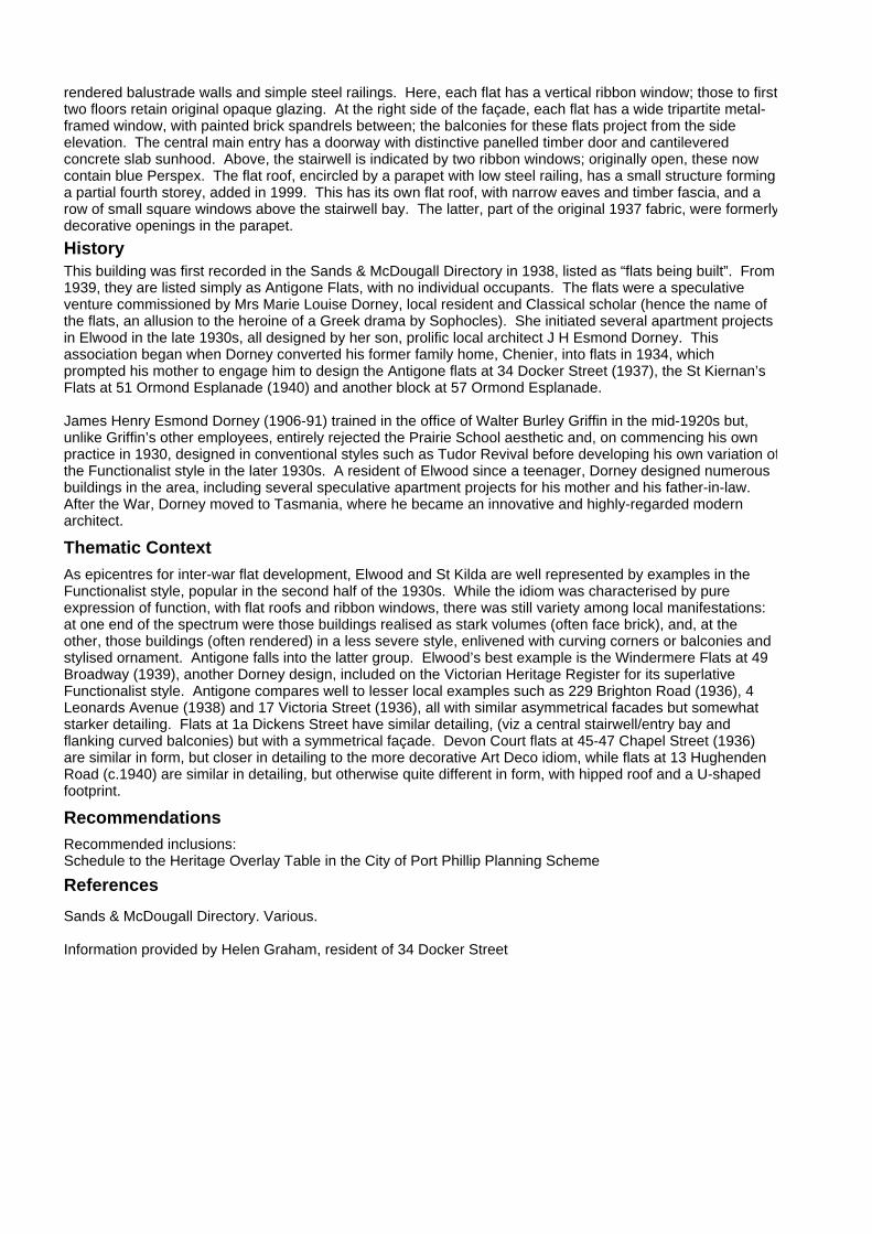
rendered balustrade walls and simple steel railings. Here, each flat has a vertical ribbon window; those to firsttwo floors retain original opaque glazing. At the right side of the façade, each flat has a wide tripartite metal-framed window, with painted brick spandrels between; the balconies for these flats project from the side elevation. The central main entry has a doorway with distinctive panelled timber door and cantilevered concrete slab sunhood. Above, the stairwell is indicated by two ribbon windows; originally open, these now contain blue Perspex. The flat roof, encircled by a parapet with low steel railing, has a small structure forming a partial fourth storey, added in 1999. This has its own flat roof, with narrow eaves and timber fascia, and a row of small square windows above the stairwell bay. The latter, part of the original 1937 fabric, were formerlydecorative openings in the parapet.
RecommendationsRecommended inclusions:Schedule to the Heritage Overlay Table in the City of Port Phillip Planning Scheme
ReferencesSands & McDougall Directory. Various.
Information provided by Helen Graham, resident of 34 Docker Street
History
As epicentres for inter-war flat development, Elwood and St Kilda are well represented by examples in the Functionalist style, popular in the second half of the 1930s. While the idiom was characterised by pure expression of function, with flat roofs and ribbon windows, there was still variety among local manifestations: at one end of the spectrum were those buildings realised as stark volumes (often face brick), and, at the other, those buildings (often rendered) in a less severe style, enlivened with curving corners or balconies and stylised ornament. Antigone falls into the latter group. Elwood’s best example is the Windermere Flats at 49 Broadway (1939), another Dorney design, included on the Victorian Heritage Register for its superlative Functionalist style. Antigone compares well to lesser local examples such as 229 Brighton Road (1936), 4 Leonards Avenue (1938) and 17 Victoria Street (1936), all with similar asymmetrical facades but somewhat starker detailing. Flats at 1a Dickens Street have similar detailing, (viz a central stairwell/entry bay and flanking curved balconies) but with a symmetrical façade. Devon Court flats at 45-47 Chapel Street (1936) are similar in form, but closer in detailing to the more decorative Art Deco idiom, while flats at 13 Hughenden Road (c.1940) are similar in detailing, but otherwise quite different in form, with hipped roof and a U-shaped footprint.
This building was first recorded in the Sands & McDougall Directory in 1938, listed as “flats being built”. From 1939, they are listed simply as Antigone Flats, with no individual occupants. The flats were a speculative venture commissioned by Mrs Marie Louise Dorney, local resident and Classical scholar (hence the name of the flats, an allusion to the heroine of a Greek drama by Sophocles). She initiated several apartment projects in Elwood in the late 1930s, all designed by her son, prolific local architect J H Esmond Dorney. This association began when Dorney converted his former family home, Chenier, into flats in 1934, which prompted his mother to engage him to design the Antigone flats at 34 Docker Street (1937), the St Kiernan’s Flats at 51 Ormond Esplanade (1940) and another block at 57 Ormond Esplanade.
James Henry Esmond Dorney (1906-91) trained in the office of Walter Burley Griffin in the mid-1920s but, unlike Griffin’s other employees, entirely rejected the Prairie School aesthetic and, on commencing his own practice in 1930, designed in conventional styles such as Tudor Revival before developing his own variation ofthe Functionalist style in the later 1930s. A resident of Elwood since a teenager, Dorney designed numerous buildings in the area, including several speculative apartment projects for his mother and his father-in-law. After the War, Dorney moved to Tasmania, where he became an innovative and highly-regarded modern architect.
Thematic Context

"Monterey Flats"Identifier unknownFormerly
35 Docker StAddress ELWOOD
Description
A substantial two storeyed apartment block in the American West Coast Mission style being symmetrically arranged with hip roofed pavilions either side of a central porch with curved roof and Tuscan order columns. The pavilions have round arched windows, the upper level openings having originally been unglazed. The walls are of rough cast and fair faced cement work with visual interest achieved by the use of clinker bricks in panels of varying sizes. There is a large clinker brick panel enclosing a Palladian window above the central porch, given further emphasis by twin chimneys above. Condition: Sound. Integrity: High.
SignificanceThe "Monterey Flats" at 35 Docker Street, Elwood are historically and aesthetically important (Criteria A and E) for their capacity to epitomise the halcyon years of apartment building in Elwood, comparing in this respect with "Glenronald" (75 Dickens Street, Elwood), 23 Dickens Street, Elwood, 41 Milton Street, Elwood, "Santa Fe" (45 Mitford Street, Elwood) and the "Los Angeles Court" apartments (81A Spenser Street, St. Kilda).
Designer unknown
Category Residential:apartment
Constructed 1928
Other Studies
Primary SourceAndrew Ward, City of Port Phillip Heritage Review, 1998
History At Crown land sales J.G.Vautier purchased portions 12 and 13 in North Elwood. Each portion had an area of eight acres and ran from Ormond Road to Ormond Esplanade.
The land was subsequently subdivided to be sold as the “Elwood Hill Estate” and two streets were formed, North Elwood and South Elwood (Vautier and Docker Streets respectively). Parallel with the streets were lanes that provided rear access to each allotment.
Ormond Esp
Dock
er St
Pine A
ve
29
(Mapped as a Significant heritage property.)
City of Port Phillip Heritage Review Citation No:
Amendment C 29
Comment
NoneHeritage Precinct OverlayHeritage Overlay(s) HO107

RecommendationsRecommended for inclusion in the Schedule to the Heritage Overlay Table in the City of Port Phillip Planning Scheme.
References
St. Kilda Rate Books: 1920-21, 1925-31, 1935-6. VPRS 8816/P1, PROV.MMBW litho plan no.84, undated.Parish Plan of Prahran, Borough of St. Kilda. SLV 820 bje.
4. Building settlements, towns and cities. 4.1.2 Making suburbs.
This area was quite isolated due to swamps to the east and north (Elwood Swamp) and was sparsely populated prior to the drainage and filling works of the early twentieth century. However when development resumed, apartment living had become popular by the Bay.
In 1920, Mrs. Annie Hansen owned a house with land at 37 Docker Street. By 1926, it had been subdivided and was rated separately from the house. It had a frontage of 60 feet and an NAV of 54 pounds. In 1927, Mrs. Hansen sold the land to Elsie Julia Levy of Elwood.
In 1928, Elsie Levy built this block of flats. The building was of brick and contained eight flats, each with four rooms. At the end of 1918, six of the flats were occupied, one of them by the owner. The NAVs ranged from 78 to 110 pounds.
The building was named “Monterey Flats” by 1936. They were fully let at that time to Charles Tomkins (manager), Robert Green (clerk), John Flintoff (investor), Walter Balleine (salesman), Norman Potts (manager), George Barrow (theatre employee), Peter Nisbet (sales organiser) and Arthur Barrows (engraver). Between two and three people lived in each flat and the NAV ranged from 70 to 80 pounds.
Thematic Context

St Lukes Church and VicarageIdentifier unknownFormerly
210-218 Dorcas StAddress SOUTH MELBOURNE
Description Original Use: Church and VicarageDate of Construction: Church 1857 (1) Vicarage 1874 (2)Architect: Church – Francis Maloney White (3) Vicarage – Charles Webb (4)
In the original 1852 township plan for Emerald Hill a reserve was set aside on part of Crown Section 8 for the Church of England (5). Represented in Emerald Hill as early as 1854, church services were held in various temporary sites (6), until January 1856, when a meeting of subscribers of the Church was held to discuss the erection of an Anglican Church (7).
In March the following year the foundation stone of the basalt building was laid by the Governor, Sir Henry Barkley (8). Francis Maloney White was the architect of the cruciform plan church (9) and the first portion, the nave, was built at a cost of £1,700 by Abraham Linacre. Services at the new building were conducted by the
SignificanceSt Luke’s Church is of significance as one of the first buildings to have been built in South Melbourne and for its substantial nature and the scholarly design of the original church and its subsequent additions. The vicarage is of significance as an intact and quite early example of Charles Webb’s use of polychromatic brickwork. The interior of the church is integral to the significance. The commercial developments to the north and the multistoreyed housing that overshadows the church and vicarage detract greatly from their significance.
Designer Francis Maloney White
Category Church
Constructed 1857, 1874
Other Studies
Primary SourceAllom Lovell Sanderson Pty. Ltd., South Melb Conservation study vol. 2, 1987
Dorcas St
Bank St
Clarendon St
1009
(Mapped as a Significant heritage property.)
City of Port Phillip Heritage Review Citation No:
Amendment C 29
Comment
NoneHeritage Precinct OverlayHeritage Overlay(s) HO108

Rev. Rivers Beachcroft Dickinson (10), while in 1859 the church was enlarged and extended (11). In 1875 the two-roomed iron house that was used as the residence of the vicar was demolished and all materials were removed (12) while in the previous year the noted Melbourne architect, Charles Webb, called tenders for the construction of the two-storey parsonage (13). Webb later designed the South Melbourne Town Hall and the polychrome brick School No. 1253 in Dorcas Street (q.q.v.). In 1862 he had added transepts (14) and in 1867 made additions further (15) to St Luke’s.
In 1881, inspired by the subdivision that occurred on the former Orphanage site, the trustees of St Luke’s constructed a development of shops, including the now demolished Chamber of Commerce, on their Clarendon Street frontage (16). A cedar pulpit was constructed by Nathaniel Billing and Son (17) in 1883 and the same boundary wall and picket fencing for the church in 1885 (18).
St Luke’s is built in basalt with some quite finely tooled freestone and basalt dressings. It is a scholarly design, particularly in the light of its very early date of construction and is a very fine example of the work of the early Melbourne architect, F.M. White. The interior is also of distinction, with its hammer beam ceiling and ecclesiastical fittings intact. The vicarage, while stylistically very different is a confident and quite early use of polychromatic brickwork and stands in a very intact state. The use of contrasting brickwork is restrained across its façade and the closely set timber eaves brackets embellish the building and remain intact.
RecommendationsA Ward, Port Phillip Heritage Review, 1998recommended inclusions:Victorian Heritage RegisterNational Estate RegisterSchedule to the Heritage Overlay Table in the City of Port Phillip Planning Scheme
References
1 Architects’ Index, University of Melbourne2 ibid.3 ibid.4 ibid.5 C. Daley, 'History of South Melbourne', p. 3726 ibid., p.1767 National Trust of Aust. (Vic.), ‘Research into St Lukes …’, 28 February 19788 ibid.9 ibid.10 Daley, loc.cit11 National Trust of Aust. (Vic.), loc.cit12 Architects’ Index13 ibid.14 ibid.15 ibid.16 Daley, loc.cit.17 Architects’ Index18 ibid.
History
unknown
see Description
Thematic Context

Former Presbyterian ChurchIdentifier unknownFormerly
223 Dorcas StAddress SOUTH MELBOURNE
Description Original Use: ChurchConstruction: circa 1909(1)Architect: Inskip and Butler(2)
This Presbyterian Congregation was formed by 1855, the first services being held in the 'Great Iron Store' in Cecil Street(3), however by 1864 a temple-like Greek Revival church building had been erected on the corner of Clarendon and Dorcas Streets(4) which served the congregation for almost half a century; the congregation becoming synonymous with Clarendon Street.
The present building was constructed on land in Dorcas Street, adjoining the Clarendon Street Church site; retaining its original Clarendon Street name until 1956(5) . In 1929, with much hesitation from the Clarendon street congregation, the church was amalgamated with the Dorcas Street congregation(6) and from then on the Dorcas Street building was used for worship(7) .
A photograph of the Church, taken not long after its completion, shows the building as being faced with horizontal striped polychrome brickwork over its entire surface(8). As it stands, the polychrome effect of the
SignificanceThe former Presbyterian Church is of significance as a substantially intact church by the leading firm of architects, Inskip and Butler, and as one of the few churches built in the area during the Edwardian period. The obscured state of the polychrome facade detracts from the significance of the whole.
Designer Inskip and Butler
Category Church
Constructed c. 1909
Other Studies
Primary SourceAllom Lovell Sanderson Pty. Ltd., South Melb Conservation study vol. 2, 1987
Moray St
Dorcas St
Clarendon St Bank St
2100
(Mapped as a Significant heritage property.)
City of Port Phillip Heritage Review Citation No:
Amendment C 29
Comment
HO3Heritage Precinct OverlayHeritage Overlay(s)

facade has been covered, the whole having been rendered over, although the church does remain intact in its overall form. As may be expected of its Edwardian date, the church displays a simplicity and boldness of form rarely found in the late-Victorian period. It is hall-like in its form, with a simple slate roof ending in a gabled end facing the street. This is embellished with corner turrets and coupled windows to the centre and the sides. A sculptural quality was added to the facade through the entrance porch; the wing walls of which are swagged back to the main facade. It is unfortunate that the polychrome effect of the facade is no longer visible as the fluidity of its forms and vibrance of design have been obscured. The church does however remain an interesting example of the work of the leading firm Inskip and Butler. The building has since been purchased by the Greek Orthodox Church and is now known as St Eustathious.
RecommendationsA Ward, Port Phillip Heritage Review, 1998recommended inclusions:Schedule to the Heritage Overlay Table in the City of Port Phillip Planning Scheme
References
1. HPBC, file 5/14/74, October 1983, 'Recommendations to the Minister for Planning…..'2. Ibid.3. G. Butler, 'South Bank Architectural and Historical Study, Vol. I,' September 1982, P.44. National Trust of Australia (Victoria), Architectural and Historic Importance of St John's Lutheran Church, 7 June 1984.5. G. Butler, loc. cit6. National Trust of Australia (Vic), citation, F.N.46347. Ibid.
History
unknown
see Description
Thematic Context

Former Salvation Army CitadelIdentifier unknownFormerly
232 Dorcas StAddress SOUTH MELBOURNE
Description
Original Use: Salvation Army Citadel(1)Construction: 1911(2)
In June 1883 the Salvation Army was established in South Melbourne, operating from the 'Academy of Music Hall' in Coventry Street(30) . Captain Rolfe was the first commanding officer(4) . After twenty-eight years of operations from that building, the Army purchased a site in Dorcas Street and constructed this citadel where they continued another sixty-five years of service(5) . Open-air meetings were held at the local market nearby and the Army made a significant contribution to the welfare of South Melbourne's needy population. The South Melbourne Salvation Army subsequently vacated their Dorcas Street premises and now operates jointly with that of Port Melbourne.
The citadel remains substantially intact despite its changed usage. The exterior is built in a hall-like form with a boldly decorated facade with castellated ornamentation above the door and to the turrets rising above parapet level. The architectural strength of these, now sadly obscured by paintwork, was originally heightened by the play of their render against the (presumably red) tuckpointed brick walls. The interior has
SignificanceThe former Salvation Army Citadel is of significance as a fine example of Edwardian public architecture and in its castellated styling was designed to evoke the cause of the Salvation Army. Located near the Town Hall, it reinforces this area as the administrative heart of South Melbourne. The pressed metal ceiling is integral to the significance of the whole.
Designer unknown
Category Church
Constructed 1911
Other Studies
Primary SourceAllom Lovell Sanderson Pty. Ltd., South Melb Conservation study vol. 2, 1987
Dorcas St
Clarendon St
Marshall St
Fishley St
Layfield St
1121
(Mapped as a Significant heritage property.)
City of Port Phillip Heritage Review Citation No:
Amendment C 29
Comment
NoneHeritage Precinct OverlayHeritage Overlay(s) HO109

been partitioned off to house offices, however the very fine pressed metal ceiling is extant. The window and door openings to Dorcas Street facade are original, however their joinery has been replaced. Plaques on the facade read: 'This building was opened to the Glory of God and for the Salvation of the People by Comm' James Hay on Feb 18th 1911', 'Lieut. Col Edward Saunders, Architect'
RecommendationsA Ward, Port Phillip Heritage Review, 1998recommended inclusions:National Estate RegisterSchedule to the Heritage Overlay Table in the City of Port Phillip Planning Scheme
References
1 'The Salvation Army : A brief History', held in South Melbourne Local History Collection, LH 3542 ibid.3 ibid. Refer Citation for 288 Coventry Street4 ibid.5 ibid.
History
unknown
see Description
Thematic Context

TerracesIdentifier unknownFormerly
239-253 Dorcas StAddress SOUTH MELBOURNE
Description
Original Use: Residences (1)Date of Construction: originally 1885, reclad c1920Architect: original buildings attributed to Sydney W. Smith (2)
Up until 1885 vacant land in Dorcas Street, Crown Section 14, was owned by the Melbourne Orphanage Trustees at which time the government came under increasing pressure to make the site available for subdivision. Sydney W. Smith, the Town Surveyor at that time, was the architect responsible for the Emerald Hill Estate development, preparing the necessary plans and designing some of its buildings (3). This row of seven shops and dwellings is attributed to Smith and tenders for its construction were first advertised in 1884 (4). The building at the eastern end of the row (No. 239), although not part of Smith row, is included in this citation as it now forms a coherent unit with the remainder of the row. All the buildings date from 1885, the original owner of No. 239 being Thomas Smith, a hotelier, and occupiers W. Willis and John Wood, printers. This was first described as five rooms of brick and a shop, with a N.A.V. of £70 (5).
Nos. 241 to 253 were purchased from the Orphan Asylum by the Brown Brothers, grocers, and first tenanted by John Jewell, a draper; Clifton Hughes, a tailor; Alfred Ericson, a pastrycook; Augustus Kenman, a
SignificanceThe terrace houses at 239-253 Dorcas Street are of significance as one of the largest and most complete essays of the Spanish Mission style in Melbourne and as an atypical application of the style, in it having been applied to a terrace row. The rear facades are not integral to the significance of the row.
Designer Sydney W. Smith
Category Residential:row
Constructed 1885, c.1920
Other Studies
Primary SourceAllom Lovell Sanderson Pty. Ltd., South Melb Conservation study vol. 2, 1987
Dorcas St
Clarendon St
Layfield St
1047
(Mapped as a Significant heritage property.)
City of Port Phillip Heritage Review Citation No:
Amendment C 29
Comment
NoneHeritage Precinct OverlayHeritage Overlay(s) HO30

photographer; and Thomas Cooke, a stationer. Nos. 249 and 251 initially standing vacant. These seven five-roomed brick shops and residences had a first N.A.V. of £64 per building (6). By 1905 the row of seven shops was used as Patrick McCawley’s Furniture Stores (7).
The row as it stands is in striking contrast, having been refurbished c.1920 to a unified row of Spanish Mission style terrace houses. The recessed trabeated ground floors hint at their having originally housed shop facades, but otherwise the row was transformed. The row is an essay in the style, with worked render to the walls, false projecting beam ends, pantiles to the parapet, a central rendered escutcheon panel, candy twist columns and wrought iron balustrades. The window joinery was replaced at ground floor level and remains intact, while some of the Victorian joinery appears to have been reused at first floor level. In a similar manner to the Spanish Mission terrace houses at 235-237 Bank Street (q.v.), the decoration does not extend beyond the front façade.
RecommendationsA Ward, Port Phillip Heritage Review, 1998recommended inclusions:Victorian Heritage RegisterNational Estate RegisterSchedule to the Heritage Overlay Table in the City of Port Phillip Planning Scheme
References
1 City of South Melbourne Rate Books, 1884-18862 Architects’ Index, University of Melbourne3 Allom Lovell and Associates, ‘The Emerald Hill Estate Conservation Study and Policy’, June 1983, prepared for the Ministry of Housing4 Architects’ Index5 City of South Melbourne Rate Books, 1885/866 ibid7 Jubilee History of South Melbourne, p.139
History
unknown
see Description
Thematic Context

Former Baptist ChurchIdentifier unknownFormerly
250 Dorcas StAddress SOUTH MELBOURNE
Description
Original Use: ChurchDate of Construction:1877(1)Architect: Thomas Watts (2)
The Baptist Church in South Melbourne was formed in 1856 led by a William Ferguson and the congregation gathered for services in a meeting house in York Street(3). In 1862 the congregation constructed a wooden church building in Howe Crescent(4) (since demolished). Subsequently the Trustees of the Baptist Church acquired land in Dorcas Street in 1874(5) and three years later, in 1877, the foundation stone for a new church was laid(6). The church was designed by Thomas Watts, the Contractor being R. Ekins(7) while later that year tenders for slating and tuckpointing were also advertised(8). The cost of the land and the church totalled £4,000(9). The Rev. William Poole(10) was the first pastor and organisations connected with the church have included the Young Men's Mutual Improvement Guild and the Boys' Naval Brigade(11).
The building has since been deconsecrated and is used for commercial purposes. It is a simple hall-like building that has detailing that adds decorative and spatial effect. The church is built in bichromatic
SignificanceThe former Baptist Church is of significance as the first substantial church built for the Baptist congregation in South Melbourne. It is also of significance for its contribution to the administrative heart of South Melbourne, being located near the Town Hall and the Emerald Hill estate. Both the internal and external fabric of the church are integral to the reflection of its historical significance.
Designer Thomas Watts
Category Church
Constructed 1877
Other Studies
Primary SourceAllom Lovell Sanderson Pty. Ltd., South Melb Conservation study vol. 2, 1987
Dorcas StFishley St
Layfield St
Marshall St
1119
(Mapped as a Significant heritage property.)
City of Port Phillip Heritage Review Citation No:
Amendment C 29
Comment
NoneHeritage Precinct OverlayHeritage Overlay(s) HO110

tuckpointed brickwork, the contrasting cream bricks having been restricted to the corners of the building and the openings. The front facade, has a loggia with three cream brick arches supported by cast iron Corinthian columns. Above this, a tripartite window and oculus vent break the sweep of brickwork in the gable end. The slate roof is decorated with bands of contrasting slates and its line broken by a series of dormer vents. The cast iron fence and the cream and terracotta tiles to the loggia are intact. Internally the fine timber ceiling and the choir loft are substantially intact. The walls to the loggia have however been defaced through sandblasting.
RecommendationsA Ward, Port Phillip Heritage Review, 1998recommended inclusions:National Estate RegisterSchedule to the Heritage Overlay Table in the City of Port Phillip Planning Scheme
References
1 Architects' Index, University of Melbourne2 ibid.3 'Jubilee History of South Melbourne', p. 754 C. Daley,' History of South Melbourne'. pp. 178-795 City of South Melbourne Rate books, 1874/756 Architects Index, University of Melbourne7 ibid.8 ibid. No architects name was associated with those later tenders9 'Jubilee History of South Melbourne', loc.cit.10 ibid.11 ibid.
History
unknown
see Description
Thematic Context

Former ShopIdentifier unknownFormerly
255-257 Dorcas StAddress SOUTH MELBOURNE
Description
Original Use: Shop Date of Construction: 1889 (1)
This property was originally a part of land granted to the Melbourne Protestant Orphan Asylum in 1842 (2). Following the removal of the Orphanage in 1877 (3) the site was developed and in the following year Daniel Gibson, a ‘providore’ constructed cellars to store his stock on this site (4).
In 1889 Patrick McCauley, described as a ‘financier’, purchased the property and erected his new ten-roomed brick building with a shop, having an initial N.A.V. of £140. By 1884 McCauley had established his furniture stores in Clarendon Street and his expansion of operations to Dorcas Street included departments specialising in pianos, organs, carpets, crockery, ironmongery and bedsteads. A branch of the business was later established at 468 Bridge Road, Richmond (5). A photograph of the Dorcas Street establishment in 1905 shows that the adjoining seven terrace houses (Nos. 239-253 q.v.) (6) were at one time used as McCauley’s Furniture Stores (7).
SignificanceThe former ‘McCauley’s furniture store is of significance as a large and substantially intact shop built soon after the subdivision of the Emerald Hill Estate. The interior and the shop window are integral to the significance, while the painted sign to the Marshall Street façade enhances the significance as a reflection of the building’s original occupant.
Designer unknown
Category Commercial
Constructed 1889
Other Studies
Primary SourceAllom Lovell Sanderson Pty. Ltd., South Melb Conservation study vol. 2, 1987
Fishley St
Layfield St
Marshall St
Bank St
Dorcas St
1086
(Mapped as a Significant heritage property.)
City of Port Phillip Heritage Review Citation No:
Amendment C 29
Comment
NoneHeritage Precinct OverlayHeritage Overlay(s) HO30
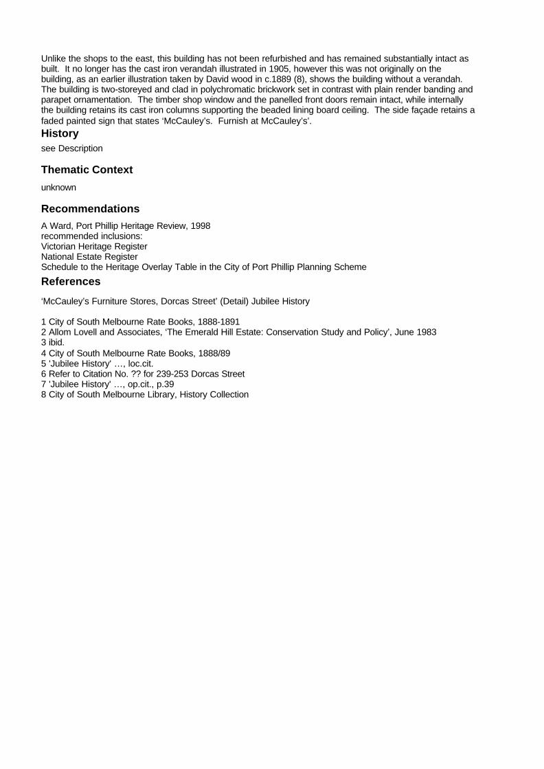
Unlike the shops to the east, this building has not been refurbished and has remained substantially intact as built. It no longer has the cast iron verandah illustrated in 1905, however this was not originally on the building, as an earlier illustration taken by David wood in c.1889 (8), shows the building without a verandah. The building is two-storeyed and clad in polychromatic brickwork set in contrast with plain render banding and parapet ornamentation. The timber shop window and the panelled front doors remain intact, while internally the building retains its cast iron columns supporting the beaded lining board ceiling. The side façade retains a faded painted sign that states ‘McCauley’s. Furnish at McCauley’s’.
RecommendationsA Ward, Port Phillip Heritage Review, 1998recommended inclusions:Victorian Heritage RegisterNational Estate RegisterSchedule to the Heritage Overlay Table in the City of Port Phillip Planning Scheme
References
‘McCauley’s Furniture Stores, Dorcas Street’ (Detail) Jubilee History
1 City of South Melbourne Rate Books, 1888-18912 Allom Lovell and Associates, ‘The Emerald Hill Estate: Conservation Study and Policy’, June 19833 ibid.4 City of South Melbourne Rate Books, 1888/895 'Jubilee History' …, loc.cit.6 Refer to Citation No. ?? for 239-253 Dorcas Street7 'Jubilee History' …, op.cit., p.398 City of South Melbourne Library, History Collection
History
unknown
see Description
Thematic Context

Former "Record" Office, South MelbourneIdentifier unknownFormerly
259 Dorcas StAddress SOUTH MELBOURNE
Description Original Use: Publishing OfficesDate of Construction: 1882(1)Architect: Sydney William Smith(2)
On 6 August 1868 William Marshall commenced publication of 'The Record'; a newspaper for distribution in Emerald Hill(3). During its early years the newspaper was printed at Marshalls 'Machine Printing Office and Stationery Warehouse' on the corner of Wynyard and Clarendon Streets(4). At the end of December 1882 it was reported that 'The Record' had moved to its 'newly erected and handsome general printing and publishing offices'(5) at the corner of Dorcas and Marshall Sreets. The official opening, in the following January, was celebrated by a grand dinner, the guests including the Mayor Cr Mackay, Baron Ferdinand von Mueller and the new editor of the paper the Rev. William Potter(6) who occupied the residence adjoining the offices at No. 2 Marshall Street (q.v.)(7).
In 1881 an auction notice appeared for 'The Record' office(8) and the newspaper's rival 'The Courier', moved into the Dorcas Street premises(9). Potter subsequently moved 'The Record' to new premises in Bank Street East, the site now occupied by the South Melbourne Police Station,(10) and by the closing years of the
SignificanceThe former 'Record' office is of significance as a landmark in South Melbourne and as one of the most distinctive buildings built early in the development of the Emerald Hill Estate. It is also of significance for its historical associations with 'The Record' and 'Courier' newspapers.
Designer Sydney William Smith
Category Commercial
Constructed 1882
Other Studies
Primary SourceAllom Lovell Sanderson Pty. Ltd., South Melb Conservation study vol. 2, 1987
Fishley St
Layfield St
Dorcas St
Bank St
1162
(Mapped as a Significant heritage property.)
City of Port Phillip Heritage Review Citation No:
Amendment C 29
Comment
NoneHeritage Precinct OverlayHeritage Overlay(s) HO30

century 'The Record' was established as the official organ for the South Melbourne Council(11). The paper is continued by Meehan & Co Pty Ltd.(12), and serves the two suburban municipalities, South and Port Melbourne.
The former 'Record' office is one of the most distinctive commercial buildings in the area and with its tall narrow form and fine detailing is a local landmark. The building is set on a rendered rusticated ground floor, the two upper floors having a system of giant order corinthian pilasters extending over the exposed bichromatic bricks of the walls. The lettering across the parapet was replaced with change of occupant.
RecommendationsA Ward, Port Phillip Heritage Review, 1998recommended inclusions:Victorian Heritage RegisterNational Estate RegisterSchedule to the Heritage Overlay Table in the City of Port Phillip Planning Scheme
References
1 Architects' Index, University of Melbourne.2 ibid.3 'The Record', 'A Brief History 1868 to 1968', held in South Melbourne Local History Collection.4 ibid5 'The Record', 29 December 1882, quoted in National Trust of Aust. (Vic), `Research into The Record Newspaper Office..,'27 July 1979.6 National Trust of Australia (Vic), loc.cit.7 Refer to Citation for 2 Marshall Street.8 Architects' Index9 'The Record', A Brief History...', loc.cit10 ibid. Refer Citation for 211-213 Bank Street11 The Record, 'A Brief History...', loc.cit.12 ibid.
History
unknown
see Description
Thematic Context

Primary School (no. 1253)Identifier unknownFormerly
286 Dorcas StAddress SOUTH MELBOURNE
Description Original Use: State School No. 1253 Construction: 1880(1) Architect. Charles Webb(2)
In 1873 following the introduction of the Education Act(3), two Emerald Hill schools (Presbyterian, No.225 and Wesleyan, No.233) combined to become State School No.1253(4). Subsequently in l877, the Town Clerk of Emerald Hill wrote to the Minister of Public Instruction '... requesting him to direct the Architect's attention to the desirability of designing a pretty and tasteful building for the State School to be erected in Dorcas Street West...'(5). In May the following year Charles Webb, architect of the South Melbourne Town Hall (q.v.)(6), completed the drawings(7), but it was not until 1880 that tenders were advertised for the stone foundations of the school(8). The building was erected by James Treeby(9) and was completed at the beginning of the following school year.
The original building was slightly modified by the removal of galleries from some class rooms in 1906(10) and in 1924 alterations and additions were carried out to the rear of the school. The school is also of interest in that Charles Daley, author of 'The History of South Melbourne', was head teacher from 1916 to 1924(11) .
SignificanceState School No. 1253 is of significance as one of the most intact and successful essays in Tudor Gothic applied to a school and executed in polychromatic brickwork, in Melbourne. It is also of significance as a major work of the leading architect, Charles Webb.
Designer Charles Webb
Category School
Constructed 1880
Other Studies
Primary SourceAllom Lovell Sanderson Pty. Ltd., South Melb Conservation study vol. 2, 1987
Dorcas St
Ward St
Coventry St
Ferrars St
Cecil St
1108
(Mapped as a Significant heritage property.)
City of Port Phillip Heritage Review Citation No:
Amendment C 29
Comment
NoneHeritage Precinct OverlayHeritage Overlay(s) HO111

Daley was well-known as an historian, teacher, naturalist and author of several books; serving as Secretary and later as President of the Royal Historical Society of Victoria(12).
The school building is most commanding, built in tuckpointed polychromatic brickwork and decorated predominantly in the Tudor vocabulary: a style so often applied to educational institutions in the nineteenth century. The form of the building is pavilioned with the end pavilions having steep gables projecting to the front while the shallower central pavilion also has a gable end but is heightened by the octagonal turrets that flank it. The Tudor is, typically, combined with Gothic motifs and the decoration across the exterior extends to elements such as the hood moulds over the square-headed multipaned windows, the capped corner buttresses and the false arrow slits and clustered colonettes below the castellated central turrets. The building remains substantially intact although the windows to the recessed wall planes have been replaced and the rear facade added to.
RecommendationsA Ward, Port Phillip Heritage Review, 1998recommended inclusions:Victorian Heritage RegisterNational Estate RegisterSchedule to the Heritage Overlay Table in the City of Port Phillip Planning Scheme
References
1 Architects' Index, University of Melbourne2 ibid.3 C. Daley, 'History of South Melbourne' p. 2434 ibid. p. 2445 Education Department, School Building File 1253 Dorcas Street 77/34003, quoted in L. Burchell, Victorian Schools, p. 1486 Refer Citation No. for 208-220 Bank Street7 HBPC, 'Government Buildings Advisory Council...', held in File no. 84/36158 Architects Index9 HBPC, loc.cit.10 L.J. Blake (ed.), 'Vision and Realisation', Vol. 3, p.330, Education Department11 ibid.12 Blake, op.cit. Vol. 1, pp. 1317, 1318-9
History
unknown
see Description
Thematic Context

Former Presbyterian ChurchIdentifier unknownFormerly
327 Dorcas StAddress SOUTH MELBOURNE
Description Original Use: Church Date of Construction: Circa 1860(1) , enlarged 1867(2)
On 21 April 1867(3) the Emerald Hill Presbyterian Church was opened for worship, additions being made to the earlier 1860 bluestone building at a cost of £567(4) . The tower, shown on the original plan was never erected(5). By 1887, although the church membership was booming, its financial situation had suffered with the substantial alterations to the session house, vestry and organ loft(6) . The Fincham and Hobday organ, built in Richmond in 1891, and now contained within the gallery, is a fine example of its type and is one of the largest two-manual Fincham organs of its Period to survive essentially intact(7).
In 1911 tenders were called for painting the church and for replacing the ceiling with steel panels(8). By 1930 the Dorcas Street congregation had amalgamated with the Clarendon Street Presbyterian Church(9), the building of the latter congregation being used for worship(10) . The church at 327 Dorcas Street is now occupied by the Uniting Church and retains a substantial tract of land free from buildings.
The church is built in basalt in a cruciform plan with an octagonal apse. In reflection of its relatively early date,
SignificanceThe former Presbyterian Church is of significance as one of the earlier churches built in the South Melbourne area. The extant Fincham and Hobday organ enhances the significance of the church as does the retention of large curtilage around the building.
Designer unknown
Category Church
Constructed 1860,1867
Other Studies
Primary SourceAllom Lovell Sanderson Pty. Ltd., South Melb Conservation study vol. 2, 1987
Dorcas St Cecil St
Bank StFerrars St
1116
(Mapped as a Significant heritage property.)
City of Port Phillip Heritage Review Citation No:
Amendment C 29
Comment
NoneHeritage Precinct OverlayHeritage Overlay(s) HO112

externally it is quite sparse of detailing with stylistic derivation being Gothic, expressed in elements such as the pointed tripartite windows.
RecommendationsA Ward, Port Phillip Heritage Review, 1998recommended inclusions:National Estate RegisterSchedule to the Heritage Overlay Table in the City of Port Phillip Planning Scheme
References
1 J. Walsh, ' Brief Histories of the Churches in the Parish of South-Port-Parks' 1977, held in South Melbourne Local History Collection LH 2752 'Jubilee History of South Melbourne', p. 693 ibid.4 ibid.5 J Walsh, loc.cit.6 ibid.7 National Trust of Australia (Vic.) File No. 46058 J Walsh, loc.cit.9 C. Daley, 'History of South Melbourne', pp. 175-17610 Refer to Citation for 223 Dorcas Street
History
unknown
see Description
Thematic Context

Former Queen's Arms HotelIdentifier unknownFormerly
330-334 Dorcas StAddress SOUTH MELBOURNE
Description Original Use: Hotel(1) Construction: 1855(2)
By the turn of the century, South Melbourne had as many as eighty hotels, of which this building was one of the first to have been built(3). In 1854 a James O'Brien was granted a licence to operate his Queen's Arms Hotel(4) on the corner of Dorcas and Coote Streets. Described as a two-storeyed brick building with eight rooms and bars(5) , its initial N.A.V. was a high £280(6). O'Brien owned and occupied the property until 1877(7) when Patrick Mornane, who was later involved with the 'Shannon and Shamrock Hotel' in Bank Street East (q.v.) became the owner of the buildings. At that date the property was listed in the Rate Books as two separate buildings: a three-roomed brick building and shop, with an N.A.V. of £20 and occupied by Bridget Burns, a grocer; and the seven-roomed brick hotel, by then with an N.A.V. of only £60, with a Thomas Davis as its 'licenced victualler'(9). In 1883 the hotel was de-licensed(10), its owner in that year being the Carlton Brewery(11) and the occupant William O'Shea, a 'hotel broker'. By 1893 the Carlton and West End Brewery Ltd. was the owner of both the properties, each described as having, respectively, five rooms and seven rooms and occupied respectively, by John Walker and Alfred Wilkinson, grocers(12).
SignificanceThe former Queen's Arms Hotel, is of significance as one of the first buildings to have been built in Emerald Hill and as one of the smaller buildings purpose-built as a hotel. As such it stands in contrast to the grand establishments of later years. It is also of significance for the rarity and outstandingly intact state of its original fabric including the cast iron decoration and the door and window joinery.
Designer unknown
Category Commercial
Constructed 1855
Other Studies
Primary SourceAllom Lovell Sanderson Pty. Ltd., South Melb Conservation study vol. 2, 1987
Emerald St
Dorcas St
Ferrars St
Coote St
Queen St
1126
(Mapped as a Significant heritage property.)
City of Port Phillip Heritage Review Citation No:
Amendment C 29
Comment
NoneHeritage Precinct OverlayHeritage Overlay(s) HO113

The extant building appears to be that erected in 1855 and as such is one of the earliest buildings in South Melbourne. Its design clearly indicates an early date of construction as the facade is simple and rendered and built hard onto the line of the pavement, with little decoration relieving the box-like form. The render has ruling across it to represent ashlar blocks, however the most dominant decorative elements are the simple cast iron balconettes under each of the first floor windows. The three entrances add interest to the facade with arched fanlights with radiating glazing bars within each, while the joinery in general is of note as it appears to be in the main, original to the building. The first floor windows are multipaned casements, while on the ground floor there are three timber-framed shop windows, two multipaned double hung sash windows and two doorways substantially intact. The hipped roof has been clad in corrugated iron while the chimneys do not remain intact.
RecommendationsA Ward, Port Phillip Heritage Review, 1998recommended inclusions:Victorian Heritage RegisterNational Estate RegisterSchedule to the Heritage Overlay Table in the City of Port Phillip Planning Scheme
References
1 City of South Melbourne Rate Books,1855-18942 ibid., 1855/563 Personal Communication, Andrew Lemon4 Cole Collection, Vol. 3, State Library of Victoria5 City of South Melbourne Rate Books, loc. cit.6 ibid. It is possible that this amount was incorrectly recorded in the Rate Books7 City of South Melbourne Rate Books,1877/789 City of South Melbourne Rate Books, loc.cit.10 A. Rowan, 'South Melbourne Hotels, 1983'. held in South Melbourne Local History Collection 11 City of South Melbourne Rate Books,1881/8212 ibid. 1893/94
History
unknown
see Description
Thematic Context

James Services's HouseIdentifier unknownFormerly
337 Dorcas StAddress SOUTH MELBOURNE
Description
Original use: Residence
This two storeyed weatherboard house appears to have been built in about 1857 and was occupied by James Service from 1858 (1) until 1862 (2). The weatherboards to the gable at the front appear to be original and are beaded, while the gable itself has a distinctive form, being stepped to form a parapet at each edge. The two storeyed verandah has been altered, having been filled in at first floor level and given new brackets and balustrade to the ground floor. A closer inspection of this house would be warranted to establish whether it was a prefabricated structure.
James Service was one of the most prominent citizens of South Melbourne. He arrived in Victoria in 1853 and spent his first few weeks living at Canvas Town. While settled in the Emerald Hill (South Melbourne) area, he pursued a political career as well as trading as a merchant. He was the leader of the campaign for the emancipation of Emerald Hill from the City of Melbourne and upon its creation, was the Municipality’s first Chairman. Service’s activities were many, both in the Emerald Hill area and in Victoria generally. In 1857 he was elected to the Legislative Assembly and his career culminated in his becoming Premier in 1880 (3). A thorough biography of Service is contained in Volume 6 of the 'Australian Dictionary of Biography'.
Significance337 Dorcas Street is of significance as a substantially intact two storeyed timber house of the 1850s and for having been the home of James Service during the years he was commencing his political career.
Designer unknown
Category Residential:detached
Constructed c.1857
Other Studies
Primary SourceAllom Lovell Sanderson Pty. Ltd., South Melb Conservation study vol. 2, 1987
Bank St
Queen St
EmeraldSt
Dorcas St
Coote St Ferrars St
966
(Mapped as a Significant heritage property.)
City of Port Phillip Heritage Review Citation No:
Amendment C 29
Comment
NoneHeritage Precinct OverlayHeritage Overlay(s) HO114

RecommendationsA Ward, Port Phillip Heritage Review, 1998recommended inclusions:Victorian Heritage RegisterNational Estate RegisterSchedule to the Heritage Overlay Table in the City of Port Phillip Planning Scheme
References
337 Dorcas Street in c.1920 (South Melbourne Library)
1 'Sands and Kenny Melbourne Directory', 18582 'Sands and McDougall Melbourne Directory', 18623 'Australian Dictionary of Biography', Vol.6, pp.106-111
History
unknown
see Description
Thematic Context

WarehouseIdentifier unknownFormerly
93 Dow StAddress PORT MELBOURNE
Description PRINCIPAL THEME: IndustrySUB-THEME: WarehousesORIGINAL OWNER: Morley and CarrickLOCAL/PRECINCT CHARACTER: AUTHENTICITYIndividual Character (individual, 90%+ originaldifferent from adjacent)BUILDING TYPE: WarehouseARCHITECTURAL STYLE: Victorian WarehousePRINCIPAL MATERIAL: Basalt
PHYSICAL/STYLISTIC DESCRIPTION
SignificanceThis large warehouse is of local significance. Its original owners William Morley and Robert Carrick were prominent early citizens of Port Melbourne, Morley being first chair of Sandridge Borough Council and Carrick, a cartage contractor, councillor and later Mayor in 1872 - 3.
The substantial bluestone facade was probably the largest constructed in Port Melbourne in the 1860s and among the largest in the metropolitan area. The scale and quality of the detailing to the window and door openings and the cornice are notable.
Designer unknown
Category Industrial
Constructed c.1865
Other StudiesJacobs Lewis Vines, Port Melbourne Conservation Study, 1979
Primary SourceAllom Lovell and Associates, Port Melbourne Conservation Study review Vol. 3, 1995
637
(Mapped as a Significant heritage property.)
City of Port Phillip Heritage Review Citation No:
Amendment C 70Comment Street address and location map corrections.
NoneHeritage Precinct OverlayHeritage Overlay(s) HO115

The store has an imposing facade to Dow Street. There are two arch headed windows and a flat arched opening over a carriageway; all with yellow brick dressings and quoins. At the upper level are three circular openings, again having yellow bricks providing [a] contrast with the bluestone. The bluestone is roughly dressed and at the edges of the building are quoins which [are quarry-faced with drafted margins]. Below the windows is a section of stonework which has natural undressed finish, and provides a substantial base to the building facade. A simple parapet above a string course completes the building. The side walls of the warehouse are constructed of red brick. The parapet and pediment have been altered.
[Jacobs Lewis Vines. Port Melbourne Conservation Study]
COMPARATIVE ANALYSISThis building is the largest nineteenth century warehouse to survive in Port Melbourne and probably was the largest to be constructed. Single storey warehouses of this scale appear to have been associated mainly with the early colonial decades of the 1850s and '60s and were later superseded to a large extent by the multi-storey warehouse type, exemplified by buildings such as the Jones Bond Stores, 25-7 Maffra Street, South Melbourne (1888) which adopted the typical form of early nineteenth century warehouses and factories in England. The massive stonework to the facade is unique in Port Melbourne and of exceptional grandeur compared with other bluestone warehouses in Melbourne.
RecommendationsA Ward, Port Phillip Heritage Review, 1998recommended inclusions:National Estate RegisterSchedule to the Heritage Overlay Table in the City of Port Phillip Planning Scheme
References1. Port Melbourne rate book. November 1865. 1377 and 13782. Photographs dated c 1872 and taken prior to 8 June 1875, referred to in Jacobs Lewis Vines. 'Port Melbourne Conservation Study', p. 174.
History
unknown
Allotment 7 of Section 5 [of the Township of Sandridge] is shown on the first subdivisional plan of Sandridge, dated 1849; the Crown Grantee being N.A. Fenwick. In December 1864 Allotments 6 and 7 contained various wood and iron buildings owned by Reynolds and Co. In the rate book entry, the name is crossed out and the name Morley and Carrick is pencilled in. The rate book entry for November 1865 has the description "Bond'd and Free Store Stabling for 30 horses", presumably the present building. (1) Certainly by 1868 the description of the building was "Store Bond and Free Store: and 1870: "Large Bluestone Store". [The building is quite large and is clearly visible in two early photos of the area when it was more sparsely developed.(2)]
[Jacobs Lewis Vines. Port Melbourne Conservation Study]
Thematic Context

Former Army and Navy HotelIdentifier Army and Navy HotelFormerly
95 Dow StAddress PORT MELBOURNE
Description
PRINCIPAL THEME: Assembly and EntertainmentSUB-THEME: HotelsORIGINAL OWNER: James FraserLOCAL/PRECINCT CHARACTER: AUTHENTICITYIndividual Character (Individual 70-90% originaldifferent from adjacent)BUILDING TYPE: HotelORIGINAL RESIDENTIAL naUSE TYPE:ARCHITECTURAL STYLE: Victorian RegencyPRINCIPAL MATERIAL: Brick
PHYSICAL/STYLISTIC DESCRIPTION
SignificanceThe former Army and Navy Hotel is of local significance. It is among the earliest remaining hotel buildings in Port Melbourne, and is unusual in appearing not to have been remodelled later in the nineteenth century. A rare survivor of a nineteenth century building type, it demonstrates the original character of the immediate area. The substantially intact facade has refined detailing notable for the distinctive and oversized keystones to the door and window openings.
Designer unknown
Category Commercial
Constructed 1866
Other StudiesJacobs Lewis Vines, Port Melbourne Conservation Study, 1979
Primary SourceAllom Lovell and Associates, Port Melbourne Conservation Study review Vol. 3, 1995
Dow
St
Espla
nade W
est
Lt Dow
Rouse St
Bay
St
Graham St
Lt Bay St
266
(Mapped as a Significant heritage property.)
City of Port Phillip Heritage Review Citation No:
Amendment C 29
Comment
HO1Heritage Precinct OverlayHeritage Overlay(s)

The building originally had an interesting form, with a narrow two storey front section and a larger single storey rear section, now demolished. The front elevation to Dow Street is rendered brick. It possesses simple detailing with unusual large keystones over the openings, and quoins at each corner of the facade. The parapet is extremely plain, with a simple panel supported by a pair of consoles.
[Jacobs Lewis Vines. Port Melbourne Conservation Study]
COMPARATIVE ANALYSISAlthough built on a corner site, the former Army and Navy Hotel is unusual in having only one principal facade. In this respect it can be compared with the relatively uncommon streetbound hotels such as the Cricketer's Arms Hotel, Street, Port Melbourne, the former Clarendon Hotel, 231 Nelson Place, Williamstown (1859), the Rose and Crown Hotel, 309 Bay Street, Port Melbourne (original building c. 1879) and the former Royal Hotel, 85 Nelson Place, Williamstown (1890). In terms of architectural treatment, the simple Classical Revival design is typical of hotels of the 1860s, contrasting with the early colonial style of hotels such as the Fountain Inn (q.v.).
RecommendationsA Ward, Port Phillip Heritage Review, 1998recommended inclusions:Schedule to the Heritage Overlay Table in the City of Port Phillip Planning Scheme
References
1. 'Plan of Allotments marked at Sandridge in the Parish of South Melbourne', 1849, Lindsay Clark, Assistant Surveyor, July 18492. Vale Collection of plans held at La Trobe Library, vol. 7, p. 35. '. . . allots 4 and 5 of Section 5, Sandridge. Sale by Mr Robert Byrne'3. Port Melbourne rate book. November 1865. 13974. Port Melbourne rate book. November 1866. 13315. R.K. Cole, 'Hotel Records', manuscript held at La Trobe Library6. Port Melbourne rate books7. A Sutherland (ed) 'Victoria and its Metropolis', 1888, Vol 2, p. 672
History
unknown
Land in Section 5 [of the Township of Sandridge] was included in the first subdivision of Sandridge, shown on a plan dated 1849. The name of the Crown Grantee, M. Benjamin, is shown on this plan. (1) [By the early 1860s, Robert Byrne was the owner. Byrne subdivided and sold the allotments (2), but was still recorded as the owner of this site, Allotment 4 of Section 5, in November 1865. (3)]
By November 1866, a six room brick hotel had been built. It was owned by James Frazer, a [d]rill [i]nstructor of Sandridge. (4) Frederick Sanderson was granted a licence for the Army and Navy Hotel on 1 October 1866. (5) Other publicans kept the hotel in its early years. These included Thomas Postle (1867) and Frederick Haycroft (1868) (6) During the 1880s the hotel was kept by Harry Hall who also ran a ballast contracting business. (7) The hotel is now de-licensed.
[Jacobs Lewis Vines. Port Melbourne Conservation Study]
Thematic Context

Former "T. W. Swindley" Stable BlockIdentifier unknownFormerly
17 Dow StAddress SOUTH MELBOURNE
Description
Original Use: StablesDate of Construction: 1885(1)
From as early as 1868 Thomas William Swindley was advertised as a fuel and produce rnerchant, supplying from his premises in Moray Street(2). By 1881 his store was substantial, being listed as a two-storey brick building, with an N.A.V. of £110(3). Swindley subsequently purchased land in Dow Street, near the Moray Street premises, from a Margaret Moore in 1885(4) and in the following year he erected these brick stables, their having an initial N.A.V. of £36(5). A photograph of the complex taken circa 1905 shows several horse drawn carts both outside the Produce Stores in Moray Street and in the vicinity of the stables in Dow Street(6). The produce store has since been demolished.
Externally, the stable bock remains substantially intact as illustrated in 1905. It is a very large gabled structure dominated by a parapet culminating in a central semicircular unit that embraces an oculus vent. The parapet scallops down at the sides and sits over a simply moulded render architrave. The configuration of the parapet is however quite functional, concealing the clerestory that runs down the full length of the building. The facade
SignificanceThe former T.W. Swindley stable block is of significance as one of the largest stable blocks built in South Melbourne and for its associations with one of municipality's earliest merchant businesses. Its distinctive form, original use and size are of significance in an otherwise predominantly residential street. The paintwork over the facade detracts from the significance of the building.
Designer unknown
Category Commercial
Constructed 1885
Other Studies
Primary SourceAllom Lovell Sanderson Pty. Ltd., South Melb Conservation study vol. 2, 1987
Eastern Rd
Cobden St
Park St
Heather St
Dow StMoray St
Napier St
1156
(Mapped as a Significant heritage property.)
City of Port Phillip Heritage Review Citation No:
Amendment C 29
Comment
HO3Heritage Precinct OverlayHeritage Overlay(s)

has one large central opening and two double hung sash windows, none of which have their original fittings. The facade has been painted, however it is built in tuckpointed brickwork that appears to be polychromatic.
RecommendationsA Ward, Port Phillip Heritage Review, 1998recommended inclusions:Schedule to the Heritage Overlay Table in the City of Port Phillip Planning Scheme
References
1 City of South Melbourne Rate Books, 1884-1886.2 'The Record', 12 November 1868, p. 1.3 City of South Melbourne Rate Books, 1881.82.4 ibid., 1884/86.5 ibid., 1885/86.6 'Jubilee History of South Melbourne', p.18.
History
unknown
see Description
Thematic Context

Primary School (No. 1852)Identifier unknownFormerly
Eastern RdAddress SOUTH MELBOURNE
Description Original Use: State School Construction: 1877(1)Architect: Henry Bastow(2)
In 1873 the Education Act came into force, replacing church schools with the State School System(3) . In 1875 the site in Eastern Road was gazetted for the Education Department's No. 1852 State School(4), and in the following Year Sunderland and Pickering secured the contract to build to the design of the Department's Chief Architect Henry Bastow( 5). Bastow was also the architect, several years later, of the State School No.2686 (q.v.) in City Road(6).
On 1 August 1877 the Eastern Road building was opened(7), the head teacher being Robert Crooke(8) . Crooke had previously been the head teacher of the National School No. 207, (the site now occupied by the A.N.Z. Bank in Clarendon Street(9) ) which had closed on 31 July l877 in favour of the Eastern Road School(10) . By 1890 increased enrolments necessitated the leasing of the Dorcas Street Presbyterian schoolroom, while for twelve years from 1893, No.1852 was amalgamated with State School No. 2686 in
SignificanceThe 1877 building is of significance as a picturesquely composed purpose built school erected soon after the introduction of the State School system. The later windows detract from the significance of the building, while the later extension is not integral to the significance of the complex. The existence of early planting in the school yard enhances the significance of the buildings.
Designer Henry Bastow
Category School
Constructed 1877
Other Studies
Primary SourceAllom Lovell Sanderson Pty. Ltd., South Melb Conservation study vol. 2, 1987
Stead
Eastern Rd
Raglan St
Heather St
Dow St
Napier St
Moray St
Park St
Cobden St
1105
(Mapped as a Significant heritage property.)
City of Port Phillip Heritage Review Citation No:
Amendment C 29
Comment
NoneHeritage Precinct OverlayHeritage Overlay(s) HO116

Moray Street(11) . In 1908 the foundation stone was laid for a second building at the Stead Street end of the site(12).
The 1877 building is a small picturesquely composed single-storeyed polychromatic brick school. It is dominated by two pavilions each capped with a pyramidal slate roof with a diagonally set fleche at the apex and the entrance stands to one side under a polychrome brick florentine arch and a small render-decorated gable. The walls are in hawthorn bricks with the contrasting bricks used mainly in horizontal bands, although the effect of the walls is changed from the original, due to the insertion of large banks of multipaned double hung sash windows, probably as part of the 1908 works. These replaced an extremely bold, large circular window set into the northern pavilion that had spoke-like glazing bars radiating out, and in the low building slung between the pavilions, coupled and tripartite florentine window units in the manner of the extant entrance door. The removal of these commanding elements has paled the design both in the window configuration and in the bold polychromatic brickwork that was set into the walls under the windows. The building does however retain much of its original liveliness of massing.
The 1908 building to the east does not continue the picturesque lines of the earlier building, it being two storeyed, and massive in effect. A number of the Ficus and Schinus molle in the school yard appear to date from at least the turn of the century.
RecommendationsA Ward, Port Phillip Heritage Review, 1998recommended inclusions:Victorian Heritage RegisterNational Estate RegisterSchedule to the Heritage Overlay Table in the City of Port Phillip Planning Scheme
References
1 L. Burchell, 'Victorian Schools', p. 132 ibid.3 Eastern Road Primary School, South Melbourne, 'Centenary Souvenir': 1877-1977, held in South Melbourne Local history Collection LH 224 ibid.5 ibid.6 Refer Citation for 207 City Road7 Eastern Road Primary School, loc. cit.8 ibid.9 Refer Citation No. for 307 Clarendon Street10 C. Daley, 'History of South Melbourne', p 24311 Eastern Road Primary School, loc. cit.12 ibid.
History
unknown
see Description
Thematic Context

"Eildon Close"Identifier unknownFormerly
7-9 Eildon RdAddress ST. KILDA
Description Style : Old EnglishThree storey multi-block walk-up flats
SignificanceOne of the finest and best preserved of St Kilda's Old English style apartment complexes. The complex is one of the largest, comprising two three storey `L' shaped blocks grouped around a intimate and well scaled garden space. Great care has been taken in the detailing and disposition of its variety of Old English motifs. Amongst these are the mock half timbering, executed in brick, the small runs of castellated parapets, the fine texturing of the brickwork surface with header courses, string course and striated spandrels, and the small multi paned windows. The voids of the corner balconies provide a visual transition into the site, and the axis of the garden is emphasised by the sentinel like series of prominent chimneys. The whole complex, with its courtyard garden, creates a romantic and enchanting setting, significantly contributing to the character of this important area. The buildings as well as the front fence and signage are intact.
Designer unknown
Category Residential:apartment
Constructed 1920's
Other Studies
Primary SourceRobert Peck von Hartel Trethowan, St Kilda 20th century Architectural Study Vol. 3, 1992
History
unknown
see Description
Thematic Context
Church SqEildon R
dAcland St
896
(Mapped as a Significant heritage property.)
City of Port Phillip Heritage Review Citation No:
Amendment C 29
Comment
HO5Heritage Precinct OverlayHeritage Overlay(s)

RecommendationsA Ward, Port Phillip Heritage Review, 1998recommended inclusions:Schedule to the Heritage Overlay Table in the City of Port Phillip Planning Scheme
References
unknown

Flats, Former residenceIdentifier unknownFormerly
16 Eildon RdAddress ST. KILDA
Description Style : Arts and CraftsTwo storey flats, former residence
SignificanceA large two storey residence notable for the bizarre styling of its front elevation. This has been achieved primarily through the application of a variety of disparate and distinctive window treatments tied together by a zipper like band of fine, subtly coloured clinker brick. The presence of the building is enhanced by its proximity to the footpath. It is substantially intact although the impressive driveway piers of its front fence have been dismantled.
RecommendationsA Ward, Port Phillip Heritage Review, 1998recommended inclusions:Schedule to the Heritage Overlay Table in the City of Port Phillip Planning Scheme
Designer unknown
Category Residential:apartment
Constructed 1920's
Other Studies
Primary SourceRobert Peck von Hartel Trethowan, St Kilda 20th century Architectural Study Vol. 3, 1992
History
unknown
see Description
Thematic Context
Inverleith St
Eildon R
d
Church Sq
897
(Mapped as a Significant heritage property.)
City of Port Phillip Heritage Review Citation No:
Amendment C 29
Comment
HO5Heritage Precinct OverlayHeritage Overlay(s)

References
unknown

"Mimi"Identifier unknownFormerly
20 Eildon RdAddress ST. KILDA
Description Style : Arts and CraftsTwo storey residence
Significance`Mimi' is notable for its restrained and consistent stylistic character, and its remarkable state of intactness. The arts and crafts style is expressed in the expanses of fine roughcast render of the facades, accented with delicate red brick string courses and sills, and its slightly underscaled multipaned sash windows painted a characteristic deep blood red. Smooth rendered pairs of Tuscan columns highlight the entrance porch. The brick and render front fence extends the house's decorative themes to the front of the property. The subdued colours of the building's palette of natural arts and crafts materials are both aesthetically pleasing and remarkably intact. The simple, neat garden, with its central specimen tree and concrete paths, consolidates the complete period and aesthetic integrity of the whole property. Its currently unknown architect is almost certainly the same as for the Ardoch complex (q.v.).
Designer unknown
Category Residential:detached
Constructed c1930
Other Studies
Primary SourceRobert Peck von Hartel Trethowan, St Kilda 20th century Architectural Study Vol. 3, 1992
History
unknown
see Description
Thematic Context
Eildon R
d
Inverleith St
Church Sq
898
(Mapped as a Significant heritage property.)
City of Port Phillip Heritage Review Citation No:
Amendment C 29
Comment
HO5Heritage Precinct OverlayHeritage Overlay(s)

RecommendationsA Ward, Port Phillip Heritage Review, 1998recommended inclusions:Schedule to the Heritage Overlay Table in the City of Port Phillip Planning Scheme
References
unknown

"Granada"Identifier unknownFormerly
28 Eildon RdAddress ST. KILDA
Description Style : Spanish MissionTwo storey residence
Significance`Granada' is perhaps the best example of pure Spanish Mission design in St Kilda. Unlike most examples of the genre, the style here extends to the picturesque massing of the whole building and the contrivedly `random' placement of the arched porches, balconette and small windows, to capture the informal style of the vernacular architecture of the Spanish villa. The eaves brackets, window grilles, twisted columns, wall mounted lantern and bracket and fine pantiled roof add authenticity to the effect. The building has recently been subject to minor alterations to the exterior, and the new colour scheme and added accessories are arguably more suited to a Federation period house than this building. The fence is intact to the extent of the masonry portions, though the steel framed window of the ground floor bay is an early alteration to the building.
Recommendations
Designer unknown
Category Residential:detached
Constructed c1928
Other Studies
Primary SourceRobert Peck von Hartel Trethowan, St Kilda 20th century Architectural Study Vol. 3, 1992
History
unknown
see Description
Thematic Context
Eildon Ct
Inverleith St
Eildon R
d
Church Sq
899
(Mapped as a Significant heritage property.)
City of Port Phillip Heritage Review Citation No:
Amendment C 29
Comment
HO5Heritage Precinct OverlayHeritage Overlay(s)

A Ward, Port Phillip Heritage Review, 1998recommended inclusions:Schedule to the Heritage Overlay Table in the City of Port Phillip Planning Scheme
References
unknown
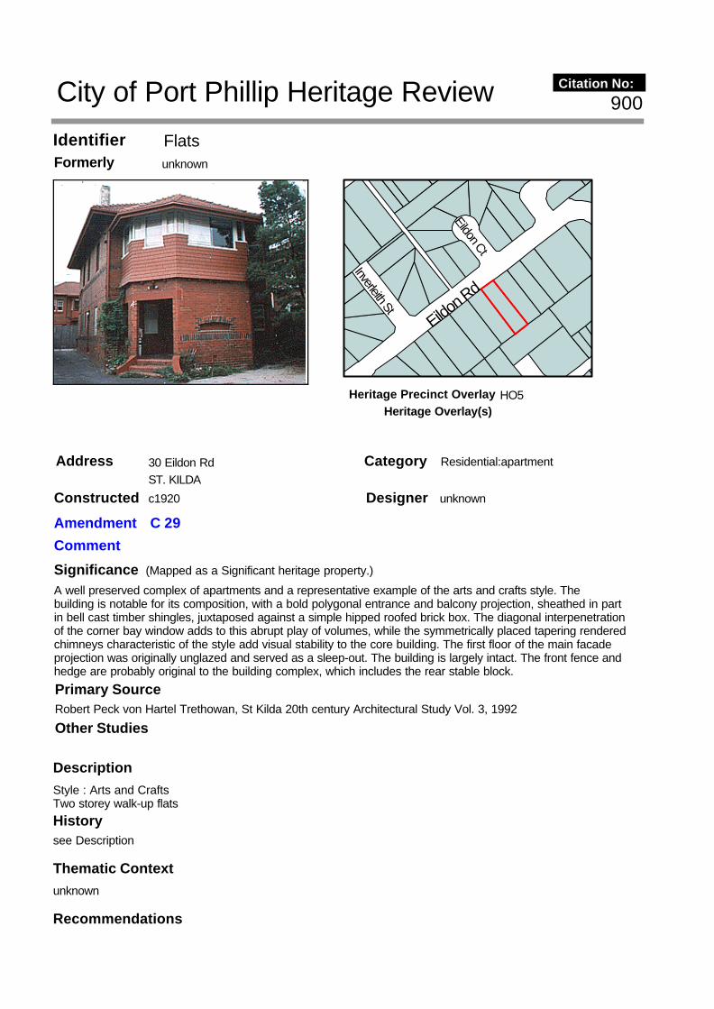
FlatsIdentifier unknownFormerly
30 Eildon RdAddress ST. KILDA
Description Style : Arts and CraftsTwo storey walk-up flats
SignificanceA well preserved complex of apartments and a representative example of the arts and crafts style. The building is notable for its composition, with a bold polygonal entrance and balcony projection, sheathed in part in bell cast timber shingles, juxtaposed against a simple hipped roofed brick box. The diagonal interpenetration of the corner bay window adds to this abrupt play of volumes, while the symmetrically placed tapering rendered chimneys characteristic of the style add visual stability to the core building. The first floor of the main facade projection was originally unglazed and served as a sleep-out. The building is largely intact. The front fence and hedge are probably original to the building complex, which includes the rear stable block.
Recommendations
Designer unknown
Category Residential:apartment
Constructed c1920
Other Studies
Primary SourceRobert Peck von Hartel Trethowan, St Kilda 20th century Architectural Study Vol. 3, 1992
History
unknown
see Description
Thematic Context
Eildon Ct
Inverleith StEildo
n Rd
900
(Mapped as a Significant heritage property.)
City of Port Phillip Heritage Review Citation No:
Amendment C 29
Comment
HO5Heritage Precinct OverlayHeritage Overlay(s)

A Ward, Port Phillip Heritage Review, 1998recommended inclusions:Schedule to the Heritage Overlay Table in the City of Port Phillip Planning Scheme
References
unknown

"Eildon Mansions"Identifier unknownFormerly
34 Eildon RdAddress ST. KILDA
Description Style : Arts and CraftsTwo storey walk-up flats
SignificanceA complex of individual apartments dating from c.1920 significant mainly for the remarkably large size of the individual apartments. The complex comprises a visually prominent building of four apartments fronting onto Eildon Road, and a separate rear wing. The size of the generously proportioned rooms and commodious porches and balconies are comparable in scale only to Summerland Mansions (q.v.) and attest to the prestigious nature of the complex. The building contributes in scale, design and materials to a fine group of buildings of similar period in this part of Eildon Road. The general soft green colour scheme is not original, neither is the extensive brush fencing.
Recommendations
Designer unknown
Category Residential:apartment
Constructed c1920
Other Studies
Primary SourceRobert Peck von Hartel Trethowan, St Kilda 20th century Architectural Study Vol. 3, 1992
History
unknown
see Description
Thematic Context
Eildon R
d
Eildon Ct
Eildon R
d
Grey St
901
(Mapped as a Significant heritage property.)
City of Port Phillip Heritage Review Citation No:
Amendment C 29
Comment
HO5Heritage Precinct OverlayHeritage Overlay(s)

A Ward, Port Phillip Heritage Review, 1998recommended inclusions:Schedule to the Heritage Overlay Table in the City of Port Phillip Planning Scheme
References
unknown

"Biltmore"Identifier unknownFormerly
36 Eildon RdAddress ST. KILDA
Description
Style : Freestyle Arts and CraftsThree storey walk-up flatsBuilder: Dunlop & Hunt
`Biltmore' probably dates from circa 1910, details of its construction are presently unknown. The complex does, however, have design similarities with No. 43 Dalgety Street and 11 Wimmera Place. Both these
Significance`Biltmore' is important for the distinctive decoration and design features to its street elevation. These are combined with the skilful facade composition combining contrasts of solid and void, mass and volume, with a bold verticality. It produces one of the most distinctive apartment buildings of this period in Melbourne. Important parts of the composition include the contrast of the flat central panel of the facade with its `cyclops eye' central ocular window and crisp rendered decoration with the deep voids of the flanking verandahs with their finely rendered balustrades and contrasting strapwork. The overall effect of these motifs together with the deep overhanging eaves is to establish a vaguely oriental character in the facade, an allusion which is reinforced by the profiled cantilevered timbers of the entrance pergola. The planning of the building is conventional for this period, and is directly comparable with three storey blocks with piered verandah structures by pioneer flat designer H R Lawson, located at 11 Wimmera Place and 43 Dalgety Street St Kilda (q.v.). The building is highly intact though certain of the concrete pelmets to the face-of-wall sash frames have deteriorated. The existing garden and the absence of a front fence contribute to character of the property, which is prominently located at the bend in Eildon Road and provides a key focus in this important streetscape.
Designer unknown
Category Residential:apartment
Constructed late1910's
Other Studies
Primary SourceRobert Peck von Hartel Trethowan, St Kilda 20th century Architectural Study Vol. 3, 1992
Eildon R
d
Eildon Ct
Grey St
Eildon R
d
902
(Mapped as a Significant heritage property.)
City of Port Phillip Heritage Review Citation No:
Amendment C 29
Comment
NoneHeritage Precinct OverlayHeritage Overlay(s) HO347

buildings were designed by the architect Howard R. Lawson.
The main apartment element of the building is conceived in a reasonably straight forward manner as a red brick box capped by a hipped roof clad in terra-cotta tiles with wide overhanging eaves. The distinctive element is the projecting hipped bay facing onto the street with its bizarre decoration, and the equally distinctive entrance porch that steps the building out to the street alignment.
The projection includes balconies to each of the apartments and part of the stair envelope. It is comprised of four thin brick piers that rise from ground to eaves. Seemingly weightless spandrel panels divide the side bays to form the balconies. The face brick of the central panel is pierced by a variety of unusually detailed small windows on the upper floors. A giant entrance archway envelopes the two central piers on ground floor. A low masonry wall flanks the entrance steps from the street and supports two stout circular columns which in turn support the pergola tile roof of the covered entrance porch.
The verticality of the projecting central bay is echoed in two small vertical projections on the two corners of the street elevation of the main structure. Both of these projections includes a bizarre decoration (somewhat reminiscent of a minora).
RecommendationsA Ward, Port Phillip Heritage Review, 1998recommended inclusions:National Estate RegisterSchedule to the Heritage Overlay Table in the City of Port Phillip Planning Scheme
References
unknown
History
unknown
see Description
Thematic Context

ResidenceIdentifier unknownFormerly
38 Eildon RdAddress ST. KILDA
Description Style : Arts and CraftsTwo storey residence
SignificanceA large attic residence with a variety of gables, dormer windows, balconies, bellcast shingled window bulkheads, projections and recesses producing a sprawling but picturesque composition in the confines of a restricted site. The building is significant mainly for its size and the integrity of its setting which includes the contemporary front fence with is pergolated entrances and high hedge, and the total design in this setting on a curve on Eildon Road evokes British Garden City suburban ideals. Its location also makes it a prominent building and an important part of the Interwar character of the Eildon Road streetscape.
RecommendationsA Ward, Port Phillip Heritage Review, 1998recommended inclusions:
Designer unknown
Category Residential:detached
Constructed 1920's
Other Studies
Primary SourceRobert Peck von Hartel Trethowan, St Kilda 20th century Architectural Study Vol. 3, 1992
History
unknown
see Description
Thematic Context
Eildon R
d
Eildon Ct
Grey St
Eildon R
d
903
(Mapped as a Significant heritage property.)
City of Port Phillip Heritage Review Citation No:
Amendment C 29
Comment
HO5Heritage Precinct OverlayHeritage Overlay(s)

Schedule to the Heritage Overlay Table in the City of Port Phillip Planning Scheme
References
unknown

FlatsIdentifier unknownFormerly
39 Eildon RdAddress ST. KILDA
Description Style : French ChateauThree storey walk-up flats
SignificanceAn unusual looking apartment complex taking on elements of a French chateau and providing a contrasting stylistic character within a consistent group of flats in this section of Eildon Road. The building is massed with a projecting bay at the front, and the rest of the building coalesces around a staircase tower topped by a turret roof clad in terra-cotta shingles and terminated by a small finial. This tower, and the cantilevered, corbelled upper storey bays flanking the composition, are the elements that give this otherwise ordinary block its vaguely French character. Comparable examples survive in St Kilda at the corner of Alma Road and Hammerdale Avenue and in Toorak at the corner of Wallace Avenue and Washington Street. The basement garage is an unusual feature for flats of this period (the only other Interwar example being Banff in Fitzroy Street (q.v.)).
Recommendations
Designer
Category Residential:apartment
Constructed 1940-1941
Other Studies
Primary SourceRobert Peck von Hartel Trethowan, St Kilda 20th century Architectural Study Vol. 3, 1992
History
unknown
see Description
Thematic Context
Eildon Ct
Grey St
Eildon R
d
Eildon R
d
904
(Mapped as a Significant heritage property.)
City of Port Phillip Heritage Review Citation No:
Amendment C 29
Comment
HO5Heritage Precinct OverlayHeritage Overlay(s)

A Ward, Port Phillip Heritage Review, 1998recommended inclusions:Schedule to the Heritage Overlay Table in the City of Port Phillip Planning Scheme
References
unknown

"Moama"Identifier unknownFormerly
1 Emilton AveAddress ST. KILDA
Description
Style : Queen AnneTwo storey flats, former residence
Significance`Moama' is significant as a fine two storey Queen Anne style residence, a notable example of a conversion of a residence to flats, and as the dominant element in this unusually configured streetscape.
RecommendationsA Ward, Port Phillip Heritage Review, 1998recommended inclusions:Schedule to the Heritage Overlay Table in the City of Port Phillip Planning Scheme
References
Designer unknown
Category Residential:apartment
Constructed c1900-1920
Other Studies
Primary SourceRobert Peck von Hartel Trethowan, St Kilda 20th century Architectural Study Vol. 3, 1992
History
unknown
see Description
Thematic Context
Charles St
Bar
kly
StEmilto
n AvWaterloo Cr
Grey St
905
(Mapped as a Significant heritage property.)
City of Port Phillip Heritage Review Citation No:
Amendment C 29
Comment
HO5Heritage Precinct OverlayHeritage Overlay(s)

unknown

"Bon Jours"Identifier unknownFormerly
1 Erindale AveAddress ST. KILDA
Description Style : Arts and CraftsAttic villa, hedge and lych-gate
SignificanceA property most notable for its magnificent hedge, a local landmark on the corner of Erindale Ave and Fuller Rd, and the single most important feature on either street. The hedge is set off by a timber lych-gate at the corner (the original wire fence is now buried inside the hedge). Through the gate is glimpsed a pleasant garden and attic villa, which are sufficiently intact to make the property significant as a whole.
RecommendationsA Ward, Port Phillip Heritage Review, 1998recommended inclusions:Schedule to the Heritage Overlay Table in the City of Port Phillip Planning Scheme
Designer unknown
Category Residential:detached
Constructed 1920's
Other Studies
Primary SourceRobert Peck von Hartel Trethowan, St Kilda 20th century Architectural Study Vol. 3, 1992
History
unknown
see Description
Thematic Context
Lyndon St
Victoria Ave
Fuller RdErindale Av
906
(Mapped as a Significant heritage property.)
City of Port Phillip Heritage Review Citation No:
Amendment C 29
Comment
HO7Heritage Precinct OverlayHeritage Overlay(s)

References
NOTESSt K.C.C. building approval No 2619, May 1915

"Guernsey House"Identifier unknownFormerly
232 Esplanade EastAddress PORT MELBOURNE
Description PRINCIPAL THEME: ResidentialSUB-THEME: Nineteenth century brick freestanding houses, two storeyedORIGINAL OWNER: Peter GrutLOCAL/PRECINCT CHARACTER: AUTHENTICITYIndividual Character (Individual, 90%+ originaldifferent from adjacent)BUILDING TYPE: Nineteenth century brick freestanding houses, two-storeyedORIGINAL RESIDENTIAL Private residenceUSE TYPE:ARCHITECTURAL STYLE: Victorian FiligreePRINCIPAL MATERIAL: Rendered brick
PHYSICAL/STYLISTIC DESCRIPTIONGuernsey House is a large two-storey double-fronted house of rendered masonry construction. The front facade has a cast iron decorated balcony with convex roof below masonry wing walls. The parapet is elaborately designed, with a dentilled cornice with modillions and large urns of a distinctive design to each
SignificanceGuernsey House is of local significance. An exceptionally large and grand house for Port Melbourne, this double fronted house is representative of similar large balconied houses in other suburbs and is particularly notable for the quality of the ground floor windows and the parapet.
Designer unknown
Category Residential:detached
Constructed 1883
Other StudiesJacobs Lewis Vines, Port Melbourne Conservation Study, 1979
Primary SourceAllom Lovell and Associates, Port Melbourne Conservation Study review Vol. 4, 1995
Bridge St
Esplanade E
astEspl
anade
East
267
(Mapped as a Significant heritage property.)
City of Port Phillip Heritage Review Citation No:
Amendment C 29
Comment
HO1Heritage Precinct OverlayHeritage Overlay(s)

end. The large segmental arched pediment to the centre is dentillated and is supported on vermiculated pedestals; it has corner antefixae and a scrolled finial. The tripartite ground floor windows are arched with moulded archivolts and piers. The front door has sidelights and an arched fanlight. By contrast, the first floor windows have plain rectangular openings. The house retains a cast iron palisade fence to the front.
COMPARATIVE ANALYSISAn exceptionally large and grand house for Port Melbourne, Guernsey House can be compared with similar double-fronted balconied houses at 646 Canning Street, Carlton, 26 Acland Street, St Kilda, 32a St Vincent Place, South Melbourne and 34 Ferrars Place, South Melbourne. Even compared to houses such as these, Guernsey House is notable for elements such as the arched tripartite ground floor windows and the very elaborate cornice and parapet.
RecommendationsA Ward, Port Phillip Heritage Review, 1998recommended inclusions:Schedule to the Heritage Overlay Table in the City of Port Phillip Planning Scheme
References
1. Map of 'Sandridge', surveyed by J. Noone, 21.5.1878.2. Vale Collection held at La Trobe Library, Volume 7a, p. 125.3. Port Melbourne rate book. January 1883. 1806. 4. Port Melbourne rate book. December 1883. 1835.5. David Saunders (ed), 'Historic Buildings of Victoria', Jacaranda Press, 1966, p. 121.6. According to P. Grainger.
History
unknown
The land on which Guernsey House is built (Section 48/Allotment 1) was purchased from the Crown by Robert Byrne, an auctioneer and estate agent, on 12 May 1865. (1) A later plan (2) of 27 June 1867, surveyed by William White, shows this allotment and a number of other allotments in Section 50 also owned by Robert Byrne. It is possible that Section 48/Allotment 1 was purchased by Mr Peter Grut shortly after this date as Grut had purchased a number of other blocks in Esplanade East from the Crown in 1875. By January 1883, Peter Grut, whose trade was variously given as carpenter and shipwright was living in a 5 room timber house on the site. (3)
In December 1883, rate books show that Grut had erected the present 10 room brick house. (4) David Saunders (5) erroneously claimed that Guernsey House was constructed in 1886 for architect John B. Grut, who did other work in Port Melbourne. J.B. Grut was Peter's son. The name of the house is derived from the Grut's place of origin. (6)
When first built, the house faced directly onto the lagoon. Esplanade East and Esplanade West were planned before the lagoon was filled in and therefore their direction reflects the original location of the lagoon.
[Jacobs Lewis Vines. Port Melbourne Conservation Study]
Thematic Context

ResidenceIdentifier unknownFormerly
331 Esplanade EastAddress PORT MELBOURNE
Description
PRINCIPAL THEME: ResidentialSUB-THEME: Nineteenth century weatherboard cottage, one-storeyORIGINAL OWNER: William KnightLOCAL/PRECINCT CHARACTER: AUTHENTICITYPrecinct Character (similar to adjacent, 90%+ originalcontributes to overall character of the precinct)BUILDING TYPE: Nineteenth century weatherboard cottage, one-storeyORIGINAL RESIDENTIAL Private residenceUSE TYPE:PRINCIPAL MATERIAL: Timber
PHYSICAL/STYLISTIC DESCRIPTIONThis small single-storey timber-framed residence is weatherboarded to the sides and rear and has a more formal timber block front in imitation of ashlar rising to a parapet above the corrugated iron roof. The
Significance331 Esplanade East is of local significance. It is among the earliest houses on this side of Esplanade East, being built apparently immediately following the infilling of the north end of the lagoon. In general form, it is typical of small timber residences of the 1870s, but it is notable for its asymmetric front elevation, unusual degree of architectural elaboration, external intactness, and timber construction on the property line.
Designer unknown
Category Residential:detached
Constructed 1876
Other Studies
Primary SourceAllom Lovell and Associates, Port Melbourne Conservation Study review Vol. 4, 1995
Raglan St
Esplana
de East
Ingles St
640
(Mapped as a Significant heritage property.)
City of Port Phillip Heritage Review Citation No:
Amendment C 29
Comment
HO1Heritage Precinct OverlayHeritage Overlay(s)

asymmetric front elevation is built up to the property line, and comprises a projecting wing framed by panelled pilasters to the north, and verandahed recessed bay to the south. A moulded timber cornice supported on paired shaped brackets extends the full width of the elevation, and is terminated at each end by console brackets. The single sash window to the projecting wing and the verandah, and the front door, have moulded timber architraves. The verandah has Edwardian style turned timber posts and fretwork valence, with closely spaced wide and narrow balusters to the fence and gate.
COMPARATIVE ANALYSISThis small house is unusual for its asymmetric front elevation and its relatively elaborate treatment. It is comparable in form to the house at 222 Moray Street, South Melbourne (c. 1860), which has a mock timber block front in imitation of ashlar, with projecting wings to each side of a recessed front verandah. Unlike 331 Esplanade East, the projecting wings are gabled. The degree of elaboration of the front elevation of this house, with pilasters and bracketed cornice, appears to be unequalled among small timber houses in Port Melbourne.
RecommendationsA Ward, Port Phillip Heritage Review, 1998recommended inclusions:Schedule to the Heritage Overlay Table in the City of Port Phillip Planning Scheme
References
1. Port Melbourne rate book, 1876-77, no. 1752.2. Port Melbourne rate book, various years, N. Turnbull and N. U'Ren. 'A History of Port Melbourne'. p. 276.3. Port Melbourne rate book, 1893-4, no. 2209, Port Melbourne rate book, 1894-5, no. 2318.4. N. Turnbull and N. U'Ren. op. cit. p. 123.
History
Filling of the northern end of the lagoon, beyond Bridge Street, commenced in 1876. (4) Though the progress of the works was slow, development of the reclaimed land began soon after. This timber residence would appear to have been one of the first to be constructed. It is one of many to be constructed in Port Melbourne in the 1860s and 1870s and is typical of the small workers' residences of the period.
This house appears to have been built by a shipwright, William Knight, in 1876. When first rated, the humble cottage was described as a three roomed wood dwelling, and was valued at £16. (1) Knight lived in the house for a number of years, but in the mid-1880s, it was sold to a labourer, James Locke, and in 1894, changed hands again, being purchased by Irwin Brinton, who was a Port Melbourne councillor in the 1870s. (2) Upon acquiring the house, Brinton appears to have added to it, the description changing from three rooms to five rooms. (3) It is probable that the front facade was altered to its existing form at this time, its elaborate nature suggestive of an owner of a higher social and economic standing than William Knight's.
The house remained in the Brinton family until well into the twentieth century.
Thematic Context
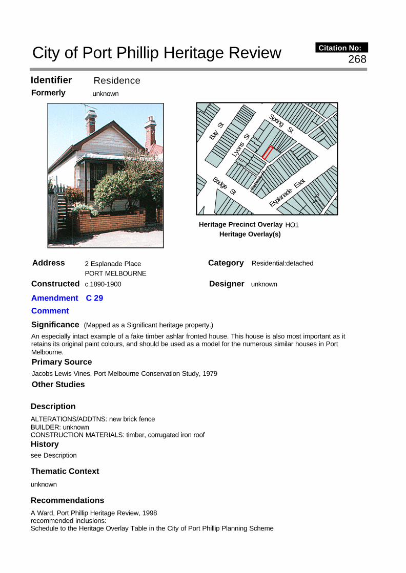
ResidenceIdentifier unknownFormerly
2 Esplanade PlaceAddress PORT MELBOURNE
Description ALTERATIONS/ADDTNS: new brick fenceBUILDER: unknownCONSTRUCTION MATERIALS: timber, corrugated iron roof
SignificanceAn especially intact example of a fake timber ashlar fronted house. This house is also most important as it retains its original paint colours, and should be used as a model for the numerous similar houses in Port Melbourne.
RecommendationsA Ward, Port Phillip Heritage Review, 1998recommended inclusions:Schedule to the Heritage Overlay Table in the City of Port Phillip Planning Scheme
Designer unknown
Category Residential:detached
Constructed c.1890-1900
Other Studies
Primary SourceJacobs Lewis Vines, Port Melbourne Conservation Study, 1979
History
unknown
see Description
Thematic Context
Bridge St Espla
nade
Pl
Esplana
de E
ast
Lyon
s S
t
Spring St
Bay
St
268
(Mapped as a Significant heritage property.)
City of Port Phillip Heritage Review Citation No:
Amendment C 29
Comment
HO1Heritage Precinct OverlayHeritage Overlay(s)

References
unknown

ResidenceIdentifier unknownFormerly
220 Esplanade WestAddress PORT MELBOURNE
Description
PRINCIPAL THEME: ResidentialSUB-THEME: Inter-War weatherboard housesORIGINAL OWNER: Thomas PrenticeLOCAL/PRECINCT CHARACTER: AUTHENTICITYPrecinct Character (similar to 90%+ originaladjacent, contributes to overallcharacter of the precinct)BUILDING TYPE: Inter-War weatherboard housesORIGINAL RESIDENTIAL Private residenceUSE TYPE:SIGNIFICANT TREES: Small Canary Island palm (Phoenix canariensis), characteristic planting for the period of the house.ARCHITECTURAL STYLE: Inter-War Californian BungalowPRINCIPAL MATERIAL: Timber
PHYSICAL/STYLISTIC DESCRIPTION
Significance220 Esplanade West is of local significance. The house is an unusually intact and representative example of the Inter-War Californian Bungalow style applied to small inner-urban houses.
Designer unknown
Category Residential:attached
Constructed 1924-25
Other Studies
Primary SourceAllom Lovell and Associates, Port Melbourne Conservation Study review Vol. 4, 1995
Esplanade E
astEsp
lana
de W
est
Pool St
Bay S
tLy
ons S
t
Bridge St
641
(Mapped as a Significant heritage property.)
City of Port Phillip Heritage Review Citation No:
Amendment C 29
Comment
HO1Heritage Precinct OverlayHeritage Overlay(s)

This substantially intact timber-framed and weatherboarded house is single-storey and single-fronted, and is separated from its slightly different pair by a brick party wall. The front elevation displays many of the typical characteristics of the Californian Bungalow style, including a full-width shingled and bell-mouthed gable extending over a full-width verandah, a louvred gable vent, and lead lighted bay window. The garden, appropriately planted with roses, contains a small Canary Island palm (Phoenix canariensis), which is appropriate for the house, but which is not original.
COMPARATIVE ANALYSISThis house is similar in form and detail to a number of other paired houses, including the adjacent house at 222 Esplanade West, and in stylistic terms displays typical features of 1920s houses in the Californian Bungalow style. It is of particular interest for its especially intact state. The majority of houses in this style were built as detached houses on relatively wide blocks and in the middle ring of suburbs. The Port Melbourne example is also of interest, being a less common application of Californian Bungalow style to small inner suburban sites.
RecommendationsA Ward, Port Phillip Heritage Review, 1998recommended inclusions:Schedule to the Heritage Overlay Table in the City of Port Phillip Planning Scheme
References
1. Port Melbourne rate book, 1924-5, no. 4012. Port Melbourne rate book, 1926-7, no. 4013. Port Melbourne rate book, 1927-28, no. 401
History
This house was constructed as part of the Inter-War development of this part of Port Melbourne following the filling of the lagoon.
220 Esplanade West was constructed in 1924-5, when the rate books note a house in course of erection on the site. (1) Its original owner was Collingwood labourer, Thomas Prentice. It was first fully rated in 1925-6, when it was described as a four-roomed wood house and was valued at £45. (2) Prentice sold the house in 1927, to a cellarman, John Fennessy. (3)
Thematic Context

Horse TroughIdentifier unknownFormerly
Cnr. Evans St and Bridge StAddress PORT MELBOURNE
Description
PRINCIPAL THEME: ObjectsSUB-THEME: Horse troughsORIGINAL OWNER: City of Port MelbourneCURRENT OWNER: City of Port PhillipLOCAL/PRECINCT CHARACTER: AUTHENTICITYIndividual Character (Individual, 90%+ original different from adjacent)OBJECTS: Horse troughARCHITECTURAL STYLE: naPRINCIPAL MATERIAL: Stone
PHYSICAL/STYLISTIC DESCRIPTIONThis horse trough has bluestone rubble sides enclosing a semicircular section precast concrete trough. The tops of the bluestone sides are rendered. At one end is a semicircular concrete head stone originally
SignificanceThis horse trough is of local significance. Along with the similar example at the corner of Bay and Raglan Streets (q.v.), it is one of only two remaining examples in Port Melbourne of a once common nineteenth and early twentieth century item of street furniture.
Designer Fred Cook City of Port Melbourne Chief Engineer
Category Street Furniture
Constructed c1940s
Other Studies
Primary SourceAllom Lovell and Associates, Port Melbourne Conservation Study review Vol. 4, 1995
Ross St
Evans S
t
Farrell St
Bridge St
646City of Port Phillip Heritage Review Citation No:
Amendment C 29
Comment
HO1Heritage Precinct OverlayHeritage Overlay(s)
incorporating a water outlet.
COMPARATIVE ANALYSISThe simple, somewhat rustic, stone construction of this horse trough is characteristic of mid-twentieth century municipal structures such as park planters, drinking fountains and other landscape and street structures. It is in marked contradistinction to the more precise and engineered character of the nineteenth century cast iron and dressed bluestone horse troughs installed in the City of Melbourne and other suburbs, and the later shaped iron sheet trough.
RecommendationsA Ward, Port Phillip Heritage Review, 1998recommended inclusions:Schedule to the Heritage Overlay Table in the City of Port Phillip Planning Scheme
References
1. A drawing for a standard horse trough signed by Fred Cook is held by the Port Melbourne Historical Society.
History
The horse trough is associated with the historical development of road transport in the area, and in particular demonstrates the continuing existence of horsedrawn transport as late as the 1940s.
This trough was constructed sometime after 1942 by the City of Port Melbourne, to a 1942 design by the municipality's Chief Engineer, Fred Cook. (1)
Thematic Context

Pillar BoxIdentifier unknownFormerly
Cnr. Evans St and Bridge StAddress PORT MELBOURNE
Description PRINCIPAL THEME: ObjectsSUB-THEME: Post boxes Postal servicesORIGINAL OWNER: Victorian/Commonwealth GovernmentCURRENT OWNER: Commonwealth GovernmentLOCAL/PRECINCT CHARACTER: AUTHENTICITYIndividual character (Individual, 90%+ originaldifferent from adjacent)OBJECTS: Post boxARCHITECTURAL STYLE: naPRINCIPAL MATERIAL: Cast Iron
PHYSICAL/STYLISTIC DESCRIPTIONThis cylindrical cast iron pillar box is cylindrical in form with a base of slightly larger diameter than the main body. The cap is ogee-shaped and has a crown finial and a chevron moulding to the underside. Above the hinged door is a torus moulding around the body, formed into a weather hood above the door. Above the
SignificanceThis pillar box is of local significance. Along with the pillar box at the corner of Bay and Rouse Streets (q.v.), it is one of only two surviving nineteenth or early twentieth century pillar boxes in Port Melbourne.
Designer unknown
Category Street Furniture
Constructed 1880-1920
Other Studies
Primary SourceAllom Lovell and Associates, Port Melbourne Conservation Study review Vol. 4, 1995
Bridge StRoss St
Evans S
tFarrell St
642City of Port Phillip Heritage Review Citation No:
Amendment C 29
Comment
HO1Heritage Precinct OverlayHeritage Overlay(s)

door is the letter slot and raised cast lettering 'POST OFFICE RECEIVING PILLAR'. The door handle is in the form of a clenched fist, originally holding a ring, now missing.
COMPARATIVE ANALYSISOne of the standard pillar box designs used by the Post-Master General's Department in the late nineteenth and early twentieth centuries, pillar boxes of this type were once common in Victoria. Reduced, but significant numbers remain extant across the metropolitan area and country Victoria.
RecommendationsA Ward, Port Phillip Heritage Review, 1998recommended inclusions:Schedule to the Heritage Overlay Table in the City of Port Phillip Planning Scheme
References
1. Pers. comm. Craig Coot, Australia Post.
History
The cast iron post box was positioned as a late nineteenth or early twentieth century element of Port Melbourne's street furniture.
This cast iron post box is one of the standard designs produced by the Post Office and used for street post boxes in the period between 1880-1920. The boxes were manufactured at the Reliance Ironworks (1).
Thematic Context

ResidencesIdentifier unknownFormerly
62-6 Evans StAddress PORT MELBOURNE
Description
PRINCIPAL THEME: ResidentialSUB-THEME: Nineteenth century brick villa, single storey, double fronted Nineteenth century weatherboard villa, single-storeyORIGINAL OWNER: Caleb Amos KennettLOCAL/PRECINCT CHARACTER: AUTHENTICITYIndividual Character (Individual 70-90% originaldifferent from adjacent) BUILDING TYPE: Nineteenth century brick villa, single-storey, double fronted ORIGINAL RESIDENTIAL Private residences
Significance62-6 Evans Street is of local significance. The site has associations with Caleb Amos Kennett, the locally prominent owner of the Sandridge Abattoir in the nineteenth century. It demonstrates a locally unusual pattern of development in the nineteenth century, retaining in largely intact form the original 1874 house built by Caleb Kennett and the subsequent houses constructed within the original garden by his widow Jane Ann Kennett. The 1874 house, substantially intact externally, except to the rear, is an exceptional example in Port Melbourne of a relatively large house in a large garden. Apart from the later nineteenth century houses to each side, the garden retains its original form to the front, and appears to contain a number of early trees and shrubs. The front boundary wall and fence are unique in Port Melbourne. 66 Evans Street is substantially intact externally and is typical of timber houses of the period. Its extraordinary location behind the original garden wall is significant in the context of the pattern of development of the site.
Designer unknown
Category Residential:detached
Constructed 1873-4
Other Studies
Primary SourceAllom Lovell and Associates, Port Melbourne Conservation Study review Vol. 4, 1995
Evans S
tFarrell St
Ross St
647
(Mapped as a Significant heritage property.)
City of Port Phillip Heritage Review Citation No:
Amendment C 29
Comment
HO1Heritage Precinct OverlayHeritage Overlay(s)

USE TYPE:DOMESTIC GARDEN TYPE: Nineteenth century villaSIGNIFICANT TREES: Several trees possibly of nineteenth or early twentieth century dateARCHITECTURAL STYLE: Victorian FiligreePRINCIPAL MATERIAL: Brick
PHYSICAL/STYLISTIC DESCRIPTIONThis large site, bounded to the front by a brick wall and cast iron fence, contains two residences fronting onto Evans Street and a brick shed to the rear. The site is reduced from its original extent, which included the later house at 60 Evans Street to the south and a fourth house and a shop to the rear facing Ross Street. The brick boundary wall extends across the front of the existing site to 62 and 64 Evans Street, and originally extended in front of 60 Evans Street.
The earliest of the houses, no 64, is located in the centre of the site and is a single-storey double-fronted brick building with a verandah extending across the front elevation. The walls are constructed of dark brown bricks with dentilled eaves and painted quoin bricks, possibly originally of contrasting colour, to the corners and door and window jambs. The hipped roof is covered with corrugated iron. The verandah has cast iron posts, brackets and frieze panels. Extensive additions have been constructed to the rear of the house.
The front boundary wall and fence are probably contemporary with the original house. The central cast iron palisade fence is constructed on a basalt plinth, and incorporates a gate with large square cast iron gate piers. The flanking brick walls are constructed of dark brown brick with cream brick diaper patterning and square piers with rendered caps.
The second house to be built, no 66, is timber-framed, with weatherboarded side and rear walls and timber block front to imitate ashlar. The asymmetric double-fronted principal elevation has tripartite windows to the projecting wing and next to the front door. The verandah to the set-back bay has a convex corrugated iron roof and cast iron columns, brackets and frieze. The chimneys are of red brick with unpainted render plinths and dentilled cornices.
No. 60 is a single-fronted weatherboarded house with a front verandah. The brick boundary wall which originally extended across the front of the house has been demolished, and this building, along with the later house and shop facing Ross Street, are no longer visually related to the original site as is 66 Evans Street.
COMPARATIVE ANALYSISThe original house at 62 Evans Street, although exceptional in Port Melbourne as a large double-fronted verandahed house, is similar to many other single-storey double-fronted houses of the 1870s and '80s in other parts of Melbourne, and particularly the eastern suburbs such as Kew and Hawthorn. The adjacent house at no 66, likewise, is typical of timber houses built in these suburbs in the 1890s. What is unusual about this site in the local context, apart from the nature of the original house, is the exceptionally large size of the original site and the pattern of subsequent development. While subdivision of large estates was common in other suburbs, particularly in the east and south-east, in Port Melbourne, the existing small plots generally correspond to the original subdivisions. Although subdivision of the sort that occurred on this site was by no means unique in Port Melbourne, in no other place in the city does the pattern of development remain so evident.History The brick house at 64 Evans Street was constructed in 1873-4 for slaughterman, Caleb Amos Kennett, owner of the Sandridge Abattoirs. Land north-west of the railway line near Graham Street was first auctioned in late 1868, and Kennett was one of the first to buy.(1) He also became a spokesman for the residents of this new area in their efforts to get a better deal from the Council in terms of services such as water and roads.(2) The first house constructed by Kennett on this site was a timber cottage.(3) This was demolished in the 1870s to make way for his new brick house. When first rated in 1874-5, the property, which encompassed the frontages then known as 2 and 3 Evans Street, was described as a six roomed brick house, with stables and outhouses, and was valued at £66. The house may have been extended within a few years of being built; between 1877-8 and 1878-9, the number of rooms described in ratebooks increased from six to eight, and the value of the property increased from £70 to £80.(4) The house appears to have been further extended in the following years; in 1886-7, it was described as nine rooms, but in 1890-91, this had increased to eleven.(5)
Caleb Kennett died of cancer in 1888,(6) and in 1889, his wife, Jane Ann Kennett is listed as the owner of the property. Presumably in need of a regular income following her husband's death, in the following year, Kennett constructed a new timber residence on the property, moved into it, and leased out the larger brick house. When first rated in 1890-1, the seven roomed timber house, now known as 66 Evans Street, was rated at £50, while the main house was valued at £110.

RecommendationsA Ward, Port Phillip Heritage Review, 1998recommended inclusions:Schedule to the Heritage Overlay Table in the City of Port Phillip Planning Scheme
References
1. N. Turnbull and N. U'Ren. 'A History of Port Melbourne'. p. 84.2. ibid. p. 84.3. Port Melbourne rate book, 1873-4, no. 1641.4. Port Melbourne rate book, 1877-78, no. 1817, Port Melbourne rate book, 1878-9, no. 1829.5. Port Melbourne rate book, 1886-7, no. 2204, Port Melbourne rate book, 1889-90, no. 2308.6. N. Turnbull and N. U'Ren. op. cit. p. 164.7. Port Melbourne rate book, 1895-6, no. 2313.
Caleb Kennett, the original owner of 64 Evans Street, was one of Port Melbourne's more significant early businessmen, owning the Sandridge Abattoirs. He was also one of the first to buy and develop land west of the railway line. The construction of the substantial brick house at 64 Evans Street to replace Kennett's earlier timber dwelling was a function of his improved circumstances. It is of interest that Kennett chose to build in predominantly working-class Port Melbourne at this time, in preference to relocating to a more prestigious suburb.
The later construction of other buildings on the original allotment was a fairly common occurrence in Melbourne in the nineteenth century, but is unusual for Port Melbourne.
Jane Kennett remarried in the 1890s, and by 1895-6, as Jane Ann McMurray, had moved back into the house built over twenty years before by her first husband.(7)
Another brick house, a shop and a shed onto Evans Street were all constructed on this original allotment later. The main house originally featured an open courtyard; this has been filled in and floored, and the original rear verandah has been removed. The house has recently undergone extensions and alterations.
Thematic Context

"Gloster House"Identifier unknownFormerly
73 Evans StAddress PORT MELBOURNE
Description
PRINCIPAL THEME: ResidentialSUB-THEME: Nineteenth century brick terrace, two storeyORIGINAL OWNER: David ArmstrongLOCAL/PRECINCT CHARACTER: AUTHENTICITYPrecinct Character (similar to adjacent, 70-90% originalcontributes to overall character of the precinct)BUILDING TYPE: Nineteenth century brick terrace, two storeyORIGINAL RESIDENTIAL Private residenceUSE TYPE:ARCHITECTURAL STYLE: Victorian filigreePRINCIPAL MATERIAL: Rendered masonry
PHYSICAL/STYLISTIC DESCRIPTIONGloster House is a two-storey rendered masonry house. The front elevation is relatively plain with most
SignificanceGloster House is of local significance. Part of a group of residences with significant historical associations, Gloster House has associations with the locally prominent auctioneer David Armstrong. Although less distinctively detailed than its neighbour at 75 Evans Street (q.v.), the house is representative of the larger two storey houses that were being built in pockets in Port Melbourne. Located on a corner site facing the railway reserve, it forms an important streetscape element.
Designer unknown
Category Residential:detached
Constructed 1885
Other Studies
Primary SourceAllom Lovell and Associates, Port Melbourne Conservation Study review Vol. 4, 1995
Evans S
tFarrell St
Ross St
Bridge St
643
(Mapped as a Significant heritage property.)
City of Port Phillip Heritage Review Citation No:
Amendment C 29
Comment
HO1Heritage Precinct OverlayHeritage Overlay(s)

decorative interest focussed on the simple moulded cornice and parapet incorporating a triangular topped centrepiece containing the inscription 'Gloster House', flanked by scrolled brackets. The first floor windows have moulded architrave surrounds, while the tripartite ground floor window has a single plain opening. The balcony is simply detailed with cast iron to the balustrading only, with the brackets and valence no longer extant. The house retains its original cast iron fence and gate.
COMPARATIVE ANALYSISGenerally typical of the Victorian two-storied balconied house, Gloster House is one of a relatively small number of similar houses in Port Melbourne. A comparable grouping of two-storey houses is Alfred Terrace and the adjoining houses at 160-4 Station Street (q.v.).
RecommendationsA Ward, Port Phillip Heritage Review, 1998recommended inclusions:Schedule to the Heritage Overlay Table in the City of Port Phillip Planning Scheme
References
1. Port Melbourne rate book, 1885-6, no. 21942. Port Melbourne rate book, 1886-87, no. 22363. N. Turnbull and N. U'Ren. 'A History of Port Melbourne'. pp. 118, 157, 167, 171, 172, 197.4. Port Melbourne rate book, 1887-8, 23025. N. Turnbull and N. U'Ren. op. cit. pp. 273
History
Gloster House has strong associations with two prominent Port Melbourne identities. It was originally owned by David Armstrong, who was involved in a wide range of business, community, sporting and political activities in Port Melbourne, including football, debating, and the woman suffrage movement. He was also the Liberal candidate for the 1894 State Parliamentary elections, and chaired the founding meeting of the Port Melbourne branch of the Liberal Party.(3)
Armstrong lived in the house until 1887, after which he leased the building to Amy Malcolmson. (4). Almost immediately, Armstrong sold the house to another prominent Port Melbourne citizen, William Henry Prohasky, councillor between 1885 and 1893, and Mayor in 1888-9. (5)
With Magnolia House and Lily Cottage, Gloster House was constructed on land owned by David Armstrong. The pattern of subdivision and building construction and ownership of the three houses is of some interest, as are their associations with various well-known Port Melbourne identities and families in the 1880s and 1890s.
Gloster House was constructed in 1885 for its first owner and occupant, auctioneer and prominent local identity, David Armstrong. In 1884-5, local auctioneer David C. Armstrong was the owner of vacant land measuring 125' x 60' [38m x 18m] in Evans Street. This land was subsequently subdivided into three smaller blocks, one of which Armstrong sold (75 Evans Street (q.v.)), while he constructed residences on the other two (73 Evans Street and 77 Evans Street, q.v.). When first rated in 1885-6, Gloster House was described as an eight-roomed brick house, valued at £60. (1) The following year, the description notes the presence of stables on the property. (2)
Thematic Context
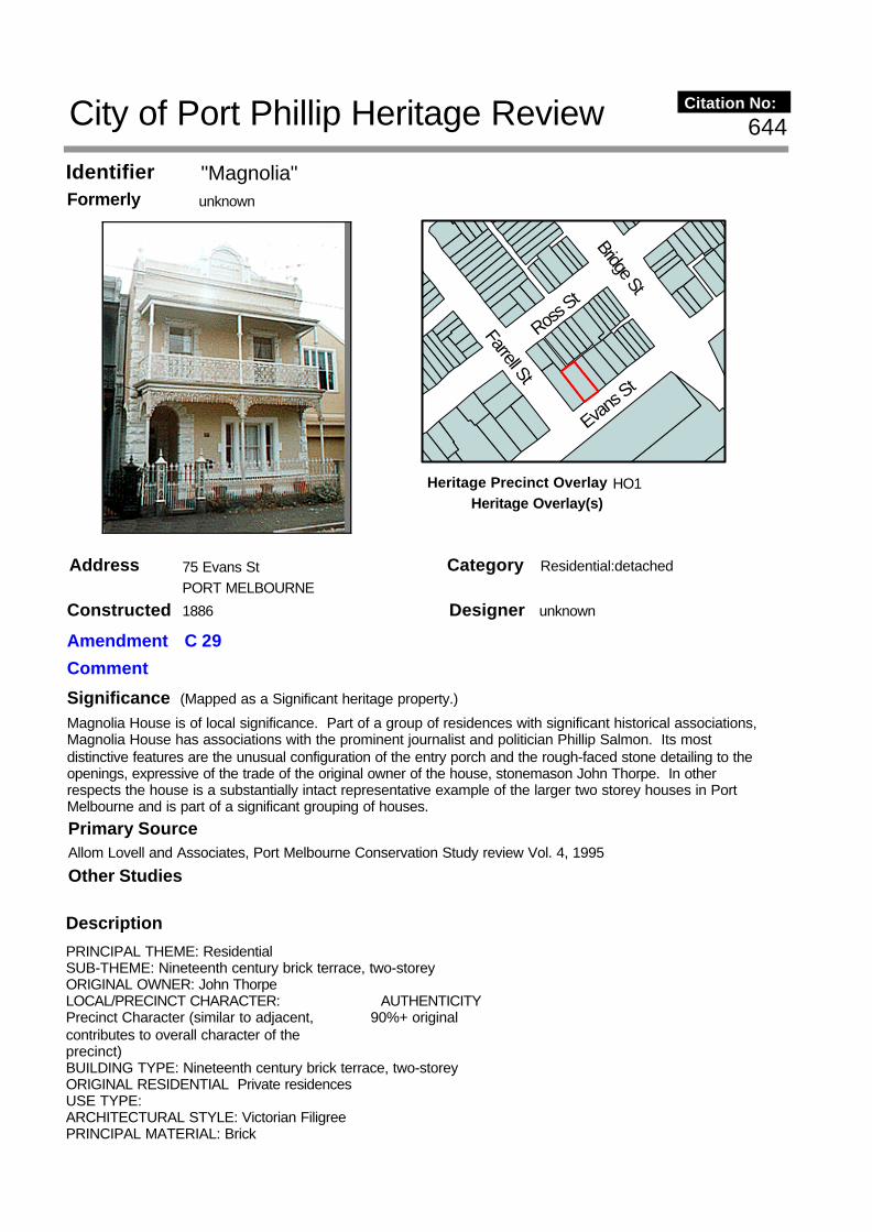
"Magnolia"Identifier unknownFormerly
75 Evans StAddress PORT MELBOURNE
Description
PRINCIPAL THEME: ResidentialSUB-THEME: Nineteenth century brick terrace, two-storeyORIGINAL OWNER: John ThorpeLOCAL/PRECINCT CHARACTER: AUTHENTICITYPrecinct Character (similar to adjacent, 90%+ originalcontributes to overall character of theprecinct)BUILDING TYPE: Nineteenth century brick terrace, two-storeyORIGINAL RESIDENTIAL Private residencesUSE TYPE:ARCHITECTURAL STYLE: Victorian FiligreePRINCIPAL MATERIAL: Brick
SignificanceMagnolia House is of local significance. Part of a group of residences with significant historical associations, Magnolia House has associations with the prominent journalist and politician Phillip Salmon. Its most distinctive features are the unusual configuration of the entry porch and the rough-faced stone detailing to the openings, expressive of the trade of the original owner of the house, stonemason John Thorpe. In other respects the house is a substantially intact representative example of the larger two storey houses in Port Melbourne and is part of a significant grouping of houses.
Designer unknown
Category Residential:detached
Constructed 1886
Other Studies
Primary SourceAllom Lovell and Associates, Port Melbourne Conservation Study review Vol. 4, 1995
Bridge St
Evans S
tFarrell St
Ross St
644
(Mapped as a Significant heritage property.)
City of Port Phillip Heritage Review Citation No:
Amendment C 29
Comment
HO1Heritage Precinct OverlayHeritage Overlay(s)

PHYSICAL/STYLISTIC DESCRIPTIONMagnolia House is a two storey house built originally of exposed face brick, now painted, with rubble-faced stone quoins and dressings to the surrounds to the entry porch and first floor windows. The entrance is in a recessed porch with arched openings located at the left-hand corner of the front facade. The ground floor window is tripartite and has a heavy moulded render surround and sill contrasting with the stone surrounds to the other openings. The parapet supports a round-headed centrepiece, containing the inscription 'Magnolia', flanked by piers and scrolled brackets. The cast iron balcony has a hipped convex roof. The house retains the original cast iron fence and gate. On what was originally vacant land to the north has been constructed a relatively recent flat-roofed garage.
COMPARATIVE ANALYSISMagnolia House is unusual particularly for the configuration of the entry. In contrast to the virtually universal form of nineteenth century terrace houses of this type, in which the front door is set flush with the wall, urban houses with recessed porches appear to be rare. The house is also distinctive for the combination of face brick and rough-faced stone dressings on the front elevation. The only local example, it contrasts with the usual rendered masonry or wholly brick finishes.
RecommendationsA Ward, Port Phillip Heritage Review, 1998recommended inclusions:Schedule to the Heritage Overlay Table in the City of Port Phillip Planning Scheme
References
1. Port Melbourne rate book, 1886-7, no. 23922. N. Turnbull and N. U'Ren. 'A History of Port Melbourne'. p. 1493. ibid. p. 280.4. ibid. p. 167.5. ibid. p. 167.
History
The original owner of Magnolia House, John Thorpe, lived in the house only briefly, selling it to one of Port Melbourne's most prominent citizens, Phillip M. Salmon, in 1889.
Salmon had lived in the Sandridge area in the 1860s, but moved to Footscray, where he launched the Footscray Advertiser. Salmon returned to Port Melbourne in the late 1870s and became editor of the Port Melbourne Standard. From his platform at the newspaper, Salmon launched a career in local and state politics. Turnbull and U'Ren have characterised the political scene in the borough in the late 1880s as being dominated by a struggle between the wealthier conservative 'decency' or 'respectable' group, headed up by F.T. Derham, and the radical Liberal merchant class, whose central figure was Phillip Salmon, who they describe as 'an aggressive, egotistical, non-establishment figure who was distinctly radical in liberal reformist terms'. (2) Salmon ran for state parliament in 1889. He was a long-serving councillor and was Mayor in 1890-91. (3) During his term as Mayor, which coincided with the onset of the 1890s crash, Salmon was variously adored or hated by the local community, partly because of his stand against police repression of local stevedores gathering on corners looking for work. In April 1892, Salmon again attempted to enter Parliament, and after an intense political battle, succeeded in ousting F.T. Derham, member for nine years, and a former Cabinet member. (4) The post-election celebration was held at Magnolia House. (5)
Salmon's parliamentary career was marked by a somewhat erratic performance, and his role in local politics was similarly marred by conflict, his one great achievement being the declaration of Port Melbourne as a town. (6) Eventually, facing severe financial problems in 1894, Salmon left politics behind, and saw the Standard amalgamated with the Tribune. (7) He has been described as an important transitional figure in the political and social development of the area. (8)
With Gloster House and Lily Cottage, Magnolia House was constructed on land owned by David Armstrong. The pattern of subdivision and building construction and ownership of the three houses is of some interest, as are their associations with various well-known Port Melbourne identities and families in the 1880s and 1890s.
In 1884-5, local auctioneer David C. Armstrong was the owner of vacant land measuring 125' x 60' in Evans Street. This land was subsequently subdivided into three smaller blocks, one of which Armstrong sold (75 Evans Street), while he constructed residences on the other two (73 Evans Street, q.v. and 77 Evans Street, q.v.). The site of 75 Evans Street was sold to builder, John Thorpe, who constructed Magnolia House in 1886. When first rated, the building was described as a seven-roomed brick house and stables, valued at £50. (1)
Thematic Context

6. ibid. pp. 168-170.7. ibid. p. 172.8. ibid. p. 172.

"Lily Cottage"Identifier unknownFormerly
77 Evans StAddress PORT MELBOURNE
Description
PRINCIPAL THEME: ResidentialSUB-THEME: Nineteenth century brick cottages, single fronted, one storeyORIGINAL OWNER: David and Sophia ArmstrongLOCAL/PRECINCT CHARACTER: AUTHENTICITYPrecinct Character (similar to adjacent, 90% originalcontributes to overall character of theprecinct)BUILDING TYPE: Nineteenth century brick cottages, single fronted, one storeyORIGINAL RESIDENTIAL Private residenceUSE TYPE:ARCHITECTURAL STYLE: Victorian FiligreePRINCIPAL MATERIAL: Brick
PHYSICAL/STYLISTIC DESCRIPTION
SignificanceLily Cottage is of local significance. Built originally for the locally prominent auctioneer David Armstrong, it is part of a group of houses with historical associations with well-known Port Melbourne families. It is typical in most respects of single-fronted brick cottages in Port Melbourne, and is notable for its extraordinary amalgam of Gothic and conventionally Classical elements in the elaborately designed and disproportionately large parapet.
Designer unknown
Category Residential:detached
Constructed 1886
Other Studies
Primary SourceAllom Lovell and Associates, Port Melbourne Conservation Study review Vol. 4, 1995
Bridge St
Evans S
tFarrell St
Ross St
645
(Mapped as a Significant heritage property.)
City of Port Phillip Heritage Review Citation No:
Amendment C 29
Comment
HO1Heritage Precinct OverlayHeritage Overlay(s)

Lily Cottage is a small single-storey single-fronted cottage of brick construction. The front elevation below the verandah roof is of brick, now painted, and includes a tripartite sash window with timber mullions. The rendered parapet is unusually elaborate and mixes Classical and Gothic elements. The moulded cornice is supported on brackets alternating with trefoil leaf motifs. Dominating the whole elevation is a large Gothic arched centrepiece supporting urns and an anthemion finial, and flanked by a parapet of open interlocking circles. The narrow piers to each end are decorated with sunflower motifs. The verandah includes a cast iron frieze.
COMPARATIVE ANALYSISWhile generally typical in form of small urban cottages of the 1880s, Lily Cottage is unusual for the Gothic detailing of the parapet. Like many Boom period cottages, the parapet is elaborately detailed and is the main architectural focus of the facade. The Gothic form of the centrepiece and the trefoil decorative motifs, however, is relatively rare compared with the almost universal use of the Classical Revival idiom in houses of this type in the 1880s.
RecommendationsA Ward, Port Phillip Heritage Review, 1998recommended inclusions:Schedule to the Heritage Overlay Table in the City of Port Phillip Planning Scheme
References
1. Port Melbourne rate book, 1886-7, no. 23282. Port Melbourne rate book, various years, 'Sands and McDougall Melbourne Directories, various years'
History
With Gloster House and Magnolia House, Lily Cottage was constructed on land owned by David Armstrong. The pattern of subdivision and building construction and ownership of the three houses is of some interest, as are their associations with various well-known Port Melbourne identities and families in the 1880s and 1890s.
In 1884-5, local auctioneer David C. Armstrong was the owner of vacant land measuring 125' x 60' in Evans Street. This land was subsequently subdivided into three smaller blocks, one of which Armstrong sold (75 Evans Street, (q.v.)), while he constructed residences on the other two (73 Evans Street (q.v.) and 77 Evans Street). Lily Cottage was constructed for Armstrong in 1886. When first rated in 1886-7 the single-storey cottage was described as a five-roomed brick house, and was valued at £26. (1). Though originally listed in the ownership of Armstrong's wife, Sophia, the following year the building changed hands, being sold to Emma Prohasky. Various members of the Prohasky family, who ran a grocery in Bay Street, were listed as the owners of Lily Cottage until the mid-1890s. (2).
Thematic Context

"Kelvin Cottage"Identifier unknownFormerly
111 Evans StAddress PORT MELBOURNE
Description
PRINCIPAL THEME: ResidentialSUB-THEME: Nineteenth century brick villa, double-fronted, one storeyORIGINAL OWNER: Norman McLeodLOCAL/PRECINCT CHARACTER: AUTHENTICITYIndividual character (Individual, 90%+ originaldifferent from adjacent)BUILDING TYPE: Nineteenth century brick villa, double-fronted, one storeyORIGINAL RESIDENTIAL Private residenceUSE TYPE:DOMESTIC GARDEN TYPE: Nineteenth century villaARCHITECTURAL STYLE: Victorian FiligreePRINCIPAL MATERIAL: Brick
PHYSICAL/STYLISTIC DESCRIPTIONA single-storey double-fronted detached house, Kelvin Cottage is constructed from dark purple-brown bricks
SignificanceKelvin Cottage is of local significance. Among the larger single-storey houses in Port Melbourne, it is notable for its relatively early date in relation to the development of the area and for the unusually refined detailing of the brickwork and parapet, and is representative of the restrained style of domestic architecture of the 1870s.
Designer unknown
Category Residential:detached
Constructed 1874
Other Studies
Primary SourceAllom Lovell and Associates, Port Melbourne Conservation Study review Vol. 4, 1995
Station
StEvan
s St
Ross St
Derham
St
Bridge St
Raglan St
648
(Mapped as a Significant heritage property.)
City of Port Phillip Heritage Review Citation No:
Amendment C 29
Comment
HO1Heritage Precinct OverlayHeritage Overlay(s)

with contrasting cream brickwork to the door and window surrounds and the corners. The central front door incorporates side and top lights. The sash windows to each side are tripartite with timber mullions and basalt sills. The rendered parapet, of restrained design, incorporates a moulded cornice supported on simple paired brackets with moulded roundels and raised and fielded rectangular panels between the brackets. Above the cornice, the parapet is plain, with a segmental arched central pediment flanked by squat panelled piers. The piers and the ends of the parapet support acorn finials and urns, possibly not original, and the pediment is surmounted by a scrolled accretion finial. The pediment contains the inscription 'KELVIN COTTAGE A.D. 1874'. The front verandah is convex roofed and incorporates a simple scrolled cast iron valence. The verandah wing walls have moulded render masks on the outer faces. In front of the house are a garden in broadly Victorian style and a reconstructed timber picket fence and gate.
COMPARATIVE ANALYSISSubstantial double-fronted single-storey brick houses of the sort represented by Kelvin Cottage were relatively rare in Port Melbourne, other comparable local examples being 62 Evans Street (q.v.) and the significantly later houses at 21 Ross Street (q.v.), 200 Graham Street and 238 Graham Street. In other suburbs such as South Melbourne and the eastern and south-eastern suburbs from Kew and Hawthorn around to Armadale and Prahran, they were far more common, reflecting the more middle-class nature of these areas.
RecommendationsA Ward, Port Phillip Heritage Review, 1998recommended inclusions:Schedule to the Heritage Overlay Table in the City of Port Phillip Planning Scheme
References
1. Port Melbourne rate book, 1874-5, no. 16692. Port Melbourne rate book, 1889-90, no. 2273
History
Land north-west of the railway line near Graham Street was first auctioned in late 1868, and developed in the following years. This is one of the few substantial brick houses to be constructed in the immediate vicinity in this period. The working-class occupation of its original owner is somewhat surprising in this context, and it may be that McLeod had a financial interest in a stevedoring company.
Kelvin Cottage was constructed in 1874. The first owner of the building was stevedore, Norman McLeod. When first rated in 1874-5, the residence was described as a brick house of six rooms. (1) It was increased in size in 1886-87, when it was described as a nine-roomed brick house valued at £70. (2).
Thematic Context

ResidencesIdentifier unknownFormerly
127-130 Evans StAddress PORT MELBOURNE
Description
PRINCIPAL THEME: ResidentialSUB-THEME: Federation brick terracesORIGINAL OWNER: Executors of the Estate of McLeodLOCAL/PRECINCT CHARACTER: AUTHENTICITYIndividual Character (Individual 90%+ originaldifferent from adjacent)BUILDING TYPE: Federation brick terracesORIGINAL RESIDENTIAL Private residencesUSE TYPE:ARCHITECTURAL STYLE: Federation Arts and CraftsPRINCIPAL MATERIAL: Brick
PHYSICAL/STYLISTIC DESCRIPTIONThis terrace of four single-storey houses is constructed of brick. The design exhibits typical Federation period characteristics contrasting with the parapeted facades of earlier terraces. The longitudinally ridged roof is relatively steeply pitched and is covered with terra cotta Marseilles pattern tiles and terra cotta ridge cresting.
Significance127-30 Evans Street is of local significance. This row is representative of the Arts and Crafts derived Federation style as applied to inner-suburban terraces, and is the most intact of the few examples of the type in Port Melbourne.
Designer unknown
Category Residential:row
Constructed 1911
Other Studies
Primary SourceAllom Lovell and Associates, Port Melbourne Conservation Study review Vol. 4, 1995
Evans S
t
Ross St
Raglan St
649
(Mapped as a Significant heritage property.)
City of Port Phillip Heritage Review Citation No:
Amendment C 29
Comment
HO1Heritage Precinct OverlayHeritage Overlay(s)

Rendered parapeted party walls rise above the roof. Square brick chimneys rise above the ridge. The roof extends down at slightly reduced pitch over the front verandahs, which have small central half-timbered and roughcasted gables. The verandahs have turned timber posts and capitals, and arched valences with closely spaced timber verticals. The wide front windows have three-light casement frames. The brick walls to nos 129 and 130 have been painted; otherwise these houses are substantially intact to the front.
COMPARATIVE ANALYSISThe characteristic Arts and Crafts derived Federation style of this terrace can be seen in similar form in pockets of early twentieth century terraces in a number of inner metropolitan suburbs including North Melbourne, North Fitzroy, Prahran and East St Kilda. While individual houses were built in Port Melbourne in the early twentieth century, terrace development appears to have been relatively uncommon in the suburb at that time. 127-30 Evans Street is the only local example to display the characteristic form of arched verandah woodwork and front-facing gablets.
The three-house terrace at 288-90 Ross Street (1911) has broadly similar timber detailing. The planning and form, however, are unusual and, in contrast to the conventional form of 127-30 Evans Street, demonstrate the way in which attempts were being made in the early twentieth century to vary the standard nineteenth century terrace form, before the virtual demise of terrace housing after World War I.
RecommendationsA Ward, Port Phillip Heritage Review, 1998recommended inclusions:Schedule to the Heritage Overlay Table in the City of Port Phillip Planning Scheme
References
1. Port Melbourne rate book, 1911, nos 1593-1596.
History
Though land west of the railway line was first sold in the late 1860s, development in this part of Port Melbourne would appear to have proceeded on a relatively piecemeal basis, as the MMBW 160': 1" plan, which shows this site as vacant, indicates. The houses themselves are of a type which was relatively common in the period.
Four houses were constructed at 128-131 Evans Street in 1911 for the executors of the estate of a person simply listed as McLeod. Each of the five roomed brick houses was valued at £25.(1) The site was previously vacant.
Thematic Context

ResidencesIdentifier unknownFormerly
152-153 Evans StAddress PORT MELBOURNE
Description
PRINCIPAL THEME: ResidentialSUB-THEME: Nineteenth century brick terraces, single-fronted, one storeyORIGINAL OWNER: William WeatherstoneLOCAL/PRECINCT CHARACTER: AUTHENTICITYIndividual Character (individual, 90%+ originaldifferent from adjacent)BUILDING TYPE: Nineteenth century brick terraces, single-fronted, one storeyORIGINAL RESIDENTIAL Private residencesUSE TYPE:ARCHITECTURAL STYLE: Victorian Free ClassicalPRINCIPAL MATERIAL: Brick
PHYSICAL/STYLISTIC DESCRIPTIONThis pair of single-storey single-fronted houses is constructed of brick with rendered parapet, cornice and quoining to the corners. The front windows and doors have render surrounds splayed at the window heads and sills. The cornice is supported on distinctive block-like moulded brackets with a simple moulded string
Significance152-3 Evans Street is of local significance. A relatively early pair of houses in this part of Port Melbourne, the simple detailing of the cornice, parapet and window surrounds is representative of domestic architecture of the 1870s. They are unusual in Port Melbourne, particularly for the early date, for their brick construction.
Designer unknown
Category Residential:detached
Constructed 1872
Other Studies
Primary SourceAllom Lovell and Associates, Port Melbourne Conservation Study review Vol. 4, 1995
Evans S
t
Ross St
Raglan St
650
(Mapped as a Significant heritage property.)
City of Port Phillip Heritage Review Citation No:
Amendment C 29
Comment
HO1Heritage Precinct OverlayHeritage Overlay(s)

course. At the centre of the plain parapet is a small triangular pediment flanked by scrolled brackets. The concave roofed verandah is supported on timber posts with shaped timber brackets, probably of early twentieth century date. The brickwork to no 152 is painted, while no 153 remains unpainted.
COMPARATIVE ANALYSISThe restrained Classical revival detailing of this pair of houses is typical of houses built in the 1860s and 70s in the inner metropolitan area. While comparable houses remain in areas such as North Melbourne, Carlton and Fitzroy, they are relatively few in number compared with the overwhelming predominance of more elaborately decorated houses in these areas dating from the late 1870s through to the 1890s. They are also unusual in the context of Port Melbourne, where weatherboard houses predominate.
RecommendationsA Ward, Port Phillip Heritage Review, 1998recommended inclusions:Schedule to the Heritage Overlay Table in the City of Port Phillip Planning Scheme
References
1. Port Melbourne rate book, 1872-3, nos. 1576-15772. Port Melbourne rate book, 1871-2, nos. 1583-15843. Port Melbourne rate book, 1869-70, nos. 1583-1584
History
These cottages were relatively early brick structures for Evans Street. When constructed, the street was only partially developed and the building stock comprised largely of small timber cottages. (3)
This pair of single storey brick cottages was constructed in 1872, probably by William Weatherstone, their first owner. (1) Weatherstone had previously owned a timber cottage on this site.(2)
Thematic Context