PPG363992 265. - Universitas PGRI Palembang · ‘regime’ – the stable ... prescribed design...
23
http://ppg.sagepub.com/ Progress in Physical Geography http://ppg.sagepub.com/content/34/3/265 The online version of this article can be found at: DOI: 10.1177/0309133310363992 2010 34: 265 Progress in Physical Geography Michael Church The trajectory of geomorphology Published by: http://www.sagepublications.com can be found at: Progress in Physical Geography Additional services and information for http://ppg.sagepub.com/cgi/alerts Email Alerts: http://ppg.sagepub.com/subscriptions Subscriptions: http://www.sagepub.com/journalsReprints.nav Reprints: http://www.sagepub.com/journalsPermissions.nav Permissions: http://ppg.sagepub.com/content/34/3/265.refs.html Citations: by Giyanto Giyanto on October 7, 2010 ppg.sagepub.com Downloaded from
Transcript of PPG363992 265. - Universitas PGRI Palembang · ‘regime’ – the stable ... prescribed design...

http://ppg.sagepub.com/
Progress in Physical Geography
http://ppg.sagepub.com/content/34/3/265The online version of this article can be found at:
DOI: 10.1177/0309133310363992
2010 34: 265Progress in Physical GeographyMichael Church
The trajectory of geomorphology
Published by:
http://www.sagepublications.com
can be found at:Progress in Physical GeographyAdditional services and information for
http://ppg.sagepub.com/cgi/alertsEmail Alerts:
http://ppg.sagepub.com/subscriptionsSubscriptions:
http://www.sagepub.com/journalsReprints.navReprints:
http://www.sagepub.com/journalsPermissions.navPermissions:
http://ppg.sagepub.com/content/34/3/265.refs.htmlCitations:
by Giyanto Giyanto on October 7, 2010ppg.sagepub.comDownloaded from

Article
The trajectory ofgeomorphology
Michael ChurchThe University of British Columbia, Canada
AbstractModern geomorphology was founded in the nineteenth century as an exercise of historical interpretation oflandscapes. After the mid-twentieth century it dominantly became a quest to understand the processes bywhich landscapes are modified. This focused attention on the measurement of sediment fluxes on synoptictimescales and on a reductionist, Newtonian programme of construction of low-order theories about thosefluxes, largely imported from engineering science. The period also saw the emergence of an applied geomor-phology. Toward the end of the twentieth century the subject was dramatically transformed by improvedtechnologies for remote sensing and surveying of Earth’s surface, the advent of personal computation andof large-scale computation, and important developments of absolute dating techniques. These technical inno-vations in turn promoted recognition of geomorphology as a ‘system science’ and facilitated the reintegrationof tectonics into geomorphology, opening the way for a renewed consideration of the history of the land-scape. Finally, increasing recognition of the dominance of human agency in contemporary modification ofEarth’s terrestrial surface has become a significant theme. Important influences on the continuing develop-ment of the subject will include the search for physically sound laws for material fluxes; reconciling geomor-phological information and process representations across spatial and temporal scales, in both observationand theory; comprehending complexity in geomorphological processes and landform histories; incorporatingthe geomorphological role of living organisms, particularly micro-organisms; understanding the role of cli-mate in geomorphology, both in the contemporary changing climate and in the long term; and fully admittingthe now dominant role of humans as geomorphic agents. Geomorphology is simultaneously developing indiverse directions: on one hand, it is becoming a more rigorous geophysical science – a significant part ofa larger earth science discipline; on another, it is becoming more concerned with human social and economicvalues, with environmental change, conservation ethics, with the human impact on environment, and withissues of social justice and equity.
Keywordsfuture of geomorphology, history of geomorphology, geomorphology and dating, geomorphology andremote sensing, process geomorphology, significant trends in geomorphology
I Introduction: Historical legacies
Modern geomorphology grew out of the
nineteenth-century quest to understand the his-
tory of Earth (Chorley et al., 1964; Rudwick,
2008). That quest had two major themes: to
comprehend the significance of the rock column
and the evidences that it bore of Earth’s history,
and to understand the development of modern
landscapes. Both are essentially historical
Corresponding author:Department of Geography, The University of BritishColumbia, Vancouver, British Columbia, V6T 1Z2, CanadaEmail: [email protected]
Progress in Physical Geography34(3) 265–286
ª The Author(s) 2010Reprints and permission:
sagepub.co.uk/journalsPermissions.navDOI: 10.1177/0309133310363992
ppg.sagepub.com
by Giyanto Giyanto on October 7, 2010ppg.sagepub.comDownloaded from
inquiries. Modern geomorphology developed,
then, essentially as an exercise of historical
interpretation, issuing in the early twentieth
century in several competing models for how
landscapes might generally evolve by erosional
development (Davis, 1899, cf. King and
Schumm, 1980; Penck, 1924, cf. Czech and
Boswell, 1953; Baulig, 1935, following E. Suess;
King, 1953). These were the earliest grand
scientific abstractions from the perceived facts
of landscape. They developed in parallel with
early modern generalizations in the rest of earth
science – in particular, with generalizations
about tectonics and the construction of relief.
To be sure, there was substantial attention
paid in the nineteenth century to the processes
that form landscape. In significant measure, cur-
rent or ostensibly recent processes were studied
in the attempt to resolve the prominent debate
about whether the modern world is a uniformitar-
ian one, or a world created by successive cata-
strophic changes (Rudwick, 2008). There were
also students of geomorphology who pursued a
more systematic, physically based study of the
processes at work in the landscape, either for its
own sake or in pursuit of practical ends. Arguably
the most prominent among them was the
American geologist Grove Karl Gilbert (see
Yochelson, 1980). There has been considerable
discussion about why his approach to geomor-
phology – a recognizable precursor of approaches
taken in the second half of the twentieth century –
did not prevail. The most immediately obvious
answer lies in the preoccupation of earth science
at the time with the great historical questions.
In geomorphology and, indeed, in much of
earth science, the nineteenth century ended in
about 1950. Up until the time of the second
world war, the major questions remained the his-
torical ones and the methods of investigation
remained largely the same. The change, when
it came, was in substantial measure technology
driven. Airborne and seaborne surveying instru-
ments, many initially developed for the purposes
of war, gave major impetus to geophysical
exploration, making available information about
Earth’s surface and shallow subsurface never
before accessible. On land, the global extension
of modern topographic mapping, the increasing
availability of aerial photography and rapidly
developing access to much of the terrestrial sur-
face all facilitated geomorphological work. An
era of unprecedented prosperity in the amphi-
Atlantic world after 1950 led to a large extension
of technical surveys of landscape and of hydrologi-
cal and other environmental monitoring programs
– largely for resource development purposes – that
provided basic data for a systematic approach
toward understanding Earth’s surface environ-
ment. Perhaps even more importantly, it led to a
rapid expansion of advanced education and
research. Geomorphology participated modestly
in and benefited greatly from these developments.
Within the discipline, understanding the pro-
cesses that formed the surface environment
became the major focus of research efforts after
1950. The trend was launched in the English-
speaking world by a number of benchmark
papers that served as programmatic statements
(Strahler, 1952) and early models for practice
(Bagnold, 1941; Horton, 1945; Strahler, 1950;
Leopold and Maddock, 1953). Much guidance
was secured from the engineering literature –
from hydraulics, from soil mechanics, and from
coastal engineering – while philosophical sup-
port derived from a strong positivist influence
over the scientific method of the day. The
research program of the United States Geologi-
cal Survey Water Resources Division, under the
direction of L.B. Leopold, and work at Columbia
University under the direction of Arthur Strahler
(see Strahler, 1992, for a retrospective view of
the Columbia ‘programme’) were dominant
influences in effecting the reorientation of the
discipline. The intention was to interpret land-
scape in terms of direct observables by the appli-
cation of Newtonian mechanics, something that
engineers had been attempting to do ever since
the time of Leonardo. This paradigm seemed
to set space and timescales for the subject; they
266 Progress in Physical Geography 34(3)
by Giyanto Giyanto on October 7, 2010ppg.sagepub.comDownloaded from

were the everyday human scales, on the order of
metres to kilometres and seconds to years,
within which well-defined dynamical processes
could be observed and reasonably compre-
hended. They were quite different than the scales
of the preceding period.
One singular development that was especially
influential in the reorientation of geomorpholo-
gical timescale was the development of absolute
dating methods. Uranium-series methods, under
development since early in the century, were
closing in on the age of Earth but of more imme-
diate relevance to geomorphology was the
development of radiocarbon dating (Libby,
1955; see Walker, 2005, for a recent review). Ini-
tially able to furnish an approximate absolute
timescale for the most recent 30 ka, and now
extendable to about 50 ka, 14C dating powerfully
augments the study of recent events and pro-
cesses, but it scarcely admits a period sufficiently
long to appreciate significant development in
Earth landscapes. History – apart from continu-
ing study of the Quaternary Period – largely dis-
appeared from the modern subject, at least in the
scientifically dominant Anglo-American world.
II Where have we come from?
The geomorphology of the period between 1960
and 1990 (that is, the formative period of this
writer’s career) was, then, largely dominated
by a reductionist, Newtonian paradigm. A basic
tenet was Gilbert’s (1877) concept of ‘dynamic
equilibrium’, a condition in which landforms are
adapted to the dominant exogenous forcing so
that form is maintained through time (Strahler,
1950; Hack, 1960; review by Ahnert, 1994).
Dynamic equilibrium is a logical consequence
of thinking in terms of Newtonian force
balances. In the landscape, where synoptic pro-
cesses and observable events are forced by
weather and hydrology, one arrives at timescales
that seem short in comparison with any concept
of the timescale for landscape evolution that had
been arrived at by the early twentieth century. In
fact, equilibrating forces leads quickly to the
notion of steady state in the landscape, a condi-
tion in which landforms maintain their form and
gradient relations while material moves through
them.
In rivers, for example (this writer inevitably
will fall into a river sooner rather than later),
these concepts were made explicit in terms of
‘regime’ – the stable channel dimensions for
some governing flow. Correspondingly, ‘regime
time’ is the period during which a channel might
be expected to maintain some stable mean form,
even though synoptic period scour and fill might
occur. ‘Regime’ in this sense is an engineering
term, originated in investigations in the late
nineteenth century of the equilibrium dimen-
sions for unlined irrigation canals in then British
India and in the Nile delta (see Leliavsky, 1955),
signifying the stable channel dimensions for a
prescribed design flow. Generalized to alluvial
rivers (Leopold and Maddock, 1953), it gives
rise to the auxiliary question ‘what flow is equiv-
alent to the design flow?’ or ‘what flow would
transfer water and sediment in the same
amounts, on average, as are transferred over the
range of varying actual flows, while maintaining
a stable channel form?’. The question has never
been generally resolved (see Pickup and Rieger,
1979; Ferguson and Church, 2009), but it is clear
that regime time occupies decennial to centen-
nial timescales – not many millennia – and, in
a world not drastically disturbed by human
activity, corresponds with periods of approxi-
mately stable hydroclimate. This appears to be
the timescale that largely absorbed geomorphol-
ogists’ interest for several decades, even though
the occurrence of different patterns of landscape
evolution on longer timescales remained per-
fectly apparent (Schumm and Lichty, 1965).
A major problem was the impossibility to retrieve
measurements over those longer timescales.
This was a problem because, in the
Newtonian paradigm, measurement is the acme
of scientific endeavour. Thinking, again, of riv-
ers, the outcome was the explosion of studies of
Church 267
by Giyanto Giyanto on October 7, 2010ppg.sagepub.comDownloaded from

hydraulic geometry using available stream
gauging measurements (Leopold and Maddock,
1953; see Ferguson, 1986), intense interest in
sediment transport – in particular, that part of the
sediment load that substantially influences chan-
nel morphology (see, for example, Gomez,
1991) – and in relatively short-term channel
adjustments (see, for example, Gregory, 1977).
Even after 50 years, however, the problem of
alluvial channel form has scarcely been properly
constructed, let alone solved (see Eaton et al.,
2004).
The advent of landscape measurement served
to emphasize for the first time the remarkable
variability of landforms (see Strahler, 1950).
Statistics entered geomorphology as, indeed, it
must enter any properly constructed empirical
science. Quantitative documentation of variabil-
ity in landforms and landscape made for a more
acute description of the landscape (Strahler,
1954), but it substantially complicated theory
building and prediction. Nevertheless, that a sig-
nificant measure of statistical regularity could be
perceived in landscape, and a significant level of
insight developed, was demonstrated early on by
members of the Strahler school (eg, Schumm,
1956; Melton, 1958a; 1958b; 1960; the impact
of Melton’s papers is reviewed by Keylock,
2003). R.L. Shreve (1975; 1979) directly tackled
the problem of a probabilistic-statistical basis for
theory production in geomorphology.
However, the main focus of interest and the
principal body of results concerned the measure-
ment and description of contemporary geomor-
phological processes on synoptic to seasonal
scales and the construction of first-order theories
to generalize the phenomena. Geomorphology
had no strong tradition of physical theorizing,
formerly preoccupied as it was with historical
reconstruction of particular landscapes. Conse-
quently, there was a significant migration of
engineering knowledge into geomorphology and
its reorganization in ways appropriate for the
description of landscape and the analysis of
slope stability, of surface erosion, of fluvial
sediment transport and river stability, of coastal
sedimentary phenomena and coastal stability,
and of the geomorphological effects of wind and
ice. This history is to a significant degree sum-
marized in the pages of Progress in Physical
Geography, in papers on subjects as diverse as
weathering (Whalley and McGreevy, 1985),
slope processes (Rapp, 1986), soil erosion
(Loughran, 1989), river hydraulics (Ferguson,
1986) and morphology (Lewin, 1978), karst
(Waltham, 1981), coastal and beach processes
(Jolliffe, 1978; Clayton, 1980), wind effects
(Pye, 1984; Sarre, 1987) and glaciation (Hart,
1995).
Some more complex geomorphological
effects began to be revealed. For example, PIPG
includes papers on complex features of sediment
transport in rivers (Hoey, 1992; Powell, 1998)
and on drainage networks (Dunne, 1980; Jones,
1987), leading to the general topic of self-
organization in landscapes (Phillips, 1995).
Arguments developed over the appropriate
level of reduction to both preserve the essential
features of landscape and to create a viable
model of landscape-forming processes (eg,
Mackin, 1963; Simpson, 1963). Major textbooks
of the day (eg, Leopold et al., 1964; Selby, 1985)
remained in substantial measure descriptive,
despite the insidious invasion of equations (but
see Carson and Kirkby, 1972), while a purely
theoretical text based on a collation of exercises
largely conducted outside the main stream over
the preceding 50 years (Scheidegger, 1961;
1970) had no great impact on the field. Never-
theless, the period produced a substantially
greater appreciation than before for the variabil-
ity of landscapes – leading, in turn, to the reali-
zation that far more extensive sampling
programs need to be undertaken in order to com-
prehend the variability than had classically
been conducted. It produced a generation of
geomorphologists who had learned to use mod-
ern surveying and sampling instruments, who
were comfortable at least with standard statisti-
cal methods, and who were used to the notion
268 Progress in Physical Geography 34(3)
by Giyanto Giyanto on October 7, 2010ppg.sagepub.comDownloaded from

that measurement is the basis upon which
modern empirical science is built. Most impor-
tantly, it laid the foundations for the analysis
of landform- and landscape-forming processes
in physical terms. But it did not produce a coher-
ent, unified account of geomorphology. For that,
a much longer timeframe is needed than that
considered by most investigators in the period.
The period did claim a signal practical
achievement. The Newtonian focus and the
appropriation of engineering methods of obser-
vation and analysis brought geomorphology to
the attention of engineers and land managers at
a time when there was also increasing concern
for the quality of land management and environ-
mental engineering. For the first time, a substan-
tial portion of geomorphology became applied
geomorphology (see Coates, 1971 and 1976, for
early work; Sherman, 1989, for a philosophical
statement; Downs and Gregory, 2004, for an
example of more recent and more specialized
work). In many contexts, geomorphological
investigations came to be defined by practical
problems. Ironically, the most valuable contri-
bution of the geomorphologist to the solution
of problems of land management is the historical
perspective, largely abandoned in this period in
basic research. Nonetheless, this movement
began to knit geomorphology into a wider com-
munity of environmental scientists and managers,
it increased the confidence of geomorphologists
in the value of the discipline, it imported many
technical methods of investigation into the disci-
pline, and it contributed to the increasing sophis-
tication of geomorphological investigations.
Was this period a cul-de-sac? No. It is impor-
tant for the emergence of geomorphology from
being essentially a part of natural history toward
being a modern science. Nineteenth-century
geomorphology consisted of mapping and
observation generalized by inference and specu-
lation; (late) twentieth-century geomorphology
came to be characterized by a preoccupation
with measurement, with the use of statistics for
both descriptive and inferential purposes, and
by the application of first-order physical theories
to describe and predict the behaviour of earth
materials in order to understand dynamical pro-
cesses at synoptic scales. It has been an essential
stage in the growth of the science.
III Bases of the contemporarydiscipline
Dramatic changes have occurred in geomorphol-
ogy since about 1980, rapidly gathering
momentum after about 1990. The bases for these
changes are, again, largely technological. The
main influences include: (1) improved technolo-
gies for remote sensing and surveying of Earth’s
surface; (2) the advent of personal computation
and of large-scale computation; and (3) impor-
tant developments of absolute dating techniques.
These technical innovations have stimulated two
substantive developments of central importance
for the discipline: (4) recognition that geomor-
phology is a ‘system science’; and (5) the reinte-
gration of tectonics into geomorphology,
opening the way for a renewed consideration
of the history of the landscape. Finally, (6)
increasing recognition of the dominance of
human agency in contemporary modification
of Earth’s terrestrial surface has become a signif-
icant theme.
One additional condition has strongly influ-
enced the development of the discipline over the
last 30 years. That is the emergence of a body of
younger geomorphological scientists with far
more adequate training in physical science and
mathematics than had appeared in the subject
before, the consequence of training curricula
initiated by the ‘Newtonian generation’. Some
of them have come to geomorphology with
background training in other areas of science
or engineering. A logical sequel of the later
twentieth-century focus on understanding geo-
morphological processes, this development was
largely initiated in several major American
universities, but it is now spreading rapidly.
These people have enthusiastically appropriated
Church 269
by Giyanto Giyanto on October 7, 2010ppg.sagepub.comDownloaded from

and applied the technical developments – none
of them peculiarly geomorphological in intent
– listed above.
1 Remote sensing and surveying
In terms of global environmental management,
this development is commonly associated with
satellite remote sensing of Earth. For geomor-
phology, a whole range of developments in
high-resolution remote sensing, performed in the
atmosphere and on the surface, are much more
important. These include wavelength-specific
methods in airborne remote sensing, airborne
LiDAR, terrestrial surveying with a range of
semi-autonomous instruments that use optical
interferometry, advanced sonars for bathymetry
and water-column soundings, acoustic detection
of water and sediment motion, ground-
penetrating radar and the appropriation of seis-
mic techniques and other geophysical sounding
methods.
These developments have enhanced two
critical dimensions of geomorphological infor-
mation. First, spatial continuity of information
can now be secured at centimetre scale over
large areas. Hence, the morphology of Earth’s
surface – what geomorphology seeks to explain
– can now be recorded faithfully at a resolution
sufficient to satisfy most information demands
for mechanistic explanation. The most striking
development in this respect is the recent avail-
ability of airborne LiDAR imagery of significant
areas (Figure 1), which dramatically improves
capabilities for terrain typing and landform
measurement. Similarly, terrestrial LiDAR
imagery can provide something like a metric
digital photograph of landscape features right
down to granular scale. Most basically,
however, the widespread availability of digitally
recorded topography developed from remotely
sensed imagery (abetted by developments in
computation) has opened up a wide range of ana-
lytical possibilities for studying landscape (Lane
et al., 1993). Other innovations are also impor-
tant. Wavelength-specific remote sensing can
determine soil surface moisture, the water con-
tent of snow, and surface temperature, all of
which are relevant in particular studies. Spectral
methods can be used to determine the texture of
surface materials (for example, Carbonneau and
Bergeron, 2005: the approach was pioneered in
the 1960s in early studies of the lunar surface)
and the characteristics of surface vegetation
cover.
The second important dimension is depth
below Earth’s surface. Geomorphologists are
frequently concerned with the depth and circula-
tion of water bodies, with depth and character of
both subaqueous and terrestrial surficial materi-
als, and with the stratigraphy of sediments.
Information of these kinds yields the third spatial
dimension necessary to properly understand the
development of landforms. Formerly, such
information was yielded only by laborious
soundings and excavations, hence was very
incompletely known. Developments in acoustic
Figure 1. LiDAR image, illustrating the unprece-dented clarity with which landforms are displayed.The scene illustrates a modern alluvial fan set withinlateglacial outwash terraces with kettles on them.Meltwater channels occur on the hillsides above.Fishtrap Creek, North Thompson Valley, nearKamloops, British Columbia. Image courtesy ofBrett Eaton, Department of Geography, TheUniversity of British Columbia.
270 Progress in Physical Geography 34(3)
by Giyanto Giyanto on October 7, 2010ppg.sagepub.comDownloaded from

sounding during the past three decades,
including both the adaptation of older geophysi-
cal methods such as electrical resistivity surveys
and the introduction of ground-penetrating
radar (see Baker and Jol, 2007), have dramati-
cally increased the transparency of Earth’s
near-surface. In the water column, improve-
ments in frequency-specific sounding and in the
interpretation of acoustic signals have yielded
dramatic improvements in information about
turbulent water flows and transported sediments,
and about stratification in water bodies.
An additional technology of critical importance
to these developments is the ability to determine
position on Earth’s surface with unprecedented
accuracy by the use of Global Positioning System
technology. This technology and technologies
associated with optical interferometry also open
the way for direct measurement of some of the
Earth movements most important to comprehend
in geomorphology, varying from soil and rock
creep to tectonic and isostatic movements. It is
critically important that these technologies have
become affordable for individual investigators.
For measurements of geomorphological pro-
cesses, improvements in sensor capabilities and
in digital electronic data recording speed and
capacity have similarly revolutionized the col-
lection of information in time. Altogether, the
technologies underlying these developments
have radically improved the information base
upon which geomorphological studies are
founded. Until perhaps a decade ago, the major
inferential problem in geomorphology was how
to penetrate a problem with too few accessible
data; for the first time, geomorphologists con-
front problems of analysis in the face of arguably
too many data.
2 Computation
The appearance of the electronic personal
computer made computation beyond the level
of simple analytical calculations a natural exten-
sion of thinking about a problem. Large-scale
computation has enabled geomorphologists to
construct models of geomorphological systems
– models that begin to encompass some of the
actual complexity of real landscapes and to
allow hypotheses about landscape development
to be tested more or less rigorously.
Classical mechanistic science proceeded by
seeking closed-form theoretical explanation for
observed phenomena – closed in the sense that
logically consistent, and preferably mathemati-
cally strict, statements based on physical
principles led to verifiable predictions about the
phenomenon. The mathematical tools preferably
took the form of analytic (in the specifically
mathematical sense) statements which admit
specific solutions. Statistics entered the picture
as a means of controlling the variance associated
with observations. The method works best in the
classically reduced situation of controlled bench
experiments wherein simple cause-and-effect
relations may be discerned. In the natural world
of geomorphology (and other field sciences), the
degree of experimental control necessary to test
closed-form theories is rarely achieved. In these
circumstances, statistical variation of the phe-
nomena becomes an integral part of the substan-
tive appearances, and ‘theorizing’ more often
takes the form of constructing ‘model’ systems
to simulate the phenomena. Such ‘models’ com-
monly include bridging empirical statements
when theoretically grounded relations are not
available. To analyse such systems, large data
sets of statistically complex structure must often
be investigated and they are usually subjected to
computationally extended statistical or simula-
tion procedures (eg, Melton, 1958b, who, in a
remarkable pioneering effort, used manually
manipulated punched cards to analyse his data).
None of this could be routinely accomplished
without electronic computers. Nor could the
volumes of data delivered by modern remote
sensing and monitoring methods be analysed.
An important development for environmental
sciences has been the advent of geographic
information systems. Basically nothing more
Church 271
by Giyanto Giyanto on October 7, 2010ppg.sagepub.comDownloaded from
than a spatially referenced system for filing data,
the addition of functional capacity for manipu-
lating data has created a flexible tool for analys-
ing the many aspects of environmental data with
spatial dimensions and patterns of correlation in
both space and time.
As a consequence of these possibilities, com-
puting technology has changed the way we con-
struct scientific arguments in every science,
including geomorphology. ‘Models’ of complex
processes that encompass multiple pathways for
the transfer of material and energy can be con-
structed and tested for range of outcomes and
sensitivities to parameter variations. Model stud-
ies vary in scale from the hillslope, the funda-
mental landscape element, through drainage
basins, to entire orogens. Martin and Church
(2004) summarized the scale relations of these
studies, which carry implications for the charac-
ter of appropriate model constructs. Modelling
strategies also create novel problems for predic-
tion and model confirmation (Church, 2003).
The most important ramification of this change
lies in the emergence of ‘system science’.
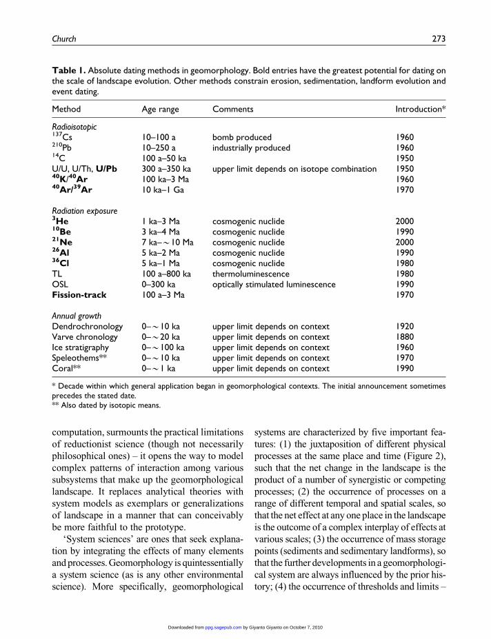
3 Dating
The development of techniques that absolutely
date aspects of the history of mineral crystals
or exposed mineral surfaces has opened the way
to decipher an absolute history of landscape
development over long periods using native
earth materials (neither of which 14C admits).
This is arguably the most important single devel-
opment for contemporary geomorphology
because it has reinvigorated interest in long-
term landscape evolution. Techniques include
radiometric decay series methods (some of them
of longer standing, but rarely applied within geo-
morphology until recent years), methods based
on cosmogenic nuclide accumulation, and meth-
ods based on radiation exposure, including
mineral luminescence and fission tracks. Indi-
rect dating methods include a significant number
of geochemical reaction or substitution
phenomena. These methods (Walker, 2005),
consistent with the primacy of measurement, have
brought to geomorphology the possibility for
quantitative study of long-term landscape history.
Earth science before the mid-twentieth century
had no reliable absolute chronometers.1 Earth his-
tory was recorded in relative terms using the
principle of superposition of sediments, fossil
sequences and cross-cutting erosional relations
inferred from landforms. Laminated sediments
that could reliably be ascribed to seasonal or
annual effects and the growth rings in woody tis-
sue gave some chronometric information about
recent (mainly Holocene) Earth history. After
1950, the well-known radiocarbon method was
introduced and methods based on the uranium
decay series were steadily improved. Radiocar-
bon revolutionized Quaternary studies but it is not
suited to studies on the temporal scale of signifi-
cant landscape evolution, except in respect of the
most recent major glaciation. Within the last third
of a century a suite of methods based on radio-
metric decay and on radiation exposure has dra-
matically widened absolute dating possibilities
(Table 1) including the possibility to directly date
minerals or mineral surfaces. This possibility
incidentally also draws geomorphology back
toward close association with the geological
aspect of its disciplinary roots since it entails the
necessity to interpret the geological provenance
and context of the material to be dated.
Methods based on cosmogenic isotopes are
proving to be particularly versatile: depending on
context, they can be used to date times of surface
exposure, rates of weathering, and residence times
for materials in sedimentary reservoirs. Bierman
(1994) and Cerling and Craig (1994) give early
reviews, Gosse and Phillips (2001) review theory
and applications, and Cockburn and Summerfield
(2004) give a more recent review of applications.
4 System science
The notion of geomorphology as a system sci-
ence, congruent with the advent of large-scale
272 Progress in Physical Geography 34(3)
by Giyanto Giyanto on October 7, 2010ppg.sagepub.comDownloaded from
computation, surmounts the practical limitations
of reductionist science (though not necessarily
philosophical ones) – it opens the way to model
complex patterns of interaction among various
subsystems that make up the geomorphological
landscape. It replaces analytical theories with
system models as exemplars or generalizations
of landscape in a manner that can conceivably
be more faithful to the prototype.
‘System sciences’ are ones that seek explana-
tion by integrating the effects of many elements
and processes. Geomorphology is quintessentially
a system science (as is any other environmental
science). More specifically, geomorphological
systems are characterized by five important fea-
tures: (1) the juxtaposition of different physical
processes at the same place and time (Figure 2),
such that the net change in the landscape is the
product of a number of synergistic or competing
processes; (2) the occurrence of processes on a
range of different temporal and spatial scales, so
that the net effect at any one place in the landscape
is the outcome of a complex interplay of effects at
various scales; (3) the occurrence of mass storage
points (sediments and sedimentary landforms), so
that the further developments in a geomorphologi-
cal system are always influenced by the prior his-
tory; (4) the occurrence of thresholds and limits –
Table 1. Absolute dating methods in geomorphology. Bold entries have the greatest potential for dating onthe scale of landscape evolution. Other methods constrain erosion, sedimentation, landform evolution andevent dating.
Method Age range Comments Introduction*
Radioisotopic137Cs 10–100 a bomb produced 1960210Pb 10–250 a industrially produced 196014C 100 a–50 ka 1950U/U, U/Th, U/Pb 300 a–350 ka upper limit depends on isotope combination 195040K/40Ar 100 ka–3 Ma 196040Ar/39Ar 10 ka–1 Ga 1970
Radiation exposure3He 1 ka–3 Ma cosmogenic nuclide 200010Be 3 ka–4 Ma cosmogenic nuclide 199021Ne 7 ka–*10 Ma cosmogenic nuclide 200026Al 5 ka–2 Ma cosmogenic nuclide 199036Cl 5 ka–1 Ma cosmogenic nuclide 1980TL 100 a–800 ka thermoluminescence 1980OSL 0–300 ka optically stimulated luminescence 1990Fission-track 100 a–3 Ma 1970
Annual growthDendrochronology 0–*10 ka upper limit depends on context 1920Varve chronology 0–*20 ka upper limit depends on context 1880Ice stratigraphy 0–*100 ka upper limit depends on context 1960Speleothems** 0–*10 ka upper limit depends on context 1970Coral** 0–*1 ka upper limit depends on context 1990
* Decade within which general application began in geomorphological contexts. The initial announcement sometimesprecedes the stated date.** Also dated by isotopic means.
Church 273
by Giyanto Giyanto on October 7, 2010ppg.sagepub.comDownloaded from

set by material properties, by energetic inputs, or
by scale considerations – such that abrupt changes
might occur in system behaviour; and (5) the
occurrence of variable system forcing over all
timescales.
These features have some important conse-
quences for the way we perceive geomorphologi-
cal systems. The juxtaposition of different
processes means that we can rarely isolate a sin-
gle process in the landscape for experimentally
controlled study; furthermore, that understanding
the relations among thevariousprocesses –whether
simply additive or amplifying – often forms
the essential basis for successful diagnosis of
the system. Variations in temporal and spatial
scale often lead to the need for different kinds
of theoretical construction over those different
scales. For example, a hillslope subject to dis-
crete (‘shot’ type) failures in the short term
might satisfactorily be modelled by a diffusional
process in the very long term. But it is important
that different theoretical constructs should be
appropriately matched; that is, that a shorter-
term and more locally specified process should
integrate properly to the longer-term solution,
at least in concept. The appreciation of mass
storage points is critical: it is this feature
that confers significant non-linearity on most
geomorphological systems (Phillips, 2003).
Thresholds and limits introduce abrupt regime
change and surprise (Schumm, 1973). Finally,
variable forcing eventuates both non-linear
response and threshold crossings, and constrains
the possibilities for hindcasting or forecasting
specific events in specific landscapes. This latter
fact strongly constrains the quality of knowledge
about the history of a specific landscape – or its
future – that it is possible to have (Church, 2003).
The characterization of geomorphology as a
system science was early introduced by Chorley
(1962) and the concept was developed by
Chorley and Kennedy (1971). Schumm (1973)
explored some practical consequences without
specifically invoking the system framework.
However, proper application of the concept
really began with the advent of attempts to
numerically model geomorphological systems
using digital computers.
5 Tectonics and geomorphology
A perversity of geomorphology in the late twen-
tieth century was that, at the very time when the
global synthesis of plate tectonics was emerging,
the discipline firmly set its course away from the
Figure 2. Correlation structure of a montanegeomorphic system (largely adapted from resultsgiven in Melton, 1958b). The diagram illustrates themultiple pathways of topographic and processdependence in the system. The boxes indicate theprincipal morphological features. The description ofthe drainage network includes drainage density, Dd
¼ L/Ad; ruggedness number, H ¼ hDd; and relativedrainage density, F/Dd
2; wherein L is the total lengthof stream channels in a drainage basin; Ad is the areaof the basin; h is the total relief in a drainage basin(not equivalent to local relief, which may be at sub-basin scale, according to the scale of investigation);F ¼ N/Ad is relative channel frequency; and N is thenumber of channel links in a drainage basin. Thelinks annotated with þ/– signs were measured byMelton and correlated as indicated.
274 Progress in Physical Geography 34(3)
by Giyanto Giyanto on October 7, 2010ppg.sagepub.comDownloaded from

large-scale problems of landscape history with
which it had formerly been largely preoccupied.
Reawakening to these ‘global problems’ began
in the 1980s, initially driven by geophysicists
coming to recognize that erosional histories of
the terrestrial landscape, and consequent iso-
static adjustments, had to be incorporated into
their tectonic mechanics. An early review of the
consequent renewal of interest in landscape evo-
lution at the large scale was given by Thomas
and Summerfield (1987).
The geophysicists turned to geomorphology
to provide information on rates and volumes of
sediment transport over large temporal and spa-
tial scales in order that the response of the litho-
sphere to erosion and sedimentation might be
modelled. Empirically, such information was
not to be had. The result of this challenge has
been the opening of substantial new research
directions within geomorphology. To improve
the data of long-term trends of erosion and sedi-
mentation, regional studies have been conducted
of primary material mobilization by landslides
(eg, Hovius et al., 1997; 2000). Studies of bed-
rock erosion utilize the new absolute dating
methods (eg, among many studies, Garver et
al., 1999; Kirchner et al., 2001). Particular inter-
est has been focused on the relative efficacy of
fluvial versus glacial erosion in the production
of alpine relief (see Brocklehurst and Whipple,
2002). Field and experimental exercises are for
the first time being conducted specifically to elu-
cidate sediment flux laws in support of model
studies to elucidate processes of bedrock erosion
and erosional development of landscapes (see
Dietrich et al., 2003). A major initiative has over
the past two decades has been the ongoing
attempt to understand fluvial incision of bed-
rock, a key factor for understanding the produc-
tion of terrestrial relief.
At the scales of direct tectonic interest,
recourse must be had to model exercises to
investigate the synthesis of climate, tectonic
evolution and erosional development of the
landscape. Early work is well represented in the
set of papers coordinated by Merritts and Ellis
(1994), while Codilean et al. (2006) provide a
recent critical summary of progress.
Perhaps the most surprising outcome of work
to date is the appearance that climate, as well as
the erosional development of the landscape, feed
back into the ongoing tectonic process (cf.
Willett, 1999; Willett et al., 2006). Confirmation
of this outcome, however, remains difficult
(Whipple, 2009). Remarkably, the connections
among geophysical phenomena essayed in this
work were already crudely apparent in Melton’s
landscape correlation structure of 50 years ago
(Figure 2), even though that structure was
mounted upon evidence gained at a much more
local scale. Further, models of coupled tectonics
and surface processes have gone some way to
reconcile the classical, qualitative landscape
development models of the turn of the twentieth
century with contemporary ideas of landscape
evolution (Kooi and Beaumont, 1996). It appears
as if the most fundamental ideas in geomorpho-
logy may be remarkably consistent across spatial
and temporal scales in the landscape, and
through the passage of intellectual time.
6 The dominance of human agency
George Perkins Marsh (1864) was the first scho-
lar to explicitly and deeply consider the role of
humans in changing Earth’s surface environ-
ment. Possibly the first quantitative analysis
was that of Stafford Happ and his associates
(Happ et al., 1940), who examined valleybottom
sedimentation in the midwestern USA as a con-
sequence of nineteenth-century agricultural
clearance, work that was continued in a land-
mark investigation by Trimble (1983; 1999) and
in other modern studies. Hooke (1994; 2000) has
examined the issue of humans as geomorpholo-
gical agents in the long perspective of human
history. So far as fragmentary data permit, it
appears that the quantitative human impact has
increased steadily through human history, in
step with the improvement of technology, and
Church 275
by Giyanto Giyanto on October 7, 2010ppg.sagepub.comDownloaded from
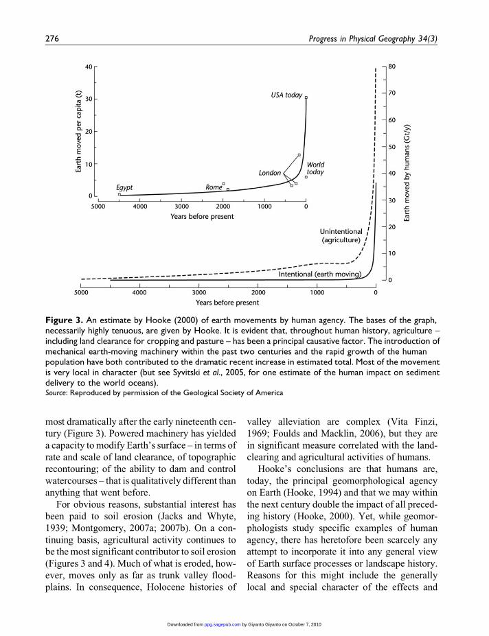
most dramatically after the early nineteenth cen-
tury (Figure 3). Powered machinery has yielded
a capacity to modify Earth’s surface – in terms of
rate and scale of land clearance, of topographic
recontouring; of the ability to dam and control
watercourses – that is qualitatively different than
anything that went before.
For obvious reasons, substantial interest has
been paid to soil erosion (Jacks and Whyte,
1939; Montgomery, 2007a; 2007b). On a con-
tinuing basis, agricultural activity continues to
be the most significant contributor to soil erosion
(Figures 3 and 4). Much of what is eroded, how-
ever, moves only as far as trunk valley flood-
plains. In consequence, Holocene histories of
valley alleviation are complex (Vita Finzi,
1969; Foulds and Macklin, 2006), but they are
in significant measure correlated with the land-
clearing and agricultural activities of humans.
Hooke’s conclusions are that humans are,
today, the principal geomorphological agency
on Earth (Hooke, 1994) and that we may within
the next century double the impact of all preced-
ing history (Hooke, 2000). Yet, while geomor-
phologists study specific examples of human
agency, there has heretofore been scarcely any
attempt to incorporate it into any general view
of Earth surface processes or landscape history.
Reasons for this might include the generally
local and special character of the effects and
Figure 3. An estimate by Hooke (2000) of earth movements by human agency. The bases of the graph,necessarily highly tenuous, are given by Hooke. It is evident that, throughout human history, agriculture –including land clearance for cropping and pasture – has been a principal causative factor. The introduction ofmechanical earth-moving machinery within the past two centuries and the rapid growth of the humanpopulation have both contributed to the dramatic recent increase in estimated total. Most of the movementis very local in character (but see Syvitski et al., 2005, for one estimate of the human impact on sedimentdelivery to the world oceans).Source: Reproduced by permission of the Geological Society of America
276 Progress in Physical Geography 34(3)
by Giyanto Giyanto on October 7, 2010ppg.sagepub.comDownloaded from

their generally incremental rather than novel
nature. But there can be no doubt that agricultu-
rally provoked soil movement has had a sys-
tematic impact on slope-base colluvial deposits
and on river floodplains, in some parts of the
world for thousands of years.
IV Contemporary questions anddirections
Every geomorphologist will have her/his own
perceptions of the major contemporary ques-
tions in the discipline, and they will inevitably
be coloured by individual experience. The fol-
lowing elaboration of six major conceptual ques-
tions – each one really a covering statement for a
range of important research questions – is there-
fore a personal and probably transient view.
1 Geomorphic fluxes and flux laws
Geomorphology is centrally concerned with the
evolution of the landscape. As became apparent
early in this essay, the subject might be
approached from either the perspective of under-
standing the physicochemical processes by
which landforms and landscapes in general
evolve, or the perspective of describing the his-
torical development of particular landscapes.
Ideally, one would hope to deduce the latter
from the former. This is a goal that is unlikely
ever to be completely realized, but one may hope
for substantial progress.2 Temporal constraints
imposed by the relative scales of human obser-
vation and landscape history dictate that prog-
ress toward understanding landscape evolution
must be essayed by theoretical means, and tested
by whatever relevant observations we can mus-
ter. Within our contemporary understanding of
geomorphology as a system science, that means
by system modelling.
Landscape evolution consists of the shifting
of earth materials from one place to another on
the surface of the planet; hence the principles
by which this shifting occurs must be a central
focus of interest. That is to say, the kernel of any
landscape evolution model must be the mass
transport laws that effect this redistribution.
Such laws must be applications of the relevant
principles of physics and, in complete form, they
must incorporate criteria for mobilization, trans-
fer and deposition of earth materials of varying
character. They must cover such phenomena as
the continuous deformation of surficial material
on hillside slopes; episodic failure of surficial
and rock material; the transport of sediment by
running water, both in channelled and unchan-
nelled flows; transport of material by wave
motion and currents along coasts; transport by
wind; and transport by glacial ice. A review of
progress in developing ‘geomorphic transport
laws’ has been presented by Dietrich et al.
(2003). After more than a century of modern
study, we still do not have an entirely satisfactory
Figure 4. A comparison of agricultural erosionrates with geological erosion rates, based on datacompiled by D.R. Montgomery and presented inMontgomery (2007a). Agricultural rates of sedimentmobilization exceed geological rates by between 1and 2 orders of magnitude across the entire range.Source: Original material copyright (2007) National Acad-emy of Sciences, USA
Church 277
by Giyanto Giyanto on October 7, 2010ppg.sagepub.comDownloaded from

view of any specific law, though in fact we have
useful approximations for some of them.
Two important aspects of the general problem
deserve further notice. The first is that transport
laws for particular media and particular geo-
morphic contexts (for example, sediment carried
in suspension in a river, compared with sediment
carried in suspension on the wind) have custo-
marily – though by no means exclusively – been
studied in isolation from each other. Yet there
often are important common features in the
underlying physics. It is probable that – for pur-
poses of elucidating the applied physics – con-
siderably less attention ought to be paid to
particular contexts, and more attention to gen-
eric processes (see Pelletier, 2008, on this topic).
The second is that the particular expression of
a geomorphic transport law must be consistent
with the scale of representation of the model sys-
tem within which it is applied, because scale of
representation influences the information con-
tent of the model. This issue is taken up again
in the following paragraphs.
2 Reconciling geomorphic information andprocess representation across scales
Questions of scale pervade any environmental
science. In geomorphology, scale leads to a
series of questions that can be divided into two
types: (1) questions related to transferring or
extrapolating geomorphological information in
the landscape; and (2) questions related to the
reconciliation of theories/models with different
scales of representation.
The first issue, and the underlying reason why
it is an issue, is best exemplified by an example.
In keeping with the concept that a fundamental
theme in geomorphology is the shaping of land-
scape by the transfer of earth materials from
place to place, information abut areal sediment
yield on Earth’s terrestrial surface represents
important geomorphological information. At
spatial scales beyond that of an individual hill-
slope, this information for the subaerial
landscape has customarily been collected and
presented as the transport of sediment in rivers.
Information derived from drainage basins of sub-
stantially differing size – all the way up to world
compilations – is customarily collated. Yet there
are well-known, regionally variable spatial scale
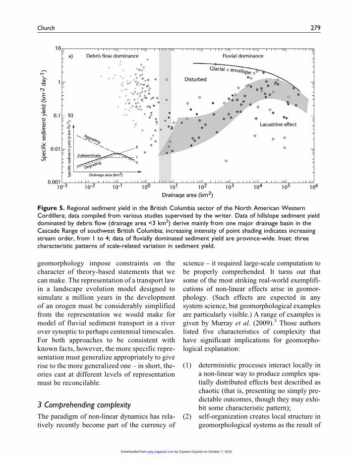
effects in sediment yield (eg, Church et al.,
1999). The effect arises because of spatially sys-
tematic variations in source-sink relations for
sediment (that is, from reservoir effects). Across
all scales of a regional landscape, with varying
modes of sediment transfer, the effect can be
complex (Figure 5). Geomorphic information
needs to be scale-adjusted for valid comparison.
Much more needs to be learned about regional
scaling relations for geomorphic information in
order to place this matter – much better under-
stood today in hydrology – on a firm foundation.
This issue applies to the proper interpretation
of ‘geomorphological experiments’ – more or
less controlled manipulations of landscape ele-
ments – and, in an extreme form, it leads to ques-
tions about the geomorphological relevance of
radically reduced model experiments, such as
physical models of landscape evolution or of
drainage basins conducted with synthetic materi-
als on the scale of metres. S.A. Schumm and his
collaborators (Schumm et al., 1987) were early
proponents of this approach. Recently, landscape
model experiments have been run by Hasbargen
and Paola (2000), Hancock and Willgoose
(2001) and Lague et al. (2008), among others.
How can such analogue experiments be justified
when, plainly, strict scaling of materials and
forces cannot apply? Paola justifies the
comparison on the basis of self-similarity of
the revealed morphology, referring to the effect
as ‘spontaneous similarity’ (in contrast to the
‘imposed similarity’ of a formally scaled experi-
ment). Recently, Malverti et al. (2008) have
extended the analogy to apply to some of the
actual processes by which the landforms emerge
in the world and in the model.
The second issue arises because the range
of spatial and temporal scales involved in
278 Progress in Physical Geography 34(3)
by Giyanto Giyanto on October 7, 2010ppg.sagepub.comDownloaded from
geomorphology impose constraints on the
character of theory-based statements that we
can make. The representation of a transport law
in a landscape evolution model designed to
simulate a million years in the development
of an orogen must be considerably simplified
from the representation we would make for
model of fluvial sediment transport in a river
over synoptic to perhaps centennial timescales.
For both approaches to be consistent with
known facts, however, the more specific repre-
sentation must generalize appropriately to give
rise to the more generalized one – in short, the-
ories cast at different levels of representation
must be reconcilable.
3 Comprehending complexity
The paradigm of non-linear dynamics has rela-
tively recently become part of the currency of
science – it required large-scale computation to
be properly comprehended. It turns out that
some of the most striking real-world exemplifi-
cations of non-linear effects arise in geomor-
phology. (Such effects are expected in any
system science, but geomorphological examples
are particularly visible.) A range of examples is
given by Murray et al. (2009).3 Those authors
listed five characteristics of complexity that
have significant implications for geomorpho-
logical explanation:
(1) deterministic processes interact locally in
a non-linear way to produce complex spa-
tially distributed effects best described as
chaotic (that is, presenting no simply pre-
dictable outcomes, though they may exhi-
bit some characteristic pattern);
(2) self-organization creates local structure in
geomorphological systems as the result of
Figure 5. Regional sediment yield in the British Columbia sector of the North American WesternCordillera; data compiled from various studies supervised by the writer. Data of hillslope sediment yielddominated by debris flow (drainage area <3 km2) derive mainly from one major drainage basin in theCascade Range of southwest British Columbia; increasing intensity of point shading indicates increasingstream order, from 1 to 4; data of fluvially dominated sediment yield are province-wide. Inset: threecharacteristic patterns of scale-related variation in sediment yield.
Church 279
by Giyanto Giyanto on October 7, 2010ppg.sagepub.comDownloaded from

still more local interactions among ele-
ments of the system;
(3) autogenic temporal behaviour occurs,
including sudden changes in the system
state with no obvious external forcing;
(4) emergent behaviour is seen, such that
larger-scale elements of a system exhibit
patterns and behaviours that are not simply
integrable from more elementary processes
(which means that patterns of explanation
cannot be entirely reductionist);
(5) self-similarity occurs in morphology and
in behaviour over a wide range of scales.
These characteristics, well illustrated now in a
range of geomorphological studies, generate
challenges for both explanation and prediction
(Phillips, 1995; 2003).
4 The intersection with life
There is no doubt that both vegetation and ani-
mals play a significant role in geomorphology
– the former pervasively. Yet they have been
comparatively little considered. Biota are impor-
tant in a wide variety of roles that range far
beyond the familiar ones of providing root rein-
forcement for soils to resist mass failure on
slopes and along stream banks, and ground cover
to resist surface erosion. Dietrich and Perron
(2006) provide a recent review that provoca-
tively asks whether life has left any unique sig-
nature in the landscape.
Microbiota are increasingly implicated in
weathering processes, even far below the sur-
face. Soil fauna structure the soil, thereby affect-
ing hydrologic behaviour and erodibility.
Animals may achieve significant soil movement
on hillslopes and tree-throw contributes to soil
disturbance and downslope soil movement.
Vegetation also contributes directly to soil
material and mediates the effective climate at the
land surface, thereby influencing both the
weathering environment and the ability of wind
and water to move material. To date, these
effects have been investigated in only a sum-
mary way, the main interest having normally
been focused upon soil erosion under a range
of land surface conditions, including studies of
erosion under various crop types.
Vegetation also plays a direct morphological
role on hillslopes and in rivers when woody
material becomes entrained in slope failures,
debris flows and water courses. These macro-
scopic effects are better studied, yet their com-
plexity leaves many questions unanswered.
5 The role of climate in geomorphology
This is by no means a new concern, but it now
assumes increased prominence. Again, there are
two aspects. In the long term – commensurable
with the time for significant geomorphological
evolution of landscapes – the mutual interactions
of climate, topography and vegetation are a
focus of significant inquiry (eg, Molnar and
England, 1990; Willett, 1999; Whipple, 2009).
It is well accepted that the major features of
Earth’s relief influence the large-scale steering
of the atmospheric circulation and thereby influ-
ence regional climate, and it is well known that
topography influences climate locally through
various topographic effects. It has more recently
been realized that climate reciprocally influ-
ences the evolution of relief, especially through
the influence of precipitation on runoff and
erosion, which usually is quite asymmetric
around mountains. In the long term, this, in turn,
influences isostatic compensation of the crust
and the further evolution of relief. There is, in
summary, a complex interaction between cli-
mate and topography that influences the course
of erosion, sedimentation and the entire develop-
ment of landscape.
In the shorter term, there is concern for the influ-
ence of climate change on geomorphological pro-
cesses. This effect is studied at two principal
scales: that of the glacial–interglacial changes of
the Pleistocene Epoch, and that of contemporary
climate change. While these two themes are closely
280 Progress in Physical Geography 34(3)
by Giyanto Giyanto on October 7, 2010ppg.sagepub.comDownloaded from
linked in climatological studies – for the former
may bring valuable insights to the latter – this is less
true of the geomorphological consequences, for the
contemporary climate trend moves us farther from
the conditions of a glacial Earth. Conditions of the
warm early- to mid-Holocene Epoch may, how-
ever, provide significant insight.
The most important way in which contempo-
rary climate change influences geomorphologi-
cal processes is through the hydrological cycle.
The effects of changes in the balance of precipi-
tation and evaporation, and of changes in
seasonal snowcover, are easy to comprehend
qualitatively. Unfortunately, primary changes
to precipitation are more difficult to predict
quantitatively than projected thermal changes.
Furthermore, they will be more nuanced region-
ally because of the interaction of precipitation
mechanisms with surface topography, and all
climate change predictions remain difficult at
regional scales. There remains a great deal of
work to be done in this area before the geomor-
phological consequences become entirely clear.
Overall, the questions associated with
prospective geomorphological consequences of
contemporary climate change have received far
less attention than they deserve (see Goudie,
2006; Slaymaker et al., 2009).
6 Integrating the human impact
One possible reason for relative ignorance of the
geomorphological effects of contemporary cli-
mate change is the fact that the effects are over-
printed by the pervasive impact of the human
presence on Earth. As shown above, humans are,
today, the dominant geomorphological agency
on the planet, and human impacts extend to
almost the entire terrestrial surface (Slaymaker
et al., 2009). Indeed, geomorphology urgently
needs to find a paradigm within which to inves-
tigate the intersection of the last two themes with
this one, for direct manipulation of land surface
cover and modification of the hydrological cycle
are the two most important ways in which
humans influence the overall course of geomor-
phological processes. In comparison, direct and
deliberate earth-moving operations, while cer-
tainly highly significant, are comparatively local
in their effect.
To date, consideration of the human impact
has, in geomorphological work, largely been
cast as an ‘applied’ study and a sort of footnote
to the main narrative of the discipline. In fact,
in the contemporary world, it is the major theme.
It has perhaps most squarely been faced in stud-
ies of soil erosion (eg, Montgomery, 2007b) – by
no means exclusively the province of geomor-
phologists – but it is equally true of fluvial geo-
morphology in most of the world (cf. Nilsson et
al., 2005), of aeolian geomorphology, the geo-
morphology of coasts, and even, increasingly
pervasively, of the geomorphology of the
world’s mountains (see discussions in Slay-
maker et al., 2009).
V Conclusions: Where are wegoing?
Prophesy is an exercise best left to oracles.
It may nevertheless be useful to record one
observer’s impression of the orientations that
will dominate the discipline in the immediate
future, especially in relation to the significant
bases and questions for the modern discipline
discussed above. There is the appearance, in the
contemporary discipline, of a significant dichot-
omy in orientation.
On the one hand, concerns to firmly ground
the discipline in physical principles – to find the
fundamental transport laws that govern the redis-
tribution of earth materials on the surface of the
planet; to properly reconcile the effects of those
laws over large ranges of space and time; and
to understand the complex nature of geomorpho-
logical processes and effects within the Earth
system – seem to dictate a future in which geo-
morphology becomes increasingly a geophysical
science. This process is in fact well under way;
geomorphology is increasingly prominent in the
Church 281
by Giyanto Giyanto on October 7, 2010ppg.sagepub.comDownloaded from

affairs of organizations such as the American and
European geophysical unions. With this orienta-
tion comes a methodological apparatus that
requires considerable training in mathematical
and physical sciences and an appreciation for the
appropriate degree of reductionism to employ in
the analysis of particular problems.
An alternative path is largely inspired, I think,
by the perception that geomorphology is – or
should be – becoming more and more preoccu-
pied with issues such as the broader definition
of the Earth system, environmental change in
that system, and the dominance of human
agency. It defines a subject less narrowly con-
fined by a particular methodological approach.
This is a geomorphology that more readily
incorporates human social and economic dimen-
sions – as necessary – into its analyses, and that
no longer treats humans as a special and some-
what exceptional agency modifying Earth’s sur-
face. Some implications of this approach are
sketched by Slaymaker (2009). It pays attention
to human experience, as well as observations of
landscape, as basic facts, it focuses on specific
elements of landscape as defining entities for the
field, it pays significant attention to the historical
dimension of particular landscapes, and it incor-
porates social values, such as a conservation
ethic and a concept of social justice. This is not
incompatible with a geophysical approach to
understanding geomorphological processes, but
it substantially broadens both the purview and
the intellectual bases of the subject. Which way
to go, or how to reconcile these views of what
geomorphology is, is a topic that is perhaps too
little pursued. If the history of the discipline be
any guide, it is more likely to be resolved by
practice than by discussion.
Notes
1. The development of the uranium-lead radioisotopic
method began at the turn of the twentieth century with
the discovery of radioactivity, but was still under
development until after mid-century. Until the
invention of precise mass spectrometers, analytical
accuracy remained a major problem.
2. This is, in effect, the programme envisaged, within the
limits imposed by knowledge of the time, by Charles
Lyell for his Principles of Geology.
3. See also the set of papers in Geomorphology 91 (2007),
173–404, on ‘Complexity in geomorphology’, the
Proceedings of the 38th Binghamton Symposium.
References
Ahnert, F. 1994: Equilibrium, scale and inheritance in geo-
morphology. Geomorphology 11, 125–40.
Bagnold, R.A. 1941: The physics of blown sand and desert
dunes. London: Methuen, 265 pp.
Baker, G.S. and Jol, H.M. 2007: Stratigraphic analysis
using GPR. GSA Special Paper 432. Boulder, CO:
Geological Society of America, 181 pp.
Baulig, H. 1935: The changing sea level. Publication 3.
London: Institute of British Geographers, 46 pp. (rep-
rinted 1956).
Bierman, P.R. 1994: Using in situ produced cosmogenic
isotopes to estimate rates of landscape evolution: a
review from the geomorphic perspective. Journal of
Geophysical Research 99, 13,885–96.
Brocklehurst, S.H. and Whipple, K.X. 2002: Glacial ero-
sion and relief production in the Eastern Sierra Nevada,
California. Geomorphology 42, 1–24.
Carbonneau, P. and Bergeron, N. 2005: Automated grain
size measurements from airborne remote sensing
for long profile measurements of fluvial grain sizes.
Water Resources Research 41, W11426, DOI:
10.1029/2005WR003994.
Carson, M.A. and Kirkby, M.J. 1972: Hillslope form and
process. Cambridge: Cambridge University Press,
475 pp.
Cerling, T.E. and Craig, H. 1994: Geomorphology and in
situ cosmogenic isotopes. Annual Review of Earth and
Planetary Sciences 22, 273–317.
Chorley, R.J. 1962: Geomorphology and general systems
theory. Professional Paper 500B. Reston, VA: United
States Geological Survey, 10 pp.
Chorley, R.J. and Kennedy, B.A. 1971: Physical geogra-
phy, a systems approach. London: Prentice-Hall Inter-
national, 370 pp.
Chorley, R.J., Dunn, A.J. and Beckinsale, R.P. 1964: The
history of the study of landforms, volume 1. London:
Methuen, 678 pp.
282 Progress in Physical Geography 34(3)
by Giyanto Giyanto on October 7, 2010ppg.sagepub.comDownloaded from

Church, M. 2003: What is a geomorphological prediction?
In Wilcock, P.R. and Iverson, R., editors, Geomorpho-
logical prediction, Geophysical Monograph 135,
Washington, DC: American Geophysical Union,
183–94.
Church, M., Ham, D.G., Hassan, M. and Slaymaker, O.
1999: Fluvial clastic sediment yield in Canada: a scaled
analysis. Canadian Journal of Earth Sciences 36,
1267–80.
Clayton, K.M. 1980: Beach sediment budgets and coastal
modification. Progress in Physical Geography 4,
471–88.
Coates, D.R., editor 1971: Environmental geomorphology
(Proceedings volume of the 1st Binghamton
Symposium). Binghamton, NY: Publications in Geo-
morphology, 262 pp.
Coates, D.R., editor 1976: Geomorphology and engineer-
ing (Proceedings volume of the 7th Binghamton
Symposium). Stroudsburg, PA: Dowden, Hutchinson
and Ross, 360 pp.
Cockburn, H.A.P. and Summerfield, M.A. 2004: Geo-
morphic applications of cosmogenic isotope analysis.
Progress in Physical Geography 28, 1–42.
Codilean, A.T., Bishop, P. and Hoey, T.B. 2006: Surface
process models and the links between tectonics and
topography. Progress in Physical Geography 30,
307–33.
Czech, H. and Boswell, K.C. 1953: Morphological
analysis of landforms. London: Macmillan: 429 pp.
(Translation of Penck, 1924).
Davis, W.M. 1899: The geographical cycle. Geographical
Journal 14, 481–504. Many subsequent papers are rep-
rinted in Davis, W.M. 1954: Geographical essays (edi-
ted by D.W. Johnson), New York, Dover, 777 pp. (first
published in 1909).
Dietrich, W.E. and Perron, J.T. 2006: The search for a
topographic signature of life. Nature 439, 411–18.
Dietrich, W.E., Bellugi, D.G., Sklar, L.S. and Stock, J.D.
2003: Geomorphic transport laws for predicting
landscape form and dynamics. In Wilcock, P.R. and
Iverson, R.M., editors, Prediction in geomorphology,
Geophysical Monograph 135, Washington, DC:
American Geophysical Union, 103–32.
Downs, P.W. and Gregory, K.J. 2004: River channel
management: towards sustainable catchment hydro-
systems. London: Arnold, 395 pp.
Dunne, T. 1980: Formation and controls of channel net-
works. Progress in Physical Geography 4, 211–39.
Eaton, B.C., Church, M. and Millar, R.G. 2004: Rational
regime model of alluvial channel morphology and
response. Earth Surface Processes and Landforms 29,
511–29.
Ferguson, R.I. 1986: Hydraulics and hydraulic geometry.
Progress in Physical Geography 10, 1–31.
Ferguson, R.I. and Church, M. 2009: A critical perspective
on 1D modelling of river processes: gravel load and
aggradation in lower Fraser River. Water Resources
Research 45, W11424, DOI: 10.1029/2009WR007740.
Foulds, S.A. and Macklin, M.G. 2006: Holocene land-use
change and its impact on river basin dynamics in Great
Britain and Ireland. Progress in Physical Geography
30, 589–604.
Garver, J.I., Brandon, M.T., Roden-Tice, M. and Kamp,
P.J. 1999: Erosional denudation determined by
fission-track ages of detrital apatite and zircon. In Ring,
U., Brandon, M.T., Willett, S and Lister, G., editors,
Exhumation processes: normal faulting, ductile flow,
and erosion, Special Publication 154, London: Geolo-
gical Society of London, 283–304.
Gilbert, G.K. 1877: Report on the geology of the Henry
Mountains. Washington, DC: United States Geographi-
cal and Geological Survey of the Rocky Mountain
Region, 160 pp.
Gomez, B. 1991: Bedload transport. Earth Science
Reviews 31, 89–132.
Gosse, J. and Phillips, F. 2001: Terrestrial in situ cosmo-
genic nuclides: theory and application. Quaternary
Science Reviews 20, 1475–560.
Goudie, A.S. 2006: Global warming and fluvial geomor-
phology. Geomorphology 79, 384–94.
Gregory, K.J., editor 1977: River channel changes.
Chichester: Wiley, 448 pp.
Hack, J. 1960: Interpretation of erosional topography in
humid temperate regions. American Journal of Science
258A, 80–97.
Hancock, G. and Willgoose, G. 2001: The interaction
between hydrology and geomorphology in a landscape
simulator experiment. Hydrological Processes 15,
115–33.
Happ, S.C., Rittenhouse, G. and Dobson, G.C. 1940: Some
principles of accelerated stream and valley sedimenta-
tion. Technical Bulletin 695. Washington, DC: United
States Department of Agriculture, 133 pp.
Hart, J.K. 1995: Subglacial erosion: deposition and defor-
mation associated with deformable beds. Progress in
Physical Geography 19, 173–91.
Church 283
by Giyanto Giyanto on October 7, 2010ppg.sagepub.comDownloaded from

Hasbargen, L.E. and Paola, C. 2000: Landscape instability
in an experimental drainage basin. Geology 28,
1067–70.
Hoey, T.B. 1992: Temporal variations in bedload transport
rates and sediment storage in gravel-bed rivers. Prog-
ress in Physical Geography 16, 319–38.
Hooke, R.LeB. 1994: On the efficacy of humans as
geomorphic agents. GSA Today 4, 217 and 224–25.
Hooke, R.LeB. 2000: On the history of humans as
geomorphic agents. Geology 28, 843–46.
Horton, R.E. 1945: Erosional development of streams and
their drainage basins: hydrophysical approach to quan-
titative morphology. Geological Society of America
Bulletin 56, 275–370.
Hovius, N., Stark, C.P. and Allen, P.A. 1997: Sediment
flux from a mountain belt derived by landslide map-
ping. Geology 25, 231–34.
Hovius, N., Stark, C.P., Shu, H.-T. and Lin, J.-C. 2000:
Supply and removal of sediment in a landslide-
dominated mountain belt: Central Range, Taiwan.
Journal of Geology 108, 211–27.
Jacks, G.V. and Whyte, R.O. 1939: The rape of the earth: a
world survey of soil erosion. London: Faber and Faber,
313 pp.
Jolliffe, I.P. 1978: Littoral and offshore sediment transport.
Progress in Physical Geography 2, 264–308.
Jones, J.A.A. 1987: The initiation of natural drainage net-
works. Progress in Physical Geography 11, 207–45.
Keylock, C.J. 2003: Mark Melton’s geomorphology and
geography’s quantitative revolution. Transactions of
the Institute of British Geographers NS 28, 142–57.
King, L.C. 1953: Canons of landscape evolution.
Geological Society of America Bulletin 64, 721–52.
King, P.B. and Schumm, S.A., compilers 1980: The phys-
ical geography (geomorphology) of William Morris
Davis. Norwich: Geo Abstracts, 174 pp.
Kirchner, J.W., Finkel, R.C., Riebe, C.S., Granger, D.E.,
Clayton, J.L. and Megahan, W.F. 2001: Episodic
mountain erosion inferred from sediment yields over
decades and millennia. Geology 29, 591–94.
Kooi, H. and Beaumont, C. 1996: Large-scale geomor-
phology: classical concepts reconciled and integrated
with contemporary ideas via a surface processes model.
Journal of Geophysical Research 101, 3361–86.
Lague, D., Crave, A. and Davy, P. 2008: Laboratory
experiments simulating the geomorphic response to
tectonic uplift. Journal of Geophysical Research 108,
B1, DOI: 10.1029/2002JB001785.
Lane, S.N., Richards, K.S. and Chandler, J.H. 1993:
Developments in photogrammetry: the geomorphic
potential. Progress in Physical Geography 17, 306–28.
Leliavsky, 1955: An introduction to fluvial hydraulics.
London: Constable, 257 pp.
Leopold, L.B. and Maddock, T. 1953: The hydraulic geo-
metry of stream channels and some physiographic
implications. Professional Paper 252. Reston, VA:
United States Geological Survey, 57 pp.
Leopold, L.B., Wolman, M.G. and Miller, J.P. 1964:
Fluvial processes in geomorphology. San Francisco:
Freeman, 522 pp.
Lewin, J. 1978: Floodplain geomorphology. Progress in
Physical Geography 2, 408–37.
Libby, W.F. 1955: Radiocarbon dating (second edition).
Chicago: University of Chicago Press, 175 pp.
Loughran, R.J. 1989: The measurement of soil erosion.
Progress in Physical Geography 13, 216–33.
Mackin, J.H. 1963: Rational and empirical methods of
investigation in geology. In C.C. Albritton Jr, editor,
The fabric of geology, Stanford, CA: Freeeman Cooper
(for the Geological Society of America), 135–63.
Malverti, L., Lajeunesse, E. and Metivier, F. 2008: Small is
beautiful: upscaling from microscale laminar to natural
turbulent rivers. Journal of Geophysical Research 113,
F04004, DOI: 10.1029/2007JF000974.
Marsh, G.P. 1864: Man and nature, or physical geography
as modified by human action. New York: Scribner.
Republished 1876 as The earth as modified by human
action, 674 pp.
Martin, Y. and Church, M. 2004: Numerical modelling of
landscape evolution: geomorphological perspectives.
Progress in Physical Geography 28, 1–23.
Melton, M.A. 1958a: Geometric properties of mature drai-
nage systems and their representation in an E4 phase
space. Journal of Geology 66, 35–56.
Melton, M.A. 1958b: Correlation structure of morphometric
properties of drainage systems and their controlling
agents. Journal of Geology 66, 442–60.
Melton, M.A. 1960: Intravalley variation in slope angles
related to microclimate and erosional environment.
Geological Society of America Bulletin 71, 133–44.
Merritts, D.J. and Ellis, M. 1994: Introduction to special
section on tectonics and topography. Journal of Geo-
physical Research 99, 135–41.
Molnar, P. and England, P. 1990: Late Cenozoic uplift of
mountain ranges and global climate change: chicken
or egg? Nature 346, 29–34.
284 Progress in Physical Geography 34(3)
by Giyanto Giyanto on October 7, 2010ppg.sagepub.comDownloaded from
Montgomery, D.R. 2007a: Soil erosion and agricultural
sustainability. Proceedings of the National Academy
of Sciences (USA) 104, 13,268–72.
Montgomery, D.R. 2007b: Dirt: the erosion of civiliza-
tions. Berkeley, CA: University of California Press,
285 pp.
Murray, A.B., Lazarus, E., Ashton, A., Baas, A., Coco, G.,
Coulthard, T., Fonstad, M., Haff, P., McNamara, D.,
Paola, C., Pelletier, J. and Reinhardt, L. 2009: Geomor-
phology, complexity, and the emerging science of the
Earth’s surface. Geomorphology 103, 496–505.
Nilsson, C., Reidy, C.A., Dynesius, M. and Revenga, C.
2005: Fragmentation and flow regulation of the world’s
largest river systems. Science 308, 405–408.
Pelletier, J.D. 2008: Quantitative modeling of earth sur-
face processes. Cambridge: Cambridge University
Press, 295 pp.
Penck, W. 1924: Die morphologische analyse. Geogra-
phische Abhandlungen, 2 Reihe, Heft 2, 283 pp. (For
a translation, see Czech and Boswell, 1953).
Phillips, J.D. 1995: Self-organization and landscape devel-
opment. Progress in Physical Geography 19, 309–21.
Phillips, J.D. 2003: Sources of nonlinearity and complexity
in geomorphic systems. Progress in Physical Geogra-
phy 27, 1–23.
Pickup, G. and Rieger, W.A. 1979: A conceptual model of
the relationship between channel characteristics and
discharge. Earth Surface Processes 4, 37–42.
Powell, D.M. 1998: Patterns and processes of sediment
sorting in gravel-bed rivers. Progress in Physical
Geography 22, 1–32.
Pye, K. 1984: Loess. Progress in Physical Geography 8,
176–217.
Rapp, A. 1986: Slope processes in high latitude mountains.
Progress in Physical Geography 10, 53–68.
Rudwick, M.J.S. 2008: Worlds before Adam. Chicago:
University of Chicago Press, 614 pp.
Sarre, R.D. 1987: Aeolian sand transport. Progress in
Physical Geography 11, 157–82.
Scheidegger, A.E. 1961: Theoretical geomorphology.
Berlin: Springer, 333 pp.
Scheidegger, A.E. 1970: Theoretical geomorphology
(second edition). Berlin: Springer, 435 pp.
Schumm, S.A. 1956: Evolution of drainage systems and
slopes in badlands at Perth Amboy, New Jersey.
Geological Society of America Bulletin 67, 597–646.
Schumm, S.A. 1973: Geomorphic thresholds and complex
responses of drainage systems. In Morisawa, M., editor,
Fluvial geomorphology, Binghamton, NY: Publica-
tions in Geomorphology, 299–310.
Schumm, S.A. and Lichty, R.W. 1965: Time, space and
causality in geomorphology. American Journal of
Science 263, 110–19.
Schumm, S.A., Mosley, M.P. and Weaver, W.E. 1987:
Experimental fluvial geomorphology. New York:
Wiley-Interscience, 413 pp.
Selby, M.J. 1985: Earth’s changing surface. Oxford:
Oxford University Press, 607 pp.
Sherman, D.J. 1989: Geomorphology: praxis and theory.
In Kenzer, M.S., editor, Applied geography: issues,
questions and concerns, Geojournal Library 15, Dor-
drecht: Kluwer, 115–31.
Shreve, R.L. 1975: The probabilistic-topologic
approach to drainage-basin geomorphology. Geology
3, 527–29.
Shreve, R.L. 1979: Models for prediction in fluvial geo-
morphology. Mathematical Geology 1, 165–74.
Simpson, G.G. 1963: Historical science. In Albritton, C.C.
Jr, editor, The fabric of geology, Stanford, CA: Freee-
man Cooper (for the Geological Society of America),
24–48.
Slaymaker, O. 2009: The future of geomorphology.
Geography Compass 3, 329–49.
Slaymaker, O., Spencer, T. and Embleton-Hamann, C.,
editors 2009: Geomorphology and global environmen-
tal change. Cambridge: Cambridge University Press,
528 pp.
Strahler, A.N. 1950: Equilibrium theory of erosional
slopes approached by frequency distribution ana-
lysis. American Journal of Science 248, 673–96,
800–14.
Strahler, A.N. 1952: Dynamic basis of geomorphology.
Geological Society of America Bulletin 63, 923–37.
Strahler, A.N. 1954: Statistical analysis in geomorphic
research. Journal of Geology 62, 1–25.
Strahler, A.N. 1992: Quantitataive/dynamic geomorphol-
ogy at Columbia 1945–60: a retrospective. Progress
in Physical Geography 16, 65–84.
Syvitski, J.P.M., Vorosmarty, C.J., Kettner, A.J. and
Green, P. 2005: Impact of humans on the flux of terres-
trial sediment to the global coastal ocean. Science 308,
376–80.
Thomas, M.F. and Summerfield, M.A. 1987: Long-term
landform development: key themes and research prob-
lems. In Gardiner, V., editor, International Geomor-
phology 1986: part II, Chichester: Wiley, 935–56.
Church 285
by Giyanto Giyanto on October 7, 2010ppg.sagepub.comDownloaded from

Trimble, S. 1983: A sediment budget for Coon Creek basin
in the Driftless Area, Wisconsin. American Journal of
Science 283, 454–74.
Trimble, S. 1999: Decreased rates of alluvial sediment
storage in the Coon Creek basin, Wisconsin, 1975–
93. Science 285, 1244–46.
Vita Finzi, C. 1969: The Mediterranean valleys. Cam-
bridge: Cambridge University Press, 140 pp.
Walker, M. 2005: Quaternary dating methods. Chichester:
Wiley, 286 pp.
Waltham, A.C. 1981: Origin and development of limestone
caves. Progress in Physical Geography 5, 242–56.
Whalley, W.B. and McGreevy, J.P. 1985: Weathering.
Progress in Physical Geography 9, 559–81.
Whipple, K.X. 2009: The influence of climate on the tec-
tonic evolution of mountain belts. Nature Geoscience
2, 97–104.
Willett, S.D. 1999: Orography and orogeny: the effects of
erosion on the structure of mountain belts. Journal of
Geophysical Research 104, 957–82.
Willett, S.D., Hovius, N., Brandon, M.T. and Fisher, D.M.,
editors 2006: Tectonics, climate and landscape
evolution. Special Paper 398. Boulder, CO: Geological
Society of America, 434 pp.
Yochelson, E.L. 1980: The scientific ideas of G.K. Gilbert.
Special Paper 183. Boulder, CO: Geological Society of
America, 148 pp.
286 Progress in Physical Geography 34(3)
by Giyanto Giyanto on October 7, 2010ppg.sagepub.comDownloaded from


![[Doreen Massey, John Allen Phil Sarre] Human Geo(BookFi.org)](https://static.fdocuments.us/doc/165x107/56d6beb41a28ab301693407e/doreen-massey-john-allen-phil-sarre-human-geobookfiorg.jpg)