Potential Impacts and Risks of Proposed Next Generation ...
94
WCS CANADA CONSERVATION REPORT NO. 8 | NOVEMBER 2015 Potential Impacts and Risks of Proposed Next Generation Hydroelectric Dams on Fish and Fish Habitat in Yukon Waters Al von Finster and Donald Reid
Transcript of Potential Impacts and Risks of Proposed Next Generation ...

WCS CANADA CONSERVATION REPORT NO. 8 | NOVEMBER 2015
Potential Impacts and Risks of Proposed Next Generation Hydroelectric Dams on Fish and Fish Habitat in Yukon Waters
Al von Finster and Donald Reid

Potential Impacts and Risks of Proposed Next Generation Hydroelectric Dams on Fish and Fish Habitat in Yukon Waters
WCS CANADA CONSERVATION REPORT #8NOVEMBER 2015
Al von Finster, Independent ConsultantDonald Reid, Wildlife Conservation Society Canada

WCS Canada Conservation Reports: ISSN 1719-8941 Conservation Report Series (Print)ISSN 1719-8968 Conservation Report Series (Online)ISBN 978-1-927895-02-3 Potential Impacts and Risks of Proposed Next Generation Hydroelectric Dams on Fish and Fish Habitat in Yukon Waters (Print)ISBN 978-1-927895-03-0 Potential Impacts and Risks of Proposed Next Generation Hydroelectric Dams on Fish and Fish Habitat in Yukon Waters (Online)
Copies of WCS Canada Conservation Reports are available from: Wildlife Conservation Society Canada344 Bloor Street West, Suite 204Toronto, Ontario, M5S 3A7Telephone: (416) 850-9038www.wcscanada.org
Suggested Citation: von Finster, Al and Donald Reid, 2015. Potential Impacts and Risks of Proposed Next Generation Hydroelectric Dams on Fish and Fish Habitat in Yukon Waters. Wildlife Conservation Society Canada Conservation Report No. 8. Toronto, Ontario, Canada.
Front Cover Photos: Arctic Grayling are widely distributed in Yukon rivers and lakes, and frequently undertake annual migrations to specific spawning habitats. A new dam would halt some migrations, and may destroy spawning habitats (Photo: Peter Mather). Inset: The Whitehorse Rapids Hydroelectric Dam often releases large volumes of water over the spillway in late summer (Photo: Donald Reid).
Copyright:©2015 The contents of this paper are the sole property of the authors and cannot be reproduced without permission of the authors.
Wildlife Conservation Society Canada Conservation Reports SeriesWildlife Conservation Society Canada (WCS Canada) was incorporated as a con-servation organization in Canada in July 2004. Its mission is to save wildlife and wildlands by improving our understanding of — and seeking solutions to — critical problems that threaten vulnerable species and large wild ecosystems throughout Canada. WCS Canada implements and supports comprehensive field studies to gather information on the ecology and behavior of wildlife. Then, it applies that information to resolve key conservation problems by working with a broad array of stakeholders, including local community members, conservation groups, regula-tory agencies, and commercial interests. It also provides technical assistance and biological expertise to local groups and agencies that lack the resources to tackle conservation dilemmas. Already, WCS Canada has worked on design of protected areas (Nahanni National Park), monitoring and recovery of species (grizzly bear, lynx, wolverine, and woodland caribou), restoration of ecosystems, integrated man-agement of large landscapes, and community-based conservation.
Although WCS Canada is independently registered and managed, it retains a strong collaborative working relationship with sister WCS programs in more than 55 countries around the world. The Wildlife Conservation Society is a recognized global leader in conservation, dedicated to saving wildlife and wildlands for spe-cies in peril, such as elephants, tigers, sharks, macaws and bears. For more than a century, WCS has worked in North America promoting conservation actions such as recovery of bison, establishment of parks, and legislation to protect endangered wildlife. Today, WCS Canada draws upon this legacy of experience and expertise to inform its strategic programs from Yukon to Labrador. To learn more about WCS Canada, visit: www.wcscanada.org. To contact WCS Canada, write to: [email protected]. The purpose of the WCS Canada Conservation Reports Series is to provide an outlet for timely reports on WCS Canada conservation projects.

TABLE OF CONTENTS
Executive Summary ................................................................................................................ 2
1.0 Introduction .................................................................................................................. 7
2.0 Administrative and Bio-physical Environments .......................................................112.1 Administrative environment ............................................................................... 112.2 Biophysical environment .................................................................................... 15 2.2.1 Physical characteristics of water courses and bodies ................................ 15 2.2.2 Climate .................................................................................................... 19
3.0 Fish Species, Populations and Habitats ...................................................................203.1 Fish species distribution ...................................................................................... 203.2 Fish populations ................................................................................................. 24 3.2.1 Anadromous fish ..................................................................................... 24 3.2.2 Freshwater fish ........................................................................................ 253.3 Fish habitats ....................................................................................................... 26
4.0 Impacts and Risks from a New Hydroelectric Project .............................................304.1 Impacts and risks to migration ........................................................................... 31 4.1.1 Anadromous fish ..................................................................................... 31 4.1.2 Freshwater fish ........................................................................................ 334.2 Impacts and risks upstream of a dam ................................................................. 36 4.2.1 Pre-impoundment preparation within the reservoir footprint .................. 36 4.2.2 Operation – riverine reservoirs ................................................................ 36 4.2.3 Operation – lacustrine reservoirs ............................................................. 454.3 Impacts and risks downstream of a dam ............................................................. 47 4.3.1 Dissolved gas supersaturation ................................................................. 47 4.3.2 Flow regimes and channel stability .......................................................... 48 4.3.3 Temperature ............................................................................................ 51 4.3.4 Nutrients ................................................................................................. 524.4 Mercury and heavy metals .................................................................................. 53
5.0 Mitigation ...................................................................................................................545.1 Fish migration and movements ........................................................................... 555.2 Downstream water temperatures ........................................................................ 585.3 Dissolved gas supersaturation (DGS) .................................................................. 585.4 Downstream sediments ....................................................................................... 585.5 Mercury bio-accumulation ................................................................................. 59

iv WILDLIFE CONSERVATION SOCIETY CANADA | CONSERVATION REPORT NO. 8
6.0 Conclusion ..................................................................................................................60
7.0 References and Cited Literature ...............................................................................64
8.0 Appendices ................................................................................................................. 77Appendix A. Fish species with distributions only downstream of proposed dam sites .. 77Appendix B. Range of water levels in reservoirs and heights of dams ........................... 78Appendix C. Chinook Salmon spawning streams potentially affected .......................... 79

1FISH AND HYDRO DAMS IN YUKON
We wish to acknowledge funding from The W. Garfield Weston Foundation that enabled us to investigate this topic and write the Report. The following reviewers provided valuable comments and assistance with the Report’s content and presentation: Ian Birtwell, Mike Bradford, Heather Leba, and Justina Ray. Brad Cundiff and Tracy Kett of Green Living Communications provided valu-able editing and graphic design work for the final Report. Thanks to all!
ACKNOWLEDGEMENTS

2 WILDLIFE CONSERVATION SOCIETY CANADA | CONSERVATION REPORT NO. 8
The Yukon government’s proposal to build a large hydroelectric dam on one of Yukon’s large undammed rivers raises major environmental concerns, particu-larly about impacts on important fish populations. Hydroelectric dams have a well-documented history of disrupting and even destroying the ecology of rivers and lakes in northern Canada. Impacts on fish populations and their habitats have been widespread and often irreversible.
The Yukon Government’s Next Generation Hydro initiative has identified ten potential sites for such a dam. In this report we summarize the major risks to fish and fish habitats of a new hydroelectric dam on a large river with the goal of providing Yukon communities and citizens with better information on the scope of these impacts and risks.
This is important as the Territorial government has not actually consid-ered these risks in selecting the ten potential sites for a new hydroelectric dam. Instead, environmental impacts and risks will be assessed after a project site is chosen (Next Generation Hydro 2015). Such an approach will likely be too little, too late.
Instead, the government should start by assessing whether, given its envi-ronmental impacts and risks and the associated socio-economic impacts and risks, such a dam is desirable at all and whether there are better alternatives for meeting the Yukon’s energy needs.
Fish Distributions, Populations and HabitatOne of the key concerns about the Yukon government’s plan is that scientific knowledge of Yukon fish species is very limited. We lack information on distri-butions, population ranges, population sizes and high-value habitats for most fish species, with the sole exception of Chinook Salmon.
We also do not know the full suite of species that would be directly affected by a dam or which populations might be affected in any specific location. This lack of knowledge of population locations, abundance and movements is par-ticularly a problem for species that are potentially at risk, such as Northern Dolly Varden and Bull Trout.
EXECUTIVE SUMMARY

3FISH AND HYDRO DAMS IN YUKON 3
These large knowledge gaps for most fish species can only be filled with an extended period of intensive study, which should happen in consultation with governments and communities, prior to any decision to build a dam. Studies need to be carried out over a long enough time frame to capture the full range of natural variation in these ecosystems. No typical environmental assessment of a development project, such as those that have been prepared for the Yukon Environmental and Socio-economic Assessment Board (YESAB), will meet this requirement or be able to fill these gaps. Without significant investment in new studies, the impacts of a new dam will remain unknown, and society runs the risk of losing significant natural capital that it never even knew existed.
Biophysical EnvironmentYukon rivers and lakes have strong seasonal patterns when it comes to factors such as water flow, connections between and within water bodies, water tem-perature, and sedimentation. Fish – and aquatic ecosystems in general – have adapted to these patterns over the roughly 11,000 years since the last glaciation. Climate warming, however, is already changing these patterns, making the envi-ronment less predictable for fish. A hydro dam on a large river would dramati-cally change most of these patterns, with strong impacts and risks for fish.
Impacts and RisksEach of the proposed dams would completely halt all upstream movements of fish and strongly limit downstream movements. This impact will result in the loss of populations of ocean-going (anadromous) species - Chinook Salmon, Chum Salmon, Arctic Lamprey - that spawn above a dam site in the Yukon River drainage. Chinook Salmon are known to spawn above each of the pro-posed dam sites on the Stewart, Pelly and Teslin Rivers.
The blockage of upstream movement is also likely to result in the loss of some populations of freshwater fish species if their spawning habitats are iso-lated from seasonal habitat downstream. Our knowledge of fish distributions and movements is currently too poor to document this impact in most cases.
Each dam would create an upstream reservoir in place of existing rivers and valley bottoms and/or existing lakes, with diverse impacts and risks to fish. For example, reservoir depth and surface area will vary significantly more than in most natural lakes during any single year and over years. As a result of these variations, large areas of reservoir bottom will become exposed, mostly in late winter and spring, when water is drawn down to generate power. Aquatic eco-systems in reservoirs will therefore be less stable, and less able to sustain robust aquatic food webs, compared to the original rivers and lakes.
Reservoirs also change the kinds of fish habitat available, often resulting in decades of instability in fish populations. Stream-dwelling populations (e.g., of Arctic Grayling) will be most at risk because their moving water habitats, including spawning sites, will be converted to standing water.
Dams on the Stewart, Pelly or Teslin Rivers would flood and destroy exist-ing spawning sites for Chinook Salmon, with a high risk that those populations would be completely eliminated. Lake-dwelling fish that prefer shallow water

4 WILDLIFE CONSERVATION SOCIETY CANADA | CONSERVATION REPORT NO. 8
will lose most of their habitat because of large seasonal changes in water depth in reservoirs. These fish will have to find new spawning habitats, a process that may significantly reduce populations. However, without better population inventory information these risks cannot be quantified.
Reservoirs flood existing land and create new shorelines leading to substan-tial new erosion, which will add sediment to the impounded water. This process will last many years, especially in permafrost-rich soils and with continued cli-mate warming. This ongoing deposition of sediment will continually change the depth and substrate of potential spawning habitats and create a significant risk of high mortality for fertilised eggs. Over-wintering fish will experience reduced oxygen availability due to the reduced water volume, a risk made worse by oxygen loss due to decomposition of vegetation in the newly flooded reservoir. Biologically important lake outlet habitats will also be lost or fundamentally changed.
Dam operations will also dramatically change the seasonal pattern of downstream water flows.
The new flow regime will depend on whether the hydroelectric facility is operated to supply base-load or peak-load power. Base-load usage produces fairly constant downstream water flow, at least seasonally, and fish can adapt relatively easily. Peak power production, on the other hand, produces rapidly changing (daily or hourly) and widely varying downstream flows, which can spill outside normal river channels during winter, create bursts of heavy erosion and then leave some channels dry. This variable flow can directly kill fish, make many channels uninhabitable, and generally results in poor fish habitat.
Peak load usage needs to be avoided. Even base load usage will create downstream flows with less than normal seasonal variations and with less natural flooding of back channels and valley bottom habitats downstream. Habitat quality for many fish species will decline. As well, flow of water over and through a dam often makes the water supersaturated with gases, which can be lethal or debilitating to fish downstream.
Finally, operation of dams often causes changes in downstream water tem-peratures. Water drawn from the reservoir surface may be warmer than average, leading to problems for downstream fish such as migratory salmon, while water drawn from the base of the dam can be colder than normal.
MercuryHydroelectric reservoirs typically result in more rapid movement of mercury into the food chain and potential risk of toxicity to humans eating fish caught in fisheries, a risk that can last at least a decade after flooding. The risk of elevated mercury releases is particularly high when wetland and peatland areas are flooded.
MitigationVarious approaches, such as fishways, have been used to try to offset the impacts of hydro power developments. But there are significant limitations to these approaches.

5FISH AND HYDRO DAMS IN YUKON
Structures (e.g., fishways) and artificial propagation can be used to help a few fish species (notably Chinook Salmon) move up and downstream past a dam. However, many species will rarely use these structures, and mortality of young fish may be very high. There are no mitigation measures that will com-pletely overcome the blockage caused by a dam.
The problem of changes to the temperature of downstream water can be mitigated to a large extent by designing a facility that can selectively release water from different depths, and therefore different temperatures, in the reser-voir.
Mortality caused by exposure to water supersaturated with gases can be mitigated to some extent by the design and operation of water-release struc-tures.
The release of methyl-mercury into the food chain can be reduced to some extent by minimizing the amount of flooded land the reservoir will cover, and by removing trees and other organic material before flooding. However, the risk will still remain and will require careful monitoring.
But while some impacts can be partially mitigated, there are no efficient and cost-effective mitigation measures available to deal with loss of spawning habitats in flooded streams; erosion of flooded land surfaces and shorelines and resulting in-filling of the reservoir; loss and shifting availability of spawning habitats in flooded lakes; added instability in environmental conditions and changes in species composition of aquatic food webs in reservoirs; declines in quality of winter habitats for fish in reservoirs; changes to patterns of water flow in downstream rivers; changing sediment loads in downstream rivers; and risks of oxygen depletion causing fish mortality.
Regulatory EnvironmentGovernments and institutions change over the long life of a hydroelectric facil-ity, so legislation, licenses, regulations and agreements also may change. The risk is that terms, conditions and agreements regarding conservation of fish, and attempted mitigation of negative impacts to fish, as negotiated at the onset or during a project, will be weakened, overlooked, ignored or re-negotiated over time, with a resulting loss or reductions in effectiveness.
There is also a risk of a growing conflict of interest within the Yukon Territorial Government (YTG) if the federal government delegates authority or powers to YTG under the Fisheries Act or the Yukon Environmental and Socio-economic Assessment Act. This is because YTG, or its designated agencies such as Yukon Development Corporation (YDC), will then be both the proponent of the hydroelectric development and its primary assessor and regulator.
Three international agreements (International Boundary Waters Treaty, Yukon River Salmon Agreement, and North American Free Trade Agreement) have provisions that could be used to improve conservation outcomes for Yukon fish, especially salmon species, through the proposal, design, develop-ment and operation phases of a new hydroelectric project.
6 WILDLIFE CONSERVATION SOCIETY CANADA | CONSERVATION REPORT NO. 8
Public EngagementIt is critical that any assessment of the Yukon’s dam plans include an examina-tion of how many fish populations could be potentially affected and what the resulting impact would be on food security and the economic well-being of people in Yukon.
The assessment, planning, permitting, operation, maintenance and decom-missioning of any new hydroelectric project will produce a lot of complicated documentation and will raise serious questions about economic and envi-ronmental trade-offs, environmental and social impacts and how accurately we can predict outcomes. To meaningfully participate in these processes and address these questions, First Nations and Yukon communities should be able to obtain the services of independent technical experts and advisors paid for by the Territorial government or the proponent agency.
Although hydroelectric power generation is widely considered as a source of renewable energy, it is not environmentally friendly or “green” when it requires a dam and reservoir on a large river. Such dams have widespread and long-lasting impacts on fish and fish habitats, many of which cannot be miti-gated. Any proposal for a large in-river dam must be assessed in environmental and socio-economic terms in comparison to a suite of smaller-scale hydroelec-tric or other renewable energy sources.

7FISH AND HYDRO DAMS IN YUKON
1.0 INTRODUCTION
This report provides an overview of the impacts and potential risks to fish populations and fish habitats from the building of a major dam across a large Yukon river as is currently proposed by the Next Generation Hydro initiative of the Yukon Territorial Government (Yukon Government 2013; Next Generation Hydro 2015). Our primary goal is to provide Yukon communities and citizens, and their governments, with information regarding the scope of these impacts and risks.
This information is being provided in the context of a political conclusion that a large hydro-electric dam is necessary to satisfy Yukon’s future energy needs (Yukon Government 2013). This conclusion has been justified on eco-nomic grounds, but has been reached without a thorough assessment of alter-native means of satisfying energy needs, and, equally importantly, without an assessment of impacts to fish and wildlife. The Next Generation Hydro initiative will include socio-economic and environmental impact assessments, but these will come after the decision has been made to build a dam (Next Generation Hydro 2015) so their findings will not directly impact the decision to develop a dam, but instead simply address issues around how to build the dam.
The impacts of hydro-electric dams on water, fish and wildlife resources have been large and often devastating in river and lake ecosystems around the world, including in Canada, and many impacts cannot be mitigated (Hirst 1991, Rosenberg et al. 1997, Lichatowich 1999, Graf 2006, Clarke et al. 2008, Kemp et al. 2011). Other hydroelectric facilities (e.g., Bennett Dam on the Peace River) have been built in western Canada without adequate assessment of impacts and risks. Consequently, these projects have significantly reduced the quality of the environment and resulted in high costs for mitigation and compensation.
Major projects such as these have long lifespans, so decisions made today will impact future generations. Simply put, the environmental impacts of a new Yukon dam, especially impacts on fish, should have been taken into account early in the process of deciding whether or not such a large in-river dam is a responsible development at all. Our secondary goal, therefore, is to draw atten-tion to the impacts and risks to fish, given that little attention has been paid to these risks in the initial decision-making process.

8 WILDLIFE CONSERVATION SOCIETY CANADA | CONSERVATION REPORT NO. 8
Fish have a long history of use by, and value to, the people of the Yukon. Aboriginal peoples netted, trapped or speared fish as part of their seasonal round (McClennan 1975, Weinstein 1992, Joe 2014) and stored it for winter use (O’Leary 1992). Early settlers and government agencies created markets for fish. The first commercial fisheries developed near settler communities prior to the Klondike Gold Rush (Seigel and McEwen 1984), and thereafter increased rapidly in geographical distribution and numbers of fish captured annually. Both salmon and freshwater commercial fisheries were developed. Aboriginal fisheries for salmon and freshwater species continued even as commercial har-vesting declined and First Nations continue to rely on fish across the Yukon to this day (McClennan et al. 1987).
Meanwhile, concerns about the effects of sports angling on native fish pop-ulations emerged as human populations increased (Brown et al. 1976). Sport fish angling is now the dominant freshwater fishery, accounting for an estimated 85% of the Yukon’s freshwater fish harvest, with the aboriginal fishery and a very small commercial fishery harvesting the remaining 15% (Environment Yukon 2010). Salmon, and particularly Chinook Salmon, are widely distrib-uted and support highly valued aboriginal, commercial, domestic and sports fisheries (JTC 2013).
The Next Generation Hydro initiative has included the screening of more than 200 potential hydroelectric development sites through a four-stage process, bringing this list down to a short-list of 10 potential projects for further study (Midgard 2015). All projects have to be at least 10 megawatts (MW) in size and none could be on the Yukon River main stem or be in a National Park. The 10 projects on the short list are in the watersheds of three principal tributaries of the Yukon River (the Stewart, Pelly and Teslin Rivers), and on the Frances River, a tributary of the Liard River (Figure 1). A final screening stage to determine the best location is underway (Next Generation Hydro 2015) as this report is being prepared.
We classify the potential projects as “riverine” (converting an existing river to a reservoir, which applies to the Stewart, Teslin and lower Pelly Rivers), “lacustrine” (converting an existing lake to a reservoir; Frances Lake/River), or combined “riverine/lacustrine” (upper Pelly River). We do not address the potential impacts to fish of the actual process of constructing a hydroelectric facility. Instead we assume that existing environmental assessment processes along with other legislation, regulations, standard operating procedures and guidelines will do this job.
The level of detail in this report reflects the current status of the screening and planning process led by Yukon Development Corporation. That process has only addressed general locations for possible hydroelectric facilities and provides no detailed description of the components or mode of operation of any facility. Accordingly, our descriptions of the impacts and risks are often general. To the extent possible, however, we identify impacts and risks specific to the fish species, rivers, and lakes of the watersheds associated with specific hydroelectric projects as mapped in Midgard (2015).

9FISH AND HYDRO DAMS IN YUKON
!!
!!
!!
!
!
! !
")
")
")
")")
")
")
")
")
Porcupine River
! Potential Dam Site
Lake/ River
Road
Existing Transmission Grid
0 100 200 300 40050Kilometers
Stewart River
Pelly River
Liard River
5
Yukon River
Teslin River
Peel River
Whi
te R
iver
WHITEHORSEHAINES
JUNCTION
TESLIN WATSONLAKE
ROSSRIVER
DAWSONCITY
CARMACKS
MAYO
STEWARTCROSSING
Fraser Falls (High & Low)
Two Mile Canyon
Detour Canyon(with or without Fortin Lake Dam)
Hoole Canyon & Fortin Lake Dam
Slate Rapids(Diversion Scheme)
Upper Canyon (Large, Medium & Small)
False CanyonMiddle (or Lower) Canyon
(Large & Small)NWPI(Low)
Granite Canyon
(Large & Small)
Figure 1. Map of Yukon Territory showing the locations of the 10 potential hydroelectric project sites under consideration by Next Generation Hydro. The Liard and Peel watersheds flow into the Mackenzie River, all within Canada. All other projects are on tributaries to the Yukon River, which flows into Alaska.

10 WILDLIFE CONSERVATION SOCIETY CANADA | CONSERVATION REPORT NO. 8
The report has five main sections. We start by describing the nature of Yukon’s regulatory and bio-physical environments as these could affect deci-sion-making and the fish resources. This sets the stage for a discussion of the state of knowledge of fish populations and habitats in the affected drainages. We then address the various impacts and risks to fish and fish habitats caused by a dam and its upstream and downstream effects and outline potential options for mitigating these impacts and risks. Finally a concluding section summarizes the major findings and provides some overview comments.
11FISH AND HYDRO DAMS IN YUKON
2.0 REGULATORY AND BIOPHYSICAL ENVIRONMENTS
The selected project will exist in two inter-related, dynamic and unpredictable environments. The regulatory environment includes the design, construction, operation, maintenance, monitoring, management and eventual decommis-sioning of the dam and generating station, along with the application of laws, regulations, standards, agreements and underlying economics and ownership of the project during its lifespan.
The biophysical environment includes the land, water, climate and all living things that may affect fish habitat and fish directly. In this section we review and discuss these two environments to provide context for this report.
2.1 Regulatory environment The long lifespan of a typical hydroelectric project makes consideration of the regulatory environment important. Every component of this environment is sub-ject to change. Governments modify laws, regulations and standards in accor-dance with their philosophical views and commitments to electors. Similarly, agreements regarding operation, maintenance, funding or other aspects of the project can be changed – and should be expected to change – often through reinterpretation or renegotiation.
The ownership of the facility may also change, resulting in consequent changes to the underlying economics, such as a decision to operate generators more frequently or to hold back more water. Political decisions may be made to change the terms of licences, agreements, or commitments or to allow the transfer of powers from one department to another.
In this section we discuss some components of the administrative environ-ment that are relevant to the review and regulation of a new hydro dam project. Currently, a new hydroelectric project would require, at a minimum, one or more federal Fisheries Act authorization(s), and a territorial license granted under the Waters Act. An assessment pursuant to the Yukon Environmental and Socio-economic Assessment Act would be conducted by the Yukon Environmental

12 WILDLIFE CONSERVATION SOCIETY CANADA | CONSERVATION REPORT NO. 8
and Socio-economic Assessment Board, while Yukon First Nations legislation would have to be satisfied where the project impacts settlement lands. Fisheries Act The project as proposed by the Yukon Government will require an authoriza-tion under the Fisheries Act. These types of authorization have usually been issued under Section 35(2), which allowed for the “harmful alteration, disrup-tion or destruction (HADD) of fish habitat” that is prohibited under Section 35(1). The history of the administration of this section demonstrates the chang-ing nature of the regulatory environment from past to present.
The Section was first incorporated into the Fisheries Act in 1970 as Section 31(2), but was not fully implemented until after the 1985 version of the Act was passed by Parliament (at which point it was renumbered to Section 35). Limited implementation of Section 35(2) began in 1986, when the “Policy for the Management of Fish Habitat” was released. Administration became more complex after the passing of the Canadian Environmental Assessment Act (CEAA) in 1992, because Section 35(2) authorizations triggered an environ-mental assessment.
In 2012 the Fisheries Act was amended and the habitat provisions rewrit-ten. The focus of Section 35 changed from “fish” and “fish habitat” to “fish that are part of a commercial, recreational or Aboriginal fishery, or fish that support such a fishery.” Additionally, the “harmful alteration, disruption and destruction of fish habitat” was replaced with “harm to fish” which was further defined as “the death of fish or any permanent alteration to, or destruction of, fish habitat.” This, and other changes to the Act, were seen by the environ-mental, scientific and Aboriginal communities as a significant weakening of the Act (Olszynski In press). Of relevance to the long-term management of a hydroelectric facility, holders of valid pre-2012 authorizations could remit them to DFO for amendment to meet the requirements of the new regime.
Currently, Fisheries and Oceans Canada does not publish the author-izations that it issues. Interested parties must submit access-to-information requests to determine whether an authorization has been granted, what the terms and conditions agreed to between the proponent and the department are, and whether the terms and conditions are being met. This fosters uncertainty, as the terms and conditions developed with input from the community and fol-lowing consultation with First Nations could be changed without notification or consultation.
In the absence of commitments or agreements for adequate communication between the owner(s) of any new hydroelectric facility and the community and First Nations, only Fisheries and Oceans staff and the owner of the facility will know the terms and conditions of the operation of the facility and the effective-ness of any measures undertaken to mitigate negative effects on fish and fish habitat.
An additional issue with the current Fisheries Act is Section 4, which allows a “province” to enter into an agreement with Canada to take over the adminis-tration of specific provisions of the Fisheries Act. Thus, the Yukon Government (YG) could reach agreement with the federal government and assume respon-sibility for the habitat provisions of the Fisheries Act.

13FISH AND HYDRO DAMS IN YUKON
The Yukon Government would therefore be both owner and regulator of hydroelectric projects in respect of the provisions of the Fisheries Act. This is a potential conflict of interest. As owner of the project (through a designated Corporation), successive governments would be faced with fiscal pressure to minimize costs of development and operation, some of which would likely include costs of mitigating impacts on fish and fish habitat. The risk is that a mitigation program will be underfunded and not fully implemented as a result of cost cutting.
Yukon Environmental and Socio-economic Assessment ActThe environmental review and assessment process in Yukon is changing. In summer 2015, the Government of Canada enacted legislative amendments (Bill S-6) to remove much of the independence of the Yukon Environmental and Socio-economic Assessment Board (YESAB). The amendments include the imposition of time limits, binding policy directions, and the power to delegate any or all federal authority from the federal Minister responsible to a Territorial Minister. Should this occur, the Yukon Government would control both the Yukon Development Corporation (YDC) – the proponent of a new hydroelec-tric facility – and be in a position to impose binding policy direction on YESAB with respect to that Board’s review and assessment of YDC’s chosen project.
Once again this is a potential conflict of interest within the Yukon Government. However, the future role and influence of YESAA on any pro-posed hydroelectric project is somewhat uncertain, because Bill S-6 will face a legal challenge (Forrest 2015). This is an example of how changing legislation can create uncertainty in the regulatory environment under which a hydroelec-tric facility is developed and operated.
International Boundary Waters TreatyThe Yukon River crosses the Canadian boundary with Alaska and as such is subject to the International Boundary Waters Treaty and the Canadian International Boundary Waters Treaty Act. Changes in the levels of cross-boundary water flows or quality, which are likely with a new hydroelectric dam on a major Yukon River tributary, could enable Alaska to request that the proj-ect be referred to the International Joint Commission (IJC) for consideration at any time before or during the life of the facility.
The IJC, in turn, has the power to apply conditions on project design and operation (IJC 2015). A recent example of this has been the call for the IJC to review major mines in British Columbia located at the headwaters of rivers that flow through Alaska to the Pacific Ocean and that provide habitat for various fish species of high value to Alaskans (Lavoie 2015). The IJC, with its powers of project review, could provide a more thorough environmental review of, and improved mitigation for, any proposed hydroelectric facility.
Yukon River Salmon AgreementThe Yukon River Salmon Agreement (YRSA) is a chapter of the international Pacific Salmon Treaty signed by Canada and the United States in 2002. The Yukon River Panel was established to oversee its provisions. Section 30.(a) of

14 WILDLIFE CONSERVATION SOCIETY CANADA | CONSERVATION REPORT NO. 8
the Agreement requires that: “Salmon should be afforded unrestricted access to and from, and use of, existing migration, spawning and rearing habitats.”
Subsection 30.(d) allows the Panel to recommend corrective measures if Section 30.(a) is contravened, and Section 15 states that management agen-cies will take the Panel’s recommendations into account in setting regula-tions. Corrective measures could include adjustments to the harvest shares of the American and Canadian fisheries. This means that Canadian salmon fishers throughout the Yukon River Basin in Canada could have portions of their harvest allocated to Alaskan fishers to compensate for losses of habitat caused by a new Canadian hydroelectric dam built by an agency of the Yukon Government.
Section 30.(d) could be invoked at any time during the life of the project if salmon populations impacted by a hydroelectric facility are not sustained at acceptable levels of abundance. The resulting risk is that the economic and subsistence value of salmon in Yukon may be diminished if Canadian harvest shares are reduced.
North American Free Trade AgreementThe North American Agreement on Environmental Co-operation is part of the North American Free Trade Agreement (NAFTA). It allows any citizen or non-governmental organization to make a submission to the Commission for Environmental Cooperation (CEC) concerning whether a party to NAFTA is failing to effectively enforce its environmental laws.
A pertinent example of this was the submission against BC Hydro and Fisheries and Oceans Canada made by the BC Aboriginal Fisheries Commission, British Columbia Wildlife Federation and others regarding the application of Section 35.1 of the Fisheries Act (CEC 2000). An outcome of the CEC review was the strengthening of the BC Water Use Planning process, particularly addressing the requirements of competing water uses (Mattison et al. 2014).
NAFTA will be of particular importance if and when the Yukon hydroelec-tric grid is connected to the continental grid or transmission lines are extended to Alaska. It may provide a mechanism to force improved or adequate applica-tion of environmental legislation that affects fish in the Yukon River drainage.
Changing public attitudesPublic attitudes toward fish have changed in past decades and will probably continue to do so. In the past, only those fish with high economic value were protected and considered to be worthy of inclusion as Valued Ecosystem Components in environmental assessments or other processes (YEC 2003 & 2009).
More recently, there has been an emerging interest in non-economic fish species, particularly as this relates to the maintenance of biodiversity. Recently, for example, the BC government specified seven species as representing the 34 species likely to be affected by the construction and operation of the proposed Site C project on the Peace River (Mainstream Aquatics Ltd. 2012).
The Canadian Species at Risk Act requires an assessment by the Committee on the Status of Endangered Species in Canada (COSEWIC) of any species when the population status is thought to be at-risk.

15FISH AND HYDRO DAMS IN YUKON
However, the trend towards a more inclusive view of all fish species may or may not continue and this inclusive approach can only have conservation value in any case if it is backed up by legislation, regulations and adequate assessment of projects. The risk here is that legislation such as the federal Species at Risk Act could be weakened or repealed, while the strength of Fisheries and Oceans Canada’s assessments of harm to fish and fish habitat will be influenced by funding and staffing levels.
In conclusion, changes in the regulatory environment are highly likely to occur during the long life of any new hydroelectric project. Some changes could be beneficial, but others detrimental to fish conservation. There is a definite, though uncertain, risk that the terms and conditions of licenses, authoriza-tions and non-regulatory agreements will be changed to the detriment of fish conservation. These terms and conditions may include, but not be limited to, operation of mitigation facilities and measures, monitoring programs, adap-tive management processes, threshold effects, and First Nation and community engagement.
The risk of such detrimental effects requires care in development and negotiation of the text of any agreement and licenses in order to make them more robust and resilient to changes – and changing interpretations – in their application.
2.2 Biophysical environment The biophysical environment includes the biological and physical characteristics of the waters potentially converted to reservoirs by a new hydroelectric dam and the lands which directly affect those waters.
The term “conversion” is used deliberately. Once a new hydroelectric facil-ity is constructed, the waters it impounds will become a reservoir. The timing and volume of water releases from the reservoir, and hence water levels in the reservoir and downstream drainage, will then be controlled by the dam owner. Currently, all existing waters upstream of the potential hydroelectric sites are “wild” with no human regulation of flows.
In the following sections, we provide a brief description of the broad char-acteristics of the existing rivers and lakes (and their tributaries), that could be converted into reservoirs, focusing on the biological characteristics of these drainages as they relate to fish and, to a lesser extent, the aquatic food web.
2.2.1 Physical characteristics of water courses and bodies
2.2.1.1 Rivers
All of the potentially affected rivers are in the Yukon Interior Hydrological Region, where winter flows are very low relative to those during summer (Janowicz 2004). The Pelly River at Pelly Crossing demonstrates the annual range of flows. For the period between 1951 and 2013, the average April flow was 68.6 cubic meters per second (cms), while the average June flows were approximately 26-times greater at 1,760 cms (Environment Canada 2015).
Winter flow paths within rivers may be around, through or under aggregat-ed slush (frazil) ice in the river channel (Alford 1986). Spring flow volumes rise rapidly in May and peak in June or early July. Summer rainfall events provide

16 WILDLIFE CONSERVATION SOCIETY CANADA | CONSERVATION REPORT NO. 8
secondary peaks in flow and may create the annual instantaneous maximum flow in any year.
Major tributaries to the Yukon River reflect the concept of the shifting habitat mosaic (Stanford et al. 2005). This concept suggests that there will be a predictable sequence of changes in the nature and structure of river channels as one moves downriver from the headwaters to the river mouth. The locations of the proposed hydroelectric reservoirs are in the mid-reaches of rivers, where the lateral movement – or shift – of river channels in loose alluvial materials often occurs.
As the channels shift, the location and structure of other flood plain fea-tures such as riparian and flood plain vegetation, side and back channels, and oxbow lakes, also changes (Newbury 1995). The rate of change depends on a number of factors, including short and longer-term variations in flow volumes and timing. Some of the variation is relatively predictable, such as annual low flows occurring in late winter (Janowicz 2004) or the general timing of the spring freshet and peak flow. However, the precise timing and intensity of events with potential to shift channels can only be determined with a high degree of accuracy immediately before the event based on the amount of water in the remaining snow pack and the conditions affecting melt. The timing, intensity and duration of summer floods are also not predictable.
The second major factor influencing the rate of change in channel and floodplain form and structure is the supply of sediment to the water course and its subsequent transport downstream (Newbury 1995). The current volume of sediments entering the three Yukon River tributaries (Stewart, Pelly and Teslin Rivers) is poorly documented and not easily predicted, in part due to a lack of monitoring of land surface stability and the low intensity of monitoring of suspended sediment or bed loads in the rivers.
Sediment may be introduced into the river from the erosion of banks or from events such as landslides, slumps, debris torrents and other down-slope movements of material from adjacent or upland areas (Strahler 1969). The sedi-ment may be deposited directly into the river or transported to it by tributary streams.
Slumps, landslides and other “mass wasting” events are most common in areas of discontinuous permafrost (Lipovsky and Huscroft 2007) and may be related to the thawing of underlying soils. If the volume of sediment entering the river channel exceeds the capacity of the river to transport it, sediment will settle in the channel. This will reduce the channel’s capacity to convey high flows and may result in erosion of river banks along with channel instability and shifts in channel pathways. Instability may extend for some distance down-stream from the location of the original sediment deposition.
In addition to the visible surface flows in rivers, water also flows as near-surface ground water in the hyporheic zone. The hyporheic zone is a shallow saturated zone located under or adjacent to a water course and close to the land surface. It is almost always in alluvium, which is primarily composed of inor-ganic materials such as gravels, sands and other sediments previously deposited by flowing water. Water from the hyporheic zone may discharge back into the

17FISH AND HYDRO DAMS IN YUKON
channel or into off-channel areas. These discharges tend to consist of clear, high-quality water that is warmer than the river water during the winter (Geist et al. 2001), but cooler during the summer (Burkholder et al. 2008).
Waters in the main channels of the Yukon River’s tributaries tend to warm quickly when flows are low, the sky is clear, daylight hours are long, and air temperatures are warm. Elevated water temperature may occur as early as mid-June or as late as mid-August. Temperatures of larger rivers generally remain above 10o C until mid-September (von Finster, unpublished data). In the absence of discharging ground water, off-channel areas or channel margins with low current velocities cool quickly in the autumn and ice-up well before the main-stem watercourse.
Aquatic vegetation is generally limited to off-channel areas such as side and back channels. Most organic material in the active channel is composed of algae and woody debris. The source of the woody debris is generally channel erosion or upstream mass wasting. Limited deposits of smaller organic debris are present in slack water areas, and communities of algae and bacteria (per-iphyton) coat stream bottom materials in clear water areas.
Ice jams may occur in autumn or more rarely later in the winter as a result of channel geometry or changing air temperature. Most rivers have a closed ice surface through most of the winter, with water flow continuing under the ice. However, off-channel areas may not freeze over where hyporheic or other types of groundwater discharge relatively warm flows (Stanford et al. 2005, Brown et al. 2011).
Upstream lakes buffer the variation in river flows, reducing the severity of both maximum and minimum flows. Teslin Lake is located upstream of one of the proposed dam sites (NWPI, Figure 1) and provides significant water storage. Variation in seasonal flows in the lower Teslin River are accordingly buffered, with greater winter flows than would occur on a river of equivalent watershed area without upstream lakes and less of an early summer peak flow.
Flows in the Frances River are likewise heavily buffered by Frances Lake. The Frances River valley is narrower than the valleys of the Yukon River tribu-taries. The river flows through a series of canyons and has a variable, stepped gradient.
All rivers upstream of the potential project sites are unregulated. Their river channels, floodplains, and hyporheic zones have developed naturally in the period since the ice retreated at the end of the last glacial period (c. 11,000 years ago; Dyke 2004). Fish and associated aquatic organisms have evolved life histories and behaviours to deal with the strong seasonality found in these river systems.
Hydroelectric dams will have a direct impact by changing water volumes and sediment loads, effectively destroying some of the seasonal patterns. A warming climate may already be increasing the rates of permafrost melt caus-ing landslides into some Yukon rivers (Lipovsky and Huscroft 2007) and dams may exacerbate this impact. Development plans that would disrupt the long legacy of seasonality and adaptation in these rivers and their aquatic ecosystems require careful consideration.

18 WILDLIFE CONSERVATION SOCIETY CANADA | CONSERVATION REPORT NO. 8
2.2.1.2 Lakes
All the lakes potentially affected by a proposed hydroelectric facility are in the Yukon Interior Hydrological Region and have a common suite of characteris-tics, outlined below (based on Holdren et al. 2001 and Janowicz 2004). Lakes provide more stable aquatic environments and have more predictable charac-teristics than rivers.
Water levels in the lakes are at or near their lowest at ice-off. However, water levels in most lakes will usually not fall below the elevation of the river or stream bed at the lake outlet. Inflow from snowmelt and precipitation in the upstream watershed will determine how quickly water levels rise from winter levels. Ice-off in spring is not reported by government agencies, meaning local knowledge is the most reliable source of information on when the ice goes out on average each year.
Water flow out of the lake will depend somewhat on channel conditions downstream and will increase as lake water levels rise. High water marks are usually reached in summer, but the average high water mark may be exceeded during years with high snowfall and/or rapid melt or after a series of years with high precipitation. Pioneering vegetation may begin to get established in areas below the ordinary high water mark during multi-year periods of low precipita-tion. It will then recede when water levels begin rising again.
Lake shorelines tend to be stable, but may erode during periods of elevated lake levels (Strahler 1969). Wave-cut benches are common along sloping shore-lines composed of alluvial, colluvial or glacial materials.
Sediments carried by tributaries entering from the sides of lakes may form deltas at lake entrances. Finer materials may be transported along shorelines by long-shore drift or deposited directly into deeper areas of the lake. Once deposited in deeper areas, the sediments are stable and become consolidated into the lake bottom.
Sediments carried by streams entering the ends of lakes are deposited directly in the lake and result in the filling of the valley bottom beneath the lake, which, in turn, results in the gradual reduction of lake area and volume.
Surface waters of many larger lakes may be warmer than other lake waters in the spring and early summer due to warmer, less dense waters from tributar-ies moving across the surface of the lake and not mixing with the lake’s colder waters (Holdren et al. 2001). Thermoclines are stable layers of water in which the water temperature changes more rapidly from the top to the bottom of the layer compared to within surface waters above or in deeper waters below. They tend to form later in the summer as surface water layers warm.
Winds can disturb the lake waters and cause mixing, resulting in the trans-fer of warm water downward and the pushing of cooler water to the surface. The mid-summer deep water temperature of most Yukon lakes remains at around 40C (Mackenzie-Grieve and Post 2006). The warmest waters in a lake are usually in shallow near-shore or sheltered areas and usually support the greatest amount of aquatic vegetation.
Waters in shallow lake margins and bays cool rapidly in the autumn and early winter. Ice cover may form in these locations well before the main body of the lake freezes over. Larger, deeper lakes may remain ice free or be only

19FISH AND HYDRO DAMS IN YUKON
partially ice-covered until well into the winter. Shallower lakes ice-over more swiftly.
Polynyas (ice free areas) are present at the outlets of most large lakes throughout the winter due to the discharge of relatively warm water from the depths of the lake. The polynyas decrease in size during periods of cold weather and increase as temperatures climb (Alford 2014). The outlets of smaller lakes may freeze in the winter during drought conditions (Jasek and Ford 1997).
Lake outlets are highly productive. The water leaving lakes is almost always clear throughout the year, and carries little sediment. Outlets can also sup-port dense and diverse invertebrate communities (Kwanlin Dun First Nation 2006). Bull Trout have been observed spawning in lake outlets in the Liard River drainage and may currently spawn at the outlets of Frances and Simpson Lakes. Round and Lake Whitefish were observed spawning at the outlet of Aishihik Lake (Bryan & Kato 1975) prior to the construction of the Aishihik Lake Storage Dam.
As with rivers, lakes in the project area have developed since the retreat of ice at the end of the last glacial period. The lakes vary in size, depth and other characteristics. However, they all continue to be large bodies of water through-out the coldest winters and the most extreme droughts.
2.2.1.3 Tributaries
Tributaries enter all of the lakes and rivers that may be affected by a new hydro-electric facility. The physical characteristics of these tributaries vary widely. In general, those with lakes in their lower reaches have less extreme flows and convey little sediment into downstream rivers or lakes. Tributaries that drain mainly upland areas tend to have cooler water than those that drain mainly lowland areas. Sections of tributaries downstream from lower elevation lakes tend to warm quickly in the spring and cool slowly in the autumn (von Finster 2014).
2.2.2 Climate
The climate in northwestern North America is expected to continue to change. Scenarios for future climatic conditions indicate that air temperature and total annual precipitation will both continue their upward trend (Environment Yukon 2011).
Historical trends in stream flows have been less consistent (Fleming and Clarke 2003, Janowicz 2008) and future trends are uncertain. Winter flows are increasing in the Yukon River basin due to increased ground water discharges (Walvoord and Striegl 2007). Evaporation and evapotranspiration are expected to increase, but the rate of increase is uncertain (Environment Yukon 2011).
Trends in the thermal storage of lakes in Yukon have been little studied. However, detailed investigations of the Great Lakes have identified significant increases in total energy storage over the last century (Mishra et al. 2011).
Melting permafrost is contributing to land surface instability (Lipovsky and Huscroft 2007) and deeper-seated landslides (Lyle 2006) in the central Yukon.

20 WILDLIFE CONSERVATION SOCIETY CANADA | CONSERVATION REPORT NO. 8
A fish population is a group of individuals of the same species or subspecies that is spatially, genetically, or demographically separated from other groups of the same species (Pope et al. 2010). Different populations of the same species may use the same migratory pathways and/or reside in the same water course or body.
A relatively small number of fish species are found in the upper Yukon River and upper Liard River basins compared to other boreal drainages (McPhail and Lindsey 1970). Fifteen species are generally believed to be present in the upper Yukon and 12 in the upper Liard, though there are still some uncertainties regarding distribution (Table 1). Most species are ecological generalists – they are able to live in quite a wide variety of habitats and are often migratory to some extent.
The physical, chemical and biological components of the waters that the populations inhabit provide the framework of their aquatic habitat. Lands close to, and draining into, the aquatic habitats also contribute to and affect the qual-ity of the aquatic habitats.
3.1 Fish species distribution The current distribution of fish species in the Yukon is considered to be a reflec-tion of past drainage patterns and glacial events. Fish are generally unable to cross drainage basin boundaries unless the divide is temporarily or permanently removed.
Extension of a species range may occur within the same drainage basin as fish colonize waters up or downstream of their past distribution limits. Some fish species, such as salmon, can enter the marine environment and colonize adjacent or even distant fresh water basins that are connected to the same marine environment (Babaluk et al. 2000).
3.0 FISH SPECIES, POPULATIONS AND HABITATS

21FISH AND HYDRO DAMS IN YUKON
The primary determinant of the current distribution of fish species in the upper Yukon and Liard River watersheds is understood to be past glaciation (McPhail and Lindsey 1970, Lindsey et al. 1981, McPhail and Carveth 1999, Rogers 2008). Glaciers and ice sheets covered most of the land surface upstream of and at the locations of all of the potential hydroelectric projects during the last maximum glacial advance (Duk-Rodkin 2004, Dyke 2004).
Proglacial lakes resulted as meltwater was impounded by ice or glacial deposits such as moraines. These lakes existed in various forms throughout the glacial period, and the remnants of some remain today. At times, the flow of water was reversed over current continental drainage basin boundaries. When the last glacial period ended approximately 11,000 to 12,000 years ago (Dyke
Common Name Latin NameUpper Yukon
River Upper Liard
River Chinook Salmon Oncorhynchus tshawytcha Y NChum Salmon Oncorhynchus keta Y NLake Trout Salvelinus namaycush Y YNorthern Dolly Varden Salvelinus malma malma Note 1 Note 2Bull Trout Salvelinus confluentus Note 1 YArctic Grayling Thymallus arcticus Y YLake Whitefish Coregonus clupeaformis Y YBroad Whitefish Coregonus nasus Y NRound Whitefish Prosopium cylindraceum Y YMountain Whitefish Prosopium williamsoni N YPygmy Whitefish Prosopium coulteri Y Note 3Least Cisco Coregonus sardinella Y NInconnu Stenodus leucichthys Y NNorthern Pike Esox lucius Y YBurbot Lota lota Y YLongnose Sucker Catostomus catostomus Y YWhite Sucker Catostomus commersoni N Note 4Slimy Sculpin Cottus cognatus Y YLake Chub Couesius plumbeus Y YArctic Lamprey Lampetra japonica Y N
Table 1. Currently recognized fish species in the upper Yukon River and upper Liard River drainages (Y = present; N = absent).
Note 1. Northern Dolly Varden and Bull Trout in the upper Yukon River Basin. Populations of either or both of these species are present in the upper Teslin, Pelly and Stewart Rivers. Further work is required to determine which spe-cies each of the populations belongs to. Note 2. Northern Dolly Varden and Bull Trout in the upper Liard River. The existence of sympatric (both species utilizing the same habitat) populations of these species has recently been documented (Mochnacz et al. 2013) in the Northwest Territories. Further work is necessary to confirm that all Liard River populations are indeed Bull Trout.Note 3. Pygmy Whitefish in the Liard Basin. Adult Pygmy Whitefish closely resemble juvenile Round Whitefish, and may have been mistaken for them. It is likely that the species is present, although not yet documented. Note 4. White Sucker in the upper Liard River. Accounts of the distribution of this species are confusing and the upstream limit of distribution is unclear.

22 WILDLIFE CONSERVATION SOCIETY CANADA | CONSERVATION REPORT NO. 8
2004), the surface levels of proglacial lakes receded and current drainage pat-terns gradually became established. As the glaciers receded, some water courses found new routes, and lakes were redefined in remaining depressions. The cur-rent network of water bodies and courses generally reflects the drainage pattern existing towards the end of the last glaciation (Duk-Rodkin 2004).
A limited number of fish species are believed to have survived in proglacial lakes and associated streams and rivers during the last glaciations (Lindsey et al. 1981). Examples of these are the populations of Lake Trout remaining in high elevation, residual proglacial lakes in the southern and eastern Yukon, particu-larly those located in difficult to access or remote areas.
Waters draining unglaciated regions adjacent to glaciated areas also served as refuges for fish (McPhail and Lindsey 1970). To the northwest lay the Bering refuge; to the south, the Columbia (Pacific) refuge; and to the southeast the Mississippian (Great Plains) refuge (McPhail and Lindsey 1970, McPhail 2007), all of which could have contributed fish to the present-day Yukon drainages. In the southwest Northwest Territories the small Nahannian refuge was entirely surrounded by glaciers but may have been a source of fish (Stamford and Taylor 2004, Wilson and Mandrak 2004, McPhail 2007).
As the glaciers retreated or melted in place, those species that had spent the glacial period in proglacial lakes and peripheral refuges were able to colonize newly available aquatic environments (McPhail 2007). Populations of fish came to share water bodies or courses with other populations of the same species that had spent the glacial period in one of the other refuges.
The extent to which the different populations were able to interbreed was difficult to determine until the technique of genetic stock identification was developed. A complicating factor was that most fish species inhabiting the upper Yukon and Liard River basins exhibit considerable phenotypic plasticity (variation in body form and colour) and hence adaptability (Rogers 2008). This means that individual fish in one lake may have different physical characteris-tics and appearance than fish in another lake (or even the same lake) despite being of the same species.
Some fish species may have crossed what are now continental drainage divides via prehistoric proglacial lakes that straddled the divides (Stamford 2001), but only those species that utilize the extreme headwaters of streams would have been able to do so after the end of the glacial period. Stream chan-nels crossing alluvial fans at drainage divides periodically discharge to both basins as the fan develops. Flow reversals can also occur where the drainage divide is in a wide upland valley and the direction of water flow is reversed when impounded behind landslides or when creating newly eroded channels. If fish are present in the diverted waters they may enter the adjacent basin and colonize downstream. This may explain the charr populations in the tributaries of the upper Stewart, Pelly and mid-Teslin Rivers. Charr in the upper Pelly and Stewart River drainages may either be Bull Trout or Northern Dolly Varden, as both species are present in at least some adjoining headwaters of tributaries to the MacKenzie River (Mochnacz et al. 2013). Bull Trout have been identified in the Teslin River drainage (COSEWIC 2012).

23FISH AND HYDRO DAMS IN YUKON
The upper Yukon and Liard River basins are notable in having simple fish species assemblages (McPhail and Lindsey 1970) typical of regions of the far north and arctic (Johnson 2002). The species listed in Table 1 are limited to those found upstream or immediately downstream of the potential new dam sites (Figure 1). However, a number of other species occupy portions of these drainages further downstream from the potential dam sites (Appendix B). It is unclear what may be limiting upstream colonization by these species and the dis-tribution data may simply reflect insufficient inventory work. In the Liard River a series of canyons with rapids downstream of the Yukon / British Columbia border may block colonization upstream (McPhail and Carveth 1999).
Phylogenetics is the application of genetic data to determine the origins, his-tory and relatedness of fish populations. It characterizes the evolutionary legacy of species and has identified considerable genetic diversity within some species. In fact, it has supported the division of some species into two or more new spe-cies, various subspecies or legally recognized groupings such as “designatable units” as described in the Canadian Species at Risk Act.
It is also not unheard of for testing to reveal one or more genetically dis-tinct populations of the same apparent species within the same water body or water course. For example, individuals belonging to four genetically separate “designatable units” of Lake Whitefish have been identified in a single Yukon Lake (Rogers 2008). This is an extreme example, but demonstrates the potential complexity of aquatic ecosystems in the Yukon.
The application of phylogenetic methods complicates fisheries and fish hab-itat management. A newly identified “designatable unit” within a historically recognized species is likely to have a more confined distribution and a smaller population than that of the species as a whole. It will likely be at a higher risk of endangerment, extirpation or extinction and may be a candidate for protec-tion or enhanced management pursuant to the Canadian Species at Risk Act.
An example is what was formerly considered to be the Dolly Varden/Bull Trout species complex. Scott and Crossman (1979) stated that Bull Trout was a local name for Dolly Varden; that Arctic Charr inhabited the Peel River watershed; and that Dolly Varden occupied the Liard River drainage. However, by 1980 the Northern Dolly Varden had been identified as a functional species utilizing the lower Mackenzie River basin, including the Peel watershed, and Bull Trout were recognized as a separate species (Morrow 1980). Then, by the late 1990s, the Dolly Varden in the Liard River basin and headwaters of the Teslin River were determined to be Bull Trout (COSEWIC 2012). The Yukon Government therefore currently considers Dolly Varden to be absent from these drainages.
Northern Dolly Varden (Western Arctic population) is currently listed as a Species of Special Concern in Canada by COSEWIC (2010). As of 2014 the available data on Yukon Bull Trout was considered inadequate to support a list-ing decision (COSEWIC 2014) and the species is not currently listed.
With more detailed genetic analyses in the future, more diversity within the fish community is likely to be recognized. For example, fish of other spe-cies inhabiting the Yukon River tributaries and upper Liard drainage may be recognized as genetically distinct designatable units. These species include, but should not be considered limited to:

24 WILDLIFE CONSERVATION SOCIETY CANADA | CONSERVATION REPORT NO. 8
Arctic Grayling. Stamford (2001) found genetic evidence suggesting that there were three refuges for this species north of the area covered by ice during the last glaciation and one refuge to the south. The location of the refuges and the nature of the boundaries between them has not been established. Descendants of each group may be present but not inter-breeding in the areas that would be impacted by new hydro projects.
Burbot. Scott and Crossman (1979) discussed, but rejected a North American sub-species of the burbot. However, Recknagel et al. (2014) were able to establish a sub-species (Lota lota maculosa) and define a boundary between its distribution and that of Lota lota lota in the lower Mackenzie River. The waters potentially impacted by a proposed hydroelectric project may have been colonized by either or both of the sub-species. As with the Arctic Grayling, Burbot of both sub-species may be using the same waters, but not interbreeding.
Lake Whitefish. The taxonomy of the Lake Whitefish is sufficiently con-fusing that it has generally been considered a species complex (McPhail and Lindsey 1970). A recent classification conducted by COSEWIC examined the genetic relationships of Lake Whitefish from 85 popula-tions from across Canada. A total of 32 Putative Designatable Units (PDU) were identified. Nine PDUs were identified in the 15 Yukon Lakes included in the classification (Rogers 2008).
Much of the genetic tissue analysis that helps to identify species and sub species is conducted in academic institutions or government research facilities. The results are not readily available to the public until published in publications or reports. Phylogenetic species determination for the above species or for oth-ers present in the project areas may currently be underway and should be made available during the pre-project assessment period.
3.2 Fish populations The total population size of any fish species in a particular location is usu-ally unknown because the enumeration of all individuals is impossible. This is mainly due to the large numbers of eggs produced by fish and the corresponding high number of juveniles, particularly in their earliest life stages. Eggs released at each spawning event by individual female fish of species in the upper Yukon or Liard River basins varies widely. For example, Slimy Sculpin deposit about 1,500 eggs, while Burbot may deposit well over 1,000,000 (Scott and Crossman 1979). Population estimates are only meaningful if qualified by size (i.e. all indi-viduals over a certain fork/total length) or by life history stage (e.g., number of individuals spawning).
3.2.1 Anadromous (sea going) fish
Chinook Salmon are the best studied species in the Yukon River drainage and contribute to multiple fisheries: in Alaska, to commercial and subsistence fish-eries; and in Canada to Aboriginal, commercial, domestic and sports fisheries

25FISH AND HYDRO DAMS IN YUKON
(Bradford et al. 2009). Chinook Salmon are the priority species of the 2002 U.S.-Canada Yukon River Salmon Agreement. The Agreement includes fund-ing for salmon conservation, restoration and enhancement projects (YRDFA & YRP 2005).
Through programs supported by the Canadian government, State of Alaska, United States government, and First Nation governments, a significant body of information on the distribution and abundance of salmon has been developed and the distribution of Chinook Salmon spawning streams and rivers in the Yukon is fairly well known (von Finster 2006, Bradford et al. 2009). However, the geographical upstream limit of spawning has only been established for a small number of the water courses in which spawning has been documented.
Annual abundance of adult Yukon River salmon is monitored in Alaska by sonar at Pilot Station, which is located near the river mouth. A co-located test fishery harvests fish to obtain genetic samples throughout the migration to determine their country-of-origin and hence contribution to fisheries at any given time. A second sonar facility is located at Eagle, just below the U.S.-Canada border. Chinook Salmon are visually enumerated at the Whitehorse Rapids Fishway and at a fish counting facility at Blind Creek, a tributary of the Pelly River near Faro. High-resolution sonar enumeration is conducted in the lower Big Salmon and Teslin Rivers. A genetic baseline has been developed that allows the identification of probable natal rivers (spawning origin) with a high degree of accuracy for those stocks with adequate numbers in the baseline (JTC 2013).
The sonar estimates inform the co-operative management of the fisheries by U.S. and Canadian agencies. Fishing tends to be tightly restricted or stopped entirely when numbers are low, and opened for set periods when numbers are high. It follows that the number of adult fish returning to spawning areas will be relatively unaffected by in-river fisheries at low stock levels. However, the number returning to spawn will be reduced at high stock levels due to the effects of the in-river fisheries.
Regardless of the management of the fisheries, spawning escapements (numbers of fish that reach the spawning grounds) vary widely (Bradford et al. 2009). For example, numbers of adult Chinook Salmon counted at Blind Creek varied between 157 (2012) and 716 (2009), or a low-high ratio of 1:4.6. At the Big Salmon River sonar, the numbers were 1329 (2008) and 9261 (2009), or a low-high ratio of 1:7.
Adult Yukon River Chum Salmon have a smaller geographical range and a lower social and economic value than Chinook Salmon.
Pacific Lamprey is the only other anadromous fish likely to have spawning populations in one or more of the Yukon River tributaries on which the new hydroelectric facility may be located.
3.2.2 Freshwater fish
Freshwater fish species and populations have not been monitored to the same extent as Yukon River Chinook Salmon. The typical inter-annual or decadal ranges in abundance for these species are not known. Short-term population studies, such as those done in a typical environmental assessment of a develop-

26 WILDLIFE CONSERVATION SOCIETY CANADA | CONSERVATION REPORT NO. 8
ment project, will not be able to determine the range of variation in population size across time, and may seriously under- or over-estimate the population size the river can support and any related habitat requirements.
Stream-dwelling freshwater fish populations, including those that migrate in streams between lakes, could have even greater ranges of abundance than Yukon River Chinook Salmon over similar time periods. This could be due to variations in stream flows, access to critical habitats, predation, and/or disease.
Populations of large-bodied lake-dwelling fish are expected to have a more limited range of adult abundance due to the presence of many age classes and their limited sensitivity to environmental variation. Large-bodied lake-dwelling fish are also less vulnerable to predation than are smaller fish. These fish may achieve great ages: as an example, adult Lake Whitefish captured in Fox Lake were between 4 and 38 years old (Barker et al. 2014), while Lake Trout may exceed 50 years (Environment Yukon 2010).
Currently, there is no species on Schedule 1 of the Species at Risk Act in any of the proposed areas of a new hydroelectric facility. However, this may just reflect an incomplete inventory. It is possible that at least some of the charr in the Stewart, Pelly or Teslin Rivers are Northern Dolly Varden, which is listed as a Species of Special Concern by COSEWIC (2010). There is also a possibil-ity that both Bull Trout and Northern Dolly Varden are present in the upper Liard drainage. These issues need to be resolved with further inventory work and genetic testing.
3.3 Fish habitatsFish habitats are, at the most simple level, the waters that fish inhabit through all stages of life including reproduction. Fish habitat is often divided into spe-cific geographic areas depending on life history stages, such as spawning, rear-ing, overwintering or feeding. Fish habitat may also be described in terms of the conditions required for each life history stage, such as stream or lake bottom materials, water clarity, water temperature and other physical characteristics.
Where fish move from one geographical area to another as part of their life cycle, “habitat” must include the migratory pathways between different areas. When habitat is divided into its composite parts (e.g., spawning grounds, feed-ing areas), a measurement or assessment of a number of interacting variables may be required to describe the habitat used during a single life history stage. It is often very difficult to determine the relative importance or influence of the habitat variables on the fish population in question, and under which condi-tions each variable may have an effect.
Fish habitat modelsRegardless of these difficulties, fish management agencies have attempted to develop models to determine the suitability, or value, of specific habitats to fish. The models may be of general application or confined to a single industry or area.
In the Yukon, an industry-specific model was developed for the Yukon Placer Industry (Yukon Placer Implementation Steering Committee 2005). This model is part of the Yukon Placer Secretariat Fish Habitat Management System,
27FISH AND HYDRO DAMS IN YUKON
and functions as a form of habitat suitability index. It was used by Midgard (2015) in their environmental screening of potential hydroelectric project sites, however, it is uncertain whether the Yukon Placer model will continue to be used.
A brief description of the development and use of Habitat Suitability Models follows to allow a greater understanding of their utility in the assess-ment of potential effects of any selected hydro project.
Governments tend to invest in comprehensive studies of fish habitat use when specific populations of high economic or social value are at depressed lev-els (Schindler et al. 2013). The results of the studies are often published in the scientific and technical literature. Fisheries and fish habitat managers in other areas of the species’ geographical range refer to the published reports either directly or in subject matter reviews as they prepare regulations and guidance documents.
There are three broad areas of concern with this: first, the assumption that behaviour of individuals in the studied population reflects accurately what would happen in the same population when it is at higher density; second, the degree to which the studied population reflects the behaviour of geographically distant populations subject to significantly different environmental conditions; and third, the degree to which results of the studies conducted remain valid in consideration of the advances made in techniques and understanding since they were published.
The results of the published studies may be aggregated to form Habitat Suitability Indexes (HSI). The United States Fish and Wildlife Service (USFWS) Habitat Suitability Index Models and series of Instream Flow Suitability Curves for fish are examples of these.
Arctic Grayling are present in the upper Yukon and Liard basins, and Chinook Salmon are present in the upper Yukon Basin. The USFWS Arctic Grayling HSI (Hubert et al. 1985) lists the titles of 75 documents used in its preparation. A maximum of 29 of the documents reported primary research by the author(s). Of those 29, 11 documents appear to be based on the same data reported twice: as an example, a MSc thesis and a subsequent agency publication on the same topic authored by the same person. Three documents reported research in Canada, with one from British Columbia and two from the Northwest Territories. Eight documents reported research in Montana, where a small, isolated and relict population of Arctic Grayling persists in the Black Hills. The oldest document referenced was from 1907.
Similarly, the USFWS Chinook Salmon HSI (Raleigh et al. 1986) lists 89 documents, of which a maximum of 27 appear to report primary research. Five report research in southern British Columbia, 16 in the western United States, and one in Alaska. The location of the research reported in the remaining five documents could not be determined from the title. The oldest document refer-enced was from 1950. The Chinook Salmon HSI has been referenced as recently as 2011 in a report prepared for Yukon Energy Corporation (Thomas R. Payne & Associates 2011).
The Yukon Placer Mining Watershed Sensitivity and Fish Habitat Classification Methodology includes the Yukon Placer Secretariat Fish Habitat Suitability Index to classify streams and rivers for the purpose of placer mining

28 WILDLIFE CONSERVATION SOCIETY CANADA | CONSERVATION REPORT NO. 8
(Yukon Placer Secretariat 2007). The classification system is map-based and is among the most simple types of Habitat Suitability models (de Kerckhove et al. 2008). The focus of the Index in the Yukon River basin is almost exclusively on Chinook Salmon. Most of the known Chinook Salmon spawning rivers and streams are shown. Rearing streams are classified on the basis of gradi-ent and distance from rivers used by adult Chinook Salmon for migration or spawning. The classification maps were electronically generated from digital 1:50,000 National Topographic System maps, however, the base maps were not necessarily current. As well, with some possible exceptions, the stream channel locations and presence of surface connection to flowing waters have not been confirmed in the field. This has resulted in streams with no surface connection to fish-bearing waters being classified as having significant value to fish despite the fact that fish likely have no access to them (Taylor 2011). An additional shortcoming is that the distribution of Chinook Salmon spawning is not accu-rately portrayed: as an example, the major spawning complex in the Woodside River between Pelly Lakes and the Pelly River is not identified as a Chinook Salmon spawning area.
Figure 2. Chinook Salmon spawn in a variety of shallow water river and stream environments. This one is on the North Big Salmon River. Redds (spawning nests) and spawning Chinook Salmon are visible in the lower right-hand corner of the picture.
Al v
on F
inst
er
29FISH AND HYDRO DAMS IN YUKON
The preceding paragraphs have identified some of the shortcomings of fish habitat suitability modelling approach. They demonstrate the lack of geo-graphically validated models available for the Yukon, which will create a major challenge for the Next Generation Hydro project and its agents in determining impacts of any hydroelectric project and/or developing plans to mitigate or offset impacts.
Additional inventory work to determine fish species, stocks, abundance and distribution, and the habitats fish use and depend upon, is required before the potential impacts of a hydroelectric project can be adequately described. This work should be informed by locally relevant scientific/technical studies and investigations, including studies conducted in Alaska and Yukon on Chinook Salmon, and particularly on juvenile habitat utilization in smaller streams (Bradford et al. 2001, Bradford et al. 2008, Perry 2012, Perry et al. 2003, Mossop and Bradford 2004 & 2006, Mossop 2003, Daum and Flannery, 2009, 2011 & 2012, Smith 1996 & 1997).
Most Chinook Salmon spawning streams have been identified (example in Figure 2). However, locating main-stem spawning areas in larger rivers, including the Pelly and Stewart Rivers, requires further investigation. Spawning habitats in smaller rivers have not been characterized in detail, but have been observed to change in location during different stream flows. Maintenance of migration habitat has been determined to be critical for sustaining populations (Yukon River Panel 2007). Chum salmon spawning habitats are often well known, but it is very likely that their documentation and mapping is incomplete.
Habitat requirements for stream-dwelling fish or lake-stream migrating freshwater fish populations have not been systematically investigated. The pres-ence and maintenance of upstream migration is the only critical habitat require-ment identified by Midgard (2015). Use of strontium isotope analysis or other analytical methods may allow scientists to reconstruct migratory pathways and to determine which habitats are being utilized throughout the life spans of migratory freshwater fish (Brennan et al. 2015).
Habitat use by highly valued resident lake-dwelling fish had been investi-gated and are a component of the current Yukon Territorial Government lake assessment methodology (Barker et al. 2014; MacKenzie-Grieve and Post 2006) for Lake Trout management.
The large knowledge gaps currently existing for most fish species should be filled with a long period of independent and intensive study prior to any deci-sion to build a dam. We need to learn a great deal more about fish distributions, population differentiation, fish movements and habitat use. Studies need to last long enough to capture the range of natural variation in these ecosystems. No typical environmental assessment of a development project, such as those that have been prepared for YESAB, will be able to fill these gaps. They demand a more complex and long-lasting effort. Without significant investment in new studies, the impacts of a new dam will remain unknown, and society runs the risk of losing significant natural capital that it never knew existed or ever cata-logued. Data collected and reports generated through such research efforts must be made available to all Yukoners and their governments.

30 WILDLIFE CONSERVATION SOCIETY CANADA | CONSERVATION REPORT NO. 8
In this section we summarize impacts and risks to fish populations and their habitats posed by the construction and operation of a new hydroelectric facil-ity. This is followed by a discussion in the next section of potential mitigation measures.
All proposed new hydroelectric facilities include the construction of one or more dams, any one of which will be high enough to halt upstream movements of fish (Appendix B). The new dam will serve to impound water in a reservoir and then release it when it is needed for power generation. The impounded water results in upstream effects, while the released water results in down-stream effects. Dams will remain in place for the life of the project and could be increased in height or otherwise modified at any point.
All dams will create reservoirs, thereby permanently altering the aquatic ecosystems both upstream and downstream of the dam. Reservoirs differ from rivers and lakes in that the surface elevation of the water in the reservoir, and the rate of flow exiting the reservoir, is controlled by facility operators. Water levels in reservoirs will fluctuate, mostly between the lowest licensed level that the owner can drop the surface elevation of the reservoir, the Minimum Operating Level (MOL) and the maximum licensed level that the owner can raise the surface of the Reservoir, the Full Supply Level (FSL).
Appendix B provides estimates of the ranges in surface elevation of res-ervoirs between FSL and MOL, as supplied by Midgard (2015). Ranges vary between 0 meters (low estimate) for the Middle Canyon to 20 meters (high estimate) for the Granite Canyon projects, located on the Frances and Stewart Rivers respectively.
4.0 IMPACTS AND RISKS FROM A NEW HYDROELECTRIC PROjECT

31FISH AND HYDRO DAMS IN YUKON
By comparison, data collected by the Water Survey of Canada on Yukon lakes demonstrate that un-impounded lakes also have a natural range in water levels through the year, but generally this is much lower than the ranges expect-ed in a new reservoir. For example, the annual maximum range of water levels in Kluane Lake is ~4.7 meters, and in Lake Lebarge, ~3.3 meters. Of interest, the Tagish / Marsh Lakes Reservoir, which stores water for the Whitehorse Rapids Hydroelectric facility, has a maximum range of only ~3.8 meters.
4.1 Impacts and risks to migration Impacts and risks to fish vary depending on whether the fish population is anadromous or freshwater. Anadromous fish spawn in freshwater and either migrate directly to sea to grow to adulthood or spend a variable period in fresh-water prior to migrating seaward. Freshwater fish spend all their life in fresh-water environments and generally have seasonal, and often complex, migratory movements between habitats.
4.1.1 Anadromous fish
Anadromous species in the Yukon River tributaries include Chinook Salmon, Chum Salmon (Figure 3) and Arctic Lamprey. No anadromous fish species has yet been found in the Liard River watershed upstream of the Yukon-British Columbia border.
Adult upstream migrantsChinook Salmon have a wide spawning distribution in the Upper Yukon River basin with spawning extending almost to the headwaters of the Stewart, Pelly and Teslin Rivers. Known spawning areas above each proposed dam are pre-sented in Appendix C.
There is traditional and/or local knowledge of Chum Salmon being cap-tured at Fraser Falls on the Stewart River as part of Aboriginal fisheries (Buchan 1993). Chum spawning has been reported in the main-stem Teslin River near the mouths of the Mary River (Ferguson and Tobler 2004), the Boswell River, and Miller Creek (Sparling 2012). The Mary River site is within the proposed Teslin River reservoir, the Boswell River site is in the approximate area of the proposed dam, and the Miller Creek site is downstream of the proposed dam.
Chum salmon have not been recorded to date in the Pelly River.

32 WILDLIFE CONSERVATION SOCIETY CANADA | CONSERVATION REPORT NO. 8
Arctic Lamprey have seldom been seen or sampled in the Yukon and little is known about their distribution. However, Arctic Lamprey have been captured in the Yukon River and McCabe Creek (Walker 1976); on the upper South McQuesten River and on the main stem Stewart River (Tobler et al. 2003); the Nordenskiold River (WMEC 1995); Mica Creek (de Graff 2006a); in a tribu-tary of the MacMillan River upstream of the proposed Granite Canyon dam site on the Pelly River (Sparling 2003); and in the Teslin River drainage basin upstream of the proposed dam site (Connor et al. 1998). To date, they have not been captured in the Stewart River upstream of the mouth of the McQuesten River.
Any dam on the Stewart, Pelly and Teslin Rivers will stop the upstream migration of adult Chinook Salmon. Fishways, fish ladders or other fish trans-port structures would have to be built to allow Chinook Salmon to by-pass the dam (see Mitigation on page 54).
Dams that straddle migratory routes of Chum Salmon or Arctic Lamprey would also halt their migrations. Chum Salmon are weaker swimmers than Chinook Salmon. Lamprey may require specific fishway designs to facilitate passage (Keefer et al. 2012). Impacts on these two species could be more severe than those on Chinook Salmon unless particular effort is put into design and construction of fish passage structures.
Figure 3. Chum salmon migrate between the ocean and freshwater spawning habitats, some of which have been mapped upstream of proposed dams on Yukon River tributaries. However, we do not know all the streams and sites where Chum Salmon spawn so the full scale of impacts of a hydro dam and reservoir is currently unknown.
Pete
r Mat
her

33FISH AND HYDRO DAMS IN YUKON
Juvenile downstream migrantsThere is also a risk to juvenile anadromous fish migrating downstream. Downstream migration of Chum Salmon occurs during or shortly after “ice-out.” Downstream migration of juvenile Yukon River young-of-year and year-ling Chinook Salmon has most recently been documented at a site near Dawson City. The migration extended from prior to June 15th to after August 31st (Duncan and Bradford 2004).
Downstream passage by juveniles past a dam may occur via the dam spill-way, through the turbines, through specialized by-pass structures or by cap-ture and transportation to release sites below the dam (Budy et al. 2002) (see “Operation – riverine reservoirs” and “Mitigation” on pages 36 and 54).
4.1.2 Freshwater fish AdultsThe potential effects on freshwater (non-anadromous) fish stocks are much less clear than those on anadromous fish, mainly because of the relative lack of knowledge of their movements and habitat needs. It is almost certain that dams in all of the proposed locations would disrupt migrations by freshwater fish of one or more species. What is uncertain is which fish populations currently migrate past each of the possible dam sites, in which direction and for what purpose, and whether they constitute a distinct genetic population or are part of a larger, undifferentiated population.
This information has not been collected for the rivers where a new hydro-electric facility is being proposed. It is possible, however, that migratory path-ways could be determined in the near future for many or most fish species. Recent advances in the use of strontium isotope ratios appear to offer the ability to determine provenance, connectivity and movement patterns of fish through-out their lifespan (Brennan et al. 2014 & 2015; Bataille et al. 2014).
Certain freshwater species, particularly the whitefish, may have complex and lengthy migratory pathways (Brown et al. 2012). Some juvenile Broad Whitefish produced in spawning areas on the Yukon River in Alaska are car-ried as far downstream as the ocean. They rear in near-shore waters and then migrate as far as 1,700 km up the Yukon River to spawn in the Yukon Flats (Carter 2010). In the Northwest Territories, lake-resident along with stream- and lake-migratory stocks are found together in the same lake (Millar et al. 2011). In the Pelly River, Broad Whitefish (locally known as “Tezra”) migrate up and down Mica Creek between Tatlmain Lake and the Pelly River (Klugie et al. 2003). Given that the Granite Canyon dam site is only ~30 km upstream of Mica Creek mouth, it is likely that the fish from this population pass the proposed dam site as they migrate upstream.
In the Yukon River watershed migratory pathways of some freshwater spe-cies may cross into Alaska, making these populations potentially international in distribution.

34 WILDLIFE CONSERVATION SOCIETY CANADA | CONSERVATION REPORT NO. 8
Arctic Grayling (Figure 4) fisheries have long taken place where adults congregate prior to making their spawning migrations up streams (Mishler and Simeone 2004). Hughes (1999) detailed Arctic Grayling migrations in the Chena and Goodpaster Rivers (tributaries to the Tanana River and thence the Yukon River) in Alaska, and inferred upstream migrations in excess of 150 km.
Longnose Suckers (Figure 4) have been little studied by the scientific/technical communities in the Yukon. However, large and persistent spawning congregations are locally known, such as that in Chootla Creek near Carcross and Giltana Creek in the East Aishihik River system.
Northern Pike are also migratory but little studied. However, some migration routes are known to local fishers. Some Bull Trout are migratory (COSEWIC 2012), and seasonal movements past proposed dam sites on the Frances River would be expected.
Figure 4. Arctic Grayling and Longnose Sucker are two freshwater species that congregate for spawning and make pre-spawning migrations that could be halted by a new dam. Whether or not this impact would occur at any of the proposed dam sites is uncertain because we do not know the population structure, distributions and movements of these and other freshwater species near most of the potential sites.
Pete
r Mat
her
35FISH AND HYDRO DAMS IN YUKON
Individuals of any freshwater fish population residing above the dam are at risk of becoming genetically isolated from those residing downstream of the structure as there would no longer be interbreeding above the dam. However, genetic diversity of fish living downstream of the dam may be maintained, as some individual fish would continue to either migrate to, or be carried by, the current downstream through the dam/turbines or over the spillways.
JuvenilesThere is little information available on the movement of juvenile freshwater species in any of the principal tributaries of the Yukon and no information at all could be found for the Frances River. However, there are indications that sig-nificant downstream migrations of juvenile freshwater fish occur in the Yukon River watershed within Canada. Evidence for this was collected incidentally during juvenile salmon sampling in the Yukon River immediately above the mouth of the Klondike River between 2002 and 2004 inclusive (Bradford et al. 2008, Duncan and Bradford, 2004).
The results provide a degree of insight into the downstream migration of juvenile fish in larger watercourses in the upper Yukon River drainage, includ-ing the Stewart, Pelly and Teslin Rivers. Sampling was with a Rotary Screw Trap (RST), a specialised sampling apparatus designed to capture downstream-moving small-bodied fish. Dates of sampling varied annually, but usually com-menced in mid-June and continued past mid-August. A total of 24,164 fish were captured. Freshwater species included Broad, Lake, Pygmy and Round Whitefish, Burbot, Inconnu, Lake Chub, Longnose Sucker, Northern Pike and Slimy Sculpin (Bradford et al. 2008, Duncan and Bradford 2004).
Local and traditional information sourcesThe scientific/technical community is not the primary source of most informa-tion regarding the migratory behaviour of adult freshwater fish in the upper Yukon River and Liard River basins. Local resource users, particularly First Nations and their citizens, have a much wider, and deeper, pool of information than government fisheries management agencies on the fish populations that are, or were, harvested in fisheries.
Fish are most efficiently harvested during their migrations or as they con-gregate in preparation for migration. Traditional fisheries and associated fish camps were positioned to exploit this vulnerability (Vuntut Gwitchin First Nation & Smith 2009, O’Leary 1992, Mishler and Simeone 2004). The reason for the fish migrations can be inferred from the season the fishery took place. For example, late winter/spring hook or jig fisheries for Arctic Grayling would have exploited the pre-spawning congregations preceding the spring spawning migration. Summer net or trap fisheries for whitefish species in streams between lakes would have intercepted feeding/pre-spawn staging migrations, and the winter fishery for Burbot would have targeted pre-spawning or spawning con-gregations.
36 WILDLIFE CONSERVATION SOCIETY CANADA | CONSERVATION REPORT NO. 8
The sites of fish camps and fish traps have been used to indicate the loca-tions of past migrations of fish populations large enough to support a fishery (Anderton and Frost 2003; Anderton 2004). Such locations were mapped and used in the preparation of the North Yukon Regional Land Use Plan.
4.2 Impacts and risks upstream of a dam 4.2.1 Pre-impoundment preparation within the reservoir footprint
Clearing of vegetation and disposal of organic material within the area to be flooded by any of the proposed new reservoirs will be a significant expense, and will probably be incomplete. This is due to the very large areas to be flooded: Fraser Falls (High) would require preparation of about 570 square kilometers of land surface, while Fraser Falls (Low) would require about 240 square kilo-meters (Midgard 2015).
Forest clearing removes considerable organic matter, but much of it is likely to remain in place. This includes other living vegetation, peat, humus, and frozen organic material such as “black muck” and buried stems. Organic material below the Minimum Operating Level (MOL) could remain in place for a very long time and potentially be displaced only after decommissioning. An example of the longevity of permanently flooded vegetation is Kluane Lake, which retains drowned forests (Bostock 1969) resulting from a lake level rise circa 1650 C.E. (Clague et al. 2006).
This matters because decomposing vegetation and organic materials reduce the amount of dissolved oxygen, with the risk of making portions of the reser-voir uninhabitable for fish (see “Operation – lacustrine reservoir”, below).
4.2.2 Operation – riverine reservoirs
The potential riverine reservoirs include those on the Teslin, Stewart, and Pelly Rivers.
Riverine reservoirs: de-wateringAll of the projects include the initial flooding of the reservoir, followed by periodic de-watering (water drawdowns that leave part of the reservoir bottom exposed) and re-flooding, generally on an annual cycle.
At full supply level (FSL), all of the riverine reservoirs will be long and narrow (Figure 5, maps in Midgard 2015), and will extend well upstream from the dam site. In some projects the potentially de-watered and exposed surface extends across the entire reservoir bottom and exceeds 25 km in length. This is a reflection of the low gradients of the river valley bottoms, which appear gener-ally to be at or below 0.2% for long distances. At a gradient of 0.2%, each ver-tical meter in elevation that the reservoir drops below FSL results in 500 meter of river bottom being de-watered: at a gradient of 0.1%, one kilometer will be de-watered. De-watered land will be exposed in spring, laying bare extensive areas of mud, sand, gravel or bed rock (Figure 6). These areas will be flooded as waters rise in spring and summer.

37FISH AND HYDRO DAMS IN YUKON
Figure 5. An aerial view of the lower Macmillan River valley just upstream of its confluence with the Pelly River. Most of this valley floor would be flooded by a dam at Granite Canyon on the Pelly River, in a reservoir with two long arms, one up the Macmillan and the other up the Pelly Rivers.
Jam
ie K
enyo
n
Figure 6. Abraham Lake, the reservoir behind the Bighorn Hydroelectric Dam on the North Saskatchewan River, Alberta, in early summer. The reservoir level, lowered due to de-watering over winter, is shown at or near the Minimum Operating Level (MOL). The exposed reservoir bottom is comprised of loose, unstable sands and gravels. The volume of available fish habitat at MOL is only a fraction of that at FSL.
Al v
on F
inst
er
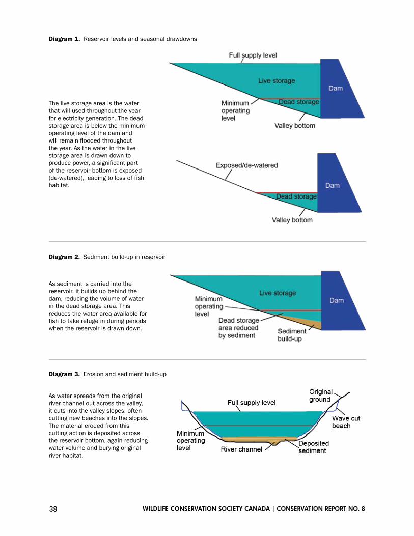
38 WILDLIFE CONSERVATION SOCIETY CANADA | CONSERVATION REPORT NO. 8
Diagram 1. Reservoir levels and seasonal drawdowns
Diagram 2. Sediment build-up in reservoir
Diagram 3. Erosion and sediment build-up
The live storage area is the water that will used throughout the year for electricity generation. The dead storage area is below the minimum operating level of the dam and will remain flooded throughout the year. As the water in the live storage area is drawn down to produce power, a significant part of the reservoir bottom is exposed (de-watered), leading to loss of fish habitat.
As sediment is carried into the reservoir, it builds up behind the dam, reducing the volume of water in the dead storage area. This reduces the water area available for fish to take refuge in during periods when the reservoir is drawn down.
As water spreads from the original river channel out across the valley, it cuts into the valley slopes, often cutting new beaches into the slopes. The material eroded from this cutting action is deposited across the reservoir bottom, again reducing water volume and burying original river habitat.

39FISH AND HYDRO DAMS IN YUKON
Figure 7. A portion of the shoreline of Abraham Lake, the reservoir behind the Bighorn Hydroelectric Dam on the North Saskatchewan River, Alberta, after 43 years of operation. Shorelines are repeatedly exposed to changing water levels and therefore erosion continues. The eroded material moves down-slope and contributes to in-filling of the reservoir.
Riverine reservoirs: sediment erosion, transport and deposition within reservoirsAn initial phase of rapid shoreline erosion may be expected, followed by a period of reduced erosion (Blackman et al. 1990). Rates of erosion may accel-erate if the reservoir is maintained at FSL or higher for extended periods. New sections of shoreline may be created as a result of permafrost melt or other types of landslides into the lake, followed by a return to initial high rates of erosion on the deposited materials. Erosion of shorelines continues in the Marsh/Tagish Lake reservoir 46 years after the Lewes River Dam was constructed, and some degree of shoreline erosion is expected to occur for the effective life of any res-ervoir (Figure 7).
Al v
on F
inst
er

40 WILDLIFE CONSERVATION SOCIETY CANADA | CONSERVATION REPORT NO. 8
All waterbodies transport or contain some level of sediment in solution or suspension but human activity can change the seasonal patterns of this sediment load with strong impacts and risks to fish survival, fish habitat quality and fish food sources (Donohue and Molinos 2009, Jones et al. 2011). Heavy sediment loads suspended in the water column can impair fish health and reduce survival (Kemp et al. 2011).
When sediment settles, it changes the bed of the waterbody and can destroy fish habitat and food availability by covering and cutting off water and dis-solved oxygen supply to eggs, juveniles and invertebrate foods (Donohue and Molinos 2009, Jones et al. 2011). These issues pertain to all reservoirs and downstream waters, but are particularly of concern with riverine reservoirs because these reservoirs convert relatively large areas of land to lake-bottom, have more variable water levels, and destroy the river-based ecological condi-tions and associated food web. In the following paragraphs we discuss some of the major processes affecting sediment load, deposition and rearrangement in riverine reservoirs.
The original main-stem river and its tributaries will carry sediment into the reservoir in patterns that vary depending on season (higher in spring and summer), gradient, and upstream water bodies (Holdren et al. 1991). Fish and their aquatic food webs will have adapted to these patterns, but these patterns are already shifting with climate change. In a survey of the mid-Pelly and lower Macmillan River watersheds, Lipovsky and Huscroft (2006) identified 114 per-mafrost related landslides, of which 51 had potentially direct impacts on rivers further down-slope. They also suggested that climate change would result in an increase in the frequency and magnitude of landslide triggering events.
Similar inventories for the Stewart and Teslin Rivers are not available. However, landslides and other forms of mass wasting have been observed along the Teslin, upper Pelly and Stewart Rivers. The net result is that sediment loads may well be increasing in the upstream river systems, and these loads will end up in the reservoirs if dam construction proceeds.
Sediments entering any reservoir will be deposited, then moved and re-deposited by repeated changes in water flow and storage volume (Holdren et al. 2001). Incoming sediments will be deposited as water speed slows when it enters the reservoir, filling existing channels and forming deltas as the reservoir water level rises during the summer. Each time the reservoir is lowered, the tributaries and main-stem river will have to re-establish channels through the deposited sediments or cut new channels. Assuming that drawdown occurs in winter, sedi-ments deposited in the tributaries and river channels during high water will be re-worked, mobilized and carried further downstream under ice. Sediments will eventually be deposited in the reservoir’s “dead storage” water volume, which is the water below the elevation of the Minimum Operating Level (MOL) (Morris and Fan 1998), thereby reducing the volume of water retained.
By flooding areas of land, the reservoir will expose many slopes to erosion and thereby will produce numerous new sources of sediment. Wave action and currents will cut beaches around the perimeter of the reservoir. If the reservoir perimeter comes into contact with permafrost, and particularly ice-rich per-mafrost, new thaw slumps may be anticipated. Existing steep slopes composed

41FISH AND HYDRO DAMS IN YUKON
of glacio-fluvial or glacio-lacustrine materials are present along all three river valleys where a reservoir may be located (Figure 8). Development of a wave cut bench will remove the toe support from some of the slopes and initiate landslides in these slopes. Once entering the reservoir, most sediment will be transported down-slope through gravity, wave action and currents, and will gradually move to being stored below the MOL.
Raising the surface water level in the reservoir will result in a rise in the groundwater level in unconfined aquifers that flow underground into the res-ervoir. If the groundwater cannot drain quickly enough into this new body of water, a landslide could occur (Wahlstom 1974).
On the basis of the maps provided by Midgard (2015), it appears that the projects with riverine reservoirs will have a high proportion of “live storage” to total reservoir volume. Live storage is the volume of water in the reservoir between the MOL (minimum operating level) and FSL (full supply level). This means that much, and perhaps most, of the water in the reservoir at FSL will be drained when the reservoir is reduced to MOL. As a result, these reservoirs may experience more rapid buildup of sediments than would occur in reservoirs where water drawdowns do not result in such a rapid drop of water levels due to the reservoir being wider and shallower. In the latter case, sediments would be dispersed across a wider reservoir bottom and would have less of an effect on water volumes at MOL.
Figure 8. The Pelly River valley floor, in the stretch that would be flooded by the Hoole Canyon project, currently supports productive white spruce forests that would be lost under the reservoir. The steep slopes defining the valley sides will become part of the shoreline of the potential reservoir, and are highly susceptible to erosion. This erosion, in turn, will partly fill the reservoir reducing water volumes especially during low water levels.
Lila
Tau
zer

42 WILDLIFE CONSERVATION SOCIETY CANADA | CONSERVATION REPORT NO. 8
Riverine reservoirs: temperatures, productivity and dissolved oxygenThe extensive shallows that will be flooded will respond rapidly to changes in air temperature and sunlight (Holdren et al. 1991). Waters in these areas will likely warm quickly as the water level rises in spring and summer.
Nutrient transfer to impounded waters will initially be elevated due to decomposing submerged vegetation and organic material in the soils. High algal growth is expected, particularly in the first decade(s).
Invertebrate abundance may also be high, albeit composed of species that are tolerant of freezing, are able to move away from freezing fronts or spend the winter in unfrozen areas associated with springs or channels (Irons et al. 1993). Springs with constant temperature and flow may have low invertebrate com-munity diversities but high abundances of a relatively small group of dipteran species (Laperriere 1994). Overall, species that can swiftly colonize available habitats will likely dominate. It is expected that species that require stable envi-ronments or are sedentary will be at a disadvantage.
Temperate and boreal lakes often undergo seasonal mixing of deep and shallow waters interspersed with periods of fairly fixed thermal stratification (Holdren et al. 2001). It is uncertain whether thermal stratification will occur in the riverine reservoirs during the summer. However, it is possible that the incoming rivers will continue to flow along the bottom of the reservoir if the river waters are colder, and therefore denser than the surface waters.
Thermal stratification during the winter is possible in some years. Williston (Lake) Reservoir on the Peace River in British Columbia is the closest match to the larger riverine reservoirs proposed for Yukon (however, Williston Reservoir is deeper than any of the proposed riverine reservoirs in Yukon and has a live storage of 20% of the volume of the reservoir at FSL).
Williston was isothermal (even temperature) over the winter months in the 1970s (Hirst 1991), but a winter thermocline (a water layer within which there is rapid temperature change) has been present in more recent years (Stockner et al. 2005). This highlights the uncertain future physical conditions of riverine reservoirs in cold climates, and the difficulty in predicting impacts and risks to fish in uncertain and variable conditions.
It is possible that portions of the riverine reservoirs will be anoxic (oxygen depleted) or hypoxic (oxygen starved) during the winter as a result of high biological oxygen demand from decomposing organic matter or from anoxic/hypoxic groundwater discharges into the reservoir (Holdren et al. 1991). This effect is expected to be most severe in the first years, but could stretch over decades of reservoir life as the vegetation in the seasonally flooded area decom-poses.
Anoxic or hypoxic conditions would most likely occur in depressions in the pre-existing land surface where denser water might settle. Fish kills may occur in some portions of the reservoir in some years depending on the sever-ity of hypoxic conditions and the relative resistance of the resident fish species to low oxygen levels. If a thermocline does develop in the summer across the reservoir or portions of it, waters at depth will be isolated from sources of re-oxygenation, also resulting in oxygen depletion.

43FISH AND HYDRO DAMS IN YUKON
Riverine reservoirs: fish populationsFish abundance in the purely riverine reservoirs is expected to decline initially for all types of fish. Migratory fish obstructed by the dam will not be able com-plete their upstream migrations.
If upstream passage is partly maintained by some mitigation process such as a fishway (see “Mitigation” below), it is probable that some, and perhaps most, adult Chinook Salmon will be able to pass by the dam and follow the flow of the river through the reservoir to upstream or tributary spawning areas.
Juvenile salmon, on the other hand, are unlikely to stay and rear in the reservoir, but would instead pass by the dam on their way back to the ocean, which entails several risks. Passage past a simple dam would be via the spillway or through the turbines. These routes may involve direct mortality to substan-tial proportions of the young fish, often due to physical trauma (Williams et al. 2001).
Where bypass systems that divert the juveniles from the turbine flow are in place, mortality can be reduced, although far from completely (William et al. 2001). In addition, it appears that fish that successfully move past the dam are still more susceptible to death later on, perhaps due to having been injured and stressed in the passage through the dam (Budy et al. 2002, Ferguson et al. 2006).
As well, predatory birds and other fish are likely to focus on these juveniles, either in the reservoir or just downstream, because the juveniles are forced together by the obstacle of the dam and become disoriented in the unusual water currents downstream.
The riverine stocks of freshwater fish – including Arctic Grayling, Broad, Lake and Round Whitefish, and Inconnu – will probably suffer the greatest declines because of blockage of movements by the dam and loss of typical river habitats due to artificial flooding (Hirst 1991, Blackman 1992, Kruk & Penczak 2000). Their fate will depend on their ability to adapt to living partly in a reservoir while continuing to use or find new spawning habitats in upstream tributaries.
A rebound in abundance is possible in some circumstances, depending on access to spawning habitats and the ecological productivity of the reser-voir (Northcote 1995). Arctic Grayling stocks in the Williston Reservoir and its tributaries initially increased and then inexplicably crashed a decade later (Blackman 2002). They now appear to be relegated to tributary streams with little or no inter-connectivity through the reservoir (Clarke et al. 2007). This raises considerable uncertainty as to whether a reservoir-based population of this species could develop in Yukon.
The reservoir itself will provide novel ecological opportunities for some fish species that are adapted to living in lakes (Blackman 1992). There may be adequate planktonic food organisms to support healthy populations of fish that feed in the body of the lake (i.e. pelagic). These include Least Cisco and juve-nile Inconnu (Brown 2000, Brown et al. 2012). Juvenile and immature Lake Whitefish also feed on planktonic organisms (Pothoven and Nalepa 2006), as do juvenile Arctic Grayling (Schmidt and O’Brien 1982). It is possible but

44 WILDLIFE CONSERVATION SOCIETY CANADA | CONSERVATION REPORT NO. 8
Figure 9. Chinook salmon spawning habitats vary widely and include streams at lake outlets such as on the Tatchun River depicted here. The light coloured areas are groups of salmon redds (spawning nests). The Tatchun River is similar in size to the Little Kalzas River and smaller than the Woodside River.
Al v
on F
inst
er
not probable that populations of one or more of these species, or others, will develop in the reservoir, depending partly on their ability to colonize the new water body.
Winter conditions for fish in the reservoir are likely to be challenging. The projected high proportion of live storage in the riverine reservoirs will serve to concentrate fish into the continually shrinking volume of remaining water as winter progresses. Depressions in oxygen, increases in suspended sediment from upstream under-ice erosion, and the infilling of the dead storage with sediment will be added stressors. At some point in the life of the reservoir, much of both the dead and live storage volumes of the reservoir may fill with sediment causing severe loss of winter habitat.
The Granite Canyon (Large) project includes the flooding of Little Kalzas Lake. The effects on the current lake-dwelling fish community will depend on the degree to which the lake and surrounding land surface will be flooded.
All projects on Yukon River tributaries are expected to result in the destruc-tion of one or more Chinook Salmon spawning areas (Figure 9). In the case of the Granite Canyon (large) project an entire population, the Little Kalzas River population (Wilson 1997), will be lost because its spawning habitat will be flooded. Chinook Salmon spawning habitats in the lower portions of the Big Kalzas River (Mercer 2005) and the Moose River (de Graff 2006b) may also be partly flooded with consequent population declines.

45FISH AND HYDRO DAMS IN YUKON
The NWPI (Low) project will back-flood several major main-stem Chinook Salmon spawning areas in the Teslin River. The riverine portions of the suggested upper Pelly River reservoir (Slate Rapids Diversion) will flood the extensive Chinook Salmon spawning dune complex on the Woodside River (Mercer & Eiler 2004). It’s important to note that Chinook Salmon spawning areas are difficult to find in large rivers such as the Pelly, Stewart and Teslin Rivers and it is therefore likely that each river has spawning areas that have not yet been documented. Accordingly, impacts may be more severe than currently envisaged. This is also true for Chum Salmon whose full suite of spawning areas remains unknown.
4.2.3 Operation – lacustrine reservoirs
The potential lacustrine reservoirs, those based primarily on a pre-existing lake, are located on the Frances River. Some proposed projects, in the upper Pelly River and the Frances River watersheds, combine existing lakes and rivers in the flooded area. Lacustrine reservoirs will raise the level(s) of the pre-existing lakes when water storage levels are high in the reservoir.
Lacustrine reservoirs: lake outletsAll lacustrine and combined projects will include the replacement of natural lake outlets with spillways and/or electrical-generating facilities including dams. Such developments will be a net loss to the existing productivity of the lakes and the region, because lake outlets are particularly productive biologically and are rapidly disappearing globally (Giller & Malmqvist 1998). In the Yukon these areas are frequently ice-free throughout winter and therefore have high value to various fish, semi-aquatic mammals, and bird species.
Lacustrine reservoirs: sediment erosion, transport and deposition within reservoirsAs with the riverine reservoirs, changes to the land surface between the MOL and FSL will include shoreline erosion and the development of new wave cut beaches. In coarse, thawed materials only the smaller sediment particles will be eroded from the land surface. There will be little instability of the slope above the eroded headwall of the new beach.
Portions of the west shoreline of Kluane Lake are analogous to this type of change. Rooted stumps from the ~ 1650 CE flow reversal of the lake (Clague et al. 2006) remain in place in a boulder matrix. Shorelines along lacustrine reservoirs will respond similarly to those along riverine reservoirs where similar ground materials exist at the shoreline and upslope. The potential exists for high volumes of sediment to enter the lake due to landslides where shorelines are composed of highly erodible materials or where upslope permafrost melts.
A major difference from the riverine reservoirs is that the lacustrine reser-voirs have a greater capacity to store sediment and allow settling of suspended sediments. At a minimum, the pre-existing lake will be dead storage, and the rate of infilling will be correspondingly lower than for the riverine reservoirs. The greater volume of water in lacustrine reservoirs relative to surface area will also reduce the effects of winter sediment transport within the reservoir as water levels fall and sediments deposited by tributary streams are re-mobilized.

46 WILDLIFE CONSERVATION SOCIETY CANADA | CONSERVATION REPORT NO. 8
However, there will still be a risk of mortality to fertilised and incubating eggs of fish that spawn in autumn in shallow areas, particularly Lake Trout and Bull Trout (where present) (Kemp et al. 2011). In the reservoirs, shallow areas will lie over newly flooded terrain, but there may be high oxygen consump-tion due to decomposition. Both Lake and Bull Trout require relatively high dissolved oxygen levels during egg development (Stewart et al. 2007). Bottom areas, and fertilised fish eggs in these areas, may also be exposed by early-winter drops in water levels.
Lacustrine reservoirs: temperatures, productivity and dissolved oxygenThe lacustrine reservoirs, and the lake components of the combined reservoirs, are expected to continue to have many of the characteristics of lakes (Holdren et al. 2001). They may well stratify in summer, mix in the autumn (when waters at the surface and at depth approach the same temperature), stratify in winter, and mix in spring or early summer. However, the thermal regimes of the res-ervoir may differ in detail from the pre-existing lakes in response to changes in the surface area, volume, depth and shoreline characteristics. For example, shallow waters around the margin of the reservoir will heat rapidly in the spring and summer. If the area of shallows increases as a result of the conversion to a reservoir, stratification may develop earlier than in the original lake. The shal-lows will also cool more quickly in autumn and may result in an early autumn mixing period. Ice cover may develop later as the increase in lake volume will allow more heat to be stored during the open water period.
The biological productivity of the reservoir is initially expected to increase in response to nutrients made available by the rapid decomposition of organic material within the active storage zone of the reservoir, and the slower decom-position of the material in the dead storage zone. This will increase the biologi-cal oxygen demand in the waters of the reservoir, with a consequent reduction in dissolved oxygen. This is unlikely to be an issue if atmospheric sources of oxygen are available to allow the water to be re-oxygenated. However, colder water may be isolated at depth in the summer due to lake stratification.
Lake trout are vulnerable to low summer dissolved oxygen levels as they are a cold water species with a limited tolerance for low dissolved oxygen levels. The species’ optimal temperature range is between 8 and 12 degrees (Mackenzie-Grieve and Post 2006), and their minimum dissolved oxygen requirement is 7 milligrams/liter (Evans 2006). In contrast, Northern Pike grow most swiftly when water temperatures are between 19 and 21 degrees Celsius and can survive in water with dissolved oxygen levels as low as 0.3 milligrams/liter (Casselman 1978).
In winter, the entire reservoir may be isolated from the atmosphere due to the formation of an ice cover. Reservoir-wide depressions of oxygen during this period could have wide ranging effects on incubating eggs of autumn spawning species, along with the wintering resident and migratory populations of fresh-water species whose life histories and movements were based on the ecology of the pre-existing lake.

47FISH AND HYDRO DAMS IN YUKON
The initial increase in productivity resulting from the breakdown of organic material is not likely to be sustained. Judging from the history of the Williston Reservoir, productivity is likely to decline to pre-impoundment or even lower levels because nutrient inputs are lost in sedimentation or never reach the water because the ever-changing water levels leave unproductive, temporarily exposed shoreline areas for much of the growing season (Figure 6) (Stockner et al. 2005).
Lacustrine reservoirs: fish populationsFish density is likely to drop in a newly created lake-based reservoir in the first few years due to the increase in water volume as the reservoir fills. However, fish abundance could then rapidly increase in response to the pulse of nutrients, as long as oxygen levels are not limiting. When the pulse of nutrients declines (after a variable length of time lasting perhaps a few years to decades), fish abundance is also likely to drop. This would reflect the patterns experienced in the Williston Reservoir (Blackman 1992) where substantial changes in the rela-tive abundance of species continue to be observed 40 years after impoundment (Sebastian et al. 2008).
The newly impounded water body will provide ecosystem conditions more like a lake than a river system, and therefore will be better able to support fish species that live in lakes. These species will already be present in the original lake(s), so they could respond relatively rapidly to the new conditions. This is especially true for lake-dwelling fish that feed on organisms (plankton) in the water column (i.e. pelagic feeders such as Least Cisco). However, lake-dwelling fish that rely on the shallow-water littoral ecosystems near the shorelines (e.g., Northern Pike, young of numerous species) are likely to decline because these ecosystems will largely disappear when water levels change dramatically across the seasons. These are the patterns seen in the Williston Reservoir and elsewhere (Blackman 1992).
In particular, an impact on autumn-spawning lake-dwelling fish species is anticipated. These fish usually spawn in water shallower than the range between the proposed MOL and FSL. The change in water levels in the res-ervoir may no longer provide a suitable depth range for spawning on suitable substrates. Eggs that are deposited well above the MOL during relatively high water levels in autumn may be exposed and die as water levels drop during the winter. Monitoring of spawning success of vulnerable species (including Lake Whitefish, Lake Trout, and Bull Trout) will be critical to determine the effects of the reservoir water management on egg survival during incubation.
4.3 Impacts and risks downstream of a dam 4.3.1 Dissolved gas supersaturation
Fish can suffer direct impacts (mortality) and indirect effects (reduced survival and health) from gas bubble trauma (GBT) when they are exposed to super-saturated solutions of typical gases found in air such as nitrogen and oxygen (Golder Associates 2012). GBT is often associated with hydroelectric dams where downstream water becomes supersaturated with gases (a condition

48 WILDLIFE CONSERVATION SOCIETY CANADA | CONSERVATION REPORT NO. 8
known as Dissolved Gas Supersaturation – DGS). This results from air being drawn along in water released over spillways or other structures, which then plunges deeper into the downstream water column.
The increased pressure that results forces the air into solution where the gases become supersaturated relative to those at the water surface (Antcliffe and von Finster 1999). The gases can enter the blood of fish through their gills, and leave the supersaturated solution in their bodies. As a result, bubbles form under the skin or in internal organs and muscle tissue.
In severe cases GBT will kill fish. However, the onset is not immediate. The fish may first become debilitated and experience impaired swimming abil-ity along with a reduced ability to avoid predators (Mesa and Warren 1997, Birtwell et al. 2001, Antcliffe et al. 2002). GBT may occur for kilometers below the dam (McArthur 2014).
4.3.2 Flow regimes and channel stability
The flow regime is one of the most important elements in determining ecologi-cal conditions in a river (Power et al. 1995). Changes to a river’s natural flow regime are often detrimental to existing fish populations (Poff and Zimmerman 2010).
For dammed rivers, the way a hydroelectric facility is operated is a primary determinant of the flow regime, channel stability, and fish habitat quality. The major difference is whether the facility is operated as a peak load facility or a base load facility, with the former producing flow regimes that are much more detrimental to fish than the latter (Bunn and Arthrington 2002).
If the volume of water released from an electrical generating facility is relatively constant during the winter, which would be typical of a base-load facility, downstream channels will be relatively stable and may form a cover of ice. Most or all of the water discharging from the facility will flow within the existing channel and there will be little or no flooding, and subsequent icing, of surrounding lands further downstream. The Whitehorse Rapids Dam operates in this discharge mode.
In comparison, the Aishihik Hydroelectric project has usually been oper-ated as a peaking, or load-following, facility and its winter water discharges vary depending on electrical demand. Pulses of relatively high volumes of water are released to meet periods of high electrical demand, which cannot be satisfied entirely by the Whitehorse Rapids facility. These pulses are often separated by periods (generally much longer in duration) of much lower flow when electrical demand is reduced.
During winter the river channel downstream of the Aishihik facility does not always carry the entire flow of each discharge, especially the high volume pulses. Instead, much of the water leaves the river channel and flows across the valley bottom. It freezes there, creating a series of ice covers over the down-stream channel and even the adjacent forest floor. Subsequently, erosion of the stream bed or banks appears to occur judging by horizontal layers of sediment visible in the thick downstream ice when it melts in the spring (Figure 10). Substantial erosion and channel migration in the Aishihik River are also evident from the viewpoint on the Aishihik road.
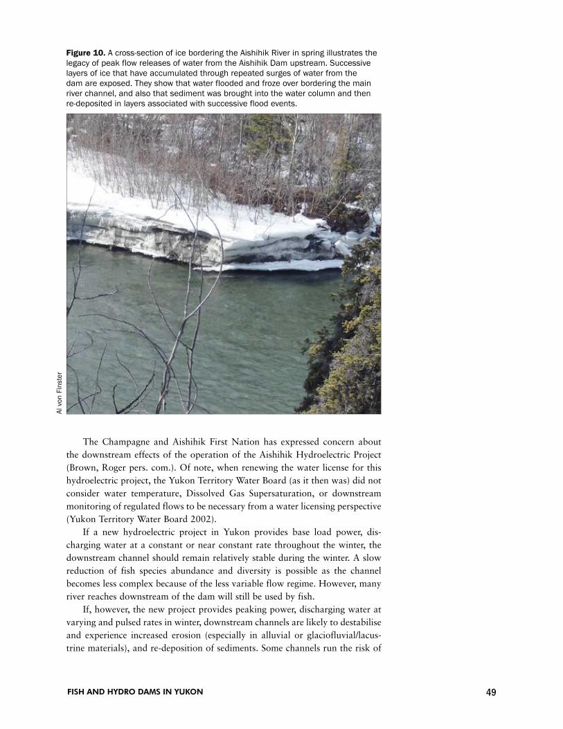
49FISH AND HYDRO DAMS IN YUKON
The Champagne and Aishihik First Nation has expressed concern about the downstream effects of the operation of the Aishihik Hydroelectric Project (Brown, Roger pers. com.). Of note, when renewing the water license for this hydroelectric project, the Yukon Territory Water Board (as it then was) did not consider water temperature, Dissolved Gas Supersaturation, or downstream monitoring of regulated flows to be necessary from a water licensing perspective (Yukon Territory Water Board 2002).
If a new hydroelectric project in Yukon provides base load power, dis-charging water at a constant or near constant rate throughout the winter, the downstream channel should remain relatively stable during the winter. A slow reduction of fish species abundance and diversity is possible as the channel becomes less complex because of the less variable flow regime. However, many river reaches downstream of the dam will still be used by fish.
If, however, the new project provides peaking power, discharging water at varying and pulsed rates in winter, downstream channels are likely to destabilise and experience increased erosion (especially in alluvial or glaciofluvial/lacus-trine materials), and re-deposition of sediments. Some channels run the risk of
Figure 10. A cross-section of ice bordering the Aishihik River in spring illustrates the legacy of peak flow releases of water from the Aishihik Dam upstream. Successive layers of ice that have accumulated through repeated surges of water from the dam are exposed. They show that water flooded and froze over bordering the main river channel, and also that sediment was brought into the water column and then re-deposited in layers associated with successive flood events.
Al v
on F
inst
er

50 WILDLIFE CONSERVATION SOCIETY CANADA | CONSERVATION REPORT NO. 8
losing flow entirely under the ice, in which case fish are at risk of stranding and death (Cushman 1985). With such de-watering, it is likely that many or most of the organisms comprising the aquatic food web living in these channels and their sediments would also be stranded and would also die (Cushman 1985).
Natural winter flows in Yukon Rivers are generally free of suspended sediment. Even the White River, which carries a high sediment load in glacier meltwater in the ice-free period of the year, is clear in the winter. Increases in suspended sediment in winter, resulting from peaking discharges, will have numerous negative impacts on fish physiology, stress levels and survival (Kemp et al. 2011) including reducing the ability of juvenile fish to avoid predation (Korstrom and Birtwell 2006). Rapid changes in sediment loading will badly impact fish habitat including the survival of invertebrates on which the fish feed (Hesse and Newcomb 1982, Kemp et al. 2011). The overall effect of operating a new hydroelectric project as a peaking facility is likely to be a relatively rapid decline in abundance and diversity of fish for considerable distances below the dam.
Even dams that steadily produce electricity tend to change flow regimes by making them more uniform, reducing annual and seasonal variability. In a survey of large dams in the United States, Graf (2006) found that dams reduced annual peak discharges by an average of 67%, decreased the ratio of annual maximum/mean flow by 60%, and decreased the range of daily discharges by 64%.
When compared to similar unregulated reaches, he found that regulated reaches had 32% larger low-flow channels, 50% smaller high-flow channels, 79% less active floodplain area, and 3.6 times more inactive floodplain area. Caution is advised in applying these numbers to Yukon as they reflect land uses, private land ownership and protection measures in the specific areas down-stream of the dams which were included in the survey. However, the trends are consistent and the effects significant across a large sample of dams, and are similar for the Peace River (Prowse et al. 2002). Similar patterns are likely in Yukon with dams operated to store water in summer when it is most plenti-ful, and release it steadily during winter when electricity demand is highest but water supply the lowest.
More stable and less variable flow regimes result in reduced flooding of forested floodplains downstream (Newbury 1995, Prowse et al. 2002). The sup-ply of water-borne nutrients carried into these ecosystems is therefore reduced. The regulated flow regimes also mean less water flow into and through the high-water channels and some back-water channels and oxbow features. These aquatic environments can be important to fish, especially younger age classes, so regulated flows run the risk of reducing the extent and diversity of habitats downstream (Poff and Zimmerman 2010). In extreme cases, dam operators focussed on storing water may severely reduce summer flows causing complete de-watering or “drought” in some downstream channels. Such conditions cause high fish mortality (Assani et al. 2013).
Impounding rivers with high natural sediment loads results in much of the sediment being stored in the reservoir. Consequently, the river water immedi-ately downstream of the dam has increased energy, compared to conditions

51FISH AND HYDRO DAMS IN YUKON
without a dam, as it is no longer expending energy in moving the suspended sediment. With increased energy, the river has greater ability to erode the unpro-tected sections of the bed or banks of the river downstream of the dam (Clarke et al. 2008). If the river bank material is more erodible than that of its bed, the banks will erode at a greater rate, and as a consequence, the channel will migrate and change course.
4.3.3 Temperature
Water temperatures in the river below a dam are quite likely to differ from those experienced by fish before the dam was built, but the exact changes will depend on the extent of water mixing within the reservoir and the place(s) through the dam where water is released from the reservoir (Poff and Zimmerman 2010).
The most general risk in summer is that reservoir water will become warmer than the streams and river entering the reservoir. When this water is released it may exceed the pre-impoundment temperature of the river and be warmer than ideal for fish downstream. This risk is more likely to occur in shallow reservoirs which warm faster, and when near-surface water is released (e.g., over the spill-way) rather than deep water being released through the dam.
Deep water is likely to be colder, especially if a summer thermocline devel-ops (as is likely in the lacustrine reservoirs) or when incoming streams flow under the warmer near-surface layers. Water released from deep in the reservoir below the thermocline will be relatively cold and potentially much colder than the pre-impoundment temperature of the river (Olden and Naiman 2010). This would reduce the risk that fish would suffer from warm water, but may increase the risk of Dissolved Gas Supersaturation. This is because the colder water at depth is capable of holding higher volumes of gas in solution than warmer water. Releasing cold water below the dam could increase the chances of it becoming supersaturated, especially as it warms downstream.
The risk in winter is that the heat stored in the reservoir water during sum-mer will keep the temperatures of released water relatively high through the fall and early winter, allowing downstream waters to stay ice-free longer than they normally would. However, this is not as big a problem for fish as the summer pattern, because the temperatures of released water will still be declining as winter sets in.
Whether or not changing temperature regimes are a risk to fish depends on the individual species’ range of temperature tolerance. These ranges are not well known for populations of Yukon fish, but some temperature thresholds exist. The Fraser River Environmental Watch (2015) was developed to assess and monitor upstream migrating sockeye salmon habitat in the Fraser River and has published temperature thresholds. These thresholds relate to sub-lethal physiological and indirect lethal effects, and are based on exposure of fish to the daily mean water temperature:
18°C - Decreased swimming performance.•
19°C - Early signs of physiological stress and slow migration.•
20°C - Associated with high pre-spawn mortality and disease.•
21°C - Chronic exposure can lead to severe stress and early mortality.•

52 WILDLIFE CONSERVATION SOCIETY CANADA | CONSERVATION REPORT NO. 8
The Alaska Department of Environmental Conservation (ADEC) has also published temperature standards. These are regulatory in nature and relate to human-caused changes in water temperatures rather than the general monitor-ing of water temperatures to determine effects on fish. The standards state that the following temperatures may not be exceeded unless a variance is granted (ADEC 2012):
15• oC – Migration routes.
13• oC – Spawning areas.
15• oC – Rearing areas.
13• oC – Egg & fry incubation.
Current temperature regimes in key Yukon River tributaries are already risky for salmon in some years. The Pelly River below Pelly Crossing, and the Teslin River at its mouth, have both approached a threshold temperature of concern for upstream migrating salmon. These rivers exceeded the lowest Fraser River Environmental Watch threshold of 18o C in 2013, and the Pelly River exceeded 19o. The ADEC standard for migration is generally exceeded daily in the Pelly, Stewart and Teslin Rivers during late spring, summer and early autumn. In 2013, this standard was exceeded on the Stewart River at Stewart Crossing on 43 days, on the Pelly River below Pelly Crossing on 49 days, and on the Teslin River at its mouth on 46 days (von Finster 2014 & 2015).
Riverine reservoirs may well increase this current risk to salmon health and survival, by causing increases in the downstream temperatures of these large tributaries to the Yukon River during the Chinook Salmon upstream migration. There could be increasing pre-spawn mortality.
4.3.4 Nutrients
Immediately after flooding, reservoirs may experience increasing nutrient levels due to high rates of decomposition of flooded matter. Proposed riverine reser-voirs, or the combined riverine/lacustrine reservoirs in the upper Pelly River drainage, are likely to experience the greatest increases in nutrients because they will cover relatively large flooded land surfaces. Pulses of nutrient input to downstream waters in the growing season might promote growth of vegeta-tion, especially algae. This is probably a low risk because strong currents and turbulent flow are likely to disrupt much vegetative growth.
For much of their lives, reservoirs, by trapping sediments, tend to be a sink or trap for many inflowing nutrients, including phosphorus and nitrogen, so there is a concern that downstream waters will be poor in nutrients (Clarke et al. 2008). This risk is magnified by the reduction in variability of downstream flows and consequent reduction in flooding of backwaters, high channels and floodplains, all of which provide nutrient flows into the river (Clarke et al. 2008). The long-term downstream impacts of changing nutrient flows are com-plicated by issues of water temperature, flow rates, and depth of release through the dam, so generalizations are difficult (Clarke et al. 2008).

53FISH AND HYDRO DAMS IN YUKON
4.4 Mercury and heavy metalsA major concern with hydroelectric projects that flood extensive areas of land is the potential increase in the uptake of mercury by aquatic organisms (Stokes and Wren 1987). Mercury that is naturally present in flooded vegetation and soils becomes available as methyl-mercury for ingestion by the smallest aquatic organisms. Mercury reaches progressively higher concentrations as it passes up the food chain and reaches its highest concentrations in the longer-living preda-tors, such as Lake Trout and humans, found at the top of the chain (Rosenberg et al. 1997).
This mercury bio-accumulation is mostly an issue for people eating the contaminated fish (Rosenberg et al. 1997). Commercial and aboriginal fisheries have been closed or advisories issued following the flooding of reservoirs. In 1971, for example, the commercial whitefish fishery at Cedar Lake, Manitoba, was closed due to methyl-mercury contamination in the fish following the con-version of the lake to a reservoir (Loney 1995).
The relative risk of mercury accumulation to high levels will likely be different for each of the potential reservoirs but highest in riverine reservoirs where larger land areas will be flooded. Reviewing the state of knowledge of methyl-mercury levels in water and fish following conversion of natural systems to reservoirs, Azimuth Consulting (2010) noted that the most important factors contributing to elevated methyl-mercury concentrations were the area of land flooded, and particularly the area of wetlands, marshes and peat bogs. These landscape features are the greatest contributors of mercury to the food chain.
Mercury mobilisation and accumulation up the food chain are likely to fol-low a pattern of fairly rapid increase within the first decade after flooding of the new reservoir followed by gradual decrease over a few subsequent decades (Bodaly et al. 2007). Elevated methyl-mercury levels in fish could persist for a few decades, with the highest and longest-lasting levels found in top predators such as Lake Trout and Bull Trout.
The highest levels of methyl-mercury to be found in fish, and the length of time that these fish would reside in the lake, would be related to the area and wetland composition of flooded land and the mode of operation of the hydro-electric facility (Azimuth Consulting 2010). As most of the proposed Yukon reservoirs would see large drawdowns of water over the year, there will be sig-nificant downstream transfer of bio-available mercury in the annual process of discharging much of the reservoirs’ water through the dam. In these cases the methyl-mercury mobilised into the water and absorbed by smaller organisms in the reservoir’s food web can be expected to affect fish and other organisms downstream (Bodaly et al. 2007).
The issue of methyl-mercury contamination of water and fish within and downstream of any new reservoir requires careful assessment by modeling the risk of methyl-mercury mobilisation from flooded lands and its transfer through the food web.
Heavy metals other than mercury also may be mobilized and reach toxic levels in a reservoir. The Williston Reservoir has experienced elevated levels of copper and chromium, with chromium exceeding safe levels for fish (Blackman et al. 1990). The potential for pollution of Yukon reservoirs by a variety of heavy metals would have to be monitored.

54 WILDLIFE CONSERVATION SOCIETY CANADA | CONSERVATION REPORT NO. 8
5.0 MITIGATION
Mitigation to avoid, reduce or offset impacts or risks to fish and fish habitat should be considered as part of assessing the practicality of any hydroelectric power development plan.
Mechanisms for reducing or offsetting risks will vary in applicability or effectiveness depending on the particular biological composition and landscape features of the different water systems proposed for flooding. This is one reason why an environmental impact assessment should be part of the decision making process around whether or not to invest in a new hydroelectric facility, rather than a topic to be addressed after the decision to invest has been made.
If a decision is made to proceed with a new dam, identifying mitigation measures must be an immediate part of the planning and design stages. Some impacts and risks can be avoided altogether with good planning. But where impacts and risks cannot be avoided, ways to reduce or offset them must be considered, including adapting the facility design, deciding on operational modes, and prior treatment of lands to be flooded. These considerations will affect the facility’s construction timeline, as well as its capital and operating costs, which is why they need to be well understood in the project’s earliest stages. Mitigation may also require ongoing monitoring of the dam’s impacts over its entire lifetime.
Here we discuss known and published approaches to mitigating some of the largest impacts and risks of a dam. However, we note that there are no efficient and cost-effective mitigation measures available to deal with loss of spawning habitats in flooded streams; erosion of flooded land surfaces and shorelines causing in-filling of the reservoir; loss and shifting availability of spawning habitats in flooded lakes; added instability in environmental conditions and spe-cies composition of aquatic food webs in reservoirs; declines in quality of winter habitats for fish in reservoirs; changes to patterns of water flow in downstream rivers; changing sediment loads in downstream rivers; and risks of oxygen depletion causing fish mortality.

55FISH AND HYDRO DAMS IN YUKON
5.1 Fish migration and movementsThe most pervasive impact of a hydroelectric dam is the fact that it blocks all upstream movements of fish. Populations of fish species that would have moved past the dam site to reproduce upstream will be extirpated unless adequate measures are put in place to maintain upstream and downstream passage or to support artificial propagation.
During most of the history of hydroelectric developments on rivers draining into the Pacific Ocean from Canada and the United States, salmon have suffered huge impacts (Lichatowich 1999). Thanks to the large number of dams block-ing salmon migration that were constructed in the 19th and 20th centuries, we have a high degree of knowledge about impacts on these salmon populations. One of the largest lessons learned was that while mitigation measures were partly successful in maintaining salmon populations, populations nearly always declined to some extent and lost much of their genetic diversity (Lichatowich 1999).
In the last 20 years, advances in the design of salmon passage facilities, and in the design and operation of hydroelectric dams, have mitigated some of the previous problems but at a high financial cost (e.g., Cada 2001, Naughton et al. 2007, Schilt 2007). Avoiding a repetition, in the Yukon River drainage, of the impacts seen elsewhere will require careful consideration of recent technologies and probably a commitment to expensive infrastructure that may make hydro-electric projects much less economically attractive.
Mitigation measures to allow upstream passage past the dam can include fish-ways (often referred to as fish ladders) where fish swim over a dam in an engineered channel or structure (Figure 11) (Clay 1995, Hatry et al. 2012). They can also include fish lifts, where the fish swim into a tank in an elevator-like structure and are then lifted over the dam and released (Clay 1995). They can even include collection of fish below the dam with subsequent transport by vehicles for release above the dam (Katopodis 2005).
Generally, fish-ways work best when applied to relatively low dams and to fish species with a strong migratory instinct and strong swimming ability (e.g., Chinook Salmon), while fish lifts and collect-and-transport methods are more appropriate for higher dams, dams in confined areas where a fish-way would be difficult to construct (Beckwith et al. 2013), or where fish with limited swim-ming abilities or migratory instinct (e.g., Chum Salmon, Arctic Lamprey, most freshwater species) must be moved over the dam (Noonan et al. 2012).
Artificial propagation could be used along with, or in place of, a fish-way. It would include capture of fish downstream of the dam that would then be artifi-cially spawned, incubated in a hatchery facility, and reared to a size appropriate for release. Applying this approach to Chinook Salmon would be problematic because a number of different Chinook Salmon spawning populations migrate upstream of each of the proposed dams on the Yukon River tributaries at the same general time. Managers would have to implement some means of assur-ing that the fish from the different spawning stocks are maintained as separate genetic lines during spawning.

56 WILDLIFE CONSERVATION SOCIETY CANADA | CONSERVATION REPORT NO. 8
Figure 11. The Whitehorse Rapids hydroelectric dam on the Yukon River. The fishway or fish-ladder built to allow Chinook Salmon and other species to migrate past the dam is the structure in the foreground. The dam and fish-way were built in 1958 and have received ongoing maintenance.
Don
ald
Reid
With the exception of Bull Trout, there is relatively little technical literature on successful fish-way design for upstream migration of northern freshwater fish species (Noonan et al. 2012). Successful passage up fish-ways by species other than salmon, trout and charr appears uncommon and unlikely to main-tain migrations of many freshwater species (e.g., Arctic Grayling, various white-fish, various suckers). In fact, success with northern freshwater fish appears limited to fish-ways with a vertical lift of less than five meters (Katopodis 1992 & 2005, Thiem et al. 2012).
Collect-and-transport methods may be required to move some portion of the various fish populations over the dam. Such an approach is technically fea-sible but is costly. It would have to be sustained over the life of the dam, and would stress, perhaps fatally, the individuals captured and transported.
If no measures are in place to help fish move upstream past the dam, the fish population will have to adapt or will die out. Those members of a popula-tion that do survive the initial loss of connectivity between their habitats may adapt their behaviours and eventually become established as a new population if they can find the necessary set of habitats for reproduction and survival above and/or below the dam. There remains, however, a substantial, though currently unquantifiable, risk of the extirpation (i.e. loss) of some populations.

57FISH AND HYDRO DAMS IN YUKON
Fish also need to go downstream past the dam, so measures must be put in place to help this to happen. Young age classes of migratory anadromous species (e.g., Chinook Salmon) in particular need to pass the dam in large numbers or the population will be lost. A number of technologies are available to enhance safe passage for juvenile fish and reduce high rates of mortality that can occur when these fish pass over the spillway or go through the turbines. Technologies include, but are not limited to, removable or temporary spillway weirs, bypass systems, collection and transport, or multiple types of downstream guidance and screening technologies (Katopodis 2005, Beckwith et al. 2013). Regardless of the method chosen, its effectiveness would need to be monitored and assessed for the life of the project.
Upstream and downstream passage structures and artificial propagation facilities are all expensive to design, construct, maintain, monitor, evaluate, and renew for the entire life of a hydroelectric facility. There is considerable risk that at some time during the very long life of the dam its owners would become unwilling or unable to maintain and operate these measures and/or structures to sustain the fish populations. For example, the facility may become economically marginal, and the cost of maintaining the mitigative structures may exceed the ability of the owner to pay.
Fish are a common property resource, belonging to the public, with stew-ardship responsibility legally falling on governments. When hydroelectric facilities are owned and operated by government or its delegated agencies then mitigative measures fit logically and ethically in the mandate of the facility. However, when a hydroelectric facility is privatized, the cost of operating and maintaining mitigative structures and of ensuring that they continue to meet their objectives may be considered expendable as it has no tangible return.
Privitization of a future hydroelectric facility is therefore an additional risk to the future effectiveness of measures to mitigate impacts to fish. Privatization of public hydroelectric assets is imminent in Ontario (Morrow 2015), and could conceivably occur in Yukon. Any sale of a public hydroelectric asset should include legally binding provisions that the private owner must maintain, oper-ate and monitor the measures put in place to mitigate negative impacts on the public’s resource, its fish.
Measures and structures to allow passage past a dam must continue to be in place when the dam is decommissioned at the end of its life cycle. Decommissioning a dam is a complicated process including physical removal of the dam structure while dealing with the inevitable changes to flow regimes and sediment loads in the river when and after the reservoir waters are released downstream (Katopodis and Aadland 2006). A decommissioning plan should be part of the licenses and authorizations required for the construction and operation of the facility, and should include sufficient financial security (e.g., bonds secured by government) to ensure that the decommissioning plan is implemented if the owners of the facility are unwilling or unable to carry out this critical action themselves.

58 WILDLIFE CONSERVATION SOCIETY CANADA | CONSERVATION REPORT NO. 8
5.2 Downstream water temperatures Dams and their reservoirs change the temperature regime of waters in down-stream rivers. However, these changes can be reduced in scale and timing to some extent. This involves active management of the water released through the dam using specific structures designed and built into the dam. An example is the use of a selective withdrawal system (also called a temperature control device) to extract water from selected depths in the thermally-stratified reservoir so that the released water is within a specific targeted range of temperatures (Price and Meyer 1992). This technology provides the flexibility to increase water temperature by preferentially selecting warm water from near the surface of the reservoir or to decrease water temperature by drawing cold water from below the thermocline (Olden and Naiman 2010).
5.3 Dissolved gas supersaturation (DGS)The supersaturation of gases in outflow waters of new hydroelectric facilities can be reduced through the appropriate design of spillways and associated structures and by changing operational procedures regarding outflow based on active monitoring (BC Hydro 2013). These approaches aim to reduce levels of dissolved gas in downstream waters and thereby reduce the exposure of down-stream fish to supersaturated gases.
At low levels of supersaturation, supersaturated gases can disorient fish and make them more susceptible to predation. Mitigation of this risk includes dis-couraging predators from increasing in local abundance as a result of the ease of capturing disoriented fish immediately downstream of the dam. While active predator control may not be desirable or affordable, the design of the overall facility should ensure that no fish-eating birds can establish a nesting colony immediately downstream, particularly in a location that mammalian nest preda-tors cannot access. Such a problem exists at the Whitehorse Rapids dam where Herring Gulls can nest successfully out of reach of ground-based predators on a rocky area isolated by various human structures.
5.4 Downstream sediments Dams trap river sediments and reduce the amount of sediment in downstream waters (Kemp et al. 2011), so the inclination might be to periodically release some of the sediments from the base of the reservoir. This can be done by design-ing and building flushing ports or other structures in the dam. This mitigation approach is, however, not recommended, because it results in rapid release of substantial volumes of sediment. Birtwell (1999) summarizes the negative effects of dam flushing, including very high levels of suspended sediment often resulting in fish kills. Fish that survive still appear to be affected, with more erratic swimming, less responsive to light and slowness at seeking cover – a set of behaviours that makes them more likely to be killed by predators (Korstrom and Birtwell 2006).

59FISH AND HYDRO DAMS IN YUKON
5.5 Mercury bio-accumulationVarious strategies have been proposed to reduce the risk of mercury bio-accu-mulation in the food chain in hydroelectric reservoirs. These include selection of a reservoir site with lower likelihood of mercury mobilization into the food chain; removing standing trees before flooding commences; intensive fishing; adding selenium; adding lime to acidic waters; burning before flooding; and capping and dredging bottom sediments, among others (Mailman et al. 2006).
The first two of these approaches are generally recognized to be the most useful and most desirable, as they are relatively safe compared to the other measures, all of which have substantial negative impacts or side effects of their own (Mailman et al. 2006). Selecting the reservoir site with least chance of mobilizing mercury means finding the site that will flood the least land surface area – especially the least amount of land currently covered by wetlands (fens, swamps, bogs and muskegs) – because the mercury comes from soils and from live and dead vegetation. Removing trees from land that will be flooded also removes some of the mercury source from the reservoir.

60 WILDLIFE CONSERVATION SOCIETY CANADA | CONSERVATION REPORT NO. 8
This Report has provided an overview of a number of the more obvious impacts and risks to fish and fish habitat posed by the potential hydroelectric projects being considered in the “Next Generation Hydro” planning process (Midgard 2015).
The continued existence of Chinook Salmon, Chum Salmon and Arctic Lamprey populations that currently spawn above any new dam site in the Yukon River drainage would be entirely dependent on mitigative measures such as fish-ways, fish lifts, bypass channels and/or hatchery propagation. While these measures are all technically feasible, none will work well enough to allow passage of the complete spawning population or all the juveniles.
The measures also may be prohibitively expensive as they would have to operate (and be maintained and renewed) throughout the long life of a hydro-electric facility. Therefore, it is fair to question whether any government agency or private-sector operator could provide assurance that anadromous fish pas-sage – and/or artificial propagation – will be sufficiently well operated and maintained to sustain each anadromous fish population over the lifespan of the facility.
Besides blockage caused by the dam, there are other direct impacts and risks for anadromous species. Some populations would lose existing spawning habi-tats due to flooding by the new dam, so they would have a high risk of being extirpated. This fact is relatively well documented for Chinook Salmon. It is less well understood for Chum Salmon and Arctic Lamprey because our knowledge of their distributions and habitats in the rivers in question is incomplete. Some populations may be at risk of extirpation, but we cannot make definitive state-ments.
Our knowledge of the distribution and habitat requirements of freshwa-ter fish species in the potentially affected waters is similarly incomplete. For example, there is uncertainty regarding which species of charr occupy the upper Stewart, Pelly and Frances River drainages. This is important because some charr are species listed as of Special Concern under the Canadian Species At Risk Act.
Our knowledge of the origins and relatedness of all freshwater fish species occupying the potentially affected waterways is very incomplete. We have little knowledge of their migratory pathways and habitat requirements and very lim-
6.0 CONCLUSION

61FISH AND HYDRO DAMS IN YUKON
ited population-level inventory and assessment work has been conducted. Given this lack of knowledge, a dam could conceivably result in the extirpation of one or more populations of freshwater fish that have not yet even been identified.
Freshwater fish populations using one of the riverine reservoirs on the Stewart, Teslin or lower Pelly Rivers would be at highest risk. These reservoirs will have large fluctuations in water levels. As a result many flooded habitats will last for only short periods during the year, often too short to satisfy the needs of aquatic species in that season. This pattern is made worse by the apparently small percentage of the total volume of the reservoir that will be dead storage (i.e. always present in any season as it lies below the Minimum Operating Level), and the high likelihood of rapid infilling of the reservoir with sediments. As well, the volume of water in the dead storage zone of the reser-voir will become progressively less with each year that passes due to sediment build up. This increases the risk that these reservoirs will be unable to maintain an adequate quality and quantity of habitat for freshwater fish in winter, the season when water levels drop to their lowest.
Fish and fish habitat downstream of any new dam will be most at risk if the facility is operated to provide “peaking power” in winter rather than to supply constant power. Peaking power production creates highly variable downstream flow rates, with bursts of flooding and channel erosion interspersed with low flows and the drying-up of some channels. The periodic pulses of released water often result in high levels of suspended sediment. These conditions would be rare in un-dammed rivers and streams, which have fairly constant flow rates in winter. The abundance and diversity of all fish species in waters below a peak-ing power production facility will very likely decline due to direct mortality and stress resulting from these conditions.
The numerous gaps in our knowledge of fish populations, movements and habitats in the potentially affected Yukon drainages need to be filled before any decision is made about a new hydroelectric dam. The environmental impacts and risks of a new dam, including but not just limited to fish, need to be con-sidered alongside social and economic impacts in any decision as to whether a large dam is a necessary and environmentally friendly means of providing new energy to the Territory.
Most existing large dams in western Canada, including the Whitehorse Rapids Dam, were built before detailed knowledge about fish and fish habitats was collected and quantified and before thorough environmental assessments of development projects became a legal requirement. Many of the owners and operators of those hydroelectric facilities are now trying to reconstruct or reha-bilitate aquatic environments and fish populations that their dams impacted and altered.
An example is the Williston Reservoir behind the Bennett Dam on the Peace River, where a water use plan (BC Hydro 2007) and a fish and wildlife compen-sation plan (BC Hydro 2014) are being implemented in an attempt to address impacts. These plans provide an understanding of the considerable magnitude of impacts and risks to fish and aquatic ecosystems resulting from the Bennett Dam, and of the costly measures required to adequately monitor, evaluate, and attempt to mitigate that dam’s adverse ecological effects. This example, among
62 WILDLIFE CONSERVATION SOCIETY CANADA | CONSERVATION REPORT NO. 8
many others, should serve as a lesson for the Next Generation Hydro Project regarding the need to assess environmental impacts prior to deciding to invest in a dam and the substantial costs involved in mitigation.
The process followed for the assessment and review of environmental impacts to fish and fish habitat by the Site C project on the Peace River in British Columbia could serve as a template for the more comprehensive assess-ment of any new hydroelectric project needed in Yukon. Site C is one of a handful of large dams currently under development in North America. Given that the Peace River has many of the same fish species and water flow patterns as the Yukon, the Site C Project is dealing with many of the same impacts and risks for fish that would occur in Yukon. There has been considerable invest-ment in understanding the nature of the fish and aquatic resources that will be impacted, and in designing the project to reduce risks during operation and maintenance (Site C Project 2015).
Many fish species are valuable because they provide food for Yukoners, so the question of the fate of fisheries needs to be addressed in future environmen-tal assessments. Chinook Salmon are relatively well studied, compared to other species, because they continue to be prized for aboriginal, commercial, domestic and sports use.
In the past, many Yukon fish populations were harvested in aboriginal and domestic fisheries, with a large number of the territory’s lakes historically supporting a commercial fishing industry that developed organically to satisfy local needs (Seigel and McEwen 1984). Today, commercial fishing is limited to six lakes (Environment Yukon 2010). Aboriginal fisheries remain an important part of First Nation’s culture and food supply, but knowledge about these fish-eries is mostly in the hands of First Nations. Many fish populations throughout the territory are, of course, fished recreationally.
So the question remains: how many of the fish populations potentially impacted by a new dam could contribute to the future food security and eco-nomic well-being of Aboriginal communities and the greater Yukon popula-tion? This needs to be clearly addressed in an integrated environmental and economic impact assessment of a new dam.
The Next Generation Hydro initiative, and subsequent review and assess-ment processes, will generate a lot of technical information that needs to be presented, interpreted and made understandable to Yukoners, especially for those in communities close to potentially affected drainages. This information will involve the assessment, planning, permitting, operation, maintenance and decommissioning of any new hydroelectric project. The information is often dif-ficult to understand and interpret. In order to meaningfully participate in these processes First Nations and Yukon communities should be given the opportu-nity to obtain the services of independent technical experts and advisors at the government’s expense.
63FISH AND HYDRO DAMS IN YUKON
However, given the current poor state of knowledge about fish populations in the waters that would be affected by a new large hydroelectric project, the costs and uncertainty surrounding mitigating often severe impacts on habitat and food chains, the high risks of difficult-to-control impacts such as erosion, landslides, unnatural water flows and changing water temperatures, and loss of spawning habitat, combined with the pressure already being put on fish populations by climate change, we see the Next Generation Hydro proposal as presenting unacceptable risks for fish. The Yukon Government needs to rethink whether this project presents acceptable ecological trade-offs, whether we actu-ally have the information needed to make informed judgements, and whether there are lower-impact alternatives for meeting Yukon’s power needs.

64 WILDLIFE CONSERVATION SOCIETY CANADA | CONSERVATION REPORT NO. 8
ADEC. 2012. Water Quality Standards: 18 AAC 70 (8 April 2012). Alaska Department of Environmental Conservation, Juneau. 56 pp. Available at: http://dec.alaska.gov/com-mish/regulations/pdfs/18%20AAC%2070.pdf
Alford, M. 1986. Yukon water doctor. Burns & Morton, Whitehorse. 131 pp.
Alford, M. 2014. Winter wise: Travel and survival in ice and snow. Heritage House Publishing Company, Victoria. 165 pp.
Anderton, I. and P. Frost. 2003. Traditional/local knowledge salmon survey. Prepared on behalf of North Yukon Renewable Resources Council and Vuntut Gwitchin First Nation. Yukon River Panel Project CRE-16-0335, Whitehorse.
Anderton, I. 2004. Porcupine River watershed fisheries information summary report. Prepared for North Yukon Planning Commission. Yukon Planning Council, Whitehorse. 48 pp.
Antcliffe, B.L. and A. von Finster. 1999. Dissolved Gas Supersaturation monitoring at three hydroelectric generating facilities in the Yukon, Canada in August of 1997 and 1998. Canadian Manuscript Report of Fisheries and Aquatic Sciences 2275. Dept. Fisheries and Oceans Canada, Whitehorse. 33 pp.
Antcliffe, B.L., L.E. Fidler and I.K. Birtwell. 2002. Effect of Dissolved Gas Supersaturation on the survival and condition of juvenile Rainbow Trout (Oncoryhnchus mykiss) under static and dynamic exposure scenarios. Canadian Manuscript Report of Fisheries and Aquatic Sciences 2370. Dept. Fisheries and Oceans Canada, Nanaimo. 70 pp.
Azimuth Consulting 2010. Site C Technical Memorandum mercury data review and planning considerations. Prepared for BC Hydro. Azimuth Consulting Group Inc., Vancouver. 63 pp.
Assani, A., É. Simard, É. Gravel, G. Ibrahim and S. Campeau. 2013. The impact of “man-made hydrological drought” on plant species abundance in the low-flow channel downstream from the Matawin Dam, Quebec. Water 5: 875-892.
Babaluk, J.A., J.D. Reist, J.D. Johnson and L. Johnson. 2000. First records of sockeye (Oncorhynchus nerka) and pink salmon (O. gorbuscha) from Banks Island, and other records of Pacific salmon in Northwest Territories, Canada. Arctic 53: 161-164.
Barker, O.E., N.P. Millar and A. Foos. 2014. Lake Trout and Lake Whitefish popula-tion assessment: Fox Lake 2013. Yukon Fish and Wildlife Branch Report TR-14-09, Whitehorse. 21 pp.
7.0 REFERENCES AND CITED LITERATURE

65FISH AND HYDRO DAMS IN YUKON
Bataille, C.P., S.R. Brennan, J. Hartmann, N. Moosdorf, M.J. Wooller and G.J. Bowen. 2014. A geostatistical framework for predicting variability in strontium concentrations and isotope ratios in Alaskan rivers. Chemical Geology 389: 1–15.
BC Hydro 2007. Peace Project water use plan: revised for acceptance by the Comptroller of Water Rights. BC Hydro Generation, Vancouver. Available at: http://www.bchydro.com/about/sustainability/conservation/water_use_planning/northern_interior/peace_river.html
BC Hydro 2013. Site C Clean Energy Project Environmental Impact Statement: Executive Summary. BC Hydro Generation, Vancouver. 84 pp. Available at: http://www.ceaa-acee.gc.ca/050/document-eng.cfm?document=85328
BC Hydro 2014. Peace basin plan: fish and wildlife compensation program. British Columbia Hydro, Vancouver. 40pp. Available at: https://www.bchydro.com/content/dam/BCHydro/customer-portal/documents/corporate/environment-sustainability/fwcp/fwcp-peace-basin-plan-march-31-2014.pdf
Beckwith, R., T. Greene, M. Sheely, L. Pierce, R. Padilla, J. Kleinfelter and O. Al-Shafie. 2013. Technologies for passing fish at large dams. Department of Water Resources, State of California Natural Resources Agency. 304 pp. & Appendices.
Birtwell, I.K. 1999. The effects of sediment on fish and their habitat. Canadian Stock Assessment Secretariat Research Document 99/139. Fisheries and Oceans Canada. 34 pp.
Birtwell, I.K., Korstrom, J.S., Komatsu, M., Fink, B.J., Richmond, L.I., and R.P. Fink. 2001. The susceptibility of juvenile chum salmon (Oncorhynchus keta) to predation fol-lowing sublethal exposure to elevated temperature and dissolved gas supersaturation in seawater. Canadian Technical Report Fisheries and Aquatic Sciences 2343. Fisheries and Oceans Canada. 128 pp.
Blackman, B.G. 1992. Fish resources of Williston Lake twenty years after impoundment. BC Environment Fisheries Branch and BC Hydro Environmental Resources. 40 pp. and Appendices.
Blackman, B.G. 2002. An information summary on Arctic Grayling from the Williston Reservoir watershed with data gap analysis and recommendations. Peace/Williston Fish and Wildlife Compensation Report No. 258. BC Hydro, Prince George. 36 pp.
Blackman, B.G., D.A. Jesson, D. Ableson and T. Down. 1990. Williston Lake Fisheries Compensation Program Management Plan. Peace/Williston Fish and Wildlife Compensation Report No. 58. BC Hydro, Prince George. 38 pp.
Bodaly, R.A., W.A. Jansen, A.R. Majewski, R.J.P. Fudge, N.E. Strange, A.J. Derksen and D.J. Green. 2007. Postimpoundment time course of increased mercury concentra-tions in fish and hydroelectric reservoirs of northern Manitoba, Canada. Archives of Environmental Contamination and Toxicology 53: 379-389.
Bostock, H.S. 1969. Kluane Lake, Yukon Territory, its drainage and allied problems (115G and 115 F/E). Geological Survey of Canada Paper 36-65, Ottawa. 19 pp.
Bradford, M.J., J.A. Grout and S. Moodie. 2001. Ecology of juvenile Chinook Salmon in a small non-natal stream of the Yukon River drainage and the role of ice conditions on their distribution and survival. Canadian Journal of Zoology 79: 2043-2054.
Bradford, M.J., J. Duncan and J.W. Jang. 2008. Downstream migrations of juvenile Chinook Salmon and other fishes in the upper Yukon River. Arctic 61: 255-264.
Bradford, M.J., A. von Finster and P.A. Milligan. 2009. Freshwater life history, habitat, and the production of Chinook Salmon from the upper Yukon basin. Pp. 19-39 In: C.C. Krueger and C.E. Zimmerman (eds.) Pacific salmon: Ecology and management of western Alaska’s populations. American Fisheries Symposium 70, Bethesda.

66 WILDLIFE CONSERVATION SOCIETY CANADA | CONSERVATION REPORT NO. 8
Brennan S.R, D.P. Fernandez, C.E. Zimmerman, T.E. Cerling, R.J. Brown and M.J. Wooller. 2014. Strontium isotopes in otoliths of a non-migratory fish (slimy sculpin): Implications for provenance studies. Geochimica et Cosmochimica Acta 149: 32-45.
Brennan S.R., C.E. Zimmerman, D.P. Fernandez, T.E. Cerling, M.V. McPhee and M. J. Wooller. 2015. Strontium isotopes delineate fine-scale natal origins and migration histo-ries of Pacific salmon. Science Advances 1:e1400124 DOI: 10.1126/sciadv.1400124
Brown, R.F., M.S. Elson and L.W. Steigenberger. 1976. Catalogue of aquatic resources of the upper Yukon River drainage (Whitehorse Area). Fisheries and Marine Service Report PAC/T-76-4. Environment Canada, Whitehorse. 149 pp.
Brown, R.J. 2000. Migratory patterns of Yukon River Inconnu as determined with oto-lith microchemistry and radio telemetry. MSc. Thesis, University of Alaska Fairbanks. 73 pp.
Brown, R.J., C. Brown, N.M. Braem, W.K. Carter III, N. Legere and L. Slayton. 2012. Whitefish biology, distribution, and fisheries in the Yukon and Kuskokwim River drainages in Alaska: a synthesis of available information. Alaska Fisheries Data Series Number 2012-4, U.S. Fish and Wildlife Service, Anchorage. 316 pp.
Brown, R.S., W.A. Hubert and S.F. Daly. 2011. A primer on winter, ice, and fish: What fisheries biologists should know about winter ice processes and stream-dwelling fish. American Fisheries Society. Fisheries 36: 8-26.
Brown, Roger. Personal Communication. April 7, 2015. Manager of Environment and Natural Resources. Dept. Lands and Resources. Champagne and Aishihik First Nations.
Bryan, J.E. and D.A. Kato. 1975. Spawning of lake whitefish, Coregonus clupeaformis, and round whitefish, Prosopium cylindreum, in Aishihik Lake and East Aishihik River, Yukon Territory. Journal Fisheries Research Board of Canada 32: 283-288.
Buchan, L. 1993. A local survey of historical knowledge of salmon in the Mayo area, Yukon Territory. Prepared for the Mayo Renewable Resources Council. 56 pp.
Budy, P., G.P. Thiede, N. Bouwes, C.E. Petrosky and H. Schaller. 2002. Evidence linking delayed mortality of Snake River salmon to their earlier hydrosystem experience. North American Journal of Fisheries Management 22: 35-51.
Bunn, S. and A. Arthington. 2002. Basic principles and ecological consequences of altered flow regimes for aquatic biodiversity. Environmental Management 30: 492-507.
Burkholder, B.K., G.E. Grant, R. Haggerty, T. Khangaonkar and P.J. Wampler. 2008. Influence of hyporheic flow and geomorphology on temperature of a large, gravel bed river, Clackamas River, Oregon, USA. Hydrological Processes 22: 941-953.
Cada, G.F. 2001. The development of advanced hydroelectric turbines to improve fish passage survival. Fisheries 26: 14-23.
Carter, W.K. 2010. Life history and spawning movements of Broad Whitefish in the middle Yukon River. MSc Thesis, University of Alaska Fairbanks. 55 pp.
Clague, J.J, B.H. Luckman, R.D. Van Dorp, R. Gilbert, D. Froese, B.J.L. Jensen and A.V. Reyes. 2006. Rapid changes in the level of Kluane Lake in Yukon Territory over the last millennium. Quaternary Research 66: 342–355.
Clarke, A.D., K.H. Telmer and J.M Shrimpton. 2007. Habitat use and movement patterns for a fluvial species, the Arctic grayling, in a watershed impacted by a large reservoir: evidence from otolith microchemistry. Journal of Applied Ecology 44: 1156–1165.

67FISH AND HYDRO DAMS IN YUKON
Clarke, K.D., T.C. Pratt, R.G. Randall, D.A. Scruton and K.E. Smokorowski. 2008. Validation of the flow management pathway: effects of altered flow on fish habitat and fishes downstream from a hydropower dam. Canadian Technical Report Fisheries Aquatic Sciences 2784, Fisheries and Oceans Canada.
Casselman, J.M. 1978. Effects of environmental factors on growth, survival, activity and exploitation of northern pike. American Fisheries Society Special Publication 11: 114-128.
Clay, C.H. 1995. Design of fishways and other fish facilities. CRC Press, Boca Raton. 249 pp.
CEC 2000. SEM 97-001 (BC Hydro). North American Environmental Law and Policy 5: 3-28. Commission for Environmental Cooperation, Montreal.
Connor, M., P. Sparling, B. Burns, K. Nordin and S. Withers. 1998. Chinook Salmon assessment and restoration/enhancement options for selected tributaries of the Teslin River, 1998. White Mountain Environmental Consulting, Laberge Environmental Services and Research Northwest. 83 pp.
COSEWIC. 2010. COSEWIC assessment and status report on the Dolly Varden Salvelinus malma malma (Western Arctic populations) in Canada. Committee on the Status of Endangered Wildlife in Canada. Ottawa. x + 65 pp. (www.sararegistry.gc.ca/status/status_e.cfm).
COSEWIC. 2012. COSEWIC assessment and status report on the Bull Trout Salvelinus confluentus in Canada. Committee on the Status of Endangered Wildlife in Canada. Ottawa. iv + 103 pp. (www.registrelep-sararegistry.gc.ca/default_e.cfm)
COSEWIC. 2014. Canadian Wildlife Species at Risk. Committee on the Status of Endangered Wildlife in Canada, Ottawa. 108 pp.
Cullenward, D. and D.G. Victor. 2006. The dam debate and its discontents. Climatic Change 75: 81-86.
Cushman, R.M. 1985. Review of ecological effects of rapidly varying flows downstream from hydroelectric facilities. North American Journal of Fisheries Management 5(3A): 330-339.
Daum, D.W. and B.G. Flannery. 2009. Canadian-origin Chinook Salmon rearing in non-natal U.S. tributary streams in the Yukon River, Alaska, 2006-2007. Alaska Fisheries Technical Report Number 102, U.S. Fish and Wildlife Service, Anchorage. 44 pp.
Daum, D.W. and B.G. Flannery. 2011. Stock composition of age-0 Chinook Salmon rearing in non-natal U.S. tributary streams of the Yukon River. Final report to the Yukon River Panel URE-23N-10. Alaska Fisheries Technical Report Number 102, U.S. Fish and Wildlife Service, Anchorage. 22 pp.
Daum, D.W. and B.G. Flannery. 2012. Distribution and genetic origin of Chinook Salmon rearing in non-Natal U.S. tributary streams of the Yukon River, Alaska. Alaska Fisheries Data Series No. 2012-10, U.S. Fish and Wildlife Service, Anchorage. 37 pp.
de Graff, N. 2006a. Pelly River Sub-Basin Community Stewardship Project. Yukon River Restoration and Enhancement Project CRE-31N-05. 23 pp. & Appendices Available at: http://yukonriverpanel.com/salmon/restoration-enhancement/re-fund-reports/
de Graff, N. 2006b. Pelly River Sub-Basin Community Stewardship Project. Yukon River Restoration and Enhancement Project CRE-31N-06. 35 pp. Available at: http://yukon-riverpanel.com/salmon/restoration-enhancement/re-fund-reports/
de Kerckhove, D.T., K.E. Smokorowski and R.G. Randall. 2008. A primer on fish habi-tat models. Canadian Technical Report of Fisheries and Aquatic Sciences 2817, Fisheries and Oceans Canada. 65 pp.

68 WILDLIFE CONSERVATION SOCIETY CANADA | CONSERVATION REPORT NO. 8
Donohue, I. and J.G. Molinos. 2009. Impacts of increased sediment loads on the ecology of lakes. Biological Reviews 84: 517-531.
Duk-Rodkin, A. 2004. Glacial History. Pp. 24-26 In: C.A.S. Smith, J. Meikle and C.F. Roots (eds.) Ecoregions of the Yukon Territory: Biophysical properties of Yukon landscapes. PARC Technical Bulletin No. 04-01, Agriculture and Agri-food Canada, Summerland.
Duncan, J. and M. Bradford. 2004. Yukon River juvenile Chinook and Chum Salmon out-migration timing and sampling characteristics as determined using a rotary screw trap, 2003. Yukon River Restoration and Enhancement Project CRE-01-03. 35 pp. & Appendices. Available at: http://yukonriverpanel.com/salmon/restoration-enhancement/re-fund-reports/
Dyke, A.S. 2004. An outline of North American deglaciation with emphasis on central and northern Canada. Pp. 373-424 In: J. Ehlers and P.L. Gibbard (eds.) Quaternary glaciations – extent and chronology: Part II. Elsevier B.V., Amsterdam.
Environment Canada. 2015. Data available at: http://wateroffice.ec.gc.ca/
Environment Yukon. 2010. Status of Yukon Fisheries 2010: An overview of the state of Yukon fisheries and the health of fish stocks, with special reference to fisheries manage-ment programs. Yukon Fish and Wildlife Branch Report MR-10-01, Department of Environment, Whitehorse. 95 pp.
Environment Yukon. 2011. Yukon Water: An assessment of climate change vulnerabili-ties. Environment Yukon, Whitehorse. 81 pp.
Evans, D.O. 2006. Effects of hypoxia on scope-for-activity of lake trout: defining a new dissolved oxygen criterion for protection of lake trout habitat. Ontario Ministry of Natural Resources Technical Report 2005 -01, OMNR, Peterborough. 19 pp.
Ferguson, J.W., R.F. Absolon, T.J. Carlson and B.P. Sanford. 2006. Evidence of delayed mortality of juvenile Pacific salmon passing through turbines at Columbia River dams. Transactions of the American Fisheries Society 135: 139-150.
Ferguson, N.L. and P. Tobler. 2004. Compilation and mapping of fisheries informa-tion within the Teslin Tlingit Traditional Territory. Yukon River Restoration and Enhancement Project CRE43-03. 66 pp. Available at: http://yukonriverpanel.com/salmon/restoration-enhancement/re-fund-reports/
Fleming, S.W. and G.K.C. Clarke. 2003. Glacial control of water resource and related environmental responses to climatic warming: empirical analysis using historical stream-flow data from northwestern Canada. Canadian Water Resources Journal 28: 69-86.
Forrest, M. 2015. First Nations hire lawyer to sue over Bill S-6. Yukon News. September 4, 2015.
Fraser River Environmental Watch 2015. Website with various monitoring docu-ments. http://www.pac.dfo-mpo.gc.ca/science/habitat/frw-rfo/index-eng.html (Accessed September 2015).
Geist, D.R., T.P. Hanrahan, E.V. Arntzen, G.A. McMichael, C.J. Murray and Yi-Ju Chien. 2001. Physicochemical characteristics of the hyporheic zone affect redd site selec-tion of chum and fall chinook salmon, Columbia River. Bonneville Power Administration Report DOE/BP-00000652-5, Portland.
Giller, P.S. and B. Malmqvist. 1998. The biology of streams and rivers. Oxford University Press, Oxford. 296 pp.
Golder Associates. 2012. Site C Clean Energy Project: EIS Technical Appendix: Water quality baseline conditions in the Peace River, Volume 2, Appendix E. Submitted to BC Hydro. Report No. 10-1373-0028. 79 pp. & Appendices.

69FISH AND HYDRO DAMS IN YUKON
Graf, W.L. 2006. Downstream hydrologic and geomorphic effects of large dams on American rivers. Geomorphology 79: 336-360.
Hatry, C., T.R. Binder, J.D. Thiem, C.T. Hasler, K.E. Smokorowski, D. Clarke. C.Katopodis and S.J. Cooke. 2012. The status of fishways in Canada: trends identified using the national CanFishPass database. Reviews in Fish Biology and Fisheries. DOI 10.1007/s11160-012-9293-3
Hesse, L.W. and B.A. Newcomb. 1982. Effects of flushing Spencer Hydro on water qual-ity, fish, and insect fauna in the Niobrara River, Nebraska. North American Journal of Fisheries Management 2: 45-52.
Hirst, S.M. 1991. Impacts of the operation of existing hydroelectric developments on fishery resources in British Columbia. Volume II. Inland fisheries. Canadian Manuscript Report of Fisheries and Aquatic Sciences 2093, Fisheries and Oceans Canada. 332 pp.
Holdren, C., W. Jones and J. Taggart. 2001. Managing lakes and reservoirs. North American Lake Management Society and Terrene Institute, in cooperation with Office of Water Assessment, Watershed Protection Division, U.S. Environmental Protection Agency, Madison.
Hubert, W.A., R.S. Helzner, L.A. Lee and P.C. Nelson. 1985. Habitat suitability index models and instream flow suitability curves: Arctic Grayling riverine populations. Biological Report 82(10.110), US Fish and Wildlife Service, Washington, D.C.
Hughes, N.F. 1999. Population processes responsible for larger-fish-upstream distribu-tion patterns of Arctic grayling (Thymallus arcticus) in interior Alaska runoff rivers. Canadian Journal of Fisheries and Aquatic Sciences 56: 2292-2299.
IJC 2015. Water levels and flows. International Joint Commission website: http://www.ijc.org/en_/Water_Quantity (Accessed September 2015).
Irons, J.G. III, L.K. Miller and M.W. Oswood. 1993. Ecological adaptations of aquatic macroinvetebrates to overwintering in interior Alaska (U.S.A.) streams. Canadian Journal of Zoology 71: 98-100.
Janowicz, R. 2004. Watersheds and hydrological regions. Pp. 15-18 In: C.A.S. Smith, J. Meikle and C.F. Roots (eds.) Ecoregions of the Yukon Territory: Biophysical properties of Yukon landscapes. PARC Technical Bulletin No. 04-01, Agriculture and Agri-food Canada, Summerland.
Janowicz, J.R. 2008. Apparent recent trends in hydrological response in permafrost regions of northwest Canada. Hydrology Research 39: 267-275.
Jasek, M. and G. Ford. 1997. Coal Lake outlet freeze-up, containment of winter inflows and estimates of related outburst flood. Proceedings Western Snow Conference 65: 279-288.
Joe, N.F. 2014. Using conceptual modelling to advance an integrated watershed man-agement approach in the Aishihik River drainage basin. MSc. Thesis, Royal Roads University, Victoria. 148 pp.
Johnson, L. 2002. Imperfect symmetry: thermodynamics in ecology and evolution. Torgoch Publishing, Sidney.
Jones, J.I., J.F. Murphy, A.L. Collins, D.A. Sear, P.S. Naden and P.D. Armitage. 2011. The impact of fine sediment on macro-invertebrates. River Research and Applications DOI: 10.1002/rra.1516
JTC 2013. Yukon River salmon 2012 season summary and 2013 season outlook. Joint Technical Committee of the Yukon River Panel. Regional Information Report No. 3A13-02, Alaska Department of Fish and Game, Division of Commercial Fisheries, Anchorage. 195 pp.

70 WILDLIFE CONSERVATION SOCIETY CANADA | CONSERVATION REPORT NO. 8
Katopodis, C. 1992. Introduction to fishway design. Fisheries and Oceans Canada, Winnipeg. 67 pp. Available at http://www.dfo-mpo.gc.ca/Library/216976.pdf
Katopodis, C. 2005. Developing a toolkit for fish passage, ecological flow management and fish habitat works. Journal of Hydraulic Research 43: 451-467.
Katopodis, C. and L.P. Aadland. 2006. Effective dam removal and river channel restora-tion approaches. International Journal of River Basin Management 4: 153-168.
Keefer, M.L., T.C. Clabough, M.A. Jepson, E.L. Johnson, C.T. Boggs and C. C. Caudill. 2012. Adult Pacific Lamprey passage: Data synthesis and fishway improvement priori-tization tools. Department of Fish and Wildlife Sciences, College of Natural Resources, University of Idaho. Prepared for: U.S. Army Corps of Engineers. 116 pp.
Kemp, P., D. Sear, A. Collins, P. Naden and I. Jones. 2011. The impacts of fine sediment on riverine fish. Hydrological Processes 25: 1800-1821.
Klugie, S., D. Bradley, M. O’Donoghue and P. Sparling. 2003. Mica Creek salmon habi-tat restoration. Yukon River Panel Restoration and Enhancement Fund Project CRE-28-02. 8 pp. Available at: http://yukonriverpanel.com/salmon/restoration-enhancement/re-fund-reports/
Korstrom, J.S and I.K. Birtwell. 2006. Effects of suspended sediment on the escape behaviour and cover-seeking response of juvenile Chinook Salmon in freshwater. Transactions of the American Fisheries Society 135: 1006-1016.
Kruk, A. and T. Penczak. 2000. Impoundment impact on populations of facultative river-ine fish. Annales de Limnologie - International Journal of Limnology 39: 197-210.
Kwanlin Dun First Nation. 2006. Geis Too’e’: King Salmon River - 2005 Michie Creek Chinook Salmon Field Investigations. Yukon River Panel Restoration and Enhancement Fund Project CRE-50-05. 30 pp. & appendices. Available at: http://yukonriverpanel.com/salmon/restoration-enhancement/re-fund-reports/
Laperriere, J.D. 1994. Benthic ecology of a spring-fed river of interior Alaska. Freshwater Biology 32: 349-357.
Lavoie, J. 2015. BC First Nations and Alaskan natives join forces to fight border mines. http://desmog.ca/2015/08/12/b-c-first-nations-and-alaskan-natives-join-forces-fight-bor-der-mines
Lichatowich, J.A. 1999. Salmon without rivers, a history of the Pacific salmon crisis. Island Press, Washington, DC. 317 pp.
Lindsey, C.C., K. Patalas, R.A. Bodaly and C.P. Archibald. 1981. Glaciation and physi-cal, chemical and biological limnology of Yukon lakes. Canadian Technical Report of Fisheries and Aquatic Sciences 966. 45 pp.
Lipovsky, P.S. and C.A. Huscroft. 2007. A reconnaissance inventory of permafrost-related landslides in the Pelly River watershed, central Yukon. Pp. 181-195 In: D.S. Emond, L.L. Lewis and L.H. Weston (eds.) Yukon Exploration and Geology 2006. Yukon Geological Survey, Whitehorse.
Loney, M. 1995. Social problems, community trauma and hydro project impacts. Canadian Journal of Native Studies 15: 231-254.
Lyle, R.R. 2006. Landslide susceptibility mapping in discontinuous permafrost: Little Salmon Lake, Central Yukon. MSc. (Engineering) Thesis. Queen’s University. 352 pp.
Mackenzie-Grieve, J.L. and J.R. Post. 2006. Projected impacts of climate warming on production of lake trout (Salvalinus namaycush) in southern Yukon lakes. Canadian Journal Fisheries Aquatic Sciences 63:788-797.

71FISH AND HYDRO DAMS IN YUKON
Mailman, M., L. Stepnuk, N. Cicek and R.A. Bodaly. 2006. Strategies to lower methyl-mercury concentrations in hydroelectric reservoirs and lakes: a review. Science of the Total Environment 368: 224-235.
Mainstream Aquatics Ltd. 2012. Site C Clean Energy Project – Fish and Fish Habitat Technical Data Report. Prepared for BC Hydro Site C Project, Corporate Affairs Report No. 12002F. 239 pp.
Mattison, J., L. Nowlan, M. Lebel and C. Orr. 2014. Water for power, water for nature: The story of BC Hydro’s water use planning program. WWF Canada, Vancouver. 55 pp.
McArthur, M. 2014. Peace River water use plan monitoring program - Peace River spill total gas pressure/temperature. Report GMSMON-11, BC Hydro, Vancouver. 22 pp.
McClennan, C. 1975 My old people say: an ethnographical survey of southern Yukon Territory. National Museum of Man, Ottawa. 637 pp.
McClennan, C., L. Birckel, R. Bringhurst, J.A. Fall, C. McCarthy and J.R. Sheppard. 1987. Part of the land, part of the water: A history of the Yukon Indians. Douglas & McIntyre, Vancouver/Toronto. 328 pp.
McPhail, J.D. 2007. The freshwater fishes of British Columbia. The University of Alberta Press, Edmonton.
McPhail, J.D. and C.C. Lindsey. 1970. Freshwater fishes of northwestern Canada and Alaska. Bulletin 173, Fisheries Research Board of Canada. 381 pp.
McPhail, J.D. and J. Carveth. 1999. Field key to the freshwater fishes of British Columbia. Province of British Columbia Resources Inventory Committee. 145 pp.
Mercer, B. 2005. Distribution and abundance of radio tagged Chinook Salmon in the Canadian portion of the Yukon River watershed as determined by 2004 aerial telemetry surveys. Yukon River Panel Restoration and Enhancement Fund Project 77-04. 38 pp. Available at: http://yukonriverpanel.com/salmon/restoration-enhancement/re-fund-reports/
Mercer, B. and J.H. Eiler. 2004. Distribution and abundance of radio tagged Chinook Salmon in the Canadian portion of the Yukon River watershed as determined by 2003 aerial telemetry surveys. Yukon River Panel Restoration and Enhancement Fund Project 77-03. 37 pp. Available at: http://yukonriverpanel.com/salmon/restoration-enhancement/re-fund-reports/
Mesa, M.G. and Warren, J.J. 1997. Predator avoidance ability of juvenile chinook salm-on (Oncorhynchus tshawytscha) subjected to sublethal exposure of gas-supersaturated water. Canadian Journal Fisheries Aquatic Sciences 54: 757-764.
Midgard 2015. Yukon Next Generation Hydro and Transmission Viability Study: Site Screening Inventory (Part 2 of 2). Report by Midgard Consulting Incorporated to Yukon Development Corporation. Available at: http://nextgenerationhydro.ca/documents/
Millar, N.P., L.N. Harris and K.L. Howland. 2011. Seasonal migrations of broad white-fish (Coregonus nasus (Pallas)) in an Arctic lake. Advances in Limnology 64: 91-107.
Mishler, C. and W.E. Simeone. 2004. Han Hwechin - People of the River: an ethnogra-phy and ethnohistory. University of Alaska Press, Fairbanks. 297 pp.
Mishra, V., K.A. Cherkauer and L.C. Bowling. 2011. Changing thermal dynamics of lakes in the Great Lakes region: Role of ice cover feedbacks. Global and Planetary Change 75: 155-172.

72 WILDLIFE CONSERVATION SOCIETY CANADA | CONSERVATION REPORT NO. 8
Mochnacz, N.J., R. Bajno, J.D. Reist, G. Low and J.A. Babaluk. 2013. Distribution and biology of Bull Trout (Salvelinus confluentus) in the Mackenzie Valley, Northwest Territories, with notes on sympatry with Dolly Varden (Salvelinus malma). Arctic 66: 79-93.
Morris, J.L. and J. Fan. 1998. Reservoir sedimentation hand book. McGraw-Hill Book Company, New York. 796 pp.
Morrow, A. 2015. Ontario to give power workers shares in privatized Hydro One. The Globe and Mail. May 1, 2015.
Morrow, J.E. 1980. The freshwater fishes of Alaska. Alaska Northwest Publishing Company, Anchorage. 248 pp.
Mossop, B. 2003. Monitoring salmon habitat in small streams using streambed profiling and the importance of large woody debris for juvenile Chinook salmon habitat in small Yukon streams. M.R.M. Thesis. School of Resource and Environmental Managment. Simon Fraser University, Burnaby. 91 pp.
Mossop, B. and M.J. Bradford. 2004. Importance of large woody debris for juvenile Chinook salmon habitat in small boreal forest streams in the upper Yukon River basin, Canada. Canadian Journal Forest Research 34: 1955-1966.
Mossop, B. and M.J. Bradford. 2006. Using thalweg profiling to assess and monitor juvenile salmon (Oncorhycus spp) habitat in small streams, Yukon River basin, Canada. Canadian Journal of Fisheries and Aquatic Sciences 63: 1515-1525.
Naughton, G.P., C.C. Caudill, C.A. Peery, T.S. Clabough, M.A. Jepson, T.C. Bjornn and L.C. Stuehrenberg. 2007. Experimental evaluation of fishway modifications on the pas-sage behaviour of adult chinook salmon and steelhead at Lower Granite Dam, Snake River, USA. River Research and Applications 23: 99-111.
Newbury, R.W. 1995. Rivers and the art of stream restoration: Natural and anthro-pogenic influences in fluvial geomorphology. Geophysical Monogram 89. American Geophysical Union.
Next Generation Hydro 2015. Summary documents regarding mandate and work plan for the Yukon Development Corporation Project. Available at: http://nextgeneration-hydro.ca/
Noonan, M.J., J.W.A. Grant and C.D. Jackson. 2012. A quantitative assessment of fish passage efficiency. Fish and Fisheries 13: 450-464.
Northcote, T.G. 1995. Comparative biology and management of Arctic and European grayling (Slamonidae, Thymallus). Reviews in Fish Biology and Fisheries 5: 141-194.
Olden, J.D., and R.J. Naiman. 2010. Incorporating thermal regimes into environmental flows assessments: modifying dam operations to restore freshwater ecosystem integrity. Freshwater Biology 55: 86-107.
O’Leary, B.L. 1992. Salmon and storage: Southern Tutchone use of an “abundant” resource. Occasional Papers in Archaeology No. 3. Hudē Hudän Series. Heritage Branch, Tourism Yukon, Whitehorse. 117 pp.
Olszynski, M.Z.P. In press. From ‘badly wrong’ to worse: An empirical analysis of Canada’s new approach to fish habitat protection laws. Environmental Law and Practice 28.
Perry, M.T. 2012. Growth of juvenile Chinook Salmon (Oncorhynchus tshawytscha) as an indicator of density-dependence in the China River. MSc. Thesis, University of Alaska Fairbanks. 76 pp.

73FISH AND HYDRO DAMS IN YUKON
Perry, R.W., M.J. Bradford and J.A. Grout. 2003. Effects of disturbance on contribution of energy sources to growth of juvenile Chinook salmon (Oncorhynchus tshawytscha) in boreal streams. Canadian Journal Aquatic Sciences 60: 390-400.
Poff, N.L. and J.K.H. Zimmerman. 2010. Ecological responses to altered flow regimes: a literature review to inform the science and management of environmental flows. Freshwater Biology 55: 194-205.
Pope, K.L., S.E. Lochmann and M.K. Young. 2010. Methods for assessing fish popula-tions. Pp. 325-351 In: M.C. Quist and W.A. Hubert (eds.) Inland fisheries management in North America. American Fisheries Society, Bethesda.
Pothoven, S.A. and T.F. Nalepa. 2006. Feeding ecology of Lake Whitefish in Lake Huron. Journal Great Lakes Research 32: 489-501.
Power, M.E., A. Sun, G. Parker, W.E. Dietrich and J.T. Wootton. 1995. Hydraulic food-chain models. BioScience 45: 159-167.
Price R.E. and E.B. Meyer. 1992. Water quality management for reservoirs and tailwa-ters: Operational and structural water quality techniques. Technical Report E-89-1. US Army Engineer Waterways Experimental Station, Vicksburg.
Prowse, T.D., F.M. Conly, M. Church and M.C. English. 2002. A review of hydroeco-logical results of the northern river basins study, Canada. Part 1. Peace and Slave Rivers. River Research Applications 18: 429-446.
Raleigh, R.F., W.J. Miller and P.C. Nelson. 1986. Habitat Suitability Index models and instream flow suitability curves: Chinook Salmon. U.S. Fish and Wildlife Service. U.S. Department of the Interior, Washington, D.C. 64 pp.
Recknagel, H., A. Amos and K.R. Elmer. 2014. Morphological and ecological variation among populations and subspecies of Burbot (Lota lota [L. 1758]) from the Mackenzie River Delta, Canada. Canadian Field-Naturalist 128: 377-384.
Rogers, S.M. 2008. Designatable units at an appropriate scale for the Lake Whitefish Coregonus clupeaformis in Canada. Report prepared for Committee on the Status of Endangered Wildlife in Canada (COSEWIC). 64 pp.
Rosenberg, D.M., F. Berkes, R.A. Bodaly, R.E. Hecky, C.A. Kelly and J.W.M. Rudd. 1997. Large-scale impacts of hydroelectric development. Environmental Reviews 5: 27-54.
Schilt, C.R. 2007. Developing fish passage and protection at hydropower dams. Applied Animal Behaviour Science 104: 295-325.
Schindler, D., C. Krueger, P. Bisson, M. Bradford, B. Clark, J. Conitz, K. Howard, M. Jones, J. Murphy, K. Myers, M. Scheuerell, E. Volk and J. Winton. 2013. Arctic-Yukon-Kuskokwim Chinook Salmon Research Action Plan: Evidence of decline of Chinook Salmon populations and recommendations for future research. Report prepared for the Arctic-Yukon-Kuskokwim Sustainable Salmon Initiative, Anchorage. 70 pp.
Schmidt, D. and W.J. O’Brien. 1982. Planktivorous feeding ecology of Arctic grayling (Thymallus arcticus). Canadian Journal Fisheries Aquatic Sciences 39: 475-482.
Scott, W.B. and E.J. Crossman. 1979. Freshwater fishes of Canada. Bulletin 184, Fisheries Research Board of Canada, Ottawa. 966 pp.
Sebastian, D., G. Andrusak, G. Scholten and A. Langston. 2008. Williston Fish Index: An index of fish distribution and abundance in Peace Arm of Williston Reservoir based on hydroacoustic and gillnet surveys. Report GMSMON #13, BC Hydro. 89 pp. Available at: https://www.bchydro.com/content/dam/hydro/medialib/internet/docu-ments/planning_regulatory/wup/northern_interior/2010q3/gmsmon-13_jul_2009.pdf

74 WILDLIFE CONSERVATION SOCIETY CANADA | CONSERVATION REPORT NO. 8
Seigel, N. and C. McEwen. 1984. A historical overview of fishing in the Yukon. Northern Biomes Ltd. for Department of Fisheries and Oceans, Whitehorse. 138 pp.
Site C Project. 2015. Peace River Site C Hydroelectric Project website. https://www.sitecproject.com (Accessed September 2015).
Smith, P. 1996. Chinook salmon (Oncorhynchus tshawytscha) spawning and juvenile rearing habitat in Janet Creek: inventory, utilisation and restoration. Prepared for the Stewart Valley Salmon for the Future Society and the Yukon River Panel. 10 p. & appendices.
Smith, P. 1997. Assessment of Chinook salmon (Oncorhynchus tshawytscha) habitat and population in Crooked Creek. Prepared for the Stewart Valley Salmon for the Future Society and the Yukon River Panel. Yukon River Panel Restoration and Enhancement Project CRE01-97. 14 pp. & appendices. Available at: http://yukonriverpanel.com/salmon/restoration-enhancement/re-fund-reports/
Sparling, P. 2003. Investigations into fish habitats of tributaries to the Pelly and Macmillan Rivers 2002. Prepared for Selkirk Renewable Resource Council. Yukon River Panel Restoration and Enhancement Project CRE27-02. 11 pp. Available at: http://yukonriverpanel.com/salmon/restoration-enhancement/re-fund-reports/
Sparling, P. 2012. Teslin River Chum Salmon genetic materials collection program. In: E. MacDonald (ed.) 2013. Collection and analysis of Yukon River DNA baseline samples in Alaska and Canada – Canadian Collections. Yukon River Panel Restoration and Enhancement Project CRE-78-13. Stock Assessment Division, Fisheries and Oceans Canada. 6 pp. and attachments. Available at: http://yukonriverpanel.com/salmon/resto-ration-enhancement/re-fund-reports/
Stamford, M.D. 2001. Mitochondrial and microsatellite DNA diversity throughout the range of a cold adapted freshwater salmonid: Arctic grayling (Thymallus arcticus). Report No. 248, Peace/Williston Fish and Wildlife Compensation Program, BC Hydro, Prince George. 90 pp.
Stamford, M.D. and E.B. Taylor. 2004. Evidence for multiple phylogeographic lineages of Arctic grayling (Thymallus arcticus) in North America. Molecular Ecology 13: 1533-1549.
Stanford, J.A., M.S. Lorang and F.R. Hauer. 2005. The shifting habitat mosaic of river ecosystems. Verhandlungen der Internationalen Vereinigung für Theoretische und Angewandte Limnologie 29: 123–136.
Stewart, D.B., N.J. Mochnacz, C.D. Sawatzky, T.J. Carmichael and J.D. Reist. 2007. Fish life history and habitat use in the Northwest Territories: bull trout (Salvelinus confluentus). . Canadian Manuscript Report of Fisheries and Aquatic Sciences 2797, Central and Arctic Region, Fisheries and Oceans Canada. 45 pp.
Stockner, J., A. Langston, D. Sebastian and G. Wilson. 2005. The limnology of Williston Reservoir: British Columbia’s largest lacustrine ecosystem water. Water Quality Research Journal of Canada 40: 28–50.
Stokes, P.M. and C.D. Wren. 1987. Bioaccumulation of mercury by aquatic biota in hydroelectric reservoirs: A review and consideration of mechanisms. Pgs 255-277 In: T.C. Hutchinson and K.M. Meema (eds.) Lead, mercury, cadmium and arsenic in the environment. John Wiley and Sons, Hoboken.
Strahler, A.N. 1969. Physical Geography. John Wiley & Sons, Hoboken. 733 pp.
Taylor, L. 2011. Yukon River north main-stem stewardship. Yukon River Panel Restoration and Enhancement Fund Report CRE-06-11. 45 pp.
75FISH AND HYDRO DAMS IN YUKON
Thiem, J.D., T.R. Binder, P. Dumont, D. Hatin, C. Hatry, C. Katopodis, K.M. Stanplecoski and S.J. Cooke. 2012. Multispecies fish passage behaviour in a vertical slot fishway on the Richelieu River, Quebec, Canada. River Research Applications DOI: 10.1002/rra.2553
Thomas R. Payne & Associates. 2011. Yukon River instream flow Chinook Salmon pas-sage and spawning. Prepared for Yukon Energy Corporation. 66 pp. & appendices.
Tobler, P., R. Sharples and M. Miles. 2003. McQuesten River watershed assessment and restoration plan. Prepared on behalf of the First Nation of the Nacho Nyak Dun. Yukon River Panel Restoration and Enhancement Project CRE-20-02. Environmental Dynamics Inc. 123 pp.
von Finster, A. 2006. Utilization of habitats by Chinook, Chum and Coho Salmon in the Yukon River Basin in Canada. Habitat and Enhancement Branch, Yukon and Transboundary Rivers Area, Fisheries and Oceans Canada, Whitehorse. 5 pp.
von Finster, A. 2014. Water temperature monitoring of Yukon River Chinook Salmon spawning and migration habitats in Canada: Progress Report 2014. Yukon River Panel Restoration and Enhancement Fund Project CRE-20-14. 39 pp.
von Finster, A. 2015. Teslin Tlingit Council temperature monitoring of Teslin River and tributaries program – Network status report to September 2014. Prepared for the Teslin Tlingit Council. 33 pp.
Vuntut Gwitchin First Nation and S. Smith. 2009. People of the Lakes - Stories of our Van Tat Gwich’in Elders. University of Alberta Press, Edmonton. 391 pp.
Wahlstom, E. 1974. Dams, dam foundations, and reservoir sites. Elsevier Scientific Publishing Company, Amsterdam. 267 pp.
Walvoord, M.A. and R.G. Striegl. 2007. Increased groundwater to stream discharge from permafrost thawing in the Yukon River basin: Potential impacts on lateral export of carbon and nitrogen. Geophysical Research Letters 34: L12402.
Walker, C.E. 1976. Studies on the freshwater and anadromous fishes of the Yukon River within Canada. Report PAC T/76-7, Fisheries and Marine Services, Environment Canada, Whitehorse. 99 pp.
Weinstein, M.S. 1992. Just like people get lost: a retrospective assessment of the impacts of the Faro mining development on the land use of the Ross River people. A Report to the Ross River Dena Council. 193 pp.
WMEC. 1995. Fisheries assessment for the Nordenskiold River and Klusha Creek 1995. Report prepared for Cash Resources. White Mountain Environmental Consulting, Whitehorse. 6 pp. and appendices.
Williams, J.G., S.G. Smith and W.D. Muir. 2001. Survival estimates for downstream migrant yearling juvenile salmonids through the Snake and Columbia rivers hydropower system, 1966-1980 and 1993-1999. North American Journal of Fisheries Management 21: 310-317.
Wilson, J. 1997. Investigations of Mica Creek, Little Kalzas Lake and Little Kalzas River. Selkirk First Nation. 16 pp.
Wilson, C.C. and N E. Mandrak. 2004. History and evolution of lake trout in Shield lakes: past and future challenges. Pp. 21-35 In: J.M. Gunn, R.J. Steedman and R.A. Ryder (eds.) Boreal Shield watersheds: lake trout ecosystems in a changing environment. Lewis Publishers, CRC Press, Boca Raton.
YEC. 2003. Aishihik Lake Aquatics Monitoring Program. Yukon Energy Corporation, Whitehorse. 15 pp.

76 WILDLIFE CONSERVATION SOCIETY CANADA | CONSERVATION REPORT NO. 8
YEC. 2009. Mayo Hydro Enhancement Project. Yukon Energy Corporation, Whitehorse.
Yukon Government. 2013. Yukon Hydroelectric Power Planning Directive. http://next-generationhydro.ca/the-directive/
Yukon Placer Secretariat. 2007. Yukon placer mining watershed sensitivity and fish habi-tat suitability classification methodology. The Yukon Placer Risk Management Working Group and Fisheries and Oceans Canada. 23 pp.
Yukon Placer Implementation Steering Committee. 2005. An integrated regulatory regime for Yukon placer mining. Final Report to the Minister of Fisheries and Oceans. 38 pp. Available at: http://www.yukonplacersecretariat.ca/pdf/yukon_placer_regime_final_report(1).pdf
YRDFA and YRP. 2005. Yukon River Salmon Agreement Handbook: Information and reference materials pertaining to the Yukon River Salmon Agreement. Yukon River Drainage Fisheries Association (YRDFA) and Yukon River Panel (YRP), Whitehorse. 44 pp.
Yukon River Panel. 2007. Budget priorities framework 2007. Restoration and Enhancement Fund for Yukon River Salmon, Yukon River Panel, Whitehorse. 52 pp.
Yukon Territory Water Board. 2002. Reasons for decision: Water License HY99-011 (Yukon Energy Corporation). Report by Yukon Territory Water Board (September 19, 2002), Whitehorse.
77FISH AND HYDRO DAMS IN YUKON
8.0 APPENDICES
Appendix A. Fish species with distributions documented only downstream of proposed dam sites Both the Yukon River and the Liard River downstream of the proposed dam sites support fish species which have not yet been observed or captured close to or upstream of the sites. Further inventory effort is required to more accurately determine the upstream limit of their distribution.
Yukon RiverCoho Salmon (Oncorhynchus kisutch)Bering Cisco (Coregonus laurettae)Trout-perch (Percopsis omiscomaycus)
Liard River Flathead Chub (Platygobio gracilis)Longnose Dace (Rhinichthys cataractae)Arctic Cisco (Coregonus autumnalis)Trout-perch (Percopsis omiscomaycus)Chum Salmon (Oncorhynchus keta)Inconnu (Stenodus leucichthys)

78 WILDLIFE CONSERVATION SOCIETY CANADA | CONSERVATION REPORT NO. 8
Appendix B. Range of water levels in reservoirs and heights of dams This list covers more than 10 options, because alternative dam heights have been proposed for some of the 10 sites. Data presented here are from Section 3 and Appendix C in Midgard Consulting Incorporated. 2015. Yukon Next Generation Hydro and Transmission Viability Study: Site Screening Inventory Part 2 of 2. MOL is Minimum Operating Level of the reservoir, and FSL is Full Supply Level of the reservoir.
Range between MOL and FSL (meters)
Height (meters)
Detour Canyon 15 61False Canyon 18 50Fraser Falls (Low) 15 50Fraser Falls (High) 15 85Fortin Lake (for Detour & Hoole Canyon) 13 20Granite Canyon (Small) 12 50Granite Canyon (Large) 20 100Hoole Canyon (Fortin Lake integral) 7 46Middle Canyon (Large) 2 52Middle Canyon (Small) 0 30NWPI (Low) 5.5 30Upper Canyon (Small) 5 38Upper Canyon (Medium) 13 49Upper Canyon (Large) 12 58Slate Rapids (diversion scheme) 5 43Two Mile Canyon 15 69
79FISH AND HYDRO DAMS IN YUKON
Appendix C. Chinook Salmon spawning streams potentially affectedThis is a list of known spawning streams for Chinook Salmon, with a listing of the references from which the information is drawn.
Stewart River watershed
Note: the upper Stewart River has not been comprehensively explored. Additional spawning streams may yet be identified.
Above Fraser Falls Dam
Hess River (Local knowledge)Pleasant Creek (Elson 1974)Emerald Creek (Mercer 2005)Ollie Creek (Cox 1999)Beaver River (Local knowledge)Rackla River (Mercer 2005)
Above 2 mile Canyon Dam
Hess River (Local knowledge)Pleasant Creek (Elson 1974)Emerald Creek (Mercer 2005)Ollie Creek (Cox 1999)
Pelly River watershedAbove Granite Canyon
Big Kalzas River (Mercer 2005)Little Kalzas River (Wilson 1997)Moose River (de Graff 2006)Russell Creek (Johnston 1996)S. Macmillan River (Mercer 2005)N. Macmillan River (Mercer & Eiler 2004)Tummel River (Sparling 2003)Earn River (Mercer & Eiler 2004)Tay River (Elson 1974)Glenlyon River (Mercer & Eiler 2004)Anvil Creek (Jobin 1993)Rose Creek (Mackenzie-Grieve 2009)Blind Creek (Harder & Associates 1996)Ross River (Mercer & Eiler 2004)Otter Creek (Mercer & Eiler 2004)Prevost River (Mercer 2005)Lapie River (Env. Man. Ass. 1993)Hoole River (Mercer & Eiler 2004)Mink River (NNRS 1977)Big Campbell Creek (Mercer & Eiler 2004)Woodside River (Mercer & Eiler 2004)

80 WILDLIFE CONSERVATION SOCIETY CANADA | CONSERVATION REPORT NO. 8
Above Detour Canyon Dam
Tummel River (Sparling 2003)Earn River (Mercer & Eiler 2004)Tay River (Elson 1974)Glenlyon River (Mercer & Eiler 2004)Anvil Creek (Jobin 1993)Rose Creek (Mackenzie-Grieve 2009)Blind Creek (Harder & Associates 1996)Ross River (Mercer & Eiler 2004)Otter Creek (Mercer & Eiler 2004)Prevost River (Mercer 2005)Lapie River (Environ. Manage. Assoc. 1993)Hoole River (Mercer & Eiler 2004)Mink River (NNRS 1977)Big Campbell Creek (Mercer & Eiler 2004)Woodside River (Mercer & Eiler 2004)
Above Hoole Canyon Dam
Hoole River (Mercer & Eiler 2004)Mink River (NNRS 1977)Big Campbell Creek (Mercer & Eiler 2004)Woodside River (Mercer & Eiler 2004)
Above Slate Rapids or Fortin Lake Dams
Woodside River (Mercer & Eiler 2004)
Teslin River watershedAbove NWPI dam
Lower Teslin River (Mercer & Eiler 2004)Swift River (North) {WMEC 1997)Squanga River (WMEC 1997)Nisutlin River (Mercer & Eiler 2004)Wolf River (WMEC 1998)Red River (WMEC 1998)Sidney Creek (WMEC 1998)Hundred Mile Creek (Mercer & Eiler 2004)Rose River (von Finster 1996)McNeil River (Mercer & Eiler 2004)Morley River (Environ. Manage. Assoc. 1993)Gladys River (Wilson 1999a)Swift River (South) (Ferguson & Tobler 2004)Smart River (Environ. Manage. Assoc. 1993)Jennings River (Mercer 2005)Upper Teslin River (Wilson 1999b)

81FISH AND HYDRO DAMS IN YUKON
References for Appendix C: Chinook Salmon spawning streamsCox, J. 1999. Salmon in the Yukon River Basin, Canada – a compilation of historical records and written narratives. Yukon River Panel Restoration and Enhancement Fund Project CRE-17-98. 303 pp.
de Graff, N. 2006. Pelly River sub-basin community stewardship project. Yukon River panel Restoration and Enhancement Fund Project CRE-31N-05. 23 p. & appendices.
Elson, M. 1974. Catalogue of fish and stream resources of east central Yukon Territory. Report PAC/T-74-4, Fisheries and Marine Service, Environment Canada, Whitehorse. 54 pp.
Environmental Management Associates. 1993. Preliminary fisheries investigations of potential hydroelectric developments in Yukon Territory. Report submitted to Acres International, Yukon Electric Company Limited and Yukon Energy Corporation. 56 pp.
Ferguson, N.L. and P. Tobler. 2004. Compilation and mapping of fisheries informa-tion within the Teslin Tlingit Traditional Territory. Yukon River Panel Restoration and Enhancement Fund Project CRE43-03. 66 pp.
Harder, P.A. and Associates. 1991. Overview assessment of fish resources in the Blind Creek Drainage. Curragh Resources Ltd. 42 pp. & appendices.
Jobin, J. November 22, 1993. Chinook salmon Anvil Creek. Memo to file. Department of Fisheries and Oceans, Whitehorse. 2 pp.
Johnston, S. November 27, 1996. Report of spawning Chinook salmon in Russell Creek. Memo to file. Department of Fisheries and Oceans StAD, Whitehorse. 1 p.
Mackenzie-Grieve, J. August 27, 2009. Chinook Spawning – Rose Creek Diversion Channel. Memo to file. Department of Fisheries and Oceans OHEB, Whitehorse. 2 pp.
Mercer, B. and J.H. Eiler. 2004. Distribution and abundance of radio tagged Chinook Salmon in the Canadian portion of the Yukon River watershed as determined by 2003 aerial telemetry surveys. Yukon River Panel Restoration and Enhancement Fund Project CRE-77-03. 37 pp.
Mercer, B. 2005. Distribution and abundance of radio tagged Chinook Salmon in the Canadian portion of the Yukon River watershed as determined by 2004 aerial telemetry surveys. Yukon River Panel Restoration and Enhancement Fund Project CRE-77-04. 38 pp.
NNRS 1977. A collection of fisheries information from water bodies associated with pipeline routes in the Yukon Territory from Dawson to Watson Lake. Report by Northern Natural Resource Services Ltd., for Department of Fisheries and the Environment, Fisheries and Marine Services. 404 pp.
Sparling, P. 2003. Investigations into fish habitats of tributaries to the Pelly and Macmillan Rivers 2002. Prepared for Selkirk Renewable Resource Council as part of Yukon River Panel Restoration and Enhancement Fund Project CRE-27-02. 11 pp.
von Finster, A. August 15, 1996. Chinook salmon spawning: Rose River. Memo to file. Department of Fisheries and Oceans OHEB, Whitehorse. 1 p.
WMEC. 1997. Chinook Salmon assessment and restoration/enhancement options for selected tributaries of the Teslin River, 1997. Report by White Mountain Environmental Consulting for Yukon River Panel Restoration and Enhancement Fund Project CRE-08-97. 47 pp. & appendices.

82 WILDLIFE CONSERVATION SOCIETY CANADA | CONSERVATION REPORT NO. 8
WMEC. 1998. Chinook Salmon assessment and restoration/enhancement options for selected tributaries of the Nisutlin River and Teslin Lake tributaries, 1998. Report by White Mountain Environmental Consulting for Yukon River Panel Restoration and Enhancement Fund Project CRE-20-98. 83 pp.
Wilson, J. 1997. Investigations of Mica Creek, Little Kalzas Lake and Little Kalzas River. Selkirk First Nation. 16 pp.
Wilson, J. 1999a. Gladys River Chinook Salmon habitat survey & Chinook Salmon spawner Aerial surveys – Morley, Jennings & Upper Teslin Rivers. Prepared for the Teslin Tlingit Council. 8 pp. & appendices.
Wilson, J. 1999b. Chinook Salmon spawner aerial surveys – Morley, Jennings & Upper Teslin Rivers. Prepared for the Teslin Tlingit Council. 3 pp. & appendices.

83FISH AND HYDRO DAMS IN YUKON
WCS Canada aims to be an "Information Provider" – supplying solid research that can be used as the basis for sound decision making. The results of our research projects have been published as conservation reports, working papers, peer-reviewed journal articles and numerous books. Copies are available at http://www.wcscanada.org/Publications.aspx
The WCS Working Paper Series, produced through the WCS Institute, is designed to share with the conservation and development communities infor-mation from the various settings where WCS works. The series is a valuable counterpart to the WCS Canada Conservation Reports. Copies of the WCS Working Papers are available at http://ielc.libguides.com/wcs/library_wps
WCS Canada Conservation Report #1BIG ANIMALS and SMALL PARKS: Implications of Wildlife Distribution and Movements for Expansion of Nahanni National Park Reserve. John L. Weaver. 2006.
WCS Canada Conservation Report #2Freshwater fish in Ontario's boreal: Status, conservation and potential impacts of development. David R. Browne. 2007.
WCS Canada Conservation Report #3Carnivores in the southern Canadian Rockies: core areas and connectivity across the Crowsnest Highway. Clayton D. Apps, John L. Weaver, Paul C. Paquet, Bryce Bateman and Bruce N. McLellan. 2007.
WCS Canada Conservation Report #4Conserving Caribou Landscapes in the Nahanni Trans-Border Region Using Fidelity to Seasonal Ranges and Migration Routes. John L. Weaver. 2008.
WCS Canada Conservation Report #5 Strategic conservation assessment for the northern boreal mountains of Yukon and British Columbia. Donald Reid, Brian Pelchat, and John Weaver. (2010).
WCS CANADA CONSERVATION REPORTS

84 WILDLIFE CONSERVATION SOCIETY CANADA | CONSERVATION REPORT NO. 8
WCS Canada Conservation Report #6 Safe Havens, Safe Passages for Vulnerable Fish and Wildlife: Critical Landscapes in the Southern Canadian Rockies, British Columbia and Montana. John L. Weaver. 2013.
WCS Canada Conservation Report #7Protecting and Connecting Headwater Havens: Vital Landscapes for Vulnerable Fish and Wildlife, Southern Canadian Rockies of Alberta. John L. Weaver. 2013.
WCS Canada Conservation Report #8Potential Impacts and Risks of Proposed Next Generation Hydroelectric Dams on Fish and Fish Habitat in Yukon Waters. Al von Finster and Donald Reid. 2015.
WCS WORKING PAPER SERIESWCS Working Paper No. 1Bleisch, William V. (1993). Management Recommendations for Fanjing Mountain Na-ture Reserve and Conservation at Guizhou Golden Monkey & Biodiversity.
WCS Working Paper No. 2Hart, John A. and Claude Sikubwabo. (1994). Exploration of the Maiko National Park of Zaire, 1989-1994, History, Environment and the Distribution and Status of Large Mammals.
WCS Working Paper No. 3Rumiz, Damian and Andrew Taber. (1994). Un Relevamiento de Mamíferos y Algunas Aves Grandes de la Reserva de Vida Silvestre Ríos Blanco y Negro, Bolívia: Situación Actual y Recomendaciones. WCS Working Paper No. 4Komar, Oliver and Nestor Herrera. (1995). Avian Density at El Imposible National Park and San Marcelino Wildlife Refuge, El Salvador.
WCS Working Paper No. 5Jenkins, Jerry. (1995). Notes on the Adirondack Blowdown of July 15th, 1995: Scientific Background, Observations, and Policy Issues.
WCS Working Paper No. 6Ferraro, Paul, Richard Tshombe, Robert Mwinyihali, and John Hart. (1996). Projets Integres de Conservation et de Developpement; un Cadre pour Promouvoir la Conserva-tion et la Gestion des Ressources Naturalles.
WCS Working Paper No. 7Harrison, Daniel J. and Theodore G. Chapin. (1997). An Assessment of Potential Habi-tat for Eastern Timber Wolves in the Northeastern United States and Connectivity with Occupied Habitat on Southeastern Canada.
WCS Working Paper No. 8Hodgson, Angie. (1997). Wolf Restoration in the Adirondacks? The Question of Local Residents.
WCS Working Paper No. 9Jenkins, Jerry. (1997). Hardwood Regeneration Failure in the Adirondacks: Preliminary Studies of Incidence and Severity.
WCS Working Paper No. 10García Víques, Randall. (1996). Propuesta Técnica de Ordenamiento Territorial con Fines de Conservación de Biodiversidad en Costa Rica: Proyecto GRUAS.
WCS Working Paper No. 11Thorbjarnarson, John and Alvaro Velasco. (1998). Venezuela’s Caiman Harvest Pro-gram: A historical perspective and analysis of its conservation benefits.
WCS Working Paper No. 12Bolze, Dorene, Cheryl Chetkiewicz, Qui Mingjiang, and Douglas Krakower. (1998). The Availability of Tiger-Based Traditional Chinese Medicine Products and Public Awareness about the Threats to the Tiger in New York City’s Chinese Communities: A Pilot Study.
85FISH AND HYDRO DAMS IN YUKON
WCS Working Paper No. 13O’Brien, Timothy, Margaret F. Kinnaird, Sunarto, Asri A. Dwiyahreni, William M. Rom-bang, and Kiki Anggraini. (1998). Effects of the 1997 Fires on the Forest and Wildlife of the Bukit Barisan Selatan National Park, Sumatra.
WCS Working Paper No. 14McNeilage, Alistair, Andrew J. Plumtre, Andy Brock-Doyle, and Amy Vedder. (1998). Bwindi Impenetrable National Park, Uganda. Gorilla and large mammal census, 1997.
WCS Working Paper No. 15Ray, Justina C. (2000). Mesocarnivores of Northeastern North America: Status and Conservation Issues.
WCS Working Paper No. 16Kretser, Heidi. (2001). Adirondack Communities and Conservation Program: Linking Communities and Conservation Inside the Blue Line.
WCS Working Paper No. 17Gompper, Matthew E. (2002). The Ecology of Coyotes in Northeastern North America: Current Knowledge and Priorities for Future Research.
WCS Working Paper No. 18Weaver, John L. (2001). The Transboundary Flathead: A Critical Landscape for Carni-vores in the Rocky Mountains.
WCS Working Paper No. 19Plumptre, Andrew J., Michel Masozera, Peter J. Fashing, Alastair McNeilage, Corneille Ewango, Beth A. Kaplin, and Innocent Liengola. (2002). Biodiversity Surveys of the Nyungwe Forest Reserve In S.W. Rwanda.
WCS Working Paper No. 20Schoch, N. (2003). Schoch, N. (2003). The Common Loon in the Adirondack Park: An Overview of Loon Natural History and Current Research.
WCS Working Paper No. 21Karasin, Leslie N. (2003). All-Terrain Vehicles in the Adirondacks: Issues and Options.
WCS Working Paper No. 22Clarke, Shelley. (2002). Trade in Asian Dry Seafood, Characterization, Estimation & Implications for Conservation.
WCS Working Paper No. 23Mockrin, Miranda H., E. L. Bennett, and D. T. LaBruna. (2005). Wildlife Farming: A Viable Alternative to Hunting in Tropical Forests?
WCS Working Paper No. 24Ray, Justina C., Luke Hunter, and Joanna Zigouris. (2005). Setting Conservation and Research Priorities for Larger African Carnivores.
WCS Working Paper No. 25Redford, Kent H. and Michael Painter. (2006). Natural Alliances Between Conservation-ists and Indigenous Peoples.
WCS Working Paper No. 26Agrawal, Arun and Kent Redford. (2006). Poverty, Development, and Biodiversity Con-servation: Shooting in the Dark?
WCS Working Paper No. 27Sickler, Jessica, John Fraser, Sarah Gruber, Paul Boyle, Tom Webler, and Diana Reiss. (2006). Thinking About Dolphins Thinking.
WCS Working Paper No. 28Castillo, Oscar, Connie Clark, Peter Coppolillo, Heidi Kretser, Roan McNab, Andrew Noss, Helder Quieroz, Yemeserach Tessema, Amy Vedder, Robert Wallace, Joseph Wal-ston, and David Wilkie. (2006). Casting for Conservation Actors: People, Partnerships and Wildlife.
WCS Working Paper No. 29Redford, Kent H., and Eva Fearn, eds. (2007). Protected Areas and Human Displace-ment: A Conservation Perspective.

86 WILDLIFE CONSERVATION SOCIETY CANADA | CONSERVATION REPORT NO. 8
WCS Working Paper No. 30Redford, Kent H., and Eva Fearn, eds. (2007). Ecological Future of Bison in North Amer-ica: A Report from a Multi-stakeholder, Transboundary Meeting.
WCS Working Paper No. 31Smith, Brian D., Robert G. Shore, and Alvin Lopez. (2007). Status and Conservation of Freshwater Populations of Irrawaddy Dolphins.
WCS Working Paper No. 32Redford, Kent H., and Eva Fearn, eds. (2007). Protected Areas and Human Liveli-hoods.
WCS Working Paper No. 33Beckmann, J. P., L. Karasin, C. Costello, S. Matthews, and Z. Smith. (2008). Coexisting with Black Bears: Perspectives from Four Case Studies Across North America.
WCS Working Paper No. 34 Painter, Michael, Ana Rita Alves, Carolina Bertsch, Richard Bodmer, Oscar Castillo, Avecita Chicchón, Félix Daza, Fernanda Marques, Andrew Noss, Lilian Painter, Claudia Pereira de Deus, Pablo Puertas, Helder Lima de Queiroz, Esteban Suárez, Mariana Va-rese, Eduardo Martins Venticinque, and Robert Wallace. (2008). Landscape conservation in the Amazon: Progress and lessons.
WCS Working Paper No. 35 Brodie, Jedediah F. (2008). A Review of American bison (Bos bison) demography and population dynamics.
WCS Working Paper No. 36 Redford, Kent H., and Catherine Grippo, eds. (2008). Protected areas, governance, and scale.
WCS Working Paper No. 37 Estes, Richard D., and Rod East. (2009). Status of the wildebeest (Connochaetes tauri-nus) in the wild, 1967-2005.
WCS Working Paper No. 38 Olupot, William, Alaistair J. McNeilage, and Andrew J. Plumptre. (2009). An analysis of socioeconomics of bushmeat hunting at major hunting sites in Uganda.
WCS Working Paper No. 39 O'Brien, Tim. (2010). Wildlife picture index: Implementation manual version 1.0.
WCS Working Paper No. 40Weaver, John L. (2011). Conservation value of roadless areas for vulnerable fish and wildlife species in the Crown of the Continent Ecosystem, Montana.
WCS Working Paper No. 41 Strindberg, Samantha and Tim O'Brien. (2012). A decision tree for monitoring wildlife to assess the effectiveness of conservation interventions.
WCS Working Paper No. 42 Johnson, Arlyne, Chanthavy Vongkhamheng, Santi Saypanya, Troy Hansel, and Saman-tha Strindberg. (2013). Using systematic monitoring to evaluate and adapt management of a tiger reserve in northern LAO PDR.
WCS Working Paper No. 43Weaver, John L. (2014). Conservation legacy on a flagship forest: Wildlife and wildlands on the Flathead National Forest, Montana.


Longnose Sucker is one of many understudied freshwater fish species in Yukon waters. It is possible that a new dam might halt annual movements of a Longnose Sucker population, but much more information on their distribution, movements and habitat requirements is needed to better understand impacts and risks to this and all other freshwater species (Photo: Peter Mather).
Wildlife Conservation Society Canada344 Bloor Street West, Suite 204
Toronto, Ontario, M5S 3A7Tel. 416-850-9038
www.wcscanada.org