Post Seismic Deformation Monitoring in Peninsular Malaysia ... International Symposium on GPS/GNSS...
4
2010 International Symposium on GPS/GNSS Taipei, Taiwan. October 26-28, 2010. 1 Post Seismic Deformation Monitoring in Peninsular Malaysia using Global Positioning System K. Omar 1* , Jhonny 2* , and A. Mohamed 3 1 Department of Geomatic Engineering, Universiti Teknologi Malaysia, Malaysia, E-mail ([email protected]) 2 Department of Geomatic Engineering, Universiti Teknologi Malaysia, Malaysia, E-mail ([email protected]) 3 Geodesy Section, Department of Survey and Mapping Malaysia, Malaysia, E-mail ([email protected]) Abstract Peninsular Malaysia is rotated anti-clock wise after series of mega-earthquakes in 2004, 2005 and 2007 at the west coast of Sumatra. Generally, Peninsular Malaysia from 2004 until 2005 moved towards west-southwest with 8.2 cm/year but in 2006, there was a slight change in the motion. From 2006 until 2008, the southern part has moved towards east-southeast with 0.23 cm/year and the northern part moved towards west-southwest with 5.9 cm/year. Those motions have caused a gap of displacement between the northern and the southern part of the peninsula. Key words Peninsular Malaysia, Anti-clock wise, Displacement, Earthquake. 1. Introduction Peninsular Malaysia was located at the relative stable continent with small seismic activity, which moved toward the east-southeast direction with 2-3 cm per year [1] and rotated clock wise [2]. Since the Aceh mega thrust earthquake occurred at 26 December 2004 and other series of earthquakes such as Nias earthquake at 28 March 2005 and Bengkulu earthquake at 12 September 2007 has indicated that Peninsular Malaysia no longer in the stable region. Since 2005 until 2008, Peninsular Malaysia moved to the west-southwest direction and rotating anti-clock wise. On the other hand, there are several tremors recorded in Peninsular Malaysia with the epicenter located at Bukit Tinggi, Jerantut and Kuala Pilah area since 2007 until 2009 [3]. The Global Positioning System (GPS) has been used to monitor the deformation that caused by the mega thrust earthquake in Peninsular Malaysia. In the early time, peninsula had two GPS tracking network. One of the tracking networks was known as Malaysia Active GPS System (MASS). This network was fully operating since 1998 until 2006 and in the mid 2007 MASS was upgraded into another tracking network, which knows as Malaysia Real Time Kinematic Network (MyRTKnet). MyRTKnet start operating since 2004. Nowadays, there are 50 MyRTKnet station covering the whole peninsula, and 28 MyRTKnet station covering the Sabah and Sarawak (Fig. 1). The MyRTKnet data was processed using Bernese 5.0 with double difference strategy. In the data processing also included 30 International GNSS Service (IGS) stations GPS data. The solution from the processing was mapped into International Terrestrial Reference Frame (ITRF) 2005 with reference epoch 1 st January 2000. Fig. 1. Distribution of MyRTKnet stations over Malaysia Fig. 2. Distribution of IGS stations used in this study 2. Seismic Motion An earthquake, especially in the subduction zone has three types of seismic motion that can be well recognized. The first motion known as pre-seismic or inter seismic motion. This type of motion can take hundreds of years to accumulate the elastic stress [4]. The second motion is known as co-seismic motion. Generally, this motion takes few seconds to minutes to release the accumulated energy (stress) into the surface [4]. The third motion is known as post-seismic motion. This motion type can take days, months, years, even decade and century to return to the steady state [4].
Transcript of Post Seismic Deformation Monitoring in Peninsular Malaysia ... International Symposium on GPS/GNSS...

2010 International Symposium on GPS/GNSS Taipei, Taiwan. October 26-28, 2010.
1
Post Seismic Deformation Monitoring in Peninsular Malaysia using Global Positioning System
K. Omar1*, Jhonny2*, and A. Mohamed 3 1Department of Geomatic Engineering, Universiti Teknologi Malaysia, Malaysia, E-mail ([email protected])
2 Department of Geomatic Engineering, Universiti Teknologi Malaysia, Malaysia, E-mail ([email protected]) 3 Geodesy Section, Department of Survey and Mapping Malaysia, Malaysia, E-mail ([email protected])
Abstract Peninsular Malaysia is rotated anti-clock wise after series of mega-earthquakes in 2004, 2005 and 2007 at the west coast of Sumatra. Generally, Peninsular Malaysia from 2004 until 2005 moved towards west-southwest with 8.2 cm/year but in 2006, there was a slight change in the motion. From 2006 until 2008, the southern part has moved towards east-southeast with 0.23 cm/year and the northern part moved towards west-southwest with 5.9 cm/year. Those motions have caused a gap of displacement between the northern and the southern part of the peninsula. Key words Peninsular Malaysia, Anti-clock wise, Displacement, Earthquake. 1. Introduction Peninsular Malaysia was located at the relative stable continent with small seismic activity, which moved toward the east-southeast direction with 2-3 cm per year [1] and rotated clock wise [2]. Since the Aceh mega thrust earthquake occurred at 26 December 2004 and other series of earthquakes such as Nias earthquake at 28 March 2005 and Bengkulu earthquake at 12 September 2007 has indicated that Peninsular Malaysia no longer in the stable region. Since 2005 until 2008, Peninsular Malaysia moved to the west-southwest direction and rotating anti-clock wise. On the other hand, there are several tremors recorded in Peninsular Malaysia with the epicenter located at Bukit Tinggi, Jerantut and Kuala Pilah area since 2007 until 2009 [3].
The Global Positioning System (GPS) has been used to monitor the deformation that caused by the mega thrust earthquake in Peninsular Malaysia. In the early time, peninsula had two GPS tracking network. One of the tracking networks was known as Malaysia Active GPS System (MASS). This network was fully operating since 1998 until 2006 and in the mid 2007 MASS was upgraded into another tracking network, which knows as Malaysia Real Time Kinematic Network (MyRTKnet). MyRTKnet start operating since 2004. Nowadays, there are 50 MyRTKnet station covering the whole peninsula, and 28 MyRTKnet station covering the Sabah and Sarawak (Fig. 1).
The MyRTKnet data was processed using Bernese 5.0 with double difference strategy. In the data processing also included 30 International GNSS Service (IGS) stations GPS data. The solution from the processing was mapped into
International Terrestrial Reference Frame (ITRF) 2005 with reference epoch 1st January 2000.
Fig. 1. Distribution of MyRTKnet stations over Malaysia
Fig. 2. Distribution of IGS stations used in this study
2. Seismic Motion An earthquake, especially in the subduction zone has three types of seismic motion that can be well recognized. The first motion known as pre-seismic or inter seismic motion. This type of motion can take hundreds of years to accumulate the elastic stress [4]. The second motion is known as co-seismic motion. Generally, this motion takes few seconds to minutes to release the accumulated energy (stress) into the surface [4]. The third motion is known as post-seismic motion. This motion type can take days, months, years, even decade and century to return to the steady state [4].

2010 International Symposium on GPS/GNSS Taipei, Taiwan. October 26-28, 2010.
2
2.1 Peninsula inter-seismic motion As written in the introduction, Peninsular Malaysia before the mega-thrust earthquake occurred in 26 December 2004 near the west coast of Aceh was moved toward the east-southeast direction with 2-3 cm/year (Fig. 3). All the MASS stations in Peninsular Malaysia and Sabah – Sarawak was moved to the same direction and magnitude [1]. Besides that from the long period GPS observation over the South and South East Asia region (GEODYSSEA) since 1994 until 2003 indicates that peninsula rotated clock wise direction, which follows the Sundaland motion [2].
Fig. 3. The inter-seismic motion of Malaysia [1]
2.2 Peninsula co-seismic motion
Peninsular Malaysia at least experienced three significant co-seismic event because of the earthquakes occurred in the west coast of Sumatra in December 2004 (Aceh), March 2005 (Nias) and September 2007 (Bengkulu). The co-seismic motion due to the Aceh earthquake has caused most of GPS stations in the peninsula moved to the west-southwest direction. The worse displacement was detected in the northwest and west part of the peninsula, which displace until 15 cm level. Meanwhile the southern area only displaced into 1-2 cm level due to that earthquake (Fig. 4).
Fig. 4. The co-seismic displacement due to Aceh earthquake (26 December 2004)
The co-seismic motion due to Nias earthquake at 28 March 2005 was detected at all MyRTKnet stations in Peninsular Malaysia. The worse displacement was detected in the west coast of the peninsula (Fig. 5). The next co-seismic motion is due to Bengkulu earthquake at 12 September 2007. This co-seismic only detected in the southern region of the peninsula (Fig. 6).
Fig. 5. Co-seismic displacement due to Nias Earthquake at PUPK station (west coast area)
Fig. 6. Co-seismic displacement due to Bengkulu Earthquake at JHJY station (Southern area)
2.3 Peninsula post-seismic motion The post seismic motion in Peninsular Malaysia was too complicated (Fig. 7). Until the end of 2008, the post seismic motion in the peninsula is the combination of Aceh, Nias, Bengkulu earthquakes and plate tectonic motion.
Fig. 7. Illustration of post-seismic motion in Peninsular Malaysia Generally, Peninsular Malaysia from 2004 until 2005 moved towards west-southwest with 8.2 cm/year but in 2006, there was a slight change in the motion. From 2006 until 2008, the southern part has moved towards east-
2010 International Symposium on GPS/GNSS Taipei, Taiwan. October 26-28, 2010.
3
southeast with 0.23 cm/year and the northern part moved towards west-southwest with 5.9 cm/year (Fig. 8).
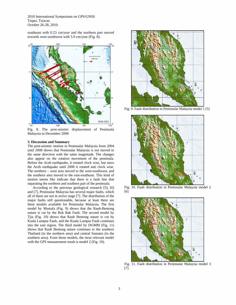
Fig. 8. The post-seismic displacement of Peninsula Malaysia in December 2008 3. Discussion and Summary The post-seismic motion in Peninsular Malaysia from 2004 until 2008 shows that Peninsular Malaysia is not moved to the same direction with the same magnitude. The changes also appear on the rotation movement of the peninsula. Before the Aceh earthquake, it rotated clock wise, but since the Aceh earthquake until 2008 it rotated anti clock wise. The northern – west area moved to the west-southwest, and the southern area moved to the east-southeast. This kind of motion seems like indicate that there is a fault line that separating the northern and southern part of the peninsula. According to the previous geological research [5], [6] and [7], Peninsular Malaysia has several major faults, which all of them are not in active stage [7]. The distribution of the major faults still questionable, because at least there are three models available for Peninsular Malaysia. The first model by Mustafa (Fig. 9) shows that the Raub-Bentong suture is cut by the Bok Bak Fault. The second model by Tjia (Fig. 10) shows that Raub Bentong suture is cut by Kuala Lumpur Fault, and the Kuala Lumpur Fault continues into the east region. The third model by DGMM (Fig. 11) shows that Raub Bentong suture continues to the southern Thailand (in the northern area) and central Sumatra (in the southern area). From those models, the most relevant model with the GPS measurement result is model 2 (Fig. 10).
Fig. 9. Fault distribution in Peninsular Malaysia model 1 [5]
Fig. 10. Fault distribution in Peninsular Malaysia model 2 [6]
Fig. 11. Fault distribution in Peninsular Malaysia model 3 [7]

2010 International Symposium on GPS/GNSS Taipei, Taiwan. October 26-28, 2010.
4
Meanwhile in 2007 until 2009 there were several small earthquakes (tremors) recorded in the peninsula (Fig. 12). The epicenter of the tremors was located at Bukit Tinggi Area (at least 13 times), Jerantut Area (less than five times) and Kuala Pilah Area (more than five times) [3]. Look careful at the Fig. 12, there is a continuation of tremors from west to east. This continuation could be interpreted as an indication of the fault line in that area. If it is true that the epicenter of the tremors represents the fault line, then these phenomena tallies with the GPS measurement result. Therefore, in the future, it is necessary to carry out collaboration research between the geology, geophysics and geodesy agencies. The purpose of the collaboration research is to find the correct distribution of fault in the peninsula and to map the stage of the activeness of the fault in the peninsula. At the end, that information should become a good input for the civil (government) and private agency to map the high-risk zone, especially in the big city such as Kuala Lumpur.
Fig. 12. Distribution of tremors epicenter and predicted fault Acknowledgements The support of Department Survey and Mapping Malaysia in providing data is greatly appreciated. References [1] Kee, T. C., Omar, K., Simons, W. F. J. and Abu, S.
(2005). GPS for regional crustal deforamtion measurement: case study of Aceh Earthquake 2004 and Nias Earthquake 2005. South East Asia Survey Congress 2005. 21 - 25 November. Bandar Seri Bengawan.
[2] Simons, W.J.F., Socquet, A., Vigny, C., Ambrosius, B.A.C., Abu, S.H., Promthong, C., Surabaya, C., Sarsito, D.A., Matheussen, S., Morgan, P. & Spakman, W. (2007), A decade of GPS in Southeast
Asia: Resolving Sundland motion and boundaries, J. Geophys. Res., 112, B06420.
[3] Malaysian Meteorological Department (MMD). (2009). Earthquake list from 2007 until 2009, retrieved January 10, 2010, from http://www.met.gov.my/index.php?option=com_content&task=view&id=1564&Itemid=1635.
[4] Vigny, C. and the SEAMERGES participants (eds.) (2005). Report on Banda Aceh mega-thrust earthquake, December 26, 2004. SEAMERGES report. SEAMERGES Delft, Netherlands: http://www.deos.tudelft.nl/seamerges/docs/Banda_aceh.pdf.
[5] Mustaffa, K. S. (2009). Major Faults. In Hutchison, C. S. and Tan, D. N. K.(Eds.) Geology of Peninsular Malaysia. (pp. 249 – 269). University Malaya.
[6] Liew, K. K. (1995). Timing of Cenozoic basin formation in northern Sundaland Southeast Asia. Geol. Soc. Malaysia Bulletin, 37, 231 – 251.
[7] Department Geoscience and Mineral Malaysia (DGMM). (2008). The Seismotectonic Map of Malaysia (3rd eddition). Mesy.Kumpulan Kerja Geodetik Bil 1/2008. Kuala Lumpur.