Portfolio 2013
70
Applying For Summer Internship 2013 Portfolio
-
Upload
eric-zhang -
Category
Documents
-
view
212 -
download
0
description
Portfolio 2013 works at GSD and Tongji
Transcript of Portfolio 2013

Ziyi ZhangApplying For Summer Internship 2013 Portfolio

Ziyi Zhang
Candidate, Master of Landscape ArchitectureHarvard Graduate School of Design
Bachelor of Landscape ArchitectureTongji University

PHILOSOPHYIN GARDENINGChinese Garden DesignP24
MELODYOF NATURECity Plaza DesignP30
URBAN “GREENWELL”Budget Hotels DesignP42
FABRICATIVEEXPERIMENTATION
LIGHT UPTHE SITEInteractive LandscapeP64
Cardboard HouseP62
Westgate Street DesignP50
REVIVAL OFFORGOTTEN TOWN
CONCERTO: reconnecting urban life & natureUrban Green Space PlanningP56
2009-2012
Eyear
FLUX CITYReorganize Site VectorsP16
OverlayHuman SenseP22
FIELD CRAFT
Programmatic EcologiesP06
2012-Present

6
01FIELD CRAFT
Anticipating the decommissioning of the Massachusetts Military Reservation (MMR) and a growing need to understand and embrace the role of conservation within military pe-rimeters, FIELDCRAFT sets up an operative platform for the U.S. Army National Guard and the Massachusetts Department of Environmental Protection to ecologically service the region. A mosaic within a large-scale patch, the project seeks to transform the MMR through cycles of selective arrested succession (e.g. mowing, grazing, clear cutting) in order to create a network of diverse and evolving habitats as an innovative mode of conservation: conservation through adaptation. Fieldcraft, a military term referring to the codified reading of the landscape for survival, is adopted as a framework for encoding and deciphering micro and macro ecological processes within the designed landscape, as a means to extract the most ecological value by promoting the most biodiversity from large, open spaces.
Semester: Fall 2012Instructor: Elkin RosettaType: academic team work with: Carolyn Deuschle, Gabriella Solange
Programmatic Ecologies

7
The context diagram explores regional networks and corridors, such as powerlines, roads, ferry routes, airports, and so on, and how they connect the MMR regionally (and globally)
Instead of approaching conservation with the aim of preserving a static definition of the landscape, FIELDCRAFT aims to exploit unexploded ordinance detonation and circulatory flows—wind, hydrology, bird migration, transportation networks, human movement, and so on—to make conservation an active agent in changing the land, by recovering and progressing past and present conditions. Working primarily with flows and pro-cesses that are active agents in seed dispersal, we attempt to understand vegetation—native and non-native—as a means to nurture flexible and resilient landscapes, both locally and regionally.
CONTEXT DIAGRAM
5000 10000 20000
meters

8
The plan takes a transect of the site in order to highlight arrested succession, landform, and seed dispersal strategies.
Plan Transect
500 1000 2000
meters

9
Figure-ground diagrams illustrate how the site is cleared over time via arrested succession methods.
Infrastructure types
Figure-ground diagrams
cantilevered path
shelter
elevated path
current: some parts of the vegetation of the site are cleared for military usages.
2015: central area will be cleared in order to grow senti-mental species and prepare for ordanances detonation.
2020: Forest near major path will be cleared to increase accessibility and help seeds dispersal process.
Later: deferent area use different succession strategy to encourage diversity.
tower
platform
A typology of infrastructures that extend across the site, meet demands of various agency like transportation, tourism, forestra-tion, administration etc.

10
Detail plans and axonometrics reveal how succession methods affect vegetation growth and spatial configurations over time.
Mowing & Patch Cutting
Patch Cutting
Grazing & Patch Cutting

11
EmergentFloating
Submerged
MICROORGANISM HABITATLocation where water accumulates and is protected from cold Microorganisms require water and/or humidity with an optimum growth between 4°C and 60°C. They help breakdown contaminants.
FAUNA HABITATLocation at semi-open wetlands. This provides a necessary additional habitat area for local species such as the Upland Sandpiper, Southern Red-Backed Vole, and Northern Harrier, who favor open terrain.
South-facing slopes are characterized by plants that are more xeric (not requiring very much moisture) and north-facing slopes are characterized by plants that are more mesic (requiring a moderate amount of
CIVILIANLocation is accessible with good walking conditions and points of interest.
FAUNA HABITATLocation on slopes to increase biodiversi-ty—some plants will prefer xeric condi-tions over mesic conditions.
AMPHIBIAN HABITATVernal pools are ideal for amphibians (bullfrogs, green frogs, grey tree frogs, wood frogs, and spring peepers).
0
1
2
3
-1
-2
-3
-4
-5
0
1
2
3
-1
-2
-3
-4
-5
0
1
2
3
-1
-2
-3
-4
-5
0
1
2
3
-1
-2
-3
-4
-5
0
1
2
3
-1
-2
-3
-4
-5
These detail sections highlight key design moments.
Models illustrate the topography of the landform created from biopiles after the detonation of unexploded ordinances, and the relationship between the blast size, contamination, and frequency of cut and fill. Triangulated mesh and sections illuminate the topography of the model.
One to one scale detail models are made to explore how seeds hit the ground and begin to sprout.
Detail sections

12
206
0
205
0
204
0
203
0
202
0
207
0
20
15
19
30
1930
201
5
202
0
203
0
205
0
206
0
207
0
204
0
Army Environmental Policy Institute formed to better
prepare the Army for emerging and future
environmental challenges.
1935
Acquisition approved of 200,000 acres of land in Cape Cod for military training.
Primarily using Works Project Administration funds, sixty-three buildings and two 150 m-wide runways at Otis Field begin construction on site.
Troops begin setting up camp and began training
1936
At its peak, 80,000 people live and train at Camp Edwards.
1940
The Engineer Amphibian Command activated at Camp Edwards.
Hospital established at Camp Edwards.
1942 1950
Air Force constructs new hangars and buildings at Otis Air Force Base.
1951
Wilderness Act passes.
1964
Army creates the Department of the Army
Project Manager for Chemical Demilitarization.
1972
U.S. Army begins withdrawal from Camp Edwards.
1973
Safe Drinking Water Act passes.
1974
Otis Air Force Base ends its long-range surveillance missions.
Installation Restoration Program established to assess environmental conditions on military installations under the U.S. Army Toxic and Hazardous Materials Agency.
Comprehensive Environmental Response, Compensation, and Liability Act passes.
1980
Army National Guard develops a plan to expand training at the MMR.
Contamination found in MMR groundwater
Expanded training plans suspended.
1985
Base Realignment and Closure Commission
MMR listed as a Superfund site.
1989 1990 1996
Regulations put in place to further the Army’s goal of systematically conserving biological diversity on Army lands.
1999
EPA orders the National Guard to begin the process for the removal of UXOs from the base and to clean up contaminated groundwater and soils.
First survey of threatened and endangered species on army lands published by USAEC.
2000
Environmental and Readiness Center at the MMR created.
2001
Portions of MMR removed from EPA’s Superfund list.
2007
First sustainability report on army’s practices released.
2008
Canine detection of UXOs Clearing of explosion area UXOs detonated
Vernal pools appearArrested succsession via patch cutting, grazing, mowing
Seed catching in cleared areas Buried seeds revealedSelect watchtowers built
Biopile contaminated soils treatment cycle
Landform created
New ecosystems emerge
MMR formally sanctioned as nature preserve with public access at own risk Site ecologically services region with rich biodiversitySelect roads closed to decayElevated paths and trails constructed
Pump and treat water remediation pools createdMycoforestry
Select treated soil moved near road
Mycoremediation
1976 1978 1984-5
0m
-10
-15
-20
-25
-30
-35
-40
-5
0m
-10
-15
-20
-25
-30
-35
-40
35
30
25
20
15
10
5m
45
50
40
35
25
20
15
10
5
45
50
30
40
206
0
205
0
204
0
203
0
202
0
207
0
20
15
19
30
1930
201
5
202
0
203
0
205
0
206
0
207
0
204
0
Army Environmental Policy Institute formed to better
prepare the Army for emerging and future
environmental challenges.
1935
Acquisition approved of 200,000 acres of land in Cape Cod for military training.
Primarily using Works Project Administration funds, sixty-three buildings and two 150 m-wide runways at Otis Field begin construction on site.
Troops begin setting up camp and began training
1936
At its peak, 80,000 people live and train at Camp Edwards.
1940
The Engineer Amphibian Command activated at Camp Edwards.
Hospital established at Camp Edwards.
1942 1950
Air Force constructs new hangars and buildings at Otis Air Force Base.
1951
Wilderness Act passes.
1964
Army creates the Department of the Army
Project Manager for Chemical Demilitarization.
1972
U.S. Army begins withdrawal from Camp Edwards.
1973
Safe Drinking Water Act passes.
1974
Otis Air Force Base ends its long-range surveillance missions.
Installation Restoration Program established to assess environmental conditions on military installations under the U.S. Army Toxic and Hazardous Materials Agency.
Comprehensive Environmental Response, Compensation, and Liability Act passes.
1980
Army National Guard develops a plan to expand training at the MMR.
Contamination found in MMR groundwater
Expanded training plans suspended.
1985
Base Realignment and Closure Commission
MMR listed as a Superfund site.
1989 1990 1996
Regulations put in place to further the Army’s goal of systematically conserving biological diversity on Army lands.
1999
EPA orders the National Guard to begin the process for the removal of UXOs from the base and to clean up contaminated groundwater and soils.
First survey of threatened and endangered species on army lands published by USAEC.
2000
Environmental and Readiness Center at the MMR created.
2001
Portions of MMR removed from EPA’s Superfund list.
2007
First sustainability report on army’s practices released.
2008
Canine detection of UXOs Clearing of explosion area UXOs detonated
Vernal pools appearArrested succsession via patch cutting, grazing, mowing
Seed catching in cleared areas Buried seeds revealedSelect watchtowers built
Biopile contaminated soils treatment cycle
Landform created
New ecosystems emerge
MMR formally sanctioned as nature preserve with public access at own risk Site ecologically services region with rich biodiversitySelect roads closed to decayElevated paths and trails constructed
Pump and treat water remediation pools createdMycoforestry
Select treated soil moved near road
Mycoremediation
1976 1978 1984-5
0m
-10
-15
-20
-25
-30
-35
-40
-5
0m
-10
-15
-20
-25
-30
-35
-40
35
30
25
20
15
10
5m
45
50
40
35
25
20
15
10
5
45
50
30
40
13
206
0
205
0
204
0
203
0
202
0
207
0
20
15
19
30
1930
201
5
202
0
203
0
205
0
206
0
207
0
204
0
Army Environmental Policy Institute formed to better
prepare the Army for emerging and future
environmental challenges.
1935
Acquisition approved of 200,000 acres of land in Cape Cod for military training.
Primarily using Works Project Administration funds, sixty-three buildings and two 150 m-wide runways at Otis Field begin construction on site.
Troops begin setting up camp and began training
1936
At its peak, 80,000 people live and train at Camp Edwards.
1940
The Engineer Amphibian Command activated at Camp Edwards.
Hospital established at Camp Edwards.
1942 1950
Air Force constructs new hangars and buildings at Otis Air Force Base.
1951
Wilderness Act passes.
1964
Army creates the Department of the Army
Project Manager for Chemical Demilitarization.
1972
U.S. Army begins withdrawal from Camp Edwards.
1973
Safe Drinking Water Act passes.
1974
Otis Air Force Base ends its long-range surveillance missions.
Installation Restoration Program established to assess environmental conditions on military installations under the U.S. Army Toxic and Hazardous Materials Agency.
Comprehensive Environmental Response, Compensation, and Liability Act passes.
1980
Army National Guard develops a plan to expand training at the MMR.
Contamination found in MMR groundwater
Expanded training plans suspended.
1985
Base Realignment and Closure Commission
MMR listed as a Superfund site.
1989 1990 1996
Regulations put in place to further the Army’s goal of systematically conserving biological diversity on Army lands.
1999
EPA orders the National Guard to begin the process for the removal of UXOs from the base and to clean up contaminated groundwater and soils.
First survey of threatened and endangered species on army lands published by USAEC.
2000
Environmental and Readiness Center at the MMR created.
2001
Portions of MMR removed from EPA’s Superfund list.
2007
First sustainability report on army’s practices released.
2008
Canine detection of UXOs Clearing of explosion area UXOs detonated
Vernal pools appearArrested succsession via patch cutting, grazing, mowing
Seed catching in cleared areas Buried seeds revealedSelect watchtowers built
Biopile contaminated soils treatment cycle
Landform created
New ecosystems emerge
MMR formally sanctioned as nature preserve with public access at own risk Site ecologically services region with rich biodiversitySelect roads closed to decayElevated paths and trails constructed
Pump and treat water remediation pools createdMycoforestry
Select treated soil moved near road
Mycoremediation
1976 1978 1984-5
0m
-10
-15
-20
-25
-30
-35
-40
-5
0m
-10
-15
-20
-25
-30
-35
-40
35
30
25
20
15
10
5m
45
50
40
35
25
20
15
10
5
45
50
30
40
206
0
205
0
204
0
203
0
202
0
207
0
20
15
19
30
1930
201
5
202
0
203
0
205
0
206
0
207
0
204
0
Army Environmental Policy Institute formed to better
prepare the Army for emerging and future
environmental challenges.
1935
Acquisition approved of 200,000 acres of land in Cape Cod for military training.
Primarily using Works Project Administration funds, sixty-three buildings and two 150 m-wide runways at Otis Field begin construction on site.
Troops begin setting up camp and began training
1936
At its peak, 80,000 people live and train at Camp Edwards.
1940
The Engineer Amphibian Command activated at Camp Edwards.
Hospital established at Camp Edwards.
1942 1950
Air Force constructs new hangars and buildings at Otis Air Force Base.
1951
Wilderness Act passes.
1964
Army creates the Department of the Army
Project Manager for Chemical Demilitarization.
1972
U.S. Army begins withdrawal from Camp Edwards.
1973
Safe Drinking Water Act passes.
1974
Otis Air Force Base ends its long-range surveillance missions.
Installation Restoration Program established to assess environmental conditions on military installations under the U.S. Army Toxic and Hazardous Materials Agency.
Comprehensive Environmental Response, Compensation, and Liability Act passes.
1980
Army National Guard develops a plan to expand training at the MMR.
Contamination found in MMR groundwater
Expanded training plans suspended.
1985
Base Realignment and Closure Commission
MMR listed as a Superfund site.
1989 1990 1996
Regulations put in place to further the Army’s goal of systematically conserving biological diversity on Army lands.
1999
EPA orders the National Guard to begin the process for the removal of UXOs from the base and to clean up contaminated groundwater and soils.
First survey of threatened and endangered species on army lands published by USAEC.
2000
Environmental and Readiness Center at the MMR created.
2001
Portions of MMR removed from EPA’s Superfund list.
2007
First sustainability report on army’s practices released.
2008
Canine detection of UXOs Clearing of explosion area UXOs detonated
Vernal pools appearArrested succsession via patch cutting, grazing, mowing
Seed catching in cleared areas Buried seeds revealedSelect watchtowers built
Biopile contaminated soils treatment cycle
Landform created
New ecosystems emerge
MMR formally sanctioned as nature preserve with public access at own risk Site ecologically services region with rich biodiversitySelect roads closed to decayElevated paths and trails constructed
Pump and treat water remediation pools createdMycoforestry
Select treated soil moved near road
Mycoremediation
1976 1978 1984-5
0m
-10
-15
-20
-25
-30
-35
-40
-5
0m
-10
-15
-20
-25
-30
-35
-40
35
30
25
20
15
10
5m
45
50
40
35
25
20
15
10
5
45
50
30
40
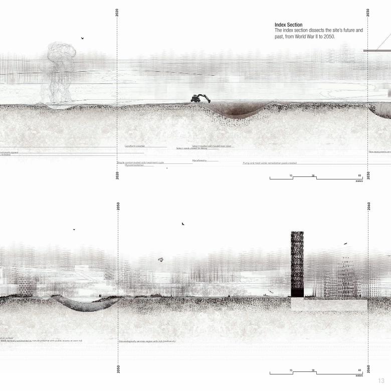
The index section dissects the site’s future and past, from World War II to 2050.
Index Section
15 30 60
meters
15 30 60
meters
14
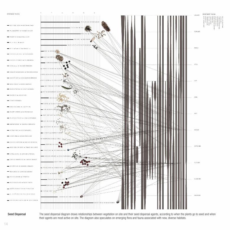
The seed dispersal diagram draws relationships between vegetation on site and their seed dispersal agents, according to when the plants go to seed and when their agents are most active on site. The diagram also speculates on emerging flora and fauna associated with new, diverse habitats.
Seed Dispersal

15
A processing script runs over a model, showing how seeds may potentially move throughout the landform near the Central Impact Area and around the road, according to the seed disper-sal agents.
Seed Dispersal RepresentationSeed Dispersal Agents
VideoMen
Sprout Location
Vehicle
Animals
Wind
Stream
Vernal Pool
Succession Clearing Road/PathForest
A recorded video can be found here: https://vimeo.com/55685247

16
02Flux CitySemester: Spring 2013Instructor: Zaneta HongType: academic team work with: Shengyi Yue
Reorganizing Site Vectors
Jamaica Bay is located in Nassau County, New York city. It con-nects the lower New York bay and to the west through Rocka-way inlet. The Jamaica Bay is an estuary where freshwater and tidal salt water meet. The salt marsh ecosystem provides environmental and economical benefits to the locals.
However, urban expansion, sea level rise and sewage water rush caused the vanishing of salt marsh ecosystem.
The project “flexing field” aims to reorganized site vectors including but not limited in current direction,salinity exchange, transportation and urban movement to create a proper environ-ment (proper sediment and salinity) for the recovering of salt marsh.
Regional Plan
5000 10000 20000
meters

17
Urban fabric connection Mudflat
Underground boat routeAnimal corridor
Energy generation
Sediments Catcher
Below ground
Above ground
Housing
Open spaceTransportation
Fresh + Salt
High tidal Max 5’
Low tidal Min -1’
Harricane Category I-III
Shore Bedrock -6’
Alter current
Sewage water
Tidal Salt water 32psu
Tidal Elevational flucturationVelocity and vector
Flood control
Tourism industry
Gate Controller
Generate energy
Salt marsh restoration Food webFlexing field
HousingOpen Space Transportation
Boat Route
Energy generation
Animal corridor
Parking
Landscape here modified the site flow using methods such connecting, redirecting, blocking and so on. New landscape and vectors can provide both ecological and social benefits.
Surge
High tide
Low tide
High Tidal
Low Tidal
Surge
B
B’
C
C’
Highway Boat route Underground pathway Mudflat Pedestrian bridge
Waterfront promenade Pathway Mixed use housing
Sediment catcher Sediment mounds Salt marsh
Surge
High Tidal
Low Tidal
Natural observatory
A
A’
beforeafter
beforeafter
beforeafter
Operational Diagram
Reorganizing Site Vectors
Surge
High tide
Low tide
High Tidal
Low Tidal
Surge
B
B’
C
C’
Highway Boat route Underground pathway Mudflat Pedestrian bridge
Waterfront promenade Pathway Mixed use housing
Sediment catcher Sediment mounds Salt marsh
Surge
High Tidal
Low Tidal
Natural observatory
A
A’
beforeafter
beforeafter
beforeafter
Surge
High tide
Low tide
High Tidal
Low Tidal
Surge
B
B’
C
C’
Highway Boat route Underground pathway Mudflat Pedestrian bridge
Waterfront promenade Pathway Mixed use housing
Sediment catcher Sediment mounds Salt marsh
Surge
High Tidal
Low Tidal
Natural observatory
A
A’
beforeafter
beforeafter
beforeafter

18
500 1000 2000
meters
Site Plan
19
Urban fabric connectionMudflat
Underground boat routeAnimal corridor
Energy generation
Sediments Catcher
Below ground
Above ground
Housing
Open spaceTransportation
Fresh + Salt
High tidal Max 5’
Low tidal Min -1’
Harricane Category I-III
Shore Bedrock 6’
Alter current
Sewage water
Tidal Salt water 32psu
Tidal Elevational flucturation
Velocity and vector
Flood control
Tourism industry
Gate Controller
Generate energy
Salt marsh restoration Food webFlexing field
HousingOpen Space Transportation
Boat Route
Energy generation
Animal corridor
Parking
Two folds angle variationOne fold angle variationZero fold angle variation
Highest elevated structure
Deepest cut and fill structure
Low tide-1’
High tide-5’
Z
X Y
Elevation variation
Operational diagram
Water body
Road system
Open space
Sewage system location
Z
X Y
Z
X Y
Formation, operation and assembly
Anim
al Co
rrido
rSa
nd C
atch
erW
ave
Atta
nuat
orAq
ua In
dust
rial
Look
out
Plan
tatio
n
look
out
Fres
h+Sa
ltUn
derw
ater
Obs
erva
tory
Com
mer
cial
Mul
ti-ele
vatio
n Pl
aza
Pede
stria
n Br
idge
Boat
Rou
te, C
anals
Ener
gy G
ener
ator
Pede
stria
n/ B
ike/ P
ath
Gol
fPa
rkin
g Lo
ts
Doc
kG
alle
ryPr
omen
ade
Ligh
t Rail
Sta
ition
Landscape Types Infrastructure Types
Unit
Unit Form
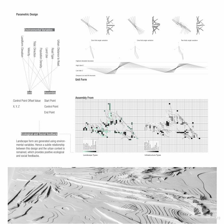
Environmental Variables
Assembly From
Parametric Design
Assembly
Ecological and Social feedback
Landform: Elevation
Tidal: Direction
Velocity
Urban: Distance to Road
Road Type
Land Use
Population Density
Control Point Offset Value
X, Y, Z
Start Point
Control Point
End Point
Landscape form are generated using environ-mental variables. Hence a subtle relationship between this design and the urban context is remained, which provides positive ecological and social feedbacks.
20
Landscape
Infrastructure
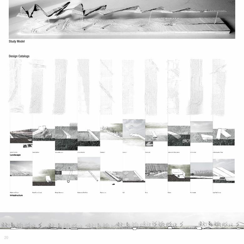
Study Model
Design Catalogs

21
Section A
ABC
D
Section B
Section C
Section D
A study model shows how the unit form can be changed to according to the environ-mental variables and change the environment (catch sediments) in return.
The catalog shows the relationship between the site vector field and the generated landscape. And this demonstrate the adaptiveness of generated form which can reflect the nature of site.
Sections shows the spacial relationship of the units. These units vary in different urban context.
50 100 200
meters
10 20 40
meters
10 20 40
meters
10 20 40
meters

22
03Eyear
Semester: Spring 2013Instructor: Allen SayeghType: academic team work with: Wenting Guo
Overlay Human Sense
Arduino
Sound Sensor x4
Processing
Camera Captured Image
Left side Right side
From Front
From Back
Serial Port
Analog Input
Optimize and calculate sound change value of each sensor.
Use the value differences of sound sensors which face to four direction to calculate the sound source location.
Use the transparency of unit squares to reflect the sound direction and volume.
Human get used to see things through eyes and hear things through ears. The information coming into eyes is actually light changes. Sound wave can be translate to another form to be seen and help man filter the visual information. Eyear is a human-centered device overlaying one’s hearing to vision and try to create a new way to perceive the sur-roundings. By creating a new rule to restrict human sensory organ, this device enable men to see what they hear, and let them only see the surroundings which have sound.

23
Silent environment will block most of user’s view, and this device will high-light the person who is talking.
Sound created by movement will be reflect on the screen.
User can see images with visual and hearing information through a screen in this device.

24
04PHILOSOPHYIN GARDENINGChinese Garden Design
A Chinese classical garden, as a work of art of spontaneity, is more than the designer’s composition of geometric complexity and contrast. It symbolizes the owner’s characters and reflects his/her philosophy of life as well.
This garden design was inspired by two mainstream genres of traditional Chinese philosophies—Taoism and Confucianism.
Employing the concept of estrangement, the design reflected a balanced fusion of the two philosophies and unification of nature and society.

25
Semester: Spring 2010Duration: 4 weeksInstructor: Wang MinType: Academic Independent work
This garden was designed exclusively for Tao Yuanming(or Tao Qian), an ancient poet.
In his early days, he was torn between his political ambi-tion and desire to retreat into solitude. He served in some minor posts, but his sister’s death, as well as disgust at the corrupted government prompted his resignation. He lived in retirement and spiritual tranquility since then.
Tao Yuanming
SITE PLAN0.5 1.0 2.0

26
Taoism pursues the unity of man and nature and conformity to the Tao of nature—an individual is to the universe what a speck of pollen is to a dandelion.
Confucianism
Taoism
order
With humanism at its heart, it focuses on the virtue and ethics of the community. Humanity, righteousness, propriety, knowledge, integrity are the basic principles.
27
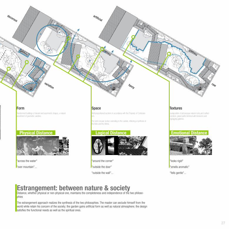
Distance, whether physical or non-physical one, maintains the completeness and independence of the two philoso-phies
The estrangement approach realizes the synthesis of the two philosophies. The master can seclude himself from the world while retain his concern of the society; the garden gains artificial form as well as natural atmosphere; the design satisfies the functional needs as well as the spiritual ones.
Estrangement: between nature & society
Physical Distance
Form Space Textures
Emotional DistanceLogical Distance
variation
decorous
artificial
fancyraw
Transformed buildings of deviant and asymmetric shapes, a natural assortment of geometric varieties.
"across the water"
"over mountain"...
"around the corner"
"outside the door"
"outside the wall"...
"looks rigid"
"smells aromatic"
"fells gentle"...
Well-proportioned sections in accordance with the Propriety of Confucian-ism.
The semi-circular section extending to the outside, reflecting a synthesis of the finite and the infinite.
Juxtaposition of picturesque natural rocks and crafted corridors, gravel paths trimmed with blossoms and zigzagging galleries.

28
SECTION A
The main space of the garden was a miniature of natural scenery. Raw texture and flowing space introduced the rhythms of universe.

29
SECTION B
A
AB
B
The bridge confined the master in a secluded space while his thoughts spread to the unlimited natural dimension.

30
05MELODYOF NATUREWith the rapid development of the society, the modern pace of life become more and more fast, most people tend to ignore the scenes along the way. Besides, those who cannot catch up with the pace become marginalized.
In this project, the site at the intersection serves as an important traffic hub, however, it fails to satisfy the demands of local people –– there is no space for them to enjoy a quiet urban life.
By revealing the nature context of the site, a vivid plaza is envi-sioned. Rainwater management, ecological system optimization is introduced, creating pure and sincere natural ambience. Therefore, the pace of life is adjusted, people become closer to both nature and city in this site.
City Plaza Design

31
Semester: Fall 2009Duration: 6 weeksInstructor: Dong NannanType: Academic Independent work
32
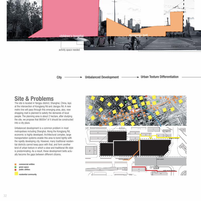
The site is located in Yangpu district, Shanghai, China, lays at the intersection of Kongjiang Rd and Jiangpu Rd. A new metro line will pass through this emerging area, also, new shopping mall is planned to satisfy the demands of local people. The planning area is about 2 hectare, after studying the site, we propose that 8600m2 of it should be constructed into a city plaza.
Unbalanced development is a common problem in most metropolises including Shanghai. Along the Kongjiang Rd, economic is highly developed. Architectural complex, large transportation systems enable this area to bond tightly with the rapidly developing city. However, many traditional residen-tial districts cannot keep pace with that, and form another kind of urban texture in which a slow and traditional life style is predominating. As a result, these development belts actu-ally become the gaps between different citizens.
Site & Problems
children's hospital
activity space neededprovids service transportation hub
economic belt
City Unbalanced Development Urban Texture Differentiation
commercial building
public service interface
residence interface
metro systembusiness interface
green space
parking lots
city plaza(design area)
commercial entitiesgreen spacepublic utilities
residential community
Kongjiang Rd
33
relaxation needed
residential district
marginalizes
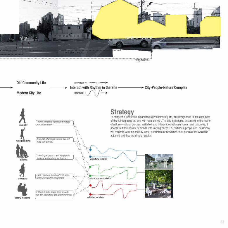
To bridge the fast urban life and the slow community life, this design tries to influence both of them, integrating the two with natural style . The site is designed according to the rhythm of nature––natural process, waterflow and interactions between human and creatures, it adapts to different user demands with varying paces. So, both local people and passersby will resonate with this melody, either accelerate or slowdown, their paces of life would be adjusted and they are simply happier.
Strategy
activities variation
waterflow variation
Old Community Life
Modern City Life
natural process variation
Interact with Rhythm in the Site City-People-Nature Complex
passerby
young residents
patients
shoppers
elderly residents
I wanna something interesting to happen on my way to work.
A big park where I can run and play with those cute animals!
I need a quiet place to rest, enjoying the sunshine and breathing the fresh air.
I wish I can have a seat and drink some coffee when waiting for someone.
It’s hard to find a proper place for us to chat with each others and do some exercise.
accelerate
slowdown
site

34
Stormwater Management
Flora & Fauna
Activity Zone
Surface Moisture Content
urban activities
trees long-stemmed grass waterplants fishes shrubs flowers birds insects
link urban complex
slow down urban pace
introduce a quiet life style
restore nature activities
transportation hub
leisure and recreation
indigenous plant
walk through reeds
birdwatching
birdwatching
rest
shopping
exercise dragonfly chasing
dragonfly chasing
outdoor concert
go to work
bicycle parking
walking
smell flowers
smell flowers
grass knitting
grass knitting
play with petsplay chess
waiting
play with water
drink coffeefishes feeding
jogging
street performance
taxi hailing take metro
cross the street
read news paper
touch lotusfishwathing
enjoy the cool
take photos
buy breakfirst
Nature Matrix
Ground Textures
Stormwater Scenarios
Human-Nature Interaction
Daily Activities
Porous pavements pavements with runoff
poolswater holding plantation
1. collecting from pedestrian zone The runoff and pool create dynamic landscape in the site, alter people's daily routine, generate more communication between human and nature.
Natural process now become a part of the site. People have the access to interact with the animals and plants at the intersection of urban and nature.
Runoffs contribute to biodiversity of the site, water plants, longgrass, shrubs, trees provide a good environment for the insects and small animals.
2. stormwater cleansing3. discharging, storing and reusing
Melody of stream
Melody of creatures
Melody of activities

35SITE PLAN
5 10 20
0.00
-1.00 -2.150.00
-1.10
-0.95
1.10
-0.15
-0.25
-0.30
-0.10
0.00
-0.65
-0.30
0.00
-1.10
-2.40
-2.30
-3.00
36
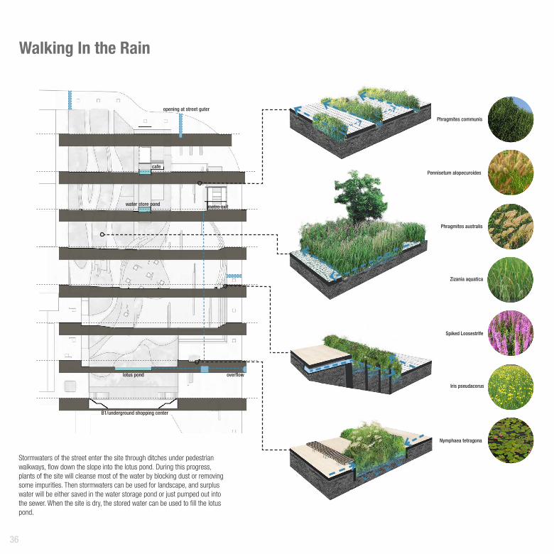
Walking In the Rain
overflowlotus pond
water store pond
cafe
opening at street guter
metro exit
B1/underground shopping center
Zizania aquatica
Spiked Loosestrlfe
Nymphaea tetragona
Iris pseudacorus
Phragmites australis
Phragmites communis
Pennisetum alopecuroides
Stormwaters of the street enter the site through ditches under pedestrian walkways, flow down the slope into the lotus pond. During this progress, plants of the site will cleanse most of the water by blocking dust or removing some impurities. Then stormwaters can be used for landscape, and surplus water will be either saved in the water storage pond or just pumped out into the sewer. When the site is dry, the stored water can be used to fill the lotus pond.

37
People walk in the rain while runoffs flow among them, toneless everyday routine will be activated by the rhythem of rain.
Lotus pond plays a very important role in connecting nature and city. It creates a logical distance between the shopping mall and plaza, the contrast breathes naturalness into
the plaza.

38
Ecologic Community
Water
Vegetation
Tree
Layers Main creatures
stor
mw
ater
prey
artifi
cial
bird
's n
est
6m &
10m
hig
h
purifi
ed w
ater
& O
2
food
depo
sit
nutr
ition
habitat & food
habi
tat
nitr
ogen
habitat
photosynthesis
photosynthesis
emergent vegetation & shrub
floating plant
soil
water
insects
fishes
birds
abor
atmosphere
Man-made birds’ nests will be installed in the trees to attract birds. Those birds can live in the plaza and prey on insects in the site. Fresh air, shadow in the summer make local people feel relaxed in the site, also, residents will enjoy appreciating birds and listening to the birds’ tweets.
Stormwater can be purified by plants and also brings oxygen and minerals into the pond. Plants will grow very well due to abundant nutrition.
Algae is the main food of fishes, and vegetation near the pond is the perfect habitat for many kinds of insects.
Goldfish is the traditional Chinese pet fish, brings a lot of joy to people. The rainwater brings the oxygen they need. Their feces deposit, which makes the soil full of nutri-tion.
Parusmajor
Coccinella septempunctata
Bufo gargarizans
Hirundorustica
...
...
Paradoxorniswebbianus
Atractomorpha sinensis
Cyprinus carpio
Passermontanus
Pantala flavescens Fabricius
Carassius auratus

39
Through establishing the eco-community, the site becomes lively and more adaptable to daily activities. The tradi-tional joys of appreciating flowers, birds, fishes and insects are reproduced in the site, hence people can enjoy a pleasant life again.

40
Memory of PlantsMost Chinese have some interesting experienc-es and unforgettable stories regarding some plants. Nevertheless, lack of access to the wild prevents them from enjoying those experiences again.
Those plants are indigenous ones, adapt to the local environment well, and they can be used as foods, decorations or toys. Local people like them a lot.
By introducing those plants into the site, the happy memories of local people would be recalled. And the site will seem more friendly, tight connection between the user and nature would be created. Meanwhile, the local envi-ronment will be significantly improved by those plants.
mall viewing deck lotus pond terrace garden on water shadowed square
tasty
trumpet flower
climb tree
dishes
snack
drinkssoup
porridge
grass made toy
bonsai design
bonsai
floral hoop
bracelet
necklacependant
blow dandelion
joyful
decorative

41
Coix
lacr
oym
a-jo
bi
Ulm
us p
umila
L.
Penn
iset
um a
lope
curo
ides
Herb
a Ta
raxa
ci
Ipom
oea
nil
Chry
sant
hem
um in
dicu
m L
.
unde
rsto
ryca
nopy
gink
go
Mor
us a
lba
L.
flower garden rest area woods sidewalk
SECTION2.0 4.0 8.0
...
...
42
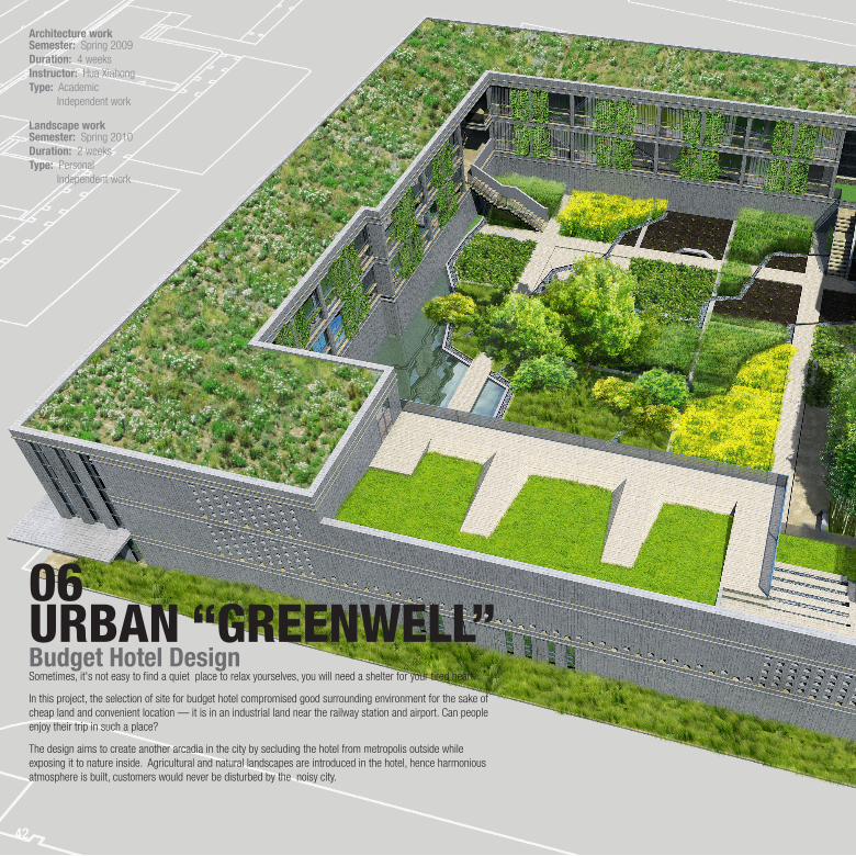
06URBAN “GREENWELL”Budget Hotel Design
Architecture work
Sometimes, it's not easy to find a quiet place to relax yourselves, you will need a shelter for your tired heart.
In this project, the selection of site for budget hotel compromised good surrounding environment for the sake of cheap land and convenient location –– it is in an industrial land near the railway station and airport. Can people enjoy their trip in such a place?
The design aims to create another arcadia in the city by secluding the hotel from metropolis outside while exposing it to nature inside. Agricultural and natural landscapes are introduced in the hotel, hence harmonious atmosphere is built, customers would never be disturbed by the noisy city.
Semester: Spring 2009 Duration: 4 weeksInstructor: Hua XiahongType: Academic Independent work
Semester: Spring 2010 Duration: 2 weeksType: Personal Independent work
Landscape work

43
Inner Ring Elevated RD
Outer Ring Expy
SITE
Industrial Land
storage factory residence construction site
The hotel is located in the fringe area of downtown Shanghai. Between the inner ring and outer ring of the city, some of the lands are used for industry. As the result, urban infrastructure is under-developed in this area, and more pollution problems appear.
However, this site is suitable for budget hotel, people can get to the airport or railway station in ten minutes. What's more, the land price which is the major costs of the project, is lower than it is in the downtown.
The wonderful natural surface is well preserved in the noisy city.
1 2 4km
Hongqiao Airport
Shanghai South Railway Station
44
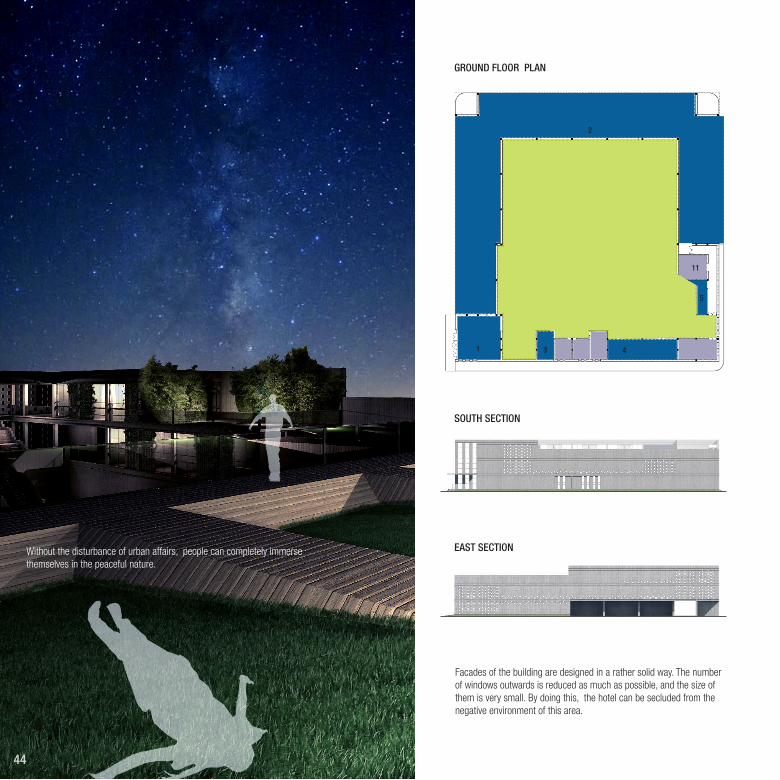
GROUND FLOOR PLAN
SOUTH SECTION
EAST SECTION
Facades of the building are designed in a rather solid way. The number of windows outwards is reduced as much as possible, and the size of them is very small. By doing this, the hotel can be secluded from the negative environment of this area.
1
2
3 9 4 10
11
5
Without the disturbance of urban affairs, people can completely immerse themselves in the peaceful nature.

45
5 10 20FIRST FLOOR PLAN SECOND FLOOR PLAN
1. receptionsingle room 19.5m2 *15
double room 23.0m2 *30
9. administration office 14. linen room*26. library
12
12
13 13
14 14
7
6
8
2. carports *30 10. kitchen
5. laundromat
After check-in, walking around the corner, people could immediately feel surrounded by a fancy world.
Well designed route makes sure that customers can get to their car or room without exposing in the open air during rainy days.
During the day, public spaces in the corner serve as activities place. While at night, they help reduce the influence between rooms.
Most rooms are east/north-facing in order to maximize sun exposure.
3. toilet
34001990
12. storage*2
8. meeting room
4. cafeteria
11. staff room
7. convenience store
13. work room*2
Service facilities ManagementRooms Public space
4700
3700
2100
Transitional Space Circle Corridors Space Partition Sunshine

46
5 10 20GARDEN PLAN
INNER SECTION
1st floor 1st floor
1st floor
2nd floor
2nd floor
Building-Garden Complex
In this project, the architecture design fulfills the needs of the building as a hotel and the landscape design makes it unique and attrac-tive.
Moreover, they promote mutually. The building creates a secluded space to ensure that the inner garden would not be disturbed. Mean while, the landscape brings vitality to the build-ing to make it more suitable to be lived in. Also, green space connects different parts of the building to make it an organic whole.

47
Ground Landscape
Connection Hubs
Roof Garden
natural
agricultural
Hustle Tranquility
artificial
support hotel’s service facilitiesenhance communication
grass slope on the roof
landscape type garden route
The grass slope tries to guide people’s sight to the infinite sky, hence it creates connections between the inner garden and the outer nature.
Nature permeates into the building and makes it more lively.
Such “green hubs” connect different parts horizontally and vertically, becoming the activities’ center for consumers. They provides space for reading, resting, charting...
Different types of landscape creates various ambient in the garden.
The relatively artificial landscape help people transit from the outer city into this natural world, and it also creates space for people to enjoy the service of the hotel (eg. cafeteria).
Then walk from agricultural area to natural area, people can totally devote themselves into the quiet atmosphere, relax, and feel what they cannot experience in the hustle city.

AgriculturalLandscapeCrops are main plants in the garden, people can feel like living in the wild when appreciating, planting, picking or eating them, and that's really joyful.
To ensure the access to those entertainment, crop rotation is introduced in the design. In any season, there are crops in different state of growth, so they can bring various experiences to people.
planting zone
stream
A
C
D
B

Insects ...
Air
Provides water to support some waterlike crops.
Thanks to the photosynthesis of the crops, the air quality of the inner garden can be improved a lot.
Habbitat for insects is created.
Maitains the Ph between 6.5~7.0. Needs fertilizer to replenish ele-ments like Nitrogen, phosphorus, and Potassium.
Divides the garden into several plantation zone, forms the pathes for people to appreciate and maintain the crops.
A
Feb. Feb.Jan. Jan.Mar. Mar.May. May.Jun. Jun.Jul. Jul.Sep. Sep.Oct.
Year 1 Year 2
Oct.Dec. Dec.Apr. Apr.Aug. Aug.Nov. Nov.
B
C
D
rape
rape
soybean
soybeanbuckwheat
buckwheat
celery
celery
tomato
tomato
laterice
latericesweet corn
sweet corn
lettuce
lettuce
2 years rotation
Irrigation Ditch Yellow Brown Earth Dike
People
Crops
Foods ...
Work: Sown Irrigate Fertilize Harvest ...
Appreciate: Form Color Smell Sway ...
Entertainment: Running through the field, feeling the touch of the nature ...

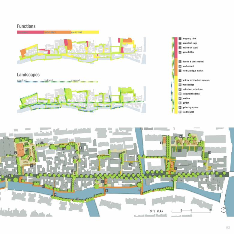
50
Westgate Street DesignSite Problems
Strategy
About eight hundreds ago, Wes的tgate Street appeared with the development of Jiading Town –– an ancient Chinese city. As the main entrance of town, it achieved its prosperity in a long his-tory. However, in modern times, along with the establishment of urban transportation system, Westgare street lost its role and became a marginalized, monotonous place.
Westgate Street needs transformation to accord with its new role in modem city. By integrating the unused lots in the district, the 3-8 meters wide street could become a idea activities space –– a street park serves both local and surrounding residents. Hence Westgate Street regains its significance.
In this project, 4 group members majoring in Urban Planning, Historic Architecture Conservation and Landscape Architecture cooperated to revive this district in a comprehensive way. I took charge of the landscape design.
07REVIVAL OFFORGOTTEN TOWN
traditional residence
old public housing
vacant lots
lack playground
places for venderdevay of street segregatioin
historic architecture conservation need activities
A park embedded in street net connects the whole district, provides functions to satisfy residence and acti-vates this forgotten town.
Semester: Spring 2010Duration: 6 weeksInstructor: Dong NannanType: Personal 4 person work(landscape design)

51
Westgate Street
town center
new commodity housing
moat
metro
site
This former city entrance is now a forgotten place.

52
Organization
Core area mainly provides required func-tions.
Landscape path makes the core area more available and efficient.
Such pattern scatters along the main street making it more lively.
More landscape paths strengthen the connections of these areas, and they become an entire system.
A
1
58
9
10
10
12
13
1415
B
C
D
Natural texture and infrastructure enable the streets of different scales to become perfect places for daily activities.
53
14
20 40 80SITE PLAN
Functions
Landscapes
flowers & birds market
food market
craft & antique market
pingpong table
basketball cage
badminton court
game tables
pavilion
waterfront pedestrian
wood bridge
historic architecture museum
recreational lawns
reading yard
garden
gathering square
play ground
waterfront boulevard grassland
market place pocket park
1
1
1
2
2
3
3
3
4
4
5
6
6
7
7
8
8
9
9
99
10
10
11
1111
11
12
12
12
13
13
13
13
14
14
15
15
15

54
ActivitiesDue to the space limits, different kinds of spaces are utilized according to their characters with efficiency.
Linear Spacemainly include green paths, people walk and rest here to enjoy the nature.
Spotspeaceful places in the site. Gardens for quiet activities are designed here.
Squareshigh participation and common sports are encouraged here.
B
C
A
B
C
55
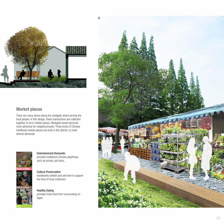
Market placesThere are many stores along the westgate street serving the local people. In this design, these transactions are collected together to form market places. Westgate street becomes more attractive for neighbourhoods. Three kinds of Chinese traditional market places are built in this district, to meet diverse demands.
flowers & birds
craft & antique
foods
Entertainment Demandsprovides traditional Chinese playthings such as bonsai, pet birds...
Culture Preservation handiworks exhibit and sell here to support the lives of local craftsmen.
Healthy Eating provides fresh food from surrounding vil-lages.
A
56
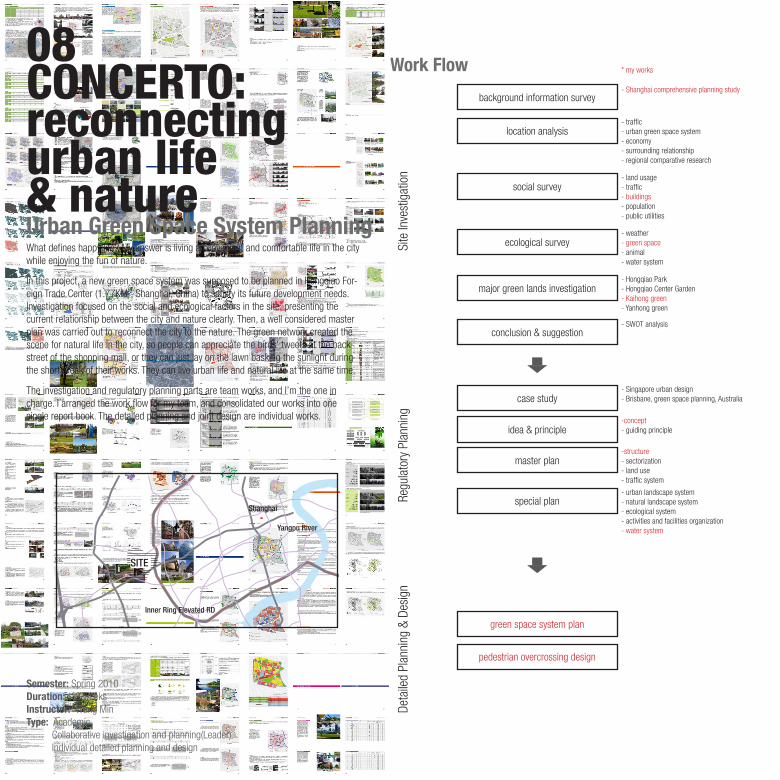
What defines happy life? My answer is living a convenient and comfortable life in the city while enjoying the fun of nature.
In this project, a new green space system was supposed to be planned in Hongqiao For-eign Trade Center (1.77KM2, Shanghai, China) to satisfy its future development needs. Investigation focused on the social and ecological factors in the site, presenting the current relationship between the city and nature clearly. Then, a well considered master plan was carried out to reconnect the city to the nature. The green network created the scene for natural life in the city, so people can appreciate the birds’ tweets at the back-street of the shopping mall, or they can just lay on the lawn basking the sunlight during the short break of their works. They can live urban life and natural life at the same time.
The investigation and regulatory planning parts are team works, and I’m the one in charge. I arranged the work flow for my team, and consolidated our works into one single report book. The detailed planning and joint design are individual works.
08CONCERTO: reconnectingurban life& natureUrban Green Space System Planning
Work Flow
background information survey- Shanghai comprehensive planning study
* my works
- traffic- urban green space system- economy- surrounding relationship- regional comparative research
-structure- sectorization- land use- traffic system
- urban landscape system- natural landscape system- ecological system- activities and facilities organization- water system
-concept- guiding principle
- Singapore urban design- Brisbane, green space planning, Australia
- land usage- traffic- buildings- population- public utilities
- weather- green space- animal- water system
- Hongqiao Park- Hongqiao Center Garden- Kaihong green- Yanhong green
- SWOT analysis
Site
Inve
stig
atio
n
location analysis
Regu
lato
ry P
lann
ing
major green lands investigation
conclusion & suggestion
master plan
special plan
green space system plan
pedestrian overcrossing design
idea & principle
case study
social survey
ecological survey
Deta
iled
Plan
ning
& D
esig
n
Semester: Spring 2010Duration: 12 weeksInstructor: Wang MinType: Academic Collaborative investigation and planning(Leader) Individual detailed planning and design
Inner Ring Elevated RD
Shanghai
Yangpu River
SITE
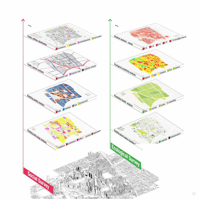
57
Existing land usage analysis
Building quality analysis
Traffic system analysis
Public utilities distribution
residencecommerce
officeservice
education
highmedium
lowpreserved
elevated roadarterial road
collector streets
commerce education entertainmentrecreation Shadow analysis - winter
Ecological sensitivity analysis
Plantation health analysis
Existing green space classification
highesthigh
lowlowest
medium
8 H6 H
2 H1 H (sunlight hours)
4 H
finenormal
weakunhealthy
parkresidence
roadsideinfrastructure
... ...
Social Survey
Ecological Survey

58
Interaction Between Urban Life and Natural Life
SHOPPING
EXERCISING
WORKING
RELAXATION
URBAN LIFENATURAL LIFE
ENTERTAINMENTDINNING
APPRECIATING
Functions- recreation- outdoor exercise- relaxation- passage- seclusion...
Functions- entertainment- service- job- transportation- education...
workingpartying
shoppingdinning
jogging
appreciatingrelaxingreading fishinggaming
filmwatching
basking
There are already many activities in the city, however, few connections exist between them, especially between the city life and nature. It’s hard for people to enjoy different kinds of life styles at the same time.
This design use green space to create a system to integrate urban life and natural life, abridging the distance between them. Hence people are free to choose their own lifestyle. Based on their choices, the city could be either a shopping mall or a big park.

SITE PLAN125 250 500
Hongqiao Park
Yanhong Green
Kaihong Green
Hongqiao Center Garden
Metro
Metro
59
Embassy District

60
parallel
intersect
Coordination of ElementsThe mixture of natural and modern textures diversifies urban life, yet probably at the cost of underming their distinctions. Therefore, it is imperative to maintain their independence and integrity in the plan.
There are two kind of relationship between the green space used for urban life and the green space used for natural life. They may parallel or intersect in the site.
By using this form, the two kinds of green space would not interfere with each other.
The key to remain this form is to design diverse flora and fauna and create dif-ferent space feelings.
This is the connecting point of the two kinds of green space, people can their preferred scenes at the intersection.
It is important to use different textures and sharp outline to represent them.
various species and space feelings
different textures and sharp layouts

61
Overpass & Square Design
This square lin the south of the site serves as an important traffic joint, it connects the major park of the site.
On the one hand, the square and overpass give people access to natural life, on the other hand, they provide a fast approach to the metro station.

62
09FABRICATIVEEXPERIMENTATION
Cardboard house is a team work for the fabrication festival, students are required to use cardboard to build a shelter in 10 hours.
I’m the leader of the 10-person group. I utilized the feature of card-boad––it can endure the force parallel to its surface. Through assem-bling cardboard, multiple ribbed walls were erected to support the whole structure. This pattern enabled me to design the form of the house with few restrictions.
Semester: Spring 2008Instructor: Qi GuangpingType: academic team workRole: team leader structure & form design organization, construction
form & structure design material preparation construction
Cardboard House

63
Timber Work StudyTimber work plays a significant role in Chinese ancient buildings. The nature texture of wood is endowed with artificial form, hence the buildings are infused with vitality and merge in to the environ-ment context.
Yinxian wooden pagoda is the paragon of Chinese wooden architecture which exists for 800 years. Studying its structure and form, we can know the achievements in respect of technique, art form, religion, philosophy, politics and so on. Furthermore, the tra-ditional feats and thoughts can also give an inspiration to modern design about how to utilize the natural materials.
The 1/80 model was made according to an important ancient book of architecture principles named "Yinzhao Fashi" and some other image materials provided by our tutor and team mem-bers. As the leader of this work, I’m responsible for the model design(digital one included); first, second floor and roof structure assembling; material preparation and work assignment as well.
Semester: Spring 2008 Duration: 3 weeksInstructor: Zhu YuhuiType: Academic Group work (9 students)Role: Leader
hiden-layer
use-layer

64
Home LightUpTheSite
www.lightupthesite.design
YoutubeArchdaily Amazon
overview Urban Challenge10LIGHT UPTHE SITEInteractive & Landscape
UNIT PLAN
PANAROMA
1.0 2.0 4.0
The Internet is developing in a dizzying speed and has changed our lifestyle fundamentally. It has excited inspirations in thousands of fields, however, rarely in Landscape Design.
This project explores a new way of Landscaping—–utilizing the Internet’s virtual elements which are well designed and perfectly established. By creatively using light as a media, the landscape will light up the sites both in real and virtual world thus converting the unused rooftops into attractive outdoor spaces for Shanghai—a densely populated and built metropolis.Therefore, creativity and connection within the community will be activated.
This design converts the “virtualscape” of the Internet—colors particularly in this project— to a visible and interactive one in real world to expand the limit of natural landscape, and hence relinks individuals who are connected by networks but isolated in real life. As the invisible networks are revealed, landscape hence eliminates the negative factors of the Internet, revitalizing the both interpersonal and the connection between human being and nature.
Semester: Spring 2011Duration: 6 weeksInstructor: Dong NannanType: Competition, Conceptual Design 2 person work(leader & main designer)

65
Facebook 豆瓣
invisible activitiesTransformation Roofgarden 2.0
2002
12
million
3
6
9
2003 2004 2005 2006 2007 2008 2009
Population37%25%
11.71 million people accounting for 62% of Shanghai's population usually surf the internet, and among them 60% use mobile devises to access the internet.
18.7 hours per week on average is spent on internet which has become increasingly important in citizens' daily life.
Although the Internet is intangible in real, it dose exit, exerting its influence to every corner of the world.
Shopping& Bussinesses
28%
Communication 69%
Entertainments 80%
Information 75%
The city is lighted up through connection between the Internet and the roof landscape, providing a lot of public space for citizens and gathering people separated in real world.
66
prob
lem
sne
w d
aily
rout
ine
roof
gar
den
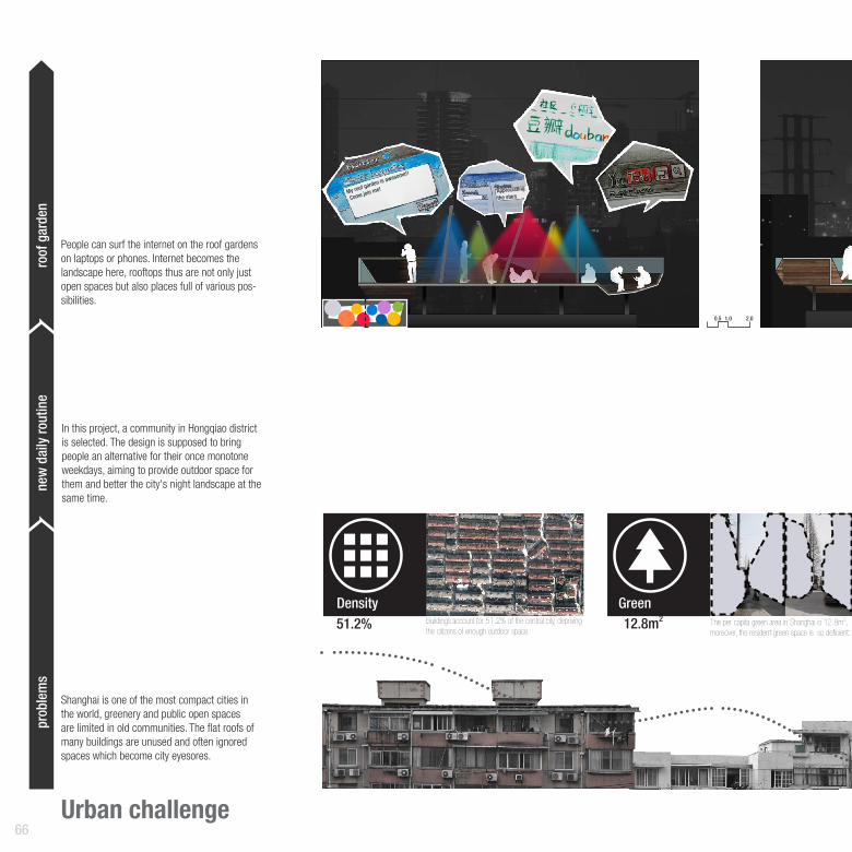
Urban challenge
Shanghai is one of the most compact cities in the world, greenery and public open spaces are limited in old communities. The flat roofs of many buildings are unused and often ignored spaces which become city eyesores.
People can surf the internet on the roof gardens on laptops or phones. Internet becomes the landscape here, rooftops thus are not only just open spaces but also places full of various pos-sibilities.
My roof garden is awesome!!
Come join me! Appreciating
the stars
In this project, a community in Hongqiao district is selected. The design is supposed to bring people an alternative for their once monotone weekdays, aiming to provide outdoor space for them and better the city's night landscape at the same time.
GreenDensity12.8m251.2% Buildings account for 51.2% of the central city, depriving
the citizens of enough outdoor space. The per capita green area in Shanghai is 12.8m2, moreover, the resident green space is so deficient.
0.5 1.0 2.0
67
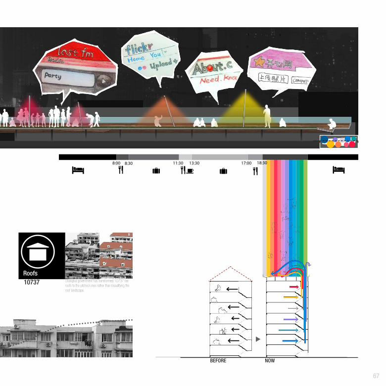
BEFORE 3New Routine: A common day of a working young people in Shanghai. Most of them have the same schedule for their weekday. However, there can be some good changes for
8:00 8:30 11:30 13:30 17:00 18:30
Roofs10737 Shanghai government has transformed 10737 flat
roofs to the pitched ones rather than beautifying the roof landscape.
NOW
68
Frame
Logo
Background
Words
Other informations... Class Environment+date : string+time : string
+weather : ArrayList+private class People
-rain() : int -festive() : boolean
-numberofpeople : int-density : int
-turbulence : int
Class People+serials : String
+location : ArrayList-mobility() : int
Class CSS+type : int
+color : string+location : ArrayList
-getarea() : int
Class Image+type : int
+img : image+location : ArrayList-getcolor() : String
-getarea() : int
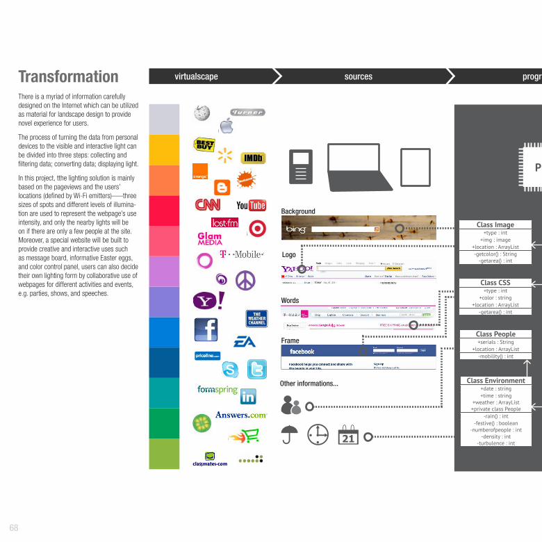
TransformationThere is a myriad of information carefully designed on the Internet which can be utilized as material for landscape design to provide novel experience for users.
The process of turning the data from personal devices to the visible and interactive light can be divided into three steps: collecting and filtering data; converting data; displaying light.
In this project, tthe lighting solution is mainly based on the pageviews and the users’ locations (defined by Wi-Fi emitters)—–three sizes of spots and different levels of illumina-tion are used to represent the webpage’s use intensity, and only the nearby lights will be on if there are only a few people at the site. Moreover, a special website will be built to provide creative and interactive uses such as message board, informative Easter eggs, and color control panel, users can also decide their own lighting form by collaborative use of webpages for different activities and events, e.g. parties, shows, and speeches.
virtualscape sources
PLC
program
69
...
Maple
Rye
Glacier
Ocean
Beach
Forest
Prairie
Sky
Lake
Sakura
Lavender
Sunset
Step 3 Displaying light.
Class Web+url : String +clicks : int
+duration : int+flow : int
+location : ArrayList+private class CSS
+private class Image-arrayfrecuency() : Arraylist
-arraycolor() : Arraylist
Class Led+serials : int+lumin : int+ color : int
-onoroff() : boolean-autoormanual() : boolean
-calculatelumin() : ArrayList-calculateallocation() :
ArrayList-calculatecolor() : int
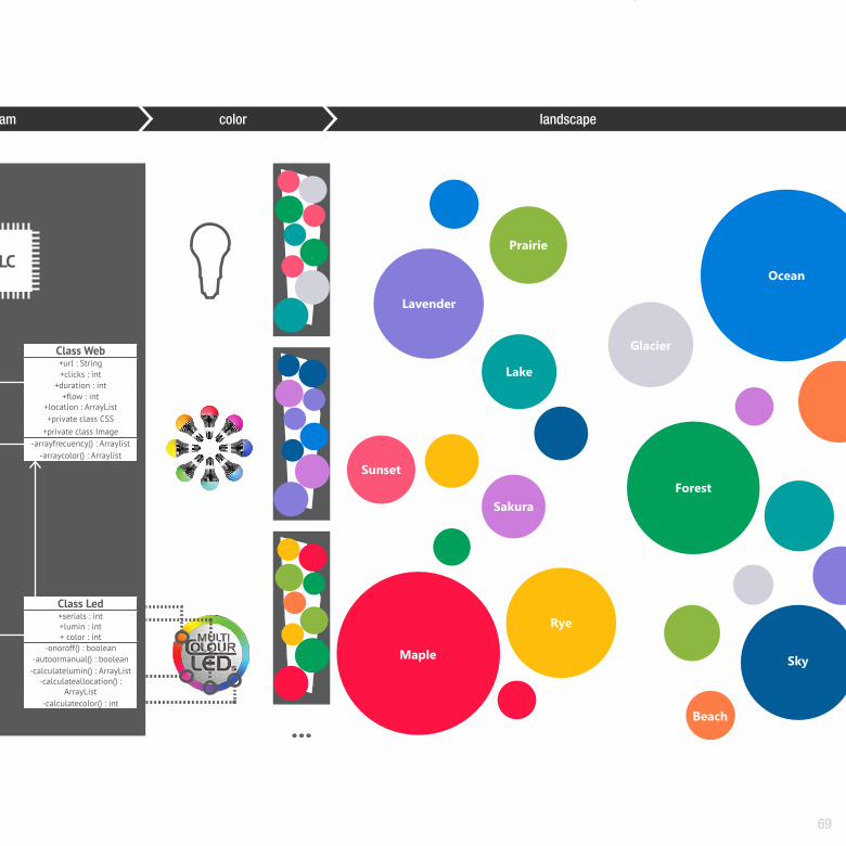
PLC
Colorprogram color landscape

70
Program
The virtual online connections among people are revealed by the media of light in this project, moreover, a brand new bond is generated to stimulate communication.

71
Roofgarden 2.0The infrastructure in this project is simple but multifunctional. Light plays the main role, which is presented on the lawn and wooden platform, arranging the space with the color and the spot size. Since the colors of the web usually are designed to conduct the users to a certain emotion, displaying them in real environment enables the site to adapt itself to the certain activities of users.
The lampposts which are made of white composite material are meanwhile Wi-Fi emitters. Nine slightly tilted lampposts are different in height to present different spot sizes. This diversifies the space. NFCs (Near Field Communication) are built at the proper position on the lamppost, allowing people to exchange information with the internet: users can get riddles by simply holding their devices close to the NFC on the lampposts on the night of the Lantern Festival, or just leave some words on the given website as message board on a usual day.
2. desk1. entrance
1
1
3
3
2
3. seat 4. platform
LED+WIFI+NFC

PORTFOLIOZiyi Zhang
Applying For Summ
er Internship 2013