
Portable Wind Tunnel Unpaved Road Dust Emission … Dust Research at DRI Portable Wind Tunnel...
30
Fugitive Dust Research at DRI Portable Wind Tunnel Unpaved Road Dust Emission Factors TRAKER measurements at Lake Tahoe Near Field Deposition Research by: Hampden Kuhns Vicken Etyemezian Jack Gillies Alan Gertler Djordje Nikolic Sean Ahonen Cliff Denney John Skotnik Nicholas Nussbaum Dave Dubois Jin Xu
Transcript of Portable Wind Tunnel Unpaved Road Dust Emission … Dust Research at DRI Portable Wind Tunnel...

Fugitive Dust Research at DRIPortable Wind Tunnel
Unpaved Road Dust Emission FactorsTRAKER measurements at Lake Tahoe
Near Field Deposition
Research by:
Hampden KuhnsVicken Etyemezian
Jack GilliesAlan Gertler
Djordje NikolicSean AhonenCliff DenneyJohn Skotnik
Nicholas NussbaumDave Dubois
Jin Xu

USDA-ARS Wind Erosion Research Unit http://www.weru.ksu.edu/vids
1. Portable Wind Tunnel

LWT at Ft. Bliss, TX
•J. Gillies and B. Nickling testing emission flux potential
•LWT is closest measurement to a “standard”
•SWT - e.g. D. James (UNLV), D. Gillette (NOAA)
•Concerns with boundary layer development, maximum wind speeds, and accounting for saltation

PI-SWIRL Schematic
Side View Bottom View
Computer Controller/ Data System PM Monitor
Sample Tube
Open-bottomed Cylindrical Chamber
Variable Speed Motor
Annular Ring
60 cm
40 cm
Side View Bottom View
Computer Controller/ Data System PM Monitor
Sample Tube
Open-bottomed Cylindrical Chamber
Variable Speed Motor
Annular Ring
Side View Bottom View
Computer Controller/ Data System PM Monitor
Sample Tube
Open-bottomed Cylindrical Chamber
Variable Speed Motor
Annular Ring
60 cm
40 cm
Blower for clean air injection

PI-SWIRL v.2

The PI-SWIRL-ogramSWIRLER RPM and PM10 Dust Concentration
0
100
200
300
400
500
14:52 15:21 15:50 16:19 16:48
Time of Day
PM10
Con
cent
ratio
n (m
g/m
3 )
0
1000
2000
3000
4000
5000
RPM
PM10RPM
Test 1: Stable Soil
Test 2: Disturbed Soil

PI-SWIRL Status• Version 3 is currently being tested
– Lower weight and smaller size– Faster measurement– Low cost custom circuitry
• Patent application filed• PI-SWIRL has been collocated with LWT to draw
empirical relationship– Data still being analyzed
• Contact Vic Etyemezian ([email protected]) for more information

2. Unpaved Road Dust Emission Factors

Emission factor
calculated as horizontal flux
of PM10passing
instrumented towers
-DT-DT
-DT
-DT
-DT
-DT
-DT
-DT
-DT
-DT
-DT
-DT
-DT
76
517266
128
125
1220570
26040
125
1220570
260
-GR
-GR
-GR
-GR
-GR
-GR
-SA
7005,00010,000
DT_1DT_2DT_3
Trailer with visibility
equipment
Generator 200 meters
LIDAR 3,000 meters
Top View
DT_1DT_2DT_3
Trailer with visibility
equipment
Generator 200 meters
LIDAR 3,000 meters
Top View
DT: DustTrakGR: GRIMMSA: Sonic Anemometer
: Wind Vane: Cup Anemometer: Laptop computer
Legend
DT: DustTrakGR: GRIMMSA: Sonic Anemometer
: Wind Vane: Cup Anemometer: Laptop computer
DT: DustTrakGR: GRIMMSA: Sonic Anemometer
: Wind Vane: Cup Anemometer: Laptop computer
Legend
-5
0
5
10
15
20
18:02:10 18:02:27 18:02:44 18:03:01 18:03:19 18:03:36 18:03:53 18:04:11Time
Dus
tTra
k R
eadi
ng (m
g/m
3)
DT_1 DT_3DT_2Baseline
Vehicle passes by DT_1

Unpaved Emissions Measured on Flux Towers in Ft. Bliss TX (April 2002)
Vehicle Weight (kg) # WheelsDodge Neon 1,176 4Ford Taurus 1,516 4Dodge Caravan 1,759 4HUMVEE 2,445 4TRAKER (Chevy Van) 3,100 426’ UHAUL Truck 5,227 6LMTV 8,060 4Freightliner (Tractor) 8,982 22HEMMET 17,727 85-ton Truck 14,318 6

EFPM10 = b W SEFPM10 [g/VKT] = 10.3 (W [Mg]) (S [m/s])
R2 = 0.89
0
500
1000
1500
2000
2500
3000
3500
4000
4500
0 50 100 150 200 250 300 350Vehicle Mass*Speed (Mg*m/s)
PM
10 E
mis
sion
Fac
tor (
g/V
KT)

Unpaved Road Dust Emission Factor Status
• Emission factors are dependent on vehicle speed and weight
• Emission potentials of unpaved road soils were relatively constant in Ft. Bliss TX based on TRAKER.
• Need to determine how emission potential varies in other regions.
• Time since last rainfall is correlated with unpaved road emission factors
John A. GILLIES, Vicken ETYEMEZIAN, Hampden KUHNS, Djordge NIKOLIC & Dale A. Gillette (2004) Effect of Vehicle Characteristics on Unpaved Road Dust Emissions. Accepted in Atmospheric Environment
Kuhns H., V. Etyemezian, J. Gillies, S. Ahonen, C. Durham, D. Nikolic (2003) Spatial Variability of Unpaved Road Dust Emissions Factors near El Paso, Texas. Accepted in J. Air & Waste Manage. Assoc.
Kuhns H., V. Etyemezian, M. Green, Karin Hendrickson, Michael McGown, Kevin Barton, Marc Pitchford (2004) Vehicle-based road dust emissions mesasurement (II): Effect of precipitation, winter time road sanding, and street sweepers on PM10 fugitive dust emissions from paved and unpaved roads. Atmospheric Environment.

3. Testing Re-entrained Aerosol Kinetic Emissions
from Roads (TRAKER)
Measurements in Lake Tahoe

• Particle Sensors– TSI DustTrak 5830– Grimm Particle Size
Analyzer 1.108
• GPS– Ashtech/Magellan
Promark X

Data Acquisition and Processing•Lab View program displays and logs data from
•6 DustTraks•3 Grimms•1 GPS
•Uniform time stamp applied to all data for synchronization•Data tables are loaded into MS Access for processing and analysis

TRAKER Signal vs Vehicle Speed
0
0.5
1
1.5
2
2.5
3
3.5
4
4.5
0 5 10 15 20 25 30 35
Speed (m/s)
TRA
KER
Sig
nal (
mg/
m3 )
Treasure Valley RegressionT=0.00017*speed2.96
R2 = 0.972
•T = Ctire – Cbkgrnd•T = a S3
•On the same paved road the TRAKER signal increases with the speed cubed
•Factoring out speed leaves a signal proportional to the emission potential of the road.
0
0.5
1
1.5
2
2.5
0 5 10 15 20 25 30 35 40
Speed (m/s)
TRA
KER
Sig
nal (
mg/
m3 )
Ft. Bliss RegressionT=0.00012*speed2.75
R2 = 0.923

Flux Ladder in Lake Tahoe

Roadside PM Flux Measurements
PM concentration profile drops off with height
Real time instruments help when wind doesn’t cooperate
0
0.25
0.5
0.75
1
1.25
1.5
16:09:07 16:10:34 16:12:00 16:13:26 16:14:53 16:16:19Time on 2003/03/31
PM
10 F
lux
Per
pind
icul
ar to
Roa
d (m
g/m
s)
.
0
90
180
270
360
Win
d D
irect
ion
(deg
rees
)
Flux PM10Wind Direction
0
50
100
150
200
250
300
350
400
450
0 0.001 0.002 0.003 0.004 0.005 0.006 0.007 0.008 0.009
PM10 Conc Profile 1 m Downwind of Paved Road (mg/m3)
Hei
ght A
bove
Gro
und
(cm
)

TRAKER vs Horizontal PM Flux
Unpaved EF = 8.36 T1/3
0.1
1
10
100
1000
0.1 1 10 100 1000 10000
Traker Signal (mg/m3)
Em
issi
on F
acto
r (g/
vkt)
Lake Tahoe PavedEF = 0.33 T1/3

Comparison of EF’s with Snow Precip
0
0.5
1
1.5
2
2.5
3
3.53/
1/20
03
3/8/
2003
3/15
/200
3
3/22
/200
3
3/29
/200
3
4/5/
2003
4/12
/200
3
4/19
/200
3
4/26
/200
3
5/3/
2003
5/10
/200
3
5/17
/200
3
5/24
/200
3
5/31
/200
3
6/7/
2003
6/14
/200
3
6/21
/200
3
6/28
/200
3
7/5/
2003
7/12
/200
3
Date
Snow
Pre
cipi
tatio
n (c
m)
0
0.1
0.2
0.3
0.4
0.5
0.6
Emis
sion
Fac
tor (
g/vk
t)
Heavenly Valley SnotelRubicon SnotelMarlette Lake SnotelAverage EF CA_LoopAverage EF NV Loop

Spatial/Temporal Variability of Road Dust

Tahoe TRAKER Status• Road Dust EF’s drop by 70-80% from Spring to
Summer• Previous TRAKER Calibration based on
unpaved roads was way off– Maybe due to whole fleet vs just TRAKER?
• Cities roads are dirtier than high speed rural highways
• Something is different b/w CA and NV roads that create less dust
Draft report completed for CARB in June. Final expected by Sept.

Transportable Fraction of Dust
• Basic Problem Statement: Inventory of dust sources appears to be too high compared with what we find in the air
• Possible Causes– Our inventory as measured at the source is
inaccurate– We are not accounting for removal of dust
near the source
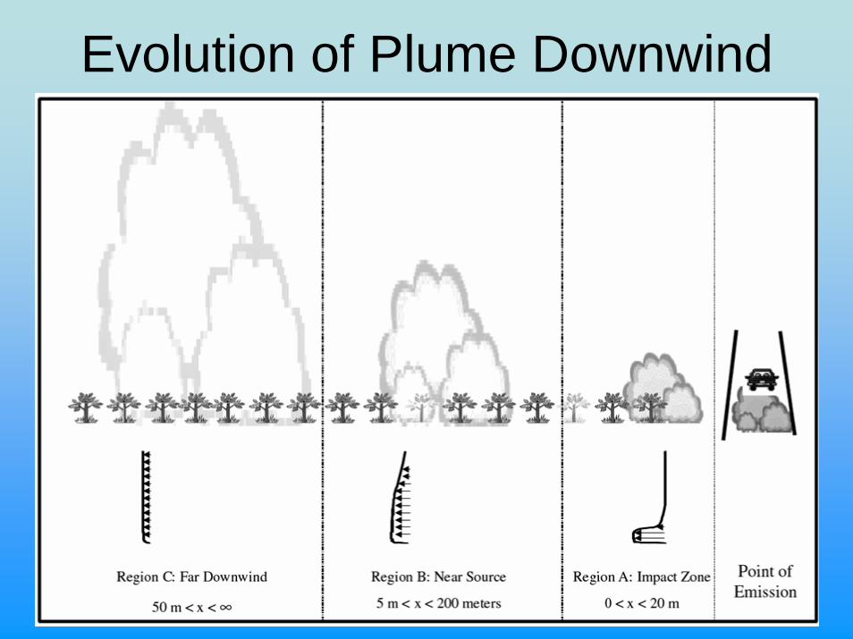
Evolution of Plume Downwind

Approaches
• Modeling– Advantages: Inexpensive, easy to simulate
countless environments– Disadvantages: Who knows if its right!
• Measurement– Disadvantage: Expensive and labor intensive
(e.g. Gillies SERDP), unclear if possible to measure
– Advantage: Results based on a “Real” data

Measurements of TF:>95% at 100 m at Ft. Bliss (Etyemezian et al., 2004)
<20% at 100 m at Dugway Proving Grounds Mock Urban Environment (Veranth et al., 2004)
USDA Proposal Submitted to measure TF in cornfield over growing season (Gillies et al., 2004)
-DT-DT
-DT
-DT
-DT
-DT
-DT
-DT
-DT
-DT
-DT
-DT
-DT
76
517266
128
125
1220570
26040
125
1220570
260-GR
-GR
-GR
-GR
-GR
-GR
-SA
7005,00010,000
DT_1DT_2DT_3
Trailer with visibility
equipment
Generator 200 meters
LIDAR 3,000 meters
Top View
DT_1DT_2DT_3
Trailer with visibility
equipment
Generator 200 meters
LIDAR 3,000 meters
Top View
DT: DustTrakGR: GRIMMSA: Sonic Anemometer
: Wind Vane: Cup Anemometer: Laptop computer
Legend
DT: DustTrakGR: GRIMMSA: Sonic Anemometer
: Wind Vane: Cup Anemometer: Laptop computer
DT: DustTrakGR: GRIMMSA: Sonic Anemometer
: Wind Vane: Cup Anemometer: Laptop computer
Legend

Change in Integrated Horizontal Flux at Ft. Bliss

Comparison of Model and
Measurements

Change is Particle Size DistibutionDownwind

Transportable Fraction Research: Status
• Initial attempt completed (WESTAR report)• Next round of research should target
– Additional field studies– Model improvement– Consideration of vegetation, landscape
Etyemezian V., J. Gillies, H. Kuhns, D. Gillette, S. Ahonen, D. Nikolic, and J. Veranth(2004) Deposition and removal of fugitive dust in the arid southwest United States: Measurements and model results. Acceptd in J. Air & Waste Manage. Assoc.


![INDEX [socwisconsin.org]€¦ · Diversion 362 Engineering 12/2010 Drainage Water Management 554 Engineering 6/2011 Dust Control on Unpaved Roads and Surfaces 373 Engineering / Resources](https://static.fdocuments.us/doc/165x107/5f331c469fbb0b7c86464553/index-diversion-362-engineering-122010-drainage-water-management-554-engineering.jpg)


