Port of Vancouver, WA: Terminal 5 Bulk Potash Handling ... OF VANCOUVER, USA TERMINAL 5 BULK POTASH...
57
PORT OF VANCOUVER, USA TERMINAL 5 BULK POTASH HANDLING FACILITY REQUEST FOR AN INCIDENTAL HARASSMENT AUTHORIZATION UNDER THE MARINE MAMMAL PROTECTION ACT May 2011 Submitted to: National Marine Fisheries Service Office of Protected Resources 1315 East-West Highway Silver Spring, Maryland 20910-3226 Prepared for: Port of Vancouver USA 3103 NW Lower River Road Vancouver, WA 98860 BHP Billiton Canada Inc. Suite 800, 1055 Dunsmuir St. Vancouver, BC V7X 1L2 1111 Main Street • Suite 300 Vancouver, Washington 98660 700 NE Multnomah Street • Suite 900 Portland, Oregon 97232 Phone: 360.823.6100/503.872.4100 Fax: 360.823.6101/503.872.4101
Transcript of Port of Vancouver, WA: Terminal 5 Bulk Potash Handling ... OF VANCOUVER, USA TERMINAL 5 BULK POTASH...
PORT OF VANCOUVER, USA
TERMINAL 5 BULK POTASH HANDLING FACILITY
REQUEST FOR AN INCIDENTAL HARASSMENT AUTHORIZATION
UNDER THE MARINE MAMMAL PROTECTION ACT
May 2011
Submitted to:
National Marine Fisheries Service
Office of Protected Resources
1315 East-West Highway
Silver Spring, Maryland 20910-3226
Prepared for:
Port of Vancouver USA
3103 NW Lower River Road
Vancouver, WA 98860
BHP Billiton Canada Inc.
Suite 800, 1055 Dunsmuir St.
Vancouver, BC V7X 1L2
1111 Main Street • Suite 300
Vancouver, Washington 98660
700 NE Multnomah Street • Suite 900
Portland, Oregon 97232
Phone: 360.823.6100/503.872.4100
Fax: 360.823.6101/503.872.4101
PORT OF VANCOUVER, USA TERMINAL 5 BULK POTASH HANDLING FACILITY Request for an Incidental Harassment Authorization
under the Marine Mammal Protection Act May 2011

Port of Vancouver, USA Terminal 5 Bulk Potash Handling Facility BergerABAM
Request for Incidental Harassment Authorization May 2011
Vancouver, Washington Page i
TABLE OF CONTENTS
1.0 Summary of the Request ................................................................................................................. 1
2.0 Description of the Activity .............................................................................................................. 2
3.0 Project Purpose and Need ............................................................................................................... 4
3.1 Project Setting and Land Use ................................................................................................... 4
3.2 Specific Project Activities .......................................................................................................... 5
3.2.1 Shiploading System ........................................................................................................ 5
3.2.2 Stormwater Outfall ........................................................................................................ 7
3.3 Construction Methods............................................................................................................... 8
4.0 Dates, Duration, and Region of Activity ....................................................................................... 9
4.1 Dates and Duration ................................................................................................................... 9
4.2 Region of Activity .................................................................................................................... 10
5.0 Affected Species and Numbers in the Area ................................................................................ 10
5.1 Steller Sea Lion ......................................................................................................................... 11
5.2 California Sea Lion .................................................................................................................. 11
5.3 Harbor Seal ............................................................................................................................... 11
6.0 Status and Distribution of Affected Species or Stocks .............................................................. 11
6.1 Steller Sea Lion ......................................................................................................................... 11
6.2 California Sea Lion .................................................................................................................. 12
6.3 Harbor Seal ............................................................................................................................... 12
7.0 Type of Incidental Take Authorization Requested ................................................................... 13
7.1 Take Authorization Request .................................................................................................. 13
7.2 Method of Incidental Taking .................................................................................................. 14
7.2.1 Underwater Noise ........................................................................................................ 14
7.2.2 Terrestrial Noise ........................................................................................................... 15
8.0 Number of Marine Mammals that May Be Affected ................................................................. 16
8.1 Steller Sea Lion ......................................................................................................................... 16
8.2 California Sea Lion .................................................................................................................. 16
8.3 Harbor Seal ............................................................................................................................... 17
9.0 Anticipated Impact on Species or Stocks .................................................................................... 18
9.1 Underwater Noise ................................................................................................................... 18
9.2 Terrestrial Noise ....................................................................................................................... 18
Port of Vancouver, USA Terminal 5 Bulk Potash Handling Facility BergerABAM
Request for Incidental Harassment Authorization May 2011
Vancouver, Washington Page ii
9.3 Water Quality ........................................................................................................................... 19
9.4 Direct Habitat Impacts ............................................................................................................ 19
9.5 Ship Strikes ............................................................................................................................... 20
10.0 Anticipated Impact on Subsistence .............................................................................................. 20
11.0 Anticipated Impact on Habitat ..................................................................................................... 20
12.0 Anticipated Impact of Loss or Modification of Habitat ............................................................ 21
13.0 Mitigation Measures ...................................................................................................................... 22
13.1 Impact Avoidance and Minimization Measures ................................................................. 22
13.2 Best Management Practices .................................................................................................... 23
13.2.1 General BMPs ............................................................................................................... 23
13.2.2 Pile Removal BMPs ...................................................................................................... 23
13.2.3 Pile Installation BMPs .................................................................................................. 24
13.2.4 Overwater Concrete BMPs .......................................................................................... 25
13.2.5 Stormwater Outfall Support Structure Construction BMPs .................................. 25
14.0 Arctic Subsistence Uses, Plan of Cooperation ............................................................................ 25
15.0 Monitoring and Reporting Plan ................................................................................................... 27
16.0 Coordinating Research to Reduce and Evaluate Incidental Take ........................................... 27
17.0 Conclusion ....................................................................................................................................... 28
18.0 Literature Cited .............................................................................................................................. 28
TABLE OF TABLES
Table 1. Summary of Pile Installation Activities ................................................................................... 3
Table 2. Marine Mammal Species Addressed in this IHA Request .................................................. 10
Table 3. Underwater Injury and Disturbance Threshold Decibel Levels for Marine Mammals .. 14
Table 4. Terrestrial Injury and Disturbance Threshold Decibel Levels for Pinnipeds ................... 14
Table 5. Maximum Sound Levels for Impact Driving and Vibratory Installation .......................... 14

Port of Vancouver, USA Terminal 5 Bulk Potash Handling Facility BergerABAM
Request for Incidental Harassment Authorization May 2011
Vancouver, Washington Page iii
TABLE OF FIGURES
Figure 1. Vicinity Map
Figure 2. Aerial Photograph
Figure 3. Site Plan
Figure 4. Marine Structures – Plan View
Figure 5. Marine Structures – Cross-Section
Figure 6. Shiploader – Cross-Section
Figure 7. Stormwater Outfall Upgrade
Figure 8. Aquatic Impacts
Figure 9. Action Area
APPENDICES
Appendix A. Figures
Appendix B. Photosheets
Appendix C. Marine Mammal Monitoring Plan

Port of Vancouver, USA Terminal 5 Bulk Potash Handling Facility BergerABAM
Request for Incidental Harassment Authorization May 2011
Vancouver, Washington Page 1
REQUEST FOR INCIDENTAL HARASSMENT AUTHORIZATION
UNDER MARINE MAMMAL PROTECTION ACT
PORT OF VANCOUVER TERMINAL 5 BULK POTASH HANDLING FACILITY
1.0 SUMMARY OF THE REQUEST
This report was prepared for the Port of Vancouver USA (Port) and BHP Billiton Canada
Inc. (BHP Billiton) for development of the Terminal 5 Bulk Potash Handling Facility
(proposed project) to be constructed and operated by BHP Billiton Canada Inc. or an
affiliate of the BHP Billiton Group.
The Port requests that the National Oceanic and Atmospheric Administration’s National
Marine Fisheries Service (NMFS) issue an incidental harassment authorization (IHA) for
incidental take (in the form of Level B harassment) of Steller sea lion, California sea lion,
and harbor seal during pile driving activities conducted during the construction of the
Terminal 5 Bulk Potash Handling Facility in the Columbia River in Vancouver,
Washington. 1
BHP Billiton is proposing to lease part of Terminal 5 located at the Port for the purpose
of establishing a bulk handling export facility to allow shipping of approximately 8
million tonnes per annum (Mtpa) of potash to global markets. The facility will accept
potash shipped by rail from potash mines located in Saskatchewan, Canada. On-site
infrastructure is proposed to enable the unloading of rail cars into on-site storage, and
the conveyance of potash to vessels at a new berth to be constructed on the Columbia
River adjacent to the facility. The on-site infrastructure will include dedicated rail
facilities for BHP Billiton and the construction and installation of materials handling
equipment, storage structures, utilities, and internal access roads on the site, a marine
berth with ship loaders and other related ancillary infrastructure.
Construction of the project will require pile installation below the ordinary high water
mark (OHWM) of the Columbia River, which has the potential to result in effects to
marine mammals. The potential impacts of the proposed project on marine mammals
include noise, water quality, and direct habitat effects associated with construction of the
marine structures. Of these potential effects, temporarily elevated noise from vibratory
and impact pile driving is the only impact that could result in take. The potential for the
project to affect marine mammals in the Exclusive Economic Zone (EEZ) was also
evaluated, but the analysis showed that the project would not result in a measurable
increase in the number of marine mammal ship strikes within the EEZ.
Three marine mammal species, subspecies, or distinct population segments (DPSs) have
known distribution ranges that include the portion of the Columbia River in which
1 Section 101(a)(5) (A-D) of the MMPA, as amended (16 U.S.C 1371 (a)(50).
Port of Vancouver, USA Terminal 5 Bulk Potash Handling Facility BergerABAM
Request for Incidental Harassment Authorization May 2011
Vancouver, Washington Page 2
construction activities will occur. These are Steller sea lion (Eumatopius jubatus),
California sea lion (Zalophus californianus), and harbor seal (Phoca vitulina ssp. richardsi).
Temporarily elevated terrestrial and underwater noise during vibratory and impact pile
driving has the potential to result in take in the form of Level B harassment (behavioral
disruption) of marine mammals that may be present during construction. Level A
harassment (harassment resulting in injury or direct mortality) is not expected to occur
as a result of the proposed action, as a marine mammal monitoring plan will be
implemented to effectively minimize the possibility of any marine mammals being
exposed to terrestrial or underwater noise levels above the injury threshold established
by NMFS.
This request has three appendices: Appendix A contains the figures, Appendix B
provides a selection of site photographs, and Appendix C contains the marine mammal
monitoring plan.
2.0 DESCRIPTION OF THE ACTIVITY
A detailed description of the specific activity or class of activities that can be expected to
result in incidental taking of marine mammals.2
The Terminal 5 Bulk Potash Handling Facility project will require work in waters that
support marine mammal species. The federal Marine Mammal Protection Act (MMPA)
prohibits the taking of marine mammals, defined as ‚harass, hunt, capture or kill, or
attempt to harass, hunt, capture or kill,‛ except under certain situations. Section 101
(a)(5)(D) allows the issuance of an IHA provided an activity will have negligible impacts
to marine mammals and will not adversely affect subsistence uses of marine mammals.
The project timing, duration, and activities have been analyzed for their potential to
result in incidental taking of marine mammals protected under the MMPA. The analysis
determined that the only project component that has the potential to result in take is
temporarily elevated underwater noise during the impact and vibratory pile driving
associated with the construction of the shiploaders, marine berthing facilities, and
stormwater outfall. These activities have the potential to result in Level B harassment
(behavioral disruption) only, as a monitoring plan will be implemented to effectively
minimize the possibility of marine mammals being exposed to Level A harassment
(harassment resulting in injury or direct mortality).
The project requests an IHA for incidental take due to potential Level B harassment of
three marine mammal species that may occur in the project vicinity: Steller sea lion,
2 The italicized material throughout this document discusses what should be included in an IHA request
and is drawn from the NOAA Fisheries website,
http://www.nmfs.noaa.gov/pr/permits/incidental.htmhttp://www.nmfs.noaa.gov/pr/permits/incidental.
htm.

Port of Vancouver, USA Terminal 5 Bulk Potash Handling Facility BergerABAM
Request for Incidental Harassment Authorization May 2011
Vancouver, Washington Page 3
California sea lion, and harbor seal. Although only the pile driving activities associated
with the shiploaders, marine berthing facilities, and outfall have the potential to result in
Level B take, a summary of the entire project is provided here for completeness.
The proposed project will consist of the following elements:
Relocating an existing track (4000) and constructing an additional loop track (4102)
The construction of:
o A railcar dumper building,
o A potash storage building,
o An administration and maintenance building,
o A potential fuel station,
o Conveyors, potash transfer towers, and other transfer facilities,
o A surge bin tower,
o Shiploaders and marine berthing facilities,
o On land access ways,
o New (or upgrading of) utilities, including stormwater, water, sanitary sewer,
electrical, telecommunications, and natural gas
The relocation of other utilities where conflicts occur with proposed construction
activities
Site grading activities including possible pre-load material
The potential installation of a temporary batch plant during construction
Temporary construction trailers
Mitigation actions
Additional information regarding the specific project elements with the potential for an
incidental taking of marine mammals included in section 7.2. Table 1 provides a
summary of the pile installation activities proposed to occur during November 1, 2012–
February 28, 2013.
Table 1. Summary of Pile Installation Activities
Activity Number of Piles (maximum) Location
Install permanent piles for ship
loader and berth.
100, 36- to 40 in (914- to
1,016mm) steel pipe piles
Port of Vancouver Terminal 5,
Columbia River Mile 103.3
Install and remove temporary
piles during construction of ship
loader and berth.
95, 18- to 24-in (457- to 610-
mm) steel pipe piles
Port of Vancouver Terminal 5,
Columbia River Mile 103.3
Install permanent piles for
stormwater outfall
8, 16-in steel H-piles Port of Vancouver Terminal 5,
Columbia River Mile 103.3
Port of Vancouver, USA Terminal 5 Bulk Potash Handling Facility BergerABAM
Request for Incidental Harassment Authorization May 2011
Vancouver, Washington Page 4
3.0 PROJECT PURPOSE AND NEED
The purpose of the proposed project is to construct a facility designed to receive and
store bulk quantities of potash and then ship it to various international destination ports.
In order to accomplish the receipt, storage, and transfer of potash, the proposed project
will involve the construction and installation of materials handling equipment,
structures, utilities, and roads on the site
The potash mining projects in Saskatchewan are being developed to meet the demand
for potash in emerging markets such as China, India, and Southeast Asia where
economic growth is driving increased agricultural production. The proposed Port
project is needed to support those mines and the project, and the proposed project site
provides the best combination of infrastructure and facilities to serve these intended
markets.
3.1 Project Setting and Land Use
The proposed project is located at 5701 NW Lower River Road in Vancouver,
Washington. The proposed project site is located approximately 3 miles (4.8 km)
northwest of downtown Vancouver, Washington, and is composed of submerged, tidal,
nearshore, and upland lands (Figure 1).
The site is located along a 2,300-foot (ft) (701-meter [m]) long section of shoreline owned
by the Port on the north bank of the Columbia River across from Hayden Island
centered approximately at river mile (RM) 103.3. The site is a heavy industrial site,
which had been used since the 1940s for aluminum smelting as well as for the
fabrication and outdoor storage of aluminum ingots. The sediment adjacent to the
project site was remediated in 2009 as part of the Alcoa Sediment Remediation project
under the oversight of the Washington State Department of Ecology (Ecology) and the
provisions of the Washington State Sediment Management Standards and Model Toxics
Control Act. Polychlorinated biphenyl (PCB) exceedances of project-specific cleanup
standards were addressed during the remediation through dredging. The sediment
adjacent to the project site achieved a clean closure designation from Ecology as a result
of a successful remediation (Ecology 2010). The site is presently used for storage of large
windmill components.
Uses surrounding the Terminal 5 site are primarily industrial. The following uses border
the site: the Clark Public Utilities (CPU) River Road Generating Plant is approximately
100 ft (30.5 m) to the northeast, the Tidewater Barge Company is approximately 100 ft
(30.5 m) to the west, and the Clark County Correctional Facility is approximately 600 ft
(183 m) to the east. The portions of Terminal 5 not encompassed by the proposed project
are presently used for outdoor storage of wind turbine towers. The site is bordered to
the south by the Columbia River and to the east by the Port’s Terminal 4 property,
which is predominantly used for staging and distributing Subaru vehicles and cargo
storage (Figure 2).

Port of Vancouver, USA Terminal 5 Bulk Potash Handling Facility BergerABAM
Request for Incidental Harassment Authorization May 2011
Vancouver, Washington Page 5
This reach of the Columbia River is approximately 3,000 ft (914 m) wide on average, and
is surrounded by industrial areas (Figures 2-3). Most of the marine portion of the project
is located on submerged and tidal lands. The Port has a Port Management Agreement
with the Washington State Department of Natural Resources (DNR) for the submerged
aquatic lands. A portion of the project will occur within designated shorelines of the
state of Washington, as regulated by local governments under the Shoreline
Management Act (SMA). All of the shoreline is within the jurisdiction of the City of
Vancouver (City). Under the City‘s Shoreline Management Master Program, the
designation for this area is Urban High Intensity, and the area is zoned as Heavy
Industrial.
3.2 Specific Project Activities
The proposed action consists of both upland and marine components (Figures 4-8). As
stated in section 7.2, the analysis provided in this document has determined that the
only project component that has the potential to result in take is temporarily elevated
underwater noise during impact and vibratory pile driving. These activities have the
potential to result in Level B harassment (behavioral disruption) only, as a monitoring
plan will be implemented to effectively minimize marine mammal exposure to Level A
harassment (harassment resulting in injury or direct mortality). The rest of the in-water
and over-water components of the project are provided here for completeness.
All permanent piles proposed for in-water work will consist of 36- to 40 in (914- to 1,016
mm) diameter steel pipes for the shiploader and berth and steel H-piles for the
stormwater outfall. Approximately 108 permanent and 94 temporary piles will be
installed during the approved in-water work window, which is anticipated to be
between November 1, 2012 and February 28, 2013. Installation will occur through both
vibratory and impact methods as described in section 3.3.
3.2.1 Shiploading System
The shiploading system will be designed to serve the facility at full build out (final
capacity of approximately 8 million tonnes per annum [Mtpa]), and to accommodate
vessels capable of navigating the Columbia River shipping channel, ranging in size from
20,000 deadweight tonnage (DWT) to 60,000 DWT. Potash will be transported to a dual-
quadrant shiploader system (Figures 4 and 6) on a fully enclosed belt conveyor system,
in order to prevent the ingress of moisture and foreign objects and to minimize fugitive
dust emissions. The berth structures for the dual-quadrant shiploading system will
consist of two shiploader quadrant beams and pivot supports, complete with access
roadway, the central maintenance access platform, four berthing dolphins, two mooring
dolphins, and interconnecting catwalks. Shiploaders will be designed to minimize the
length of belt exposed to the environment and will be equipped with soft loading,
cascade-style chutes to minimize dust generation. The shiploader pivot supports will be
sized to accommodate the shiploader feed conveyor transfer and the electrical substation
for the wharf facilities.
Port of Vancouver, USA Terminal 5 Bulk Potash Handling Facility BergerABAM
Request for Incidental Harassment Authorization May 2011
Vancouver, Washington Page 6
The deck structure will be constructed of reinforced concrete pile caps, precast box
beams, and composite concrete topping. Reinforced concrete up-stands will support the
pivot loads for the quadrant loaders. The quadrant beams will consist of short-length
concrete box beams with extended flanges for walkways on both sides of the crane rail.
The berthing dolphins are piled structures with concrete pile caps, and will be equipped
with fender systems and mooring bollards for ship mooring lines. The mooring dolphins
are also piled structures with concrete pile caps, and will be placed beyond the berthing
dolphins to accommodate bow and stern mooring lines.
The shiploader feed conveyors will be self-supporting spans, using steel trusses, and
will be supported on piled bents and cast-in-place reinforced concrete pile caps.
The types and numbers of piles for each project element are discussed below.
3.2.1.1 Quadrant Beams and Pivot Supports
The dual quadrant shiploaders will be supported by pivot pile caps at the shoreline and
by pile-supported quadrant beams at the berth. Each pivot pile cap will be cast-in-place
concrete and will be topped by a concrete pivot bearing upstand that supports the end of
the shiploader.
Two pile-supported quadrant beams will support the crane rail, allowing the shiploader
truck assemblies to travel along an arc to load the multiple holds on the vessels (Figure
4). Each of the quadrant beams will consist of cast-in-place concrete pile caps. Nine pre-
cast concrete box girders will rest on the pile cap to support the crane rail and provide a
maintenance walkway.
A total of 36, 36- to 40-in (914- to 1,016-mm) diameter steel piles will be installed
between November 1, 2012 and February 28, 2013 for this element.
3.2.1.2 Mooring and Berthing Dolphins and Platform
For vessel mooring, four breasting dolphins, and one center platform (for mooring and
vessel access) will be constructed. Each of the breasting dolphins and the center platform
will include two cone rubber fenders and steel fender panels attached one above the
other to a precast concrete panel (Figures 4-5). This positioning will allow the berth to
operate at a variety of river levels. Each breasting dolphin will consist of five 36- to 40-in
(914- to 1,016-mm) diameter steel batter piles and one 36-in (914 mm) diameter steel
plumb pile supporting a cast-in-place concrete pile cap.
The center platform will be connected to the inner two breasting dolphins by an 8-ft (2.4
m) wide walkway constructed of precast concrete box beams. The two outer and two
inner breasting dolphins will be connected by a 6-ft 6¾-in (2 m) steel grated walkway
approximately 70 ft (21.3 m) in length. The center platform will consist of six 36- to 40-in
(914- to 1,016-mm) diameter steel plumb piles supporting a cast-in-place concrete pile
cap.
Port of Vancouver, USA Terminal 5 Bulk Potash Handling Facility BergerABAM
Request for Incidental Harassment Authorization May 2011
Vancouver, Washington Page 7
Two mooring dolphins will be constructed upstream of the shiploader to provide
anchoring points for bow or stern lines. Each mooring dolphin will consist of four 36- to
40-in (914- to 1,016-mm) diameter steel batter piles supporting a cast-in-place concrete
pile cap. Access to the mooring dolphins will be provided from the shiploader quadrant
beams by 6-ft-6¾-in (2 m) wide steel grated walkways. Downstream anchor points will
be provided by newly installed mooring points on the existing dock. Up to four
additional anchoring piles consisting of 36- to 40- in (914- to 1,016-mm) steel pipe piles
will be installed to transfer the mooring loads to the shoreline.
A total of 42, 36- to 40-in (914- to 1,016-mm) diameter steel piles will be installed
between November 1, 2012 and February 28, 2013 for this element.
3.2.1.3 Access Trestles
To provide vehicle and equipment access to the center platform and the shiploaders, two
access trestles will be provided that converge at a central support dolphin with a single
trestle extending to the center platform to provide access to the vessel (Figure 4). The
two trestle legs are necessary to provide maintenance access to the shiploaders. When
maintenance is necessary, the shiploaders will be moved to the most inward position
parallel to the access trestle legs. Service vehicles and cranes will be located on the trestle
to service the equipment. The maintenance roadway will accommodate a 44-ton (40-
metric tonne) mobile crane.
The trestle will be 24 ft (7.3 m) wide and constructed of pre-cast concrete box beams
supported on steel pipe piles with steel bull rail. Each initial leg will be supported on
land by a pile-supported abutment located above the OHWM. Each trestle leg will be
supported by two 36- to 40-in (914- to 1,016-mm) diameter steel pipe piles. The central
trestle will be supported by the central support dolphin and the center berthing dolphin.
A total of 10, 36- to 40-in (914- to 1,016-mm) diameter steel piles will be installed
between November 1, 2012 and February 28, 2013 for this element.
3.2.2 Stormwater Outfall
The stormwater management design for the project requires an upgrade to the existing
stormwater outfall on the site. Due to the need for increased capacity for the entire
redeveloped Terminal 5 the project will also include the installation of a larger
stormwater outfall. The existing stormwater outfall will be upsized to a 48- to 60-in
(1219-1524 mm) diameter pipe (Figure 8). The new outfall will replace the existing
outfall but will be located downstream from the existing outfall. The existing outfall will
be removed and decommissioned once the new outfall is operational.
The outfall pipe will be supported on a pile and beam system. With this system, a pair of
H-piles would be driven at each joint in the run of an unburied (supported) storm drain
pipe. The piling would be driven to adequate depth to achieve fixity and a steel beam
would be bolted across the two piles. The storm drain pipe would bear on these beams
and would be held in place with a saddle and/or strap structurally connected to the
Port of Vancouver, USA Terminal 5 Bulk Potash Handling Facility BergerABAM
Request for Incidental Harassment Authorization May 2011
Vancouver, Washington Page 8
beam. This technique requires little earthwork or disturbance to the river bottom, but it
does entail pile installation in the river. These piles can be embedded using vibratory
equipment without proofing with an impact hammer. Areas disturbed by the outfall
construction will be restored by either replacing the riprap or planting/seeding the
exposed earth. Appurtenant structures, such as manholes, will be required to provide
permanent access.
A total of 8, 16-in steel H-piles will be installed between November 1, 2012 and February
28, 2013 for this element.
3.3 Construction Methods
The in-water and overwater construction methods for the various components of the
marine structures (i.e., shiploaders and support structures, mooring and berthing
dolphins and platform, and access trestles) include pile installation and removal as well
as over-water work to install the marine structures. These activities are described in the
following sections.
Pile removal and pile installation activities will occur below the OHWM of the Columbia
River. Piles will be removed by vibratory extraction or by pulling them directly with a
crane mounted on a barge. If a pile breaks above or below the mudline, it will be cut
with a pneumatic underwater chainsaw or pushed in to the sediment consistent with
agency-approved BMPs. Piles will be installed with a combination of impact and
vibratory driving.
The project requires the installation of approximately 116, 36-to 40-in (914- to 1,016-mm)
steel piles (102 planned and 14 contingency). Of these, approximately 100 will be located
below the OHWM of the Columbia River. The diameter of the piles is based on critical
design considerations, including soil liquefaction and associated lateral spreading,
which were evaluated for pile structural stability. Due to the potential for seismically
induced lateral spreading, a very high pile structural capacity is required. To achieve the
required structural capacity, a 36- to 40-in (914- to 1,016-mm) diameter steel pile is
necessary. Piles will be open-ended, and in order to achieve sufficient structural capacity
it may be necessary to excavate the material from the inside of the pile casing once
installed, and fill the excavated pile casing with concrete. If this is necessary, the
installed piles would be excavated with an auger or similar method, using appropriate
BMPs to capture all excavated material. Concrete would be installed via the tremie
method, to minimize the possibility of any concrete coming into contact with the water.
The in-water piles will be installed by a crane located on a derrick barge with piles and
materials stored on a work barge; a tugboat will also be required. Shoreline piles are
expected to be installed from shore by land-based equipment.
To the greatest extent possible, piles will be driven using a vibratory hammer. Piles will
be driven to refusal with the vibratory hammer, and then to final tip elevations with an
Port of Vancouver, USA Terminal 5 Bulk Potash Handling Facility BergerABAM
Request for Incidental Harassment Authorization May 2011
Vancouver, Washington Page 9
impact hammer. Temporary piles are expected to be used to support the guides that will
position and align the permanent piles and for the concrete formwork. Three or four
piles are expected to be installed during construction in up to 23 different locations to
total approximately 95 temporary piles. These temporary piles will be 18- to 24-in (457 to
610 mm) diameter open-ended steel pipe and will be driven solely with a vibratory
hammer.
3.3.1.1 Vibratory Driving
The vibratory hammer method is a common technique used to drive piles where the
type of sediment allows it. This process begins by placing a choker around the pile and
lifting it into vertical position with the crane. The pile is then lowered into position and
set in place at the mudline. The pile is held steady while the vibratory hammer drives it
to the required tip elevation. For this project, it is expected that the vibratory hammer
will be used to drive all of the permanent structural piles to the extent practicable as well
as all of the approximately 95 temporary piles.
3.3.1.2 Impact Driving
Following vibratory driving to refusal (the point at which the pile will no longer
advance with the vibratory hammer), the project will use an impact hammer to drive
piles to their final tip elevations. An impact hammer will also be needed to ‚proof‛ a
portion of the structural piles. Proofing is the process of striking piles with an impact
hammer to verify their load-bearing capacity.
An impact hammer is a large steel device that works with a hydraulic or diesel piston.
Impact hammers have guides (called a lead) that hold the hammer in alignment with the
pile while the heavy piston moves up and down, striking the top of the pile and driving
it into the substrate from the downward force of the hammer on the top of the pile.
Where the impact hammer is used, a bubble curtain or other similar noise attenuation
method (such as sound attenuation pile caps, increased hammer size, etc.) will be
employed.
4.0 DATES, DURATION, AND REGION OF ACTIVITY
The date(s) and duration of such activity and the specific geographical region where it
will occur.
4.1 Dates and Duration
It is anticipated that pile installation activities will begin November 1, 2012. Pile
installation will be restricted to the in-water work window for the project. The current
WDFW-recommended work window for this area is November 1–February 28 annually.
If pile installation cannot be completed within a single in-water work window an
additional IHA request will be made for subsequent activities.
During this time period 1 to 2 piles will be installed per day. The exact duration of the
pile installation activity occurring each day will vary depending on the installation
Port of Vancouver, USA Terminal 5 Bulk Potash Handling Facility BergerABAM
Request for Incidental Harassment Authorization May 2011
Vancouver, Washington Page 10
procedures and geotechnical conditions encountered. It is estimated that each pile will
require between 2 and 3 hours of vibratory installation and between 1 and 2 hours of
impact driving to install.
4.2 Region of Activity
The proposed project will occur at the Port’s Terminal 5, which is located at 5701 NW
Lower River Road in Vancouver, Washington at approximately Columbia RM 103.3.
The project will occur within the NE and NW quarters of Section 19, T2N R1E
Willamette Meridian (WM); in the SE and SW quarters of Section 18, T2N R1E W.M.; the
SE quarter of Section 13, T2N R1W W.M.; the SE quarter of Section 31 T3N R1E W.M.;
the NE quarter of Section 28 T2N R1E W.M; and the SE and SW quarters of Section 12
T2N R1W W.M.
The ‚action area‛ (as defined in the biological evaluation *BE]; Anchor QEA 2011), is the
extent of the detectable effects that could occur as a result of the project, and is defined
for this project by the extent of temporarily elevated underwater noise that could occur
during pile driving (Figure 9).
5.0 AFFECTED SPECIES AND NUMBERS IN THE AREA
The marine mammal species that may occur within the activity area and their
distribution.
As stated, three marine mammal species, subspecies, or DPSs have known distribution
ranges that include the portion of the Columbia River in which construction activities
will occur (Table 2). Table 2 lists the marine mammal species addressed in this IHA
request.
Table 2. Marine Mammal Species Addressed in this IHA Request
Species Name Listing
Status*
Critical
Habitat
Run Timing Common Name Scientific Name
Harbor Seal (Phoca vitulina ssp. richardsi) Not listed None January–May
California Sea Lion (Zalophus californianus) Not listed None January–May
Eastern DPS Steller Sea Lion (Eumatopius jubatus) Threatened Designated January–May
* Under the Endangered Species Act (ESA)
All of the marine mammals addressed in this document are pinniped species, which use
the portion of the Columbia River within the action area as a seasonal migration corridor
to and from Bonneville Dam. The Corps has monitored pinniped presence and salmonid
predation at Bonneville Dam (RM 146) since 2002, and its recently published evaluation
of pinniped predation in the Bonneville Dam tailrace (Stansell et al. 2010) is the primary
source of data regarding pinniped presence, numbers, and run timing within the action
area. Supporting evidence comes from Oregon Department of Fish and Wildlife (ODFW)
marine mammal biologists (pers. comm., Bryan Wright, October 20, 2010). In its 2000
Atlas of Seal and Sea Lion Haulout Sites in Washington (Jeffries et al. 2000), WDFW did

Port of Vancouver, USA Terminal 5 Bulk Potash Handling Facility BergerABAM
Request for Incidental Harassment Authorization May 2011
Vancouver, Washington Page 11
not identify any significant haulout sites upstream of the Cowlitz River on the Columbia
River, so the numbers recorded at the dam are presumed to be a close approximation of
the numbers of individuals that may be present within the action area.
Pinniped species with known distribution within the action area are harbor seal,
California sea lion, and Steller sea lion. The Corps reports that in 2010, a minimum
estimated total of 166 pinnipeds were recorded at Bonneville Dam, consisting of 89
California sea lions and 75 Steller sea lions. The remaining two individuals presumably
were harbor seals (Stansell et al. 2010).
5.1 Steller Sea Lion
Since 2002 when record-keeping began, Steller sea lions have been sighted rarely at
Bonneville Dam, with fewer than 10 individuals recorded in most years. However, since
2008, the numbers of Steller sea lions documented at the dam have increased steadily
and, in 2010, 75 individuals were documented. No Steller sea lion haulouts or haulout
habitat are documented within the action area, so any individuals present during
construction or operation of the facility will be moving quickly through the action area.
5.2 California Sea Lion
California sea lions have historically been the most frequently observed pinniped
species at Bonneville Dam (Stansell et al. 2010). In 2010, 89 individuals were identified, a
slight increase from the 54 recorded in 2009. The largest number (104) of California sea
lions was recorded in 2003. There are no California sea lion haulouts within the action
area, so any individuals present during construction or operation will likely be moving
quickly through the action area.
5.3 Harbor Seal
Harbor seals are documented only infrequently as far upstream in the Columbia River
as Vancouver. The nearest documented haulout is near Wallace Island, near RM 43,
which is approximately 60 miles (97 km) downstream of the proposed action area (pers.
comm., Bryan Wright, October 20, 2010). In each year since 2002, the Corps has
documented no more than three harbor seals at Bonneville Dam, and in some years, only
one or two individuals are identified. The individual harbor seals that may be present
within the action area will likely be moving rapidly through on their way to or from
Bonneville Dam.
6.0 STATUS AND DISTRIBUTION OF AFFECTED SPECIES OR STOCKS
A description of the status of the affected species or stocks of marine mammals likely to be
affected by such activities.
6.1 Steller Sea Lion
Steller sea lions range along the North Pacific Rim from northern Japan to California,
with centers of abundance and distribution in the Gulf of Alaska and Aleutian Islands,
respectively. Two separate stocks or DPSs of Steller sea lions have been recognized
Port of Vancouver, USA Terminal 5 Bulk Potash Handling Facility BergerABAM
Request for Incidental Harassment Authorization May 2011
Vancouver, Washington Page 12
within US waters: an eastern US stock, which includes animals east of Cape Suckling,
Alaska, and a western US stock, which includes animals at and west of that location
(NMFS 2008a). The Steller sea lion stock that migrates in the Columbia River is part of
the Eastern DPS. The species is not known to migrate, but individuals disperse widely
outside the breeding season (late May–early July), thus potentially intermixing with
animals from other areas. Despite the wide-ranging movements of juveniles and adult
males in particular, exchange between rookeries by breeding adult females and males
(other than between adjoining rookeries) appears low, although males have a higher
tendency to disperse than females (NMFS 2008a). Habitat requirements include islands
or isolated shoreline areas for breeding and undisturbed water for feeding.
The eastern DPS of Steller sea lions is listed as threatened under the ESA, and is
therefore designated as ‚depleted‛ under the MMPA. As a result, this stock is classified
as a strategic stock. The eastern stock of Steller sea lion has been proposed as a candidate
for removal from listing under the ESA by the Steller sea lion recovery team and NMFS
(NMFS 2008a), based on its annual rate of increase of approximately 3% since the mid-
1970s. Although the stock size has increased, its status relative to its optimum
sustainable population (OSP) level is unknown. The overall annual rate of increase of
3.1% throughout most of the range of the eastern DPS stock has been consistent and long
term, and may indicate that this stock is reaching OSP size (NMFS 2008a, Pitcher et al.
2007).
6.2 California Sea Lion
California sea lions on the West Coast of the US are divided into three stocks, based on
the locations of breeding concentrations on islands located in southern California,
western Baja California, and the Gulf of California: 1) the US stock, which begins at the
US/Mexico border and extends northward into Canada; 2) the western Baja California
stock, which extends from the US/Mexico border to the southern tip of the Baja
California peninsula; and 3) the Gulf of California stock, which includes the Gulf of
California from the southern tip of the Baja California peninsula and across to the
mainland and extends to southern Mexico (NMFS 2007b).
California sea lions in the US are not listed as ‚endangered‛ or ‚threatened‛ under the
ESA or as ‚depleted‛ under the MMPA. Although current total human-caused mortality
is unknown (due to a lack of data from the California set gillnet fishery that historically
has been the largest source of human-caused mortalities), California sea lions are not
considered a ‚strategic‛ stock under the MMPA because (based on historical takes in the
set gillnet fishery and current levels of fishing effort) total human-caused mortality is
still likely to be fewer than the potential biological removal (PBR) of 8,511 individuals
(NMFS 2007b).
6.3 Harbor Seal
NMFS defines seven stocks of harbor seals throughout the United States, with three
recognized along the West Coast: 1) the Washington inland stock; 2) the

Port of Vancouver, USA Terminal 5 Bulk Potash Handling Facility BergerABAM
Request for Incidental Harassment Authorization May 2011
Vancouver, Washington Page 13
Oregon/Washington coastal stock; and 3) the California stock. The stock that is present
in the Columbia River is the Oregon/Washington coastal stock.
According to the most recent status report published by NMFS (NMFS 2007a), harbor
seals are not considered to be ‚depleted‛ under the MMPA nor are they listed as
‚threatened‛ or ‚endangered‛ under the ESA. Based on currently available data, the
level of human-caused mortality and serious injury is not known to exceed the PBR level
of 1,343 harbor seals per year. Therefore, the Oregon/Washington Coast stock is not
classified as a ‚strategic‛ stock, and is within its OSP level (NMFS 2007a, Jeffries et al.
2000, Brown et al. 2005).
7.0 TYPE OF INCIDENTAL TAKE AUTHORIZATION REQUESTED
The type of incidental taking authorization that is being requested (i.e., takes by
harassment only, takes by harassment, injury and/or death), and the method of incidental
taking.
The MMPA prohibits the ‚take‛ of marine mammals unless the take is exempted or
authorized. The MMPA defines (50 CFR, Part 216, Subpart A, Section 216.3-Definitions)
‚take‛ as ‚to harass, hunt, capture, or kill, or attempt to harass, hunt, capture or kill any
marine mammal.‛ The MMPA further defines ‘‘harassment’’ as:
… any act of pursuit, torment, or annoyance which (Level A Harassment) has
the potential to injure a marine mammal or marine mammal stock in the wild; or,
(Level B Harassment) has the potential to disturb a marine mammal or marine
mammal stock in the wild by causing disruption of behavioral patterns,
including, but not limited to, migration, breathing, nursing, breeding, feeding, or
sheltering….3
7.1 Take Authorization Request
Under Section 101 (a)(5)(D) of the MMPA, the project requests an IHA for takes by
behavioral harassment (Level B harassment) during pile installation operations
associated with the construction of the proposed project from November 2012 to
November 2013. The project requests an IHA for incidental take of marine mammals
described within this application for 1 year. It is anticipated that the Port will request an
additional IHA until the pile installation is completed, anticipated to be in 2014. At this
time, the Port is not requesting a multiyear letter of authorization (LOA) because the
activities described are not expected to rise to the level of injury or death, which would
require an LOA.
3 NOAA Fisheries Office of Protected Resources website, http://www.nmfs.noaa.gov/pr/glossary.htm#h
Port of Vancouver, USA Terminal 5 Bulk Potash Handling Facility BergerABAM
Request for Incidental Harassment Authorization May 2011
Vancouver, Washington Page 14
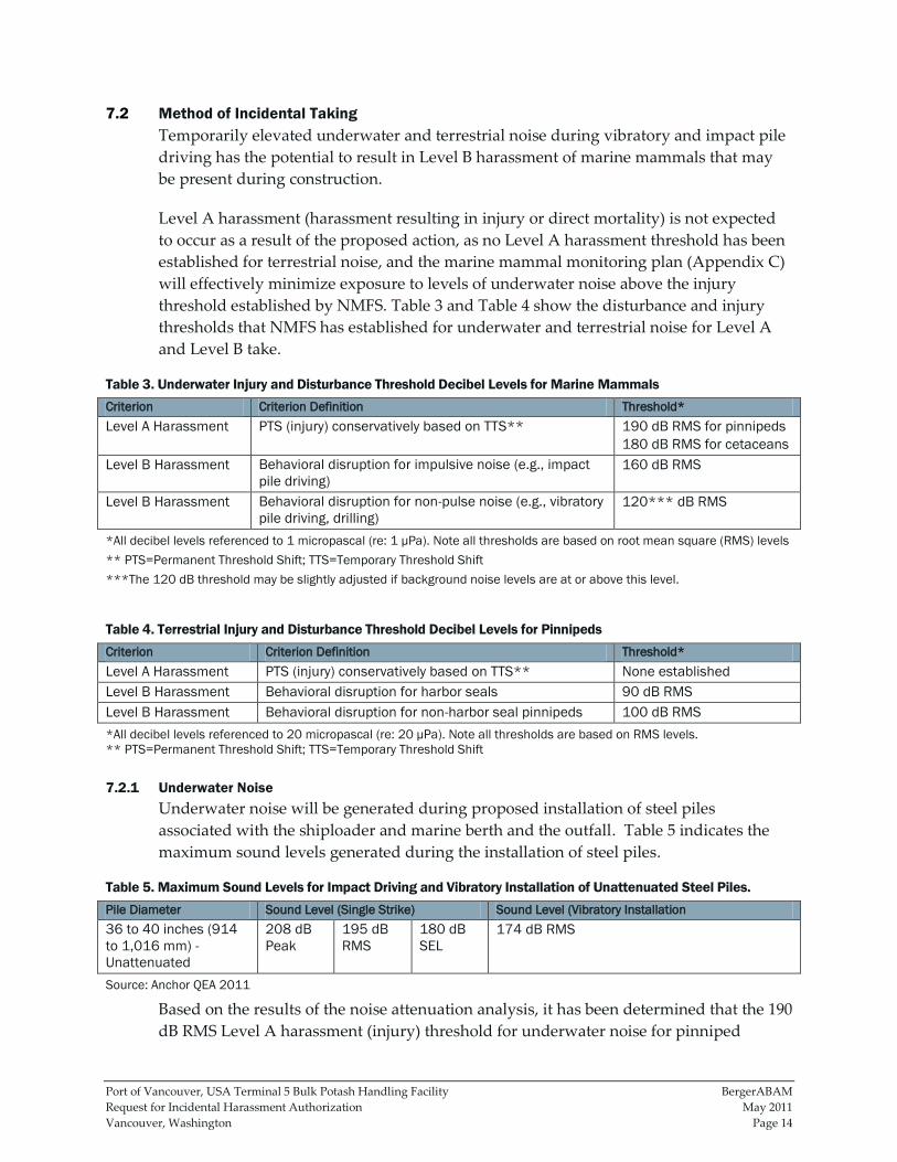
7.2 Method of Incidental Taking
Temporarily elevated underwater and terrestrial noise during vibratory and impact pile
driving has the potential to result in Level B harassment of marine mammals that may
be present during construction.
Level A harassment (harassment resulting in injury or direct mortality) is not expected
to occur as a result of the proposed action, as no Level A harassment threshold has been
established for terrestrial noise, and the marine mammal monitoring plan (Appendix C)
will effectively minimize exposure to levels of underwater noise above the injury
threshold established by NMFS. Table 3 and Table 4 show the disturbance and injury
thresholds that NMFS has established for underwater and terrestrial noise for Level A
and Level B take.
Table 3. Underwater Injury and Disturbance Threshold Decibel Levels for Marine Mammals
Criterion Criterion Definition Threshold*
Level A Harassment PTS (injury) conservatively based on TTS** 190 dB RMS for pinnipeds
180 dB RMS for cetaceans
Level B Harassment Behavioral disruption for impulsive noise (e.g., impact
pile driving)
160 dB RMS
Level B Harassment Behavioral disruption for non-pulse noise (e.g., vibratory
pile driving, drilling)
120*** dB RMS
*All decibel levels referenced to 1 micropascal (re: 1 µPa). Note all thresholds are based on root mean square (RMS) levels
** PTS=Permanent Threshold Shift; TTS=Temporary Threshold Shift
***The 120 dB threshold may be slightly adjusted if background noise levels are at or above this level.
Table 4. Terrestrial Injury and Disturbance Threshold Decibel Levels for Pinnipeds
Criterion Criterion Definition Threshold*
Level A Harassment PTS (injury) conservatively based on TTS** None established
Level B Harassment Behavioral disruption for harbor seals 90 dB RMS
Level B Harassment Behavioral disruption for non-harbor seal pinnipeds 100 dB RMS
*All decibel levels referenced to 20 micropascal (re: 20 µPa). Note all thresholds are based on RMS levels.
** PTS=Permanent Threshold Shift; TTS=Temporary Threshold Shift
7.2.1 Underwater Noise
Underwater noise will be generated during proposed installation of steel piles
associated with the shiploader and marine berth and the outfall. Table 5 indicates the
maximum sound levels generated during the installation of steel piles.
Table 5. Maximum Sound Levels for Impact Driving and Vibratory Installation of Unattenuated Steel Piles.
Pile Diameter Sound Level (Single Strike) Sound Level (Vibratory Installation
36 to 40 inches (914
to 1,016 mm) -
Unattenuated
208 dB
Peak
195 dB
RMS
180 dB
SEL
174 dB RMS
Source: Anchor QEA 2011
Based on the results of the noise attenuation analysis, it has been determined that the 190
dB RMS Level A harassment (injury) threshold for underwater noise for pinniped
Port of Vancouver, USA Terminal 5 Bulk Potash Handling Facility BergerABAM
Request for Incidental Harassment Authorization May 2011
Vancouver, Washington Page 15
species could be exceeded at a distance of up to 70 ft (21 m) during impact pile driving.
Additionally, the 160 dB RMS Level B harassment (behavioral disruption) for
underwater noise for pinniped species could be exceeded at a distance of up to 1.3 miles
(2 km) during impact pile driving. During vibratory pile driving, the 120 dB RMS Level
B harassment (behavioral disruption) for underwater noise for pinniped species could
be exceeded at a distance of approximately 7 miles (11 km), as identified in Figure 9,
which considers the extent of actual sound propagation based on the shape and
configuration of the river in the vicinity.
The distance to the underwater Level A harassment threshold for pinnipeds (the 190 dB
isopleth) (70 ft [21 m]) will be monitored during impact pile driving according to the
protocol described in the project’s marine mammal monitoring plan (Appendix C). The
area within the 190 dB isopleth will be maintained as an ‚injury protection zone,‛ where
impact pile driving will be shut down immediately if any marine mammal enters. This
will reduce the possibility of any marine mammal being exposed to Level A harassment.
The distances to the Level B harassment thresholds for impact driving (the 160 dB RMS
isopleth) (1.3 miles [2 km]) and vibratory driving (120 dB RMS isopleth) (the full extent
of the action area) also will be monitored according to the monitoring plan (Appendix
C). Marine mammal presence within these Level B harassment zones, if any, will be
monitored, but pile driving activity will not be stopped if marine mammals are found to
be present. Any marine mammal documented within the Level B harassment zones (the
160 dB isopleth during impact driving, or the 120 dB isopleth during vibratory driving)
will constitute a Level B take, and will be recorded and reported as such.
7.2.2 Terrestrial Noise
While there are no documented marine mammal haulout areas in the project area, and
no habitat that is suitable for hauling out within the distances at which the terrestrial
Level B harassment thresholds could be exceeded, pinnipeds are partially terrestrial
species and can be affected by terrestrial noise, even while swimming.
The loudest piece of equipment to be used at the site is an impact pile driver, which
produces peak terrestrial noise levels of approximately 110 dB peak (WSDOT 2010).
Vibratory pile drivers produce terrestrial noise levels of approximately 101 dB peak
(WSDOT 2010). The Level B harassment threshold for harbor seals is 90 dB RMS and for
non-harbor seal pinnipeds is 100 dB RMS A terrestrial noise attenuation analysis was
performed using the practical spreading loss (PSL) model (WSDOT 2010). The results of
the analysis indicated that the distances in which Level B terrestrial noise levels could be
exceeded are within the distances that will be monitored for underwater noise. Since no
pinniped haulout sites or habitat occur within the action area, no pinnipeds are expected
to haulout within the action area. As a result, any marine mammals that enter the area in
which Level B terrestrial noise levels could be exceeded will be in an aquatic
environment, and will be recorded as a Level B take resulting from underwater noise.

Port of Vancouver, USA Terminal 5 Bulk Potash Handling Facility BergerABAM
Request for Incidental Harassment Authorization May 2011
Vancouver, Washington Page 16
No additional takes are anticipated as a result of temporarily elevated terrestrial noise
levels.
8.0 NUMBER OF MARINE MAMMALS THAT MAY BE AFFECTED
By age, sex, and reproductive condition (if possible), the number of marine mammals (by
species) that may be taken by each type of taking identified in Section 5, and the number
of times such takings by each type of taking are likely to occur.
8.1 Steller Sea Lion
Steller sea lion do not breed or birth anywhere within the Columbia River system. The
eastern stock of Steller sea lions breeds on rookeries located in southeast Alaska, British
Columbia, Oregon, and California; there are no rookeries located in Washington (NMFS
2008a). There are no documented seal or sea lion haulouts within the action area, so the
only Steller sea lions expected to be present within the action area will be non-breeding
adult males and females traveling to and from Bonneville Dam.
As discussed above, Steller sea lions have historically been sighted only rarely at
Bonneville Dam, with fewer than 10 individuals recorded in most years. However, since
2008, the numbers of Steller sea lions documented at the dam have increased steadily. In
2010, 75 individual Steller sea lions were identified, at an average rate of fewer than 12.6
individuals per day (between January 1 and May 31). While no specific data exists
regarding the number of trips up and down river each sea lion makes, it is assumed that,
on average, each individual sea lion makes one round trip during the spring migration.
For a conservative assessment, it has been estimated that up to 75 Steller sea lions may
pass through the action area during the migration to and from Bonneville Dam each
season, for a total of up to 150 individual trips through the action area (one upstream
and one downstream). Since all pile installation will occur within the in-water work
window (November 1–February 28), the peak of the run in April and May will be
avoided. Steller sea lion presence at the dam in January and February 2010 represented
(conservatively) less than a third of the total run for the year. Using these numbers, it
has been estimated that no more than one third of the total run of Steller sea lions
(approximately 25 individuals) could be exposed to Level B harassment. Since each
individual potentially could be exposed on both the upstream and return trips, this
could represent up to 50 individual takes of Steller sea lion, but the actual number of
anticipated takes is likely to be significantly less.
8.2 California Sea Lion
As with Steller sea lions, California sea lions do not breed or birth anywhere in the
Columbia River system and their nearest documented breeding ground is on the islands
off the coast of southern California (NMFS 2007b). There are no documented California
sea lion haulouts within the action area, so the only California sea lions expected to be
present within the action area will be non-breeding adult males and females traveling to
and from Bonneville Dam.
Port of Vancouver, USA Terminal 5 Bulk Potash Handling Facility BergerABAM
Request for Incidental Harassment Authorization May 2011
Vancouver, Washington Page 17
As discussed above, California sea lions have historically been the most frequently
observed pinniped species at Bonneville Dam (Stansell et al. 2010). In 2010, 89 California
sea lions were identified, at an average rate of fewer than 10 individuals per day
(between January 1 and May 31). While no specific data exists regarding the number of
trips up and down river each sea lion makes, it is assumed that, on average, each sea
lion makes one round trip during the spring migration. In 2010, California sea lions
spent an average of 10 days at the dam, with the longest stay recorded being 39 days
(Stansell et al. 2010).
For a conservative assessment, it has been estimated that up to 90 California sea lions
may pass through the action area during the migration to and from Bonneville Dam
each season, for a total of up to 180 individuals passing through the action area. Since all
pile installation will occur within the in-water work window (November 1–February 28),
the peak migration in April and May will be avoided. California sea lion presence at the
dam in January and February 2010 represented (conservatively) less than a third of the
total run for the year. Using these numbers, it has been estimated that no more than one
third of the total run of California sea lions (approximately 30 individuals) could be
exposed to Level B harassment. Since each individual potentially could be exposed on
both the upstream and return trips, this would represent a total of up to 60 individual
takes of California sea lion; however, the actual number of expected takes is likely to be
significantly less.
8.3 Harbor Seal
While some harbor seal breeding and birthing activity does occur in the Columbia River
estuary (Jeffries 1985), this activity is limited to the estuary, approximately 100 miles
(161 km) downstream, and no breeding or pupping activity is documented within the
action area. For this reason, the only harbor seals expected to be present within the
action area during pile installation activities will be non-breeding adult males and
females.
As discussed in section 5.3, harbor seals are only infrequently documented as far
upstream in the Columbia River as Vancouver. The nearest documented haulout is near
Wallace Island, near RM 43, which is approximately 60 miles (97 km) downstream of the
action area (pers. comm., Bryan Wright, October 20, 2010). In each year since 2002, the
Corps has documented no more than three harbor seals at Bonneville Dam, and in some
years, only one or two individuals are identified. The individual harbor seals that may
be present within the action area will likely be moving rapidly through on their way to
or from Bonneville Dam, primarily during the months of January–May, with the peak
occurring around April. All pile installation will occur within the in-water work window
(November 1–February 28), avoiding the timing of the peak of the run. However, for
purposes of making a conservative assessment, it is estimated that up to three harbor
seals may be present within the action area during pile installation, and potentially
could be exposed to Level B harassment. Since each individual potentially could be

Port of Vancouver, USA Terminal 5 Bulk Potash Handling Facility BergerABAM
Request for Incidental Harassment Authorization May 2011
Vancouver, Washington Page 18
exposed on both the upstream and return trips, this would represent a total of up to 6
individual takes of harbor seal.
9.0 ANTICIPATED IMPACT ON SPECIES OR STOCKS
The anticipated impact of the activity upon the species or stock of marine mammals.
The potential impacts of the proposed project on marine mammals include noise, water
quality, and direct habitat effects associated with construction of the marine structures,
and the potential for an increase in the number of ship strikes as a result of operation. Of
these potential effects, temporarily elevated noise from vibratory and impact pile
driving is the only impact that could result in take. A more detailed effects analysis
follows.
9.1 Underwater Noise
As discussed in section 7.2.1, underwater noise during pile driving may exceed the
established injury and disturbance thresholds for marine mammals. Because there is a
chance that marine mammals may be present in the action area, the modeled injury
threshold exceedance areas will be monitored during pile driving according to the
monitoring plan (Appendix C).
The distance to the injury threshold for pinnipeds (190 dBRMS) will be monitored
during pile driving according to the protocol identified in the marine mammal
monitoring plan (Appendix C). The area within the 190 dB isopleth will be maintained
as an injury protection zone, in which impact pile driving will be shut down
immediately if any marine mammal is observed, thus effectively minimizing the
possibility of marine mammals being exposed to injury level harassment.
The distances to the disturbance thresholds for impact driving (the 160 dB RMS isopleth)
and vibratory driving (120 dB RMS isopleth) will also be monitored during pile driving
activities according to the monitoring plan (Appendix C). Marine mammal presence
within these zones, if any, will be monitored, but pile driving activity will not be
stopped if marine mammals are present. Potentially, any marine mammal documented
within the 160 dB isopleth during impact driving, or the 120 dB isopleth during
vibratory driving, could be exposed to underwater noise levels defined as disturbance.
Disturbance is expected to be limited to temporarily altered feeding or migratory
behavior such as dispersion from, or more rapid migration through, the action area.
Long-term, permanent effects, such as long-term avoidance of action area or any direct
injury or mortality, are not anticipated.
9.2 Terrestrial Noise
As discussed in section 7.2.2, temporarily elevated terrestrial noise levels during pile
driving also have the potential to exceed the established disturbance thresholds for
Port of Vancouver, USA Terminal 5 Bulk Potash Handling Facility BergerABAM
Request for Incidental Harassment Authorization May 2011
Vancouver, Washington Page 19
marine mammals within certain portions of the action area. No injury threshold has
been established for terrestrial noise for pinnipeds.
Since neither documented pinniped haulout sites nor suitable terrestrial habitat occur
within the action area, no pinnipeds are expected to haul out within the action area. As a
result, any marine mammals that enter the area in which Level B terrestrial noise levels
could be exceeded will be in an aquatic environment, and will not be expected to be
significantly affected by terrestrial noise. The effects to any pinnipeds within the portion
of the action area where terrestrial noise levels were temporarily elevated will be limited
to temporarily altered feeding or migratory behavior such as dispersion from, or more
rapid migration through, the action area. Long-term, permanent effects, such as long-
term avoidance of the action area or any direct injury or mortality, are not anticipated.
9.3 Water Quality
Pile installation and removal may increase turbidity resulting from suspended
sediments temporarily. Any increases would be temporary, localized, and minimal. All
project construction will be in compliance with Washington state water quality
standards under WAC 173 201A 200(1)(e)(i). Based on flow data for the Columbia River,
temporary exceedances for turbidity could occur up to 300 ft (91 m) downstream from
areas of pile installation and removal.
Additionally, during any in-water construction activities there is a risk of localized and
temporary water quality impairments from the unintentional release of machinery
fluids. All necessary actions will be taken to avoid such a discharge, and in the event of a
spill, containment and cleanup would take precedence over continued work. Any
potential for construction material or debris to enter the water will be managed by
strictly adhering to above-water and in-water BMPs.
Marine mammals are not expected to be affected by potential water quality impairments
that could occur during pile installation or removal activities or during operation of the
constructed facility. Any potential effects will be temporary, localized, and greatly
minimized by adherence to the BMPs described in this document and would not result
in take.
9.4 Direct Habitat Impacts
Overall, the proposed marine structures will increase overwater coverage by
approximately 21,626 sf (2,009 m2) and the number of piles in the aquatic environment
by approximately 100. However, 84 percent of the overwater coverage (18,132 sf [1,685
m2]) and 95 percent of the piles (94) will be placed in the deep water zone (measured as
greater than 20 ft [6 m] of water depth from the OHWM, which is 15.2 ft [14.6 m]
Columbia River Datum [CRD]). A small amount of overwater coverage (2,964 sf [275
m2]) and a small number of piles (5) will be placed in the shallow water zone (measured
as 20 ft (6 m) or less of water depth from the Corps-defined OHWM (15.2 ft [14.6 m]
CRD at RM 103]), but in an area completely armored with riprap substrate. In addition,
Port of Vancouver, USA Terminal 5 Bulk Potash Handling Facility BergerABAM
Request for Incidental Harassment Authorization May 2011
Vancouver, Washington Page 20
the installation of the replacement stormwater outfall may impact approximately 100 sf
(9.3 m2) of area below the OHWM.
The direct habitat impacts from installing the piles and stormwater outfall supports and
the overwater shading are not expected to affect marine mammals significantly. The
project has implemented a habitat mitigation plan which will mitigate fully for any
temporarily or permanently impacted aquatic habitat function. Marine mammals use the
action area as a migratory corridor between the Columbia River estuary and Bonneville
Dam. There is no suitable habitat for hauling out within the action area, and marine
mammals typically pass through it quickly during their migration in deep water
habitats. Pinnipeds are not expected to use the structure, or to be affected by the increase
in overwater shading.
9.5 Ship Strikes
An analysis in the BE (Anchor QEA 2011) examined the project’s potential to result in an
increase in ship traffic within the EEZ of the Pacific Ocean. Several cetacean species are
distributed within this zone, including blue whale (Balaenoptera musculus), fin whale
(Balaenoptera physalus), humpback whale (Megaptera novaeangliae), sperm whale (Physeter
macrocephalus), killer whales (Orcinus orca), minke whales (Balaenoptera acutorostrata), and
gray whales (Eschrichtius robustus). The analysis in the BE found that the project
potentially could increase the number of vessel calls to the state of Washington by a
maximum of approximately 1.5% from current levels, which would not result in any
measurable increase in the number of vessel strikes. Therefore, the proposed project will
have no measurable or significant effect on the species described above, and they are not
addressed elsewhere in this IHA request.
10.0 ANTICIPATED IMPACT ON SUBSISTENCE
The anticipated impact of the activity on the availability of the species or stocks of marine
mammals for subsistence uses.
There are no subsistence hunting grounds within the action area (NMFS 2008b). Both the
ESA and the MMPA contain provisions that allow coastal Alaska natives to harvest
endangered, threatened, or depleted species for subsistence purposes, but the number of
subsistence takes has shown steady decline in recent years (NMFS 2008b). Since the
proposed action will not result in any mortality of any marine mammals, it is concluded
that it will have no impact on the availability of any marine mammal species or stocks
for subsistence uses.
11.0 ANTICIPATED IMPACT ON HABITAT
The anticipated impact of the activity upon the habitat of the marine mammal
populations, and the likelihood of restoration of the affected habitat.
Port of Vancouver, USA Terminal 5 Bulk Potash Handling Facility BergerABAM
Request for Incidental Harassment Authorization May 2011
Vancouver, Washington Page 21
Impacts to marine mammal habitat as a result of the proposed action will be limited to
temporary noise impacts during pile driving, temporary water quality impacts from
localized increased turbidity, and direct habitat impacts resulting from overwater
shading and substrate disturbance. As described in section 9.0, temporary noise and
water quality impacts have been minimized to the greatest extent possible through
impact minimization measures and implementation of BMPs, and are not expected to
affect marine mammal habitat within the action area significantly.
Permanent direct habitat impacts associated with pile placement and overwater shading
are also not expected to affect marine mammal habitat significantly, as marine mammals
use the action area solely as a migratory corridor between the Columbia River estuary
and Bonneville Dam. There is no suitable habitat for hauling out within the action area,
and marine mammals typically pass through it quickly during their migration in deep
water habitats.
A mitigation plan has been proposed for the project to replace impacted aquatic habitat
functions resulting from the placement of piles, the stormwater outfall replacement, and
overwater shading in functional nearshore habitats. The proposed mitigation will
consist of pile removal activities (both on site and at the Port’s Terminal 2) and riparian
restoration along Buckmire Slough. While these mitigation activities are not specifically
required to address any measurable impacts to marine mammal habitat, they will offset
the relatively minor impacts to the aquatic environment, thereby restoring affected
aquatic function.
12.0 ANTICIPATED IMPACT OF LOSS OR MODIFICATION OF HABITAT
The anticipated impact of the loss or modification of the habitat on the marine mammal
populations involved.
Temporarily elevated underwater noise levels during pile driving will result in portions
of the action area being less suited to marine mammal migration, and have the potential
to result in Level B take as described in section 7.0. These temporary impacts to habitat
associated with underwater noise levels will not have a significant impact on any marine
mammal populations. Level A take is unlikely to occur, as a result of the implementation
of the marine mammal monitoring protocol attached as Appendix C.
Temporary impacts to marine mammal habitat related to temporarily elevated turbidity
levels during pile installation and removal activities are not expected to result in any
measurable or significant impacts to the marine mammal populations as they are
expected to be migrating rapidly through the action area. Any effects to marine mammal
habitat have been minimized through the implementation of BMPs and impact
minimization measures, and will not have any significant impact on any marine
mammal population.
Port of Vancouver, USA Terminal 5 Bulk Potash Handling Facility BergerABAM
Request for Incidental Harassment Authorization May 2011
Vancouver, Washington Page 22
Similarly, the direct habitat impacts associated with overwater shading and with the
habitat lost as a result of pile placement for the new in-water structures are expected to
be insignificant. The new structures will not impede migration through the action area
significantly, nor will their placement result in any functional changes in the
composition of prey or predator species. The habitat impacts that will result from the
proposed action will not result in any measurable or significant adverse effects on the
marine mammal populations discussed in this document.
13.0 MITIGATION MEASURES
The availability and feasibility (economic and technological), methods, and manner of
conducting such activity or means of effecting the least practicable impact upon affected
species or stock, their habitat, and of their availability for subsistence uses, paying
particular attention to rookeries, mating grounds, and areas of similar significance.
The project has implemented several impact avoidance and minimization measures and
has adopted a list of BMPs to reduce, eliminate, or minimize the effects of the project to
marine mammals.
13.1 Impact Avoidance and Minimization Measures
In addition to BMPs and conservation measures, impact avoidance and minimization
measures are proposed that avoid and minimize the potential for adverse environmental
effects. General impact avoidance and minimization measures include those listed
below.
Timing restrictions are used to avoid in-water work when listed species are most
likely to be present. The current WDFW-recommended work window for this area is
November 1–February 28 annually
Project construction will be completed in compliance with Washington state water
quality standards (WAC 173-201A), including:
No petroleum products, fresh cement, lime, concrete, chemicals, or other toxic or
deleterious materials will be allowed to enter surface waters.
There will be no discharge of oil, fuels, or chemicals to surface waters, or onto land
where there is a potential for re-entry into surface waters.
Fuel hoses, oil drums, oil or fuel transfer valves, fittings, etc., will be checked
regularly for leaks, and materials will be maintained and stored properly to prevent
spills.
A spill prevention, control, and countermeasures (SPCC) plan will be prepared to be
used for the construction and operation of the project. A copy of the plan with any
updates will be maintained at the work site.
The SPCC plan will outline BMPs, responsive actions in the event of a spill or
release, and notification and reporting procedures. The plan will also outline

Port of Vancouver, USA Terminal 5 Bulk Potash Handling Facility BergerABAM
Request for Incidental Harassment Authorization May 2011
Vancouver, Washington Page 23
management elements such as personnel responsibilities, project site security, site
inspections, and training.
The SPCC plan will outline the measures that will be taken to prevent the release or
spread of hazardous materials, either found on site and encountered during
construction but not identified in contract documents, or any hazardous materials
that is stored, used, or generated on the construction site during construction
activities. These items include, but are not limited to, gasoline, oils, and chemicals.
Applicable spill response equipment and material designated in the SPCC plan will
be maintained at the job site.
13.2 Best Management Practices
The project has implemented the following BMPs to minimize the extent of any effects to
marine mammals or the aquatic environment.
13.2.1 General BMPs
Typical construction BMPs for working in, over, and near water will be applied,
including activities such as:
Checking equipment for leaks and other problems that could result in the discharge
of petroleum-based products or other material into the Columbia River.
Corrective actions will be taken in the event of any discharge of oil, fuel, or
chemicals into the water, including:
In the event of a spill, containment and cleanup efforts will begin immediately and
be completed in an expeditious manner, in accordance with all local, state, and
federal regulations and taking precedence over normal work. Cleanup will include
proper disposal of any spilled material and used cleanup material.
The cause of the spill will be ascertained and appropriate actions taken to prevent
further incidents or environmental damage.
Spills will be reported to the Washington State Department of Ecology’s Southwest
Regional Spill Response Office at (360) 407-6300.
Work barges will not be allowed to ground out on the river bottom.
Excess or waste materials will not be disposed of or abandoned waterward of
ordinary high water or allowed to enter waters of the state. Waste materials will be
disposed of in an appropriate landfill.
Demolition and construction materials will not be stored where wave action or
upland runoff can cause materials to enter surface waters.
Oil-absorbent materials will be present on site for use in the event of a spill or if any
oil product is observed in the water.
13.2.2 Pile Removal BMPs
Pile removal BMPs will be applied, including activities such as:
Port of Vancouver, USA Terminal 5 Bulk Potash Handling Facility BergerABAM
Request for Incidental Harassment Authorization May 2011
Vancouver, Washington Page 24
While creosote-treated piles are being removed, a containment boom will surround
the work area to contain and collect any floating debris and sheen. Any debris will
be retrieved and disposed of properly.
The piles will be dislodged with a vibratory hammer, when possible and will not be
intentionally broken by twisting or bending.
The piles will be removed in a single, slow, and continuous motion in order to
minimize sediment disturbance and turbidity in the water column.
If a pile breaks above or below the mudline, it will be cut or pushed in the sediment
consistent with agency approved BMPs.
Removed piles, stubs, and associated sediments (if any) will be contained on a barge.
If piles are placed directly on the barge and not in a container, the storage area will
consist of a row of hay or straw bales, filter fabric, or similar material placed around
the perimeter of the barge.
All creosote-treated material, pile stubs, and associated sediments (if any) will be
disposed of by the contractor in a landfill approved to accept those types of
materials.
13.2.3 Pile Installation BMPs
Pile installation BMPS to be applied will include the following:
To minimize noise levels, to the extent possible, the vibratory hammer method will
be used to drive all piles.
A bubble curtain or other similar noise attenuation method (such as sound
attenuation pile caps, increased hammer size, etc.) will be employed during impact
pile driving.
A marine mammal monitoring plan (included as Appendix C) will be implemented
during pile driving activities to reduce the risk of potential marine mammal impacts.
The area within which the Level A harassment thresholds could be exceeded (the 190
dB isopleth during impact pile driving) will be maintained as an injury protection
zone. The injury protection zone will be scanned for at least 15 minutes before
impact pile driving activities begin and during all impact pile driving activities. If a
marine mammal enters or is observed within the designated Level A injury
protection zone 15 minutes prior to impact pile driving, the monitors will notify the
on-site construction manager to not begin work until the animal has moved outside
the designated radius or has not been sighted for at least 15 minutes. If a marine
mammal is sighted within or on a path toward the injury protection zone during pile
installation, then pile installation activities will cease until the animal has cleared the
zone or 15 minutes have elapsed since the last sighting.
A ‚soft-start‛ technique will be used. For vibratory pile installation, the soft-start
procedure would require contractors to initiate noise for 15 seconds at 40-60 percent
reduced energy followed by a 1-minute waiting period. The procedure would be
repeated two additional times before full energy is achieved. For impact hammering,
contractors would provide an initial set of three strikes at 40 percent energy,
Port of Vancouver, USA Terminal 5 Bulk Potash Handling Facility BergerABAM
Request for Incidental Harassment Authorization May 2011
Vancouver, Washington Page 25
followed by a 1-minute waiting period, then two subsequent three-strike sets. The
soft-start procedure would be conducted prior to driving each pile if pile installation
ceases for more than 30 minutes.
If material needs to be excavated from inside piles to facilitate infill of concrete for
structural purposes, appropriate methods will be put in place to minimize the
contact of any excavated material with the marine environment.
Excavated material will be stockpiled and disposed of in an appropriate upland
location.
13.2.4 Overwater Concrete BMPs
Concrete work over water will include the following BMPs:
Wet concrete will not be allowed to come into contact with surface waters.
Forms for any concrete structure will be constructed to prevent leaching of wet
concrete.
Curing concrete will not be watered.
If piles need to be filled with concrete, concrete will be installed using the tremie
method.
13.2.5 Stormwater Outfall Support Structure Construction BMPs
During construction of the stormwater outfall support structures, the following BMPs
will be employed:
The vibratory hammer method will be used to drive steel piles, to the extent
possible, to minimize noise levels.
Silt curtains may be employed if there is significant disturbance to the river bottom.
Excavated material will be stockpiled and disposed of in an appropriate upland
location.
Construction may occur during the approved in-water work window for the Lower
Columbia River, or during low water, when work can occur above the usual
seasonal low water level.
Temporary jute netting or cut straw, wattles, and/or silt fencing may be placed in
disturbed areas of the shoreline.
Work will be performed from the land side where possible.
14.0 ARCTIC SUBSISTENCE USES, PLAN OF COOPERATION
Where the proposed activity would take place in or near a traditional arctic subsistence
hunting area and/or may affect the availability of a species or stock of marine mammal for
arctic subsistence uses, the applicant must submit a plan of cooperation or information
that identifies what measures have been taken and/or will be taken to minimize any
adverse effects on the availability of marine mammals for subsistence use.

Port of Vancouver, USA Terminal 5 Bulk Potash Handling Facility BergerABAM
Request for Incidental Harassment Authorization May 2011
Vancouver, Washington Page 26
The proposed action will take place in and adjacent to the Columbia River in Vancouver,
Washington. No activities will take place in or near a traditional Arctic hunting place.
Port of Vancouver, USA Terminal 5 Bulk Potash Handling Facility BergerABAM
Request for Incidental Harassment Authorization May 2011
Vancouver, Washington Page 27
15.0 MONITORING AND REPORTING PLAN
The suggested means of accomplishing the necessary monitoring and reporting that will
result in increased knowledge of the species, the level of taking or impacts on the
population of marine mammals that are expected to be present while conducting activities
and suggested means of minimizing burdens by coordinating such reporting
requirements with other schemes already applicable to persons conducting such activity.
Monitoring plans should include a description of the survey techniques that would be
used to determine the movement and activity of marine mammals near the activity
site(s), including migration and other habitat uses, such as feeding.
The project has developed a marine mammal monitoring plan (Appendix C) which will
be implemented to minimize the potential for exposure to Level A harassment, and to
document and quantify the number of Level B takes. See Appendix C for details
regarding the monitoring protocol.
A monitoring report will be prepared following the end of the in-water work window in
which monitoring is conducted, and will be submitted to NMFS Office of Protected
Resources. The purpose of each monitoring report will be to summarize the activities
conducted which may result in take, species documented, and number of takes recorded
during the monitoring period. Each monitoring report will include the following:
A brief summary of the relevant activities conducted during the monitoring period
(in this case, pile driving activities);
the number of marine mammals documented during the monitoring period, by
species;
the behavioral responses (if any) of any marine mammals recorded during pile
driving activities;
any actions taken as a result of the documented presence of marine mammals during
pile driving; and
a summary of the number of Level B takes recorded during the monitoring period.
16.0 COORDINATING RESEARCH TO REDUCE AND EVALUATE INCIDENTAL TAKE
Suggested means of learning of, encouraging, and coordinating research opportunities,
plans, and activities relating to reducing such incidental taking and evaluating its effects.
The data recorded during marine mammal monitoring activities will be provided to
NMFS in the monitoring reports. These reports will provide useful information
regarding the density, run timing, migratory behavior, and behavioral response to
construction activities for the marine mammals discussed in this document. The
monitoring data collected will inform permit applicants and regulatory staff and assist
the evaluation of the potential effects of future projects of similar scope on the lower
Columbia River.
Port of Vancouver, USA Terminal 5 Bulk Potash Handling Facility BergerABAM
Request for Incidental Harassment Authorization May 2011
Vancouver, Washington Page 28
17.0 CONCLUSION
For the reasons described in this document, the project has determined that the effects of
the proposed action have the potential to result in Level B harassment of small numbers
of harbor seals, California sea lions, and Steller sea lions. The project has implemented
impact minimization measures, including noise attenuation measures, in-water work
timing restrictions, and a marine mammal monitoring plan, to effectively minimize the
potential for Level A harassment.
While Level B harassment has the potential to result in minor behavioral effects to any
marine mammals present during pile driving activities, based on the analysis presented
in this document, the Port concludes that these temporary effects will have a negligible
effect on the stocks of marine mammals described in this document or their habitats.
18.0 LITERATURE CITED
Anchor QEA, LLC. 2011. Biological Evaluation. Port of Vancouver USA Terminal 5 Bulk
Handling Facility. January 2011.
Best, P.B., J.L. Bannister, R.L. Brownell Jr. and G.P. Donovan (eds). 2001. Report of the
workshop on the comprehensive assessment of right whales: a worldwide comparison. J.
Cetacean Res. Manage. (Special Issue) 2:1-60.
Brown, R.F., B.E. Wright, S. D. Riemer, and J. Laake. 2005. Trends in abundance and current
status of harbor seals in Oregon: 1977-2003. Mar. Mammal Sci. 21(4):657-670.
Carretta, J.V., K.A. Forney, M.M. Muto, J. Barlow, J. Baker, B. Hanson and M.S. Lowry. 2006. US
Pacific marine mammal stock assessments, 2005. NOAA-TM-NMFS-SWFSC-388. 318 pp.
Douglas, A. B., J. Calambrokidis, S. Raverty, S.J. Jefferies, D.M. Lambourn, and S.A. Norman.
2008. Incidence of ship strikes of large whales in Washington State. J. of the Marine
Biological Association of the United Kingdom, 88(6), 1121-1132.
Jeffries, S., H. Huber, J. Calambokidis, and J. Laake. 2003. Trends and status of harbor seals in
Washington State: 1978-1999. J. Wildl. Manage. 67(1):208-219.
Jeffries, S. J., P. J. Gearin, H. R. Huber, D. L. Saul, and D. A. Pruett. 2000. Atlas of seal and sea
lion haulout sites in Washington. Washington Department of Fish and Wildlife, Wildlife
Science Division, Olympia. 139 pp.
Jeffries, S. J. 1985. Occurrence and distribution patterns of marine mammals in the Columbia
River and adjacent coastal waters of northern Oregon and Washington. Pp. 15-50, In:
Beach, R. J., A. C. Geiger, S. J. Jeffries, S. D. Treacy, and B. L. Troutman, Marine
mammals and their interactions with fisheries of the Columbia River and adjacent
Port of Vancouver, USA Terminal 5 Bulk Potash Handling Facility BergerABAM
Request for Incidental Harassment Authorization May 2011
Vancouver, Washington Page 29
waters, 1980–1982. NWAFC Processed Report 85-04. 316 pp. Available at National
Marine Mammal Laboratory, 7600 Sand Point Way NE, Seattle, WA 98115.
Knowlton, A.R. and S.D. Kraus. 2001. Mortality and serious injury of northern right whales
(Eubalaena glacialis) in the western North Atlantic Ocean. J. Cetacean Res. Manage.
(Special Issue) 2:193-208.
Laist, D.W., A.R. Knowlton, J.G. Mead, A.S. Collet, and M. Podesta. 2001. Collisions between
ships and whales. Marine Mammal Science, 17(1):35-75.
National Marine Fisheries Service (NMFS). 2008a. Marine Mammal Stock Assessment Report for
Steller Sea Lion. November 25, 2008. Accessed at:
http://www.nmfs.noaa.gov/pr/sars/species.htm
National Marine Fisheries Service (NMFS). 2008b. Recovery Plan for the Steller Sea Lion Eastern
and Western Distinct Population Segments (Eumatopius jubatus). Accessed at
http://www.alaskafisheries.noaa.gov/protectedresources/stellers/recovery/sslrpfinalrev0
30408.pdf
National Marine Fisheries Service (NMFS). 2007a. Marine Mammal Stock Assessment Report for
Harbor Seal. October 30.2007. Accessed at:
http://www.nmfs.noaa.gov/pr/sars/species.htm
National Marine Fisheries Service (NMFS). 2007b. Marine Mammal Stock Assessment Report
for California Sea Lion. October 30.2007. Accessed at:
http://www.nmfs.noaa.gov/pr/sars/species.htm
National Marine Fisheries Service (NMFS). 2004. Large Whale Ship Strike Database. NOAA
Technical Memorandum NMFS-ORP-25
Pitcher, K. W., P. F. Olesiuk, R. F. Brown, M. S. Lowry, S. J. Jeffries, J. L. Sease, W. L. Perryman,
C. E. Stinchcomb, and L. F. Lowry. 2007. Status and trends in abundance and
distribution of the eastern Steller sea lion (Eumetopias jubatus) population. Fisheries
Bulletin 107(1):102-115.
Pluta, P.J. 2002. Traffic separation schemes: in the Strait of Juan de Fuca and its approaches; in
Puget Sound and its approaches; and in Haro Strait, Boundary Pass, and the Strait of
Georgia. US Environmental Protection Agency. FR Document 02-217785. Billing code
4910 15-P. http://www.epa.gov/fedrgstr/EPA-IMPACT/2002/August/Day-27/i21785.htm
Stansell, Robert J., Gibbons K.M., Nagy, W.T. 2010. Evaluation of Pinniped Predation on Adult
Salmonids and Other Fish in the Bonneville Dam Tailrace, 2008–2010. US Army Corps of
Engineers (Corps). October 14, 2010
Port of Vancouver, USA Terminal 5 Bulk Potash Handling Facility BergerABAM
Request for Incidental Harassment Authorization May 2011
Vancouver, Washington Page 30
Waring, G. T., J. M. Quintal, S. L., Swartz, P. J. Clapham, T. V. N. Cole, C. P. Fairfield, A. Hohn,
D. L. Palka, M. C. Rossman, USFWS, and C. Yeung. 2001. U.S. Atlantic and Gulf of
Mexico Marine Mammal Stock Assessments – 2001. NOAA Tech. Memo. NMFS-NE-168,
318 pp.
Washington State Department of Transportation (WSDOT). 2010. Biological Assessment
Preparation – Advanced Training Manual Version 02-2010. February 2010.
Washington State Legislature. 2011. Washington Administrative Code (WAC).

APPENDIX A:
Figures

APPENDIX B:
Photosheets
APPENDIX C:
Marine Mammal Monitoring Plan

§̈¦I-5
£¤500
£¤14
TERMINAL 5BULK POTASH
HANDLING FACILITYLOCATION
§̈¦I-205
COLUMBIA RIVER
PORTLAND
VANCOUVERVANCOUVER
LAKE
BUCKMIRE SLOUGHMITIGATION
PLANTING SITE
TERMINAL 2PILE REMOVAL SITE
PARCEL 3POTENTIAL FILL SOURCE SITE
_̂
_̂
_̂
NE HI
GHWA
Y 99
NE 78TH ST
NE 88TH ST
MAIN
ST
NE 99TH ST
NE SA
INT J
OHNS
RD
E 4TH PLAIN BLV
E MILL PLAIN BLV
NE H
AZEL
DEL
L AVE
NE 50
TH AV
E
E EVERGREEN BLV
E 18TH ST
NE MINNEHAHA ST
NW 119TH ST
NW 99TH ST
E 33RD ST
NW LAKESHORE AVE
COL
UMBIA
ST
NE 117TH ST
W 39TH ST
NW 78TH ST
E MCLOUGHLIN BLV
NW FR
UIT V
ALLE
Y RD
NW ER
WIN O R
IEGER
MEMORIA
L HWY
NW 36
TH AV
E
FALK RD
NE ROSS ST
NW LOWER RIVER RD
MACARTHUR BLV
I-5
FIGURE 1VICINITY MAP
PORT OF VANCOUVER, USA3103 NW LOWER RIVER ROADVANCOUVER, WA 98660360.693.3611
PORT OF VANCOUVERTERMINAL 5 BULK POTASH HANDLING FACILITY
³IN: COLUMBIA RIVERCOUNTY OF: CLARK STATE OF: WAAPPLICATION BY: PORT OF VANCOUVERFEBRUARY 2011
DATUM: VERTICAL - CRD
ADJACENT PROPERTY OWNERS:Port of Vancouver, Washington Department ofNatural Resources (WDNR), Clark County,Clark Public Utilities, and RussellTowboat and Moorage Co.
0 1 20.5Miles
0 1 20.5Kilometers
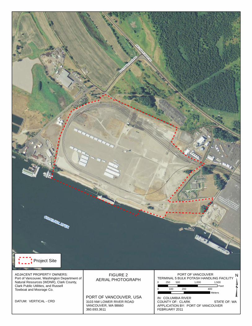
NW LOWER RIVER RD
OLD LOWER RIVER RD
COLUMBIA RIVER
FIGURE 2AERIAL PHOTOGRAPH
3103 NW LOWER RIVER ROADVANCOUVER, WA 98660360.693.3611
IN: COLUMBIA RIVERCOUNTY OF: CLARK STATE OF: WAAPPLICATION BY: PORT OF VANCOUVERFEBRUARY 2011
DATUM: VERTICAL - CRD³
Project Site
PORT OF VANCOUVER, USA
PORT OF VANCOUVERTERMINAL 5 BULK POTASH HANDLING FACILITY
ADJACENT PROPERTY OWNERS:Port of Vancouver, Washington Department ofNatural Resources (WDNR), Clark County,Clark Public Utilities, and RussellTowboat and Moorage Co.
0 500 1,000 1,500250Feet
0 200 400100Meters
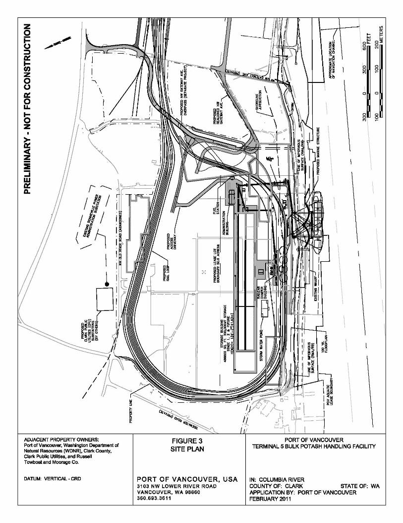
z 0 i= ~ 0 ::J iii: I-rn Z 0 , 0 \ iii: 0 I u.. I-0 Z
~ c( z :::IE :J w iii: ,------. D..
/ , / r
/ Ii / (!~
\
~
",.P ~~~~iii D..f::l,cF "'F~O
1I.~~me
ADJACENT PROPERTY OWNERS: Port of Vancouver, Washington Department of Natural Resources (WDNR), Clark County, Clark Public Utilities, and Russell Towboat and Moorage Co.
DATUM: VERTICAL - CRD
~ ~
:.:
FIGURE 3 SITE PLAN
PORTOFVANCOUVER,USA 3103 NW LOWER RIVER ROAD VANCOUVER, WA 98660 360.693.3611
\
\
PORT OF VANCOUVER
\
\
\
\
\
l-w w
0"-0
'"
0 0
'"
0
0 0
'"
\
\
Vl
'" i'! w
0:> 0 N
0 ;>
0
0 ;>
\
\
\
\
\
TERMINAL 5 BULK POTASH HANDLING FACILITY
IN: COLUMBIA RIVER COUNTY OF: CLARK STATE OF: WA APPLICATION BY: PORT OF VANCOUVER FEBRUARY 2011
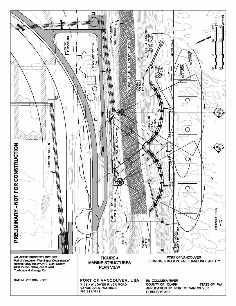
Z :> w
0 >-~
i= Vl
(J ::::I a:: I-
~ U) Z 0 ~, (J
a:: \ 0 u.. I-0 ) Z
~ ~ 0( )J~ z :::::iii V :J w '- \ a:: 11.
ADJACENT PROPERTY OWNERS: Port of Vancouver, Washington Department of Natural Resources (WDNR), Clark County, Clark Public Utilities, and Russell Towboat and Moorage Co.
DATUM: VERTICAL - CRD
FIGURE4 MARINE STRUCTURES
PLAN VIEW
PORTOFVANCOUVER,USA 3103 NW LOWER RIVER ROAD VANCOUVER, WA 98660 360.693.3611
---w ,
1
~ 0:
~ 50
!~ a
"
PORT OF VANCOUVER TERMINAL 5 BULK POTASH HANDLING FACILITY
IN: COLUMBIA RIVER COUNTY OF: CLARK STATE OF: WA APPLICATION BY: PORT OF VANCOUVER FEBRUARY 2011

z o b ~ t; z o o a:: o u..
b z
ADJACENT PROPERTY OWNERS: Port of Vancouver, Washington Department of Natural Resources (WDNR), Clark County, Clark Public Utilities, and Russell Towboat and Moorage Co.
DATUM: VERTICAL - CRD
FIGURE 5 MARINE STRUCTURES
CROSS SECTION
PORTOFVANCOUVER,USA 3103 NW LOWER RIVER ROAD VANCOUVER, WA 98660 360.693.3611
================x===~
NiJ:= =#=='It-=::-:=-=======::JC===J
PORT OF VANCOUVER
l-w w
0"-
'"
0
'"
o
o
'"
Vl
'" i'! w
0"
'"
"' o
TERMINAL 5 BULK POTASH HANDLING FACILITY
IN: COLUMBIA RIVER COUNTY OF: CLARK STATE OF: WA APPLICATION BY: PORT OF VANCOUVER FEBRUARY 2011
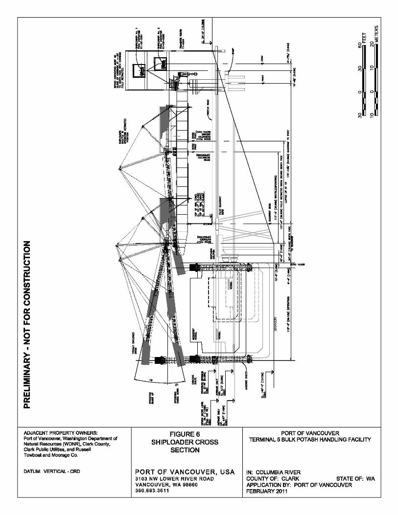
z 0 i= (J ::::I a:: l-t/) Z 0 (J
a:: 0 u.. I-0 Z
~ 0( z :::::iii :J w a:: 11.
ADJACENT PROPERTY OWNERS: Port of Vancouver, Washington Department of Natural Resources (WDNR), Clark County, Clark Public Utilities, and Russell Towboat and Moorage Co.
DATUM: VERTICAL - CRD
.. II II
FIGURE 6 SHIPLOADER CROSS
SECTION
PORTOFVANCOUVER,USA 3103 NW LOWER RIVER ROAD VANCOUVER, WA 98660 360.693.3611
Vl
'" l- I!! w w w 0"
! 0"-
'" '" • I
0
"' '" i
0 0
0
"' '"
I I I
I I I I I I I
I J I =~
~
! w
PORT OF VANCOUVER TERMINAL 5 BULK POTASH HANDLING FACILITY
IN: COLUMBIA RIVER COUNTY OF: CLARK STATE OF: WA APPLICATION BY: PORT OF VANCOUVER FEBRUARY 2011
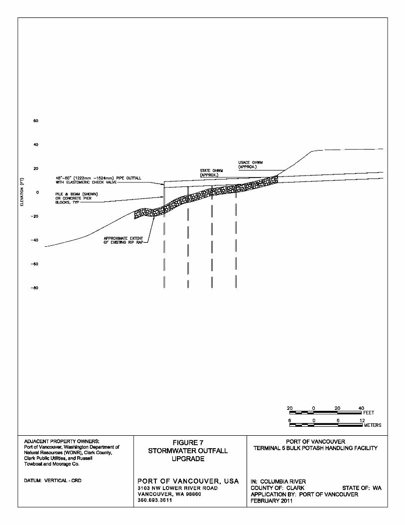
60
40
USAGE OHWt.4
20
48--60· (1222mm -1524mm) P'IFIP':E~O~'"""''''~L __ -:C==:.;;:::=~;;~;;;;ij WrTH ELASTOMERIC CHECK VALVE-
o PILE /Ie BEAM (SHOWN) OR CONCRErE' 'P~IE:"R:""': _____ ---II BLOCKS, TYP-
-20
-40
-60
-80
ADJACENT PROPERTY OWNERS, Port of Vancouver, Washington Department of Natural Resources (WDNR), Clark County, Clark Public Utilities, and Russell Towboat and Moorage Co.
DATUM: VERTICAL - CRD
FIGURE 7 STORMWATER OUTFALL
UPGRADE
PORTOFVANCOUVER,USA 3103 NW LOWER RIVER ROAD VANCOUVER, WA 98660 360.693.3611
20 0 20 40 ~ ..... =.......i~"""""...§;=;;;;;;;;iij FEET
6 a 6 12 iooo5=";;;;;~~~\;;;;;=o;;;;;jMETERS
PORT OF VANCOUVER TERMINAL 5 BULK POTASH HANDLING FACILITY
IN, COLUMBIA RIVER COUNTY OF, CLARK STATE OF, WA APPLICATION BY, PORT OF VANCOUVER FEBRUARY 2011
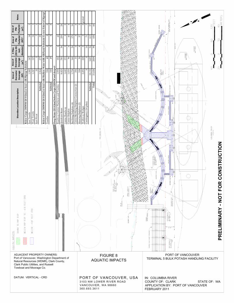
Shor
elin
e Lo
catio
n De
scrip
tion
Area
of
Over
wat
er
Cove
rage
(S
F)
Area
of
Over
wat
er
Cove
rage
(m
2 )
# Pi
les
(36
to 4
0- in
ch
diam
eter
)
Area
of
Pile
Fo
otpr
int
(SF)
*
Area
of
Pile
Fo
otpr
int
(m2 )
Note
s
East
Tre
stle
1,58
514
72
141
Wes
t Tre
stle
1,34
712
52
141
East
Piv
ot32
31
71
Subt
otal
2,96
427
55
353
Tres
tles
530
490
00
Subt
otal
530
490
00
Roa
dway
Cen
ter
Plat
form
and
Tre
stle
s1,
959
182
642
4Q
uadr
ant B
eam
8,42
378
336
255
24C
ente
r R
oadw
ay1,
643
153
00
0C
ente
r D
olph
in1,
033
966
424
Bert
hing
Dol
phin
s (4
)1,
724
160
2417
016
Cen
ter/
Bert
hing
Dol
phin
Con
nect
ion
(2)
356
330
00
Moo
ring
Dol
phin
s (2
)53
850
857
5W
alkw
ay B
ridg
es2,
456
228
00
0gr
ated
Con
ting
ency
(14
pile
s)0
014
717
Subt
otal
18,1
3216
8594
615
57T
otal
21,6
2620
0999
650
60
Bel
ow C
orps
OH
WM
( 20
ft [6
m] o
r les
s) w
ith R
ipra
p Su
bstr
ate
Bel
ow C
orps
OH
WM
(20
ft [6
m] o
r les
s) w
ith S
hallo
w W
ater
with
Silt
/San
d Su
bstr
ate
(Low
er E
xten
t of R
ipra
p)
Dee
p W
ater
(20
ft [6
m] b
elow
Cor
ps O
HW
M a
nd d
eepe
r)
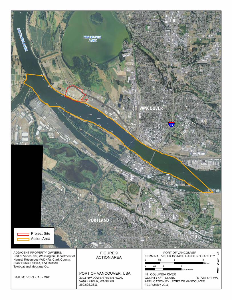
§̈¦I-5
PORTLAND
VANCOUVER LAKE
COLUMBIA RIVER
VANCOUVER
FIGURE 9ACTION AREA
3103 NW LOWER RIVER ROADVANCOUVER, WA 98660360.693.3611
0 1 20.5Miles ³
Project SiteAction Area
PORT OF VANCOUVER, USA
PORT OF VANCOUVERTERMINAL 5 BULK POTASH HANDLING FACILITY
IN: COLUMBIA RIVERCOUNTY OF: CLARK STATE OF: WAAPPLICATION BY: PORT OF VANCOUVERFEBRUARY 2011
DATUM: VERTICAL - CRD
ADJACENT PROPERTY OWNERS:Port of Vancouver, Washington Department ofNatural Resources (WDNR), Clark County,Clark Public Utilities, and RussellTowboat and Moorage Co. 0 1 20.5
Kilometers

PHOTOSHEET 1 PORT OF VANCOUVERTERMINAL 5 BULK POTASH HANDLING FACILITY
DATUM: VERTICAL - CRD
ADJACENT PROPERTY OWNERS:Port of Vancouver, Washington Department ofNatural Resources (WDNR), Clark County,Clark Public Utilities, and RussellTowboat and Moorage Co.
PORT OF VANCOUVER, USA3103 LOWER RIVER ROADVANCOUVER, WA 98660360.693.3611
IN: COLUMBIA RIVERCOUNTY OF: CLARK STATE OF: WAAPPLICATION BY: PORT OF VANCOUVERMay 2011
Photo 1: This photograph is taken facing east (upstream) from the existing dock, and documents theriparian and nearshore conditions at the site and the extent of bank armoring.
Photo 2: This photograph is taken facing west (downstream) and documents the condition of the existingdock, and the nature of the riparian and upland habitat conditions within the project area.
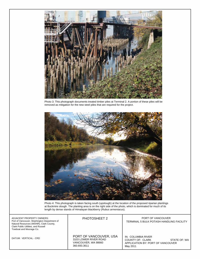
PHOTOSHEET 2 PORT OF VANCOUVER
3103 LOWER RIVER ROADVANCOUVER, WA 98660360.693.3611
IN: COLUMBIA RIVERCOUNTY OF: CLARK STATE OF: WAAPPLICATION BY: PORT OF VANCOUVER May 2011
Photo 3: This photograph documents treated timber piles at Terminal 2. A portion of these piles will beremoved as mitigation for the new steel piles that are required for the project.
Photo 4: This photograph is taken facing south (upslough) at the location of the proposed riparian plantingsat Buckmire slough. The planting area is on the right side of the photo, which is dominated for much of itslength by dense stands of Himalayan blackberry (Rubus armeniacus).
TERMINAL 5 BULK POTASH HANDLING FACILITY
PORT OF VANCOUVER, USADATUM: VERTICAL - CRD
ADJACENT PROPERTY OWNERS:Port of Vancouver, Washington Department ofNatural Resources (WDNR), Clark County,Clark Public Utilities, and RussellTowboat and Moorage Co.
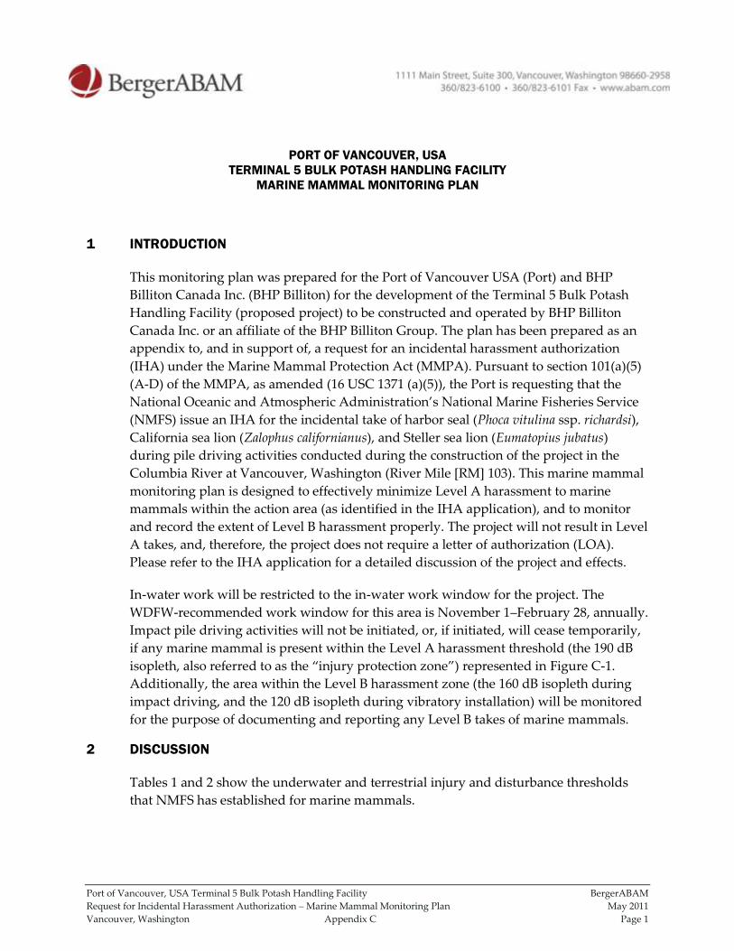
Port of Vancouver, USA Terminal 5 Bulk Potash Handling Facility BergerABAM
Request for Incidental Harassment Authorization – Marine Mammal Monitoring Plan May 2011
Vancouver, Washington Appendix C Page 1
PORT OF VANCOUVER, USA
TERMINAL 5 BULK POTASH HANDLING FACILITY
MARINE MAMMAL MONITORING PLAN
1 INTRODUCTION
This monitoring plan was prepared for the Port of Vancouver USA (Port) and BHP
Billiton Canada Inc. (BHP Billiton) for the development of the Terminal 5 Bulk Potash
Handling Facility (proposed project) to be constructed and operated by BHP Billiton
Canada Inc. or an affiliate of the BHP Billiton Group. The plan has been prepared as an
appendix to, and in support of, a request for an incidental harassment authorization
(IHA) under the Marine Mammal Protection Act (MMPA). Pursuant to section 101(a)(5)
(A-D) of the MMPA, as amended (16 USC 1371 (a)(5)), the Port is requesting that the
National Oceanic and Atmospheric Administration’s National Marine Fisheries Service
(NMFS) issue an IHA for the incidental take of harbor seal (Phoca vitulina ssp. richardsi),
California sea lion (Zalophus californianus), and Steller sea lion (Eumatopius jubatus)
during pile driving activities conducted during the construction of the project in the
Columbia River at Vancouver, Washington (River Mile [RM] 103). This marine mammal
monitoring plan is designed to effectively minimize Level A harassment to marine
mammals within the action area (as identified in the IHA application), and to monitor
and record the extent of Level B harassment properly. The project will not result in Level
A takes, and, therefore, the project does not require a letter of authorization (LOA).
Please refer to the IHA application for a detailed discussion of the project and effects.
In-water work will be restricted to the in-water work window for the project. The
WDFW-recommended work window for this area is November 1–February 28, annually.
Impact pile driving activities will not be initiated, or, if initiated, will cease temporarily,
if any marine mammal is present within the Level A harassment threshold (the 190 dB
isopleth, also referred to as the “injury protection zone”) represented in Figure C-1.
Additionally, the area within the Level B harassment zone (the 160 dB isopleth during
impact driving, and the 120 dB isopleth during vibratory installation) will be monitored
for the purpose of documenting and reporting any Level B takes of marine mammals.
2 DISCUSSION
Tables 1 and 2 show the underwater and terrestrial injury and disturbance thresholds
that NMFS has established for marine mammals.
Port of Vancouver, USA Terminal 5 Bulk Potash Handling Facility BergerABAM
Request for Incidental Harassment Authorization – Marine Mammal Monitoring Plan May 2011
Vancouver, Washington Appendix C Page 2
Table 1. Underwater Injury and Disturbance Threshold Decibel Levels for Marine Mammals
Criterion Criterion Definition Threshold*
Level A Harassment PTS (injury) conservatively based on TTS** 190 dB RMS for pinnipeds
180 dB RMS for cetaceans
Level B Harassment Behavioral disruption for impulsive noise (e.g., impact pile
driving)
160 dB RMS
Level B Harassment Behavioral disruption for non-pulse noise (e.g., vibratory
pile driving, drilling)
120*** dB RMS
*All decibel levels referenced to 1 micropascal (re: 1 µPa). Note all thresholds are based off root mean square (RMS) levels
** PTS=Permanent Threshold Shift; TTS=Temporary Threshold Shift
***The 120 dB threshold may be adjusted slightly if background noise levels are at or above this level.
Table 2. Terrestrial Injury and Disturbance Threshold Decibel Levels for Pinnipeds
Criterion Criterion Definition Threshold*
Level A Harassment PTS (injury) conservatively based on TTS** None established
Level B Harassment Behavioral disruption for harbor seals 90 dB RMS
Level B Harassment Behavioral disruption for non-harbor seal pinnipeds 100 dB RMS
*All decibel levels referenced to 20 micropascal (re: 20 µPa). Note all thresholds are based off root mean square (RMS)
levels
** PTS=Permanent Threshold Shift; TTS=Temporary Threshold Shift
Based on the results of the noise attenuation analysis conducted for the project (Anchor
QEA, LLC 2011), it has been determined that the Level A harassment (injury) threshold
for underwater noise for pinniped species could be exceeded at a distance of up to
70 feet (21 meters) during impact pile driving activities. Additionally, the Level B
harassment (behavioral disruption) for underwater noise for pinniped species could be
exceeded at a distance of up to 31.3 miles (50.4 kilometers) during impact pile driving.
During vibratory pile driving, because of the shape and configuration of the river, the
Level B harassment (behavioral disruption) for underwater noise for pinniped species
could be exceeded throughout the full extent of the action area identified in Figure C-1.
During pile driving, the area where underwater noise levels may exceed the Level A
harassment threshold for pinnipeds (the 190 dB isopleth) will be monitored according to
the protocol described in this plan. This area will be maintained as an injury protection
zone. To prevent Level A harassment, impact pile driving will be shut down
immediately if any marine mammals are observed entering the area, effectively reducing
the possibility of any marine mammals being exposed to Level A harassment, and, for
this reason, the project will not require an LOA for Level A takes.
During pile driving, the area where underwater noise levels may exceed the Level B
harassment thresholds for impact driving (the 160 dB RMS isopleth) and vibratory
driving (120 dB RMS isopleth) will be monitored intermittently according to the protocol
described in this plan. Marine mammal presence within this area, if any, will be
monitored, but pile driving activity will not be stopped if marine mammals are observed
to be present. Marine mammals documented within the Level B harassment area during
pile driving will constitute a Level B take, and will be recorded and used to document
the number of take incidents.
Port of Vancouver, USA Terminal 5 Bulk Potash Handling Facility BergerABAM
Request for Incidental Harassment Authorization – Marine Mammal Monitoring Plan May 2011
Vancouver, Washington Appendix C Page 3
3 TERRESTRIAL NOISE
The area in which terrestrial noise levels could exceed the Level B harassment thresholds
is within the distances that will be monitored for underwater noise (Anchor QEA 2011).
Since no pinniped haulout sites or suitable haulout habitat occur within the action area,
no pinnipeds are expected to haul out within the action area. As a result, any marine
mammals that enter the area in which Level B terrestrial noise levels could be exceeded
will be in an aquatic environment, and will be recorded as a Level B take resulting from
underwater noise. As such, the terrestrial noise isopleths are not taken into account in
this monitoring plan.
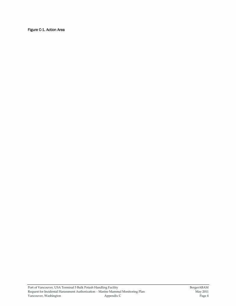
Port of Vancouver, USA Terminal 5 Bulk Potash Handling Facility BergerABAM
Request for Incidental Harassment Authorization – Marine Mammal Monitoring Plan May 2011
Vancouver, Washington Appendix C Page 4
Figure C-1. Action Area
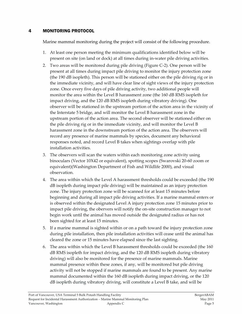
Port of Vancouver, USA Terminal 5 Bulk Potash Handling Facility BergerABAM
Request for Incidental Harassment Authorization – Marine Mammal Monitoring Plan May 2011
Vancouver, Washington Appendix C Page 5
4 MONITORING PROTOCOL
Marine mammal monitoring during the project will consist of the following procedure.
1. At least one person meeting the minimum qualifications identified below will be
present on site (on land or dock) at all times during in-water pile driving activities.
2. Two areas will be monitored during pile driving (Figure C-2). One person will be
present at all times during impact pile driving to monitor the injury protection zone
(the 190 dB isopleth). This person will be stationed either on the pile driving rig or in
the immediate vicinity, and will have clear line of sight views of the injury protection
zone. Once every five days of pile driving activity, two additional people will
monitor the area within the Level B harassment zone (the 160 dB RMS isopleth for
impact driving, and the 120 dB RMS isopleth during vibratory driving). One
observer will be stationed in the upstream portion of the action area in the vicinity of
the Interstate 5 bridge, and will monitor the Level B harassment zone in the
upstream portion of the action area. The second observer will be stationed either on
the pile driving rig or in the immediate vicinity, and will monitor the Level B
harassment zone in the downstream portion of the action area. The observers will
record any presence of marine mammals by species, document any behavioral
responses noted, and record Level B takes when sightings overlap with pile
installation activities.
3. The observers will scan the waters within each monitoring zone activity using
binoculars (Vector 10X42 or equivalent), spotting scopes (Swarovski 20-60 zoom or
equivalent)(Washington Department of Fish and Wildlife 2000), and visual
observation.
4. The area within which the Level A harassment thresholds could be exceeded (the 190
dB isopleth during impact pile driving) will be maintained as an injury protection
zone. The injury protection zone will be scanned for at least 15 minutes before
beginning and during all impact pile driving activities. If a marine mammal enters or
is observed within the designated Level A injury protection zone 15 minutes prior to
impact pile driving, the obervers will notify the on-site construction manager to not
begin work until the animal has moved outside the designated radius or has not
been sighted for at least 15 minutes.
5. If a marine mammal is sighted within or on a path toward the injury protection zone
during pile installation, then pile installation activities will cease until the animal has
cleared the zone or 15 minutes have elapsed since the last sighting.
6. The area within which the Level B harassment thresholds could be exceeded (the 160
dB RMS isopleth for impact driving, and the 120 dB RMS isopleth during vibratory
driving) will also be monitored for the presence of marine mammals. Marine
mammal presence within these zones, if any, will be monitored but pile driving
activity will not be stopped if marine mammals are found to be present. Any marine
mammal documented within the 160 dB isopleth during impact driving, or the 120
dB isopleth during vibratory driving, will constitute a Level B take, and will be
Port of Vancouver, USA Terminal 5 Bulk Potash Handling Facility BergerABAM
Request for Incidental Harassment Authorization – Marine Mammal Monitoring Plan May 2011
Vancouver, Washington Appendix C Page 6
recorded and used to document the number of take incidents. Monitoring will occur
every five days in order to estimate the number of individuals present within the
Level B harassment area.
7. If waters exceed a sea-state which restricts the obervers’ ability to make observations
within the injury protection zone (the 190 dB isopleth) (e.g., excessive wind or fog),
impact pile installation will cease until conditions allow the resumption of
monitoring. Vibratory pile installation would continue under these conditions.

Port of Vancouver, USA Terminal 5 Bulk Potash Handling Facility BergerABAM
Request for Incidental Harassment Authorization – Marine Mammal Monitoring Plan May 2011
Vancouver, Washington Appendix C Page 7
Figure C-2. Monitoring Locations and Observation Radii

Port of Vancouver, USA Terminal 5 Bulk Potash Handling Facility BergerABAM
Request for Incidental Harassment Authorization – Marine Mammal Monitoring Plan May 2011
Vancouver, Washington Appendix C Page 8
5 MINIMUM QUALIFICATIONS FOR MARINE MAMMAL OBSERVERS
1. Visual acuity in both eyes (correction is permissible) sufficient to discern moving
targets at the water’s surface and to estimate target size and distance. Use of
binoculars may be necessary to correctly identify the target.
2. Experience and ability to conduct field observations and collect data according to
assigned protocols (this may include academic experience).
3. Experience or training in the field identification of marine mammals (i.e. pinnipeds).
4. Sufficient training, orientation, or experience with the construction operation to
provide for personal safety during observations.
5. Writing skills sufficient to prepare a report of observations that will include such
information as the number and types of marine mammals observed; the behavior of
marine mammals in the project area during construction; the dates and times when
observations were conducted; the dates and times when in-water construction
activities were conducted; the dates and times when marine mammals were present
at or within the defined disturbance zone; the dates and times when in-water
construction activities were suspended to avoid incidental harassment by
disturbance from construction noise; etc.
6. Ability to communicate orally, by radio or in person, with project personnel to
provide real time information on marine mammals observed in the area.
6 REFERENCES
Anchor QEA, LLC. 2011. Biological Evaluation. Port of Vancouver USA Terminal 5 Bulk
Handling Facility. January 2011.
Garret, Howard, Susan Berta, and Jason Woods. 2010. Orca Network. Whale Museum.
Personal communication to Rick Huey. March 26, 2010.
US Coast Guard. 2010. http://www.uscg.mil/news/stormcenter/. Accessed March 28,
2010.
Washington Department of Fish and Wildlife. 2000. Final Report. Monitoring Incidental
Harassment of Harbor Seals (Phoca vitulina richardsi) at Gertrude Island during
the McNeil Island Corrections Center Still Harbor Dock Renovation Project. 1
December 1998 to 15 August 1999. Dyanna Lambourn and Steven Jeffries.
Washington Department of Fish and Wildlife Marine Mammal Investigations.
Tacoma, WA. January 10, 2000.