PORT OF SAN FRANCISCO PIER 70 RISK … OF SAN FRANCISCO P 70 R M P F S PIER 70 RISK MANAGEMENT PLAN...
123
PORT OF SAN FRANCISCO Fact Sheet PIER 70 RISK MANAGEMENT PLAN BACKGROUND This fact sheet informs tenants of the Port of San Francisco’s Risk Management Plan (RMP) for Pier 70. The RMP describes how workers, the public, and the environment will be protected from environmental pollutants in soil and groundwater at Pier 70. The RMP applies to the area within the dotted line shown on the map to the right. All tenants and their agents (i.e. contractors) within this area must comply with the RMP, which can be found at www.sfport.com/pier70. This fact sheet presents an overview of RMP mandates, but tenants will need to refer to the RMP itself to fully understand all requirements. CONTAMINATION AT PIER 70 Pier 70 was created by placing fill in the bay beginning in the mid-1800s, using rock from shoreline bluffs, and other rock, soil, and debris. Pier 70 has been occupied by industrial use almost continuously since then. This fill material makes up the native soil present at Pier 70 today. Chemicals that occur naturally in the bedrock and former rock bluffs, were present in other fill material placed at the shoreline to create new land, or released from historic industrial activities are present in the soil and groundwater at Pier 70. The Port has investigated the level of contamination in soil, soil gas, and groundwater at Pier 70 and found that the soil is contaminated with metals, petroleum hydrocarbons, polycyclic aromatic hydrocarbons, and polychlorinated biphenyls. Exposure to contaminants by eating, breathing, or prolonged direct skin contact with native soil could be harmful to human health. FACT SHEET WHAT IS A RISK MANAGEMENT PLAN? An RMP describes measures that must be taken to protect human health and the environment from potential risks associated with exposure to contaminants. The Port’s approved RMP contains risk management measures for Pier 70, including the following three components: Durable Cover: Physical barriers to prevent human contact with native soil or exposure of contaminants in the soil to the environment. Durable cover may be in the form of buildings, streets, sidewalks, paved areas, and new landscaping with imported clean soil. Maintenance and Monitoring: Regular inspections and repairs of the durable cover to ensure the physical barrier is maintained. Land Use and Activity Restrictions: Certain activities are prohibited at Pier 70 to prevent the contaminants in the soil from contact with people or release into the environment. Groundwater may not be used for any purpose other than dewatering. Growing edible plants for human consumption in native soil is prohibited. PORT OF SAN FRANCISCO Pier 70 RMP Boundary:
Transcript of PORT OF SAN FRANCISCO PIER 70 RISK … OF SAN FRANCISCO P 70 R M P F S PIER 70 RISK MANAGEMENT PLAN...

P O R T O F S A N F R A N C I S C O
P i e r 7 0 R i s k M a n a g e m e n t P l a n F a c t S h e e t
PIER 70RISK MANAGEMENT PLAN
BACKGROUNDThis fact sheet informs tenants of the Port of San Francisco’s Risk Management Plan (RMP) for Pier 70. The RMP describes how workers, the public, and the environment will be protected from environmental pollutants in soil and groundwater at Pier 70. The RMP applies to the area within the dotted line shown on the map to the right. All tenants and their agents (i.e. contractors) within this area must comply with the RMP, which can be found at www.sfport.com/pier70. This fact sheet presents an overview of RMP mandates, but tenants will need to refer to the RMP itself to fully understand all requirements.
CONTAMINATION AT PIER 70Pier 70 was created by placing fill in the bay beginning in the mid-1800s, using rock from shoreline bluffs, and other rock, soil, and debris. Pier 70 has been occupied by industrial use almost continuously since then. This fill material makes up the native soil present at Pier 70 today. Chemicals that occur naturally in the bedrock and former rock bluffs, were present in other fill material placed at the shoreline to create new land, or released from historic industrial activities are present in the soil and groundwater at Pier 70.
The Port has investigated the level of contamination in soil, soil gas, and groundwater at Pier 70 and found that the soil is contaminated with metals, petroleum hydrocarbons, polycyclic aromatic hydrocarbons, and polychlorinated biphenyls. Exposure to contaminants by eating, breathing, or prolonged direct skin contact with native soil could be harmful to human health.
FA C T S H E E T
WHAT IS A RISK MANAGEMENT PLAN?An RMP describes measures that must be taken to protect human health and the environment from potential risks associated with exposure to contaminants. The Port’s approved RMP contains risk management measures for Pier 70, including the following three components:
� Durable Cover: Physical barriers to prevent human contact with native soil or exposure of contaminants in the soil to the environment. Durable cover may be in the form of buildings, streets, sidewalks, paved areas, and new landscaping with imported clean soil.
� Maintenance and Monitoring: Regular inspections and repairs of the durable cover to ensure the physical barrier is maintained.
� Land Use and Activity Restrictions: Certain activities are prohibited at Pier 70 to prevent the contaminants in the soil from contact with people or release into the environment. Groundwater may not be used for any purpose other than dewatering. Growing edible plants for human consumption in native soil is prohibited.
P O R T O F S A N F R A N C I S C O
Pier 70 RMP Boundary:

P O R T O F S A N F R A N C I S C O
P i e r 7 0 R i s k M a n a g e m e n t P l a n F a c t S h e e t
WHERE CAN I GET MORE INFORMATION?
Pier 70 Websites:For the complete Risk Management Plan and additional site condition information, visit: www.sfport.com/pier70
For the Pier 70 Preferred Master Plan and additional information regarding Pier 70 redevelopment, visit: www.pier70sf.org
Contact Information:Carol Bach | Environmental Affairs, Planning & Development Division | [email protected] | (415) 274-0568
Mark Johnson | California Regional Water Quality Control Board, San Francisco Bay Region | [email protected] | (510) 622-2493
Port of San Francisco | Pier 1, The Embarcadero, San Francisco, CA 94111 | www.sfport.com | Main Line: (415) 274-0400
The California Regional Water Quality Control Board, San Francisco Bay Region (Water Board), the San Francisco Department of Public Health (DPH), and the Port require that all ground-disturbing activities comply with the RMP, in addition to all other applicable federal, state, and city permitting and environmental regulations and procedures, and Port permit requirements. All tenants and their contractors and other agents, and other workers and occupants at Pier 70 must abide by the RMP. The following are summaries of some of the RMP require-ments. In all cases, tenants should refer to the RMP for details.
� Regulated Activities: All activities where the durable cover may be compromised or native soil may be exposed are regulated by the RMP. Tenant activities that may disturb native soil may include grading, demolition of paving or below-grade features, utility installation or maintenance, landscaping, light con-struction, or other activities that expose or disturb soil.
� Notification and Reporting: Requirements vary based on the extent of work to be performed and may include 45 days’ prior notice to the Port, preparation of a pre-construction plan prepared by a California-licensed Professional Engineer or Geologist, or noti-fication to and approval by the Water Board or DPH. Refer to the RMP for details.
� Contracting: If a tenant is hiring a contractor to perform construction or maintenance work that will expose or disturb soil, the tenant must provide the contractor with a copy of the RMP and ensure compliance with all provisions. Tenant and contractor must evaluate the activities prior to start of work to determine notification and reporting and other applicable requirements. Refer to RMP for project-specific requirements when planning any soil-disturbing activity.
� Protective Measures: For all ground-disturbing activities, tenants must implement measures to protect human health and the environment, which include controlling access to work areas, requiring personal protective equipment for workers, controlling dust and runoff properly, storing and disposing of excess soil, and protecting existing groundwater monitoring wells.
� Annual Inspection: Tenants are required to inspect their premises and submit an “Annual Reporting and O&M Checklist” [the form is included in Appendix A to the RMP] to the Port by March 31 of each year. The Port may also conduct its own inspections of tenants’ premises and activities to monitor RMP compliance.
WHAT DOES THE RMP MEAN FOR THE TENANTS OF PIER 70?
A U G U S T 2 0 1 4
I:\Pier 70\Environmental Risk Management Plan,7-25-13\P70_RMP_Fact_Sheet.indd

PIER 70 RISK MANAGEMENT PLAN Pier 70 Master Plan Area San Francisco, California
Prepared For: Port of San Francisco
San Francisco, California
25 July 2013 Project No. 730496301

i 25 June 2013
TABLE OF CONTENTS
1.0 INTRODUCTION ..................................................................................................................... 1 1.1 Redevelopment Plans .................................................................................................. 2 1.2 Intended Users ........................................................................................................... 3 1.3 Regulatory Oversight ................................................................................................... 3
2.0 BACKGROUND ........................................................................................................................ 4 2.1 Summary of Environmental Conditions ......................................................................... 4
2.1.1 Soil ................................................................................................................ 5 2.1.2 Soil Gas ......................................................................................................... 6 2.1.3 Groundwater .................................................................................................. 6 2.1.4 Known Existing or Former Below-grade Features .............................................. 7
2.2 Remedy ...................................................................................................................... 7 2.2.1 Description of Remedy .................................................................................... 7 2.2.2 Cleanup Levels ................................................................................................ 9
3.0 RISK MANAGEMENT PLAN ....................................................................................................... 9 3.1 Regulatory Oversight Responsibilities for RMP Implementation .................................... 10 3.2 Ground Disturbing Activities ....................................................................................... 11 3.3 Prohibited Activities ................................................................................................... 11 3.4 Compliance with Existing Requirements ...................................................................... 12 3.5 Agency Site Access ................................................................................................... 12 3.6 Modifications to the RMP ........................................................................................... 13 3.7 Public Information Repositories .................................................................................. 13
4.0 GROUND DISTURBING ACTIVITY NOTIFICATION AND REPORTING ......................................... 14 4.1 Information Required for Water Board Notification ...................................................... 16
4.1.1 Notification for RMP Compliant Submittals ...................................................... 16 4.1.2 Notification and Approval Process of RMP Variance Submittals ......................... 17
4.2 Information Required for SFDPH Notification .............................................................. 17 4.3 Completion Reports ................................................................................................... 18 4.4 Annual Inspection and Reporting to the Port and Water Board ..................................... 19
5.0 RISK MANAGEMENT MEASURES PRIOR TO DEVELOPMENT ..................................................... 20 5.1 Maintain Existing Protections ..................................................................................... 20 5.2 Control Access ..................................................................................................... 20 5.3 Notification & Reporting ............................................................................................ 21 5.4 Existing Cover Disturbance ........................................................................................ 21
6.0 RISK MANAGEMENT MEASURES DURING DEVELOPMENT ........................................................ 22 6.1 Access Control during Construction ............................................................................ 22 6.2 Existing or Durable Cover Disturbance ........................................................................ 22 6.3 Notification for Ground Disturbing Activities ................................................................ 23 6.4 Environmental Health & Safety .................................................................................. 23 6.5 Soil Management Protocols ........................................................................................ 24
6.5.1 Movement of Soil .......................................................................................... 24 6.5.2 Soil Stockpile Management Protocols .............................................................. 25 6.5.3 Soil Import Criteria ........................................................................................ 25
6.6 Dust Control Plan ...................................................................................................... 26

ii 25 June 2013
TABLE OF CONTENTS
(Continued)
6.7 Construction Stormwater Management ....................................................................... 26 6.8 Off-site Soil Disposal ................................................................................................. 27 6.9 Unanticipated Conditions Response Protocol ............................................................... 27
6.9.1 Field Screening ............................................................................................. 29 6.9.2 Health and Safety ......................................................................................... 29 6.9.3 Notification ................................................................................................... 29
6.10 Groundwater Management Protocols .......................................................................... 29 6.10.1 Temporary Dewatering Activities .................................................................... 30 6.10.2 Conduits Prevention ...................................................................................... 31 6.10.3 Groundwater Intrusion Prevention.................................................................. 32
6.11 Groundwater Monitoring Wells ................................................................................... 32 6.11.1 Abandonment of Existing Monitoring Wells ..................................................... 33 6.11.2 Replacement of Monitoring Wells ................................................................... 33 6.11.3 Measures to Protect Monitoring Wells ............................................................. 34
6.12 Shoreline Improvements............................................................................................ 35
7.0 RISK MANAGEMENT MEASURES AFTER DEVELOPMENT .......................................................... 35 7.1 Notification ............................................................................................................... 35 7.2 Durable Cover Disturbance ........................................................................................ 35 7.3 Health and Safety ..................................................................................................... 35
8.0 PUBLIC PARTICIPATION ........................................................................................................ 36
REFERENCES
TABLES
FIGURES
APPENDICES

iii 25 June 2013
LIST OF TABLES
Table 1 Cleanup Levels for Soil Gas
Table 2 Cleanup Levels for Groundwater
Table 3 Soil Import Criteria
Table 4 RMP Notification and Oversight Responsibilities
LIST OF FIGURES
Figure 1 Site Location Map
Figure 2 Site Plan for Risk Management Plan Area
Figure 3 Pier 70 Master Plan Land Use
Figure 4 California Hazardous Criteria Exceedances in Shallow Soil
Figure 5 Sample Locations and Areas with Identified Impacts
APPENDIXES
Appendix A Annual Inspection O&M Checklist and Durable Cover O&M Plan
Appendix B Dust Control Plan
Appendix C Maps of Existing Utilities and UST Memorandum
Appendix D Contact Information
Appendix E Stormwater Pollution Prevention Plan Outline
Appendix F Environmental Health and Safety Plan Outline
Appendix G Groundwater Management Plan Outline
iv 25 June 2013
ACRONYM AND ABBREVIATION LIST
ADMP Asbestos Dust Mitigation Plan
AMEC AMEC Geomatrix Inc.
ATCM Airborne Toxic Control Measures
BAAQMD Bay Area Air Quality Management District
BCDC San Francisco Bay Conservation and Development Commission
BMPs Best management practices
CARB California Air Resources Board
Cal/OSHA California Department of Occupational Safety and Health
CCR California Code of Regulations
CERCLA the Comprehensive Environmental Response, Compensation, and Liability Act
CFR Code of Federal Regulations
CHHSLs California Human Health Screening Levels
CHSC the California Health and Safety Code Section
CIH Certified Industrial Hygienist
City City and County of San Francisco
COCs Constituents of Concern
CUPA California Unified Program Agency
DCP Dust Control Plan
DNAPL Dense non-aqueous phase liquids
DTSC California Department of Toxic Substances Control
DWR Department of Water Resources
EHSP Environmental Health and Safety Plan
EPA United States Environmental Protection Agency
ESLs Environmental Screening Levels
FS Feasibility Study
FS/RAP FS and Remedial Action Plan
ft bgs feet below ground surface
GMP Groundwater Management Plan
HHRA Human Health Risk Assessment
IRM Interim Remedial Measure
LUC Agreement Land Use Control Agreement
LUCs Land Use Controls
v 25 June 2013
ACRONYM AND ABBREVIATION LIST
(Continued)
The Master Plan the Pier 70 Preferred Master Plan
MHHW mean higher high water
NAPL non-aqueous phase liquid
NCP National Oil and Hazardous Substances Pollution Contingency Plan
NOA naturally occurring asbestos
NOI Notice of Intent
NPDES National Pollutant Discharge Elimination System
O&M operation and maintenance
OSHA Cal/Occupational Safety and Health Administration
OVA organic vapor analyzer
OVM organic vapor monitor
PAHs polycyclic aromatic hydrocarbons
PCBs polychlorinated biphenyls
PDR Product Distribution & Repair (also referred to as “light industrial”)
PG&E Pacific Gas and Electric
PID photoionization detector
Port the Port of San Francisco
QSD Qualified SWPPP Developer
RAO Remedial Action Objective
RCRA Resource Conservation and Recovery Act
R&D Research and Development
RCM Reactive Core Mat
RMP Risk Management Plan
SFDPH the San Francisco Department of Public Health
SFFD San Francisco Fire Department
SFPUC City and County of San Francisco Public Utilities Commission
SI The Site Investigation
SIP Soil Importation Plan
SSHO Site Safety and Health Officer
STLC soluble threshold limit concentration
SWPPP Storm Water Pollution Prevention Plan
SWRCB the California State Water Resource Control Board
vi 25 June 2013
ACRONYM AND ABBREVIATION LIST
(Continued)
TCLP toxicity characteristic leaching potential
TPH total petroleum hydrocarbons
T&R Treadwell & Rollo, a Langan Company
TSCA Toxic Substances Control Act
TTLC total threshold limit concentration
USACE US Army Corps of Engineers
USFWS US Fish and Wildlife Service
USTs Underground storage tanks
VOC volatile organic compound
Water Board the Regional Water Quality Control Board – San Francisco Bay Region
WDRS Waste Discharge Requirements
WET the California waste extraction test

1 25 June 2013
RISK MANAGEMENT PLAN
Pier 70 Master Plan Area San Francisco, California
1.0 INTRODUCTION
Treadwell & Rollo, a Langan Company (T&R) has prepared this Risk Management Plan (RMP) for the Pier
70 Master Plan Area (Figure 1) on behalf of the Port of San Francisco (Port). The Pier 70 Master Plan
Area is located on the eastern shoreline of San Francisco at Potrero Point (a continuation of serpentinite
based Potrero Hill). It is roughly bounded by Mariposa Street to the north, San Francisco Bay to the
north and east, 22nd Street and the former GenOn Site (now owned by GenOn Potrero LLC, hereafter
referred to in this RMP as “the GenOn Site”) to the south, and Illinois Street to the west. For the
purposes of this RMP, the “Site” or “Pier 70 RMP Area” consists of the onshore portions of the Pier 70
Master Plan Area (above mean higher high water (MHHW1)) delineated in Figure 2. Intertidal and
subtidal areas around the Pier 70 RMP Area are not addressed by this RMP. Onshore portions of the Pier
70 RMP Area where constituents associated with the former power plant operations at the adjacent
GenOn Site are present in the subsurface have been investigated by PG&E, the former property owner,
and are included in this RMP (Figure 2).
Treadwell & Rollo, on behalf of the Port, completed a Feasibility Study and Remedial Action Plan (FS/RAP)
for the Site (Treadwell & Rollo, 2012), with oversight by the Regional Water Quality Control Board –
San Francisco Bay Region (Water Board) and the San Francisco Department of Public Health (SFDPH).
The FS/RAP underwent public review and comment and was approved by the Water Board on 9 August
2012. The chosen remedy consists of engineering controls (e.g., removing, replacing, or capping soil
with durable cover) and institutional controls (e.g., deed restrictions, soil management measures, health
and safety plans) to manage potential health risks. The remedy includes:
Durable Covers over existing native soil that meet the remedial action objective of preventing
human exposure to constituents of concern (COCs) in the soil beneath the Site.
Long-term maintenance and monitoring of durable covers to ensure that covers continue to
function as designed are described further in Appendix A.
1 Mean Higher High Water is a tidal datum equal to the average of the higher high water height of each tidal day
observed over the National Tidal Datum Epoch. For stations with shorter series, simultaneous observational comparisons are made with a control tide station in order to derive the equivalent datum of the National Tidal Datum Epoch.
2 25 July 2013
Institutional controls to minimize the potential to impact human health and the environment
after installation of durable cover.
The RMP is an essential component of the remedy for the Site. It is a tool for ensuring effectiveness of
the institutional controls and provides a framework to manage residual COCs in soil in a manner that
protects site users under current and future land use. This RMP specifies pre-development, development,
and post-development measures to mitigate potential risks to the environment, current and future on-site
employees, future residents, construction and maintenance workers, visitors, and the public. It was
prepared under Water Board and SFDPH oversight to provide specifications and details on how risk will
be mitigated and managed during future construction, operation, and maintenance.
The Land Use Control (LUC) Agreement is another important component of the Institutional Controls. It
will describe activity restrictions, specifically those presented in the RMP, that will be enforceable through
a deed restriction, recorded in the official records of the City and County of San Francisco against all land
that is subject to this RMP. The RMP and LUC Agreement will be enforceable regardless of land
ownership. The RMP is a component of the environmental deed restriction and will be incorporated into
the deed restriction by reference. The deed restriction and RMP compliance is binding on all owners,
occupants and their agents. Therefore, if a project proponent does not comply with the RMP, they would
also violate the terms of the Deed Restriction.
1.1 Redevelopment Plans
The Port has developed a Pier 70 Preferred Master Plan dated April 2010 (the Master Plan) that envisions
continued operation of the BAE San Francisco Ship Repair facility and redevelopment of other portions of
the Site with a mix of commercial (office, retail), light industrial, education/cultural, mixed use including
residential, public open space, and multi-family housing. Although the Port’s 2010 Master Plan lays out
general land use types and locations, opportunities for Commercial, Residential, and Recreational land
uses exist site-wide and exact locations and boundaries of different land uses in various portions of the
Pier 70 RMP area will be developed over time. The currently anticipated layout of future land uses in
different subareas within Pier 70 is illustrated in Figure 3. There are portions of the Pier 70 Master Plan
Area (i.e. parcels identified as 2, 4, 6, 8 or Slipways Park in the 2010 Master Plan and 2011 Site
Investigation, as further described in Section 2.1.2 of this RMP) that may require additional risk
evaluations and potentially mitigation measures if developed for residential use.

3 25 July 2013
1.2 Intended Users
This RMP is intended for use by the following entities or their designees who may occupy, manage, or
perform or oversee maintenance or construction within the Pier 70 RMP Area as delineated in Figure 1:
The Port;
“Project proponents”: developers, ground lessees, tenants, licensees or other entities
authorized by the Port to conduct operations, maintenance, construction or other activities at
the Site;
The Water Board; and,
SFDPH.
The Port shall provide a copy of the RMP to project proponents who will perform work that poses the
potential for exposure to contaminants on the Site. However, the Port as landowner retains ultimate
responsibility and authority for compliance with all aspects of the RMP and LUC Agreement.
1.3 Regulatory Oversight
The Water Board is the lead agency overseeing environmental investigation and remediation activities at
the Site, including implementation of this RMP, except for implementation of local regulations as
discussed below with respect to the City and County of San Francisco Health Code, which is implemented
by SFDPH. The Water Board is also the beneficiary of the environmental deed restriction. The Water
Board may delegate portions of the regulatory oversight to SFDPH. The United States Environmental
Protection Agency (EPA) is the lead agency with respect to impacts from polychlorinated biphenyls (PCBs)
in Crane Cove Park under the Toxic Substances Control Act (TSCA), as it applies.
The Pier 70 RMP Area is outboard of the original historic shoreline and therefore subject to the
requirements of the City and County of San Francisco Health Code Article 22A. Article 22A states that
construction projects located in San Francisco which are bayward of the historic 1852 high tide line and
disturb more than 50 cubic yards (cy) of soil, require assessment of the site history and subsurface soil
quality2. The SI, combined with information from previous investigations, documented the Site history
and characterized the Site subsurface conditions. The shallow subsurface materials consist of fill placed
2 Article 22A requires analysis of soil for TPHg,TPHd, TPHmo, PAHs, VOCs, PCBs, CAM 17 metals, asbestos,
cyanide, pH, methane (soil gas), and, sulfide.

4 25 July 2013
along the historic shoreline. As discussed below and typical of bayshore fill sites, this material contains
residual chemical concentrations that exceed FS/RAP risk-based cleanup levels. Therefore, the chosen soil
remedy consists of capping native soil with durable cover to mitigate the exposure of human and
ecological receptors to residual COCs (T&R, 2012). This RMP contains risk mitigation and soil
management procedures required by Article 22A as outlined in Sections 2.2 and 6.5 respectively;
however, additional project-specific review and/or sampling may be required by SFDPH as outlined in
Section 4.2.
The San Francisco Health Code Article 22B requires dust control during construction (demolition, earth-
moving activities), including implementation of certain dust control measures. In some circumstances,
Article 22B requires monitoring to ensure that dust is not emanating from the construction site and
reporting to SFDPH. The Dust Control Plan (DCP) in Appendix B incorporates the Port Building Code
Section 106A.3.2.3, San Francisco Health Code Article 22B, and the California Air Resources Board (CARB)
Airborne Toxic Control Measures (ATCM). The RMP also requires that appropriate dust mitigation
measures are performed as outlined in Section 6.6.
The EPA under TSCA is involved in an advisory capacity to Water Board in matters relating to impacts due
to PCBs. As described below and in the approved RAP for the Site (T&R, 2012), PCBs have been
detected only in soil at Crane Cove Park.
2.0 BACKGROUND
The Pier 70 Risk Management Plan Area has been in use for various industrial and commercial purposes
since at least the 1850s. The majority of the Site is currently covered by buildings or pavement with the
exception of portions of Crane Cove Park and other small isolated unpaved areas (Figure 2). On-site
tenants at the time of RMP publication include BAE San Francisco Ship Repair, a large drydock and ship
repair facility, and smaller interim-use facilities including automobile towing and storage, trucking, various
storage and warehousing operations, and a scrap metal yard.
2.1 Summary of Environmental Conditions
Several investigations and remediation activities have been conducted throughout the Pier 70 Master Plan
Area between 1989 and 2011. The Site Investigation (SI) and Human Health Risk Assessment (HHRA)
conducted in 2009 and 2010 included soil gas, soil and groundwater sampling and analysis. Results from
that and previous investigations were evaluated with respect to applicable regulatory standards and risk-
5 25 July 2013
based site-specific Cleanup Levels presented in the FS/RAP to identify COCs. A thorough discussion of
Site environmental conditions is provided in the SI report (T&R, 2011) and summarized, including lists of
COCs for all impacted media, in Section 4.4 of the RAP (T&R, 2012).
2.1.1 Soil
Pier 70 is like many areas along San Francisco’s waterfront that are comprised primarily of fill material.
Pier 70 soil contains naturally occurring metals and asbestos (NOA) as well as heavy hydrocarbons typical
of bayshore fill material. Soil throughout the site contains polycyclic aromatic hydrocarbons (PAHs),
metals and/or total petroleum hydrocarbons (TPH) at concentrations exceeding Cleanup Levels.
PCBs are present at concentrations above risk-based screening levels only in soil in the Crane Cove Park
area. In 2002, there was a release of PCB transformer oil from Building 50 in this area. The Port
conducted emergency response and subsequent removal actions that are described in the Final Closure
Report PCB Removal Action Building 50, Pier 70 (AEW Engineering, 2008). During excavation of PCB-
imacted soil, confirmation samples collected at 10 feet below ground surface (bgs) were found to contain
PCB at concentrations exceeding risk-based Cleanup Levels in five samples. At this depth, the soil does
not pose a human health risk to park users, nor is it anticipated that park construction or maintenance
will require excavation of soil to that depth. PCBs are also present in shallow soil elsewhere within the
Crane Cove Park area at concentrations above Cleanup Levels (T&R, 2011 and 2012).
The SI included waste characterization analysis to assist in the development of appropriate soil
management procedures for soil that may be removed during future construction activities. Results
indicated that shallow soil in some areas (shown on Figure 4) exhibits characteristics of California-
regulated hazardous waste due to concentrations of total and soluble metals. None of the analyses
found concentrations exceeding criteria for federally-regulated hazardous waste. In shallow soil, metals
are present at levels that would be regulated under California Hazardous Waste criteria in areas indicated
on Figure 4. At approximately 20 percent of the historical and SI soil sampling locations, if removed from
the Site, the soil would be classified as California-regulated hazardous waste due to total or soluble
metals concentrations (T&R, 2011, 2012). None of the shallow soil sample results exceeded federal
criteria for classification as hazardous waste; the remainder would be non-hazardous. None of the
samples of deeper soil (greater than 10 feet bgs) would be characterized as state or federally-regulated
hazardous waste.

6 25 July 2013
2.1.2 Soil Gas
Benzene (in locations identified as Parcels 2 and 4 in the SI), naphthalene (in locations identified as
Parcels 6 and 8 of the SI), and/or TPH as gasoline (TPHg) (Parcel 2 in the SI) were found in soil gas
exceeding the Residential Cleanup Levels at four locations (Table 1 and Figure 5). The concentrations of
these compounds detected in soil gas in these parcels do not pose a significant health risk based on the
HHRA under current use or land use anticipated by the Master Plan. If residential development is
proposed for locations where volatile organic compounds (VOCs) or TPHg in soil gas exceed the
calculated risk-based Residential Cleanup Levels (Table 1 and Figure 5), such development would be
subject to additional evaluation and/or potential mitigation measures in accordance with this RMP.
During the SI, 30 temporary soil gas probes were sampled and six semi-permanent probes were sampled
up to four times. This maximum methane level detected (0.183%) is well below the 1.25% for
protection of indoor air quality in overlying structures (T&R, 2011).
2.1.3 Groundwater
Vapor Intrusion
Benzene was found in groundwater at concentrations exceeding the risk-based vapor intrusion
Residential Cleanup Level at one location in Slipways Park (Figure 5). TPH in the gasoline range was
found to exceed its risk-based Residential Cleanup Level at one location at SI Parcel 4 (Figure 5).
Concentrations of these compounds detected in groundwater do not pose a significant health risk based
on the HHRA under current use or land use anticipated by the Master Plan. If residential development is
proposed at either of the above referenced locations, such development would be subject to additional
soil gas sampling and evaluation, and/or potential mitigation measures as described in Section 2.2.1 of
this RMP.
DNAPL
Site investigations conducted by the Port and PG&E have found a hydrocarbon-based dense non-aqueous
phase liquid (DNAPL) within some portions of the fill adjacent to and beneath the pier which forms the
edge of the three southernmost historical dry docks on the Pier 70 Property (AMEC, 2011). PG&E has
delineated the extent of DNAPL beneath Pier 70 associated with former Manufactured Gas Plant (MGP)
operations and anticipates completing remediation activities at the former power plant and within the
Site, as described in Section 2.2, in 2017.

7 25 July 2013
NAPL
The SI found that residual petroleum is present in the form of non-aqueous phase liquid (NAPL),
generally beneath and adjacent to the BAE Ship Repair facility as shown in Figure 5. The NAPL is present
in discontinuous globules that are nonvolatile, insoluble, highly viscous, highly degraded and essentially
immobile, and does not pose a significant risk to human health or migration to San Francisco Bay (T&R,
2011). Activities that would potentially encounter impacted groundwater will be governed by the RMP.
2.1.4 Known Existing or Former Below-grade Features
Utility maps for existing storm and sanitary sewer are presented in Appendix C along with historical
water, steam, storm and sanitary sewer line maps. Underground storage tanks (USTs) were removed or
investigated during previous investigations within Pier 70. During the SI, to further identify potential UST
locations at the Site, T&R reviewed records and conducted field reconnaissance at the Site and
determined that additional investigation or field sampling to investigate USTs is not warranted. A
memorandum summarizing the UST reconnaissance is presented in Appendix C. However, unknown
existing below-grade features, such as sumps, oil-water separators, steam lines, or additional USTs, may
exist beneath building foundations or elsewhere that have not yet been identified or removed.
2.2 Remedy
2.2.1 Description of Remedy
The FS/RAP identifies the preferred remedy to protect human health and the environment and allow the
reuse of the property. In summary, the remedy includes engineering controls and institutional controls
that will mitigate the exposure of human and ecological receptors to residual COCs in the soil, soil gas,
and groundwater beneath the Site. The remedy does not require any specific cleanup at the Site. The
following components comprise the remedy:
Installation of durable covers over Site soil and, where needed, shoreline revetment, to
provide a physical barrier against the exposure of human and ecological receptors to COCs in
soil, including metals, PAHs, petroleum hydrocarbons, and PCBs. Acceptable durable covers
include:
New or existing building foundations.
New or existing streets and sidewalks.
New or existing hardscapes or paved parking areas.
8 25 July 2013
New landscaping on a minimum of 2 feet of clean import soil over a demarcation layer. The
clean soil layer must accommodate the depth of root bearing zones and/or irrigation systems
to assure that general maintenance workers will not contact any of the native soil below the
demarcation layer. The demarcation layer must provide a visual indicator that distinguishes
the native soil beneath the demarcation layer from overlying clean soil. The demarcation
layer is not intended to be impermeable to water.
Six inches of gravel over a demarcation layer or geotextile.
Shoreline revetment or other shoreline improvements.
Long-term monitoring, maintenance, and repair of the durable covers. The required
monitoring, operation and maintenance (O&M) for the durable cover are provided in the O&M
Plan (Appendix A).
Institutional controls, including land use and activity restrictions to prevent or minimize
exposure to contaminated soil and soil vapor, and to prevent or minimize exposure to
impacted groundwater by restricting activities related to groundwater.
Additionally, the RAP specifies that if residential land use is proposed in any portion of the site where
VOCs have been found at concentrations above soil gas or groundwater Residential Cleanup Levels
(Parcels 2, 4, 6, 8 or Slipways Park, see Figure 5 for specific locations within the subject parcels), then
additional risk evaluation and/or mitigation measures to minimize or eliminate exposure to soil gas
through the vapor intrusion pathway, may be required. Appropriate vapor intrusion mitigation measures
include: i) additional soil gas sampling to verify current condition; ii) design of an intrinsically-safe
building configuration; iii) installation of a vapor barrier and/or iv) design and installation of a vapor
mitigation system (VMS). Additional soil gas sampling may be used to document that an unacceptable
vapor intrusion risk (greater than 1 x 10⁻⁶ cancer risk or non-cancer hazard index greater than 1) does
not exist under a project-specific scenario, potentially including residential occupation on the first floor,
and therefore mitigation is not required
For the purpose of the RMP, ground surface within the Pier 70 RMP Area is categorized as “native soil”,
“existing cover”, or “durable cover”. The term “native soil” refers to existing Site soil, regardless of its
provenance, that is not paved or otherwise covered. The native soil in the Pier 70 RMP Area consists
mostly of historic fill placed during the evolution and development of Pier 70 and typically contains COCs
at concentrations that pose a potential threat to human health and the environment as described in the
FS/RAP. “Existing cover” refers to any of the various types of surface treatments that currently exist
within the Pier 70 RMP area, including streets, buildings, sidewalks, asphalt, concrete paving, and/or

9 25 July 2013
other durable hardscape that prevents contact with native soil. The term “durable cover” as used in this
RMP refers to existing durable surface treatments that adequately prevent exposure to native soil, as well
as new or replacement durable cover installed during construction and redevelopment, such as those
listed above.
Currently, the Site includes existing durable cover or hardscape of several types. The existing hardscape
at Pier 70 is considered acceptable and conforms with the requirements of a durable cover discussed in
the FS/RAP and this RMP. In some portions of the Site (i.e. Crane Cove and Central Plaza Parks), native
soil is exposed and acceptable durable cover is not yet present. After full implementation of the remedy,
durable cover that conforms with the intent of the RAP, including buildings (existing, historic structures
rehabilitated for reuse, new construction), streets, sidewalks, asphalt and concrete pavement, hardscape,
two-foot minimum layer of clean fill underlain by a demarcation layer to identify native soil, and other
approved covers will exist throughout the Site. Certain shoreline areas may have a rock revetment or
other shoreline strengthening measures installed for stabilization and erosion control. Such shoreline
improvements will be designed to prevent erosion of contaminated soil into the bay.
PG&E has completed and the Water Board has approved a FS for the northeast portion of the GenOn site
and the southeast portion of Pier 70 (Haley & Aldrich, 2012). The subject area is shown on Figure 5. For
the portion of the DNAPL-impacted area within the Pier 70 site, the remedial action plan includes
excavation of soil containing continuous DNAPL and installation of durable cover over remaining FS area.
2.2.2 Cleanup Levels
The chosen soil remedy consists of capping native soil with durable cover to mitigate the exposure of
human and ecological receptors to residual COCs that exceed the soil Cleanup Levels (T&R, 2012). The
risk-based Cleanup Levels for COCs in soil gas and groundwater established by the HHRA are listed in
Tables 1 and 2. The cleanup levels will be used to assess unanticipated soil gas and groundwater
conditions as discussed in Section 6.9.
3.0 RISK MANAGEMENT PLAN
This RMP defines and governs two types of activities that will occur at the Site: “ground disturbing”, and
“prohibited” activities as described in Section 4. The geographic area subject to this RMP, the “Site” or
“Pier 70 RMP Area”, is depicted on Figure 2. This RMP was prepared solely for use within the Site and is
not intended to be applied for the management of risks within any other area or project. Although this

10 25 July 2013
RMP sets forth the requirements to appropriately manage the potential risks in soil and groundwater prior
to, during, and following remedy completion, the RMP is not intended to catalog all other legal
requirements that may apply to the property or to activities conducted under the RMP such as, worker
health and safety as governed by the Occupational Safety and Health Administration (OSHA), Building
Code, Port Building or Encroachment Permit conditions, or other applicable laws, regulations or agency
requirements.
Although intertidal portions along the perimeter of the Pier 70 RMP Area are not included in the RMP,
construction and maintenance activities at the Site may include maintenance or improvements to
revetment walls, rip rap, sheet piles, quay walls, or bulkheads at the bay margin. Work in these areas
will require permits and approvals from the Port and other appropriate agencies, which may include the
US Army Corps of Engineers (USACE), US Fish and Wildlife Service (USFWS), San Francisco by
Conservation and Development Commission (BCDC), Water Board, and State Lands Commission.
3.1 Regulatory Oversight Responsibilities for RMP Implementation
The Water Board is the lead regulatory agency for this RMP. The SFDPH has jurisdiction over
implementation of local regulations, including Articles 22A and 22B. This RMP specifies site mitigation
measures that will be implemented throughout the Pier 70 RMP area, for activities ranging from single
excavations to excavation and grading activities conducted over a large area during various phases of
development. Implementation of the RMP will mitigate potential risks to human health and the
environment due to the presence of COCs in soil, soil gas, or groundwater. These risk management
measures generally fulfill the requirements of a Site Mitigation Report as referenced in Article 22A and
the dust control measures referred to in Article 22B. However, SFDPH remains responsible to review
project-specific information for compliance with Article 22A.
The Water Board and SFDPH roles include, but are not limited to:
Review, oversight, and approval of notification packages and completion reports for any
ground disturbing projects as described in Section 4.3 (Water Board).
Review and approval of modifications to the RMP (Water Board in consultation with SFDPH).
Inspection to verify compliance with the RMP procedures and protocols (Water Board and
SFDPH).
Review and approval of notification packages, environmental health and safety plans (EHSP),
and completion reports in accordance with Article 22A (SFDPH).

11 25 July 2013
Review and approval of dust control and monitoring plans in accordance with Article 22B
(SFDPH).
Review and approval of activities involving unknown conditions that fall outside the
prescribed remedy for the Site (Water Board, in consultation with SFDPH). If required (see
Section 2.2.1), review and approval of VMS design plans (Water Board, in consultation with
SFDPH).
As the property owner and issuer and approver of building and encroachment permits, the Port will be
copied on, review, and approve all notification packages.
A summary of the RMP notification and regulatory oversight process is presented in Table 3. Contact
information for the Port, Water Board and SFDPH is presented in Appendix D. The categories of activities
subject to this RMP are described further in Section 4. The required regulatory approvals for each type of
activity are described below.
3.2 Ground Disturbing Activities
The project proponent must notify the Water Board of proposed activities that will disturb areas 1,250
square feet (sf) or larger in accordance with Section 4.1. The project proponent must also notify SFDPH
(Section 4.2) of any activities that will disturb 50 cy or more of native soil, and therefore are subject to
Article 22A, or will disturb one-half acre or more of soil, and therefore are subject to Article 22B. Project
proponents must apply for Port Building and Encroachment Permits as applicable, and the Port must be
copied on all Water Board and SFDPH notifications.
Ground disturbing activities that impact less than 1,250 sf, do not require advance notification to the
Water Board. The project proponent must provide documentation compliant with the RMP (including
photographs) using the Annual Owner RMP Inspection Report (see Section 4.4 and Appendix A) which
will be provided to the Port for inclusion in the Annual Inspection Report to the Water Board.
3.3 Prohibited Activities
Using groundwater and growing vegetables, fruit, or any edible items in native soil for human
consumption are prohibited throughout the RMP Area. Plants for human consumption may be grown in
the RMP Area if they are planted in raised beds (above the approved cover) containing non-native soil.
Fruit trees (including nut-bearing trees) may also be planted provided that they are grown in containers

12 25 July 2013
with a bottom that prevents the roots from penetrating the native soil. The Port and regulatory agencies
have the authority to perform inspections without prior notice to verify that no such activities are being
performed.
3.4 Compliance with Existing Requirements
Compliance with this RMP is required in addition to all other applicable federal, state and City permitting
and environmental regulations and procedures for any construction or maintenance activity. The
following is a list of state and local agencies that have environmental, health and safety requirements for
certain construction and maintenance activities, in addition to those described in this RMP. This list is a
summary, and is not intended to be complete.
Bay Area Air Quality Management District (BAAQMD) – regulates air emissions and/or dust
control.
City and County of San Francisco Public Utilities Commission (SFPUC) – Regulates wastewater
discharge to the City’s combined storm and sanitary sewer system, including permitting
discharges from dewatering.
OSHA – regulates worker health and safety.
The Port is responsible for numerous regulatory and proprietary approvals, including issuing
building and encroachment permits. With respect to implementation of the RMP, the Port
will be responsible for ensuring that development design and construction within the Pier 70
RMP Area conform to the RMP and other agency requirements through its various project
review and approvals.
USACE and Water Board permit construction in or over water.
BCDC - approval of any land use and construction within its jurisdiction, generally within 100
feet of the shoreline.
SFDPH implements Articles 22A (also known as the Maher Ordinance), which requires soil
characterization and soil management planning prior to construction, and 22B, which requires
dust control during construction. SFDPH also issues soil boring and monitoring well permits.
3.5 Agency Site Access
The Port, Water Board, and SFDPH are responsible for enforcing compliance with the RMP and may elect
to visit the site, as needed. In addition, project proponents will submit copies of all permit applications,

13 25 July 2013
construction drawings, and construction specifications to the Port, Water Board, and SFDPH for
information and consideration in enforcing compliance with the RMP.
3.6 Modifications to the RMP
Modifications to the RMP may become necessary to address unanticipated events, such as newly-
identified COCs for which cleanup levels have not been established, in the event of a remedy failure, or a
change in regulatory requirements. Additionally, based on the progress of development, modification or
termination of specific conditions or controls stated in this RMP may be warranted. The oversight
agencies may also propose modifications to the RMP based on new information that the RMP must
address for the remedy to remain protective of human health and the environment. The Port as the
landowner and the Water Board as the lead agency and in consultation with SFDPH will review any
proposed revision to the RMP, request any additional background information needed, and issue a
decision regarding the proposal within approximately 60 (calendar) days of receiving the proposal and
any additional requested information. Both the Port and Water Board must agree to any proposed
modification to the RMP before it is approved.
Modification to the RMP will consist of a permanent change to the entire document, which would affect
the entire Pier 70 RMP Area and result in a revised or amended RMP (termed Amended RMP).
Alternatively, individual variances may be granted on a project specific basis with notification to and
approval by the Water Board (termed RMP Variance). RMP Variances would be granted on a single time
basis and affect only the area or activity covered by the request for variance.
Once approved, an Amended RMP would be distributed to all then current Site owners and lessees and
filed in the public information repositories (Section 3.4). A Variance approval would be returned to the
project proponent and also added to the information repositories outlined in Section 3.4.
Changes in notification personnel (Appendix D) are not considered a modification to the RMP and do not
require regulatory agency approval, but will be documented in the public information repositories.
3.7 Public Information Repositories
Key technical documents will be available in the File Room at the Water Board’s Oakland office and online
at the Water Board’s GeoTracker website. Interested parties may make appointments with the Water
Board to review and copy any Site documents in Water Board files. Electronic versions of the documents

14 25 July 2013
may be downloaded from the GeoTracker website:
http://geotracker.waterboards.ca.gov/profile_report.asp?global_id=T10000001210.
Additionally, the Port will maintain information regarding the project for convenience of interested people
where Site documents will be available for public review. Information repositories will contain reports,
fact sheets, public notices, and other information as appropriate, and will be updated as documents are
issued. Information will be available :
On-line at http://www.sf-port.org/index.aspx?page=245 [to be established]; electronic
versions of key documents may be downloaded and
At the Port’s offices at Pier 1 on The Embarcadero; to be made available upon request.
4.0 GROUND DISTURBING ACTIVITY NOTIFICATION AND REPORTING
“Ground disturbing activities” include, but are not limited to: (1) excavation of native soil; (2) grading or
related construction of roads, utilities, facilities, structures, and appurtenances that disturbs native soil;
(3) demolition or removal of “hardscape” (for example, concrete roadways, parking lots, foundations,
asphalt, and sidewalks) that exposes native soil; (4) any activity that moves native soil to the surface
from below the surface of the land; and (5) any activity that causes or facilitates the movement of known
contaminated groundwater Examples of anticipated ground disturbing activities include, but are not
limited to:
Excavation of trenches, potholes or other movement of native soil in support of the
installation of new below grade utilities, foundations, or other foundational structures (e.g.,
sewer lines, water lines, storm water pump station wet wells, pile caps and/or grade beams,
fences, etc.). Following completion of these activities, all excavated soil must be handled in
accordance with the Soil Management Protocols and durable cover protocols as described in
Section 6.5.
Demolition of existing below-grade, at-grade or above-grade structures. Following
completion of demolition activities exposed native soil must be covered with a durable cover.
Grading for the purpose of raising and/or lowering site elevation, creating building pads, or to
support road installation, and associated excavating, loading, hauling, stockpiling and/or
compacting soil. Following completion of these activities native soils must be covered with a
durable cover.

15 25 July 2013
Pre-drilling for pile installation, including drilling pilot holes through fill material prior to the
installation of foundation piles.
Extraction of groundwater and installation of new groundwater extraction, injection, or
monitoring wells with the exception of construction, operation, and maintenance activities
associated with responses or remedial actions undertaken by PG&E or for other purpose. In
areas where there is no known groundwater contamination and to the extent that such
activities will not impact areas of known groundwater contamination, temporary dewatering
activities may be conducted including temporary pumping of groundwater to dewater below-
grade excavations in support of both infrastructure installation and/or foundation installation,
which may include both pumping of groundwater from an open excavation and/or pumping
groundwater via perimeter temporary dewatering wells (typically used for building foundation
installation). Additional information on groundwater management is provided in Section
6.10.
Alteration, disturbance, or removal of the durable cover or project specific components of a
remedy following completion and regulatory agency approval (including, but not limited to,
revetment walls and shoreline protection).
Following completion of any ground disturbing activities, all native soil that has been moved from below
the durable cover must either be hauled offsite in compliance wtih Section 6.8 or placed underneath the
durable cover, when re-installed. Excavated soil may be moved within the Pier 70 RMP Area and used at
other locations in the Pier 70 RMP Area so long as it is placed beneath a durable cover. All surplus
excavated soil must be handled in accordance with the Soil Management Protocols in Section 6.5 and
durable cover must be reinstalled as described in Section 6.2.
Any entity performing the above-noted activities will be required to implement a DCP (see Section 6.6
and Appendix B), including soil stockpile management (see Section 6.5.2), a Soil Importation Plan (SIP)
(see Section 6.5.3), a Storm Water Pollution Prevention Plan (SWPPP, see Section 6.7 and Appendix E),
their own EHSP (see Section 6.4 and Appendix F), and if needed, a Groundwater Management Plan
(GMP, see Section 6.10 and Appendix G). A summary of ongoing or completed activities will be included
in the Annual Inspection and O&M Checklist discussed in Section 4.4 and/or will be reported to SFDPH as
a part of Article 22A requirements.
16 25 July 2013
The risk management measures established in this RMP are appropriate and sufficient to ensure that
ground-disturbing activities performed anywhere within the Pier 70 RMP area do not pose significant risk
to human health and the environment. Activities that may disturb NAPL in groundwater (Figure 5) will
include measures to appropriately manage and contain residual petroleum hydrocarbons.
Although the SI did not find VOCs in groundwater or soil gas that indicate a significant potential risk from
vapor intrusion into structures under current or anticipated land use, additional sampling to evaluate
vapor intrusion risk may be required if residential land use is planned in locations previously identified as
having elevated VOC concentrations in soil gas and groundwater (see Figure 5). If warranted, vapor
intrusion risk can be mitigated through engineering controls as described in Section 2.2.1. For projects
that include construction of enclosed residential structures at these locations , the project proponent will
submit vapor mitigation design drawings stamped by a professional engineer licensed in the State of
California (California licensed professional), to the Water Board and SFDPH as part of the notification
package (Section 4.2) prior to construction. The Water Board, in consultation with SFDPH will review and
accept or request revisions. The completion report (Section 4.3) for any engineering controls will include
as built design plans stamped by a California licensed engineer, inspection reports, and a project specific
O&M plan.
4.1 Information Required for Water Board Notification
4.1.1 Notification for RMP Compliant Submittals
The project proponent must submit a notification to the Port and Water Board 45 days prior to
performing any ground disturbing activity that disturbs 1,250 sf or more of native soil. A notification
package must be submitted for activities ranging in size from a single excavation that exceeds the
threshold square footage (1,250 sf) to grading and excavation for large areas undergoing one or more
phases of development. Notifications are the responsibility of project proponent. The notification
submittal must include the following:
Description of current site conditions within the proposed limits of work.
A description of the proposed ground disturbing activity, together with appropriate exhibits to
illustrate the location and/or issue that triggers the notification.
Engineering design drawings stamped by California licensed Professional that describes
construction of the applicable components of the remedy, including installation of durable
cover in accordance with this RMP and potentially including VMS design plans if required.

17 25 July 2013
Completed project-specific plans including DCP (Appendix B), SWPPP (Appendix E), EHSP
(Appenidx F), SIP (Section 6.5.3) and GWMP (Appendix G) as applicable to the project.
A project schedule, prepared to track activities and installation or restoration of the remedy
(e.g., reinstallation of the durable cover) following completion of the ground disturbing
activity.
Once the notification package is submitted to the Water Board and 45 days have passed without Water
Board comment, the project proponent may proceed with the ground disturbing activity without a formal
approval letter from the Water Board. The Water Board has the authority to stop work if they find that
the notification package does not conform to the requirements of this RMP. This process does not
replace or supersede the requirement for building or encroachment permits from the Port.
4.1.2 Notification and Approval Process of RMP Variance Submittals
If the notification package is requesting a specific variance from the RMP, in addition to the items
discussed above in Section 4.1.1 it should also include:
A precise description of the request and reason for variance from the RMP; and,
The analysis and reasoning of how the variance is protective of human health and
environment, stamped by a California licensed Professional.
Variance requests must be submitted at least 60 days prior to performing the activity. The project
proponent may not proceed with the project until the Water Board and Port have approved the variance.
4.2 Information Required for SFDPH Notification
The project proponent must submit a notification to the SFDPH of any ground disturbing activity greater
than 50 cy in accordance with Articles 22A and/or affecting an area greater than one-half acre in
accordance with Article 22B. The following documents must be submitted to SFDPH 45 days in advance
of the proposed activity for review and approval:
A work plan stamped by a California licensed Professional that describes excavation activities
(general limits and depth of excavation) and a proposed sampling plan to characterize soil
within an excavation footprint. If, based on historical results presented in the SI report
(T&R, 2011), additional sampling is not warranted, the project proponent may submit a site
evaluation report, stamped by a California licensed Professional, instead of a work plan for
additional sampling. Such site evaluation report should describe the proposed excavation

18 25 July 2013
activities and provide an evaluation of the adequacy of existing data to characterize the
potential risks related to the proposed activity. Either a work plan or site evaluation report
will be subject to SFDPH approval. Whether the project warrants submittal of a work plan or
site evaluation report, a Site History Report will not be required.
All of the items listed in Section 4.1.1 above as information required for Water Board
notification.
4.3 Completion Reports
Following completion of the ground disturbing activity, the project proponent shall prepare a completion
report for submittal to the Port, Water Board and SFDPH. One of the purposes of the completion reports
is to document the activity and, if necessary, any corrective actions implemented in the event the ground
disturbing activity had any unforeseen impact. A completion report shall include the following
components, as appropriate:
Description of activities performed.
Boring logs/well completion diagrams.
Laboratory analytical reports.
Waste disposal manifests.
As built drawings of the components of the remedy, including the durable cover or other
engineered control, stamped by a California licensed Professional.
All permits and inspection reports of the installed remedy components, including the durable
cover or other engineered control stating that it was properly installed and inspected by a
California licensed Professional licensed in the technical area representative of the work.
A long-term maintenance and monitoring plan for any permanent remedy components not
covered by the O&M Plan for durable cover presented in Appendix A.
Other appropriate documentation or components as specified as a condition of undertaking
the subject activity and/or required by the Port and/or regulatory agencies.
The project proponent performing the work that requires prior notification to regulatory agencies (i.e.
disturbing greater than 1,250 sf or 50 cy of native soil, or removal/replacement of more than 10,000 sf of
durable cover) shall submit completion reports to the Port and regulatory agencies within 45 days of
completing the ground disturbing activities.
19 25 July 2013
The Port, Water Board, and SFDPH will review all completion reports to confirm that the actions taken are
consistent with the RMP procedures and protocols. Within 45 calendar days of receiving the completion
report, the Port and agencies will notify the entity performing the work of any discrepancies or
deficiencies in the completion report regarding compliance with this RMP. The authors and regulators will
work collaboratively to resolve such issues.
Upon concluding that the actions taken are consistent with the RMP and the RAP, the Water Board will
issue an approval letter for the completion report.
4.4 Annual Inspection and Reporting to the Port and Water Board
The Port is required to conduct annual inspections and produce an Annual Inspection Report to be
submitted to the Water Board by April 31 of each year. Building/facility owners (e.g. development
partners with tenants or other operators in new or renovated facilities) or operators (e.g. tenants in Port-
owned facilities, Port in Port- operated facilities) will be responsible for completing an Annual Reporting
and O&M Checklist (Appendix A) and submitting the Annual Reporting and O&M Checklist to the Port by
March 31 of each year. The Port shall conduct annual site inspections of the Pier 70 RMP Area outside of
those areas owned/operated by tenants or development partners, compile all owner/operator annual
checklists, and submit an Annual Inspection and O&M Checklist (Appendix A) for the entire Site to the
Water Board. The report prepared by the Port will include the results of the Port’s annual inspection and
self-certification of compliance with the LUC Agreement and RMP and any recommendations for any
modification, update or revisions to the RMP. Any changes would be subject to the procedures for
modification to the RMP discussed in Section 3.6.
Should the Port discover any actions or conditions inconsistent with the RMP at any time, including during
the annual site inspection, the Port will prepare a written explanation indicating the specific deficiencies
and what efforts or measures the Port has taken or will take to correct those actions. The Port shall
provide the written explanation to the Water Board within 15 working days of the Port’s discovery.
The Port as the property owner is ultimately responsible for the annual inspection and reporting
requirements, and incident reporting that is outside of the annual inspection process. The Port shall work
with the project proponents, building owner/operators, and or regulatory agencies to correct any
problem(s) discovered and cooperate with the agencies during the performance of their inspection and
enforcement responsibilities.

20 25 July 2013
The Annual Inspection Report includes forms to be submitted to the Port that will allow it to report on the
RMP activities that have been conducted over the previous year. The Port’s submittal of these forms to
the Water Board, with any additional explanation as required, will comply with the annual inspection and
reporting obligations of the RMP.
5.0 RISK MANAGEMENT MEASURES PRIOR TO DEVELOPMENT
5.1 Maintain Existing Protections
Existing protections include access control measures (e.g., fencing, locks on building doors); signage
(e.g., no trespassing, hazardous materials notification); and existing durable covers (e.g., streets and
sidewalks, existing buildings, hardscaped or paved areas). Maintenance of these protections is the
responsibility of the Port, as well as the project proponent as may be delegated by lease, license, permit,
access agreement, or development agreement.
5.2 Control Access
Due to the fact that the remedy will not be fully in-place until some future time, the potential for
trespassers or visitors to gain access to the Site and come into direct contact with potentially
contaminated soil will be controlled through the implementation of the following access and perimeter
security measures:
Existing access control measures will be maintained, especially those areas with exposed
native soil, while still allowing tenant, public, and others’ access to specific portions of the
Site as warranted.
Security fencing will be placed as-needed to prevent pedestrian/vehicular access to unpaved
areas. Gates will be closed and locked during non-business hours. Fencing will consist of a
6-foot chain link or equivalent fence.
Access to any exposed native soil will be restricted with fencing and warning signs at
approximately 200-foot intervals, where appropriate. Areas of unpaved soil will be accessible
to Port staff and Port-authorized personnel.

21 25 July 2013
Warning signs should read as follows with 2-inch lettering height in black capital letters on a
yellow background:
CAUTION- NO TRESPASSING PORT OF SAN FRANCISCO PROPERTY
POTENTIAL ENVIRONMENTAL POLLUTION NO GROUND DISTURBANCE
ALLOWED
CONTACT: (415) 274-0400 PORT OF SAN FRANCISCO
Compliance with and maintenance of the specific access control measures is the responsibility of the Port,
and the project proponent that performs work on the Site prior to redevelopment, as may be delegated
by lease, license, permit, access agreement, or development agreement.
5.3 Notification & Reporting
A fact sheet will be provided to notify Port tenants, project proponents, building owners and operators of
existing conditions (such as areas of exposed native soil), requirements, and prohibited activities outlined
in the RMP. The Port, Port tenants, project proponents, and building operators and owners shall provide
a copy of the RMP to lessees, permittees, tenants, contractors, future transferees or any other party with
the legal right to perform subsurface work on the property. However, the Port, Port tenants, project
proponents, and building owners and operators remain responsible for compliance with all aspects of this
RMP.
The Port will report annually to the Water Board and SFDPH on Site conditions, ground disturbing
activities, development plans, and schedules through the Annual Inspection and Reporting process
described in Section 4.4.
5.4 Existing Cover Disturbance
Any maintenance or repair activities that disturb more than 10,000 sf of existing cover must comply with
the Existing or Durable Cover Disturbance Requirements presented in Section 6.2. If any activity disturbs
more than 1,250 sf or greater than 50 cy of native soil, the project proponent must notify the Water
Board and SFDPH in accordance with Section 4.1 through 4.4, and comply with Articles 22A and B.
22 25 July 2013
6.0 RISK MANAGEMENT MEASURES DURING DEVELOPMENT
6.1 Access Control during Construction
Access to the Site during construction and maintenance activities will be limited to authorized personnel
in compliance with EHSP requirements (Section 6.4).
The potential for trespassers or visitors to gain access to construction areas and come into direct contact
with native soil will be controlled through the implementation of the following access and perimeter
security measures:
Except in streets, security fencing will be placed around any portion of the site that is under
construction or where existing or other durable cover has been disturbed to prevent
pedestrian/vehicular entry except at controlled (gated) points. Gates will be closed and
locked during non-construction hours. Fencing will consist of a 6-foot chain link or equivalent
fence unless particular safety considerations warrant the use of a higher fence. Use of
fences during small routine maintenance activities will be determined in the EHSP.
In streets, use a combination of K-rails or similar barriers and fences with locked gates.
Post “No Trespassing” signs every 200 feet.
Post signs warning that contamination within the fenced areas may be harmful to health.
Implementation of appropriate site-specific measures as outlined above will reduce the potential for
trespassers or visitors to gain access to construction areas and to come into direct contact with soil or
groundwater. Compliance with the specific access control measures is the responsibility of the Port and
the project proponent, as may be delegated by lease, license, permit, access agreement or development
agreement.
6.2 Existing or Durable Cover Disturbance
Following completion of any maintenance or repair work that disturbs any durable cover, the integrity of
the previously existing durable cover shall be re-established in accordance with the protocols described in
the O&M Plan. The O&M Plan describes procedures for the inspection, maintenance and repair of durable
and soil covers.

23 25 July 2013
Disturbance of the durable cover must follow the RMP requirements including the DCP (Appendix B) and,
if applicable, a project-specific SIP (see Section 6.5.3). In landscaped areas, disturbed areas must be re-
covered with either clean segregated soil (i.e. previously imported) or with minimum of 2 feet of imported
clean soil that meets soil importation requirements. The layer of clean soil must accommodate the depth
of root bearing zones and/or irrigation systems over a demarcation layer to assure that maintenance
workers will not directly contact any of the native soil below the demarcation layer. When a project is
complete, project proponents must document that the durable cover was replaced with one of the
approved durable covers (see Section 4.3 and 4.4). Documentation is to include photographs of the
work, measured cover thickness and/or elevation survey, and a statement signed by the person(s)
performing the maintenance activities that the work was completed as per these instructions. This
documentation will be attached to the RMP annual inspection form.
The project proponent will submit a completion report documenting that any disturbed cover is replaced
with one of the acceptable durable covers specified by the RMP to the entities previously notified in
accordance with the protocols described in this RMP. The Port and the regulatory agencies have the
authority to inspect to verify that these conditions are being met.
6.3 Notification for Ground Disturbing Activities
The project proponent shall notify the Port, Water Board and/or SFDPH prior to conducting ground
disturbing activities in accordance with Section 4.1 and 4.2. Following completion of ground disturbing
activities, any affected portions of durable cover will be restored as described in this RMP and the project
proponent shall prepare a completion report as described in Section 4.3.
6.4 Environmental Health & Safety
Construction and maintenance contractors, whose workers may contact native soil, soil vapor, or
groundwater within the RMP Area during activities disturbing 50 cubic yards or more are required to
prepare project-specific EHSPs under the direction of a CIH and in a manner consistent with applicable
occupational health and safety standards, including, but not limited to OSHA 1910.120. If a ground
disturbing project triggers Article 22A, the EHSPs must be certified and stamped by a CIH and submitted
to SFDPH for review and approval. The EHSPs will be maintained by the contractor at the Site.
It is the responsibility of the contractor preparing their EHSP to review information available in the project
information repositories (see Section 3.4) regarding site conditions and potential health and safety

24 25 July 2013
concerns. It is also the responsibility of the contractor or other person preparing an EHSP to verify that
the components of the EHSP are consistent with applicable OSHA occupational health and safety
standards and currently available toxicological information for potential COCs at the work site. Contractor
compliance with the RMP obligations will be specified in the project proponent’s contract documentation
for the contractors performing subsurface work. Each contractor must require its employees who may
directly contact native Site soil or groundwater to perform all activities in accordance with the contractor’s
EHSP. Each construction contractor will assure that its onsite construction workers will have the
appropriate level of health and safety training, site-specific training, and will use the appropriate level of
personal protective equipment as determined in the relevant EHSP based upon the evaluated job hazards
and monitoring results. An example EHSP outline is included in Appendix F.
6.5 Soil Management Protocols
6.5.1 Movement of Soil
The Pier 70 RMP Area is considered to be a single area of contamination, and soil within the boundaries
of the Site may be moved within or between various portions of the Site, managed and reused without
need for sampling, provided that reuse is conducted in accordance with this RMP and that no unknown or
unexpected conditions are encountered. Soil that is excavated and moved must remain within the
RMP Area and must be placed under durable cover. Soil reuse must be addressed in the notification
package (Sections 4.1 and 4.2). Soil moved within the Pier 70 area may be temporarily stockpiled with
adequate protection, as further described in Section 6.5.2, until final placement under durable cover. Soil
which originates outside the RMP Area and is brought into the RMP Area must comply with requirements
presented in Section 6.5.2 and Section 6.5.3.
Trucks used to transport solid bulk material, such as soil or other construction materials, that have the
potential to cause visible dust emissions will be loaded in a manner to provide at least 1 foot of
freeboard. When transported within or leaving the Site, loads will be either covered with a tarp, or the
materials will be sufficiently wetted to prevent dust generation. Unpaved haul routes will be wetted or
stabilized to prevent dust generation; trucks will not exceed speeds of 10 miles per hour. Potential
impacts from dust associated with the handling and movement of soil, soil compaction, soil stockpiling,
etc., will be addressed through the implementation of the DCP (Appendix B).
25 25 July 2013
6.5.2 Soil Stockpile Management Protocols
Stockpiling of excavated and/or imported soils may be necessary on a temporary basis to support the
logistical phasing of the redevelopment activities. Whenever possible, soil stockpiles will be located in
close proximity to the work area or the ultimate disposition area as practicable within the Site.
Stockpiles will be managed in compliance with storm water runoff and dust control requirements. Storm
water runoff requirements will be specified in a project-specific SWPPP and the DCP. The project specific
SWPPP will be generated for each project involving earth disturbing activity and is incorporated herein by
reference. The DCP that will apply to all work is summarized in Section 6.6 and the detailed plan is
included in Appendix B. In general, stockpiles must be covered with a tarp, wetted, sloped, or controlled
via appropriate means and methods as specified in the DCP (Appendix B). Best management practices
(BMPs) for erosion and sediment control will be implemented, as specified in the SWPPP (Appendix E),
during construction activities. BMPs may include diversion of drainage from the stockpiles, installation of
silt fencing/straw bale filter barriers on the down gradient toe of the stockpile slope and dust control.
Stockpiles will be under control of the project proponent at all times and inspected at least weekly to
ensure dust control and runoff control measures are functioning adequately and as specified in the
appropriate plans.
6.5.3 Soil Import Criteria
All soil imported onto the Site will be subject to sampling and soil quality controls established in a project-
specific SIP, to be prepared by the project proponent, stamped by a California licensed Professional, and
provided to the Water Board, SFDPH and Port as part of the Notification Package (Section 4.1). When
the chemical properties of imported fill are known (e.g., engineered fill), sampling may not be required.
The SIP may include reference to the Department of Toxic Substances Control’s (DTSCs) October 2001
Clean Imported Fill Material Information Advisory or other appropriate regulatory guidance. Soil quality
parameters for acceptable imported soil are provided in Table 4 and based on the Water Board Direct
Exposure Soil Environmental Screening Levels (ESLs) for residential land use (Water Board, 2013
Table K-1), the Residential California Human Health Screening Levels (CHHSLs; California Environmental
Protection Agency, 2005), or background concentrations for metals in soil. If an ESL, CHHSL or
background concentration is not available the EPA Regional Screening Levels (RSLs) for Residential Land
Use will be used (EPA, 2013). Import soil with visual or olfactory evidence of petroleum hydrocarbons is
prohibited. The Water Board may approve the placement of imported soil that does not meet direct
exposure ESLs or background levels. It is important to note that the soil remedy described above in

26 25 July 2013
Section 2.2.1, allows COCs in soil at concentrations exceeding Cleanup Levels (T&R, 2012) to remain in
place under durable cover.
6.6 Dust Control Plan
A DCP (Appendix B) identifies the measures that will be taken to reduce particulate emissions during
demolition of existing structures, grading, soil handling and stockpiling, vehicle loading, utility work, truck
traffic and construction of site infrastructure. The DCP incorporates existing state and local regulations
applicable to maintenance, construction and redevelopment activities, including Port Building Code
Section 106A.3.2.3, San Francisco Health Code Article 22B, and the CARB ATCM. As described in
Section 2, NOA has been found in the serpentinite bedrock and soil throughout the San Francisco Bay
Area, and within the Pier 70 RMP area. Projects involving disturbance of one acre or more of native soil
in such areas are subject to the ATCM, including requirement for an Asbestos Dust Mitigation Plan
(ADMP) to be submitted to and approved by the BAAQMD.
6.7 Construction Stormwater Management
A Construction Storm Water Pollution Prevention Plan (Construction SWPPP) will be required prior to the
start of construction projects that disturb one acre or more of soil. The Construction SWPPP will describe
the storm water pollution prevention measures that contractors will implement during construction. The
Construction SWPPP must conform to the requirements of the California State Water Resource Control
Board (SWRCB) National Pollutant Discharge Elimination System (NPDES) General Permit No. CAS00002,
Waste Discharge Requirements (WDRs) for Discharges of Stormwater Runoff Associated with
Construction and Land Disturbance Activities. Compliance with the SWPPP will be maintained throughout
the duration of the construction work. The SWPPP will be prepared by a Qualified SWPPP Developer
(QSD) per Section VII of the 2009-0009-DWQ Permit
(http://www.waterboards.ca.gov/sanfranciscobay/water_issues/programs/stormwater/construction.shtml)
A Construction SWPPP outline appears in Appendix E.
Because the permittee must own the title to the land, the Port of San Francisco will apply for coverage
under the state-wide general permit and be the permittee. Project proponent or contractor shall retain a
Qualified SWPPP Developer (QSD). The QSD shall work with the Port to file the required project record
documents, including a Notice of Intent (NOI) with the SWRCB prior to commencement of regulated
construction work. All decisions pertaining to this permit shall be made by the QSD with oversight by the

27 25 July 2013
Port staff that are responsible for the Municipal Separate Sanitary Sewer System (MS4) Permit. Project
proponents and contractors shall abide by the Construction Permit in full.
Construction projects that disturb less than one acre of land will be subject to building and encroachment
permit requirements that may include preparation of a SWPPP or other BMPs.
6.8 Off-site Soil Disposal
Soil excavations will be required during construction of utility trenches, building foundations and other
facilities. It is likely that excavated soil will be reused within the RMP area. As a result, offsite soil
disposal should be limited. Any offsite soil disposal is subject to all applicable federal and state laws and
regulations. All activities associated with waste disposal, such as truck loading, truck traffic and
decontamination of trucks leaving the facility will be performed in accordance with the DCP provided in
Appendix B (and summarized below) and any other applicable federal or state law or regulation.
Project proponents generating surplus soil, which cannot be reused on-site and is to be removed for off-
site disposal, are the generators of the waste soil and are responsible for all testing, waste classification,
selection of appropriate disposal site, transportation, and all documentation related to off-site disposal of
soil, debris, or other waste resulting from the project proponent’s activities. Although SI data indicate
that soil within the RMP area would generally not be classified as hazardous waste, soil removed from the
site must be characterized and managed in accordance with Title 22 of the California Code of
Regulations, Division 4.5, Chapter 11, if applicable, as well as the requirements of the disposal facility,
and any other applicable law. To the extent applicable, labeling requirements for transportation of waste
shall additionally be in accordance with Title 29 of the Code of Federal Regulations, Parts 172 and 173.
All soil to be disposed will be taken only to a certified and permitted California landfill or an equivalent
out-of-state landfill, as appropriate and as determined by the waste profile.
6.9 Unanticipated Conditions Response Protocol
The potential exists for encountering unknown conditions during the course of development. Unknown
conditions are physical or chemical conditions that have not been previously identified and evaluated as
documented in the SI and FS/RAP. Unknown conditions may include unanticipated soil and/or
groundwater contamination, unexpected subsurface structures, buried pipelines, USTs tanks, and/or
other visual or olfactory evidence of contamination. This section establishes a protocol for the initial
28 25 July 2013
response to the discovery of an unknown condition, notification protocols, and a path forward such that
development activities can continue safely. The site-specific health and safety training that project
proponents are required to provide to site workers will include instruction on how to identify potential
unknown conditions.
The primary purposes of this protocol are to: i) provide initial required response and notification of the
discovered condition, ii) prescribe the collection and analysis of initial samples; and iii) provide the
regulatory agencies and the Port with initial sampling data, documentation of proposed further work, and
results of response actions, when complete. The specific sampling to be conducted will be dependent on
the nature of the discovered condition, COCs and potential impacts, and Water Board and SFDPH
requirements. The primary SFDPH contact (Appendix D) will manage or refer the unanticipated condition
within SFDPH depending on the condition identified.
Buried physical objects including USTs, sumps, barrels, drums, containers, or other underground
structures of potential concern, and/or visual or olfactory evidence of contamination could be discovered
during site grading and excavation activities. Visual or olfactory evidence of potential contamination
would include, but is not limited to:
Oily or shiny soil or soil saturated with free-phase petroleum product;
Soil with a significant chemical or hydrocarbon-like odor;
Groundwater odor, sheen or free-phase globules; or,
Any other indication that contamination other than that identified by the SI and FS/RAP may
exist that would trigger notification protocols.
If unexpected subsurface conditions are encountered during construction, the project proponent will
initiate the procedures described below.
For UST encounters, the contractor must stop work, notify the SFDPH contact (Appendix D) and gain
permits from San Francisco Fire Department (SFFD) and SFDPH Hazardous Materials Unified Program
Agency (HMUPA) before proceeding. If an UST is broken open, then the contractor should immediately
take action to stop or prevent a release by removing fluid, and then notify SFDPH, SFFD and HMUPA.

29 25 July 2013
6.9.1 Field Screening
Upon initial discovery, the project proponent or on-site representative will initiate field screening and
physical observation of the affected soil or other unanticipated condition. Measures may include
conducting field monitoring by taking organic vapor readings using portable field screening devices
such as an organic vapor monitor (OVM), an organic vapor analyzer (OVA), and/or photoionization
detector (PID).
6.9.2 Health and Safety
In accordance with the site-specific EHSP, appropriate measures will be undertaken to ensure worker
safety in areas where unknown conditions are encountered. The Site Safety and Health Officer (SSHO)
will be responsible for evaluating any change in site conditions. The SSHO may stop work to determine if
the level of site security and personnel protective equipment is adequate. If warranted, the area in which
the unknown condition was encountered will be secured with barricades or fencing, as appropriate, and
signage will be installed to prevent unauthorized access to the area.
6.9.3 Notification
Upon discovery of a non-emergency unanticipated subsurface condition as described in Section 6.9, the
project proponent shall notify the Port, Water Board and SFDPH as soon as practicable , but in no case
more than 5 days after discovery. If any unanticipated subsurface condition is discovered work must
stop and the project proponent must consult with a California licensed Professional.
Most subsurface work will require a building permit or encroachment permit from the Port, and a Port
Permit Inspector will be assigned to each permit. For large development projects, the Port may assign a
designated representative working under direction of the Port. The project proponent should first notify
the assigned Port Permit Inspector or designated representative of discovery of unanticipated conditions
to facilitate a coordinated response by the Port. Contact information for referenced agencies is provided
in Appendix D. Table 3 summarizes notification procedures for unanticipated conditions.
6.10 Groundwater Management Protocols
As presented in Section 2.0 and Figure 5, there are localized areas within the RMP area where NAPL and
DNAPL have been found in groundwater. This section describes protocols to follow during performance
of ground disturbing activities in these areas in order to minimize worker exposure to contaminated
30 25 July 2013
groundwater and provide for the appropriate management of groundwater containing COCs. All activities
discussed below will require notification and completion reporting in accordance with the protocols
described in Section 4.0.
6.10.1 Temporary Dewatering Activities
Current development plans include excavation of native soil to depths that may be below groundwater
levels to support the installation of utilities, construction of parks, and residential and commercial
development. Due to the depth of these proposed excavations, temporary construction dewatering may
be necessary. A GMP to manage the groundwater during construction activities to protect workers’
health and safety and ensure proper handling of extracted groundwater will be prepared by each project
proponent executing the construction effort. A draft GMP will be submitted to the Port and Water Board
for review and approval. A GMP outline is provided in Appendix G.
If it is determined via the procedure outlined in the GMP that construction necessitates the use of
temporary dewatering and that the dewatering activities may occur in or around an area of known NAPL
or DNAPL in groundwater, the work plan submitted to the Port and Water Board for review and approval
prior to construction will discuss the dewatering scope and related risk management measures. As a
general guide, the following risk management protocols will be included in the work plan:
Conduct preliminary estimates of the amount of water that will need to be removed and the
duration of pumping for the specific construction activity.
Review of available groundwater monitoring data to evaluate groundwater quality in the
vicinity of the planned dewatering activities.
Based on the location of the proposed dewatering, a California licensed Professional will
evaluate whether the volume of water that would need to be removed would result in
significant alterations in the groundwater flow patterns.
If the volume estimates, duration estimates and location of the groundwater dewatering
suggest that such activities are not likely to significantly alter groundwater flow patterns,
then simple dewatering methods, such as use of a sump pump, may be proposed to prevent
groundwater from accumulating in an open excavation.
Water removed during dewatering activities will be sampled and tested for profiling and the
water disposed of in accordance with applicable permits and regulations. If approved in
advance by the Port and Water Board, water may be reused for dust control purposes.

31 25 July 2013
Disposal options may include pre-treatment and discharge into the City’s combined sanitary
sewer system under a SFPUC batch wastewater discharge permit. The project proponent
may also apply for an NPDES permit through the Water Board for discharge to the Bay.
Compliance with provisions of any discharge permit is the responsibility of the project
proponent (or other entity designated by the Port or project proponent).
The results of the analysis and the plans for dewatering and disposition of accumulated
groundwater will be contained in the notification to the regulatory agencies.
6.10.2 Conduits Prevention
As much as practicable, installation of subsurface utilities in areas of known NAPL or DNAPL in
groundwater will be avoided. Prior to subsurface utility trench installation in areas of known
contamination, existing groundwater monitoring data will be evaluated by a Professional Engineer or
Geologist licensed in the State of California to identify areas where NAPL or DNAPL remain at the site. As
described in Section 6.10.1, a GMP will be approved prior to the start of construction activities.
Backfill placed into utility trenches that extend through the vicinity of known NAPL or DNAPL
contamination may create a horizontal conduit for impacted groundwater and/or soil vapor containing
COCs to flow and migration into other areas of the site and/or the Bay. In the event that such trench
installation is proposed, the project proponent’s design plans submitted for Port and regulatory agency
review and approval prior to construction will include risk management measures to minimize the
potential for creating conduits. The appropriate method for managing the groundwater and soil vapor
will be determined by a California licensed Professional and will be approved by the regulatory agencies.
Groundwater
Material that is less permeable than the surrounding soil can be placed at 200-foot intervals within the
trench through a variety of methods. At a minimum, less-permeable material can be placed in the utility
trench at the edges of the area of known groundwater contamination to disrupt the flow into the trench
backfill. One method is backfilling a short section of the utility pipe with a concrete or cement/bentonite
mixture. Another method is the installation of a clay plug by compacting the clay around the
circumference of the pipe for a five-foot section of trench. A third method is the installation of barrier
collars (cutoff features) around the pipes by forming and pouring concrete in place. Trench plug
locations will be selected to mitigate lateral migration of impacted groundwater.

32 25 July 2013
Soil Vapor
To minimize potential migration of soil vapor through backfill in utility corridors, currently available
engineering controls may be used including sealing the end of utility conduits with inert gas -
impermeable material such as closed cell polyurethane foam. The seals will extend into the conduit a
minimum of six conduit diameters or six inches, whichever is greater (EPA, 2008). The need for soil
vapor control in utility corridor backfill will be evaluated on a project-specific basis.
6.10.3 Groundwater Intrusion Prevention
For new subsurface utilities placed in the areas of known or newly discovered areas of groundwater
contamination, the pipe joints of non-pressurized utilities (e.g., sanitary sewer, storm drain) will be
adequately sealed to prevent COCs in groundwater from entering the buried piping, and all materials will
be selected to ensure the integrity of the piping when in contact with known contaminants.
6.11 Groundwater Monitoring Wells
Groundwater monitoring wells may be present within the Site at any point in time, and additional wells
associated with remedial action monitoring may be installed in the future. Prior to the initiation of any
demolition or earth-disturbing activities, the project proponent will review all available information
regarding the presence of groundwater monitoring wells, including maps of existing monitoring wells in
the final RAP, which may be found in the public information repositories and on the Port’s Pier 70
website. Locations of additional wells to be installed as part of remedial alternatives will be presented in
future Remedial Design Implementation Reports and Remedial Action Completion Reports, which will also
be made available in public information repositories and on the Port’s website. Any abandonment,
unintentional damage to, or replacement of groundwater monitoring wells will require notification, as
described in Section 6.3, regulatory approval of a work plan as described in Section 4.2, and adherence
to the procedures presented below in Sections 6.11.1 through 6.11.3. Only the Water Board can
determine that a monitoring well that was installed as a part of a groundwater remedy is no longer
needed or can be relocated. Assuming that Water Board approval for the work is obtained, any well that
is part of a remedial action that is damaged or abandoned during construction must be replaced within
sixty calendar days unless the Water Board grants an extension.
The Port, project proponent, tenant, or other authorized occupant must allow access to monitoring wells
as-needed to perform any required monitoring or maintenance. Thus, regulatory approval must be

33 25 July 2013
obtained prior to any action that will bar access to a monitoring well for a period of greater than seven
calendar days.
6.11.1 Abandonment of Existing Monitoring Wells
Prior to the abandonment of groundwater monitoring wells, the project proponent (i.e., Port, Lessee,
permittee, tenant or any other party with the legal right to perform subsurface work on the Site) will
obtain Water Board approval, notify the Port, and select replacement well locations in coordination with
the Port. If an existing groundwater monitoring well cannot be preserved, the well will be abandoned in
accordance with applicable State and SFDPH regulations. The project proponent is responsible for
obtaining all appropriate permits and approvals for well abandonment.
Following abandonment of groundwater monitoring wells, a completion report will be prepared by a
California licensed Professional Engineer or Geologist describing the abandonment procedures and
submitted to the Port and agencies. The report will include:
The well location (with coordinates)
Photographic documentation of the abandonment
A description of the well destruction activities, including rationale for abandonment
All associated permits and waste disposal manifests, if necessary
Department of Water Resources (DWR) well completion and abandonment reports.
6.11.2 Replacement of Monitoring Wells
Any required replacement of abandoned monitoring wells that are part of an ongoing groundwater
monitoring network will be re-installed within sixty days of the prior well’s abandonment date unless the
Water Board grants an extension. Replacement wells will be located as close as possible and constructed
in the same manner as the original well, and will monitor, to the extent possible, the same groundwater
zone as the original well. The location of any replacement wells will be documented by global positioning
satellite equipment (GPS), marked and protected by the project proponent. The project proponent is
responsible for obtaining all appropriate permits and approvals for well replacement.
Prior to the replacement of an abandoned well, a work plan, prepared by a California licensed
Professional Engineer or Geologist, will be submitted to the Water Board. The work plan will include soil
management protocols, sampling and analysis requirements for waste profiling, monitoring procedures,

34 25 July 2013
health and safety requirements, the boring log of the original well (obtained from the public information
repositories), proposed well construction details, and will describe procedures to be followed during
installation of the replacement well. The location of the replacement well must be approved by the Port
and Water Board.
Following installation of the replacement well(s), a monitoring well installation completion report (see
Section 4.3) will be submitted to the Port and agencies. The report will include, among other things:
Well location
Identification of driller and drilling procedures
DWR Well Completion Report
Decontamination procedures
Well installation procedures
Lithologic log
Well development procedures
Horizontal location coordinates and vertical elevation of top of casing
Well completion details (depth, screen interval, materials used, materials used, surface
completion, etc.)
Initial water level measurement
Well sampling, if necessary
Permitting information and
Disposition of installation-derived wastes.
The report shall be signed by a California licensed Professional Engineer or Geologist.
6.11.3 Measures to Protect Monitoring Wells
Existing monitoring wells that are not removed prior to earthwork will be located by using global
positioning satellite equipment (GPS), marked and protected by the project proponent, in coordination
with the Port. All monitoring wells present within a construction area will be addressed in this manner
before starting construction anywhere within subject area. Monitoring wells will be marked with brightly

35 25 July 2013
colored paint if flush with the ground surface, or painted steel pipes or bollards. The pipes and bollards
will extend above ground not less than four feet so as to be easily visible. All wells will be kept locked.
6.12 Shoreline Improvements
Construction and maintenance activities at the Site may include maintenance or improvements to
revetment walls, rip rap, sheet piles, quay walls, or bulkheads at the bay margin. Although this RMP
does not address intertidal and subtidal areas along the Pier 70 shoreline, it is anticipated that
construction along the shoreline will include installation of durable cover and/or shoreline revetment
designs that prevent migration of Site soil. Shoreline construction will be subject to existing regulatory
and permitting requirements, and in the case of shoreline construction that is part of a remedial action,
will be regulated by the Water Board. The Port and Water Board must be contacted during the planning
phase of any shoreline construction to obtain information concerning the nature of the sediments to be
disturbed where known, potential activities being performed in these areas by others, requirements for
work plans and other specific requirements.
7.0 RISK MANAGEMENT MEASURES AFTER DEVELOPMENT
7.1 Notification
Building or facility operators/owners and or tenants will notify any future contractors of existing site
conditions and hazards of exposure to native soil if routine maintenance that would impact durable cover
is required. If any activities that occur after initial development disturb 1,250 sf or 50 cy or more of
native soil, remove/replace 10,000 sf or more of durable cover, or request approval to vary from the
requirements of the RMP, then Water Board and SFDPH must be notified in accordance with Sections 4.1
and 4.2.
7.2 Durable Cover Disturbance
If any maintenance or repair work disturbs durable cover, the integrity of the previously existing durable
cover shall be re-established in accordance with the protocols described in Section 6.2 and the O&M Plan.
7.3 Health and Safety
Based on information provided by building or facility owner/operators, contractors that will perform any
activity that will disturb native soil or impacted groundwater, including those listed in Section 4.0, must
develop an EHSP to protect their workers during subject activities. Nothing in this section is intended to

36 25 July 2013
relieve any person, including contractors or employers, of other mandated worker health and safety
planning and training requirements under any federal, state, or local statute or regulations.
8.0 PUBLIC PARTICIPATION
This RMP was presented at a public meeting on 27 February 2013 and subject to a 30-day public review
and comment period in March 2013. The RMP was revised to address comments raised during the
public review period, and submitted to the Water Board and SFDPH on July 25, 2013. The Water Board
approved this RMP in an approval letter dated 24 January 2014.
37 25 July 2013
REFERENCES
AEW Engineering, Inc., 2008. Final Closure Report PCB Removal Action Building 50, Pier 70, Port of San Francisco, San Francisco, California. May.
AMEC GeoMatrix Inc. (AMEC), 2010. Completion Report, Shoreline Interim Remedial Measure, Potrero Power Plant, San Francisco, California. July.
AMEC, 2011. Report of Results: Phase III Subsurface Investigation Pier 70 Property, Potrero Power Plant, San Francisco, California. May.
California EPA, 2005. Use of California Human Health Screening Levels (CHHSLs) in Evaluation of Contaminated Properties. January.
California Regional Water Quality Control Board, San Francisco Bay Region, 2013. Environmental
Screening Levels, Interim Final. February. Available Online at:
http://www.waterboards.ca.gov/rwqcb2/water issues/programs/esl.shtml
Haley & Aldrich, 2012. Report on the Northeast Area of the Potrero Power Plant and a Portion of the Southeast Area of Pier 70 Feasibility Study, Potrero Power Plant Site, San Francisco, California. December.
Port of San Francisco, 2010. Pier 70 Preferred Master Plan, Pier 70 Northeastern Shoreline, San Francisco, California. April.
Treadwell & Rollo (T&R), 2011. Environmental Site Investigation Report, Pier 70 Master Plan Area, San Francisco, California. January.
T&R, 2012. Feasibility Study and Remedial Action Plan, Pier 70 Master Plan Area, San Francisco, California. May.
United States Environmental Protection Agency (USEPA), 2008. Indoor Air Vapor Intrusion Mitigation Approaches. October.
USEPA Regional Screening Levels for Residential Land Use, November 2012. Available Online
at: http://www.epa.gov/region9/superfund/prg/

TABLES

Table 1Cleanup Levels for Soil Gas
Pier 70 Master Plan AreaRisk Management PlanSan Francisco, California
Acetone 1.6E+09 2.5E+04 2.6E+05 1.7E+07Benzene 4.1E+08 8.3E-02 1.0E+00 6.4E+012-Butanone 5.1E+08 5.2E+03 5.3E+04 4.3E+06Carbon Disulfide 1.5E+09 7.5E+02 7.7E+03 5.4E+05Chloroform 1.2E+09 4.1E-01 5.1E+00 2.9E+02Dichlorodifluoromethane 3.9E+09 2.4E+02 2.5E+03 2.1E+051,1-Difluoroethane 2.7E+09 3.8E+04 3.9E+05 2.8E+07Ethanol 2.0E+08 4.6E+03 4.7E+04 3.0E+06Ethylbenzene 5.4E+07 1.1E+00 1.3E+01 8.7E+024-Ethyltoluene 1.5E+07 5.0E+02 5.1E+03 4.3E+05Tetrachloroethene 1.5E+08 4.6E-01 5.7E+00 3.8E+02Toluene 1.4E+08 3.1E+02 3.2E+03 2.4E+051,1,1-Trichloroethane 9.4E+08 1.1E+03 1.1E+04 8.9E+05Trichloroethene 6.2E+08 1.3E+00 1.6E+01 1.0E+03Trichlorofluoromethane 4.4E+09 7.2E+02 7.5E+03 5.6E+051,2,4-Trimethylbenzene 1.4E+07 9.1E+00 9.4E+01 8.0E+031,3,5-Trimethylbenzene 4.8E+05 9.1E+00 9.4E+01 8.1E+03Vinyl Acetate 4.2E+08 2.1E+02 2.2E+03 1.6E+05m,p-Xylene 5.8E+07 7.8E+02 8.0E+03 6.3E+05o-Xylene 3.8E+07 7.2E+02 7.5E+03 5.6E+05
Naphthalene 6.1E+05 9.0E-02 1.1E+00 8.1E+01
TPH-Gasoline ---- 4.9E+02 5.1E+03 Unlimited
Notes:
Values are the lower of the cancer or noncancer endpoint for each population evaluated.
Exposure pathways for soil gas Cleanup Levels include vapor migration to indoor air for residents and workers, and vapor migration to ambient air for the recreational scenario.
When RBTC is listed as Unlimited, the Hazard Index is less than 1 even when the vapor concentrations of all hydrocarbon fractions are at their maximum levels.
Total Petroleum Hydrocarbons (TPH)
Vapor Pressure Limit
(μg/L)
Cleanup Level for a Resident
(μg/L)
Cleanup Level for a
Commercial Worker (μg/L)
Cleanup Level for a Recreational
User(μg/L)
Volatile Organic Compounds (VOCs)
Semi-Volatile Organic Compounds (SVOCs)
Chemical
---- = Value not calculated: vapor pressures for individual fractions are presented in Table C-23 of Remedial Action Plan (T&R, 2012).
Risk Management Plan Page 1 of 1 July 2013

Table 2Cleanup Levels for Groundwater
Pier 70 Master Plan AreaRisk Management PlanSan Francisco, California
Acetone 1.0E+09 4.4E+07 4.6E+08 1.7E+11 aBenzene 1.8E+06 1.4E+00 1.7E+01 6.6E+03Bromobenzene 4.5E+05 2.2E+03 2.3E+04 1.1E+07 a2-Butanone 2.2E+08 7.3E+06 7.5E+07 3.2E+10 asec-Butylbenzene 3.9E+03 5.4E+05 a 5.6E+06 a 2.5E+09 atert-Butylbenzene 3.0E+04 2.0E+03 2.1E+04 1.0E+07 aCarbon Disulfide 1.2E+06 2.0E+03 2.1E+04 9.4E+06 aChloroform 7.9E+06 9.5E+00 1.2E+02 4.5E+04Chloromethane 5.3E+06 6.0E+02 6.2E+03 2.7E+06Cumene 6.1E+04 4.3E+03 4.4E+04 2.2E+07 ap-Cymene 2.3E+04 3.2E+03 3.3E+04 a 1.6E+07 a1,1-Dichloroethane 5.1E+06 2.7E+01 3.4E+02 1.3E+051,1-Dichloroethene 2.2E+06 2.3E+02 2.3E+03 1.1E+06Ethylbenzene 1.7E+05 1.4E+01 1.8E+02 7.0E+04Methyl tert-butyl ether 5.1E+07 1.1E+03 1.4E+04 5.2E+06Methylene Chloride 1.3E+07 8.4E+01 1.0E+03 3.9E+05n-Propylbenzene 6.0E+04 4.4E+03 4.5E+04 2.2E+07 aToluene 5.3E+05 4.5E+03 4.7E+04 2.2E+07 a1,2,4-Trimethylbenzene 5.7E+04 1.8E+02 1.8E+03 9.1E+05 am,p-Xylene 1.8E+05 1.1E+04 1.1E+05 5.3E+07 ao-Xylene 1.8E+05 1.5E+04 1.5E+05 7.0E+07 aXylenes (total) 1.8E+05 1.1E+04 1.1E+05 5.3E+07 a
Acenaphthylene 1.6E+04 7.8E+03 8.1E+04 a 3.9E+07 aNaphthalene 3.1E+04 2.3E+01 2.9E+02 1.2E+05 aPhenanthrene 1.2E+03 2.2E+04 a 2.3E+05 a 1.1E+08 a
TPH-Diesel ---- Unlimited Unlimited UnlimitedTPH-Gasoline ---- 2.0E+02 3.0E+04 UnlimitedTPH-Residual (Oil and Grease) ---- Unlimited Unlimited Unlimited
Notes:
Values are the lower of the cancer or noncancer endpoint for each population evaluated.Exposure pathways for groundwater Cleanup Levels include vapor migration to indoor air for residents and workers, and vapor migration to ambient air for the recreational scenario.
When RBTC is listed as Unlimited, the Hazard Index is less than 1 even when the dissolved concentrations of all hydrocarbon fractions are at their maximum levels.
a - The Cleanup Level is greater than the water solubility limit, therefore it should not be possible to have cancer risks greater than 1x10⁻⁶, or non-cancer hazards greater 1.
Semi-Volatile Organic Compounds (SVOCs)
Total Petroleum Hydrocarbons (TPH)
---- = Value not calculated: vapor pressures for individual fractions are presented in Tables C-25 to C-27 of the Remedial Action Plan (T&R, 2012).
Water Solubility Limit
(μg/L)
Cleanup Level for a Resident
(μg/L)
Cleanup Level for a Commercial
Worker(μg/L)
Cleanup Level for a Recreational User
(μg/L)
Volatile Organic Compounds (VOCs)
Chemical
Risk Management Plan Page 1 of 1 July 2013
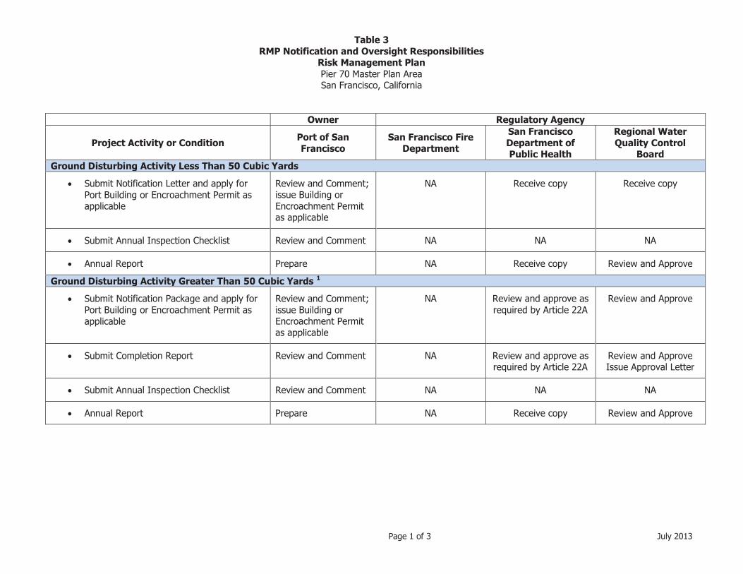
Table 3 RMP Notification and Oversight Responsibilities
Risk Management Plan Pier 70 Master Plan Area San Francisco, California
Page 1 of 3 July 2013
Owner Regulatory Agency
Project Activity or Condition Port of San Francisco
San Francisco Fire Department
San Francisco Department of Public Health
Regional Water Quality Control
Board Ground Disturbing Activity Less Than 50 Cubic Yards
� Submit Notification Letter and apply for Port Building or Encroachment Permit as applicable
Review and Comment; issue Building or Encroachment Permit as applicable
NA Receive copy Receive copy
� Submit Annual Inspection Checklist Review and Comment NA NA NA
� Annual Report Prepare NA Receive copy Review and Approve
Ground Disturbing Activity Greater Than 50 Cubic Yards 1
� Submit Notification Package and apply for Port Building or Encroachment Permit as applicable
Review and Comment; issue Building or Encroachment Permit as applicable
NA Review and approve as required by Article 22A
Review and Approve
� Submit Completion Report Review and Comment NA Review and approve as required by Article 22A
Review and Approve Issue Approval Letter
� Submit Annual Inspection Checklist Review and Comment NA NA NA
� Annual Report Prepare NA Receive copy Review and Approve
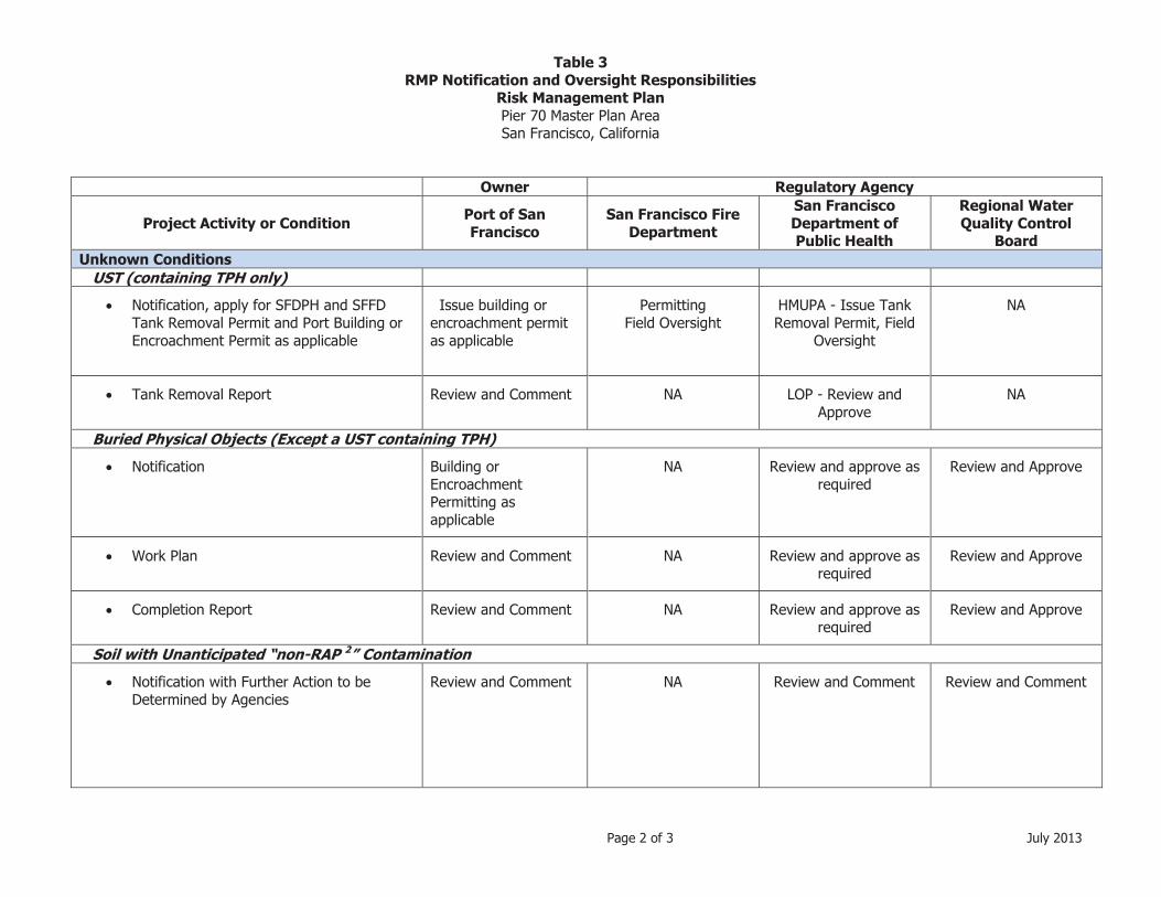
Table 3 RMP Notification and Oversight Responsibilities
Risk Management Plan Pier 70 Master Plan Area San Francisco, California
Page 2 of 3 July 2013
Owner Regulatory Agency
Project Activity or Condition Port of San Francisco
San Francisco Fire Department
San Francisco Department of Public Health
Regional Water Quality Control
Board Unknown Conditions
UST (containing TPH only)
� Notification, apply for SFDPH and SFFD Tank Removal Permit and Port Building or Encroachment Permit as applicable
Issue building or encroachment permit as applicable
Permitting Field Oversight
HMUPA - Issue Tank Removal Permit, Field
Oversight
NA
� Tank Removal Report Review and Comment NA LOP - Review and Approve
NA
Buried Physical Objects (Except a UST containing TPH)
� Notification Building or Encroachment Permitting as applicable
NA Review and approve as required
Review and Approve
� Work Plan Review and Comment NA Review and approve as required
Review and Approve
� Completion Report Review and Comment NA Review and approve as required
Review and Approve
Soil with Unanticipated “non-RAP 2” Contamination
� Notification with Further Action to be Determined by Agencies
Review and Comment NA Review and Comment Review and Comment

Table 3 RMP Notification and Oversight Responsibilities
Risk Management Plan Pier 70 Master Plan Area San Francisco, California
Page 3 of 3 July 2013
Owner Regulatory Agency
Project Activity or Condition Port of San Francisco
San Francisco Fire Department
San Francisco Department of Public Health
Regional Water Quality Control
Board Groundwater Contaminated with Free Product
� Notification Review and Comment NA Receive copy
Review and Approve
� Work Plan Review and Comment NA Review and approve as required by Article 22A
Review and Approve
� Completion Report Review and Comment NA Review and approve as required by Article 22A
Review and Approve
Groundwater Contaminated with other Chemicals
� Notification Review and Comment NA Receive copy Review and Approve
� Work Plan Review and Comment NA Receive copy Review and Approve
� Completion Report Review and Comment NA Receive copy Review and Approve
Notes:
TPH – Total Petroleum Hydrocarbons
SFFD – San Francisco Fire Department
SFDPH – San Francisco Department of Public Health 1 Document adequate soil data exists per Article 22 or proposed additional soil sampling. 2 Contaminant with no remedy specified in Remedial Action Plan (T&R, 2012).
HMUPA – Hazardous Materials Unified Program Agency
LOP – Local Oversight Program
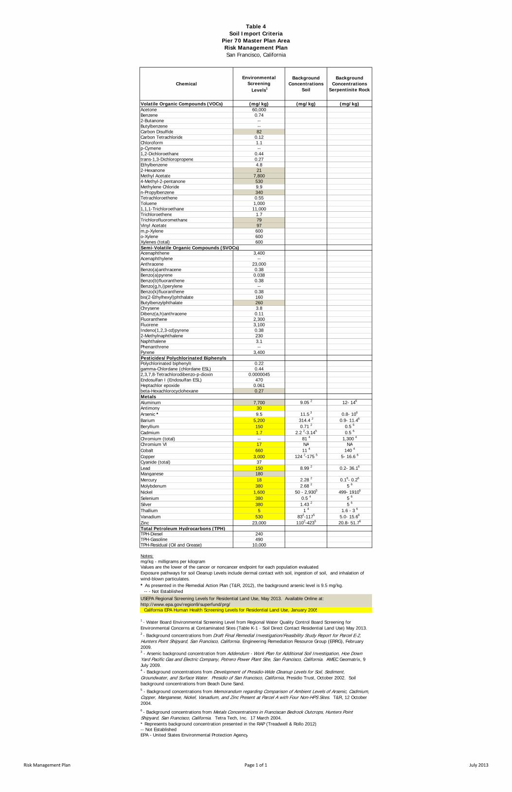
Table 4Soil Import Criteria
Pier 70 Master Plan AreaRisk Management PlanSan Francisco, California
Volatile Organic Compounds (VOCs) (mg/kg) (mg/kg) (mg/kg)Acetone 60,000Benzene 0.742-Butanone --Butylbenzene --Carbon Disulfide 82Carbon Tetrachloride 0.12Chloroform 1.1p-Cymene --1,2-Dichloroethane 0.44trans-1,3-Dichloropropene 0.27Ethylbenzene 4.82-Hexanone 21Methyl Acetate 7,8004-Methyl-2-pentanone 530Methylene Chloride 9.9n-Propylbenzene 340Tetrachloroethene 0.55Toluene 1,0001,1,1-Trichloroethane 11,000Trichloroethene 1.7Trichlorofluoromethane 79Vinyl Acetate 97m,p-Xylene 600o-Xylene 600Xylenes (total) 600Semi-Volatile Organic Compounds (SVOCs)Acenaphthene 3,400Acenaphthylene --Anthracene 23,000Benzo(a)anthracene 0.38Benzo(a)pyrene 0.038Benzo(b)fluoranthene 0.38Benzo(g,h,i)perylene --Benzo(k)fluoranthene 0.38bis(2-Ethylhexyl)phthalate 160Butylbenzylphthalate 260Chrysene 3.8Dibenz(a,h)anthracene 0.11Fluoranthene 2,300Fluorene 3,100Indeno(1,2,3-cd)pyrene 0.382-Methylnaphthalene 230Naphthalene 3.1Phenanthrene --Pyrene 3,400Pesticides/Polychlorinated BiphenylsPolychlorinated biphenyls 0.22gamma-Chlordane (chlordane ESL) 0.442,3,7,8-Tetrachlorodibenzo-p-dioxin 0.0000045Endosulfan I (Endosulfan ESL) 470Heptachlor epoxide 0.061beta-Hexachlorocyclohexane 0.27MetalsAluminum 7,700 9.05 2 12- 146
Antimony 30Arsenic * 9.5 11.5 3 0.8- 106
Barium 5,200 314.4 2 0.9- 11.46
Beryllium 150 0.71 2 0.5 6
Cadmium 1.7 2.2 2-3.145 0.5 6
Chromium (total) -- 81 4 1,300 4
Chromium VI 17 NA NACobalt 660 11 4 140 4
Copper 3,000 124 2-175 5 5- 16.6 6
Cyanide (total) 37Lead 150 8.99 2 0.2- 36.16
Manganese 180Mercury 18 2.28 2 0.16- 0.26
Molybdenum 380 2.68 2 5 6
Nickel 1,600 50 - 2,9305 499- 19106
Selenium 380 0.5 4 5 6
Silver 380 1.43 2 5 6
Thallium 5 1 4 1.6 - 3 6
Vanadium 530 832-1175 5.0- 15.66
Zinc 23,000 1102-4235 20.8- 51.76
Total Petroleum Hydrocarbons (TPH)TPH-Diesel 240TPH-Gasoline 490TPH-Residual (Oil and Grease) 10,000
Notes:mg/kg - milligrams per kilogramValues are the lower of the cancer or noncancer endpoint for each population evaluated.
-- - Not Established
California EPA Human Health Screening Levels for Residential Land Use, January 2005
* Represents background concentration presented in the RAP (Treadwell & Rollo 2012)-- Not EstablishedEPA - United States Environmental Protection Agency
5 - Background concentrations from Memorandum regarding Comparison of Ambient Levels of Arsenic, Cadmium, Copper, Manganese, Nickel, Vanadium, and Zinc Present at Parcel A with Four Non-HPS Sites. T&R, 12 October 2004.6 - Background concentrations from Metals Concentrations in Franciscan Bedrock Outcrops, Hunters Point Shipyard, San Francisco, California. Tetra Tech, Inc. 17 March 2004.
1 - Water Board Environmental Screening Level from Regional Water Quality Control Board Screening for Environmental Concerns at Contaminated Sites (Table K-1 - Soil Direct Contact Residential Land Use) May 2013.2 - Background concentrations from Draft Final Remedial Investigation/Feasibility Study Report for Parcel E-2, Hunters Point Shipyard, San Francisco, California. Engineering Remediation Resource Group (ERRG), February 2009.3 - Arsenic background concentration from Addendum - Work Plan for Additional Soil Investigation, Hoe Down Yard Pacific Gas and Electric Company, Potrero Power Plant Site, San Francisco, California. AMEC Geomatrix, 9 July 2009.4 - Background concentrations from Development of Presidio-Wide Cleanup Levels for Soil, Sediment, Groundwater, and Surface Water. Presidio of San Francisco, California, Presidio Trust, October 2002. Soil background concentrations from Beach Dune Sand.
USEPA Regional Screening Levels for Residential Land Use, May 2013. Available Online at: http://www.epa.gov/region9/superfund/prg/
* As presented in the Remedial Action Plan (T&R, 2012), the background arsenic level is 9.5 mg/kg.
Exposure pathways for soil Cleanup Levels include dermal contact with soil, ingestion of soil, and inhalation of wind-blown particulates.
ChemicalBackground
Concentrations Soil
Background Concentrations
Serpentinite Rock
Environmental Screening Levels1
Risk Management Plan Page 1 of 1 July 2013

FIGURES

Figure 1\\langan.com\data\SF\data3\730496301\Engineering Data\Environmental\Illustrator\Site Location Map RMP.ai
Project No. 730496301
PIER 70 MASTER PLAN AREA RISK MANAGEMENT PLAN
San Francisco, California SITE LOCATION MAP
SITE
Base map: The Thomas Guide San Francisco County 1999
0 1/2 Mile
Approximate scale
1/4
SANFRANCISCO
BAY
Date 07/24/13
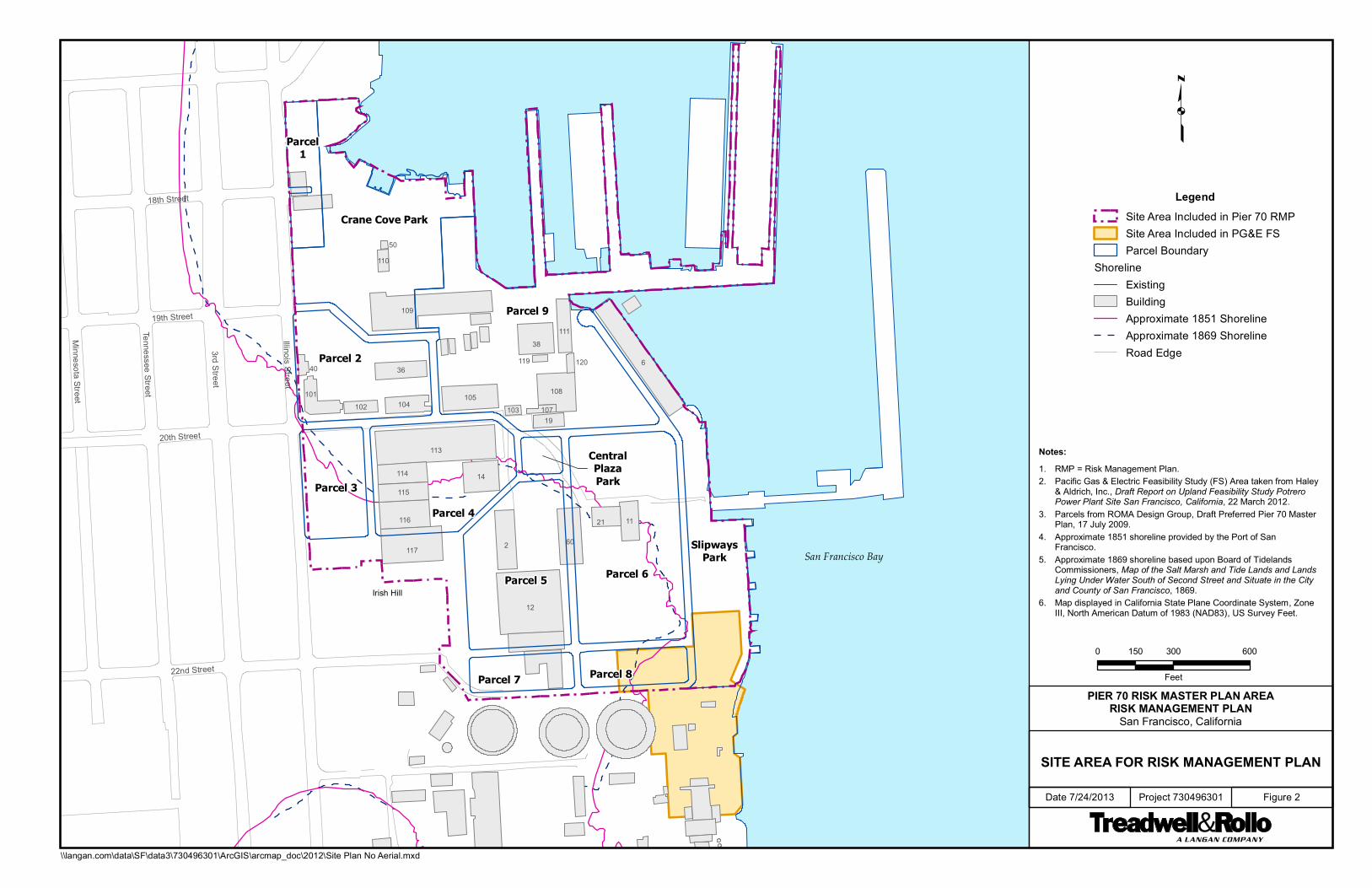
Illinois Street
3rd Street
Tennessee Street
Minnesota Street
20th Street
22nd Street
19th Street
18th Street
Irish Hill
San Francisco Bay
Parcel 9
Parcel 6Parcel 5
Parcel 4
Parcel 2
Crane Cove Park
Parcel 3
Parcel 8Parcel 7
SlipwaysPark
Parcel1
CentralPlazaPark
6
12
113
2
109
11760
38
14
116
105108
11
114
115
21
111
101
19
36
104102
40
110
107103
120119
50
PIER 70 RISK MASTER PLAN AREARISK MANAGEMENT PLAN
San Francisco, California
SITE AREA FOR RISK MANAGEMENT PLAN
Date 7/24/2013 Project 730496301 Figure 2
0 300 600150
Feet
LegendSite Area Included in Pier 70 RMPSite Area Included in PG&E FSParcel Boundary
ShorelineExistingBuildingApproximate 1851 ShorelineApproximate 1869 ShorelineRoad Edge
\\langan.com\data\SF\data3\730496301\ArcGIS\arcmap_doc\2012\Site Plan No Aerial.mxd
Notes: 1. RMP = Risk Management Plan. 2. Pacific Gas & Electric Feasibility Study (FS) Area taken from Haley
& Aldrich, Inc., Draft Report on Upland Feasibility Study Potrero Power Plant Site San Francisco, California, 22 March 2012.
3. Parcels from ROMA Design Group, Draft Preferred Pier 70 Master Plan, 17 July 2009.
4. Approximate 1851 shoreline provided by the Port of San Francisco.
5. Approximate 1869 shoreline based upon Board of Tidelands Commissioners, Map of the Salt Marsh and Tide Lands and Lands Lying Under Water South of Second Street and Situate in the City and County of San Francisco, 1869.
6. Map displayed in California State Plane Coordinate System, Zone III, North American Datum of 1983 (NAD83), US Survey Feet.

109
101 102 104122
123
105
103 107
108
36
111
120
19
113
114
115
116
14
2
12
6
64
250
110
21
50
23
1275868
141
Kneass
SLIP
WAY
4
SLIPWAYS PARK
19th Street
20th Street
22nd Street
Illin
ois
Stre
et
Illin
ois
Stre
et
18th Street
Kneass
COVE
IRISHHILL
CRANE COVE PARK
(PORT)
HISTORIC CORE
(ORTON)
SHIP REPAIR(BAE SYSTEMS)
WATERFRONT SITE(FOREST CITY)
Mariposa Street
HISTORIC BUILDINGS
OPEN SPACE
MIXED USE- RESIDENTAL ALLOWED
SHIP REPAIR (HISTORIC USE)
BUILDING PROPOSED FOR REMOVAL*
PIER 70 RMP AREA BOUNDARY
COMMERCIAL/SPECIAL USE- HISTORIC CORE
OFFICE, BIOTECH, COMMECIAL, RESIDENTIALR&D, PDR
*NOTE: BUILDING 21 PROPOSED TO BE RELOCATED
PIER 70 PROJECT SUB-AREAS
CRANE COVE PARK
SHIP REPAIR
FOREST CITY WATERFRONT SITE
ORTON - 20TH STREET CORE
*NOTE: BOUNDARIES BETWEEN PROJECTS ARE CONCEPTUAL, VARY SLIGHTLY FROM THE EXCLUSIVE NEGOTIATING AGREEMENT TERMS, AND WILL BE REFINED AS LEASE DETAILS ARE NEGOTIATED.
HISTORIC BUILDINGS
OPEN SPACE
MIXED USE- RESIDENTAL ALLOWED
SHIP REPAIR (HISTORIC USE)
PIER 70 RMP AREA BOUNDARY
OFFICE, BIOTECH, COMMECIAL, RESIDENTIALR&D, PDR
PIER 70 PROJECT SUB-AREAS
CRANE COVE PARK
SHIP REPAIR
FOREST CITY WATERFRONT SITE
ORTON - 20TH STREET HISTORIC CORE
*NOTE: BOUNDARIES BETWEEN PROJECTS ARE CONCEPTUAL, VARY SLIGHTLY FROM THE EXCLUSIVE NEGOTIATING AGREEMENT TERMS, AND WILL BE REFINED AS LEASE DETAILS ARE NEGOTIATED.
Project No. FigureDate 73049630107/24/13 3
PIER 70 MASTER PLAN AREARISK MANAGEMENT PLAN
San Francisco, California
PIER 70 MASTER PLAN LAND USESUB AREAS PROJECT PLAN
Source:Port of San Francisco, February 2013.
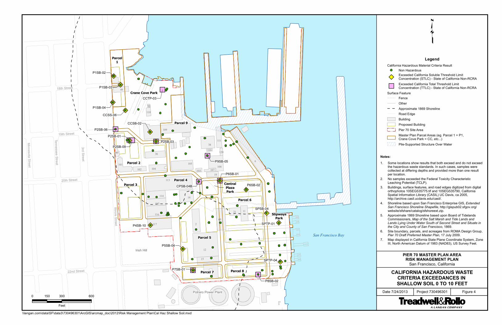
P8SB-02
Illinois Street
3rd Street
Tennessee Street
Minnesota S
treet
20th Street
22nd Street
19th Street
18th Street
Irish Hill
San Francisco Bay
Potrero Power Plant
Parcel 9
Parcel 6
Parcel 5
Parcel 4
Parcel 2
Crane Cove Park
Parcel 3
Parcel 8Parcel 7
SlipwaysPark
Parcel1
CentralPlazaPark
6
12
113
2
109
11760
38
14
15
108
36
1121
111
104
116
105
114
115
101
19102
40
110
107103
120119
50
49
SPTP-04
SPTP-01
SPSB-04
P9SB-05
P7SB-01
P6SB-02
P5SB-04
P4SB-10
P2SB-06
P2SB-03
P1SB-04
P1SB-03
P1SB-02
CCTP-03
CCSS-06
CCSB-02
CPSB-04B
P6SB-01
P2SB-01
P2SB-09
PIER 70 MASTER PLAN AREARISK MANAGEMENT PLAN
San Francisco, California
CALIFORNIA HAZARDOUS WASTECRITERIA EXCEEDANCES IN SHALLOW SOIL 0 TO 10 FEET
Date 7/24/2013 Project 730496301 Figure 40 300 600150
Feet
\\langan.com\data\SF\data3\730496301\ArcGIS\arcmap_doc\2012\Risk Management Plan\Cal Haz Shallow Soil.mxd
LegendCalifornia Hazardous Material Criteria Result
Non HazardousExceeded California Soluble Threshold LimitConcentration (STLC) - State of California Non-RCRA
Exceeded California Total Threshold LimitConcentration (TTLC) - State of California Non-RCRA
Surface FeatureFenceOtherApproximate 1869 ShorelineRoad EdgeBuildingProposed BuildingPier 70 Site AreaMaster Plan Parcel Areas (eg. Parcel 1 = P1,Crane Cove Park = CC, etc...)
Pile-Supported Structure Over Water
Notes: 1. Some locations show results that both exceed and do not exceed
the hazardous waste standards. In such cases, samples were collected at differing depths and provided more than one result per location.
2. No samples exceeded the Federal Toxicity Characteristic Leaching Potential (TCLP).
3. Buildings, surface features, and road edges digitized from digital orthophotos 10SEG535775.tif and 10SEG535790, California Spatial Information Library (CASIL) UC Davis, ca 2005, http://archive.casil.ucdavis.edu/casil/.
4. Shoreline based upon San Francisco Enterprise GIS, Extended San Francisco Shoreline Shapefile, http://gispub02.sfgov.org/ website/sfshare/catalog/sfshoreext.zip.
5. Approximate 1869 Shoreline based upon Board of Tidelands Commissioners, Map of the Salt Marsh and Tide Lands and Lands Lying Under Water South of Second Street and Situate in the City and County of San Francisco, 1869.
6. Site boundary, parcels, and acreages from ROMA Design Group, Pier 70 Draft Preferred Master Plan, 17 July 2009.
7. Map displayed in California State Plane Coordinate System, Zone III, North American Datum of 1983 (NAD83), US Survey Feet.
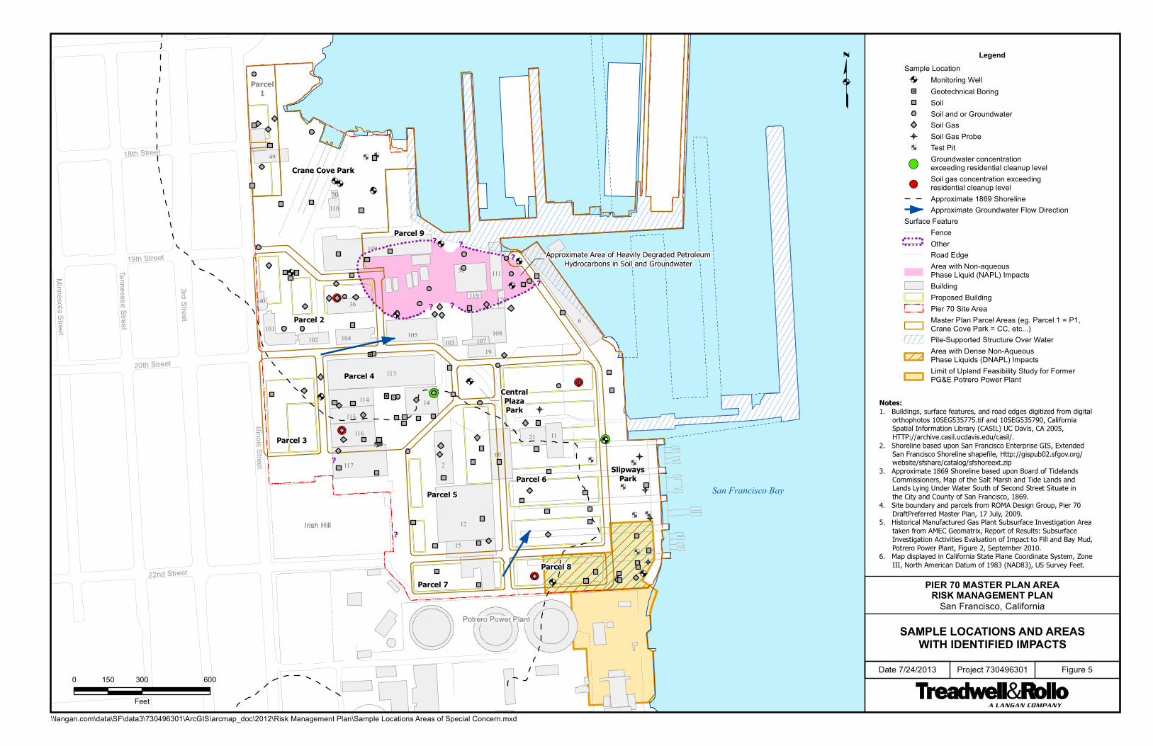
Illinois Street
3rd Street
Tennessee Street
Minnesota S
treet
20th Street
22nd Street
19th Street
18th Street
Irish Hill
San Francisco Bay
Potrero Power Plant
Parcel 9
Parcel 6Parcel 5
Parcel 4
Parcel 2
Crane Cove Park
Parcel 3
Parcel 8Parcel 7
SlipwaysPark
Parcel1
CentralPlazaPark
6
12
113
2
109
11760
38
14
15
108
36
1121
111
104
116
105
114
115
101
19102
40
110
107103
120119
50
49
? ?
?
?
?
?
??
Approximate Area of Heavily Degraded PetroleumHydrocarbons in Soil and Groundwater
PIER 70 MASTER PLAN AREARISK MANAGEMENT PLAN
San Francisco, California
SAMPLE LOCATIONS AND AREASWITH IDENTIFIED IMPACTS
Date 7/24/2013 Project 730496301 Figure 50 300 600150
Feet
\\langan.com\data\SF\data3\730496301\ArcGIS\arcmap_doc\2012\Risk Management Plan\Sample Locations Areas of Special Concern.mxd
LegendSample Location
Monitoring WellGeotechnical BoringSoilSoil and or GroundwaterSoil GasSoil Gas ProbeTest PitGroundwater concentrationexceeding residential cleanup levelSoil gas concentration exceedingresidential cleanup levelApproximate 1869 ShorelineApproximate Groundwater Flow Direction
Surface FeatureFenceOtherRoad EdgeArea with Non-aqueousPhase Liquid (NAPL) ImpactsBuildingProposed BuildingPier 70 Site AreaMaster Plan Parcel Areas (eg. Parcel 1 = P1,Crane Cove Park = CC, etc...)Pile-Supported Structure Over WaterArea with Dense Non-AqueousPhase Liquids (DNAPL) ImpactsLimit of Upland Feasibility Study for FormerPG&E Potrero Power Plant
Notes:1. Buildings, surface features, and road edges digitized from digital orthophotos 10SEG535775.tif and 10SEG535790, California Spatial Information Library (CASIL) UC Davis, CA 2005, HTTP://archive.casil.ucdavis.edu/casil/.2. Shoreline based upon San Francisco Enterprise GIS, Extended San Francisco Shoreline shapefile, Http://gispub02.sfgov.org/ website/sfshare/catalog/sfshoreext.zip3. Approximate 1869 Shoreline based upon Board of Tidelands Commissioners, Map of the Salt Marsh and Tide Lands and Lands Lying Under Water South of Second Street Situate in the City and County of San Francisco, 1869.4. Site boundary and parcels from ROMA Design Group, Pier 70 DraftPreferred Master Plan, 17 July, 2009.5. Historical Manufactured Gas Plant Subsurface Investigation Area taken from AMEC Geomatrix, Report of Results: Subsurface Investigation Activities Evaluation of Impact to Fill and Bay Mud, Potrero Power Plant, Figure 2, September 2010.6. Map displayed in California State Plane Coordinate System, Zone III, North American Datum of 1983 (NAD83), US Survey Feet.

PIER 70 RISK MANAGEMENT PLAN Pier 70 Master Plan Area San Francisco, California
Prepared For: Port of San Francisco
San Francisco, California
25 July 2013 Project No. 730496301
APPENDIX A
ANNUAL INSPECTION O&M CHECKLIST AND DURABLE COVER O&M PLAN

1 Appendix A July 2013
APPENDIX A
OPERATION AND MAINTENANCE PLAN PIER 70 MASTER PLAN AREA
RISK MANAGEMENT PLAN SAN FRANCISCO, CALIFORNIA
1.0 INTRODUCTION AND BACKGROUND
Over the course of redevelopment, the Port and various project proponents will incorporate construction
of a durable cover over native soil that meets the requirements of the Remedial Action Plan (RAP) for the
Pier 70 Master Plan Area, San Francisco, California (Site). Inspection and maintenance of the durable
cover to ensure that it remains in a condition that prevents site user exposure to native soil is an
essential component of the remedy for the Pier 70 Master Plan Area. Project proponents will prepare
durable cover designs for review and approval by the Regional Water Quality Control Board (Water
Board). Upon completion, project proponents will submit a completion report to document durable cover
installation (See Section 4.3). The remedial action completion reports must also document that required
long-term operation and maintenance (O&M) of the durable cover is taking place. This O&M plan
describes the long-term maintenance and monitoring requirements for the durable cover and includes:
A description of inspection, maintenance, and repair for the durable cover;
A maintenance schedule;
Guidance for inspection of signs, drainage features, vegetation, and the condition of the durable
cover and shoreline strengthening;
Repair procedures;
Reporting requirements; and
Emergency response planning and procedures related to O&M of the Site.
A list of the projected inspection items, inspection procedures, generalized repair procedures, and
inspection frequency is included as Attachment 1. This attachment will be supplemented or replaced
during and after redevelopment based on the actual construction of the remedy (durable covers) and the
materials used.
Inspection, maintenance, and monitoring of the durable cover are required and are the responsibility of
the Port as landowner. The Port may impose requirements to inspect, maintain, and repair durable cover

2 Appendix A July 2013
on tenants, licensees, permittees, and other entities responsible for construction and/or operation of
facilities at Pier 70, but remains responsible for ensuring compliance and submitting annual monitoring
reports to the San Francisco Department of Public Health (SFDPH) and the Water Board. Facility owners
or operators that conduct annual self-inspections and certify completion may use the Owner Checklist
and Certification found in Attachment 1, and submit it to the Port.
This O&M Plan applies only to the durable cover. Potential future conditions (e.g. changes in land use,
type of construction) may require additional engineering controls, such as soil vapor intrusion mitigation
systems. In the event that additional engineering controls are installed, this O&M Plan will be revised as
described in Section 1.2.
1.1 Remedy Components
The remedial alternative selected for this Site is described in Treadwell & Rollo’s Feasibility Study
Remedial Action Plan Report (FS/RAP) Pier 70 Master Plan Area, Port of San Francisco, San Francisco
California, dated 31 May 2012, was approved by the Water Board on 9 August 2012, and is summarized
below. The Risk Management Plan (RMP) is an essential component of the remedy for the Site. It is a
tool for ensuring effectiveness of the institutional controls and provides a framework to manage residual
constituents of concern (COCs) in soil in a manner that protects site users under current and future land
use. The RMP specifies pre-development, development, and post-development measures to mitigate
potential risks to the environment, current and future on-site employees, future residents, construction
and maintenance workers, visitors, and the public. It has been prepared under Water Board and the
SFDPH oversight to provide specifications and details on how risk will be mitigated and managed during
future construction, operation, and maintenance.
1.1.1 Durable Cover
The essential design criterion for durable cover is that it prevent site users’ contact with native soil. The
durable cover over the Site currently consists of the existing building foundations, asphalt and concrete
pavement, streets and sidewalks. Over the course of redevelopment, rehabilitation of existing structures
and new construction will result in installation of durable cover including historic and new building
foundations; new streets and sidewalks; hardscapes; and new landscaping on a minimum of 2 feet of
clean import soil over a demarcation layer. The clean soil layer must accommodate the depth of root
bearing zones and/or irrigation systems to assure that general maintenance workers will not contact any
of the native soil below the demarcation layer. The cover will be graded to direct storm water flow

3 Appendix A July 2013
toward drainage features that run through the Site. Shoreline strengthening measures will be designed
to protect the shoreline sediment and landward soil from erosion. If any activities that occur after initial
development disturb 1,250 square feet (sf) or 50 cubic yards (cy) or more of native soil, remove/replace
10,000 sf or more of durable cover, or request approval to vary from the requirements of the RMP, then
Water Board and SFDPH must be notified in accordance with Sections 4.1 and 4.2 of the RMP.
1.1.2 Institutional Controls
Institutional controls are legal and administrative mechanisms that limit site users’ exposure to
contaminants and enable reuse of the site while protecting human health and the environment. The RAP
for Pier 70 includes two primary institutional controls: deed restrictions that impose conditions under
which other land uses can occur, and implementation of the RMP, which establishes those conditions
under which land can be used. Inspections are required to ensure that land use controls are
implemented and maintained effectively
1.2 O&M Plan Revisions
As redevelopment proceeds, changes to the O&M Plan may be needed to address changes in land use,
design, construction materials and methods, or other conditions. This O&M plan may therefore change
as durable cover construction is completed in various portions of the Site. Soil vapor controls may
become necessary at the Site, depending on the results of additional risk evaluation or sampling that may
be required if residential land use is proposed in areas within the Site where volatile organic compounds
(VOCs) in soil gas and groundwater are present above Human Health Cleanup Levels (see RMP, Sections
2.1.2 and 2.1.3). Any soil vapor controls would likely require long-term O&M provisions, and therefore a
revision of the O&M plan. If short-or long-term groundwater monitoring is found to be necessary in the
area where Dense Non Aqueous Phase Liquids (DNAPL) are present (See RMP Section 2.1.3) or
elsewhere on the Site, appropriate O&M procedures would need to be added to this O&M plan.
The Port will revise the O&M Plan as needed to reflect as-built conditions, or when experience shows a
deficiency in the identification, frequency, or adequacy of repair needs over time. The Port or project
proponents will develop and submit proposed revisions to SFDPH and the Water Board for review and
approval.

4 Appendix A July 2013
2.0 INSPECTION, MAINTENANCE, AND REPAIR
This section describes the O&M personnel responsible for inspecting site conditions, and the inspection
maintenance, and repair tasks associated with site security measures, durable covers, and shoreline
improvements.
2.1 O&M Personnel
The Port or facility operators will retain qualified personnel and contractors to perform O&M at the Site to
provide adequate long-term support for the remedy. O&M activities and associated qualifications may
change after the Site is redeveloped and the O&M plan is revised for specific Site conditions as they
change over time.
2.2 Inspection of Site Conditions
The Port or its designated representative will inspect general conditions throughout the Site annually.
However, the Port or its designated representative may be required or choose to conduct annual and/or
additional site inspections for unforeseen emergencies as described in Section 4.0. Inspections must
assess all portions of the Site to identify any changes in land use, grading, excavation, new construction,
damage to durable cover, or other conditions that could result in unacceptable exposure to native soil.
1Inspections will include site access points and integrity of site access controls and signage. Any issues
of concern (i.e. evidence of unauthorized digging, evidence that site security is compromised, damage to
durable cover that results in exposure to native soil) must be reported to the Port remedied as soon as
practicable but no later than 2 weeks after the Port becomes aware of the breach. Repairs to the durable
cover should be consistent with and functionally equivalent to the original installation design drawings.
2.3 Inspection, Maintenance, and Repair of Site Security Measures
The Site security measures are intended to protect the public from physical and chemical hazards that
exist at the Site. In order to minimize potential contact with exposed native soil greater than 100
sf, barriers, fencing and signs will be installed and maintained to restrict access or covered with a
temporary cover, such as “cold” asphalt patch or 12-inches of gravel.
Where durable cover is in place, signage and fencing are required only when and where Site activities
include disturbance of more than 100 sf of durable cover. If any native soil is exposed, the Dust Control
Plan (DCP) must be followed (Appendix B of the RMP). The goal of the DCP is no visible dust. While it is

5 Appendix A July 2013
understood that soil disturbance and excavation activities will produce dust, dust controls will be used to
mitigate visible dust as it occurs (see Sections 4.6 and 5.0 of the DCP).
Signs will be used to warn against unauthorized access to the Site and provide emergency contact
information. The project proponent will replacement signs as necessary to ensure legibility. Signage
requirements are described in Section 5.2 of the RMP.
2.4 Inspection, Maintenance, and Repair of Durable Covers
This section describes the procedures for inspection, maintenance, and repair for the durable covers,
which include the existing asphalt and concrete pavement, soil cover, and building foundations. In
general, any deficiencies that reduce the protectiveness of the cover to human health and the
environment will be corrected. In some cases, damaged areas may need to be secured to prevent access
by the public while repairs are planned and implemented. The Port or its designated representative will
evaluate the need for and type of security appropriate in relation to the repair needed.
Recording the inspection through forms, note taking, and photographs is a necessary part of the
inspection. An Inspection logbook will be maintained and include field notes and photographs recorded
during inspections. The list of inspection items, procedures, and frequency is included as Attachment 1
to this O&M plan and will be modified as necessary after construction, during the course of
redevelopment, and during O&M.
The Port or its designated representative will inspect general conditions throughout the Site annually, and
will inspect asphalt pavement cover and building foundations after earthquakes for settling, cracking, or
other breaches. Refer to Attachment 1 for inspection tasks, triggers, and procedures.
2.4.1 Asphalt Pavement Cover and Building Foundations
Existing pavement, primarily asphalt, and building foundations minimize contact with and release of the
COCs in soil at the Site. Building foundations appear to be primarily constructed of reinforced concrete.
Maintenance, repair, or replacement of the asphalt pavement or building foundations is required when
damage that reduces the effectiveness of the remedy is observed. During the required annual
inspections and after significant seismic events asphalt pavement will be inspected for signs of stress,
which may include excessive cracking and settlement. Cracking of these covers is expected over time

6 Appendix A July 2013
and is not necessarily an immediate concern, but should be repaired when underlying soil becomes
exposed or accessible or when expansion of cracks is observed. Settlement and subsidence are not an
immediate concern but should be monitored over time and repaired if water accumulation is or becomes
persistent.
Items to note during inspection of the asphalt pavement and building foundations include:
Pavement condition (depressions and excessive cracking)
Cracks in the building foundation
Crawl spaces access is blocked off (where applicable)
Wear and tear due to excessive vehicle or pedestrian traffic
Settlement and subsidence
Surface water accumulation indicative of inadequate drainage
Vandalism and unauthorized access to Site or buildings
Vegetation should not be present over the asphalt pavement portion of the Site. Vegetation should be
removed when present and cover should be repaired to prevent future growth.
Building foundations should be inspected for cracking or signs of stress from outside of the buildings.
Building interiors should be inspected when exterior cracking or evidence of unauthorized access is
observed. Buildings themselves do not require maintenance because they are not considered part of the
durable cover. Access points to subslab or subfloor crawl spaces should be inspected for integrity and
evidence of vandalism or tampering.
Deficiencies, damage, settlement, or failure of the asphalt pavement and the building foundations will be
repaired when underlying soil is exposed or accessible. Temporary repairs will be made, if necessary,
until permanent repairs can be scheduled.
2.4.2 Vegetated Soil Cover
The soil cover specified by the RAP is designed to minimize contact with contaminants in native soil at the
Site. The specified cover consists of a minimum 2-foot-thick clean soil layer over a demarcation layer in
landscaped portions of the Site. The clean soil layer must accommodate the depth of root bearing zones

7 Appendix A July 2013
and/or irrigation systems to assure that general maintenance workers will not contact any of the native
soil below the demarcation layer. Applicable O&M-related documentation for the components of the soil
cover is included in Attachment 1 of this O&M plan and will be updated after construction of soil covered
or landscaped areas.
Items to note during inspection of the vegetated soil cover include:
Evidence of erosion, potentially including exposed demarcation layer;
Visible depressions;
Proper surface water drainage;
Cracks;
Settlement and subsidence;
Slope failure;
Vandalism;
Evidence of burrowing pests;
Vegetation stress; and
Bare spots.
2.4.3 Shoreline Protection
Some portions of the shoreline within the Pier 70 Master Plan area will be improved, including
construction of shoreline strengthening or stabilization. Shoreline improvements will be designed and
constructed to prevent upland and intertidal soil from eroding into the bay, thereby minimizing potential
release of contaminants into the San Francisco Bay. Refer to Attachment 1 for inspection tasks and
procedures related to improved shoreline areas. Items to note during inspection include observations of
settlement, vandalism, and displacement of materials.
3.0 REPORTING
An annual inspection report will be prepared to summarize the inspections for each year (see RMP
Section 4.4); this report will be forwarded for review and approval by the regulatory agencies. The
annual inspection report will include, at a minimum, the results of the inspections and a summary of all
repair and maintenance activities conducted. The annual inspection report will be certified by an Owner
or designated Port representative.

8 Appendix A July 2013
Additional reporting may be necessary following significant repairs to components of the remedy, such as
repairs conducted under an agency-approved work plan1, or after inspection triggered by an earthquake
or other natural event. General maintenance tasks, such as filling potholes, sealing pavement, repair of
fencing or signage, and replacing damaged drainage features would not require the submittal of a work
plan and agency approval. Additional reporting requirements and procedures should be considered
through the course of O&M to refine the plan based on experience at the Site.
A copy of the O&M plan will be maintained by the Port. The O&M Plan will also be provided to all
tenants, licensees, permittees or others with operational control over facilities or land within the Pier 70
Master Plan area for 12 months or longer, or whose operations have potential to impact native soil and/or
durable cover.
4.0 EMERGENCY RESPONSE PLAN
Some emergencies can affect the integrity or effectiveness of the durable cover, fencing and signage, or
other features of the remedy. Although the Port and future lessees will take action to reduce the
potential for emergencies, it is possible for events to occur at the Site that cannot be prevented. This
plan provides response procedures for the following occurrences that threaten the effectiveness of the
durable cover:
Vandalism
Fires
Earthquake
Floods
Surface drainage problems
Release of potentially contaminated materials (soil, soil gas, or water)
Attachment 2 provides recommended responses for the above emergencies. This plan is intended to
address contingencies that are reasonably foreseeable, but will be amended if the need for additional
contingency measures is identified.
1 Work that disturbs a 1,250 sf or larger area requires advance notification to the Water Board. Work that does not
comply with the RMP requires a Water Board approved work plan. Work that disturbs more than 50 cy of soil may require work plans and site mitigation plans in accordance with the City of San Francisco’s Article 22A (Maher) Ordinance.
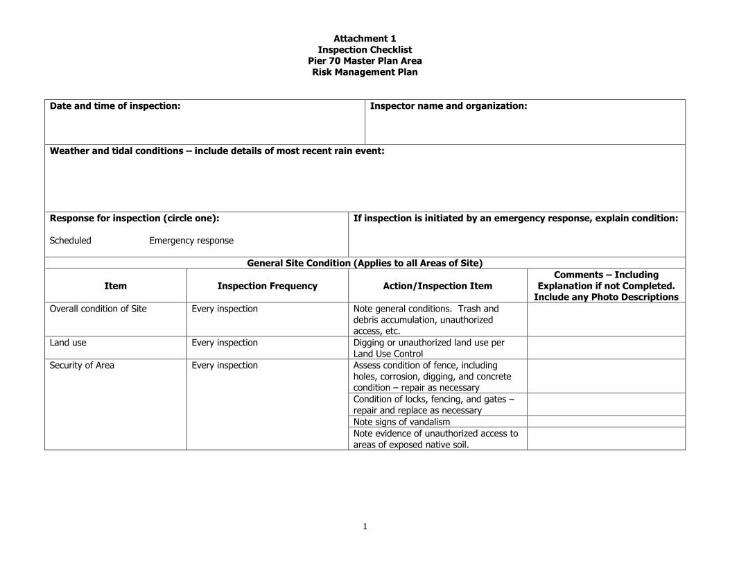
Attachment 1
Inspection Checklist Pier 70 Master Plan Area
Risk Management Plan
1
Date and time of inspection:
Inspector name and organization:
Weather and tidal conditions – include details of most recent rain event:
Response for inspection (circle one):
Scheduled Emergency response
If inspection is initiated by an emergency response, explain condition:
General Site Condition (Applies to all Areas of Site)
Item Inspection Frequency Action/Inspection Item
Comments – Including
Explanation if not Completed. Include any Photo Descriptions
Overall condition of Site Every inspection Note general conditions. Trash and
debris accumulation, unauthorized access, etc.
Land use Every inspection Digging or unauthorized land use per
Land Use Control
Security of Area Every inspection Assess condition of fence, including
holes, corrosion, digging, and concrete condition – repair as necessary
Condition of locks, fencing, and gates –
repair and replace as necessary
Note signs of vandalism
Note evidence of unauthorized access to
areas of exposed native soil.

Attachment 1
Inspection Checklist Pier 70 Master Plan Area
Risk Management Plan
2
General Site Condition (Applies to all Areas of Site)
Item Inspection Frequency Action/Inspection Item
Comments – Including
Explanation if not Completed.
Include any Photo Descriptions
All signs in place and secure – repair and
replace as necessary
Site signage Every inspection All signs in place and secure – repair and replace as necessary
Wording legible – replace and repair as
necessary or document degradation
Note signs of vandalism
Surface Inspection Every inspection Access cracking in asphaltic concrete layer
and inspect transition between cover and utility features such as manholes and
utility boxes
Assess cracking in foundations
Assess the crawl space access to maintain
the prevention of unauthorized access
Evidence of settlement and subsidence
Note evidence of burrowing pests
Assess accumulation of soils over cover
Inspect areas of previous repair
Remove vegetation, repair asphalt
Note signs of unauthorized access to the
Site or the buildings
Storm water drainage Every inspection Observe areas of accumulated water for cracking and settlement
Remove trash and debris from catch
basins
Monitor areas of accumulation in the vicinity of Site buildings

Attachment 1
Inspection Checklist Pier 70 Master Plan Area
Risk Management Plan
3
General Site Condition (Applies to all Areas of Site)
Item Inspection Frequency Action/Inspection Item Comments – Including
Explanation if not Completed.
Include any Photo Descriptions
Note evidence of overflow in drainage channels
Remove trash or debris from
drainage channels
Note any change in condition of
drainage contributing areas
Soil Cover
Vegetation Every inspection Assessment of unhealthy/bare areas, degradation of durable cover, or
exposed demarcation layer
Note evidence of burrowing pests
Note signs of unauthorized access
Soil cover Every inspection Note evidence of cover settlement
Evidence of slope failure along boundaries and slope transition
areas
Evidence of cracking or soil movement
Shoreline Strengthening
Shoreline inspection Every inspection Note evidence of settlement or movement of materials
Note evidence of wave overtopping
Assess any areas of visible erosion, scour or changes in slope

Attachment 1
Inspection Checklist Pier 70 Master Plan Area
Risk Management Plan
4
Other Observations:
Follow-Up Actions (Include area requiring further action):
Signature: Date:

1
ANNUAL RISK MANAGEMENT PLAN (RMP) OWNER INSPECTION REPORT
PIER 70 MASTER PLAN AREA
SAN FRANCISCO, CALIFORNIA
Property Owner/
Site
Operator/Port’s
Designated
Representative:
Address:
Site Contact:
1. Have any of the following activities been conducted within the past year? (Check all that apply.)
Excavation of soil;
Construction of roads, utilities, facilities, structures, and appurtenances of any kind;
Demolition or removal of hardscape (e.g., concrete or asphalt roadways, parking lots, foundations,
and sidewalks);
Any maintenance activities that may have disturbed the final soil cover except for the upper 2 feet
of landscaped areas where clean fill has been placed; or
Grading or other movement of soil.
Describe all pertinent activities related to each checked above.
Have any of the following ground-disturbing activities been conducted in the past year that required
Water Board approval?
Land disturbance activities which include but are not limited to those listed above, and any other
activity that causes or facilitates the movement of known contaminated groundwater;
Alteration, disturbance, or removal of any component of a response or cleanup action (including
but not limited to shoreline protection and durable cover), groundwater extraction, injection, and
monitoring wells and associated piping and equipment, or associated utilities;
Extraction of groundwater and installation of new groundwater wells; or
Removal of or damage to security features (e.g., locks on monitoring wells, survey monuments,
fencing, signs, or monitoring equipment and associated pipelines and appurtenances).
Describe all pertinent activities related to each activity checked above.
2. For activities conducted in the past year describe durable cover remedy completion. Attach remedy
completion report as required by the RMP (Section 4.3) or refer to previously submitted
documentation. Remedy completion report to include activity description, notification protocol
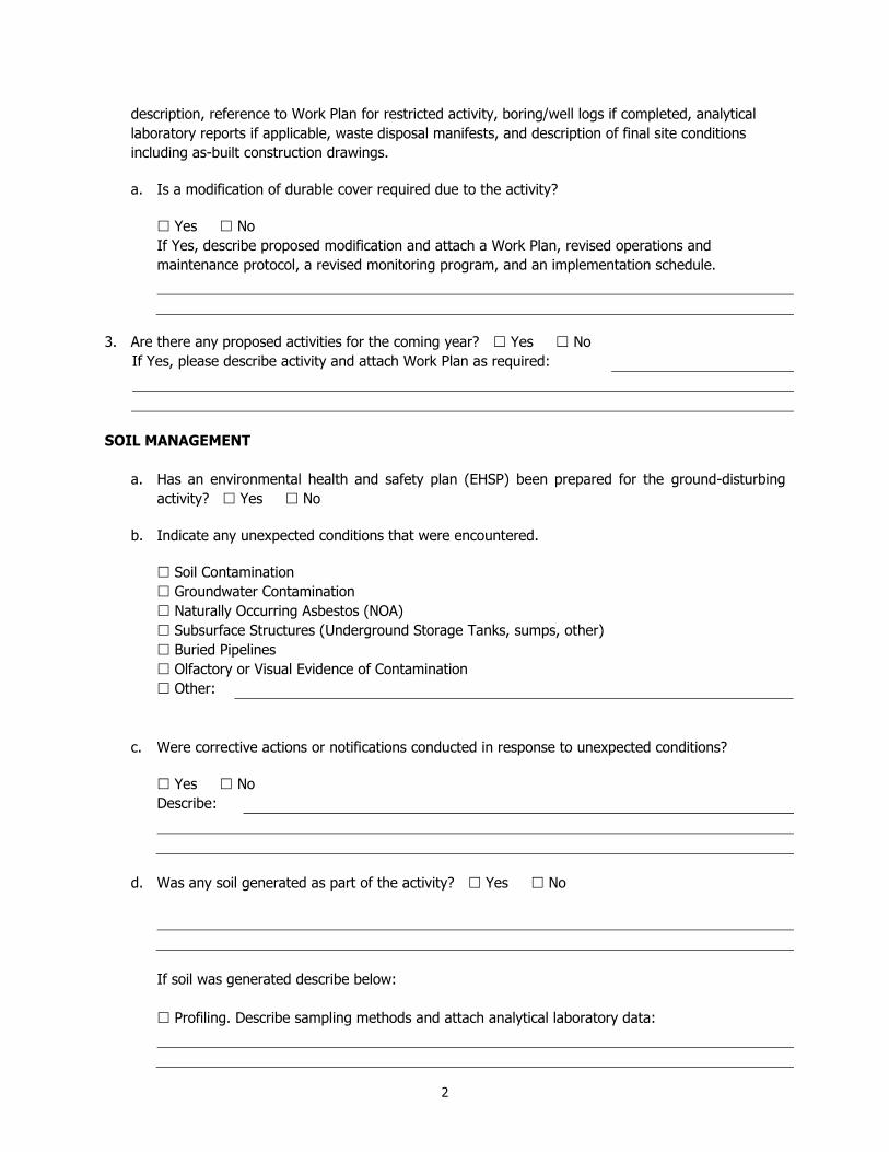
2
description, reference to Work Plan for restricted activity, boring/well logs if completed, analytical
laboratory reports if applicable, waste disposal manifests, and description of final site conditions
including as-built construction drawings.
a. Is a modification of durable cover required due to the activity?
Yes No
If Yes, describe proposed modification and attach a Work Plan, revised operations and
maintenance protocol, a revised monitoring program, and an implementation schedule.
3. Are there any proposed activities for the coming year? Yes No
If Yes, please describe activity and attach Work Plan as required:
SOIL MANAGEMENT
a. Has an environmental health and safety plan (EHSP) been prepared for the ground-disturbing
activity? Yes No
b. Indicate any unexpected conditions that were encountered.
Soil Contamination
Groundwater Contamination
Naturally Occurring Asbestos (NOA)
Subsurface Structures (Underground Storage Tanks, sumps, other)
Buried Pipelines
Olfactory or Visual Evidence of Contamination
Other:
c. Were corrective actions or notifications conducted in response to unexpected conditions?
Yes No
Describe:
d. Was any soil generated as part of the activity? Yes No
If soil was generated describe below:
Profiling. Describe sampling methods and attach analytical laboratory data:

3
Reuse. Specify method and location of final disposition of soil:
Off-site disposal. Describe the disposal facility:
e. Was soil imported to the site ? Yes No
If Yes, describe sampling and quality controls and compliance with the Soil Importation
Plan (SIP) or
refer to
previously
submitted
documentation:
Has a Stormwater Pollution Prevention Plan (SWPPP) been implemented for construction activity that
triggers construction stormwater permit requirements? Yes No
Describe runoff testing, best management practices implemented as part of the SWPPP or refer
to previously submitted documentation:
GROUNDWATER MANAGEMENT
a. Were dewatering activities conducted as part of the activity? Yes No
b. If Yes:
i. How much water was extracted and what were the methods?
ii. What were the storage vessels for extracted groundwater?
iii. Describe profiling and disposal procedures:
iv. Was water disposed to the sewer system? Yes No
If Yes, was an NPDES permit obtained? Yes No
If Yes, please attach all compliance documentation.

4
c. As part of the activity, were any groundwater monitoring wells destroyed, repaired, or installed?
Yes No
If Yes, please describe including notifications and regulatory approval and attach report including
well locations, identification of driller and drilling procedures, decontamination procedures,
lithologic logs, wells development procedures, survey data, any sampling data if collected, and
investigation-derived waste disposal.
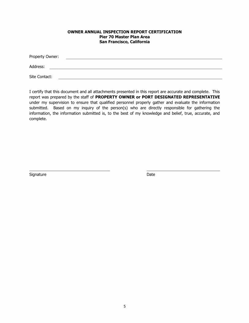
5
OWNER ANNUAL INSPECTION REPORT CERTIFICATION
Pier 70 Master Plan Area San Francisco, California
Property Owner:
Address:
Site Contact:
I certify that this document and all attachments presented in this report are accurate and complete. This
report was prepared by the staff of PROPERTY OWNER or PORT DESIGNATED REPRESENTATIVE
under my supervision to ensure that qualified personnel properly gather and evaluate the information
submitted. Based on my inquiry of the person(s) who are directly responsible for gathering the
information, the information submitted is, to the best of my knowledge and belief, true, accurate, and
complete.
Signature Date

Attachment 2
Emergency Response Plan Pier 70 Master Plan Area
Risk Management Plan
1
Occurrence Threat Posed Response
Vandalism (that results
in exposure of soil)
Monitoring systems rendered
inoperative
Site security compromised
Health or safety hazards, or
both
Damage to durable cover
Exposure to contaminated soil
or sediment
Release of soil or sediment
1. Immediately conduct visual inspection of vandalism to assess damage and potential
impacts
2. In the event of a safety hazard, immediately cordon off the affected area.
3. Notify in accordance with Appendix D of the RMP.
4. For damage to durable cover that results in unacceptable exposure to native soil, arrange
immediate temporary repairs (if necessary) and arrange repair or restoration within 2 weeks (weather conditions permitting) to design conditions and in accordance with repair
specifications.
5. Recommended preventative measures.
Fire Health and safety hazards
Damage to monitoring systems
Damage to vegetation
Impacts to erosion and
drainage
1. Notify City of San Francisco Fire Department (call 911), notify in accordance with
Appendix D when safe to do so.
2. Immediately conduct visual inspection of area to assess damage and potential impact.
3. Immediately cordon off affected area.
4. For damage or potential damage to other components that affect integrity of the durable
cover, security, or safety, arrange immediate temporary repairs (if necessary) and arrange repair or restoration within 2 weeks (weather and conditions permitting) to design
conditions and in accordance with repair specifications.
5. Notify regulatory agencies in accordance with Appendix D of the RMP.
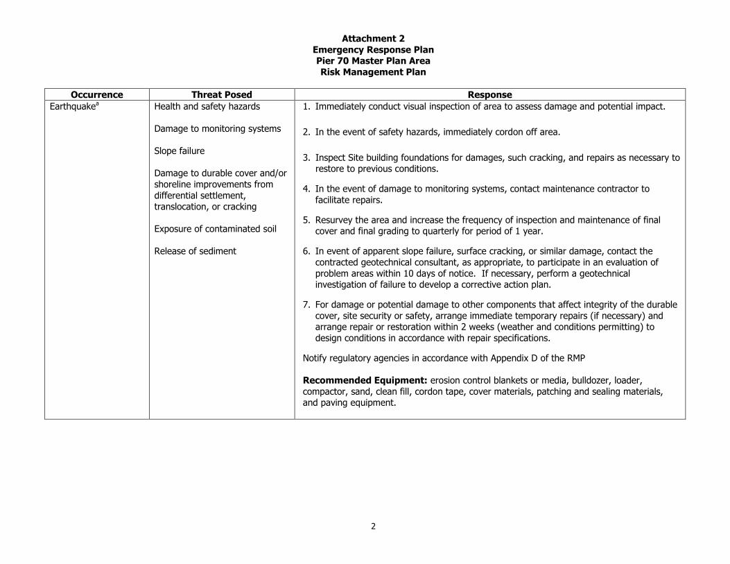
Attachment 2
Emergency Response Plan Pier 70 Master Plan Area
Risk Management Plan
2
Occurrence Threat Posed Response
Earthquakea Health and safety hazards
Damage to monitoring systems
Slope failure
Damage to durable cover and/or
shoreline improvements from
differential settlement, translocation, or cracking
Exposure of contaminated soil
Release of sediment
1. Immediately conduct visual inspection of area to assess damage and potential impact.
2. In the event of safety hazards, immediately cordon off area.
3. Inspect Site building foundations for damages, such cracking, and repairs as necessary to restore to previous conditions.
4. In the event of damage to monitoring systems, contact maintenance contractor to
facilitate repairs.
5. Resurvey the area and increase the frequency of inspection and maintenance of final cover and final grading to quarterly for period of 1 year.
6. In event of apparent slope failure, surface cracking, or similar damage, contact the
contracted geotechnical consultant, as appropriate, to participate in an evaluation of
problem areas within 10 days of notice. If necessary, perform a geotechnical investigation of failure to develop a corrective action plan.
7. For damage or potential damage to other components that affect integrity of the durable
cover, site security or safety, arrange immediate temporary repairs (if necessary) and arrange repair or restoration within 2 weeks (weather and conditions permitting) to
design conditions in accordance with repair specifications.
Notify regulatory agencies in accordance with Appendix D of the RMP
Recommended Equipment: erosion control blankets or media, bulldozer, loader,
compactor, sand, clean fill, cordon tape, cover materials, patching and sealing materials, and paving equipment.

Attachment 2
Emergency Response Plan Pier 70 Master Plan Area
Risk Management Plan
3
Occurrence Threat Posed Response
Flooding and Surface Drainage Problems
Damage to cover or its components
Saturation of soil slopes and instability
Erosion and undercutting of
foundations, cover, and utilities
1. Immediately conduct visual inspection of area to assess damage and potential impact. 2. In the event of safety hazard, immediately cordon off the affected area.
3. If necessary, conduct a geotechnical investigation of failure in order to develop a
corrective action plan. 4. For damage or potential damage to components that affect Site integrity, security, or
safety, arrange repair or restoration within 2 weeks (weather and conditions permitting) to design conditions and in accordance with repair specifications.
5. Investigate preventative measures.
6. Notify in accordance with Appendix D of the RMP.
Recommended Equipment: portable berm, absorbency media or blankets, loader/backhoe, clean fill soil, high-solids-passing explosion-proof portable pump, Baker
tank or waste receptacles, cordon tape, sandbags, cover materials, patching and sealing materials, and paving equipment.
Release of potentially contaminated soils
Health and safety hazards Potential environmental impacts
1. Immediately conduct visual inspection of area to assess damage and potential impacts. 2. In the event of safety hazards, immediately cordon off area.
3. Notify Port. 4. Identify the discharged material, if possible. If hazardous or toxic, contact a licensed
company that handles hazardous or toxic waste disposal to remove the waste.
5. Use necessary heavy equipment to restore area. 6. Notify regulatory agencies in accordance with Appendix D of the RMP.
7. Repair cause of release.
Recommended Equipment: portable berm, absorbency media or blankets, loader/backhoe, clean fill soil, high-solids-passing explosion-proof portable pump, Baker
tank or waste receptacles, cordon tape, sandbags, cover materials, patching and sealing
materials, and paving equipment.
Notes:
a The Port or its designated representative will determine the appropriate trigger for inspection and emergency response in consultation with other agencies.
PIER 70 RISK MANAGEMENT PLAN Pier 70 Master Plan Area San Francisco, California
Prepared For: Port of San Francisco
San Francisco, California
25 July 2013 Project No. 730496301

APPENDIX B
DUST CONTROL PLAN

DUST CONTROL PLAN PIER 70 MASTER PLAN AREA
Pier 70 San Francisco, California
Port of San Francisco San Francisco, California
July 2013 Project No. 730496301

TABLE OF CONTENTS
1.0 INTRODUCTION ..................................................................................................................... 1 1.1 Objective of the Dust Control Plan ............................................................................... 1 1.2 Regulatory Basis ......................................................................................................... 1 1.3 Responsibility for Implementing the Dust Control Plan ................................................... 2
2.0 BACKGROUND ........................................................................................................................ 2
3.0 POTENTIAL SOURCES OF DUST EMISSIONS ............................................................................. 3
4.0 DUST CONTROL MEASURES .................................................................................................... 3 4.1 Measures Required for All Dust-generating Activities ..................................................... 3 4.2 Traffic Control ............................................................................................................. 5 4.3 Transport ................................................................................................................... 6 4.4 Earthwork ................................................................................................................... 6 4.5 Dust-Generating Foundation Work ............................................................................... 7 4.6 Post-Construction Durable Cover .................................................................................. 7 4.7 Additional Requirements for Serpentine Material ........................................................... 7
5.0 Projects Greater Than One-Half Acre Area – Dust Control Plan................................................... 8
6.0 VISIBLE DUST EMISSIONS ...................................................................................................... 9 6.1 Visible Dust during Site Activities ................................................................................. 9 6.2 Visible Dust Crossing the Property Boundary ............................................................... 10 6.3 Windblown Visible Dust during Inactive Periods .......................................................... 10
7.0 AIR MONITORING AND RECORDS .......................................................................................... 10 7.1 Air Monitoring for Dust .............................................................................................. 11
7.1.1 Monitoring Equipment ................................................................................... 11 7.2 Personnel Air Sampling for Asbestos........................................................................... 11 7.3 Recordkeeping and Reporting .................................................................................... 12
REFERENCES
FIGURES
Figure 1 Site Location Map
Figure 2 – Site Plan Area of Dust Control Plan
Figure 3 – Dust Control Plan 1,000 Foot Sensitive Receptor Zone

Appendix B 1 July 2013
APPENDIX B
DUST CONTROL PLAN Pier 70 Master Plan Area
San Francisco, California
1.0 INTRODUCTION
1.1 Objective of the Dust Control Plan
Dust control to prevent or minimize workers or site user’s exposure to native soil is an essential
component of the Risk Management Plan (RMP) for the Pier 70 Master Plan Area in San Francisco,
California (Site) (Figure 1). This Dust Control Plan (DCP) identifies steps that will be taken to reduce dust
generation during excavation, grading, demolition and construction, and describes required dust
monitoring and reporting during potential dust-generating activities.
1.2 Regulatory Basis
This DCP incorporates requirements of the following applicable regulations:
California Code of Regulations (CCR) Title 17, Section 93105, the Asbestos Airborne Toxic
Control Measure (ATCM) for Construction, Grading, Quarrying, and Surface Mining Operations
Bay Area Air Quality Management District (BAAQMD) Regulation 2, Permits
BAAQMD Regulation 6, Particulate Matter and Visible Emissions
City and County of San Francisco Ordinance Number 176-08
City of San Francisco Health Code Article 22B Construction Dust Ordinance
Port Building Code Section 106A.3.2.3 Construction Dust Control
City Ordinance 176-08 specifies a goal of no visible dust emissions from construction and other dust-
generating activities, and outlines housekeeping measures required to meet this goal. The requirements
of the ordinance are codified in the above-referenced sections of the San Francisco Health Code and Port
Building Code. BAAQMD Regulation 6, which generally prohibits emission of visible dust beyond the
property boundary, is also applicable. Because the Site is in an area with serpentine rock potentially
containing naturally occurring asbestos (NOA), CCR Title 17, Section 93105 (ATCM) applies. ATCM
includes, among other things, the requirement for submission of an Asbestos Dust Mitigation Plan
(ADMP) for BAAQMD approval prior to dust generating activities in areas where serpentine rock is

Appendix B 2 July 2013
anticipated to be present. The ATCM also includes very specific dust mitigation measures to be
implemented during construction. In addition, BAAQMD Regulation 11, Rule 14 prohibits the use or sale
of asbestos-containing serpentine materials for road surfacing.
1.3 Responsibility for Implementing the Dust Control Plan
The Port, tenants, licensees, or other entity undertaking construction or other dust-generating activity at
Pier 70 (the project proponent) will be responsible for implementing all provisions of this DCP applicable
to its activities, including conveying the requirements of the DCP to its contractors and enforcing
contractors’ compliance. Project proponents undertaking dust-generating projects of one-half acre or
more in size must designate a person responsible for compliance with a site-specific DCP, post contact
information for the designated person, and notify adjacent occupants. The project proponent must
respond to complaints regarding dust and take corrective action within 24 hours. The project proponent
is also responsible for ensuring that for projects that require air monitoring, monitoring is performed by a
qualified third party.
2.0 BACKGROUND
The Pier 70 Master Plan Area (Figures 1 and 2) is located on the eastern shoreline of San Francisco at
Potrero Point (a continuation of serpentinite based Potrero Hill). It is roughly bounded by Mariposa
Street to the north, San Francisco Bay to the north and east, 22nd Street to the south, and Illinois Street
to the west. For the purposes of this DCP, the “Site” consists of the onshore portions of the Pier 70
Master Plan Area (above the mean higher high water (MHHW1)). The onshore portions of the former
Potrero Power Plant where constituents associated with manufactured gas plant (MGP) waste are present
in the subsurface within the Pier 70 property boundaries have been investigated by PG&E and are also
included in this DCP (Figure 2).
The Site encompasses approximately 65 acres and is largely underlain by fill material placed seaward of
the San Francisco historic shoreline between the late 1800s to early 1900s. The historic shoreline is
shown in Figure 2. The original shoreline was comprised of serpentinite bluffs overlooking mud flats that
extended into San Francisco Bay. Much of the land that now makes up the Site was constructed by
blasting the serpentinite hills of Potrero Point (Port of San Francisco, 2009) and placing the resultant rock
1 Mean Higher High Water is a tidal datum equal to the average of the higher high water height of each tidal day
observed over the National Tidal Datum Epoch. For stations with shorter series, simultaneous observational comparisons are made with a control tide station in order to derive the equivalent datum of the National Tidal Datum Epoch.

Appendix B 3 July 2013
in the bay to create new land along the shoreline. The ground surface elevation at Pier 70 ranges from
below mean sea level (msl) in the shoreline portion of the Site to approximately 10 feet above msl inland.
The majority of the Site is generally covered by buildings or pavement with the exception of portions of
Crane Cove Park and other small areas of unpaved native soil (Figure 2). On-site tenants at the time of
DCP publication include ship repair, towing and car return, automobile storage and trucking, various
storage and warehousing operations, and a metal recycling yard.
The detailed Site history is provided in the Feasibility Study and Remedial Action Plan Pier 70 Master Plan
Area, San Francisco, California dated 31 May 2012 (FS RAP).
3.0 POTENTIAL SOURCES OF DUST EMISSIONS
Possible sources of dust emissions include:
Construction Traffic - Movement of construction equipment and vehicles around excavated or
cleared areas and unpaved roads can create dust emissions. Construction equipment or
vehicles on paved roads and parking lots may also generate dust if soil from unpaved ground
is tracked out onto adjacent paved roadways.
Earthwork - Site Preparation, grading, excavation, trenching, and backfilling can produce
dust.
Material Handling, Transport, and Stockpiles - Loading or unloading, trucking or other
transport, and stockpiling potentially dust-generating materials (soil, excavated material,
backfill, sand, gravel, aggregate base or other import material) may contribute to windborne
dust emissions.
Demolition activities – Wrecking, cutting, disjointing, stripping, moving or dismantling any
structure.
4.0 DUST CONTROL MEASURES
4.1 Measures Required for All Dust-generating Activities
All Site preparation, demolition, construction, grading, excavation, or other activities that have the
potential to create dust (collectively referred to as “construction activities”) or will expose or disturb more

Appendix B 4 July 2013
than 10 cubic yards or 500 square feet of soil shall implement the following dust control measures as
required by the Port Building Code:
Water all active construction areas or dust-generating activities at least every two hours to
prevent dust from becoming airborne, applying as much water as necessary to control dust
without creating run-off. Increased watering frequency may be needed during hot, dry
weather or when wind speed exceeds 15 miles per hour.
Minimize trackout of mud, dirt and other potentially dust-generating material on vehicles and
equipment by inspecting tires and cleaning as necessary to remove material prior to entering
paved roadways. Trackout of loose materials such as dust, mud, and construction debris will
be minimized by using a stabilized construction exit (gravel pads) installed at the
access/egress point to the project site. Gravel pads will be installed in accordance with the
Erosion and Sediment Control Best Management Practices (BMPs) as outlined in the
Stormwater Pollution and Prevention Plan (SWPPP) (prepared separately). Vehicle tires and
equipment will be inspected and cleaned if dry soil particles are present. Wheel washers will
be utilized if cleaning will not remove particulates before they reenter paved roadways.
Wet-sweep or vacuum (with a high efficiency particulate air (HEPA) filter equipped vacuum)
streets, sidewalks, and intersections were work is in progress at least two times a day or
more often as needed to prevent material carried out of the construction area from being
deposited onto adjacent paved areas.
Cover or otherwise stabilize (e.g., soil stabilizer products like a bonded fiber matrix material)
any inactive (no disturbance for more than 10 days) cleared areas, or stockpiles of potentially
dusty material greater than 10 cubic yards (cy), with a 10 mil polyethylene plastic tarp or
equivalent and brace it down; or use other equivalent stabilization method.
Use dust enclosures, curtains, and dust collectors as necessary to control dust generation.
In accordance with Article 22B, signs will be posted with a project proponent’s contact phone
number around the project boundary. This phone number will be provided to adjacent
businesses, residences, and schools, and will allow community members to report any visible
dust problems.

Appendix B 5 July 2013
4.2 Traffic Control
Mitigation of dust mitigation from construction traffic, paved and unpaved roads, parking lots, and
construction staging areas shall include:
1. A maximum vehicle speed limit of ten (10) miles per hour (mph) or less and
2. One or more of the following:
Watering every two hours of active operations or sufficiently often to keep the area
adequately wetted. Watering may be increased during above average temperatures
or wind speeds
Applying chemical dust suppressants consistent with manufacturer's directions.
Maintaining a gravel, recrushed/recycled concrete or asphalt cover with a silt content
that is less than five (5) percent to a depth of three (3) inches on the surface being
used for travel.
Paved roads within a construction site will be swept twice daily with a wet sweeper
during dust-generating activities.
At least the first 500 feet of any public roadway exiting from the construction site will
be swept twice daily during dust-generating activities.
Implementation of erosion control BMPs as identified in the SWPPP (prepared
separately), will control dust emissions from public roadways, parking areas and any
above grade unpaved staging areas or roadways.
Construction employees will park in paved or graveled laydown areas, to reduce dust
emissions
To the extent possible, heavy equipment will be left on the construction site and not
staged outside the construction site to minimize potential for trackout.
Reduced vehicle trips through efficient truck and equipment usage by minimizing
equipment mobilization and demobilization and using full truck loads, etc.

Appendix B 6 July 2013
4.3 Transport
Trucks transporting potentially dust-generating material shall not enter or leave the construction area
unless:
1. Trucks are maintained such that no spillage can occur from holes or other openings in cargo
compartments; and
2. Loads are adequately wetted and either:
Covered with tarps; or
Loaded such that the material does not touch the front, back, or sides of the cargo
compartment at any point less than six inches from the top and that no point of the
load extends above the top of the cargo compartment.
3. Onsite vehicle speeds are limited to 10 mph or less.
4. Site personnel will be stationed at project Site access points to monitor inflow and
outflow of traffic to and from Site and will be responsible for inspecting all vehicles
exiting and performing tire cleaning or other trackout preventative measures.
4.4 Earthwork
Dust Control for earthmoving activities shall include one or more of the following:
If grading will not take place immediately following demolition, and unattended, exposed soil
could generate dust, exposed surface soil will be stabilized with a chemical dust suppressant
and water or equivalent soil stabilization measure.
Areas to be graded or excavated must be kept adequately wetted to prevent visible dust
emissions from crossing the property line.
Pre-wetting the ground prior to grading excavation.
Suspending all demolition, grading and earthmoving operations when wind speeds are high
enough (sustained winds at an hourly average speed of 25 mph) to result in dust emissions
crossing the property line, despite the application of dust mitigation measures.
Application of water prior to any land clearing.
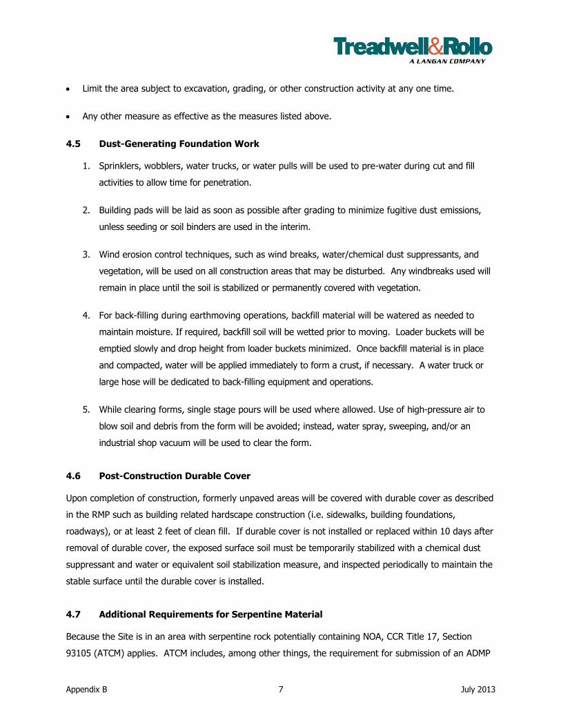
Appendix B 7 July 2013
Limit the area subject to excavation, grading, or other construction activity at any one time.
Any other measure as effective as the measures listed above.
4.5 Dust-Generating Foundation Work
1. Sprinklers, wobblers, water trucks, or water pulls will be used to pre-water during cut and fill
activities to allow time for penetration.
2. Building pads will be laid as soon as possible after grading to minimize fugitive dust emissions,
unless seeding or soil binders are used in the interim.
3. Wind erosion control techniques, such as wind breaks, water/chemical dust suppressants, and
vegetation, will be used on all construction areas that may be disturbed. Any windbreaks used will
remain in place until the soil is stabilized or permanently covered with vegetation.
4. For back-filling during earthmoving operations, backfill material will be watered as needed to
maintain moisture. If required, backfill soil will be wetted prior to moving. Loader buckets will be
emptied slowly and drop height from loader buckets minimized. Once backfill material is in place
and compacted, water will be applied immediately to form a crust, if necessary. A water truck or
large hose will be dedicated to back-filling equipment and operations.
5. While clearing forms, single stage pours will be used where allowed. Use of high-pressure air to
blow soil and debris from the form will be avoided; instead, water spray, sweeping, and/or an
industrial shop vacuum will be used to clear the form.
4.6 Post-Construction Durable Cover
Upon completion of construction, formerly unpaved areas will be covered with durable cover as described
in the RMP such as building related hardscape construction (i.e. sidewalks, building foundations,
roadways), or at least 2 feet of clean fill. If durable cover is not installed or replaced within 10 days after
removal of durable cover, the exposed surface soil must be temporarily stabilized with a chemical dust
suppressant and water or equivalent soil stabilization measure, and inspected periodically to maintain the
stable surface until the durable cover is installed.
4.7 Additional Requirements for Serpentine Material
Because the Site is in an area with serpentine rock potentially containing NOA, CCR Title 17, Section
93105 (ATCM) applies. ATCM includes, among other things, the requirement for submission of an ADMP
Appendix B 8 July 2013
to BAAQMD for approval prior to grading areas greater than one acre. In addition, BAAQMD Regulation
11, Rule 14 prohibits the use or sale of asbestos-containing serpentine materials for road surfacing. It is
anticipated that any serpentine materials excavated during Site remediation or redevelopment will be
reused on Site, and none will be used as a surfacing agent.
If any excavated soil containing serpentine material or demolition debris suspected of containing asbestos
is slated for off-site disposal, it must be analyzed for asbestos content. In accordance with the CCR
Section 66261.24, material with greater than 1 percent by-weight asbestos is considered a Class I
California Hazardous Waste, and will be handled and disposed of offsite in accordance with all
requirements for proper disposal of asbestos. In such circumstance, the following waste management
methods will be used when handling serpentine waste designated as hazardous waste:
Keep asbestos-containing waste material adequately wetted at all times during handling and
loading.
Adhere to requirements of Section 11-2-608 for marking of vehicles used to transport
asbestos-containing waste.
Maintain waste shipment records as specified in Section 11-2-502.
Provide a copy of the waste shipment record to the disposal site owner or operator upon
delivery.
Contact transporter and/or owner of the disposal site if the waste shipment has not arrived
within 35 days of initial acceptance by the transporter as hazardous waste.
Provide a written report to the Air Pollution Control Officer (APCO) if the waste shipment is
not received within 45 days of initial acceptance by the transporter.
5.0 PROJECTS GREATER THAN ONE-HALF ACRE AREA – DUST CONTROL PLAN
For projects that disturb more than greater than one-half acre of soil, all above-listed measures are
required and the project proponent must identify “sensitive receptors” (residences, schools, child-care
centers, hospital or health-care facilities, group living quarters) located within 1,000 feet of the project
boundary. Figure 3 shows the approximate 1,000 foot sensitive receptor zone around the Pier 70 Master
Plan area. If no sensitive receptors are determined to be within 1,000 feet of the project, the Director of
Public Health or designee way waive the requirement to submit a site-specific DCP.

Appendix B 9 July 2013
If sensitive receptors are present within 1,000 feet of the project boundary, the project proponent must
submit a site-specific DCP to the SFDPH for review and approval. The site-specific DCP will include all of
the requirements specified by Health Code Article 22B, the Port Building Code (the measures listed in
Section 4.1) and this DCP. Additionally, the site-specific DCP must:
Specify wetting any areas of exposed or disturbed soil at least three (3) times per day (or
8-hour shift), and paving, wetting three times daily, or applying non-toxic soil stabilizer to
all unpaved access roads, parking areas or staging areas within the construction area.
Specify that dust-generating activities will be shut down if dust control measures cannot
be made sufficiently effective to prevent dust generation as outlined in Section 6.0.
Designate a person who will be responsible for monitoring compliance with dust control
requirements. The Designated Person must be on-site or available by telephone at all
times during site preparation, demolition, or construction activities, including holidays
and weekends. The name and telephone number for the Designated Person with
responsibility for compliance with the dust control requirements must be posted in
publicly visible location(s) at the project site and provided to the Port representative, the
Department of Public Health, and adjacent residents, schools, and businesses prior to
beginning work.
Establish protocols for air monitoring by developing a, site specific Dust Monitoring Plan
(DMP) that is implemented by an independent third party.
6.0 VISIBLE DUST EMISSIONS
6.1 Visible Dust during Site Activities
The goal of this plan is no visible dust. While it is understood that soil disturbance and excavation
activities will produce dust, dust controls will be used to mitigate visible dust as it occurs. In the event
that visible dust from soil disturbance or excavation is observed on-site, but does not cross the
construction area boundary, the following procedures will be followed:
1. A more aggressive application of the existing mitigation measures described in Section
4.0 will be implemented within 15 minutes of making the observation.
2. Additional methods of dust suppression will be implemented if Step 1 specified above
fails to result in adequate mitigation within 30 minutes of the original observation.
Appendix B 10 July 2013
3. If Step 2 specified above fails to result in effective mitigation within 1 hour of the original
observation, the source of emissions will be temporarily shut down until the implemented
dust control mitigation is effective or, due to changed conditions, no longer necessary.
6.2 Visible Dust Crossing the Property Boundary
In the event that visible dust from soil disturbance or excavation is observed crossing the property
boundary, the following procedures will be followed:
1. The specific source of the emissions will be immediately shut down and a more
aggressive application of the existing mitigation measures described in Section 4.0 will be
implemented.
2. Once the mitigation measures have been applied, the operation at the source of
emissions will resume and observations will be conducted to verify that the mitigation
measures were successful.
In addition, dust curtains, plastic tarps, or tree windbreaks will be installed on the windward and down
windward sides of construction areas to prevent visible dust from crossing property boundary.
6.3 Windblown Visible Dust during Inactive Periods
The standards in this section apply on weekends, holidays, or any other times when no work is being
performed on site. In the event that visible dust originating on the project site is observed emanating
beyond the construction site area boundary, mitigation measures described in Sections 4.0, 6.1 and 6.2
will be implemented within less than 8 hours of making the observation. Mitigation measures will be
applied until the visible dust plumes originating from the project site are minimized or eliminated. Any
observations of visible dust originating from the project site during inactive periods should be reported to
the Contractor’s Designated Person as defined in Section 5.0.
7.0 AIR MONITORING AND RECORDS
This section discusses air monitoring and record and reporting requirements for Particulate Matter with a
diameter of less than 10 micrometers (µm) (PM10) (Article 22B, Port Building Code) and the CCR Title
17, Section 93105 (ATCM).
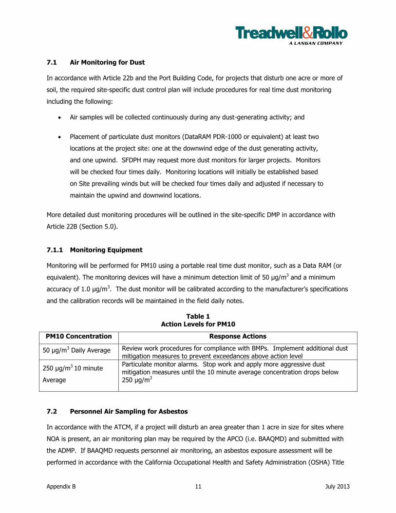
Appendix B 11 July 2013
7.1 Air Monitoring for Dust
In accordance with Article 22b and the Port Building Code, for projects that disturb one acre or more of
soil, the required site-specific dust control plan will include procedures for real time dust monitoring
including the following:
Air samples will be collected continuously during any dust-generating activity; and
Placement of particulate dust monitors (DataRAM PDR-1000 or equivalent) at least two
locations at the project site: one at the downwind edge of the dust generating activity,
and one upwind. SFDPH may request more dust monitors for larger projects. Monitors
will be checked four times daily. Monitoring locations will initially be established based
on Site prevailing winds but will be checked four times daily and adjusted if necessary to
maintain the upwind and downwind locations.
More detailed dust monitoring procedures will be outlined in the site-specific DMP in accordance with
Article 22B (Section 5.0).
7.1.1 Monitoring Equipment
Monitoring will be performed for PM10 using a portable real time dust monitor, such as a Data RAM (or
equivalent). The monitoring devices will have a minimum detection limit of 50 µg/m3 and a minimum
accuracy of 1.0 µg/m3. The dust monitor will be calibrated according to the manufacturer’s specifications
and the calibration records will be maintained in the field daily notes.
Table 1 Action Levels for PM10
PM10 Concentration Response Actions
50 µg/m3 Daily Average Review work procedures for compliance with BMPs. Implement additional dust
mitigation measures to prevent exceedances above action level
250 µg/m3 10 minute
Average
Particulate monitor alarms. Stop work and apply more aggressive dust
mitigation measures until the 10 minute average concentration drops below
250 µg/m3
7.2 Personnel Air Sampling for Asbestos
In accordance with the ATCM, if a project will disturb an area greater than 1 acre in size for sites where
NOA is present, an air monitoring plan may be required by the APCO (i.e. BAAQMD) and submitted with
the ADMP. If BAAQMD requests personnel air monitoring, an asbestos exposure assessment will be
performed in accordance with the California Occupational Health and Safety Administration (OSHA) Title
Appendix B 12 July 2013
8 Section 1529 regulations. This monitoring will be conducted when work begins for a period of at least
three days, and once every 10 days working days thereafter.
7.3 Recordkeeping and Reporting
Dust monitors will be equipped with data loggers. If air monitoring is required by BAAQMD, to comply
with ATCM, air monitoring records will be kept for a minimum of seven years. BAAQMD has the authority
to request air monitoring reports or results for this duration. Reporting requirements are at the discretion
of BAAQMD and may change on a project by project basis.
In accordance with Article 22B, if a site-specific dust control plan (as discussed in Section 4.0) is required,
the project proponent must submit monitoring data that includes real time data and daily averages along
with corrective actions to SFDPH on a weekly basis for no less than four weeks. Following review of the
monitoring data, SFDPH may determine that additional monitoring is not required.

Appendix B 13 July 2013
REFERENCES
Air Resources Board, 2002. California Code of Regulations (CCR) Title 17, Section 93105, the Asbestos
Airborne Toxic Control Measure (ATCM) for Construction, Grading, Quarrying, and Surface Mining
Operations. 29 July.
California Air Resources Board (CARB), 2012. Ambient Air Quality Standards. 7 June.
http://www.arb.ca.gov/research/aaqs/aaqs2.pdf
City and County of San Francisco, 2012. San Francisco Health Code, Article 22B, Construction Dust
Control Requirements. Last amended by Ordinance 229-12, File No. 120815, approved 14 November
2012, effective 14 December 2012.
Port of San Francisco, 2009. Pier 70 Draft Preferred Master Plan, Pier 70 Northeastern Shoreline,
San Francisco, California. August.
Treadwell & Rollo, 2012. Feasiblity Study and Remedial Action Plan Pier 70 Master Plan Area, Pier 70
San Francisco California. 31 May.

FIGURES
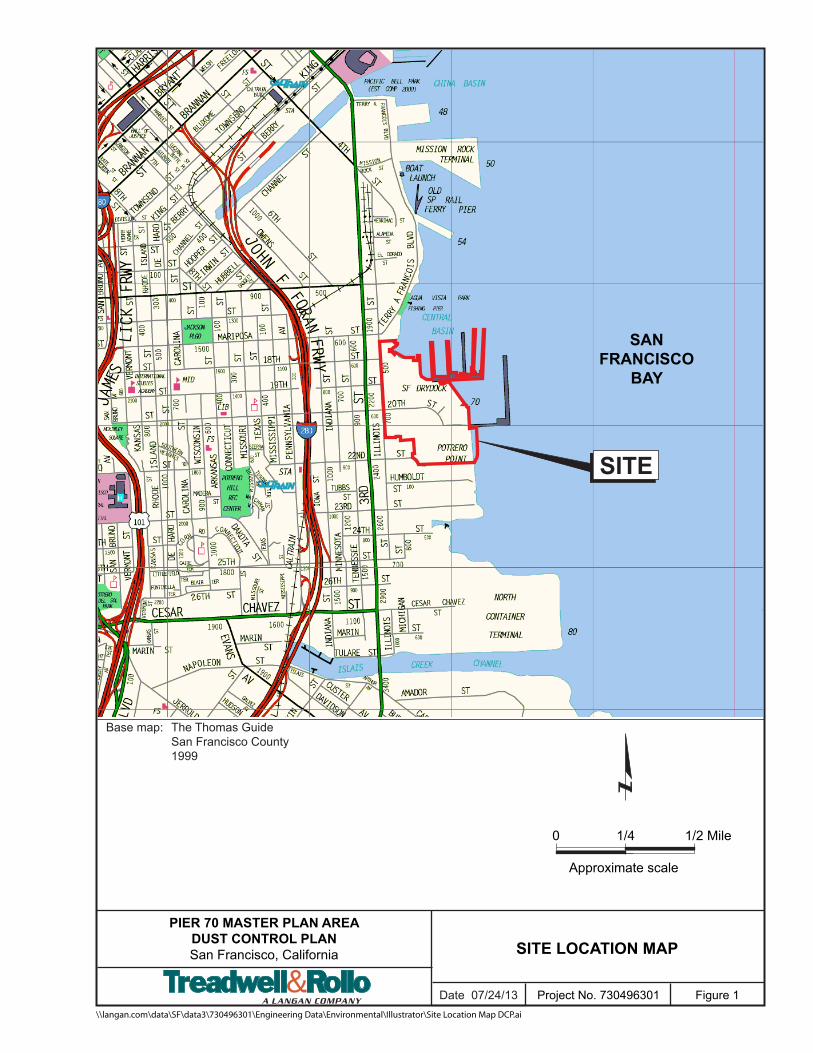
Figure 1\\langan.com\data\SF\data3\730496301\Engineering Data\Environmental\Illustrator\Site Location Map DCP.ai
Project No. 730496301
PIER 70 MASTER PLAN AREADUST CONTROL PLANSan Francisco, California SITE LOCATION MAP
SITE
Base map: The Thomas Guide San Francisco County 1999
0 1/2 Mile
Approximate scale
1/4
SANFRANCISCO
BAY
Date 07/24/13
Illinois Street
3rd Street
Tennessee Street
Minnesota S
treet
20th Street
22nd Street
19th Street
18th Street
Irish Hill
San Francisco Bay
Parcel 9
Parcel 6Parcel 5
Parcel 4
Parcel 2
Crane Cove Park
Parcel 3
Parcel 8Parcel 7
SlipwaysPark
Parcel1
CentralPlazaPark
6
12
113
2
109
11760
38
14
116
105108
11
114
115
21
111
101
19
36
104102
40
110
107103
120119
50
PIER 70 MASTER PLAN AREADUST CONTROL PLANSan Francisco, California
SITE AREA FOR DUST CONTROL PLAN
Date 7/24/2013 Project 730496301 Figure 2
0 300 600150
Feet
LegendParcel BoundarySite Area Included in Pier 70 DCPArea of Special Concern with Dense Non-Aqueous Phase Liquids (DNAPL) ImpactsLimit of Upland Feasibility Study for FormerPG&E Potrero Power PlantBuildingExisting ShorelineApproximate 1851 ShorelineApproximate 1869 ShorelineRoad Edge
\\langan.com\data\SF\data3\730496301\ArcGIS\arcmap_doc\2012\Risk Management Plan\Site Area Dust Control Plan.mxd
Notes: 1. DCP = Dust Control Plan. 2. Pacific Gas & Electric Feasibility Study (FS) Area taken from Haley
& Aldrich, Inc., Draft Report on Upland Feasibility Study Potrero Power Plant Site San Francisco, California, 22 March 2012.
3. Parcels from ROMA Design Group, Draft Preferred Pier 70 Master Plan, 17 July 2009.
4. Approximate 1851 shoreline provided by the Port of San Francisco.
5. Approximate 1869 shoreline based upon Board of Tidelands Commissioners, Map of the Salt Marsh and Tide Lands and Lands Lying Under Water South of Second Street and Situate in the City and County of San Francisco, 1869.
6. Map displayed in California State Plane Coordinate System, Zone III, North American Datum of 1983 (NAD83), US Survey Feet.
Crane Cove Park
Central PlazaPark
SlipwaysPark
San Franscisco BayEspritPark
Enola D. MaxwellMiddle School
Daniel WebsterElementary School
Live OakSchool
I.M. Scott Elementary School
(Closed)
Starr KingElementary School
Potrero Nursery
PIER 70 MASTER PLAN AREADUST CONTROL PLANSan Franc isc o, California
DUST CONTROL PLAN 1,000 FOOT SENSITIVE RECEPTOR ZONE
Date 7/24/2013 Proje c t 730496301 Figure 3
0 700 1,400350
Fe e t
Legend1,000 Foot Se nsitive Re c e ptor ZoneExisting Shore lineApproxim ate 1851 Shore lineApproxim ate 1869 Shore lineParc e l Bound arySite Are a Inc lud e d in Pie r 70 DCPAre a of Spe c ial Conc e rn with De nse N on-Aque ous Phase Liquid s (DN APL) Im pac tsLim it of Upland Fe asibility Stud y for Form e rPG&E Potre ro Powe r PlantBuild ingSc hools (Private & Public )ParkRe sid e ntial Zoning
\\langan.c om \d ata\SF\d ata3\730496301\Arc GIS\arc m ap_ d oc \2013\Site Plan - Re c e ptor Line s.m xd
Notes: 1. DCP = Dust Control Plan. 2. Pac ific Gas & Ele c tric RMP Are a take n from Hale y & Ald ric h, Inc .,
Draft Report on Upland Feasibility Study Potrero Power Plant Site San Francisco, California, 22 Marc h 2012.
3. Parc e ls from ROMA De sign Group, Draft Pre fe rre d Pie r 70 Maste r Plan, 17 July 2009.
4. Approxim ate 1851 shore line provid e d by the Port of San Franc isc o.
5. Approxim ate 1869 shore line base d upon Board of Tid e land s Com m issione rs, Map of the Salt Marsh and Tide Lands and Lands Lying Under Water South of Second Street and Situate in the City and County of San Francisco, 1869.
6. Map d isplaye d in California State Plane Coord inate Syste m , Zone III, N orth Am e ric an Datum of 1983 (N AD83), US Surve y Fe e t.
7. Bing Maps Hybrid ae rial and road s base m ap is provid e d through Langan’s Esri Arc GIS software lic e nsing and Arc GIS online © 2010 Mic rosoft Corporation and its d ata supplie rs.
8. Parks sc hools and zoning Shape file obtaine d from the City and County Planning De partm e nt of San Franc isc o.
APPENDIX D
CONTACT INFORMATION

RMP D-1 July 2013
APPENDIX D Contact Information
Port of San Francisco
Permit Inspector: A permit inspector will be assigned upon issuance of project-specific building or encroachment permit.
Port of San Francisco, Pier 1 – The Embarcadero San Francisco, CA 94111
Carol Bach, Environmental Affairs Manager, Port Planning & Development Port of San Francisco, Pier 1 – The Embarcadero
San Francisco, CA 94111 Phone: 415-274-0568
Email: [email protected]
Regional Water Quality Control Board
Mr. Mark Johnson Case Worker
San Francisco Bay Regional Water Quality Control Board 1515 Clay Street, Suite 1400
Oakland, CA 94612 Phone: 510-622-2493
Email: [email protected]
San Francisco City and County Department of Public Health
Ms. Elyse Heilsorn Senior Environmental Health Inspector
Local Oversight Program
1390 Market Street, Suite 210 San Francisco, CA 94102
Phone: 415-252-3885 Email: [email protected]
San Francisco Fire Department Department Headquarters
698 2nd Street San Francisco, CA 94107
Phone: 415-558-3200 or 911

PIER 70 RISK MANAGEMENT PLAN Pier 70 Master Plan Area San Francisco, California
Prepared For: Port of San Francisco
San Francisco, California
25 July 2013 Project No. 730496301
APPENDIX E
STORMWATER POLLUTION PREVENTION PLAN OUTLINE
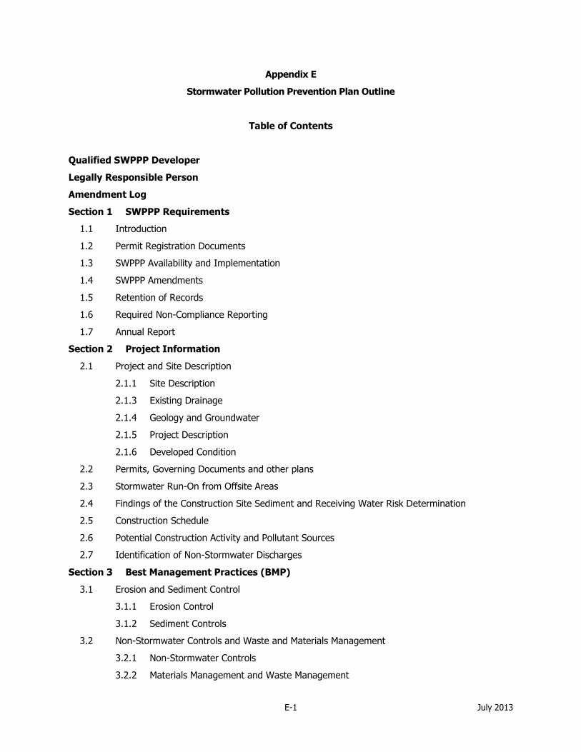
E-1 July 2013
Appendix E
Stormwater Pollution Prevention Plan Outline
Table of Contents
Qualified SWPPP Developer
Legally Responsible Person
Amendment Log
Section 1 SWPPP Requirements
1.1 Introduction
1.2 Permit Registration Documents
1.3 SWPPP Availability and Implementation
1.4 SWPPP Amendments
1.5 Retention of Records
1.6 Required Non-Compliance Reporting
1.7 Annual Report
Section 2 Project Information
2.1 Project and Site Description
2.1.1 Site Description
2.1.3 Existing Drainage
2.1.4 Geology and Groundwater
2.1.5 Project Description
2.1.6 Developed Condition
2.2 Permits, Governing Documents and other plans
2.3 Stormwater Run-On from Offsite Areas
2.4 Findings of the Construction Site Sediment and Receiving Water Risk Determination
2.5 Construction Schedule
2.6 Potential Construction Activity and Pollutant Sources
2.7 Identification of Non-Stormwater Discharges
Section 3 Best Management Practices (BMP)
3.1 Erosion and Sediment Control
3.1.1 Erosion Control
3.1.2 Sediment Controls
3.2 Non-Stormwater Controls and Waste and Materials Management
3.2.1 Non-Stormwater Controls
3.2.2 Materials Management and Waste Management
RMP E-2 July 2013
3.3 Post construction Stormwater Management Measures
Section 4 BMP Inspection, and Maintenance
4.1 BMP Inspection and Maintenance
Section 5 Training
Section 6 Responsible Parties and Operators
6.1 Responsible Parties
6.2 Contractor List
Section 7 Construction Site Monitoring Program
7.1 Purpose
7.2 Applicability of Permit Requirements
7.3. Weather and Rain Event Tracking
7.3.1 Weather Tracking
7.4 Safety and Monitoring Exemptions
7.5 Visual Monitoring
7.5.1 Routine Observations and Inspections
7.5.1.1 Routine BMP Inspections
7.5.1.2 Non-Stormwater Discharge Observations
7.5.2 Rain-Event Triggered Observations and Inspections
7.5.2.1 Visual Observations Prior to a Forecasted Qualifying Rain Event
7.5.2.2 BMP Inspections During an Extended Storm Event
7.5.2.2 Visual Observations Following a Qualifying Rain Event
7.5.3 Visual Monitoring Procedures
7.5.4 Visual Monitoring Follow-Up and Reporting
7.5.5 Visual Monitoring Locations
7.6 Water Quality Sampling and Analysis
7.6.1 Sampling and Analysis Plan for Non-Visible Pollutants in Stormwater Runoff Discharges
7.6.1.1 Sampling Schedule
7.6.1.2 Sampling Locations
7.6.1.3 Monitoring Preparation
7.6.1.4 Analytical Constituents
7.6.1.5 Sample Collection
7.6.1.6 Sample Analysis
7.6.1.7 Data Evaluation and Reporting
7.6.2 Training of Sampling Personnel
7.6.3 Sample Collection and Handling

RMP E-3 July 2013
7.6.3.1 Sample Collection
7.6.3.2 Sample Handling
7.6.3.3 Sample Documentation Procedures
7.7 Quality Assurance and Quality Control
7.7.1 Field Logs
7.7.2 Clean Sampling Techniques
7.7.3 Chain of Custody
7.7.4 QA/QC Samples
7.7.4.1 Field Duplicates
7.7.4.2 Equipment Blanks
7.7.4.3 Field Blanks
7.7.4.4 Travel Blanks
7.7.5 Data Verification
7.8 Records Retention
CSMP Attachment 1: Weather Reports
CSMP Attachment 2: Monitoring Records
CSMP Attachment 3: Example Forms
CSMP Attachment 4: Field Meter Instructions
CSMP Attachment 5: Supplemental Information
Section 8 References
Appendix A: Calculations
Appendix B: Site Maps
Appendix C: Permit Registration Documents
Appendix D: SWPPP Amendment Certifications
Appendix E: Submitted Changes to Permit Registration Documents
Appendix F: Construction Schedule
Include a copy of construction schedule
Appendix G: Construction Activities, Materials Used, and Associated Pollutants
Appendix H: CASQA Stormwater BMP Handbook Portal: Construction Fact Sheets
Appendix I: BMP Inspection Form
Appendix J: Training Reporting Form
Appendix K: Responsible Parties
Authorization of Approved Signatories
Appendix L: Contractors and Subcontractors
Appendix M: Construction General Permit Error! Bookmark not defined.

RMP E-4 July 2013
Qualified SWPPP Developer
Approval and Certification of the Stormwater Pollution Prevention Plan
Project Name:
Project Number/ID [if applicable]
Note About Stormwater Pollution Prevention Plan and Attachments.
“This Stormwater Pollution Prevention Plan and Attachments were prepared under my direction to meet the requirements of the California Construction General Permit (SWRCB Orders No. 2009-009-DWQ as amended by
Order 2010-0014-DWQ). I certify that I am a Qualified SWPPP Developer in good standing as of the date signed below.”
QSD Signature
Date
QSD Name
QSD Certificate Number
Title and Affiliation
Telephone Number

RMP E-5 July 2013
Legally Responsible Person
Approval and Certification of the Stormwater Pollution Prevention Plan
Project Name:
Project Number/ID
“I certify under penalty of law that this document and all Attachments were prepared under my direction or supervision in accordance with a system designed to assure that qualified personnel properly gather and
evaluate the information submitted. Based on my inquiry of the person or persons who manage the system or
those persons directly responsible for gathering the information, to the best of my knowledge and belief, the information submitted is, true, accurate, and complete. I am aware that there are significant penalties for
submitting false information, including the possibility of fine and imprisonment for knowing violations."
Legally Responsible Person
Signature of Legally Responsible Person or Approved
Signatory
Date
Name of Legally Responsible Person or Approved Signatory Telephone Number

RMP E-6 July 2013
Amendment Log
Project Name:
Project Number/ID [if applicable]
Amendment
No. Date
Brief Description of Amendment, include
section and page number
Prepared and Approved
By
Name:
QSD#
Name:
QSD#
Name:
QSD#
Name:
QSD#
Name:
QSD#
Name:
QSD#
Name:
QSD#
Name:
QSD#
Name:
QSD#

PIER 70 RISK MANAGEMENT PLAN Pier 70 Master Plan Area San Francisco, California
Prepared For: Port of San Francisco
San Francisco, California
25 July 2013 Project No. 730496301

APPENDIX F
ENVIRONMENTAL HEALTH AND SAFETY PLAN OUTLINE
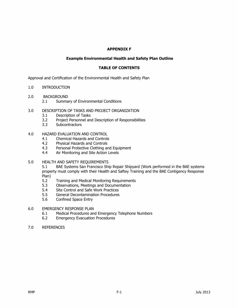
RMP F-1 July 2013
APPENDIX F
Example Environmental Health and Safety Plan Outline
TABLE OF CONTENTS
Approval and Certification of the Environmental Health and Safety Plan
1.0 INTRODUCTION
2.0 BACKGROUND 2.1 Summary of Environmental Conditions 3.0 DESCRIPTION OF TASKS AND PROJECT ORGANIZATION
3.1 Description of Tasks 3.2 Project Personnel and Description of Responsibilities 3.3 Subcontractors
4.0 HAZARD EVALUATION AND CONTROL 4.1 Chemical Hazards and Controls 4.2 Physical Hazards and Controls 4.3 Personal Protective Clothing and Equipment 4.4 Air Monitoring and Site Action Levels
5.0 HEALTH AND SAFETY REQUIREMENTS 5.1 BAE Systems San Francisco Ship Repair Shipyard (Work performed in the BAE systems property must comply with their Health and Saftey Training and the BAE Contigency Response Plan) 5.2 Training and Medical Monitoring Requirements 5.3 Observations, Meetings and Documentation 5.4 Site Control and Safe Work Practices 5.5 General Decontamination Procedures 5.6 Confined Space Entry
6.0 EMERGENCY RESPONSE PLAN 6.1 Medical Procedures and Emergency Telephone Numbers 6.2 Emergency Evacuation Procedures
7.0 REFERENCES

RMP F-2 July 2013
LIST OF FIGURES
Figure 1 Site Location Map
Figure 2 Site Plan
Figure 3 Hospital Route Map
LIST OF TABLES
Table 1 Contaminants of Concern
Table 2 Project Contacts
Table 3 Symptoms and Treatment of Heat and Cold Stress
Table 4 General Physical Hazards and Controls
Table 5 Personal Protective Clothing/Equipment
Table 6 Air Monitoring Action Levels
Table 7 Emergency Contacts
LIST OF APPENDICES
Appendix A Agreement and Acknowledgement Form
Appendix B BAE Consolidated Contingency Plan
Appendix C Tailgate Safety Meeting Form
Approval and Certification of Environmental Health and Safety Plan

RMP F-3 July 2013
Project Name:
Project Number/ID
“This Project Specific Environmental Health and Safety Plan and Attachments were prepared under my direction to comply with applicable occupational health and safety standards, including, but not limited to OSHA 1910.120”
Certified Industrial Hygienist Signature and Stamp
Date

PIER 70 RISK MANAGEMENT PLAN Pier 70 Master Plan Area San Francisco, California
Prepared For: Port of San Francisco
San Francisco, California
25 July 2013 Project No. 730496301

APPENDIX G
GROUNDWATER MANAGEMENT PLAN OUTLINE

RMP G-1 July 2013
Appendix G
Groundwater Management Plan Outline
A Groundwater Management Plan (GMP) will be prepared to describe the pumping of groundwater for
both temporary or permanent dewatering projects in support of development and construction activities. If there are projects that propose permanent pumping of groundwater (i.e. ongoing dewatering of the
area around and within below grade parking garages), a detailed plan encompassing permanent
dewatering system design, geotechnical considerations, permitting and construction, among other items, would be required. The outline presented provides a framework for designing and permitting such a
system but the primary purpose of this outline is to support temporary dewatering in support of redevelopment activities.
The outline presented below uses Section 7.10 of the RMP to describe information that should be included in a GMP. Also presented below is other required information that describes the scope of work:
Project Description, Subsurface Conditions, Hydrogeologic Analysis, Description of Groundwater
Extraction Means and Methods, and Permitting and Reporting Requirements. The GMP should be prepared in advance of planned construction activities to allow adequate time for review, comment, and
approval by the Regulatory Agencies.
1.0 INTRODUCTION
1.1 Project Description and Schedule
1.2 Local Groundwater Description - Describe known groundwater conditions in and around
the area proposed for dewatering.
1.2.1 Presentation and discussion of existing groundwater data (locations, levels, flow
direction, flow velocity, chemicals of concern (COCs), type of data, date of
collection, source of data with references).
1.2.2 Project location and proximity to existing groundwater plumes (i.e. Areas of
Special Concern with Non Aqueous Phase Liquid (NAPL) and Dense Non Aqueous
Phase Liquid (DNAPL) Impacts)
1.2.3 Description of Proposed Project Requiring Dewatering
1.3 Hydrogeology
2.0 GROUNDWATER MANAGEMENT PLAN
2.1 Hydrogeologic Evaluation
2.1.1 Radius of influence of pumping
2.1.2 Potential effects on known COCs in groundwater (if near areas of special
concern)
2.1.2.1 Data from nearby existing groundwater monitoring wells to establish
baseline water quality
2.1.3 Proposed mitigation measures to minimize negative effects on groundwater
plumes (if near areas of special concern)
2.1.3.1 Pumping rate and/or duration to minimize/eliminate negative
effects on known groundwater plumes - If necessary based on the
judgment of a qualified professional, the installation of “guard wells”
may be appropriate to provide an early warning of adverse impacts
from the temporary pumping on the nearby plume.
2.1.3.2 Monitoring Well Sampling - If necessary, collect groundwater samples
from select (new or existing) monitoring wells in the vicinity to ensure

RMP G-2 July 2013
existing plumes are not negatively affected by localized and
temporary pumping.
2.1.3.3 Other engineering measures (i.e., sheet pile walls, tide fluctuation
management, injection grouting, etc.)
2.1.4 Permitting and Discharge Requirements
2.2 Proposed Groundwater Extraction
2.2.1 Dewatering Project Duration
2.2.1.1 Dewatering system design
2.2.1.2 Groundwater treatment design (if required as a condition of
discharge permit) - Description of chemical treatment to address pre-
existing condition of extracted groundwater (i.e., activated charcoal,
physical filtration, pH adjustment, etc.)
2.2.1.3 Groundwater Infiltration Mitigation- Description of any measures to
slow or minimize groundwater infiltration into below grade
excavations for the duration of the project (i.e.., sheet pile walls,
injection grouting, management of tidal water if close to the bay
margin, not-to-exceed pumping rates, etc.)
2.2.1.4 Conveyance system and temporary storage, and discharge design (if
any)
2.2.1.5 Discharge point - Describe location and ownership of discharge point
(i.e. San Francisco Public Utilities Commission [SFPUC] combined
sewer)
2.2.1.6 Provide engineering drawings of dewatering and treatments systems,
locations of any wells, discharge point(s), sampling point(s)
3.0 PERMITTING AND REPORTING REQUIREMENTS
3.1 Permit Requirements
3.1.1 Performance/discharge criteria
3.1.2 Sampling criteria (Field monitoring, field observation, collection and laboratory
analysis of discharge water samples)
3.2 Reporting Requirements
3.2.1 Permit-specific reporting requirements
3.2.1.1 Field notes/observations
3.2.1.2 Laboratory results
3.2.1.3 Quarterly/annual reporting
3.2.1.4 Project completion process
3.2.2 Regulatory Agency Approval and Reporting
3.2.2.1 RWQCB
3.2.2.2 San Francisco Department of Public Health (SFDPH) requirements
3.2.2.3 Other City and County of San Francisco (City) entities, when
appropriate: San Francisco Public Utilities Commission (SFPUC),
San Francisco Department of Public Works (SFDPW-Bureau of
Construction Management [BCM]), Department of Building
Inspection (DBI)
RMP G-3 July 2013
4.0 HEALTH AND SAFETY
4.1 Site Specific Health and Safety Measures
4.1.1 Groundwater-specific health and safety measures designed to protect
workers conducting dewatering and subsurface work covered under
the Environmental Health and Safety Plan (EHSP).
4.1.2 Health and Safety issues, Notification requirements, and Site Security
5.0 DISCOVERY OF UNKNOWNS
5.1 Refer reader to Unknown Condition Response Protocol in RMP
6.0 REFERENCES

Illinois Street
3rd Street
Tennessee Street
Minnesota S
treet
20th Street
22nd Street
19th Street
18th Street
Irish Hill
San Francisco Bay
Potrero Power Plant
Parcel 9
Parcel 6Parcel 5
Parcel 4
Parcel 2
Crane Cove Park
Parcel 3
Parcel 8Parcel 7
SlipwaysPark
Parcel1
CentralPlazaPark
6
12
113
2
109
11760
38
14
15
108
36
1121
111
104
116
105
114
115
101
19102
40
110
107103
120119
50
49
? ?
?
?
?
?
??
Approximate Area of Heavily Degraded PetroleumHydrocarbons in Soil and Groundwater
PIER 70 MASTER PLAN AREARISK MANAGEMENT PLAN
San Francisco, California
SAMPLE LOCATIONS AND AREASWITH IDENTIFIED IMPACTS
Date 7/24/2013 Project 730496301 Figure 50 300 600150
Feet
\\langan.com\data\SF\data3\730496301\ArcGIS\arcmap_doc\2012\Risk Management Plan\Sample Locations Areas of Special Concern.mxd
LegendSample Location
Monitoring WellGeotechnical BoringSoilSoil and or GroundwaterSoil GasSoil Gas ProbeTest PitGroundwater concentrationexceeding residential cleanup levelSoil gas concentration exceedingresidential cleanup levelApproximate 1869 ShorelineApproximate Groundwater Flow Direction
Surface FeatureFenceOtherRoad EdgeArea with Non-aqueousPhase Liquid (NAPL) ImpactsBuildingProposed BuildingPier 70 Site AreaMaster Plan Parcel Areas (eg. Parcel 1 = P1,Crane Cove Park = CC, etc...)Pile-Supported Structure Over WaterArea with Dense Non-AqueousPhase Liquids (DNAPL) ImpactsLimit of Upland Feasibility Study for FormerPG&E Potrero Power Plant
Notes:1. Buildings, surface features, and road edges digitized from digital orthophotos 10SEG535775.tif and 10SEG535790, California Spatial Information Library (CASIL) UC Davis, CA 2005, HTTP://archive.casil.ucdavis.edu/casil/.2. Shoreline based upon San Francisco Enterprise GIS, Extended San Francisco Shoreline shapefile, Http://gispub02.sfgov.org/ website/sfshare/catalog/sfshoreext.zip3. Approximate 1869 Shoreline based upon Board of Tidelands Commissioners, Map of the Salt Marsh and Tide Lands and Lands Lying Under Water South of Second Street Situate in the City and County of San Francisco, 1869.4. Site boundary and parcels from ROMA Design Group, Pier 70 DraftPreferred Master Plan, 17 July, 2009.5. Historical Manufactured Gas Plant Subsurface Investigation Area taken from AMEC Geomatrix, Report of Results: Subsurface Investigation Activities Evaluation of Impact to Fill and Bay Mud, Potrero Power Plant, Figure 2, September 2010.6. Map displayed in California State Plane Coordinate System, Zone III, North American Datum of 1983 (NAD83), US Survey Feet.