Pliocene vertebrat localite oyf Çalta ,Ankara, Turkey. 1...
10
Pliocene vertebrate locality of Çalta, Ankara, Turkey. 1. Sedimentation and lithostratigraphy Juha Pekka LUNKKA Department of Geology, University of Helsinki, P.O. B o x 1 1 , FIN-00014 University of Helsinki (Finland) [email protected] John KAPPELMAN Department of Anthropology, University of Texas at Austin, Austin, TX 78712-1086 (USA) [email protected] Douglas EKART Department of Geology and Geophysics, University of Utah, Salt Lake City, U T 8 4 1 1 2 ( U S A ) [email protected] Sevket SEN Laboratoire de Paléontologie, U R A 1 2 d u CNRS, Muséum national d'Histoire naturelle, 8 rue de Buffon, F-75231 Paris cedex 05 (France) [email protected] Lunkka J. P. , Kappelman J., Ekart D. & Sen S. — Sedimentation and lithostratigraphy, in Sen S. (ed.), Pliocene vertebrate locality of Çalta, Ankara, Turkey. 1, Geodiversitas 20 (3) : 329-338. KEYWORDS lithostratigraphy, sedimentation, alluvial facies, paleosols, Turkey, Central Anatolia. ABSTRACT A fossil bearing volcaniclastic sequence at Cklta, Central Anatolia, Turkey was investigated using a modified facies and architectural element analysis. This was done in order to describe the local lithostratigraphy and to shed light on depositional environments and palaeogeography of the area during time of formation. Four main depositional environments were recognized: (1) distal alluvial fan; (2) fluvial channel; (3) overbank and floodplain and (4) pond environment. These environments characterize the evolution of landscape from a relatively steep to land surface of low relief in the more dis- tal part of an alluvial plain. The main fossil beds occur in the floodplain and ponded deposits at levels that show best developed paleosols. • 1 9 9 8 • 2 0 ( 3 ) 329
Transcript of Pliocene vertebrat localite oyf Çalta ,Ankara, Turkey. 1...
Pliocene vertebrate locality of Çalta, Ankara, Turkey. 1. Sedimentation and lithostratigraphy
Juha Pekka LUNKKA D e p a r t m e n t o f G e o l o g y , U n i v e r s i t y of H e l s i n k i ,
P . O . B o x 1 1 , F I N - 0 0 0 1 4 U n i v e r s i t y of H e l s i n k i ( F i n l a n d )
l u n k k a @ t o u k o . h e l s i n k i . f i
John KAPPELMAN D e p a r t m e n t o f A n t h r o p o l o g y , U n i v e r s i t y o f T e x a s a t A u s t i n ,
A u s t i n , T X 7 8 7 1 2 - 1 0 8 6 ( U S A )
j k a p p e l m a n @ m a i l . u t e x a s . e d u
Douglas EKART D e p a r t m e n t o f G e o l o g y a n d G e o p h y s i c s , U n i v e r s i t y o f U t a h ,
S a l t L a k e C i t y , U T 8 4 1 1 2 ( U S A )
d d e k a r t @ m i n e s . u t a h . e d u
Sevket SEN L a b o r a t o i r e d e P a l é o n t o l o g i e , U R A 1 2 d u C N R S , M u s é u m n a t i o n a l d ' H i s t o i r e n a t u r e l l e ,
8 r u e d e B u f f o n , F - 7 5 2 3 1 P a r i s c e d e x 0 5 ( F r a n c e )
s e n @ c i m r s 1 . m n h n . f r
L u n k k a J . P. , K a p p e l m a n J . , E k a r t D. & S e n S . — S e d i m e n t a t i o n a n d l i t h o s t r a t i g r a p h y , in S e n S . ( e d . ) , P l i o c e n e v e r t e b r a t e l o c a l i t y o f Ç a l t a , A n k a r a , T u r k e y . 1 , Geodiversitas 2 0 (3 ) : 3 2 9 - 3 3 8 .
K E Y W O R D S lithostratigraphy,
sedimentation, alluvial facies,
paleosols, Turkey,
Central Anatolia.
ABSTRACT A fossil bearing volcaniclastic sequence at Cklta, Central Anatolia, Turkey was investigated using a modified facies and architectural element analysis. This was done in order to describe the local lithostratigraphy and to shed light on depositional environments and palaeogeography of the area during time of formation. Four main depositional environments were recognized: (1) distal alluvial fan; (2) fluvial channel; (3) overbank and floodplain and (4) pond environment. These environments characterize the evolution of landscape from a relatively steep to land surface of low relief in the more distal part of an alluvial plain. The main fossil beds occur in the floodplain and ponded deposits at levels that show best developed paleosols.
• 1 9 9 8 • 2 0 ( 3 ) 329

L u n k k a J . P., K a p p e l m a n J . , Ekart D. & Sen S.
M O T S C L E S
lithostratigraphie, sédimentation,
faciès alluvial, paléosols, Turquie ,
Anatolie centrale.
RÉSUME Le gisement de vertébrés pliocenes de Çalta, Ankara, Turquie. 1. Sédimentation et lithostratigraphie. La séquence sédimentaire des formations fossilifères de Çalta, Anatolie centrale, Turquie, a été étudiée en prenant en compte l'évolution des faciès au cours du temps et en analysant l'architecture des corps sédimentaires. Ce travail a été effectué dans le but de décrire la stratigraphie locale et de mettre en évidence les environnements sédimentaires et la paléogéographie de la région lors de la mise en place de ces dépôts. Quatre principaux faciès sédimentaires ont été identifiés : (1) des coulées détritiques ; (2) des dépôts de chenaux fluviátiles ; (3) des dépôts de plaine d'inondation ; (4) des dépôts marécageux. Les changements de faciès au cours du temps démontrent l'évolution du terrain d'un relief accidenté vers des paysages plutôt plats, dans une partie distale d'une plaine alluviale. Le niveau fossilifère principal se trouve dans des dépôts de plaine d'inondation et d'étangs temporaires ; il correspond également à un paléosol bien développé.
INTRODUCTION
The small village of Caha is located approximate ly 13 k m N W of town Kazan in C e n t t a l Anatolia to the north of Ankara (Fig. 1) . The tectonic setting of the Ankara region including the C a h a a r e a has been a part of the collision system involving Eurasian continent to the north, Gondwana to the south and Sakarya continent in between (Sengor & Yilmaz 1 9 8 1 ; Kocyigit 1991). Pre-Miocene rocks of the area (Fig. 1) are related to the closure of the Neo-Tethyan Ocean and comprise aftet Kocyigit (1991) the Karakaya C o m p l e x ( t e c t o n o - s e d i m e n t a r y m e l a n g e ) , Ankara Group (marine sedimentary rocks and sedimentary melange), Anatolian Complex (tecton ic m e l a n g e ) and the Uppe r C r e t a c e o u s -Middle Eocene Meml ik Group that represents forearc basin fill (Fig. 1).
Miocene to Pliocene rocks rest upon Meml ik Group wi th an angu la t unconformity. These subaerial basalts and volcaniclast ic sediments outcrop on the flanks of prominent hills and ate covered by recent Pleistocene a l luvium in the general region sur rounding Kazan and C a h a (Liittig & Steffens 1976; Lunkka et al. 1995; Kappelman et al. 1996).
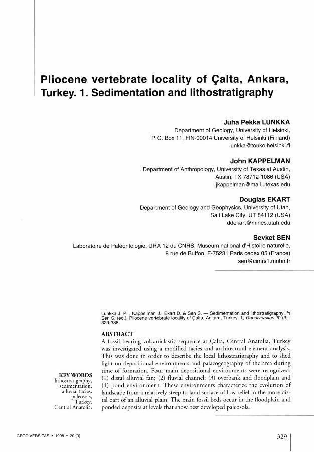
The general lithostratigraphy for the area around Kazan is shown in figure 2. The oldest Miocene sediments exposed in the atea are current bedded volcaniclastics that lie beneath the basaltic lava
flow dated 15.2 ± 0.3 (Kappelman et al. 1996, see Fig. 2 ) . This lava flow is in turn overlain by a thick accumulation of volcaniclastics that become younger from the east, north of Yassioren towards rhe Caha area in the west (see Figs 1 ,2 ) . These volcaniclastic sediments were deposited in a variety of terrestrial depositional settings ranging from alluvial to lacustfine (Kappelman et al.
1996) but have subsequently undergone deformation as a result of neotectonic activity most p robab ly re la ted to the deve lopmen t of the North Anatolian transform fault (Angelier et al.
1981; Inci 1991).
The volcaniclastic sediments in the area around the village of C a ha have undergone extensive folding and small anticlinal and synclinal structures dominate the landscape. The fossil-bearing sediments described here occur in tight folded, gently plunging anticline, the axis of which is curved and plunges 15° towatds the southwest (Fig. 1). Structural and stratigraphical investigations suggest that the Caha sedimentary sequence represents the distal patt of a depositional system that is related to the evolution of a small, telatively isolated intetmontane basin further southwest. Similar relatively small, isolated systems are claim e d to be t y p i c a l for t h i s par t of C e n t r a l Anatolia (Liittig & Steffens 1976; Erol 1981). The primary aim of the present article is to present the local l i thos t ra t ig taphy for the fossil-bear ing sed iment succession at Caha and to
330 GEODIVERSITAS • 1 9 9 8 • 2 0 ( 3 )

S e d i m e n t a t i o n and l i thostrat igraphy oi Ca l ta I
B
Kizjlcahamam P Çubuk
d' p Kazan // . '^Ankara
Elnrîadag
HKarakaya ComplexQ v o f c a r T i c s M ' ° C e n e
Ankara Group Q ^ § ^ t | ° P l i o c e n e )
Qforearc sequence 0 ^ t o ^ s
e n e a l l u v i a l
[^Anatolian Complex / fau l t
FIG. 1 . — A , l o c a t i o n of t h e C a l t a a r e a n e a r t o w n K a z a n a n d a g e n e r a l g e o l o g i c a l m a p o f t h e A n k a r a a r e a m o d i f i e d a f t e r K o g y i g i t ( 1 9 9 1 ) ; B , l o c a t i o n o f t h e s t u d y a r e a S W of C a l t a a n d t h e s t r u c t u r a l m a p of t h e a r e a a l s o i n d i c a t i n g S e c t i o n s 1 a n d 2 i n v e s t i g a t e d .
reconstruct the paleoenvironments that existed duting the time when fossiliferous deposits were laid down.
DESCRIPTION OF LITHOSTARTIGRAPHY AND SEDIMENTS
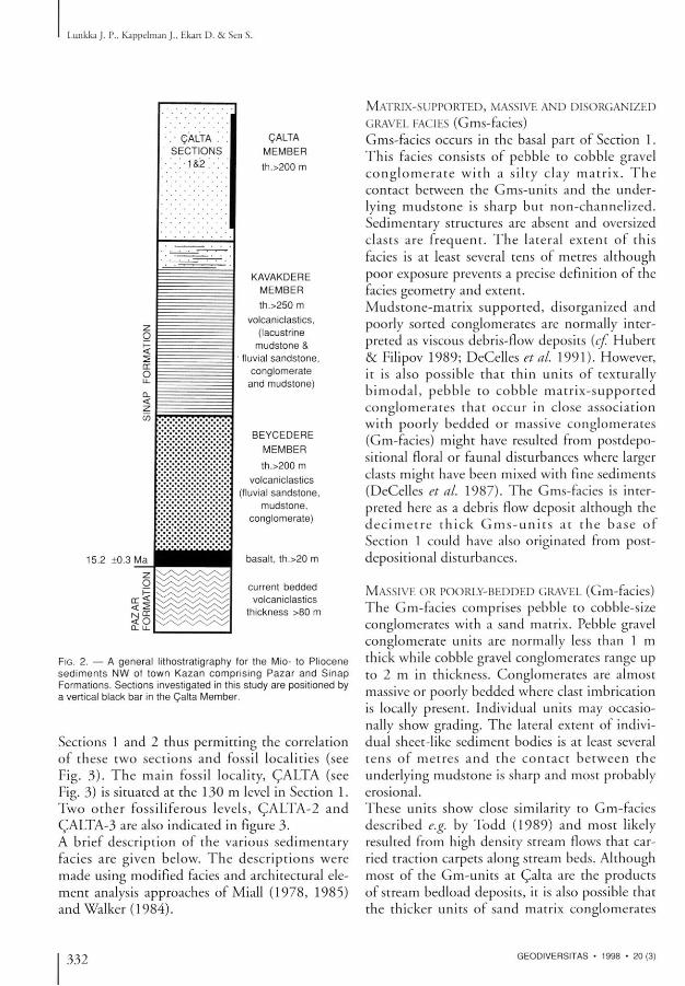
Two sections were selected for lithostratigraphi-cal and sedimentological investigations at Çalta (Fig. 1) . Sedimentary units at these two sites, located approximately 250 m apart, dip between 33°-66° towards the northwest (Fig. 1). Section 1
is 195 m thick while the thickness of Section 2 is 69 m (Fig. 3) . Sediments in both sections are characterized by massive mudstone uni ts that are interbedded with relatively thin layers of gravel conglomerates and sandstones. Pebble-sized clasts studied from conglomerate units have a very consistent composition throughout the sequence dominated by local basalt and siliceous fragments (over 9 5 % ) with subotdinate amount of sandstone. Although sediments are rather poorly exposed in the area, one continuous conglomerate bed forms a marker h o r i z o n tha t can be t r a c e d b e t w e e n
GEODIVERSITAS • 1 9 9 8 • 2 0 ( 3 ) 331
Lunkka J . P., K a p p e l m a n J . , Ekart D . & Sen S.
1 5 . 2 ± 0 . 3 M a
. ' C A L T A .
S E C T I O N S
• : •'. • 1 & 2 ; • ; •
C A L T A
M E M B E R
t h . > 2 0 0 m
o < 2 N DC
< o 0 - LL
K A V A K D E R E
M E M B E R
t h . > 2 5 0 m
v o l c a n i c l a s t i c s .
( l a c u s t r i n e
m u d s t o n e &
f l uv ia l s a n d s t o n e ,
c o n g l o m e r a t e
a n d m u d s t o n e )
B E Y C E D E R E
M E M B E R
t h . > 2 0 0 m
v o l c a n i c l a s t i c s
( f luv ia l s a n d s t o n e ,
m u d s t o n e ,
c o n g l o m e r a t e )
b a s a l t , t h . > 2 0 m
c u r r e n t b e d d e d
v o l c a n i c l a s t i c s
t h i c k n e s s > 8 0 m
FIG. 2 . — A g e n e r a l l i t h o s t r a t i g r a p h y f o r t h e M i o - t o P l i o c e n e s e d i m e n t s N W o f t o w n K a z a n c o m p r i s i n g P a z a r a n d S i n a p F o r m a t i o n s . S e c t i o n s i n v e s t i g a t e d in t h i s s t u d y a r e p o s i t i o n e d b y a v e r t i c a l b l a c k b a r in t h e Ç a l t a M e m b e r .
Sections 1 and 2 thus permitting the correlation of these two sections and fossil locali t ies (see Fig. 3 ) . The main fossil locality, ÇALTA (see Fig. 3) is situated at the 130 m level in Section 1. Two othet fossiliferous levels, ÇALTA-2 and ÇALTA-3 are also indicated in figure 3. A brief description of the vatious sedimentary facies are given below. The descriptions were made using modified facies and architectutal element analysis approaches of Miall (1978, 1985) and Walker (1984) .
MATRIX-SUPPORTED, MASSIVE AND DISORGANIZED
GRAVEL FACIES (Gms-facies)
Gms-facies occurs in the basal part of Section 1. This facies consists of pebble to cobble gtavel c o n g l o m e r a t e w i th a s i l ty c l ay m a t r i x . T h e contact between the Gms-units and the underlying mudstone is sharp but non-channelized. Sedimentary sttuctures are absent and oversized clasts are frequent. T h e lateral extent of this facies is at least several tens of metres although poor exposure prevents a precise definition of the facies geometry and extent.
Mudstone-matr ix supported, disorganized and poorly sorted conglomerates are normally interpreted as viscous debris-flow deposits (cf. Hubert & Filipov 1989; DeCelles et al. 1991). However, it is also possible that thin units of textutally b imoda l , pebble to cobble mat r ix-suppor ted conglomerates that occur in close association with pootly bedded or massive conglomerates (Gm-facies) might have resulted from postdepo-sitional floral or faunal disturbances where larger clasts might have been mixed with fine sediments (DeCelles et al. 1987). The Gms-facies is interpreted here as a debris flow deposit although the d e c i m e t t e t h i c k G m s - u n i t s at the base of Section 1 could have also originated from post-depositional disturbances.
MASSIVE OR POORLY-BEDDED GRAVEL (Gm-facies)
The Gm-facies comprises pebble to cobble-size conglomerates with a sand matrix. Pebble gravel conglomerate units are normally less than 1 m thick while cobble gravel conglomerates range up to 2 m in thickness. Conglomerates are almost massive or poorly bedded where clast imbrication is locally present. Individual units may occasionally show grading. The lateral extent of individual sheet-like sediment bodies is at least several tens of metres and the contact be tween the undetlying mudstone is shatp and most probably erosional.
These units show close similatity to Gm-facies described e.g. by Todd (1989) and most likely resulted from high density stteam flows that carried traction carpets along stream beds. Although most of the Gm-units at Qalta ate the products of stream bedload deposits, it is also possible that the thicker units of sand matrix conglomerates
332 GEODIVERSITAS • 1 9 9 8 • 2 0 ( 3 )
Sed imenta t ion and l i thostrat igraphy o f Calta
C a l t a S e c t i o n s 1 - 2
Section 1 Section 2 M
1 2 0 - T
6 0 H
P l e i s t o c e n e c o v e r
60-1
'Q-. O-.-O-.'O/ T
Fm(+c)
Cm(GpJ27cr
Fm+fej
M S P C
Fm(Sm)
Sm Ç A L T A - 2 fin
™ > O O Ó r r n Gf, Gp 3 1 0 '
Sp F ^
T
G(, Gp, Sp Fm
Gms
calcite nodules root traces bee burrows gastropods fossil bones palaeocurrent calcareous marl (limestone) = L covered paleosol horizon F A C I E S :
Fines Fm = massive (mudstones) ^+¡£¡¿¡5%?" w i t h c l a s t s
Sp - planar cross-bedded Sm = massive Sand
Gravel
lO'.O'.O'.O
Gms = matrix supported massive Gm = massive or crudely stratified Gp = planar cross-bedded Gt = trough cross-bedded M = mudstone S = sandstone P = granule to pebble gravel conglomerate C = cobble gravel conglomerate
M ' S ' P ' c '
FIG. 3 . — L i t h o s l r a t i g r a p h i c l o g s of S e c t i o n s 1 a n d 2 a t Ç a l t a . M a r k e r c o n g l o m e r a t e a n d f o s s i l l oca l i t i es t o g e t h e r w i t h p a l e o s o l h o r i
z o n s a r e I n d i c a t e d . A r r o w s i n d i c a t e p a l a e o f l o w d i r e c t i o n s . G r a v e l c o n g l o m e r a t e s at t h e t o p o f s e c t i o n s a r e b e l i e v e d to r e p r e s e n t
m o d e r n ( P l e i s t o c e n e ?) c o v e r .
GEODIVERSITAS • 1 9 9 8 • 2 0 ( 3 ) 333
Lunkka J . P., K a p p e l m a n J . , F.kart D . & Sen S.
with poor sorting (multimodal grain-size distribution) and the absence of internal stratification were deposited en masse.
T R O U G H AND PLANAR CROSS-BEDDED GRAVEL
AND SAND FACIES (Gt, Gp and Sp-facies)
There are several units of thick (up to 5 m) pred o m i n a n t l y t rough and planar cross-bedded pebble gravel conglomerate wi th subordinate amounts of planar cross-bedded sand that occut at the 4-8 m and 57-62 m (Section 1 and 2 marker horizon) levels in the sections (Fig. 3 ) . Gp-Gt facies also occut at the top of the hills in the Calta area but these beds are considered to represent recent alluvium and are not discussed here. Cross-bedded gravel conglomerate is lateral ly continuous for several hundreds of metres, and these uni ts have an erosional lower contact . Laterally and vert ical ly clast-supported gravel bodies pass into stratified pebbly gravel with sand matrix and finally to planat cross-bedded sand. However, the lateral and vertical grain-size changes are abrupt and not systematic. Gtavel units are lenticular in cross-section. Palaeoflow indicators (corrected ior bedding orientat ion) show current flow towards the east and southeast.
The Gt-Gp-Sp facies are interpreted to represent fluvial channel deposits including longitudinal bats, side bats and channel fills. This interpretation is based on the lent icula t shape of these bodies, theit crude upward fining architecture, and the erosional bases of these cross-bedded conglometates and sands {e.g. see crireria used in Miall 1978, 1985; Rust & Kosterl984; Mack & Rasmussen 1984; DeCelles etal. 1991).
MASSIVE SAND FACIES (Sm-facies)
Massive and, in places, faintly planar cross-bedded, fine to medium sand units that range from
B A S A L T
D E B R I S F L O W D E P O S I T S
C O A R S E G R A V E L C O N G L O M E R A T E S
I I F L O O D P L A I N M U D S T O N E S
r ^ a J C A R B O N A T E P O N D S E D I M E N T S
I % I P A L E O S O L H O R I Z O N S
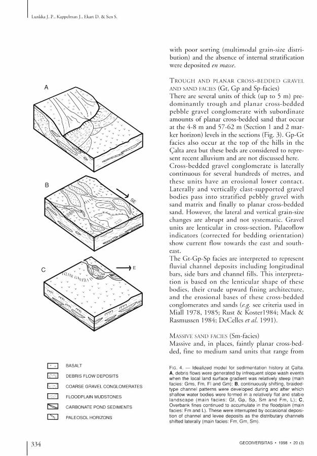
FIG. 4 . — I d e a l i z e d m o d e l f o r s e d i m e n t a t i o n h i s t o r y a t C a l t a . A , d e b r i s f l o w s w e r e g e n e r a t e d by i n f r e q u e n t s l o p e w a s h e v e n t s w h e n t h e l o c a l l a n d s u r f a c e g r a d i e n t w a s r e l a t i v e l y s t e e p ( m a i n f a c i e s : G m s , F m , Fl a n d G m ) ; B , c o n t i n u o u s l y s h i f t i n g , b r a i d e d -t y p e c h a n n e l p a t t e r n s w e r e d e v e l o p e d d u r i n g a n d a f t e r w h i c h s h a l l o w w a t e r b o d i e s w e r e f o r m e d in a r e l a t i v e l y f la t a n d s t a b l e l a n d s c a p e ( m a i n f a c i e s : G t , G p , S p , S m a n d F m , L ) ; C ,
O v e r b a n k f i n e s c o n t i n u e d to a c c u m u l a t e in t h e f l o o d p l a i n ( m a i n f a c i e s : F m a n d L ) . T h e s e w e r e i n t e r r u p t e d b y o c c a s i o n a l d e p o s i t i o n of c h a n n e l a n d l e v e e d e p o s i t s a s t h e d i s t r i b u t a r y c h a n n e l s s h i f t e d l a te ra l l y ( m a i n f a c i e s : F m . G m , S m ) .
334 GEODIVERSITAS • 1 9 9 8 • 2 0 ( 3 )

Sed imenta t ion and l i thostrat igraphy o f Coaita
0.2-1 .4 m in thickness are closely te lated to cross-bedded gravel horizons. These sands normal ly overlie cross-bedded gravels. Individual sand beds are tabular-shaped bodies and have sharp basal contacts. These bodies are laterally extensive at least for tens of mettes. Root ttaces, butrows, calcite nodules and gastropods were also observed in these sand units. The tabular geometry and the close relationship with channel deposits along with the abundant evidence for biotutbation suggests that Sm-facies represents reworked sheet-flood and overbank deposits wi th poor pedogenic a l te ta t ion (e.g. DeCdks etal. 1987).
M A S S I V E M U D S T O N E , SILTSTONE, A N D MARL
FACIES (Fm- and L-facies) The major part of the sedimentary sequence at Coaita consists of massive, often calcareous mud-stones that are slightly silicified in places. A few massive of faintly laminated siltstone beds were also recorded and most of these seem to be related to the m a r l y beds d e s c r i b e d be low. In Section 1 thete is one relatively thick accumulat ion of m u d s t o n e i n c l u d i n g m a t l beds that occurs above the marke r c o n g l o m e r a t e (see Fig. 3 ) , while in Section 2 a compatable mudstone is much thinner, perhaps reflecting later erosional events during the Pleistocene. Several thin mudstone units occur between conglomerates in the basal part of Section 1. In addition to these thin mudstones, there is one relatively thick (25 m thick) mudstone unit below the marker conglomerate. The massive mudstones that occur above the marker conglomerate show distinct hotizons with typical pedogenic features including mottling, biotutbation, calcite nodules and subparallel calcite veins discussed below. Based on the massive structure, bioturbation, fossil content, and pedochemical alterations, the muds tones are in t e tp te t ed hete as overbank deposits laid down in a floodplain environment with moderate pedogenic alteration. In addition to the ted brown to light brown and dark grey, often calcareous mudstones, several whi te marl beds ( l imestones) , 0.9-5 m thick, occur in the sequence. The lower contacts of these marls are somewhat gradational where the under ly ing massive or l amina ted si l ts tone or
conglomerate passes gradually into marls. Some of the marl beds show b io tu tba t ion in thei t upper part and pass with shatp contact into massive mudstone or sand. The exact lateral extent of marly horizons is unknown but one of them seems to continue for several hundreds of metres in the sequence. Mar l beds are interpreted as temnants of small ephemeral ponds that existed in the flood plain (see e.g. Sanz et al. 1995).
DEPOSITIONAL ENVIRONMENTS
The facies succession, paleosol horizons, and ponded sediments together with palaeontological evidence (see other contributions in this monograph) clearly indicates that the sediments at Calta were laid down in a terrestrial setting. As a whole, the sedimentaty sequence was most certainly deposited in an alluvial environment. The provenance atea is thought to have been local s ince pebble counts car r ied out from gravel conglomerate units indicate that the local volcanic rocks dominate the rock assemblage. In broad terms, the sediments can be grouped into four different categories that chatacterize the depositional environments during the time when Calta sequence was deposited. Debris flow deposits (Gms-facies) alternating with fine sediments are found in the basal part of Section 1. Such flows are generally believed to be generated by steep slopes, loose debris, relatively sparse vegetation cover, infrequent heavy rainfall, and a volcanic terrain with abundant volcaniclas-tic mater ia l (cf. Hooke 1 9 6 7 ; Wasson 1977; Vessell & Davies 1981) . These condit ions are most commonly met under ar id or semi-ar id conditions in an alluvial fan setting (cf Mack & Rasmussen 1984). Since the coarse conglomerate facies in the basal part of the sequence at C a h a
does not show featutes that are typical of a well-developed fan head or mid-fan facies (e.g. Walker 1984), the sediment succession in the basal part of Section 1 probably resulted from infrequent slope wash events in the volcanic terrain followed by overbank deposition in the mote distal part of an alluvial fan (Fig. 4A) . The local gradient of the land surface during this stage must have been relatively steep in order to generate these debris flows.
GEODIVERSITAS • 1 9 9 8 • 2 0 ( 3 ) 335

Lunkka J . P., K a p p e l m a n J . , Ekart D . & Sen S.
The cross- or crudely-bedded gravel conglomerate and sand facies represent channel bars that originated from bedload deposition duting stteam flows. These sediments indicate that duting the time when the marker conglomerate (see Fig. 3) and Gp-Gt-Gm-Sm-facies (further up in the sequence) were deposi ted, a dis t inct channel c o n f i g u r a t i o n was e s t a b l i s h e d in the area (Fig. 4B) . Categorizing different tivet types such as straight, meandering, braided or anastomosing on the basis of channel deposits is highly suspect (cf. Collinson 1995) , but it is well known that coarse-grained bedload streams generally show low sinuosity and modetate or strong braiding. Based on the internal structures observed in gravel conglomerates along with theif lateral extent and ovetall geometty, it is suggested that stream flow deposits at C a l t a w e r e 'aid down by braided-type channel patterns that shifted continuously in space and time across the distal alluvial fan but generally flowed towards the east and southeast.
A f ine-grained mudstone facies that includes p o n d e d m a r l s d o m i n a t e s the s e d i m e n t a r y sequence at C a l t a a n ( l represents flood plain deposits that were modified by pedogenic processes mentioned above. A variety of methods including observations on biogenic featutes (e.g. root ttaces, terrestrial molluscs, pupal cases of insects, burrows), colour, macro-structutes, hori-zon t a t i on and b o u n d a r i e s , g r a n u l o m e t f i c s , micromorphology, and mineral assemblages are normally used to tecognize paleosols in terrestrial sequences (cf. Retallack 1988; Wright 1989). At Calta such featutes including root traces, calcite nodules and veins, slickensides and peds, along w i th os t tacods and pupa l cases were a lmost exclusively observed in the mudstones at distinct horizons (see Fig. 3) .
Thin mudstone units that are associated with the debtis ot streamflow deposits found in the basal part of Section 1 show little indication of paleo-sol development . These uni ts most probably represent times of more rapid sediment deposition resulting from a higher sedimentation rate during the t ime when debris flow events were relatively frequent in the area. The thin mud-stones were p robab ly b u r i e d by subsequen t events before pedogenesis could proceed. In the
25 m thick, massive mudstone bed that is found above the basal conglomeiates, calcite nodules, calcite layets (ca. 2 cm thick), and mottling assoc i a t ed w i t h os t racods occur at 2 2 . 5 m and 40.4 m levels (see Fig. 3 ) . These features can be interpreted as pedogenic in or igin . However, much clearer paleosol horizons are present in a thick mudstone unit above the matket conglomera te . Two of the fossil beds , CALTA and CALTA-2, occur in these well-developed paleosol horizons (see Fig. 3 ) .
Relatively thin marl units frequently occur in the middle part of the section (Fig. 3) . These maris are intetpreted to represent ponded deposits as discussed above. The term pond is considered here as a shallow standing waterbody with reduced extent (see criteria used by Bates & Jackson 1980). In addition, ponds are normally considered ephemeral and lack facies associations typical for other types of standing waterbody deposits such as lakes, playas, salt pans, and marsh deposits (Currey 1990; Sanz et al. 1995). The occurrence of pond depos i t s at C a J t a i nd i ca t e s a relatively flat and stable landscape with reduced sediment input . These condit ions could have prevailed in a distal flood plain environment when the active channel network (see above) switched out of the immediate atea and left isolated, shallow depressions that were occupied by shor t - l ived lakes (Fig. 4 B ) . O v e t b a n k f inegrained sediments continued to accumulate in the floodplain environment, and these deposits were occasionally interrupted with channel and levee deposits (Fig. 4 C ) .
The main fossil locality CALTA and other mammal fossils found in locality CALTA-3 are situated in paleosol horizons while mammal bones at CALTA-2 were discovered at the top of ponded sediments and in the highet massive sand unit. Based on taphonomical observations at the site it is evident that all of these bone beds represent more or less in situ deposition and each site most certainly represents a contemporary fauna.
CONCLUSION
The lithostratigraphic sedimentary sequence at Calta comprises four main sedimentary environ-
336 GEODIVERSITAS • 1 9 9 8 • 2 0 ( 3 )

Sed imenta t ion and l i thostrat igraphy of Ca l ta
ments that are represented by slope wash, distal floodplain, ephemeral pond and fluvial channel deposits. These facies characterize deposition in an a l luv ia l env i ronmen t that most p robab ly occurred in a relatively distal part of the drainage basin. Gravity flow deposits in the basal part of the sequence suggest that the sufface gradient was ini t ial ly telatively steep and slope wash events were f requent across sparse ly vege ta ted hi l l slopes. A distinct drainage pattern was subsequently established in the area. This second pattern was a c c o m p a n i e d by a lower ing of the sufface gtadient to such a degree that a relatively s t ab l e a n d flat l a n d s c a p e w a s d e v e l o p e d . Distfibutaty stteams were most probably actively btaiding. The abandoned channels created by channel switching formed shallow ponds in the more distal patt of the floodplain. This standing water probably served as water holes for the local fauna, and at least one of the thtee fossil localities ( (JALTA-2) appears to have formed as a consequence of animals dying in the vicinity of the pond.
The presence of relatively well-developed paleo-sols on flood plain sediments at sevetal horizons in the upper part of the sequence suggests that the sedimentation rate was relatively low. The main fossil locality, CALTA, occurs in this depo-sitional setting. Lateral exposure at this level in the section is l imi ted by the steep dip of the beds, but it is hypothesized that a nearby pond in an abandoned channel mighr have served to attract the animals to the site.
REFERENCES
Angelier R., Dumont J . J . F., Kramandersei H., Poisson A., Sinsek S. & Uysal S. 1981. — Analyses of fault mechanisms and expansion of southwestern Anatolia since the late Miocene. Tectonophysks 75: T1-T9.
Bates R. L. & Jackson J . A. 1980. — Glossary of Geology. American Geological Institute, Falls Church, VA, 748 p.
Collinson J . D. 1995. — Alluvial sediments: 37-82, in Reading H. G. (ed.), Sedimentary Environments: Processes, Facies and Stratigraphy. Blackwell Science, Oxford.
Currey D. R. 1990. — Quaternary paleolakes in the
evolution of semidesert basins, with special emphasis on Lake Boneville and the Great Basin, U.S.A. Palaeogeography, Palaeoclimatology, Palaeoecology 76: 189-214.
DeCelles P. G., Tolson R. B., Graham S. A., Smith G. A., Ingersoll R. V., White J . , Schmidt C. J . , Rice R., Moxon I., Lemke L., Handschy J . W., Folio M. F., Fdwards D. P., Cavazza W., Caldwell M. & Bargar E. 1987. — Laramide Thrust-Generated Alluvial-Fan Sedimentation, Sphinx Conglomerate, Southwestern Montana. American Association of Petroleum Geologists Bulletin 71 : 135-155.
DeCelles P. G., Gray M. B., Ridgway K. D., Cole R. B., Pivnik D. A., Pequera N. & Srivastava G. 1991. — Controls on synorogenic alluvial-fan architecture, Beartooth Conglomerate (Paleocene), Wyoming and Montana. Sedimentology 38: 567-590.
Erol O. 1981. — Neotectonic and geomorphological evolution of Turkey. Zeitschrififur Geomorphofogie, Neue Folge, Supplement Band 40: 193-21 1.
Hooke R. LeB. 1967. — Processes on arid region alluvial fans. Journal of Geology 75: 438-460.
Hubert J . F. & Filipov A. J . 1989. — Debris-flow deposits in alluvial fans on the western flank of the White Mountains, Owens Valley, California, U.S.A. Sedimentary Geology 61: 177-205.
Inci U. 1991. — Miocene alluvial fan-alkaline playa lignite-trona bearing deposits ftom an inverted basin in Anatolia: sedimentology and tectonic controls on depositions. Sedimentary Geology 71 : 73-97.
Kappelman J . , Sen S., Fortelius M., Duncan A., Alpagut B., Crabaugh J . , Gentry A., Lunkka J . P., McDowell F., Solounias N., Viranta S. & Werdel in L. 1996. — Chronology and Biostratigraphy of the Miocene Sinap Formation of Central Turkey: 78-95, in Bernor R. L., Fahlbusch V. & Mittman H.-W. (eds), The Evolution of Western Eurasian Neogene Mammal Faunas. Columbia University Press, New York.
Kx>9yigit A. 1991. — An example of an accretionary forearc basin from northern Central Anatolia and its implications for the history of subduction of Neo-Tethys in Turkey. Geological Society of America Bulletin 103: 22-36.
Lunkka J . P., Kappelman J . , Ekart D., Fortelius M., McDowell F., Sen S. & Alpagut B. 1995. — Sedimentology and chronology of the vertebrate bearing Miocene Sinap Formation, Central Turkey. Geological Society of America, Annual Meeting 1995, Abstracts with Programs 27 (6): A-278.
Liittig G. & Steffens P. 1976. — Explanatory Notes for the Paleogcographic Atlas of Turkey from the Oligocene to the Pleistocene, in Bundesanstalt fur Geowissenschafien und Rohstoffe. Hannover, 64 p.
Mack G. H. & Rasmussen K. A. 1984. — Alluvial fan sedimentation of the Culter Formation (Permo-
GEODIVERSITAS • 1 9 9 8 • 2 0 ( 3 ) 337
Lunkka J . P., K a p p e l m a n J . , Hkart D . & Sen S.
Pensylvanian) near Gateway, Colorado. Geological Society of America Bulletin 95:109-116.
Miall A. D. 1978. — Lithofacies types and vertical profile models in braided river deposits: A summary: 597-604 , in Mial l A. D. (ed . ) , Fluvial Sedimentology. Canadian Society of Petroleum Geologists, Memoir 5, Calgary.
— 1985. — Architectural-Element Analysis: A New Method of Facies Analysis Applied to Fluvial Deposits. Earth Science Reviews 22: 261-308.
Retallack G. J . 1988. — Field tecognition of paleo-sols: 1-20, in Reinhardt J . & Sigleo R. (eds), Paleosols and Weathering Through Geologic Time: Principles and Applications. Geological Society of America, Special Paper 216, Boulder, Colorado.
Rust B. R. & Koster E. H. 1984. — Coarse Alluvial Deposits: 53-69, in Walker R. G. (ed.), Facies Models. Ainsworth Press, Kitchner, Ontario.
Sanz M. E., Alonso Zarza A. M. & Calvo J . P. 1995. — Carbonate pond deposits related to semi-arid alluvial systems: examples from the Tertiary Madrid Basin, Spain. Sedimentology 42: 437-452.
Sengor A. M. C. & Yilmaz Y. 1981. — Tectonic evolution of Turkey: A plate tectonic approach.
Tectonophysics 75: 181 -241. Todd S. P. 1989. — Stream-driven, high-density gra
velly tractioncarpets: possible deposits in the Trabeg Conglomerate Formation, SW Ireland and some theoretical considerations of their origin. Sedimentology 36: 513-530.
Vessel R. K. & Davies D. K. 1981. — Non-marine sedimentation in an active fore-arc basin: 31-45, in Ethridge F. G. & Flores R. M. (eds), Recent and Ancient Non-marine Depositional Environments: Models for Exploration. Society of Economic Paleontologists and Mineralogis ts , Special Publication 31, Tulsa.
Walker R. G. 1984. — Facies Models. Geoscience Canada, Reprint Series 1. Ainsworth Ptess, Kitchner, Ontario, 317 p.
Wasson R. J . 1977. — Last glacial alluvial fan sedimentation in the Lower Derwent Valley, Tasmania. Sedimentology 24: 781 -799.
Wright V. P. 1989. — Paleosol Recognition, in Allen J . R. L. & Wright V. P. (eds) , Paleosols in Siliciclastic Sequences. Postgraduate Research Institute for Sedimentology, Short Course Notes No. 001, Reading University, 98 p.
Submitted for publication on 10 July 1997; accepted on 5 February 1998.
338 GEODIVERSITAS • 1 9 9 8 • 2 0 ( 3 )


