PLEC NEWS AND VIEWS - United Nations Universityarchive.unu.edu/env/plec/pnv/PNV5 · PLEC NEWS AND...
36
The United Nations University PLEC NEWS AND VIEWS No. 5 – September 1995 A Newsletter of the United Nations University Project of Collaborative Research on Population, Land Management and Environmental Change (PLEC Edited by Harold Brookfield Scientific Coordinator Produced in the Department of Anthropology, Division of Society and Environment, Research School of Pacific and Asian Studies, The Australian National University for the United Nations University ISSN 1020 0843 The clusters of PLEC
Transcript of PLEC NEWS AND VIEWS - United Nations Universityarchive.unu.edu/env/plec/pnv/PNV5 · PLEC NEWS AND...

The United NationsUniversity
PLEC NEWS AND VIEWSNo. 5 – September 1995
A Newsletter of the United Nations University Projectof Collaborative Research on Population, LandManagement and Environmental Change (PLEC
Edited by Harold BrookfieldScientific Coordinator
Produced in the Department of Anthropology, Division of Societyand Environment, Research School of Pacific and Asian Studies,The Australian National University for the United Nations University
ISSN 1020 0843
The clusters of PLEC

P L E C N E W S A N D V I E W S No. 5, September 1995
CONTENTS
Page
FROM THE EDITOR:NEWS OF THE PROJECT AND THE CLUSTERS
The Name of PLECPLEC and the GEFThe Project
West AfricaEast AfricaMontane Mainland Southeast AsiaPapua New GuineaThe CaribbeanAmazonia
The MMSEA Workshopby Kanok and Benjavan Rerkasem
PAPER BY THE SCIENTIFIC COORDINATOR
The Methodology of PLECby Harold Brookfield
ANNOUNCEMENT
MONTANE MAINLAND SOUTHEAST ASIA IN TRANSITIONA Regional Symposium in Chiang Mai, Thailand November 12-16, 1995
PAPERS BY PROJECT MEMBERS
Agricultural Systems in Papua New Guinea Project:Approaches and Methods
by Bryant J. Allen, R. Michael Bourke and Robin L. Hide
Indigenous Knowledge in Space and Timeby Kojo Sebastian Amanor
A Note on Mixed Cropping by Hill-Tribe People in Northern Thailandby Benjavan Rerkasem, Kanok Rerkasem and BenchaphunShinawatra
FIGURESFigure 1Figure 2
1
Inside back cover11233344
5
11
15
16
26
31
2425
P L E C N E W S A N D V I E W SNo.5, SEPTEMBER 1995
FROM THE EDITOR: NEWS OF THE PROJECT AND THE CLUSTERS
PLEC AND THE GEF
The March issue reported completion of theDraft Project Document and its transmissionto UNEP in Nairobi, which happened at theend of February. I followed it there in lateMarch. PLEC had a generally goodreception in UNEP, but the timing of oursubmission was too early from the point ofview of presenting the project for funding tothe Global Environmental Facility. The PilotPhase of the GEF came to an end in 1994,but without getting a whole new set ofpolicies into place for the RestructuredProgramme. The new Scientific andTechnical Advisory Panel (STAP), replacingthe old one, was not appointed untilFebruary. New strategies for the three mainareas of GEF operation had reached only apreliminary phase, and the BiodiversityStrategy, in particular, would not becompleted until later in 1995. The old policyon research within the GEF was no longeroperative and a new policy will not beformulated until later in this year.
Moreover, some major changes in theformat of submissions were made inNovember and February. The format inwhich we had prepared our document hadbecome obsolete. An Executive Summaryon lines laid down in November was fairlyquickly prepared in late March and April, butwill have to be modified to reflect a newformat determined in early May. We have torealize that we are dealing with what is, to allintents and purposes, a new GEFProgramme which is still determining its
rules. There is, however, progress.Padoch and Stocking visited a number of
key people in UNDP (New York) and theWorld Bank (Washington) in April and May.They and the Coordinators met at Arima(outside Kobe) in Japan after the re-convened Global Environmental Forum inOsaka at the end of May. It was decided todelay submission until after the OctoberGEF meetings, and to scale down someplanned activities. The new scheduledemands that we get full draft material toNairobi by the end of October, then Uittoand I will follow it to Nairobi in November forfinal revision in UNEP. We are now finallyrevising the (shorter) project document,preparing new budgets to reflect revisedGEF policy known to date, and to satisfyUNEP requirements, and drafting therequired summary documentation. Somesubstantial work has already been done, inCanberra and in some of the Clusters.
The Project
Although central project work has beenoverwhelmingly concerned with the GEFapplication during most of the past fewmonths, one major paper on methodologywas written, initially for external use. It hasbeen distributed to all Cluster leaders, andan adapted version, extracted from theoriginal, is printed below. In April, finaleditorial work on the papers for the specialPLEC issue of Global EnvironmentalChange was completed, and the last paperswere despatched to the journal in England in

2 • PLEC NEWS AND VIEWS, NO.5, SEPTEMBER 1995
May. The issue will appear about October.A major event for the project as a whole
is a second change in leadership of theAmazonia Cluster. The leader is now Profa.Dra. Tereza Ximenes-Pontes, Vice-coordenadora, Nucléo de Altos EstudosAmazônicos (NAEA), Campus ProfissionalGuamá Universidade Federal do Pará,66.075-900, Belém, Pará, Brazil. Prof.David (Toby) McGrath, also of NAEA,remains deputy leader.
This issue of PLEC News and Views isprepared by the Project's own secretary inCanberra (Margaret Forster), rather than bythe staff of the Department of Anthropology.It follows the same style, and benefits fromthe technical advice of the Department'sstaff. For reasons described above, it isbeing prepared to a rather tight deadline.Some matter which was promised cannot beprovided in time, and will have to be carriedover to the next issue. However, theopportunity is used to include four papers.
The Clusters
In their mid-1995 reports, and by othercorrespondence, several Clusters reportsubstantial progress. Because of limitedtime and space, only one part of one ofthese reports is presented in the originalform. The following summaries are preparedfrom Cluster material by the editor.
West Africa
The expansion of the West Africa Cluster,reported in the last issue, has been put intoeffect with small subgroups formed in centraland northern Ghana (Kumasi and Tamale),and a larger group at Conakry, in theGuinea Republic. Although not yet fullyformed, the latter reports completion of thefirst stage of a substantive research task in awatershed draining the central sandstoneplateau of the Futa Jalon, carried out by fiveof its members. The area has about 7,700people of Fulani (Puelh) ethnicity, practisingmixed farming on an infield-outfield pattern.The well-tended and manured infields
appear to be sustainably managed withconsiderable diversity. A lower-intensityshifting cultivation, mainly for fonio millet(Digitaria exilis), together with pastoralism, inthe outfields is accompanied by severedegradation on the weaker soils. There isserious depletion of remaining woodland, forfuel wood and charcoal. More detailedinventories and inquiries are planned in thesecond half of 1995. (Report by Abdul KarimBarry, Alpha Abdoulaye Sow, Amirou Diallo,Ibrahima Sory Seck and Sékou Fofana).
The new group in northeastern Ghanahas also prepared a preliminary report,setting out the main characteristics andproblems of the region in which theypropose to work. Although close to theSahel climatically, with a mean of only 900-1,100 mm of rain, and high variability, theregion has a high density of population,ranging from 50 to almost 200/km2.Settlement is dispersed, with compoundfarms around homesteads and short-fallowcultivation outside. Cash cropping is limitedand there is widespread poverty. Heavypressures of production and shortage of landwould seem to be having seriousconsequences in terms of land degradation.(Report by A. Sadik Abdulai and SaaDittoh).
Most Ghanaian members of the Clustermet in Legon, Ghana, in May to reviewprogress and plans. The Chief Director andtwo other senior members of the Ministry ofEnvironment, Science and Technology werealso among the participants, and so was DrBede Okigbo, Director of UNU/INRA andScientific Advisor to PLEC. Papers werepresented describing the ongoing researchin southeastern Ghana, and also thepreliminary work of the new groups incentral and northern Ghana. Other papersreviewed aspects of methodology, and ageneral statement leading toward a Clustermethodology has since been prepared anddistributed. One of the methodology paperspresented,by Kojo Amanor, is printed(lightly edited) in this issue. A furthermeeting, to include a representative fromGuinea, is planned to be held in November,

PLEC NEWS AND VIEWS, NO.5, SEPTEMBER 1995 • 3
possibly at Tamale in northern Ghana. Thegrowing size of the West African group haspresented some problems of organization,and as a first step toward resolving these DrLewis Enu-Kwesi has been nominated asdeputy cluster leader. (Report by EdwinGyasi).
East Africa
There has been substantial progress both inKenya and Tanzania, but commencement ofwork in Uganda has been seriously delayedby difficulties in transmission of funds thatwere not resolved until June. The Clusterleader visited both Tanzania and Ugandaduring the first half of the year. Work in bothKenya and Tanzania has mainly beenconcerned with detailed sitecharacterization, including sequential aerialphotograph interpretation in Kenya. TheKenya group has spent two short periodsworking on selected sites in Kiambu District,an area of very high population density onwhich it was decided mainly to focus 1995work. Work in Tanzania has covered threevillages in Arameru District on the slopes ofMt Meru, an area exhibiting great variation inaltitude, rainfall, vegetation, agriculture andpopulation density. Densities range from60-80/km2 at 2,100 m to 100-200/km2 at3,800 m. Work has included character-ization of household types, marriage,migration and mortality patterns. Preliminaryfindings suggest that agrodiversitydiminishes with altitude, the upland villageshaving more specialized production;however, biodiversity increases with altitude,despite the higher population density.
The Cluster has received two visitorsduring 1995. Professor Elizabeth Thomas-Hope, leader of the Caribbean Cluster, spenta few days with the Kenya group after aconference in Nairobi, which she attended.In June, Dr Bede Okigbo, Scientific Advisor,visited the Kenya group to discuss the placeof biodiversity in Cluster work, and itsrelation to work on soil quality. Both visitorswere taken to field sites.
A major review and planning meeting of
the whole Cluster, to be attended also byMichael Stocking (Principal ScientificAdvisor), will be held at the start of 1996.(Report by Romano M. Kiome).
Montane Mainland Southeast Asia
The principal activity during the period hasbeen the Workshop described below. BothSubcluster groups have continued field workat chosen sites, and in Thailand anadditional site among Lua/H'tin villages inthe remote Nan Province, practisingtraditional rotational shifting agriculture, hasbeen inspected. The Yunnan group hascommenced work under its grant from theMacArthur Foundation which, while primarilyin western Yunnan (Baoshan), also includesa biodiversity protection initiative in theborder areas of China, Myanmar andVietnam. They were visited at Baoshan byChristine Padoch in January. The Thaigroup has had to face the problem that,since Thailand has not yet ratified theConvention on Biological Diversity, theycannot be included in the first phase of theGEF application. They have thereforeactively been seeking other funding.(Reports by Kanok Rerkasem and GuoHuijun).
Papua New Guinea
The ongoing programmes of both Japan-based and Australia-based groups havecontinued, using their funds from Japaneseand Australian sources respectively. TheAustralian group, and their PNGcollaborators, have now completed all mainfield research for their three-year study ofagricultural systems. A paper describingthis methodology is printed in this issue.The Japanese group, mainly through theirstudents, has continued their programme ofdemographic and nutritional studies.
The main use made of PLEC-suppliedfunding has been to support the new workof Graham Sem and his students on 'fallow'successions in Papua New Guinea, and itsintegration as a core element in the total

4 • PLEC NEWS AND VIEWS, NO.5, SEPTEMBER 1995
PLEC programme in the country. Semvisited Canberra for five months to reviewliterature, and has now returned to theUniversity of Papua New Guinea (UPNG).During the balance of 1995, funds will beused to place two UPNG fourth-yearstudents in the field, where they will bevisited by Allen and Sem. Sites chosen willbe determined in association with Ohtsuka,and will most likely be associated with thosestudied by two Japanese postgraduatestudents. Sem will himself work on a thirdsite, where a party of undergraduatestudents will be trained by Sem and Allen.(Reports by Ryutaro Ohtsuka and BryantAllen).
The Caribbean
This is a first report from the CaribbeanCluster, formed in 1994. A meeting to planwork was held in Jamaica on 24-27November 1994, with two intendedmembers from the Dominican Republic.Unfortunately, one of these latter soonafterward left his university, resulting in thedecision to defer development in theDominican Republic. The remainder of theCluster, which includes Janet Momsen,Scientific Advisor to the Project, decided tofocus its main attention during 1995 onbasic survey in Jamaica and on an island inthe eastern Caribbean. There would also beemphasis on the effect of global economicprescriptions (especially affecting the marketfor bananas and sugar) on small farmers,their livelihood and their land. During thefirst part of 1995 the Jamaican subgroupdeveloped this programme by documentaryresearch.
A meeting in the eastern Caribbean inJune was attended by three members of theCluster. The meeting provisionally selectedfield sites in both parts of the region and,using RRA methods, will conduct initial fieldwork between August and the end of theyear. The object of field work will be toestablish field methods for the study ofagrodiversity and biodiversity, deforestationand erosion, and the uses and potential
value of 'idle' land and its vegetation.Population and migration will also bestudied, and there will be emphasis ongender and generational comparisons.(Report by Elizabeth Thomas-Hope).
Amazonia
There has been a good deal of activity inAmazonia, notwithstanding the change inleadership mentioned in the general sectionabove. One group has withdrawn but hasbeen replaced by another, working in theupper Amazon and based at lquitos, Peru.There has been field research in the Estuaryproject at Macapá, the Delta project atAbaetetuba, and in the Middle Amazonproject near Santarém. An important newaspect has been networking among the sub-projects to exchange experiences. Thedeputy leader visited Mamirauá, nowseparated from PLEC, early in the year foran evaluation, and was able to drawimportant lessons from the experimentalagroforestry work done there withassistance from members of the Várzeaproject. In February-April, work at Ituquí inthe Middle Amazon included completion ofcensus work, covering seasonal migration.Miguel Pinedo-Vasquez of the Estuaryproject visited for several days, and assistedwith the development of participatoryresearch involving the fishermen's union,other grass-roots organizations and thefarming/fishing people. Also in the MiddleAmazon, an experimental programme isnow under way examining the relationshipbetween aquatic plants and fisheries, andchanges in comparative biomass arisingfrom pressures from commercially grazedcattle and water buffalo. A fuller reportdescribing these new developments willappear in the next issue. (Report by DavidMcGrath).
PLEC NEWS AND VIEWS, NO.5, SEPTEMBER 1995 • 5
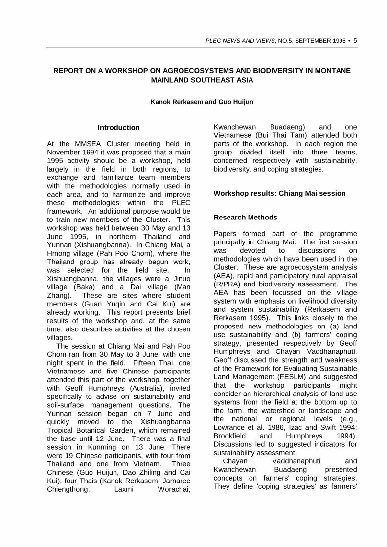
REPORT ON A WORKSHOP ON AGROECOSYSTEMS AND BIODIVERSITY IN MONTANEMAINLAND SOUTHEAST ASIA
Kanok Rerkasem and Guo Huijun
Introduction
At the MMSEA Cluster meeting held inNovember 1994 it was proposed that a main1995 activity should be a workshop, heldlargely in the field in both regions, toexchange and familiarize team memberswith the methodologies normally used ineach area, and to harmonize and improvethese methodologies within the PLECframework. An additional purpose would beto train new members of the Cluster. Thisworkshop was held between 30 May and 13June 1995, in northern Thailand andYunnan (Xishuangbanna). In Chiang Mai, aHmong village (Pah Poo Chom), where theThailand group has already begun work,was selected for the field site. InXishuangbanna, the villages were a Jinuovillage (Baka) and a Dai village (ManZhang). These are sites where studentmembers (Guan Yuqin and Cai Kui) arealready working. This report presents briefresults of the workshop and, at the sametime, also describes activities at the chosenvillages.
The session at Chiang Mai and Pah PooChom ran from 30 May to 3 June, with onenight spent in the field. Fifteen Thai, oneVietnamese and five Chinese participantsattended this part of the workshop, togetherwith Geoff Humphreys (Australia), invitedspecifically to advise on sustainability andsoil-surface management questions. TheYunnan session began on 7 June andquickly moved to the XishuangbannaTropical Botanical Garden, which remainedthe base until 12 June. There was a finalsession in Kunming on 13 June. Therewere 19 Chinese participants, with four fromThailand and one from Vietnam. ThreeChinese (Guo Huijun, Dao Zhiling and CaiKui), four Thais (Kanok Rerkasem, JamareeChiengthong, Laxmi Worachai,
Kwanchewan Buadaeng) and oneVietnamese (Bui Thai Tam) attended bothparts of the workshop. In each region thegroup divided itself into three teams,concerned respectively with sustainability,biodiversity, and coping strategies.
Workshop results: Chiang Mai session
Research Methods
Papers formed part of the programmeprincipally in Chiang Mai. The first sessionwas devoted to discussions onmethodologies which have been used in theCluster. These are agroecosystem analysis(AEA), rapid and participatory rural appraisal(R/PRA) and biodiversity assessment. TheAEA has been focussed on the villagesystem with emphasis on livelihood diversityand system sustainability (Rerkasem andRerkasem 1995). This links closely to theproposed new methodologies on (a) landuse sustainability and (b) farmers' copingstrategy, presented respectively by GeoffHumphreys and Chayan Vaddhanaphuti.Geoff discussed the strength and weaknessof the Framework for Evaluating SustainableLand Management (FESLM) and suggestedthat the workshop participants mightconsider an hierarchical analysis of land-usesystems from the field at the bottom up tothe farm, the watershed or landscape andthe national or regional levels (e.g.,Lowrance et al. 1986, Izac and Swift 1994;Brookfield and Humphreys 1994).Discussions led to suggested indicators forsustainability assessment.
Chayan Vaddhanaphuti andKwanchewan Buadaeng presentedconcepts on farmers' coping strategies.They define 'coping strategies' as farmers'

6 • PLEC NEWS AND VIEWS, NO.5, SEPTEMBER 1995
ability to deal with or manage the changes.It is the ability that is created or re-createdby a group of farmers in responding to thechanging environment and socio-economicconditions in order to sustain their living andsocial relations. (Vaddanaphuti andBuadaeng 1995). A number of copingstrategies have been proposed such asdiversification, regeneration technology,labour exchange or common landmanagement. A model of farmers' copingstrategy has been suggested for fieldtesting. On assessment of biodiversity, GuoHuijun and Chusie Trisonthi proposed aformat for rapid field assessment whichsuggested ways to combine rapid appraisalwith transect survey and on-site communityplot investigation. Dao Zhiling alsoproposed an ethnotaxonomic approach forbiodiversity assessment.1 After the papersessions and a briefing, the workshopmoved into the field.
Pah Poo Chom (Hmong village)
The major changes in Pah Poo Chom maybe listed as follows:• 1959: Hmong people resettled in a
forest area near the Department ofPublic Welfare (DPW) headquarters.Wage income from tea picking in anearby plantation.
• 1960: Moved close to the present PahPoo Chom site but settled on the peakof the mountain. Adopted extensiveshifting cultivation and opium growing.
• 1962: Relocated at lower Pa Sang site.• 1972: Paddy and irrigation development
with assistance from the DPW.• 1980: Commencement of large
Development project (World Bank
1 A paper derived from these presentations willappear in PLEC News and Views No. 6 in March1996. So far, little study has been attempted andresearch has been carried out on a fairly limitedarea (e.g., Guodong 1992 and Xu Zaifu andHongmao 1994).
support). Opium reduction andintroduction of alternative cash crops,e.g. Lychee.
• 1983-4: Moved to the present site in asmall valley. Stopped opium cultivation.
• 1985-present: Introduction of cabbageand successful expansion of productionon a commercial scale.
The land-use group concluded that soilerosion does not appear to be a problem atthe local scale, though it has been observedin some patches, especially on steepslopes. Lower fields seem to benefit fromdeposition. Chemicals are increasing, P andK fertilizers and herbicide in particular.Mechanisation is also increasing and use of4-wheel tractors for ploughing is notuncommon. Crop intensification is rapidlytaking the form of simple structure of mixedcropping of lychee as a canopy crop, withvegetables or traditional crops grownunderneath, but the sustainability of this isuncertain. There seems to have been someeconomic advantage of lychee growing, i.e.,early harvests (April- mid May) and hencegood price even if the quality is relativelylow, juicy and sour. However, there are alsoagronomic problems with lychee, not yetfully understood. On a larger scale,increasing demand for irrigation water maylead to negative impacts on the watershedas a whole.2
On biodiversity, a transect survey showsthat in the forest, the tree coverage is ratherpoor, estimated at <20 percent.Understorey growth is also very poor. Only26 species can be counted. There is a needto know about forest management in thepast. Who used the land and how? What
2 There is a need for mapping of land use andmonitoring land use changes. Existing mapse.g., road construction mapping, forest mappingetc. have yet to be found. If aerial photographstaken during the World Bank project in 1980 canbe discovered, it may be worthwhile to find outthe possibility of taking aerial photos of thepresent land use, in cooperation/coordination withthe RFD and the Air Force.
PLEC NEWS AND VIEWS, NO.5, SEPTEMBER 1995 • 7
were the purposes? In the orchard, 24species (crops, weeds and wild plants) werecounted. Mimosa invasa is abundant. Inthe swidden fields, sample plots of 10 m x10 m were marked in a 20-year fallow.These plots contain 11-13 species of treesand about 24 species of understorey plants.There is a need to establish the changes inbiodiversity. Comparative approaches mightbe used, e.g., sampling biodiversity fromnatural forests (with scattered rock) or lessdisturbed habitats.
The Coping Strategy group has beenable to identify potentials and limitations ofthe local people in terms of value systems,indigenous knowledge, resources, localcommunity networking and/or organisationand external support. The Hmong havebeen conventionally labelled as 'pioneer'shifting cultivators but now can managesedentary systems with prospects ofsustainability. The Pah Poo Chom casemay offer the opportunity to find out thesocial learning and interactive processeswhich enable them to practise permanentcropping or forest protection and watershedconservation. A number of specific researchquestions on indigenous knowledge ofbiodiversity, the design and management ofthe permanent agroecosystems and localland tenure have been raised.
Workshop results: Yunnan session
Discussions in Kunming
As a number of Chinese participants had notattended the Chiang Mai part, briefpresentations and discussions on fieldmethods were repeated on the first day. Inthis session, the Chinese participants camefrom a wide range of institutes in Yunnanand Xishuangbanna, suggesting possibilitiesfor widening the interdisciplinary team.Official participants provided invaluablebackground information on the land use andforest policies. From the immediate point ofview of the workshop, the most significant
information was on the relatively new forestland-use policy or Liangshan Yidi. This isbased on stabilisation of forest rights,delineation of private mountain land, anddelineation of contract mountain land. Eachfamily may own 2-5 mu of private mountainland, which cannot be leased or sold.Liangshan Yidi is intended to increaseaccess to natural forests, through contractor private tenure.
Baka (Jinuo village)
In Baka, some of the major events andchanges were as follows:• Before Liberation in 1950: traditional
shifting cultivation with communalarrangements.
• 1953-64: Individual land ownership andexchange labour systems.
• 1964: Commune system; productionplan enforced, communal landownership.
• 1965: Production teams formed, withown work plans.
• 1972: Moved from natural reserve tothe present village site; paddydevelopment and irrigation supported bygovernment.
• 1983: Land allocation for individualhouseholds (use-right).
The people of Baka were from a remotearea on the mountain, and resettled in twodifferent sites (including the study village).However, not all the people from the originalsite moved. Some 30-40 households stayedand have grown up to 45 households.About 50 households moved out to the newsites. The study village has now grown upto 53 households and is located near a mainroad. Government support for paddydevelopment appears to be one of the majorincentives for relocation of the Jinuo inBaka. Traditional shifting cultivationprovided inadequate rice for householdconsumption. Moreover, wet rice productionwas intensified by the adoption of high
8 • PLEC NEWS AND VIEWS, NO.5, SEPTEMBER 1995
yielding hybrid rice, but when governmentprice support for the hybrid seeds wasremoved, poor households could not affordto buy them. The villagers are currentlybuying rice from other villages. Land usehas changed rapidly towards short fallowperiods, and to permanent agriculture.Recent commercialisation has led to rubbermonoculture on the hillslopes, where it israpidly replacing traditional crops in shiftingcultivation fields. Woodlots have beenestablished for household use, i.e., fuelwoodand timber. Non-timber forest products arenow sold to outside markets. Baka peoplehave been able to negotiate with theforesters to use natural reserve land for theproduction of Chinese Cardamom (Amomumvillosum) for cash income.3
New cash crops have been introduced,e.g., passion fruit, which is expandingrapidly, but depends on a single fruit factoryin the nearby town. Success in cropdiversification depends on the ability of thelocal people to identify an appropriateecological 'niche' for specific crops, i.e.,rubber on the uplands, passion fruit at lowerelevation in the shade close to water supplyand near the village, and ChineseCardamom grown under forest. Thedynamics of land-use change in Baka will bea major investigation task. Baka farmers donot apply any chemical fertilizers on theupland fields. Preliminary assessment ofsoil fertility ranges from very poor (lateritesoils) to moderate. Soil depth varies greatly.The distribution of soil types is highly diversein patches and local people understand thevariation very well.4
Local technical knowledge has
3 The evaluation of Chinese Cardamom underagroforestry systems in this village has beendescribed by Guan et.al. 1995.4 Chromolaena odorata is abundant everwherewhen management pressures are released. Therole of Chromolaena odorata in swiddensuccession may help to build up soil fertilityduring the fallow periods. However, if land useintensification increases, its ecological functionmay be disrupted.
contributed to the design of the newsystems but the processes of systemreconstruction have yet to be investigated.There are a number of unsustainability risksassociated with the land-use changes (e.g.economic risks in passion fruit production orgovernment price support in rubber, lossesof biological diversity in monoculture ofrubber plantation, and genetic erosion intraditional food crops). The trade offbetween intensification of land for higherproductivity and land use sustainability willhave to be investigated. The traditional landmanagement of the local people is largelyunknown and should be explored further.This study may have to be extended tocover the original sites where the oldergenerations could provide the informationfrom their past experiences.
Man Zhang (Dai village)
Man Zhang in Dai literally means elephantvillage (or Ban Chang in Thai). The villagehas been settled recently, in 1963 when afew households from a nearby Dai village(Man'e) decided to move to the uplands toopen up new land for living. The villagepopulation has now grown to 22households. Livelihood activities have nowexpanded to cover rice production frompaddy, water melon and vegetables asmajor cash crops after wet season rice, andtraditional food crops from shifting cultivationfields, e.g., upland rice, maize, cotton,peanuts and beans. Rubber plantation isalso expanding. The local people keeplarge numbers of livestock, i.e., buffaloes,cattle, pigs and chickens, but they arecurrently using walking tractors to plough thepaddy fields. Young members of the familyalso go to work for the service sector intown.
The village is located near the buffer zoneof a natural reserve, and government hastaken their cardamom in the forests.Therefore, cardamom production is on avery limited scale with no opportunity forfuture expansion. The Dai in Man Zhang

PLEC NEWS AND VIEWS, NO.5, SEPTEMBER 1995 • 9
appear to have better external contact andnetworks than some other villages. Forexample, the labour exchange system forrice production is organized betweenvillages. As production has moved towardscommercialisation, wage labour systems areadopted for production of cash crops in thedry season or in rubber plantations.Farmers in Man Zhang make heavy use ofchemical fertilizers, without which watermelon would not give fruit of reasonable sizefor the external markets. Paddy land wasofficially claimed to cover a total area ofabout 32 mu (1 ha = 15 mu) but the areaobserved during the field walk is muchlarger. A village land-use survey is plannedin the near future.
Intensification in the use of paddy land isprominent. It relates to the high rate ofhybrid rice adoption and multiple cropping,with rice as the main season crop andwatermelon or vegetables for the dryseason. The proportion of hybrid rice iscurrently over 80% of the total planted area.Farmers are facing water constraints in thedry season. Moreover, fertilizer subsidieshave been reduced. Some farmers havealready introduced chilli to replace watermelon, because less water and fertilizer arerequired. Further development of surfaceirrigation water is possible but the potentialimpact on downstream villages has to berecognized. As at Baka, the area of rubberexpands rapidly and competes with shiftingcultivation fields. Another significant factorin intensification is good access toinformation. Unlike the Jinuo group (Baka),not officially recognized before the 1970s,the Dai of Man Zhang enjoy access togovernment support and extension services.
More details are needed to elaborate thehistorical changes in Man Zhang. As forestshave been declared natural reserve, theextent to which villagers still depend onforest products has yet to be known. On thewhole, villagers say that their livelihoodshave improved greatly for the past 15 years.Attempts to evaluate land use sustainabilityin Man Zhang have to await understandingof historical changes and 'big events' which
have happened. More intensive interviewand survey or mapping of the village arerequired. Land tenure, allocation andarrangement have to be better understood.For example, inability to use the buffer zoneseems in contrast to the Liangshan Yidi andunexpected.
Future plans
All papers and most diagrams presented atthe meeting will be published, in Chiang Mai,together with a more complete version ofthis report. It was agreed that the commonmethodological focus should be on threemain areas. The first of these is land usesustainability. It will involve study ofhistorical land-use systems and changes,paying attention to the major events in themodern histories of both regions. This willlead on to studies of productivity, and ofparticular stresses identified in thepreliminary phase. The second focus will beon biological diversity assessment indifferent land-use types, including the use ofbiodiversity, and social aspects ofmanagement in the wild. There will also beemphasis on indigenous knowledge ofbiodiversity, and its role. The third focus willbe on farmers' coping strategies withemphasis on changes in land management,especially the transition from swiddening topermanent farming. The future of the casheconomy is embraced within this focus, asalso is social inquiry in the villages, and onindigenous practices and knowledge. In allthree focus areas lessons will be drawn fromcases both of apparent success, andapparent failure.
References
Brookfield, H. and Humphreys, G.1994 Evaluating sustainable land
management: are we on the right track?Proceedings of the 15th InternationalCongress of Soil Science. Acapulco,Mexico.
Dao Guodong.1992 Some historical culture of Dai. Beijing:
Ethnic Press.

10 • PLEC NEWS AND VIEWS, NO.5, SEPTEMBER 1995
Guan Yuqin, Dao Zhiling and Cui Jingyun1995 Evaluation of the cultivation of
Amomum villosum under tropicalforests in Southern Yunnan, China.PLEC News and Views 4: 22-28.
Izac, A-M N. and Swift, M.J.1994 On agricultural sustainability and its
measurement in small-scale farmingin sub-Saharan Africa. EcologicalEconomics 11: 105-125.
Lowrance, R. Hendrix, P.F. and Odum, E.P.1986 A hierarchical approach to
sustainable agriculture. AmericanJournal of Alternative Agriculture 1:169-173.
Rerkasem, K. and Rerkasem, B.1995 Montane mainland Southeast Asia:
agroecosystems in transition.Global Environmental Change (inpress).
Vaddhanaphuti, C. and Buadaeng, K.1995 Farmers' coping strategies. Paper
prepared for the MMSEA/PLECField Workshop on Agroecosystemsand Biodiversity in MontaneMainland Southeast Asia. 31 May1995. Chiang Mai.
Xu Zaifu and Liu Hongmao.1994 Approach on the relationship
between indigenous botanicalknowledge of Dai and ruralsustainable development inXishuangbanna, Yunnan, China.Xishuangbanna Tropical BotanicalGarden, Chinese Academy ofSciences.

PLEC NEWS AND VIEWS, NO.5, SEPTEMBER 1995 • 11
PAPER FROM THE SCIENTIFIC COORDINATOR
THE METHODOLOGY OF PLEC(Adapted from a note written in June 1995)
Harold Brookfield
PLEC is an 'integrated core project', bringingtogether the guided work of six 'Clusters' ofscientists for common aims in targeted,action-oriented research on themanagement of biodiversity and the land.By thus combining sub-projects distributedacross the tropics and sub-tropics, the workof each is given greater global significance,and the whole networked product will begreater than the sum of the parts. The basiccapacity building task is to equip developingcountry professionals and practitioners withthe tools they need to deal with anincreasingly complex mandate. Thismandate now involves national economicdevelopment, livelihoods of the poor anddisadvantaged, and environmentalprotection, as well as longer-termconservation and biodiversity issues. Thelatter issues, in the context of sustainablewelfare for small-farming populations, arethe principal area in which PLECmethodology is applied.
Use of the knowledge and experienceof participants
The six PLEC Clusters include three whichbrought substantial ongoing work into theProject (Southeast Asia, Papua NewGuinea, Amazonia), and three in which allPLEC work has been designed since theirformation, though there is substantialbackground in related work (West Africa,East Africa, the Caribbean). All containexperienced as well as more juniorscientists, and students. All Clusters aremultidisciplinary, with both natural and socialscientists working together. Disciplinesrepresented include anthropology, botanyand ethnobotany, soil science, agricultural
science, geography, resource economics,sociology, and others. Among the 75scientists involved in PLEC are several whohave a wide international reputation forexpertise in particular fields of relevance.One important objective of PLEC is to sharethis expertise and transfer the knowledge tothe younger workers and students. At thesame time, through PLEC News and Views,through meetings, and with the aid of theScientific Advisors, it is planned to introduceall participants to methods and approachesto research, monitoring and measuring thatare at the cutting edge of internationalresearch on small farmers, their agriculturalsystems, and their management of land andbiodiversity.
The question of scale
Management of biodiversity and the land inagricultural areas calls for ability to researchthe problems, monitor the situation, andanalyse problems and potential solutions ata range of scales. The regional orlandscape scale is appropriate both for initialreconnaissance and final generalization, butthis must be supplemented by more detailedanalysis at chosen sites. Establishment ofthe wider framework calls on a number ofmethods, including rapid rural appraisal,interpretation of satellite imagery and aerialphotographs, as well as the systematicdetermination of agricultural systemcharacteristics. More detailed work alsocalls on participatory rural appraisal and theuse of transects. It leads to thedetermination of particular sites for closerstudy, whether representative, or presentingcritical problems. Work at still finer scale,that of the small catchment, field or patch, is

12 • PLEC NEWS AND VIEWS, NO.5, SEPTEMBER 1995
required for measurement of biodiversity,soil fertility status and trends, erosion, andmanagement.
At the present formative stage of PLECcertain Clusters are already concentratingefforts on particular communities, whileothers are advocating prolonged use ofsurvey methods over 100 km2 areas. Whilethese contrasts to some degree reflectdifferences in landscape complexity andpopulation density, a priority task must be todevelop a common method of proceedingfrom landscape to community level, and inturn to specific measurement at patch, fieldor landscape unit level, and then ofassembling results so as to generalize atlandscape level. This applies equally tothose areas of relevance that are amenableto natural science approaches, and to thoserequiring social science approaches.
The problem of wider scale versus depthis common to all forms of work on landresource management. Academicscommonly use a recursive approach thattakes time. PLEC does not have this luxury,and must establish a set of replicablemethods quickly. One guiding principle hasto be the use of short-cut methods that willachieve reliable results without serious lossof scientific rigour. Two such have beenproposed or discussed in previous issues ofPLEC News and Views (Stocking, 1994,Elwell and Stocking, 1983; Zarin, 1995).Another is elaboration of the transectmethod used in agroecosystem research. Afourth is use of 'participatory environmentalmonitoring' in which particular indicators,selected both by observation and enquiry,are used to build up a reliable general viewof trends that can be used as it stands, orform the basis for more detailed inquiry into‘rural people's knowledge' (Leach andFairhead, 1994, pp. 89-93). In all theseareas, PLEC has to develop both thesuccessful combination of observation withinquiry that must form the core of areplicable methodology, and also test this bylonger-term on-the-spot inquiry in depth. Inthe present design, most of the latter workwill be done by students under supervision,
but more senior team members, in particularanthropologists and geographers, humanecologists and ethnobotanists, also have animportant role to play.
Multiple working hypotheses
One of PLEC's principal objectives is toprovide a rational assessment of the causesof trends in resource management andenvironmental change within the areaschosen to exemplify its method. Without anunderstanding of causes, no intervention islikely to be successful. In several areas,recent work has shown that prevailingconclusions about environmentaldegradation and its causes rest on incorrectassumptions, even about the speed anddirection of environmental change itself.Conclusions about the effect of humaninterference which disregard the sensitivityand resilience of the natural system are verylikely to miss the mark. 'Conclusions' thatgrowth of population density is the centraldeterminant of past, ongoing or threatenedfuture degradation, are often basedprincipally on assumption. Suchassumptions are thrown into question byseveral modern studies which havedemonstrated environmental enhancement,through improved management, undermarked increases of population density (e.g.Tiffen, Mortimore and Gichuki, 1994; Leachand Fairhead, 1994). If PLEC is tocontribute to improved policy formulation,knee-jerk generalizations of the former kindmust be avoided.
The approach being advocated to ourClusters is that of 'multiple workinghypotheses'. Given observation of a stateand its apparent trend, the first task is to testthe reality of that trend, first by use of thehistorical record of aerial photographs and,where available, written accounts by officialsand travellers, and then by participatoryenquiry among the people. Once a trend isestablished, whether or not it is the trendthat was initially supposed, the major taskthen becomes that of enumerating all

PLEC NEWS AND VIEWS, NO.5, SEPTEMBER 1995 • 13
possible causes as hypotheses, and testingthese. Hypothesized causes may includeexternal interference of several kinds,catastrophic climatic events, and widerchanges in land cover, as well as internaltrends in population, land tenure, incomeinequality, and management practice. Inmodern times, commercialization iseverywhere a major force. Although mainlyin a natural science context, an excellentand well-illustrated statement on 'multipleworking hypotheses' is provided by Cookeand Reeves (1976).
Rational paths by which each postulatedcause can impinge on the quality andsuccess of land management then need tobe set out. Each path must then beexplored, and elaborated as required. Inmany small-scale cases, the effect of oneexplanatory path may be overwhelminglyobvious, but on a regional level this may befar less clear. Commonly, in fact,contributions from multiple causes will all berecognized, though not in equal proportion.Where this happens, there is an importantconclusion for policy, in that intervention inone part only of the system is likely to beineffective. However, close inquiry may alsodemonstrate that farmers adapt to large andcomplex changes, and the most properintervention is to assist them in this processrather than impose external coercion.
Farmers' adaptations and use ofknowledge
Pilot work within and around PLEC, andwork in other areas, is demonstrating thatfarmers' knowledge and skills are not astatic inheritance from the past, but are inconstant change as new pressures emerge,and new sources of information areevaluated. Adaptive innovation in farming isas old as agriculture itself, and indeed isresponsible for the great variety of farmingsystems, and micro-level variation withinthem, that exists in the world. In regard tobiodiversity, most farmers not only possessan extensive knowledge of its range, but
they also manage it. Their indigenousefforts to do so are often at least as effectiveas are external science-based interventionse.g. Haverkort and Millar, 1994).
Faced with degradation and itsconsequences, farmers who are free to doso often experiment with ways in which tomanage its consequences, and reverse thetrend. Some fail, but others enjoy ameasure of success (e.g. Amanor, 1994).One of PLEC's most basic workinghypotheses is that farmers' adaptations andthe knowledge on which they are basedcould be successful, if societal conditionspermit and assist. The study of, and searchfor, farmers' adaptations and innovations isthus central to PLEC methodology, andinquiry into the knowledge on which theseare based, and its sources, is thus a majortask. Equally, as a policy-oriented objective,it is important to identify those societalconditions that permit and assist successfuladaptations. PLEC hopes to give farmers'knowledge and practices an equal placewith the findings of external science in thesearch for sustainability with conservation.However, recognition of a problem byfarmers may well be a necessary conditionfor innovation. If outsiders see a problem,but farmers do not, it does not necessarilymean that the farmers are wrong.Moreover, they may see quite differentresource problems from those identified byoutsiders. In a few fortunate cases, thesolution to both farmers' and outsiders'problems may coincide, but this is not allthat common. Successful interventiondemands that the farmers' problems bethoroughly understood. (See also Amanor,this issue.)
Working with farmers
Certain of our Clusters are working veryclosely with farmers' groups, to the extentthat farmers are already full participants inan agenda that is designed with theircollaboration. Others do not yet have thisclose relationship, and for still others the
14 • PLEC NEWS AND VIEWS, NO.5, SEPTEMBER 1995
necessary farmers' groups and communitygroups do not exist as bodies with whichthey can work. Their main target areas,therefore, have to be the extension servicesand local leadership, rather than the farmersthemselves. To all, the linkage betweenfarmers, the local leadership, and theextension services are of major importancein policy guidance. Closely exploring theseconnexions, PLEC can provide concreteinputs to project design for ruraldevelopment.
For some Clusters, an important part ofthe plan of work includes experiment, onfarmers' land, with crops and methodsidentified as most promising from among thefarmers' own stock. In only four years, weshall not be able to equalize this inequalitybetween the Clusters, but it is none the lesspossible to reduce it. Strong support istherefore given to experimental initiatives.
While these activities have obviousnational benefits, there is also a majorglobal benefit in demonstrating that closeparticipation with farmers whose ownproblems, methods and adaptations are thetopic of interest, is a feasible strategy.Experimentation in collaboration withfarmers is also a feasible internationalstrategy both for conservation andsustainable development. Indeed, sincemost of the global conservation problem liesin agricultural and pastoral areas, a strategyof collaboration with farmers is by far themost promising for world-wide use.Development and demonstration of thisstrategy is therefore central to our method.
Science and policy formation
Scientists are well aware of the importanceof 'multiple working hypotheses' but a lot ofapplied science makes scant use of them.A culture hostile to spending on basicresearch often prefers to assume that theanswers are all known, and that all that isneeded is to find ways of getting themadopted. Modern work on small farmingshould already have shown the importance
of farmers' own methods and adaptations,but findings are slow to seep through toplaces where they most matter.Unfortunately, many scientific institutions indeveloping countries tend to be behind thecutting edge of thinking in many areas.They lack contacts, good libraries, and aconstant flow of information. One of PLEC'smajor tasks is to remedy this situation inCluster areas, and thereby encouragetesting of alternative hypotheses whichchallenge prevailing wisdom. PLEC needs,through networking, to support andencourage the excellent intellects that areavailable among and around ourmembership. Major benefits to the donoragencies in terms of project design will flowfrom such empowerment of our Clusters, inmaking a strong future contribution toconservation with development.
References cited
Amanor, K.S.1994 The New Frontier: Farmers' Response
to Land Degradation, A West AfricanStudy. Zed Books, London.
Cooke, R.U. and Reeves, R.W.1976 Arroyos and Environmental Change
in the American South-West.Clarendon Press, Oxford.
Elwell, H.A. and Stocking, M.A.1983 Developing a simple yet practical
method of soil loss estimation.Tropical Agriculture 59: 43-48.
Haverkort, B. and Millar, D.1994 Constructing diversity: the active
role of rural people in maintainingand enhancing biodiversity.Etnoecológica 11 (3): 51-64.
Leach, M. and Fairhead, J.1994 The Forest Islands of Kissidougou:
Social Dynamics of EnvironmentalChange in West Africa's Forest-Savanna Mosaic. IDS, Brighton,U.K. Report to ESCOR of the ODA.
Stocking, M.A.1994 Assessing erosion quickly and
(hopefully) cleanly. PLEC News andViews 3: 17-21.

PLEC NEWS AND VIEWS, NO.5, SEPTEMBER 1995 • 15
Tiffen, M., Mortimore, M. and Gichuki, F.1994 More People, Less Erosion:
Environmental Recovery in Kenya.John Wiley, Chichester, U.K.
Zarin, D. J.1995 Diversity measurement for the PLEC
Clusters. PLEC News and Views 4:11-21.
ANNOUNCEMENT
MONTANE MAINLAND SOUTHEAST ASIA IN TRANSITIONA Regional Symposium in Chiang Mai, Thailand November 12-16,1995
This international symposium has grown out of a suggestion that a group of researchers atChiang Mai University might get together with colleagues from Vietnam and the YunnanProvince of China to share experiences about a common concern on sustainable uplandresource use. Interest was shown by government, NG0s, and academic researchers andpractitioners who share a common focus on environment and development issues in theupland areas of Thailand, Yunnan Province of China, Laos, Myanmar, Vietnam and Cambodia.In consequence, this intended informal gathering has now become a collaboratively organizedsymposium with an expected international attendance of about 120.
UNU and PLEC are two of the many groups which have provided support, intellectually, inthe form of programming and papers, and financially for travel cost of participants, as well asassisting the publication of proceedings and the MMSEA-Agenda, a brief booklet to provide anoutline of the region, its development trends, opportunities, and emerging problems andresearch and support needs. The agenda is expected to provide a guidance for a wide range offuture activities within the region. The programme so far contains 35 papers. Contributions tothe programme from PLEC include papers by Christine Padoch, Xu Zaifu, Guo Huijun andMichael Stocking, as well as by Chiang Mai members.
The symposium is being organized by the CMLI-consortium, a collection of research groupswithin Chiang Mai University, in collaboration with a number of national institutions, namely, theChinese Academy of Science/Kunming, Institute of Rural Economy of Yunnan Academy ofSocial Sciences and the Vietnam Upland Management Working Group, Thailand DevelopmentResearch Institute and CARE International - Thailand. International institutions include FordFoundation, East West Center, World Resources Institute, United Nations University,International Institute on Environment and Development, Southeast Asian UniversitiesAgroecosystems Network, Centre for International Forestry Research, International Centre forResearch in Agroforestry, SAMUTE.
Further information from Dr Benjavan Rerkasem, Agricultural Systems Programme, Facultyof Agriculture, Chiang Mai University, Chiang Mai 50002, Thailand.
Fax: +66 53 210 000. E-mail [email protected]

16 • PLEC NEWS AND VIEWS, NO.5, SEPTEMBER 1995
PAPERS BY PROJECT MEMBERS
AGRICULTURAL SYSTEMS IN PAPUA NEW GUINEA PROJECT: APPROACHES ANDMETHODS
Bryant J. Allen, R. Michael Bourke and Robin L. HideThe Australian National University, Canberra, Australia
Introduction
This paper presents the approach andmethod of the Papua New GuineaAgricultural Systems Project, run from withinour department with national collaborators.The project is producing information onsmall holder (subsistence) agriculture atprovincial and national levels. Information iscollected by field observation, interviewswith villagers and reference to publishedand unpublished documents. Theinformation is entered into a computerdatabase (dBase IV), from where it can betransferred to a mapping program(ARC/INFO). From ARC/INFO, maps anddata are transferred to the PC basedmapping software MapInfo, in the form of aGIS for PNG users. The scale of fieldmapping is 1:500,000.
Project objectives are both applied andtheoretical. Information generated will beapplied to practical problems such as theestimation of the contribution of staple foodcrops to the national gross domestic productand the description of agro-ecological zonesin order to better allocate scarce nationalresearch resources. Agricultural systemswill also be assessed vis-à-vis their physicalenvironments in order to estimate theirstability and sustainability, in the face ofrapidly increasing demographic and socio-economic demands. Sustainability implies asuccessful and on-going adaptation tochanged environmental and socio-economiconditions.
Sustainability also implies a system has thecapacity to withstand short termenvironmental, demographic or socialshocks such as droughts, periods ofunusually high rainfall, labour migration orepidemics. The information beingassembled will be especially important inany assessment of the impact of a potentialepidemic of HIV/AIDS in PNG.
At a theoretical level, the Project isinvestigating the evolution of agriculturalsystems from low intensity systems to highintensity systems. It is hypothesized thatintensification occurs in response to ademand for increased production whichoriginates primarily from increasing socialand economic differentiation, andsecondarily from population increase. Asproduction increases and land is used moreintensively, environmental changes occurthat necessitate changes in agriculturaltechnology. These may demand morelabour per hectare than previous lessintensive techniques, or may bring aboutchanges in the relations of production and ingendered labour patterns. Increasedinvolvement in urban fresh food markets andincreased demand for consumer goods isthe modern counterpart of pre-colonialinvolvement in competitive exchanges offood and in trade networks.
Essential elements in the assessment ofthe sustainability of contemporaryagricultural systems are an understanding ofhow intensification takes place, how presentsystems are adapted to their environments,

PLEC NEWS AND VIEWS, NO.5, SEPTEMBER 1995 • 17
the numbers of people they are supporting,and an estimate of how long they have beenfunctioning. Ideally, research intoagricultural systems should be longitudinaland take place over periods long enough tomonitor changes as they occur. In reality,funding for long term research is extremelydifficult to find and few institutions areprepared to commit themselves to programsof a sufficient length. An alternative is across-sectional study, supplemented byhistorical air photography, archa-eological and palynological investigations,documents, and oral accounts of change.
The Papua New Guinea ResourceInformation System (PNGRIS)
Data from the Agricultural Systems projectare designed to be integrated with data heldwithin the Papua New Guinea ResourceInformation System (PNGRIS). PNGRIS isa PC-based database and GIS (FoxPro andMapInfo) which contains information on thenatural resources of PNG (Bellamy 1986).However PNGRIS contains no informationon agricultural practices, other than anassessment of land-use intensity based onair photograph interpretation by Saunders(1993), and a program concerned withpredicted crop performance. For this reasonthe Agricultural Systems database containsalmost no information on the environmentalsettings of the systems, except for altitudeand slope. The layout of text descriptions,the database code files and the village listsare modelled on PNGRIS, because users inPNG are already familiar with informationpresented in this format.
The mapping of agricultural systems hasbeen carried out on the same map base andscale as PNGRIS (the World TacticalPilotage Chart, 1:500,000), and mappingwithin the areas of agricultural land useestablished by Saunders (1993) from aerialphotography. Except where specificallynoted, agricultural systems boundaries havebeen mapped without reference to PNGRISResource Mapping Unit (RMU) boundaries.
Agricultural systems are defined at the levelof the Province (following PNGRIS) but theirwider distribution is recognized in thedatabase by cross-referencing systemswhich cross provincial borders.
The PNGRIS database, the AgriculturalSystems database, and GISs have beenlinked to enable movement from one to theother. From selected RMUs, it is possible toaccess information on the agriculturalsystem which occur within those RMUs, andfrom selected agricultural systems it ispossible to access information on physicalenvironmental measures, such as soils orrainfall, in the RMUs which occur in thoseagricultural systems.
Identification of agricultural systems andsubsystems
An agricultural system is identified when aset of similar agricultural crops andagronomic practices occur within a definedarea. Six criteria are used to distinguish onesystem from another:
1. Fallow type (the vegetation which iscleared from a garden site beforecultivation).
2. Fallow period (the length of time agarden site is left agriculturally unusedbetween cultivations).
3. Cultivation intensity (the number ofconsecutive crops planted beforefallow).
4. The staple, or most important, crops.5. Soil fertility maintenance techniques
(other than natural regrowth fallows).6. Garden and crop segregation (the
extent to which crops are planted inseparate gardens; in separate areaswithin a garden; or are plantedsequentially).
Where one or more of these factorsdiffers significantly and the differences canbe mapped, then a separate system isdistinguished. The measures of significance

18 • PLEC NEWS AND VIEWS, NO.5, SEPTEMBER 1995
differ between factors, but are carefullydefined and documented. Nevertheless, thedefining of systems is not an entirelyobjective or mechanistic process. It isundertaken by discussion and debatebetween three very experienced principalresearchers, and is based on fieldobservations; interviews with farmers; andthe spatial distributions of all the factors. Itis certainly not undertaken by acomputerized classification program. Thereasons behind the definition of eachsystem are documented and included as atext field in the database.
A subsystem is identified where variationoccurs, but is not able to be mapped at1:500,000 scale because the areas in whichthe variation occurs are too small or arewidely dispersed within the larger system.Subsystems within an agricultural systemare allocated a separate record in thedatabase.
Methods
Prior to fieldwork, existing published andunpublished literature is reviewed and basemaps of agriculturally used land areprepared (see below). Field traverses areplanned with topographic and populationdistribution maps, so that all majorconcentrations of rural populations arevisited. Along these traverses currentgardens and fallows are inspected andfarmers are interviewed in their gardens, toobtain information on features that cannot bedirectly observed. The most difficultinformation to collect is that relating to fallowand cropping periods. Farmers are helpedto estimate the length of the fallow period oftheir present gardens based on the presentage of the previous user, if still alive, or theages of children now living when the sitewas previously cultivated. Importanthistorical events are also used to estimatefallow lengths.
Information is collected systematically on44 variables, the most significant of whichare described below. Both notebooks and a
pre-prepared field-form are used to captureinformation. Probable or possibleboundaries of agricultural systems arelocated on the base map and ontopographic maps at a scale of 1:100,000.Photographs are taken to document theoutstanding characteristics of each system.Approximately six person-weeks arescheduled for fieldwork in each Province.
Following fieldwork, the large number offield-forms are examined against thetentative system boundaries created in thefield. At this stage considerable discussiontakes place over whether or not agriculture insome areas is similar enough to that inother areas for both areas to be included ina larger system, or dissimilar enough for aseparate system to be created. The fieldphotographs and the literature are usedextensively during this process. Finalizedsystem boundaries are added to thedigitized base map, and data entrycompleted for all systems. Text descriptionsof the systems and notes of outstandingfeatures are included in the data entry.
At the completion of a provincial survey,the database is published as a WorkingPaper. The Working Paper presents thedata in basic English text and as numericcodes. Also presented are listings ofvillages by census codes, alphabetically andby Agricultural Systems identificationnumbers. Some additional information isincluded from the National Nutrition Surveyof 1982/83. The families included in thesurvey were asked about foods they hadeaten during the previous day.
The Agricultural Systems Database
Information on agricultural systems is storedin the database, one record per agriculturalsystem (or subsystem where identified) and109 fields per record. A number of fieldsidentify the agricultural system and itslocation, using National Population Censuscodes and a Papua New Guinea-wide fourdigit number. Districts and CensusDivisions are also included. The lowest
PLEC NEWS AND VIEWS, NO.5, SEPTEMBER 1995 • 19
and highest altitudinal extent of the systemis recorded, as is the slope of gardens inthe system (in four classes from flat to verysteep).
A description of the quality of theinformation is given, including details onareas visited, the length of time spent indifferent areas, traverses undertaken, themode of transport used, the month and yearof the survey.
The database also includes the areaoccupied by each System, in squarekilometres (the figure is calculated by themapping program ARC/INFO).
Crop components
The most important staple food crops grownin the system are recorded. A dominantstaple is defined as a crop estimated tocover one-third or more of the staple gardenarea, and therefore no more than 3dominant staples may be identified for asystem. An important exception occurswhen sago is the staple. Sago is extractedfrom palms which are not cultivated ingardens. A subdominant staple is definedas a crop estimated to cover more than 10percent of a staple garden area; up to sixcrops may be listed.
Staple crops are mostly root cropsincluding various species of taro (Colocasiaesculenta and others), sweet potato(Ipomoea batatas), yam (Dioscorea spp.,),'Chinese' taro (Xanthosoma sagittifolium),cassava (Manihot esculenta), and potato(Solanum tuberosum). Other staple cropsinclude banana (Musa cvs), sago(Metroxylon sagu), breadfruit (Artocarpusaltilis) and coconut (Cocos nucifera).
Up to 10 important vegetable crops arerecorded. These are mainly greens, inparticular Abelmoschus manihot,Amaranthus spp., Rungia klossii, Gnetumgnemon, Oenanthe javanica and chokoleaves (Sechium edule). Also grown arewinged bean (Psophocarpustetragonolobus) and the common bean(Phaseolus vulgaris); grasses (Setaria
palmifolia and Saccharum edule); corn (Zeamays); pumpkin (Cucurbita moschata); andpeanuts (Arachis hypogaea).
Up to eight important fruits are recorded.These include sugarcane (Saccharumofficinarum); the oil-bearing pandanus(Pandanus conoideus); and a number oftree species. Important nuts and narcoticsare listed, including two nut pandanusspecies (P. julianettii and P. brosimos), betel(Areca spp.) and tobacco (Nicotianatabacum).
Many of the important food crops havebeen introduced from the Americas, mostwithin the last 100 years. Although sweetpotato was introduced at least 250 yearsago and perhaps earlier, the importantvarieties now are more recent introductions.
Arrangement and sequencing of crops intime and space
Observations are made on the arrangementof crops within and between gardens, onwhen they are planted during the year, andon particular repetitive sequences ofplanting of crops. The seasonality of maincrops and other crops are measures ofwhether the dominant staple crops, thesubdominant staples, and other crops andvegetables are planted at about the sametime each year. Garden segregation andcrop segregation refer to whetherindividual staple food crops are planted indifferent gardens, or in different parts of thesame garden. A garden is defined as acontiguous area of land planted with cropsunder the management of a social unit suchas a family or a household. Cropsequences occur when the harvesting ofone crop species is regularly followed by theplanting of another, eg. yams followed bysweet potato, or sweet potato followed bypeanuts followed by sweet potato. If cropsequences occur repetitively, and one of thecrops is leguminous, they are also classedas legume rotations. Another garden typeis the household garden which is typicallysmall relative to the main gardens and islocated near houses, and contains a variety

20 • PLEC NEWS AND VIEWS, NO.5, SEPTEMBER 1995
of crops. Household gardens are also knownas door-yard or kitchen gardens.
Fallow clearing practices
The most common method of clearing fallowvegetation is burning. This measureincludes the burning of material which hasbeen heaped, and the frequency of burningrelative to the cropping intensity. Burning isconsidered to be 'very significant' if themajority of the fallow material cleared fromthe site is burnt at the initial clearing of agarden, and only one or two plantings aremade before fallowing. If a large number ofplantings are made before the next longfallow, with little or no burning betweenplantings, burning is considered to be of‘minor' importance.
There are a number of areas in PapuaNew Guinea where felled fallow vegetationis not burnt. In some areas, crops areplanted beneath standing vegetation, andthe fallow vegetation is later cut downonto the growing crops. Variations on thispractice are: to fell all the vegetation and toplant through the uncleared debris into thesoil beneath; to place the felled vegetationinto heaps on specially constructed hurdlesthat are later used for the planting ofparticular nutrient demanding crops; or toplant crops beneath the canopy, and togradually expose the crops to increasingsunlight as they mature by progressiveclearing of trees. These practices areassociated with high rainfall areas.
Soil fertility maintenance techniques
The presence and significance of a numberof agronomic techniques to assist in themaintenance of soil fertility, other than theuse of a long fallow, are recorded. Theyinclude: legume rotations, usually peanutsor winged bean, between plantings of mainfood crops; the use of short fallows of lessthan 12 months between plantings; plantedtree fallows in which tree species (eg.Casuarina spp.) are planted into gardens or
fallows for the stated purpose of improvingsoil quality during subsequent cultivations -this measure excludes the relativelycommon practice of planting fruit treespecies into gardens and fallows, but doesnot exclude the planted trees being used fortimber or firewood; the use of compost,which is the placing of organic matter,usually dried weeds, sweet potato vines andgrasses, beneath the surface of the soil intowhich crops are planted; and the use ofmulch, which is the application of organicmaterial to the soil surface.
Mounds and beds
In addition to these techniques, the soil isformed into circular mounds or raised bedsof varying dimensions and crops are plantedon them, in many parts of Papua NewGuinea. Mounding is not to be confusedwith composting. Mounds may or may notcontain compost and composting may takeplace in the absence of mounds. Moundsare usually re-formed at each new planting.The following types of mounds are recorded:very small mounds up to 10 cm high;small mounds 10 to 40 cm high, mounds40-70 cm high and between 1m and 2.5m indiameter, and large mounds, more than 70cm high and 2.5m in diameter.
Two shapes of beds are distinguishable:square beds are constructed by diggingshallow ditches typically 2m to 4m apart ona grid layout, and throwing the soil removedonto the surface to form a bed. Theoutcome is a characteristic 'chequerboard' or'grid-iron' pattern in gardens. Long bedsare constructed by digging shallow ditchesdown slope, typically 2m to 4m metres apart,and over 10m in length, and throwing the soilremoved to the centre to form a bed.

PLEC NEWS AND VIEWS, NO.5, SEPTEMBER 1995 • 21
Other agronomic techniques
A number of other particular techniques areconsidered important and are recorded.Soil tillage is the breaking up, or turningover, of the whole or the major part of thesoil on the garden surface. The measureincludes tillage in either the first plantingand/or subsequent plantings. The placingof pigs in gardens between plantings ispractised for a number of reasons: to eatearthworms, to eat unharvested crops, or totill the soil. This measure excludes thedeliberate breaking of fences to allow pigs toforage after the cropping phase,immediately before a long fallow. Anassociated, but generally unimportanttechnique is the placing of animal manureon or in the soil. This excludes deposition ofmanure by the animals themselves, such astethered pigs, a technique mainly confined tohouse or kitchen gardens. The use ofmachines, hand tractors and motorizedtractors as a form of mechanical soil tillageoccurs in a very limited number of places.
Other activities
A number of other activities do not fall easilyinto any broad category. They relate toovercoming environmental constraints at asite; improving crop production; producingcrops of a culturally desired shape anddimension; and to the presence of wild pigsor management of large numbers ofdomestic pigs.
Drains are commonly used in and aroundgardens to remove surface water or to lowerthe ground water table.
Island beds are beds of soil on whichcrops are planted and which are raisedabove the level of a surrounding area ofstanding or slowly moving water.
Irrigation is used less commonly, mostlyin highly seasonal environments during along dry season.
Stakes are used, including trellises orstanding dead trees, to lift crops off the soilsurface. This practice is usually applied to
yams (Dioscorea spp.), beans andsugarcane, and sometimes gourds,cucumber and choko. Banana trees aresometimes tied to stout poles to preventthem failing under the weight of the fruit.
Deep holes are sometimes used in yamcultivation in order to grow exceptionallylong tubers for competitive exchanges.Deep (> 50 cm) holes are dug, the soil isbroken into a fine tilth and the hole re-filledbefore planting. This technique is usuallyrestricted to the cultivation of Dioscoreaalata.
Fences (linear barriers made of wood,bamboo, cane grass or stones, which mayincorporate a ditch or a bank) are used toexclude or control the movements of pigsand people. The measure excludes lowridges which form between fields whenstones are thrown to the perimeter duringcultivation. In the assessment of thesignificance of fences, the occurrence offences around every individual garden isgiven greater significance than one fencearound a large number of gardens.
Inorganic fertiliser records use in foodgardens and excludes the use on cashcrops, such as coffee or vegetables.
Fresh silt from flooding contributes tosoil fertility. It is assumed the flooding is ofnatural causes, but the measure does notexclude deliberate manipulation of streamchannels in order to enhance the delivery ofsilt, or for the partial control of flood waters.
Soil retention barriers (pegged logs,fences or hurdles, stone walls) aresometimes constructed along the contour orbelow individual plants on steep slopes, inorder to prevent or reduce the down slopemovement of soil, a measure which can beviewed as fertility maintenance.
Population data
The total population resident within thearea covered by the System at the time ofthe 1980 National Population Census isrecorded (the 1990 National PopulationCensus figures are not used because of

22 • PLEC NEWS AND VIEWS, NO.5, SEPTEMBER 1995
questions over their reliability, but the 1990National Population Census maps are usedto locate most Census Units). An estimateis made of the proportion of the populationabsent from villages in the system in 1978-79, expressed as a percentage of the totalpopulation.
The population density (persons persquare kilometre in 1980) is calculated fromthe area and total population figures.
There are two situations where adjustedfigures are given: in some systems sago isthe staple food and there is little or noagriculture; or subsistence is basedcompletely on non-agricultural activities (eg.fishing or trading) and no agricultural landuse can be identified. For these systemsthe area has been adjusted to include a 5kilometre buffer strip around the systemboundary, or centred on settlements whereno land use is identified. The 5 kilometrebuffer zone is assumed to be the area ofnon-agricultural land, usually forest, in whichwild plants and animals are exploited. In thelatter case, settlements are identified withpoint symbols.
The second kind of adjustment occurswhere the populations of two adjoiningsystems, both of which use both systems,are unequally distributed between the twosystem areas due to the locations of thecensus units.
Land use intensity
Measures of the intensity of land use arebased on two measures. The long fallowperiod is an estimate of the length of time(greater than 12 months) land is left to revertto regrowth, before it is cultivated again (infour classes: not significant, 1 to 4 years, 5to 15 years, and greater than 15 years).Cropping intensity is the number of timesstaple crops are planted in the main gardensbefore those gardens are returned to a longfallow (in six classes: 1 planting only, 2plantings, 3 to 5 plantings, 6 to 14 plantings,14 to 40 plantings, and more than 40plantings).
From these data an index of intensity ofland use is calculated, based onRuthenburg's R-value, the ratio of thecropping period in years to the length of thecultivation cycle in years. Cropping period isestimated from the number of plantings ofthe staple crops before a long fallow and thecultivation cycle is the sum of the croppingperiod and the long fallow period.
The predominant type of fallowvegetation cleared from garden sites at thebeginning of a new period of cultivation isrecorded (in eight classes: short grass (eg.Imperata cylindfica <1.5 m tall); tall grass(eg. Miscanthus or Saccharum >1. 5 m tall);grass and woody regrowth (dense short ortall grass and short woody regrowth); shortwoody regrowth (shrubs and trees <10 mtall); tall woody regrowth (trees >10 m tall);forest (forest with no indication of previoususe); no long fallow; and savanna (scatteredwoody growth with grass ground cover)).Where short fallows less than 12 monthslong are used between plantings ofimportant crops, fallow type refers to thevegetation cleared after a long fallow.
Cash earning activities
The importance of a number of rural cashincome earning activities carried out bypeople living within the system is noted.Those included are sources related toagricultural or land based production fromthe farmers' own resources. They includethe sale of animal products such as skins,furs and bird plumes; betel nut, cardamom;cattle, as live beasts or as fresh meat; driedchillies; cocoa bean; copra and nuts fromcoconut palms; Arabica coffee andRobusta coffee; freshwater or salt watercrocodile products such as skins or meatfrom managed and wild animals; firewood;fresh or smoked, freshwater or salt waterfish, shellfish or crustacea; fresh food suchas vegetables, fruits, nuts and fresh orsmoked meat from domesticated or wildanimals; oil palm; Irish potato; driedpyrethrum flowers; rice; latex from rubber

PLEC NEWS AND VIEWS, NO.5, SEPTEMBER 1995 • 23
trees; sheep as live animals, meat or wool;unprocessed tea; and dried tobacco leaf.Other products are occasionally sold andthese include copal gum (Agathis sp);massoi bark (Massoia aromatica); tigasso oil(Campnosperma sp); salt extracted fromplants or natural springs and deposits;mineral oil; bêche-de-mer; insects andbutterflies; live birds, marsupials, pigs andhorses; house building materials includingthatching and sheets of woven cane; canoehulls; clothing; weapons; string bags;carvings; and artefacts. This categoryexcludes other sources of cash income suchas wages and salaries, logging or miningroyalties, gold mining, banditry, gamblingand remittances.
Applications outside of Papua NewGuinea*
The methods described here are applicablein any area in which forest, bush and grassfallow agriculture is practised. They areimmediately applicable in Vanuatu, where asimilar database to PNGRIS (known asVANRIS) already exists, and to otherMelanesian areas such as Irian Jaya, theother half of the island of New Guinea inIndonesia, and the Solomon Islands. Theywould be extendable with little adaptationinto much of upland Southeast Asia, inparticular Eastern Indonesia, Kalimantan,Sumatra and much of upland Java.Extension into many parts of Africa wouldalso be possible with minor changes.
Figures 1 and 2 (pages 24-25). Thesetwo figures represent selected dataextracted from the surveyed material, in bothcases diagnostic of more intensivepractices. The two Provinces shown lieacross the central mountains from north to
* For further information: Land ManagementProject, Department of Human Geography,RSPAS, Australian National University, CanberraACT 0200, Australia. Fax (06) 249 4896; E-mail:[email protected]
south, including sparsely-peopled lowlands,uninhabited high mountains and thedensely-peopled intermontane valleys.
Acknowledgements:
In Canberra Robin Grau is responsible formanaging the ARC/INFO GIS and Daniel Fritschthe FoxPro/MapInfo programming and interface,using modifications of programs originally writtenby Gael Keig and John Quigley. Patty Hobsbawnis Research Assistant to the Project.
In Papua New Guinea Balthasar Wayi,Director of Research, Department of Agricultureand Livestock is the Senior Collaborator, withGraham Sem and Malcolm Levett, Department ofGeography, University of Papua New Guinea.The Project is funded by the Australian NationalUniversity, AusAID, PNGDAL and PLEC.
Working papers
A list of the 11 working papers that have so farappeared is available but cannot be reproducedhere for want of space.
References
Bellamy, J. (ed)1986 Papua New Guinea Inventory of
Natural Resources, PopulationDistribution and Land UseHandbook. CSIRO Division of Waterand Land Resources, NaturalResources Series No. 6, Canberra.
Brookfield, H.C. with D. Hart1971 Melanesia: a Geographical
Interpretation of an Island World.Methuen, London.
Ruthenberg, H.1980 Farming Systems in the Tropics. Oxford
University Press, London.Saunders, J.C.
1993 Agricultural Land Use of Papua NewGuinea [map with explanatorynotes]. Scale 1:1 000 000. PNGRISPublication No. 1. CSIRO, Brisbane.
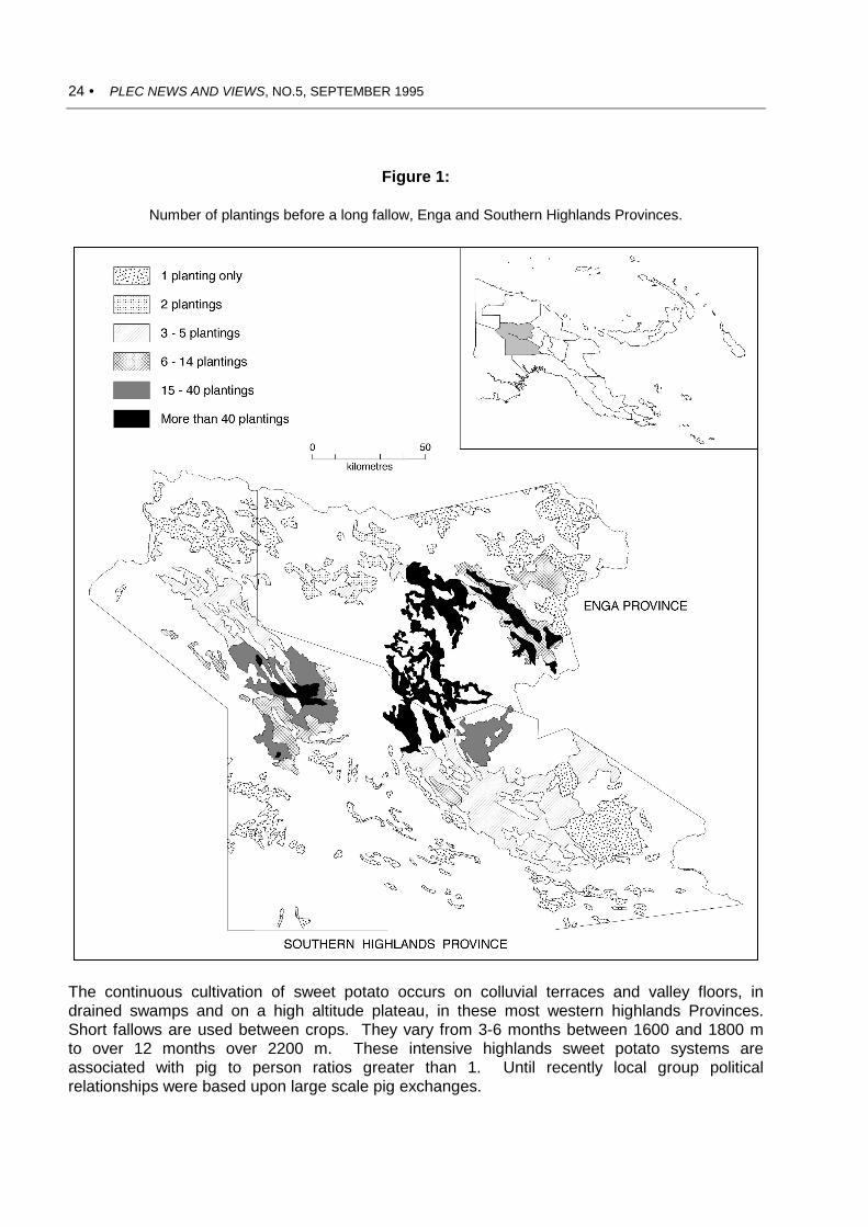
24 • PLEC NEWS AND VIEWS, NO.5, SEPTEMBER 1995
Figure 1:
Number of plantings before a long fallow, Enga and Southern Highlands Provinces.
The continuous cultivation of sweet potato occurs on colluvial terraces and valley floors, indrained swamps and on a high altitude plateau, in these most western highlands Provinces.Short fallows are used between crops. They vary from 3-6 months between 1600 and 1800 mto over 12 months over 2200 m. These intensive highlands sweet potato systems areassociated with pig to person ratios greater than 1. Until recently local group politicalrelationships were based upon large scale pig exchanges.

PLEC NEWS AND VIEWS, NO.5, SEPTEMBER 1995 • 25
Figure 2:
The use of mounds and beds, Enga and Southern Highlands Provinces.
Intensive sweet potato production in the western highlands is closely associated with use oflarge mounds. These are filled with green compost, dry grasses, old vines and weeds, beforebeing closed. Mounding appears to have been invented in Enga Province and to have spreadwest and south into the Southern Highlands over the last 150 years. The adoption of moundinginvolves a major step away from bush and forest fallowing into continuous cultivation ingrasslands.

26 • PLEC NEWS AND VIEWS, NO.5, SEPTEMBER 1995
INDIGENOUS KNOWLEDGE IN SPACE AND TIME
Kojo Sebastian Amanor
University of Ghana, Legon
Introduction
The knowledge and perceptions which ruralcommunities hold about the environment willdetermine their relationship to theenvironment, and their capacities andwillingness to engage in activities which willameliorate environmental degradation, orenable people to adapt to changingconditions. Failure to understand popularperceptions of the environment, andexperiences of degradation, may lead tofailure in the design of 'green technologies',if these do not take local farming styles, andthe objectives and strategies of farmers, intoconsideration. Farmers have considerableknowledge of local conditions andmicroenvironments, which often eludescientists who tend to aggregate data orabstract models from them. Farmers'knowledge often constitutes a science of theconcrete or an art of the locality, a dynamicsystem of interaction between people andthe environment in which responses arecontinually made to changing conditions,and knowledge is continuously updated asadaptations are made and remade.
Indigenous knowledge is often supposedto be traditional - old knowledge rooted inantiquated customs and ways of doingthings which ignorance and apathy preventrural people from overcoming. However,there is nothing traditional about the farmingsystems of West Africa, which have showndynamic ability to adapt crops from the NewWorld and create new varieties which havebecome an integral part of popular culture.This includes food crops such as cassavaand maize, as well as more recent exportcrops such as cocoa. Farmers have
themselves found ways of adapting thesecrops to fit into the local agroecosystems,and of integrating them into indigenouscropping patterns.
One example comes from the late SamAsare Mate Kole, a senior agricultural officerwho served at Cadbury Hall, and wasinstrumental in inspiring my own interest inagriculture. During the early colonial periodfarmers planted cocoa 8 ft (2.44 m) apart.The Colonial Agricultural Departmentdecried this as too close, followingrecommendations for a 12 ft (3.66 m)spacing worked out in Trinidad. It was,however, found that 12 ft was too wide forGhana, and that 8 ft was the ideal distanceat which cocoa would form a canopyshading the soil. The much malignedfarmer, castigated as practising forms ofagriculture which constituted robbery of thesoil, turned out to be right. This knowledgearose from no long familiarity with cocoa, butfrom ability intuitively to apply ecologicalprinciples grasped through long observation,interaction and experiments with nature.
Policy makers and government servicesoften dismiss the ecological knowledge offarmers, and advise them to give up their'backward ways' and follow modernmethods of farming. However, modernagriculture has hardly established a goodrecord in Ghana. Large state farms such asthe Ghana Oil Palm Development Companyat Kwae, and the Branam, Ejura and Wenchistate farms, stand out from the surroundingmosaic of small farms by the extent of landdegradation on their enterprises.
In a recent book on the history of worldtechnology, Pacey argues that Africantechnology has made great contributions to

PLEC NEWS AND VIEWS, NO.5, SEPTEMBER 1995 • 27
modern science. He writes:
The greatest technical expertise of manyAfrican cultures has been the survivaltechnology they have developed to copewith the especially demandingenvironments. Recognition of thepossibility of a dialogue between this fundof expertise and western agriculturalscience has come very late, aftertremendous ecological damage has beendone by inappropriate techniques,unbalanced development and populationgrowth, but still offers more hope for thefuture than any pretence about the transferof unmodified western technologies (Pacey1990, p. 205).
Following Paul Richards (1985), he seesthat a growing appreciation of the dynamicsof traditional African agriculture is beginningto shift the whole paradigm of tropicalagriculture away from monocropping and'soil and water engineering' approachestoward greater understanding of ecologicalprinciples, integration of trees with crops,and farming systems with the ecosystem.How ironic it is that our policy makers andexperts in agriculture continue to decrythose very principles now found to be ofgreat value on the frontiers of science, andinstead promote old and worn theories andtechnologies!
Indigenous environmental knowledge
Two types of environmental knowledge canbe found in rural agricultural communities.The first consists of ritual knowledge, inwhich custom sanctions and regulatesactivities in such a way as to preserve theenvironment. This may include regulationswhich prohibit fishing during a particularseason, which prevent the felling of certainsacred trees and plants, or involve theprotection of sacred places from cultivationor other human productive activities.1 In the 1 Some sacred trees protected include odii(Okuobaka aubrevillei) and ahomakyem(Spiropetalum heterophyllum). Before farmers
early 20th century, the oil palm tree wasconsidered sacred among the Krobo, andbefore a tree could be felled for makingpalm wine an elaborate series of rituals hadto be performed.
While such rituals may protect theenvironment, no environmentalconsciousness is articulated with them.Thus sacred groves are not protectedspecifically for ecological preservation, butoften because they are ancient burialgrounds or historical sites. It is forresearchers to presume or project anarticulated environmental consciousnessonto these activities. Moreover, in themodern period many of these customs havebecome outmoded and no longer influencedaily practice. Akpetishie distilling is now amajor enterprise in Krobo, and no oneperforms any rituals before felling oil palmtrees for tapping palm wine.
Approach through 'custom' will thereforenot get us very far. Detailed understandingof indigenous environmental knowledgemust proceed from the consciousenvironmental knowledge that is associatedwith the processes of production, work, andtransforming the environment. In studyingthis knowledge, researchers need to becareful not to project their ownenvironmental biases and prejudices.Environmental knowledge should not beequated with present global (western)concerns about environmental conservation.It should be formulated in a broad, neutralway to embrace all knowledge about natureand ecology, which people use to achieveproduction goals.
Indigenous knowledge in time
In an epoch when population density is verylow, and people are concerned with movinginto the hostile frontier of new forest,
can collect any part of these trees for medicinal orother use they must first perform an elaborateseries of rituals which include pouring of libationand sacrifice of eggs.

28 • PLEC NEWS AND VIEWS, NO.5, SEPTEMBER 1995
ecological knowledge will not be involvedwith conservation. It will be concerned withways of manipulating natural processes, toenable people to settle within the forest andtransform it into an agroecosystem (Amanor1994). The types of ecological knowledgewhich will emerge relate to methods offarming which will minimize on labour, andwill enable agriculture to develop whilepreventing rapid soil erosion, destruction ofthe root mat, and depletion of organicmatter. The development of cocoa farminginvolved sound ecological principles ofintercropping the orchard crop with shade-tolerant food crops (plantains, bananas,cocoyams [taro] and cassava), and with anupper storey of shade forest trees. But thistook place within an overall strategy whichstressed minimal labour expenditure andextensive farming practices, involving rapidpenetration of the forest, and heavy use ofaccumulated soil fertility. As populationdensity began to build up, frontier landceased to be available and pressures led toland degradation. Farmers began toevaluate their farming strategies. Facedwith mounting problems of weed control,declining soil fertility, and build up of pestpopulations, some began to hark back to thegolden days of the frontier when real forestland existed.
For some, at least, this process ofrevaluation may result in a conscious effortto preserve elements of the pastenvironment which were considered ablessing, including attempts to preservecertain species of trees to shade out grassyweeds and halt the spread of bush fires, toconserve woodlands, and activities toameliorate the environment and encourageforms of forest/woodland regeneration. Thenegative impact of land degradation onlivelihoods encourages farmers to developnew strategies based on ecologicalprinciples of which they are aware. Thisrevaluation mirrors scientific ecologicalthinking. In both formal science, and inpopular production activities, may be foundtrends which lead to unsustainability, andalso new trends which aim for a more
balanced exploitation of the environment.
Historical dimensions
Farming practices which define the ways inwhich ecological knowledge is applied arelikely to change in relation to transformationin the conditions of production. Farmingknowledge is not static. Therefore it isimportant to understand the changes infarmers' perceptions and the directions inwhich knowledge is moving. This can beachieved in different ways:
1. Through interviewing old people onconditions in the 'old times', how thingshave changed, and significant eventswhich were associated with change.This could involve changes invegetation, weed associations,cropping systems, crop yields, weedingwork loads, availability of land andhiring arrangements, gender division oflabour, labour exchange and hiring oflabour, and in general how people feltabout agriculture in those times. Caremust be taken not to engage inromanticism of the 'old days', inproducing a catalogue of how everythinghas changed for the worse, andencouraging informants to engage in akind of thinking which neatly fits anenvironmentally alarmist ideology.
2. Through interviewing young peopleabout their perceptions of the past, andwhat they consider to be the mainsignificant differences. This may notnecessarily be an accurate record, butwill provide much insight into howenvironmental problems are beingconceptualized at present, and whattypes of environmental knowledge arebeing transmitted between generations.
3. Comparisons between spatially differentareas that have been settled at differenttimes, and which lie at different stages inthe cycle of land degradation. Thiscan reveal much about changingpatterns of environmental use, and

PLEC NEWS AND VIEWS, NO.5, SEPTEMBER 1995 • 29
conceptualization of the environment inrelation to changing conditions.
Data elicited from these research activitiescan be woven with data collected fromsecondary sources, including travellers'accounts, various sector and politicalexperts, colonial archives, aerialphotographs, maps and other sources, tobuild up a picture of environmental change.However, the information gained frominformants has the added merit of impartingconsciousness and perceptions of localpeople to more empirical data.
Spatial dimensions
Detailed collection of ecological knowledge,classificatory schemes of nature and aboutparticular localities carry little merit unlessthey are woven into an analytical framework.The 'my grandmother says' line of research,or 'the traditional way of doing things asrecounted by such-and-such an elder' arefull of interesting insights, but are inevitablyparochial. Any analytical framework mustproceed by documenting a wide range ofexperiences, and classifying andcategorizing differences in production andfarming strategies and concepts, in relationto material conditions. The aim must be toproduce a large amount of quantifiableempirical data, and also information onqualitative processes at play within localities,which can then be combined in oneanalytical framework which synthesizes intoexplanatory scientific theory.
One method of doing this is to carry outresearch along a transect, documenting thewhen, how and why of changing farmingpractice. This is often carried out mostsuccessfully across an ecotone whereconditions change rapidly amongpopulations with similar material cultures,and extensive networks of communication.Where comparison is carried out among amore extensive sample over a wider area, itis necessary to understand the history ofproduction in the various areas, and the
factors which have influenced thedevelopment of different societies. It is alsoimportant to understand the role andposition of each group in the regionaleconomy, including access and linkages tomarkets, social relations of production, andthe history of political and economicrelations with neighbouring areas and urbancentres.
Field research requires formal researchmethods providing data on differentquantifiable experiences in relation to socio-economic data and environmentalconditions. This would include data onavailability of land, size of holdings, type ofaccess to land, types of soil available,division of labour, availability of householdand extra-household labour, person-hoursspent in farming, crop combinations, yieldsand farming strategies. The last of thesewould include tillage techniques, types ofvegetation preserved on the land, weedingregimes, crop calendars, mixtures andsequences. In addition to all this, moreinformal data are required revealing theproblems with which farmers are coping,and the solutions they are formulating. Thisemerges through spontaneous conversationand visits to farms.
Breadth of knowledge (whoseknowledge counts?)
There are no short-cut methods or magicalsolutions to accessing the impact ofindigenous environmental knowledge,although many researchers have claimed tohave developed such methods. It is a time-consuming activity. While group interviewsmay be a quick way of gathering andassessing information, and encouragingbrainstorming, it is easy for the researcher toprompt answers in a particular direction, andgloss over serious problems which can onlybe articulated by individuals in relation totheir own personal conditions. Rankingorders in rural societies, and concerns withprestige, seniority and authority, may alsolead to silence, or deference, among the

30 • PLEC NEWS AND VIEWS, NO.5, SEPTEMBER 1995
poor, the young, and the women. The moreprominent members of the community maynot be those who possess the mostsignificant environmental knowledge, andtheir responses cannot be taken as definingits parameters. The responses of poorfarmers, young farmers and women farmers,if separately obtained, may open up newdoors in the search for information. Workmust proceed by talking to a wide sample ofthe community, including those who may notseem to be knowledgeable, and to do thison an individual basis so that respondentscan exhaust all that they have to say.
Indigenous environmental knowledgeemerges as the common store informing thedifferent paths of improvisation, and flightsof fancy, of community members. Ratherthan by sitting under the fig tree at thechief's palace, with dignitaries, it is bestexplored by taking off along the windingpaths and discovering the extremities of thevillage, the chop bars with their bush-meatsoup, the drinking spots, the jokers, the oldwomen with their pithy comments, the youngwomen carrying water. Each of these pathsreveals a different story, the diversity ofwhich will point to common themes andprecepts in indigenous perceptions, as wellas to different voices and nuances.
Conclusion
Indigenous environmental knowledge refersto the modern folk knowledge of farmingpeople, of the relationship of theiragricultural systems to the naturalenvironment, of the various uses of naturalresources, of the problems which emergefrom farming, and of methods of conservingthe environment and adapting to change.Environmental knowledge is consciousknowledge. It is constantly being updated inrelation to changing factors of production,and changes in technology and society. It isa knowledge concerned with observation,reflection, experimentation and interaction
with the environment. Since it is beingconstantly updated in response to changeand new information, it needs to beinvestigated through time and acrossdifferent spaces, charting the factors whichresult in changing perceptual frameworksand processes of adaptation.
Indigenous environmental knowledgeneeds to be related to different socio-economic conditions, different farmingstrategies and responses to changingenvironments. An analytical frameworkneeds to be developed which goes beyonddetailed descriptions of local technique andperceptions. The challenge is to develop aframework which merges quantitative andqualitative data, producing a wealth ofempirical information about specific localitieswhich can be placed within the theoreticalcontext of the relationship betweenecological, technical, socio-economic andpolitical dimensions of agrariantransformation.
References
Amanor, K. S.1994 The New Frontier: Farmers'
Responses to Land Degradation, aWest African Study. Zed Books,London.
Richards, P.1985 Indigenous Agricultural Revolution:
Ecology and Food Production in WestAfrica. Hutchinson, London.
Pacey, A.1990 Technology in World Civilization.
Blackwell, Oxford.

PLEC NEWS AND VIEWS, NO.5, SEPTEMBER 1995 • 31
A NOTE ON MIXED CROPPING BY HILL-TRIBE PEOPLE IN NORTHERN THAILAND
by Benjavan Rerkasem, Kanok Rerkasem, Benchaphun Shinawatra
Faculty of Agriculture, Chiang Mai University, Thailand
In the course of evaluating a 'WatershedDevelopment and Demonstration Pro-gramme' (WDP) in northern Thailand, in1992-93, several very interesting examplesof mixed cropping were seen. At onevillage, Lo Pa Krai, are examples of somehighly developed mixed gardens in fields at asmall distance from the village. The fewfields above the village (about 10 minuteswalk) have been developed into a highlydiverse production system, incorporatinggrass strips, new tree crops, traditional andlocal useful perennial species, and someannual, new as well as traditional, crops.Most notable among these was a fieldbelonging to Japu Paloh, one of the villageleaders.
The 33 species of useful plants cultivatedin this 3 rai (0.48 ha) field are listed in Table1. Many of these species are grown largelyfor cash, but others provide a year roundsupply of food, herbs, spices and animalfeed. The harvest of these for subsistenceappeared to be readily shared within thevillage. Farmers discussed the possibility ofusing some of these species in conservationefforts, e.g. the legumes Acacia pennatasubsp. insuavis (Cha-om) and pigeon peaand lemon grass in contour strips.
In all villages in WDP the idea of mixedcropping is still very much in practice inassociation with upland rice. At Pa Rai,farmers always leave trees standing in theirswidden fields. There is a bank ofindigenous knowledge on the effect eachtree species has on the rice yield. Forexample, Pterocarpus macrocarpus, avaluable timber tree, was pointed out for its'good' effect on rice yield (though noobvious difference was seen between rice inthe open and rice under its shade). Irvingiamalayana (Ma muen in Northern Thai), onthe other hand, was shown to have anextremely detrimental effect on the upland
rice: under this tree the upland rice wasextremely sparse, with only a few tillers perhill and yielded almost no seed.
Some 'kitchen' species are almostinvariably grown with upland rice: a few hillsof pumpkin, wax gourds, cucumber, lufa,chili peppers etc. Most notable is thepresence of cowpea (Vigna unguiculata), invarious forms. Some are climbers, whichare only grown in isolated hills with stakes.One particular type, called Tua Lod or TuaSod was found everywhere, when closelyasked. It is particularly suitable for intercropwith upland rice because of its groundhugging habit (denoted by the names: Sod =interwoven, Lod = going underneath) itinterferes very little with the upland rice.The black seeded type is interchangeablewith the recommended black bean (TuaDam). The regular Tua Dam has a veryvigorous climbing habit; upland rice can bequickly smothered by it. Farmers in PangGorm prefer their own Tua Lod to the TuaDam for this reason. They also claim thatthe seed of Tua Lod is more resistant toinsect attack than the Tua Dam.
Ricebean is also commonly grown inassociation with rice, although farmers havebeen reluctant to grow ricebean as a covercrop as recommended by WDP. The seedof traditional type is largely buff or of palegreen colour, with a few black and brown.The Karen call it Sue Bay.
Another common practice by farmers, toreplace tree seedlings from last seasonplanting with their own species, alsocontributes towards the development of asystem of mixed species. For example atYang Klang kapok and jackfruit seedlingsreplaced some mangoes from last year thathad died. Calamus spp. (rattan and cane)have been found cultivated in associationwith tree crops in Nan and Chiang Rai.

32 • PLEC NEWS AND VIEWS, NO.5, SEPTEMBER 1995
Table 1.A list of useful plants in Japu Paloh's mixed garden at Lo Pa Krai.
Common Name Species
1. Newly introduced tree crops 1 Bamboo Dendrocalamus asper2 Lychee Litchi sinensis3 Santol Sandoricum koetjape4 Jackfruit Atrocarpus heterophyllus5 Mango Mangifera indica6 Tamarind Tamarindus indica
2. New field crops and 7 Soybean Glycine maxvegetables grown largely as 8 Adzuki bean Vigna angulariscash crops. 9 Payee (lablab) Lablab purpureus
10 Ginger Zingiber officinale11 Green gram Vigna radiata
3. Traditional trees/shrubs 12 Cha-om (Thai name) Acacia pennata subsp. insuavis13 Banana Musa sapientum14 Papaya Carica papaya15 Jujube Zikiyphus jujuba
4. Traditional field crops, 16 Upland rice Oryza sativavegetables, and etc. for home 17 Maize Zea maysuse, animal feed, some for 18 Sugarcane Saccharum officinarumsale. 19 Sweet sorghum Sorghum vulgare
20 Makua (Thai name) Solanum spp.21 Chili pepper Capsicum spp.22 Pineapple Ananus comosus23 Pumpkin Cucurbita moschata24 Wax or white gourd Benincasa cerifera25 Cowpea, several types Vigna unguiculata26 Pigeon pea cajanus cajun27 Mustard green Brassica spp.28 Taro Colocasia spp.29 Pak Ped (Thai name) Vemonia silhetensis30 Lemon grass Cymbopogon citratus31 Sweet potato lpomoea batatus32 Tobacco Nicotiana tabacum33 Sesame Sesamum indicum
There are advantages of mixed croppingover single species in spreading the risk ofproduction failure (current problem withbeetle damage of bamboo; potential fruit setproblem with lychee without dry seasonwater) as well as market/price (current lowcoffee price) failure. A continuous supply ofa variety of food can be harvested from the'homegardens' (on the homestead or onfields not too far from the village. A betterecological balance in the mixed croppingsystem could also mean fewer
problems with pests. Grass strips may helpto stabilize the steeper slopes. Mixedcropping should be encouraged, at least ona portion of the land farmed by each family,as part of the WDP in association withupland rice as well as with tree crops.
Adapted, by permission, from Appendix 11 of'Watershed Development and DemonstrationProgramme', Monitoring and Evaluation Report byChiang Mai University, Thai-Australia HighlandAgricultural and Social Development Project. 1993.

THE NAME OF PLEC
PEOPLE, LAND MANAGEMENT AND ENVIRONMENTAL CHANGE
The name of PLEC has been changed more than once since the programme was initiated in1992, and it has now been changed again. Readers may recall that we were originally'Population Growth, Land Transformation and Environmental Change'. 'Land Transformation'quickly became 'Land Management' the better to describe the real nature of our work. In 1993we dropped the word 'Growth' after 'Population', thus removing any lingering suggestion that webegan with an assumption that growth in population numbers or density is the only major forcebearing on change in land management and its consequences for the environment.
More recently, the shift in emphasis toward agrodiversity and its relation to biodiversity hasled some observers to question if 'Population' is really our main context. 'Population' is thecentral field of the discipline of demography. It implies that we study people in the aggregaterather than as individuals, communities and societies. During the second quarter of this year,after the draft Project Document and its Annexes were completed, there was an exchangebetween a few of us concerning the possibility of a total change in the name of PLEC, whichwould also have involved a new acronym. It was agreed, however, that 'PLEC' as an acronym isnot only widely accepted among the membership, and generally liked, but it is also the shortname by which the programme is becoming more and more widely known. Therefore a morelimited change only has been made, though an important one.
'People' replaces 'Population'. PLEC is fundamentally about people, the way they managethe land, and adapt to and seek to manage environmental change. Our concerns with'population dynamics' are embraced within 'people'. We feel that the new name describes theprogramme much more accurately than does the old one. The new name will not become officialin UNU until January 1996, but we are using it informally for all purposes from now on.
A short sub-title is sometimes also useful, especially in describing our work to outsiders.From among the April-May suggestions, we have chosen 'AGRODIVERSITY, BIODIVERSITYAND CONSERVATION' for this purpose. It appears on a number of documents, including allGEF documents, but is not a formal part of the title of PLEC.
_______________________________________________________________________
PLEC NEWS AND VIEWS is published for the United Nations University in the Department ofAnthropology, Division of Society and Environment, Research School of Pacific and AsianStudies, The Australian National University. Production work has been undertaken by MargaretForster, PLEC Administrator. Artwork is by Margaret Tyrie and Keith Mitchell.
Copyright: Permission to copy any material in this Newsletter will be given, provided that fullreference to the author, title, volume title, and place and date of publication are given. Abstractingdoes not require permission. Enquiries should be addressed to the Editor, Professor HaroldBrookfield, Department of Anthropology, Division of Society and Environment, Research Schoolof Pacific and Asian Studies (RSPAS), The Australian National University, Canberra, ACT 0200,Australia. Fax: (+61-6) 2494896. E-mail: [email protected]

34 • PLEC NEWS AND VIEWS, NO.5, SEPTEMBER 1995
PLEC NEWS AND VIEWS
• Published about twice yearly• Editor: Professor Harold Brookfield• Address: Department of Anthropology, Division
of Society and Environment, RSPAS,The Australian National University, Canberra,ACT 0200, Australia
• Phone: +61 (0)6 2494348• Fax: +61 (0)6 2494896/4688• e-mail: [email protected]