Plate tectonics
46
Earthquake and Plate Tectonics By Arshaghosh Ajayan
-
Upload
arshaghosh-ajayan -
Category
Science
-
view
71 -
download
0
Transcript of Plate tectonics
Earthquake and Plate Tectonics
ByArshaghosh Ajayan

The study of earthquakes dates back many centuries. Written records of earthquakes in China dates back as far as 3000 years.
Japanese records from the eastern Mediterranean region go back nearly 1600 years.
In the United States the historical record of earthquakes is much shorter, about 350 years.
On the seismically active west coast of the United States, earthquake records go back only about 200 years.
Compared with the millions of years over which earthquakes have been occurring, humankind’s experience with earthquakes is very brief.
History of Earthquakes

Earthquake is a sudden tremor or movement of the earth’s crust, which originates naturally at or below the surface
A list of natural and man made earthquake causes
What Causes Earthquakes?
Natural source Man made source
Tectonic earthquakes Controlled sources(explosives)
Volcanic earthquake Reservoir induces earthquakes
Rock falls/ collapse of cavity Mining induces earthquakes
microseism Cultural noise(industry, traffic etc.)
4
Causes- Tectonic Plate Movement
The most common cause of earthquakes. The earthquake occurs when the pressure that has built up in
tectonic plates causes the rock to break suddenly.
This usually occurs at the boundaries of tectonic plates and along existing faults.

Earth‘s Structure
The inner core is believed to be a solid metal body. Heavier and denser materials
The outer core is believed to be a liquid metal layer.
The mantle materials are in a viscous, semi molten state
The crust is the outer layer of hard rock
At the Core, the temperature is estimated to be 2500°C, the pressure 4 million atmospheres and density ~13.5 gm/cc; this is in contrast to ~25°C, 1 atmosphere and 1.5 gm/cc on the surface of the Earth.
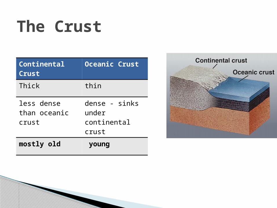
The Crust
Continental Crust
Oceanic Crust
Thick thin
less dense than oceanic crust
dense - sinks under continental crust
mostly old young

Plate Tectonics
The convective flows of Mantle material cause the Crust and some portion of the Mantle, to slide on the hot molten outer core. This sliding of Earth’s mass takes place in pieces called Tectonic Plates

The theory of plate tectonics tells us that the Earth's rigid outer shell (lithosphere) is broken into a mosaic of oceanic and continental plates that can slide over the plastic aesthenosphere (uppermost layer of the mantle).
The plates are in constant motion. There are seven major crustal plates, subdivided into a
number of smaller plates They are about 80 kilometers thick, moving relative to one
another at rates varying from 1 to 13 centimeters per year. Their pattern is neither symmetrical nor simple. Several
different landform features found on our planet - mountains, rift valleys, volcanoes, earthquakes, faulting - are the result of geologic processes that occur where plates interact.
Plate Tectonics

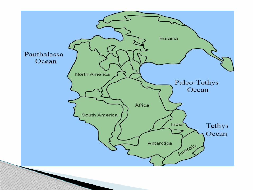
The breaking up and formation of supercontinents appears to have happened several times over Earth’s history
Pangea was the supercontinent that existed 250 million years ago during the Paleozoic and Mesozoic eras.
During the ensuing millennia, plate tectonics slowly moved each continent to its current position on the planet. Each continent is still slowly moving across the face of our world.
what is Pangea?

In the early 1900's Alfred Wegener proposed the idea of Continental Drift.
His ideas centered around continents moving across the face of the earth.
The idea was not quite correct - compared to the plate tectonics theory of today - but his thinking was on the proper track.
Continental Drift


The earth’s crust is broken into about seven major plates, each of which behaves for the most part as a rigid body that slides over the partially molten mantle, in which deformation occurs plastically.
Tectonic earthquakes result from motion between these plates. The plates are driven by the convective motion of the material in the Earth’s mantel, which in turn is driven by heat generated at the Earth’s core
The surface of the earth is made up of 21 tectonic plates,
some large and some small, that are constantly moving.
As the plates are forced against each other, they deform, and eventually they crush and fracture.
The sudden fracture of the rock sends out a shock wave that causes the earth's surface to shake. This is one way earthquakes can happen.

Main tectonic plates of the Earth

African Plate Antarctic Plate Eurasian Plate Indo-Australian Plate North American Plate Pacific Plate South American Plate
Minor Plates These smaller plates are generally shown on major plate maps, but with the exception of the Arabian plate which do not comprise significant land area.
Arabian Plate Caribbean Plate Cocos Plate Juan de Fuca Plate Nazca Plate Philippine Sea Plate Scotia Plate
Major Plates

Divergent boundaries or constructive plate margin-- where new crust is generated as the plates pull away from each other (green lines in Figure 1).
Convergent boundaries or destructive plate margin-- where crust is destroyed as one plate dives under another (red lines in Figure 1).
Transform boundaries or conservative plate margin -- where crust is neither produced nor destroyed as the plates slide horizontally past each other (grey continuous lines in Figure 1).
There are three types of plate boundaries


Convergent, Divergent and Transform Plate Boundary

zones of spreading . In certain areas the plates move apart from each
other at boundaries known as spreading ridges or spreading rifts. Molten rock from the underlying mantle rises to the surface where it cools and becomes part of the spreading plates.
Ex. Mid oceanic ridges Seafloor spreading over the past 100 to 200 million
years has caused the Atlantic Ocean to grow from a tiny inlet of water between the continents of Europe, Africa, and the Americas into the vast ocean that exists today.
DIVERGENT BOUNDARIES
Bridge across the Álfagjá rift valley in southwest Iceland, that is part of the boundary between the Eurasian and North American continental tectonic plates.

World Distribution of Mid Oceanic Ridges

The Mid-Atlantic Ridge (MAR) is a mid-ocean ridge, a divergent tectonic plate or constructive plate boundary located along the floor of the Atlantic Ocean, and part of the longest mountain range in the world.
In the North Atlantic, it separates the Eurasian and North American Plates
The section of the ridge that includes the island of Iceland is also known as the Reykjanes Ridge. The average spreading rate for the ridge is about 2.5 cm per year
Mid-Atlantic Ridge

The Mid-Atlantic Ridge, which splits nearly the entire Atlantic Ocean north to south, is probably the best-known and most-studied example of a divergent plate boundary.
Map showing the Mid-Atlantic Ridge splitting Iceland and separating the North American and Eurasian Plates. The map also shows Reykjavik, the capital of Iceland, the Thingvellir area, and the locations of some of Iceland's active volcanoes (red triangles), including Krafla

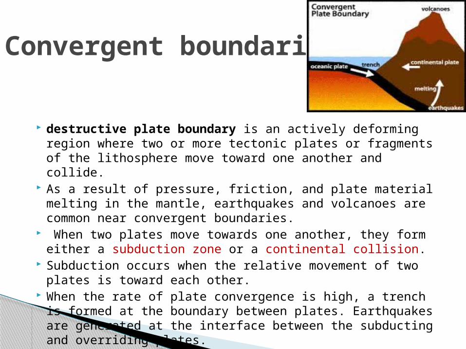
destructive plate boundary is an actively deforming region where two or more tectonic plates or fragments of the lithosphere move toward one another and collide.
As a result of pressure, friction, and plate material melting in the mantle, earthquakes and volcanoes are common near convergent boundaries.
When two plates move towards one another, they form either a subduction zone or a continental collision.
Subduction occurs when the relative movement of two plates is toward each other.
When the rate of plate convergence is high, a trench is formed at the boundary between plates. Earthquakes are generated at the interface between the subducting and overriding plates.
Convergent boundaries

There are three types of convergent boundaries: 1. Oceanic-Continental Oceanic plate sub ducts due higher density
2. Oceanic-Oceanic they typically create an island arc, deep oceanic trench
3. Continental-Continental Himalayas
Convergent boundaries

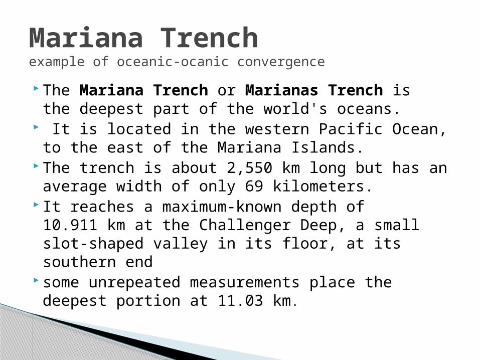
The Mariana Trench or Marianas Trench is the deepest part of the world's oceans.
It is located in the western Pacific Ocean, to the east of the Mariana Islands.
The trench is about 2,550 km long but has an average width of only 69 kilometers.
It reaches a maximum-known depth of 10.911 km at the Challenger Deep, a small slot-shaped valley in its floor, at its southern end
some unrepeated measurements place the deepest portion at 11.03 km.
Mariana Trench example of oceanic-ocanic convergence

The Pacific plate is subducted beneath the Mariana Plate, creating the Mariana trench, and (further on) the arc of the Mariana islands, as water trapped in the plate is released and explodes upward to form island volcanoes.

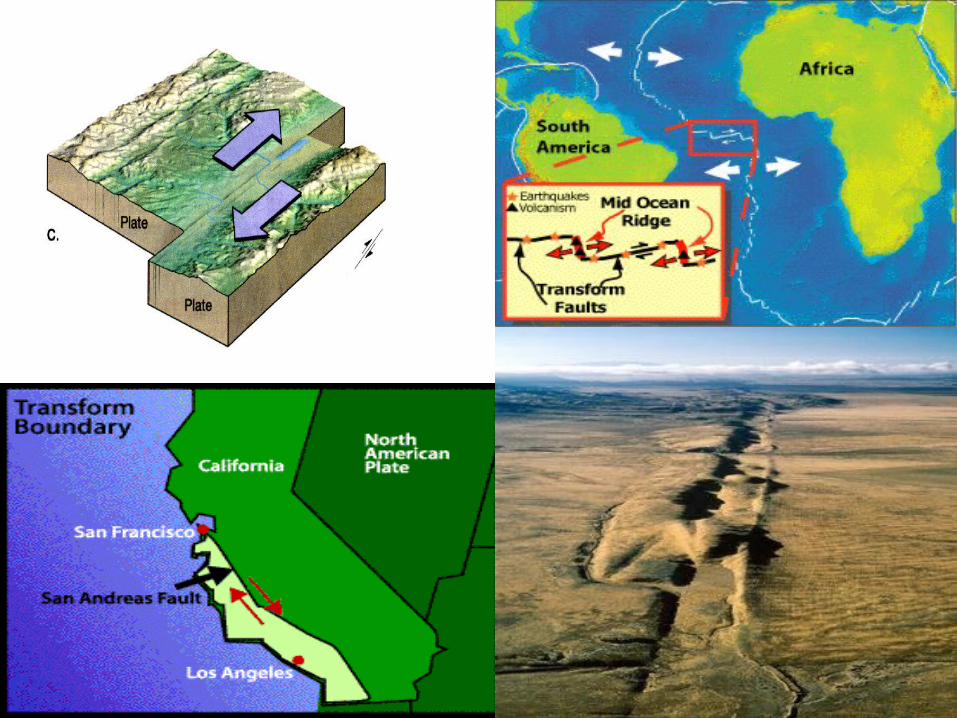
these faults neither create nor destroy lithosphere
most transform faults are hidden in the deep oceans where they form a series of short zigzags accommodating seafloor spreading
Few occurs in land Ex. San Andreas Fault zone California,
here the earthquake occurs at shallow depth, unaccompanied by volcanic activity
Periodically large earthquakes happens
A transform fault or transform boundary

When plates move towards each other continental collisions can lead to the formation of mountain ranges. Example: Himalayas formed due to collision of Australia-Indian plate with Eurasian plate.
Movement of Indian plate

Among the most dramatic and visible creations of plate-tectonic forces are the lofty Himalayas, which stretch 2,900 km along the border between India and Tibet.
This immense mountain range began to form between 40 and 50 million years ago.
when two large landmasses, India and Eurasia, driven by plate movement, collided.
Because both these continental landmasses have about the same rock density, one plate could not be subducted under the other.
The pressure of the impinging plates could only be relieved by thrusting skyward, contorting the collision zone, and forming the jagged Himalayan peaks.

•About 225 million years ago, India was a large island still situated off the Australian coast, and a vast ocean (called Tethys Sea) separated India from the Asian continent.
• When Pangaea broke apart about 200 million years ago, India began to forge northward.
•About 80 million years ago, India was located roughly 6,400 km south of the Asian continent, moving northward at a rate of about 9 m a century.
• When India rammed into Asia about 40 to 50 million years ago, its northward advance slowed by about half.
•The collision and associated decrease in the rate of plate movement are interpreted to mark the beginning of the rapid uplift of the Himalayas.

What causes earthquakes? Elastic Rebound Sources of stress
◦ Plate Tectonics◦ Other stresses

Tectonic plates move past each other causing stress. Stress causes the rock to deform◦ Plastic deformation – does not cause earthquakes◦ Elastic deformation – rock stretches then reaches
a breaking point, releasing energy.

Following the great 1906 San Francisco earthquake, Henry Feilding Reid examined the displacement of the ground surface around the San Andreas Fault.
From his observations he concluded that the earthquake must have been the result of the elastic rebound of previously stored elastic strain energy in the rocks on either side of the fault.
The elastic rebound theory states that an earthquake is the sudden reaction of the earth’s overly strained crust “snapping back” along the fault (Figure 2.4).
Elastic rebound theory states that as tectonic plates move relative to each other, elastic strain energy builds up along their edges in the rocks along fault planes. Since fault planes are not usually very smooth, great amounts of energy can be stored (if the rock is strong enough) as movement is restricted due to interlock along the fault. When the shearing stresses induced in the rocks on the fault planes exceed the shear strength of the rock, rupture occurs.
The elastic rebound theory is an explanation for how energy is spread during earthquakes. As plates on opposite sides of a fault are subjected to force and shift, they accumulate energy and slowly deform until their internal strength is exceeded. At that time, a sudden movement occurs along the fault, releasing the accumulated energy, and the rocks snap back to their original undeformed shape.
Elastic Rebound Theory

Elastic Rebound
(a) Initial Time- The fence is built straight across the fault trace.
(b) After Several Years- Tectonic movement occurs, but the edges of the crustal blocks are restrained by friction along the fault, and the ground and fence bend. Elastic strain energy builds up.
(c) Following Rupture- The edges of the blocks along the fault try to "catch up" with the middle as they release their strain energy during the rupture, but don't quite make it due to fault drag. Now the fence is offset and slightly curved

Elastic Rebound – deformed rock goes back to its original shape
http://www.uwgb.edu/dutchs/EarthSC-102VisualsIndex.HTM

44
Fault Over millions of years the earth's tectonic plates have been moving continuously and
pushing against each other. These movements have forced them to deform producing mountains and valleys in the earth's surface.
Sometimes the rocky surface of the earth has just been bent and folded (Fig.1). Sometimes the movements have caused the rock to deform so much that they fracture. These fractures are called faults (Fig. 2). When the rock fractures, its sudden movement causes an earthquake as shock waves spread away from it.
Fig. 2 How Rocks FractureFig. 1 How Rocks are bent and folded

Three Types of Faults
Strike-SlipThrust
Normal

Thank you