Remember… Continental drift Plate tectonics Which movement causes earthquakes?
De La Salle College
Geography Department
Ms.Diane Sammut
PLATE TECTONICS
TOPIC FOUR
2
We will be focusing on...
Page
The theory of Plate Tectonics 3
Cross-section of the Earth 5
Tectonic plates 7
Plate boundaries 8
Constructive plate boundaries 10
Destructive plate boundaries 12
Collision zones 14
Conservative plate boundries 16
Volcanoes 20
Living in a danger zone 26
Mount St.Helens 28
Supervolcanoes and hotspots 33
Mount Etna 34
Earthquakes 38
Kobe, Japan 42
Tsunami 46
Predict and prepare 48
Glossary 50
3
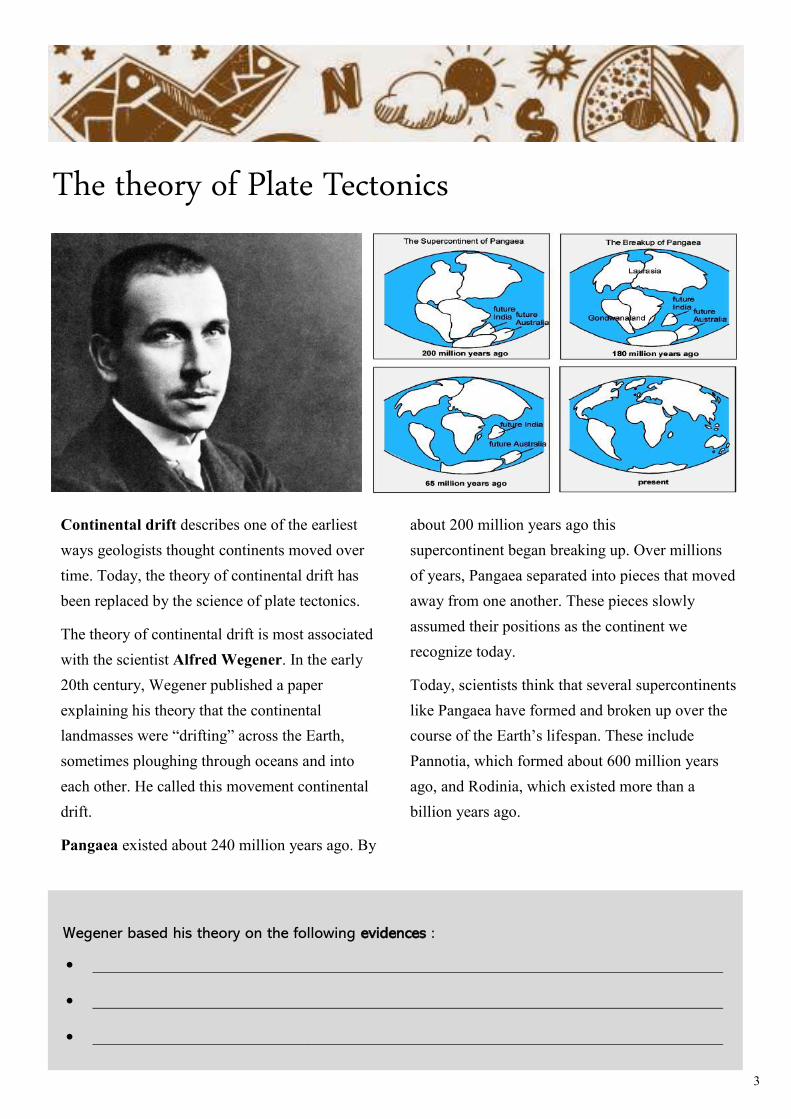
The theory of Plate Tectonics
Continental drift describes one of the earliest
ways geologists thought continents moved over
time. Today, the theory of continental drift has
been replaced by the science of plate tectonics.
The theory of continental drift is most associated
with the scientist Alfred Wegener. In the early
20th century, Wegener published a paper
explaining his theory that the continental
landmasses were “drifting” across the Earth,
sometimes ploughing through oceans and into
each other. He called this movement continental
drift.
Pangaea existed about 240 million years ago. By
about 200 million years ago this
supercontinent began breaking up. Over millions
of years, Pangaea separated into pieces that moved
away from one another. These pieces slowly
assumed their positions as the continent we
recognize today.
Today, scientists think that several supercontinents
like Pangaea have formed and broken up over the
course of the Earth’s lifespan. These include
Pannotia, which formed about 600 million years
ago, and Rodinia, which existed more than a
billion years ago.
Wegener based his theory on the following evidences :
• _______________________________________________________________________________
• _______________________________________________________________________________
• _______________________________________________________________________________
4
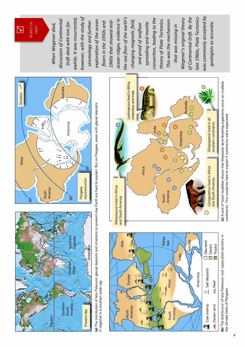
Wh
en W
egen
er d
ied
,
dis
cuss
ion
of
Co
nti
nen
tal
Dri
ft d
ied
wit
h h
im f
or
aw
hile
. It
wa
s re
surr
ecte
d,
ho
wev
er, w
ith
th
e st
ud
y o
f
seis
mo
log
y a
nd
fu
rth
er
exp
lora
tio
n o
f th
e o
cea
n
flo
ors
in t
he
19
50s
an
d
19
60
s th
at
sho
wed
mid
-
oce
an
rid
ges
, evi
den
ce in
the
sea
flo
or
of
the
eart
h’s
cha
ng
ing
ma
gn
etic
fiel
d,
an
d p
roo
f o
f se
afl
oo
r
spre
ad
ing
an
d m
an
tle
con
vecti
on
, lea
din
g t
o t
he
theo
ry o
f P
late
Tec
ton
ics.
This
wa
s th
e m
ech
an
ism
tha
t w
as
mis
sin
g in
Weg
ener
’s o
rig
ina
l th
eory
of
Co
nti
nen
tal D
rift
. By
the
late
19
60
s, P
late
Tec
ton
ics
wa
s co
mm
on
ly a
ccep
ted
by
geo
log
ists
as
acc
ura
te.
POIN
T O
F IN
FO
5
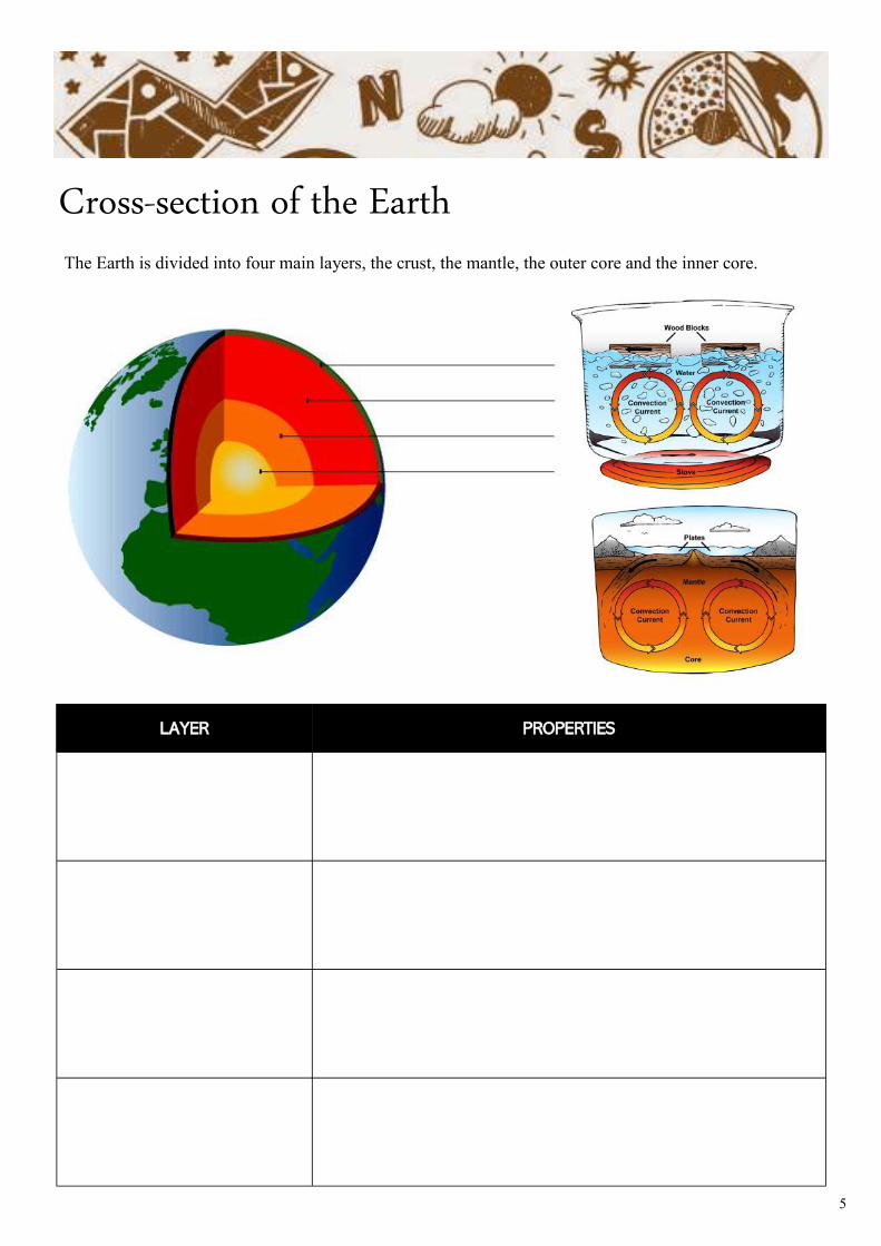
Cross-section of the Earth
LAYER PROPERTIES
The Earth is divided into four main layers, the crust, the mantle, the outer core and the inner core.
6
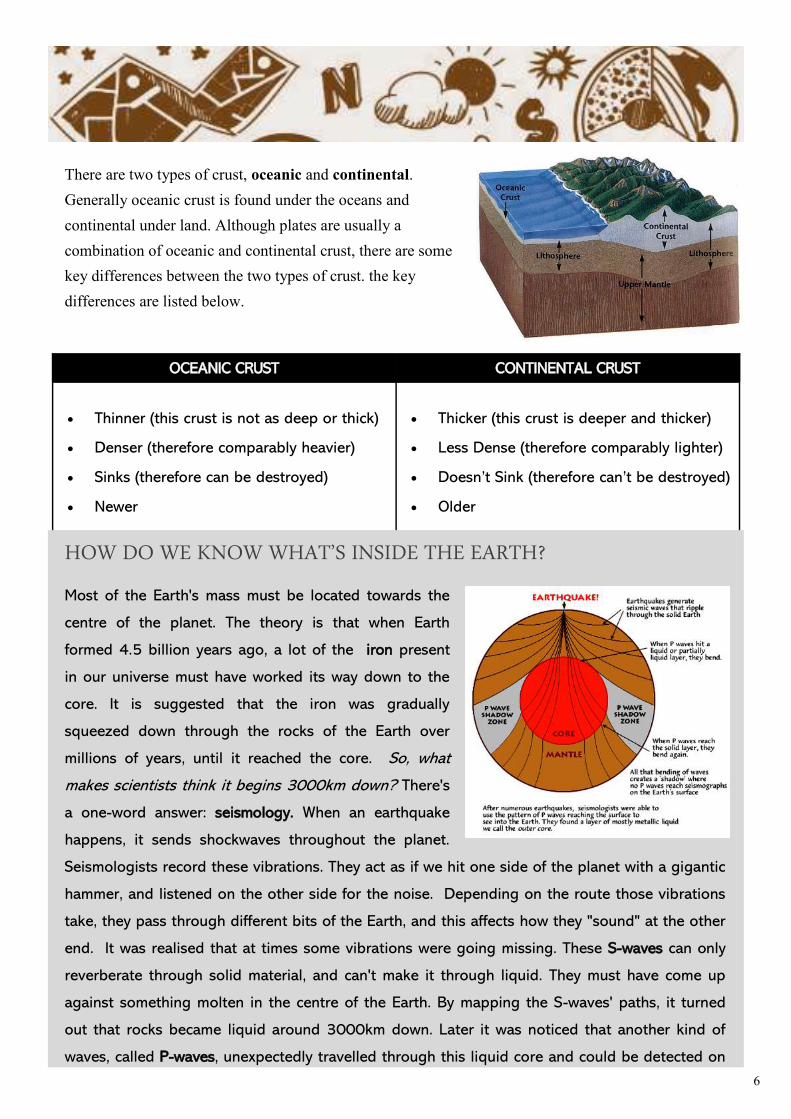
OCEANIC CRUST CONTINENTAL CRUST
• Thinner (this crust is not as deep or thick)
• Denser (therefore comparably heavier)
• Sinks (therefore can be destroyed)
• Newer
• Thicker (this crust is deeper and thicker)
• Less Dense (therefore comparably lighter)
• Doesn’t Sink (therefore can’t be destroyed)
• Older
There are two types of crust, oceanic and continental.
Generally oceanic crust is found under the oceans and
continental under land. Although plates are usually a
combination of oceanic and continental crust, there are some
key differences between the two types of crust. the key
differences are listed below.
HOW DO WE KNOW WHAT’S INSIDE THE EARTH?
Most of the Earth's mass must be located towards the
centre of the planet. The theory is that when Earth
formed 4.5 billion years ago, a lot of the iron present
in our universe must have worked its way down to the
core. It is suggested that the iron was gradually
squeezed down through the rocks of the Earth over
millions of years, until it reached the core. So, what
makes scientists think it begins 3000km down? There's
a one-word answer: seismology. When an earthquake
happens, it sends shockwaves throughout the planet.
Seismologists record these vibrations. They act as if we hit one side of the planet with a gigantic
hammer, and listened on the other side for the noise. Depending on the route those vibrations
take, they pass through different bits of the Earth, and this affects how they "sound" at the other
end. It was realised that at times some vibrations were going missing. These S-waves can only
reverberate through solid material, and can't make it through liquid. They must have come up
against something molten in the centre of the Earth. By mapping the S-waves' paths, it turned
out that rocks became liquid around 3000km down. Later it was noticed that another kind of
waves, called P-waves, unexpectedly travelled through this liquid core and could be detected on
7
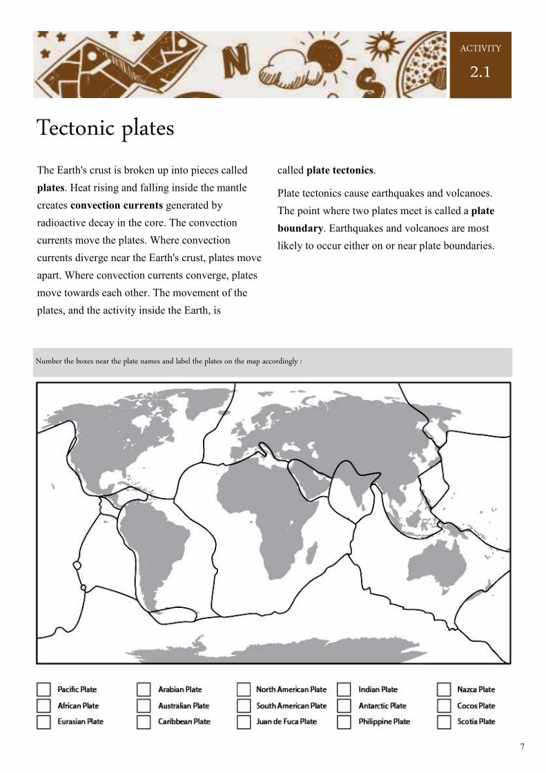
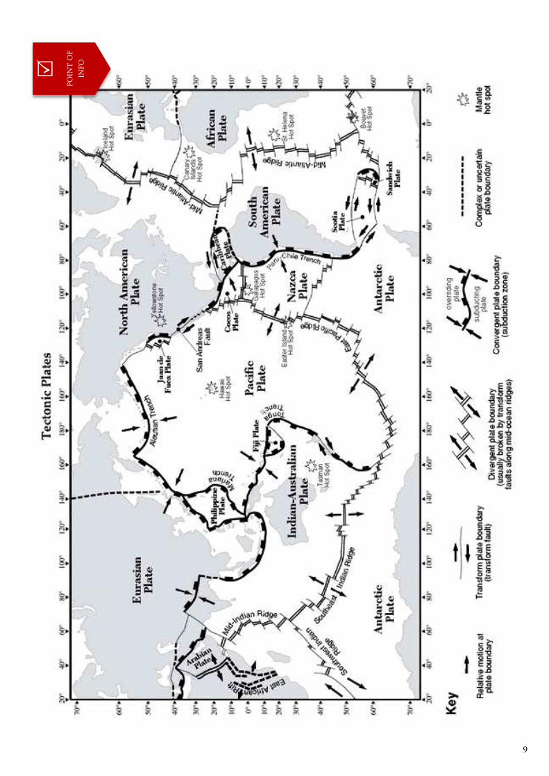
Tectonic plates
The Earth's crust is broken up into pieces called
plates. Heat rising and falling inside the mantle
creates convection currents generated by
radioactive decay in the core. The convection
currents move the plates. Where convection
currents diverge near the Earth's crust, plates move
apart. Where convection currents converge, plates
move towards each other. The movement of the
plates, and the activity inside the Earth, is
called plate tectonics.
Plate tectonics cause earthquakes and volcanoes.
The point where two plates meet is called a plate
boundary. Earthquakes and volcanoes are most
likely to occur either on or near plate boundaries.
ACTIVITY
2.1
Number the boxes near the plate names and label the plates on the map accordingly :
8
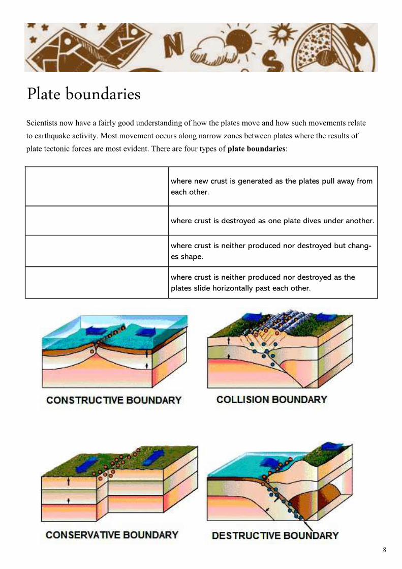
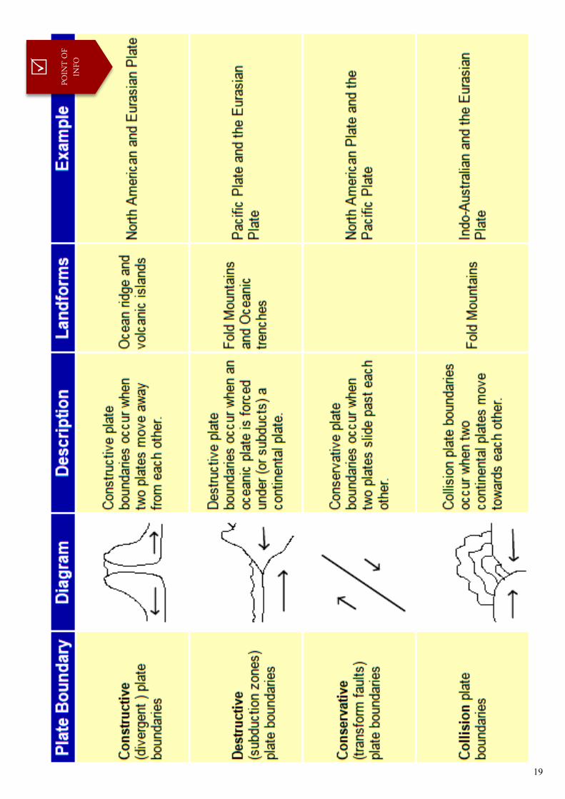
Plate boundaries Scientists now have a fairly good understanding of how the plates move and how such movements relate
to earthquake activity. Most movement occurs along narrow zones between plates where the results of
plate tectonic forces are most evident. There are four types of plate boundaries:
where new crust is generated as the plates pull away from
each other.
where crust is destroyed as one plate dives under another.
where crust is neither produced nor destroyed but chang-
es shape.
where crust is neither produced nor destroyed as the
plates slide horizontally past each other.
9
POIN
T O
F IN
FO
10
Constructive plate boundaries
As the plates move apart (very slowly), magma
rises from the mantle. The magma erupts to the
surface of the Earth. This is also accompanied by
earthquakes. When the magma reaches the surface,
it cools and solidifies to form a new crust
of igneous rock. This process is repeated many
times, over a long period of time.
Eventually the new rock builds up to form a
volcano. Constructive boundaries tend to be found
under the sea, ex. the Mid Atlantic Ridge. Here,
chains of underwater volcanoes have formed along
the plate boundary. One of these volcanoes may
become so large that it erupts out of the sea to form
a volcanic island, ex. Surtsey and the Westman
Islands near Iceland.
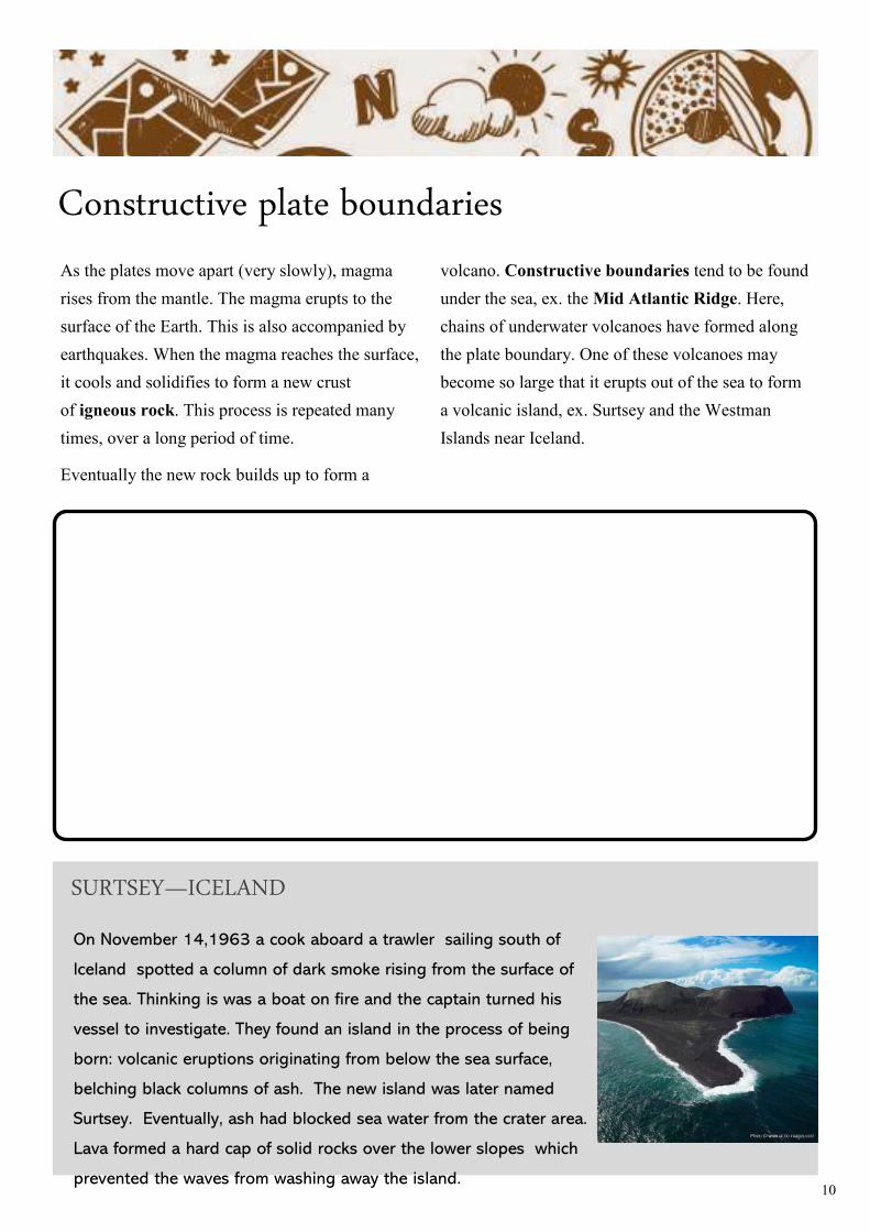
On November 14,1963 a cook aboard a trawler sailing south of
Iceland spotted a column of dark smoke rising from the surface of
the sea. Thinking is was a boat on fire and the captain turned his
vessel to investigate. They found an island in the process of being
born: volcanic eruptions originating from below the sea surface,
belching black columns of ash. The new island was later named
Surtsey. Eventually, ash had blocked sea water from the crater area.
Lava formed a hard cap of solid rocks over the lower slopes which
prevented the waves from washing away the island.
SURTSEY—ICELAND
11
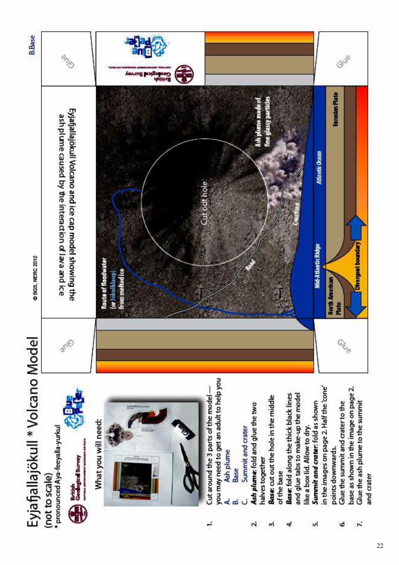
Living on the Mid-Atlantic ridge
Iceland lies on a constructive plate margin. It is
part of a submarine mountain chain called the
Mid-Atlantic Ridge, which stretches for
thousands of kilometres through the middle of the
Atlantic Ocean.
Did you know that Iceland is growing in size?
As the two plate move apart new land is formed
every time there is an eruption. Despite being at
risk from occasional earthquake and volcanic
eruptions, the people of Iceland gain a number of
benefits from living on top of this plate boundary.
Just a few kilometres below the surface is a huge
body of heat that provides them with the following:
• _________________________________________________________
_________________________________________________________
• _________________________________________________________
_________________________________________________________
• _________________________________________________________
_________________________________________________________
• _________________________________________________________
_________________________________________________________
• _________________________________________________________
_________________________________________________________
• _________________________________________________________
_________________________________________________________
• _________________________________________________________
_________________________________________________________
ACTIVITY
2.2
THE BENEFITS OF ICELAND’S UNDERGROUND
12
Destructive plate boundary
At a destructive boundary the plates are moving
towards each other. This usually involves
a continental plate and an oceanic plate.
The oceanic plate is denser than the continental
plate so, as they move together, the oceanic plate
is forced underneath the continental plate. The
point at which this happens is called
the subduction zone. As the oceanic plate is
forced below the continental plate it melts to form
magma and earthquakes are triggered. The magma
collects to form a magma chamber. This magma
then rises up through cracks in the continental
crust. As pressure builds up, a volcanic eruption
may occur.
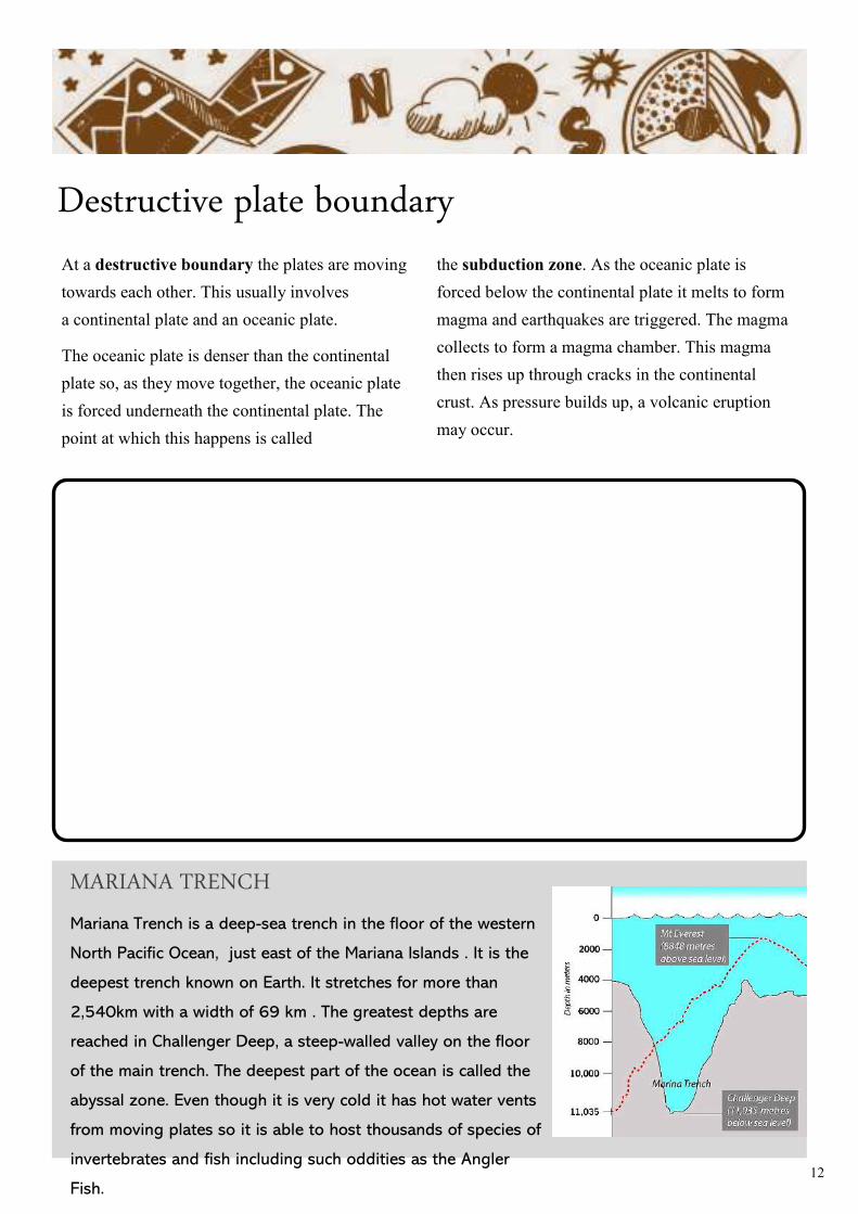
Mariana Trench is a deep-sea trench in the floor of the western
North Pacific Ocean, just east of the Mariana Islands . It is the
deepest trench known on Earth. It stretches for more than
2,540km with a width of 69 km . The greatest depths are
reached in Challenger Deep, a steep-walled valley on the floor
of the main trench. The deepest part of the ocean is called the
abyssal zone. Even though it is very cold it has hot water vents
from moving plates so it is able to host thousands of species of
invertebrates and fish including such oddities as the Angler
Fish.
MARIANA TRENCH
13
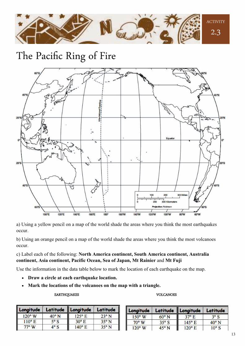
The Pacific Ring of Fire
a) Using a yellow pencil on a map of the world shade the areas where you think the most earthquakes
occur.
b) Using an orange pencil on a map of the world shade the areas where you think the most volcanoes
occur.
c) Label each of the following: North America continent, South America continent, Australia
continent, Asia continent, Pacific Ocean, Sea of Japan, Mt Rainier and Mt Fuji
Use the information in the data table below to mark the location of each earthquake on the map.
• Draw a circle at each earthquake location.
• Mark the locations of the volcanoes on the map with a triangle.
EARTHQUAKES VOLCANOES
ACTIVITY
2.3
14
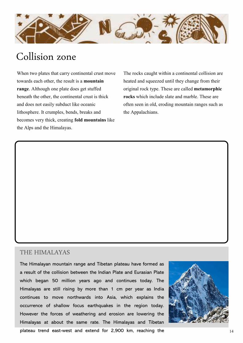
Collision zone When two plates that carry continental crust move
towards each other, the result is a mountain
range. Although one plate does get stuffed
beneath the other, the continental crust is thick
and does not easily subduct like oceanic
lithosphere. It crumples, bends, breaks and
becomes very thick, creating fold mountains like
the Alps and the Himalayas.
The rocks caught within a continental collision are
heated and squeezed until they change from their
original rock type. These are called metamorphic
rocks which include slate and marble. These are
often seen in old, eroding mountain ranges such as
the Appalachians.
The Himalayan mountain range and Tibetan plateau have formed as
a result of the collision between the Indian Plate and Eurasian Plate
which began 50 million years ago and continues today. The
Himalayas are still rising by more than 1 cm per year as India
continues to move northwards into Asia, which explains the
occurrence of shallow focus earthquakes in the region today.
However the forces of weathering and erosion are lowering the
Himalayas at about the same rate. The Himalayas and Tibetan
plateau trend east-west and extend for 2,900 km, reaching the
THE HIMALAYAS
15
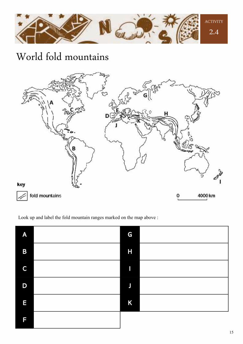
World fold mountains
Look up and label the fold mountain ranges marked on the map above :
A
G
B
H
C
I
D
J
E
K
F
ACTIVITY
2.4
16
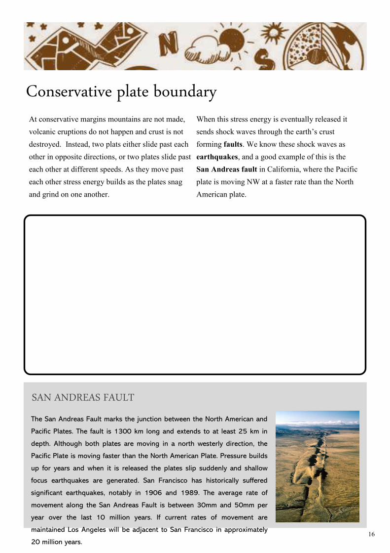
Conservative plate boundary At conservative margins mountains are not made,
volcanic eruptions do not happen and crust is not
destroyed. Instead, two plats either slide past each
other in opposite directions, or two plates slide past
each other at different speeds. As they move past
each other stress energy builds as the plates snag
and grind on one another.
When this stress energy is eventually released it
sends shock waves through the earth’s crust
forming faults. We know these shock waves as
earthquakes, and a good example of this is the
San Andreas fault in California, where the Pacific
plate is moving NW at a faster rate than the North
American plate.
The San Andreas Fault marks the junction between the North American and
Pacific Plates. The fault is 1300 km long and extends to at least 25 km in
depth. Although both plates are moving in a north westerly direction, the
Pacific Plate is moving faster than the North American Plate. Pressure builds
up for years and when it is released the plates slip suddenly and shallow
focus earthquakes are generated. San Francisco has historically suffered
significant earthquakes, notably in 1906 and 1989. The average rate of
movement along the San Andreas Fault is between 30mm and 50mm per
year over the last 10 million years. If current rates of movement are
maintained Los Angeles will be adjacent to San Francisco in approximately
20 million years.
SAN ANDREAS FAULT
17
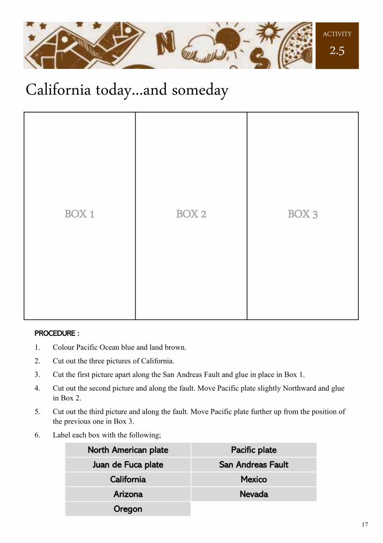
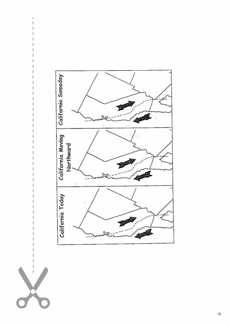
California today...and someday
BOX 1 BOX 2 BOX 3
PROCEDURE :
1. Colour Pacific Ocean blue and land brown.
2. Cut out the three pictures of California.
3. Cut the first picture apart along the San Andreas Fault and glue in place in Box 1.
4. Cut out the second picture and along the fault. Move Pacific plate slightly Northward and glue
in Box 2.
5. Cut out the third picture and along the fault. Move Pacific plate further up from the position of
the previous one in Box 3.
6. Label each box with the following;
North American plate Pacific plate
Juan de Fuca plate San Andreas Fault
California Mexico
Arizona Nevada
Oregon
ACTIVITY
2.5
18
19
POIN
T O
F IN
FO
20
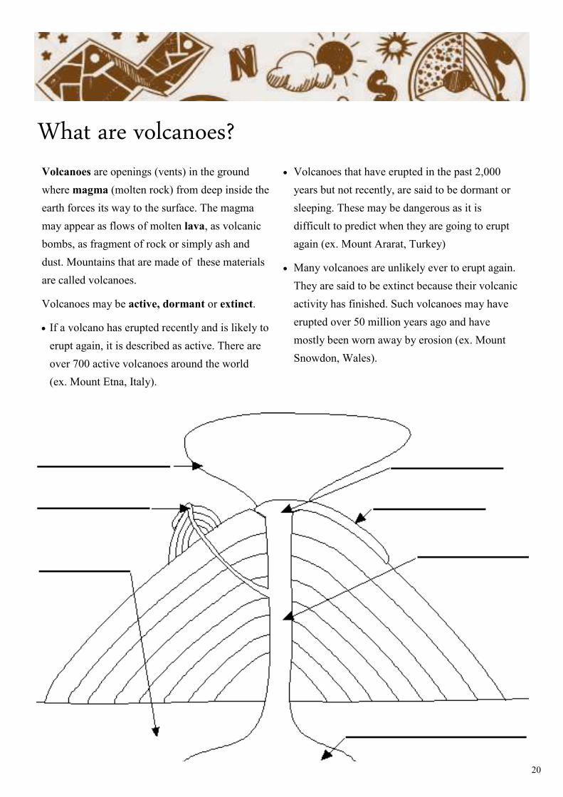
What are volcanoes? Volcanoes are openings (vents) in the ground
where magma (molten rock) from deep inside the
earth forces its way to the surface. The magma
may appear as flows of molten lava, as volcanic
bombs, as fragment of rock or simply ash and
dust. Mountains that are made of these materials
are called volcanoes.
Volcanoes may be active, dormant or extinct.
• If a volcano has erupted recently and is likely to
erupt again, it is described as active. There are
over 700 active volcanoes around the world
(ex. Mount Etna, Italy).
• Volcanoes that have erupted in the past 2,000
years but not recently, are said to be dormant or
sleeping. These may be dangerous as it is
difficult to predict when they are going to erupt
again (ex. Mount Ararat, Turkey)
• Many volcanoes are unlikely ever to erupt again.
They are said to be extinct because their volcanic
activity has finished. Such volcanoes may have
erupted over 50 million years ago and have
mostly been worn away by erosion (ex. Mount
Snowdon, Wales).
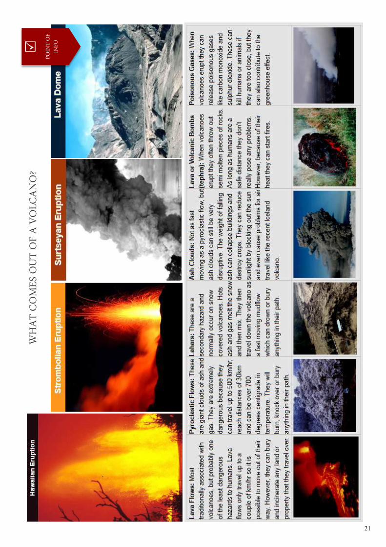
21
WH
AT
CO
MES
OU
T O
F A
VO
LCA
NO
?
POIN
T O
F IN
FO
22
23
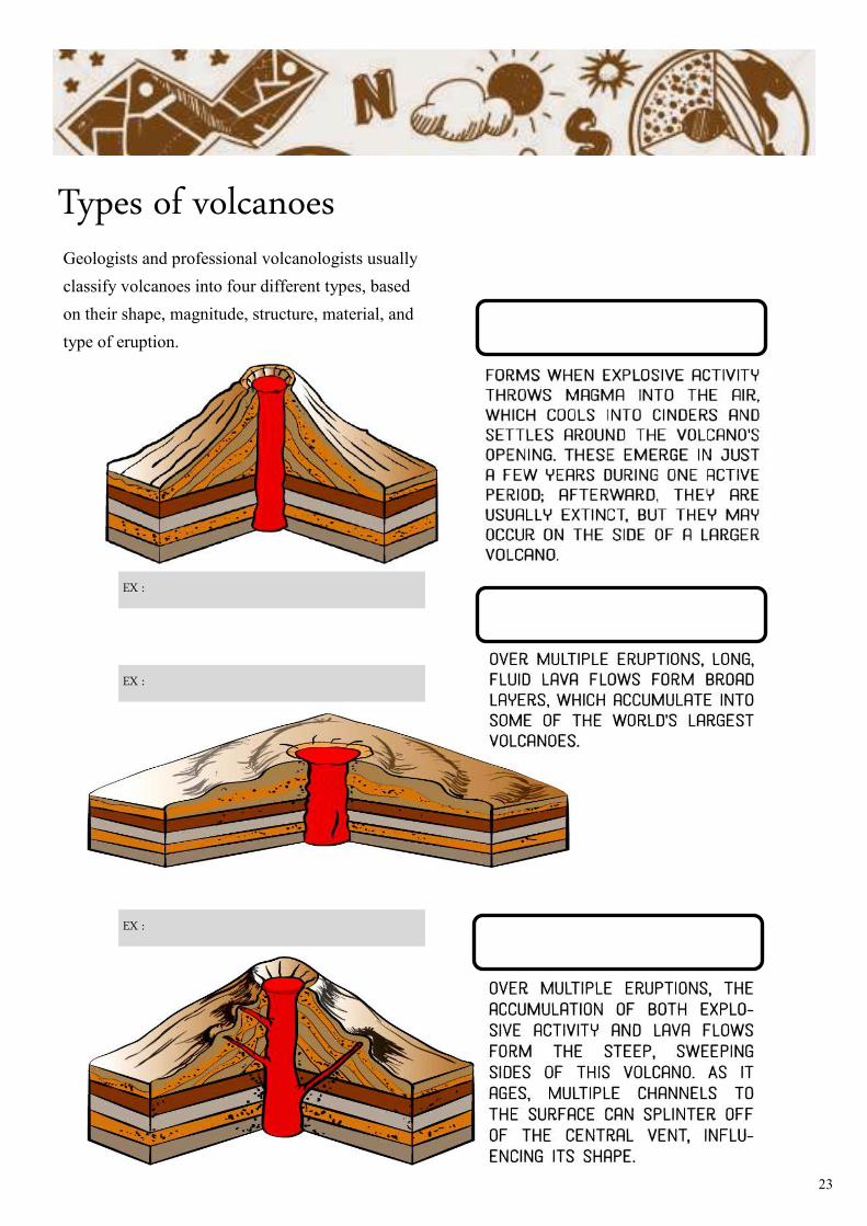
Types of volcanoes Geologists and professional volcanologists usually
classify volcanoes into four different types, based
on their shape, magnitude, structure, material, and
type of eruption.
EX :
EX :
EX :
24
ACTIVITY
2.6
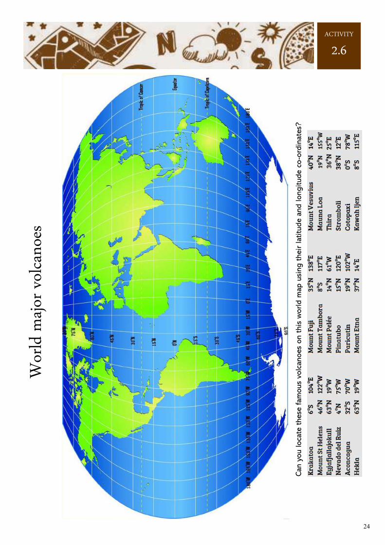
Can y
ou loca
te t
hese
fam
ous
volc
anoes
on t
his
world m
ap u
sing t
heir latitu
de a
nd longitude c
o-o
rdin
ate
s?
Wor
ld m
ajor
vol
cano
es
25
Volcanoes
ACTIVITY
2.7
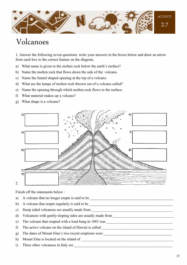
1. Answer the following seven questions. write your answers in the boxes below and draw an arrow
from each box to the correct feature on the diagram.
a) What name is given to the molten rock below the earth’s surface?
b) Name the molten rock that flows down the side of the volcano.
c) Name the funnel shaped opening at the top of a volcano.
d) What are the lumps of molten rock thrown out of a volcano called?
e) Name the opening through which molten rock flows to the surface.
f) What material makes up a volcano?
g) What shape is a volcano?
2.
Finish off the statements below :
a) A volcano that no longer erupts is said to be ____________________________________________
b) A volcano that erupts regularly is said to be ____________________________________________
c) Steep sided volcanoes are usually made from ___________________________________________
d) Volcanoes with gently-sloping sides are usually made from ________________________________
e) The volcano that erupted with a loud bang in 1883 was ___________________________________
f) The active volcano on the island of Hawaii is called ______________________________________
g) The dates of Mount Etna’s two recent eruptions were ____________________________________
h) Mount Etna is located on the island of _________________________________________________
i) Three other volcanoes in Italy are ____________________________________________________
26
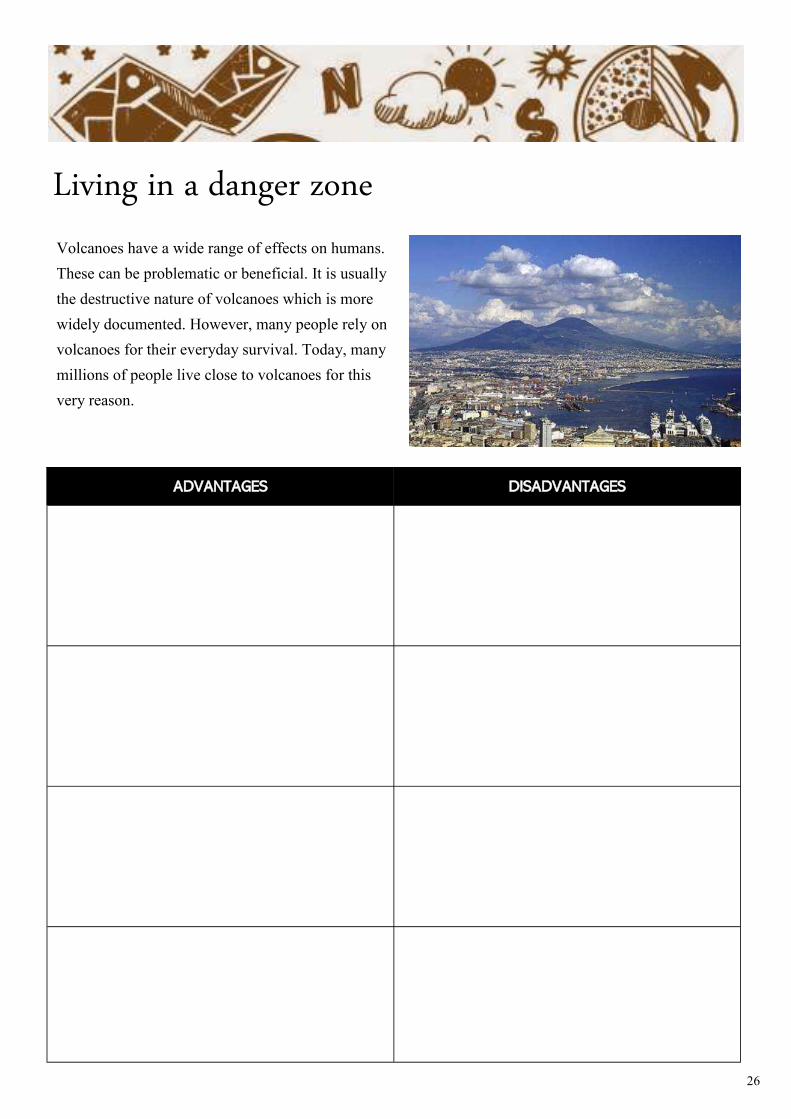
Living in a danger zone
Volcanoes have a wide range of effects on humans.
These can be problematic or beneficial. It is usually
the destructive nature of volcanoes which is more
widely documented. However, many people rely on
volcanoes for their everyday survival. Today, many
millions of people live close to volcanoes for this
very reason.
ADVANTAGES DISADVANTAGES
27
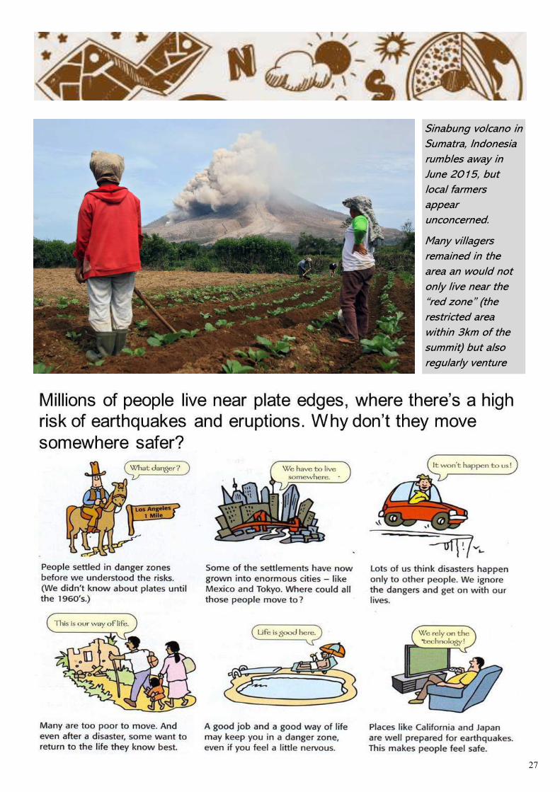
Sinabung volcano in
Sumatra, Indonesia
rumbles away in
June 2015, but
local farmers
appear
unconcerned.
Many villagers
remained in the
area an would not
only live near the
“red zone” (the
restricted area
within 3km of the
summit) but also
regularly venture
28
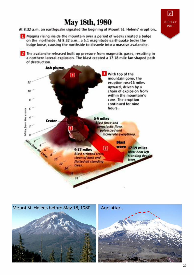
Mount St. Helens
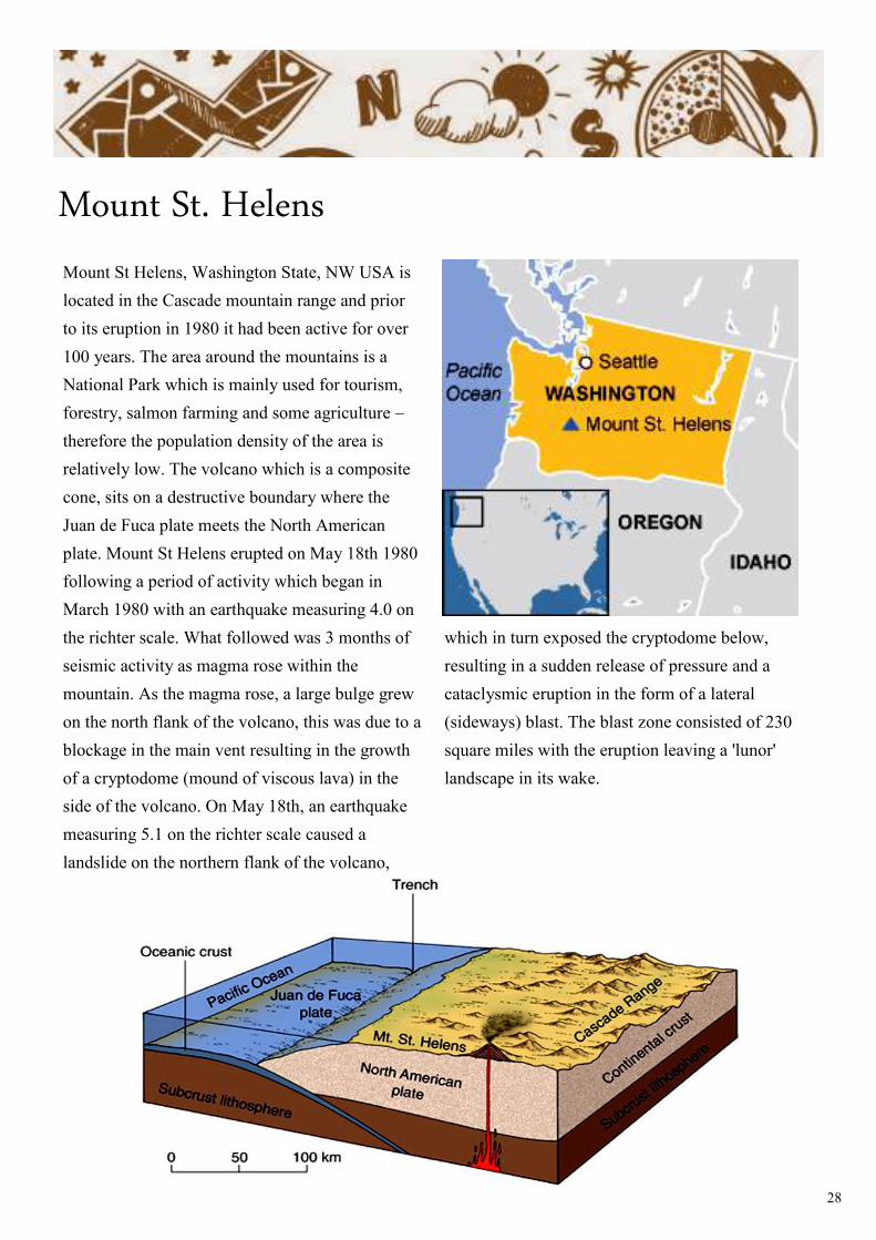
Mount St Helens, Washington State, NW USA is
located in the Cascade mountain range and prior
to its eruption in 1980 it had been active for over
100 years. The area around the mountains is a
National Park which is mainly used for tourism,
forestry, salmon farming and some agriculture –
therefore the population density of the area is
relatively low. The volcano which is a composite
cone, sits on a destructive boundary where the
Juan de Fuca plate meets the North American
plate. Mount St Helens erupted on May 18th 1980
following a period of activity which began in
March 1980 with an earthquake measuring 4.0 on
the richter scale. What followed was 3 months of
seismic activity as magma rose within the
mountain. As the magma rose, a large bulge grew
on the north flank of the volcano, this was due to a
blockage in the main vent resulting in the growth
of a cryptodome (mound of viscous lava) in the
side of the volcano. On May 18th, an earthquake
measuring 5.1 on the richter scale caused a
landslide on the northern flank of the volcano,
which in turn exposed the cryptodome below,
resulting in a sudden release of pressure and a
cataclysmic eruption in the form of a lateral
(sideways) blast. The blast zone consisted of 230
square miles with the eruption leaving a 'lunor'
landscape in its wake.
29
POINT OF INFO
30
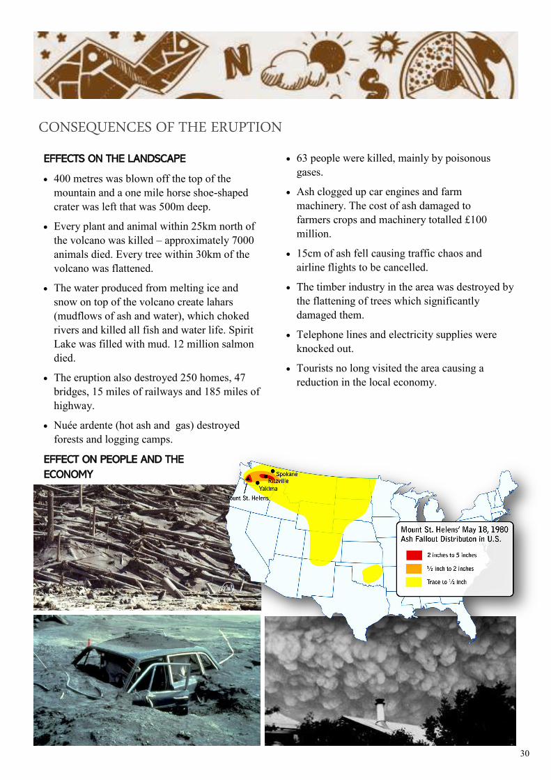
EFFECTS ON THE LANDSCAPE
• 400 metres was blown off the top of the
mountain and a one mile horse shoe-shaped
crater was left that was 500m deep.
• Every plant and animal within 25km north of
the volcano was killed – approximately 7000
animals died. Every tree within 30km of the
volcano was flattened.
• The water produced from melting ice and
snow on top of the volcano create lahars
(mudflows of ash and water), which choked
rivers and killed all fish and water life. Spirit
Lake was filled with mud. 12 million salmon
died.
• The eruption also destroyed 250 homes, 47
bridges, 15 miles of railways and 185 miles of
highway.
• Nuée ardente (hot ash and gas) destroyed
forests and logging camps.
EFFECT ON PEOPLE AND THE
ECONOMY
• 63 people were killed, mainly by poisonous
gases.
• Ash clogged up car engines and farm
machinery. The cost of ash damaged to
farmers crops and machinery totalled £100
million.
• 15cm of ash fell causing traffic chaos and
airline flights to be cancelled.
• The timber industry in the area was destroyed by
the flattening of trees which significantly
damaged them.
• Telephone lines and electricity supplies were
knocked out.
• Tourists no long visited the area causing a
reduction in the local economy.
CONSEQUENCES OF THE ERUPTION
31
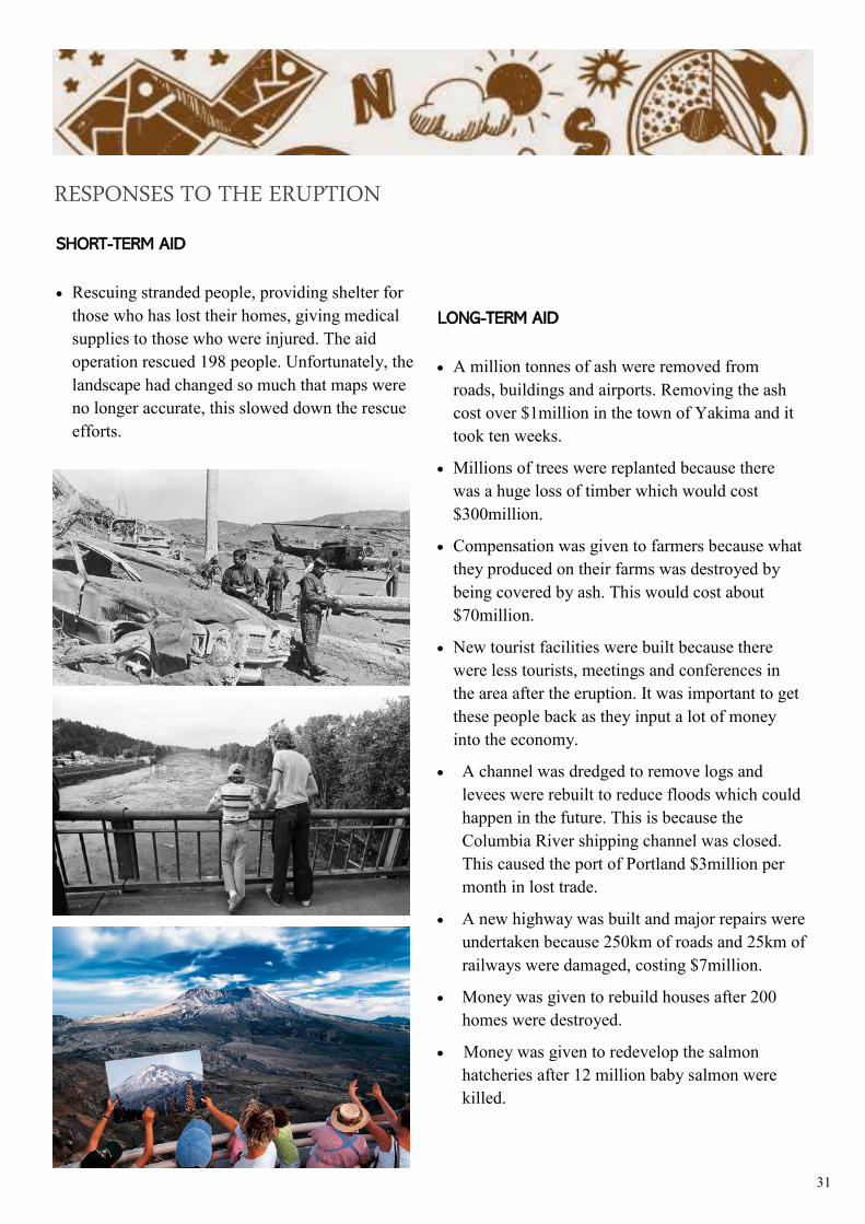
SHORT-TERM AID
• Rescuing stranded people, providing shelter for
those who has lost their homes, giving medical
supplies to those who were injured. The aid
operation rescued 198 people. Unfortunately, the
landscape had changed so much that maps were
no longer accurate, this slowed down the rescue
efforts.
LONG-TERM AID
• A million tonnes of ash were removed from
roads, buildings and airports. Removing the ash
cost over $1million in the town of Yakima and it
took ten weeks.
• Millions of trees were replanted because there
was a huge loss of timber which would cost
$300million.
• Compensation was given to farmers because what
they produced on their farms was destroyed by
being covered by ash. This would cost about
$70million.
• New tourist facilities were built because there
were less tourists, meetings and conferences in
the area after the eruption. It was important to get
these people back as they input a lot of money
into the economy.
• A channel was dredged to remove logs and
levees were rebuilt to reduce floods which could
happen in the future. This is because the
Columbia River shipping channel was closed.
This caused the port of Portland $3million per
month in lost trade.
• A new highway was built and major repairs were
undertaken because 250km of roads and 25km of
railways were damaged, costing $7million.
• Money was given to rebuild houses after 200
homes were destroyed.
• Money was given to redevelop the salmon
hatcheries after 12 million baby salmon were
killed.
RESPONSES TO THE ERUPTION
32
Date : ____________________ Name/location of volcano :
______________________
Tectonic plates :
_________________________________________________________
Type of plate boundary :
__________________________________________________
Causes : __________________________________________
ACTIVITY
2.8
_________________________________________________________________________
_________________________________________________________________________
_________________________________________________________________________
_________________________________________________________________________
_________________________________________________________________________
_________________________________________________________________________
_________________________________________________________________________
_________________________________________________________________________
_________________________________________________________________________
_________________________________________________________________________
_________________________________________________________________________
_________________________________________________________________________
_________________________________________________________________________
_________________________________________________________________________
_________________________________________________________________________
_________________________________________________________________________
_________________________________________________________________________
_________________________________________________________________________
_________________________________________________________________________
_________________________________________________________________________
_________________________________________________________________________
Research some information about a famous volcanic eruption :
Volcanic eruption profile
33
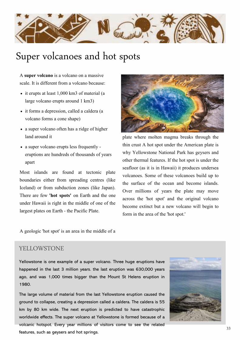
Super volcanoes and hot spots
A super volcano is a volcano on a massive
scale. It is different from a volcano because:
• it erupts at least 1,000 km3 of material (a
large volcano erupts around 1 km3)
• it forms a depression, called a caldera (a
volcano forms a cone shape)
• a super volcano often has a ridge of higher
land around it
• a super volcano erupts less frequently -
eruptions are hundreds of thousands of years
apart
Most islands are found at tectonic plate
boundaries either from spreading centres (like
Iceland) or from subduction zones (like Japan).
There are few 'hot spots' on Earth and the one
under Hawaii is right in the middle of one of the
largest plates on Earth - the Pacific Plate.
A geologic 'hot spot' is an area in the middle of a
plate where molten magma breaks through the
thin crust A hot spot under the American plate is
why Yellowstone National Park has geysers and
other thermal features. If the hot spot is under the
seafloor (as it is in Hawaii) it produces undersea
volcanoes. Some of these volcanoes build up to
the surface of the ocean and become islands.
Over millions of years the plate may move
across the 'hot spot' and the original volcano
become extinct but a new volcano will begin to
form in the area of the 'hot spot.'
Yellowstone is one example of a super volcano. Three huge eruptions have
happened in the last 3 million years. the last eruption was 630,000 years
ago, and was 1,000 times bigger than the Mount St Helens eruption in
1980.
The large volume of material from the last Yellowstone eruption caused the
ground to collapse, creating a depression called a caldera. The caldera is 55
km by 80 km wide. The next eruption is predicted to have catastrophic
worldwide effects. The super volcano at Yellowstone is formed because of a
volcanic hotspot. Every year millions of visitors come to see the related
features, such as geysers and hot springs.
YELLOWSTONE
34
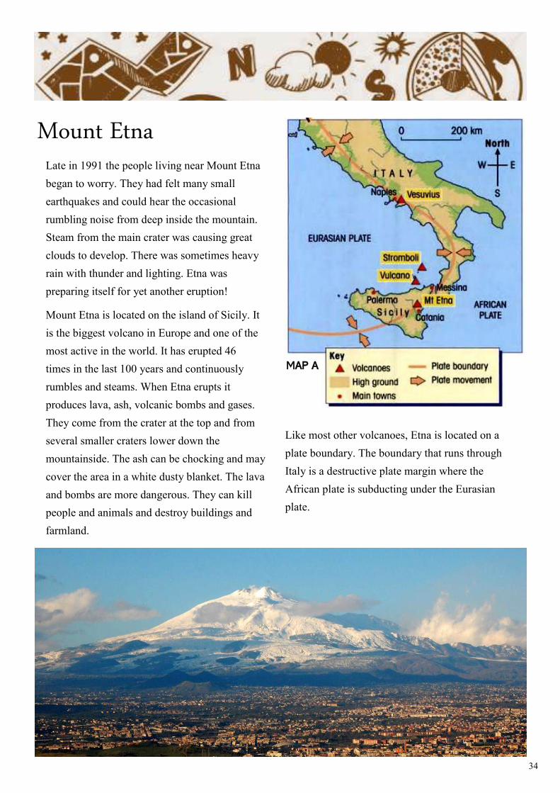
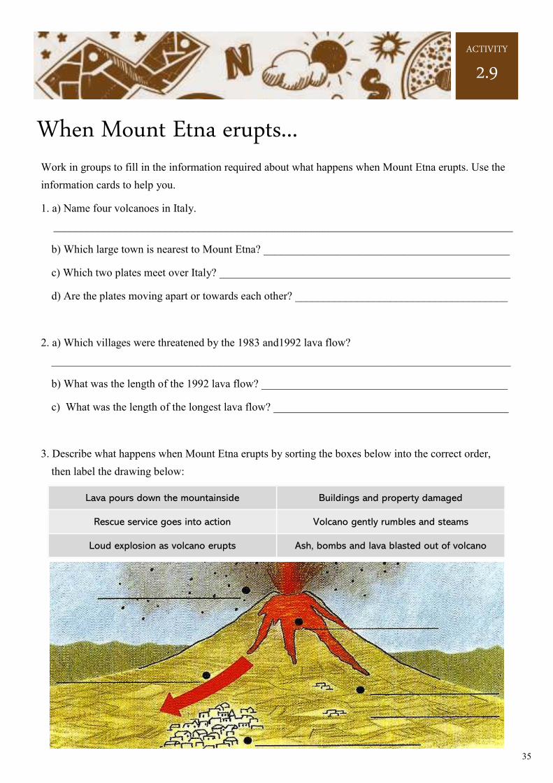
Mount Etna Late in 1991 the people living near Mount Etna
began to worry. They had felt many small
earthquakes and could hear the occasional
rumbling noise from deep inside the mountain.
Steam from the main crater was causing great
clouds to develop. There was sometimes heavy
rain with thunder and lighting. Etna was
preparing itself for yet another eruption!
Mount Etna is located on the island of Sicily. It
is the biggest volcano in Europe and one of the
most active in the world. It has erupted 46
times in the last 100 years and continuously
rumbles and steams. When Etna erupts it
produces lava, ash, volcanic bombs and gases.
They come from the crater at the top and from
several smaller craters lower down the
mountainside. The ash can be chocking and may
cover the area in a white dusty blanket. The lava
and bombs are more dangerous. They can kill
people and animals and destroy buildings and
farmland.
Like most other volcanoes, Etna is located on a
plate boundary. The boundary that runs through
Italy is a destructive plate margin where the
African plate is subducting under the Eurasian
plate.
MAP A
35
When Mount Etna erupts...
ACTIVITY
2.9
Work in groups to fill in the information required about what happens when Mount Etna erupts. Use the
information cards to help you.
1. a) Name four volcanoes in Italy.
__________________________________________________________________________________
b) Which large town is nearest to Mount Etna? ____________________________________________
c) Which two plates meet over Italy? ____________________________________________________
d) Are the plates moving apart or towards each other? ______________________________________
2. a) Which villages were threatened by the 1983 and1992 lava flow?
__________________________________________________________________________________
b) What was the length of the 1992 lava flow? ____________________________________________
c) What was the length of the longest lava flow? __________________________________________
3. Describe what happens when Mount Etna erupts by sorting the boxes below into the correct order,
then label the drawing below:
Lava pours down the mountainside Buildings and property damaged
Rescue service goes into action Volcano gently rumbles and steams
Loud explosion as volcano erupts Ash, bombs and lava blasted out of volcano
36
ACTIVITY
2.9
4. List six positive effects from the eruption of Mount Etna:
• _______________________________________________________________________________
• _______________________________________________________________________________
• _______________________________________________________________________________
• _______________________________________________________________________________
• _______________________________________________________________________________
• _______________________________________________________________________________
5. Fill in the table below. Sort the negative effects into the correct column:
6. The two farmers below live near to Mount Etna. Complete the sentences to explain their views.
Some problems caused by Mount Etna eruptions
FARMING TOURISM OTHER
Cont.
37
ACTIVITY
2.9
7. Zaffarena is a farming village 10km from the summit of Mount Etna. In 1991 an eruption lasted four
months.
a) When did the eruption start? _______________________________________________________
b) On what dates were army teams brought in? ___________________________________________
c) When was Zaffarena finally declared safe? ____________________________________________
d) How close to the village did the lava get?
______________________________________________________________________________
e) What three ways were tried to stop the lava?
______________________________________________________________________________
______________________________________________________________________________
______________________________________________________________________________
f) Why was building dams with bulldozers difficult?
______________________________________________________________________________
______________________________________________________________________________
g) What method of protection finally saved the village?
______________________________________________________________________________
8. Write down six points how damage and danger from an eruption can be reduced.
• ______________________________________________________________________________
• ______________________________________________________________________________
• ______________________________________________________________________________
Cont.
38
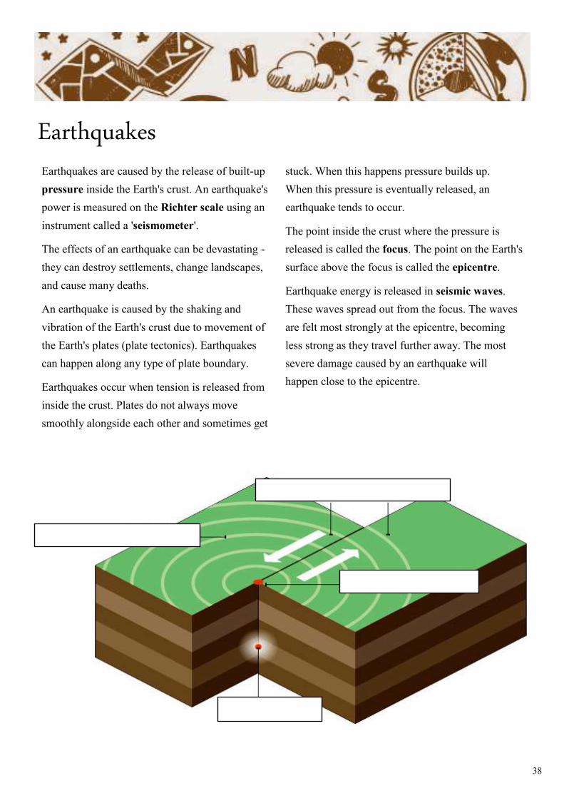
Earthquakes Earthquakes are caused by the release of built-up
pressure inside the Earth's crust. An earthquake's
power is measured on the Richter scale using an
instrument called a 'seismometer'.
The effects of an earthquake can be devastating -
they can destroy settlements, change landscapes,
and cause many deaths.
An earthquake is caused by the shaking and
vibration of the Earth's crust due to movement of
the Earth's plates (plate tectonics). Earthquakes
can happen along any type of plate boundary.
Earthquakes occur when tension is released from
inside the crust. Plates do not always move
smoothly alongside each other and sometimes get
stuck. When this happens pressure builds up.
When this pressure is eventually released, an
earthquake tends to occur.
The point inside the crust where the pressure is
released is called the focus. The point on the Earth's
surface above the focus is called the epicentre.
Earthquake energy is released in seismic waves.
These waves spread out from the focus. The waves
are felt most strongly at the epicentre, becoming
less strong as they travel further away. The most
severe damage caused by an earthquake will
happen close to the epicentre.
39
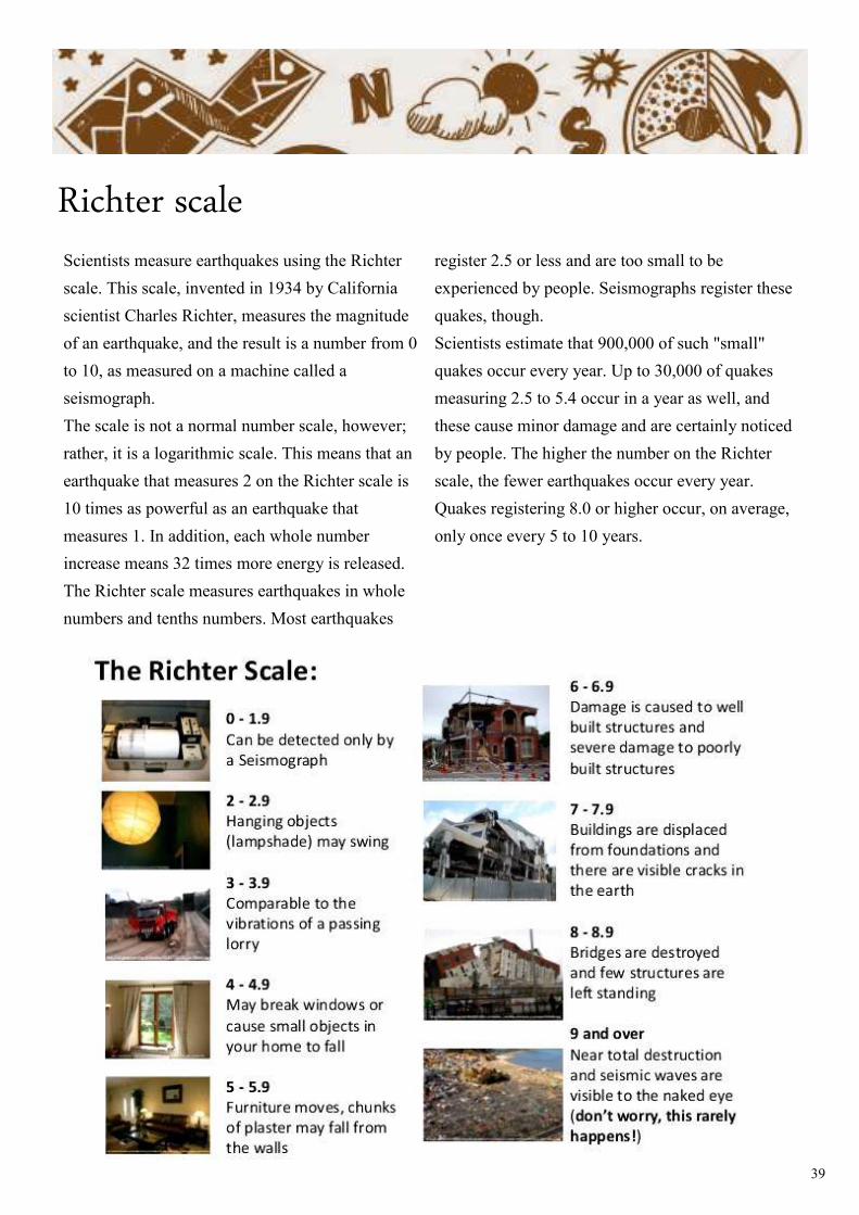
Richter scale Scientists measure earthquakes using the Richter
scale. This scale, invented in 1934 by California
scientist Charles Richter, measures the magnitude
of an earthquake, and the result is a number from 0
to 10, as measured on a machine called a
seismograph.
The scale is not a normal number scale, however;
rather, it is a logarithmic scale. This means that an
earthquake that measures 2 on the Richter scale is
10 times as powerful as an earthquake that
measures 1. In addition, each whole number
increase means 32 times more energy is released.
The Richter scale measures earthquakes in whole
numbers and tenths numbers. Most earthquakes
register 2.5 or less and are too small to be
experienced by people. Seismographs register these
quakes, though.
Scientists estimate that 900,000 of such "small"
quakes occur every year. Up to 30,000 of quakes
measuring 2.5 to 5.4 occur in a year as well, and
these cause minor damage and are certainly noticed
by people. The higher the number on the Richter
scale, the fewer earthquakes occur every year.
Quakes registering 8.0 or higher occur, on average,
only once every 5 to 10 years.
40
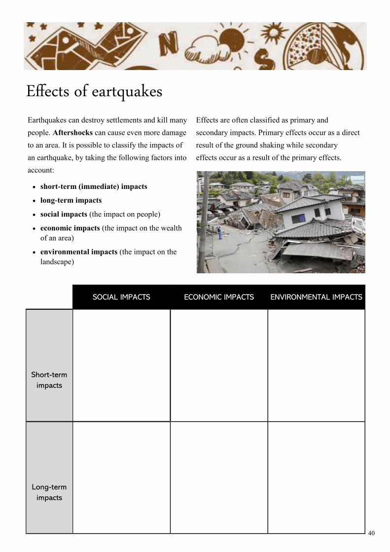
Effects of eartquakes
Earthquakes can destroy settlements and kill many
people. Aftershocks can cause even more damage
to an area. It is possible to classify the impacts of
an earthquake, by taking the following factors into
account:
• short-term (immediate) impacts
• long-term impacts
• social impacts (the impact on people)
• economic impacts (the impact on the wealth
of an area)
• environmental impacts (the impact on the
landscape)
Effects are often classified as primary and
secondary impacts. Primary effects occur as a direct
result of the ground shaking while secondary
effects occur as a result of the primary effects.
SOCIAL IMPACTS ECONOMIC IMPACTS ENVIRONMENTAL IMPACTS
Short-term
impacts
Long-term
impacts
41
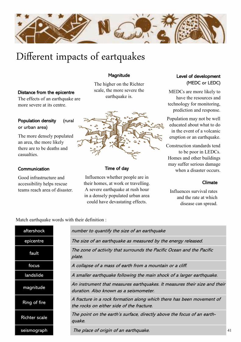
Different impacts of eartquakes
Distance from the epicentre
The effects of an earthquake are
more severe at its centre.
Magnitude
The higher on the Richter
scale, the more severe the
earthquake is.
Level of development
(MEDC or LEDC)
MEDCs are more likely to
have the resources and
technology for monitoring,
prediction and response.
Population may not be well
educated about what to do
in the event of a volcanic
eruption or an earthquake.
Construction standards tend
to be poor in LEDCs.
Homes and other buildings
may suffer serious damage
when a disaster occurs.
Population density (rural
or urban area)
The more densely populated
an area, the more likely
there are to be deaths and
casualties.
Communication
Good infrastructure and
accessibility helps rescue
teams reach area of disaster.
Time of day
Influences whether people are in
their homes, at work or travelling.
A severe earthquake at rush hour
in a densely populated urban area
could have devastating effects.
Climate
Influences survival rates
and the rate at which
disease can spread.
aftershock number to quantify the size of an earthquake
epicentre The size of an earthquake as measured by the energy released.
fault The zone of activity that surrounds the Pacific Ocean and the Pacific
plate.
focus A collapse of a mass of earth from a mountain or a cliff.
landslide A smaller earthquake following the main shock of a larger earthquake.
magnitude An instrument that measures earthquakes. It measures their size and their
duration. Also known as a seismometer.
Ring of fire A fracture in a rock formation along which there has been movement of
the rocks on either side of the fracture.
Richter scale The point on the earth’s surface, directly above the focus of an earth-
quake.
seismograph The place of origin of an earthquake.
Match earthquake words with their definition :
42
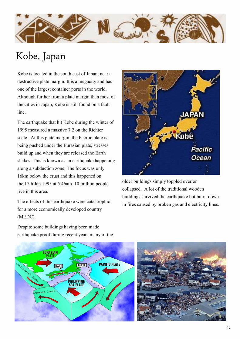
Kobe, Japan
Kobe is located in the south east of Japan, near a
destructive plate margin. It is a megacity and has
one of the largest container ports in the world.
Although further from a plate margin than most of
the cities in Japan, Kobe is still found on a fault
line.
The earthquake that hit Kobe during the winter of
1995 measured a massive 7.2 on the Richter
scale . At this plate margin, the Pacific plate is
being pushed under the Eurasian plate, stresses
build up and when they are released the Earth
shakes. This is known as an earthquake happening
along a subduction zone. The focus was only
16km below the crust and this happened on
the 17th Jan 1995 at 5.46am. 10 million people
live in this area.
The effects of this earthquake were catastrophic
for a more economically developed country
(MEDC).
Despite some buildings having been made
earthquake proof during recent years many of the
older buildings simply toppled over or
collapsed. A lot of the traditional wooden
buildings survived the earthquake but burnt down
in fires caused by broken gas and electricity lines.
43
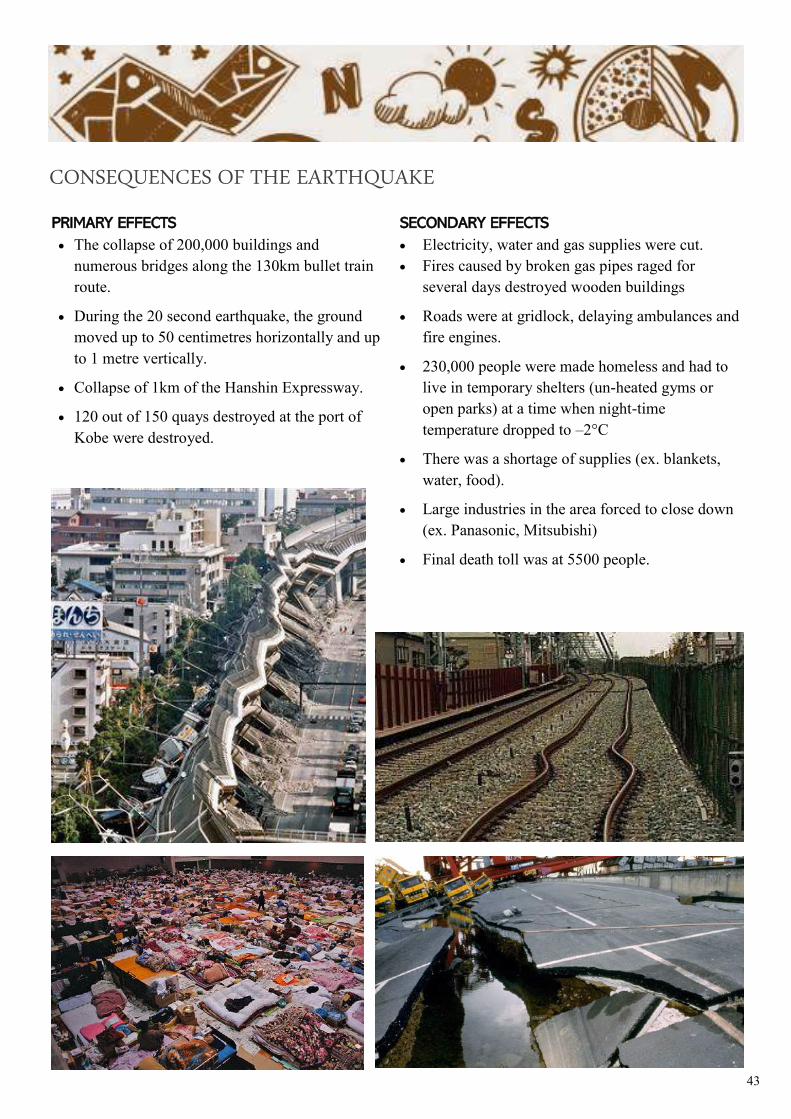
PRIMARY EFFECTS
• The collapse of 200,000 buildings and
numerous bridges along the 130km bullet train
route.
• During the 20 second earthquake, the ground
moved up to 50 centimetres horizontally and up
to 1 metre vertically.
• Collapse of 1km of the Hanshin Expressway.
• 120 out of 150 quays destroyed at the port of
Kobe were destroyed.
SECONDARY EFFECTS
• Electricity, water and gas supplies were cut.
• Fires caused by broken gas pipes raged for
several days destroyed wooden buildings
• Roads were at gridlock, delaying ambulances and
fire engines.
• 230,000 people were made homeless and had to
live in temporary shelters (un-heated gyms or
open parks) at a time when night-time
temperature dropped to –2°C
• There was a shortage of supplies (ex. blankets,
water, food).
• Large industries in the area forced to close down
(ex. Panasonic, Mitsubishi)
• Final death toll was at 5500 people.
CONSEQUENCES OF THE EARTHQUAKE
44
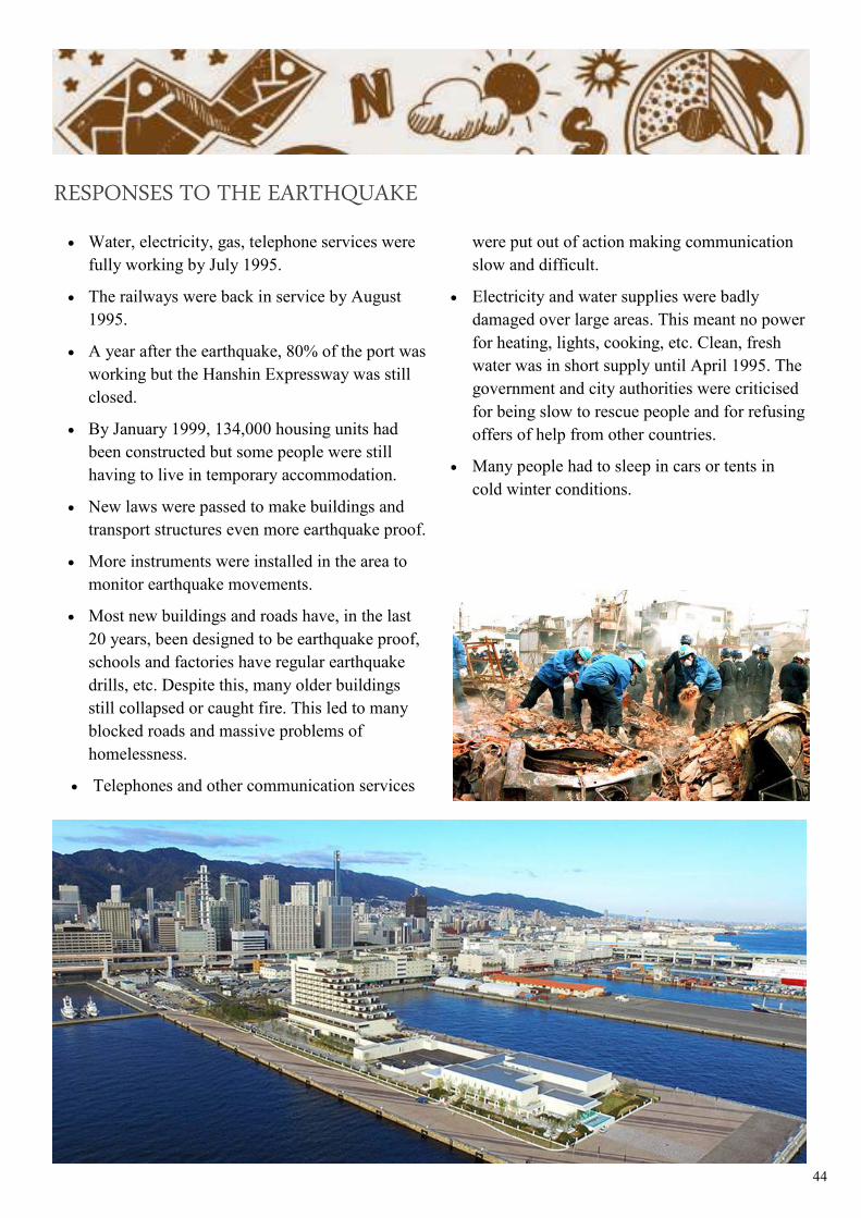
• Water, electricity, gas, telephone services were
fully working by July 1995.
• The railways were back in service by August
1995.
• A year after the earthquake, 80% of the port was
working but the Hanshin Expressway was still
closed.
• By January 1999, 134,000 housing units had
been constructed but some people were still
having to live in temporary accommodation.
• New laws were passed to make buildings and
transport structures even more earthquake proof.
• More instruments were installed in the area to
monitor earthquake movements.
• Most new buildings and roads have, in the last
20 years, been designed to be earthquake proof,
schools and factories have regular earthquake
drills, etc. Despite this, many older buildings
still collapsed or caught fire. This led to many
blocked roads and massive problems of
homelessness.
• Telephones and other communication services
were put out of action making communication
slow and difficult.
• Electricity and water supplies were badly
damaged over large areas. This meant no power
for heating, lights, cooking, etc. Clean, fresh
water was in short supply until April 1995. The
government and city authorities were criticised
for being slow to rescue people and for refusing
offers of help from other countries.
• Many people had to sleep in cars or tents in
cold winter conditions.
RESPONSES TO THE EARTHQUAKE
45
ACTIVITY
2.10
Research some information about a famous earthquake :
Earthquake profile
Date : ____________________ Name/location of volcano : ______________________
Tectonic plates : _________________________________________________________
Type of plate boundary : __________________________________________________
Causes : __________________________________________
_________________________________________________
_________________________________________________
_________________________________________________________________________
_________________________________________________________________________
_________________________________________________________________________
_________________________________________________________________________
_________________________________________________________________________
_________________________________________________________________________
_________________________________________________________________________
_________________________________________________________________________
_________________________________________________________________________
_________________________________________________________________________
_________________________________________________________________________
_________________________________________________________________________
_________________________________________________________________________
_________________________________________________________________________
_________________________________________________________________________
_________________________________________________________________________
_________________________________________________________________________
_________________________________________________________________________
_________________________________________________________________________
_________________________________________________________________________
_________________________________________________________________________
46
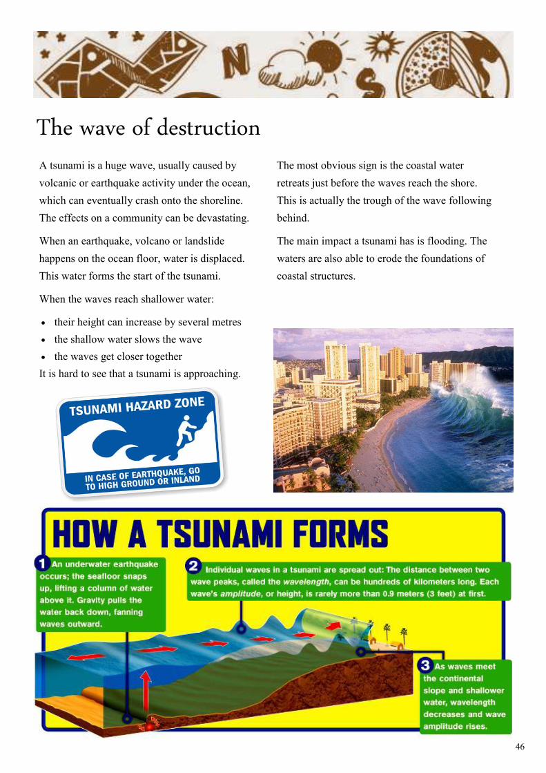
The wave of destruction A tsunami is a huge wave, usually caused by
volcanic or earthquake activity under the ocean,
which can eventually crash onto the shoreline.
The effects on a community can be devastating.
When an earthquake, volcano or landslide
happens on the ocean floor, water is displaced.
This water forms the start of the tsunami.
When the waves reach shallower water:
• their height can increase by several metres
• the shallow water slows the wave
• the waves get closer together
It is hard to see that a tsunami is approaching.
The most obvious sign is the coastal water
retreats just before the waves reach the shore.
This is actually the trough of the wave following
behind.
The main impact a tsunami has is flooding. The
waters are also able to erode the foundations of
coastal structures.
47
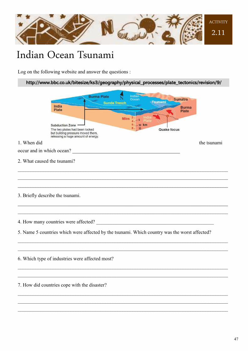
Indian Ocean Tsunami Log on the following website and answer the questions :
http://www.bbc.co.uk/bitesize/ks3/geography/physical_processes/plate_tectonics/revision/9/
1. When did the tsunami
occur and in which ocean? ___________________________________________
2. What caused the tsunami?
____________________________________________________________________________________
____________________________________________________________________________________
____________________________________________________________________________________
3. Briefly describe the tsunami.
____________________________________________________________________________________
____________________________________________________________________________________
4. How many countries were affected? _______________________________________________
5. Name 5 countries which were affected by the tsunami. Which country was the worst affected?
____________________________________________________________________________________
____________________________________________________________________________________
6. Which type of industries were affected most?
____________________________________________________________________________________
____________________________________________________________________________________
7. How did countries cope with the disaster?
____________________________________________________________________________________
____________________________________________________________________________________
____________________________________________________________________________________
ACTIVITY
2.11
48
Predict and prepare
It's not possible to prevent earthquakes and
volcanic eruptions. However, careful
management of these hazards can minimise the
damage that they cause. Prediction is the most
important aspect of this, as this gives people time
to evacuate the area and make preparations for
the event. Unfortunately volcanic eruptions and
earthquakes cannot be prevented. Managing
hazards such as earthquakes and volcanoes can be
done by prediction and preparation.
PREDICTING AN ERUPTION
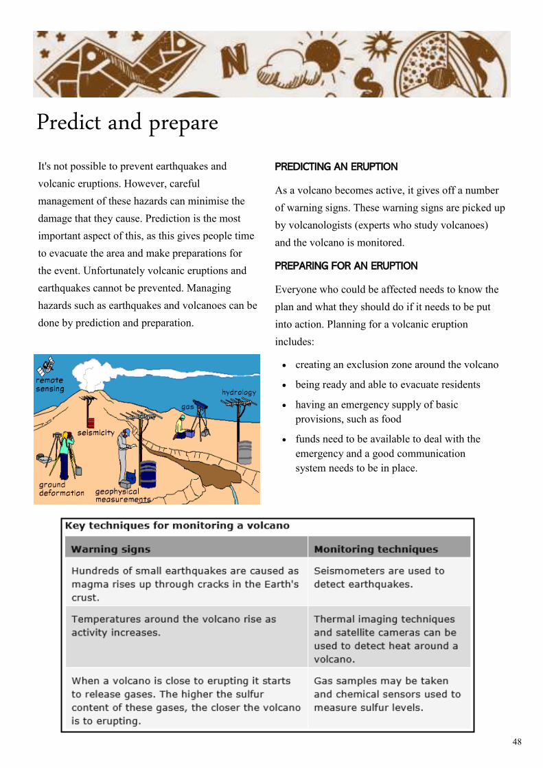
As a volcano becomes active, it gives off a number
of warning signs. These warning signs are picked up
by volcanologists (experts who study volcanoes)
and the volcano is monitored.
PREPARING FOR AN ERUPTION
Everyone who could be affected needs to know the
plan and what they should do if it needs to be put
into action. Planning for a volcanic eruption
includes:
• creating an exclusion zone around the volcano
• being ready and able to evacuate residents
• having an emergency supply of basic
provisions, such as food
• funds need to be available to deal with the
emergency and a good communication
system needs to be in place.
49
PREDICTING AN EARTHQUAKE
Earthquakes are not as easy to predict as volcanic
eruptions. However, there are still some ways of
monitoring the chances of an earthquake:
• Laser beams can be used to detect plate
movement.
• A seismometer is used to pick up
the vibrations in the Earth's crust. An increase
in vibrations may indicate a possible
earthquake.
• Radon gas escapes from cracks in the Earth's
crust. Levels of radon gas can be monitored - a
sudden increase may suggest an earthquake.
PREPARING FOR AN ERUPTION
Many of the prediction techniques used to monitor
earthquakes are not 100 per cent reliable. Planning
and preparing for an earthquake is therefore very
important.
• People living in earthquake zones need to know
what they should do in the event of a
quake. Training people may involve
holding earthquake drills and educating people
via TV or radio.
• People may put together emergency kits and
store them in their homes. An emergency kit
may include first-aid items, blankets and tinned
food.
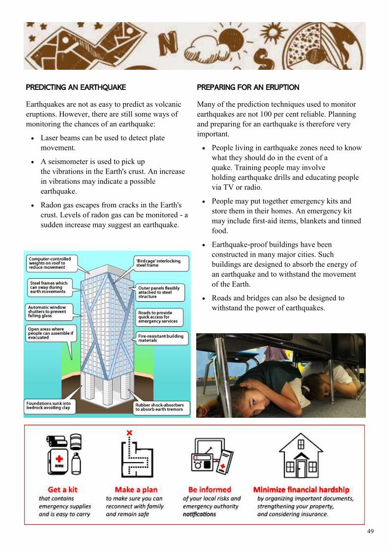
• Earthquake-proof buildings have been
constructed in many major cities. Such
buildings are designed to absorb the energy of
an earthquake and to withstand the movement
of the Earth.
• Roads and bridges can also be designed to
withstand the power of earthquakes.
50
Glossary
aftershock a smaller earthquake following the main shock of a large earthquake.
continental drift the gradual movement of the continents across the earth's surface through geological time.
convection currents very hot material at the deepest part of the mantle rising, then cooling, sinking again and then heating, rising and repeating the cycle over and over.
crust the outer layer of the earth made up of solid rock layer upon which we live.
core the hottest part at the centre of the Earth which with its immense heat energy, the inner core is like the engine room of the planet
earthquake a sudden violent shaking of the ground, typically causing great destruction, as a result of movements within the earth's crust or volcanic action.
epicentre the point on the earth's surface vertically above the focus of an earthquake.
fault a fracture along which the rocks have been displaced.
focus the point of origin of an earthquake unerneath the crust.
fold mountains form mainly by the effects of folding on layers within the upper part of the Earth's crust.
geothermal energy thermal energy generated and stored in the Earth.
hot spot a place deep within the Earth where hot magma rises to just underneath the surface, creating a bulge and volcanic activity.
igenous rock a type of rock formed through the cooling and solidification of magma or lava.
lahars a destructive mudflow on the slopes of a volcano.
landslide a collapse of a mass of earth or rock from a mountain or cliff.
lava the resulting rock after solidification and cooling of magma coming out of a volcano.
magma molten rock located deep within the mantle of the Earth that comes to the surface through the eruption of volcanoes .
51
mantle the layer between the earth’s crust and the outer core made up of semi-molten rock.
metamorphic rock rock that was once one form of rock but has changed to another under the influence of heat or pressure.
nueé ardente a cloud of gas, ash, and lava fragments ejected from a volcano, typically as part of a pyroclastic flow.
plate a massive, irregularly shaped slab of solid rock which floats on the mantle.
plate boundary/margin the locations where two tectonic plates meet.
plate tectonics the theory that Earth's outer shell is divided into several plates that glide over the mantle.
pyroclastic flow a dense, destructive mass of very hot ash, lava fragments, and gases ejected explosively from a volcano and typically flowing at great speed.
Richter scale a numerical scale for expressing the magnitude of an earthquake.
seismometer an instrument that measures and records details of earthquakes, such as force and duration.
seismic waves A wave in the earth produced by an earthquake.
subduction zone a plate boundary where two plates converge, and one plate is forced beneath the other.
trench a long, narrow, deep depression in the ocean bed, typically one running parallel to a plate boundary and marking a subduction zone.
vent the main outlet for the magma to escape.