PLANNING STATEMENT APRIL 2020 - Lea Bridge Gasworks
58
PLANNING STATEMENT APRIL 2020
Transcript of PLANNING STATEMENT APRIL 2020 - Lea Bridge Gasworks

PLANNING STATEMENTAPRIL 2020

Planning statement
PLANNING STATEMENT LEA BRIDGE GASWORKS
APRIL 2020 ST WILLIAM LLP
Quod | Lea Bridge Gasworks | Planning Statement | April 2020
Contents
1 Introduction ______________________________________________________________________ 1
2 An Introduction to St William ________________________________________________________ 3
3 The Benefits of the Application _______________________________________________________ 4
4 Supporting Application Documents ___________________________________________________ 5
5 The Site & Surrounding Area _________________________________________________________ 7
6 Pre-Application Engagement________________________________________________________ 10
7 The Proposed Scheme _____________________________________________________________ 14
8 Planning Policy ___________________________________________________________________ 18
9 Gasworks Planning Policy __________________________________________________________ 24
10 Housing Considerations ____________________________________________________________ 28
11 Other Considerations _____________________________________________________________ 41
12 Planning Obligations and CIL ________________________________________________________ 53
13 Conclusions _____________________________________________________________________ 55

Quod | Lea Bridge Gasworks | Planning Statement | April 2020
1
1 Introduction 1.1 This Planning Statement has been prepared by Quod on behalf of St William Homes LLP (the
‘Applicant’) to support a detailed planning application (the ‘Planning Application’) to the London
Borough of Waltham Forest (‘LBWF’) in relation to a residential-led development on land known as Lea
Bridge Gasworks (the ‘Site’).
1.2 Full Planning permission is sought for the following (the ‘Proposed Development’):
A comprehensive phased development comprising demolition of existing buildings and structures, and
erection of buildings to provide a mixed use scheme including 573 residential units (Use Class C3) in 10
buildings ranging from 2 to 18 storeys, 582m2 flexible residential facilities and commercial uses (Use
Classes A1, A2, A3, A4, B1, C3, D1 and D2), together with public open space; public realm works and
landscaping; car and cycle parking; servicing arrangements; sustainable energy measures; formation
of new pedestrian and cycle access onto Clementina Road; formation of new pedestrian, cycle and
vehicular access onto Orient Way; means of access and circulation within the site; and site preparation
works.
1.3 The Planning Application is submitted to LBWF and will be referred to the Greater London Authority
(the ‘GLA’) as a PSI application owing to it comprising development of more than 150 residential units
and buildings of more than 30 metres outside the City of London (Part 1 Category 1A and 1C(c)
respectively.
1.4 The Planning Application is an Environmental Impact Assessment (‘EIA’) application for the purposes
of the Town and Country Planning (Environmental Impact Assessment) Regulations 2017.
1.5 The Site comprises three decommissioned gas holders on 2.64 hectares (ha) of land, located to the
south of the junction of Perth Road/Clementina Road. Neighbouring the Site is land which contains a
Pressure Reduction Station (PRS). The PRS sits outside of the redline planning application boundary.
1.6 The Proposed Development presents an excellent opportunity to optimise development on a
constrained and underutilised former utility site and contributes to wider regeneration and housing
delivery aspirations of the LBWF.
1.7 The proposals have been subject to extensive pre-application discussion and consultation with the
LBWF, the GLA, the Design Council, statutory consultees, local stakeholders and members of the public.
A number of key planning issues have been identified and resolved as part of the pre-application
process.
1.8 The purpose of this Planning Statement is to define and assess the planning issues arising from the
Proposed Development. This Planning Statement is structured as follows:
• Section 2 – An Introduction to St William
• Section 3 – The Benefits of the Planning Application: This section discusses the public benefits
arising out of the Planning Application which are positive material considerations which weigh
in favour of the Planning Application.

Quod | Lea Bridge Gasworks | Planning Statement | April 2020
2
• Section 4 – Supporting Application Documents: This section lists the suite of supporting
documents that accompany the Planning Application.
• Section 5 – Site and Surrounding Area: This section describes the Site and Surrounding Area to
provide a context to the Planning Application.
• Section 6 – Pre-Application Engagement: This section explains the public consultation that has
been undertaken to help inform the proposals and ensure that local stakeholders understand
the component parts of the application prior to submission.
• Section 7 – The Proposed Scheme: This section sets out the Proposed Development describing
the detailed components of the scheme.
• Section 8 – Planning Policy: This section provides commentary on the nature of the
development in the context of local development plan policy and national planning policy and
guidance.
• Section 9 – Gasworks Planning Policy: This section sets out policy relevant to former utility
sites.
• Section 10 – Housing Considerations: This section discusses the relevant planning issues arising
out of the delivery of residential floorspace at the Site.
• Section 11 – Other Considerations: This section provides commentary on other non-residential
planning matters arising from the Planning Application.
• Section 12 – Planning Obligations and CIL: This section addresses issues relating to Section 106
and the Community Infrastructure Levy (‘CIL’).
• Section 13 – Conclusions: This section draws conclusions from the assessment of planning
considerations undertaken.

Quod | Lea Bridge Gasworks | Planning Statement | April 2020
3
2 An Introduction to St William 2.1 The Applicant (St William Homes LLP) is a joint venture between the Berkeley Group and National Grid
Property Holdings Ltd (‘National Grid’) with the objective of bringing forward gasworks sites for major
residential and mixed-use development schemes across London and the South East.
2.2 The partnership, named St William Homes LLP ("St William"), brings together access to a significant
portfolio of brownfield land owned by National Grid Property in key areas of housing need with
Berkeley's expertise to design, build and market new developments.
2.3 St William has the potential to provide over 20,000 homes in twelve boroughs across Greater London.
It will combine the design expertise of Berkeley with National Grid Property's portfolio of redundant
brownfield sites to create some fantastic new places for people to live.
2.4 These sites could see 231 acres of land remediated and restored to play a positive, useful role in each
community. The developments will offer a broad mix of housing and a wide range of tenures from
social rented and shared ownership properties, to homes for first time buyers and families,
accommodation for senior living, and private apartments.
2.5 Gasholder sites form an integral part of the emerging London Plan. They are identified as a strategic
source of housing, and are exempt from the commercial floorspace capacity test. The Mayor has also
confirmed in his response to the London Plan EIP that they are subject to the 35% Fastrack Approach.
2.6 The Government’s National Planning Policy Framework (NPPF) supports the redevelopment of
contaminated brownfield land for housing. It seeks to optimise land for housing.
2.7 St William intend to develop land at Lea Bridge Gasworks, Perth Road, for residential development.
The Gasworks site area is 2.64 hectares, and the vision of the project is to create a well-connected
urban community uniquely located to access green space and recreation at Leyton Jubilee Park, the
Lea Valley and beyond.
2.8 The Berkeley Group has a history of achieving economic and social sustainability objectives through
recognised and tested programmes providing benefit to their local communities. These programmes
and activities will be applied to the Site to ensure not only that the environment will be enhanced, but
that the Applicant will engage with and enhance the local community which will be of benefit in social
and economic terms.
2.9 The Berkeley Group Economic Contribution Report (2014) demonstrated that every home they build
sustains 5.6 jobs; on the Site this equates to 3,209 jobs. In addition to jobs sustained by new
development, during construction the Applicant will be adopting the principles of the National Skills
Academy for Construction to develop and implement and Employment and Skills Strategy through on-
site training.
2.10 More widely, the Berkeley Foundation has committed more that £13 million to the voluntary sector in
London and the South of England, and supported more than 15,000 people to move out of
homelessness, build their skills, move into work or access new opportunities.

Quod | Lea Bridge Gasworks | Planning Statement | April 2020
4
3 The Benefits of the Application 3.1 The Planning Application proposes a number of significant public benefits for LBWF, the local
community and future occupiers. These are material benefits which weigh in favour of a grant of
planning permission and are set out below:
• The opportunity to deliver a significant quantum of new housing, including affordable homes
and family sized units. This will be a meaningful contribution towards the Borough’s housing
need and housing choice. The Site will deliver 573 new homes, 35% of which will be affordable
housing by habitable room, comprising a policy compliant split of affordable/social rented
units and intermediate units (70:30 tenure split).
• The creation of access into Leyton Jubliee Park, new open space and public realm, including
children’s playspace and landscaping features which would serve the needs of existing and
future residents and the wider community; and result in tangible improvements to biodiversity
and ecology.
• Opening up an impermeable site to the wider local community. The development will create
a new public square off Clementina Road, where no public space exists at present, providing
spatial relief and new open space. Routes through the site will lead to Leyton Jubilee Park.
• An appropriate townscape response to the Site and surrounding area, which considers the
scale and nature of recent and future anticipated change in the surrounding area and the
requirement to provide much needed market and affordable homes, optimising the site at its
boundaries with Leyton Jubilee Park.
• A development that seeks to support sustainable environmental objectives through taking
steps to achieve reductions in energy consumption, carbon, water usage and waste
production.
• It is estimated that the construction works would generate approximately 277 construction
jobs per annum over the duration of the construction programme for the Development. The
number of people working on-site will vary considerable over the programme above and
below this average.
• Up to £10.1 million per annum in additional spending in the area from residents and
employees to boost the local economy.
• A managed development within the Berkeley Group which includes on-site concierge, and a
management plan to ensure that maintenance of the external and internal building areas are
managed with a high quality and effective plan.
• The Proposed Development comprises a high quality and sustainable design that respects the
evolving surrounding context and optimises the Site by creating new homes and jobs that
would directly support the economic growth and competitiveness of the capital and support
the regeneration of outer London generally.
• Contributions towards Mayoral and Borough CIL.

Quod | Lea Bridge Gasworks | Planning Statement | April 2020
5
4 Supporting Application Documents 4.1 The application is supported by the following documents, which has been agreed with the LBWF prior
to submission.
Table 4.1 – Planning Application Documents List
Document Author
Application Forms
Planning Application Forms, Certificates & Notices Quod
CIL Information Form Quod
Cover Letter Quod
Application Fee St William Homes LLP
Design Principles
Design & Access Statement (inc. Landscaping Details) PTE & BMD
Drawings and Accommodation Schedule
Drawing Schedule PTE
Accommodation Schedule PTE
Red Line Boundary & Site Location Plan PTE
Existing & Proposed Plans PTE
Landscape Plans BMD
Stand Alone Assessments
Planning Statement Quod
Transport Assessment & Travel Plan TPP
Car Park Management Plan TPP
Delivery Servicing Management Plan TPP
Energy & Sustainability Statement Vector
Internal Daylight & Sunlight Assessment EB7
Fire Statement FDS
Outline Remediation Strategy Ramboll
Environmental Site Assessment Ramboll
Flood Risk Assessment and Drainage Strategy Ramboll
Noise and Vibration Impact Assessment Cole Jarman
Ecology Report Ecology Solutions
Habitat Regulations Assessment (HRA) Ecology Solutions
Tree Survey/Arboricultural Impact Assessment Keen
Archaeological Desk Based Assessment RPS
Construction Environmental Management Plan
(CEMP)
St William Homes LLP
Statement of Community Involvement BECG
Health Impact Assessment – ‘Watch out for Health’
Screening Assessment
Addressed within Socio Economic Impact
Assessment of EIA
The Proposed Development is EIA Development for which an Environmental Impact Assessment is
required in accordance with the Town and Country Planning (Environmental Impact Assessment)
Regulations 2017. Accordingly, an Environmental Statement has been prepared in accordance with the
Quod | Lea Bridge Gasworks | Planning Statement | April 2020
6
regulations and accompanies the planning application. The Environmental Statement contains the
following chapters:
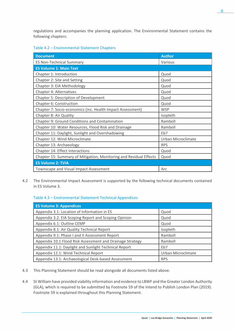
Table 4.2 – Environmental Statement Chapters
Document Author
ES Non-Technical Summary Various
ES Volume 1: Main Text
Chapter 1: Introduction Quod
Chapter 2: Site and Setting Quod
Chapter 3: EIA Methodology Quod
Chapter 4: Alternatives Quod
Chapter 5: Description of Development Quod
Chapter 6: Construction Quod
Chapter 7: Socio-economics (inc. Health Impact Assessment) WSP
Chapter 8: Air Quality Isopleth
Chapter 9: Ground Conditions and Contamination Ramboll
Chapter 10: Water Resources, Flood Risk and Drainage Ramboll
Chapter 11: Daylight, Sunlight and Overshadowing Eb7
Chapter 12: Wind Microclimate Urban Microclimate
Chapter 13: Archaeology RPS
Chapter 14: Effect Interactions Quod
Chapter 15: Summary of Mitigation, Monitoring and Residual Effects Quod
ES Volume 2: TVIA
Townscape and Visual Impact Assessment Arc
4.2 The Environmental Impact Assessment is supported by the following technical documents contained
in ES Volume 3.
Table 4.3 – Environmental Statement Technical Appendices
ES Volume 3: Appendices
Appendix 3.1: Location of Information in ES Quod
Appendix 3.2: EIA Scoping Report and Scoping Opinion Quod
Appendix 6.1: Outline CEMP Quod
Appendix 8.1: Air Quality Technical Report Isopleth
Appendix 9.1: Phase I and II Assessment Report Ramboll
Appendix 10.1 Flood Risk Assessment and Drainage Strategy Ramboll
Appendix 11.1: Daylight and Sunlight Technical Report Eb7
Appendix 12.1: Wind Technical Report Urban Microclimate
Appendix 13.1: Archaeological Desk-based Assessment RPS
4.3 This Planning Statement should be read alongside all documents listed above.
4.4 St William have provided viability information and evidence to LBWF and the Greater London Authority
(GLA), which is required to be submitted by Footnote 59 of the Intend to Publish London Plan (2019).
Footnote 59 is explained throughout this Planning Statement.

Quod | Lea Bridge Gasworks | Planning Statement | April 2020
7
5 The Site & Surrounding Area Site Location
5.1 The Site extends to 2.64ha and is situated within the Lea Bridge ward of Waltham Forest.
5.2 The Site contains limited built floorspace. The Site has recently undergone demolition works; it
formally contained three decommissioned gas holders: two spiral gasholders with above ground tanks
and a smaller telescopic gasholder with a below ground tank. The footprint of the three gasholders
remain along with a building containing a lobby, telemetry system and a diesel tank in the centre of
the Site alongside extant hardstanding and concrete roadways.
5.3 As a result of the rationalisation and modernisation of the exiting gas infrastructure on the Site, it is
available for redevelopment. There is not a net loss in capacity in the Site’s utility function because it
will continue to distribute gas via the on-site Pressure Reduction Station (PRS). The PRS is not included
within the redline boundary.
5.4 The Site is bound to the north by Clementina Road. To the south is Leyton Jubilee Park.
Figure 5.1 – Aerial Image of the Site
Figure 5.2: Red Line Planning Application Boundary

Quod | Lea Bridge Gasworks | Planning Statement | April 2020
8
5.5 The Site is not located within a Conservation Area, the closest being 1.25km south-east of the Site
Boundary. The Site does not contain any statutorily listed buildings, the closest being the Parish Church
of Emmanuel (Grade II listed), located approximately 340m north-east of the site boundary, and ‘Ice
House’ at St Josephs Roman Catholic School (Grade II listed), located approximately 380m south-east
of the site boundary.
5.6 The Site is located within an Archaeological Priority Area. The majority of the site is also located within
Flood Risk Zone 2, with some of the site within Flood Risk Zone 3.
Description of the Surrounding Area
5.7 The site is bound by a variety of land uses. The eastern and southern boundary, totals approximately
470m in length, bounds Leyton Jubilee Park and playing fields. The western boundary of 270m bounds
the Orient Way Industrial Estate (also known as ‘Golden Business Park’). The northern boundary, the
shortest at 247m, bounds the Clementina Road residential estate. This residential boundary comprises
only 25% of the whole site.
5.8 The Orient Way Industrial Estate is allocated as Strategic Industrial Land (SIL), which comprises a range
of warehouse units. The SIL allocation extends across Orient Way and a National Rail railway line.
Further west of the site is Hackney Marshes and the River Lea. To the east of the site is the Lammas
School and Sixth Form and their playing fields. The Dagenham Brook runs along the school’s eastern
boundary.
5.9 As part of the Orient Way Industrial Estate, the adjacent Golden Business Park, is identified as a
Strategic Industrial Location for redevelopment in the Local Plan. The applicant has met with the
Council’s advisors, Avison Young, to discuss the proposals for rationalisation or intensification of the
SIL site. Avison Young have advised that they will be producing a policy document for the Council which
will likely be adopted Q3 2020.
5.10 Within the wider area there are a number of high-density mixed-use residential developments coming
forward. To the north west of the site is the redevelopment of 97 Lea Bridge Road, named Motion,
providing 300 residential units across three new buildings ranging from 12, 15 and 18 storeys in height
on a 0.59 hectare site (508 units / ha). Other nearby developments, Bywaters and Coronation Square,
are 15 and 18 storeys respectively.
5.11 Future regeneration plans around Lea Bridge station, on three Council owned sites, aim to provide
around 300 new homes, a new station entrance with public space, and cultural, creative and
commercial uses. The Council’s aspiration is for tall buildings in this location.
Site Accessibility
5.12 Public Transport Accessibility Level (PTAL) provides a measurement which rates locations by distance
from frequent public transport services, with a rating of 6b being best and 0 being the worst. The
existing site PTAL rating is 2. The PTAL of the surrounding area ranges from 1b to 3.
5.13 Notwithstanding its relatively low PTAL rating, the Site benefits from good transport links and is well
connected to public transport networks, including Lea Bridge railway station which is located
approximately 0.5 miles north-west of the site. Leyton Midland Road Overground station is located

Quod | Lea Bridge Gasworks | Planning Statement | April 2020
9
approximately 1 mile east of the site, whilst Leyton Underground station, served by the Central Line,
is located 1.5 miles south of the site.
5.14 The nearest bus stops to the Site are located on Lea Bridge Road, with future plans for buses to serve
Orient Way to the west of the site. Routes 55, 56, N38 and N55 currently serve Lea Bridge Road.
5.15 Cycle Superhighway 23 runs along Lea Bridge Road. Perth Road, Kettlebaston Road, Bloxhall Road,
Morieux Road and Seymour Road provide access to this route from and to the Site.
Relevant Planning History
5.16 LBWF’s online planning application portal lists the Prior Approval application for demolition of the
gasholders as the only application registered at the Site. The details of this application are shown
below:
Application Reference Address Description Decision & Date
180131
Former Gas Work Site,
Clementina Road,
Leyton E10 5YA
Prior Approval
Demolition
Prior Approval Not
Required
09/02/2018

Quod | Lea Bridge Gasworks | Planning Statement | April 2020
10
6 Pre-Application Engagement 6.1 The Applicant has undertaken extensive pre-application engagement and consultation with LBWF
Planning Officers, the Design Council, the Greater London Authority (GLA), statutory consultees, local
stakeholders and the local community since June 2019.
6.2 Regular meetings have been held with LBWF over the last 9 months to ensure that the emerging
proposals have been developed with input from planning officers. A series of topic-specific meetings
with LBWF Officers, Design Council, and a meeting with the GLA took place on the following dates:
• 18th June 2019 – Initial pre-application discussion with LBWF
• 3rd July 2019 – pre-application meeting with LBWF
• 17th July 2019 – pre-application meeting with LBWF
• 6th August 2019 – pre-application meeting with LBWF
• 13th August 2019 – pre-application meeting with LBWF
• 11th September 2019 – pre-application meeting with LBWF
• 19th September 2019 – Design Council: Design Review Panel
• 16th October 2019 – pre-application meeting with LBWF
• 22nd October 2019 – pre-application meeting with GLA
• 23rd October 2019 – pre-application meeting with LBWF
• 6th November 2019 – pre-application meeting with LBWF
• 13th November 2019 – pre-application meeting with LBWF
• 26th November 2019 – pre-application meeting with LBWF
• 4th December 2019 – pre-application meeting with LBWF
• 14th January 2020 – pre-application meeting with LBWF
• 29th January 2020 – pre-application meeting with LBWF
• 7th February 2020 – pre-application meeting with GLA
• 1st April 2020 – pre-application meeting with LBWF
6.3 The following provides a summary of the feedback and advice received during the pre-application
process. The Design and Access Statement describes in greater detail how the scheme has evolved to
respond to feedback received.

Quod | Lea Bridge Gasworks | Planning Statement | April 2020
11
LB Waltham Forest
6.4 A number of meetings have taken place with LBWF Planning Officers and feedback has been received
on an evolutionary basis. A summary of the key comments received from officers over the last 9
months is set out below:
• Advice relating to the location of Affordable Units across the site to deliver mixed and
sustainable communities.
• A request to reduce the car parking across the site.
• Support for vehicular access being from Orient Way.
• Request for the proposed development to consider further the relationship with the Former
Town Gas Works Site (SIL7) site.
• Support for connectivity and permeability between Leyton Jubilee Park and the residential
roads to the north, namely Clementina Road, Perth Road, Kettlebaston Road, Bloxhall Road,
Morieux Road and Seymour Road.
• SUDs & Drainage will be critical to the success of the scheme, and that the scheme needs to
achieve Greenfield Run-off rates.
• Blocks A, B and H have been well developed in relation to the adjacent homes on Clementina Road.
• Advice relating to the massing of Blocks D and E, ensuing their elevations are elegant with a
clear base, middle and top.
• Support for the principle of height up to 18-storeys in this location with advice given regarding
the breaking down of blocks to prevent a monolithic development.
• Discussion and advice regarding the relationship of Blocks B, C and D relationship with the
Golden Business Park, ensuring residential amenity is not impacted.
• Advice regarding the spaces between Blocks C, D, F and E to ensure this part of the site is not
dominated by parking and blank frontages, ensuring there is no lack of overlooking which could
encourage Antisocial Behaviour.
• Officers have stated their support for the predominantly brick-led material approach.
• Encouragement to increase the non-residential floorspace to include community use/nursery
floorspace within the scheme.
Design Council: Design Review Panel
6.5 The emerging proposals were presented to the Design Council on 19th September 2019. The Panel
provided a number of comments on the masterplan, building heights and massing, and the proposed

Quod | Lea Bridge Gasworks | Planning Statement | April 2020
12
landscape led approach and connections through the site. A summary of the Design Council’s feedback
is set out below and further details can be found in the Design and Access Statement:
• The design approach is sympathetic to the qualities and context of the site, and the landscape-
led approach is supported.
• Support for the different iterations of site layout, height and typology to achieve the desired
quantum and quality of design.
• There is an opportunity for a more refined approach to height and scale, moving beyond a
linear, incremental approach to increased building heights. Daylight and sunlight analysis
should be undertaken to inform further iterations of the height and massing of the southern
blocks.
• Support for the provision of open spaces across the site. The hierarchy and function of these
spaces could be further developed with greater clarity on which spaces are intended to be
public, which are semi-public, semi-private and private.
• Artefacts of the site’s previous function such as the brick of the original gasholder could be
reused in the landscape treatment or in other features to create a strong sense of place and
identity for the site.
• A request that the design team develop options for the Pressure Reduction Station land. What
would the future use be if this infrastructure was no longer required?
• Recommendation that the design team explore how the vehicular access could be addressed
in another ways, in order to create a more legible front and back to the western blocks and an
attractive pedestrian-led environment.
GLA
6.6 A summary of the advice received by the GLA, which is set out in their pre-application response letter
(ref. GLA/5295/01/TO) dated 24th February 2020, is outlined below:
• The principle of a residential-led redevelopment on this surplus utility site is supported in
principle.
• The remaining site’s function for utilities infrastructure is redundant. The release of land from
industrial use can be supported where it is part of a managed approach and where the release
supports strategic and local planning objectives, particularly to provide more housing.
• Within the Intend to Publish London Plan, Footnote 59 to paragraph 4.5.7 recognises that
some surplus utilities sites are subject to substantial decontamination, enabling and
remediation costs, and if it is robustly demonstrated that extraordinary decontamination,
enabling or remediation costs must be incurred to bring the site forward for development,
then a 35% affordable housing threshold could be applied, subject to detailed evidence,
including viability evidence, being made available.
• The scheme would deliver 35% affordable housing by habitable room. In line with Footnote
59, the proposed development would meet the relevant threshold for consideration under the

Quod | Lea Bridge Gasworks | Planning Statement | April 2020
13
Fast Track Route subject to detailed consideration of evidence, including viability evidence,
being made available and demonstrating that extraordinary costs incurred.
• The layout principles of the proposed scheme, providing public routes through the site,
stitching existing residential homes to Jubilee Park through green landscaped linear routes is
broadly a supported.
• The heights and massing arrangement across the masterplan area are broadly supported.
Locating taller buildings against open space is an appropriate response in this location.
• The arrangement of the 10 blocks provides adequate offset distances, to ensure the amenity
of properties within the development are unlikely to suffer harmful impacts by way of
overlooking or loss of privacy.
• No north facing single aspect dwellings are proposed which is supported.
• Clarity on how the PRS will function in the short-term or change in the long term, in respect of
potential environmental impact on residential dwellings in close proximity, should support any
subsequent application. Clarity on the appearance, boundary treatment and surrounding
landscaping are important to ensure that any potential harm is sufficiently mitigated.
• The new public spaces at Lea Bridge Gasworks will transform the character of Clementina Road
by removing walls and introducing activity.
Public Consultation
6.7 In addition to the pre-application engagement that has been carried out, public and stakeholder
consultation also took place between July 2019 and November 2019.
6.8 The consultation process was divided into two stages: initial consultation including initial
masterplanning and design strategies, and final designs.
6.9 A public drop-in exhibition was held on Thursday 18th July 2019 and Saturday 20th July 2019 at Lea
Bridge Library. A total of 97 people attended and 33 feedback forms were received.
6.10 A further exhibition was held on Thursday 14 November 2019 and Saturday 16 November 2019. A total
of 77 people attended and 25 feedback forms were received.
6.11 An FAQ leaflet was delivered on 18th April 2020 to the same 2,516 households that received invitations
for the public exhibition, addressing the common questions raised through the consultation.
6.12 Further details can be found within the Statement of Community Involvement.

Quod | Lea Bridge Gasworks | Planning Statement | April 2020
14
7 The Proposed Scheme 7.1 This section describes the Proposed Development and defines the principal components of the
scheme.
7.2 The application is accompanied by a comprehensive set of visuals and illustrative material, prepared
by Pollard Thomas Edwards, which together with the Design and Access Statement and technical
drawings illustrate and explain the rationale behind the design of the scheme.
Planning Application Boundary
7.3 The extent of works that planning permission is applied for are included within the ‘red line’ Planning
Application Boundary shown in Figure 6.1 below. The red line excludes Cadent’s Pressure Reduction
Station.
Figure 7.1: Red Line Planning Application Boundary
The Proposed Scheme
7.4 The Planning Application seeks detailed planning permission for the development as set out in the
description of development.
A comprehensive phased development comprising demolition of existing buildings and structures, and
erection of buildings to provide a mixed use scheme including 573 residential units (Use Class C3) in 10
buildings ranging from 2 to 18 storeys, 582m2 flexible residential facilities and commercial uses (Use
Classes A1, A2, A3, A4, B1, C3, D1 and D2), together with public open space; public realm works and
landscaping; car and cycle parking; servicing arrangements; sustainable energy measures; formation
of new pedestrian and cycle access onto Clementina Road; formation of new pedestrian, cycle and
vehicular access onto Orient Way; means of access and circulation within the site; and site preparation
works.

Quod | Lea Bridge Gasworks | Planning Statement | April 2020
15
7.5 The specific quantum of development will be set out and controlled by planning conditions. The
proposed residential mix for the detailed component is set out in Table 6.1.
Table 7.1: Residential (Use Class C3)
Type Proposed Area/Unit
Total Units 573
Total Unit Mix
58 x Manhattan (10%)
190 x 1 bedroom units (33%)
257 x 2 bedroom units (45%)
68 x 3 bedroom units (12%)
0 x 4 bedroom units (0%)
Total 573
Private Housing Mix
58 x Manhattan (14%)
149 x 1 bedroom units (36%)
189 x 2 bedroom units (45%)
19 x 3 bedroom units (5%)
0 x 4 bedroom units (0%)
Total 415
Shared Ownership & Affordable Rent
0 x Manhattan (0%)
41 x 1 bedroom units (26%)
68 x 2 bedroom units (43%)
49 x 3 bedroom units (31%)
0 x 4 bedroom units (0%)
Total 158
Affordable Housing Provision
35% by habitable room
30% by floorspace
27.5% by unit
Total Flexible Residential Facilities and Commercial
Uses 577m2
Amenity Space
Private residential balconies and terraces 3,723m2
Private communal garden/courtyard 3,424m2
Public open and amenity space 11,109m2
Children’s playspace (doorstep) 913m2

Quod | Lea Bridge Gasworks | Planning Statement | April 2020
16
Use, Layout and Building Heights
7.6 The proposals comprise 10 buildings ranging in height up to 18 storeys:
• Block A – at part 4, part 2 storeys;
• Block B – at part 6, part 5 storeys;
• Block C – at part 9, part 5 storeys;
• Block D – at part 18, part 7 storeys;
• Block E – at part 17, part 7 storeys;
• Block F – at part 11, part 5 storeys;
• Block G – at part 9, part 5 storeys;
• Block H – at part 4, part 3 storeys;
• Block I – at part 9, part 5 storeys;
• Block J – at part 9, part 5 storeys.
7.7 The site concierge and post room are located in Block A. Block B contains a residents gym, whilst Block
G contains a nursery with capacity for 50 children.
7.8 The general arrangement of the development is shown in Figure 7.2 below.
Table 7.2: General Arrangement

Quod | Lea Bridge Gasworks | Planning Statement | April 2020
17
Access
7.9 The proposal provides access from Orient Way which will form the main vehicular access to the
proposed development.
7.10 The Orient Way access will provide access to all car parking spaces, as well as access by refuse
collection and servicing/delivery vehicles.
7.11 The site’s internal road network has been designed to accommodate a large refuse vehicle, which will
be the largest vehicle that will access the site on a frequent basis.
7.12 The existing access points from the north will be designated for use by pedestrian and cyclists only and
no vehicular access is permitted from the north (except by emergency vehicles).
7.13 The development has been designed to be permeable, significantly enhancing access to/from areas to
the south and north of the site. There will be pedestrian and cyclist routes running across the site,
connecting the northern accesses to the Jubilee Park and Marsh Lane to the site. This permeability
allows residents to the north of the site direct access to Leyton Jubilee Park on-foot or by bicycle. It
will also provide direct access for cyclists to access the segregated cycle lane along Orient Way via the
development site. For residents living to the south west of the site, the new access routes will allow a
more direct route towards key local amenities along Lea Bridge Road, local bus stops as well as Lea
Bridge Station.
7.14 The internal road networks have been designed to push vehicular movements towards perimeter
roads as much as possible and minimise interfaces between the key pedestrian and cyclist routes with
vehicles. The blocks main entrances are mainly off the site’s walking and cycling only routes which will
further enhance safety and encourage Active Travel. In response to comments at the 1st April pre-app,
the DAS also provides details for the secondary block entrances designed for convenient access to bike
stores.
Parking
7.15 The following parking will be provided on site.
Table 7.2: Parking Provision
Type Count
Residential M4(3) Compliant Car Parking 40
Residential Standard Car Parking 8
Car Club Parking 2
Residential Cycle Parking 1,003 + 15 Visitor
Commercial Cycle Parking 9
7.16 Following discussions at the 1st April pre-application meeting, we have distributed the visitor cycle
stands around the site (by Block A, Block D, and Block J) and added a standalone secure cycle store for
use by nursery staff.

Quod | Lea Bridge Gasworks | Planning Statement | April 2020
18
8 Planning Policy 8.1 This section provides commentary on the nature of the Proposed Development in the context of
development plan policy and national planning policy guidance.
National Planning Policy and Guidance
National Planning Policy Framework (‘NPPF’) and Planning Practice Guidance (‘PPG’) (2019)
8.2 The NPPF was published in July 2018 and updated in February 2019, superseding the NPPF (2012).
8.3 The NPPF sets out the Government’s planning policies for England and how these are expected to be
applied. The NPPF contains national policy on a range of topic areas including decision-taking, viability,
affordable housing, design, open space, heritage, and the economy. The “presumption in favour of
sustainable development” remains the central tenet of the NPPF.
8.4 The NPPF refers specifically to the need to deliver more homes, at a greater density, on brownfield
land, identifying contaminated land as an opportunity which should not be overlooked.
8.5 The Government’s objective of “significantly boosting the supply of homes” is a clear national policy
objective contained in the first paragraph of Chapter 5 of the NPPF, Delivering a Sufficient Supply of
Homes.
8.6 National policy requires strategic policy-making authorities to have a clear understanding of the land
available in their area through the preparation of a strategic housing land availability assessment. From
this, planning policies should identify a sufficient supply and mix of sites, taking into account their
availability, suitability and likely economic viability. Local planning authorities should identify and
update annually a supply of specific deliverable sites sufficient to provide a minimum of five years’
worth of housing against their housing requirement set out in adopted strategic policies, or against
their local housing need where the strategic policies are more than five years old.
8.7 Chapter 11 of the NPPF sets out policies for Making Effective Use of Land. Planning policies and
decisions should promote an effective use of land in meeting the need for homes and other uses, while
safeguarding and improving the environment and ensuring safe and healthy living conditions. Strategic
policies should set out a clear strategy for accommodating objectively assessed needs, in a way that
makes as much use as possible of previously-developed or ‘brownfield’ land.
8.8 National policy sets out the Government’s approach to brownfield contaminated land, giving
“substantial weight” to its redevelopment and remediation at Paragraph 118 Part (c), which is set out
below:-
“(c) give substantial weight to the value of using suitable brownfield land within settlements for homes
and other identified needs, and support appropriate opportunities to remediate despoiled, degraded,
derelict, contaminated or unstable land”
8.9 It also promotes and supports the development of under-utilised land and buildings, especially if this
would help to meet identified needs for housing where land supply is constrained and available sites
could be used more effectively.

Quod | Lea Bridge Gasworks | Planning Statement | April 2020
19
8.10 Chapter 11 considers the objective of achieving appropriate housing densities. The Government
expects planning policies and decisions to support development that makes efficient use of land, taking
into account viability. At Paragraph 123, national policy expects the optimal use of a site for housing.
“Where there is an existing or anticipated shortage of land for meeting identified housing needs, it is
especially important that planning policies and decisions avoid homes being built at low densities, and
ensure that developments make optimal use of the potential of each site”.
8.11 National planning policy promotes the redevelopment of the Gasholder Site for housing, at optimal
densities giving substantial weight to the value of using suitable brownfield land for homes.
8.12 The PPG is published by Government to provide further detailed guidance on the application of policies
set out in the revised NPPF.
The Development Plan
8.13 Section 38(6) of the Planning and Compulsory Purchase Act 2004 states that planning applications
should be determined in accordance with the Development Plan unless material considerations
indicate otherwise. In this instance, the current adopted Development Plan for the Site comprises the
London Plan and Waltham Forest Local Plan.
The London Plan (2016)
8.14 The London Plan provides the spatial strategy and policy context to guide development in London.
Waltham Forest Core Strategy (2012)
8.15 The Core Strategy was adopted in 2012. It allocates the site as falling within the ‘key growth area’ of
the Northern Olympic Fringe where 2,500 new homes are to be delivered.
8.16 The Northern Olympic Fringe is a high-profile regeneration area with growth potential due to its
proximity to the Olympic Park and Stratford City. The council was preparing a Northern Olympic Fringe
and Lea Bridge Area Action Plan (AAP) which it issued for consultation during 2011 however this
document was never adopted. It does provide some broad planning objectives which may inform how
the Council see benefits arising out of developing the gas holder site.
8.17 Housing growth is to be focused in the growth areas, with a minimum housing target for new homes
of 862dpa.
8.18 At least 50% homes (5,700 homes) are expected to be affordable, with a balance of tenures.
8.19 Tall buildings (defined as ten storeys and above (26 metres above natural ground level)), are acceptable
in principle within the key growth areas, including the Northern Olympic Fringe identified in the AAPs.
Medium rise, taller buildings (defined as between 5-9 storeys (13 - 23 metres above natural ground
level)) may be appropriate both within the growth areas and in appropriate gateway sites.
Waltham Forest Development Management Policies (2013)
8.20 The Development Management Document was adopted in 2013. Its policies reflect the core strategy
strategic polices with added detail in respect of housing tenure and mix.
8.21 DM3 seeks a tenure split of 60% social/affordable rented units and 40% intermediate housing units.

Quod | Lea Bridge Gasworks | Planning Statement | April 2020
20
8.22 DM5 seeks a range of dwelling sizes focusing on the provision of larger family sized homes (three bed
plus) in line with the Council’s preferred housing mix table 6.1 set out below at Figure 7.1.
Figure 8.1: Local Plan Preferred Housing Mix
8.23 Supporting text to the table states that the Council aims to provide at least 50% of new private and
social / affordable rented homes as three bed plus.
8.24 DM7 establishes the amenity space for flatted development with a requirement for a minimum of 10
sq.m amenity space to be provided per bedroom. (e.g: 2 bed flat - 20 sq.m and 3 bed flat - 30 sq.m).
Each flat should provide an element of private amenity space, however the overall provision can be
provided in the form of both private amenity space and communal amenity space. Balconies should
be a minimum size of 5 sq.m.
8.25 DM12 confirms that development proposals affecting the Lee Valley Regional Park or Epping Forest
must not contribute to adverse impacts on amenity, ecological integrity or visitor enjoyment; and will
be expected to deliver enhancements where possible. The Council supports Epping Forest's long-term
management objectives and Lee Valley Regional Park Authority's Park Development Framework.
Waltham Forest Site Allocations and Designations (2013)
8.26 An extract of the 2013 policies map is enclosed below, with the site outlined in red.
Figure 8.2: Local Plan Polices Map

Quod | Lea Bridge Gasworks | Planning Statement | April 2020
21
8.27 The policies map includes the following relevant policies:-
• Flood Zone 2 (majority of site), with some areas Flood Zone 3
• SIL7 – note this relates to the small parcel of land linking the site to Orient Way
8.28 The main Gasworks site is not SIL7, it is not a Borough Employment Area and is not a conservation
area.
8.29 The open space to the south is allocated F37 playing fields (Marsh Lane Playing Field), Metropolitan
Open Land (MOL4) beyond this and a site for enhancement of biodiversity and habitat of Marsh Lane
Playing Field (EH18).
The Northern Olympic Fringe AAP
8.30 The AAP, whilst not adopted, does provide some indication as to the broad approach to spatial
planning in the key growth area, and the likely level of infrastructure requirements which might be
expected.
8.31 A predominant feature of the document is a new east west link from Hackney Marshes to Marsh Lane
to address “severance”. Whilst the proposed development opens up a link through the site and into
Leyton Jubilee Park, an improved link has not been created from Marsh Lane, across the footbridge
over Orient Way, over the River Lea, through to Hackney Marshes changing rooms. This is due to land
ownership constraints, and the land not being within St William’s ownership.
Housing Zone 24 Blackhorse Road (Phase 1) and Northern Olympic Fringe (Phase 2)
8.32 The site falls within Housing Zone 24 Blackhorse Road and Northern Olympic Fringe. As of 13th
December 2016, the GLA contractually committed to £800,000 grant funding to the London Borough
of Waltham Forest to fund the Blackhorse Road station works intervention within the Blackhorse Road
and Northern Olympic Park Housing Zone.
8.33 The Housing Zone allocation anticipates 2,477 homes, 596 affordable homes and £41.98M indicative
GLA funding allocation.
Supplementary Planning Guidance
8.34 Supplementary planning guidance documents are also material considerations in the determination of
planning applications.
The Mayor’s Supplementary Planning Guidance (‘Mayoral SPGs’)
8.35 There are 22 Mayoral SPGs, which provide supplementary detail and guidance on policies in the
London Plan. They cover relevant topics including, affordable housing and viability, housing, social and
green infrastructure, town centres, culture and the night-time economy, character and context,
sustainable design and construction, play and informal recreation, and planning for equality and
diversity.
8.36 The relevant SPGs are addressed in specific chapters later in this statement.
LBWF Supplementary Planning Documents (SPDs)
8.37 LBWF has a suite of SPDs which provide detailed guidance on how the council expects planning policies
to be addressed by planning applications. Of relevance to the Proposed Development. LBWF’s

Quod | Lea Bridge Gasworks | Planning Statement | April 2020
22
Development Viability SPD (2018) and Planning Obligations SPD (2017) provide guidance on the
approach to viability and planning obligations.
Emerging Policy Framework
8.38 In addition to the adopted policy framework, the below emerging regional and local planning
documents are sufficiently advanced to be considered a material planning consideration in the
determination of the Application.
London Plan – Intend to Publish (December 2019)
8.39 The Mayor is preparing a new London Plan which covers the period 2019 to 2041. Following and
Examination in Public on the London Plan between January and May 2019, the Panel of Inspectors
appointed by the Secretary of State issued their report and recommendations to the Mayor on 8th
October 2019.
8.40 The Mayor has considered the Inspectors’ recommendations and, on the 9th December 2019, issued
to the Secretary of State his intention to publish the London Plan.
8.41 It is anticipated that the new London Plan will be adopted in early 2020 and once adopted, it will
replace the existing London Plan. On that basis, the draft new London Plan is considered to carry
substantial weight in the determination of planning applications.
LBWF Draft Local Plan 2020-2035 Regulation 18 (July 2019)
8.42 LBWF are currently preparing a new Local Plan, which will provide a borough wide planning and
regeneration strategy up to 2035. Adoption of the new Local Plan is not expected until Spring/Summer
2021, and once adopted will replace the Core Strategy (2012) and Development Management Policies
(2013).
8.43 The emerging plan earmarks the former Gasworks site for residential uses and de-allocates the residual
part of the site (access onto Orient Way) that currently remains in a SIL allocation.
8.44 St William submitted representations to the Regulation 18 Local Plan on 30th September 2019.
8.45 The new Local Plan (Policy 2) has an overarching objective of delivering over the Plan period (2020-
2035) significant levels of housing, employment, office and retail development which is supported by
the Applicant. There is also support for the strategic objective of ensuring a significant increase in the
supply, choice and mix of high quality new homes, in particular delivering genuinely affordable homes.
8.46 The emerging plan aims to deliver 27,000 additional homes over this period. The majority of this
growth will be focused in South Waltham Forest with “a minimum of 15,000 new homes” in the
strategic locations which includes Lea Bridge (Policy 3). Policy 7 Lea Bridge and Church Road Strategic
Location seeks to achieve a minimum growth target of 2,850 new homes. Part (6) of Policy 7 promotes
development opportunities in areas of change such as the Site.
8.47 Policy 24 “Delivering genuinely affordable housing” confirms that the Council will follow the “Mayor
of London Threshold Approach” to affordable housing, although the current drafting does not follow
the drafting of the London Plan H6 which should be revised to ensure conformity.
8.48 For example, Policy 24(iii) refers to a Fast Track Route for Industrial Land of 50%. London Plan H6
stipulates that 50% Fastrack only occurs for Strategic Industrial Locations, Locally Significant Industrial

Quod | Lea Bridge Gasworks | Planning Statement | April 2020
23
Sites and Non-Designated Industrial Sites appropriate for residential uses in accordance with Policy E7
Industrial intensification, co-location and substitution where the scheme would result in a net loss of
industrial capacity.
8.49 We also note that proposed Policy 24 does not refer to Footnote 59 of the 2019 London Plan. We
propose that it should to ensure conformity with the London Plan (2019). Policy H5 and Footnote 59
should be read together in conformity with the intent of the London Plan (2019), and should not be
considered separately.

Quod | Lea Bridge Gasworks | Planning Statement | April 2020
24
9 Gasworks Planning Policy 9.1 The unique characteristics of surplus utility sites (specifically Gasworks sites) comprises an integral part
of the 2016 and 2019 London Plan.
9.2 The recent evidence base to the 2019 London Plan recognises that remediation costs of gasholder sites
are significant. The London Industrial Land Demand Study 2017 explicitly recognises the limitation of
land contamination at gasholders, its cost, and the requirement to incentivise development through
higher land values. It states that “Land contamination can constrain the future of such land (e.g. for
former gas holder sites): decontamination works are costly and can require the incentive of higher land
values (e.g. from residential developments)”.
9.3 As a result of these significant and abnormal costs (some of which will remain unknown until works
commence), the investment risk profile of gasholder sites is different from traditional brownfields
sites, certainly as much of the abnormal cost is experienced at the start of the project. It is therefore
important that impediments to delivery of these sites are removed to incentivise delivery as a strategic
source of housing, and to maximise output to overcome viability constraints.
London Plan, 2016
9.4 Decommissioning, remediation and redevelopment for higher value uses are current policy objectives
expressed within the adopted London Plan 2016.
9.5 London Plan Policy 5.22 Hazardous Substances and Installations1 (Part C) confirms that in preparing
Local Development Frameworks (LDF), boroughs should:
“(a) identify the locations of major hazards (including pipelines carrying hazardous substances)
(b) consult and give due weight to advice from the Health and Safety Executive to ensure that land use
allocations take account of proximity to major hazards
(c) consult utilities to ensure that the timing of decommissioning and the implications for development
are reflected in proposals
(d) ensure that land use allocations for hazardous installations take account of the need to incentivise
and fund decommissioning”.
9.6 The Mayor’s commitment to prioritising decommissioning to contribute to the provision of new homes
and jobs on and around Gasworks sites is set out in paragraph 5.31H:
“There are numerous low-pressure gasholders in London. Only a few are still operational and both gas
distribution companies pursue de-commissioning strategies, which will result in brownfield land
becoming available for development. The Mayor will work with them to prioritise de-commissioning of
those gasholder sites which have significant potential to contribute to the provision of new homes and
jobs on and round them.”
1 Appendix 11 London Plan 2016, Policy 5.22

Quod | Lea Bridge Gasworks | Planning Statement | April 2020
25
9.7 The adopted London Plan supports the redevelopment of Gasworks sites, as these have a significant
potential to contribute to the provision of new homes and jobs.
Draft New London Plan - Intend to Publish, 2019 (the “2019 London Plan”)
9.8 The London Plan 2019 establishes a strategic policy framework for the delivery of housing on gasholder
sites.
9.9 The 2019 London Plan has been subject to public consultation and an Examination in Public. Policies
relevant to gasholder sites have been subject to hearing sessions, and whilst the Panel has only
recently issued its report, the policies have been tested and do carry weight.
9.10 The draft new London Plan encompasses gasholder sites within the broader category of “surplus utility
sites” and identifies them as a strategic source of housing. At the same time the draft new London Plan
removes gasholder sites from the plan’s industrial floorspace capacity test to promote their delivery.
9.11 Policy H1 is the principle housing delivery policy for the new London Plan. Its purpose is “Increasing
Housing Supply”.
9.12 Policy H1 Part B(2) states that Boroughs should “optimise the potential for housing delivery on all
suitable and available brownfield sites through their Development Plans and planning decisions,
especially the following sources of capacity…”.
9.13 Policy H1 Part B(2) then lists six strategic sources of housing capacity at (a) to (f). Sub paragraph (d) is
relevant to gasholders and identifies them for redevelopment as a strategic source of housing:
“d) the redevelopment of surplus utilities and public sector owned sites.”
9.14 Surplus utilities are distinguished from other categories of sites. For example, industrial sites planned
for release under Policies E4, E5, E6 and E7 are a separate sub category at Policy H1(b)(2)(f).
9.15 Policy H1 underpins the housing objectives of the new London Plan. The Mayor’s objective is to
“double” average completion rates. The Mayor’s approach is summarised below:
“The Mayor recognises that development of this scale will require not just an increase in the number of
homes approved but also a fundamental transformation in how new homes are delivered”2.
9.16 Utility sites are considered in the Strategic Housing Land Availability Assessment 2017 (SHLAA) which
forms part of the evidence base for the new London Plan. The SHLAA confirms that “surplus utilities
sites” have been retained within the 10-year housing target3 where promoted for redevelopment
unlike designated industrial sites.
9.17 The Mayor’s commitment to promote gasholder sites for housing, is reflected in his approach to
remove them from the policy objectives of his economic policies at Chapter 6 of the new London Plan.
2 The Draft New London Plan, July 2019 Paragraph 4.1.3 3 Appendix 14 London SHLAA 2017 Paragraph 5.52

Quod | Lea Bridge Gasworks | Planning Statement | April 2020
26
9.18 Supporting text to Policy E4 (Land for Industry, Logistics and Services to Support London’s Economic
Function) confirms that the principle of no net loss of industrial floorspace capacity (which requires
existing floorspace to be re-provided or replaced at a plot ratio of 65%, whichever is the greater) does
not apply to sites previously used for utilities infrastructure which are no longer required e.g. surplus
utility sites. The reason for this is to stimulate their regeneration.
“The principle of no net loss of floorspace capacity does not apply to sites used for utilities infrastructure
or land for transport functions which are no longer required”4.
9.19 The London Plan 2019 also recognises the opportunities that exist for “innovations” within Strategic
Industrial Locations (SILs) to make more effective use of land in SILs at Policy E5 Strategic Industrial
Locations (SIL).
9.20 The policy requires Boroughs to take into account the potential to rationalise SILs. The flexibility within
the policy recognises the importance of housing delivery at such sites. In particular land that is not in
industrial and related uses, or land that contains “surplus utilities sites” should be considered for
rationalisation in SILs:-
“Innovations to make more effective use of land in SILs are encouraged and should be explored in Local
Plan reviews and Opportunity Area Planning Frameworks. This includes collaborative working with
other planning authorities in the relevant property market areas including authorities in the Wider
South East (see also Policy E7 Intensification, co-location and substitution). This should take into
account the potential to rationalise areas of SIL that are currently in non-industrial and related uses or
contain transport or utilities uses which are surplus to requirements.” (Quod’s emphasis)
9.21 Surplus utility sites are one of six strategic sources of housing supply which will enable the Mayor to
double his housing completion rates. The SHLAA relies upon such sites for its 10-year housing target,
and therefore the soundness of the plan. Gasholder sites are quite separate from industrial sites
released for development under Policies E4, E5, E6 and E7. The economic policies exclude surplus
utility sites from the no net loss of floorspace test to stimulate growth due to known abnormal costs
of such sites.
9.22 The Mayor of London clarified the policy approach of the London Plan by responding to the matters
submitted at the London Plan EIP. He has confirmed that gasworks sites are capable of having a 35%
threshold level of affordable housing applied and following the Fastrack Route as part of Appendix 1:
M24 Further Suggested Changes. The amendment appears as Footnote 59 within the London Plan
2019. The Mayor requires the demonstration of decontamination requirements, and that enabling or
remediation costs must be incurred to bring the surplus utility site forward for development.
9.23 With regard to Affordable Housing, Policy H5 (Threshold approach to applications) confirms that the
threshold level of affordable housing on gross residential development is initially set at:
1) A minimum of 35 per cent; or
2) 50 per cent for public sector land where there is no portfolio agreement with the Mayor; or
4 The Draft New London Plan, July 2019 Paragraph 6.4.8

Quod | Lea Bridge Gasworks | Planning Statement | April 2020
27
3) 50 per cent for Strategic Industrial Locations, Locally Significant Industrial Sites and Non-Designated
Industrial Sites appropriate for residential uses in accordance with Policy E7 Industrial intensification,
co-location and substitution where the scheme would result in a net loss of industrial capacity.
9.24 Paragraph 4.5.7 of the supporting text states:
Given the difference in values between industrial and residential development, residential development
proposals that would result in a net loss of industrial floorspace capacity (Footnote 59) on Strategic
Industrial Locations, Locally Significant Industrial Sites or Non-Designated Industrial Sites are expected
to provide at least 50 per cent affordable housing to follow the Fast Track Route. If this is not possible,
detailed viability evidence will be needed to justify a lower level of affordable housing.
9.25 Footnote 59 of the draft London Plan recognises the substantial costs of preparing surplus utilities sites
for development. It therefore (inter alia) confirms that surplus utility sites could be subject to the 35%
affordable housing fast track approach, conditional upon evidence being provided of extraordinary
costs.
It is recognised that some surplus utilities sites are subject to substantial decontamination, enabling
and remediation costs. If it is robustly demonstrated that extraordinary decontamination, enabling or
remediation costs must be incurred to bring a surplus utilities site forward for development, then a 35
percent affordable housing threshold could be applied, subject to detailed evidence, including viability
evidence, being made available.
9.26 Gasworks sites are therefore capable of having a 35% threshold level of affordable housing applied
and follow the Fastrack Route. The Mayor requires the demonstration of decontamination
requirements, and that enabling or remediation costs must be incurred to bring surplus utility sites
forward for development.
9.27 St William will separately provide information to Waltham Forest and the GLA regarding the tests set
out in Footnote 59 of the 2019 London Plan.

Quod | Lea Bridge Gasworks | Planning Statement | April 2020
28
10 Housing Considerations 10.1 This section provides commentary on the proposed housing at the Site.
Housing Requirements
10.2 The NPPF continues to place its emphasis on the Government’s objective of significantly boosting
housing supply in order to meet the Government’s target of providing 300,000 new homes per year.
10.3 The NPPF introduced new measures to stimulate the delivery of new housing. Collectively these make
clear the Government’s emphasis on the need to increase the delivery of housing in the places it is
needed most. These include:
• A standardised methodology for the calculation of housing need (paragraph 60);
• A more prescriptive approach to the use of buffers in the calculation of housing supply where
a plan is more than five years old (Paragraph 73); and
• A Housing Delivery Test, which is designated to ensure that the presumption in favour of
sustainable development applies to decision-making when authorities deliver less than 75% of
their housing requirement over three years (footnote 7). Planning Authorities are required to
produce an action plan to address under delivery by more than 5% (Paragraph 75).
10.4 The adopted London Plan recognises the need to increase housing supply and optimise housing
potential. It seeks to deliver at least 42,000 additional homes per annum. Policy 3.3 (Increasing Housing
Supply) states that this target should be addressed through a proactive and positive approach to
planning. Boroughs should seek to achieve and exceed their minimum annual average housing targets.
In particular, the opportunity to utilise brownfield sites through intensification or town centre renewal
should be explored, especially in areas of good public transport accessibility.
10.5 The pressing need for new housing has been translated into spatial policy targets of the delivery of
housing across London, as set out in Table 3.1 of the London Plan. The LBWF has a housing target that
aims to provide 8,620 new homes over the plan period 2015-2025 (862 homes annually).
10.6 The 2019 London Plan sets LBWF a ten-year housing target of 17,940 to be delivered between 2019
and 2029, adjusted to 12,640 homes owing to the Panel Response to reduce small sites from 8,890 to
3,590.
10.7 LBWF adopted Core Strategy (2012) commits to providing 10,320 new homes between 2012 and 2026
(Policy CS2). LBWF’s draft new Local Plan 2020-2035 (July 2019) commits to delivering 27,000
additional homes across the borough between 2020 and 2035, which are to be focused in Waltham
Forest’s Strategic Locations and accessible locations around transport hubs; maximising opportunities
to increase the supply of additional homes on all suitable, appropriate and available sites including
developing brownfield land, surplus public sector land and encouraging residential intensification.
10.8 Delivering housing is a fundamental objective of the NPPF, London Plan and LBWF’s Local Plan and is
a recognised public benefit.
10.9 The Site is a brownfield, former utility site with potential to deliver a significant quantum of housing,
which is acknowledged by Housing Zone 24 Blackhorse Road and Northern Olympic Fringe. There is a
Quod | Lea Bridge Gasworks | Planning Statement | April 2020
29
clear and overriding need for additional homes in LBWF and the delivery of 573 new homes is a
material benefit of the Proposed Development.
Principle of Residential Use
10.10 Policy E7C(2) of the Intend to Publish London Plan specifies that mixed use development on non-
designated industrial sites, should only be supported where the site has been allocated in an adopted
Development Plan Document for Residential or mixed use development.
10.11 The Lea Bridge Gasworks site is not subject to a site specific adopted site allocation for residential uses
(like other Gasholder sites). The LBWF 2013 adopted Proposals Map and Development Management
Document do not allocate the site for residential uses. The site is allocated for - Flood Zone 2 (majority
of site), with some areas Flood Zone 3; and SIL7 – note that SIL7 only relates to the small parcel of land
linking the site to Orient Way.
10.12 Within the draft Northern Olympic Fringe AAP (2011), the site is allocated as Site 17 which shows Lea
Bridge Gas Holders being allocated for “Mixed use / employment / residential redevelopment in the
event of de-commissioning by National Grid”. This document however was never adopted.
10.13 Adopted Waltham Forest Core Strategy (2012) Policy CS1 (Location and Management of Growth) refers
to: “A) focusing regeneration activities in the key growth areas of … Northern Olympic Fringe - up to
2,500 new homes”. Further, Policy CS2 - Improving Housing Quality and Choice Housing Growth
confirms that the Council will facilitate sustainable housing growth by: “A) maximising the number of
quality homes in the Borough by … focusing the delivery of new homes in Waltham Forest’s key growth
areas of … Northern Olympic Fringe”. The Northern Olympic Fringe is shown at Figure 10.1 below, the
site is circled.
10.14 Paragraph 11.7 supporting to Policy CS8 - Making Efficient Use of Employment Land (SIL Protection)
within the Core Strategy states that “One exception to this is the Lea Bridge Gas Works section of Lea
Bridge Gateway, hence its de-designation (of SIL) as illustrated in Figure 23. The Employment Land
Study found this portion of the SIL to have 'very poor access to the strategic road network, poor
servicing and parking for B1, B2 or B8 uses, but well connected to the existing residential grid.”
10.15 One could argue that the “de-allocation” of the site (all bar the remaining southern proportion) from
SIL because it is not quality Class B land, twinned with adopted policy to deliver 2,500 homes in the
Northern Olympic Fringe is equivalent the site being allocated in an adopted Development Plan
Document for residential or mixed use development.

Quod | Lea Bridge Gasworks | Planning Statement | April 2020
30
Figure 10.1 – Lea Bridge Gasworks within the Northern Olympic Fringe
Affordable Housing
10.16 Policy 3.12 of the London Plan (2016) requires new developments to provide the ‘maximum reasonable
amount’ of affordable housing on sites which have the capacity to provide 10 or more units, subject to
viability. Policy 3.11 encourages a diverse housing sector comprising a tenure split of 60% social and
affordable rent and 40% intermediate rent or sale.
10.17 Policy CS2 of the LBWF Core Strategy (2012) explains that LBWF are seeking to deliver 10,320 new
homes (equating to 688 per year) from 2012 to 2026 in line with the housing targets set out in the
London Plan. Policy DM3 of the Development Management Policies (2013) sets an overall strategic
target for affordable homes of 50% affordable homes across the borough at an overall strategic tenure

Quod | Lea Bridge Gasworks | Planning Statement | April 2020
31
split for affordable homes from new development as 60% social/affordable rented units and 40%
intermediate housing units.
10.18 Policy DM3 of the LBWF Development Management Policies (2013) also requires development to
maximise affordable housing in accordance with the Council’s tenure split (60% social/affordable
rented units and 40% intermediate housing units).
10.19 Policy 25 of LBWF Reg 18 Local Plan (2019) proposes to amend the preferred Affordable Housing
Tenure split to 70% low cost affordable rent and 30% intermediate housing product.
10.20 The Mayor’s Affordable Housing and Viability SPG (August 2017) provides a threshold approach to
affordable housing. The threshold approach states that schemes providing above 35% affordable
housing or above 50% on public land (without grant) calculated in accordance with the total number
of habitable rooms do not need to provide detailed viability information to the local authority or the
Mayor, where relevant, at the application stage.
10.21 The Mayor’s threshold approach to affordable housing is also reflected in Policy 24 of the Reg 18 Local
Plan (2019), and LBWF’s Affordable Housing and Viability SPD (2018) which provides additional
guidance in relation to viability appraisals to be submitted and seeks to incentivise developers who
deliver 35% affordable housing by not requiring viability appraisals to be submitted.
10.22 Supporting text to Policy 24, Paragraph 2.14(2), states:
’Fast Track’ Threshold Approach: If an application can prove it can meet or exceed the 35% affordable
housing threshold it will be able to choose a fast track viability route. To take this route there are
conditions the applicant has to meet:
• proving that they are providing 35% affordable housing without public subsidy;
• being consistent with the relevant tenure split as set by the Mayor and meet other obligations
and requirements to the satisfaction of the LPA and the Mayor where relevant; and
• having sought to increase the level of affordable housing beyond 35 per cent by accessing
grant.
If an applicant meets the above they are not required to provide viability information. To ensure an
applicant fully intends to build the permission, an Early Stage Viability Review will be triggered if an
agreed level of progress on implementation is not made within two years of the permission being
granted or as agreed with the LPA. At this stage, there may be a requirement to share viability
information to see changes in values and build costs.
10.23 The 2019 London Plan which carries significant weight due to its advanced stage also establishes a
strategic policy framework for the delivery of housing of gasholder sites, which are identified as one
of six strategic sources of housing supply.
10.24 Footnote 59 of the Intend to Publish London Plan recognises the substantial costs of preparing surplus
utilities sites for development, to which the Mayor separately identifies that former gasworks sites
should be the subject to the 35% Fastrack Route where evidence of decontamination, enabling and/or
remediation costs shall be incurred to bring the surplus utility site forward for development.

Quod | Lea Bridge Gasworks | Planning Statement | April 2020
32
10.25 In accordance with the above policy requirements, the proposal will deliver 35% affordable housing
(by habitable room) of the total number of new homes. Furthermore, as required by emerging policy
the affordable housing will deliver a policy compliant tenure split of 70:30 affordable/social rent :
intermediate (also calculated by habitable room).
10.26 Moreover, the development prioritises the delivery of affordable housing first with Blocks H, I and J of
the development delivering 96 units, all of which are London Affordable Rented units.
10.27 The affordable housing provision will be controlled through the S106 agreement to ensure compliance
with LBWF affordability and mix requirements on a phase by phase basis.
Tenure Distribution
10.28 St William and LB Waltham Forest first met in August 2018, (pre pre-application engagement which
began in June 2019), to discuss the potential redevelopment of Lea Bridge Gasworks. From the outset,
St William has made a commitment to deliver the affordable component as the first development
phases. This ensures the affordable units are available for occupation at the earliest opportunity and
this commitment has been welcomed by LBWF.
10.29 St William initially proposed to deliver the site with access from Clementina Road, a one-way
residential road. Following dialogue with LBWF, the vehicular access to the site has been moved to
Orient Way, at the southern end of the site. With this southern access, construction must start in the
northeastern part of the site, with building completions progressing southwards to finish by the site
entrance on Orient Way.
10.30 To deliver on St William’s original commitment, the affordable tenures are therefore provided in Blocks
B, C, H, I and J. A variety of principles embedded in the scheme ensure the delivery of an integrated
community, including: tenure blind design; landscaped public realm and playspace open to all
residents; and Clementina Road, Orient Way and Leyton Jubilee Park entrances are also fully
permeable and open to all residents.
Housing Mix
10.31 Adopted London Plan Policy 3.8 (Housing Choice) states that Londoners should have a genuine choice
of homes that they can afford and which meet their requirements for different sizes and types of
dwellings in the highest quality environments. New developments are required to offer a range of
housing choices in terms of the mix of housing sizes and types.
10.32 LBWF’s policy requires new residential development to provide a range of dwelling sizes and tenures
particularly focusing on the provision of larger family sized homes. Table 9.1 below provides a summary
of LBWF’s housing mix requirements as set out within the adopted Development Management Policies
(2013), and Table 9.2 provides a summary of the Reg 18 Local Plan 2019 requirements.
Table 9.1 – Housing Unit Mix Requirements (Adopted)
Unit Size Market Intermediate Social/Affordable
Rent
1 Bed 20% 20% 20%
2 Bed 30% 40% 30%
3 Bed 40% 30% 40%
4 Bed 10% 10% 10%

Quod | Lea Bridge Gasworks | Planning Statement | April 2020
33
Table 9.2 – Housing Unit Mix Requirements (Reg 18 Local Plan)
Unit Size Market London Living Rent
/ Shared Ownership
Social Rent /
London Affordable
Rent
1 Bed 20% 20% 20%
2 Bed 30% 40% 30%
3 Bed+ 50% 40% 50%
10.33 Both versions of the Local Plan importantly note that flexibility should be applied to this policy.
Paragraph 6.6 of the Development Management Polices (2013) states that justification should be
provided for the proposed dwelling mix. Policy 26, part B of the Regulation 18 Local Plan 2019 allows
for variations to the dwelling size mix where it can be fully justified based on the tenures and type of
housing proposed, site allocation, area characteristics, design constraints, scheme viability; and where
shared ownership is proposed, the ability of potential occupiers to afford the homes proposed.
10.34 Detailed pre-application discussions have taken place with LBWF Planning and Housing officers in
relation to the proposed residential mix and the proposals reflect these discussions. The proposal will
deliver a range and mix of unit types and sizes, including family sized accommodation, as detailed
below:
Table 9.3 – Housing Mix (Proposed Development: Market Housing)
Type Unit Count % (By Unit) Habitable
Room Count
% (By
Habitable
Room)
Manhattan 58 14% 58 6
1 Bed 149 36% 298 30
2 Bed 189 45% 567 57
3 Bed 19 5% 76 7
4 Bed 0 0% 0 0
Total 415 100% 999 100%
Table 9.4 – Housing Mix (Proposed Development: Shared Ownership)
Type Unit Count % (By Unit) Habitable
Room Count
% (By
Habitable
Room)
Manhattan 0 0% 0 0%
1 Bed 24 39% 48 30%
2 Bed 38 61% 114 70%
3 Bed 0 0% 0 0%
4 Bed 0 0% 0 0%
Total 62 100% 162 100%

Quod | Lea Bridge Gasworks | Planning Statement | April 2020
34
Table 9.5 – Housing Mix (Proposed Development: Affordable Rent)
Type Unit Count % (By Unit) Habitable
Room Count
% (By
Habitable
Room)
Manhattan 0 0% 0 0%
1 Bed 17 18% 34 9%
2 Bed 30 31% 104 27%
3 Bed 49 51% 241 64%
4 Bed 0 0% 0 0%
Total 96 100% 379 100%
Table 9.6 – Housing Mix (Proposed Development: Combined Tenure)
Type Unit Count % (By Unit) Habitable
Room Count
% (By
Habitable
Room)
Manhattan 58 10% 58 4%
1 Bed 190 33% 380 25%
2 Bed 257 45% 785 51%
3 Bed 68 12% 317 20%
4 Bed 0 0% 0 0%
Total 573 100% 1,540 100%
10.35 In the context of Regulation 18 Policy 26, the development will deliver a range of unit types, including
the provision of family homes and priorities the delivery of social rent units.
Residential Density
10.36 The NPPF incorporates a new chapter dedicated to ‘making efficient use of land’. Paragraph 123 states
where there is an anticipated or existing shortage of land for meeting housing need, it is especially
important that planning policies and decisions avoid low density housing, ensure developments make
optimal use of the potential of each site, and refuse them where they do not. It states that LPAs should
consider the use of minimum density standards and ‘take a flexible approach in applying policies or
guidance relating to daylight and sunlight, where they would otherwise inhibit making efficient use of
a site (as long as the resulting scheme would provide acceptable living standards).’
10.37 Density ranges for new residential developments are set out in the current London Plan in relation to
site accessibility. Policy 3.4 (Optimising Housing Potential) states that development should optimise
housing output for different locations within the relevant density range set out in Table 3.2. However,
the draft London Plan does not seek to rigidly apply a density matrix. Rather, draft Policy D6
(Optimising Housing Density) states that development proposals ‘must make the most efficient use of
land and be developed at the optimum density’ (with consideration being given to site context,
connectivity and accessibility, and the capacity of surrounding infrastructure). Proposals that do not
demonstrably optimise the housing density of a site should be refused and greater scrutiny of design
is required the greater the level of density.
10.38 In the context of achieving Borough housing completion targets, the spirit of the draft London Plan
aligns with that of the NPPF, placing a focus on making efficient use of land. Draft Policy H1 (increasing

Quod | Lea Bridge Gasworks | Planning Statement | April 2020
35
housing supply) states that boroughs should (inter alia) ‘optimise the potential for housing delivery on
all suitable and available brownfield sites through their…planning decisions’. This is especially the case
on sites identified as surplus utilities sites.
10.39 As a surplus utility site and vacant brownfield site, the Site represents a significant opportunity to
optimise housing delivery on the site through high density development.
10.40 The residential density has been calculated in accordance with the GLA Housing SPG (2016)
methodology. For mixed-use schemes, the non-residential floorspace is deducted from the overall site
area as a ratio of residential and non-residential floorspace albeit in this case the non-residential
component is de minimis and therefore no deduction has taken place.
10.41 The maximum residential floorspace includes all communal entrances, hallways, stairways, servicing
plant and flexible uses, which yields a total of 47,867 sqm. Apply these proportions to the total site
area identifies the below plot ratio for residential density purposes:
Net site area: 26,400m² (2.64 ha)
Residential GIA: 47,867m² (GIA)
Non-Residential GIA: 298m² (GIA)
Number of dwellings: 573
Number of Habitable Rooms: 1,540
10.42 Density calculation based on 99% of the net site area (reducing the site area by 1% - the proportion of
proposed non-residential floorspace), giving a site area for density purposes of 2.62ha.
Density: 219 u/ha (588 hr/ha)
10.43 The projected density exceeds the density ranges set out within the London Plan (2016) Table 3.2 –
‘Sustainable Residential Quality (SRQ) Density Matrix’. The level of development and number of
residential units is however considered as appropriate on account of the Site’s location, its strategic
policy designation, its local plan site allocation, housing needs (including affordable housing) high
quality of design, together with benefits to the community.
10.44 The Site is located within Housing Zone 24 Blackhorse Road and Northern Olympic Fringe. The Housing
Zone allocation anticipates 2,477 homes and 596 affordable homes, and by virtue of these strategic
housing allocations, has the ability to deliver higher density development.
10.45 London Plan Policy 3.7, 2019 London Plan D6 and the Mayor’s Housing SPG recognises that large sites
have the potential to accommodate higher density developments to create distinctive neighbourhoods
and generate the critical mass to support physical and green infrastructure.
10.46 The 2019 London Plan focuses on high quality design in promoting optimal densification, moving away
from the Density Matrix approach. The proposed development represents a positive and responsive
townscape solution and seeks to optimise the development potential of the Site through a design led
approach, responding to its context, thus ensuring an efficient scheme. The scheme has been designed
to a high standard, ensuring the provision of quality accommodation for future occupiers and creates
an attractive and sustainable new place.

Quod | Lea Bridge Gasworks | Planning Statement | April 2020
36
Housing Quality
10.47 The following sections addresses housing quality and design standards.
Minimum space standards / Unit sizes
10.48 Policy DM7 (External Amenity and Internal Space Standards) of the LBWF adopted Development
Management Policies (2013) states that in accordance with policy CS2 and CS13, new residential
development should be of the highest quality and make a positive contribution quality of life. In order
to address the increasing concerns over inadequate dwelling size and insufficient amenity space
provided in new housing in the Borough, the Council seeks to establish internal and external space
standards. The minimum unit size standards are set out in Table 3.3 of the London Plan. The Housing
SPG states that these are minimum unit sizes in the draft London Plan. Policy DM7 of the LBWF
Development Management Policies sets out housing standards in line with adopted London Plan Policy
3.5.
10.49 The proposed units within the development will provide high quality residential accommodation with
large gross internal space standards for each individual dwelling which meet the Mayor’s minimum
unit sizes as set out in London Plan Policy 3.5.
Aspect
10.50 The Mayor’s Housing SPG Standard 29 stipulates that ‘developments should minimise the number of
single aspect dwellings. Single aspect dwellings that are north facing, or exposed to noise levels above
which significant adverse effects on health and quality of life occur, or which contain three or more
bedrooms should be avoided.’ Hence, the provision of ‘dual aspect’ units within a development is
strongly encouraged by the SPG.
10.51 The 2019 London Plan Policy D4 requires new housing development to be of high quality design,
provide adequate-sized rooms, with comfortable and functional layouts, which are fit for purpose and
meet the needs of Londoners without differentiating between tenures.
10.52 The proposed arrangement of the massing seeks to minimise the number of single aspect north facing
units and maximise the opportunity for dual aspect homes. Dual aspect homes have been counted as
those which have windows on two or more facades perpendicular to one another and therefore have
multiple outlooks. Within the Proposed Development, 63% of the units proposed will be dual aspect
and only 37% of the units will be single aspect.
10.53 There are no single aspect units within 45 degrees of north.
Amenity Space
10.54 Standard 26 of the Mayor’s 2016 Housing SPG requires a minimum of 5sqm of private outdoor space
to be provided for 1-2 person dwellings and an extra 1sqm to be provided for each additional occupant.
This standard is further reiterated in the 2019 London Plan Policy D4 part D9 (Housing Quality and
Standards).
10.55 Policy DM7 of the LBWF adopted Development Management Policies (2013) sets out the external
amenity space standards required by LBWF:
i. All homes including flatted development, should have access to an element of private space.
Balconies will count towards private amenity space;

Quod | Lea Bridge Gasworks | Planning Statement | April 2020
37
ii. The role and function of each space is clear and that the boundaries between these different
types of space are clearly defined;
iii. The external amenity space should be well-designed, appropriately located and useable.
External amenity space should not be steeply sloping, awkwardly shaped or very narrow;
iv. The communal external amenity space is easily accessible by all residents of that development.
Communal external amenity space can be provided in the form of green roofs and roof gardens;
v. Where external amenity space standards cannot be provided on-site the Council may require
financial contributions towards enhance or upgrade the provision of local open space(s) in the
vicinity of the development; and
vi. The calculation of external amenity space should exclude footpaths, driveways, areas for
vehicle circulation and parking.
10.56 Policy 27C(ii) of the LBWF Regulation 18 Local Plan establishes the following amenity space
requirement for flatted developments:
Flatted Development – a minimum of 10 sq.m amenity space to be provided per bedroom. (e.g: 2 bed
flat - 20 sq.m and 3 bed flat - 30 sq.m).
Each flat should provide an element of private amenity space, however the overall provision can be
provided in the form of both private amenity space and communal amenity space. Balconies should be
a minimum size of 5 sq.m.
10.57 The scheme will provide 3,723m² balconies; 3,424m² private communal amenity space; 11,109m² open
and amenity space.
Playspace and open space
10.58 Adopted London Plan Policy 3.6 and 2019 London Plan Policy S4 seek to ensure that development
proposals include at least 10 sqm per child of suitable play provision. Further guidance is set out in the
Mayor’s Shaping Neighbourhoods: Play and Informal Recreation SPG (2012).
10.59 Policy 27C(iii) of the LBWF Reg 18 Local Plan seeks to apply the London Plan standards and states the
following:
Children's Play Space – Children’s play areas should be provided in all developments containing 10 or
more child bed spaces. A minimum of 10 sq.m of playspace should be provided as per child bedspace
(as per Mayors Providing for Children and Young People's Play and Informal Recreation SPD).
10.60 Using the ‘SPG play space requirement calculator’ which allocates a GLA benchmark of 10sqm of
dedicated play space per child, a total of 2,074m² play space is required.

Quod | Lea Bridge Gasworks | Planning Statement | April 2020
38
GLA Playspace Calculation for Lea Bridge Gasworks
Number of
Children
Percentage Play Typology Provision @10m²
per child
Under 5 91 44% Doorstep
Playable Space
910m²
5 to 11 69 33% Local Playable
Space
690m²
12+ 48 23% Youth Space 480m2
Total 208 100% Required
Provision
2,080m²
10.61 The table below indicate the breakdown of these spaces across the scheme.
Age Group Total (sqm)
0-4 year old 1,198m2
5-11 year olds 1,154m2
12+ Provided off-site (Leyton Jubilee Park)
Total 2,349m2
10.62 Based on the figures calculated above the application scheme complies with the GLA SPG and offers
an over provision of informal and formal 0 - 11 on-site, achieving 10sqm of dedicated play per child.
10.63 The development will deliver 913m2 of playspace for the 0-4 year old category. A total of 11,109m2
shared residential outdoor amenity space will also be delivered.
10.64 As set out in the submitted Landscape Strategy, prepared by BMD, play elements and facilities will be
provided in a range of forms within the public and private realms. This is replicated below:
Age Group Further Detail
0-4 year olds
Example of facilities: Landscaping, climbable objects, fixed equipment,
seating, sand and water play
Location: Residential areas, pocket parks, public squares
5-11 year olds
Example of facilities: Landscaping, equipment, multigames/ball walls,
basketball, kick about
Location:
12+
Example of facilities: informal sport and recreation, climbing walls, kick about
area, landscaping, seating, outdoor space
Location: Residential areas, adjacent to community facilities, local parks.
Daylight, sunlight and overshadowing
10.65 Guidelines relating to daylight and sunlight are contained within the Building Research Establishment
(BRE) Handbook – Site Layout Planning for Daylight and Sunlight (1991). This guidance includes
discussion on how to protect the daylight and sunlight to existing buildings when new developments
are proposed.
10.66 The NPPF states that daylight and sunlight guidance should be applied flexibly ‘where they would
otherwise inhibit making efficient use of a site (as long as the resulting scheme would provide
acceptable living standards)’ (paragraph 123c).

Quod | Lea Bridge Gasworks | Planning Statement | April 2020
39
10.67 Policy 7.6 (Architecture) of the adopted London Plan requires new buildings and structures to ensure
that they do not cause unacceptable harm to the amenity of surrounding land and buildings in relation
to a number of factors, including overshadowing. It makes reference to this requirement being
particularly important for tall and residential buildings.
10.68 Policy 7.7 (Location and Design of Tall Buildings and Large Buildings) further states that tall buildings
should not adversely affect their surroundings in terms of overshadowing and reflected glare. The 2019
London Plan similarly seeks to ensure that sunlight penetration around tall buildings and their
neighbourhoods is carefully considered (Policy D9 Tall Buildings).
10.69 Supplementing Policy 7.6, however, the Mayor’s Housing SPG makes clear that ‘an appropriate degree
of flexibility’ should be applied when assessing the impacts of new development on surrounding
properties and within developments. It is worth noting the following extracts from paragraphs 1.3.45-
46:
“…Guidelines should be applied sensitively to higher density development, especially in opportunity
areas, town centres, large sites and accessible locations, where BRE advice suggests considering the
use of alternative targets. This should take into account local circumstances; the need to optimise
housing capacity; and scope for the character and form of an area to change over time.
The degree of harm on adjacent properties and the daylight targets within a proposed scheme should
be assessed drawing on broadly comparable residential typologies within the area and of a similar
nature across London. Decision makers should recognise that fully optimising housing potential on
large sites may necessitate standards which depart from those presently experienced but which still
achieve satisfactory levels of residential amenity and avoid unacceptable harm.”
10.70 This approach is endorsed by the NPPF Paragraph 123, subsection (c) which requires a flexible
approach as set out below:
“Where there is an existing or anticipated shortage of land for meeting identified housing needs, it is
especially important that planning policies and decisions avoid homes being built at low densities, and
ensure that developments make optimal use of the potential of each site. In these circumstances:
(c) local planning authorities should refuse applications which they consider fail to make efficient use
of land, taking into account the policies in this Framework. In this context, when considering
applications for housing, authorities should take a flexible approach in applying policies or guidance
relating to daylight and sunlight, where they would otherwise inhibit making efficient use of a site (as
long as the resulting scheme would provide acceptable living standards).”
10.71 Further, National Planning Policy Guidance (July 2019) (Paragraph: 007; Reference ID: 66-007-
20190722) states:
“All developments should maintain acceptable living standards. What this means in practice, in relation
to assessing appropriate levels of sunlight and daylight, will depend to some extent on the context for
the development as well as its detailed design. For example in areas of high-density historic buildings,
or city centre locations where tall modern buildings predominate, lower daylight and daylight and
sunlight levels at some windows may be unavailable if new developments are to be in keeping with the
general form of their surroundings.

Quod | Lea Bridge Gasworks | Planning Statement | April 2020
40
In such situations good design (such as giving careful consideration to a building’s massing and layout
of habitable rooms) will be necessary to help make the best use of the site and maintain acceptable
living standards.”
10.72 Chapter 11 of the ES, prepared by Eb7, includes an assessment of the likely significant effects of the
proposed development on daylight sunlight and overshadowing. An Internal Daylight & Sunlight
Assessment has also been prepared by Eb7 to prove an assessment of the internal daylight and sunlight
levels within the proposed development.
10.73 Chapter 11 of the ES concludes that once the development is completed, there are no significant
effects to the neighbouring residential properties. These have been avoided through considered
design with the Development stepping down to the neighbouring properties, designed through a
cutback exercise.
10.74 Once the Development is completed, the likely effects on daylight for residential properties in the
vicinity of the Development would be negligible.
10.75 In terms of sunlight the likely effects on sunlight for residential properties in the vicinity of the
Development are negligible.
10.76 Mitigation measures have been included through the design process of the Development, taking the
surrounding properties into consideration to reduce the potential impact to these receptors. Cutbacks
to the Development have been implemented in certain areas of the Development, significantly
reducing the impact to neighbouring daylight and sunlight levels. Accordingly, no further mitigation
measures are required. The likely residual effects in relation to daylight and sunlight would be
negligible.
10.77 Once the Proposed Development is completed, the likely residual effects on overshadowing to existing
surrounding amenity areas would remain negligible-minor and as such, no mitigation measures are
considered necessary.
10.78 The Internal Daylight and Sunlight Assessment states that provision of daylight within the proposal is
high with c.90% of all rooms within the buildings on the lowest floors meeting or exceeding the BRE
targets well in excess of the recommended levels.
10.79 The results of the overshadowing assessment indicate that the total amenity space would experience
at least two hours of sun across at least 82% of their areas on the 21st March.
10.80 Overall, the assessment concludes that the provision of daylight within the proposed residential units
and to the proposal amenity spaces is in line with the intentions of the BRE guidance and planning
policy.

Quod | Lea Bridge Gasworks | Planning Statement | April 2020
41
11 Other Considerations Surplus Utilities Site and Strategic Industrial Land (SIL)
11.1 Policy H15 of the 2019 London Plan is the principal housing delivery policy. Its purpose is “Increasing
Housing Supply”. Sub paragraph (d) is relevant to gasholders and identifies them for redevelopment
as a strategic source of housing “d) the redevelopment of surplus utilities and public sector owned
sites”.
11.2 Supporting text to Policy E4 (Land for Industry, Logistics and Services to Support London’s Economic
Function) confirms that the principle of no net loss of industrial floorspace capacity (which requires
existing floorspace to be re-provided or replaced at a plot ratio of 65%, whichever is the greater) does
not apply to sites previously used for utilities infrastructure which are no longer required e.g. surplus
utility sites.
“The principle of no net loss of floorspace capacity does not apply to sites previously used for utilities
infrastructure or land for transport functions which are no longer required.”6
11.3 The London Plan 2019 also recognises the opportunities that exist for “innovations” within Strategic
Industrial Locations (SILs) to make more effective use of land in SILs at Policy E5 Strategic Industrial
Locations (SIL).
11.4 The policy requires Boroughs to take into account the potential to rationalise SILs. The flexibility within
the policy recognises the importance of housing delivery at such sites. In particular land that is not in
industrial and related uses, or land that contains “surplus utilities sites” should be considered for
rationalisation in SILs:-
“Innovations to make more effective use of land in SILs are encouraged and should be explored in Local
Plan reviews and Opportunity Area Planning Frameworks. This includes collaborative working with
other planning authorities in the relevant property market areas including authorities in the Wider
South East (see also Policy E7 Intensification, co-location and substitution). This should take into
account the potential to rationalise areas of SIL that are currently in non-industrial and related uses or
contain transport or utilities uses which are surplus to requirements.”7
11.5 In this case, the application red line boundary comprises a surplus utility site. A very small part of that
site (0.19 ha / 0.48 acres) is allocated as SIL. The London Plan 2019 allocates surplus utility sites as a
strategic source of housing and excludes such sites from the principle of the no net loss of industrial
capacity test. The area allocated as SIL serves no existing industrial function and has not been
developed for such uses. The land is proposed to be deleted as a SIL allocation within the LBWF
Regulation 18 Local Plan. The proposed development seeks to utilise this land as the primary vehicular
access point into the development.
11.6 There is therefore no policy requirement to provide industrial floorspace capacity at the application
site, as set out within paragraph 13 of the GLA Lea Bridge Gasworks Pre-application response.
5 London Plan 2019, Policy H1 6 The London Plan 2019 Paragraph 6.4.5B 7 The London Plan 2019 Paragraph 6.5.3

Quod | Lea Bridge Gasworks | Planning Statement | April 2020
42
Tall Buildings
11.7 The NPPF requires local planning authorities to ensure that proposals optimise the potential of sites to
accommodate and sustain development (Paragraph 127e).
11.8 The tall buildings guidance paper prepared by CABE and English Heritage, Guidance on Tall Buildings
(2007) updated by a consultation document in 2014, recognises that in the right place, tall buildings
can make a positive contribution to city life.
11.9 This is reflected in Waltham Forest’s adopted Core Strategy, Policy CS15(C). The policy seeks to address
issues of height and scale sensitively, and defines tall buildings as ten storeys and above (26 metres
above natural ground level). It goes on to state that tall buildings may be appropriate within the
Northern Olympic Fringe.
11.10 The proposed development seeks to optimise the use of the site, and it does so by providing additional
height to accommodate 573 units of private and affordable tenure.
11.11 Within Waltham Forest’s adopted Development Management Policies (2013), Policy DM31 Tall
Buildings states, (subject to compliance with Core Strategy CS15(C)), that the Council will consider all
of the following factors when considering proposals for tall buildings:
i. The quality of design and architecture;
ii. The quality of construction and materials;
iii. Detail and impact at ground floor level;
iv. Impact on privacy and amenity with adjacent properties;
v. accessibility to transport interchanges and nearby facilities such as shops, community facilities
and other services etc;
vi. Impact on local and strategic views; vii) impact on microclimate for example wind, sun and
reflection;
vii. Impact on the historic context;
viii. Relationship to topography and surrounding land form; and
ix. The management regime, particularly in relation to residential mix.
11.12 The NPPF, London Plan and LBWF Local Plan place great emphasis on making the most of development
opportunities by optimising the potential of sites, particularly in sustainable locations. In addition, the
NPPF encourages a step change in design quality of local areas, where this is needed and can be
achieved, through outstanding or innovative approaches. The opportunity to deliver a development of
significant scale and quality on the site is therefore clear and aligns with the objectives of the revised
NPPF.
11.13 The London Plan is to be read as a whole alongside the NPPF. Any individual line should be read in the
context of the policy as a whole as well. London Plan (2019) Policy D9 Tall Buildings comprises sections
A, B, C and D, which together have 25 subsections.
11.14 Policy D9C(1) deals with visual impact, and D9C(1)(a) the views of buildings from different distances –
namely long range views, mid-range views and immediate views from the surrounding streets.

Quod | Lea Bridge Gasworks | Planning Statement | April 2020
43
11.15 D9C(1)(a) Part (iii) considers immediate views from the surrounding streets and notes that there should
be an appropriate transition between the tall building “and its surrounding context” to protect
“amenity or privacy”.
11.16 In this case, the proposed development is considered appropriate. It is set back from the park
boundary. It is also set back and of a transitional scale with residential properties to the north “in the
surrounding context to protect amenity and privacy”. The scale of development next to the park is not
considered to detrimentally impact the park’s amenity or privacy - the purpose of the London Plan
policy.
11.17 With regards to townscape, heritage and visual effects, the design of the proposal has had regard to
the townscape and context of its surroundings. The focus of the height of the proposed development
is set back from surrounding residential properties and is sensitively located at the southern end of the
Gasworks site.
11.18 Part C(1) (b) also goes on to say that tall buildings should reinforce the spatial hierarchy of the wider
context and aid legibility and wayfinding. This proposal is effective in this regard, by marking the newly
created entrance to the new permeable routes through the regenerated site.
11.19 It is considered that the Lea Bridge Gasworks proposal complies with relevant tall building policy.
Highways Works and Servicing
11.20 The site’s main vehicular access will be from Orient Way to the south, serving all car parking spaces, as
well as access by refuse collection and majority of servicing/delivery vehicles, minimising any adverse
traffic related impact on the residential dwellings to the north. There will be no vehicular link through
from Orient Way to Clementina Road.
11.21 Highways works will connect the vehicular access road of the site to Orient Way. This is within the red
line boundary of the site. Figure 10.1 below shows the site’s red boundary in relation to Public
Highways land.
Figure 11.1: Red Line Plan relationship to Public Highway

Quod | Lea Bridge Gasworks | Planning Statement | April 2020
44
11.22 The site’s existing northern access opposite Perth Road will be retained for pedestrian and cyclist use,
whilst the north eastern access opposite Kettlebaston Road will be re-established for use by
pedestrians only. The development has been designed to be permeable, significantly enhancing access
to/from areas to the south and north of the site given that the existing gasworks was not accessible to
members of the public.
11.23 This permeability allows residents to the north of the site direct access to Leyton Jubilee Park on-foot
or by bicycle. It will also provide direct access for cyclists to access the segregated cycle lane along
Orient Way via the development site.
11.24 A Delivery and Servicing Management Plan has been prepared by TPP and is submitted in support of
this application. In response to comments from LBWF’s waste officer at the 1st April pre-application, St
William have added a bulk waste store in Block I, and specified a waste collection strategy specifically
to WCH units.
Transport
11.25 A Transport Assessment (in line with TfL’s Heathy Streets Approach) and Travel Plan has been prepared
by TPP in accordance with planning policy requirements and is submitted in support of this Planning
Application.
11.26 The NPPF requires all new development to contribute to the achievement of sustainable development,
which comprises three overarching objectives: economic, social and environmental (Paragraph 8), of
which are mutually supportive and combine to meet the needs of the present without compromising
the ability of future generations to meet their own needs (Paragraph 7). When determining planning
applications, development should only be refused on highways grounds where they would have an
unacceptable impact on highway safety, or the residual cumulative impacts on the road network would
be severe. In demonstrating an acceptable impact, planning applications should be supported by a
Transport Assessment that can outline any likely impacts of the proposal (Paragraph 111).
11.27 Similarly, the London Plan requires all development proposals to ensure that impacts on transport
capacity and the transport network, at both a corridor and local level, are fully assessed via the
submission of a Transport Assessment prepared in accordance with TfL’s Transport Assessment Best
Practice Guidance (Policy 6.3) and TfL’s Heathy Streets Approach.
11.28 A robust trip generation assessment has been undertaken for the proposed uses at the site. The
assessment predicts that the proposals could generate a total of 262 and 246 two-way person trips in
the AM and PM peak hours, respectively.
11.29 The site is accessible by walking, cycling and public transport and increases in trips are expected to
dissipate quickly across the network and will not have a noticeable impact. The site could also result
in a net increase of up to 22 car driver trips during the peak hours and this level of trip generation is
not expected to have an impact on the capacity of the highway network.
Heritage
11.30 The NPPF requires planning applications to demonstrate the significance of any heritage assets that
may be affected by a proposal (paragraph 190). The level of detail should be proportionate to the
assets’ importance and the potential impact of the proposal on their significance. Where a site on

Quod | Lea Bridge Gasworks | Planning Statement | April 2020
45
which development is proposed includes, or has the potential to include, heritage assets with
archaeological interest, a desk-based assessment should be prepared. Paragraph 197 of the NPPF
states that the effect of an application on the significance of a non-designated heritage asset should
be taken into account in determining the application. In weighing applications that affect non-
designated heritage assets, a balanced judgement will be required, having regard to the scale of any
harm or loss and the significance of the heritage asset.
11.31 The London Plan Policy 7.8 requires planning applications to identify, value, conserve, restore, re-use
and incorporate heritage assets, where appropriate. Where proposed development will affect heritage
assets or their setting, applications should seek to conserve their significance by being sympathetic to
their form, scale, materials and architectural detail.
11.32 The Archaeology Desk Based Assessment, prepared by RPS, concludes that in terms of relevant
designated heritage assets, no designated World Heritage Sites, Scheduled Monuments, Historic
Battlefield sites, Historic Wreck sites or Historic Parks and Gardens lie on or within the vicinity of the
site. This is also evidenced within Figure 4.1 of the TVIA which identifies all of the heritage assets within
a 1km radius if the site.
11.33 It is therefore considered that the proposed development would have no heritage impact.
Archaeology
11.34 The site lies within an Archaeological Priority Zone (River Lea and Tributaries) as defined in the adopted
Local Development Framework. This is due to its location within the alluvial floodplain of the River Lea
which has the potential to preserve archaeological and palaeo-environmental remains dating from the
Prehistoric periods.
11.35 London Plan Policy 7.8 expects new development to make provision for the protection of
archaeological resources, landscapes and significant memorials, with development expects to
incorporate measures that identify, record and, where appropriate protect the presence of
archaeology.
11.36 An Archaeological Desk Based Assessment, prepared by RPS, has been submitted as part of this
planning application. The Assessment concludes the site has been identified as having a low
archaeology potential for the Prehistoric to Post Medieval periods. The potential for Modern activity
is invested in buried remains associated with the late 19th century fireworks manufactory and 20th
century gas works and a pylon.
11.37 The extant remains of the gasworks include three gasholders that have all been decommissioned and
demolished to ground level. The remains are considered to be of low/local significance.
11.38 Past, post-depositional activity can be considered to have had a widespread, negative impact on any
other surviving archaeological remains. Such remains are also likely to be of low/local significance.
11.39 As part of the Environmental Statement, an ‘Archaeological Watching Brief and Deposit Model for
Geotechnical Investigations’ report has been prepared. The report details the results and working
methods of an archaeological watching brief that was undertaken by Pre-Construct Archaeology Ltd
(PCA).

Quod | Lea Bridge Gasworks | Planning Statement | April 2020
46
11.40 The report evidences that site investigation and evaluation works were undertaken, and no
archaeological finds or archaeological features were observed during the excavation of eight test pits.
11.41 On the basis of the available information, it is suggested that should the Local Planning Authority
require further archaeological mitigation measures, these can be secured by an appropriately worded
archaeological planning condition attached to any planning consent.
Air Quality
11.42 The NPPF seeks to prevent new and existing development from contributing to, being put at
unacceptable risk from, or being adversely affected by, unacceptable levels of air pollution (Paragraph
170e). It states at Paragraph 181 that planning decisions should ensure that any new development in
Air Quality Management Areas and Clean Air Zones is consistent with the local air quality action plan.
11.43 The London Plan and the Mayor’s Air Quality Strategy (2010) seek to minimise the emissions of key
pollutants and to reduce concentrations to levels at which no, or minimal, effects on human health are
likely to occur. Policy 7.14 (Improving air quality) of the London Plan promotes an ‘air quality neutral’
approach, where developments will not contribute to further deterioration of air quality.
11.44 The 2019 London Plan (Policy SI1 Improving air quality) states that large-scale redevelopments should
propose methods of achieving an Air Quality Positive approach through the development. Air Quality
Assessments should be submitted with all major developments unless transport and building emissions
will be less than previous or existing uses, and a preliminary AQA should be carried out before
designing the development to inform the design process. Where emissions need to be reduced, this
should be done on-site unless it can be proven to be impractical or inappropriate and so long as
equivalent air quality benefits can be demonstrated.
11.45 The air quality impacts associated with the Development have been assessed and presented within
Chapter 8 of the ES. As part of the ES submitted in support of this Planning Application, Isopleth have
carried out an assessment of the likely significant effects arising from the proposed development upon
local air quality and have proposed a range of mitigation measures to be implemented.
11.46 During the construction works, a range of best practice mitigation measures will be implemented to
minimise dust emissions, which will result in a ‘not significant impact’ of which any impact would be
temporary in nature and limited to the construction period. A full list of construction dust mitigation
measures is presented within Chapter 8 ‘Air Quality’ of the ES.
11.47 Emissions associated with both construction and operational traffic of the Proposed Development
have been assessed and are anticipated to have a ‘negligible’ effect on traffic related pollutant levels.
11.48 The Proposed Development’s overall parking provision is only 50 spaces which are 80% wheelchair
accessible spaces, of which 20% will comprise electric vehicle charging points from the outset
(including all non-wheelchair parking spaces), and significant cycle storage facilities will be provided;
this will help to reduce reliance on the car and promote the use of zero emission transport. The
Proposed Development has also been shown to meet the London Plan’s requirement that new
developments are at least ‘air quality neutral’ in terms of transport emissions.
11.49 The assessment also considers emissions associated with the future operational uses of the Site and
their suitability in accordance with current and predicated air quality levels. The assessment reports a

Quod | Lea Bridge Gasworks | Planning Statement | April 2020
47
‘negligible’ effect for all modelled receptors. No mitigation measures are therefore necessary in
relation to scheme design.
Noise and Vibration
11.50 The NPPF requires new development to be appropriate to its location when considering the effects of
pollution sources including noise and vibration (Paragraph 180). Consequently, planning applications
should demonstrate that the development will not unacceptably introduce or be detrimentally
sensitive to existing pollution sources, with all applications expected to demonstrate that new noise
sources can be successfully mitigated and/or reduced to minimise potential impacts.
11.51 The London Plan seeks to manage the impacts of noise to improve health and quality of life. Policy 7.15
therefore requires development proposals to: manage noise by avoiding significant adverse noise
impacts on health and quality of life as a result of new development; mitigating and minimising the
existing and potential adverse impacts of noise on, from, within, as a result of, or in the vicinity of new
development; and separating new noise sensitive development from major noise sources through the
use of distance, screening or internal layout. Where it is not possible to achieve separation of noise
sensitive development and noise sources without undue impact on other sustainable development
objectives, then any potential adverse effects should be controlled and mitigated through the
application of good acoustic design principles.
11.52 The 2019 London Plan (Policy D13) supports the principle to reduce, manage and mitigate noise to
improve health and quality of life.
11.53 A Noise and Vibration Assessment has been prepared by Cole Jarman in accordance with the above
policy.
11.54 Two noise surveys have been carried out on site to quantify noise sources around the site and have
formed the basis of a noise assessment. This has shown that with appropriate mitigation, suitable
levels of amenity can be achieved, in line with national guidance.
11.55 Appropriate mitigation is expected to take the form of upgraded acoustic double glazing and trickle
ventilators to one of the ten blocks proposed, with the remaining blocks requiring Rw 30 dB glazing
(expected to be provided by thermal double glazing) and non-acoustic trickle ventilators.
11.56 Noise levels on balconies are expected to meet the aspirational criterion across the site.
11.57 During construction a range of best practice mitigation measures will be implemented to minimise
noise and vibration effects as far as reasonably practical, detail of which are presented within the Noise
and Vibration Assessment. Piling during construction may cause short term adverse effects for the
closest residential receptors. It is proposed that these residents be engaged and given warning prior
to commencement.
11.58 In order to mitigate operational sound emission, the submitted documents recommend a range of
measures be implemented as part of the development design to ensure appropriate sound reduction
to the building envelope’s acoustic performance be achieved, including the use of double glazing along
with high-performance sound insulation for walls.
Quod | Lea Bridge Gasworks | Planning Statement | April 2020
48
11.59 Further mitigation measures are also proposed including appropriate design of operational plant and
a Delivery and Servicing Plan to control noise associated with servicing movements. It is requested that
such measures are secured via an appropriately worded planning condition.
Contamination
11.60 The NPPF states that development proposals should consider the suitability of a development site, in
relation to the level of contamination, and opportunities for its remediation. Adequate site
investigation should be undertaken to assess the level of contaminates, and as required, remediation
should be completed to return land to a level that cannot be considered as contaminated under Part
IIA of the Environmental Protection Act 1990 (Paragraph 178). Where land is known to be
contaminated, the responsibility to secure a safe remediation of such land is the liability of the
developer or landowners (Paragraph 179).
11.61 The London Plan (Policy 5.21) outlines that the Mayor shall support the remediation of contaminated
land to ensure that brownfield land can be safely developed without resulting in harm to human health
and the environment or leading to an activation or spread of contaminates.
11.62 An assessment of ground conditions and contamination has been prepared as part of the ES (Chapter
9). Due to the historic use of the Site, there is the potential for a variety of sources of contamination
to present environmental and human health risk including contaminated soil and groundwater,
asbestos, ground gas or vapours, or unexploded ordnance.
11.63 An Outline Remediation Strategy, prepared by Ramboll, is submitted with this Planning Application.
11.64 Following competition of remediation, further site investigations and assessments will be undertaken
prior to construction to confirm appropriate ground conditions and land quality. A Remediation
Strategy, Construction Environmental Management Plan and Foundation Works Risk Assessment are
the proposed primary instruments to be implemented to mitigate effects during construction of the
Proposed Development. It is requested that such mitigation measures are secured via an appropriately
worded planning condition.
Flood Risk
11.65 An assessment of Water Resources and Flood Risk as part of the ES (Chapter 10) and a Flood Risk
Assessment (FRA) has been prepared by Ramboll in line with planning policy requirements and is duly
submitted in support of this Planning Application.
11.66 In accordance with the NPPF, inappropriate development within areas of flood risk should be avoided.
Where development is necessary, such development should be made safe across its lifetime without
increasing flooding risk elsewhere (Paragraph 155), which shall be informed through the preparation
of a site-specific flood risk assessment.
11.67 In line with the London Plan, all development proposals must comply with the flood risk assessment
and management requirements of the NPPF and the associated Technical Guidance on flood risk
(Policy 5.12).
11.68 The FRA concludes that the majority of the Site is shown to be at Very Low risk of surface water
flooding, with part of the site at Medium Risk. The ground elevations of the development are to be
altered as part of the proposed development such that any surface water flood risk would change for
the post-development scenario.

Quod | Lea Bridge Gasworks | Planning Statement | April 2020
49
11.69 The principle source of flood risk in the area is typically associated with the River Lea, the Lee
Navigation and the River Lea Flood Relief Channel.
11.70 The design of the proposed buildings has been informed by Ramboll’s flood modelling exercise and
Finished Floor Levels (FFLs) of residential habitable areas have been set above a minimum of 7.3m
AOD. This is at least 0.5m above the peak flood level during a current day 1 in 1,000 year event. The
habitable areas would also remain at least 0.3m above the future climate change adjusted 1 in 100
year event (35% climate change allowance) and also would not be impacted if a 70% climate change
allowance is considered.
11.71 Other non-habitable areas such as cycle and bin stores are to be set at a lower elevation as has
previously been advised to be acceptable by the EA.
11.72 The Site is located within an area for which the EA offers a Flood Warning service. The occupants of
the completed development would be encouraged to sign up to the Flood Warning service.
Wind Microclimate
11.73 In line with the London Plan - Policy 7.6 (Architecture) and Policy 7.7 (Location and Design of Tall and
Large Buildings) all new development should not cause unacceptable harm to the amenity of
surrounding land and buildings in relation to wind and microclimate, against which tall buildings should
not create unacceptable wind turbulence.
11.74 Accordingly, a Wind Microclimate Assessment has been prepared as part of the ES (Chapter 12). Wind
tunnel testing has been undertaken to fully assess the impact of the Development upon pedestrian
comfort and the potential for strong winds to impact on pedestrian safety. Wind conditions have been
assessed for the construction site, both off-site and on-site thoroughfares, building entrances and
amenity areas.
11.75 The Assessment concludes that the development would have a negligible effect on the wind
microclimate of the site and surrounding area.
Energy Strategy and Sustainability
11.76 An Energy and Sustainability Statement, prepared by Vector, has been submitted with the Planning
Application in line with planning policy requirements.
11.77 In line with the London Plan, the Energy and Sustainability Statement demonstrates that the Proposed
Development follows the Energy Hierarchy of ‘Be Lean’, ‘Be Clean’ and ‘Be Green’ to reduce the carbon
dioxide emissions of the entire Development.
11.78 The design of the Proposed Development has taken a holistic approach towards sustainability,
incorporating a range of measures to maximise sustainability across the development from sourcing
of materials, development managements, energy and water use, waste management and transport.
Key sustainability measures include:
• Heating system - High efficiency, low NOx boilers will be provided to serve the heating network.
The heating network is to be designed to be in accordance with the guidance provided in the
London Heat Network Manual. It is proposed to use Air Source Heat Pumps as the primary
source of renewable energy for the development.

Quod | Lea Bridge Gasworks | Planning Statement | April 2020
50
• Ventilation system – All dwellings are to be provided with mechanical ventilation with heat
recovery. In addition, all dwellings will have openable windows to assist with overheating
mitigation and to provide purge ventilation as required.
• Lighting systems – All dwellings will be provided with high efficiency, low energy lighting in all
areas.
• Building Orientation – The blocks and apartments have been developed to make best use of the
site and to be inkeeping with the surroundings. Emphasis has been placed on maximising the
number of rooms that receive direct sunlight but also balancing this with considering the
quantity of North facing glazing to minimise heat loss but maximising South facing glazing to
benefit from winter solar gain but being mindful of the requirement to shade from the high
summer sun to help mitigate against overheating. Enhance G-values (solar control) has been
introduced to the South facing glazing systems to help balance between achieving beneficial
winter solar gain and mitigate against the overheating risk in the summer months.
• Building Materials – Focus has been placed on targeting improvement to the building fabric and
therefore reducing U-values. All blocks will have high performing glazing and enhanced
insulation to external walls. There will also be enhanced insulation to exposed floors and roofs
and internal communal corridor walls (communal corridors will be unheated).
• Solar Photovoltaics – PVs are not considered suitable as the primary renewable energy
contributor at the site, however due to the ease of installation, they will be provided as a
secondary renewable source and will be connected to the commercial units so that they directly
benefit these units during daylight hours which are when the peak electrical loads for these units
are expected.
11.79 Resultantly, the approach to Energy and Sustainability accords with national, regional and local policy.
Agent of Change
11.80 London Plan Policy D13 (Agent of Change) states that the Agent of Change principle places the
responsibility for mitigating impacts from existing noise and other nuisance-generating activities or
uses on the proposed new noise sensitive development.
11.81 The policy outlines that development should be designed to ensure that established noise and other
nuisance-generating uses remain viable and can continue or grow without unreasonable restrictions
being placed on them.
11.82 Part D of Policy D13 sets out that development proposals should manage noise and other potential
nuisances by:
1) Ensuring good design mitigates and minimises existing and potential nuisances generated by
existing uses and activities located in the area
2) Exploring mitigation measures early in the design stage, with necessary and appropriate
provisions including ongoing and future management of mitigation measures secured through
planning obligations
3) Separating new noise-sensitive development where possible from existing noise-generating
businesses and uses through distance, screening, internal layout, sound-proofing, insulation
and other acoustic design measures.

Quod | Lea Bridge Gasworks | Planning Statement | April 2020
51
11.83 The Lea Bridge Gasworks site is adjacent to the Golden Business Park, allocation SIL7. The design
proposals for Lea Bridge Gasworks have been developed to respect the current SIL allocation which
comprises large warehouse units. The proposals do not jeopardise the existing industrial use of the
adjacent site, with mitigation measures proposed as set out below.
11.84 Blocks A, B, C and D of the proposed development are the buildings closest to the adjacent warehouses.
These buildings have been set back by distances ranging from 13.7m to 16.8m from the boundary of
the warehouses to ensure good quality residential amenity for future residents of the redeveloped
Gasworks site. This is shown in Figure 11.2 below.
Figure 11.2 – Separation Distances
11.85 Boundaries to the west of the Lea Bridge Gasworks site will be defined by the existing palisade fence
clad with timber panelling and softened with vegetation. The Boundary will be landscaped with ‘Street
feature’ trees, as set out within the landscape strategy prepared by BMD.
11.86 The Noise Impact Assessment, prepared by Cole Jarman, outlines that enhanced double glazing
(Glazing type G1) will be installed on habitable rooms within Block D on units with a view of the
adjacent Golden Business Park service yard. The glazing requirement will lower from standard G1 to
G3 on units from the 7th floor and above. All other facades will have Glazing type G2 installed.
11.87 It is considered that the existing noise levels and existing visual amenity on the boundary will be
drastically improved as part of the redevelopment of the Gasworks site. The design approach and
mitigation measures comply with Policy D13(D.3) of the Intend to Publish London Plan.

Quod | Lea Bridge Gasworks | Planning Statement | April 2020
52
11.88 It can therefore be concluded that the proposed development will not jeopardise the existing use of
the Golden Business Park within their existing noise levels on these grounds, and that the two
developments can exist as neighbours.

Quod | Lea Bridge Gasworks | Planning Statement | April 2020
53
12 Planning Obligations and CIL 12.1 In relation to planning obligations associated with development proposals, Regulation 122 (2) of the
Community Infrastructure Levy Regulations states that:
“A planning obligation may only constitute a reason for granting planning permission for the
development if the obligation is:
a) Necessary to make the development acceptable in planning terms;
b) Directly related to the development; and
c) Fairly and reasonably related in scale and kind to the development.”
12.2 Paragraph 56 of the revised NPPF states that planning obligations must only be sought where they
meet all of the tests outlined in Regulation 122 of the Community Infrastructure Regulations, as set
out above.
12.3 London Plan Policy 8.2 (Planning Obligations) is clear that ‘when considering planning applications of
strategic importance, the Mayor will take into account, among other issues including economic viability
of each development concerned [and] the existence and content of planning obligations’.
CIL
12.4 LBWF adopted a CIL Charging Schedule in March 2014. The schedule allocates the borough into two
charging zones; the Site is in Zone B. In this charging zone, a CIL rate of £70/sqm applies to all new
residential floorspace. Other uses proposed as part of this development (community use etc.) are
classified as ‘All other uses’, which have a Nil CIL rate.
12.5 LBWF are currently consulting on a Preliminary Draft Revised Charging Schedule. Adoption of the
Revised Charging Schedule is anticipated to take place in 2020. Once adopted it will result in an
increased CIL rate of £120/sqm to all new residential floorspace.
12.6 In addition, the Mayor introduced a London wide CIL in 2012 to help raise up to £600m to finance the
Crossrail project (‘MCIL1’). MCIL1 rates have since been revised and MCIL2 came into effect as of 1
April 2019. The MCIL2 Schedule allocated three ‘CIL Charging Bands’: Bands 1, 2 and 3. LBWF is in
MCIL2 Charging Band 2 and as such MCIL2 is applicable to development at a rate of £60/sqm.
12.7 Relief is available on residential floorspace for affordable housing.
12.8 The proposed development will therefore give rise to separate Mayoral and Borough CIL charges that
the Applicant will be liable for.
12.9 The planning permission will be a ‘phased planning permission’ for CIL purposes as defined by CIL
Regulations 2 and 9. As a result each phase will be a separate Chargeable Development, for which CIL
will be calculated and payment made in line with the Council’s instalments policy.
Draft Heads of Terms
12.10 It is anticipated that the s106 agreement will include the following items, in line with LBWF’s Planning
Obligations SPD 2017:
• Delivery of 35% affordable housing (by habitable room) on-site

Quod | Lea Bridge Gasworks | Planning Statement | April 2020
54
• S278 Highway Works
• Public access routes through the site
• Carbon offsetting contribution
• Skills and employment training and initiatives
• Monitoring costs
12.11 The applicant intends to discuss the Heads of Terms with the Council during the determination period.

Quod | Lea Bridge Gasworks | Planning Statement | April 2020
55
13 Conclusions 13.1 This Planning Statement has been prepared in support of a detailed planning application made on
behalf of St William Homes LLP to the London Borough of Waltham Forest for the comprehensive
redevelopment of the existing Lea Bridge Gasworks site.
13.2 The proposals have been developed over a 9-month period in consultation with LBWF Planning and
Design Officers, the GLA, the Design Council and key stakeholders and the local community.
13.3 Lea Bridge Gasworks is a suitable and available brownfield site which can help meet the Council’s
objectives. The Gasworks site is free of land ownership issues and has immediate residential
development capacity. This site can help LBWF meet its housing growth ambitions, and indeed, is
fundamental to it. It will play a role in being a catalyst for housing growth within the immediate area,
and borough, to help LBWF meet its aim of 27,000 additional homes over the plan period (2020-2035)
13.4 The Planning Application proposes to deliver a high quality development that will result in significant
regeneration of the Site and area. As such, LBWF should apply the presumption in favour of sustainable
development and grant planning permission for the Planning Application.