1 Oracle Applications Committed to Your Success Jagdish Mirani Sr. Director, Marketing Oracle.


Planning Report Proposed Fixed Wireless Facility Lot 1475 Leichhardt Road Mirani QLD 4754 Applicant Reference
NBN - Mirani The contents of this document reflect NBN Co’s current position on the subject matter of this document. It is provided solely to explain information relevant to NBN Co’s planning proposal. The contents of this document should not be relied upon as representing NBN Co’s final position on the subject matter, except where stated otherwise. Any dates provided are indicative only, are subject to change and are dependent upon a number of factors.
Prepared on behalf of NBN Co Limited By Visionstream Pty Ltd
May 2015

Contents
Executive Summary ............................................................................................................. 4
1 INTRODUCTION ...................................................................................................... 5
2 BACKGROUND ....................................................................................................... 6
2.1 NBN Co and the National Broadband Network ........................................................... 6
2.2 What is Fixed Wireless and how is it different to Mobile Broadband? .......................... 6
2.3 The Fixed Wireless Network – Interdependencies ...................................................... 6
3 SITE SELECTION .................................................................................................... 9
3.1 Identification of areas requiring Fixed Wireless coverage ........................................... 9
3.2 Site Selection Parameters .......................................................................................... 9
3.3 Candidate Sites ....................................................................................................... 10
4 SUBJECT SITE & SURROUNDS .......................................................................... 12
4.1 Preferred Nominated Candidate (Candidate A) ........................................................ 12
4.2 Site Context ............................................................................................................. 12
4.3 Existing Infrastructure Sites...................................................................................... 13
4.4 Site Details .............................................................................................................. 13
5 THE PROPOSAL ................................................................................................... 14
5.1 Facility and Equipment Details ................................................................................. 14
5.1.1 Equipment to be Installed ............................................................................ 14
5.1.2 Access and Parking Details ......................................................................... 14
5.1.3 Utility Service Details ................................................................................... 15
5.1.4 Construction and Noise ............................................................................... 15
5.2 Site Selection........................................................................................................... 15
6 CURRENT PLANNING CONTROLS ..................................................................... 16
6.1 Commonwealth Legislation ...................................................................................... 16
6.1.1 Telecommunications Act 1997 ..................................................................... 16
6.1.2 Telecommunications Code of Practice 1997 ................................................ 16
6.1.3 The Telecommunications (Low-impact Facilities) Determination 1997 .......... 17
6.1.4 The Environment Protection and Biodiversity Conservation Act 1999 ........... 17
6.2 Queensland Planning Legislation and Guidelines ..................................................... 17
6.2.1 The Sustainable Planning Act 2009 ............................................................. 17
6.2.2 State Planning Regulatory Provisions .......................................................... 18
6.2.3 State Planning Policies (SPPs) .................................................................... 18
6.2.4 Referral Agencies ........................................................................................ 20
6.3 Local Government Regulatory Framework ............................................................... 21
6.3.1 Mackay Regional Council’s Mirani Shire Plan 2007...................................... 21

7 OTHER ENVIRONMENTAL CONSTRAINTS AND OPPORTUNITIES .................. 22
7.1 Visual Amenity and Setting ...................................................................................... 22
7.2 Heritage ................................................................................................................... 22
7.3 Electrical Interference and Grounding of the Facility ................................................. 22
7.4 Erosion, Sedimentation Control and Waste Management ......................................... 22
7.5 Flora and Fauna Study ............................................................................................ 23
7.6 Endangered Species................................................................................................ 23
7.7 Social and Economic Impacts .................................................................................. 23
7.8 Public Safety............................................................................................................ 23
7.8.1 Radiofrequency Emissions .......................................................................... 23
7.8.2 Access ........................................................................................................ 24
7.9 The Public Interest and the Benefits of Telecommunications .................................... 24
7.9.1 Other Benefits of Reliable Broadband Services............................................ 24
8 CONCLUSION ....................................................................................................... 25
9 APPENDIX ............................................................................................................. 26
9.1 Appendix 1 – Proposal Plans ................................................................................... 26
9.2 Appendix 2 – Site Photographs ................................................................................ 27
Appendix 3 – Applicable Codes and Comments ................................................................. 33
9.3 Appendix 4 – ARPANSA EME Report ...................................................................... 34

Executive Summary
Proposal
NBN Co propose to install a new fixed wireless facility at Mirani comprised of the following:
One (1) 40m slimline monopole, with three (3) panel antennas on a circular headframe;
One (1) 900mm parabolic antenna; One (1) 2400mm parabolic antenna; Two (2) outdoor cabinets to house associated equipment at
the base of the pole; and Ancillary equipment associated with operation of the facility,
including cable trays, cabling, safe access methods, bird proofing, earthing, electrical works and air-conditioning equipment.
All equipment will be located within an 80m2 compound, enclosed by
a 2.4 metre high chainlink fence.
Not including any construction variations, the facility will not exceed a total height of 42.0 metres above ground level.
Purposes
The proposed facility is necessary to provide NBN fixed wireless coverage to the areas surrounding Mirani.
Property Details
Lot & Plan No: Lot 1475 on C124268 and Lot 1 on RL2441 Street Address: Lot 1475 Leichhardt Road, Mirani QLD 4754 Overall Site Area: 161.874 Ha approx. Property Owner: G & R Blackburn
Town Planning Scheme
Council: Mackay Regional Council Zoning: Rural Overlays: Bushfire Management Use Definition: Major Utility (Telecommunications Facility)
Application
Impact assessable material change of use development application (MCU) seeking a development permit for the installation of a Major Utility (Telecommunications Facility).
Applicant
NBN Co Limited (NBN Co) c/- Visionstream Pty Ltd PO Box 735 Fortitude Valley QLD 4006 Contact: Michael Loughnan Our Ref: NBN - Mirani

Page 5 NBN - Mirani
1 INTRODUCTION NBN Co has engaged Ericsson as the equipment vendor and project manager to establish the infrastructure required to facilitate the fixed wireless component of the National Broadband Network (NBN). Ericsson has in turn engaged Visionstream to act on its behalf in relation to the establishment of the required fixed wireless network infrastructure. The NBN is an upgrade to Australia’s existing telecommunications network. It is designed to provide Australians with access to fast, affordable and reliable internet and landline phone services. NBN Co plans to upgrade the existing telecommunications network in the most cost-efficient way using best-fit technology and taking into consideration existing infrastructure. To support the Fixed Wireless component of this network, NBN Co requires a fixed wireless transmission site to provide fixed wireless internet coverage to areas surrounding Mirani and to act as the critical connection point between the fixed line network and the adjoining Fixed Wireless facilities via the transmission network. An in-depth site selection process was undertaken in the area prior to confirming the site as the preferred location. This process matched potential candidates against four key factors, namely:
• Town planning considerations (such as zoning, surrounding land uses, environmental significance and visual impact);
• The ability of the site to provide acceptable coverage levels to the area;
• Construction feasibility; and
• The ability for NBN Co to secure a lease agreement with the landowner. This application seeks planning consent for:
a 40 metre high monopole;
radio transmission equipment;
two (2) associated outdoor cabinets; and
ancillary equipment associated with the operation of the facility. Located at Lot 1475 Leichhardt Road, Mirani QLD 4754; formally known as Lot 1475 on C124268. This submission will provide assessment in respect of the relevant planning guidelines, and demonstrates site selection on the basis of:
The site is designed so as to be appropriately located & sited so as to minimise visual impact on the immediate and surrounding areas;
The proposal is designed to comply with the Mirani Shire Plan 2007;
The site is designed to achieve the required coverage objectives for the area;
The proposal is designed to operate within the regulatory framework of Commonwealth, State and Local Government; and
The facility is designed to operate within all current and relevant standards and is regulated by the Australian Communications and Media Authority.

Page 6 NBN - Mirani
2 BACKGROUND
2.1 NBN Co and the National Broadband Network
NBN Co is the organisation responsible for overseeing the upgrade of Australia’s existing telecommunications network and for providing wholesale services to retail service providers. The NBN is designed to provide Australians with access to fast, affordable and reliable internet and landline phone services. NBN Co plans to upgrade the existing telecommunications network in the most cost-efficient way using best-fit technology and taking into consideration existing infrastructure. The NBN’s fixed wireless network will use cellular technology to transmit signals to and from a small antenna fixed on the outside of a home or business, which is pointed directly towards the fixed wireless facility. NBN Co’s fixed wireless network is designed to offer service providers with wholesale access speeds of up to 25Mbps for downloads and 5Mbps for uploads.1
2.2 What is Fixed Wireless and how is it different to Mobile Broadband?
The NBN’s fixed wireless network, which uses advanced technology commonly referred to as LTE or 4G, is engineered to deliver services to a fixed number of premises within each coverage area. This means that the bandwidth per household is designed to be more consistent than mobile wireless, even in peak times of use. Unlike a mobile wireless service where speeds can be affected by the number of people moving into and out of the area, the speed available in a fixed wireless network is designed to remain relatively steady.
2.3 The Fixed Wireless Network – Interdependencies
Although fixed wireless facilities are submitted to Council as standalone developments from a planning perspective, they are highly interdependent. Each fixed wireless facility is connected to another to form a chain of facilities that link back to the fixed line network. This is called the ‘transmission network’. The transmission network requires line of sight from facility to facility until it reaches the fixed line network. The fixed wireless network will remain unconnected without the transmission network and a break in this chain can have flow on effects to multiple communities.
1 NBN Co is designing the NBN to provide these speeds to our wholesale customers, telephone and internet service providers. End user experience including the speeds actually achieved over the NBN depends on some factors outside NBN Co’s control like equipment quality, software, broadband plans and how the end user’s service provider designs its network.

Page 7 NBN - Mirani
A typical fixed wireless facility will include three antennas mounted above the surrounding area. Each antenna is designed to cover a set area to maximise signal strength. These network antennas communicate to a small antenna installed on the roof of each customer’s home or business. The proposed Fixed Wireless facility at Mirani is a fibre hub site. It has been designed not only to provide fixed wireless internet services to surrounding premises, but is also designed to act as the critical connection point between the fixed line network and the adjoining Fixed Wireless facilities via the transmission network.

Page 8 NBN - Mirani
The character of the Fixed Wireless network is visually demonstrated through Figure 1 below.
Figure 1: The fixed wireless network
Physical connection to optical fibre – the fibre spur
Facility coverage area
Fixed wireless facility – the Fibre Hub
Fixed wireless facility – wireless hub site
Transmission signal connecting the facilities
Transmission signal connecting the facilities
Transmission signal connecting the facilities
Fixed wireless facility – transmission end site
Facility coverage area
Fixed wireless facility –transmission end site
FSAM (Fibre Service Area
Module)
FAN - Fibre Access Node (typically a
Telephone Exchange)

Page 9 NBN - Mirani
3 SITE SELECTION
Planning for a new fixed wireless broadband facility is a complex process. NBN Co conducts a rigorous multi-stage scoping process, as outlined below.
3.1 Identification of areas requiring Fixed Wireless coverage
NBN Co’s Fixed Wireless locations are determined by a number of factors including the availability of both the NBN Co Fibre transit network and the availability of Point of Interconnect (POI) facilities to allow for the installation of NBN Co fibre equipment. NBN Co uses a number of methods to identify those parts of Australia that require Fixed Wireless coverage. When an area is identified as requiring Fixed Wireless coverage, investigations are undertaken to determine the measures required to provide this coverage. NBN Co has identified a requirement to provide a Fixed Wireless facility at Lot 1475 Leichhardt Road, Mirani QLD 4754. The facility is designed to provide Fixed Wireless internet services to dwellings surrounding the Mirani area, in addition to serving as a key communications link for other NBN Fixed Wireless facilities in the region.
3.2 Site Selection Parameters
NBN Co generally identifies an area where the requirement for a Fixed Wireless facility would be highest, a ‘search area.’ A preliminary investigation of the area is then generally undertaken, in conjunction with planning and property consultants, radiofrequency engineers and designers in order to identify possible locations to establish a facility. Generally speaking, new sites must be located within, or immediately adjacent to, the identified search area in order to be technically feasible. However, while the operational and geographical aspects of deploying new facilities are primary factors, there are also many other issues that influence network design, which have to be resolved in parallel. Some of the issues that may be considered include visual amenity, potential co-location opportunities, the availability and suitability of land as well as a willing site provider, occupational health and safety, construction issues (including structural and loading feasibility and access for maintenance purposes), topographical constraints affecting network line of site, legislative policy constraints, environmental impacts, and cost implications. The number, type and height of facilities required to complete the Fixed Wireless network are largely determined by the above operational, geographical and other factors discussed that influence final network design. These compounding factors often severely restrict the available search area within which a facility can be established to provide Fixed Wireless internet services to a local community.

Page 10 NBN - Mirani
3.3 Candidate Sites
A number of candidate sites were examined within the search area, with regard to each site’s ability to meet the coverage objectives and site considerations listed in Section 3.2 of this report. In this instance, a total of three (3) candidates were selected for in-depth investigation, as per Figure 2 below.
Figure 2 – NBN Co Candidate Sites
The search ring encompasses the township of Mirani and a small area west of the Pioneer River. The region is comprised predominately of land zoned for residential purposes but also includes a mixture of rural and community zoning.
Figure 3 – Mirani Planning Scheme Zoning Areas

Page 11 NBN - Mirani
NBN Co endeavours to avoid locating search areas in close proximity to residential localities and potentially sensitive land uses, where it is possible to do so. Though this must be weighed against building implications and coverage feasibility provisions. In this case, the proposed site is located within the rural zone. A summary of the candidates that were proposed is set out below, including a description of the opportunities and constraints that each site afforded.
Table 1 – Site Candidates
Candidate Address and Lot Number Facility Type Description
A Lot 1475 Leichhardt Road, Mirani QLD 4754 (Lot 1475 on C124268)
New 40m greenfield monopole
Candidate A was selected as the prime candidate and will be discussed in detail throughout this report.
B 2644 Mackay-Eungella Road, Mirani QLD 4754 (Lot 11 on SP148323)
New 40m greenfield monopole
Candidate B requires a new greenfield monopole to the west of the Pioneer River and approximately 300 metres west of the Mirani township. The site is zoned Rural and is currently used for the production of sugarcane. Candidate B is located adjacent to Mackay-Eungella Road and approximately 300 metres west of Mirani State High School. The location lacked adequate screening and was expected to have a more significant visual impact, particularly on the inbound and outbound traffic on Mackay-Eungella Road. Given the closer proximity to the Mirani State High School and increased visual impact, Candidate B was discounted.
C 405 Mirani-Boldon Road, Mirani QLD, 4754 (Lot 14 on RP702142)
New 40m greenfield monopole
Candidate C requires a new 40m greenfield development located to the north east of the Mirani township. The site is located in a previously cleared, vacant block of land that is set back approximately 380 metres north of Mackay-Eungella Road. The closest residential dwellings are located approximately 380m to the east and south west. The site and surrounding land lacks adequate screening and is expected to have a larger visual impact on surrounding land uses. Candidate A achieves greater setbacks to surrounding dwellings than Candidate C. As such, Candidate C was discounted.

Page 12 NBN - Mirani
4 SUBJECT SITE & SURROUNDS
4.1 Preferred Nominated Candidate (Candidate A)
A preferred nominated candidate was selected for the proposed facility, based on the radiofrequency objectives, planning and environmental issues, potential community sensitive uses, and engineering criteria, as noted in Section 3.2 of this report. In this case, Candidate A (a new 40m monopole at Lot 1475 Leichhardt Road, Mirani QLD 4754) was considered the best option, and was selected as NBN Co’s proposal site. The proposal is for the construction of a new 40m monopole, as well as the installation of associated infrastructure on the site at Lot 1475 on C124268. The site is owned by Graeme and Robyn Blackburn. The site is governed by, and subject to the requirements of the Mirani Shire Plan 2007. In accordance with the planning scheme, the proposal is defined as a ‘Major Utility’, and the site itself is located within the rural zone. Pursuant to the planning scheme, the proposed telecommunications facility requires an impact assessable material change of use development application within the rural zone.
4.2 Site Context
The proposal site is located at Lot 1475 on C124268, and is situated on agricultural land directly south of the Mirani township (Figure 4). The proposal will maintain the character of the area, whilst providing the community with access to high speed broadband.
Figure 4 – Site Context

Page 13 NBN - Mirani
4.3 Existing Infrastructure Sites
Where possible, NBN Co endeavours to co-locate with existing telecommunications facilities. As such, the possibility of co-locating on the existing Telstra facility (Lot 18 on RP719208) and council water tower (Lot 1 on M30416) were thoroughly investigated. Both locations were unable to provide the height necessary to meet the coverage requirements of NBN Co.
4.4 Site Details
The site is described as Lot 1475 on C124268, located at Lot 1475 Leichhardt Road, Mirani QLD 4754. The property is 161.874ha in size. The proposed facility is not located in proximity of any specific sensitive land uses, like schools or childcare centres. A number of site photographs have been taken and are included as Appendix 2.
Page 14 NBN - Mirani
5 THE PROPOSAL
5.1 Facility and Equipment Details
5.1.1 Equipment to be Installed
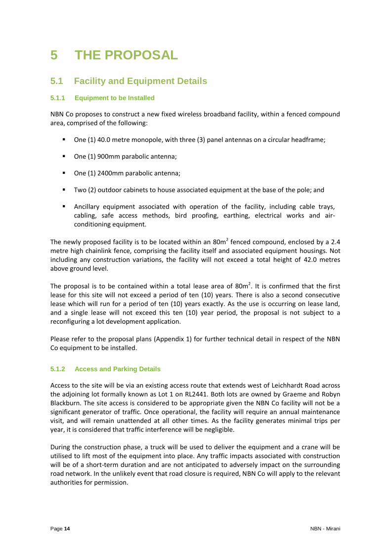
NBN Co proposes to construct a new fixed wireless broadband facility, within a fenced compound area, comprised of the following:
One (1) 40.0 metre monopole, with three (3) panel antennas on a circular headframe;
One (1) 900mm parabolic antenna;
One (1) 2400mm parabolic antenna;
Two (2) outdoor cabinets to house associated equipment at the base of the pole; and
Ancillary equipment associated with operation of the facility, including cable trays, cabling, safe access methods, bird proofing, earthing, electrical works and air-conditioning equipment.
The newly proposed facility is to be located within an 80m2 fenced compound, enclosed by a 2.4 metre high chainlink fence, comprising the facility itself and associated equipment housings. Not including any construction variations, the facility will not exceed a total height of 42.0 metres above ground level. The proposal is to be contained within a total lease area of 80m2. It is confirmed that the first lease for this site will not exceed a period of ten (10) years. There is also a second consecutive lease which will run for a period of ten (10) years exactly. As the use is occurring on lease land, and a single lease will not exceed this ten (10) year period, the proposal is not subject to a reconfiguring a lot development application. Please refer to the proposal plans (Appendix 1) for further technical detail in respect of the NBN Co equipment to be installed.
5.1.2 Access and Parking Details
Access to the site will be via an existing access route that extends west of Leichhardt Road across the adjoining lot formally known as Lot 1 on RL2441. Both lots are owned by Graeme and Robyn Blackburn. The site access is considered to be appropriate given the NBN Co facility will not be a significant generator of traffic. Once operational, the facility will require an annual maintenance visit, and will remain unattended at all other times. As the facility generates minimal trips per year, it is considered that traffic interference will be negligible. During the construction phase, a truck will be used to deliver the equipment and a crane will be utilised to lift most of the equipment into place. Any traffic impacts associated with construction will be of a short-term duration and are not anticipated to adversely impact on the surrounding road network. In the unlikely event that road closure is required, NBN Co will apply to the relevant authorities for permission.

Page 15 NBN - Mirani
A total construction period of approximately ten weeks (including Civil works and network integration and equipment commissioning) is anticipated. Construction activities will involve four basic stages:
Stage 1 (Week 1) – Site preparation works, including field testing, excavation and construction of foundations;
Stage 2 (Weeks 2, 3 and 4) – Construction of the monopole;
Stage 3 (Weeks 5 and 6) – Construction of the equipment shelter and fences;
Stage 4 (Weeks 7 – 10) – Installation of antennas and radio equipment, as well as equipment testing.
Once operational, the facility will function on a continuously unstaffed basis and will typically only require maintenance works once a year, for approximately one day per year.
5.1.3 Utility Service Details
Electricity will be sourced from an existing power pole located on site. NBN contractors will install a 70m underground consumer mains cable that connects the existing power pole with the proposed facility. Please refer to the proposal plans for further details (Appendix 1).
5.1.4 Construction and Noise
Noise and vibration emissions associated with the proposed facility are expected to be limited to the construction phase outlined above. Noise generated during the construction phase is anticipated to be of short duration and accord with the standards outlined in the relevant EPA guidelines. Construction works are planned only to occur between the hours of 7.00am and 6.00pm. There is expected to be some low level noise from the ongoing operation of air conditioning equipment associated with the equipment cabinets, once installed. Noise emanating from the air conditioning equipment is expected to be at a comparable level to a domestic air conditioning installation, and should generally accord with the background noise levels prescribed by relevant guidelines.
5.2 Site Selection
In the absence of feasible co-location options, the candidate was considered the most suitable from a town planning standpoint. The site is located in a rural zone surrounded by predominantly rural land uses.
The proposal achieves large setbacks from the Mirani township.
The proposal is not located in proximity of any sensitive land uses such as schools and achieves large setbacks from adjoining land uses ;
The proposed site will meet NBN Co’s coverage objectives and provide a suitable level of coverage to the local area; and
To construct the site will require minimal earthworks and there is a suitable level of access
and power supply.

Page 16 NBN - Mirani
6 CURRENT PLANNING CONTROLS
6.1 Commonwealth Legislation
As a licensed telecommunications carrier, NBN Co must operate under the provisions of the Telecommunications Act 1997 and the following supporting legislation:
The Telecommunications Code of Practice 1997;
The Telecommunications (Low-impact Facilities) Determination 1997 (as amended); and
The Environment Protection and Biodiversity Conservation (EPBC) Act 1999.
6.1.1 Telecommunications Act 1997
The Telecommunications Act 1997 (the Act) is the principal Act that governs the activities of telecommunications carriers. The aim of the Telecommunications Act 1997 is to provide a regulatory framework that promotes:
The long-term interests of end users of carriage services or of services provided by means of carriage services; and
The efficiency and international competitiveness of the Australian Telecommunications Industry.
The proposal is required to comply with the requirements of the Telecommunications Act 1997.
6.1.2 Telecommunications Code of Practice 1997
Under the Telecommunications Act 1997, the Government established the Telecommunications Code of Practice 1997, which sets out the conditions under which a carrier must operate. Section 2.11 of the Telecommunications Code of Practice 1997 sets out the design, planning and installation requirements for the carriers to ensure the installation of facilities is in accordance with industry ‘best practice’. This is required to:
“… minimise the potential degradation of the environment and the visual amenity associated with the facilities.” [Section 2.11(3)]
The siting and design of the proposal has taken place in accordance with Section 3 (Planning and Siting) of the Australian Standard – Siting of Radio Communications Facilities (AS 3516.2). Furthermore, following an assessment of the available options, it became evident that there were no suitable existing telecommunications facilities or other structures (including buildings or water tanks located within the search area that could provide the required site objective/co-location opportunities.

Page 17 NBN - Mirani
6.1.3 The Telecommunications (Low-impact Facilities) Determination 1997
The Telecommunications (Low-impact Facilities) Determination 1997 identifies both the type of facilities that can be “Low-impact”, and the areas in which these facilities can be installed. Importantly, this current facility is not defined as a “low impact facility” and is therefore subject to State and Territory Planning Laws and Regulation. In this specific instance, the provisions of the Sustainable Planning Act 2009 and the Mirani Shire Plan will be applicable to the proposal.
6.1.4 The Environment Protection and Biodiversity Conservation Act 1999
The Environment Protection and Biodiversity Conservation (EPBC) Act 1999 obliges telecommunications carriers to consider ‘matters of national environmental significance’. Under this legislation, an action will require approval from the Minister of Environment if the action has or is likely to have an impact on a matter of ‘national environmental significance’. According to the EPBC Act 1999, there are seven matters of national significance which must be considered. All relevant EPBC matters have been considered. It is not anticipated that the proposal will have a significant impact on any matters of national environmental significance. Accordingly, approval from the Minister of Environment is not required in this instance.
6.2 Queensland Planning Legislation and Guidelines
As identified in Section 6.1.3 of this report, the proposed facility does not fall within the definition of the Telecommunications (Low-impact Facilities) Determination 1997. It is therefore subject to State planning instruments and regulation in addition to the Commonwealth regulatory framework. There are a number of State Government provisions which could potentially apply to the proposed NBN Co facility. These include:
The Sustainable Planning Act 2009
State Planning Policy; and
Referral Agencies.
6.2.1 The Sustainable Planning Act 2009
The Sustainable Planning Act 2009 (SPA) has the overall aim of achieving ecological sustainability, through:
Managing the process by which development takes place, including ensuring the process is accountable, effective and efficient and delivers sustainable outcomes;
Managing the effects of development on the environment, including managing the use of premises; and
Continuing the coordination and integration of planning at the local, regional and State levels (Section 1.2.3 SPA)
Pursuant to Chapter 6 of the Sustainable Planning Act 2009, this application has been prepared to form part of an impact assessable material change of use development application, seeking a development permit under the Mirani Shire Plan.

Page 18 NBN - Mirani
6.2.2 State Planning Regulatory Provisions
State Planning Regulatory Provisions (SPRPs) are the pre-eminent planning instruments and have the ability to regulate and prohibit development, despite the provisions of a local planning instrument. Assessment against the relevant SPRPs is outlined in Table 2 below.
Table 2 - Assessment of State Planning Regulatory Provisions
Current Regulatory Provisions Comments
South East Queensland Regional Plan 2009-2031 State planning regulatory provisions – 2 May 2014
Not Applicable - The site is not located in the
Guragunbah State Planning Regulatory Provision – 27 September 2013
Not Applicable - The site is not located within the Guragunbah affected area.
State planning regulatory provision (adopted charges) – 2 August 2013
Not Applicable – No infrastructure charges are considered applicable for the proposal, given the use.
Yeerongpilly Transit Oriented Development State Planning Regulatory Provision – 23 September 2014
Not Applicable - The site is not located within the area of the Yeerongpilly TOD.
Off-road motorcycling facility on State-owned land at Wyaralong – October 2010
Not Applicable - The site is not located in Wyaralong nor is the proposed use of the site for a motor sport activity facility.
State Planning Regulatory Provisions (Adult stores) – July 2010
Not Applicable - The proposed use of the site does not involve an Adult Store.
South East Queensland Koala Conservation State Planning Regulatory Provisions – May 2010
Not Applicable - The site is not located in within a Koala Assessable Development Area.
6.2.3 State Planning Policies (SPPs)
On 2 December 2013, the Queensland Government adopted its new single State Planning Policy (SPP). The SPP replaces the previous multiple policies in existence. The SPP sets out policies on matters of state interest in relation to planning and development, and provides a key framework for the government's broader commitment to planning reform.
The SPP identifies the state's interests in planning and development and how these are to be dealt with in planning instruments, Council development assessment processes and in designating land for community infrastructure.
It is noted a number of state interests identified within the SPP are only applicable to the preparation of Council planning schemes. As such, the following state interests are not applicable to the assessment of the subject development application.
Livable communities
Housing supply and diversity
Agriculture

Page 19 NBN - Mirani
Development and construction
Tourism
Cultural heritage
Energy and water supply
Strategic ports
It is intended that the SPP be reflected in Council’s planning schemes. However, as this is a relatively new instrument, and many Councils are still operating on planning schemes written prior to the release of the SPP, assessment against the SPP may need to be considered. As the Mirani Shire Plan was written prior to the release of the SPP an assessment against the applicable themes of the SPP has been provided in Table 3 below.
Table 3 - Assessment of State Planning Policy
State Interests Comments
Economic Growth
Agriculture Not Applicable
The proposal is represents only a small portion of the overall property size in a location agreed upon between NBN Co and the landowner. The location, along the northern property boundary, will not fragment the land or restrict future agricultural development.
Mining and Extractive Resources Not Applicable
This proposal does not include any mining or extractive resources activity.
Environment and Heritage
Biodiversity
Not Applicable
This proposal does not impact on any area identified by the SPP Biodiversity Interactive Mapping System.
Coastal Environment Not Applicable
This proposal is not located within a coastal environment.
Water Quality Not Applicable
This proposal does not impact on any area identified by SPP Water Quality Interactive Mapping.
Cultural Heritage Not Applicable
This proposal is not located within an area of state or national cultural heritage significance.
Water Quality Not Applicable
This proposal is not located within close proximity

Page 20 NBN - Mirani
State Interests Comments
of any water supply or water buffer area. All works associated with this proposed development will be confined to within the telecommunications compound; therefore no impacts to any waterways or wetlands are anticipated.
Hazards and Safety
Hazardous Activities
Not Applicable
The proposed use is not defined as a sensitive land use under the SPP. In addition, the telecommunications facility will not emit noise or air emissions.
Natural Hazards Not Applicable
The proposed location is not affected by any of the following hazard areas:
a) Flood hazard area (as per local council
mapping); or
b) Landslide hazard area; or
c) Coastal hazard area;
d) Bushfire hazard areas.
Infrastructure
State Transport Infrastructure Not Applicable
The proposed use is not located within 400 metres of a public passenger transport facility or a future public passenger transport facility.
Strategic Airports and Aviation Facilities Not Applicable
This site is not located in the vicinity of any airport or aviation facility.
6.2.4 Referral Agencies
The Referral Agencies triggered by this proposal and their jurisdictions have been established with reference to Schedule 7 of the Sustainable Planning Regulations 2009.
This proposal will trigger referral to the State Assessment Referral Agency (SARA) under Schedule 7, Table 3, Item 1(a) of the Sustainable Planning Regulations 2009. As per Figure 5, the proposed development requires a material change of use on a property within 25m of a State Controlled Road.

Page 21 NBN - Mirani
Figure 5 – SARA Mapping – within 25m of State Controlled Road
6.3 Local Government Regulatory Framework
In addition to relevant Commonwealth and State Government regulatory requirements, the proposed facility is also subject to the Local Government regulatory framework. In this instance, the relevant Local Government regulatory framework is the SPA compliant with the Mirani Shire Plan 2007.
6.3.1 Mackay Regional Council’s Mirani Shire Plan 2007
This application is seeking to obtain a development permit for a Major Utility, which is defined under the Mirani Shire Plan as:
“telecommunications facility not defined as a local utility.” The proposal requires the construction of a 40 metre freestanding monopole and as such, cannot be defined as a local utility. In the rural zone, a major utility will trigger an impact assessable development application. A Major Utility within this zone is Impact Assessable (Inconsistent Use) and assessment against the planning scheme as a whole applies. As such, the following codes apply:
Rural Locality Code
The Community Use Class Code; and
The Infrastructure Code An assessment against these provisions is provided in Appendix 3. It is considered that the proposal is generally in accordance with the intent of the Mirani Planning Scheme and applicable codes.

Page 22 NBN - Mirani
7 OTHER ENVIRONMENTAL CONSTRAINTS AND OPPORTUNITIES
7.1 Visual Amenity and Setting
This proposal is for the installation of a 40 metre monopole on rural land located approximately 530 metres south of the Mirani township. NBN Co considers that the proposal is appropriate for the locality, given the rural zoning of the site and the nature of existing and anticipated uses of the site and surrounding land. The site is located in a rural zone surrounded by predominantly rural land uses. Given the large setbacks from adjoining land uses, the proposal will not have a significant visual impact. Please note that the proposed 40.0 metre monopole is considered to be the smallest structure capable of meeting coverage and operational objectives.
7.2 Heritage
In order to determine any possible natural or cultural values of state or national significance associated with the site, a search was conducted through the relevant Heritage Registers. There are no known items of cultural, historical or environmental heritage significance located in the vicinity of the proposal site.
7.3 Electrical Interference and Grounding of the Facility
The NBN fixed wireless broadband network is licensed by the Australian Communications and Media Authority (ACMA) for the exclusive use of the OFDMA2300 frequency band. As NBN Co is the exclusive licensee of this sub-band, emissions from NBN Co equipment within the frequency band will not cause interference. Filters also ensure that each facility meets the ACMA specifications for emission of spurious signals outside the NBN Co frequency allocations. NBN Co will promptly investigate any interference issues that are reported. The facility is also grounded to the relevant Australian Standards – that is, the facility will be ‘earthed’.
7.4 Erosion, Sedimentation Control and Waste Management
All erosion and sediment control mitigation measures will be detailed in construction plans and will be designed to comply with the Building Code of Australia and local Council standards. In addition, NBN Co’s contractors will be informed that they must comply with the ‘NBN Construction Specification' that requires contractors to undertake the necessary erosion and sediment control measures in order to protect the surrounding environment. On completion of the installation, NBN Co intends to restore and reinstate the site to an appropriate standard. No waste which requires collection or disposal should be generated by the operation of the facility.

Page 23 NBN - Mirani
7.5 Flora and Fauna Study
In order to determine any possible natural flora and fauna significance associated with the site, a search was conducted through the relevant environmental searches. It is not anticipated that the proposal will have a significant impact on any items of flora or fauna significance.
7.6 Endangered Species
In order to determine any possible endangered species associated with the site, a search was conducted through the relevant environmental searches. It is not anticipated that the proposal will have a significant impact on any endangered species.
7.7 Social and Economic Impacts
Access to high quality broadband is a necessary service in modern society. Initially, small to medium business customers accounted for a significant part of the demand for broadband technology, but broadband services have now been embraced by the general public. Usage of broadband services continues to widen as new technologies become progressively more affordable and accessible for the wider community. The proposed development will provide significantly enhanced fixed wireless broadband coverage to areas surrounding the township of Mirani. This will be of particular benefit for residential dwellings in the area. The new National Broadband Network will provide the community with far greater access to high quality broadband services. Reliable broadband internet is important to ensure the economic growth of communities, and the facility is likely to have significant social and economic benefits for the local community.
7.8 Public Safety
7.8.1 Radiofrequency Emissions
In relation to public safety and specifically Electromagnetic Emissions (EME) and public health, NBN Co always operates within the operational standards set by the Australian Communication and Media Authority (ACMA) and Australian Radiation Protection and Nuclear Safety Agency (ARPANSA). ARPANSA is a Federal Government agency incorporated under the Health and Ageing portfolio and is charged with the responsibility for protecting the health and safety of both people and the environment from the harmful effects of radiation (ionising and non-ionising). All NBN Co installations are designed and certified by qualified professionals in accordance with all relevant Australian Standards. This ensures that the NBN Co facility does not result in any increase in the level of risk to the public. This facility is to be operated in compliance with the mandatory standard for human exposure to EME – currently the Radio communications (Electromagnetic Radiation Human Exposure) Standard 2003. The EME Report associated with this site is attached in Appendix 4. The report shows that the maximum predicted EME will equate to 0.087% of the maximum exposure limit. This is substantially less than 1% of the maximum allowable exposure limit (where 100% of the limit is still considered to be safe). Moreover, all NBN Co equipment has the following features, all of which minimise the amounts of energy used and emitted:

Page 24 NBN - Mirani
Dynamic/Adaptive Power Control is a network feature that automatically adjusts the power and hence minimises EME from the facility.
Varying the facility’s transmit power to the minimal required level, minimising EME from the network, and
Discontinuous transmission, a feature that reduces EME emissions by automatically switching the transmitter off when no data is being sent.
7.8.2 Access
The proposed facility will have restrictions aimed at preventing public access, including a secured compound fence with a locked gate and warning signs placed around the facility.
7.9 The Public Interest and the Benefits of Telecommunications
The proposed NBN Co facility will have significant benefit for residents surrounding Mirani. NBN Co believes that the public interest would be served by approval of the proposal, given benefits for enhanced broadband coverage in the area. The facility will have benefits for local residents and businesses within the district.
7.9.1 Other Benefits of Reliable Broadband Services
There are numerous other benefits of telecommunications connectivity, as follows:
There are many educational benefits justifying the implementation of the National Broadband Network. Curriculum and data sharing, increased availability and accessibility of research materials, and virtual classroom environments are good examples. Such elements are particularly beneficial within a tertiary education context.
Businesses can, through internet usage, increase efficiency through time, resource and monetary savings. Improved broadband services effectively remove physical distance and travel time as a barrier to business.
Improvements to broadband services may also be of benefit for local employees, by enabling telecommuting and home business. The telecommuting trend is heavily reliant on access to high quality internet services, and is anticipated to continually increase in popularity.
The public benefits of access to high quality broadband have been widely acknowledged for many years. Reliable internet access is now more than ever an integral component, so much so that its absence is considered a social disadvantage.

Page 25 NBN - Mirani
8 CONCLUSION NBN Co proposes to install a new fixed wireless broadband facility at Lot 1475 Leichhardt Road, Mirani QLD 4754 (Lot 1475 on C124268). The facility seeks to provide fixed wireless broadband services to areas surrounding Mirani. The facility will be an integral element in the National Broadband Network that is being established throughout Queensland and Across Australia. In conjunction with Visionstream, NBN Co has undertaken an assessment of the relevant planning and technical matters, as required by Commonwealth, State and Local legislation, environmental, operational, radiofrequency and public safety requirements. As a result of this process, NBN Co considers that the proposed facility is suitable for its location, given the following:
The site has been assessed as a viable option for the effective delivery of NBN Co coverage and radiofrequency objectives for the search area;
The facility will operate within the regulatory framework of Commonwealth, State and Local Governments;
The facility will operate within all current and relevant Australian Standards;
The development proposal is the most appropriate option from a town planning perspective, given there are no suitable co-location options and the site is located in a rural area;
The facility is not anticipated to have an adverse impact on local environmental values for the subject site and surrounding area;
The NBN proposal will not interfere with agricultural activities due to the small footprint of the compound and location against the lot boundary;
The proposed development will not prejudice the existing or future uses of the site;
The proposed facility will provide a structure on which other telecommunications carriers can co-locate in the future, if required;
The installation will provide high quality fixed wireless broadband coverage; and
The proposed development will have a number of significant economic and social benefits as outlined in previous sections of this report.
Based on the above, we respectfully request that Mackay Regional Council approve the application and issue a development permit for a material change of use for a Major Utility at this location, subject to reasonable and relevant conditions, in accordance with the plans attached in Appendix 1.

Page 26 NBN - Mirani
9 APPENDIX
9.1 Appendix 1 – Proposal Plans

PROJECT SUMMARY
NBN GREENFIELD
NBN 40m ROCLA MONOPOLE WITH ROAM CIRCULAR HEADFRAME
NBN OUTDOOR CABINET ON CONCRETE SLAB
COVER SHEET
SITE No.MIRANI
LEICHHARDT ROAD
LOT 1475
4MRN-51-12-MIRA
DISTRIBUTION
MIRANI
GENERAL
ELECTRICAL
RF AND TX CONFIGURATIONS AND EME EXCLUSION ZONES
STRUCTURAL
CIVIL
MONOPOLE DESIGN
LEASE
QLD 4754
RFNSA SITE No: 4754004
Drawing Title:
RevisionDrawing No.
Rev
APPROVED BY:CHECKED BY:DRAFTED BY:
Client:
Project:
Date Revision Details
CAD
File:
\\vsn
ahos
an2b
\eb_p
rod_
file_c
ifs_0
2\Mulg
rave
\Nati
onal\
Erics
son N
BN W
ireles
s\16.0
SAE
D\Qu
eens
land\5
.0 Ma
ckay
Syn
thetic
Clus
ter\1.
0 All S
ites\M
irani_
4MRN
-51-
05-M
IRA\
6.0 D
esign
(Prim
e)\6.
14 A
utoCA
D\4M
RN-5
1-12
-MIR
A-C_
Rev0
1.dwg
Date
: Mon
day,
25 M
ay 20
15 2:
59:24
PM
Log
in: d
vidic
NATIONAL BROADBAND
NETWORK
ERICSSON
Client:
CAD
VISIONSTREAM PTY LTD
236 East Boundary Road2 North Drive Virginia Park Bentleigh East VIC 3165
Tel- (03) 9258 5700 fax- (03) 9563 7481www.visionstream.com.au
PRELIMINARY
Client:
024MRN-51-12-MIRA-T1
JRK
SG/AL
GA
MIRANI
LEICHHARDT ROAD
LOT 1475
MIRANI
SITE No: 4MRN-51-12-MIRA
QLD 4754
02

SITE SPECIFIC
NOTES
Drawing Title:
RevisionDrawing No.
Rev
APPROVED BY:CHECKED BY:DRAFTED BY:
Client:
Project:
Date Revision Details
CAD
File:
\\vsn
ahos
an2b
\eb_p
rod_
file_c
ifs_0
2\Mulg
rave
\Nati
onal\
Erics
son N
BN W
ireles
s\16.0
SAE
D\Qu
eens
land\5
.0 Ma
ckay
Syn
thetic
Clus
ter\1.
0 All S
ites\M
irani_
4MRN
-51-
05-M
IRA\
6.0 D
esign
(Prim
e)\6.
14 A
utoCA
D\4M
RN-5
1-12
-MIR
A-C_
Rev0
1.dwg
Date
: Mon
day,
25 M
ay 20
15 2:
59:25
PM
Log
in: d
vidic
NATIONAL BROADBAND
NETWORK
ERICSSON
Client:
CAD
VISIONSTREAM PTY LTD
236 East Boundary Road2 North Drive Virginia Park Bentleigh East VIC 3165
Tel- (03) 9258 5700 fax- (03) 9563 7481www.visionstream.com.au
PRELIMINARY
Client:
024MRN-51-12-MIRA-C1
JRK
SG/AL
GA
MIRANI
LEICHHARDT ROAD
LOT 1475
MIRANI
SITE No: 4MRN-51-12-MIRA
QLD 4754

SITE LOCATIONN
OVERALL SITE
PLAN
SITE CO-ORDINATES
LEGEND
16/04/2015
9061182
Drawing Title:
RevisionDrawing No.
Rev
APPROVED BY:CHECKED BY:DRAFTED BY:
Client:
Project:
Date Revision Details
CAD
File:
\\vsn
ahos
an2b
\eb_p
rod_
file_c
ifs_0
2\Mulg
rave
\Nati
onal\
Erics
son N
BN W
ireles
s\16.0
SAE
D\Qu
eens
land\5
.0 Ma
ckay
Syn
thetic
Clus
ter\1.
0 All S
ites\M
irani_
4MRN
-51-
05-M
IRA\
6.0 D
esign
(Prim
e)\6.
14 A
utoCA
D\4M
RN-5
1-12
-MIR
A-C_
Rev0
1.dwg
Date
: Mon
day,
25 M
ay 20
15 2:
59:26
PM
Log
in: d
vidic
NATIONAL BROADBAND
NETWORK
ERICSSON
Client:
CAD
VISIONSTREAM PTY LTD
236 East Boundary Road2 North Drive Virginia Park Bentleigh East VIC 3165
Tel- (03) 9258 5700 fax- (03) 9563 7481www.visionstream.com.au
PRELIMINARY
Client:
024MRN-51-12-MIRA-C2
JRK
SG/AL
GA
MIRANI
LEICHHARDT ROAD
LOT 1475
MIRANI
SITE No: 4MRN-51-12-MIRA
QLD 4754

N
SITE SETOUT
PLAN
LEGEND
Drawing Title:
RevisionDrawing No.
Rev
APPROVED BY:CHECKED BY:DRAFTED BY:
Client:
Project:
Date Revision Details
CAD
File:
\\vsn
ahos
an2b
\eb_p
rod_
file_c
ifs_0
2\Mulg
rave
\Nati
onal\
Erics
son N
BN W
ireles
s\16.0
SAE
D\Qu
eens
land\5
.0 Ma
ckay
Syn
thetic
Clus
ter\1.
0 All S
ites\M
irani_
4MRN
-51-
05-M
IRA\
6.0 D
esign
(Prim
e)\6.
14 A
utoCA
D\4M
RN-5
1-12
-MIR
A-C_
Rev0
1.dwg
Date
: Mon
day,
25 M
ay 20
15 2:
59:27
PM
Log
in: d
vidic
NATIONAL BROADBAND
NETWORK
ERICSSON
Client:
CAD
VISIONSTREAM PTY LTD
236 East Boundary Road2 North Drive Virginia Park Bentleigh East VIC 3165
Tel- (03) 9258 5700 fax- (03) 9563 7481www.visionstream.com.au
PRELIMINARY
Client:
024MRN-51-12-MIRA-C3
JRK
SG/AL
GA
MIRANI
LEICHHARDT ROAD
LOT 1475
MIRANI
SITE No: 4MRN-51-12-MIRA
QLD 4754
0202

SITE ELEVATION
Drawing Title:
RevisionDrawing No.
Rev
APPROVED BY:CHECKED BY:DRAFTED BY:
Client:
Project:
Date Revision Details
CAD
File:
\\vsn
ahos
an2b
\eb_p
rod_
file_c
ifs_0
2\Mulg
rave
\Nati
onal\
Erics
son N
BN W
ireles
s\16.0
SAE
D\Qu
eens
land\5
.0 Ma
ckay
Syn
thetic
Clus
ter\1.
0 All S
ites\M
irani_
4MRN
-51-
05-M
IRA\
6.0 D
esign
(Prim
e)\6.
14 A
utoCA
D\4M
RN-5
1-12
-MIR
A-C_
Rev0
1.dwg
Date
: Mon
day,
25 M
ay 20
15 2:
59:28
PM
Log
in: d
vidic
NATIONAL BROADBAND
NETWORK
ERICSSON
Client:
CAD
VISIONSTREAM PTY LTD
236 East Boundary Road2 North Drive Virginia Park Bentleigh East VIC 3165
Tel- (03) 9258 5700 fax- (03) 9563 7481www.visionstream.com.au
PRELIMINARY
Client:
024MRN-51-12-MIRA-C4
JRK
SG/AL
GA
MIRANI
LEICHHARDT ROAD
LOT 1475
MIRANI
SITE No: 4MRN-51-12-MIRA
QLD 4754
02
02
02
02

ALLOTMENT
PLAN
Drawing Title:
RevisionDrawing No.
Rev
APPROVED BY:CHECKED BY:DRAFTED BY:
Client:
Project:
Date Revision Details
CAD
File:
\\vsn
ahos
an2b
\eb_p
rod_
file_c
ifs_0
2\Mulg
rave
\Nati
onal\
Erics
son N
BN W
ireles
s\16.0
SAE
D\Qu
eens
land\5
.0 Ma
ckay
Syn
thetic
Clus
ter\1.
0 All S
ites\M
irani_
4MRN
-51-
05-M
IRA\
6.0 D
esign
(Prim
e)\6.
14 A
utoCA
D\4M
RN-5
1-12
-MIR
A-C_
Rev0
1.dwg
Date
: Mon
day,
25 M
ay 20
15 2:
59:29
PM
Log
in: d
vidic
NATIONAL BROADBAND
NETWORK
ERICSSON
Client:
CAD
VISIONSTREAM PTY LTD
236 East Boundary Road2 North Drive Virginia Park Bentleigh East VIC 3165
Tel- (03) 9258 5700 fax- (03) 9563 7481www.visionstream.com.au
PRELIMINARY
Client:
024MRN-51-12-MIRA-C5
JRK
SG/AL
GA
MIRANI
LEICHHARDT ROAD
LOT 1475
MIRANI
SITE No: 4MRN-51-12-MIRA
QLD 4754

NBN ANTENNA
CONFIGURATION
& SETOUT PLAN
N
Drawing Title:
RevisionDrawing No.
Rev
APPROVED BY:CHECKED BY:DRAFTED BY:
Client:
Project:
Date Revision Details
CAD
File:
\\vsn
ahos
an2b
\eb_p
rod_
file_c
ifs_0
2\Mulg
rave
\Nati
onal\
Erics
son N
BN W
ireles
s\16.0
SAE
D\Qu
eens
land\5
.0 Ma
ckay
Syn
thetic
Clus
ter\1.
0 All S
ites\M
irani_
4MRN
-51-
05-M
IRA\
6.0 D
esign
(Prim
e)\6.
14 A
utoCA
D\4M
RN-5
1-12
-MIR
A-C_
Rev0
1.dwg
Date
: Mon
day,
25 M
ay 20
15 2:
59:31
PM
Log
in: d
vidic
NATIONAL BROADBAND
NETWORK
ERICSSON
Client:
CAD
VISIONSTREAM PTY LTD
236 East Boundary Road2 North Drive Virginia Park Bentleigh East VIC 3165
Tel- (03) 9258 5700 fax- (03) 9563 7481www.visionstream.com.au
PRELIMINARY
Client:
024MRN-51-12-MIRA-A1
JRK
SG/AL
GA
MIRANI
LEICHHARDT ROAD
LOT 1475
MIRANI
SITE No: 4MRN-51-12-MIRA
QLD 4754
02
02 02

Page 27 NBN - Mirani
9.2 Appendix 2 – Site Photographs

Page 28 NBN - Mirani
Photo 1 – Proposed Location

Page 29 NBN - Mirani
Photo 2 – View from Proposed Location, Facing North

Page 30 NBN - Mirani
Photo 3 – Existing On-Site Power Supply

Page 31 NBN - Mirani
Photo 4 – Proposed Access Track, off Leichhardt Road

Page 32 NBN - Mirani
Photo 5 - Proposed Access Track, Facing East Towards Leichhardt Road

Page 33 NBN - Mirani
Appendix 3 – Applicable Codes and Comments

Mirani Shire Plan 2007 Rural Locality Code
4.2.3 Overall Outcomes and Purposes of the Rural Locality Code
Overall Outcome Comment
A range of primary production activities is accommodated.
The proposal will not detract from the diversity or number of primary production activities. The provision of high broadband internet may benefit agricultural activities through increased efficiency and monetary savings.
Existing and potential primary production operations are not restricted by incompatible development.
The proposal occupies only a small portion of the overall property in a location agreed upon in collaboration with the property owners. It is not expected that the proposal will fragment or restrict future agricultural uses of the property.
Uses and works are compatible with other uses and works within the Rural Locality.
The proposal will benefit existing uses within the Rural Locality through the provision of high speed broadband.
Natural environment and landscape values are maintained and protected.
The facility has been designed to sighted to minimise visual impact on surrounding view sheds. The proposed location achieves large setbacks from adjoining land uses and is considered consistent with the predominately rural land use.
Rural character and amenity is maintained.
The facility has been designed to sighted to minimise visual impact on surrounding view sheds. The proposed location achieves large setbacks from adjoining land uses and is considered consistent with the predominately rural land use.
Tourism activities, consistent with the natural and landscape values of the locality, occur in defined locations suitable for such uses.
No tourism activities are included in this proposal.
The rural locality is protected from residential encroachment and the potential land use conflicts associated with such encroachment.
This proposal will benefit rural land owners through the provision of high speed broadband and will not result in residential encroachment into the rural locality.

Mirani Shire Plan 2007 Rural Locality Code
Commercial, industrial or community uses are limited to that which is necessary to support the Rural Locality.
The provision of community infrastructure will ensure that residents and businesses within the Rural Locality have adequate opportunity to access high speed broadband.
Rural infrastructure, including aviation facilities, is protected from incompatible development.
The proposed infrastructure is on flat agricultural land and achieves large setbacks. The proposed location is consistent with the intent of the Rural Locality Zone.
Uses are serviced by an adequate standard of Infrastructure, including water supply, effluent disposal, road access, electricity and telecommunications services, stormwater management and waste management.
This proposal will benefit residents and businesses within the Rural Locality through the provision of community infrastructure and high speed broadband.
Uses and works are located, designed, constructed and operated to minimise the risk and potential effects of natural and other hazards.
The proposed works will be designed and constructed in accordance with relevant Australian Standards. Operation of the proposed facility will not result in any increased risk or hazard to property or person.
4.1.4 Specific Outcomes and Probably Solutions for the Rural Locality Code
Specific Outcomes Probable Solutions Applicant Response
Primary Production
O1 Land capable of use for primary production is used or protected for use accordingly
S1.1 Land Identified as GQAL is used for agriculture, or protected for such use. S1.2 Land suitable for other forms of primary production, including agriculture, aquaculture, animal husbandry and/or forestry plantation is used, or protected for use, as such.
S1.1 – S1.3 Complies The site is not identified as GQAL. Furthermore, the proposal has been sited through discussions with the landowner, and is considered to be consistent with current and long term anticipated uses on site. Given the small scale of the proposal, the intensity of the use is considered minor, and in keeping with the capacity of the rural site.

Mirani Shire Plan 2007 Rural Locality Code
S1.3 Land suitable for extractive industry is used, or protected for use, as such. S1.4 Land used or suitable for primary production is protected from incompatible development.
Incompatible Development
02 Uses and works are consistent with the intent of the zone in which they are located, as set out in Schedule 4-2(A)
S2.1 Uses that are inconsistent uses within a zone are not located within that zone.
S2.1 Complies The proposal will ensure the surrounding area is serviced by adequate telecommunications infrastructure and is consistent with the intent of the Rural Zone.
O3 Development does not fragment, alienate, result in the loss of or diminish the productive capacity of GQAL or other land suitable for primary production or associated infrastructure.
S3 No solution specified.
S3 Complies The site is not identified as GQAL. Given the small scale of the proposal, the intensity of the use is considered minor, and will not reduce capacity of future primary production or associated infrastructure. Improved telecommunications infrastructure may result in greater productive capacity.
Natural Values
O4 The values of areas with significant natural features, including rainforest areas, areas of remnant vegetation, vegetation corridors wetlands and rivers, creeks and associated riparian zones, are protected from any adverse impacts. O5 Areas of significant landscape values, such as
S4.1 In partial fulfilment of O4, development does not encroach into, occur in close proximity to, or otherwise result in any adverse impacts on, any area displaying significant natural values. S5.1 In partial fulfilment of O5, development does
S4.1 Complies The proposal is located on previously cleared, flat farm land and does not encroach into or within proximity of any area displaying significant natural values. Operation and maintenance of the facility will not result in any adverse environmental impacts. S5.1 Complies The proposal is located on flat land that is not

Mirani Shire Plan 2007 Rural Locality Code
hillsides, are protected from incompatible development.
not encroach into an area displaying, or otherwise detract from, significant natural landscape values.
considered to have significant landscape values. Futhermore, the structure achieves large setbacks from adjoining land uses and has been proposed at the minimum feasible height.
Cultural Heritage
O6 Cultural heritage values are protected from incompatible development
S6.1 In partial fulfilment of O6, development does not encroach into an area containing or displaying cultural heritage values.
S6.1 Complies The proposal is not located on, or adjacent to, any area containing cultural heritage values.
Character and Amenity
O7 Uses and works are located, designed, constructed and operated to maintain the rural character and amenity of the locality.
S7.1 1. In partial fufilment of O7:
a. Uses and works do not generate adverse amenity impacts of significance, including: i) Visual Impact ii) Noise emissions iii) Hazards iv) Reduction of air or water
quality, or v) Illumination or other electro-
magnetic emissions; OR
b. Effective measures are implemented to eliminate such impacts or to mitigate and manage and off-site effects to acceptable levels
S7.1.1 Alternate Solution Proposed Given the nature and height requirements of the telecommunications facility to be feasible, the proposal will be visible from the surrounding areas. NBN have taken steps to ensure this facility does not generate significant visual impact. The facility has been located to achieve large setbacks and has been proposed as a slim line monopole at the minimum feasible height. The design is considered consistent with the predominately rural land use. There is expected to be some low level noise from the ongoing operation of air conditioning equipment associated with the equipment cabinets, once installed. Noise emanating from the air conditioning equipment is expected to be at a comparable level to a domestic air conditioning installation, and should generally accord with the background noise levels prescribed by relevant guidelines.

Mirani Shire Plan 2007 Rural Locality Code
AND 2. Incompatible land uses and works located to maintain effective separation between such uses and works
The proposed facility will be located within a fenced, secured compound and will not pose any additional hazard. The proposed facility will not result in the reduction of air or water quality. All NBN Co installations are designed and certified by qualified professionals in accordance with all relevant Australian Standards. This ensures that the NBN Co facility does not result in any increase in the level of risk to the public. Appensix 4 indicates that the maximum predicted EME will equate to 0.087% of the maximum exposure limit. This is substantially less than 1% of the maximum allowable exposure limit (where 100% of the limit is still considered to be safe). S7.1.2 Complies The proposal has been located on rural land and is setback greater than 500m from the closest surrounding dwelling.
Tourism Activities
O8 The type and nature of tourism activities is consistent with the rural character and the environmental and landscape values of the locality. O9 Tourism activities are located, designed,
S8 No solution specified. S9 No solution specified.
N/A No tourism activity is proposed. N/A No tourism activity is proposed.

Mirani Shire Plan 2007 Rural Locality Code
constructed and operated so as not to result in adverse impacts on any environmental or landscape values O10 Eco-tourism activities are established in designated key locations providing a high standard of attractiveness, amenity and accessibility and characterised by existing tourism infrastructure.
S10
1. Eco-tourism activities are located at or near the following tourism opportunities16:
i) Kinchant Dam ii) Teemburra Dam iii) Pioneer River iv) Eungella Dam v) Finch Hatton Gorge vi) Broken River vii) Mackay Highlands Great
Walk (Crediton)
N/A No tourism activity is proposed.
Residential Uses
O11 Residential uses are:
a) limited to that required to accommodate the permanent residents of land used for primary production on the same lot; or
b) located within the Rural Residential Zone; or
c) used for tourism accommodation in a designated key location on Map 2.
012 Residential uses do not restrict primary production operations or rural infrastructure.
S11 No solution specified. S12.1 A Residential use or lot is not located within:
a) 1000m of land used or suitable for use for Extractive Industry involving blasting, or 500m otherwise; or
N/A No residential use is proposed N/A No residential use is proposed

Mirani Shire Plan 2007 Rural Locality Code
b) 300m of land used or suitable for use for Agriculture, Animal Husbandry or Forestry Plantation, or 40 metres with landscaping; or
c) 500m of land used or suitable use for an aquaculture use; or
d) 2000m of land used or suitable for use for Intensive Animal Husbandry or Stock Saleyard; or
e) 200m of an Industrial use; f) 700m from a sewage treatment plant.
Commercial, Industrial or Community Uses
013 Commercial, industrial or community uses are limited to uses and works that cannot practically be located in an urban locality due to their nature, scale, effects or particular requirement for a rural location.
S13 No solution specified.
S13 Complies The proposed telecommunications infrastructure cannot practically be located within an urban locality. NBN investigated the feasibility of the existing 22.9 metre Telstra lattice tower located at 21 Alexandra Street, Mirani. This facility was unable to provide the height required to meet NBN coverage requirements. Given the small scale of surrounding residential development, the urban localities within the Mirani township was considered less desirable for the proposal.
Rural Infrastructure
O14 The provision and operation of infrastructure associated with primary production activities, including tramline infrastructure, haul-out routes and irrigation infrastructure, is not restricted by incompatible uses.
S14 No solution specified.
S14 Complies This proposal is for the provision of telecommunications infrastructure in a location that will not restrict the future provision of infrastructure associated with primary production activities.

Mirani Shire Plan 2007 Rural Locality Code
O15 A use sensitive to noise is separated from any rail corridor or major road.
S15 A use sensitive to noise is located more than 100 metres from a rail corridor (other than a tramline corridor or siding), 30m from a state-controlled road or 20 metres from any other major road (other than a haul-out route).
N/A The proposed telecommunications infrastructure is not sensitive to noise.
Aviation Facilities
O16 Permanent or temporary physical obstructions within 4000m of the radar facility at Swampy Ridge as shown on Map 2 in Part 9, do not affect the functioning of this facility. O17 If in the vicinity of the VHF/UHF communication facility at Mount Macartney, electrical or electromagnetic fields or reflective surfaces do not adversely affect the functioning of the aviation facility within the 500 metre buffer as shown on Map 2 in Part 9.
S16.1 No part of any works, including buildings, structures, fencing and landscaping, located within the 4,000m sensitive buffer area shown on Map 2, is higher than the following limits:
a. within 1000m of the facility, h+4m
b. within 2000m of the facility, h+8m
c. within 3000m of the facility, h+17m
d. within 4000m of the facility, h+25m
Where h is the height of a point, measured to the Australian Height Datum (AHD), below the middle of the antenna. S17.1 Works or uses within the buffer area as shown on Map 2 do not involve arc welding or similar activities that generate electromagnetic fields, or reflective or metallic surfaces.
S16.1 Complies The proposal is located greater than 4000m from the radar facility at Swamy Ridge and will not affect the functioning of this facility. Furthermore, the NBN fixed wireless broadband network is licensed by the Australian Communications and Media Authority (ACMA) for the exclusive use of the OFDMA2300 frequency band. As NBN Co is the exclusive licensee of this sub-band, emissions from NBN Co equipment within the frequency band will not cause interference. S17.1 Complies The proposal is located outside of the 500m buffer as shown on Map 2 in Part 9. Furthermore, the NBN fixed wireless broadband network is licensed by the Australian Communications and Media Authority (ACMA) for the exclusive use of the OFDMA2300 frequency band. As NBN Co is the exclusive licensee of this sub-band,

Mirani Shire Plan 2007 Rural Locality Code
emissions from NBN Co equipment within the frequency band will not cause interference.
Infrastructure
O18 Development is provided with an independent potable water supply that is reliable, and of sufficient capacity to ensure a continuous supple at all times, having regard to the capacity population of the use.
S18.1 Provision of a reticulated water supply. S18.2 Provision of an on-site bore water supply such that:
a) has a minimum pumping capacity of 0.3I/s/ET; and
b) the supply is potable and healthy S18.3 Provision of on-site rainwater storage tanks, together with associated plumbing, of sufficient capacity to ensure an adequate supply at all times, having regard to:
a) Local rainfall characteristics and a maximum acceptable probability of failure of 10%,
b) Available roof collection area, c) Projected maximum consumption,
and d) The need to avoid any reliance on the
transportation of water.
N/A The proposed telecommunications infrastructure does not require supply of potable water.
O19 Development is provided with independent electricity and telephone services.
S19.1 Uses or lots are connected to electricity and telephone services provided by Ergon Energy and Telstra, respectively
S19.1 Complies An NBN contractor will connect the facility to the existing onsite power pole via underground mainscable (approximately 70m

Mirani Shire Plan 2007 Rural Locality Code
run). The proposed facility does not require telephone services.
O20 Development has safe, all-weather, flood free vehicle access
S20.1 Residential uses have direct access, in a safe location having regard to the available sight lines and speed environment, from a local government or a state-controlled road. AND S20.2 Internal access is sealed, or to a gravel standard up to a maximum gradient of 10%.
S20.1 & S20.2 Alternate Solution Proposed An NBN contractor will supply and install an NBN access track (approximately 300m). This will connect the facility to Leichhardt Road via a gravel track suitable for all weather vehicle access. The site access is considered to be appropriate given the NBN Co facility will not be a significant generator of traffic. Once operational, the facility will require an annual maintenance visit, and will remain unattended at all other times. As the facility generates minimal trips per year, it is considered that traffic interference will be negligible.
O21 Premises have Infrastructure of a standard and capacity sufficient to meet the ongoing needs of such use.
S21.1 In partial fulfilment of O21, uses are serviced by:
a) A permanent and reliable water supply, including a safe and healthy potable supply,
b) an effective fire-fighting water supply,
S21.1a) N/A This proposal for a non habitable building and does not require permanent water supply. S21.1b) Alternate Solution Proposed Telecommunication facilities are designed to be fire resistant (through use of construction materials impervious to fire damage), and are not themselves fire risks as they do not emit sparks, excessive heat or open flame. Furthermore, the existing facility will continue to be unmanned and will not result in

Mirani Shire Plan 2007 Rural Locality Code
c) A safe and effective system of effluent disposal,
d) Electricity and telecommunications services,
e) A safe and effective system of stormwater management,
f) Safe, all-weather vehicle access, and
g) An effective waste management service.
additional persons residing on the site. Maintenance visits will be infrequent and for short periods of time, therefore not posing a significant risk to maintenance personnel. As such, no fire fighting water supply has is proposed. S21.1c) N/A This proposal does will not generate any effluent. S21.1d) Complies NBN contractors will supply and construct consumer mains cables to service the facility. See Appendix 1 for further details. S21.1e) Alternate Solution Proposed The proposed compound is 80m² and will not generate significant storm run off during heavy rainfall. Given the surrounding flat agricultural land, no additional stormwater management is considered necessary. S21.1f) Complies NBN contractors will supply and construct 300m gravel access track to facilitate safe, all weather vehicle access. S21.1g) N/A The proposed facility will operate on a continual unstaffed basis and will not generate any waste.
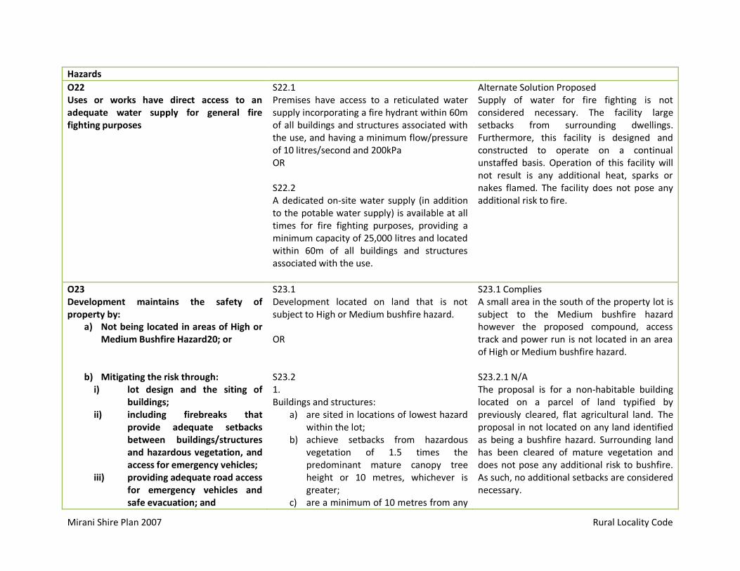
Mirani Shire Plan 2007 Rural Locality Code
Hazards
O22 Uses or works have direct access to an adequate water supply for general fire fighting purposes
S22.1 Premises have access to a reticulated water supply incorporating a fire hydrant within 60m of all buildings and structures associated with the use, and having a minimum flow/pressure of 10 litres/second and 200kPa OR S22.2 A dedicated on-site water supply (in addition to the potable water supply) is available at all times for fire fighting purposes, providing a minimum capacity of 25,000 litres and located within 60m of all buildings and structures associated with the use.
Alternate Solution Proposed Supply of water for fire fighting is not considered necessary. The facility large setbacks from surrounding dwellings. Furthermore, this facility is designed and constructed to operate on a continual unstaffed basis. Operation of this facility will not result is any additional heat, sparks or nakes flamed. The facility does not pose any additional risk to fire.
O23 Development maintains the safety of property by:
a) Not being located in areas of High or Medium Bushfire Hazard20; or
b) Mitigating the risk through: i) lot design and the siting of
buildings; ii) including firebreaks that
provide adequate setbacks between buildings/structures and hazardous vegetation, and access for emergency vehicles;
iii) providing adequate road access for emergency vehicles and safe evacuation; and
S23.1 Development located on land that is not subject to High or Medium bushfire hazard. OR S23.2 1. Buildings and structures:
a) are sited in locations of lowest hazard within the lot;
b) achieve setbacks from hazardous vegetation of 1.5 times the predominant mature canopy tree height or 10 metres, whichever is greater;
c) are a minimum of 10 metres from any
S23.1 Complies A small area in the south of the property lot is subject to the Medium bushfire hazard however the proposed compound, access track and power run is not located in an area of High or Medium bushfire hazard. S23.2.1 N/A The proposal is for a non-habitable building located on a parcel of land typified by previously cleared, flat agricultural land. The proposal in not located on any land identified as being a bushfire hazard. Surrounding land has been cleared of mature vegetation and does not pose any additional risk to bushfire. As such, no additional setbacks are considered necessary.

Mirani Shire Plan 2007 Rural Locality Code
providing an adequate and accessible water supply for firefighting purposes.
retained vegetation strips or small areas of vegetation; and
d) are sited so that building elements least susceptible to fire are sited closest to the bushfire hazard.
AND 2. Uses and lots for residential uses are designed so that their size and shape allow for efficient emergency access to buildings for fire-fighting appliances (e.g. by avoiding long narrow lots with long access drives to buildings). AND 3. a) Firebreaks are provided by perimeter road that separates lots from areas of bushfire hazard, and that road has a minimum cleared width of 20 metres and a constructed road of an all-weather standard. OR
(a) Where it is not practical to provide the firebreaks referred to in (a), fire maintenance trails are located as close
(b) as possible to the boundaries of the lots and the adjoining bushland hazard, and the trails:
i) Have a minimum cleared width of 6 metres; and
ii) Have a formed width and gradient, and erosion control devices; and
iii) Have vehicular access at each end; and
S23.2.2 N/A This proposal is not for residential uses. 23.2.3 N/A This facility is not located in an area indentified as a bushfire hazard. Furthermore, no firebreaks or fire maintenance trails are proposed.

Mirani Shire Plan 2007 Rural Locality Code
iv) Provide passing bays and turning points for firefighting appliances; and
v) Are either located on public land, or within an access easement that is granted in favour of the local government and QFRS.
AND 4. Cleared breaks of 6 metres minimum width are available in retained bushland within the development (e.g. creek corridors and other retained vegetation) to allow burning of sections and access for bushfire response. AND 5. Roads are designed and constructed in accordance with applicable local government and State government standards and:
a) Have a maximum gradient of 12.5%; and
b) Exclude culs-de-sac, except where a perimeter road isolates the use works or lot from hazardous vegetation or the culs-de-sac are provided with an alternative access linking the cul-de-sac with other through roads.
AND 6. In a High Bushfire Hazard Area, a use, work or lot complies with a Bushfire Management Plan.
23.2.4 N/A The proposal is located on not located on bushland. 23.2.5 N/A
No new roads are proposed.
23.2.6 N/A
This proposal is not located within a Bushfire Hazard Area.

Mirani Shire Plan 2007 Rural Locality Code
O24 Public safety and the environment are not adversely affected by the impacts of bushfire on hazardous materials manufactured or stored in bulk.
S24.1 A use, work or lot complies with a Bushfire Management Plan.
24.1 Complies The proposed use does not involve the manufacturing or storage or hazardous materials. Furthermore, as the facility will not generate any excessive heat, sparks or naked flames, it is not considered that the proposal will result in an increased risk of bushfire in the region.
O25 The safety of people, property and hazardous materials from the risk of landslide is maintained.
S25.1 Development, including vegetation clearing, does not occur on land with or below a slope gradient > 15%
S25.1 Complies This proposal is on flat land and will not result in any additional risk of landslide.
O26 The safety of people, property and hazardous materials from all floods up to and including a Q100 flood is maintained.
S26.1 Development is not sited on land subject to flooding during a Q100 flood event. AND S26.2 Works do not involve any physical alteration to a watercourse or flood way, including vegetation clearing or net filling exceeding 50m³. AND S26.3 The manufacture or storage in bulk of hazardous materials is located above the Q100 flood level. AND S26.4 Infrastructure is located above the Q100 flood level, or is designed, constructed and operated to prevent damage or intrusion by flood waters.
S26.1 Complies This proposal is not located on any land subject to a Q100 flood. S26.2 Complies This proposal does not involve the physical alteration to a watercourse or flood way. S263. N/A This proposal does will not generate or store hazardous waste. S26.2 Complies This proposal is not located on any land subjected to a Q100 flood.

Mirani Shire Plan 2007 Community Use Code
6.2.3 Overall Outcomes and Purposes of the Community Use Code
Overall Outcome Comment
Provide a high standard of service. The proposed telecommunications infrastructure will provide rural residents surrounding Mirani with high speed, reliable broadband. The objective of this facility is to upgrade existing telecommunications infrastructure to ensure residents have access to a high standard of service.
Are safely and conveniently accessible to all users. All NBN Co installations are designed and certified by qualified professionals in accordance with all relevant Australian Standards. This ensures that the NBN Co facility does not result in any increase in the level of risk to the public. Furthermore, users can access the high speed broadband from the convenience of their own home.
Do not have an adverse impact on adjoining uses and works. This proposal is located on flat, previously cleared agricultural land. The proposed compound represents only a small portion of the overall property area. This will not detract from future on site or adjoining land uses.
Are provided in a timely and cost effective manner. The construction and eventual operation of the proposed facility would be provided in a cost effective, co-ordinated, efficient and equitable manner that supports sustainable development practices.
Are located, designed and managed to be compatible with other uses and works. Are located, designed and managed to maintain or enhance aspects of the character of the area, including style of buildings, local character, landmark features and views of the rural landscape. Are located, designed and managed to maintain or enhance the prevailing amenity, including through the operation of machinery, light, noise, dust, odour or other physical conditions.
NBN Co has undertaken a thorough site selection process to ensure the facility is located away from sensitive land uses and will not detract from existing and anticipated uses of the site and surrounding land. Refer to Section 5.2 of this report for further information.

Mirani Shire Plan 2007 Community Use Code
Are located, designed and managed to maintain the safety of people and works.
All NBN Co installations are designed and certified by qualified professionals in accordance with all relevant Australian Standards. This ensures that the NBN Co facility does not result in any increase in the level of risk to the public.
Are located, designed and managed to avoid significant adverse effects on the natural and cultural heritage values of the environment.
This proposal is not located on land identified as having natural of cultural values. The facility has been designed to retain the smallest visual profile possible, whilst being at a height to ensure transmission links between additional sites within the Mackay Regional Council are achieved.
6.3.4 Specific Outcomes and Probable Solutions for the Community Use Code
Specific Outcomes Probable Solutions Applicant Response
Location and Site Suitability
O1 A community use is accessibly and conveniently located having regard to the needs of the population it is intended to serve.
In partial fufilment of 01: S1.1 Community uses are located in the Community Purposes Zone AND
S1.1 Proposed Alternate Solution The proposed telecommunications infrastructure is designed to provide high speed broadband access to the rural residential dwellings surrounding the Mirani township. As previously outlined within this report, NBN Co investigated a number of candidates. There were no candidates located within the Community Purposes Zone that meet NBN Co technical requirements and were compatible with the nature of development. Given the setbacks from surrounding dwellings and sensitive land uses, the location is the most appropriate for the proposed 40m

Mirani Shire Plan 2007 Community Use Code
S1.2 Compatible community uses are, wherever possible co-located or integrated with another. AND S1.3 Uses are accessible by way of a safe and convenient system of footpaths and cycleways. AND S1.4 Uses located on existing or potential future public transport routes.
greenfield monopole. S1.2 Proposed Alternative Solution Opportunities for the co-location of telecommunications infrastructure was limited to the existing Telstra lattice tower (Lot 18 on RP719208) and council water tank (Lot 1 on M30416). These locations did not provide feasible candidates as they did not afford the height required to meet NBN Co coverage objectives. S1.3 N/A This proposal is located on private land and does not require footpaths or cycleways. S1.4 N/A This proposal does not require integration with public transport routes.
O2 Community use is accessible for maintenance purposes.
In partial fufilment of 02: S2.1 Any lot used for a Community Use has legal and practical vehicle access from a public road, capable of safely and efficiently accommodating the type of vehicles, machinery and equipment required for maintenance functions.
S2.1 Complies NBN Co Contractors will supply and install a 300m access track to facilitate all weather, vehicle access. This track will connect the proposed compound with Leichardt Road. The site access is considered to be appropriate given the NBN Co facility will not be a significant generator of traffic. Once operational, the facility will require an annual

Mirani Shire Plan 2007 Community Use Code
maintenance visit, and will remain unattended at all other times. As the facility generates minimal trips per year, it is considered that traffic interference will be negligible.
Design
O3 A community use contributes positively to the visual qualities of the built environment.
No probable solution is prescribed. O3 Proposed Alternate Solution NBN Co considers that the proposal is appropriate for the locality, given the rural zoning of the site and the nature of existing and anticipated uses of the site and surrounding land.
O4 The scale and design of buildings and structures are consistent with other uses on surrounding land.
No probable solution is prescribed. O4 Proposed Alternate Solution NBN Co considers that the proposal is appropriate for the locality, given the rural zoning of the site and the nature of existing and anticipated uses of the site and surrounding land. The proposal achieves large setbacks from residential and sensitive land uses. The location achieves large setbacks from adjoining land uses. Please note that the proposed 40.0 metre monopole is considered to be the smallest structure capable of meeting coverage and operational objectives.
O5 Premises are located and designed to meet the mobility requirements of all users.
No probable solution is prescribed. N/A This proposal will not impede public mobility.

Mirani Shire Plan 2007 Community Use Code
Amenity
O6 The community use does not adversely affect the amenity of associated land uses.
No probable solution is prescribed. O6 Complies NBN Co considers that the proposal is appropriate for the locality, given the rural zoning of the site and the nature of existing and anticipated uses of the site and surrounding land.

Mirani Shire Plan 2007 Infrastructure Code
7.4.3 Overall Outcomes and Purposes of the Infrastructure Code
Overall Outcome Comment
Uses and lots are serviced by infrastructure of a standard that meets community needs, construction and maintenance cost constraints, public health standards, and environmental management responsibilities
The proposed telecommunications infrastructure will provide rural residents of Mirani access to high speed, reliable broadband. The objective of this facility is to upgrade existing telecommunications infrastructure to ensure residents have access to a high standard of service. NBN Co installations are designed and certified by qualified professionals in accordance with all relevant Australian Standards. This ensures that the NBN Co facility does not result in any increase in the level of risk to the public. This proposal does not require the removal of any vegetation and will minimise disturbance to the land by minimising power and access runs.
Adverse impacts are avoided or, where avoidance is not possible, are effectively mitigated.
NBN Co has undertaken a thorough site selection process to ensure the facility does not adversely affect existing or future uses of the land. The proposed location achieves large setbacks from sensitive land uses and will not detract from existing and anticipated uses of the site and surrounding land. Refer to Section 5.2 of this report for further information.

Mirani Shire Plan 2007 Infrastructure Code
7.4.4 Specific Outcomes and Probable Solutions for the Infrastructure Code
Specific Outcomes Probable Solutions Applicant Response
General Requirements
O1 Development:
1) Maximises the utilisation of existing trunk infrastructure
2) Avoids the need for the premature provision of new trunk infrastructure, and
3) Is serviced by trunk infrastructure to the required standard.
S1.1 Development occurs in areas already serviced by trunk infrastructure having sufficient capacity to accommodate the development. AND S1.2 Developer contributions, in the form of monetary payments and/or works, are provided in accordance with the Planning Scheme Policies listed below:
1) Planning Scheme Policy No 1 Developer Contributions for Water Supply and Sewerage Headworks,
2) Planning Scheme Policy No 2 Developer Contributions for External Roadworks, and
3) Planning Scheme Policy No 3 Developer Contributions for Parkland.
S1.1 Complies An NBN contractor will connect the facility to the existing onsite power pole via an underground mains cable (approximately 70m). Given the facility is designed and constructed to operate on an un-staffed basis, no further trunk infrastructure is proposed. S1.2.1 N/A This proposal does not require water supply or sewerage headworks. S1.2.2 N/A This proposal will be designed to operate on a continuous unstaffed basis and will not result in a significant increase in traffic utilizing the Shire’s road network. S1.2.3 N/A This proposal will not result in an increase in the demand for parkland or associated facilities.

Mirani Shire Plan 2007 Infrastructure Code
O2 Uses or lots serviced by infrastructure to an appropriate standard, having regard to the nature of the use.
S2.1 Prior to the endorsement of any survey plan or the commencement of any use:
1) Uses or lots are provided with the infrastructure set out in Table 7-4(A), at no cost to the local government; and
2) Such infrastructure is completed and made operational.
S2.1 Alternate Solution Proposed NBN contractors will supply and install an underground mains cable to service the facility with electricity. This connection is required prior to commencement of use. The proposed facility will be designed and constructed to operate on a continual, unstaffed basis and will not have any additional infrastructure requirements.
O3 All easements, reserves and/or lots necessary to accommodate public infrastructure are established in favour of, or transferred to, the relevant public authority.
No probable solution is prescribed.
S3 N/A This proposal will not require the establishment of any easement, reserve or lot necessary to accommodate public infrastructure.
O4 Uses or lots have good access to community facilities.
No probable solution is prescribed.
S4 N/A The proposed facility will be designed and constructed to operate on a continual, unstaffed basis and does not require any access to community facilities.
Road Access
O5 Roads are designed and constructed to provide efficiently and safely for anticipated pedestrian, cyclist and vehicular traffic volumes.
S5.1 Roads meet the requirements of the road hierarchy in terms of:
1) Type and function (Table 7-4(B), 2) Catchment area & design speed (Table
7-4(C), 3) Width and gradient (Table 7-4(D), and 4) Pedestrian & cycleway facilities (Table
7-4(E).
S5.1 Alternate Solution Proposed Given the facility will not be a significant generator of traffic, the proposed culvert is considered appropriate to ensure safe vehicle access.

Mirani Shire Plan 2007 Infrastructure Code
O6 The road network contributes positively to the aesthetic environment.
S6.1 Within the Urban Locality, a street tree is provided to every lot frontage within an access street, access place or collector street.
S6.1 N/A This proposal is not located within the Urban Locality
O7 Safe provision is made for vehicular access to every lot.
S7.1 In the Urban Locality, a concrete driveway (kerb invert crossing type) is provided to corner lots and lots adjoining a roundabout or traffic calming device, such that:
1) Any such driveway is not within 6 metres of any intersection truncation, roundabout or traffic calming device,
2) the driveway extends to the lot frontage, and
3) the crossing is constructed per Drawing 7-4(F).
AND S7.2 In the Rural Locality, a rural access is provided in accordance with Drawing 7-4(G).
S7.1 N/A This proposal is not located within the Urban Locality. S7.2 Complies The proposed culvert will be designed in accordance with Drawing 7-4(G).
Stormwater Management
O8 Stormwater drainage is provided to effectively convey stormwater runoff to a lawful point of discharge with minimal nuisance, risk, damage or pollution.
S8.1 In the Urban Locality:
1) Stormwater arising from the development and any upstream catchment is collected within the lot and piped underground to Council’s stormwater drainage.
AND 2) The stormwater drainage system
comprises a cross-road drainage system and table drains within the
S8.1 N/A This proposal is not located within the Urban Locality.

Mirani Shire Plan 2007 Infrastructure Code
road reserve have sufficient capacity to contain flows arising from a Q5 design rainfall event, such that table drains are stabilised as follows: a) For gradients 10% - concrete
lining; b) Otherwise – grassing.
AND 1) Effective erosion and sediment
control measures are implemented in accordance with Planning Scheme Policy No. 4 Engineering Design and Construction Manual.
AND S8.3 Stormwater drainage is designed and constructed in accordance with Planning Scheme Policy No. 4 Engineering Design and Construction Manual.
S8.3 Not Applicable The proposed compound is 96m² and achieves large setback from adjoining land uses. No additional storm water drainage is proposed.
Electricity and Telephone
O9 In the Urban Locality, underground electricity and telecommunications services are provided to each lot.
No probably solution specified. N/A This proposal is not located in the Urban Locality.
O10 In the Urban Locality, street lighting is provided to ensure the safety of access and movement40.
S10.1 Street Lighting is located, designed and constructed in accordance with Planning Scheme Policy No. 4 Engineering Design and Construction Manual.
N/A This proposal is not located in the Urban Locality.
Water Reticulation
O11 Where available, uses and lots are provided
S11.1 Water reticulation is designed in accordance
S11.1 Alternate Solution Proposed This proposal will be designed and

Mirani Shire Plan 2007 Infrastructure Code
with a reticulated water supply of sufficient capacity and standard to service peak demand.
with Planning Scheme Policy No. 4 Engineering Design and Construction Manual.
constructed to operate on an unstaffed basis and will not require the supply of reticulated water.
Sewerage
O12 Where available, uses and lots are provided with a reticulated sewerage system of sufficient capacity and standard to service peak demand.
S12.1 Sewerage is designed and constructed in accordance with Planning Scheme Policy No. 4 Engineering Design and Construction Manual.
S12.1 Alternate Solution Provided This proposal will be designed and constructed to operate on an unstaffed basis and will not require the supply of reticulated sewage system.

State development assessment provisions Module 1 — Community amenity 1.1 Managing noise and vibration impacts from transport corridors state code 10 October 2014 V1.5 Page 1 of 9
1.1 Managing noise and vibration impacts from transport corridors state code
Table 1.1.1: Building work and material change of use
Performance outcomes Acceptable outcomes Response Comment
Residential buildings near a state-controlled road or type 1 multi modal corridor
PO1 Development involving an accommodation activity that is a residential building achieves acceptable noise levels for residents and visitors by mitigating adverse impacts on the development from noise generated by a state-controlled road or a type 1 multi-modal corridor.
AO1.1 All facades of a residential building exposed to noise from a state-controlled road or type 1 multi-modal corridor meet the following external noise criteria
^#:
(1) ≤60 dB(A) L10 (18 hour) facade corrected (measured L90 (8 hour) free field between 10 pm and 6 am ≤40 dB(A))
(2) ≤63 dB(A) L10 (18 hour) facade corrected (measured L90 (8 hour) free field between 10 pm and 6 am >40 dB(A)).
AND
N/A This proposal is not for a residential building.
AO1.2 Every private open space* in an accommodation activity exposed to noise from a state-controlled road or type 1 multi-modal corridor meet the following external noise criteria
^#:
(1) ≤57 dB(A) L10 (18 hour) free field (measured L90 (18 hour) free field between 6 am and 12 midnight ≤45 dB(A))
(2) ≤60 dB(A) L10 (18 hour) free field (measured L90 (18 hour) free field between 6 am and 12 midnight >45 dB(A)).
AND
N/A This proposal does not involve any accommodation activity.
AO1.3 Every passive recreation area* in an accommodation activity exposed to noise from a state-controlled road or type 1 multi-modal corridor meets the following external noise criteria
^#:
(1) 63 dB(A) L10 (12 hour) free field (between 6 am and 6 pm).
AND
N/A This proposal does not involve any accommodation activity.
AO1.4 Every habitable room in an accommodation activity (other than a residential building), exposed to noise from a state-controlled road or type 1 multi-modal corridor meet the following internal noise criteria
^#:
(1) ≤35 dB(A) Leq (1 hour) (maximum hour over 24 hours).
Note: Noise levels from a state-controlled road or type 1
N/A This proposal does not involve any accommodation activity.
Response column key: Achieved P/S Performance solution N/A Not applicable

State development assessment provisions Module 1 — Community amenity 1.1 Managing noise and vibration impacts from transport corridors state code 10 October 2014 V1.5 Page 2 of 9
Performance outcomes Acceptable outcomes Response Comment
multi-modal corridor are to be measured in accordance with AS1055.1–1997 Acoustics – Description and measurement of
environmental noise.
Editor’s note: Habitable rooms of residential buildings located within a transport noise corridor must comply with the
Queensland Development Code MP4.4 Buildings in a transport
noise corridor, Queensland Government, 2010. Transport
noise corridors are mapped on the Department of Housing and Public Works website.
Accommodation buildings near a railway with more than 15 passing trains per day or a type 2 multi modal corridor
PO2 Development involving an accommodation activity that is a residential building achieves acceptable noise levels for residents and visitors by mitigating adverse impacts on the development from noise generated by a railway with more than 15 passing trains per day or a type 2 multi-modal corridor.
AO2.1 All facades of a residential building exposed to noise from a railway with more than 15 passing trains per day or a type 2 multi-modal corridor meet the following external noise criteria
^#:
(1) ≤65 dB(A) Leq (24 hour) facade corrected
(2) ≤87 dB(A) (single event maximum sound pressure level) facade corrected.
AND
N/A This proposal does not include any residential building.
AO2.2 Every private open space and passive recreation area* exposed to noise from a railway with more than 15 passing trains per day or type 2 multi-modal corridor meet the following external noise criteria
^#:
(1) ≤62 dB(A) Leq (24 hour) free field
(2) ≤84 dB(A) (single event maximum sound pressure level) free field.
AND
N/A This proposal does not include any residential building.
AO2.3 Every habitable room in an accommodation activity exposed to noise from a railway with more than 15 passing trains per day or a type 2 multi-modal corridor meet the following internal noise criteria
^#:
(1) ≤45 dB(A) single event maximum sound pressure level (railway).
Note: Noise levels from railways or type 2 multi-modal corridors are to be measured in accordance with AS1055.1–1997
Acoustics – Description and measurement of environmental noise.
N/A This proposal does not involve any accommodation activity.
Accommodation activities or residential care facilities near a busway or light rail
PO3 Development involving an accommodation activity or residential
AO3.1 All facades of an accommodation activity or residential care facility (other than a residential building)
N/A This proposal does not involve any accommodation activity or residential care facility.

State development assessment provisions Module 1 — Community amenity 1.1 Managing noise and vibration impacts from transport corridors state code 10 October 2014 V1.5 Page 3 of 9
Performance outcomes Acceptable outcomes Response Comment
care facility achieves acceptable noise levels for residents and visitors by mitigating adverse impacts on the development from noise generated by a busway or light rail.
exposed to noise from a busway or light rail meet the following external noise criteria
^#:
(1) ≤55 dB(A) Leq (1 hour) facade corrected (maximum hour between 6 am and 10 pm)
(2) ≤50 dB(A) Leq (1 hour) facade corrected (maximum hour between 10 pm and 6 am)
(3) ≤64 dB(A) Lmax facade corrected (between 10 pm and 6 am).
AND
AO3.2 Every private open space and passive recreation area* in an accommodation activity or residential care facility (other than a residential building) exposed to noise from a busway or light rail meet the following external noise criteria
^#:
(1) ≤52 dB(A) Leq (1 hour) free field (maximum hour between 6 am and 10 pm)
(2) ≤66 dB(A) Lmax free field.
AND
N/A This proposal does not involve any accommodation activity or residential care facility.
AO3.3 Every habitable room of an accommodation activity or residential care facility (other than a residential building) exposed to noise from a busway or light rail meet the following internal noise criteria
^#:
(1) ≤35 dB(A) Leq (1 hour) (maximum hour over 24 hours).
Note: Noise levels from a busway or light rail are to be measured in accordance with AS1055.1–1997 Acoustics –
Description and measurement of environmental noise.
N/A This proposal does not involve any accommodation activity or residential care facility.
Particular development near a state-controlled road or type 1 multi modal corridor
PO4 Development involving a: (1) child care centre, or
(2) educational establishment
achieves acceptable noise levels for workers and patrons by mitigating adverse impacts on the development from noise generated by a state-controlled road or a type 1 multi-modal corridor.
AO4.1 All facades of buildings for a child care centre or educational establishment exposed to noise from state-controlled roads or type 1 multi-modal corridors meet the following external noise criteria
^#:
(1) ≤58 dB(A) L10 (1 hour) facade corrected (maximum hour during normal opening hours).
AND
N/A This proposal does not involve any child care centre or educational establishment.
AO4.2 Outdoor education area and outdoor play area* exposed to noise from a state-controlled road or type 1 multi-modal corridor meet the following external noise criteria
^#:
N/A This proposal does not involve any child care centre or educational establishment.

State development assessment provisions Module 1 — Community amenity 1.1 Managing noise and vibration impacts from transport corridors state code 10 October 2014 V1.5 Page 4 of 9
Performance outcomes Acceptable outcomes Response Comment
(1) ≤63 dB(A) L10 (12 hours) free field (between 6 am and 6 pm).
AND
AO4.3 Indoor education areas and indoor play areas in a childcare centre, health care service, hospital, educational establishment, library and place of worship exposed to noise from a state-controlled road or type 1 multi-modal corridor meet the following internal noise criteria
^#:
(1) ≤35 dB(A) Leq (1 hour) (maximum hour during opening hours).
AND
N/A This proposal does not involve any childcare centre, educational establishment.
PO5 Development involving a hospital achieves acceptable noise levels for workers and patrons by mitigating adverse impacts on the development from noise generated by a state-controlled road or a type 1 multi-modal corridor.
AO5.1 All facades of buildings for a hospital exposed to noise from state-controlled roads or type 1 multi-modal corridors meet the following external noise criteria#:
(1) ≤58 dB(A) L10 (1 hour) facade corrected (maximum hour during normal opening hours).
AND
N/A This proposal does not involve a hospital.
AO5.2 Patient care areas exposed to noise from a state-controlled road or type 1 multi-modal corridor meet the following internal noise criteria#:
(1) ≤35 dB(A) Leq (1 hour) (maximum hour during opening hours).
Note: Noise levels from state-controlled roads or type 1 multi-
modal corridors are to be measured in accordance with AS1055.1–1997 Acoustics – Description and measurement of environmental noise.
N/A This proposal does not involve a hospital.
Particular development near a railway (with more than 15 passing trains per day) or a type 2 multi modal corridor
PO6 Development involving a: (1) child care centre, or
(2) educational establishment
achieves acceptable noise levels for workers and patrons by mitigating adverse impacts on the development from noise generated by a railway with more than 15 passing trains per day or a
AO6.1 All facades of buildings in a child care centre or educational establishment exposed to noise from a railway with more than 15 passing trains per day or a type 2 multi-modal corridor meet the following external noise criteria
^#:
(1) ≤65 dB(A) Leq (1 hour) facade corrected (maximum hour during normal opening hours)
(2) ≤87 dB(A) (single event maximum sound pressure level) facade corrected.
N/A This proposal does not involve any child care centre or educational establishment.

State development assessment provisions Module 1 — Community amenity 1.1 Managing noise and vibration impacts from transport corridors state code 10 October 2014 V1.5 Page 5 of 9
Performance outcomes Acceptable outcomes Response Comment
type 2 multi-modal corridor. AND
AO6.2 Outdoor education area and outdoor play area* exposed to noise from a railway with more than 15 passing trains per day or a type 2 multi-modal corridor meet the following external noise criteria
^#:
(1) ≤62 dB(A) Leq (12 hour) free field (between 6 am and 6 pm)
(2) ≤84 dB(A) (single event maximum sound pressure level) free field.
AND
N/A This proposal does not involve any child care centre or educational establishment.
AO6.3 Sleeping rooms in a child care centre exposed to noise from a railway with more than 15 passing trains per day or a type 2 multi-modal corridor meet the following internal noise criteria#: (1) ≤45 dB(A) single event maximum sound pressure
level.
AND
N/A This proposal does not involve any child care centre or educational establishment.
AO6.4 Indoor education areas and indoor play areas exposed to noise from a railway with more than 15 passing trains per day or a type 2 multi-modal corridor meet the following internal noise criteria#: (1) ≤50 dB(A) single event maximum sound pressure
level.
Note: Noise levels from railways or type 2 multi-modal
corridors are measured in accordance with AS1055.1–1997
Acoustics – Description and measurement of environmental noise.
N/A This proposal does not involve any child care centre or educational establishment.
PO7 Development involving a hospital achieves acceptable noise levels for workers and patrons by mitigating adverse impacts on the development from noise generated by a railway with more than 15 passing trains per day or a type 2 multi-modal corridor.
AO7.1 All facades of buildings for a hospital exposed to noise from a railway with more than 15 passing trains per day or a type 2 multi-modal corridor meet the following external noise criteria#: (1) ≤65 dB(A) Leq (1 hour) facade corrected (maximum
hour during normal opening hours)
(2) ≤87 dB(A) (single event maximum sound pressure level) facade corrected.
AND
N/A This proposal does not involve any hospital.
AO7.2 Ward areas exposed to noise from a railway with more than 15 passing trains per day or a type 2 multi-modal corridor meet the following internal noise criteria#:
N/A This proposal does not involve any hospital.

State development assessment provisions Module 1 — Community amenity 1.1 Managing noise and vibration impacts from transport corridors state code 10 October 2014 V1.5 Page 6 of 9
Performance outcomes Acceptable outcomes Response Comment
(1) ≤45 dB(A) single event maximum sound pressure level.
AND
AO7.3 Patient care areas (other than ward areas) exposed to noise from a railway with more than 15 passing trains per day or a type 2 multi-modal corridor meet the following internal noise criteria#: (1) ≤50 dB(A) single event maximum sound pressure
level.
Note: Noise levels from railways or type 2 multi-modal
corridors are measured in accordance with AS1055.1–1997
Acoustics – Description and measurement of environmental
noise.
N/A This proposal does not involve any hospital.
Particular development near a busway or light rail
PO8 Development involving a: (1) child care centre, or
(2) educational establishment
achieves acceptable noise levels for workers and patrons by mitigating adverse impacts on the development from noise generated by a busway or light rail.
AO8.1 All facades of buildings for a child care centre or educational establishment exposed to noise from a busway or light rail meet the following external noise criteria#: (1) ≤55 dB(A) Leq (1 hour) facade corrected (maximum
hour during normal opening hours).
AND
N/A This proposal does not involve any child care centre or educational establishment.
AO8.2 Outdoor education area and outdoor play areas* exposed to noise from a busway or light rail meet the following external noise criteria
^#:
(1) ≤52 dB(A) Leq (1 hour) free field (maximum hour during normal opening hours)
(2) ≤66 dB(A) Lmax free field (during normal opening hours).
AND
N/A This proposal does not involve any child care centre or educational establishment.
AO8.3 Indoor education areas and indoor play areas exposed to noise from a busway or light rail meet the following internal noise criteria#: (3) ≤35 dB(A) Leq (1 hour) (maximum hour during
opening hours).
Note: Areas exposed to noise from a busway or light rail are measured in accordance with AS1055.1–1997 Acoustics –
Description and measurement of environmental noise.
N/A This proposal does not involve any child care centre or educational establishment.
PO9 Development involving a hospital AO9.1 All facades of buildings for a hospital exposed to N/A This proposal does not involve any hospital.

State development assessment provisions Module 1 — Community amenity 1.1 Managing noise and vibration impacts from transport corridors state code 10 October 2014 V1.5 Page 7 of 9
Performance outcomes Acceptable outcomes Response Comment
achieves acceptable noise levels for workers and patients by mitigating adverse impacts on the development from noise generated by a busway or light rail.
noise from a busway or light rail meet the following external noise criteria#: (1) ≤55 dB(A) Leq (1 hour) facade corrected (maximum
hour during normal opening hours).
AND
AO9.2 Patient care areas exposed to noise from a busway or light rail meet the following internal noise criteria#: (1) ≤35 dB(A) Leq (1 hour) (maximum hour during
opening hours).
Note: Areas exposed to noise from a busway or light rail are measured in accordance with AS1055.1–1997 Acoustics –
Description and measurement of environmental noise.
Noise barriers or earth mounds
PO10 Noise barriers or earth mounds erected to mitigate noise from transport operations and infrastructure are designed, sited and constructed to:
(1) maintain safe operation and maintenance of state transport infrastructure
(2) minimise impacts on surrounding properties
(3) complement the surrounding local environment
(4) maintain fauna movement corridors where appropriate
AO10.1 Where adjacent to a state-controlled road or type 1 multi-modal corridor, noise barriers and earth mounds are designed, sited and constructed in accordance with Chapter 7 Integrated Noise Barrier Transport Noise Management Code of Practice – Volume 1 Road Traffic Noise, Department of Transport and Main Roads, 2013.
Design of the.
OR
N/A The proposed development is set back more than 850 metres from a state controlled road. No noise barrier or earth mounds are erected to mitigate noise.
AO10.2 Where adjacent to a railway or type 2 multi-modal corridor, noise barriers and earth mounds are designed, sited and constructed in accordance with Civil Engineering Technical Requirement — CIVIL-SR-014 Design of noise barriers adjacent to railways, Queensland Rail, 2011.
OR
N/A The proposed development is set back more than 850 metres from a state controlled road. No noise barrier or earth mounds are erected to mitigate noise.
AO10.3 No acceptable outcome is prescribed for noise barriers and earth mounds adjacent to a busway or light rail.
N/A The proposed development is set back more than 850 metres from a state controlled road. No noise barrier or earth mounds are erected to mitigate noise.
Vibration
PO11 Development mitigates adverse impacts on the development from vibration generated by transport operations and infrastructure.
No acceptable outcome is prescribed. The proposed location is set back greater than 850 metres from the state controlled road. The proposal will not be subject to vibrations generated by any transport operations.

State development assessment provisions Module 1 — Community amenity 1.1 Managing noise and vibration impacts from transport corridors state code 10 October 2014 V1.5 Page 8 of 9
Table 1.1.2: Reconfiguring a lot
Performance outcomes Acceptable outcomes Response Comment
Future anticipated accommodation activity near a state controlled road or type 1 multi-modal corridor
PO1 Development involving land where a future anticipated accommodation activity is made exempt or self-assessable development under a local planning instrument is to achieve acceptable noise levels for residents and visitors by mitigating adverse impacts on the development site from noise generated by a state-controlled road or a type 1 multi-modal corridor.
AO1.1 Land for a future anticipated accommodation activity exposed to noise from a state-controlled road or type 1 multi-modal corridor meets the following external noise criteria at the building envelope or if the building envelope is unknown, the deemed-to-comply setback distance for buildings stipulated by the local planning instrument or relevant building regulations#: (5) ≤57 dB(A) L10 (18 hour) free field (measured L90 (18
hour) free field between 6 am and 12 midnight ≤45 dB(A))
(6) ≤60 dB(A) L10 (18 hour) free field (measured L90 (18 hour) free field between 6 am and 12 midnight >45 dB(A)).
N/A This proposal requires a Material Change of Use for a Telecommunication Facility, not reconfiguration of a lot.
Future anticipated accommodation activity near a railway with more than 15 passing trains per day or a type 2 multi-modal corridor
PO2 Development involving land where a future anticipated accommodation activity is made exempt or self-assessable development under a local planning instrument is to achieve acceptable noise levels for residents and visitors by mitigating adverse impacts on the development site from noise generated by a railway with more than 15 passing trains per day or a type 2 multi-modal corridor.
AO2.1 Land for a future anticipated accommodation activity exposed to noise from a railway with more than 15 passing trains per day or a type 2 multi-modal corridor meets the following external noise criteria at the building envelope or if the building envelope is unknown, the deemed-to-comply setback distance for buildings stipulated by the local planning instrument or relevant building regulations#:
(1) ≤62 dB(A) Leq (24 hour) free field
≤84 dB(A) (single event maximum sound pressure level) free field.
N/A This proposal requires a Material Change of Use for a Telecommunication Facility, not reconfiguration of a lot.
Future anticipated accommodation activity near a busway or light rail
PO3 Development involving land where a future anticipated accommodation activity is made exempt or self-assessable development under a local planning instrument is to achieve acceptable noise levels by mitigating adverse impacts on the development site from noise generated by a busway or light rail.
AO3.1 Land for a future anticipated accommodation activity exposed to noise from a busway or light rail meets the following external noise criteria at the building envelope or if the building envelope is unknown, the deemed-to-comply setback distance for buildings stipulated by the local government planning instrument or building regulations#:
(1) ≤52 dB(A) Leq (1 hour) free field (maximum hour
N/A This proposal requires a Material Change of Use for a Telecommunication Facility, not reconfiguration of a lot.

State development assessment provisions Module 1 — Community amenity 1.1 Managing noise and vibration impacts from transport corridors state code 10 October 2014 V1.5 Page 9 of 9
Performance outcomes Acceptable outcomes Response Comment
between 6 am and 10 pm)
(2) ≤47 dB(A) Leq (1 hour) free field (maximum hour between 10 pm and 6 am)
≤66 dB(A) Lmax free field.
Noise barriers or earth mounds
PO4 Noise barriers or earth mounds erected to mitigate noise from transport operations and infrastructure are designed, sited and constructed to:
(1) maintain safe operation and maintenance of state transport infrastructure
(2) minimise impacts on surrounding properties
(3) complement the surrounding local environment
(4) maintain fauna movement corridors where appropriate.
AO4.1 Where adjacent to a state-controlled road or a type 1 multi-modal corridor, noise barriers and earth mounds are designed, sited and constructed in accordance with Chapter 7 Integrated Noise Barrier Design of the Transport Noise Management Code of Practice – Volume 1 Road Traffic Noise, Department of Transport and Main Roads, 2013.
OR
N/A This proposal requires a Material Change of Use for a Telecommunication Facility, not reconfiguration of a lot.
AO4.2 Where adjacent to a railway or a type 2 multi-modal corridor, noise barriers and earth mounds are designed, sited and constructed in accordance with the Civil Engineering Technical Requirement — CIVIL-SR-014 Design of noise barriers adjacent to railways, Queensland Rail, 2011.
OR
N/A This proposal requires a Material Change of Use for a Telecommunication Facility, not reconfiguration of a lot.
AO4.3 No acceptable outcome is prescribed for noise barriers and earth mounds adjacent to a busway or light rail.
N/A This proposal requires a Material Change of Use for a Telecommunication Facility, not reconfiguration of a lot.

State development assessment provisions Module 1 — Community amenity 1.2 Managing air and lighting impacts from transport corridors state code 10 October 2014 V1.5 Page 1 of 2
1.2 Managing air and lighting impacts from transport corridors state code
Table 1.2.1: Building work, material change of use and reconfiguring a lot
Performance outcomes Acceptable outcomes Response Comment
Air quality
PO1 Development involving sensitive development achieves acceptable levels of air quality for occupiers or users of the development by mitigating adverse impacts on the development from air emissions generated by state transport infrastructure.
AO1.1 Every private open space and passive recreation area of an accommodation activity or residential care facility (other than a residential building) meet the air quality objectives in the Environmental Protection (Air) Policy 2008 for the following indicators: (1) carbon monoxide
(2) nitrogen dioxide
(3) sulphur dioxide
(4) photochemical oxidants
(5) respirable particulate matter (PM10)
(6) fine particulate matter (PM2.5)
(7) lead
(8) toluene
(9) formaldehyde
(10) xylenes.
AND
N/A This proposal does not include any sensitive development.
AO1.2 Every outdoor education area and passive recreation area of an educational establishment, childcare centre and hospital, meet the air quality objectives in the Environmental Protection (Air) Policy 2008 for the following indicators: (1) carbon monoxide
(2) nitrogen dioxide
(3) sulphur dioxide
(4) photochemical oxidants
(5) respirable particulate matter (PM10)
(6) fine particulate matter (PM2.5)
(7) lead
(8) toluene
(9) formaldehyde
(10) xylenes.
N/A This proposal does not include any sensitive development.
Response column key: Achieved
P/S Performance solution N/A Not applicable

State development assessment provisions Module 1 — Community amenity 1.2 Managing air and lighting impacts from transport corridors state code 10 October 2014 V1.5 Page 2 of 2
Lighting impacts
PO2 Development involving an accommodation activity, residential care facility, or hospital achieves acceptable levels of amenity for residents and patients by mitigating lighting impacts from state transport infrastructure.
AO2.1 Buildings for an accommodation activity, residential care facility (other than a residential building), or hospital are designed, sited and constructed to incorporate treatments to attenuate ingress of artificial lighting from state transport infrastructure during the hours of 10 pm – 6 am.
N/A This proposal does not involve any accommodation activity, residential care facility or hospital.

State development assessment provisions Module 18 — State transport infrastructure protection 18.1 Filling, excavation and structures state code 10 October 2014 V1.5 Page 1 of 7
18.1 Filling, excavation and structures state code
Table 18.1.1: All development
Performance outcomes Acceptable outcomes Response Comment
All development
PO1 Buildings, services, structures and utilities do not adversely impact on the safety or operation of:
(1) state transport corridors
(2) future state transport corridors
(3) state transport infrastructure
Editor’s note: For a railway, Section 3.2 –
Structures, setbacks, utilities and maintenance of the Guide for development in a railway
environment, Department of Transport and
Main Roads, 2014, provides guidance on how to comply with this performance outcome.
AO1.1 Buildings, structures, services and utilities are not located in a railway, future railway land or public passenger transport corridor.
AND
This proposal is not located in a railway, future railway land or public passenger transport corridor.
AO1.2 Buildings and structures are set back horizontally a minimum of three metres from overhead line equipment.
AND
This proposal is set back greater than 850m from a state controlled road and approximately 70 metres from the existing power pole.
AO1.3 Construction activities do not encroach into a railway or public passenger transport corridor.
AND
Construction activities will not encroach on any railway or public passenger transport corridor.
AO1.4 The lowest part of development in or over a railway or future railway land is to be a minimum of:
(1) 7.9 metres above the railway track where the proposed development extends along the railway for a distance of less than 40 metres, or
(2) 9.0 metres above the railway track where the development extends along the railway for a distance of between 40 and 80 metres.
Editor’s note: Part A.10 – Clearances of the Guide for
development in a railway environment, Department of
Infrastructure and Planning, 2010, provides guidance on how to
comply with this acceptable outcome.
AND
N/A No part of this proposal is in or over a railway or future railway land.
AO1.5 Existing authorised access points and access routes to state transport corridors for maintenance and emergency works are maintained.
AND
This proposal does not include any amendment to access points or routes to state transport corridors.
Response column key:
Achieved P/S Performance solution N/A Not applicable
Response column key: Achieved P/S Performance solution
N/A Not applicable
Response column key: Achieved
P/S Performance solution N/A Not applicable
Response column key:
Achieved P/S Performance solution N/A Not applicable
Response column key: Achieved P/S Performance solution
N/A Not applicable
Response column key: Achieved
P/S Performance solution N/A Not applicable
Response column key:
Achieved P/S Performance solution N/A Not applicable
Response column key: Achieved P/S Performance solution
N/A Not applicable

State development assessment provisions Module 18 — State transport infrastructure protection 18.1 Filling, excavation and structures state code 10 October 2014 V1.5 Page 2 of 7
Performance outcomes Acceptable outcomes Response Comment
AO1.6 Pipe work, services and utilities can be maintained without requiring access to the state transport corridor.
AND
The proposed compound, services and utilities are not accessed from a state transport corridor. Access to the facility is via Leichhardt Road.
AO1.7 Pipe work, services and utilities are not attached to rail transport infrastructure.
AND
Pipe work, services and utilities are not attached to rail transport infrastructure.
AO1.8 Buildings and structures are set back a minimum of three metres from a railway viaduct.
AND
The proposal is not located within proximity of any railway viaduct.
AO1.9 Development below or abutting a railway viaduct is to be clear of permanent structures or any other activity that may impede emergency access or works and maintenance of rail transport infrastructure. Editor’s note: Temporary activities below or abutting a railway viaduct could include, for example, car parking or outdoor
storage.
N/A The proposal is not located within proximity of any railway viaduct.
AO1.10 Development above a railway is designed to facilitate ventilation as follows:
(1) for development extending above a railway for a distance of less than 80 metres, gaps are provided to ensure natural ventilation, or
(2) for development extending above a railway for a distance of more than 80 metres, ventilation shafts are provided.
N/A No part of this proposal requires development above a railway.
PO2 Development prevents unauthorised access to:
(1) state transport corridors,
(2) future state transport corridors,
(3) state transport infrastructure,
by people, vehicles and projectiles.
AO2.1 Fencing is provided along the property boundary with the railway. Editor’s note: Where fencing is provided it is to be in accordance with the railway manager’s standards.
AND
N/A The subject site does not adjoin a railway.
AO2.2 Accommodation activities with a publicly accessible area located within 10 metres from the boundary of a railway or 20 metres from the centreline of the nearest railway track (whichever is the shorter distance), include throw protection screens for the publicly accessible area as follows:
N/A No accommodation activities are proposed.

State development assessment provisions Module 18 — State transport infrastructure protection 18.1 Filling, excavation and structures state code 10 October 2014 V1.5 Page 3 of 7
Performance outcomes Acceptable outcomes Response Comment
(1) openings of no greater than 25 mm x 25 mm
(2) height of 2.4 metres vertically above the highest toe hold if see-through, or 2 metres if non see-through.
Editor’s note: Expanded metal is considered see-through.
AND
AO2.3 Development in or over a railway or future railway land includes throw protection screens.
Editor’s note: Throw protection screens in a railway or future
railway land designed in accordance with the relevant provisions of the Civil Engineering Technical Requirement CIVIL-SR-005 Design of buildings over or near railways, Queensland Rail, 2011,
and the Civil Engineering Technical Requirement CIVIL-SR-008 Protection screens, Queensland Rail, 2011, comply with this
acceptable outcome.
AND
N/A No part of this proposal requires development above a railway or future railway land.
AO2.4 Built to boundary walls and solid fences abutting a railway are protected by an anti-graffiti coating.
AND
N/A The subject site does not abut a railway.
AO2.5 Road barriers are installed along any proposed roads abutting a railway.
Editor’s note: Road barriers designed in accordance with Queensland Rail Civil Engineering Technical Requirement CIVIL-SR-007 Design and selection criteria for road/rail interface barriers comply with this acceptable outcome.
AND
N/A The subject site does not abut a railway.
AO2.6 Proposed vehicle manoeuvring areas, driveways, loading areas or carparks abutting a railway include rail interface barriers.
Editor’s note: A Registered Professional Engineer of Queensland
(RPEQ) certified barrier design complies with this acceptable outcome.
N/A The subject site does not abut a railway.
PO3 Buildings and structures in, over or below a railway or future railway land are able to sustain impacts to their structural integrity in the event of an impact from a
AO3.1 Buildings and structures, including piers or supporting elements, located in, over or below a railway or future railway land are designed and constructed in accordance with AS5100 Bridge design, AS 1170 Structural
N/A The subject site is not located in, over or below a railway or future railway land.
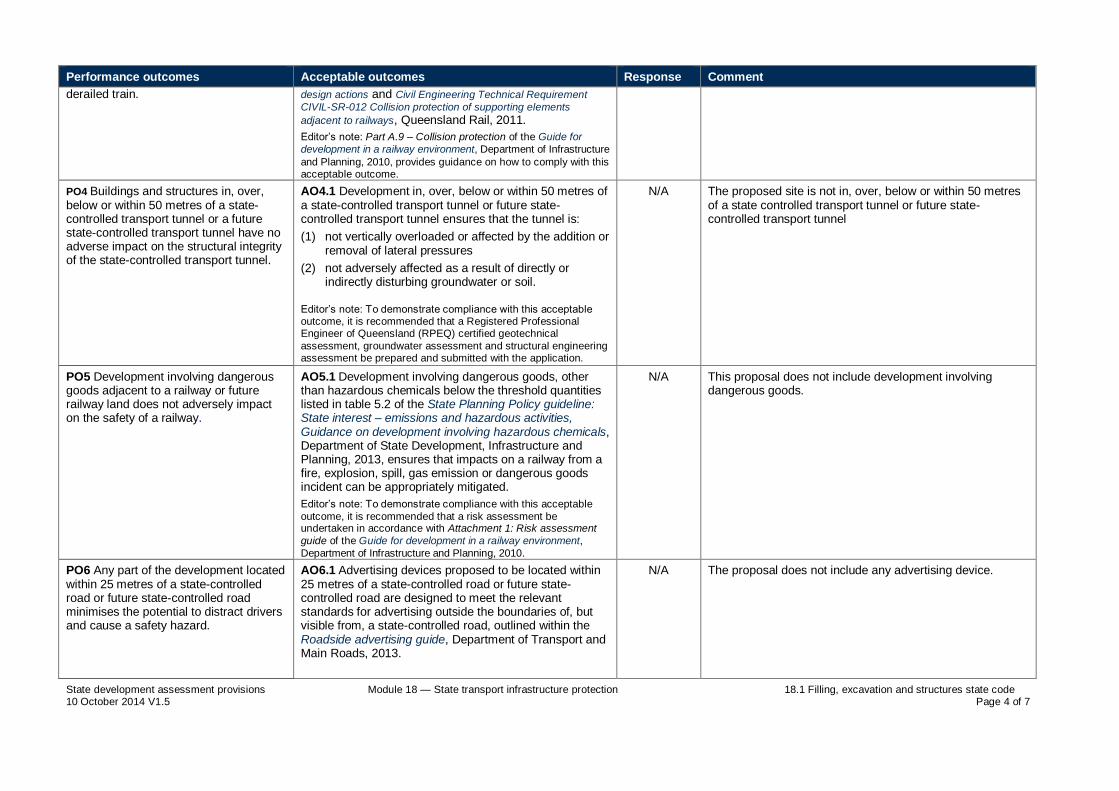
State development assessment provisions Module 18 — State transport infrastructure protection 18.1 Filling, excavation and structures state code 10 October 2014 V1.5 Page 4 of 7
Performance outcomes Acceptable outcomes Response Comment
derailed train. design actions and Civil Engineering Technical Requirement
CIVIL-SR-012 Collision protection of supporting elements
adjacent to railways, Queensland Rail, 2011.
Editor’s note: Part A.9 – Collision protection of the Guide for
development in a railway environment, Department of Infrastructure
and Planning, 2010, provides guidance on how to comply with this acceptable outcome.
PO4 Buildings and structures in, over, below or within 50 metres of a state-controlled transport tunnel or a future state-controlled transport tunnel have no adverse impact on the structural integrity of the state-controlled transport tunnel.
AO4.1 Development in, over, below or within 50 metres of a state-controlled transport tunnel or future state-controlled transport tunnel ensures that the tunnel is:
(1) not vertically overloaded or affected by the addition or removal of lateral pressures
(2) not adversely affected as a result of directly or indirectly disturbing groundwater or soil.
Editor’s note: To demonstrate compliance with this acceptable outcome, it is recommended that a Registered Professional Engineer of Queensland (RPEQ) certified geotechnical
assessment, groundwater assessment and structural engineering assessment be prepared and submitted with the application.
N/A The proposed site is not in, over, below or within 50 metres of a state controlled transport tunnel or future state-controlled transport tunnel
PO5 Development involving dangerous goods adjacent to a railway or future railway land does not adversely impact on the safety of a railway.
AO5.1 Development involving dangerous goods, other than hazardous chemicals below the threshold quantities listed in table 5.2 of the State Planning Policy guideline: State interest – emissions and hazardous activities, Guidance on development involving hazardous chemicals, Department of State Development, Infrastructure and Planning, 2013, ensures that impacts on a railway from a fire, explosion, spill, gas emission or dangerous goods incident can be appropriately mitigated.
Editor’s note: To demonstrate compliance with this acceptable
outcome, it is recommended that a risk assessment be undertaken in accordance with Attachment 1: Risk assessment
guide of the Guide for development in a railway environment,
Department of Infrastructure and Planning, 2010.
N/A This proposal does not include development involving dangerous goods.
PO6 Any part of the development located within 25 metres of a state-controlled road or future state-controlled road minimises the potential to distract drivers and cause a safety hazard.
AO6.1 Advertising devices proposed to be located within 25 metres of a state-controlled road or future state-controlled road are designed to meet the relevant standards for advertising outside the boundaries of, but visible from, a state-controlled road, outlined within the Roadside advertising guide, Department of Transport and Main Roads, 2013.
N/A The proposal does not include any advertising device.

State development assessment provisions Module 18 — State transport infrastructure protection 18.1 Filling, excavation and structures state code 10 October 2014 V1.5 Page 5 of 7
Performance outcomes Acceptable outcomes Response Comment
PO7 Filling, excavation and construction does not adversely impact on or compromise the safety or operation of:
(1) state transport corridors,
(2) future state transport corridors,
(3) state transport infrastructure.
AO7.1 Filling and excavation does not undermine, cause subsidence of, or groundwater seepage onto a state transport corridor or future state transport corridor.
Editor’s note: To demonstrate compliance with this acceptable outcome for a state-controlled road, it is recommended that a
filling and excavation report assessing the proposed filling and excavation be prepared in accordance with the requirements of the Road planning and design manual, Department of Transport
and Main Roads, 2013.
Editor’s note: If a development involves filling and excavation
within a state-controlled road, an approval issued by the Department of Transport and Main Roads under section 33 of the Transport Infrastructure Act 1994 may be required.
AND
The proposal location is set back more than 850m from a state controlled road. Excavation and construction will not result in any adverse impact on Mirani Eton Road.
AO7.2 Development within 25 metres of a railway or public passenger transport corridor and involving excavation, boring, piling or blasting does not result in vibration impacts during construction or blasting which would compromise the safety and operational integrity of the railway or public passenger transport corridor.
Editor’s note: To demonstrate compliance with this acceptable
outcome it is recommended that an RPEQ certified geotechnical report be prepared and submitted with the application.
Editor’s note: Development within 25 metres of a railway or public
passenger transport corridor may require an RPEQ certified vibration monitoring plan for the construction phase of
development as a condition of approval.
N/A This proposal is not located within 25 metres of a railway or public passenger transport corridor.
PO8 Filling and excavation does not interfere with or impact on existing or future planned services or public utilities on a state-controlled road.
AO8.1 Any alternative service and public utility alignment must satisfy the standards and design specifications of the service or public utility provider, and any costs of relocation are borne by the developer.
Editor’s note: An approval issued by the Department of Transport and Main Roads under section 33 of the Transport Infrastructure Act 1994 may be required.
The proposal location is set back more than 850m from a state controlled road. Excavation will not have any adverse impact on future planned services or public utilities on a state controlled road.
PO9 Retaining or reinforced soil structures required to contain fill and excavation:
(1) do not encroach on a state transport corridor
AO9.1 Retaining or reinforced soil structures (including footings, rock anchors and soil nails) are not located in a state transport corridor or future state transport corridor.
AND
N/A This proposal does not include any retaining wall or reinforced soil structure located in a state transport corridor or future state transport corridor.

State development assessment provisions Module 18 — State transport infrastructure protection 18.1 Filling, excavation and structures state code 10 October 2014 V1.5 Page 6 of 7
Performance outcomes Acceptable outcomes Response Comment
(2) are capable of being constructed and maintained without adversely impacting a state transport corridor
(3) are constructed of durable materials which maximise the life of the structure.
AO9.2 Retaining or reinforced soil structures in excess of an overall height of one metre abutting a state transport corridor are to be designed and certified by a structural RPEQ.
Editor’s note: To demonstrate compliance with this acceptable
outcome a RPEQ report should demonstrate that the works will not destabilise state transport infrastructure or the land supporting this infrastructure.
AND
N/A This proposal does not include any retaining wall or reinforced soil structure abutting a state transport corridor.
AO9.3 Retaining or reinforced soil structures that are set back less than 750 millimetres from a common boundary with a state-controlled road are certified by a structural RPEQ and designed to achieve a low maintenance external finish.
AND
N/A This proposal does not include any retaining wall or reinforced soil structure abutting a state transport corridor.
AO9.4 Retaining or reinforced soil structures adjacent to a state-controlled road, and in excess of an overall height of two metres, incorporate design treatments (such as terracing or planting) to reduce the overall height impact.
AND
N/A This proposal does not contain any retaining wall or reinforced soil structure in excess of 2 metres in height.
AO9.5 Construction materials of all retaining or reinforced soil structures have a design life exceeding 40 years, and comply with the specifications approved by a RPEQ.
AND
N/A This proposal does not include any retaining wall or reinforced soil structure abutting a state transport corridor.
AO9.6 Temporary structures and batters do not encroach into a railway.
Temporary structures will not encroach into any railway.
PO10 Filling and excavation does not cause siltation and erosion run-off from the property, or wind blown dust nuisance onto a state-controlled road.
AO10.1 Compaction of fill is carried out in accordance with the requirements of AS 1289.0 2000 – Methods of testing soils for engineering purposes.
Any compaction of fill will be carried out in accordance with AS1289.0 2000 – Methods of testing soild for engineering purposes.
PO11 Where the quantity of fill or excavated spoil material being imported or exported for a development exceeds 10 000 tonnes, and haulage will be on a state-controlled road, any impact on the infrastructure is identified and mitigation measures implemented.
AO11.1 The impacts on the state-controlled road network are identified, and measures are implemented to avoid, reduce or compensate the effects on the asset life of the state-controlled road.
Editor’s note: It is recommended that a pavement impact
assessment report be prepared to address this acceptable outcome. Guidance for preparing a pavement impact assessment is set out in Guidelines for assessment of road impacts of
development (GARID), Department of Transport and Main
N/A The proposal requires groundwork and will not result spoil exceeding 10 000 tonnes. The removal of spoil will be transported away from the site via Leichhardt Road (Not State-Controlled).

State development assessment provisions Module 18 — State transport infrastructure protection 18.1 Filling, excavation and structures state code 10 October 2014 V1.5 Page 7 of 7
Performance outcomes Acceptable outcomes Response Comment
Roads, 2006.
PO12 Filling and excavation associated with providing a driveway crossover to a state-controlled road does not compromise the operation or capacity of existing drainage infrastructure.
AO12.1 Filling and excavation associated with the design of driveway crossovers complies with the relevant Institute of Public Works Engineering Australia Queensland (IPWEAQ) standards.
Editor’s note: The construction of any crossover requires the
applicant to obtain a permit to work in the state-controlled road corridor under section 33 of the Transport Infrastructure Act 1994
and a section 62 approval under the Transport Infrastructure Act 1994 for the siting of the access and associated works.
N/A This proposal does not include any drive way cross over to a state controlled road.
PO13 Fill material does not cause contamination from the development site onto a state-controlled road.
AO13.1 Fill material is free of contaminants including acid sulphate content, and achieves compliance with AS 1289.0 – Methods of testing soils for engineering purposes and AS 4133.0-2005 – Methods of testing rocks for engineering purposes.
Fill material will achieve compliance with AS 1289.0 and AS 4133.0-2005.
PO14 Vibration generated through fill compaction does not result in damage or nuisance to a state-controlled road.
AO14.1 Fill compaction does not result in any vibrations beyond the site boundary, and is in accordance with AS 2436–2010 – Guide to noise and vibration control on construction, demolition and maintenance sites.
Fill compaction will be carried out in accordance with AS 2436-2010.
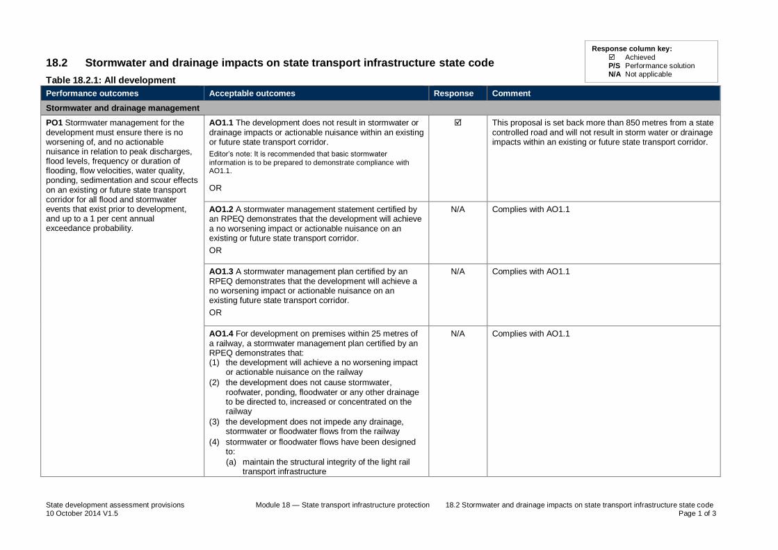
State development assessment provisions Module 18 — State transport infrastructure protection 18.2 Stormwater and drainage impacts on state transport infrastructure state code 10 October 2014 V1.5 Page 1 of 3
18.2 Stormwater and drainage impacts on state transport infrastructure state code
Table 18.2.1: All development
Performance outcomes Acceptable outcomes Response Comment
Stormwater and drainage management
PO1 Stormwater management for the development must ensure there is no worsening of, and no actionable nuisance in relation to peak discharges, flood levels, frequency or duration of flooding, flow velocities, water quality, ponding, sedimentation and scour effects on an existing or future state transport corridor for all flood and stormwater events that exist prior to development, and up to a 1 per cent annual exceedance probability.
AO1.1 The development does not result in stormwater or drainage impacts or actionable nuisance within an existing or future state transport corridor.
Editor’s note: It is recommended that basic stormwater
information is to be prepared to demonstrate compliance with AO1.1.
OR
This proposal is set back more than 850 metres from a state controlled road and will not result in storm water or drainage impacts within an existing or future state transport corridor.
AO1.2 A stormwater management statement certified by an RPEQ demonstrates that the development will achieve a no worsening impact or actionable nuisance on an existing or future state transport corridor.
OR
N/A Complies with AO1.1
AO1.3 A stormwater management plan certified by an RPEQ demonstrates that the development will achieve a no worsening impact or actionable nuisance on an existing future state transport corridor.
OR
N/A Complies with AO1.1
AO1.4 For development on premises within 25 metres of a railway, a stormwater management plan certified by an RPEQ demonstrates that: (1) the development will achieve a no worsening impact
or actionable nuisance on the railway
(2) the development does not cause stormwater, roofwater, ponding, floodwater or any other drainage to be directed to, increased or concentrated on the railway
(3) the development does not impede any drainage, stormwater or floodwater flows from the railway
(4) stormwater or floodwater flows have been designed to:
(a) maintain the structural integrity of the light rail transport infrastructure
N/A Complies with AO1.1
Response column key:
Achieved P/S Performance solution N/A Not applicable

State development assessment provisions Module 18 — State transport infrastructure protection 18.2 Stormwater and drainage impacts on state transport infrastructure state code 10 October 2014 V1.5 Page 2 of 3
Performance outcomes Acceptable outcomes Response Comment
(b) avoid scour or deposition (5) additional railway formation drainage necessitated by
the development is located within the premises where the development is carried out
(6) retaining structures for excavations abutting the railway corridor provide for drainage.
Lawful point of discharge
PO2 Stormwater run-off and drainage are directed to a lawful point of discharge to avoid adverse impacts on a future or existing state transport corridor.
AO2.1 Where stormwater run-off is discharged to a state transport corridor, the discharge is to a lawful point of discharge in accordance with section 1.4.3 of the Road drainage manual, Department of Transport and Main Roads, 2010 and section 3.02 of Queensland urban drainage manual, Department of Energy and Water Supply, 2013.
OR
N/A This proposal is set back more than 850 metres from a state controlled road.
AO2.2 For development on premises within 25 metres of a railway, approval from the relevant railway manager for the railway, as defined in the Transport Infrastructure Act 1994, schedule 6 has been gained to verify the lawful point of discharge for stormwater onto the railway.
AND
N/A This proposal is set back more than 850 metres from a state controlled road.
AO2.3 Development does not cause a net increase in or concentration of stormwater or floodwater flows discharging onto the state transport corridor during construction or thereafter.
AND
Proposed development is set back more than 850 metres from a state controlled road and will not result in an increase or concentration of stormwater or floodwater flows discharging onto a state transport corridor.
AO2.4 Development does not create any additional points of discharge or changes to the condition of an existing lawful point of discharge to the state transport corridor.
Proposed development is set back more than 850 metres from a state controlled road and will not create any additional points of discharge or changes to the condition of an existing lawful point of discharge.
Sediment and erosion management
PO3 Run-off from upstream development is managed to ensure that sedimentation and erosion do not cause siltation of stormwater infrastructure in the state transport corridor.
AO3.1 Development with a moderate to high risk of erosion incorporates erosion and sediment control measures.
Editor’s note: For a state-controlled road where a development
has a moderate to high risk of erosion as per section 13.5 of the Road drainage manual, Department of Transport and Main
N/A This proposal is located on flat agricultural land and achieves large setbacks from adjoining uses. The proposed development does not have a moderate or high risk or erosion.

State development assessment provisions Module 18 — State transport infrastructure protection 18.2 Stormwater and drainage impacts on state transport infrastructure state code 10 October 2014 V1.5 Page 3 of 3
Performance outcomes Acceptable outcomes Response Comment
Roads, 2010, an erosion and sedimentation control plan should be provided to support a stormwater management plan.

State development assessment provisions Module 19 — State transport network functionality 19.1 Access to state-controlled roads state code 10 October 2014 V1.5 Page 1 of 4
19.1 Access to state-controlled roads state code
Table 19.1.1: All development
Performance outcomes Acceptable outcomes Response Comment
Location of the direct vehicular access to the state-controlled road
PO1 Any road access location to the state-controlled road from adjacent land does not compromise the safety and efficiency of the state-controlled road.
AO1.1 Any road access location to the state-controlled road complies with a decision under section 62 of the TIA.
OR
N/A This application does not propose any direct vehicular access to a state controlled road.
AO1.2 Development does not propose a new or temporary road access location, or a change to the use or operation of an existing permitted road access location to a state-controlled road.
OR
This application does not propose any direct vehicular access to a state controlled road.
AO1.3 Any proposed road access location for the development is provided from a lower order road where an alternative to the state-controlled road exists.
OR all of the following acceptable outcomes apply
N/A This application does not propose any direct vehicular access to a state controlled road.
AO1.4 Any new or temporary road access location, or a change to the use or operation of an existing permitted road access location, demonstrates that the development:
(1) does not exceed the acceptable level of service of a state-controlled road
(2) meets the sight distance requirements outlined in Volume 3, parts 3, 4, 4A, 4B and 4C of the Road planning and design manual, 2nd edition, Department of Transport and Main Roads, 2013
(3) does not exceed the acceptable operation of an intersection with a state-controlled road, including the degree of saturation, delay, queuing lengths and intersection layout
(4) is not located within and/or adjacent to an existing or planned intersection in accordance with Volume 3, parts 4, 4A, 4B and 4C of the Road planning and design manual, 2nd edition, Department of Transport and Main Roads, 2013
(5) does not conflict with another property’s road access location and operation
N/A This application does not propose any direct vehicular access to a state controlled road.
Response column key:
Achieved P/S Performance solution N/A Not applicable

State development assessment provisions Module 19 — State transport network functionality 19.1 Access to state-controlled roads state code 10 October 2014 V1.5 Page 2 of 4
Performance outcomes Acceptable outcomes Response Comment
Editor’s Note: To demonstrate compliance with this acceptable
outcome, it is recommended a traffic impact assessment be developed in accordance with Chapters 1, 4, 6, 7, 8 and 9 of the Guidelines for assessment of road impacts of development
(GARID), Department of Main Roads, 2006, and the requirements of Volume 3, parts 4, 4A, 4B and 4C of the Road planning and design manual, 2nd edition, Department of
Transport and Main Roads, 2013, SIDRA analysis or traffic modelling.
AND
AO1.5 Development does not propose a new road access location to a limited access road.
Editor’s note: Limited access roads are declared by the chief
executive under section 54 of the TIA. Details can be accessed by contacting the appropriate DTMR regional office.
N/A This application does not propose any direct vehicular access to a state controlled road.
Number of road accesses to the state-controlled road
PO2 The number of road accesses to the state-controlled road maintains the safety and efficiency of the state-controlled road.
AO2.1 Development does not increase the number of road accesses to the state-controlled road.
AND
N/A This application does not propose any road accesses to a state controlled road.
AO2.2 Where multiple road accesses to the premises exist, access is rationalised to reduce the overall number of road accesses to the state-controlled road.
AND
N/A This application does not propose any road accesses to a state controlled road.
AO2.3 Shared or combined road accesses are provided for adjoining land having similar uses to rationalise the overall number of direct accesses to the state-controlled road.
Editor’s note: Shared road accesses may require easements to
provide a legal point of access for adjacent lots. If this is required, then the applicant must register reciprocal access easements on the titles of any lots for the shared access.
N/A This application does not propose any road accesses to a state controlled road.
Design vehicle and traffic volume
PO3 The design of any road access maintains the safety and efficiency of the state-controlled road.
AO3.1 Any road access meets the minimum standards associated with the design vehicle.
Editor’s note: The design vehicle to be considered is the same as
the design vehicle set under the relevant local government
N/A This application does not propose any road access to a state controlled road.

State development assessment provisions Module 19 — State transport network functionality 19.1 Access to state-controlled roads state code 10 October 2014 V1.5 Page 3 of 4
Performance outcomes Acceptable outcomes Response Comment
planning scheme.
AND
AO3.2 Any road access is designed to accommodate the forecast volume of vehicle movements in the peak periods of operation or conducting the proposed use of the premises.
AND
N/A This application does not propose any road access to a state controlled road.
AO3.3 Any road access is designed to accommodate 10 year traffic growth past completion of the final stage of development in accordance with GARID.
AND
N/A This application does not propose any road access to a state controlled road.
AO3.4 Any road access in an urban location is designed in accordance with the relevant local government standards or IPWEAQ R-050, R-051 , R-052 and R-053 drawings.
AND
N/A This application does not propose any road access to a state controlled road.
AO3.5 Any road access not in an urban location is designed in accordance with Volume 3, parts 3, 4 and 4A of the Road planning and design manual, 2nd edition, Department of Transport and Main Roads, 2013.
N/A This application does not propose any road access to a state controlled road.
Internal and external manoeuvring associated with direct vehicular access to the state-controlled road
PO4 Turning movements for vehicles entering and exiting the premises via the road access maintain the safety and efficiency of the state-controlled road.
AO4.1 The road access provides for left in and left out turning movements only.
AND
N/A This proposal does not include any direct vehicular access to a state controlled road.
AO4.2 Internal manoeuvring areas on the premises are designed so the design vehicle can enter and leave the premises in a forward gear at all times.
Editor’s note: The design vehicle to be considered is the same as
the design vehicle set under the relevant local government planning scheme.
N/A This proposal does not include any direct vehicular access to a state controlled road.
PO5 On-site circulation is suitably designed to accommodate the design vehicle associated with the proposed land use, in order to ensure that there is no impact on the safety and efficiency of the state-controlled road.
AO5.1 Provision of on-site vehicular manoeuvring space is provided to ensure the flow of traffic on the state-controlled road is not compromised by an overflow of traffic queuing to access the site in accordance with AS2890 – Parking facilities.
AND
N/A This proposal does not include any direct vehicular access to a state controlled road.

State development assessment provisions Module 19 — State transport network functionality 19.1 Access to state-controlled roads state code 10 October 2014 V1.5 Page 4 of 4
Performance outcomes Acceptable outcomes Response Comment
AO5.2 Mitigation measures are provided to ensure that the flow of traffic on the state-controlled road is not disturbed by traffic queuing to access the site.
N/A This proposal does not include any direct vehicular access to a state controlled road.
Vehicular access to local roads within 100 metres of an intersection with a state-controlled road
PO6 Development having road access to a local road within 100 metres of an intersection with a state-controlled road maintains the safety and efficiency of the state-controlled road.
AO6.1 The road access location to the local road is located as far as possible from where the road intersects with the state-controlled road and accommodates existing operations and planned upgrades to the intersection or state-controlled road.
AND
N/A Vehicle access to Leichhardt Road is greater than 100 metres from any intersection with a state controlled road.
AO6.2 The road access to the local road network is in accordance with Volume 3, parts 3, 4 and 4A of the Road planning and design manual, 2nd edition, Department of Transport and Main Roads, 2013, and is based on the volume of traffic and speed design of both the local road and intersecting state-controlled road for a period of 10 years past completion of the final stage of development.
AND
N/A Vehicle access to Leichhardt Road is greater than 100 metres from any intersection with a state controlled road.
AO6.3 Vehicular access to the local road and internal vehicle circulation is designed to remove or minimise the potential for vehicles entering the site to queue in the intersection with the state-controlled road or along the state-controlled road itself.
N/A Vehicle access to Leichhardt Road is greater than 100 metres from any intersection with a state controlled road.

State development assessment provisions Module 19 — State transport network functionality 19.2 Transport infrastructure and network design state code 10 October 2014 V1.5 Page 1 of 2
19.2 Transport infrastructure and network design state code
Table 19.2.1: All development
Performance outcomes Acceptable outcomes Response Comment
All state transport infrastructure – except state-controlled roads
PO1 Development does not compromise the safe and efficient management or operation of state transport infrastructure or transport networks.
Editor’s note: To demonstrate compliance with
this performance outcome, it is recommended that a traffic impact assessment be prepared.
A traffic impact assessment should identify any upgrade works required to mitigate impacts on the safety and operational integrity
of the state transport corridor, including any impact on a railway crossing. An impact on a level crossing may require an Australian Level
Crossing Assessment Model (ALCAM) assessment to be undertaken.
No acceptable outcome is prescribed. N/A This proposal is not located near state transport infrastructure or transport networks.
PO2 Development does not compromise planned upgrades to state transport infrastructure or the development of future state transport infrastructure in future state transport corridors.
Editor’s note: Written advice from DTMR advising that there are no planned upgrades of
state transport infrastructure or future state transport corridors that will be compromised by the development, will assist in addressing
this performance outcome.
AO2.1 The layout and design of the proposed development accommodates planned upgrades to state transport infrastructure.
AND
N/A This proposal is not located near state transport infrastructure or transport networks.
AO2.2 The layout and design of the development accommodates the delivery of state transport infrastructure in future state transport corridors .
Editor’s note: To demonstrate compliance with this acceptable
outcome, it is recommended that a traffic impact assessment be
prepared.
N/A This proposal is not located near state transport infrastructure or transport networks.
State-controlled roads
PO3 Development does not compromise the safe and efficient management or operation of state-controlled roads.
Editor’s note: A traffic impact assessment will
assist in addressing this performance outcome.
No acceptable outcome is prescribed. Proposed development does not compromise the safe and efficient management or operation of the state-controlled road.
The development will involve a material change for an un-staffed telecommunications facility and will not involve any building work or operational work that will change access from the State controlled Road.
Response column key:
Achieved P/S Performance solution N/A Not applicable

State development assessment provisions Module 19 — State transport network functionality 19.2 Transport infrastructure and network design state code 10 October 2014 V1.5 Page 2 of 2
Performance outcomes Acceptable outcomes Response Comment
PO4 Development does not compromise planned upgrades of the state-controlled road network or delivery of future state-controlled roads.
Editor’s note: Written advice from DTMR that
there are no planned upgrades of state-controlled roads or future state-controlled roads which will be compromised by the
development will assist in addressing this performance outcome.
AO4.1 The layout and design of the development accommodates planned upgrades of the state-controlled road
AND
The proposed development is set back greater than 850 metres from a state controlled road and will not restrict future upgrades of state-controlled roads.
AO4.2 The layout and design of the development accommodates the delivery of future state-controlled roads.
Editor’s note: To demonstrate compliance with this acceptable
outcome, it is recommended that a traffic impact assessment be prepared.
The proposed development is set back greater than 850 metres from a state controlled road and will not restrict future upgrades of state-controlled roads.
PO5 Upgrade works on or associated with, the state-controlled road network are undertaken in accordance with applicable standards.
AO5.1 Upgrade works for the development are consistent with the requirements of the Road planning and design manual, 2
nd edition, Department of Transport and Main
Roads, 2013.
AND
N/A This proposal does not require any upgrade works to a state controlled road.
AO5.2 The design and staging of upgrade works on or associated with the state-controlled road network are consistent with planned upgrades.
N/A This proposal does not require any upgrade works to a state controlled road.
PO6 Development does not impose traffic loadings on the state-controlled road network which could be accommodated on the local road network.
AO6.1 New lower order roads do not connect directly to a state-controlled road.
AND
N/A No new lower order roads are proposed.
AO6.2 The layout and design of the development directs traffic generated by the development to use lower order roads.
Access to the proposed development is off a lower order road (Leichhardt Road).

Page 34 NBN - Mirani
9.3 Appendix 4 – ARPANSA EME Report

Environmental EME report (v11.3, Feb 2014) Produced with RF-Map 2.0 (Build 1.18) NAD (v1.0.53334.25518)
Environmental EME Report
Mirani Lot 1475 Leichhardt Road, MIRANI QLD 4754
This report provides a summary of Calculated RF EME Levels around the wireless base station
Date 25/5/2015 RFNSA Site No. 4754004
Introduction
The purpose of this report is to provide calculations of EME levels from the existing facilities at the site and any proposed additional facilities.
This report provides a summary of levels of radiofrequency (RF) electromagnetic energy (EME) around the wireless base station at Mirani Lot 1475 Leichhardt Road MIRANI QLD 4754 . These levels have been calculated by Ericsson using methodology developed by the Australian Radiation Protection and Nuclear Safety Agency (ARPANSA).
The maximum EME level calculated for the proposed systems at this site is 0.087% of the public exposure limit.
The ARPANSA Standard
ARPANSA, an Australian Government agency in the Health and Ageing portfolio, has established a Radiation Protection Standard specifying limits for general public exposure to RF transmissions at frequencies used by wireless base stations. The Australian Communications and Media Authority (ACMA) mandates the exposure limits of the ARPANSA Standard.
How the EME is calculated in this report
The procedure used for these calculations is documented in the ARPANSA Technical Report “Radio Frequency EME Exposure Levels - Prediction Methodologies” which is available at http://www.arpansa.gov.au.
RF EME values are calculated at 1.5m above ground at various distances from the base station, assuming level ground.
The estimate is based on worst-case scenario, including:
wireless base station transmitters for mobile and broadband data operating at maximum power
simultaneous telephone calls and data transmission
an unobstructed line of sight view to the antennas.
In practice, exposures are usually lower because:
the presence of buildings, trees and other features of the environment reduces signal strength
the base station automatically adjusts transmit power to the minimum required.
Maximum EME levels are estimated in 360° circular bands out to 500m from the base station.
These levels are cumulative and take into account emissions from all mobile phone antennas at this site. The EME levels are presented in three different units:
volts per metre (V/m) – the electric field component of the RF wave
milliwatts per square metre (mW/m²) – the power density (or rate of flow of RF energy per unit area)
percentage (%) of the ARPANSA Standard public exposure limit (the public exposure limit = 100%).
Results
The maximum EME level calculated for the proposed systems at this site is 1.81 V/m; equivalent to 8.68 mW/m² or 0.087% of the public exposure limit.

Environmental EME report (v11.3, Feb 2014) Produced with RF-Map 2.0 (Build 1.18) NAD (v1.0.53334.25518)
Radio Systems at the Site
There are currently no existing radio systems for this site.
It is proposed that this base station will have equipment for transmitting the following services:
Carrier Radio Systems
NBN Co LTE2300 (proposed)
Calculated EME Levels
This table provides calculations of RF EME at different distances from the base station for emissions from existing equipment alone and for emissions from existing equipment and proposed equipment combined.
Distance from the antennas at Mirani Lot 1475 Leichhardt
Road
in 360 circular bands
Maximum Cumulative EME Level – All carriers at this site
Existing Equipment Proposed Equipment
Electric Field V/m
Power Density mW/m²
% ARPANSA exposure limits
Electric Field V/m
Power Density mW/m²
% ARPANSA exposure limits
0m to 50m 50m to 100m
100m to 200m 200m to 300m 300m to 400m 400m to 500m
0.7 0.58 1.52 1.81 1.72 1.34
1.3 0.89 6.14 8.68 7.81 4.78
0.013% 0.0089% 0.061% 0.087% 0.078% 0.048%
Maximum EME level 1.81 8.68 0.087
253.41 m from the antennas at Mirani Lot
1475 Leichhardt Road
Calculated EME levels at other areas of interest
This table contains calculations of the maximum EME levels at selected areas of interest that have been identified through the consultation requirements of the Communications Alliance Ltd Deployment Code C564:2011 or via any other means. The calculations are performed over the indicated height range and include all existing and any proposed radio systems for this site.
Additional Locations Height / Scan
relative to location ground level
Maximum Cumulative EME Level All Carriers at this site
Existing and Proposed Equipment
Electric Field V/m
Power Density mW/m²
% of ARPANSA exposure limits
No locations identified

Environmental EME report (v11.3, Feb 2014) Produced with RF-Map 2.0 (Build 1.18) NAD (v1.0.53334.25518)
RF EME Exposure Standard
The calculated EME levels in this report have been expressed as percentages of the ARPANSA RF Standard and this table shows the actual RF EME limits used for the frequency bands available. At frequencies below 2000 MHz the limits vary across the band and the limit has been determined at the Assessment Frequency indicated. The four exposure limit figures quoted are equivalent values expressed in different units – volts per metre (V/m), watts per square metre (W/m²), microwatts per square centimetre (µW/cm²) and milliwatts per square metre (mW/m²). Note: 1 W/m² = 100 µW/cm² = 1000 mW/m².
Radio Systems Frequency Band Assessment Frequency
ARPANSA Exposure Limit (100% of Standard)
LTE 700 758 – 803 MHz 750 MHz 37.6 V/m = 3.75 W/m² = 375 µW/cm² = 3750 mW/m²
WCDMA850 870 – 890 MHz 900 MHz 41.1 V/m = 4.50 W/m² = 450 µW/cm² = 4500 mW/m²
GSM900, LTE900, WCDMA900 935 – 960 MHz 900 MHz 41.1 V/m = 4.50 W/m² = 450 µW/cm² = 4500 mW/m²
GSM1800, LTE1800 1805 – 1880 MHz 1800 MHz 58.1 V/m = 9.00 W/m² = 900 µW/cm² = 9000 mW/m²
LTE2100, WCDMA2100 2110 – 2170 MHz 2100 MHz 61.4 V/m = 10.00 W/m² = 1000 µW/cm² = 10000 mW/m²
LTE2300 2302 – 2400 MHz 2300 MHz 61.4 V/m = 10.00 W/m² = 1000 µW/cm² = 10000 mW/m²
LTE2600 2620 – 2690 MHz 2600 MHz 61.4 V/m = 10.00 W/m² = 1000 µW/cm² = 10000 mW/m²
LTE3500 3425 – 3575 MHz 3500 MHz 61.4 V/m = 10.00 W/m² = 1000 µW/cm² = 10000 mW/m²
Further Information
The Australian Radiation Protection and Nuclear Safety Agency (ARPANSA) is a Federal Government agency incorporated under the Health and Ageing portfolio. ARPANSA is charged with responsibility for protecting the health and safety of people, and the environment, from the harmful effects of radiation (ionising and non-ionising).
Information about RF EME can be accessed at the ARPANSA website, http://www.arpansa.gov.au, including:
Further explanation of this report in the document “Understanding the ARPANSA Environmental EME Report”
The procedure used for the calculations in this report is documented in the ARPANSA Technical Report; “Radio Frequency EME Exposure Levels - Prediction Methodologies”
the current RF EME exposure standard
Australian Radiation Protection and Nuclear Safety Agency (ARPANSA), 2002, ‘Radiation Protection Standard: Maximum Exposure Levels to Radiofrequency Fields — 3 kHz to 300 GHz’, Radiation Protection Series Publication No. 3, ARPANSA, Yallambie Australia. [Printed version: ISBN 0-642-79400-6 ISSN 1445-9760] [Web version: ISBN 0-642-79402-2 ISSN 1445-9760]
The Australian Communications and Media Authority (ACMA) is responsible for the regulation of broadcasting, radiocommunications, telecommunications and online content. Information on EME is available at http://emr.acma.gov.au
The Communications Alliance Ltd Industry Code C564:2011 ‘Mobile Phone Base Station Deployment’ is available from the Communications Alliance Ltd website, http://commsalliance.com.au .
Contact details for the Carriers (mobile phone companies) present at this site and the most recent version of this document are available online at the Radio Frequency National Site Archive, http://www.rfnsa.com.au.