PLANNING PROPOSAL · 2018-06-07 · Mecone Planning October 2015 Council versions: No. Author...
30
PLANNING PROPOSAL 12A Parkes Street, Parramatta (also known as 122 Wigram Street, Harris Park)
Transcript of PLANNING PROPOSAL · 2018-06-07 · Mecone Planning October 2015 Council versions: No. Author...
PLANNING PROPOSAL 12A Parkes Street, Parramatta (also known as 122 Wigram Street, Harris Park)
Planning Proposal – 12A Parkes Street, Parramatta (also known as 122 Wigram Street, Harris Park)
RZ/22/2014 2
Planning Proposal drafts
Proponent versions:
No. Author Version
1. Mecone Planning October 2015
Council versions:
No. Author Version
1. Parramatta City Council December 2015- Council Meeting recommending
Gateway Determination
2. Parramatta City Council February - Section 56(1) submission to the DP&E
3. City of Parramatta Council May 2017 – Section 3.33 and Schedule 1 of the EP&A
Act 1979
Planning Proposal – 12A Parkes Street, Parramatta (also known as 122 Wigram Street, Harris Park)
RZ/22/2014 3
Contents
INTRODUCTION ..................................................................................................................................... 4
Background and context .................................................................................................................. 4
PART 1 – OBJECTIVES OR INTENDED OUTCOMES ......................................................................... 6
PART 2 – EXPLANATION OF PROVISIONS ........................................................................................ 6
2.1 Other relevant matters .......................................................................................................... 7
PART 3 – JUSTIFICATION .................................................................................................................... 7
3.1 Section A - Need for the planning proposal ....................................................................... 7
Section C – Environmental, social and economic impact ........................................................... 14
Section D – State and Commonwealth Interests .......................................................................... 19
PART 4 – MAPPING ............................................................................................................................. 20
4.1 Existing controls ................................................................................................................. 20
4.2 Proposed controls .............................................................................................................. 23
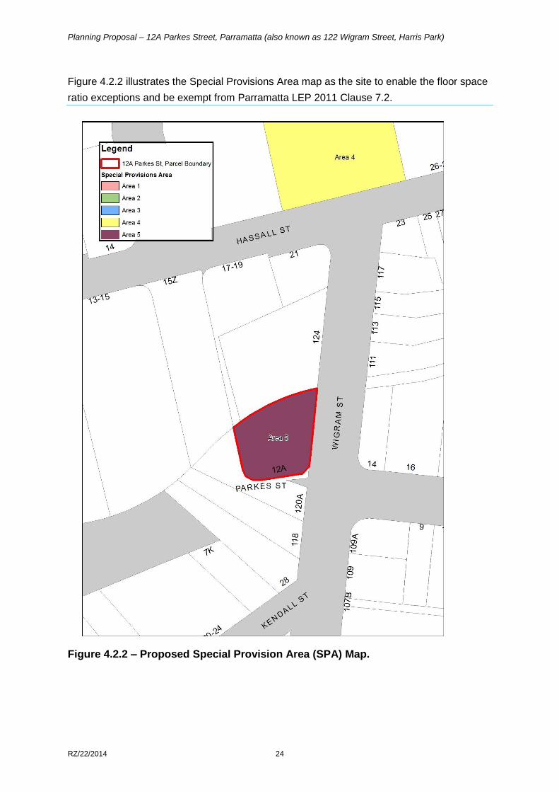
Figure 4.2.2 illustrates the Special Provisions Area map as the site to enable the floor space
ratio exceptions and be exempt from Parramatta LEP 2011 Clause 7.2. ...................................... 24
PART 5 – COMMUNITY CONSULTATION ......................................................................................... 25
PART 6 – PROJECT TIMELINE .......................................................................................................... 25
Appendix 1 – Urban Design Report ................................................................................................... 26
Appendix 2 – Flood Assessment ....................................................................................................... 27
Appendix 3 – Independent Flood Assessment ................................................................................ 28
Appendix 4 - Traffic and Transport Assessment ............................................................................. 29
Planning Proposal – 12A Parkes Street, Parramatta (also known as 122 Wigram Street, Harris Park)
RZ/22/2014 4
INTRODUCTION
This planning proposal explains the intended effect of, and justification for the proposed amendment to Parramatta Local Environmental Plan 2011. It has been prepared in accordance with Section 3.33 of the Environmental Planning and Assessment Act 1979 and the Department of Planning and Environment guides, 'A Guide to Preparing Local Environment Plans' (April 2013) and 'A Guide to Preparing Planning Proposals' (October 2012).
Background and context
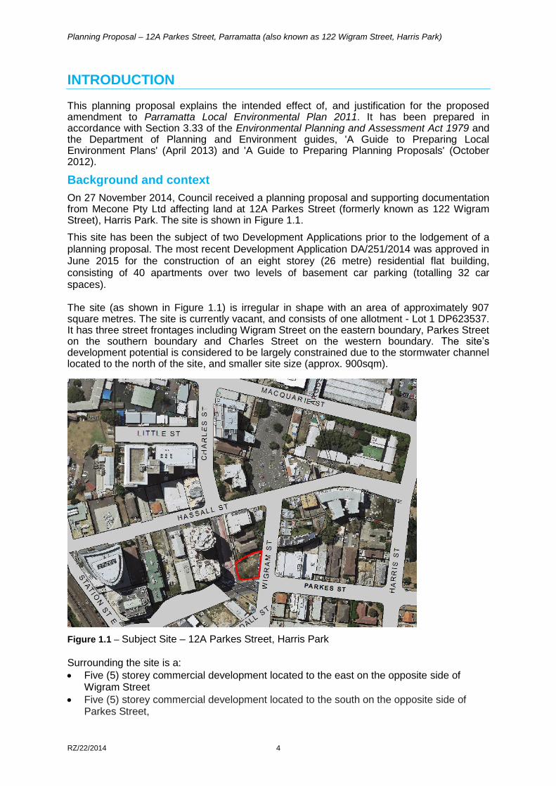
On 27 November 2014, Council received a planning proposal and supporting documentation from Mecone Pty Ltd affecting land at 12A Parkes Street (formerly known as 122 Wigram Street), Harris Park. The site is shown in Figure 1.1.
This site has been the subject of two Development Applications prior to the lodgement of a planning proposal. The most recent Development Application DA/251/2014 was approved in June 2015 for the construction of an eight storey (26 metre) residential flat building, consisting of 40 apartments over two levels of basement car parking (totalling 32 car spaces). The site (as shown in Figure 1.1) is irregular in shape with an area of approximately 907 square metres. The site is currently vacant, and consists of one allotment - Lot 1 DP623537. It has three street frontages including Wigram Street on the eastern boundary, Parkes Street on the southern boundary and Charles Street on the western boundary. The site’s development potential is considered to be largely constrained due to the stormwater channel located to the north of the site, and smaller site size (approx. 900sqm).
Figure 1.1 – Subject Site – 12A Parkes Street, Harris Park
Surrounding the site is a:
Five (5) storey commercial development located to the east on the opposite side of Wigram Street
Five (5) storey commercial development located to the south on the opposite side of Parkes Street,
Planning Proposal – 12A Parkes Street, Parramatta (also known as 122 Wigram Street, Harris Park)
RZ/22/2014 5
Sixteen (16) storey residential development located to the west on the opposite side of Charles Street.
Under Parramatta Local Environmental Plan 2011 (PLEP 2011), the site:
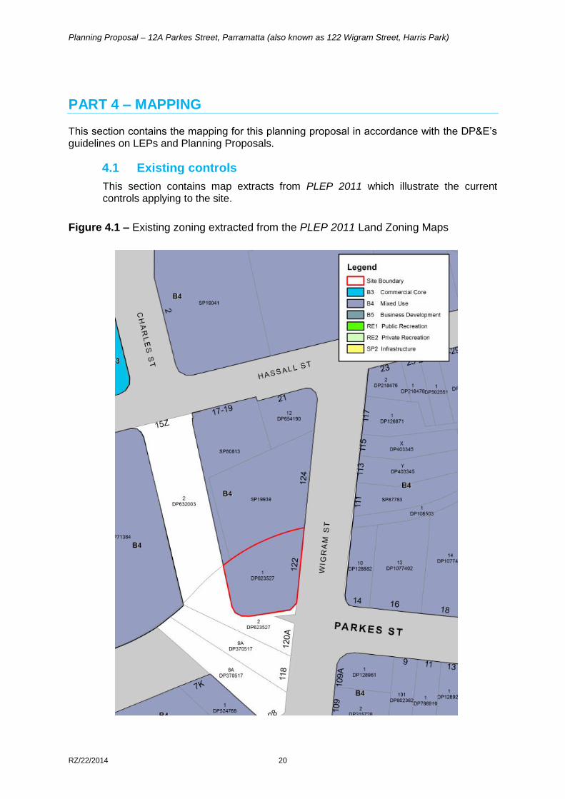
Is zoned B4 Mixed Use (refer to Figure 4.1 in Part 4 – Mapping);
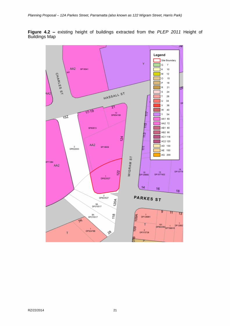
Has a maximum building height of 72 metres (refer to Figure 4.2 in Part 4 – Mapping); and
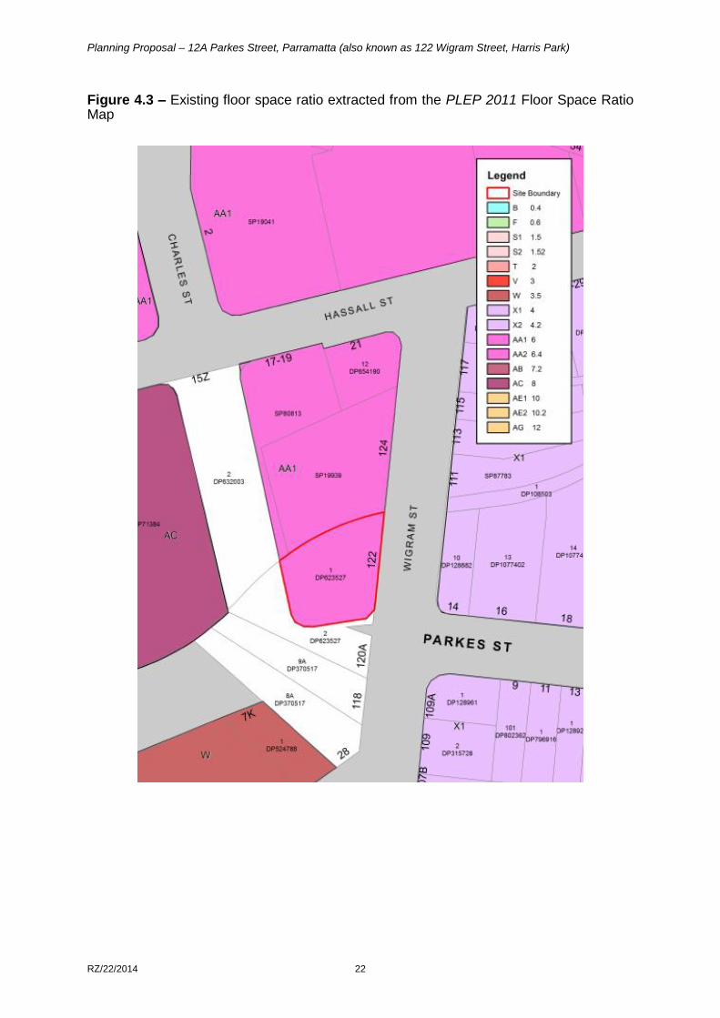
Has a maximum floor space ratio (FSR) of 4:1*(refer to Figure 4.3 in Part 4 – Mapping).
*This site is mapped at 6:1 under the PLEP 2011 however, clause 7.2 of the PLEP2011 applies to this site as it is less than 1000 square metres.
This Planning Proposal does seeks to:
Increase the maximum floor space ratio (FSR) from 4:1 to 8:1
Add site specific controls that provides for the following:
o Applies a maximum car parking rate provision that is in accordance with the CBD Strategic Transport Study
o Requires development to address floodplain risk management
o Exemption from Clause 7.2 of the PLEP 2011 which relates to floor space application to small sites (known as a sliding scale provision).
The Planning Proposal and Appendices have been amended prior to community consultation to accord with:
Conditions of the DP&E’s Gateway Determination issued on 17 June 2016 and revised Gateway Determinations on 29 November 2016 and 21 September 2017;
Updates to planning strategies and policies and amendments to the Environmental Planning and Assessment 1979.
Planning Proposal – 12A Parkes Street, Parramatta (also known as 122 Wigram Street, Harris Park)
RZ/22/2014 6
PART 1 – OBJECTIVES OR INTENDED OUTCOMES
The objective of this planning proposal is to increase the permissible density of land at 12A Parkes Street, Harris Park in accordance with the current B4 Mixed Use zone.
PART 2 – EXPLANATION OF PROVISIONS
This planning proposal seeks to amend Parramatta Local Environmental Plan 2011(PLEP 2011) in relation to the height and floor space ratio controls. In order to achieve the desired objectives, the following amendments to the PLEP 2011 would need to be made:
1. Insert a new clause in Part 7, consistent with Council’s resolution:
7.12 Development on land at 122 Wigram Street, Harris Park
(1) This clause applies to land marked “Area #” on the Special Provisions Area Map.
(2) Despite clause 7.2, the consent authority may grant consent to development on land to which this clause applies with a maximum floor space ratio of 8:1 (excluding any design excellence bonus granted pursuant to Clause 7.10).
2. Amend the maximum FSR in the Floor Space Ratio Map (Sheet FSR_010) from 6:1 to a base FSR of 8:1. Refer Figure 4.2.2 in Part 4 of this planning proposal.
3. Amend the Special Provisions Area Map (Sheet CL1_010) to include the site to enable the floor space ratio exceptions clause 7.2 (as explained in the first amendment in Point 1, above).
4. Apply a maximum car parking rate provision that is in accordance with the CBD Strategic Transport study based on the following:
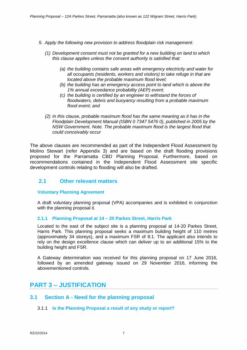
a) Residential parking rates
b) Commercial parking rates Commercial parking rates If the FSR > 3.5:1 M = (G * A) / (50 * T) where: M = maximum number of parking spaces; G = GFA of all office/business premises in the building (m²); A = Site Area (m²); T = Total GFA of all buildings on the site (m²)
Type of Apartment
Spaces/unit
3-bedroom 1 space/unit
2-bedroom .7 spaces/unit
1-bedroom .3 spaces/unit
Studio .1 spaces/unit
Planning Proposal – 12A Parkes Street, Parramatta (also known as 122 Wigram Street, Harris Park)
RZ/22/2014 7
5. Apply the following new provision to address floodplain risk management:
(1) Development consent must not be granted for a new building on land to which this clause applies unless the consent authority is satisfied that:
(a) the building contains safe areas with emergency electricity and water for
all occupants (residents, workers and visitors) to take refuge in that are located above the probable maximum flood level;
(b) the building has an emergency access point to land which is above the 1% annual exceedance probability (AEP) event;
(c) the building is certified by an engineer to withstand the forces of floodwaters, debris and buoyancy resulting from a probable maximum flood event; and
(2) In this clause, probable maximum flood has the same meaning as it has in the
Floodplain Development Manual (ISBN 0 7347 5476 0), published in 2005 by the NSW Government. Note. The probable maximum flood is the largest flood that could conceivably occur
The above clauses are recommended as part of the Independent Flood Assessment by Molino Stewart (refer Appendix 3) and are based on the draft flooding provisions proposed for the Parramatta CBD Planning Proposal. Furthermore, based on recommendations contained in the Independent Flood Assessment site specific development controls relating to flooding will also be drafted.
2.1 Other relevant matters
Voluntary Planning Agreement A draft voluntary planning proposal (VPA) accompanies and is exhibited in conjunction with the planning proposal it. 2.1.1 Planning Proposal at 14 – 20 Parkes Street, Harris Park
Located to the east of the subject site is a planning proposal at 14-20 Parkes Street, Harris Park. This planning proposal seeks a maximum building height of 110 metres (approximately 34 storeys), and a maximum FSR of 8:1. The applicant also intends to rely on the design excellence clause which can deliver up to an additional 15% to the building height and FSR. A Gateway determination was received for this planning proposal on 17 June 2016, followed by an amended gateway issued on 29 November 2016, informing the abovementioned controls.
PART 3 – JUSTIFICATION
3.1 Section A - Need for the planning proposal
3.1.1 Is the Planning Proposal a result of any study or report?
Planning Proposal – 12A Parkes Street, Parramatta (also known as 122 Wigram Street, Harris Park)
RZ/22/2014 8
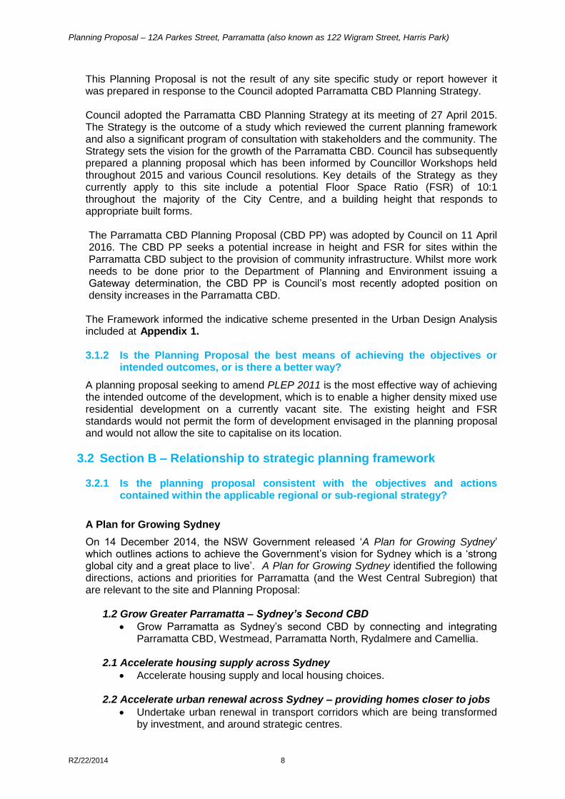
This Planning Proposal is not the result of any site specific study or report however it was prepared in response to the Council adopted Parramatta CBD Planning Strategy. Council adopted the Parramatta CBD Planning Strategy at its meeting of 27 April 2015. The Strategy is the outcome of a study which reviewed the current planning framework and also a significant program of consultation with stakeholders and the community. The Strategy sets the vision for the growth of the Parramatta CBD. Council has subsequently prepared a planning proposal which has been informed by Councillor Workshops held throughout 2015 and various Council resolutions. Key details of the Strategy as they currently apply to this site include a potential Floor Space Ratio (FSR) of 10:1 throughout the majority of the City Centre, and a building height that responds to appropriate built forms.
The Parramatta CBD Planning Proposal (CBD PP) was adopted by Council on 11 April 2016. The CBD PP seeks a potential increase in height and FSR for sites within the Parramatta CBD subject to the provision of community infrastructure. Whilst more work needs to be done prior to the Department of Planning and Environment issuing a Gateway determination, the CBD PP is Council’s most recently adopted position on density increases in the Parramatta CBD.
The Framework informed the indicative scheme presented in the Urban Design Analysis included at Appendix 1.
3.1.2 Is the Planning Proposal the best means of achieving the objectives or
intended outcomes, or is there a better way?
A planning proposal seeking to amend PLEP 2011 is the most effective way of achieving the intended outcome of the development, which is to enable a higher density mixed use residential development on a currently vacant site. The existing height and FSR standards would not permit the form of development envisaged in the planning proposal and would not allow the site to capitalise on its location.
3.2 Section B – Relationship to strategic planning framework
3.2.1 Is the planning proposal consistent with the objectives and actions contained within the applicable regional or sub-regional strategy?
A Plan for Growing Sydney
On 14 December 2014, the NSW Government released ‘A Plan for Growing Sydney’ which outlines actions to achieve the Government’s vision for Sydney which is a ‘strong global city and a great place to live’. A Plan for Growing Sydney identified the following directions, actions and priorities for Parramatta (and the West Central Subregion) that are relevant to the site and Planning Proposal:
1.2 Grow Greater Parramatta – Sydney’s Second CBD
Grow Parramatta as Sydney’s second CBD by connecting and integrating Parramatta CBD, Westmead, Parramatta North, Rydalmere and Camellia.
2.1 Accelerate housing supply across Sydney
Accelerate housing supply and local housing choices. 2.2 Accelerate urban renewal across Sydney – providing homes closer to jobs
Undertake urban renewal in transport corridors which are being transformed by investment, and around strategic centres.
Planning Proposal – 12A Parkes Street, Parramatta (also known as 122 Wigram Street, Harris Park)
RZ/22/2014 9
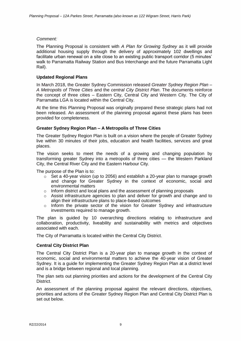
Comment:
The Planning Proposal is consistent with A Plan for Growing Sydney as it will provide additional housing supply through the delivery of approximately 102 dwellings and facilitate urban renewal on a site close to an existing public transport corridor (5 minutes’ walk to Parramatta Railway Station and Bus Interchange and the future Parramatta Light Rail). Updated Regional Plans
In March 2018, the Greater Sydney Commission released Greater Sydney Region Plan – A Metropolis of Three Cities and the central City District Plan. The documents reinforce the concept of three cities – Eastern City, Central City and Western City. The City of Parramatta LGA is located within the Central City.
At the time this Planning Proposal was originally prepared these strategic plans had not been released. An assessment of the planning proposal against these plans has been provided for completeness. Greater Sydney Region Plan – A Metropolis of Three Cities
The Greater Sydney Region Plan is built on a vision where the people of Greater Sydney live within 30 minutes of their jobs, education and health facilities, services and great places.
The vision seeks to meet the needs of a growing and changing population by transforming greater Sydney into a metropolis of three cities — the Western Parkland City, the Central River City and the Eastern Harbour City.
The purpose of the Plan is to: o Set a 40-year vision (up to 2056) and establish a 20-year plan to manage growth
and change for Greater Sydney in the context of economic, social and environmental matters
o Inform district and local plans and the assessment of planning proposals o Assist infrastructure agencies to plan and deliver for growth and change and to
align their infrastructure plans to place-based outcomes o Inform the private sector of the vision for Greater Sydney and infrastructure
investments required to manage growth.
The plan is guided by 10 overarching directions relating to infrastructure and collaboration, productivity, liveability and sustainability with metrics and objectives associated with each.
The City of Parramatta is located within the Central City District.
Central City District Plan
The Central City District Plan is a 20‑year plan to manage growth in the context of economic, social and environmental matters to achieve the 40‑year vision of Greater Sydney. It is a guide for implementing the Greater Sydney Region Plan at a district level and is a bridge between regional and local planning.
The plan sets out planning priorities and actions for the development of the Central City District.
An assessment of the planning proposal against the relevant directions, objectives, priorities and actions of the Greater Sydney Region Plan and Central City District Plan is set out below.
Planning Proposal – 12A Parkes Street, Parramatta (also known as 122 Wigram Street, Harris Park)
RZ/22/2014 10
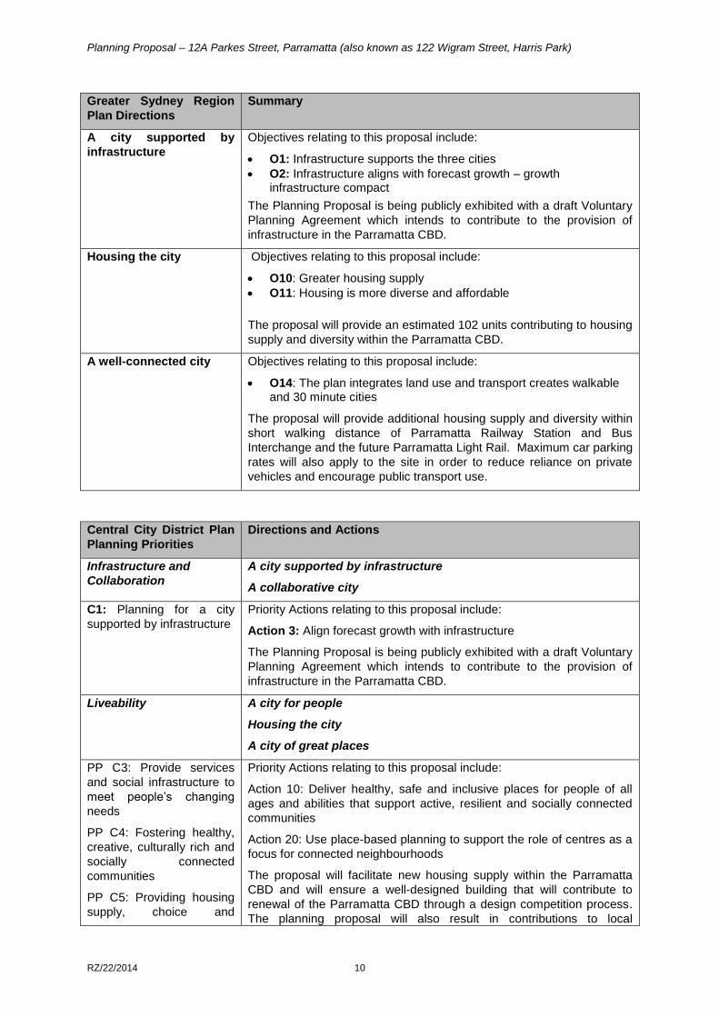
Greater Sydney Region
Plan Directions
Summary
A city supported by
infrastructure
Objectives relating to this proposal include:
O1: Infrastructure supports the three cities
O2: Infrastructure aligns with forecast growth – growth infrastructure compact
The Planning Proposal is being publicly exhibited with a draft Voluntary
Planning Agreement which intends to contribute to the provision of
infrastructure in the Parramatta CBD.
Housing the city Objectives relating to this proposal include:
O10: Greater housing supply
O11: Housing is more diverse and affordable
The proposal will provide an estimated 102 units contributing to housing
supply and diversity within the Parramatta CBD.
A well-connected city Objectives relating to this proposal include:
O14: The plan integrates land use and transport creates walkable and 30 minute cities
The proposal will provide additional housing supply and diversity within
short walking distance of Parramatta Railway Station and Bus
Interchange and the future Parramatta Light Rail. Maximum car parking
rates will also apply to the site in order to reduce reliance on private
vehicles and encourage public transport use.
Central City District Plan
Planning Priorities
Directions and Actions
Infrastructure and
Collaboration
A city supported by infrastructure
A collaborative city
C1: Planning for a city
supported by infrastructure
Priority Actions relating to this proposal include:
Action 3: Align forecast growth with infrastructure
The Planning Proposal is being publicly exhibited with a draft Voluntary
Planning Agreement which intends to contribute to the provision of
infrastructure in the Parramatta CBD.
Liveability A city for people
Housing the city
A city of great places
PP C3: Provide services
and social infrastructure to
meet people’s changing
needs
PP C4: Fostering healthy,
creative, culturally rich and
socially connected
communities
PP C5: Providing housing
supply, choice and
Priority Actions relating to this proposal include:
Action 10: Deliver healthy, safe and inclusive places for people of all
ages and abilities that support active, resilient and socially connected
communities
Action 20: Use place-based planning to support the role of centres as a
focus for connected neighbourhoods
The proposal will facilitate new housing supply within the Parramatta
CBD and will ensure a well-designed building that will contribute to
renewal of the Parramatta CBD through a design competition process.
The planning proposal will also result in contributions to local
Planning Proposal – 12A Parkes Street, Parramatta (also known as 122 Wigram Street, Harris Park)
RZ/22/2014 11
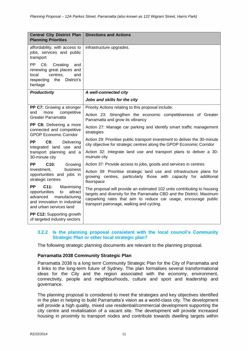
Central City District Plan
Planning Priorities
Directions and Actions
affordability, with access to
jobs, services and public
transport
PP C6: Creating and
renewing great places and
local centres, and
respecting the District’s
heritage
infrastructure upgrades.
Productivity A well-connected city
Jobs and skills for the city
PP C7: Growing a stronger
and more competitive
Greater Parramatta
PP C8: Delivering a more
connected and competitive
GPOP Economic Corridor
PP C9: Delivering
integrated land use and
transport planning and a
30-minute city
PP C10: Growing
investment, business
opportunities and jobs in
strategic centres
PP C11: Maximising
opportunities to attract
advanced manufacturing
and innovation in industrial
and urban services land
PP C12: Supporting growth
of targeted industry sectors
Priority Actions relating to this proposal include:
Action 23: Strengthen the economic competitiveness of Greater
Parramatta and grow its vibrancy
Action 27: Manage car parking and identify smart traffic management
strategies
Action 29: Prioritise public transport investment to deliver the 30-minute
city objective for strategic centres along the GPOP Economic Corridor
Action 32: Integrate land use and transport plans to deliver a 30-
muinute city
Action 37: Provide access to jobs, goods and services in centres
Action 39: Prioritise strategic land use and infrastructure plans for
growing centres, particularly those with capacity for additional
floorspace
The proposal will provide an estimated 102 units contributing to housing
targets and diversity for the Parramatta CBD and the District. Maximum
carparking rates that aim to reduce car usage, encourage public
transport patronage, walking and cycling.
3.2.2 Is the planning proposal consistent with the local council’s Community
Strategic Plan or other local strategic plan?
The following strategic planning documents are relevant to the planning proposal. Parramatta 2038 Community Strategic Plan
Parramatta 2038 is a long term Community Strategic Plan for the City of Parramatta and it links to the long-term future of Sydney. The plan formalises several transformational ideas for the City and the region associated with the economy, environment, connectivity, people and neighbourhoods, culture and sport and leadership and governance. The planning proposal is considered to meet the strategies and key objectives identified in the plan in helping to build Parramatta’s vision as a world-class city. The development will provide a high quality, mixed use residential/commercial development supporting the city centre and revitalisation of a vacant site. The development will provide increased housing in proximity to transport nodes and contribute towards dwelling targets within
Planning Proposal – 12A Parkes Street, Parramatta (also known as 122 Wigram Street, Harris Park)
RZ/22/2014 12
Parramatta, as well as provide employment through the proposed commercial use within the city centre.
Parramatta CBD Planning Proposal
Since this planning proposal was lodged with the Department of Planning and Environment for gateway determination, the Parramatta CBD Planning Strategy, now the Parramatta CBD Planning Proposal has progressed. This section of the planning proposal has been updated post gateway to reflect the current status of the Parramatta CBD Planning Proposal. The Parramatta CBD Planning Proposal (CBD PP) was adopted by Council on 11 April 2016. The CBD PP is the outcome of detailed technical studies which reviewed the current planning framework. The CBD PP sets controls responding to the vision for the growth of the Parramatta CBD as Australia’s next great city and identifies a need for significant growth in the Parramatta City Centre to which this planning proposal responds. The CBD PP proposes that a potential increase in height and FSR can be sought for sites within the Parramatta CBD subject to the provision of community infrastructure. The CBD PP allows no height limit, a maximum 10:1 FSR and of that an additional local provisions clause requiring that an FSR of 1:1 be commercial floor space to apply to the majority of sites within the CBD PP area. The Parramatta CBD Planning Proposal proposes that no maximum height limit (incentive height) apply to the majority of land within the CBD subject to the delivery of community infrastructure. The height of buildings proposed in enabling the FSR of 8:1 of the site is 72 metres and approximately 82.8 metres with 15% design excellence.
Under the Parramatta CBD Planning Proposal, 12A Parkes Street is identified on the new Incentive Floor Space Ratio Map as 10:1. The planning proposal has been amended following the Gateway Determination issued by the DP&E to apply an FSR of 8:1 on the site and an exemption from Clause 7.2 (sliding scale). 3.2.3 Is the planning proposal consistent with the applicable State Environmental
Planning Policies?
The following State Environmental Planning Policies are of relevance to the site.
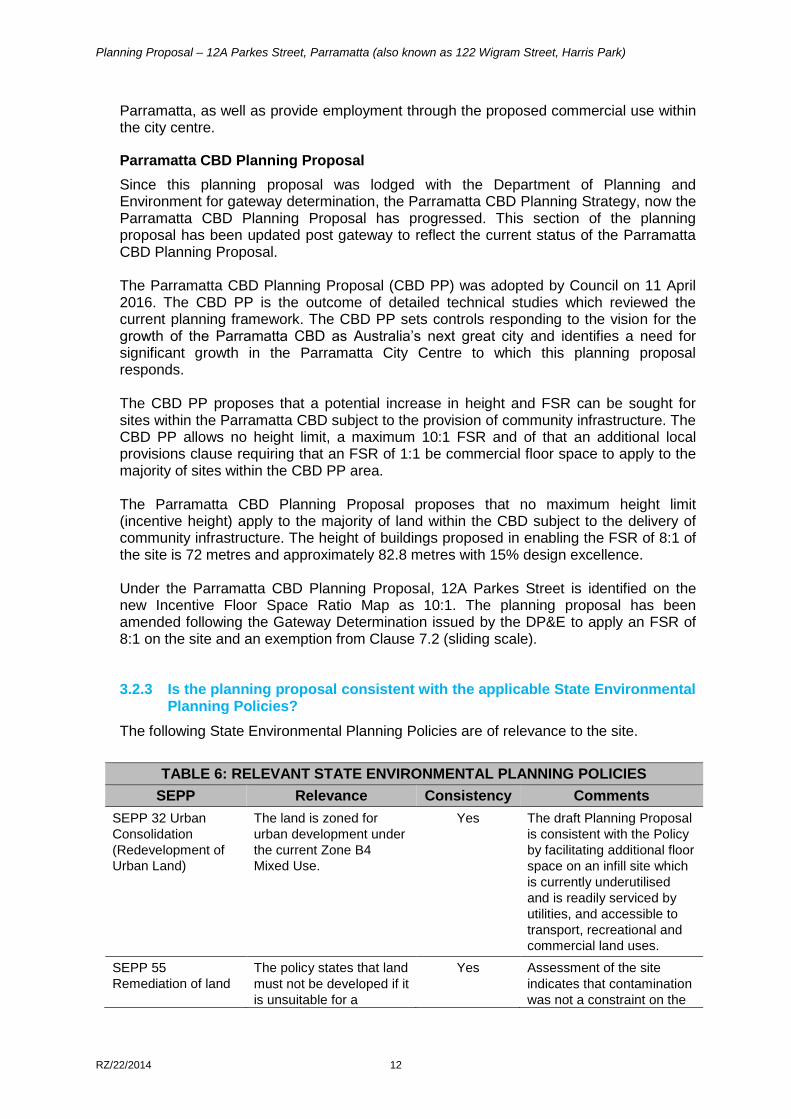
TABLE 6: RELEVANT STATE ENVIRONMENTAL PLANNING POLICIES
SEPP Relevance Consistency Comments
SEPP 32 Urban
Consolidation
(Redevelopment of
Urban Land)
The land is zoned for
urban development under
the current Zone B4
Mixed Use.
Yes The draft Planning Proposal
is consistent with the Policy
by facilitating additional floor
space on an infill site which
is currently underutilised
and is readily serviced by
utilities, and accessible to
transport, recreational and
commercial land uses.
SEPP 55
Remediation of land
The policy states that land
must not be developed if it
is unsuitable for a
Yes Assessment of the site
indicates that contamination
was not a constraint on the
Planning Proposal – 12A Parkes Street, Parramatta (also known as 122 Wigram Street, Harris Park)
RZ/22/2014 13
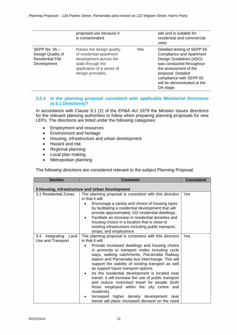
proposed use because it
is contaminated.
site and is suitable for
residential and commercial
uses.
SEPP No. 65 –
Design Quality of
Residential Flat
Development
Raises the design quality
of residential apartment
development across the
state through the
application of a series of
design principles.
Yes Detailed testing of SEPP 65
Compliance and Apartment
Design Guidelines (ADG)
was conducted throughout
the assessment of the
proposal. Detailed
compliance with SEPP 65
will be demonstrated at the
DA stage.
3.2.4 Is the planning proposal consistent with applicable Ministerial Directions
(s.9.1 Directions)?
In accordance with Clause 9.1 (2) of the EP&A Act 1979 the Minister issues directions for the relevant planning authorities to follow when preparing planning proposals for new LEPs. The directions are listed under the following categories:
Employment and resources
Environment and heritage
Housing, infrastructure and urban development
Hazard and risk
Regional planning
Local plan making
Metropolitan planning The following directions are considered relevant to the subject Planning Proposal.
Section Comment Consistent
3 Housing, Infrastructure and Urban Development
3.1 Residential Zones The planning proposal is consistent with this direction in that it will:
Encourage a variety and choice of housing types by facilitating a residential development that will provide approximately 102 residential dwellings..
Facilitate an increase in residential densities and housing choice in a location that is close to existing infrastructure including public transport, shops, and employment
Yes
3.4 Integrating Land Use and Transport
The planning proposal is consistent with this direction in that it will:
Provide increased dwellings and housing choice in proximity to transport nodes including cycle ways, walking catchments, Parramatta Railway station and Parramatta bus interchange. This will support the viability of existing transport as well as support future transport options.
As the residential development is located near transit, it will increase the use of public transport and reduce motorised travel for people (both those employed within the city centre and residents).
Increased higher density development near transit will place increased demand on the need
Yes
Planning Proposal – 12A Parkes Street, Parramatta (also known as 122 Wigram Street, Harris Park)
RZ/22/2014 14
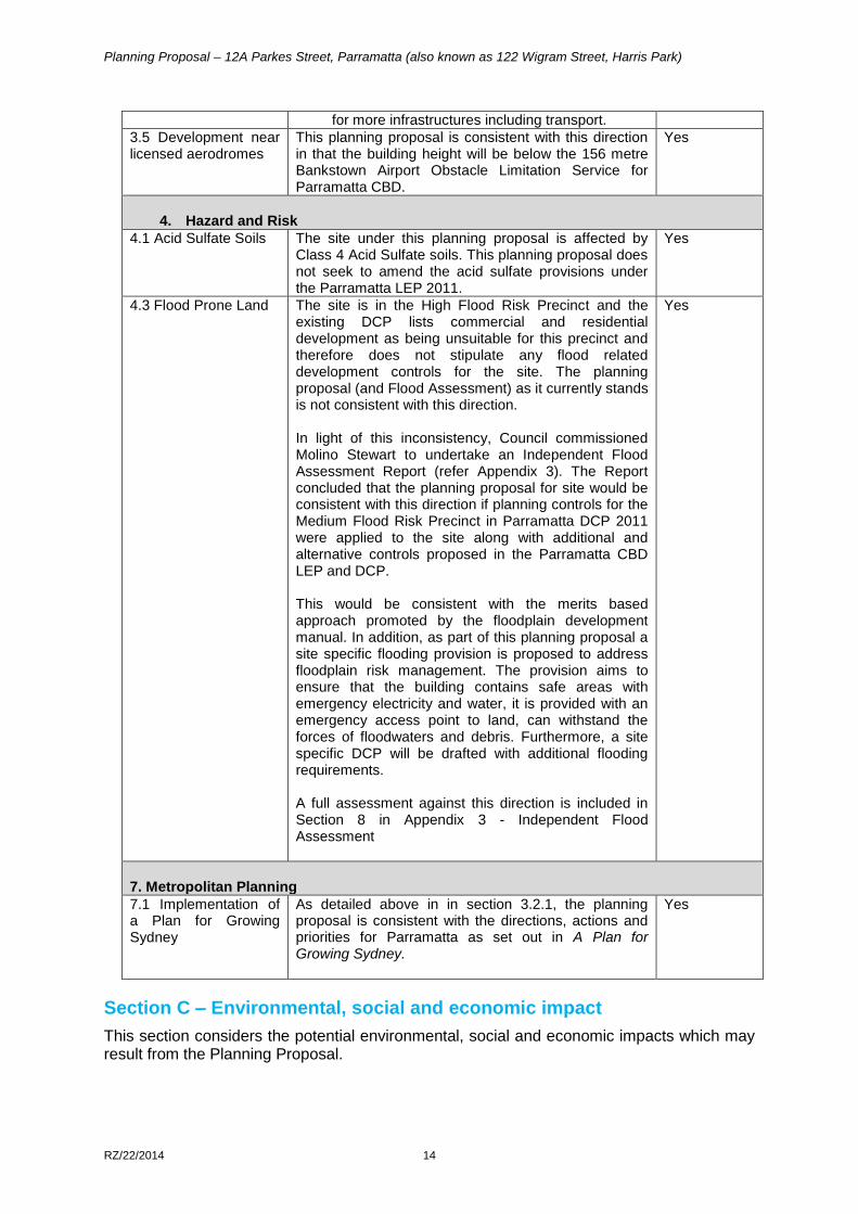
for more infrastructures including transport.
3.5 Development near licensed aerodromes
This planning proposal is consistent with this direction in that the building height will be below the 156 metre Bankstown Airport Obstacle Limitation Service for Parramatta CBD.
Yes
4. Hazard and Risk
4.1 Acid Sulfate Soils The site under this planning proposal is affected by Class 4 Acid Sulfate soils. This planning proposal does not seek to amend the acid sulfate provisions under the Parramatta LEP 2011.
Yes
4.3 Flood Prone Land The site is in the High Flood Risk Precinct and the existing DCP lists commercial and residential development as being unsuitable for this precinct and therefore does not stipulate any flood related development controls for the site. The planning proposal (and Flood Assessment) as it currently stands is not consistent with this direction. In light of this inconsistency, Council commissioned Molino Stewart to undertake an Independent Flood Assessment Report (refer Appendix 3). The Report concluded that the planning proposal for site would be consistent with this direction if planning controls for the Medium Flood Risk Precinct in Parramatta DCP 2011 were applied to the site along with additional and alternative controls proposed in the Parramatta CBD LEP and DCP. This would be consistent with the merits based approach promoted by the floodplain development manual. In addition, as part of this planning proposal a site specific flooding provision is proposed to address floodplain risk management. The provision aims to ensure that the building contains safe areas with emergency electricity and water, it is provided with an emergency access point to land, can withstand the forces of floodwaters and debris. Furthermore, a site specific DCP will be drafted with additional flooding requirements. A full assessment against this direction is included in Section 8 in Appendix 3 - Independent Flood Assessment
Yes
7. Metropolitan Planning
7.1 Implementation of a Plan for Growing Sydney
As detailed above in in section 3.2.1, the planning proposal is consistent with the directions, actions and priorities for Parramatta as set out in A Plan for Growing Sydney.
Yes
Section C – Environmental, social and economic impact
This section considers the potential environmental, social and economic impacts which may result from the Planning Proposal.
Planning Proposal – 12A Parkes Street, Parramatta (also known as 122 Wigram Street, Harris Park)
RZ/22/2014 15
3.3.1 Is there any likelihood that critical habitat or threatened species, populations or ecological communities, or their habitats, will be adversely affected as a result of the proposal?
The supporting studies accompanying this planning proposal indicate that the subject site does not contain any critical habitat, or threatened species, populations or ecological communities, or their habitats will be adversely affected as a result of this proposal.
3.3.2 Are there any other likely environmental effects as a result of the planning proposal and how are they proposed to be managed?
The main potential environmental impacts to be examined in detail with any future development proposal for the site are:
Urban Design and Built Form
Flooding
Traffic and Transport
Urban Design and Built Form
The Urban Design Analysis in Appendix 1 provides an indicative development scheme for the site to reflect the objectives of the planning proposal.
The proposed built form has been designed to respond to the constraints of the site (i.e. small site size and isolation of the site/storm water easement), the local context, and to ensure impacts on amenity are minimised, whilst allowing the site to achieve its maximum development potential.
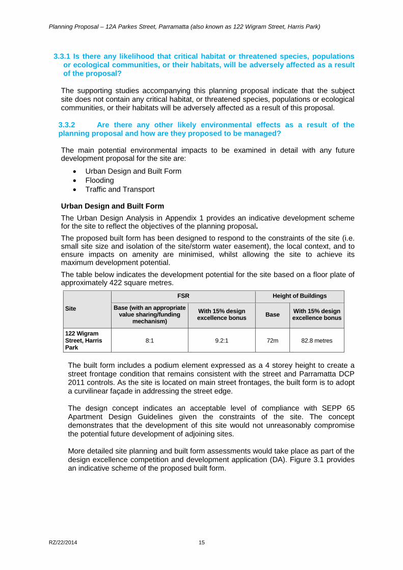
The table below indicates the development potential for the site based on a floor plate of approximately 422 square metres.
Site
FSR Height of Buildings
Base (with an appropriate value sharing/funding
mechanism)
With 15% design excellence bonus
Base With 15% design excellence bonus
122 Wigram Street, Harris Park
8:1 9.2:1 72m 82.8 metres
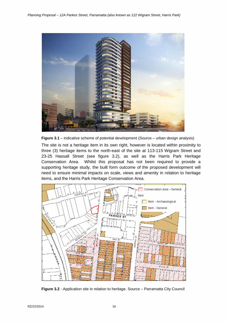
The built form includes a podium element expressed as a 4 storey height to create a street frontage condition that remains consistent with the street and Parramatta DCP 2011 controls. As the site is located on main street frontages, the built form is to adopt a curvilinear façade in addressing the street edge. The design concept indicates an acceptable level of compliance with SEPP 65 Apartment Design Guidelines given the constraints of the site. The concept demonstrates that the development of this site would not unreasonably compromise the potential future development of adjoining sites. More detailed site planning and built form assessments would take place as part of the design excellence competition and development application (DA). Figure 3.1 provides an indicative scheme of the proposed built form.
Planning Proposal – 12A Parkes Street, Parramatta (also known as 122 Wigram Street, Harris Park)
RZ/22/2014 16
Figure 3.1 – indicative scheme of potential development (Source – urban design analysis)
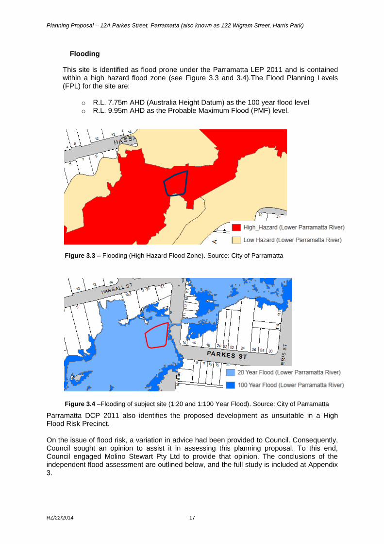
The site is not a heritage item in its own right, however is located within proximity to
three (3) heritage items to the north-east of the site at 113-115 Wigram Street and
23-25 Hassall Street (see figure 3.2), as well as the Harris Park Heritage
Conservation Area. Whilst this proposal has not been required to provide a
supporting heritage study, the built form outcome of the proposed development will
need to ensure minimal impacts on scale, views and amenity in relation to heritage
items, and the Harris Park Heritage Conservation Area.
Figure 3.2 - Application site in relation to heritage. Source – Parramatta City Council
Planning Proposal – 12A Parkes Street, Parramatta (also known as 122 Wigram Street, Harris Park)
RZ/22/2014 17
Flooding
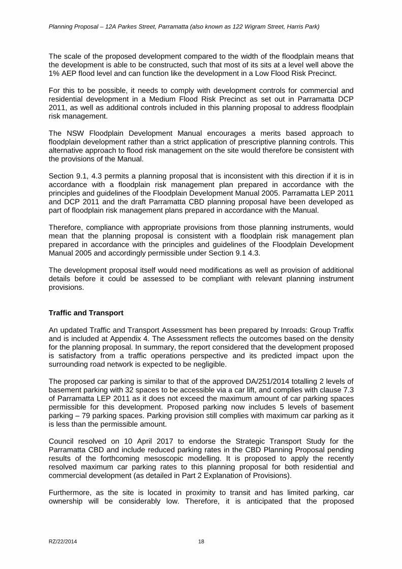
This site is identified as flood prone under the Parramatta LEP 2011 and is contained within a high hazard flood zone (see Figure 3.3 and 3.4).The Flood Planning Levels (FPL) for the site are:
o R.L. 7.75m AHD (Australia Height Datum) as the 100 year flood level o R.L. 9.95m AHD as the Probable Maximum Flood (PMF) level.
Figure 3.3 – Flooding (High Hazard Flood Zone). Source: City of Parramatta
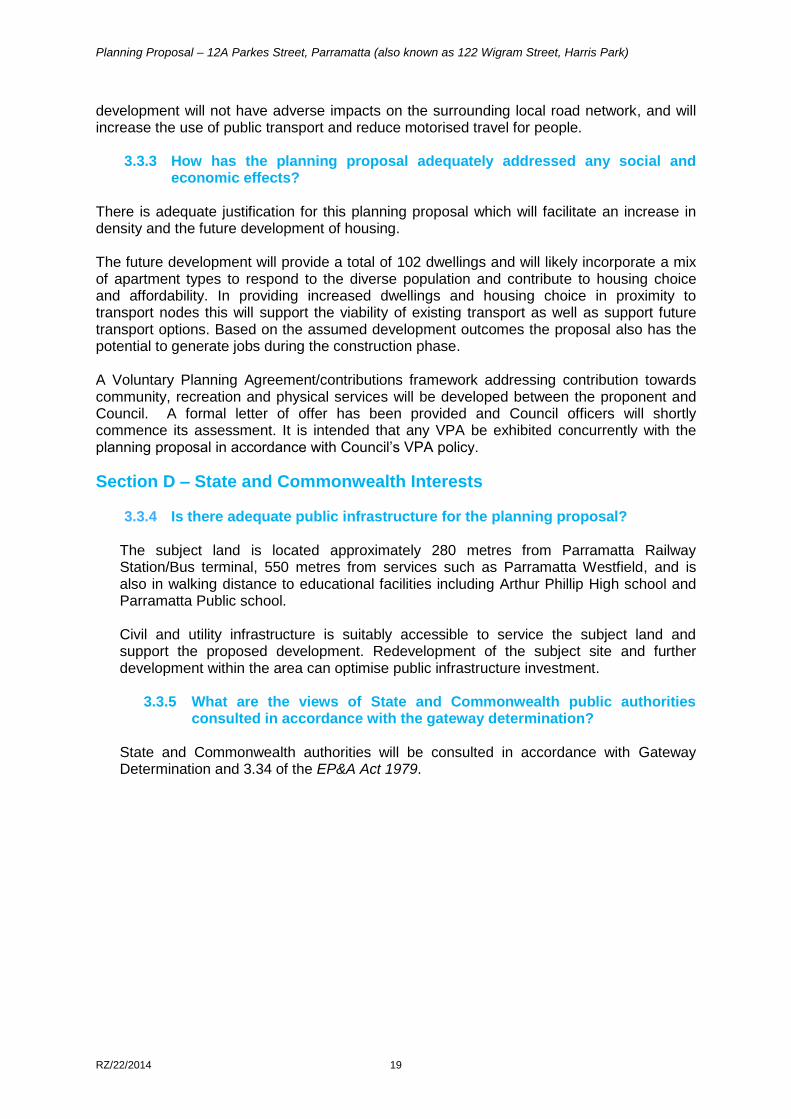
Figure 3.4 –Flooding of subject site (1:20 and 1:100 Year Flood). Source: City of Parramatta
Parramatta DCP 2011 also identifies the proposed development as unsuitable in a High Flood Risk Precinct. On the issue of flood risk, a variation in advice had been provided to Council. Consequently, Council sought an opinion to assist it in assessing this planning proposal. To this end, Council engaged Molino Stewart Pty Ltd to provide that opinion. The conclusions of the independent flood assessment are outlined below, and the full study is included at Appendix 3.
Planning Proposal – 12A Parkes Street, Parramatta (also known as 122 Wigram Street, Harris Park)
RZ/22/2014 18
The scale of the proposed development compared to the width of the floodplain means that the development is able to be constructed, such that most of its sits at a level well above the 1% AEP flood level and can function like the development in a Low Flood Risk Precinct. For this to be possible, it needs to comply with development controls for commercial and residential development in a Medium Flood Risk Precinct as set out in Parramatta DCP 2011, as well as additional controls included in this planning proposal to address floodplain risk management. The NSW Floodplain Development Manual encourages a merits based approach to floodplain development rather than a strict application of prescriptive planning controls. This alternative approach to flood risk management on the site would therefore be consistent with the provisions of the Manual. Section 9.1, 4.3 permits a planning proposal that is inconsistent with this direction if it is in accordance with a floodplain risk management plan prepared in accordance with the principles and guidelines of the Floodplain Development Manual 2005. Parramatta LEP 2011 and DCP 2011 and the draft Parramatta CBD planning proposal have been developed as part of floodplain risk management plans prepared in accordance with the Manual. Therefore, compliance with appropriate provisions from those planning instruments, would mean that the planning proposal is consistent with a floodplain risk management plan prepared in accordance with the principles and guidelines of the Floodplain Development Manual 2005 and accordingly permissible under Section 9.1 4.3. The development proposal itself would need modifications as well as provision of additional details before it could be assessed to be compliant with relevant planning instrument provisions.
Traffic and Transport An updated Traffic and Transport Assessment has been prepared by Inroads: Group Traffix and is included at Appendix 4. The Assessment reflects the outcomes based on the density for the planning proposal. In summary, the report considered that the development proposed is satisfactory from a traffic operations perspective and its predicted impact upon the surrounding road network is expected to be negligible. The proposed car parking is similar to that of the approved DA/251/2014 totalling 2 levels of basement parking with 32 spaces to be accessible via a car lift, and complies with clause 7.3 of Parramatta LEP 2011 as it does not exceed the maximum amount of car parking spaces permissible for this development. Proposed parking now includes 5 levels of basement parking – 79 parking spaces. Parking provision still complies with maximum car parking as it is less than the permissible amount. Council resolved on 10 April 2017 to endorse the Strategic Transport Study for the Parramatta CBD and include reduced parking rates in the CBD Planning Proposal pending results of the forthcoming mesoscopic modelling. It is proposed to apply the recently resolved maximum car parking rates to this planning proposal for both residential and commercial development (as detailed in Part 2 Explanation of Provisions). Furthermore, as the site is located in proximity to transit and has limited parking, car ownership will be considerably low. Therefore, it is anticipated that the proposed
Planning Proposal – 12A Parkes Street, Parramatta (also known as 122 Wigram Street, Harris Park)
RZ/22/2014 19
development will not have adverse impacts on the surrounding local road network, and will increase the use of public transport and reduce motorised travel for people.
3.3.3 How has the planning proposal adequately addressed any social and
economic effects? There is adequate justification for this planning proposal which will facilitate an increase in density and the future development of housing. The future development will provide a total of 102 dwellings and will likely incorporate a mix of apartment types to respond to the diverse population and contribute to housing choice and affordability. In providing increased dwellings and housing choice in proximity to transport nodes this will support the viability of existing transport as well as support future transport options. Based on the assumed development outcomes the proposal also has the potential to generate jobs during the construction phase. A Voluntary Planning Agreement/contributions framework addressing contribution towards community, recreation and physical services will be developed between the proponent and Council. A formal letter of offer has been provided and Council officers will shortly commence its assessment. It is intended that any VPA be exhibited concurrently with the planning proposal in accordance with Council’s VPA policy.
Section D – State and Commonwealth Interests
3.3.4 Is there adequate public infrastructure for the planning proposal?
The subject land is located approximately 280 metres from Parramatta Railway Station/Bus terminal, 550 metres from services such as Parramatta Westfield, and is also in walking distance to educational facilities including Arthur Phillip High school and Parramatta Public school. Civil and utility infrastructure is suitably accessible to service the subject land and support the proposed development. Redevelopment of the subject site and further development within the area can optimise public infrastructure investment.
3.3.5 What are the views of State and Commonwealth public authorities
consulted in accordance with the gateway determination?
State and Commonwealth authorities will be consulted in accordance with Gateway Determination and 3.34 of the EP&A Act 1979.
Planning Proposal – 12A Parkes Street, Parramatta (also known as 122 Wigram Street, Harris Park)
RZ/22/2014 20
PART 4 – MAPPING
This section contains the mapping for this planning proposal in accordance with the DP&E’s guidelines on LEPs and Planning Proposals.
4.1 Existing controls
This section contains map extracts from PLEP 2011 which illustrate the current controls applying to the site.
Figure 4.1 – Existing zoning extracted from the PLEP 2011 Land Zoning Maps
Planning Proposal – 12A Parkes Street, Parramatta (also known as 122 Wigram Street, Harris Park)
RZ/22/2014 21
Figure 4.2 – existing height of buildings extracted from the PLEP 2011 Height of Buildings Map
Planning Proposal – 12A Parkes Street, Parramatta (also known as 122 Wigram Street, Harris Park)
RZ/22/2014 22
Figure 4.3 – Existing floor space ratio extracted from the PLEP 2011 Floor Space Ratio Map
Planning Proposal – 12A Parkes Street, Parramatta (also known as 122 Wigram Street, Harris Park)
RZ/22/2014 23
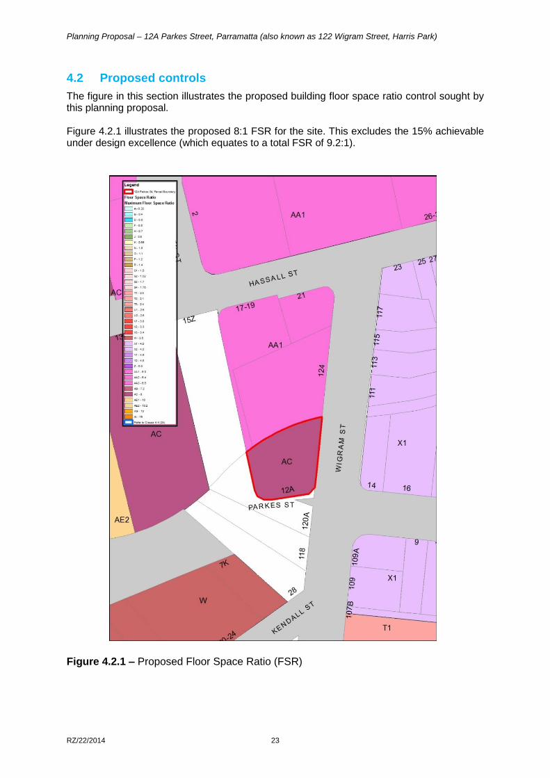
4.2 Proposed controls
The figure in this section illustrates the proposed building floor space ratio control sought by this planning proposal. Figure 4.2.1 illustrates the proposed 8:1 FSR for the site. This excludes the 15% achievable under design excellence (which equates to a total FSR of 9.2:1).
Figure 4.2.1 – Proposed Floor Space Ratio (FSR)
Planning Proposal – 12A Parkes Street, Parramatta (also known as 122 Wigram Street, Harris Park)
RZ/22/2014 24
Figure 4.2.2 illustrates the Special Provisions Area map as the site to enable the floor space
ratio exceptions and be exempt from Parramatta LEP 2011 Clause 7.2.
Figure 4.2.2 – Proposed Special Provision Area (SPA) Map.
Planning Proposal – 12A Parkes Street, Parramatta (also known as 122 Wigram Street, Harris Park)
RZ/22/2014 25
PART 5 – COMMUNITY CONSULTATION
In accordance with Section 3.34(2) of the EP&A Act 1979, the Director-General of Planning must approve the form of the planning proposal, as revised to comply with the gateway determination, before community consultation is undertaken. Public exhibition is likely to include:
newspaper advertisement;
display on the Council’s web-site; and
written notification to adjoining landowners. The gateway determination will specify the level of public consultation that must be undertaken in relation to the planning proposal including those with government agencies. Pursuant to Section 3.34(8) of the EP&A Act 1979 the Responsible Planning Authority must consider any submissions made concerning the proposed instrument and the report of any public hearing.
PART 6 – PROJECT TIMELINE
The detail around the project timeline is expected to be prepared following the referral to the Minister for a Gateway Determination. The following steps are anticipated:
Referral to Minister for a Gateway determination (February 2016) Issue of Gateway determination (June 2016, August 2016 and November 2016) Commencement and completion dates for public exhibition period and government
agency notification (May - June 2018) Consideration of submissions (July 2018) Consideration of proposal post exhibition and reporting to the Local Planning Panel
(if objections are received) and Council (August – September 2018) Submission to the Department to finalise the LEP (September 2018) Notification of instrument (December 2018)
Planning Proposal – 12A Parkes Street, Parramatta (also known as 122 Wigram Street, Harris Park)
RZ/22/2014 26
Appendix 1 – Urban Design Report
Planning Proposal – 12A Parkes Street, Parramatta (also known as 122 Wigram Street, Harris Park)
RZ/22/2014 27
Appendix 2 – Flood Assessment
Planning Proposal – 12A Parkes Street, Parramatta (also known as 122 Wigram Street, Harris Park)
RZ/22/2014 28
Appendix 3 – Independent Flood Assessment
Planning Proposal – 12A Parkes Street, Parramatta (also known as 122 Wigram Street, Harris Park)
RZ/22/2014 29
Appendix 4 - Traffic and Transport Assessment
Planning Proposal – 12A Parkes Street, Parramatta (also known as 122 Wigram Street, Harris Park)
RZ/22/2014 30
Prepared by City of Parramatta Council