
Planning for Neighborhood Change
71
The Central Main Planning Area includes nearly four square miles and is made up of several distinctive areas which make a “one-size fits all” plan difficult to achieve. In addition, as discussed in Chapter III, the future character foreseen varies greatly throughout the Planning Area. To properly plan for the future of these areas it is beneficial to consider in more detail, smaller “Neighborhood Planning Areas” within the overall planning area. As shown on Map 8, six Neighborhood Planning Areas have been defined, primarily based on the relationship to future light rail stations. The Neighborhood Planning Areas along Main Street (Downtown, Pioneer/Temple, Fraser/Sherwood, and Gilbert/Main) will have a light rail station, two within Downtown, as the approximate center. The distance from a light rail station and/or the development pattern of the remaining Neighborhood Planning Areas (Broadway Industrial and University North) necessitated individual consideration. Within each Neighborhood Planning Area this Chapter provides specific discussion and recommendations for building form and development character as it applies to each specific Neighborhood Planning Area. The Central Main Area includes six national register historic districts. Five of these districts also have local historic zoning designations. These districts are illustrated on Map A-3 in Appendix A. National historic district designation provides property owners with the opportunity to receive property tax credits provided the property is maintained in its historic character. The local designation requires that a Certificate of Appropriateness be issued by the City’s Historic Preservation Officer prior to any exterior remodeling of a structure. This process helps ensure that the historic integrity of the district is maintained. The historic district designation also requires local review and consideration of options prior to the demolition of existing structures. Any redevelopment activity considered within an established historic district will need to take into consideration the requirements and standards of the individual historic districts in addition to the recommendations made below as part of planning for the redevelopment. More information on historic district requirements is available through the City’s Historic Preservation Office and the City’s website. Planning for Neighborhood Change Historic Districts
Transcript of Planning for Neighborhood Change

The Central Main Planning Area includes nearly four square miles and is made up of several distinctive areas which make a “one-size fits all” plan difficult to achieve. In addition, as discussed in Chapter III, the future character foreseen varies greatly throughout the Planning Area. To properly plan for the future of these areas it is beneficial to consider in more detail, smaller “Neighborhood Planning Areas” within the overall planning area. As shown on Map 8, six Neighborhood Planning Areas have been defined, primarily based on the relationship to future light rail stations. The Neighborhood Planning Areas along Main Street (Downtown, Pioneer/Temple, Fraser/Sherwood, and Gilbert/Main) will have a light rail station, two within Downtown, as the approximate center. The distance from a light rail station and/or the development pattern of the remaining Neighborhood Planning Areas (Broadway Industrial and University North) necessitated individual consideration. Within each Neighborhood Planning Area this Chapter provides specific discussion and recommendations for building form and development character as it applies to each specific Neighborhood Planning Area. The Central Main Area includes six national register historic districts. Five of these districts also have local historic zoning designations. These districts are illustrated on Map A-3 in Appendix A. National historic district designation provides property owners with the opportunity to receive property tax credits provided the property is maintained in its historic character. The local designation requires that a Certificate of Appropriateness be issued by the City’s Historic Preservation Officer prior to any exterior remodeling of a structure. This process helps ensure that the historic integrity of the district is maintained. The historic district designation also requires local review and consideration of options prior to the demolition of existing structures. Any redevelopment activity considered within an established historic district will need to take into consideration the requirements and standards of the individual historic districts in addition to the recommendations made below as part of planning for the redevelopment. More information on historic district requirements is available through the City’s Historic Preservation Office and the City’s website.
Planning for Neighborhood Change
Historic Districts

STAP
LEY
DR
GIL
BER
T R
D
MES
A D
R
CO
UN
TRY
CLU
B D
R
UNIVERSITY DR
BROADWAY RD
MAIN ST
CEN
TER
ST
DowntownFraser/Sherwood
Gilbert/MainTemple/Pioneer
University North
Broadway Industrial
Map 8
Central Main Plan- Neighborhood Planning Areas -
Created By: Mesa - PlanningPrint Date: 08/15/2011Source: City of Mesa
The City of Mesa makes no claims concerning the accuracy of this map nor assumes any
liability resulting from the useof the information herein.
COPYRIGHT 1988, 2009 CITY OF MESA, ARIZONA
´0 800 1,600
Feet
Neighborhood Planning Area
Central Main Planning Area
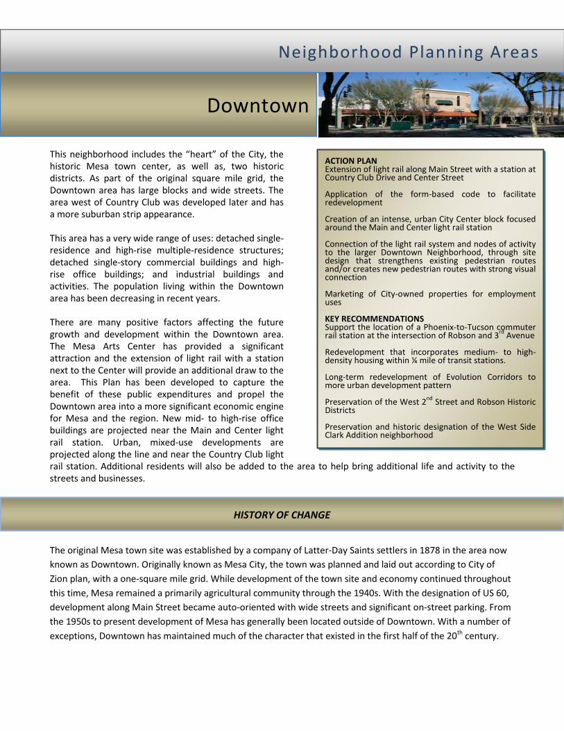
This neighborhood includes the “heart” of the City, the historic Mesa town center, as well as, two historic districts. As part of the original square mile grid, the Downtown area has large blocks and wide streets. The area west of Country Club was developed later and has a more suburban strip appearance. This area has a very wide range of uses: detached single-residence and high-rise multiple-residence structures; detached single-story commercial buildings and high-rise office buildings; and industrial buildings and activities. The population living within the Downtown area has been decreasing in recent years. There are many positive factors affecting the future growth and development within the Downtown area. The Mesa Arts Center has provided a significant attraction and the extension of light rail with a station next to the Center will provide an additional draw to the area. This Plan has been developed to capture the benefit of these public expenditures and propel the Downtown area into a more significant economic engine for Mesa and the region. New mid- to high-rise office buildings are projected near the Main and Center light rail station. Urban, mixed-use developments are projected along the line and near the Country Club light rail station. Additional residents will also be added to the area to help bring additional life and activity to the streets and businesses. The original Mesa town site was established by a company of Latter-Day Saints settlers in 1878 in the area now known as Downtown. Originally known as Mesa City, the town was planned and laid out according to City of Zion plan, with a one-square mile grid. While development of the town site and economy continued throughout this time, Mesa remained a primarily agricultural community through the 1940s. With the designation of US 60, development along Main Street became auto-oriented with wide streets and significant on-street parking. From the 1950s to present development of Mesa has generally been located outside of Downtown. With a number of exceptions, Downtown has maintained much of the character that existed in the first half of the 20th century.
NN ee iigg hh bb oo rrhh oo oo dd PP llaa nn nn iinn gg AA rreeaa ss
Downtown
ACTION PLAN Extension of light rail along Main Street with a station at Country Club Drive and Center Street Application of the form-based code to facilitate redevelopment Creation of an intense, urban City Center block focused around the Main and Center light rail station Connection of the light rail system and nodes of activity to the larger Downtown Neighborhood, through site design that strengthens existing pedestrian routes and/or creates new pedestrian routes with strong visual connection Marketing of City-owned properties for employment uses KEY RECOMMENDATIONS Support the location of a Phoenix-to-Tucson commuter rail station at the intersection of Robson and 3rd Avenue Redevelopment that incorporates medium- to high-density housing within ¼ mile of transit stations. Long-term redevelopment of Evolution Corridors to more urban development pattern Preservation of the West 2nd Street and Robson Historic Districts Preservation and historic designation of the West Side Clark Addition neighborhood
HISTORY OF CHANGE
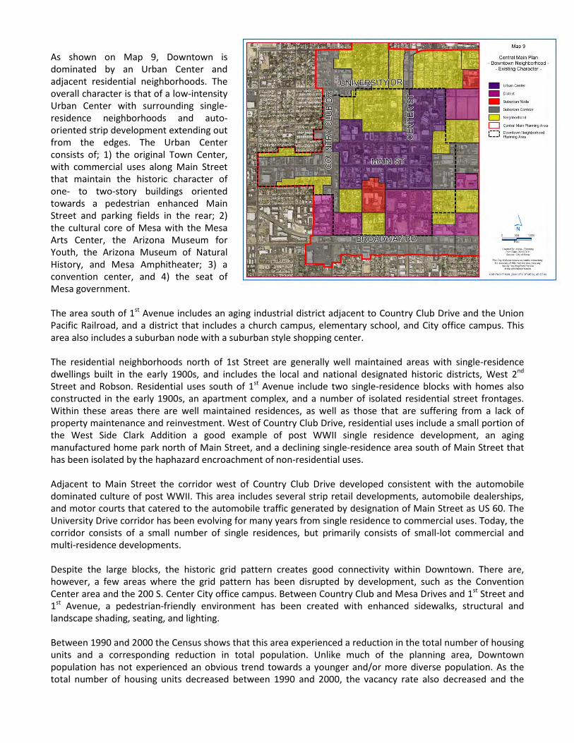
As shown on Map 9, Downtown is dominated by an Urban Center and adjacent residential neighborhoods. The overall character is that of a low-intensity Urban Center with surrounding single-residence neighborhoods and auto-oriented strip development extending out from the edges. The Urban Center consists of; 1) the original Town Center, with commercial uses along Main Street that maintain the historic character of one- to two-story buildings oriented towards a pedestrian enhanced Main Street and parking fields in the rear; 2) the cultural core of Mesa with the Mesa Arts Center, the Arizona Museum for Youth, the Arizona Museum of Natural History, and Mesa Amphitheater; 3) a convention center, and 4) the seat of Mesa government. The area south of 1st Avenue includes an aging industrial district adjacent to Country Club Drive and the Union Pacific Railroad, and a district that includes a church campus, elementary school, and City office campus. This area also includes a suburban node with a suburban style shopping center. The residential neighborhoods north of 1st Street are generally well maintained areas with single-residence dwellings built in the early 1900s, and includes the local and national designated historic districts, West 2nd Street and Robson. Residential uses south of 1st Avenue include two single-residence blocks with homes also constructed in the early 1900s, an apartment complex, and a number of isolated residential street frontages. Within these areas there are well maintained residences, as well as those that are suffering from a lack of property maintenance and reinvestment. West of Country Club Drive, residential uses include a small portion of the West Side Clark Addition a good example of post WWII single residence development, an aging manufactured home park north of Main Street, and a declining single-residence area south of Main Street that has been isolated by the haphazard encroachment of non-residential uses. Adjacent to Main Street the corridor west of Country Club Drive developed consistent with the automobile dominated culture of post WWII. This area includes several strip retail developments, automobile dealerships, and motor courts that catered to the automobile traffic generated by designation of Main Street as US 60. The University Drive corridor has been evolving for many years from single residence to commercial uses. Today, the corridor consists of a small number of single residences, but primarily consists of small-lot commercial and multi-residence developments. Despite the large blocks, the historic grid pattern creates good connectivity within Downtown. There are, however, a few areas where the grid pattern has been disrupted by development, such as the Convention Center area and the 200 S. Center City office campus. Between Country Club and Mesa Drives and 1st Street and 1st Avenue, a pedestrian-friendly environment has been created with enhanced sidewalks, structural and landscape shading, seating, and lighting. Between 1990 and 2000 the Census shows that this area experienced a reduction in the total number of housing units and a corresponding reduction in total population. Unlike much of the planning area, Downtown population has not experienced an obvious trend towards a younger and/or more diverse population. As the total number of housing units decreased between 1990 and 2000, the vacancy rate also decreased and the

percentage of owner occupied units increased. Downtown is home to the largest concentration of small businesses in the Central Main Area. While it appears that household incomes rose between 1990 and 2000, during the same period the percentage of the population below poverty level also rose. The catalysts for change described in Chapter III are expected to have the greatest impact on the Downtown Neighborhood. This Downtown Neighborhood has the greatest mix of land uses and provides the best location for high-intensity uses. Specific issues and opportunities affecting this Neighborhood that are further catalyst for change include: 1. Creating a strong and unique identity. 2. Making Downtown a neighborhood. 3. Business retention, expansion, and attraction. 4. Provision of a wide range of housing choices. 5. Underutilized land and non-residential vacancies. 6. Enhancing connectivity from residential
neighborhoods to Main Street and between Downtown attractions and entertainment venues.
7. Preservation of historic neighborhoods and maintenance/enhancement of stable neighborhoods that are experiencing negative pressure.
8. Limited formal park and open space amenities for residents.
The goal for the Downtown area is to take advantage of the public investment in light rail to create an urban environment that becomes Mesa’s City Center. As the City Center, Downtown will contain the mix of professional, commercial, entertainment, governmental, and residential uses that will make it an ever-expanding economic engine. Emphasis will be placed on the retention, expansion, and attraction of business and high-quality jobs and adding residential density to support existing and new businesses. Building upon the enhanced environment that already exists within Downtown, improved pedestrian connections to surrounding residential neighborhoods and creating or improving connections between Downtown attractions will support Downtown’s cultural assets and entertainment venues. Care will be taken to ensure the maintenance and preservation of the character of stable residential neighborhoods and historic assets. Distressed residential neighborhoods and suburban corridors will evolve over time to integrated neighborhoods that provide appropriate transitions and connections to the Main Street corridor. The key to continued growth and success in the Downtown area is an interesting and inviting public realm. The goals of the Plan in general, and specifically for this neighborhood area revolve around attracting people (employers, workers, customers, and residents) to an attractive and active urban environment in our downtown core. Therefore, the organizing element for this neighborhood is the improvements to the key streets – 1st Street, Main Street, 1st Avenue, Center, MacDonald, and Robson – such that they will be filled with people. Map 10 illustrates the need to connect, or strengthen connections between existing and planned activity centers and the “heart” of Mesa. Such connections will support the success of each activity center, as well as strengthen the urban built environment.
CATALYSTS FOR CHANGE
DOWNTOWN VISION FOR CHANGE
Organizing Element

As described above, the Downtown Neighborhood Planning Area has a distinctive history and character that requires plan consideration, in addition to the plan policies and recommendations for the entire Central Main Area. This section will describe those Downtown specific plan policies and recommendations. In addition to the general Building Form and Development Character descriptions provided at the beginning of this Chapter, a detailed description of each Building Form and Development Character type within Downtown is provided below and shown on Map 11. Policy DT 1: 1st Street and 1st Avenue are established as east-west pedestrian streets. Right-of-way width is reduced, or otherwise mitigated, such as introduction of parkway medians. As necessary, plant trees to create shaded pedestrian environment. Policy DT 2: Robson, MacDonald, and Center Street are established as north-south pedestrian streets. Right-of-way width is reduced, or otherwise mitigated, such as introduction of parkway medians. As necessary, plant trees to create shaded pedestrian environment.
Project DT 1: Application of the Form-Based Code as the base zoning district consistent with the regulating plan. Project DT 2: Develop a parking management plan that includes funding mechanisms for construction of new structured parking facilities.
TOOLS FOR CHANGE
General Downtown Recommendations

CO
UN
TRY
CLU
B D
R
UNIVERSITY DR
BROADWAY RD
MAIN ST
CEN
TER
ST
Map 11
Central Main Plan- Downtown -
Created By: Mesa - PlanningPrint Date: 07/25/2011Source: City of Mesa
The City of Mesa makes no claims concerning the accuracy of this map nor assumes any
liability resulting from the useof the information herein.
COPYRIGHT 1988, 2009 CITY OF MESA, ARIZONA
´0 300 600 900
Feet
Recommended Building Formand Development Character
Historic Downtown
Modern Downtown
Urban Gateway
Museum District
Convention District
Education Village
Transit Adjacent - Residential
Transit Adjacent - Village
Evolution Corridor
Neighborhood Maintenance
Neighborhood Preservation
Neighborhood Evolution
The Historic Downtown designation is generally centered on the intersection of MacDonald and Main Street and includes much of the area of original commercial development in Mesa. For many people, the one- to two-story intensity and historic character of this area has special meaning that should be preserved. While there is potential for redevelopment on individual properties, such development should be carefully designed to integrate with the existing character. The enhanced streetscapes and on-street parking along Main Street, MacDonald, and Robson are important elements of the Historic Downtown character that will be maintained or enhanced. With the introduction of light rail, concerted efforts should be undertaken to retain existing businesses and attract new, unique businesses. Policy HD 1: Support/Encourage alternatives to existing colonnades as part of façade improvements or building renovations. Policy HD 2: Strengthen the north-south pedestrian connections between Historic Downtown and surrounding developments. Policy HD 3: Encourage the restoration and preservation of the shell/exterior of historic structures while allowing internal and mechanical modernization. Policy HD 4: New construction should be designed to complement the historic built character of surrounding structures. Policy HD 5: Encourage art galleries and artist’s live/work spaces that complement the Mesa Arts Center and the Cultural/Museum District. Policy HD 6: Develop McDonald between Main and Pepper Streets as a space that can function as a street or
a pedestrian-only plaza that can be used for events, festivals, and gatherings. Policy HD 7: Encourage additional pedestrian-oriented elements (e.g. water features and statue program) within the enhanced pedestrian environment that will add to the character and interest of the area. Project HD 1: Develop a façade improvement program to assist property owners with architectural design and City review process. Project HD 2: Activate the pedestrian alleys with lighting, landscape, and uses that open to the alley. Project HD 3: Remove bomanite paving in vehicular and pedestrian alleys. Project HD 4: Construct enhanced pedestrian crosswalks across 1st Street and 1st Avenue.
The Modern Downtown will be anchored by the Mesa Arts Center and Mesa City Center and will include Downtown’s signature light rail station, just east of Center. This area is envisioned to transform into a highly urban environment. Emphasis will be given to creating an employment core at the intersection of Center and Main Streets and supporting mixed-use east of Centennial. Development of these areas will create an active urban environment that residents and visitors identify as the heart of Mesa. Policy MD 1: Leverage City ownership in actively pursuing public/private partnerships to develop the Mesa City Center on the area between Main and 1st Streets, Center Street, and Centennial Way. The Mesa City Center should include consolidated City Government offices, a civic square, and significant non-residential development.
• Support master planning of the Mesa City Center to ensure coordinated development and appropriate transitions of use and intensity.
• Development adjacent to Main Street should have a minimum height of between four and eight stories and no maximum height. The
remaining development should have a minimum height of between two and four stories.
• Encourage the incorporation of an “Event Zone” within the Mesa City Center.
Policy MD 2: Encourage redevelopment of the area west of Center Street with mixed-use buildings with heights that provide appropriate transition to Historic Downtown and Cultural/Museum District. Development in this area should be consistent with the T4MS and T5MS Transects, as shown on Form-Based Code regulating plan.
Modern Downtown
Historic Downtown

Policy MD 3: At that point in time when Brown and Brown Chevrolet moves their dealership from its current location, encourage the redevelopment of that block with high-rise, mixed-use buildings adjacent to Main Street, transitioning to medium- and high-density residential uses towards 1st Avenue.
• Support master planning of the Brown and Brown block to ensure coordinated development and appropriate transitions of use and intensity.
• Leverage the parking structure at the intersection of Main Street and Hibbert to encourage higher intensity use that supports an active street environment.
• Incorporate an urban open space amenity with new development.
• Development in this area should be consistent with the T5MS, T4NSF and T4N Transects, as shown on Form-Based Code regulating plan.
Policy MD 4: Maintain and enhance the Mesa Arts Center block.
• Establish strong visual and pedestrian connections between the Mesa Arts Center and surrounding development.
• Redevelop surface parking along 1st Avenue with high-density residential that takes advantage of a shared parking arrangement in the Sirrine parking structure.
Policy MD 5: Maintain existing residential uses within Modern Downtown. Enhance existing residential uses with strong pedestrian connections to Downtown
retail, entertainment, and employment uses and the light rail system. Policy MD 6: Support the redevelopment of low-intensity uses north of Main Street and east of Centennial Way with high-intensity uses. Such redevelopment could be mixed-use, or single-use commercial/office. Policy MD 7: Strengthen and extend the Urban Campus pathway that connects the Convention District to the Mesa Arts Center. Policy MD 8: Encourage additional pedestrian-oriented elements (e.g. water features and statue program) within the enhanced pedestrian environment that will add to the character and interest of the area. Policy MD 9: Surface parking will be strongly discouraged, with emphasis placed on structured and on-street parking. Project MD 1: Collaborate with Brown and Brown Chevrolet to ensure it remains a Mesa business should a location outside Downtown be pursued. Project MD 2: Introduce special paving, shade trees, and benches to highlight the pathway and encourage use of the Urban Campus pathway. Project MD 3: Connect the Urban Campus pathway to new development south of 1st Avenue, and ultimately to Broadway Road.
With the light rail station functioning as the anchor feature, the Downtown Gateway area will develop in a manner that announces entrance into Downtown. Over time, this will be accomplished with the coordinated redevelopment of the significant amount of vacant, underutilized suburban commercial, and declining residential into an active, urban environment with increased intensities. Primary focus for this area will be on commercial/retail and residential development in both mixed-use buildings and stand-alone developments. Additionally, Country Club Drive is a regional arterial with significant vehicular traffic and the potential to be an important north-south transit connection corridor that could support additional intensity. Policy DG 1: Where necessary, Morris may be closed to provide more opportunity for development and remove traffic conflicts. Policy DG 2: Surface parking will be discouraged, with emphasis placed on structured and on-street parking. Policy DT 3: Redevelopment of properties fronting on Country Club should be accompanied by
improvements to the streetscape to improve the pedestrian environment Policy DG 4: Encourage neighborhood use of the light rail station by incorporating strong pedestrian connections to the areas south of 1st Avenue
Urban Gateway
Project DG 1: Provide wider sidewalks on Country Club that incorporate shade and pedestrian amenities. Project DG 2: Provide enhanced crosswalks at the intersection of Country Club Drive and Main Street that
will help mitigate the impact of high traffic volume, high speeds, and multiple travel lanes. Project DT 3.1: Establish Form-Based Code as base zoning. Apply T5MS, T5MSF, T4NF and T4N Transects, as shown on Form-Based Code regulating plan.
The Cultural/Museum District is home to two highly regarded museums, Arizona Museum for Youth and Arizona Museum of Natural History, with the potential for a third museum in the former Federal Building. While these museums are regional attractions, there is little in the way of visual or physical connection between the museums, or from the museums to the rest of Downtown. Over time, the development of new connections and strengthening of existing connections will be an important element in the success of the museums and Downtown. In addition, residential infill development opportunities also exist on the underutilized surface parking areas along Pepper Place. Policy MUS 1: Develop a Museum Plaza that provides both the visual and physical connection between the Arizona Museum for Youth, Arizona Museum of Natural History, and Federal Building.
• Consider closing or otherwise modifying MacDonald between Pepper Place and 1st Street for integration into the Museum Plaza.
• Allow vertical mixed-use development adjacent to 1st Street to create a north edge to the Museum Plaza.
• Incorporate Downtown Waterworks element and coordinate with Mesa Arts Center to display works of art.
Policy MUS 2: Encourage high-density residential development on the surface public parking lots adjacent to Pepper Place.
• Infill development should support an active pedestrian environment and be oriented towards Pepper Place or Museum Plaza.
• Infill development should include sufficient parking to accommodate residents and lost public parking.
Policy MUS 3: Strengthen the pedestrian alleys that connect the public parking lots to Main Street. Expand the pedestrian connection through the public parking lot/infill development to the museums.
• The pedestrian connection through the public parking lot/infill development should be safe, comfortable, convenient, and easily identifiable to pedestrians.
Policy MUS 4: Attract the location of additional cultural/museum attractions to the Museum District.
The Convention District has long-term potential for intensification through infill development. Multiple options exist for the type of infill development possible. Some long term development options that may be considered through a detailed site analysis and market study include: 1) development of a new convention center complex, 2) employment uses, or 3) expansion of Mesa Community College Downtown Campus. Future detailed site and market analysis should include the following specific site considerations: • Strengthen the visual connection of the Urban
Campus Pathway between 1st Street and University Drive. Improve the pedestrian environment of the Urban Campus Pathway between 2nd Street alignment extended and University Drive.
• Consider Mesa’s participation in the convention business. Options to consider include, the status quo, leaving the convention business through sale or demolition, expansion of existing convention facilities, and expanding involvement through development of a new convention center.
• Consider reestablishment of the 2nd Street alignment.
Museum District
Convention District

These areas are envisioned to transform to a more urban environment with improved streetscape and limited mixed-use with an emphasis on medium- to medium-high-density residential developments. The development of these areas will support an urban environment with buildings addressing the public realm along Main Street. Downtown This area is located within ¼ mile of both future, Downtown light rail stations and can support higher intensity development. Residential is the primary land use focus, however, commercial activity oriented towards street intersections could occur as part of mixed-use developments.
Policy TAR-D 1: Ground floor retail is allowed, but not required. Policy TAR-D 2: Structured parking is required north of 1st Avenue and encourage south of 1st Avenue. Policy TAR-D 3: Encourage the development of pedestrian connections between Transit Adjacent-Residential and the Historic Downtown that are safe, comfortable, convenient, and easily identifiable. Connect with existing pedestrian alleys. Policy TAR-D 4: Encourage infill development on the surface public parking lots south of the Historic Downtown.
• Infill development should support an active pedestrian environment and be part of a coordinated site design.
• Consideration should be given to breaking larger blocks with an internal street or pedestrian network.
• New development should reinforce an active pedestrian environment with buildings oriented towards the existing public streets and engaging at the pedestrian level.
• Infill development should include sufficient parking to accommodate residents and lost public parking.
Policy TAR-D 5: Provide strong pedestrian connection to the Mesa Arts Center shadow walk.
West Main The Main Street Corridor consists of suburban strip retail, motor courts, individually accessed commercial lots, and a mobile home park adjacent to Main Street. Adjacent to Mahoney and 1st Avenues, the Main Street Corridor consists of single residence neighborhood that has been negatively impacted by the encroachment of commercial, industrial, and open uses. In the short term, the primary focus should be on improving the Main Street environment with better sidewalks, street trees, and street furniture. In the long term, redevelopment that orients and engages buildings towards Main Street, consolidates parcels, and minimizes the prominence of surface parking will be encouraged. Given the proximity to the Country Club station, redevelopment should focus on residential use with concentration of neighborhood scale commercial uses at the intersections with Date and Extension Road. Along Mahoney and 1st Avenues, it is unlikely that a single residence neighborhood fabric can be recreated. Consequently, focus should be placed on residential uses that orient towards, and are coordinated with redevelopment that occurs along Main Street. South of 1st Avenue commercial or light industrial redevelopment should be encouraged as a transition from the industrial uses to the south. These recommendations are consistent with the adopted West Main Street Neighborhood Area Plan, which placed an emphasis on creating a pedestrian-friendly environment.
Policy TAR-W 1: Redevelopment should focus on residential use with concentration of neighborhood scale commercial uses at the intersections of Main Street with Date and Extension Road. Policy TAR-W 2: Over time, improve the balance between pedestrian and automobile needs.
• Strip development repair – discourage additional strip development along Country Club
Drive and Main Street. Over time, redevelop with uses that reduce traffic conflicts and integrate into the adjacent neighborhood.
• Reduce the number of driveways by creating shared drives and replacement of unused and/or unnecessary driveways with curb and sidewalk.
Transit Adjacent – Residential (Downtown and West Main)

Policy TAR-W 3: Recognition that creation of viable redevelopment sites that appropriately transition to adjacent neighborhoods may require consolidation of parcels and the limited incorporation of adjacent residential properties.
The Transit Adjacent – Village area is currently a mixture of industrial, open storage, single and multiple residence uses. The majority of this area is devoted to non-residential uses and the existing residential uses have been disjointed to the point that the long term viability has suffered. In the short term (5-10 years), it is expected that the non-residential use will continue with the focus directed towards improvement of the pedestrian environment. In the long term (10-20 years), this area will benefit from the proximity to a potential Inter-City Commuter Rail station (Phoenix to Tuscon). Currently under study, the Inter-City Commuter Rail can be a driver of redevelopment similar to light rail. For purposes of this plan, it is assumed that a commuter rail station will be located at the site of Mesa’s original rail station at the intersection of Robson and 3rd Avenue. Associated redevelopment could include a mixture of residential and employment uses at urban intensities. Policy TAV 1: Encourage improvements to the pedestrian environment of MacDonald such as shade trees, benches, and lighting. Policy TAV 2: Support the development of a commuter rail route between Phoenix and Tucson with an alignment that serves Mesa and a station near the intersection of Robson and 3rd Avenue. Policy TAV 3: Encourage redevelopment of existing uses into transit-oriented developments that relate to the commuter rail station.
Policy TAV 4: Future transit-oriented developments will incorporate strong pedestrian connections to the Country Club Drive and Center Street light rail stations. Policy TAV 5: The future commuter rail station will be connected to the light rail system with regular bus circulator service.
The Education Village is currently a former high school campus that is home to City of Mesa offices. With relocation of these offices to the Mesa City Center, the existing campus will be available for short term use of a higher education provider. In the long term this area can support redevelopment to include a higher education institution in campus setting. Sufficient land area is available to also incorporate medium- to high-density residential with limited mixed-use that transitions to the higher intensity uses in the Transit Adjacent – Residential District. Policy EV 1: Utilize this asset to expand and diversify the employment base in downtown Mesa. Policy EV 2: Redevelopment of area in the southeast corner of Mesa Drive and University Drive must carefully consider the transition to the residential neighborhood to the east and south, and provide attractive pedestrian connections into this employment node. Policy EV 3: Auto oriented uses are not permitted in this area. Uses that include a drive through may be considered on a limited basis along the exterior streets.
Policy EV 4: Should a large employer such as a hospital campus or educational campus be attracted to this site, the site layout and building design should encourage pedestrian activity and integrate into the surrounding urban fabric. Policy EV 5: Redevelopment will incorporate strong pedestrian connections to the Center Street light rail station and Transit Adjacent – Mixed District. Policy EV 6: Redevelopment should incorporate the connection of 2nd Avenue between Center Street and MacDonald and consideration should be given to breaking the large blocks with an internal street or pedestrian network.
Transit Adjacent – Village
Education Village
The degree of change along Evolution Corridors is likely to be of a slower and more modest nature. The Country Club Drive Corridor consists of commercial and retail uses, primarily on smaller, individually accessed lots with prominent surface parking lots. In the short term, the primary focus should be on improving the streetscape with better sidewalks, street trees, and street furniture. In the short-to-long term, redevelopment that orients buildings towards Country Club Drive, consolidates parcels, and places surface parking to the side and rear will be encouraged. The University Drive Corridor primarily consists of single residences, single residences transitioning to commercial/office use, and small scale office use. It is anticipated that the pattern of transitioning from residential to commercial/office use will continue and that efforts should be placed on improving the pedestrian environment along University Drive with better sidewalks, street trees, street furniture, and consolidation of driveways. As a gateway into Downtown, the intersection of Center Street and University Drive provides more opportunity for a more intense commercial/office development oriented towards the intersection. Policy EC 1: Redevelopment through this area should reinforce an active streetscape and pedestrian activity. Policy EC 2: Over time, improve the balance between pedestrian and automobile needs.
• Strip development repair – discourage additional strip development along Country Club Drive and University Drive. Over time, redevelop with uses that reduce traffic conflicts and integrate into the adjacent neighborhood.
• Reduce the number of driveways by creating shared drives and replacement of unused/unnecessary driveways with curb and sidewalk
Policy EC 3: Recognition that creation of viable redevelopment sites that appropriately transition to adjacent neighborhoods may require consolidation of parcels and the limited incorporation of adjacent residential properties.
The existing neighborhoods south of 1st Avenue and east of Country Club Drive encompass areas of both suburban commercial and residential development. This area is in close proximity to the County Club Drive light rail station and can accommodate higher intensity residential infill and redevelopment. The declining residential area is envisioned to evolve over time into a stable neighborhood that can include a mix of single residence, duplex, and small apartment buildings. Compatible commercial redevelopment and/or higher intensity residential use can be used to buffer lower intensity residential uses from the Country Club Drive corridor. An emphasis is placed on creating a sense of place for the entire area and improving connections to Main Street and Country Club Drive light rail station. Policy NE 1: Encourage redevelopment of residential properties with frontage types that engage the street, such as row houses. Policy NE 2: Support the intensification of the existing suburban retail center on the southwest corner of Center Street and 1st Avenue. Policy NE-3: Redevelopment should include a range of housing options from multiple residences to attached and detached single residences, all designed in
a manner to reinforce and further develop a walkable urban environment. Project NE 1: Improve the streetscapes along Country Club Drive and 1st and 2nd Avenues to encourage pedestrian activity to Main Street businesses and the Country Club Drive light rail station. Project NE 2: Implement traffic calming techniques along Hobson in conjunction with added street trees.
Evolution Corridor
Neighborhood Evolution

West 2nd Street The West 2nd Street historic district is a unique residential neighborhood in the original Mesa townsite that reflects the City’s growth, with irregular lot splits of the original City of Zion “garden blocks”. The architectural style reflects 50+ years of evolving tastes and construction methods, with homes that range from the 1890s to 1950s. A citizen led initiative to add a local historic district overlay to the West 2nd Street District was approved by the City Council in 2001 and was added to the National Register of Historic Places in 2003. Such historic districts recognize the distinctive form and character that exists in Mesa. The goal of this plan is to preserve that distinctive character and address the threats to preservation.
Policy PN-W2 1: Continue maintenance of this historic neighborhood to provide a variety of housing options and maintain a sense of Mesa’s historic development pattern.
Policy PN-W2 2: Review all development proposals within the University Drive Evolution Corridors and Convention District for appropriate transition and compatibility with the West 2nd Street Historic District through building and site design
Robson The Robson District illustrates the early to mid-20th century growth of the Mesa Townsite and the shift from a Mormon community consisting of large garden lots to a modern residential community of small lots. The Robson District is home to important examples of architectural styles, with homes that range from the 1910s to 1950s. A citizen led initiative to add a local historic district overlay to the West 2nd Street District was approved by the City Council in 2001 and was added to the National Register of Historic Places in 2003. Such historic districts recognize the distinctive form and character that exists in Mesa. The goal of this plan is to preserve that distinctive character and address the threats to preservation.
Policy PN-R 1: Continue maintenance of this historic neighborhood to provide a variety of housing options and maintain a sense of Mesa’s historic development pattern.
Policy PN-R 2: Review all development proposals within the University Drive Evolution Corridors and Convention District for appropriate transition and compatibility with the Robson Historic District through building and site design.
West Side Clark Addition The West Side Clark Addition District is a good example of an early plat that wasn’t developed, possibly due to the Depression, until after World War II and reflects an Early Ranch style neighborhood. A citizen led initiative began to achieve National Register of Historic Places was completed in 2010. A local historic district overlay has not been applied to the West Side Clark Addition District. Such historic districts recognize the distinctive form and character that exists in Mesa. The goal of this plan is to preserve that distinctive character and address the threats to preservation.
Policy PN-C 1: Support designation as a historic district of local significance and maintenance of this historic neighborhood to provide a variety of housing options and maintain a sense of Mesa’s historic development pattern.
Policy PN-C 2: Review all development proposals within the Country Club Drive and Main Street Evolution Corridors and Downtown Gateway for appropriate transition and compatibility with the West Side Clark Neighborhood through building and site design
Three Neighborhood Maintenance areas have been identified. The first Neighborhood Maintenance area, bounded by Center Street and 1st Avenue, has a primarily single residence character, but also includes the 1st Methodist church campus and Franklin Elementary School. The second Neighborhood Maintenance area, bounded by Center and 1st Streets, includes a variety of uses that include Queen of Peace church/school campus, offices, and apartments. The third Neighborhood Maintenance area, bounded by Morris and 1st Street, also includes a variety of uses that include Mesa Police Headquarters, multiple residences, and commercial.
Neighborhood Preservation (West 2nd Street, Robson, West Side Clark)
Neighborhood Maintenance

These Neighborhood Maintenance areas will remain largely unchanged. The goal of this plan is to have in place those policies and programs that will help maintain the existing neighborhood character. Policy NM 1: Continue maintenance of the existing development pattern of each Neighborhood Maintenance area.
• Within the first Neighborhood Maintenance area, limit the intrusion of non-residential uses that break-up the residential fabric of the neighborhood.
• Within the first Neighborhood Maintenance area, allow limited redevelopment with
compatible multiple-residences such as row houses and mansion apartments that can also serve as a transition from higher intensity developments
Policy NM 2: Consider establishing the Form-Based Code as base zoning. Apply T5MSF, T4NF, T4N, and T3N Transects, as shown on Form-Based Code regulating plan
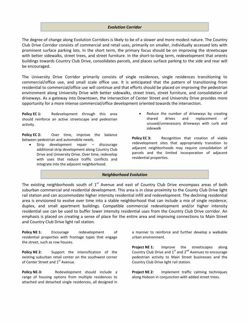
In addition to the general Street Character descriptions provided in Chapter IV, a description of street character and mobility plan recommendations within Downtown is provided below and shown on Map 12. The quality of the Downtown/Village and Downtown Neighborhood Street Character Types has already been established with the significant public investment that has occurred in the City of Mesa designated pedestrian overlay area. These streets should be the most walkable and pedestrian engaged in the Central Main Area. Additional important recommendations in Downtown street character include improvement to the building side of Country Club Drive, particularly between 1st Street and 1st Avenue, and the long-term “right-sizing” of 1st Street and 1st Avenue to more appropriately reflect the future development character along those streets, as well as to better reflect the traffic demand. The recommended Mobility Plan identifies the location of light rail stations, a potential location for a future Inter-City commuter rail station, improvements to an off-street pedestrian path, and bus stop improvements. The boundaries of the Downtown Neighborhood are somewhat arbitrary and there are strong connections with the Temple/Pioneer Park, University North, and Broadway Industrial Neighborhoods. The transition in development scale, intensity, and character between Neighborhoods should be seamless so that people on the ground will not be able to recognize when they pass from one Neighborhood to another. Particular areas of relationship and connection include: 1. The Convention District has the opportunity to
integrate into the development that occurs within the Employment District at Mesa and University Drives. Careful design of this interface is needed to insure interaction between the two areas and to help facilitate movement from the employment district to the Downtown core.
2. The Modern Downtown area needs to flow seamlessly into development within the Urban Gateway at Main Street and Mesa Drive. The streetscape design for Main Street east and west of Hibbert and both sides of Hibbert need to be coordinated.
3. The primarily residential University North neighborhood should be connected to the
Downtown with improved pedestrian and bicycle environments.
4. Future development that occurs within the Broadway Industrial Neighborhood needs to carefully designed to ensure compatibility, coordination, and connection with Downtown.
5. The arterial street network (Main Street, University Drive, and Broadway Road) and the light rail system are unifying elements between adjacent Neighborhoods. Streetscape improvements to the arterial street network and the streetscape design of the light rail system will be coordinated to create seamless networks between Neighborhoods.
Street Character and Mobility Plan
Relationship to Adjacent Neighborhoods
n¤ n¤
n¤
CO
UN
TRY
CLU
B D
R
UNIVERSITY DR
BROADWAY RD
MAIN ST
CEN
TER
ST
Map 12
Central Main Plan- Street Character and Mobility Plan -
- Downtown -
Created By: Mesa - PlanningPrint Date: 09/13/2011Source: City of Mesa
The City of Mesa makes no claims concerning the accuracy of this map nor assumes any
liability resulting from the useof the information herein.
COPYRIGHT 1988, 2009 CITY OF MESA, ARIZONA
´0 300 600 900
Feet
PedestrianPedestrian Connection
TransitLight Rail Station - Location TBDn¤
Bus Stop Improvements - Seating and Shade
Inter-City Commuter Rail
Commuter Rail Station - Location TBDn¤
Bus Stop Improvements - Shade
Street Character
Collector Street
Regional Arterial
Semi-Urban Arterial
Urban Transit Corridor
Downtown Neighborhood Street
Downtown/Village Main Street
Regional Transit Arterial

This Neighborhood includes areas that are proposed to be covered by the new Form-Based Code and areas currently zoned with Town Center Districts that are proposed to be rezoned to compatible standard zoning district. City staff will proactively work with property owners to implement the Form-Based Code regulating plan and proposed standard zoning for the Downtown Neighborhood as shown on Map 13.
Regulating Plan and Zoning Map

The Temple/Pioneer Park Neighborhood is anchored around the large open spaces provided in the Mesa Arizona Temple Grounds and Pioneer Park, which includes examples of some of the first developments to occur outside of the original downtown square mile. This Neighborhood provides a transition from the more intensive Downtown development to the less intensive development to the east. Pioneer Park and the Mesa Arizona Temple are iconic elements of Mesa and represent valuable resources for this neighborhood and City as a whole. Future development and redevelopment within this Neighborhood should focus on preserving and enhancing these assets. Specifically related to Pioneer Park, the Plan recommends higher intensity redevelopment that will surround, engage, and help reactivate the Park. The light rail station planned on Main Street just east of Mesa Drive will provide an excellent catalyst for redevelopment of surrounding properties that will help transform the area into a Downtown transit node. The Plan envisions connecting Pioneer Park to Gateway Park, located on the southwest corner of Main Street and Mesa Drive, through linear landscaping associated with the light rail station. Additional small plazas and open spaces included as part of future developments would strengthen this connection and add to the character of the area. Another valuable asset within this area is the vacant, City-owned property located at the southwest corner of Mesa and University Drives. There are many development options for this property, but the primary objective will be creation of a center for employment activities that adds high-quality jobs and strengthens the City’s economy. Additionally, integration of residential development in this area will help create a more diverse and active environment.
Temple/Pioneer Park
NN ee iigg hh bb oo rrhh oo oo dd PP llaa nn nn iinn gg AA rreeaa ss
ACTION PLAN Extension of light rail along Main Street with a station at Mesa Drive Utilization of the form-based code around Pioneer Park and the LDS Temple to facilitate redevelopment Establishment of an Urban Gateway at Mesa Drive and Main Street Reprogramming of Pioneer Park to provide more community events and meet the needs of an urbanizing neighborhood Active marketing of the vacant property at University and Mesa Drive to create an employment node with supporting services and housing KEY RECOMMENDATIONS Redevelopment around Pioneer Park to focus activity into the Park Redevelopment of the area south of 1st Avenue and west of Pomeroy into a medium intensity neighborhood Assisting in the evolution of the neighborhoods south and east of the Temple to include stronger connections to the open space and the transit station Transformation of the commercial node at Main Street and Horne into an urban development form Long-term redevelopment of Evolution Corridors to more urban development pattern

As the name for this Neighborhood suggests, the key feature of this area is the combination of open space provided by the Mesa Arizona Temple, which was dedicated in 1927; Pioneer Park, which was established as a City park in the 1950s; and the activities that have occurred that are the subject of many fond memories for long-time Mesa residents. Today the Park is underutilized and there are some concerns for the safety at the park after dark. The Neighborhood includes two historic districts: • Temple Historic District, located
between Mesa Drive and the Temple, primarily consists of smaller residential lots and homes built in the 1920s
• Wilbur Historic District, located west of Mesa Drive and between 1st and 2nd Streets, primarily consists of smaller ranch style homes built in the early to mid 1900s.
Most of the remaining areas were built between the 1920s and 1960s and have a suburban character with single-residence subdivisions segregated from nonresidential land uses. The portion of this Neighborhood west of Mesa Drive begins to exhibit a more urban character with some smaller lots, multi-story buildings, and buildings that address the street. As shown on Map 14, East of Mesa Drive the developments along Main Street, University Drive, and Broadway Road have a mix of suburban and urban character with newer developments typically exhibiting a more suburban character. The development pattern along these arterials is primarily suburban/corridor with parking fields separating buildings from the street and individual developments disconnected from each other and the adjacent residential neighborhoods. These streets have numerous curb cuts that create mulitple vehicle/pedestrian conflict points and a plethora of street signs and utility structures that create visual clutter and in many instances, sidewalk obstructions. Development along Mesa Drive, while very much an auto-oriented street, has a different character than the other arterials. Many of the properties on the west side of Mesa Drive have a reduced impact on Mesa Drive with primary access coming from Pomeroy Street and with many properties siding onto the east side of Mesa Drive, they do not present the same pattern of curb cuts and signage that dominate the other arterials. Additionally, there are several vacant lots along this portion of Mesa Drive that present an opportunity for future development. The portion of the Neighborhood east of Mesa Drive has a wide mix of zoning and land uses, and along sections of the arterial streets, this mixture of single-residence, multiple-residence, office, and commercial uses appears chaotic. Residential uses range from older homes on small lots to some larger ranch-style homes to small and large apartment complexes.
HISTORY OF CHANGE
The portion of the Neighborhood west of Mesa Drive also has a mix of zoning and land uses. However, this does not appear as chaotic as the mixture of land uses is more organized and the development near Main Street has a more urban character. This portion of the Neighborhood also includes an approximately 30 acre vacant area at the southwest corner of Mesa and University Drives that represents significant future development potential. Overall, the Neighborhood is well connected, with block lengths that are not too long and multiple connections to arterial and collector streets. However, there are a few long blocks that disrupt connectivity scattered throughout the Neighborhood. In general, commercial developments are not well connected to surrounding developments and adjacent residential neighborhoods. The Temple/Pioneer Park Neighborhood experienced a slight decrease in population between 1990 and 2000. However, as an indication that the population is generally getting younger, the percentage of the total population, people aged 20 to 49 increased during this same time period. As a sign of more racial diversity, the eastern part of the Neighborhood experienced an increase in Hispanic population between 1990 and 2000. The catalysts for change described in Chapter III will drive redevelopment around the Main Street and Mesa Drive light rail station, Pioneer Park and the Temple area. Specific issues and opportunities affecting this Neighborhood that are further catalyst for change include: • Redevelopment of vacant parcels; opportunities for
both economic development and new housing. • Re-activating Pioneer Park and creation of a unique
community space that brings the park and Temple grounds together.
• Creating a more pedestrian-friendly environment along the major streets.
• Creation of a transit village oriented around the light rail stop at Main Street and Mesa Drive.
• Transforming Main Street from an urban/suburban corridor into a true central business district.
• Some properties within this sub-area are zoned with the current Town Center zoning designations. These districts will be eliminated in the zoning code; appropriate new zoning designations need to be determined.
Into the future, this area will continue to have a very diverse character. The most significant changes are anticipated nearest the Mesa Drive light rail station and on the City-owned property at Mesa and University Drives. The transformation of Main Street to a more pedestrian oriented street will be supported by increased development intensities, with greatest intensities happening west of Pioneer Park. Pockets of single-residence areas will continue to exist, but, overall the area will evolve to include a greater mix of housing types that take on a more urban character. Pioneer Park and the Mesa Arizona Temple grounds are the key features of this Neighborhood. Therefore, building upon these features and the Mesa Drive light rail station to make the Neighborhood distinctive is the primary organizing element. As illustrated in Map 16, access to and from the light rail station plus strong connections to the open spaces are key elements that influence the planning of this area.
CATALYSTS FOR CHANGE
TEMPLE/PIONEER PARK VISION FOR CHANGE
Organizing Element

As described above, the Temple/Pioneer Park Neighborhood Planning Area has distinctive elements and character that requires plan consideration, in addition to the plan policies and recommendations for the entire Central Main Area. This section will describe those Temple/Pioneer Park specific plan policies and recommendations. In addition to the general Building Form and Development Character descriptions provided at the beginning of this Chapter, a detailed description of each Building Form and Development Character type within Temple/Pioneer is provided below and shown on Map 16. The large open spaces created by Pioneer Park and the Mesa Arizona Temple grounds are the central features of this Neighborhood. Pioneer Park is envisioned to remain a City Park. However, re-creation and reactivation of Pioneer Park is a key element in the long-term success of the entire neighborhood. Similarly, the Mesa Arizona Temple grounds are an attractive and well-maintained open space element that benefits the general public. Objectives for the future of Pioneer Park and Temple Grounds include: 1. Creation of opportunities to bring people
together. 2. Provision of a unique, high-quality environment
that attracts new business and residential development to the surrounding area.
3. Provision of venues for a diverse mix of activities for a wide variety of community residents.
4. Establishment of a distinctive development pattern that is unlike any other place in Mesa or along the light rail line, thus creating a strong sense of identity.
5. Provision of high-quality outdoor space that is responsive to the Arizona desert environment.
TOOLS FOR CHANGE
Pioneer Park/Temple Grounds

In addition to the specific policies and projects below, general consideration for redevelopment associated with Pioneer Park and Temple grounds should be given to the following: 1. Provision of pedestrian avenues for access to the
open spaces and facilitate cross traffic through the open spaces to improve access to the Mesa Drive light rail station and increase opportunities for social interaction.
2. Relocation of parking to improve access and circulation.
3. Placement of structures and activity centers at key locations within view corridors to draw attention and encourage use of open spaces.
4. Continual programming and reprogramming of the open spaces to bring more activities and resident and visitor use.
Policy PPT 1: Pioneer Park should be used as a unifying element within this district to help tie the new and existing neighborhoods together and create a central gathering place for all residents, visitors, and workers. Policy PPT 2: Reprogramming of Pioneer Park to create a distinctive urban park that meets the needs of residents, visitors, and workers. Project PPT 1: Develop an updated Pioneer Park Plan that will:
• Establish unique and iconic elements that are attractions that encourage use of the park;
• Maintain existing mature trees and establish an urban forest that provides people using the Park with a wide variety of trees to enjoy;
• Maintain and enhance view corridors that visually draw people into the Park;
• Maintain and enhance important historic elements of the park and integrate them into the new urban setting;
• Follow best practices for sustainable park design and maintenance, including storm water harvesting; and,
• Include areas for active use to encourage physical activity and social interaction.
Project PPT 2: Obtain funding for redevelopment of Pioneer Park. Project PPT 3: Reprogram Pioneer Park for uses and activities consistent with the goals and policies of this Plan.
The Pioneer Park Transit Adjacent – Village includes those areas immediately adjacent to Pioneer Park envisioned to transform into an urban village environment that focuses on a central open space and brings urban, mixed-use building to the area adjacent to Main Street and higher intensity residential uses in the remaining areas. The highest intensity development is expected in the western portion and should include four- to five-story buildings. Intensity should decrease in the northern and eastern portions, with three- to four-story and two- to three-story buildings, respectively. In all instances, buildings should be oriented towards the Park to encourage resident use, Park activation, and user safety. Developments at the intersections of LeSueur and Main and Hobson and Main should be oriented to enhance sight lines into Pioneer Park and Temple Grounds and provide active ground-floor uses, such as restaurants and shops that further encourage the activation of the open space areas. Policy TAV 1: Redevelopment at the corners of Main Street with LeSueur and Hobson are to include active ground floor uses that attract pedestrian activity during the day time and evening hours. Upper floors can be office or residential.
Policy TAV 2: Encourage the incorporation of structured parking for all developments. Surface parking may be utilized until demand warrants structures and may be considered for developments in the northern and eastern portions. Where permitted, surface parking will be located behind or to the side of buildings.
Transit Adjacent – Village (Pioneer Park)

MES
A D
R
UNIVERSITY DR
BROADWAY RD
MAIN ST
HO
RN
E
Temple East
Gateway Park
Stapley Park
University and Mesa Dr
Wilbur Historic
Pioneer Park
Pioneer Park
Temple Historic
Main and Ashland
Pomeroy and 1st Ave
Broadway South
Map 16
Central Main Plan- Temple/Pioneer Neighborhood -
Recommended Building Formand Development Character
Created By: Mesa - PlanningPrint Date: 07/25/2011Source: City of Mesa
The City of Mesa makes no claims concerningthe accuracy of this map nor assumes any liability resulting
from the use of the information herein.
COPYRIGHT 1988, 2009 CITY OF MESA, ARIZONA
´0 225 450
Feet
Commercial/Mixed-Use Node
Evolution Corridor
Neighborhood Evolution
Neighborhood Preservation
Urban Gateway
Transit Adjacent - Village
Transit Adjacent - Residential
Employment District
Pioneer Park/Temple
Neighborhood Maintenance

Policy TAV 3: Except at the corners of Main Street at LeSueur and Hobson, redevelopment is residential and includes entries and windows oriented towards Pioneer Park. The highest intensity developments should occur along LeSueur, with reducing intensities occurring along 2nd Street and Hobson. The streetscape should include shade and amenities to encourage pedestrian activity along these streets and into the Park. Policy TAV 4: New housing along the east side of Hobson should be compatible with and integrated with the existing residential neighborhood to provide a smooth transition of housing types and maintain the stability of the neighborhood.
Policy TAV 5: New development at the southwest corner of Main and LeSueur must be compatible with and integrate with the established Temple Historic District. Project TAV 1: Redevelop LeSueur, 2nd Street, and Hobson as thoroughfare types that slow traffic, provide parking, and encourage pedestrian and bicycle use. Project TAV 2: Evaluate the streets, sidewalks, and developments around Pioneer Park and the Temple grounds to identify and remedy any situations that create unsafe conditions.
With the Mesa Drive light rail station functioning as the anchor feature, the Urban Gateway area will develop in a manner that creates an urban center that announces entrance into Downtown and takes a distinctive identity from Pioneer Park, Mesa Arizona Temple, and Gateway Park. This identity will be strengthened with urban plazas incorporated into redevelopments at the intersection of Main Street and Mesa Drive. Redevelopment of the blocks at this intersection will focus on non-residential uses while also incorporating ground floor retail and upper floor residential uses. The existing Wells Fargo and City Courts building located on the southwest corner of the Main Street and Mesa Drive intersection form the foundation for additional professional and corporate office developments and have a development pattern of parking and building placement that can be replicated on surrounding blocks. Ground floor non-residential and upper floor non-residential or residential uses will be the focus of development at the northeast and southeast corners of the Main Street and Mesa Drive intersection. Redevelopment of the blocks adjacent to 1st Street will focus on residential uses. Typical building heights will generally be four- to five-story with reductions in building height to address transition to the Temple Historic District. Policy UG 1: Encourage the incorporation of structured parking for all developments. Surface parking may be utilized until demand warrants structures, excepting the low-intensity development in the Temple Historic area. Where permitted, surface parking will be located behind or to the side of buildings. Policy UG 2: Developments on Main Street and Mesa Drive need to provide appropriate transitions that maintain the integrity of the single-residence character of the Temple Historic District. Policy UG 3: Buildings at the Main Street and Mesa Drive intersection should incorporate public space that complements Gateway Park and strengthens the character of the Mesa Drive light rail station area. Policy UG 4: Development around the intersection of Main Street and Mesa Drive should be primarily Class A office buildings with minimum floor plates of at least 15,000 square feet.
Policy UG 5: A small-scale higher education institution that fits in an urban environment should be considered for this area. Policy UG 6: The preservation of the locally designated historic landmark, James MacDonald House, located at the southwest corner of Mesa Drive and 1st Street should be incorporated into future redevelopment. Project UG 1: Construction of curb returns at Pomeroy and Pepper Place to better define the parking area along Pomeroy. Either incorporate street parking on Pomeroy north of Pepper Place or reduce the right-of-way width to provide more buildable area. Project UG 2: As part of the larger Downtown area, Develop a parking management plan that manages, coordinates, regulates public parking and includes funding mechanisms for construction of new structured parking facilities.
Urban Gateway (Gateway Park)

Project UG3: Review the use and design of Gateway Park and reprogram as necessary to reflect the use as an urban park in an office location.
The large, City-owned, vacant property located south and west of the intersection of Mesa and University Drives represents an excellent opportunity to develop an urban employment district that could incorporate uses such as professional office, medical campus, or higher education institution. Consistent with an urban development pattern, commercial uses could be accommodated at the intersection of Mesa and University Drives and supporting residential uses are encouraged, particularly at the southern portion of the property to provide a transition to the historic residential character of the Wilbur Historic District. The Employment District also encompasses the property at the southeast corner of the Mesa and University Drive intersection, including the existing residential lots on the south side of 3rd Place. The future development character and use of this area will be influenced by the more intense employment activities to the west, however, this area can accommodate a wider variety of use, such as retail and residential in a development pattern that improves the transition to the residential neighborhood to the south. Additionally, the existing developments north of University Drive will be similarly influenced. While many uses are possible within this large Employment District, development needs to planned in a coordinated manner and utilize an urban form that includes buildings close to and addressing the streets and parking behind or to the side of buildings, preferably structured. Low- to mid-rise development intensities are envisioned. Proper site and building design, consistent with the Plan’s Guiding Principles, would allow long-term viability of the Employment District and evolution of the site over time. Policy ED1: Leverage the large, vacant, City-owned property at the southwest corner of Mesa and University Drives to expand and diversify the employment base of downtown Mesa. Policy ED 2: Redevelopment of area located at the southeast corner of Mesa and University Drives must carefully consider the transition to the residential neighborhood to the east and south and provide attractive pedestrian connections into this employment node. Policy ED 3: Auto oriented uses should not be permitted in this area. On a limited basis and with creative design solutions, uses that incorporate a drive through may be considered along exterior streets. Policy ED 4: Block lengths, site layout, and building design should encourage pedestrian activity and integrate into the surrounding urban fabric, particularly with the attraction of large employer/user such as a hospital campus or higher education campus that will have significant influence on the development of the remaining property. Policy ED 5: Where accommodated, residential densities should be a minimum of 12 dwelling units per acre.
Policy ED 6: Take advantage of the large land area available to create a mix of non-residential uses, while accommodating a variety of housing types in support of a diverse working and living environment. Policy ED 7: Ensure the Downtown Circulator route includes this area to facilitate access to light rail and other downtown amenities. Policy ED 8: Redevelopment should incorporate multi-modal transportation options from the beginning design stages. Project ED 1: Implement a marketing program to attract high-quality employers to this site. Project ED 2: Evaluate and modify as necessary, the existing street network with development proposals to facilitate pedestrian circulation. Project ED 3: Realign Hibbert south of University Drive with Hibbert north of University Drive to create improved pedestrian connections with a four-way intersection
Employment District (University and Mesa Drives)

Pomeroy and 1st Avenue The proximity of the Pomeroy and 1st Avenue Transit Adjacent – Residential area to the Mesa Drive light rail station and the Mesa Courts complex will influence the transformation of this area into a more pedestrian-friendly, mixed-use development pattern. The primary street frontage, Mesa Drive, will remain a primarily retail, but will evolve over time to balance the needs of the pedestrian and automobile with the introduction of street trees and wider sidewalks. The remainder of this area will transform into an urban neighborhood, with redevelopment adjacent to 1st Avenue including a mix of office, likely relating to the Mesa Courts complex, and multiple-residence developments and the remainder accommodating compact, but lower intensity residential development. The introduction of a new east-west street (approximately Kimball Avenue extended) and north-south street (approximately Wilbur Street extended) will divide the large block, create greater development potential, and help facilitate the desired transformation. Incorporation of a landscaped median in 2nd Avenue should be used to help buffer this urban neighborhood from the more industrial uses south of 2nd Avenue. Policy TAR-Pom 1: Lots fronting onto Mesa Drive may keep a more suburban development form with an improved pedestrian environment. Policy TAR-Pom 2: Vertical mixed-use can be accommodate adjacent to 1st Avenue and Mesa Drive. Policy TAR-Pom 3: Work with property owners to create a private or public street system to create an east-west and a north-south division of these blocks that will provide better access and improve development potential.
Policy TAR-Pom 4: Minimum residential densities range from 10 units/acre on the south and west sides of the block to 17 units/acre on the east and north sides of the block. Policy TAR-Pom 5: Redevelopment of this block should include a range of housing options from small apartments to detached single residences, all designed in a manner to reinforce and further develop a walkable urban environment.
Main and Ashland The Main and Ashland Transit Adjacent – Residential area is envisioned to transform to a more urban environment with improved streetscape and limited mixed-use with an emphasis on medium- to medium-high-density residential developments. The development of these areas will support an urban environment with buildings addressing the public realm along Main Street. Policy TAR-Ash 1: Typical building heights of two- to three-stories with lot coverage up to 70%. Increased height up to four stories is possible, through appropriate design and mix of uses. Policy TAR-Ash 2: Design of the new development and associated street frontage should encourage pedestrian activity to Pioneer Park and to the Mesa Drive light rail station.
Policy TAR-Ash 3: Typical residential density for development north of Main Street is 12 units per acre and 17 units per acre south of Main Street.
The Main and Horne Commercial Node is envisioned to transform from the current suburban corridor character into an urban commercial node that could incorporate a mix of uses that support surrounding residential neighborhoods. The property on the north side of Main Street should accommodate more substantial change, with the opportunity to redevelop the entire block with a low rise commercial/office development.
Transit Adjacent - Residential (Pomeroy and 1st Avenue / Main and Ashland)
Commercial/Mixed-Use Node (Main and Horne)
Policy CN 1: Redevelopment through this area should reinforce an active streetscape and pedestrian activity. Policy CN 2: Redevelopment of the block north of Main must carefully consider the transition to the residential neighborhood to the north and provide
attractive pedestrian connections into the commercial node. Policy CN 3: Ground floor commercial and office uses are preferred, particularly neighborhood serving uses.
Change is expected over time to both the University Drive and Horne corridors. The degree of change is expected to be slower and more modest in nature than will occur along Main Street or Mesa Drive. In the short term, the primary focus should be on improving the streetscape with better sidewalks, street trees, and street furniture. In the longer term, properties along University Drive could consolidate to create larger tracts for development. Properties that face onto Horne could be redeveloped with townhome type products. Policy EC 1: Strip development repair – discourage additional strip development along University Drive and, over time, redevelop with uses that reduce traffic conflicts and integrate into the adjacent neighborhood.
Project EC 1: Remove the obstacles in the sidewalk along the south side of University to improve the opportunity for pedestrian circulation.
The existing neighborhoods south and east of the Mesa Arizona Temple encompass areas of both, stability and decline. Those stable areas are envisioned to maintain the single-residence character while accommodating compatible higher intensity residential infill and redevelopment. Those declining areas are envisioned to evolve over time into stable neighborhoods containing a mix of single residence, duplex, and small apartment buildings. An emphasis is placed on compatible residential redevelopment and infill development that creates a stronger sense of place for the entire area and benefits from improved connections to Pioneer Park, Temple grounds, and Mesa Drive light rail station. Temple East Policy TE 1: Encourage redevelopment of residential properties along Hobson designed with frontage types that engage the street, such as row houses. Project TE 1: Improve the streetscape along 1st Avenue between Hobson to Ashland with large street
trees and improved sidewalks that encourage pedestrian activity to Pioneer Park, Temple grounds, and Mesa Drive light rail station. Project TE 2: Implement traffic calming techniques along Hobson in conjunction with added street trees.
Stapley Park Policy SP 1: The Broadway Road and Mesa Drive commercial corner evolves into a more pedestrian friendly development that engages with the adjacent neighborhood and helps meet their daily shopping needs. Policy SP 2: Improve pedestrian connections between Stapley Park, Pioneer Park, Temple grounds, and the Mesa Drive light rail station.
• Re-connect LeSueur between 2nd and 3rd Avenues with the removal of existing housing.
Policy SP 3: Stapley Park becomes a central focus that in long-term maintenance of a healthy neighborhood. Policy SP 4: Support the redevelopment of the area along Udall to include residential uses that front towards Stapley Park.
Neighborhood Evolution (Temple East, Stapley Park, Broadway Road)
Evolution Corridors

Policy SP 5: Improve connections between Stapley Park and surrounding residential areas by:
• Extending 3rd Avenue west of Udall, either as a street or private drive, to allow development of the vacant parcel north of 3rd Avenue extended and to improve neighborhood and park access.
• Improving LeSueur with consistent street trees and use of traffic calming techniques.
Broadway Road (Mesa Drive to Horne) Policy BR 1: Over time, commercial uses along Broadway should be consolidated into nodes at intersections of Broadway Road with Mesa Drive and Horne with multiple-residential uses integrated into the adjacent neighborhoods.
Policy BR 2: Support rezoning along Broadway to the appropriate zoning categories to achieve the desired mix of uses.
Temple Historic District Temple Historic District, located between Mesa Drive and the Mesa Arizona Temple, represents some of the first residential development to occur outside of the original Downtown square mile. This District has several quality examples 1920s residential homes constructed on smaller lots. A citizen led initiative to add a local historic district overlay to the Temple Historic District was approved by the City Council in 2001 and was added to the National Register of Historic Places in 2000. Such historic districts recognize the distinctive form and character that exists in Mesa. The goal of this plan is to preserve that distinctive character and address the threats to preservation. Policy PN-T 1: The frontages along Mesa Drive may include multiple-residence and non-residential uses provided they are integrated into and compatible with the historic scale and character of the neighborhood. Policy PN-T 2: Appropriate infill of vacant lots along 1st, Kimball, and 2nd Avenues east of Mesa Drive consistent with the historic scale and character of these blocks.
Project PN-T 1: Planting of large street trees along 1st Avenue to frame the attractive street terminus created by the Mesa Arizona Temple. Project PN-T 2: Installation of a landscaped median in 1st Avenue between Udall and LeSueur.
Wilbur Historic District The Wilbur Historic District, located west of Mesa Drive between 1st and 2nd Streets, is an example of the subdivision of original Mesa Townsite blocks associated with one of Mesa’s first housing booms. This early Mesa neighborhood was built for working class families, with most of the homes constructed from 1911 to 1948. A citizen led initiative to add a local historic district overlay to the Wilbur Historic District was approved by the City Council in 1996 and was added to the National Register of Historic Places in 1999. Such historic districts recognize the distinctive form and character that exists in Mesa. The goal of this plan is to preserve that distinctive character and address the threats to preservation. Policy PN-W 1: Preserve and enhance the streetscape to encourage pedestrian activity.
Policy PN-W 2: Continue maintenance of this historic neighborhood to provide a variety of housing options and maintain a sense of Mesa’s historic development pattern.
Neighborhood Preservation (Temple Historic District and Wilbur Historic District)

The large Neighborhood Maintenance area identified between Mesa Drive and Horne and University Drive and Pepper Place has a primarily single residence character, but also includes the large Word of Grace church campus, First Presbyterian Church, and YMCA-Valley of the Sun. This Neighborhood Maintenance area will remain largely unchanged. The goal of this plan is to have in place those policies and programs that will help maintain the existing neighborhood character. Policy NM 1: Do not allow the intrusion of non-residential uses and large parking fields that break up the residential fabric of the neighborhood. Project NM 1: Improve the streetscape along 1st Place, 1st Street, and Pepper Place, from Horne to Hobson to encourage pedestrian access to Pioneer Park.
Project NM 2: Implement traffic calming techniques along Hobson and LeSueur from University to 2nd Street in conjunction with added street trees.
In addition to the general Street Character descriptions provided in Chapter IV, a description of street character and mobility plan recommendations within Temple/Pioneer Park is provided below and shown on Map 17. To some degree, the quality of the Downtown/Village Main Street Character Type has been established west of Mesa Drive with the significant public investment that has occurred in the City of Mesa designated pedestrian overlay area. Considering the anticipated future development character, similar street improvements should be extended east of Mesa Drive resulting in a more walkable and pedestrian engaged street. Additional important recommendations in Temple/Pioneer Park street character include improvement to the building side of Mesa Drive, particularly between 2nd Street and 2nd Avenue and along Main Street east of LeSueur. The recommended Mobility Plan identifies the location of the Mesa Drive light rail station and bus stop improvements.
Neighborhood Maintenance
Street Character and Mobility Plan
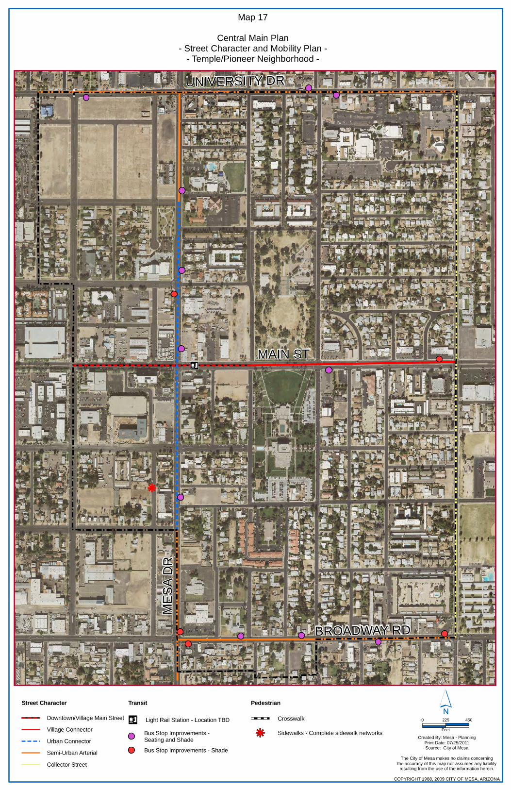
n¤
k
MES
A D
R
UNIVERSITY DR
BROADWAY RD
MAIN ST
Map 17
Central Main Plan- Street Character and Mobility Plan -
- Temple/Pioneer Neighborhood -
Created By: Mesa - PlanningPrint Date: 07/25/2011Source: City of Mesa
The City of Mesa makes no claims concerningthe accuracy of this map nor assumes any liabilityresulting from the use of the information herein.
COPYRIGHT 1988, 2009 CITY OF MESA, ARIZONA
´0 225 450
Feet
Pedestrian
Sidewalks - Complete sidewalk networkskj
Crosswalk
Transit
Bus Stop Improvements - Shade
Bus Stop Improvements - Seating and Shade
Light Rail Station - Location TBDn¤
Street Character
Collector Street
Semi-Urban Arterial
Urban Connector
Village Connector
Downtown/Village Main Street

The Temple/Pioneer Park Neighborhood is a transitional area between the more urban Downtown Neighborhood and the more suburban Fraser/Sherwood Neighborhood to the east. The boundary between this Neighborhood and those to the west and north are somewhat arbitrary and there are many strong connections and interactions with the Downtown and University North Neighborhoods. There is also a strong connection between this Neighborhood and the Fraser/Sherwood Neighborhood at the Horne and Main commercial node. The transition in development scale, intensity, and character between Neighborhoods should be seamless so that people on the ground will not be able to recognize when they pass from one Neighborhood to another. Particular areas of relationship and connection include: 1. The Broadway Road corridor has the potential to
provide neighborhood service and retail to residents of the Temple/Pioneer Park Neighborhood as well as residents south of Broadway Road. In particular, the Broadway and Horne area has the opportunity to become a local-serving commercial node for nearby residents. The redevelopment recommendations for the northwest corner of this intersection should be coordinated with the properties on the south side of Broadway to create a node of activity that meets the needs of the residents who surround this area.
2. The Main and Horne Commercial Node described in this Neighborhood extends across Horne into the Fraser/Sherwood Neighborhood. The two sides of the node need to be planned and developed together to create a location for neighborhood identity and activity.
3. The Employment District at Mesa and University
Drives will directly influence the property on the northwest corner of Mesa and University Drives. The existing medical facility on the northeast corner of Mesa and University Drives could be the catalyst for the further development of medical uses in this area or the development of medical related educational facilities. A successful node will need to address the ability to allow pedestrians to safely and easily cross both University and Mesa Drives.
4. The arterial street network (Main Street, University Drive, and Broadway Road) and the light rail system are unifying elements between adjacent Neighborhoods. Streetscape improvements to the arterial street network and the streetscape design of the light rail system will be coordinated to create seamless networks between Neighborhoods.
This Neighborhood includes areas that are proposed to be covered by the new Form-Based Code and areas currently zoned with Town Center Districts that are proposed to be rezoned to compatible standard zoning district. City staff will proactively work with property owners to implement the Form-Based Code regulating plan and proposed standard zoning for the Downtown Neighborhood as shown on Map 18.
Regulating Plan/Zoning Map
Relationship to Adjacent Neighborhoods

The Fraser/Sherwood Neighborhood encompasses the one-square mile of Central Main Planning Area bounded by Horne, Harris Drive, University Drive, and Broadway Road. The Fraser/Sherwood area was generally built out between 1940 and 1970. The established character is that of a low density, low rise suburban neighborhood, with the primary features being strip commercial areas along the arterial streets and established single-residence neighborhoods in between. The Neighborhood is home to Fraser Fields, an existing National Register Historic District, and the Sherwood area, which is nearing the time when it could be considered for the National Register. An extension of light rail along Main Street with a station at Stapley Drive, creates the primary focus for future growth and development in the Neighborhood. In the vicinity of this future light rail station, there are a number of large, underutilized properties that will be prime locations for redevelopment. The majority of the Neighborhood is devoted to residential use and most of these residential areas are in good shape and should be maintained into the future. There are, however, some areas that have not aged as well and will need some work in the coming years to retain viability. The demographics of this Neighborhood have been shifting slightly over the years. The population is becoming more diverse and younger. The overall total population has remained fairly consistent over the last 10 years. The percentage of dwellings that are renter-occupied has increased. Until the 1960s and 1970s the Fraser/Sherwood Area was considered by many to be “East Mesa”. Primarily consisting of suburban, single-residence developments, this Neighborhood supplied a good portion of the housing for Mesa’s post WWII growth up to the 1970s. One neighborhood, Fraser Fields, is designated as a local and national historic district in recognition of its unique post WWII ranch homes. Since the 1970s, the residential areas north and south of Main Street have generally been well maintained with ranch-style, single-residence dwellings built between 1940 and 1970. However, there are some residential areas that have suffered from a lack of property maintenance and reinvestment.
NN ee iigg hh bb oo rrhh oo oo dd PP llaa nn nn iinn gg AA rreeaa ss
Fraser/Sherwood
ACTION PLAN Plan for extension of light rail along Main Street with a station at Stapley Drive Preservation of the Fraser Fields Historic District Active code compliance and use of the Building Stronger Neighborhoods program to help reduce evidence of decline where needed. KEY RECOMMENDATIONS Creation of a mixed-use, local-scaled, pedestrian-friendly transit village focused on the light rail station Site design that strengthens existing pedestrian routes and/or creates new pedestrian routes with strong visual connection to the Village Core and light rail corridor from adjacent developments Improve the pedestrian environment along arterial streets Redevelopment of transit adjacent areas with medium- to high-density housing Long-term redevelopment of Evolution Corridors to more urban development pattern Maintenance of significant amount open/recreation space in an official Ellsworth Park Preservation and historic designation of the Sherwood neighborhood
HISTORY OF CHANGE

Overall, there are generally good connections between and to the arterial street system. However, there are areas that suffer from long blocks and long cul-de-sacs that reduce the level of neighborhood cohesion and the walkability of the area, which has been a contributing factor in the long-term viability of these areas. As shown on Map 19, the Fraser/Sherwood Neighborhood fully experienced the suburbanization of the arterial street corridors. Because of its visibility, the suburban corridor development pattern along Main Street, Stapley Drive, University Drive, and Broadway Road has become the dominant feature of this Neighborhood. The impression of these areas is that of parking lots, sign clutter, and traffic. These things along with narrow sidewalks with little or no shade placed near the street and multiple driveways cuts, results in an unfriendly pedestrian environment. Additionally, the bicycling environment is often a secondary consideration to the automobile with narrow and uneven stripped lanes that do not encourage use. The scale of the development within these corridors varies greatly. The Main Street corridor includes a number of large-scale commercial areas with big-box and suburban, strip retail developments that are well interconnected, but set back from the street by large parking fields. The majority of the commercial development, however, is small-scale with independent buildings physically separated from adjacent properties. While there has been some reinvestment in this corridor, commercial vacancies have become an issue. The Stapley Drive and Broadway Road corridors include some small scale commercial development, but are primarily residential in nature. This includes many independently accessed multiple residence parcels with individual owners, many of which are suffering from lack of maintenance and reinvestment. Similar, but with somewhat better property maintenance, the Horne corridor consists of many individually owned multiple-residence developments with independent access. The University Drive corridor has been evolving for many years from single residence to commercial uses. Today, the corridor consists of a small number of single residences, but primarily consists of small-lot commercial and multi-residence developments. One special district, consisting of Mesa Junior High, Lowell Elementary School, and an LDS Multi-Stake Center, exists north of Broadway Road and East of Horne. This district has a high level of activity associated with the formal school and Church uses and informal neighborhood use for sports/recreation. The use of this district is positive and provides needed recreation space; however, its size does create a physical barrier to neighborhood connectivity. Between 1990 and 2000 the Census shows that this area has had a fairly consistent total population. However, that population has gotten younger and more racially diverse owing largely to a significant increase in Hispanic population. While the total number of housing units has remained fairly steady, between 1990 and 2000 the vacancy rate decreased as the percentage of renter occupied units increased. While it appears that household incomes rose between 1990 and 2000, during the same period the percentage of the population below poverty level also rose.
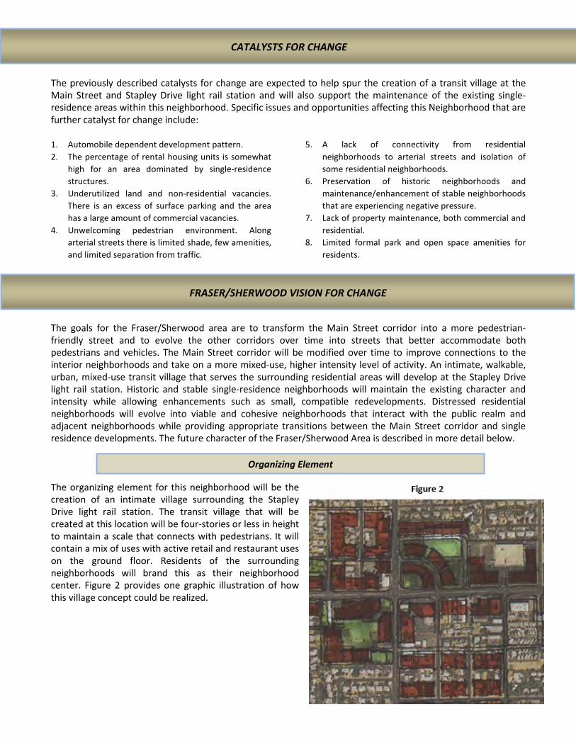
The previously described catalysts for change are expected to help spur the creation of a transit village at the Main Street and Stapley Drive light rail station and will also support the maintenance of the existing single-residence areas within this neighborhood. Specific issues and opportunities affecting this Neighborhood that are further catalyst for change include: 1. Automobile dependent development pattern. 2. The percentage of rental housing units is somewhat
high for an area dominated by single-residence structures.
3. Underutilized land and non-residential vacancies. There is an excess of surface parking and the area has a large amount of commercial vacancies.
4. Unwelcoming pedestrian environment. Along arterial streets there is limited shade, few amenities, and limited separation from traffic.
5. A lack of connectivity from residential neighborhoods to arterial streets and isolation of some residential neighborhoods.
6. Preservation of historic neighborhoods and maintenance/enhancement of stable neighborhoods that are experiencing negative pressure.
7. Lack of property maintenance, both commercial and residential.
8. Limited formal park and open space amenities for residents.
The goals for the Fraser/Sherwood area are to transform the Main Street corridor into a more pedestrian-friendly street and to evolve the other corridors over time into streets that better accommodate both pedestrians and vehicles. The Main Street corridor will be modified over time to improve connections to the interior neighborhoods and take on a more mixed-use, higher intensity level of activity. An intimate, walkable, urban, mixed-use transit village that serves the surrounding residential areas will develop at the Stapley Drive light rail station. Historic and stable single-residence neighborhoods will maintain the existing character and intensity while allowing enhancements such as small, compatible redevelopments. Distressed residential neighborhoods will evolve into viable and cohesive neighborhoods that interact with the public realm and adjacent neighborhoods while providing appropriate transitions between the Main Street corridor and single residence developments. The future character of the Fraser/Sherwood Area is described in more detail below. The organizing element for this neighborhood will be the creation of an intimate village surrounding the Stapley Drive light rail station. The transit village that will be created at this location will be four-stories or less in height to maintain a scale that connects with pedestrians. It will contain a mix of uses with active retail and restaurant uses on the ground floor. Residents of the surrounding neighborhoods will brand this as their neighborhood center. Figure 2 provides one graphic illustration of how this village concept could be realized.
CATALYSTS FOR CHANGE
FRASER/SHERWOOD VISION FOR CHANGE
Organizing Element

Effectively achieving the desired changes in this area over time will require focusing on the needs of the various areas of the neighborhood and implementing those policies, projects, and programs that can accomplish the desired results. In addition to the plan policies and recommendations for the entire Central Main Area, this section will describe Fraser/Sherwood specific plan policies and recommendations. In combination with the general Building Form and Development Character descriptions provided at the beginning of this Chapter, a detailed description of each Building Form and Development character type within Fraser/Sherwood is provided below and shown on Map 21. The most significant transformation is anticipated at the intersection of Main Street and Stapley Drive, where a future light rail station is envisioned. While the actual location of this future light rail station will follow an extensive alternatives analysis and public outreach effort, for the purposes of this plan, placement of the light rail station has been recommended for the east side of Stapley Drive. At this location the Transit Station Village will function at a local scale as the center of the larger Fraser/Sherwood Neighborhood. Consequently, development intensities will be more modest than other Transit Station Villages, such as Gilbert and Main, while still creating an urban development pattern. Development in the Transit Station Village should help shape an identity for the Fraser/Sherwood Neighborhood through creation of a distinctive place that embraces the area social and cultural diversity. Stapley Village Core The core of this Transit Station Village, shown in Figure 3, consists of the areas immediately north and south of the light rail station on both sides of Stapley Drive. Much of the core area is currently underutilized suburban developments with large parking fields, but also includes some areas of small-lot commercial and residential that would require lot assembly to create viable development sites. The Village Core will include the most intense development in the Village. Mixed-use buildings, up to four-stories in height, that include active ground floor uses and upper floor commercial or residential will be expected. Stapley Village The remainder of the Transit Station Village would be devoted to medium-high density residential uses developed as coordinated and integral component of the Village core. The introduction of a light rail station will allow the realization, over time, of the significant redevelopment potential of this area. Policy TSV 1: Light rail should be extended to Gilbert Road with a station east of Stapley Drive. Policy TSV 2: Commercial and mixed-use development should be confined to the Village Core. Policy TSV 3: Residential density is not limited in the Village Core area. The remainder of the Village should have a minimum residential density of 17 units per acre. Policy TSV 4: Typical building heights in the Core are three- to four-story and two- to four-story in the remainder of the village. Policy TSV 5: A variety of architecturally diverse, high-quality housing types and sizes will be encouraged to provide housing for families, young professionals,
executives, service workers, handicapped, retirees, and seniors. Policy TSV 6: New development within Stapley Village will include public realm amenities, such as walkable sidewalks, plazas, consistent landscape palate, shade, and seating to create an attractive and active public space that helps shape the character of the neighborhood. Policy TSV 7: Development site planning and design of the Transit Station Village will strengthen existing pedestrian routes and/or create new pedestrian routes with strong visual connections to the Village Core and light rail corridor from adjacent developments.
TOOLS FOR CHANGE
Transit Station Village (Stapley Village)

STAP
LEY
DR
UNIVERSITY DR
BROADWAY RD
MAIN ST
HO
RN
E
Map 20
Central Main Plan- Fraser/Sherwood Neighborhood -
Created By: Mesa - PlanningPrint Date: 07/26/2011Source: City of Mesa
The City of Mesa makes no claims concerning the accuracy of this map nor assumes any
liability resulting from the useof the information herein.
COPYRIGHT 1988, 2009 CITY OF MESA, ARIZONA
´0 300 600 900
Feet
Recommended Building Formand Development Character
Transit Station Village
Transit Adjacent - Residential
Commercial/Mixed-Use Node
Evolution Corridor
Neighborhood Evolution
Neighborhood Preservation
Neighborhood Maintenance

The areas east and west of the Transit Station Village along Main Street are envisioned to transform to a more urban environment with improved streetscape and limited mixed-use with an emphasis on medium- to medium-high-density residential developments. The development of these areas will support an urban environment with buildings addressing the public realm along Main Street, but at intensities that could allow the use of surface parking.
Village East A large portion of this area is located within ¼ mile of the future light rail station and can support higher intensity development. Residential is the primary land use focus, however, limited commercial activity could occur as part of a mixed-use development adjacent to Main Street. Redevelopment along Main Street should use an urban pattern of development with buildings addressing the street. As redevelop extends south of Main Street the development pattern should transition to, and be compatible with the Neighborhood Maintenance area south of Dana Avenue. Policy TAR-VE 1: With the exception of the developments addressing Dana Avenue, this area should redevelop with an urban development pattern with buildings addressing the public realm. Structured parking would be desirable if the development intensities are sufficient. Policy TAR-VE 2: Development site planning and design should strengthen existing pedestrian routes and/or create new pedestrian routes with strong visual connections to Stapley Village and light rail corridor from adjacent developments. Policy TAR-VE 3: Village East supports primarily medium density residential uses, with limited mixed use. Typical density along Main Street would be at least 15 du/acre; 12 du/acre east of Barkley alignment extended and adjacent to Main Street; and 10 du/acre south of Mahoney Avenue alignment extended.
Policy TAR-VE 4: The typical building height of two- to three-stories adjacent to Main Street one- to two-stories adjacent to Maintenance Neighborhood south of Dana Avenue. Policy TAR-VE 5: As redevelopment occurs on the blocks south of Main Street, create a private or public street system to divide these blocks to provide better access and increase development potential. Policy TAR-VE 6: Redevelopment of this block should include a range of housing options from urban multiple residence to attached and detached single residences, all designed in a manner to reinforce and further develop a walkable urban environment. Policy TAR-VE 7: Redevelopment that includes lower density attached and detached residential also includes tree-lined residential streets to encourage pedestrian activity.
Village West Because only a small portion of this area is located within ¼ mile of the future light rail station, less pressure is anticipated for high-intensity developments. Residential is the primary land use focus, however, very limited commercial activity could occur as part of a mixed-use development adjacent to Main Street.
Policy TAR-VW 1: Development site planning and design of Transit Adjacent - Residential will strengthen existing pedestrian routes and/or create new pedestrian routes with strong visual connections to Stapley Village and light rail corridor from adjacent developments Policy TAR-VW 2: Village West supports primarily medium density residential uses, with minimal mixed use. Typical density is 12 du/acre. Policy TAR-VW 3: Minimum building height is two-stories, maximum is four.
Policy TAR-VW 4: Creation of viable redevelopment sites that appropriately transition to Maintenance Neighborhoods may need to incorporate adjacent residential properties, excluding Fraser Fields Policy TAR-VW 5: Encourage a residential development pattern that transitions into and incorporates the Evolution Neighborhood (Village North) by fronting onto Miller Street, Matlock Street, and Spencer
Transit Adjacent – Residential (Village East and Village West)
Main and Horne The Main and Horne Commercial Node is envisioned to transform from the current suburban corridor character into an urban commercial node that could incorporate a mix of uses that support surrounding residential neighborhoods. The property on the north side of Main Street should accommodate more substantial change, with the opportunity to redevelop the entire block with a low rise commercial/office development that serves the needs of the surrounding neighborhoods. Considering the popularity of the Rancho Grande grocery store, it is anticipate that transformation of properties south of Main Street will focus on improving the Main Street presence, with wider sidewalks, shade, parking lot landscape, pedestrian routes through parking, and limited infill of parking with small-scale commercial/retail uses. If redevelopment does occur, it should take an urban form. Policy CN-M/S 1: Mixed-use is not anticipated, but allowed, with an emphasis on commercial and office uses. Policy CN-M/S 2: Typical buildings will be no more than two stories tall. Policy CN-M/S 3: Residential only buildings are not encouraged along the Main Street frontage, but could be
provided behind the street fronts. Typical densities would be between 12 and 18 du/acre. Policy CN-M/S 4: Redevelopment of the block north of Main must carefully consider the transition to Fraser Fields to the north and provide attractive pedestrian connections into the commercial node.
Broadway and Stapley An additional commercial node has been identified at the intersection of Broadway Road and Stapley Drive. Over time, this intersection will transform from the current suburban corridor character to a more urban node of commercial activity that serves the adjacent neighborhoods. The most substantial change will occur on the properties east of Stapley Drive through redevelopment of an underutilized property on the northeast corner and improved Broadway Road presence, with wider sidewalks, shade, parking lot landscape, pedestrian routes through parking, and limited infill of the suburban strip retail on the southeast corner with small-scale commercial/retail uses. Policy CN-B/S 1: Mixed-use is not anticipated, but allowed, with an emphasis on commercial and office uses. Policy CN-B/S 2: Typical buildings heights will be no more than two stories tall.
Policy CN-B/S 3: Residential only buildings are not encouraged along the Broadway Road or Stapley Drive street frontages, but could be provided behind the street fronts. Typical densities would be between 12 and 18 du/acre.
Change is expected over time to the Broadway Road, Stapley Drive, University Drive, and Horne corridors. The degree of change along Evolution Corridors is likely to be of a slower and more modest nature. Generally development along University Drive is large enough in size to limit disruption of pedestrian flow, and if smaller, has been developed with cross access. The primary changes will be to improve the streetscape with better sidewalks, street trees, and street furniture. Properties that front onto Stapley and Horne are smaller and individually accessed. Over time, these properties could be redeveloped with attached residential, such as townhome or rowhouse in a coordinated manner that limits the number of driveway cuts. The Broadway Road corridor is a mixture of residential and commercial uses that will benefit from improved streetscape and connection to Commercial Nodes. Policy EC 1: Redevelopment through this area should reinforce an active streetscape and encourages pedestrian activity.
Policy EC 2: Over time improve the balance between pedestrian and automobile needs
Evolution Corridor
Commercial/Mixed-Use Node (Main/Horne and Broadway/Stapley)

Policy EC 3: Strip development repair – discourage additional strip development along University Drive and, over time, redevelop with uses that reduce traffic conflicts and integrate into the adjacent neighborhood. Policy EC 4: Reduce the number of driveways by creating shared drives and replacement of unused/unnecessary driveways with curb and sidewalk.
Policy EC 5: Creation of viable redevelopment sites that appropriately transition to Maintenance Neighborhoods may need to incorporate adjacent residential properties, excluding Fraser Fields
Village North The neighborhood north of Main Street and West of Stapley Drive, is primarily single-residence, but also includes some non-residential and multi-residence uses. Evolution of this neighborhood over time should result in a stable neighborhood containing a mix of single residence, duplex, and appropriately scaled multiple-residence buildings.
Policy EN-VN 1: Encourage a natural transition of intensity, with the most intense uses near Stapley Village and Village West and decreasing intensity near the adjacent Maintenance and Preservation Neighborhoods.
• Multiple residence densities of 8 to 12 du/acre consisting of developments that address the street such as townhouses, row houses, and courtyard apartments.
• Single residence densities of 4 to 6 du/acre and consisting of both existing and new dwellings.
• Compatibly scaled multi-residence, such as duplexes and mansion apartments, may be allowed at street intersections.
Policy EN-VN 2: Encourage a redevelopment pattern that includes new public or private east-west street connections, such as extending 1st Street between Stapley Drive and Miller Street. These streets would reduce block sizes, improve pedestrian circulation, and provide additional development options.
• If streets are private, they must remain open to pedestrian and vehicular use by the general public.
Policy EN-VN 3: Redevelopment within Village North must carefully consider the transition and relationship to the adjacent Neighborhood Maintenance and Preservation areas.
• Maintain the detached single-residence character on the west side of Miller Street.
Village South The neighborhood north of Broadway Road and east of Stapley Drive, is primarily multiple-residence with multiple ownerships, but does include some non-residential uses along Stapley Drive. This neighborhood suffers from a general lack of property maintenance and reinvestment from absentee landlords. Additionally, the majority of this neighborhood is served by single points of access, which results in long cul-de-sacs.
Policy EN-VS 1: Encourage a redevelopment pattern that includes new public or private street connections to Broadway Road, Stapley Drive, Dana Avenue, and Lazona Drive. These streets would reduce block sizes, improve pedestrian circulation, and provide additional development options.
• Connect S. Allen to Broadway Road and if possible Dana Avenue.
• Connect S. Doran to Broadway Road. • Introduce the east-west grid system by
extending 2nd, Nielson, Jarvis, and 3rd Avenues between Lazona and Stapley Drives.
• If streets are private, they must remain open to pedestrian and vehicular use by the general public.
Policy EN-VS 2: Redevelopment of Village South should include a range of housing options from urban multiple residences to attached and detached single residences, all designed in a manner to reinforce and further develop a walkable urban environment.
• A variety of architecturally diverse, high-quality housing types and sizes will be encouraged to provide housing for families, young professionals, executives, and service workers.
Neighborhood Evolution (Village North, Village South, Ellsworth Park)

• Target residential density of 8 to 12 du/acre in a coordinated development pattern.
Policy EN-VS 3: Encourage redevelopment that incorporates neighborhood scale open space amenity(s).
Policy EN-VS 4: Redevelopment within Village South must carefully consider the transition and relationship to the adjacent Neighborhood Maintenance areas.
Ellsworth Park The LDS Multi-Stake center located at the northeast corner of Horne and 2nd Avenue was formerly leased to the City for use as Ellsworth Park. The lease has since expired and formal use of the property has been limited to Church activities. However, informal use of the ball fields is common and the open space is an important element of the community. This area also includes the primarily residential uses along Mahoney Avenue. Policy EN-EP 1: Redevelopment of the Ellsworth Park area includes maintenance of a sizable public open space maintained by the City.
• Programming of open space should include a wider range of amenities compatible with adjacent residential uses, such as passive open space, sport courts, and ramadas.
• A pedestrian path through Ellsworth Park should be included that provides a connection for adjacent neighborhoods to Main Street.
Policy EN-EP 2: Encourage residential redevelopment of the properties along Mahoney Avenue and Horne in a manner that addresses the park. Policy EN-EP 3: Redevelopment within Ellsworth Park must carefully consider the transition and relationship to the adjacent Neighborhood Maintenance areas.
Fraser Fields Fraser Fields is a post World War II custom ranch subdivision with quality craftsmanship, architectural variety, and large lawns that represents the first major Mesa subdivision that reflected the trend of affluent and middle-class America migrating away from the City center. A citizen led initiative to have a local historic district overlay to Fraser Fields was approved by the City Council in 2003 and was placed on the National Register of Historic Places in _____. Such historic districts recognize the distinctive form and character that exists in Mesa. The goal of this plan is to preserve that distinctive character and address the threats to preservation. Policy PN-FF 1: Continue maintenance of this historic neighborhood to provide a variety of housing options and maintain a sense of Mesa’s historic development pattern. Policy PN-FF 2: Encourage the transformation of the Village West and Main and Horne Commercial Node into compatible, high-quality urban residential and commercial developments that provide destinations for residents of Fraser Field. PolicyPN-FF 3: Review all development proposals within the Horne and University Drive Evolution Corridors, the Village West Transit Adjacent – Residential, and Main and Horne Commercial Node for
appropriate transition and compatibility with Fraser Fields through building and site design. Policy PN-FF 4: Within the Village North Evolution Neighborhood, maintain the single-residence detached character on the west side of Miller Street. Policy PN-FF 5: Preserve the streetscape within Fraser Fields and enhance the streetscapes of Main Street, University Drive, and Fraser immediately north of Main Street to encourage pedestrian activity. Policy PN-FF 6: Preserve full intersection motion onto Fraser from Main Street and from Fraser onto Main Street with the introduction of light rail.
Sherwood Sherwood Mesa is a post World War II subdivision platted in four units between 1956 and 1962 and with homes constructed from 1956 to the early 1970s. Sherwood Mesa is a well maintained example of post-war boom suburban development. An informal citizen group is exploring designation of Sherwood with a local historic
Preservation Neighborhood (Fraser Fields, Sherwood)

district overlay. Such historic districts recognize the distinctive form and character that exists in Mesa. The goal of this plan is to preserve that distinctive character and address the threats to preservation.
Policy PN-S 1: Support designation as a historic district of local significance and maintenance of this historic neighborhood to provide a variety of housing options and maintain a sense of Mesa’s historic development pattern. Policy PN-S 2: Encourage the transformation of Stapley Village and Village East into compatible, high-quality urban residential and commercial developments that provide destinations for residents of Sherwood Policy PN-S 3: Review all development proposals within Stapley Village, University Drive Evolution Corridor, and Village East Transit Adjacent – Residential
for appropriate transition and compatibility with Sherwood through building and site design. Policy PN-S 4: Preserve the streetscape within Sherwood and enhance the streetscapes of Main Street, University Drive, and Lazona immediately north of Main Street to encourage pedestrian activity. Policy PN-S 5: Preserve full intersection motion onto Lazona from Main Street and from Lazona onto Main Street with the introduction of light rail.
The existing single-residences neighborhoods identified as Neighborhood Maintenance will be largely unchanged. The goal of this plan is to have in place those policies and programs that will help maintain the existing neighborhood character. The Neighborhood Maintenance area north of Broadway Road and west of Stapley Drive includes Lowell Elementary and Mesa Junior High Schools, a node of activity for formal school use and informal recreation use. Policy NM 1: Continue maintenance of the primarily suburban, single residence development pattern.
• Do not allow the intrusion of non-residential uses that break-up the residential fabric of the neighborhood.
• Allow limited redevelopment with compatible multiple-residences such as row houses and mansion apartments that can also serve as a transition from higher intensity developments
Policy NM 2: Strengthen the pedestrian environment.
• Encourage incorporation of pedestrian routes through Transit Village and Transit Adjacent – Residential redevelopments that connect Neighborhood Maintenance areas to the major arterials.
Policy NM 3: Encourage the acquisition and development of land for small-scale neighborhood parks within under-served neighborhoods.
Project NM 1: Incorporate new sidewalks on neighborhood streets where they do not currently exist (N. Hunt Drive E & W). Project NM 2: Improve streetscapes along E. 2nd Avenue, S. Solomon, and S. Horne to encourage pedestrian access to informal park use of Mesa Junior High and future Ellsworth Park. Project NM 3: Identification of safe routes to school through Neighborhood Maintenance areas and adjacent neighborhoods outside the planning area to Lowell Elementary and Mesa Junior High Schools.
• Additional care will be taken with Broadway Road and Horne street design to ensure a safe pedestrian environment in the vicinity of Mesa Junior High.
Neighborhood Maintenance
In addition to the general Street Character descriptions provided in Chapter IV, a description of street character and mobility plan recommendations within Fraser/Sherwood is provided below and shown on Map 21. The existing character of the streets within Fraser/Sherwood reflects an automobile dominated, suburban corridor that does not encourage use by pedestrians or bicyclist. Particularly the Downtown/Village Main Street, Village Connector, and Urban Connector will greatly benefit from developments that include street character improvements consistent with the recommendations of this Chapter. The recommended Mobility Plan identifies the location of a Stapley Drive light rail station, completion of the sidewalk network, and bus stop improvements. The introduction of light rail and the long-term redevelopment of the Fraser/Sherwood Neighborhood will be more successful with thoughtful consideration of the relationship to the Temple/Pioneer and Gilbert/Main Neighborhoods and the connection to surrounding neighborhoods. The transition in development scale, intensity, and character between Neighborhoods should be seamless so that people on the ground will not be able to recognize when they pass from one Neighborhood to another. Particular areas of relationship and connection include: 1. Through the existing local and arterial street
network, the portion of the Fraser/Sherwood Neighborhood north of Main Street has good connections with the Gilbert/Main Neighborhood and both will benefit from new infill and redevelopment projects. Based on the existing pattern of development, there is very little connection between the portion of the Fraser/Sherwood Neighborhood south of Main Street and the Gilbert/Main Neighborhood, except along arterial streets. Currently, Dana Avenue is the only local street that connects between the two Neighborhoods and the potential from improved connections in the future is limited. Consequently, care needs to be taken along all arterial street corridors to ensure that there is a coordinated pattern of development over time.
2. With the exception of the arterial streets, the Fraser/Sherwood Neighborhood has limited connections with the Temple/Pioneer Neighborhood. North of Main Street there are no connections other than the arterial streets, and because of the existing development pattern there are no opportunities to develop additional connections. South of Main Street, 2nd Avenue is the only local street connection; however, there is an opportunity to develop an additional connection with the recommended redevelopment of the Ellsworth Park Evolution Neighborhood. Considering the limited existing and potential street connections, the improvement of the Main Street, University Drive, and Horne pedestrian environments is
important to encourage mobility and pedestrian activity.
3. The Broadway Road corridor has the potential to provide neighborhood service and retail to residents of the Fraser/Sherwood Neighborhood as well as residents south of Broadway Road. In particular, the Broadway and Stapley Commercial Node should include the commercial properties south of Broadway Road and provide neighborhood commercial that will serve the area south of Broadway as well.
4. The Lowell Elementary and Mesa Junior High Schools attendance areas extend across Horne into the Temple/Pioneer Neighborhood and the neighborhoods south of Broadway. In addition, the sport fields on the school property and the LDS Stake Center are both informally used by residents outside of Fraser/Sherwood. For these reasons, safe and attractive connections for students and residents walking or biking to school or the sport fields from adjacent neighborhoods need to be developed.
Relationship to Adjacent Neighborhoods
Street Character and Mobility Plan
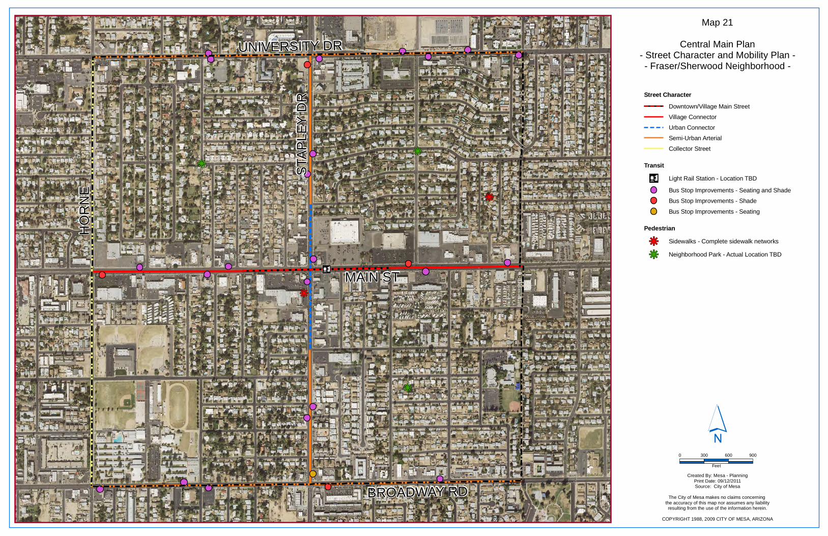
n¤
kj
kj
kjkj
kj
STAP
LEY
DR
UNIVERSITY DR
BROADWAY RD
MAIN ST
HO
RN
E
Map 21
Central Main Plan- Street Character and Mobility Plan -- Fraser/Sherwood Neighborhood -
Created By: Mesa - PlanningPrint Date: 09/12/2011Source: City of Mesa
The City of Mesa makes no claims concerning the accuracy of this map nor assumes any liabilityresulting from the use of the information herein.
COPYRIGHT 1988, 2009 CITY OF MESA, ARIZONA
´0 300 600 900
Feet
Pedestrian
kj Neighborhood Park - Actual Location TBD
Sidewalks - Complete sidewalk networkskj
TransitLight Rail Station - Location TBDn¤
Bus Stop Improvements - Seating
Bus Stop Improvements - Seating and Shade
Bus Stop Improvements - Shade
Street Character
Semi-Urban Arterial
Collector Street
Downtown/Village Main Street
Village Connector
Urban Connector
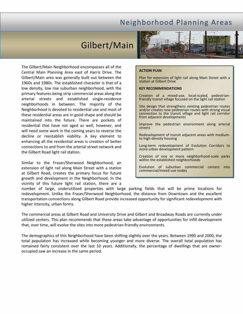
The Gilbert/Main Neighborhood encompasses all of the Central Main Planning Area east of Harris Drive. The Gilbert/Main area was generally built out between the 1960s and 1980s. The established character is that of a low density, low rise suburban neighborhood, with the primary features being strip commercial areas along the arterial streets and established single-residence neighborhoods in between. The majority of the Neighborhood is devoted to residential use and most of these residential areas are in good shape and should be maintained into the future. There are pockets of residential that have not aged as well, however, and will need some work in the coming years to reverse the decline or reestablish viability. A key element to enhancing all the residential areas is creation of better connections to and from the arterial street network and the Gilbert Road light rail station. Similar to the Fraser/Sherwood Neighborhood, an extension of light rail along Main Street with a station at Gilbert Road, creates the primary focus for future growth and development in the Neighborhood. In the vicinity of this future light rail station, there are a number of large, underutilized properties with large parking fields that will be prime locations for redevelopment. Unlike the Fraser/Sherwood Neighborhood, the distance from Downtown and the excellent transportation connections along Gilbert Road provide increased opportunity for significant redevelopment with higher intensity, urban forms. The commercial areas at Gilbert Road and University Drive and Gilbert and Broadway Roads are currently under utilized centers. This plan recommends that these areas take advantage of opportunities for infill development that, over time, will evolve the sites into more pedestrian-friendly environments. The demographics of this Neighborhood have been shifting slightly over the years. Between 1990 and 2000, the total population has increased while becoming younger and more diverse. The overall total population has remained fairly consistent over the last 10 years. Additionally, the percentage of dwellings that are owner-occupied saw an increase in the same period.
NN ee iigg hh bb oo rrhh oo oo dd PP llaa nn nn iinn gg AA rreeaa ss
Gilbert/Main
ACTION PLAN Plan for extension of light rail along Main Street with a station at Gilbert Drive KEY RECOMMENDATIONS Creation of a mixed-use, local-scaled, pedestrian-friendly transit village focused on the light rail station Site design that strengthens existing pedestrian routes and/or creates new pedestrian routes with strong visual connection to the transit village and light rail corridor from adjacent developments Improve the pedestrian environment along arterial streets Redevelopment of transit adjacent areas with medium- to high-density housing Long-term redevelopment of Evolution Corridors to more urban development pattern Creation of one or more neighborhood-scale parks within the established neighborhoods Evolution of suburban commercial centers into commercial/mixed-use nodes
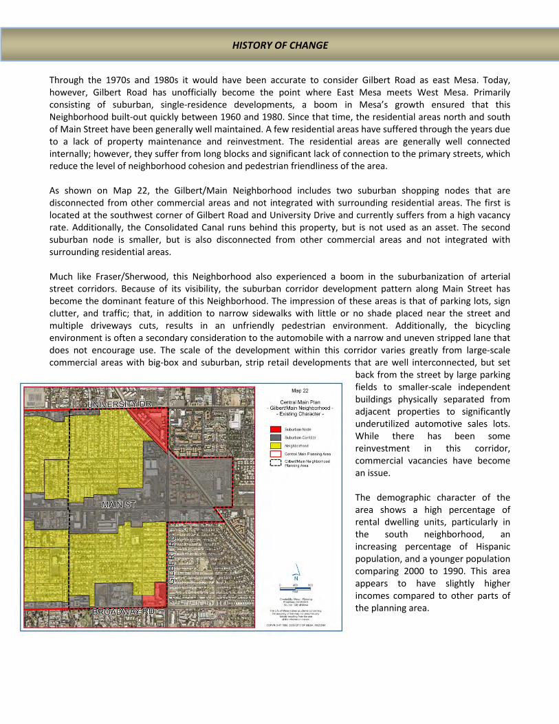
Through the 1970s and 1980s it would have been accurate to consider Gilbert Road as east Mesa. Today, however, Gilbert Road has unofficially become the point where East Mesa meets West Mesa. Primarily consisting of suburban, single-residence developments, a boom in Mesa’s growth ensured that this Neighborhood built-out quickly between 1960 and 1980. Since that time, the residential areas north and south of Main Street have been generally well maintained. A few residential areas have suffered through the years due to a lack of property maintenance and reinvestment. The residential areas are generally well connected internally; however, they suffer from long blocks and significant lack of connection to the primary streets, which reduce the level of neighborhood cohesion and pedestrian friendliness of the area. As shown on Map 22, the Gilbert/Main Neighborhood includes two suburban shopping nodes that are disconnected from other commercial areas and not integrated with surrounding residential areas. The first is located at the southwest corner of Gilbert Road and University Drive and currently suffers from a high vacancy rate. Additionally, the Consolidated Canal runs behind this property, but is not used as an asset. The second suburban node is smaller, but is also disconnected from other commercial areas and not integrated with surrounding residential areas. Much like Fraser/Sherwood, this Neighborhood also experienced a boom in the suburbanization of arterial street corridors. Because of its visibility, the suburban corridor development pattern along Main Street has become the dominant feature of this Neighborhood. The impression of these areas is that of parking lots, sign clutter, and traffic; that, in addition to narrow sidewalks with little or no shade placed near the street and multiple driveways cuts, results in an unfriendly pedestrian environment. Additionally, the bicycling environment is often a secondary consideration to the automobile with a narrow and uneven stripped lane that does not encourage use. The scale of the development within this corridor varies greatly from large-scale commercial areas with big-box and suburban, strip retail developments that are well interconnected, but set
back from the street by large parking fields to smaller-scale independent buildings physically separated from adjacent properties to significantly underutilized automotive sales lots. While there has been some reinvestment in this corridor, commercial vacancies have become an issue. The demographic character of the area shows a high percentage of rental dwelling units, particularly in the south neighborhood, an increasing percentage of Hispanic population, and a younger population comparing 2000 to 1990. This area appears to have slightly higher incomes compared to other parts of the planning area.
HISTORY OF CHANGE

The previously described area-wide catalysts for change are expected to help spur the creation of a transit village at the Main Street and Gilbert Road light rail station and will also support the maintenance of the existing single-residence areas within this neighborhood. Specific issues and opportunities affecting this Neighborhood that are further catalyst for change include: 1. Improving connections from the neighborhoods to
the arterial street network and the light rail station. 2. Underutilized and vacant commercial properties. 3. Sidewalks along arterial streets that are narrow, feel
unsafe, and are uncomfortable to use. 4. Creation of a transit village oriented around the light
rail stop at Main Street and Gilbert Road.
5. The percentage of rental housing units is somewhat high for an area dominated by single-residence structures.
6. A shortage of neighborhood-scale parks and open space within the neighborhoods.
The goals for the Gilbert/Main Neighborhood are to transform the Main Street corridor into a more pedestrian-friendly street and to evolve the other corridors over time into streets that better accommodate both pedestrians and vehicles. The Main Street corridor will be modified over time to improve connections to the interior neighborhoods and take on a more mixed-use, higher intensity level of activity. Long-term the areas around the Gilbert Road light rail station will become a walkable, urban, mixed-use transit village that supports the most intense development expected outside of Downtown within the Central Main Planning Area. This transit village will serve the surrounding residential areas and larger community. The stable single-residence neighborhoods will maintain the existing character and intensity while allowing enhancements such as small, compatible redevelopments. The future character of the Gilbert/Main Neighborhood is described in more detail below. The organizing element for this neighborhood will be the creation of an urban transit village surrounding the Gilbert Road light rail station that will be the central feature in developing a sense of place and identity. Building heights will typically be three- to five-story and will support development of a highly walkable area, with the unique opportunity for connection to a multi-use path along the Consolidated Canal. Figure 4 provides one graphic illustration of how this village concept could be realized.
CATALYSTS FOR CHANGE
GILBERT/MAIN VISION FOR CHANGE
Organizing Element

Effectively achieving the desired changes in this area over time will require focusing on the needs of the various areas of the neighborhood and implementing those policies, projects, and programs that can accomplish the desired results. In addition to the plan policies and recommendations for the entire Central Main Area, this section will describe Gilbert/Main specific plan policies and recommendations. In combination with the general Building Form and Development Character descriptions provided at the beginning of this Chapter, a detailed description of each Building Form and Development character type within Fraser/Sherwood is provided below and shown on Map 23. The most significant transformation is anticipated at the intersection of Main Street and Gilbert Road, where a future light rail station is envisioned. While the actual location of this future light rail station will follow an extensive alternatives analysis and public outreach effort, for the purposes of this plan, placement of the light rail station has been recommended on the west side of Gilbert Road. The areas north and south of this light rail station are currently underutilized suburban developments with large parking fields or low-intensity automobile sales lots. The introduction of a light rail station will allow the realization of the significant redevelopment potential of this area. At this location, the Transit Station Village will function at a local scale as the center of the Gilbert/Main Neighborhood and at the community-wide scale with the incorporation of a “beginning of the line” multi-modal transit station and as the most intense development along the light rail corridor outside of Downtown. Development in the Transit Station Village should help shape an identity for the Gilbert/Main Neighborhood through creation of a distinctive place that embraces the area’s social and cultural diversity. Policy TSV 1: Light rail should be extended along Main Street with a station west of Gilbert Road. Policy TSV 2: Building heights within 660’ of the light rail station at Gilbert Road of five stories is encouraged; taller structures may be allowed, with appropriate design and compatibility with surrounding developments. Policy TSV 3: Residential density should be at least 25 units per acre within 660’ of the light rail station and 20 units per acre within the rest of the Transit Station Village. Policy TSV 4: Additional pedestrian crossing with curb extensions should be considered at locations where a substantial number of pedestrians or bicyclists attempt to cross streets. Policy TSV 5: Pedestrian access should be improved between the adjacent neighborhoods and the station area.
Project TSV 1: Provide an improved Main Street pedestrian crossing at the Guthrie Street intersection. Project TSV 2: Create at least one pedestrian or street connection from the light rail station area directly to the residential area to the north. Project TSV 3: Create at least two pedestrian or street connections from the light rail station area directly to the residential areas to the south. Project TSV 4: Develop a lighted, multi-use path along the Consolidated Canal that connects to adjacent neighborhoods and a larger urban trail network.
TOOLS FOR CHANGE
Transit Station Village

GIL
BER
T R
D
UNIVERSITY DR
BROADWAY RD
MAIN ST
Map 23
Central Main Plan- Gilbert and Main Neighborhood -
´0 300 600 900
Feet
Created By: Mesa - PlanningPrint Date: 07/26/2011Source: City of Mesa
The City of Mesa makes no claims concerning the accuracy of this map nor assumes any
liability resulting from the useof the information herein.
COPYRIGHT 1988, 2009 CITY OF MESA, ARIZONA
Recommended Building Formand Development Character
Transit Station Village
Transit Adjacent-Village
Transit Adjacent - Residential
Commercial/Mixed-Use Node
Evolution Corridor
Neighborhood Maintenance

Opportunities also exist east of Gilbert Road for significant redevelopment. This redevelopment could take advantage of the canal as a design element and improve connectivity. Some commercial use is expected close to the intersection. The remaining development will be a combination of office and high-density residential. Policy TAV 1: Encourage redevelopment in this area to take advantage of the canal as part of the transportation system and as an amenity to the development.
Policy TAV 2: Mixed-use development is encouraged at the Gilbert Road and Main Street intersection with ground floor retail uses.
Policy TAV 3: Typical building heights of three- to four-stories. Buildings heights near the Gilbert Road and Main Street intersection up to five stories.
Project TAV 3: Develop a lighted, multi-use path along the Consolidated Canal that connects to adjacent neighborhoods and a larger path system.
The areas north and west of the Transit Station Village are envisioned to transform to a more urban environment with improved streetscape and limited mixed-use with an emphasis on medium- to medium-high-density residential developments. The development of these areas will support an urban environment with buildings addressing the public realm along Gilbert Road and Main Street, but at intensities that may allow the use of surface parking. The area east of the Consolidated Canal is currently an underutilized automobile sales lot and is large enough to accommodate significant residential redevelopment in a coordinated design that includes a range of housing options. Incorporation of the Consolidated Canal as a design element and to improve connectivity is recommended. Policy TAR 1: For the area east of the Consolidated Canal, redevelopment should include access to the canal as part of the transportation system and as an amenity to the development. Policy TAR 2: The areas north and west of the Transit Station Village support primarily medium density residential uses, with limited mixed use. Typical density along Main Street should be at least 15 du/acre. Policy TAR 3: Redevelopment of the area east of the Consolidated Canal should include a range of housing options from urban multiple residence to attached and detached single residences, all designed in a manner to
reinforce and further develop a walkable urban environment and take advantage of the canal. Policy TAR 4: Opportunities should be explored for the incorporation of additional connections between the Main Street corridor and the neighborhoods north and south of Main Street. Policy TAR 4: Additional pedestrian crossings with curb extensions should be considered at locations where a substantial number of pedestrians or bicyclists attempt to cross streets.
Gilbert and University The Main and Horne Commercial Node is envisioned to transform from the current suburban corridor character into an urban commercial node that could incorporate a mix of uses that support surrounding residential neighborhoods. Improvements should include wider sidewalks, shade, parking lot landscape, pedestrian routes through parking, and limited infill with small-scale commercial/retail uses. Policy CN-G/U 1: Mixed-use is not anticipated, but allowed, with an emphasis on commercial and office uses.
Policy CN-G/U 2: Typical buildings will be no more than two stories tall.
Transit Adjacent – Residential
Commercial/Mixed-Use Node (Gilbert and University and Gilbert and Broadway)
Transit Adjacent – Village
Policy CN-G/U 3: Improvements should include access to the Consolidated Canal as part of the transportation system and an amenity to the development.
Gilbert and Broadway An additional commercial node has been identified at the intersection of Gilbert and Broadway Roads. Over time, this intersection will transform from the current suburban corridor character to a more urban node of activity that serves the adjacent neighborhoods. This Commercial/Mixed-Use Node has area available for infill residential and residential redevelopment that would create a transition between the commercial uses and the single-residence areas. Adjacent to Broadway and Gilbert Roads improvements should include wider sidewalks, shade, parking lot landscape, pedestrian routes through parking, and limited infill of the suburban strip retail on the southeast corner with small-scale commercial/retail uses. Policy CN-G/B 1: Mixed-use is not anticipated, but allowed, with an emphasis on commercial and office uses. Policy CN-G/B 2: Typical buildings heights will be no more than two stories tall.
Policy CN-G/B 3: Residential only buildings are not encouraged along the Broadway or Gilbert Roads street frontages, but are encouraged north of Broadway Road adjacent to Shouse. Typical densities would be between 12 and 18 du/acre.
Change is expected over time to the Broadway Road and University Drive corridors. The degree of change along Evolution Corridors is likely to be of a slower and more modest nature. The primary changes will be to improve the streetscape with better sidewalks, street trees, and street furniture. The Broadway Road corridor is a mixture of residential, commercial, and institutional uses that will benefit from improved streetscape and connection to Commercial Nodes. Policy EC 1: Redevelopment through this area should reinforce an active streetscape and pedestrian activity. Policy EC 2: Improve the balance between pedestrian and automobile needs, over time. Policy EC 3: Reduce the number of driveways by creating shared drives and replacement of unused/unnecessary driveways with curb and sidewalk.
Policy EC 4: Review all development proposals to ensure buildings are properly designed and integrated into adjacent development, particularly abutting single-residence developments.
Policy EC 5: Creation of viable redevelopment sites that appropriately transition to Maintenance Neighborhoods may need to incorporate adjacent residential properties.
The existing single-residence neighborhoods identified as Neighborhood Maintenance will be largely unchanged. The goal of this plan is to have in place those policies and programs that will help maintain the existing neighborhood character. Specific enhancements to the Neighborhood Maintenance areas that should occur include improved pedestrian and bicycle connectivity to the arterial street network and Gilbert Road light rail station and improved access to open space through acquisition and development of neighborhood scale parks in underserved areas.
Evolution Corridor
Neighborhood Maintenance

Policy NM 1: Continue maintenance of the primarily suburban, single residence development pattern.
• Do not allow the intrusion of non-residential uses that break up the residential fabric of the neighborhood.
• Allow limited redevelopment with compatible multiple-residences, such as row houses and mansion apartments that can also serve as a transition from higher intensity developments
Policy NM 2: Encourage an improved pedestrian environment with the incorporation of pedestrian routes through Transit Village and Transit Adjacent – Residential developments that help connect Neighborhood Maintenance areas to the major arterials.
Policy NM 3: Encourage the acquisition and development of land for small-scale neighborhood parks within under-served neighborhoods. Project NM 1: Incorporate new sidewalks on neighborhood streets where they do not currently exist.
In addition to the general Street Character descriptions provided in Chapter IV, a description of street character and mobility plan recommendations within Gilbert/Main is provided below and shown on Map 24. The existing character of the streets within Gilbert/Main reflects an automobile dominated, suburban corridor that does not encourage use by pedestrians or bicyclist. Particularly the Downtown/Village Main Street, Village Connector, and Regional Transit Arterial will greatly benefit from developments that include street character improvements consistent with the recommendations of this Chapter. The recommended Mobility Plan identifies the location of a Gilbert Road light rail station, completion of the sidewalk network, and bus stop improvements. Very important to the Gilbert/Main Neighborhood, where street connections to Main Street and Gilbert Road are extremely few or non-existent, the mobility plan also shows general locations for off-street pedestrian connections between residential areas and Main Street and Gilbert Road.
Street Character and Mobility Plan

n¤
kj
kj
GIL
BER
T R
D
UNIVERSITY DR
BROADWAY RD
MAIN ST
Map 24
Central Main Plan- Street Character and Mobility Plan -
- Gilbert and Main Neighborhood -
Transit
Transit Center - Location TBD
Bus Stop Improvements - Seating
Bus Stop Improvements - Shade
Bus Stop Improvements - Seating and Shade
Light Rail Station - Location TBDn¤
PedestrianCrosswalk
Multi-Use Trail
Pedestrian Connection
Sidewalks - Complete sidewalk networkskjkj Neighborhood Park - Actual Location TBD
´0 300 600 900
Feet
Created By: Mesa - PlanningPrint Date: 9/12/2011Source: City of Mesa
The City of Mesa makes no claims concerning the accuracy of this map nor assumes any liabilityresulting from the use of the information herein.
COPYRIGHT 1988, 2009 CITY OF MESA, ARIZONA
Street Character
Village Connector
Urban Transit Corridor
Downtown/Village Main Street
Semi-Urban Arterial
Regional Transit Arterial
Regional Arterial
Williams Realignment
The introduction of light rail and the long-term redevelopment of the Gilbert/Main Neighborhood will be more successful with thoughtful consideration of the relationship to the Fraser/Sherwood Neighborhood and the connection to surrounding neighborhoods. The transition in development scale, intensity, and character between neighborhoods should be seamless so that people on the ground will not be able to recognize when they pass from one neighborhood to another. The future light rail station will serve an area much larger than the Gilbert/Main Neighborhood, and as such, connection to the larger community should be addressed. Particular areas of relationship and connection include: 1. Providing connections to the single-residence
development at the southeast corner of Gilbert Road and Main Street to the Central Main Area can improve the accessibility to, and success of the Gilbert/Main Neighborhood. Improved connections will also support the success of light rail and future commercial and employment developments in the Transit Station Village by providing improved access to both customers and employees. Improvements that should be considered include: • The Gilbert Road pedestrian environment
between Main Street and Broadway Road. • A multi-use path along the Consolidated Canal
that extends south to at least Broadway Road.
2. Provide connections to the multiple-residence developments at the southeast corner of Gilbert Road and University Drive and east of 22nd Place. Connection can improve the accessibility to, and success of the Gilbert/Main Neighborhood, light rail, and future commercial and employment developments. Improvements that should be considered include: • The Gilbert Road pedestrian environment Main
Street and University Drive. • A multi-use path along the Consolidated Canal. • A pedestrian route that diagonally connects
Main Street, the Consolidated Canal, and 22nd Place through future development in the Transit Adjacent-Village and Transit Adjacent-Residential east of Gilbert Road.
• Enhanced pedestrian crossings at the intersection of Gilbert Road and University Drive to improve access to the Gilbert and University Commercial/Mixed-Use Node.
3. The Broadway Road corridor has the potential to provide neighborhood service and retail to residents of the Gilbert/Main Neighborhood as well as residents south of Broadway Road. In particular, Reed Park is an area of increased activity. Additionally, as the only non-arterial street in the Neighborhood that connects Broadway Road to Main Street, Williams should be considered for creation of a neighborhood retail and service node at the intersection with Broadway Road.
4. Through the existing local and arterial street network, the portion of the Gilbert/Main Neighborhood north of Main Street has strong connections with the Fraser/Sherwood Neighborhood and both will benefit from any new infill and redevelopment projects. Except along arterial streets, there is very little connection between the portion of the Gilbert/Main Neighborhood south of Main Street and the Fraser/Sherwood Neighborhood. The potential for improved connections in this area in the future is limited. Consequently, care needs to be taken along all arterial street corridors to ensure that there is a coordinated pattern of development over time.
Relationship to Adjacent Neighborhoods

The Broadway Industrial Neighborhood is anchored around those areas along Broadway Road and Country Club Drive that are primarily industrial in nature. Industrial use in this Neighborhood got an early start in Mesa’s history with the development of the Union Pacific Rail line through this area. Over the years a variety of building types and land use activities have developed within this Neighborhood. The established character is a mixture of low-intensity industrial, commercial, and residential developments with buildings that are both brought to the street and setback behind large parking fields. The eastern portion of the Broadway Road corridor is primarily automobile oriented and includes a significant number of automobile service businesses. Country Club Drive was previously designated as State Route 87, and with this designation came significant automobile traffic. This traffic necessitated the construction of an underpass at the Union Pacific Rail line. The underpass has proven to be a barrier to vehicular and pedestrian connectivity in the area and creates a unique development situation that presents challenges to use of the adjacent properties. The Broadway Industrial Neighborhood is far enough away that the influence of the light rail extension on future character will be less than other Neighborhoods. Consequently, the focus for this area is primarily to improve the appearance and provide opportunities for continued employment uses. The eastern portion of this neighborhood has the opportunity to transition over time away from the current uses to a mix of residential and local serving commercial activities. Adaptive reuse of existing buildings and creating a greater sense of identity and place are important for the future of this area. Potential development of the Inter-City Commuter Rail Line on the existing Union Pacific Rail line, however, would directly influence the character of properties west of Center Street. As the name for this Neighborhood suggests, the key attribute of this area is the primarily industrial nature of development within the Broadway Road and Country Club Drive corridors. This, however, was not always the case. The portion of this Neighborhood located east of Country Club Drive, north of Broadway Road, and west of Mesa Drive was within the original one-square mile town site plat approved in 1883 and based on the “City of Zion” plan. A unique twist on this town planning concept included the narrow blocks that front onto the north side of Broadway Road and west side of Mesa Drive. The remaining portions of this neighborhood were brought into the City in 1930 and 1948.
NN ee iigg hh bb oo rrhh oo oo dd PP llaa nn nn iinn gg AA rreeaa ss
Broadway Industrial
ACTION PLAN Preserve and adaptively re-use the former Citrus Growers Building. Active code compliance and use of the Building Stronger Neighborhoods program to help reduce evidence of decline in some areas. Institute a mural program for large buildings masses along Broadway with murals depicting the agricultural roots of Mesa. KEY RECOMMENDATIONS Transform the industrial blocks between 2nd Ave. and 3rd Ave. east of Sirrine to residential uses. Transform the area of Broadway from Mesa Drive to Sirrine to a more mixed-use village. Redevelop the southwest corner of Broadway and Country Club into a walkable mix of commercial and residential uses.
HISTORY OF CHANGE

Originally, much of this area would have been devoted to agricultural uses. Partially due to the railroad that ran through this Neighborhood, agricultural uses gave way to a long tradition of industrial and warehouse uses. The railroad that was established early in the City’s history helped spur the industrial and warehousing uses in this area, a prominent component of which was the industrial uses associated with the processing of agricultural products. The grain elevator and citrus packing plants are reminders of these historic uses. Initially, the tracks continued along the 3rd Avenue alignment and circled the City. Later the tracks east of Center Street and the northern loop were removed and all that remains is the current Union Pacific Rail line. The presence of the Union Pacific Rail line in the western portion of the Neighborhood now forms a substantial barrier between this Neighborhood and the Downtown Neighborhood. The designation of Country Club Drive as State Highway 87 as part of the original State highway system in 1927 also influenced the character of the Neighborhood. Because of State highway designation, Country Club Drive carried larger volumes of traffic and adjacent uses evolved to cater to the motoring public. Later, to avoid the conflict with trains, it became beneficial to construct the State Highway railroad underpass. This resulted in a unique intersection to be created with Broadway Road which has created a barrier to connectivity and resulted in development challenges for the adjacent properties. Both Broadway and Country Club are high traffic arterial streets with low density, strip corridor development. As shown on Map 25, there are a variety of development forms within this area. While there is an area of residential neighborhood and some commercial uses within the suburban corridor, the majority of this area has been devoted to industrial uses. These industrial uses have occurred in specifically built industrial districts and within the suburban corridor. Most recently, industrial uses have begun to encroach into formerly residential areas south of Broadway Road. Within this neighborhood, some buildings are constructed close to the street while others are set back with parking fields separating them from the street. Most buildings are single-story and single-purpose. A notable exception to the building character is the grain elevators. In addition to the building character described above, open storage lots are another prominent feature of this area. There are very few residential properties or residents within this area. Those that do exist are located south of 2nd Avenue between Sirrine and Hibbert and south of Broadway Road between Mesa Drive and Pasadena. These areas contain a mix of single- and multiple-residence properties.
The Southern Pacific Depot located at Robson and 3rd Avenue, circa 1930
The previously described catalysts for change described in this plan will have less direct impact on redevelopment in the Broadway Industrial Neighborhood. However, the impact these catalyst are expected to have on the Downtown Neighborhood will, by relationship, have an impact on this Neighborhood. Specific issues and opportunities affecting this Neighborhood that are further catalyst for change include: • Vacant and underutilized buildings provide the
opportunity for re-investment in the area. • Historic buildings such as the Citrus Growers building
provide the opportunity for adaptive re-use.
• The expanding Downtown Neighborhood with light rail will generate interest in redevelopment within this area.
Into the future, this area will evolve into a more people-friendly, prosperous, and environmentally-conscious neighborhood. Broadway Road and Country Club Drive will remain as major arterial streets carrying high volumes of traffic. The form of development will continue to be generally auto-oriented, but improvements to the pedestrian environment will mitigate the impact of automobiles and make a more friendly and enjoyable pedestrian and bicycle experience. In the short term, industrial and warehouse uses will remain in areas near the Union Pacific Rail line, but efforts will focus on improving the quality and appearance of these properties. In the longer term, the Union Pacific Rail line will remain, but with the potential for an Inter-City Commuter Rail line, development potential exists in the vicinity of a station. The most significant change is anticipated in the eastern portion of the Neighborhood with a transformation to a more residential character, including local-serving commercial use. This Neighborhood consists of long shallow corridors on Broadway Road and Country Club Drive. Within these areas, there will be limited change to the basic form of development. The key element to create/improve the character and vitality of this area will be an improved streetscape. Developing a consistent streetscape design and implementing that design along with the implementation of a mural program for the blank walls of large buildings will create a sense of place and identity for this area. Effectively achieving the desired changes in this area over time will require focusing on the needs of the various areas of the neighborhood and implementing those policies, projects, and programs that can accomplish the desired results. In addition to the plan policies and recommendations for the entire Central Main Area, this section will describe Broadway Industrial specific plan policies and recommendations. In combination with the general Building Form and Development Character descriptions provided at the beginning of this Chapter, a detailed description of each Building Form and Development character type within the Broadway Industrial Neighborhood is provided below and shown on Map 26.
CATALYSTS FOR CHANGE
BROADWAY INDUSTRIAL VISION FOR CHANGE
Organizing Element
TOOLS FOR CHANGE

MES
A D
R
CO
UN
TRY
CLU
B D
R
BROADWAY RD
CEN
TER
ST
Map 26
Central Main Plan- Broadway Industrial Neighborhood -
Recommended Building Formand Development Character
Employment District
Commercial/Mixed-Use Node
Evolution Corridor
Transformation Neighborhood
Created By: Mesa - PlanningPrint Date: 07/26/2011Source: City of Mesa
The City of Mesa makes no claims concerning the accuracy of this map nor assumes any
liability resulting from the useof the information herein.
COPYRIGHT 1988, 2009 CITY OF MESA, ARIZONA
´0 300 600 900
Feet

This area consists of the medium to large industrial uses north of Broadway Road and west of Country Club Drive and was also included in the West Main Street Neighborhood Area Plan. This area will maintain essentially the same industrial use and intensity character into the future. The focus for transition of this area will be improvement to the quality of the streetscape, which could include additional landscaping and building façade renovations. These recommendations are consistent with the adopted West Main Street Neighborhood Area Plan, which also recommended continued industrial uses in this area and placed an emphasis on creating a pedestrian-friendly environment. This area suffers from a lack of visibility and direct access to Country Club Drive and limited access from Broadway Road due to the non-standard Broadway Road and Country Club Drive intersection, necessitated by the depression of Country Club Drive. Incorporating sprawl repair techniques, the current vacant buildings and large, underutilized parking fields can be redeveloped with a mix of uses. Given the access and visibility issues, the primary use should be residential, but the mix of uses can be either vertical or horizontal, or both, in a pedestrian friendly pattern that can create some synergy for this area. Consideration could be given to proposals that directly tie this property to the existing neighborhoods to the south and west. Policy CN 1: Encourage redevelopment of the property on the west side of the Broadway Access Road by rezoning to one or more zoning districts that will allow residential development in a mixed-use environment.
The area adjacent to Broadway Road from Country Club Drive to Center Street on the north side and from Country Club Drive to the back of the residential area along Pasadena on the south side is primarily an industrial/warehouse area. This area will continue to focus on these types of uses into the future. The primary focus for this area is the improvement to building appearance and public realm enhancements that result in a safer, friendlier, and more enjoyable pedestrian and bicycle environment. Associated with this is the goal to improve multi-modal transportation options. Policy EC 1: Encourage creation of a unique sense of place with murals on the sides of buildings along the Broadway Road corridor between Mesa and Country Club Drives. Policy EC 2: As properties redevelop, work with the property owners to reduce/consolidate curb cuts, reduce signage, and install landscaping consistent with City standards. Policy EC 3: Support the protection of residential properties on the south side of Broadway Road through the provision of screening and buffering in conjunction with redevelopment of adjacent industrial properties. Policy EC 4: Support the designation of the Mesa Citrus Growers facility as a historic landmark and assist in efforts for adaptive re-use of this facility.
Project EC 1: Any planned street improvement projects in this area should include improvements to the rights-of-way that balance the needs of pedestrian and automobiles. Project EC 2: Assist with efforts to process a Historical Landmark designation on the Citrus Growers facility.
Project EC 3: Proactively assist property owners with efforts to evaluate the re-use options of existing buildings and address any Zoning and Building Code issues identified. Program EC 1: Establish a Broadway Road corridor mural program that establishes general themes and guidelines, solicits artists and painters, and provides materials.
Evolution Corridor
Commercial/Mixed-Use Node
Employment District

The areas on the north and south sides of Broadway Road extending west from Mesa Drive to Center Street on the north and just west of Pasadena on the south have the opportunity to transform over time into more cohesive neighborhood. Broadway Road will continue to be a high-volume traffic street, but efforts will focus on mitigating the limitations this places on improving the pedestrian nature of the street and the connections across the street. Industrial and auto-oriented uses will evolve over time into retail, multi-residence, and/or mixed-use developments that serve the traffic on Broadway Road and adjacent residential areas. Policy TN 1: Support redevelopment along the south side of Second Avenue that is compatible with the residential properties on the north side of Second Avenue and provides a quality pedestrian environment. Policy TN 2: Encourage the transformation of the industrial area north of the 3rd Avenue alignment and west of Pomeroy from current uses to an urban neighborhood with multiple-residence developments that increase in intensity from north to south. Policy TN 3: Support redevelopment of properties facing Mesa Drive and Broadway Road that remove industrial, open storage, and automobile storage uses. Preferred redevelopments include retail, office, and/or mixed uses that serve both the arterial street traffic and adjacent neighborhoods. Policy TN 4: Support the maintenance of the residential areas south of Broadway that are viable and important neighborhoods. Redevelopment of properties along the south side of Broadway need to be compatible
these neighborhoods and provide proper transitions or buffers, include services for local residents, and improve pedestrian connections. Project TN 1: In conjunction with adjacent property owners, prepare a plan to narrow or eliminate the 3rd Avenue right-of-way east of Sirrine. This project will maintain any needed utility corridors and provide for storm water drainage and may maintain pedestrian and/or vehicular circulation while increasing the buildable area and improving the connectivity between properties on each side of this right-of-way. Project TN 2: Close a portion of Pomeroy midway between Broadway Road and 2nd Avenue and integrate the vacated right-of-way into a redevelopment that incorporates the block facing Mesa Drive with the block to the west. Access along Pomeroy from Broadway Road and 2nd Avenue with the creation of cul-de-sacs.
In addition to the general Street Character descriptions provided in Chapter IV, a description of street character and mobility plan recommendations within Broadway Industrial is provided below and shown on Map 27. The existing character of the streets within Broadway Industrial reflects an automobile dominated, suburban corridor that does not encourage use by pedestrians or bicyclist. Particularly the Semi-Urban Arterial and Regional Transit Arterial will greatly benefit from street improvements consistent with the recommendations of this Chapter, either as part of redevelopment projects or as capital improvement projects that encourage redevelopment. The recommended Mobility Plan identifies the location of a potential Inter-City commuter rail alignment and station, completion of the sidewalk network, and bus stop improvements. .
Transformation Neighborhood
Street Character and Mobility Plan

kj kj kj
n¤
MES
A D
R
CO
UN
TRY
CLU
B D
R
BROADWAY RD
CEN
TER
ST
Map 27
Central Main Plan- Street Character and Mobility Plan -- Broadway Industrial Neighborhood -
Created By: Mesa - PlanningPrint Date: 09/12/2011Source: City of Mesa
The City of Mesa makes no claims concerning the accuracy of this map nor assumes any liabilityresulting from the use of the information herein.
COPYRIGHT 1988, 2009 CITY OF MESA, ARIZONA
´0 300 600 900
Feet
PedestrianSidewalks - Complete sidewalk networkskj
Transit
Inter-City Commuter Rail
Bus Stop Improvements - Seating and Shade
Commuter Rail Station - Location TBDn¤
Bus Stop Improvements - Shade
Street CharacterSemi-Urban Arterial
Regional Transit Arterial
Regional Arterial
Collector Street

The Broadway Industrial Neighborhood is an aging suburban corridor along major streets and adjacent to a downtown area that will transform into an intense, pedestrian-oriented, urban environment. While Broadway Road and Country Club Drive will continue to be primarily automobile-oriented places, there will be strong connections to the Downtown Neighborhood and the areas south of Broadway Road not within the Central Main Area. The transition in development scale, intensity, and character between these areas should focus on the comfort of pedestrians. Particular areas of relationships and connection include: 1. The portion of the Evolution Corridor between
MacDonald and Center Street is connected to the Downtown Education District just to the north. Continued development and re-use of properties in this area, particularly the portions that face Center Street need to be compatible with future development in the Education District.
2. The arterial street network (Country Club Drive and Broadway Road) are unifying elements between adjacent Neighborhoods. Streetscape improvements to the arterial street network will be coordinated to create seamless networks between Neighborhoods.
This Neighborhood includes areas that are proposed to be covered by the new Form-Based Code and areas currently zoned with Town Center Districts that are proposed to be rezoned to compatible standard zoning district. City staff will proactively work with property owners to implement the Form-Based Code regulating plan and proposed standard zoning for the Broadway Industrial Neighborhood as shown on Map 28.
Relationship to Adjacent Neighborhoods
Regulating Plan/Zoning Map

The University North Neighborhood generally encompasses those portions of the Central Main Planning Area located north of University Drive. The majority of this area is devoted to residential use and most of these residential areas are in good shape and should be maintained into the future. There are, however, some areas that have not aged as well and will need some work in the coming years to retain viability. This Neighborhood is anchored around the primarily single-residence areas of Evergreen and Washington Park, which represents some of the oldest areas located outside of the original square mile. Particularly, the Evergreen Historic District is one of the first platted subdivisions outside of the original square mile and the Washington Park area was originally developed to provide homes for Mesa’s non-white population. University Drive tends to disconnect this Neighborhood from Downtown and its intersections with Country Club and Mesa Drives are the locations for low-intensity, suburban commercial and institutional uses that are oriented more to the streets and motorists than to adjacent neighborhoods. The Neighborhood is also home to the former Escobedo public housing development owned by the City. Escobedo, which encompasses approximately 10 acres, was closed in 2008 and represents a redevelopment opportunity in the Neighborhood. The University North Neighborhood is far enough away that the direct influence of the light rail extension on future character will be less than other Neighborhoods, but indirectly, the proximity to Downtown will have some influence on future character. Consequently, the focus for this area is primarily to maintain and enhance the existing residential areas. Consistent with this focus, the suburban commercial areas should be re-invented to balance the needs of pedestrians and motorists and connect them with the residential areas. Future redevelopment of the Escobedo area will need to be sensitive to the adjacent Washington Park Neighborhood and help provide connections to the commercial and employment areas to the east and south. The key attribute of the University North Neighborhood is the primarily residential nature of the development in the area, which represents some of the earliest residential subdivisions in Mesa’s history. The Evergreen subdivision (MacDonald, Grand, and Robson north of University) was originally platted in 1910 and through the early 1900s was considered Mesa’s single most prominent middle and upper class suburban neighborhood. In 1999, Evergreen Historic District was established locally and listed on the National Register of Historic Places in
NN ee iigg hh bb oo rrhh oo oo dd PP llaa nn nn iinn gg AA rreeaa ss
University North
ACTION PLAN Preservation of the Evergreen Historic District Conservation of the La Cruz and Washington Park neighborhoods Redevelopment of the Escobedo area into a mixed income neighborhood KEY RECOMMENDATIONS Evolution of the Country Club and University intersection into a more mixed-use, urban development form Improved streetscapes along major streets to provide amenities for pedestrians Improved pedestrian connections across University Drive and across Center Street Transformation of the northwest corner of Mesa Drive and University into a pedestrian oriented commercial center that provides for the needs of nearby residents Maintenance and expansion of the medical facilities on the east side of Mesa Drive
HISTORY OF CHANGE

recognition of its significant history, architectural diversity and quality, and urban streetscape. Originally platted in the early 1920s as Verde Vista, Mitchell Addition, and Tuskegee Place; the Washington Park area (Center Street east to Pasadena, north of University) was developed to house Mesa’s Mexican-American and African-American residents. At one time the area had its own school, Booker T. Washington Public School, and recreation center with swimming pool. The Escobedo area (Pasadena east to Hibbert north of University) dates from the 1940’s and served as housing for servicemen and their families during World War II. Following the war they became public housing run by the City of Mesa. The City closed this development in 2008 due to health concerns for residents of these dwellings. The Washington Park/Escobedo area is seen as an asset to the City and the planning area because of its rich history, active residents, and affordable housing. Issues identified with this area include vacant buildings and properties, existing multi-residence zoning, commercial intrusions, and evidence of poor property maintenance. As shown on Map 29, the University North Neighborhood is also home to a primarily duplex neighborhood known as La Cruz (Drew Street E and W, north of University). This area was developed with two long blocks that results in limited connection to arterial streets or neighboring subdivisions. La Cruz is generally well maintained, however, ongoing property maintenance could be an issue, as well as potential impacts from redevelopment along Center Street. An area of suburban style multi-residence is located at the intersection of Mesa Drive and Sixth Street. Mercy Housing of Arizona operates a senior apartment complex and a family apartment complex at the southwest corner of Mesa Drive and Sixth Avenue and the Salvation Army has a housing facility and associated public support operations just to the west along Sixth Avenue. The designation of Country Club Drive as State Highway 87 as part of the original State highway system in 1927 also influenced the character of the Neighborhood. Because of State highway designation, Country Club Drive carried larger volumes of traffic, gave little consideration to pedestrians, and adjacent uses evolved to cater to the motoring public. The suburban corridor at the intersection of Country Club and University Drives is an example of this influence. Development in the area is an odd mix of buildings pulled up close to the street and some setback behind parking fields. Newer development at the southwest and southeast corners of this intersection have been designed and built to provide a more pedestrian friendly development pattern. Except for the newer developments, this corridor has minimal landscaping and sidewalks are placed close to the street. Generally, there is very little in place to make this a pedestrian friendly environment. An additional suburban corridor is located along Center Street north of University Drive. This corridor has the suburban pattern of development with small, individually accessed lots facing the street and no connection to the adjacent properties. However, this corridor is in transition as the existing uses are largely left over from its early development as a residential street with structures located close to the street on narrow and shallow lots. There are several vacant lots within this corridor.

Distinct from suburban corridor development, a suburban commercial node exists at the northwest corner of University and Mesa Drives that is very car-oriented and has no connection to the adjacent residential developments. This node consists of mostly one-story buildings set behind large parking fields with limited landscaping along the sidewalks and practically non-existent internal landscaping or pedestrian connections. This area typifies many of the issues raised with regards to the quality of the commercial development that exists in this area, i.e. lack of trees/landscaping; unappealing visual appearance; heat island affect; uninviting pedestrian environment; and pattern of development that results in multiple curb cuts. The opportunity exists to redevelop this node as development occurs on the southwest corner of University and Mesa Drives. Existing bus routes on Mesa and University Drive, as well as the proximity to the future light rail station at Mesa Drive provide an opportunity for increased intensity at this location. The Mesa Regional Medical Center and surrounding medical office uses make up a special use district at the southeast corner of Mesa Drive and 6th Street. Some of the hospital and medical offices are two stories tall, but most of the development is single-story. In this area, 4th Place and LeSueur have narrow rights-of-way and many of the buildings are located close to the street, which in combination starts to create a more urban feel. The medical center was specifically listed as an asset to the planning area. The catalysts for change previously described in this plan will have less direct impact on redevelopment in the University North Neighborhood. However, the impact these catalyst are expected to have on the Downtown Neighborhood will, by relationship, have an impact on this Neighborhood. These catalyst encourage the transition to an more urban development pattern within the suburban corridors and node. Care must be taken to encourage this transition while protecting the existing residential areas from inappropriate development. Specific issues and opportunities affecting this Neighborhood that are further catalyst for change include: • Vacant and underutilized buildings and properties
provide an opportunity for reinvestment. • Re-use/redevelopment potential of the Escobedo
Public Housing area. • Addressing property maintenance and neighborhood
infill opportunities.
• Improving connection of existing residential area across University Drive to the Downtown and Temple/Pioneer Neighborhoods.
• Redevelopment opportunity for the properties that font onto Center Street.
Into the future, the primary goal for this Neighborhood is maintenance and enhancement of the existing residential areas. Country Club, Mesa, and University Drives will remain major arterial streets carrying high volumes of traffic, but a more urban form of development will be encouraged to evolve these streets from suburban corridors and nodes into urban nodes of commercial activity. Over time, the intensification and redevelopment that creates these urban nodes will result in better integration with the adjacent neighborhoods, an improved pedestrian environment that mitigates the impact of automobiles and makes a friendlier and more enjoyable pedestrian and bicycle experience, and provides local-serving commercial uses for nearby residents. The general intensity and density of development will remain relatively the same, but there may be some intensification along the major streets.
CATALYSTS FOR CHANGE
UNIVERSITY NORTH VISION FOR CHANGE

The primary organizing elements for this neighborhood are the existing residential areas. These are older neighborhoods with long, rich histories add to the fabric of our community. This Plan seeks to preserve and conserve these areas. Consequently, the redevelopment that can occur on the edges, particularly at arterial street intersections, will need to be sensitive to these neighborhoods while providing services and shopping for the adjacent neighborhoods. Another key element to create/improve the character and vitality of this area will be an improved streetscape. Developing a consistent streetscape design and implementing that design will strengthen the sense of place and identity of this area. As described above, the University North Neighborhood Planning Area has distinctive elements and character that requires plan consideration. Effectively achieving the desired character in this area over time will require focusing on the needs of the various areas of the neighborhood and implementing those policies, projects, and programs that can accomplish the desired results. In addition to the plan policies and recommendations for the entire Central Main Area, this section will describe Broadway Industrial specific plan policies and recommendations. In combination with the general Building Form and Development Character descriptions provided at the beginning of this Chapter, a detailed description of each Building Form and Development character type within the Broadway Industrial Neighborhood is provided below and shown on Map 27. The commercial uses on the west side of Mesa Drive are envisioned to transform into a more pedestrian-friendly environment that is interconnected and connected with adjacent residential developments. This transformation will be influenced by the extension of light rail and should include uses that will be compatible with and support the future Employment District at the southwest corner of Mesa and University Drives, such as restaurants, retail, and office. The eastern portion of this Employment District will evolve more slowly, with primary emphasis placed on improvements to the streetscape, property maintenance, and expansion and improvement of the Mesa Regional Medical Center. Intensification of properties in this Employment District to achieve these goals will be supported. Policy ED 1: Redevelopment through this area should reinforce an active streetscape and encourage pedestrian activity. • Ground floor retail and commercial uses, particularly
neighborhood serving uses to decrease dependence on the automobile on the west side of Mesa Drive
• Minimum 8-foot wide sidewalks on Mesa and University Drives. Sidewalks should incorporate amenities and shade.
Policy ED 2: Encourage improved integration with the adjacent residential areas with pedestrian connections. Policy ED 3: Encourage infill and redevelopment of the northwest corner of Mesa and University Drives with uses that are compatible with and support the success of the Employment District located at the southwest corner of Mesa and University Drives. Policy ED 4: Support the expansion and improvement of the Mesa Regional Medical Center.
Organizing Element
TOOLS FOR CHANGE
Employment District

MES
A D
R
CO
UN
TRY
CLU
B D
R
UNIVERSITY DR
CEN
TER
ST
Map 30
Central Main Plan- University North Neighborhood -
Recommended Building Formand Development Character
Employment District
Commercial/Mixed-Use Node
Evolution Corridor
Neighborhood Preservation
Neighborhood Maintenance
Created By: Mesa - PlanningPrint Date: 07/26/2011Source: City of Mesa
The City of Mesa makes no claims concerning the accuracy of this map nor assumes any
liability resulting from the useof the information herein.
COPYRIGHT 1988, 2009 CITY OF MESA, ARIZONA
´0 325 650 975
Feet
Country Club and University This corner has a very auto-centric development pattern that should evolve over time to a more pedestrian-friendly, urban pattern. The newer developments at the southwest and southeast corners of this intersection are examples of the desired character and set the standard redevelopment in this area. Uses should be mixed with retail and office uses occupying lower floors and residential on upper floors or lots further from the intersection. Enhanced landscaping and street furniture should be provided along the street frontages to improve the pedestrian environment. Policy CC 1: Redevelopment through this area should reinforce an active streetscape and encourage pedestrian activity. • Ground floor retail and commercial uses, particularly
neighborhood serving uses to decrease dependence on the automobile.
• Minimum 8-foot wide sidewalks on Country Club and University Drives. Sidewalks should incorporate pedestrian amenities and shade.
Project CC 2: Eliminate physical barriers between individual properties to allow increased pedestrian activity.
Center and University Much of the property adjacent to this intersection is underutilized. Consequently, the plan envisions infill and intensification of this area. Development that occurs should have an urban form with buildings addressing the street and with a frontage type that engages the street and encourage pedestrian activity. Primary uses will be neighborhood serving commercial and office, including limited employment uses. Vertically mixed uses with residential on upper floors could also be accommodated. Policy CU 1: Encourage redevelopment on the east side of Center to responds to the needs of the adjacent neighborhood by providing incubator space for local businesses, providing jobs for local residents, and/or meeting daily shopping needs. Policy CU 2: Redevelopment through this area should reinforce an active streetscape and encourage pedestrian activity.
• Ground floor retail and commercial uses, particularly neighborhood serving uses to decrease dependence on the automobile.
• Minimum 8-foot wide sidewalks on Center Street. Sidewalks should incorporate pedestrian amenities and shade.
That portion of Center Street north of 5th Street will continue to function as a corridor. However, over time it will transition from a suburban single-residence development pattern to a mixture of multi-residence, office, and commercial activities that use an urban development pattern. Additional focus will be placed on improvements to the public realm that result in a safer, friendlier, and more enjoyable pedestrian and bicycle environment. Consolidated parking should be located to the sides of buildings to allow them to move forward and engage the street. Policy EC 1: Support the evolution of this area to an urban development pattern with buildings that address the public realm and integrate with adjacent residential neighborhoods. • Mixed-use is not anticipated, but may be allowed. • Emphasis should be placed on neighborhood serving
retail and commercial uses, but multiple-residences may be allowed.
• Parking should be located to the side or rear of buildings. Shared parking arrangements are encouraged.
Policy EC 2: As properties redevelop, work with the property owners to reduce/consolidate curb cuts, reduce signage, and install landscaping consistent with City standards.
Commercial/Mixed-Use Node (Country Club/University and Center/University)
Evolution Corridor
Policy EC 3: Support the protection of residential properties in the LaCruz and Washington Park neighborhoods with appropriate transitions in scale and/or provision of screening and buffering with redevelopment of this area.
Most of the identified Neighborhood Preservation area is within the Evergreen Historic District. This is a strong, well-maintained and viable residential neighborhood that should be preserved and enhanced into the future. The Evergreen Historic District was first platted in 1910 as the first subdivision outside the original square mile townsite area. This subdivision developed slowly and reflects several periods of development. The fringes of this area along Country Club and University Drives are not within the historic district, but provide a transition from more intense to the Evergreen Historic District. Consequently, maintenance of these areas is critical to the preservation of the remainder of the Neighborhood Preservation area. Policy EG 1: Continue preservation of this historic neighborhood to provide a variety of housing options and maintain a sense of Mesa’s historic development pattern. Policy EG 2: Encourage the transition of the Country Club and University Drive Commercial/Mixed-Use Node into a high-quality, urban, mixed-use development pattern that provides destinations for residents of the Neighborhood Preservation area.
Policy EG 3: Review all development proposals within the Country Club and University Drive Commercial/Mixed-Use Node for appropriate transitions and compatibility with the Evergreen Historic District through building and site design. Policy EG 4: Preserve the historic character within the Evergreen Historic District through active utilization of the historic district overlay. Project EG 1: Complete the neighborhood sidewalk system by installing a sidewalk on 7th Place.
La Cruz The La Cruz area is a primarily duplex neighborhood along two long streets. As part of a neighborhood improvement project, three playground areas were constructed on the right-of-way of the former Mesa Canal, which diagonally bisects the La Cruz area. This area has been well maintained to date; however, because it is a duplex neighborhood absentee ownership is more common and continued property maintenance will be the focus into the future. Policy LC 1: Continue to provide active and consistent code compliance in this area go ensure properties continue to be well maintained. Policy LC 2: Review all development proposals within the Center and University Commercial/Mixed-Use Node for appropriate transition and compatibility with the La Cruz neighborhood through building and site design.
Project LC 1: Establish a tree planting program to enhance the quality of the area and provide shade for pedestrians and structures. Project LC 2: Work with the neighborhood to secure resources necessary to improve the established recreation areas. Include a paved and shaded sidewalk connecting to Center Street.
Neighborhood Preservation (Evergreen Historic District)
Neighborhood Maintenance (La Cruz and Washington Park/Escobedo)
Washington Park/Escobedo The Washington Park and Escobedo areas have a long history within Mesa. Platted in the early 1920s as a neighborhood for minorities, Washington Park contained its own schools, churches, and businesses. This history makes it a unique place in Mesa and many of the current residents treasure that uniqueness and desire to see it maintained. Escobedo has served the City and citizens for many years by providing a low cost housing option. Continuing into the future, these neighborhoods need to be maintained and rejuvenated in a way that maintains the sense of history and place, provides workforce housing, and contributes to the continued growth of the downtown area. Policy WP/E 1: Maintain the historic neighborhood scale and intensity in the Washington Park area. Policy WP/E 2: Encourage redevelopment of the Escobedo area with mixed-income housing. This could include retaining and integrating portions of the existing Escobedo Apartments into the new development. Policy WP/E 3: Continue to provide active and consistent code compliance in this area to ensure properties are well maintained. Project WP/E 1: Design home plans that provide infill options that fit on vacant lots in Washington Park. Plans should incorporate energy conservation techniques. Project WP/E 2: Actively work with property owners to rezone the Washington Park/Escobedo area consistent with the intended development pattern and density. • Consider using the Infill Development zoning district
to allow flexibility in development and uses within the neighborhood.
Project WP/E 3: Establish greater connectivity between the Washington Park/Escobedo area and the adjacent Commercial/Mixed-Use Node, Employment District, and multi-residence areas. Project WP/E 4: Improve pedestrian connections with the south side of University through one or more of the following methods: • Aligning the Hibbert intersection on both sides of
University • Providing one or more pedestrian activated crossing
locations • Installing a landscape median in the middle of
University
Program WP/E 1: Develop and implement ongoing program(s) with non-profits to assist property owners with property maintenance, homeownership responsibilities, and redevelopment of vacant properties.
In addition to the general Street Character descriptions provided in Chapter IV, a description of street character and mobility plan recommendations within University North is provided below and shown on Map 31. The existing character of the streets within University North reflects an automobile dominated, suburban corridor that does not encourage use by pedestrians or bicyclist. Particularly the Semi-Urban Arterial and Regional Transit Arterial will greatly benefit from street improvements consistent with the recommendations of this Chapter as part of redevelopment or as capital improvement projects that encourage redevelopment. The recommended Mobility Plan identifies completion of the sidewalk network and bus stop improvements.
Street Character and Mobility Plan
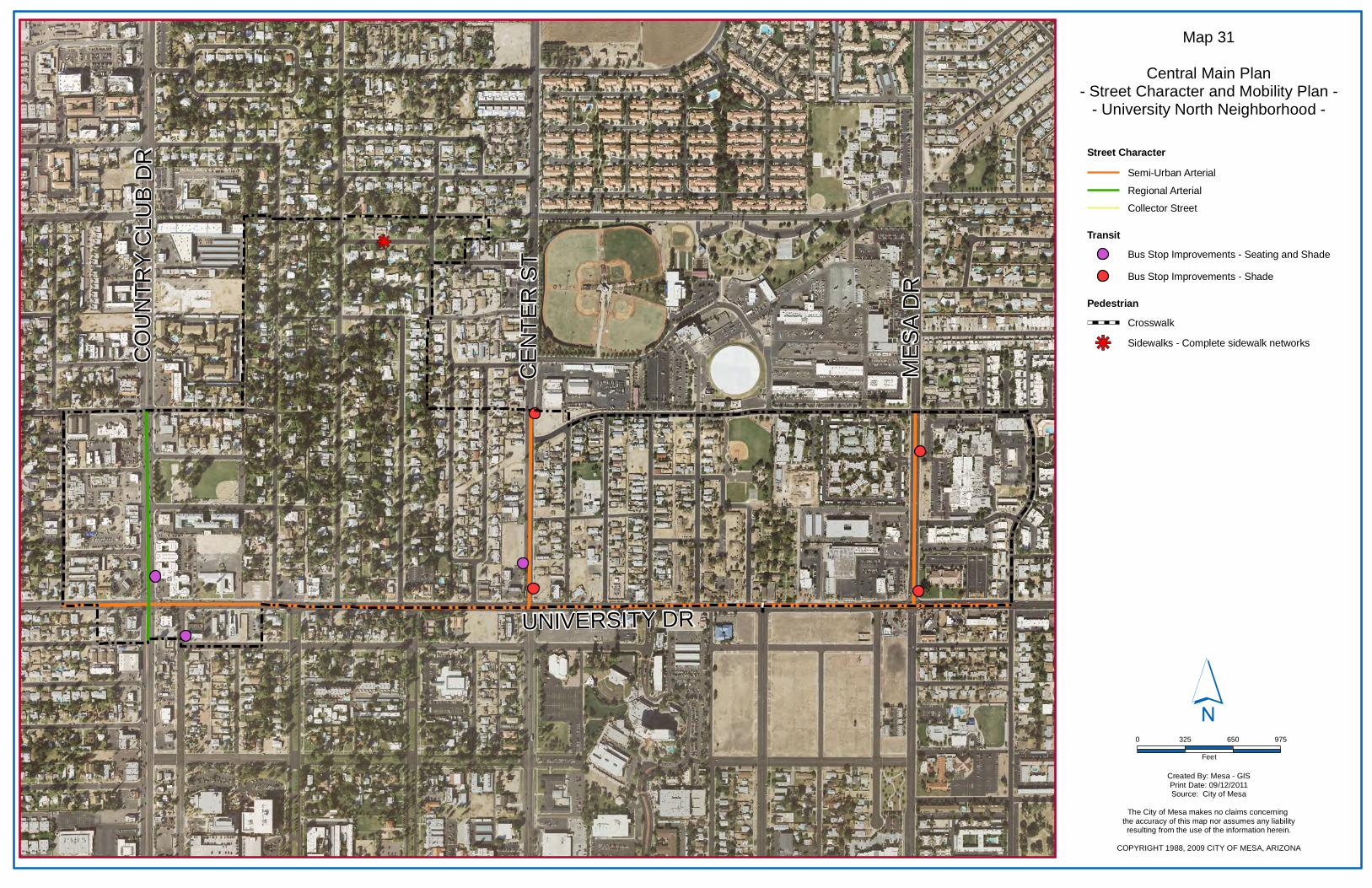
kj
MES
A D
R
CO
UN
TRY
CLU
B D
R
UNIVERSITY DR
CEN
TER
ST
Map 31
Central Main Plan- Street Character and Mobility Plan -
- University North Neighborhood -
Created By: Mesa - GISPrint Date: 09/12/2011Source: City of Mesa
The City of Mesa makes no claims concerning the accuracy of this map nor assumes any liabilityresulting from the use of the information herein.
COPYRIGHT 1988, 2009 CITY OF MESA, ARIZONA
´0 325 650 975
Feet
PedestrianCrosswalk
Sidewalks - Complete sidewalk networkskj
TransitBus Stop Improvements - Seating and Shade
Bus Stop Improvements - Shade
Street CharacterSemi-Urban Arterial
Regional Arterial
Collector Street

University North is a primarily residential Neighborhood adjacent to a downtown area that will transform into an intense, pedestrian-oriented, urban environment. This Neighborhood will benefit from strong connections to the Downtown and Temple/Pioneer Neighborhoods. The transition in development scale, intensity, and character between these areas should focus on the comfort of pedestrians. Particular areas of relationships and connection include: 1. A strong relationship between the University North
and Temple/Pioneer Employment Districts needs to be established. Physical connections with streetscape design and pedestrian amenities should be considered. Success of the Temple/Pioneer Employment District can spur redevelopment of the University North Employment District with compatible support uses.
2. The arterial street network (Center Street, Country Club Drive, Mesa Drive, and University Drive) are unifying elements between adjacent Neighborhoods. Streetscape improvements to the arterial street network will be coordinated to create seamless networks between Neighborhoods.
3. The connection of the residential areas to the Downtown and Temple/Pioneer Neighborhoods should include an improved pedestrian environment along University Drive and enhanced pedestrian crossings to facilitate pedestrian and bicycle activity into the downtown area.
Relationship to Adjacent Neighborhoods


