Planning for Large Subdivisions - The Land Use and ... large subdivisions and the course of action...
54
A workshop series offered by the University of Delaware Institute for Public Administration in conjunction with the Delaware Department of Transportation and the Kent and Sussex County Planning Divisions Planning for Large Planning for Large Subdivisions: Subdivisions: The Land Use and The Land Use and Transportation Connection Transportation Connection Kent Co. & Sussex Co. prepared by the Institute for Public Administration College of Human Services, Education & Public Policy University of Delaware www.ipa.udel.edu
Transcript of Planning for Large Subdivisions - The Land Use and ... large subdivisions and the course of action...

A workshop series offered by the
University of DelawareInstitute for Public Administration
in conjunction with the
Delaware Department of Transportation
and the
Kent and Sussex County Planning Divisions
Planning for LargePlanning for LargeSubdivisions:Subdivisions:
The Land Use andThe Land Use andTransportation ConnectionTransportation Connection
Kent Co. &Sussex Co.
prepared by the
Institute for Public AdministrationCollege of Human Services, Education & Public PolicyUniversity of Delaware www.ipa.udel.edu

Planning for Large Subdivisions: The Land Use and Transportation Connection______________________________________________________________________________
i
Table of Contents
Introduction ...........................................................................................................1
Kent County Workshop
Credits and Contact Information.................................................................2
Presentation...............................................................................................3
Full-Size Presentation Graphics...............................................................12
Presentation Notes—Kent County Division of Planning ...........................20
Presentation Notes—DelDOT Division of Planning..................................24
Sussex County Workshop
Credits and Contact Information...............................................................28
Presentation.............................................................................................29
Full-Size Presentation Graphics...............................................................36
Presentation Notes—DelDOT Division of Planning..................................43
Presentation Notes—Sussex County Division of Planning.......................47
Final Recommendations
Short-Term / High-Priority Recommendations..........................................50
Intermediate-Term Recommendations.....................................................50
Longer-Term Recommendations..............................................................51

Planning for Large Subdivisions: The Land Use and Transportation Connection______________________________________________________________________________
1
Introduction
The Planning for Large Subdivisions workshop series was a joint venture of theUniversity of Delaware Institute for Public Administration and the DelawareDepartment of Transportation (DelDOT). The purpose of the series was tofacilitate improved communication between DelDOT and the planning divisions inboth Kent and Sussex County. Coordination between these entities is essentialto the planning process. The workshop series focused specifically on planningfor large subdivisions and the course of action that both DelDOT and eachrespective county planning division take in dealing with the subdivision process.There was a workshop held on May 22, 2002, in Kent County and one onOctober 16, 2002, in Sussex County. In each workshop, a case study wasdeveloped, which followed the process by which an actual subdivision wasconsidered and approved by both DelDOT and the respective county planningdivision. The workshop presentations are found in this report, as well as notesthat accompanied the presentations. The last section of this report comprisesthe final recommendations that were compiled after analyzing both workshops.

Planning for Large Subdivisions: The Land Use and Transportation Connection______________________________________________________________________________
2
Workshop Credits and Contacts
Kent County WorkshopWednesday, May 22, 2002
Mr. Ralph Reeb, DirectorMr. David Duplessis, ManagerMr. William Brockenbrough
Delaware Department of TransportationDivision of PlanningP.O. Box 778Dover, DE 19901(302) 760-2133
Mr. D. Reed Macmillan, Director
Kent CountyDivision of Planning414 Federal StreetRoom #320Dover, DE 19901(302) 744-2471
Ms. Constance Holland, AICP, Director
State of DelawareOffice of State Planning CoordinationSuite 7, 3rd FloorThomas Collins Building540 S. DuPont HighwayDover, DE 19901(302) 739-3090
Mr. David Edgell, AICP, Policy SpecialistMr. Edward O’Donnell, AICP, Senior Policy AdvisorMr. Mark Deshon, Policy Specialist (graphics)
University of DelawareInstitute for Public Administration180 Graham HallNewark, DE 19716(302) 831-8971

3
University of DelawareParadee Center
Dover, Delaware
Wednesday, May 22, 2002
A workshop offered by the University of Delaware Institute for Public Administrationin conjunction with the Delaware Department of Transportation
Planning for Large Subdivisions:The Land Use and
Transportation Connection
Tonight's Agenda
• Issue Presentations– The Subdivision Planning Context– The Kent County Subdivision Review Process– The DelDOT Subdivision Review and TIS
process– The State’s Role – Agency Coordination
• Dinner• Moderated Discussion
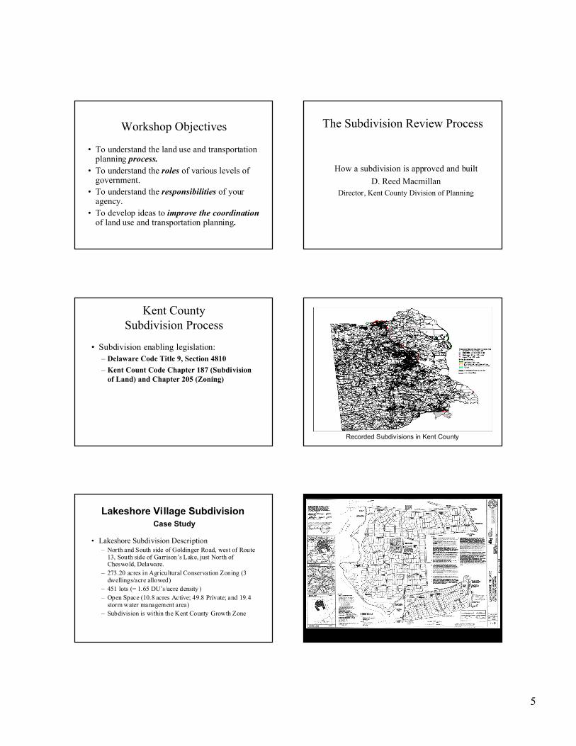
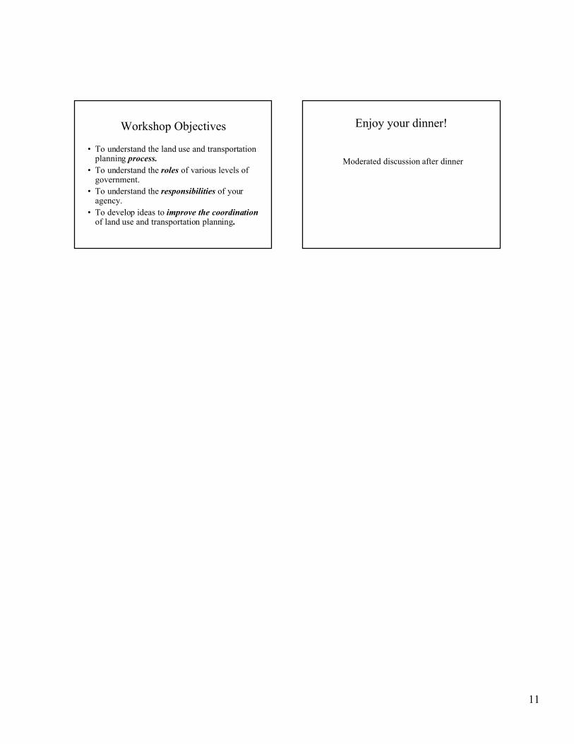
Workshop Objectives
• To understand the land use and transportationplanning processprocess.
• To understand the roles of various levels ofgovernment.
• To understand the responsibilities of youragency.
• To develop ideas to improve the coordinationof land use and transportation planning.
The SubdivisionPlanning Context
The planning and regulatoryframework that guides residential
development
Delegation of Authority
• State of Delaware delegates authority overland use issues to the counties andmunicipalities– Title 9, Sections 48-49, Del. C. (Kent County)
– Title 22, Chapters 3 & 7 (municipalities)• Town Charters
The Comprehensive Plan
• Establishes Vision
• Linkage between Land Use andTransportation– Transportation element
• Sets future agenda through implementationrecommendations
4
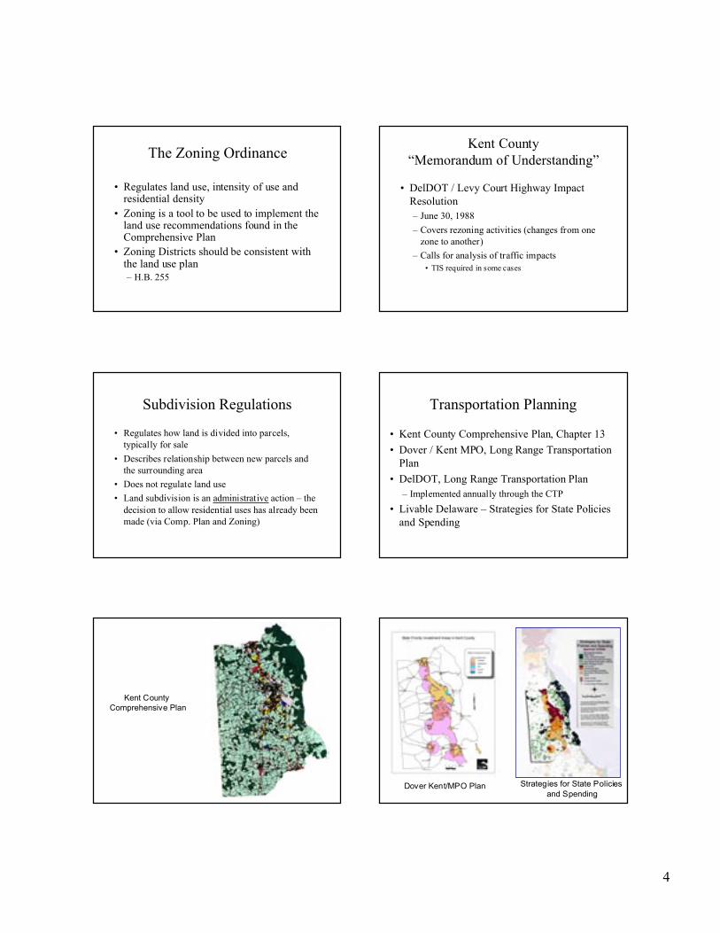
The Zoning Ordinance
• Regulates land use, intensity of use andresidential density
• Zoning is a tool to be used to implement theland use recommendations found in theComprehensive Plan
• Zoning Districts should be consistent withthe land use plan– H.B. 255
Kent County“Memorandum of Understanding”
• DelDOT / Levy Court Highway ImpactResolution– June 30, 1988
– Covers rezoning activities (changes from onezone to another)
– Calls for analysis of traffic impacts• TIS required in some cases
Subdivision Regulations
• Regulates how land is divided into parcels,typically for sale
• Describes relationship between new parcels andthe surrounding area
• Does not regulate land use
• Land subdivision is an administrative action – thedecision to allow residential uses has already beenmade (via Comp. Plan and Zoning)
Transportation Planning
• Kent County Comprehensive Plan, Chapter 13
• Dover / Kent MPO, Long Range TransportationPlan
• DelDOT, Long Range Transportation Plan– Implemented annually through the CTP
• Livable Delaware – Strategies for State Policiesand Spending
Kent County Comprehensive Plan
Dover Kent/MPO Plan Strategies for State Policies and Spending
5
Workshop Objectives
• To understand the land use and transportationplanning process.
• To understand the roles of various levels ofgovernment.
• To understand the responsibilities of youragency.
• To develop ideas to improve the coordinationof land use and transportation planning.
The Subdivision Review Process
How a subdivision is approved and built
D. Reed MacmillanDirector, Kent County Division of Planning
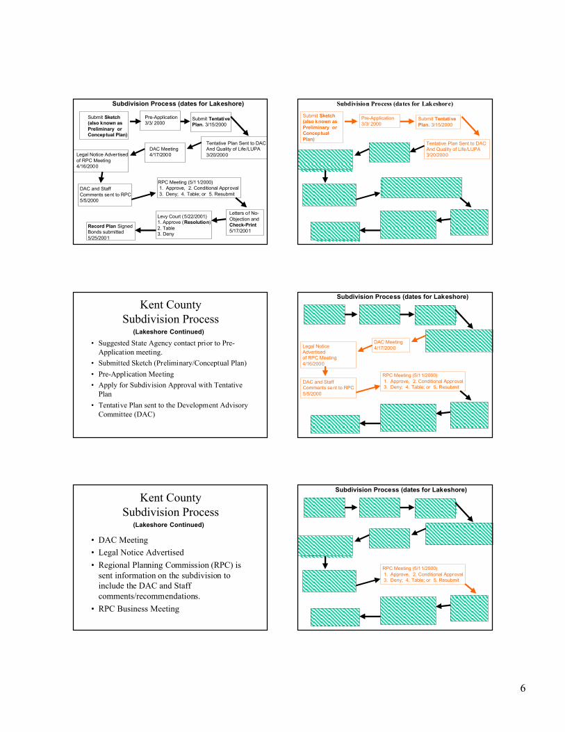
Kent CountySubdivision Process
• Subdivision enabling legislation:– Delaware Code Title 9, Section 4810
– Kent Count Code Chapter 187 (Subdivisionof Land) and Chapter 205 (Zoning)
Recorded Subdivisions in Kent County
• Lakeshore Subdivision Description– North and South side of Goldinger Road, west of Route
13, South side of Garrison’s Lake, just North ofCheswold, Delaware.
– 273.20 acres in Agricultural Conservation Zoning (3dwellings/acre allowed)
– 451 lots (= 1.65 DU’s/acre density )– Open Space (10.8 acres Active; 49.8 Private; and 19.4
storm water management area)– Subdivision is within the Kent County Growth Zone
Lakeshore Village Subdivision Case Study
6
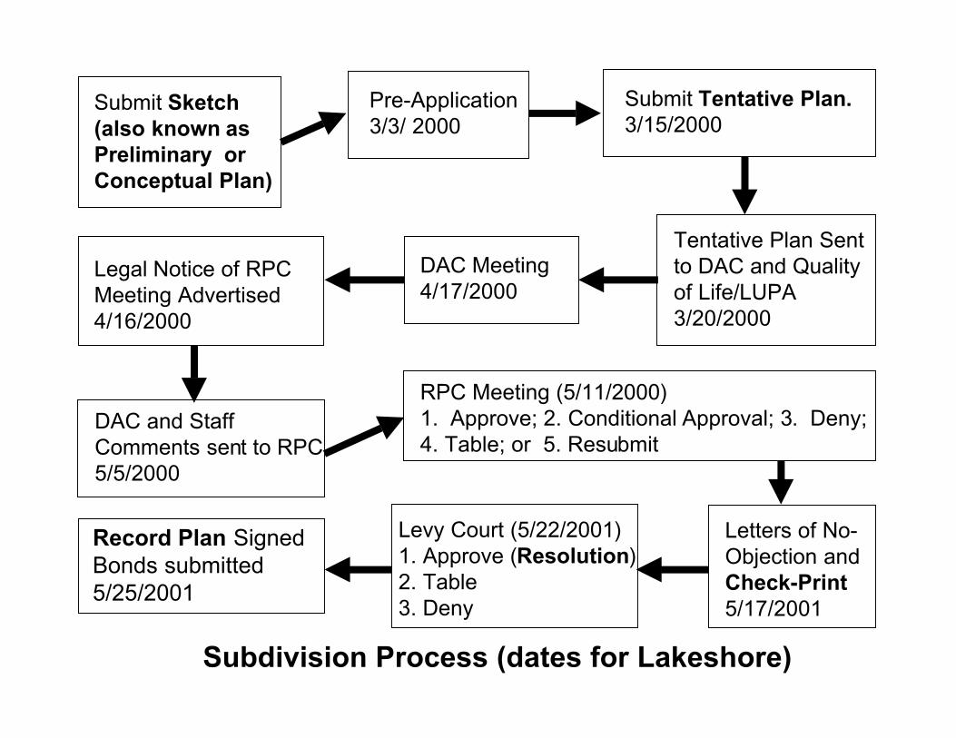
Submit Sketch(also known asPreliminary orConceptual Plan)
Pre-Application3/3/ 2000
Submit TentativePlan. 3/15/2000
Tentative Plan Sent to DAC And Quality of Life/LUPA 3/20/2000
DAC Meeting4/17/2000
RPC Meeting (5/11/2000) 1. Approve, 2. Conditional Approval 3. Deny; 4. Table; or 5. Resubmit
DAC and StaffComments sent to RPC5/5/2000
Legal Notice Advertisedof RPC Meeting4/16/2000
Letters of No-Objection andCheck-Print5/17/2001
Levy Court (5/22/2001)1. Approve (Resolution)2. Table3. Deny
Record Plan SignedBonds submitted5/25/2001
Subdivision Process (dates for Lakeshore)
Submit Sketch(also known asPreliminary orConceptualPlan)
Kent CountySubdivision Process
• Suggested State Agency contact prior to Pre-Application meeting.
• Submitted Sketch (Preliminary/Conceptual Plan)
• Pre-Application Meeting
• Apply for Subdivision Approval with TentativePlan
• Tentative Plan sent to the Development AdvisoryCommittee (DAC)
(Lakeshore Continued)
Submit Preliminary Plan
Pre-Application3/3/ 2000
Submit TentativePlan. 3/15/2000
Tentative Plan Sent to DAC And Quality of Life/LUPA 3/20/2000
DAC Meeting4/17/2000
RPC Meeting (5/11/2000) 1. Approve, 2. Conditional Approval 3. Deny; 4. Table; or 5. Resubmit
DAC and StaffComments sent to RPC5/5/2000
Legal NoticeAdvertisedof RPC Meeting4/16/2000
Letters of No-Objection andCheck-Print5/17/2001
Levy Court (5/22/2001)1. Approve (Resolution)2. Table3. Deny
Record Plan SignedBonds submitted5/25/2001
Subdivision Process (dates for Lakeshore)
Kent CountySubdivision Process
• DAC Meeting
• Legal Notice Advertised
• Regional Planning Commission (RPC) issent information on the subdivision toinclude the DAC and Staffcomments/recommendations.
• RPC Business Meeting
(Lakeshore Continued)
Submit Preliminary Plan
Pre-Application3/3/ 2000
Submit TentativePlan. 3/15/2000
Tentative Plan Sent to DAC And Quality of Life/LUPA 3/20/2000
DAC Meeting4/17/2000
RPC Meeting (5/11/2000) 1. Approve, 2. Conditional Approval 3. Deny; 4. Table; or 5. Resubmit
DAC and StaffComments sent to RPC5/5/2000
Legal Notice Advertisedof RPC Meeting4/16/2000
Letters of No-Objection andCheck-Print5/17/2001
Levy Court (5/22/2001)1. Approve (Resolution)2. Table3. Deny
Record Plan SignedBonds submitted5/25/2001
Subdivision Process (dates for Lakeshore)

7
Kent CountySubdivision Process
• RPC Action– Approve
• Approve with Conditions
– Deny
– Table
– Resubmit
Submit Preliminary Plan
Pre-Application3/3/ 2000
Submit TentativePlan. 3/15/2000
Tentative Plan Sent to DAC And Quality of Life/LUPA 3/20/2000
DAC Meeting4/17/2000
RPC Meeting (5/11/2000) 1. Approve, 2. Conditional Approval 3. Deny; 4. Table; or 5. Resubmit
DAC and StaffComments sent to RPC5/5/2000
Legal Notice Advertisedof RPC Meeting4/16/2000
Letters of No-Objection andCheck-Print5/17/2001
Levy Court (5/22/2001)1. Approve (Resolution)2. Table3. Deny
Record Plan SignedBonds submitted5/25/2001
Subdivision Process (dates for Lakeshore)
Kent CountySubdivision Process
• Letters of No-Objection
• Levy Court Action– Approve (with or without conditions)
– Table
– Deny
• Final Step
(Lakeshore Continued)
DelDOT’s Subdivision ReviewProcess
Traffic Impacts, Entrances, andConstruction
David DuPlessis
Manager, DelDOT Division of Planning
DelDOT Subdivision Review:General Procedures
• Traffic Impact Study Determination
• Site Plan Review (through Kent CountyDAC)
• Construction Plan Review
• Our reviews are guided by:- Rules and Regulations for Subdivision Streets
- DelDOT Entrance Manual
DelDOT Subdivision Review:
Traffic Impact Study
• Determine need (>2,100 avg. daily trips)
• Determine study area
• Count existing traffic
• Add future traffic
• Analyze level of service
• Recommend transportation improvements
8
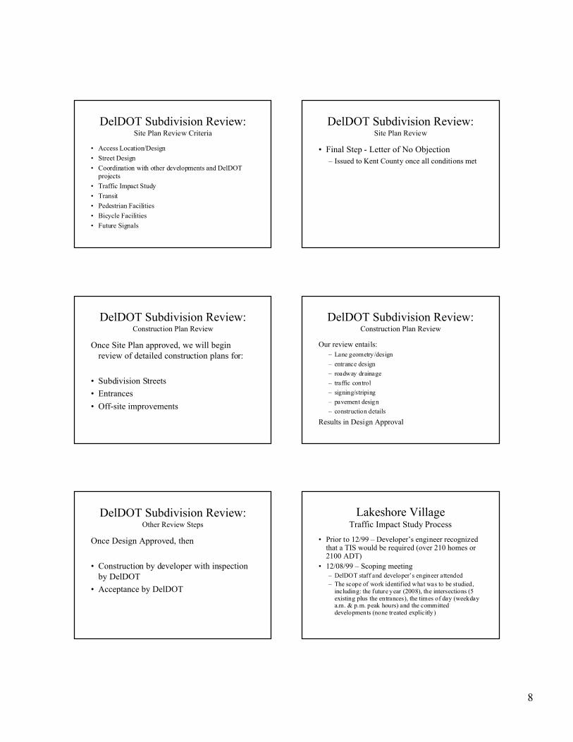
DelDOT Subdivision Review:Site Plan Review Criteria
• Access Location/Design
• Street Design
• Coordination with other developments and DelDOTprojects
• Traffic Impact Study
• Transit
• Pedestrian Facilities
• Bicycle Facilities
• Future Signals
DelDOT Subdivision Review:Site Plan Review
• Final Step - Letter of No Objection– Issued to Kent County once all conditions met
DelDOT Subdivision Review:Construction Plan Review
Once Site Plan approved, we will beginreview of detailed construction plans for:
• Subdivision Streets
• Entrances
• Off-site improvements
DelDOT Subdivision Review:Construction Plan Review
Our review entails:– Lane geometry/design
– entrance design
– roadway drainage
– traffic control
– signing/striping
– pavement design
– construction details
Results in Design Approval
DelDOT Subdivision Review:Other Review Steps
Once Design Approved, then
• Construction by developer with inspectionby DelDOT
• Acceptance by DelDOT
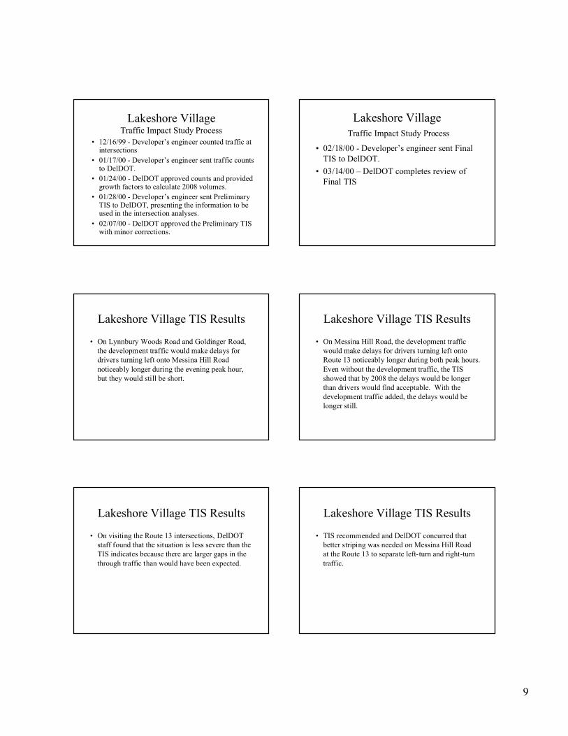
Lakeshore VillageTraffic Impact Study Process
• Prior to 12/99 – Developer’s engineer recognizedthat a TIS would be required (over 210 homes or2100 ADT)
• 12/08/99 – Scoping meeting– DelDOT staff and developer’s engineer attended– The scope of work identified what was to be studied,
including: the future year (2008), the intersections (5existing plus the entrances), the times of day (weekdaya.m. & p.m. peak hours) and the committeddevelopments (none treated explicitly)
9
Lakeshore VillageTraffic Impact Study Process
• 12/16/99 - Developer’s engineer counted traffic atintersections
• 01/17/00 - Developer’s engineer sent traffic countsto DelDOT.
• 01/24/00 - DelDOT approved counts and providedgrowth factors to calculate 2008 volumes.
• 01/28/00 - Developer’s engineer sent PreliminaryTIS to DelDOT, presenting the information to beused in the intersection analyses.
• 02/07/00 - DelDOT approved the Preliminary TISwith minor corrections.
Lakeshore Village Traffic Impact Study Process
• 02/18/00 - Developer’s engineer sent FinalTIS to DelDOT.
• 03/14/00 – DelDOT completes review ofFinal TIS
Lakeshore Village TIS Results
• On Lynnbury Woods Road and Goldinger Road,the development traffic would make delays fordrivers turning left onto Messina Hill Roadnoticeably longer during the evening peak hour,but they would still be short.
Lakeshore Village TIS Results
• On Messina Hill Road, the development trafficwould make delays for drivers turning left ontoRoute 13 noticeably longer during both peak hours.Even without the development traffic, the TISshowed that by 2008 the delays would be longerthan drivers would find acceptable. With thedevelopment traffic added, the delays would belonger still.
Lakeshore Village TIS Results
• On visiting the Route 13 intersections, DelDOTstaff found that the situation is less severe than theTIS indicates because there are larger gaps in thethrough traffic than would have been expected.
Lakeshore Village TIS Results
• TIS recommended and DelDOT concurred thatbetter striping was needed on Messina Hill Roadat the Route 13 to separate left-turn and right-turntraffic.

10
Lakeshore VillageTraffic Impact Study Process
• 03/30/00 – DelDOT sends comments andrecommendations to Kent County Planning
Lakeshore VillageTransportation Review Timeline
Kent County DAC Comments – March 30, 2000
– Address TIS recommendations
– Upgrade Goldinger Road to DelDOT standards
– Add interconnection to adjacent property
– Increase r/w width of Ryhill Drive
Lakeshore VillageTransportation Review Timeline
• May 2000 – April 2001: developer andengineer finalize plans
• April 27, 2001 – Letter of No Objection
• August 21, 2001 – Pre-Constructionmeeting held on site
The State’s Role:Agency Coordination and the LUPA
Process
Constance Holland
State Planning Coordinator
Office of State Planning Coordination
11
Workshop Objectives
• To understand the land use and transportationplanning process.
• To understand the roles of various levels ofgovernment.
• To understand the responsibilities of youragency.
• To develop ideas to improve the coordinationof land use and transportation planning.
Enjoy your dinner!
Moderated discussion after dinner
Submit Sketch(also known asPreliminary orConceptual Plan)
Pre-Application3/3/ 2000
Submit Tentative Plan.3/15/2000
DAC Meeting4/17/2000
RPC Meeting (5/11/2000)1. Approve; 2. Conditional Approval; 3. Deny;4. Table; or 5. Resubmit
DAC and StaffComments sent to RPC5/5/2000
Legal Notice of RPCMeeting Advertised4/16/2000
Letters of No-Objection andCheck-Print5/17/2001
Levy Court (5/22/2001)1. Approve (Resolution)2. Table3. Deny
Subdivision Process (dates for Lakeshore)
Tentative Plan Sentto DAC and Qualityof Life/LUPA3/20/2000
Record Plan SignedBonds submitted5/25/2001


Kent CountyComprehensive Plan

Dover/Kent MPO Plan Strategies for State Policies and Spending, Kent County

Recorded Subdivisions in Kent County

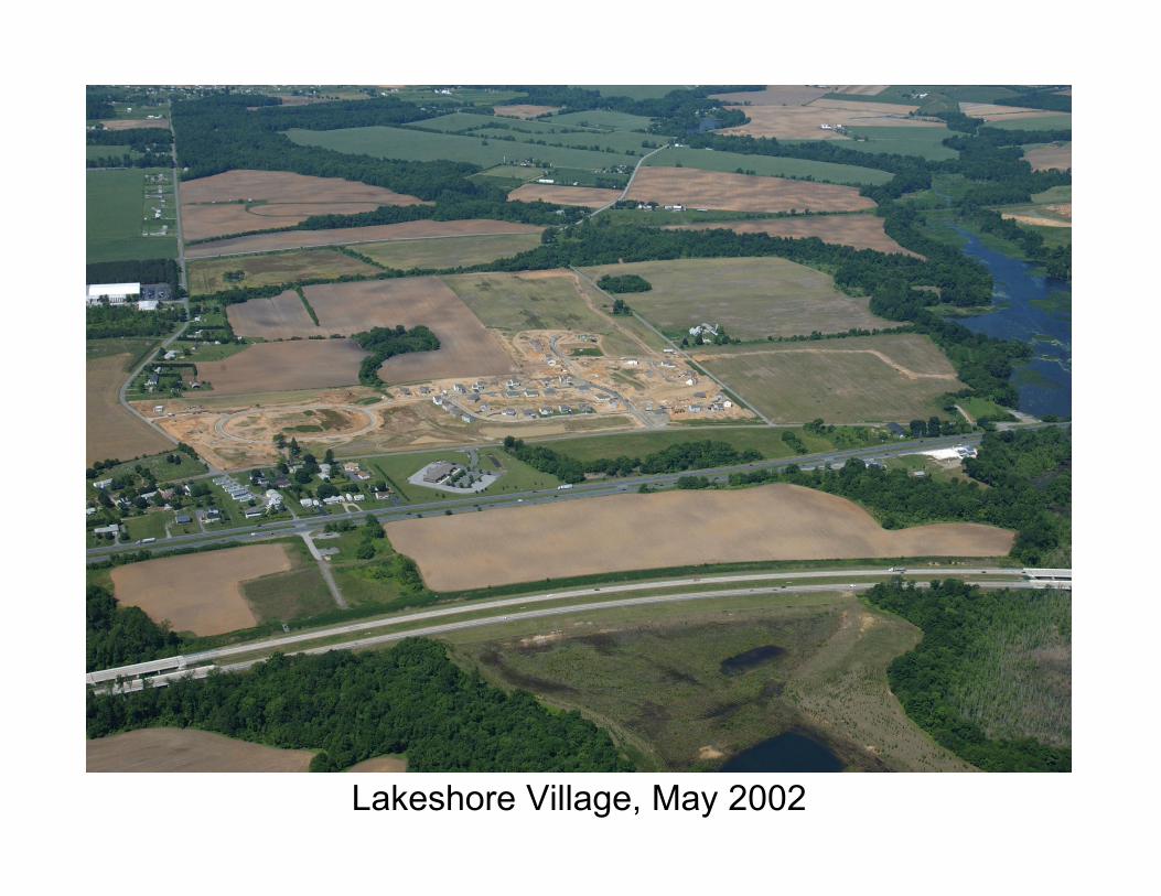
Lakeshore Village, May 2002
Planning for Large Subdivisions: The Land Use and Transportation Connection______________________________________________________________________________
20
Presentation Notes
Kent County Workshop
The Subdivision Review ProcessD. Reed Macmillan, Director
Kent County Division of Planning
1. In 1953, the State of Delaware passed legislation for the Kent CountyLevy Court that authorized a Regional Planning Commission (RPC). Oneof the RPC’s charters is to review subdivision plats per Delaware CodeTitle 9, Chapter 48 (Regional Planning Commission), Section 4810(Subdivision Plans; land development plans; road plats; submission toCommission; recording; fees; regulations).
• Kent County adopted a Subdivision Ordinance in 1973 and ZoningOrdinance in 1972 later amended in 1991. The SubdivisionOrdinance sets forth the language annotated within the DelawareCode. In December 2000, both the Kent County Subdivision andZoning Ordinances were codified into the Kent County Code.
2. The size of Kent County is approximately 367,146 acres, 22,678 of whichlie within the 20 municipalities. This leaves approximately 344,468 acresin the unincorporated land area that Kent County regulates forsubdivisions. Kent County’s population is approximately 126,643 (thisincludes municipal population).
3. The County has approximately 138,083 acres zoned AC; 131,130 zonedAR; 1,964 zoned RMH; 6,455 zoned RS1; 178 zoned RM and 0 acreszoned RS5. This totals approximately 277,810 acres out of the 344,468unincorporated acres. The remaining 66,643 acres are in the AP/10program (26,838); PDR program (31,657); BN (131); BG (1,263); IG (746);IL (604); and multi-zoned parcels (5,414).
4. Currently, Kent County has approximately 542 subdivisions, whichcomprises 20,901 parcels (7,765 of these parcels are recorded but not yetbuilt). This represents approximately 14,551 acres of land.
5. Within the planning office there are now 14 major subdivisions, numberinga total of 1,106 parcels, that are in the review and approval process.
6. Kent County approves approximately 16 major subdivisions andprocesses approximately 750 single-family home construction permits peryear.

Planning for Large Subdivisions: The Land Use and Transportation Connection______________________________________________________________________________
21
7. The Kent County Growth Zone is approximately 79,084 acres. Thisrepresents 22% of land within Kent County. If a subdivision is developedwithin a growth zone and has central sewer and water, there is a densitybonus of one additional dwelling unit per acre.
8. In the Lakeshore project, staff assumed the number of proposed parcelswould require a Traffic Impact Statement, and in this case, DelDOT wascontacted prior to the Official Kent County Pre-Application Meeting. In theLakeshore subdivision, a Traffic Impact Study (TIS) was required andcompleted around March 2000.
9. A developer applies for the Kent County Pre-Application Meeting bycompleting a submittal form and must submit his/her “Sketch(preliminary/conceptual) Plan” to the Kent County Planning Office atleast five days prior to the pre-application meeting. Cost for this meetingis $200.00. These forms and subdivision information can be found atwww.co.kent.de.us.
10. The Pre-Application Meeting is annotated in the Kent County CodeChapter 187-10. A developer must have this meeting at least five workingdays (Kent County Planning Policy) prior to the subdivision filing deadline,which is usually the third Wednesday of each month. Lakeshore had theirmeeting on March 3, 2000.
11. A developer makes formal subdivision application by submitting the“Tentative Plan,” as annotated in the Kent County Code 187-25. Cost is$400.00 for the first ten lots and $10.00 for each subsequent lot.Lakeshore made formal subdivision application on March 15, 2000 at acost of $4,810.00.
12. The Development Advisory Committee (DAC) is annotated with the KentCounty Code 187-5 and consists of State and Kent County officials. TheDelaware Code Title 9, Chapter 49 (Zoning), Section 4952-4960 requiresall County re-zonings and subdivision applications be submitted to stateagencies for review and comment. This process is called the “Quality ofLife” mailing after the 1988 Quality of Life Act signed by then GovernorCastle. Kent County utilizes this mailing to notify the DAC members. TheLakeshore Quality of Life mailing was on March 20, 2000. In addition,Kent County is required to comply with Delaware Code Title 29, Chapter92 (Land Use Planning), Section 9211 (Local land use planning actionssubject to process). This process is called the Land Use Planning Act(LUPA) mailing. Kent County combines both Quality of Life and LUPAmailings, which are sent to approximately 50 agencies.
Planning for Large Subdivisions: The Land Use and Transportation Connection______________________________________________________________________________
22
13. Kent County also utilizes the Quality of Life mailings to comply with Title 9,Section 4819 of the Delaware Code, requiring notice to local schooldistricts of residential development plans. This allows the school districtsto make formal comment.
14. To facilitate comments, Kent County sponsors a meeting for all DACmembers to attend along with the developer. This meeting allows DACmembers to ask additional questions or formally submit their commentsregarding the subdivision. The DAC meeting for Lakeshore was held onApril 17, 2000.
15. Delaware Code Title 9, Sections 4908 and 4910 require notice of thepublic hearing and business meeting date, time, and location beadvertised in a newspaper of general circulation in the County. This iscalled the Legal Notice. The Legal Notice for Lakeshore was published onApril 16, 2000.
16. The DAC and staff recommendation report, which includes copies of thetentative plan, is sent to the RPC. This is accomplished at least one weekprior to the RPC public business meeting.
17. Because subdivision of land is a “first” permitted use within Kent County, itdoes not require a public hearing. However, the developer or his/herrepresentative must appear in front of the RPC to answer questions. TheRPC is authorized under the Delaware Code Title 9, Section 4811(Approval or disapproval of plat by Commission; hearing) to either approveor deny the subdivision based on Section 4802 for the purpose ofpromoting health, safety, prosperity, and general welfare of the citizens.The RPC business meetings are usually held on the second Thursdaynight of each month.
18. The RPC can approve, approve with conditions, deny, table, or resubmitthe tentative subdivision plan. This language is annotated withinDelaware Code Section 4811 and the Kent County Code Section 187-12and 187-15.
19. If the RPC approves the subdivision with or without conditions, thedeveloper has one year to obtain required “Letters of No Objection” fromthe Kent Conservation District; the Kent County 911, community services,and engineering offices; the State Fire Marshal; and DelDOT.
20. If the RPX denies, the developer may appeal that decision to the KentCounty Levy Court within 30 days of such decision.
Planning for Large Subdivisions: The Land Use and Transportation Connection______________________________________________________________________________
23
21. The RPC may table the subdivision for one month in order to getadditional information or allow the developer to review potential conditions.
22. The RPC may also require that the subdivision tentative plan beresubmitted through the process if the plan does not meet the intent of theKent County Comprehensive Plan or the intent and purpose of the KentCounty subdivision regulations.
23. If the RPC approves the tentative plan, the developer has one year toobtain the “Letters of No Objection.” The developer may be granted a one-year extension should he/she have difficulty getting the letters. Thislanguage is annotated in the Kent County Code 187-12 (B).
24. Once Kent County Planning Staff has ensured all “Letters of No Objection”have been submitted and all RPC conditions have been included in therevised tentative subdivision plan, the plan becomes a “check print” or“Record Plan” and is placed on the Levy Court agenda for review.
25. Levy Court may:
• Approve the Record Plan with or without conditions. This isaccomplished by Levy Court adopting a “Resolution,” thusapproving the plan; or
• Table the Record Plan if there are pending issues requiringadditional information; or
• Deny the Record Plan. The developer may appeal the Levy Court’sdenial no later than 10 days after such decision to the SuperiorCourt of Kent County per Delaware Code Title 9, Section 4818.
26. If Levy Court approves the subdivision, the developer submits the RecordPlat to the County Planning Office for signatures of the Planning Directorand Kent County Administrator. The developer must also submit a RoadBond of 149% of estimated road cost. The developer gets this bond backonce Kent County receives notice from DelDOT that the roads have beenformally turned over to the state.

Planning for Large Subdivisions: The Land Use and Transportation Connection______________________________________________________________________________
24
Presentation Notes
Kent County Workshop
DelDOT’s Subdivision Review ProcessWilliam Brockenbrough
Delaware Department of TransportationDivision of Planning
I. How the Traffic Impact Study (TIS) process beginsA. In this case, the developer’s engineer initiated it.B. Other possible sources
1. County or municipal government2. DelDOT through Support Facilities Report, plan review
comment, or Land Use Planning Act (LUPA) review
II. Scoping Meeting—See memorandum dated 12/8/99A. Purpose—To define the parameters of the study for the developer’s
engineer.B. Who attends
1. DelDOT Staff2. Developer’s Engineer3. Other who might have attended but did not in this case
(Developer or representatives, Local government staff)C. What is discussed
1. Backgrounda. Identify the subject land.b. Establish what is proposed.c. Establish what approvals have been obtained and what
approvals are still needed.2. Cases to be evaluated
a. This study evaluated the three that are a minimum(existing, no-build, build). Sometimes more arenecessary.
b. Establishing buildout year- This study assumed 2008 butthere is no firm rule.
c. When to count traffic i. This study looked at morning and evening peaks,
which is typical for non-retail. ii. This study counted 7:00 to 9:00 a.m. and 4:00 to
6:00 p.m., but the hours vary.
Planning for Large Subdivisions: The Land Use and Transportation Connection______________________________________________________________________________
25
iii. Summer counts were not required but might havebeen before SR 1.
3. Facilities to be evaluateda. We identified five existing intersections plus the site
entrances.b. Factors that might have prompted us to identify more
would include the presence of a signal system, such ason Route 13 through Dover, or the existence of anAdequate Public Facilities Ordinance that mandatedmore.
c. We also identified three roads that we wanted evaluatedfor geometric and other deficiencies, including one with arailroad grade crossing.
4. Highway Capacity Softwarea. There are several programs available, which produce
similar but not identical results. We specify one calledHCS, which we use as a standard.
b. HCS is revised periodically, so we also specify whatversion we are currently using.
c. When this study was done there were problems with theHCS program for intersections without signals, so werequired manual worksheets as a check on the software.
5. Seasonal Adjustment Factorsa. Vary with month and type of road.b. Their purpose is to change counts to annual average
volumes.6. Growth factors and committed developments
a. Two methods of projecting future traffic, this way or anetwork model. Network models are generally better forlarge-scale long-term developments; sometimes usedwhere major road improvements will change traffic inways we cannot otherwise estimate. They are done byDelDOT staff.
b. Growth factors—Based primarily on past traffic growthbut can be increased to account fro committeddevelopments where that impact is sufficiently simple.
c. Committed developments—Other development in thearea that has already been approved and will almostcertainly be present in the buildout year.
7. Transit, Bicycle, and Pedestrian Facilities—Only discussed inthe TIS. No numerical analysis.
8. General Notes—Updating Section 15 of Rules and Regulations.D. Sometimes there is no meeting—Where there is no need for a
meeting, DelDOT will sometimes provide a scope of work by letter.

Planning for Large Subdivisions: The Land Use and Transportation Connection______________________________________________________________________________
26
III. Traffic Counts—These are the engineer’s first submission after thescoping meeting.A. Check for irregularities.B. Develop growth factors or forecast volumes.
IV. Preliminary TISA. Purpose: To establish agreement on the numbers that will be used
in the final TIS.B. Contents
1. Project Description2. Study Area3. Existing Traffic4. Trip Generation—How much traffic in and out?
a. Institute of Transportation Engineers’ Trip Generationreport is the standard reference and was used here.
b. Other methods, where ITE is not usable, include countsat similar uses and estimates based on interviews withthe proposed tenant.
5. Trip distribution and assignment—Where will the traffic go?a. Knowledge of areab. Use of traffic countsc. Network models
6. Future Traffic with and without sites
V. Final TIS—Preliminary TIS plusA. Capacity Analysis
1. These analyses yield levels of service (LOS).2. LOS is defined by the Transportation Research Board (a
national body) and is used to describe a driver’s satisfactionwith a facility on a scale from A to F, somewhat like a reportcard. We design facilities using a 20-year forecast and trying toobtain LOS C, or in urban areas LOS D. For a TIS, we considerLOS D in the buildout year to be minimally acceptable.
3. For intersections, LOS is a function of delay, how long a driveris delayed by having to pass through the intersection.
4. Where the intersection is controlled by stop signs on only theside streets, drivers on the through street theoreticallyexperience no delay and there is no LOS for them or for theintersection as a whole.
B. Recommendations1. This TIS found LOS D or better except for left turns onto US 13.
For left turns from a minor street, we often accept a poor LOS atpeak hours. Often the only way to remedy such a situation is toinstall a signal and we cannot reasonably install them at alllocations where they would be needed to achieve LOS D orbetter. In this case, the TIS found correctly, that there were

Planning for Large Subdivisions: The Land Use and Transportation Connection______________________________________________________________________________
27
bigger gaps in traffic on Route 13 than the HCS analysisassumed and that therefore the Messina Hill Road delays werenot and would not be as severe as the analysis predicted. TheHCS has since been revised to account for this situation.
2. The TIS recommended that lane striping would be needed onthe Messina Hill Road approaches to Route 13.
C. Conclusions
VI. DelDOT ReviewA. Rerun Capacity Analyses—In this study, there were no significant
errors in the analyses.B. Verify that all infrastructure deficiencies were identified- In this
study they were.C. Verify that all recommendations are sufficient and buildable. The
only recommendation was for a striping change.D. Recommend different or additional improvements as
necessary—Bicycle and pedestrian issues were not identified in theTIS and still remained to be addressed.
E. Review Comments—Because this project was a subdivision in KentCounty, the review was documented in an internal DelDOTmemorandum. If a county or local government, through part of itszoning or land development process, has required the study, thenthe review is documented in a letter to that government.

Planning for Large Subdivisions: The Land Use and Transportation Connection______________________________________________________________________________
28
Workshop Credits and Contacts
Sussex County WorkshopWednesday, October 16, 2002
Mr. Ralph Reeb, DirectorMr. William Brockenbrough
Delaware Department of TransportationDivision of PlanningP.O. Box 778Dover, DE 19901(302) 760- 2133
Mr. Lawrence Lank, Director
Sussex CountyDivision of PlanningSussex County Administrative Office Building2 The CircleP.O. Box 589Georgetown, DE 19947
Ms. Constance Holland, AICP, DirectorMr. David Edgell, AICP, Principal Planner
State of DelawareOffice of State Planning CoordinationSuite 7, 3rd FloorThomas Collins Building540 S. DuPont HighwayDover, DE 19901(302) 739-3090
Mr. Edward O’Donnell, AICP, Senior Policy AdvisorMs. Sarah Hench, Research Assistant
University of DelawareInstitute for Public Administration180 Graham HallNewark, DE 19716(302) 831-8971

29
The Land Use and TransportationConnection
Sussex County Council ChambersWednesday, October 16, 2002
A workshop offered by the University of Delaware’s Institute for Public Administration
in conjunction with the Delaware Department of Transportation andthe Sussex County Department of Planning
Planning for Large Subdivisions Agenda
Issue Presentations– The Subdivision Planning Context
– The DelDOT Subdivision Review and TIS Process
– The Sussex County Subdivision Review Process
– The State’s Role- Agency Coordination
• Dinner
• Moderated Discussion
Workshop Objectives
• To understand the land use and transportationplanning processprocess.
• To understand the roles of various levels ofgovernment.
• To understand the responsibilities of your agency.
• To develop ideas to improve the coordination ofland use and transportation planning.
The Subdivision PlanningContext
The planning and regulatory framework thatguides residential development.
Delegation of Authority
State of Delaware delegates authority overland use issues to the counties andmunicipalities– Title 9, Sections 68-69, Del. C. (Sussex
County)
– Title 22, Chapters 3 & 7 (Municipalities)• Town Charters
The Comprehensive Plan
• Establishes Vision
• Linkage between Land Use andTransportation– Transportation element
• Sets future agenda through implementationrecommendations

30
The Zoning Ordinance
• Regulates land use, intensity of use andresidential density
• Zoning is a tool to be used to implement theland use recommendations found in theComprehensive Plan
• Zoning Districts should be consistent withthe land use plan– H.B. 255
Subdivision Regulations
• Regulates how land is divided into parcels,typically for sale
• Describes relationship between new parcels andthe surrounding area
• Does not regulate land use
• Land subdivision is an administrative action – thedecision to allow residential uses has already beenmade (via Comp. Plan and Zoning)
Transportation Planning
• DelDOT, Long Range Transportation Plan– Implemented annually through the CTP
• Livable Delaware – Strategies for StatePolicies and Spending
Sussex CountyComprehensive Plan
Workshop Objectives
• To understand the land use and transportationplanning process.
• To understand the roles of various levels ofgovernment.
• To understand the responsibilities of your agency.
• To develop ideas to improve the coordination ofland use and transportation planning.
Red Mill Village SubdivisionCase Study
• Development of 324 dwellings and 27, 000 ofcommercial space.
– Specifically , 162 single-family detached houses, 24apartments, 42 duplexes, and 96 townhouses.
• 103 acres of land.• Located on the south side of Cave Neck Road
(Sussex Road 88) near the west side of DelawareRoute 1, to the north of Red Mill Pond.
• All access to the subdivision would be from CaveNeck Road, although the property also has frontageto the south on Best Lane.

31
Red Mill Village SubdivisionCase Study, Continued
• Development is across two adjoining properties,the 40.59 acre Millman Farm, currently zonedGeneral Residential (GR), and the 61.62 acre LoweFarm, currently zoned Agricultural Residential(AR-1).
• The project would be developed over a five-yearperiod.
• The developer is also seeking a Residential PlannedCommunity (RPC) overlay zone for both sectionsof land in order to build a more dense mixed usedevelopment.
DelDOT’s SubdivisionReview Process
Traffic Impacts, Entrances, andConstruction
Bill Brockenbrough
DelDOT Division of Planning
DelDOT Subdivision ReviewGeneral Procedures
• Traffic Impact Study Review
• Site Plan Review (through Sussex CountyDAC)
• Construction Plan Review
• Our reviews are guided by:- Rules and Regulations for Subdivision Streets
- DelDOT Entrance Manual
DelDOT Subdivision Review
Traffic Impact Study
• Determine need (>2,100 avg. daily trips)
• Determine study area
• Count existing traffic
• Add future traffic
• Analyze level of service
• Recommend transportation improvements
DelDOT Subdivision ReviewSite Plan Review Criteria
• Access Location/Design
• Street Design
• Coordination with other developments and DelDOTprojects
• Traffic Impact Study
• Transit
• Pedestrian Facilities
• Bicycle Facilities
• Future Signals
DelDOT Subdivision ReviewSite Plan Review
• Final Step - Letter of No Objection– Issued to Sussex County once all conditions
met

32
DelDOT Subdivision ReviewConstruction Plan Review
Once Site Plan approved, we will beginreview of detailed construction plans for:
• Subdivision Streets
• Entrances
• Off-site improvements
DelDOT Subdivision ReviewConstruction Plan Review
Our review entails:– Lane geometry/design
– entrance design
– roadway drainage
– traffic control
– signing/striping
– pavement design
– construction details
Results in Design Approval
DelDOT Subdivision ReviewOther Review Steps
Once Design Approved, then
• Construction by developer with inspectionby DelDOT
• Acceptance by DelDOT
Red Mill VillageTraffic Impact Study Process
• 7/11/00: Scoping Meeting– DelDOT staff, engineer, and developer attended.
– The scope of work identified what was to be studied,including: the future years (2005 and 2020), theintersections (5 existing plus 1 site entrance), the timesof day (Saturday midday, weekday a.m. and p.m. peakhours), growth factors, transit, bicycle, and pedestrianfacilities, and the 3 committed developments.
Red Mill VillageTraffic Impact Study Process
• 6/17/00, 8/26/00, and 9/19/00: Engineer countedtraffic at intersections.
• 10/5/00: Engineer sent traffic counts to DelDOT.
• 10/31/00: DelDOT accepted traffic counts andpointed out minor errors to be fixed. Alsoprovided seasonal adjustment factors to calculateseasonally adjusted weekday volumes and growthfactors to calculate weekday future trafficvolumes.
Red Mill VillageTraffic Impact Study Process
• 1/16/01: DelDOT received preliminary TIS fromproject manager.
• 3/15/01: DelDOT asked for a revised preliminaryTIS to be resubmitted based on severalcorrections.
• 3/29/01: Project manager submited revisedpreliminary TIS to DelDOT.
• 4/6/01: DelDOT approved preliminary TIS withother corrections.

33
Red Mill VillageTraffic Impact Study Process
• 6/1/01: Project manager sent final TIS toDelDOT.
• 8/23/01: DelDOT contacts Sussex Countywith comments on the final TIS.
Red Mill Village TIS Results
• Site traffic from the proposed developmentsignificantly impacts only the intersectionof Cave Neck Road and Route 1. FutureCCPP improvements to the intersectionwould remedy this issue. However, theseimprovements are not yet in the six-yearCapital Improvement Program. Limitingleft turns is another option for theintersection.
Three Existing Corridor CapacityPreservation Programs
Sussex County Capital TransportationImprovement Program
1 North-S outh LimitedAccess Highway
2 East-West Improvements3 SR 1 Dewey Beach
Improvements4 SR 30 and S R 5 from SR
24 north to Route 16 Georgetown - Park Avenue
SR 318 east ofGeorgetown and S R 321south of SR 9
6 US 13 Corridor CapacityImprovements
8 Stationary MessageInformation System
8 Indian River Inlet Bridge8 Sussex County Aviation8 County Road Concerns
Red Mill Village TIS Results
• The development is consistent with theStatewide Long-Range Transportation Plan(SLRTP) and Delaware’s State Policies andSpending Map.
Statewide Long-RangeTransportation Plan
SussexCounty:
Anticipated Problem
Areasin 2015

34
Strategies for State Policiesand Spending
Red Mill Village TIS Results
• DelDOT recommends that if the County isotherwise inclined to grant the requested rezoningthen it should do so if the developer:
– Improves the southbound deceleration lanes– Submits a plan for improvements intended to prohibit
left turns from Cave Neck Road onto Route 1– Incorporates pedestrian and bicycle facilities into the
plans for the site entrance– Dedicates sufficient rights-of-way at the northeast
corner of the site to accommodate construction ofDelDOT’s proposed interchange
The Subdivision Review Process
How a Subdivision is Approved andBuilt
Lawrence Lank
Sussex CountySubdivision Review Process
• 5/16/01: Technical Advisory Committee (TAC)meeting to discuss Paynter’s Purchase; DelDOTsends comments on TAC meeting to SussexCounty Planning and Zoning
• 5/16/01: Development Advisory Service (DAS)sends comments on the subdivision to SussexCounty Planning and Zoning
• 11/12/01: Change of zone application filed tochange zones from GR and AR-1 to MR-RPC
Sussex CountySubdivision Review Process
• 3/12/02: DelDOT informs Sussex CountyPlanning and Zoning of the developer’s preferencefor the interchange at the subdivision’s location;Approves developer’s choice
• 3/18/02: Sussex County Planning and ZoningOffice receives complete Paynter’s Purchase Plan
• 3/20/02: State Planning Office sends LUPAcomments to Sussex County Planning and Zoning;Recommends approving the change of zone, givenseveral conditions
Sussex CountySubdivision Review Process
• 3/21/02: Public hearing held before Planning andZoning Commission of Sussex County, whorecommend approval of change of zone
• 4/16/02: Public hearing held before CountyCouncil, who determined the change of zone wasin accordance with the ComprehensiveDevelopment Plan
• 4/30/02: Ordinance #1538 with conditions isadopted and changes the zoning of the lots to MR-RPC

35
The State’s RoleAgency Coordination and the LUPA Process
Constance Holland
State Planning Coordinator
Office of State Planning Coordination
Strategies for State Policiesand Spending
Workshop Objectives
• To understand the land use and transportationplanning process.
• To understand the roles of various levels ofgovernment.
• To understand the responsibilities of your agency.
• To develop ideas to improve the coordination ofland use and transportation planning.
Dinner
Moderated discussion after dinner.


Three Existing Corridor Capacity Preservation Programs, Sussex Co.

Sussex County Capital Transportation Improvement Program

Statewide Long-Range Transportation Plan: AnticipatedProblem Areas in 2015, Sussex County

Strategies for State Policies and Spending,Sussex County

Planning for Large Subdivisions: The Land Use and Transportation Connection______________________________________________________________________________
43
Presentation Notes
Sussex County Workshop
DelDOT’s Subdivision Review ProcessWilliam Brockenbrough
Delaware Department of TransportationDivision of Planning
I. How the Traffic Impact Study (TIS) process beginsA. In this case, the developer’s engineer initiated it.B. Other possible sources
1. County or municipal government2. DelDOT through Support Facilities Report, plan review
comment, or Land Use Planning Act (LUPA) review
II. Scoping Meeting—See memorandum dated 7/12/00A. Purpose—To define the parameters of the study for the developer’s
engineer.B. Who attends
1. DelDOT Staff2. Developer’s Engineer3. Others who sometimes attend (Developer did attend.
Local government staff did not.)C. What is discussed
1. Backgrounda. Identify the subject land.b. Establish what is proposed.c. Establish what approvals have been obtained and what
approvals are still needed.2. Cases to be evaluated
a. This study evaluated the three that are a minimum(existing, no-build, build). Sometimes more arenecessary.
b. Establishing buildout year—This study assumed 2005 forall intersections but also looked at 2020 for theintersections on Route 1. There is no firm rule.
c. When to count traffic i. This study looked at the weekday a.m. and p.m.
peak hours and also the summer Saturday middaypeak. Examination of the summer Saturdaymidday peak is typical for the resort area, but wehave begun looking at other peak hours as well.

Planning for Large Subdivisions: The Land Use and Transportation Connection______________________________________________________________________________
44
ii. Away from the resort area, summer countsgenerally are not required and the Saturdaymidday peak hour is of interest only for retaildevelopments.
iii. This study counted from 7:00 to 9:00 a.m. andfrom 4:00 to 6:00 p.m. on weekdays and from 9:00a.m. to 6:00 p.m. on Saturdays, but the hoursvary.
3. Facilities to be evaluateda. We identified five existing intersections plus the site
entrance.b. Factors that might have prompted us to identify more
would include the presence of a signal system, such ason Route 1 between Lewes and Rehoboth, or theexistence of an Adequate Public Facilities Ordinance thatmandated more.
c. We did not but could have identified roads that wewanted evaluated for geometric and other deficiencies.
4. Highway Capacity Softwarea. There are several programs available, which produce
similar but not identical results. We specify one calledHCS, which we use as a standard.
b. HCS is revised periodically, so we also specify whatversion we are currently using.
5. Seasonal Adjustment Factorsa. Vary with month and type of road.b. Their purpose is to change counts to annual average
volumes.c. Cannot be used in a TIS to estimate summer season
counts from off-season counts. While reasonablyaccurate for volumes on a segment of road, they may notreflect seasonal changes in turning movement volumes.
6. Growth factors and committed developmentsa. Two methods of projecting future traffic, this way or a
network model. Network models are generally better forlarge-scale, long-term developments; sometimes usedwhere major road improvements will change traffic inways we cannot otherwise estimate. They are done byDelDOT staff.
b. Growth factors—Based primarily on past traffic growthbut can be increased to account fro committeddevelopments where that impact is sufficiently simple.
c. Committed developments—Other development in thearea that has already been approved and will almostcertainly be present in the buildout year.
Planning for Large Subdivisions: The Land Use and Transportation Connection______________________________________________________________________________
45
7. Transit, Bicycle, and Pedestrian Facilities—Only discussed inthe TIS. No numerical analysis.
8. General Notes—Updating Section 15 of Rules and Regulations.D. Sometimes there is no meeting—Where there is no need for a
meeting, DelDOT will sometimes provide a scope of work by letter.
III. Traffic Counts—These are the engineer’s first submission after thescoping meeting.A. Check for irregularities.B. Develop growth factors or forecast volumes.
IV. Preliminary TISA. Purpose: To establish agreement on the numbers that will be used
in the final TIS.B. Contents
1. Project Description2. Study Area3. Existing Traffic4. Trip Generation—How much traffic in and out?
a. Institute of Transportation Engineers’ Trip Generationreport is the standard reference and was used here.
b. Other methods, where ITE is not usable, include countsat similar uses and estimates based on interviews withthe proposed tenant.
5. Trip distribution and assignment—Where will the traffic go?a. Knowledge of areab. Use of traffic countsc. Network models
6. Future Traffic with and without sites
V. Final TIS—Preliminary TIS plusA. Capacity Analysis
1. These analyses yield levels of service (LOS).2. LOS is defined by the Transportation Research Board (a
national body) and is used to describe a driver’s satisfactionwith a facility on a scale from A to F, somewhat like a reportcard. We design facilities using a 20-year forecast and trying toobtain LOS C, or in urban areas LOS D. For a TIS, we considerLOS D in the buildout year to be minimally acceptable.
3. For intersections, LOS is a function of delay, how long a driveris delayed by having to pass through the intersection.
4. Where the intersection is controlled by stop signs on only theside streets, drivers on the through street theoreticallyexperience no delay and there is no LOS for them or for theintersection as a whole.
B. Recommendations

Planning for Large Subdivisions: The Land Use and Transportation Connection______________________________________________________________________________
46
This TIS found LOS D or better except for on Route 1. For leftturns from a minor street, we often accept a poor LOS at peakhours. Often the only way to remedy such a situation is to install asignal or build an interchange, with ramps and bridges. We cannotreasonably do these things at all locations where they would beneeded to achieve LOS D or better. In this case, we have a planfor an interchange on Route 1 at Cave Neck Road, but have noscheduled date when we plan to build it. As an interim measure,we may prohibit left turns out of Cave Neck Road to avoid the needfor a signal there.
C. Conclusions
VI. DelDOT ReviewA. Rerun Capacity Analyses—In this study, there were no significant
errors in the analyses.B. Verify that all infrastructure deficiencies were identified—In this
study they were.C. Verify that all recommendations are sufficient and buildable.D. Recommend different or additional improvements as necessary-
Bicycle and pedestrian issues were not identified in the TIS and stillremained to be addressed.
E. Review Comments—Because this project was a rezoning inSussex County, the review was documented in a letter to Planningand Zoning. If the TIS had been required by DelDOT apart from alocal land use process, the review would have been documented inan internal memorandum. For example, DelDOT’s agreement withSussex County does not address subdivisions that are donewithout a rezoning or a conditional use, but DelDOT could stillrequire a TIS for such a subdivision under its own regulations.
Planning for Large Subdivisions: The Land Use and Transportation Connection______________________________________________________________________________
47
Presentation Notes
Sussex County Workshop
The Subdivision Review ProcessLawrence Lank, Director
Sussex County Division of Planning
I. The Subdivision Review Process
1. Applicant or agent meets informally with the Planning Department staff.
2. The applicant files an application form and support documents. Theapplication is required to be filed for scheduling with the Planning andZoning Commission.
3. Public notices for public hearings before the Planning and ZoningCommission are advertised in two local newspapers for at least 20working days prior to the scheduled meeting of the Planning and ZoningCommission.
4. Applicant and Planning Department staff meet with the Technical AdvisoryCommittee (TAC) for agency comments on the application (preliminaryplan).
5. The Planning and Zoning Commission holds a public hearing and receivespublic comments and a report on the Technical Advisory Committeemeeting. The Commission may recommend approval or approval withstipulations, deny, or defer an application for additional comments fromagencies. All decisions are advertised in a local newspaper.
6. If the subdivision is approved, the preliminary plan is valid for one year.The applicant may submit final plans of the entire subdivision or a phasewithin one year of the preliminary approval.
7. The Commission will consider the final plans after receipt of all appropriateagency approvals and/or permits. All decisions are advertised in a localnewspaper.
8. Once approved as a final plan, the applicant has 60 days to record therecord plat.
9. Once recorded in the Office of the Recorder of Deeds in and for SussexCounty, any major subdivision shall be rendered null and void if
Planning for Large Subdivisions: The Land Use and Transportation Connection______________________________________________________________________________
48
substantial construction is not commenced thereon within five years of thedate of recordation.
10. An applicant aggrieved by a decision of the Commission may requestreconsideration of the decision, or the applicant may appeal the decisionto the County Council within 60 days.
11. Further appeals by the applicant or opposition shall be filed with theDelaware Superior Court.
II. The Zoning Change and Conditional Use Process
1. Applicant or agent meets informally with the Planning Department staff.
2. Data request is sent to DelDOT for a traffic summary report.
3. DelDOT reviews data and responds within 20 working days. If response ispositive, the applicant may proceed with preparation of an application. IfDelDOT recommends a Traffic Impact Study, the applicant must contactDelDOT to establish data needed to satisfy DelDOT. If DelDOT issatisfied with the data collected, a revised response will be forwarded tothe Planning Department.
4. The applicant files an application form and support documents.
5. An Ordinance is prepared by the Planning Department for introduction bythe County Council.
6. Once introduced, public notices for public hearings before the Planningand Zoning Commission and the Sussex County Council are advertised intwo local newspapers for at least 20 working days prior to a scheduledpublic hearing with the Planning and Zoning Commission. Copies of thepublic notices are sent to property owners within 200 feet of the sites, theschool districts, the fire companies, and municipalities within one mile ofthe sites. Copies of the public notices, a site location data sheet, and asite location map are sent to DelDOT, DNREC, the Office of StatePlanning Coordination, the Bureau of Archaeology and HistoricPreservation, the Sussex Conservation District, the Department ofAgriculture, the County Engineering Department, and the Commission.
7. The Planning and Zoning Commission holds a public hearing. TheCommission may recommend approval, denial, or defer an application.The Commission has 45 days to make recommendations on anapplication. All decisions are advertised in a local newspaper.
Planning for Large Subdivisions: The Land Use and Transportation Connection______________________________________________________________________________
49
8. Typically, two calendar weeks later the County Council holds a publichearing. The County Council cannot make a decision on an applicationunless the Commission has made a recommendation or 45 days havepassed. The County Council has no time limit to act on an application. Alldecisions are advertised in a local newspaper.
9. If a change of zoning is approved, the approved zoning category is thenlinked to that parcel of land.
10. If a Conditional Use is approved, the use shall be substantially underwaywithin one year, or the applicant may request up to two time extensions ofone year each.
11. An applicant or opposition may file an appeal of the Sussex CountyCouncil decision with the Delaware Court of Chancery.

Planning for Large Subdivisions: The Land Use and Transportation Connection______________________________________________________________________________
50
Final Recommendations
Short-Term / High-Priority Recommendations:
1) Revise the Memorandums of Agreement in Kent and Sussex Counties.The current Memorandums of Agreement (MOAs) between DelDOT and theCounties required by the Delaware Code (Title 9, Sections 2661, 4961, and6961) only consider rezonings. During the workshop discussions, we learned thatmany other land use activities need coordination with transportation planning. Itis recommended that DelDOT and the counties revise their MOAs to includedetails of the TIS review process for all land use activities, including rezonings,site plans, conditional uses and subdivisions. Each MOA should be consistentwith the individual county’s subdivision and development review process.
2) Develop Memorandums of Agreement with Delaware Municipalities.Unlike the counties, not many Delaware municipalities currently have MOAs withthe Delaware Department of Transportation. There are many instances,particularly with large developments, when MOAs would lead to bettercoordination. It is recommended that DelDOT pursue the development of MOAswith municipalities in both counties. The MOAs should include details of the TISreview process for all land use activities, including annexations, rezonings, siteplans, and subdivisions. Each MOA should be consistent with the reviewprocess in the municipality.
3) Implement the “Request for Review” Process (LUPA Revision). Theproposed revisions to the Land Use Planning Act (LUPA) process are intended toprovide for a coordinated review of large projects (such as subdivisions) by StateAgencies (including DelDOT). The goal will be to give relevant comments to thedevelopers and the local jurisdictions at an early stage in the project so that anyissues that arise can be addressed through the design process. This may, infact, be the ideal venue to coordinate land use and transportation reviews andissues.
Intermediate-Term Recommendations
4) Enhance intergovernmental coordination between Counties andMunicipalities. County and or municipal governments should strive to involveeach other in the review of large projects. Joint review of projects that affect bothjurisdictions and the state is desirable. Municipalities should consider developingintergovernmental coordination zones through their comprehensive plans. The“Request for Review” process may be an ideal venue to facilitate thiscoordination.
5) Sidewalks and Bike Lanes / Paths. DelDOT, the counties, and themunicipalities should plan for pedestrian and bicycle networks well in advance of
Planning for Large Subdivisions: The Land Use and Transportation Connection______________________________________________________________________________
51
development. In this way sidewalks and bike paths can be provided where theyare needed to complete a defined network within and between individualsubdivisions.
6) Explore methods to support towns that don't have the administrative capacity to review and participate in land use decision making. Towns without the resources to employ full time, trained staff are often unable to adequately respond to development proposals. Methods to help these communities should be explored. Some options which may be useful for these towns are “circuit rider planners” through the OSPC, hiring town engineer/planning consultants on retainer to review development proposals, relinquishing zoning authority to the county, and counties providing review services to towns, especially in large projects likely to affect both jurisdictions.
7) Assist towns in developing model ordinances and procedures. Some smalltowns do not have up-to-date and consistent subdivision ordinances or reviewprocedures. This puts them at a serious disadvantage when faced with largesubdivision proposals. The Office of State Planning Coordination, in conjunctionwith the University of Delaware Institute for Public Administration, should continuetheir work assisting towns to update their ordinances and procedures.Specifically, model zoning ordinances, subdivision ordinances, and reviewprocedures that can be applicable in a number of towns could be developed.
Longer-Term Recommendations
8) Area Planning. Encourage counties and municipalities to do more detailedsub-area plans for areas that are designated in comprehensive plans forresidential or other urban development. DelDOT can and should be included inthis planning process. These sub-area plans could anticipate the futureresidential densities enabled by the comp plan, and seek to address thecumulative impacts of traffic and other utility, service, and natural-resourceprotection needs.
9) School Site Planning. The location of new schools has a significant impacton transportation planning and other land use activities. Schools often bring withthem the need for road and other utility improvements that can and do influenceresidential and other urban development. DelDOT and the OSPC should workwith the school districts and the DOE to develop guidelines for school planning inareas experiencing population growth. Districts should consider the school’slocation, transportation and infrastructure needs, and influence on surroundingland uses when selecting new school sites.

Institute for Public AdministrationCollege of Human Services, Education & Public Policy
University of Delaware180 Graham Hall
Newark, DE 19716-7380
phone: 302-831-8971 e-mail: [email protected] fax: 302-831-3488
www.ipa.udel.edu
The Institute for Public Administration (IPA) links the research and resources of the University of Delaware with the management,information, and leadership needs of schools and local, state, and regional governments in the Delaware Valley. IPA providesassistance to agencies and local governments through direct staff assistance and research projects as well as training programsand policy forums. IPA’s wide range of program areas includes civic education, conflict resolution, health-care policy, land-useplanning, local, state and international government, school leadership, water resources, and women’s leadership. IPA’s main officeis on the University’s Newark campus in 180 Graham Hall. Jerome Lewis is the director of the Institute and can be reached at 302-831-8971.
An Equal Opportunity/Affirmative Action EmployerThe University of Delaware is committed to assuring equal opportunity to all persons and does not discriminate on the basis of race,color, gender, religion, ancestry, national origin, sexual orientation, veteran status, age, or disability in its educational programs,activities, admissions, or employment practices as required by Title IX of the Education Amendments of 1972, Title VI of the CivilRights Act of 1964, the Rehabilitation Act of 1973, the Americans with Disabilities Act, other applicable statutes and University pol-icy. Inquiries concerning these statutes and information regarding campus accessibility should be referred to the Affirmative ActionOfficer, 305 Hullihen Hall, (302) 831-2835 (voice), (302) 831-4563 (TDD).