PLANNING AND ZONING TO PROTECT WATER...
44
PLANNING AND ZONING TO PROTECT WATER QUALITY IN THE SAGINAW BAY WATERSHED A Great Lakes Restoration Initiative (GLRI) Part 2: Working Together to Achieve Water Quality Second Local Government Workshop October 5 and 6, 2011
Transcript of PLANNING AND ZONING TO PROTECT WATER...

PLANNING AND ZONING TO PROTECT WATER QUALITY IN THE SAGINAW BAY WATERSHED
A Great Lakes Restoration Initiative (GLRI)
Part 2: Working Together to Achieve Water Quality Second Local Government Workshop October 5 and 6, 2011

Funding • Great Lakes Restoration Initiative (GLRI) by U.S.
Environmental Protection Agency (EPA) Project Team
• Planning & Zoning Center (PZC) at Michigan State University (MSU)
• East Michigan Council of Governments (EMCOG) • Saginaw Basin Land Conservancy (SBLC) Advisory Assistance • Michigan Department of Environmental Quality
(DEQ)
Introduction

To protect water quality in the Saginaw Bay by preventing future water pollution through: 1. Education 2. Collaboration 3. Coordination 4. Technical assistance 5. Action by local government 6. Action by land owners 7. Action by water quality advocacy
organizations and other local organizations
Project Purpose
Water Quality Organizations
Local Governments
Citizens

Project Study Area The Saginaw Bay Watershed: • Michigan’s largest
watershed (8,709 square miles)
• Associated with 22 counties • Drains approximately 15%
of Michigan’s total land area • Pilot sub-watersheds:
• Pigeon River • Pinnebog River • Cass River • Rifle River
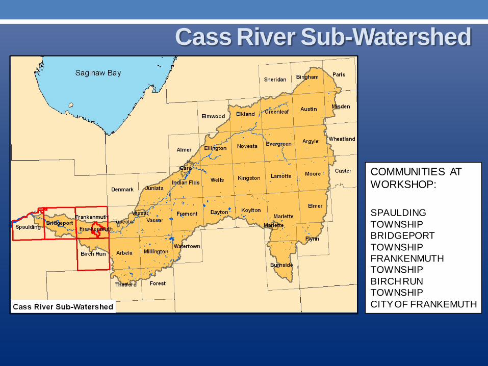
Cass River Sub-Watershed
COMMUNITIES AT WORKSHOP: SPAULDING TOWNSHIP BRIDGEPORT TOWNSHIP FRANKENMUTH TOWNSHIP BIRCH RUN TOWNSHIP CITY OF FRANKEMUTH
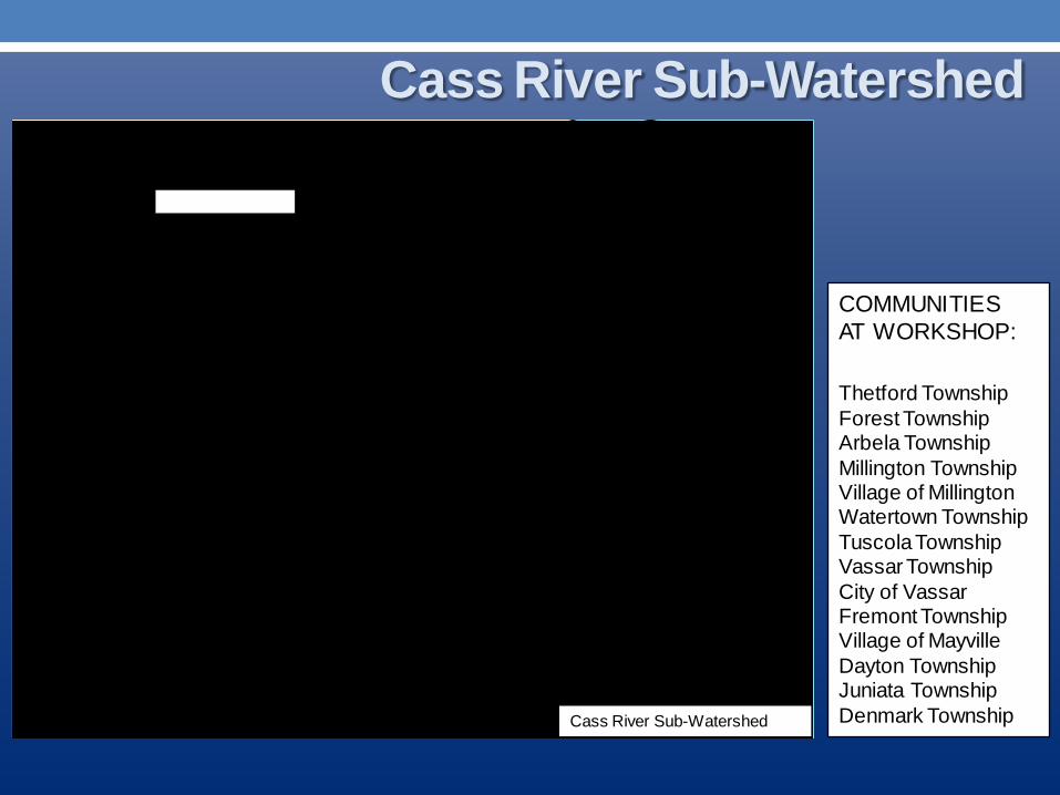
Cass River Sub-Watershed
COMMUNITIES AT WORKSHOP: Thetford Township Forest Township Arbela Township Millington Township Village of Millington Watertown Township Tuscola Township Vassar Township City of Vassar Fremont Township Village of Mayville Dayton Township Juniata Township Denmark Township
Cass River Sub-Watershed

• Everything upstream ends up downstream, including contamination (sediments, nutrients, pesticides, human and animal waste, etc.);
• Human and animal health impacts; • Potential loss of recreational opportunities; and • Healthy watersheds are necessary for a healthy economy.
Why be Concerned About Water Quality in the Saginaw Bay and Your Local Rivers?
“Muck” on the Bay

• Saginaw River/Bay is one of 14 AOCs in Michigan • Includes all 22 miles of the Saginaw River & Saginaw Bay • Designated an AOC by EPA since 1988
Background Saginaw River/Bay Area of Concern (AOC)
May 16, 2011 http://www.glerl.noaa.gov/res/glcfs/sb/modis.html

• Of the 14 Impairments criteria, Saginaw River/Bay includes10: 1. Restriction on fish and wildlife consumption 2. Eutrophication or undesirable algae 3. Degradation of fish and wildlife populations 4. Beach closings 5. Degradation of aesthetics 6. Bird or animal deformities or reproduction problems 7. Degradation of benthos lakebed ecosystem 8. Degradation of phytoplankton and zooplankton
populations 9. Restriction of dredging activities 10. Loss of fish and wildlife habitat
Background Saginaw River/Bay Area of Concern (AOC)

• The GLRI program identifies goals, objectives, measurable ecological targets, and specific actions for each of the following five focus areas:
1. Cleaning up toxics and AOCs; 2. Combating invasive species; 3. Promoting nearshore health by protecting watersheds
from polluted run-off; 4. Restoring wetlands and other habitats; and 5. Tracking progress and working with strategic partners.
Great Lakes Restoration Initiative (GLRI) Implementing the AOC Plan

Pigeon River Corridor Sediment Reduction Project
• Pigeon River Inter-county Drain Drainage Board
• $1,723,235 Shiawassee Flats Wildlife and Fish Habitat Restoration
• Dept. of Interior – US Fish and Wildlife • $785,492
Van Hove Coastal Wetland Restoration • Ducks Unlimited Inc. • $129,249
Upper Great Lakes Stream Connectivity and Habitat Initiative
• Dept. of Interior – US Fish and Wildlife • $876,786
GLRI Projects Largest Federal Investment in the Great Lakes in Two Decades

Fish Passage at the Frankenmuth Dam • City of Frankenmuth • $400,000
Rifle River Watershed Nonpoint Implementation Project
• Huron Pines • $495,000
Western Lake Huron, MI • The United States Army Corps of
Engineers (USACE) • $600,000
GLRI Projects Largest Federal Investment in the Great Lakes in Two Decades
Source: http://greatlakesrestoration.us/

• The Saginaw Bay Resource Conservation & Development Council (RC&D) received funding from the Michigan DEQ.
• Primary Objectives:
1. Organize committees comprised of key stakeholders to identify and prioritize water quality issues;
2. Evaluate and summarize watershed information to identify and prioritize specific areas for water quality improvements.
3. Submit a Watershed Management Plan for the Cass River Watershed that meets Federal and State criteria to receive future project funding to improve water quality.
Cass River Watershed Plan

• Reaching out! Learning what is important to watershed residents (in terms of water quality), and inviting participation.
• Conducting a wetland assessment, to determine where the most suitable areas are for wetland protection and restoration.
• Creating an action plan to pay for education and installation costs for improvign water quality and current land management practices
Cass River Watershed Plan What is happening now:
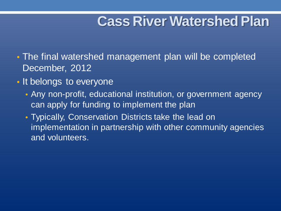
• The final watershed management plan will be completed December, 2012
• It belongs to everyone • Any non-profit, educational institution, or government agency
can apply for funding to implement the plan • Typically, Conservation Districts take the lead on
implementation in partnership with other community agencies and volunteers.
Cass River Watershed Plan

• Cass River Greenway is an effort organized group of local volunteers, assisted by professional resources and municipal leaders, working to enhance recreational opportunities and the environmental well-being of the Cass River Corridor.
• Goals Developed by the Cass River Greenway Committee: • Develop recreation opportunities on the Cass River
an along its corridors • Encourage preservation of wildlife habitat and
critical natural lands • Improve water quality of the Cass River • Promote good environmental stewardship practices • Develop eco-tourism opportunities for our area.
Cass River Greenway

• Developed in 2008 by the Cass River Rapid Watershed Assessment Technical Committee (members consisting of various federal, state, and local agencies and organizations)
• “The RWA provides a brief assessment of the Cass River watershed’s natural resources, resource concerns and conservation needs.”
The Cass River Rapid Watershed Assessment (RWA)
“Nonpoint source pollution is the primary pollution threat facing the water resources of the Cass River Watershed. Nonpoint source pollution is any pollutant carried off the land by water or wind and deposited into surface water.” Can include sediment, fertilizer, pesticides, herbicides, fungicides, vehicle lubricants, etc.
Your Local Watershed Plans

Issues • Eroding stream banks • Poor road / stream crossings • Storm runoff • Cropland erosion • Loss of riparian & wildlife • corridors • Loss of wetlands • Channelization • Septic effluent • Crop fertilizers • Livestock waste • Thermal pollution • Lack of proper zoning • Invasive species
The Cass River Rapid Watershed Assessment (RWA) Your Local Watershed Plans

Goals for Improvement • Institute responsible land use protection and public
policy to protect parcels within the watershed that provide groundwater recharge, key wildlife habitats, headwater stream protection, important wetland functions, coastal areas, etc.
• Identify sites contributing to water quality problems and work with producers to implement Best Management Practices (BMPs).
• Identify sites that are unnaturally adding sediment to the river system and implement a system of Best Management Practices where possible.
• Increase and develop citizen involvement/public awareness and responsible use of the watershed through stewardship and education.
Your Local Watershed Plans
Outcomes • Clean water that is fishable and
swimmable, with less sediment, fertilizers and pesticides.
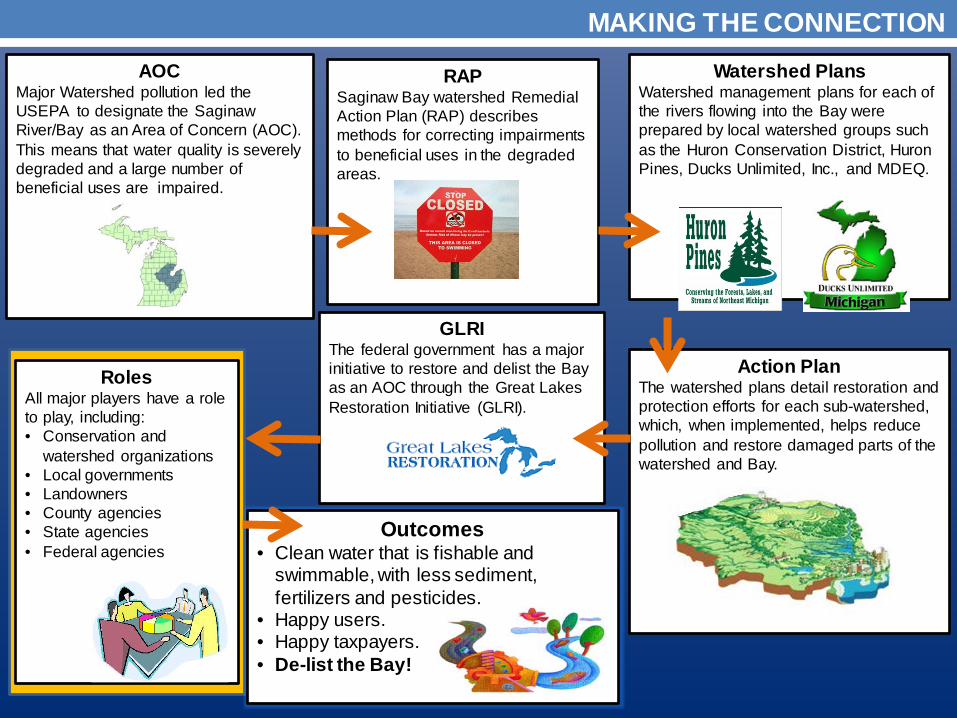
• Happy users. • Happy taxpayers. • De-list the Bay!
Roles All major players have a role to play, including: • Conservation and
watershed organizations • Local governments • Landowners • County agencies • State agencies • Federal agencies
GLRI The federal government has a major initiative to restore and delist the Bay as an AOC through the Great Lakes Restoration Initiative (GLRI).
Action Plan The watershed plans detail restoration and protection efforts for each sub-watershed, which, when implemented, helps reduce pollution and restore damaged parts of the watershed and Bay.
AOC Major Watershed pollution led the USEPA to designate the Saginaw River/Bay as an Area of Concern (AOC). This means that water quality is severely degraded and a large number of beneficial uses are impaired.
Watershed Plans Watershed management plans for each of the rivers flowing into the Bay were prepared by local watershed groups such as the Huron Conservation District, Huron Pines, Ducks Unlimited, Inc., and MDEQ.
RAP Saginaw Bay watershed Remedial Action Plan (RAP) describes methods for correcting impairments to beneficial uses in the degraded areas.
MAKING THE CONNECTION

Roles of Major Players
Federal Agencies EPA o Funded GLRI and
other enhancement activities
o Role in wetland permits
o Education
Land Protection Grants o NAWCA o NCWC o Costal Lands
Army Corps o Dredging permits o Wetland permits
USDA o Fund conservation
organizations and landowners
o Education of farmers and other landowners
o Rural housing funding programs
o Conservation innovation grants
o EQIP
State Agencies DEQ o Support cleanup
and delisting o Provide technical
assistance o Apply regulations o Education o Link stakeholder
groups o Orphaned Well
Program and Resources
DNR o Manage State
land o Education o Support cleanup
partnerships o Natural Resource
Land Trust Fund grant program
County Agencies Drain Commissioners o Reviews Site Plans
for new developments
o Proposals for BMP implementation
o Stormwater management
Health Department o Septic tank and
other environmental codes
Road Commission o Manages negative
impacts from road crossings and use of de-icers
o Road ditch impacts and improvements
Landowners o BMP
implementation o Consider long
term preservation of sensitive habitats
Local Governments o Education on
BMPs and Low Impact Development practices
o Local Master Plans
o Local Zoning Ordinances
o Enforce adopted regulations
o Facilitate coordination and cooperation with public, private and non-profit groups
o Tax relief for wetland and critical habitat areas
Conservation and Watershed Organizations o Education on Best
Management Practices (BMPs)
o Planning o Permanent land
protection o Wetland and their
sensitive land preservation and restoration
o Technical assistance
Improving Water Quality of Saginaw Bay Watershed
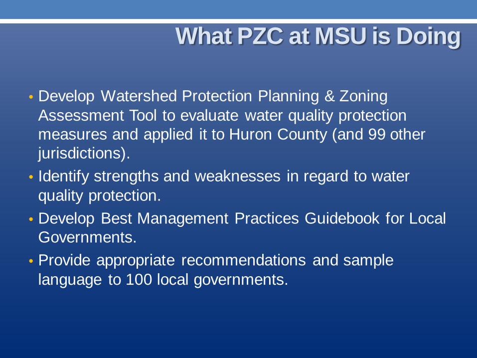
• Develop Watershed Protection Planning & Zoning Assessment Tool to evaluate water quality protection measures and applied it to Huron County (and 99 other jurisdictions).
• Identify strengths and weaknesses in regard to water quality protection.
• Develop Best Management Practices Guidebook for Local Governments.
• Provide appropriate recommendations and sample language to 100 local governments.
What PZC at MSU is Doing

• FREE consulting! • Assistance in meeting statutory requirements. • Offer expert advice for future plans. • Help improve local plans and regulations in regard to
water quality. • Strengthen relationships between your community and
the entire Saginaw Basin.
What We Offer

Planning and Zoning Documents

I. Conformance with Michigan Planning & Zoning Enabling Acts II. Introduction
Purpose, Methodology, Organization and Content, How to Use Assessment, Defined Terms, and Notes
III. Background Title of Plans, Dates Updated, Community Statistics
IV. General Questions/Provisions/Supplementary Info County Drain Commissioner, Health Departments, and other agencies
V. Master Plan Goals and Objectives and Growth and Development
VI. Zoning Ordinance General, Site Plan Review, and Subdivision/Plot Regulations
Planning & Zoning Assessment
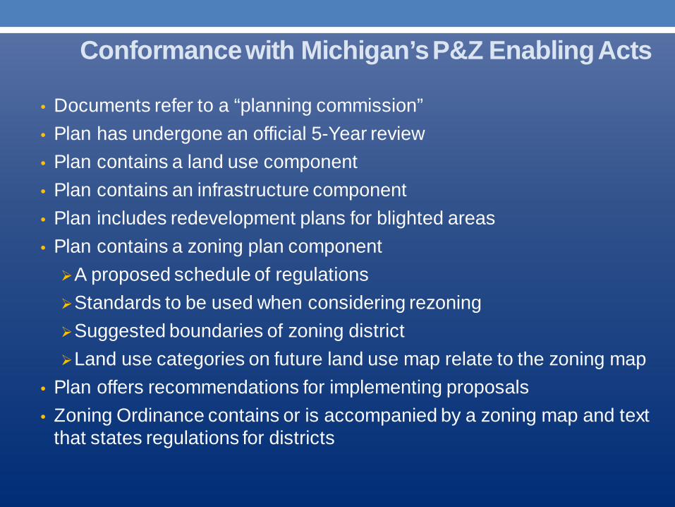
• Documents refer to a “planning commission” • Plan has undergone an official 5-Year review • Plan contains a land use component • Plan contains an infrastructure component • Plan includes redevelopment plans for blighted areas • Plan contains a zoning plan component A proposed schedule of regulations Standards to be used when considering rezoning Suggested boundaries of zoning district Land use categories on future land use map relate to the zoning map
• Plan offers recommendations for implementing proposals • Zoning Ordinance contains or is accompanied by a zoning map and text
that states regulations for districts
Conformance with Michigan’s P&Z Enabling Acts

Planning & Zoning Assessment Tool
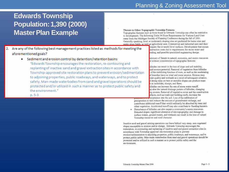
Edwards Township Population: 1,390 (2000) Master Plan Example
Planning & Zoning Assessment Tool

Planning & Zoning Assessment Tool
Edwards Township Population: 1,390 (2000) Zoning Ordinance Example
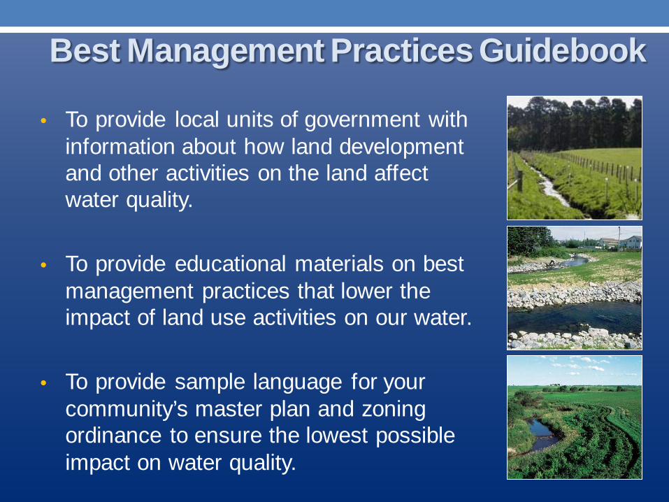
• To provide local units of government with information about how land development and other activities on the land affect water quality.
• To provide educational materials on best
management practices that lower the impact of land use activities on our water.
• To provide sample language for your
community’s master plan and zoning ordinance to ensure the lowest possible impact on water quality.
Best Management Practices Guidebook
• Communities can judge the level at which they are able to implement the approaches.
• A community may decide on the level they wish to pursue depending on the value of the community’s water resources and their sensitivity to degradation.
• For example, if the community is almost wholly agricultural, the community has little authority to regulate agricultural activities, but can play a role in providing educational materials and opportunities to its residents.
Good, Better, Best Approaches
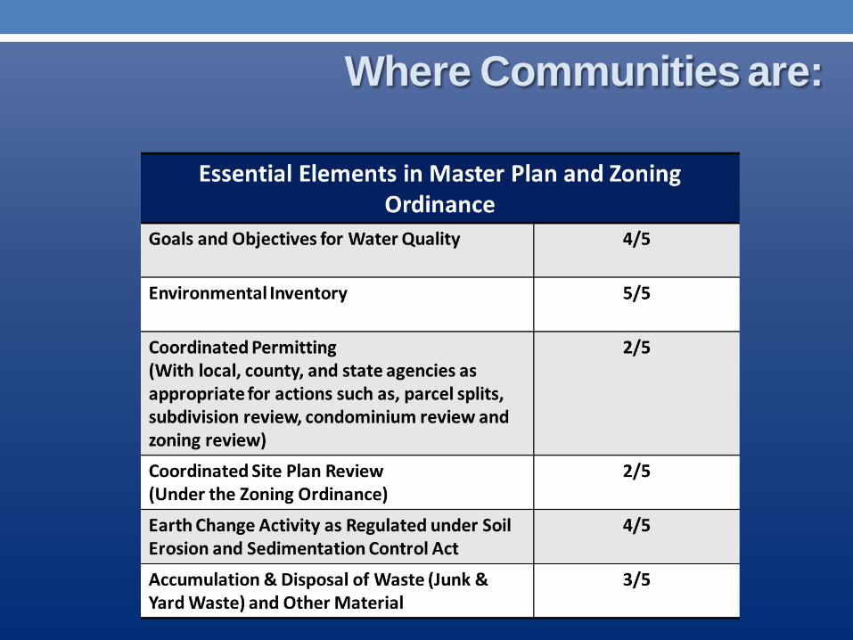
Where Communities are:

Where Communities are:

Where Communities are:
• Update Master Plan to address the future of water quality in your community
• Develop or improve land use regulations for preventing pollution and
• Encourage local farmer participation in programs like the Michigan Agricultural Environmental Assurance Program (MAEAP)
• Partner with regional groups and neighboring communities to ensure we’re all doing our part to protect the overall Saginaw Bay Watershed
What can You Do?
Review your community’s “Water Quality Planning and Zoning Assessment”
• Is the assessment of your community accurate?
• If not, please make corrections and provide citations (documents and page numbers), then return the assessment to us, as soon as possible.
Your community has been evaluated for the presence of basic water protection elements in your master plan and zoning ordinance.
• Look at the blue form: Water Quality Planning & Ordinance Approaches
Based on our criteria, your community may already fall into the categories of “good”, “better”, or “best”. If this is not the case and your community lacks a significant amount of basic protections, you should be concerned!

• Look at the green form: Methods for Protecting Water Quality
• Compare the green form with your community’s Water Quality Planning and Ordinance Approaches (blue form)
What modifications can you make to improve existing plans and ordinances?
Where your community has “nothing”, what kind of protections would you like to see?

Share this information with local land use decision makers (e.g. planning commissioners, planning staff, city/village council) and come to a consensus on what protections work best for your community.
Things to consider: • Is our community meeting basic statutory requirements? • Have we encountered issues in the past where these protections may
have helped? • Are we cooperating with our region to solve the problems in the Bay? • What kind of capacity do we have to implement these changes?
When you have come to a decision, contact the Planning & Zoning Center.

Based on your responses, the Planning & Zoning Center will craft master plan and zoning ordinance language specifically for your community.
• Is your community in the process of updating its master plan? This is the perfect time to ensure your water resources are receiving adequate attention!
• Be certain that your community is in compliance with Michigan’s most recent planning and zoning statutes
• Because planning and zoning cannot apply retroactively, receive profession help and be better prepared for unexpected nuisances that threaten to pollute your community’s resources.

Phone: (517) 432-2222
Write: 310 Manly Miles Bldg. 1405 S. Harrison Rd. East Lansing, MI 48823
E-mail: [email protected]
The Planning & Zoning Center at MSU is committed to helping Saginaw Bay-area communities achieve a higher standard for water quality protection and we will be available to assist you along the way.
Please contact us if you have questions regarding the project!

• Updated master plan to identify contemporary environmental goals and meet statutory requirements
• Zoning ordinance gets amended to ensure your community is better protected from nuisances and pollution
• Save $$$ on FREE professional consulting and avoid costs in the future from potential environmental issues
Benefits to Working with Us

PZC at MSU to refine: Technical Assistance Workshop (January) Conference
Next Steps

Mark A. Wyckoff, FAICP Professor and Director Planning & Zoning Center at MSU Senior Associate Director, Land Policy Institute Jacqueline Spry Visiting Academic Specialist-Outreach at MSU
Michigan State University Land Policy Institute
Planning & Zoning Center 310 Manly Miles Building
1405 South Harrison Road East Lansing, MI 48823
517.432.2222 ext. 123 [email protected]
Contact Information
Project Website http://www.landpolicy.msu.edu/SaginawBayProject
Great Place Network http://www.greatplacenetwork.org/