Planning and Legislative Framework · The following planning and legislative framework relates to...
26
Northern Moreton Bay Shoreline Erosion Management Plan Stage 1 11 Planning and Legislative Framework G:\Admin\B20080.g.mpb_NorthernMoretonBay_SEMP\R.B20080.001.03.Stage_1.docx 2 Planning and Legislative Framework This chapter outlines legislation, regulation and policies that require consideration in the development of the NMBSEMP. It has been compiled based on legislation, regulation and policies current at the time of writing. Further consideration should be given to the requirements current at the time of implementing erosion management recommendations. The legislation, regulation and policies mentioned in this chapter are not meant to be a comprehensive list but should be used as a starting point and guide for determination of considerations at the time of approval and construction. Proposed management options recommended within the NMBSEMP must be consistent with the local government planning scheme of the MBRC and comply with all relevant legislation (Commonwealth, State and local) and coastal and environmental planning instruments and policies. The basis and control of management of the coast of Queensland is governed by the Coastal Protection and Management Act 1995 (Coastal Act) and the Sustainable Planning Act 2009 (SP Act). Under these Acts, the Coastal Management Plan (CMP), the Coastal Protection State Planning Regulatory Provision (Coastal SPRP), the State Planning Policy (SPP) and the State Development Assessment Provisions are the primary statutory planning instruments for development planning and assessment. The following planning and legislative framework relates to the provisions of the CMP, Coastal SPRP, SPP and SDAP as they apply to the study area. Legislation and policies considered in this SEMP will require consideration of issues including, but not limited to: • The use of coastal structures for property protection; • Protection of species listed under State and Commonwealth legislation and conservation of their habitat; • Management of shoreline erosion in a manner that is not detrimental to the adjacent Moreton Bay Marine Park and Ramsar site; and • The maintenance of local biodiversity. These legislative and policy considerations are described in more detail in the following chapters. 2.1 Coastal Protection and Management Act 1995 The Queensland Coastal Act provides for management of the coastal zone. 1 The Coastal Act recognises the diverse range of resources and values of the coastal zone, and has the following objectives: 2 • Provide for the protection, conservation, rehabilitation and management of the coastal zone, including its resources and biological diversity; 1 Coastal waters and land up to a point 5km landward of the high-water mark or the point nearest the high-water mark where land reaches 10m AHD, whichever is more landward: ss15 and 18A Coastal Act 2 s3
Transcript of Planning and Legislative Framework · The following planning and legislative framework relates to...

Northern Moreton Bay Shoreline Erosion Management Plan Stage 1 11Planning and Legislative Framework
G:\Admin\B20080.g.mpb_NorthernMoretonBay_SEMP\R.B20080.001.03.Stage_1.docx
2 Planning and Legislative Framework
This chapter outlines legislation, regulation and policies that require consideration in the
development of the NMBSEMP. It has been compiled based on legislation, regulation and policies
current at the time of writing. Further consideration should be given to the requirements current at
the time of implementing erosion management recommendations. The legislation, regulation and
policies mentioned in this chapter are not meant to be a comprehensive list but should be used as
a starting point and guide for determination of considerations at the time of approval and
construction.
Proposed management options recommended within the NMBSEMP must be consistent with the
local government planning scheme of the MBRC and comply with all relevant legislation
(Commonwealth, State and local) and coastal and environmental planning instruments and
policies.
The basis and control of management of the coast of Queensland is governed by the Coastal
Protection and Management Act 1995 (Coastal Act) and the Sustainable Planning Act 2009 (SP
Act). Under these Acts, the Coastal Management Plan (CMP), the Coastal Protection State
Planning Regulatory Provision (Coastal SPRP), the State Planning Policy (SPP) and the State
Development Assessment Provisions are the primary statutory planning instruments for
development planning and assessment. The following planning and legislative framework relates
to the provisions of the CMP, Coastal SPRP, SPP and SDAP as they apply to the study area.
Legislation and policies considered in this SEMP will require consideration of issues including, but
not limited to:
• The use of coastal structures for property protection;
• Protection of species listed under State and Commonwealth legislation and conservation of their
habitat;
• Management of shoreline erosion in a manner that is not detrimental to the adjacent Moreton
Bay Marine Park and Ramsar site; and
• The maintenance of local biodiversity.
These legislative and policy considerations are described in more detail in the following chapters.
2.1 Coastal Protection and Management Act 1995 The Queensland Coastal Act provides for management of the coastal zone.1 The Coastal Act
recognises the diverse range of resources and values of the coastal zone, and has the following
objectives:2
• Provide for the protection, conservation, rehabilitation and management of the coastal zone,
including its resources and biological diversity;
1 Coastal waters and land up to a point 5km landward of the high-water mark or the point nearest the high-water mark where land reaches 10m AHD, whichever is more landward: ss15 and 18A Coastal Act 2 s3
Northern Moreton Bay Shoreline Erosion Management Plan Stage 1 12Planning and Legislative Framework
G:\Admin\B20080.g.mpb_NorthernMoretonBay_SEMP\R.B20080.001.03.Stage_1.docx
• Have regard to the goal of the National Strategy for Ecologically Sustainable Development in
the use of the coastal zone;
• Ensure decisions about land use and development safeguard life and property from the threat of
coastal hazards; and
• Encourage the enhancement of knowledge of coastal resources and the effect of human
activities on the coastal zone.
The main means of achieving this management under the Coastal Act is the regulation of
development and allocations, and the preparation of management plans.
The Queensland Government currently manages the coastal zone using the CMP and the SPP.
The CMP is an instrument prepared under the Coastal Act for the management of the coastal zone
and works that are not assessable development under the SP Act. It is aimed primarily at local
governments as well as other managers on the coastal zone (e.g. State government, Traditional
Owners, marine park managers, port authorities). The SPP provides State interests with policies to
be considered by land managers particularly when preparing planning schemes. State interests
include the coastal environment, biodiversity and natural hazards (e.g. coastal erosion).
In addition, the SPP also provides development assessment criteria to be applied when assessing
development related to particular state interests. Similarly, the Coastal SPRP and SDAP provide
the performance criteria against which assessment managers and SARA will assess development.
These instruments apply to a range of interests relevant to the SEMP, including coastal protection,
water quality, native vegetation clearing, Queensland heritage, wetlands and environmentally
relevant activities (e.g. dredging).
For the purposes of developing the Northern Moreton Bay SEMP, the CMP will be applied. At the
time of implementation of recommendations within the SEMP (e.g. submission of development
applications for construction of coastal protection works), the Coastal SPRP, SPP and SDAP will
be applied. In this context, all four instruments are considered below.
2.1.1 Coastal Management Plan
The CMP has application to the coastal zone as defined by the Coastal Act. The CMP seeks to
manage all coastal land and coastal resources within this zone and applies to all management
planning, activities, decisions and works that are not assessable development under the SP Act,
including the development of a SEMP.
The CMP provides for the decision-making of managers of State and local coastal land and coastal
resources, and for the owners of private coastal land. There are six principles for the management
of coastal land under the CMP:
(1) Coastal Landforms and Physical Coastal Processes – The long-term stability of dunes and
other coastal landforms are preserved and physical coastal processes including erosion,
accretion and the movement of sediment are able to occur without interruption.

Northern Moreton Bay Shoreline Erosion Management Plan Stage 1 13Planning and Legislative Framework
G:\Admin\B20080.g.mpb_NorthernMoretonBay_SEMP\R.B20080.001.03.Stage_1.docx
(2) Nature Conservation – Matters of state environmental significance (MSES) are conserved by
avoiding impacts or where impacts cannot be avoided residual impacts are mitigated through
rehabilitation measures.
(3) Indigenous Cultural Heritage – Aboriginal People and Torres Strait Islanders are the primary
guardians, keepers and knowledge holders of their cultural heritage; their connection to
coastal and marine resources should be maintained and enhanced.
(4) Public Access and Enjoyment of the Coast – Public access and use of the coast is
maintained or enhanced for current and future generations.
(5) Management Planning – Managing and using coastal land is planned, monitored, reported
on and reviewed to achieve continuous improvement in management outcomes.
(6) Knowledge Sharing and Community Engagement – Knowledge of coastal resources and
their management is shared with the community and the community is engaged in decision-
making processes and activities that affect them.
Each of these principles is given effect by a series of coastal management outcomes. As SEMPs
are developed for priority areas for shoreline erosion management, the most relevant coastal
management outcomes to the preparation of the Northern Moreton Bay SEMP are those regarding
coastal landforms and physical coastal processes.
Coastal Landforms and Physical Coastal Processes
The coastal management outcomes for coastal landforms and physical coastal processes identify
the need to maintain natural processes in the coastal zone, including the natural fluctuations of
erosion and accretion and buffers provided by dunes, mangroves and coastal wetlands. The
relevance of the coastal management outcomes to the SEMP include the following:
• 1.6 requires a SEMP to be prepared where there is ‘an imminent threat to the community or
infrastructure from coastal erosion’. A SEMP is intended to ‘deliver a science-based solution to
the erosion problem that considers social, environmental and economic issues.’.
• 1.1 to 1.5 establish, as a general principle, the need to maintain natural processes on the coast,
including the processes of erosion and accretion, land stabilisation by native vegetation, natural
buffering by dunes, mangroves and coastal wetlands, and maintenance of sand within the
active beach system.
• 1.7 requires management planning for assets in areas at risk from erosion to adopt the
hierarchy of avoid, retreat, accommodate or defend.
• 1.8 identifies a preference for beach nourishment when considering the defence of coastal
assets.
• 1.8 also identifies that where seawalls are considered, beach nourishment should be
undertaken in conjunction so as to balance the loss of sediment locked up behind the walls.
• 1.10 requires the consideration of sea level rise in managing the coast.

Northern Moreton Bay Shoreline Erosion Management Plan Stage 1 14Planning and Legislative Framework
G:\Admin\B20080.g.mpb_NorthernMoretonBay_SEMP\R.B20080.001.03.Stage_1.docx
These outcomes, therefore, establish the framework of considerations for the Northern Moreton
Bay SEMP. Consistent with the Coastal SPRP, SPP and SDAP, the CMP identifies a hierarchy of
management options. This is represented in Figure 2-1 below. See also Section 3.
Figure 2-1 Preference for erosion control structures identified in the CMP
Other Relevant Outcomes
Other coastal management outcomes which are relevant to the Northern Moreton Bay SEMP
include:
• 2.1 Areas containing MSES are conserved by:
○ Protecting areas containing MSES, sensitive natural ecosystems, their process and habitat
(particularly feeding, nesting and roosting sites) from threats; and
○ Maintaining, enhancing or re-establishing habitat connectivity for species movement.
• 2.2 Where impacts on MSES cannot be avoided, impacts are mitigated by actions such as
restoring or rehabilitating natural environmental values of similar or adjacent habitat or other
actions that reduce threats to MSES.
• 4.2 The use of undeveloped esplanades and road reserves vulnerable to coastal erosion for
vehicular access is supported if they provide the only lawful means of vehicular access.
2.1.2 Tidal Works and Quarry Material
Tidal works are defined under the Coastal Act as work ‘above land under tidal water, or on land
that will or may be under tidal water because of development on or near the land, and work that is
an integral part of the relevant work, wherever located’.3 This includes rockwalls, groynes, jetties,
3 Coastal Act, Sch. 1
1st PreferenceBeach nourishment
2nd PreferenceEngineered erosion control
structures with beach nourishment

Northern Moreton Bay Shoreline Erosion Management Plan Stage 1 15Planning and Legislative Framework
G:\Admin\B20080.g.mpb_NorthernMoretonBay_SEMP\R.B20080.001.03.Stage_1.docx
embankments and land reclamation. Prescribed tidal works is further defined under the Coastal
Protection and Management Regulation 2003 (Coastal Regulation) as tidal work that is completely
or partly within a local government tidal area.4 Both tidal works and prescribed tidal works require
approval under the SP Act (see Section 2.2 below).
In addition, for works involving the extraction of material from tidal water (i.e. ‘quarry material’),
approval is required from the Chief Executive administering the Act. This is relevant to the
extraction of sand from tidal water for the purpose of beach nourishment.
2.2 Other Instruments
2.2.1 Commonwealth Legislation
2.2.1.1 Environmental Protection and Biodiversity Conservation Act 1999
Any actions that have or are likely to have a significant impact on a matter of national
environmental significance (NES) are to be referred to the Minister administering the Environment
Protection and Biodiversity Conservation Act 1999 (EPBC Act). Matters of NES that may be
significantly impacted by coastal protection works in the Study Area include:
• Wetlands of international importance (Moreton Bay Ramsar Site);
• Listed threatened species and ecological communities; and
• Migratory species.
If coastal protection works are declared a ‘controlled action’, approval will be required from Minister
before the works can commence.
Directory of Important Wetlands in Australia
The Australian, State and Territory governments have jointly compiled a Directory of Important
Wetlands in Australia which identifies and recognises Australia’s nationally important wetlands.
Although not directly protected under Commonwealth legislation, these wetlands are still of
planning significance at a Commonwealth level.
The Moreton Bay Aggregation (QLD134) and Pumicestone Passage (QLD 136) are listed on the
Directory and are both protected at a State level under marine parks legislation as the Moreton Bay
Marine Park (see Section 2.2.2.6).
2.2.2 State Legislation and Instruments
2.2.2.1 Sustainable Planning Act 2009
The SP Act is the central piece of planning legislation, used by the State Government to regulate
planning and development. Management planning and erosion management development are
both regulated under the Act.
Management and planning actions in Queensland are managed by SPIs and Local Planning
Instruments (LPIs). Specifically, these instruments apply to government decision-making and
4 Coastal Regulation s14(1)

Northern Moreton Bay Shoreline Erosion Management Plan Stage 1 16Planning and Legislative Framework
G:\Admin\B20080.g.mpb_NorthernMoretonBay_SEMP\R.B20080.001.03.Stage_1.docx
planning in relation to land management. SPIs include SPRPs, Regional Plans (RPs) and SPPs,
while LPIs include planning schemes, temporary LPIs and planning scheme policies.
The SP Act also regulates the assessment of development through the Integrated Development
Assessment System (IDAS). This system utilises relevant SPIs and LPIs to assess whether or not
development can be approved.
The key SPIs and LPIs which are triggered by management or development in the study area are
summarised in Table 2-3 and include the following:
• Coastal SPRP;
• South East Queensland Koala Conservation SPRP 2010;
• South East Queensland Regional Plan 2009-2031 (SEQRP);
• SPP 2013;
• Coastal Management Plan (see Section 2.1.1); and
• Caboolture ShirePlan and planning scheme policies (see Section 2.3.3).
These are discussed below in relation to their impact on the preparation of a SEMP for the study
area. The SP Act also establishes the SDAP which are an instrument used for development
assessment.
Table 2-1 Summary of Application of SPIs and LPIs
Trigger Instrument Application of instrument
Development in or adjacent to a declared fish habitat area
SDAP Module 5 Development assessment
Clearing of native vegetation SDAP Module 8 Development assessment
Environmentally relevant activities (e.g. dredging)
SDAP Module 4 Development assessment
Development in a coastal management district SDAP Module 10 Development assessment
Coastal SPRP
SPP
Management of coastal land and coastal resources
CMP Management & decision-making
Decision making in SEQ SEQRP Management & decision-making
Development related to land affected by MSES
SPP Development assessment
Development within a coastal hazard area SPP Development assessment
Development within the former Caboolture Shire local government area
Caboolture ShirePlan
Development assessment
Northern Moreton Bay Shoreline Erosion Management Plan Stage 1 17Planning and Legislative Framework
G:\Admin\B20080.g.mpb_NorthernMoretonBay_SEMP\R.B20080.001.03.Stage_1.docx
Assessment under the SP Act for potential shoreline erosion management recommendations will
be required according to triggers including but not limited to:
• Tidal works (including prescribed tidal works) under the Coastal Act ;
• Fisheries matters (including removal, destruction or damage to marine plants, and work in fish
habitat areas) under the Fisheries Act 1994 (Fisheries Act);
• Vegetation clearing under the Vegetation Management Act 1999 (VM Act);
• Dredging under the Environmental Protection Act 1994 (EP Act);
• Interference with heritage items under the Queensland Heritage Act 1992 and Aboriginal
Cultural Heritage Act 2003; and
• Disturbance of acid sulfate soils (ASS).
These are discussed in Sections 2.2.2.2 to 2.2.2.10 below. Development applications are
assessed by the Assessment Manager, usually local government, with the State Assessment and
Referral Agency (SARA) acting as a concurrence agency on behalf of the State. Other
Departments act as technical agencies for various jurisdictional triggers. SARA assesses
development against the SDAP and while local government Assessment Managers assess against
relevant LPIs, as well as other SPIs.
Coastal Protection State Planning Regulatory Provision 2013
The Coastal Protection SPRP applies to development in a coastal management district (CMD) that
is impact assessable or requires referral to EHP, or that is assessed by EHP as the assessment
manager.
The SPRP provides assessment criteria for coastal hazards, development in an erosion prone
area, nature conservation, areas of High Ecological Significance (HES), public access, and coastal-
dependent development. The following constraints and requirements are relevant to works under
the SEMP:
• Retreat is the default option in areas threatened by erosion in the erosion prone area. The
presence of development to a scale and intensity that makes retreat not achievable may justify
property protection works. Structural engineering and stabilisation works are a last resort where
there is an immediate threat to public safety, property or infrastructure. These works must not
cause adverse impacts on coastal resources or natural cycles of erosion and accretion of
beaches.
• All tidal works require (a) proof of demonstrated need in the public interest, and (b) a
comprehensive investigation that determines no significant adverse impacts on longshore
transport of sediments or an increase in coastal hazards (including erosion) to neighbouring
foreshore.
• Beach and related areas that contain significant wildlife habitat are to be protected and
managed. This includes:
○ Key shorebird roosting and feeding habitat. Where works require the loss of shorebird
habitat, offsets are to be provided before the works commence;

Northern Moreton Bay Shoreline Erosion Management Plan Stage 1 18Planning and Legislative Framework
G:\Admin\B20080.g.mpb_NorthernMoretonBay_SEMP\R.B20080.001.03.Stage_1.docx
○ Fish habitat and movement passages, including those in Deception Bay and the
Pumicestone Passage;
○ Benthic habitat, including seagrass beds in Pumicestone Passage, around Sandstone Point
and in Deception Bay, as well as benthic communities and tidal flats; and
○ Stands of native vegetation, especially riparian vegetation. Riparian zones are to be
maintained as wildlife corridors.
• No development in areas of HES.
• No net loss of public access to the foreshore unless it compromises the protection of coastal
resources.
• Dredging must be beneficial to the State in terms of navigation and economics and be proven to
maintain the existing physical environment of the area. An application for dredging will only be
approved where supported by studies into the nature of dredging spoils and impacts on physical
processes, and maintenance dredging requires a dredge management plan.
• Reclamation will only be allowed where clearly justified and where there are no or minimal
adverse impacts on coastal resources. Reclamation is justified where it is necessary for erosion
control/nourishment purposes, protects the physical environment, or is necessary to reinstate
land that has been eroded where the reclamation is coordinated with neighbouring properties.
State Development Assessment Provisions
The SDAP is divided into 19 modules. The most relevant of these to the SEMP are Module 5
(fisheries resources), 8 (native vegetation clearing) and 10 (coastal protection). If works were
proposed consisting of dredging or in relation to a heritage location, Modules 4 (environmentally
relevant activities) and 9 (Queensland heritage) would also apply.
The requirements of these Modules are to be considered as part of development assessment. A
series of performance and acceptable outcomes are set out in each module identifying ways in
which development can meet the purpose of the Module. The key considerations for the SEMP
from these outcomes include the following:
• Development on tidal land or fish habitats should be public infrastructure with no viable
alternative, or for a legitimate public safety issue, or on land subject to a resource allocation
authority (RAA);
• Development is designed to minimise impacts on habitat values and community use of FHAs;
• Erosion control structures do not cause loss of fish habitat beyond the structure footprint and
are in response to the immediate threat of significant erosion;
• Development is in accordance with Fish Habitat Management Operational Policies (see Section
2.2.2.3);
• Clearing is in accordance with the Vegetation Management Act 1999 (see Section 2.2.2.4);
• Development in an erosion prone area maintains coastal landforms and processes;

Northern Moreton Bay Shoreline Erosion Management Plan Stage 1 19Planning and Legislative Framework
G:\Admin\B20080.g.mpb_NorthernMoretonBay_SEMP\R.B20080.001.03.Stage_1.docx
• Erosion prone areas are maintained free of development other than coastal-dependent
development or development that is temporary, readily relocatable or able to be abandoned;
• Coastal protection work is undertaken only as a last resort; and
• Development is set back from MSES.
State Planning Policy 2013
The SPP is a guiding instrument for a centralised treatment of management planning and
assessment of development activities in Queensland. It identifies the planning outcomes that
should be included in local planning schemes as well as interim development assessment
provisions.
The SPP outlines assessment requirements for all State interests, including the following three of
relevance to the SEMP:
• Coastal environment;
• Natural hazards (including coastal erosion); and
• Biodiversity.
The assessment requirements of these State Interests are summarised in Table 2-2.
Table 2-2 State Interests and Assessment Criteria under Draft SPP
State Interest Relevant Assessment Criteria
Coastal environment
Development involving operational works in a CMD is to: 1. Avoid or minimise adverse impacts on coastal processes and coastal
resources, and scenic amenity of important natural coastal landscapes, views or vistas;
2. Maintain or enhance general public access to, or along, the foreshore unless this is contrary to the protection of coastal resources or public safety; and
3. Not involve reclamation of tidal land other than for the purposes of coastal protection works or work necessary to protect coastal resources or coastal processes.
Biodiversity Development involving operational work on land related to MSES is to:
4. Identify any potential significant adverse environmental impacts on MSES; and
5. Manage the significance adverse environmental impacts on MSES by, in order of priority:
o Avoiding significant adverse environmental impacts; o Mitigating significant adverse environmental impacts where these cannot
be avoided; and
o Where applicable, offsetting any residual adverse impacts.
Natural hazards
Development involving operational works on land within a coastal hazard area or a flood hazard area is to:
6. Avoid natural hazard areas or mitigate the risk of the natural hazard;
7. Support and not unduly burden disaster management responses or recovery capacity and capabilities;

Northern Moreton Bay Shoreline Erosion Management Plan Stage 1 20Planning and Legislative Framework
G:\Admin\B20080.g.mpb_NorthernMoretonBay_SEMP\R.B20080.001.03.Stage_1.docx
State Interest Relevant Assessment Criteria
8. Directly, indirectly and cumulatively avoid an increase in the severity of the natural hazard and the potential for damage on the site or to other properties; and
9. Maintain or enhance natural processes and the protective function or landforms and vegetation that can mitigate risks associated with the natural hazard.
Development involving operational works on land within an erosion prone area is to:
10. Not be located in an erosion prone area within a CMD unless it cannot feasibly be located elsewhere and is coastal-dependent development, temporary, readily relocatable or able to be abandoned;
11. Propose to undertake coastal protection work (excluding beach nourishment) only as a last resort where coastal erosion presents an imminent threat to public safety or existing buildings and structures, and all of the following apply:
o The property cannot reasonably be relocated or abandoned; and
o Any coastal protect works to protect private property is located as far landward as practicable and on the lot containing the property to the maximum extent reasonable; and
o The coastal protection work mitigates any increase in coastal hazard risk for adjacent areas.
South East Queensland Regional Plan 2009-2031
The SEQRP is a planning document which sets the regional vision for future development and
growth in SEQ. The key effect of the SEQRP is to advise on planning and decision-making in
managing development and growth. The following principles are relevant to decision-making in the
coastal zone for the purposes of this SEMP:
• 1.4 Natural hazards and climate change adaptation;
• 2.1 Biodiversity;
• 2.4 Managing the coast;
• 3.1 Regional landscape values; and
• 4.2 Land, extractive resources, minerals, forestry and fisheries.
These policies emphasise the need to reduce the exposure of coastal areas to coastal erosion and
inundation, taking into account projected climate change impacts (mostly reflected as part of the
CMP, see Section 2.1.1). This is to be achieved without impacts on areas of significant biodiversity
values, coastal values and natural coastal processes, and fish habitat and movement values. The
SEMP must also be consistent with the Moreton Bay Marine Park zoning provisions (see Section
2.2.2.6).
No development assessment criteria apply under the SEQRP SPRP.

Northern Moreton Bay Shoreline Erosion Management Plan Stage 1 21Planning and Legislative Framework
G:\Admin\B20080.g.mpb_NorthernMoretonBay_SEMP\R.B20080.001.03.Stage_1.docx
2.2.2.2 Environmental Protection Act 1994
The Environmental Protection Act 1994 (EP Act) and the Environmental Protection Regulation
2008 (EP Regulation) provide the main framework in Queensland for controlling environmental
harm and pollution resulting from development.
The EP Act sets out a general environmental duty (s319) requiring persons not to cause
environmental harm unless all reasonable and practicable measures are taken to prevent or
minimise the harm. Compliance with the duty is a defence to causing environmental harm without
appropriate authorisation.5 In the context of the SEMP, Council must not carry out any activities
that cause, or are likely to cause, environmental harm unless they take reasonable and practicable
measures to prevent or minimise the harm.
Environmentally relevant activities (ERAs) are a particular type of action causing environmental
harm. These activities can only be undertaken with the appropriate approval. Under the EP
Regulation, ERAs include dredging (ERA 16). Authorisation to undertake ERA 16 may be required
where dredging of sand of beach nourishment purposes is recommended under the SEMP.
Environmental protection policies (EPPs) are also prepared under the EP Act to protect
Queensland’s environment. These EPPs seek to protect environmental values (EVs) and
objectives identified for various aspects of the environment including water, noise, air quality and
waste management. EVs and objectives have been identified under the following policies and
instruments for the study area:
• Environmental Protection (Water) Policy 2009;
○ Caboolture Rive Environmental Values and Water Quality Objectives, July 2010;
○ Moreton Bay, North Stradbroke, South Stradbroke, Moreton and Moreton Bay Islands
Environmental Values and Water Quality Objectives, July 2010;
○ Pumicestone Passage Environmental Values and Water Quality Objectives, July 2010;
○ Pine Rivers and Redcliffe Creeks Environmental Values and Water Quality Objectives, July
2010; and
○ Queensland Water Quality Guidelines 2009.
• Environmental Protection (Air) 2008;
• Environmental Protection (Noise) Policy 2008; and
• Environmental Protection (Waste Management) Regulation 2000.
2.2.2.3 Fisheries Act 1994
The Fisheries Act 1994 protects fisheries resources and fish habitats in Queensland. All coastal
protection works requiring the clearing of marine plants (including any removal, damage or
destruction) or occurring in declared fish habitat areas (FHA) require assessment under the SP Act
subject to concurrence assessment against the SDAP. In addition, works involving land under a
FHA declaration require resource allocation authority (RAA) from the Department of Agriculture,
5 EP Act s493A
Northern Moreton Bay Shoreline Erosion Management Plan Stage 1 22Planning and Legislative Framework
G:\Admin\B20080.g.mpb_NorthernMoretonBay_SEMP\R.B20080.001.03.Stage_1.docx
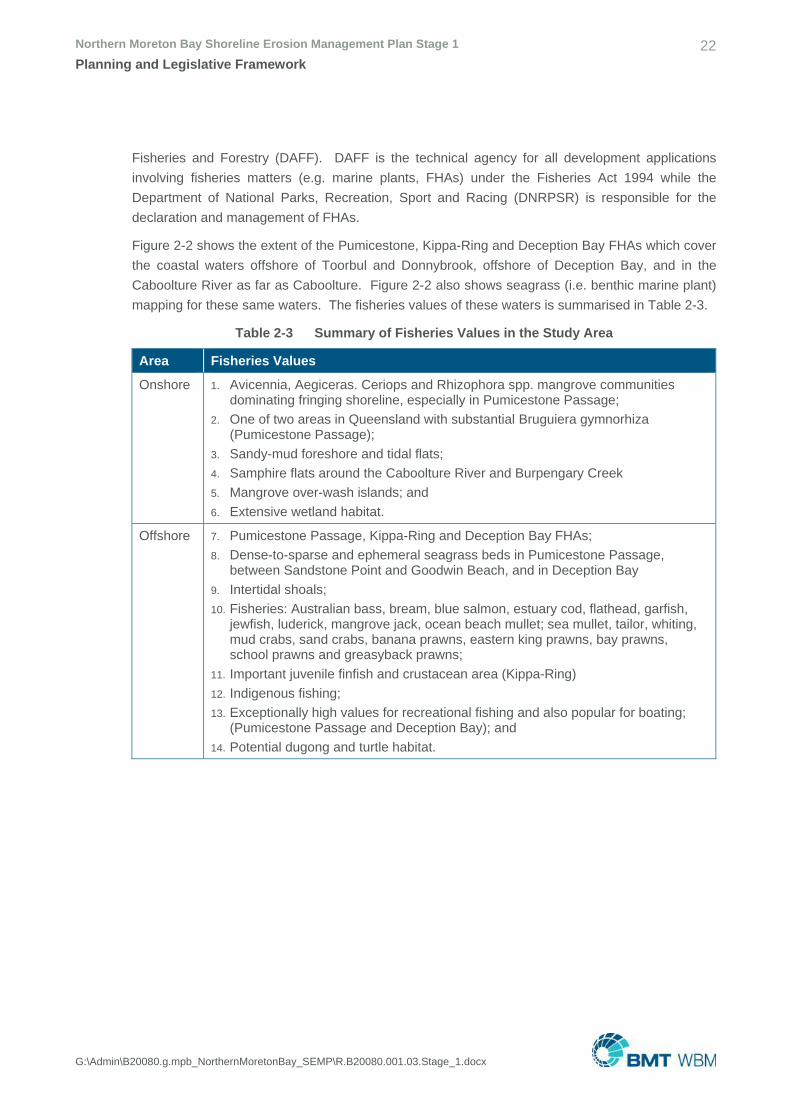
Fisheries and Forestry (DAFF). DAFF is the technical agency for all development applications
involving fisheries matters (e.g. marine plants, FHAs) under the Fisheries Act 1994 while the
Department of National Parks, Recreation, Sport and Racing (DNRPSR) is responsible for the
declaration and management of FHAs.
Figure 2-2 shows the extent of the Pumicestone, Kippa-Ring and Deception Bay FHAs which cover
the coastal waters offshore of Toorbul and Donnybrook, offshore of Deception Bay, and in the
Caboolture River as far as Caboolture. Figure 2-2 also shows seagrass (i.e. benthic marine plant)
mapping for these same waters. The fisheries values of these waters is summarised in Table 2-3.
Table 2-3 Summary of Fisheries Values in the Study Area
Area Fisheries Values
Onshore 1. Avicennia, Aegiceras. Ceriops and Rhizophora spp. mangrove communities dominating fringing shoreline, especially in Pumicestone Passage;
2. One of two areas in Queensland with substantial Bruguiera gymnorhiza (Pumicestone Passage);
3. Sandy-mud foreshore and tidal flats; 4. Samphire flats around the Caboolture River and Burpengary Creek
5. Mangrove over-wash islands; and
6. Extensive wetland habitat.
Offshore 7. Pumicestone Passage, Kippa-Ring and Deception Bay FHAs; 8. Dense-to-sparse and ephemeral seagrass beds in Pumicestone Passage,
between Sandstone Point and Goodwin Beach, and in Deception Bay
9. Intertidal shoals; 10. Fisheries: Australian bass, bream, blue salmon, estuary cod, flathead, garfish,
jewfish, luderick, mangrove jack, ocean beach mullet; sea mullet, tailor, whiting, mud crabs, sand crabs, banana prawns, eastern king prawns, bay prawns, school prawns and greasyback prawns;
11. Important juvenile finfish and crustacean area (Kippa-Ring)
12. Indigenous fishing; 13. Exceptionally high values for recreational fishing and also popular for boating;
(Pumicestone Passage and Deception Bay); and 14. Potential dugong and turtle habitat.


Northern Moreton Bay Shoreline Erosion Management Plan Stage 1 24Planning and Legislative Framework
G:\Admin\B20080.g.mpb_NorthernMoretonBay_SEMP\R.B20080.001.03.Stage_1.docx
Relevant policies necessary to consider when recommending works involving fisheries matters are
summarised in Table 2-4 below.
Table 2-4 Summary of Applicable Fish Habitat Management Operational Policies and Policy Requirements for Erosion Management Works in the SEMP Area
Policy Applicable Policy Requirements
FHMOP 001 Management of protection of marine plants and other tidal fish habitats
1. Coastal development proposals should avoid impacts to marine plants and other tidal fish habitats;
2. All private development works must be set back from tidal lands and fish habitats;
3. Tenure over tidal fish habitats for private development is not supported;
4. Erosion protection and dredging activities must be in accordance with FHMOP 010 and FHMOP 040, respectively; and
5. Revetment works supported only where there is substantiated accelerated bank erosion or slumping threatening buildings or infrastructure.
FHMOP 002 Management of declared Fish Habitat Areas
6. RAA only to be issued in a declared FHA for ‘prescribed development purposes’ includes maintaining: o A structure that was constructed before the area was
declared to be a FHA under the Fisheries Act; and
o A lawfully constructed structure; and 7. Constructing a permanent structure on tidal land or
depositing material for beach replenishment is not supported in a FHA.
FHMOP 004 Dredging, extraction and spoil disposal activities: Departmental procedures for provision of fisheries comments
8. Dredging for waterway management (i.e. beach nourishment) is determined on a case-by-case basis but requires community/habitat benefits to outweigh potential losses;
9. Dredging within FHA prohibited unless in an existing navigation channel;
10. Spoil disposal on non-tidal land is preferred;
11. Proposals for dredging for waterway management, dredging for navigational purposes, or spoil disposal will not be opposed where there are:
o No, or very minimal, immediate or foreseeable, permanent, adverse impacts on fisheries resources; or
o Demonstrated fisheries related benefits; or
o Essential community benefits (e.g. beach nourishment); and
12. Dredging or spoil disposal proposal will be opposed where dredging occurs within a FHA and/or feasible alternative exist.
FHMOP 010 Tidal fish habitats, erosion control and beach replenishment
13. Natural shoreline processes and existing tidal fish habitat values are to be maintained by:
o Using erosion buffer zones and managed retreat where there is no significant erosion;
o Treating the cause of erosion, rather than only
Northern Moreton Bay Shoreline Erosion Management Plan Stage 1 25Planning and Legislative Framework
G:\Admin\B20080.g.mpb_NorthernMoretonBay_SEMP\R.B20080.001.03.Stage_1.docx
Policy Applicable Policy Requirements
attempting to manage the erosion through the use of erosion control structures and beach replenishment, where the erosion is the result of human activities;
o Designating buffer zones;
14. Erosion control measures are supported where there is significant erosion, inadequate erosion buffer zone and impossibility of managed retreat;
15. Erosion control structures are to be constructed by parties with as-of-right or approved use of land (for private property) or by local government on behalf of the community;
16. Erosion control structures not permitted in declared FHA, unless temporary;
17. Seawalls, revetments and other structures parallel to the shoreline are to be located as far landward as possible;
18. Depositing material for beach nourishment not permitted in FHA;
19. Beach nourishment supported only where there is significant erosion or requirement for the protection or effective functioning of erosion control structures;
20. Nourishment material must be sourced outside the FHA with a buffer zone of at least 100m between extraction site and the FHA boundary;
21. Nourishment material must be sourced away from locations where there are marine plants and fishing grounds;
22. Filling of tidal land for creation of a dune or beach at a level above HAT must be an integral part of the erosion control design and minimise renourishment frequency/impact of renourishment of tidal fish habitats, or remove the need for other erosion control works; and
23. Dredging to comply with FHMOP 004.

Northern Moreton Bay Shoreline Erosion Management Plan Stage 1 26Planning and Legislative Framework
G:\Admin\B20080.g.mpb_NorthernMoretonBay_SEMP\R.B20080.001.03.Stage_1.docx
2.2.2.4 Vegetation Management Act 1999
The Vegetation Management Act 1999 (VM Act) prohibits the clearing of native vegetation unless
for a relevant purpose. Alternatively, clearing may be exempt from the approval process where
listed under Schedule 24 of the SP Regulation. Relevant purposes and exemptions relevant to
shoreline erosion management for particular land are summarised in Table 2-5.
Table 2-5 Relevant Purposes and Exemptions Applicable to Clearing Vegetation for Shoreline Management Works
Type of Vegetation on Regional Ecosystem Map
Colour on RE Map
Relevant Purpose/Exemptions Available for Clearing
Freehold land
Non-remnant White 1. For any purpose
Remnant Green, orange or pink
2. Under a development approval for a material change of use or to reconfigure a lot where the Department administering the VM Act is a concurrence agency to the development application
Leasehold land (other than a lease used for agriculture and grazing)
Non-remnant White 3. For any purpose
Road
Non-remnant or remnant least concern
White or green 4. Any purpose carried out by a local government in an urban area
Trust land
Non-remnant White 5. Carried out by the trustee for any purpose
All land types
All types White, green, orange or pink
6. Where approval has been obtained for works which are:
o A project declared to be a significant project under the State Development and Public Works Organisation Act 1971, section 26; and
o For an extractive industry (including dredging and ancillary deposition).
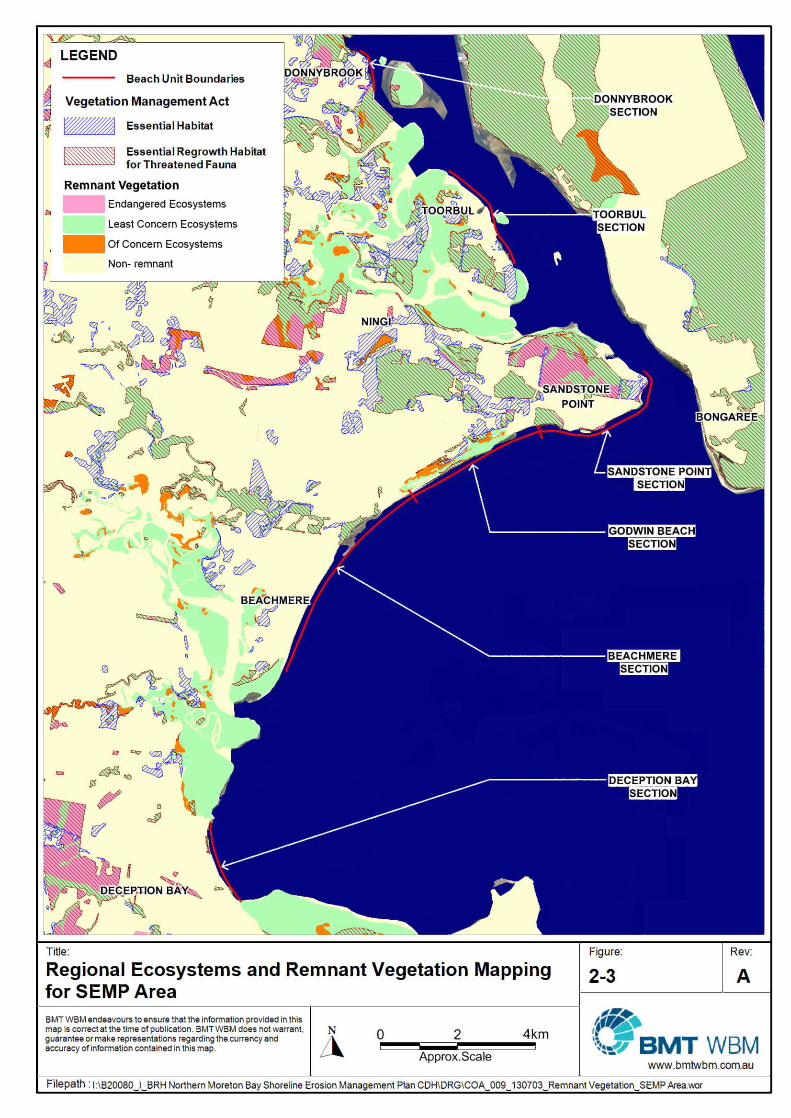
Regional ecosystem (RE) and remnant vegetation mapping for the study area are shown in Figure
2-3.

Northern Moreton Bay Shoreline Erosion Management Plan Stage 1 28Planning and Legislative Framework
G:\Admin\B20080.g.mpb_NorthernMoretonBay_SEMP\R.B20080.001.03.Stage_1.docx
2.2.2.5 Nature Conservation Act 1992
The object of the Nature Conservation Act 1992 (NC Act) is the conservation of nature. This
includes the protection of native flora and fauna and the declaration of protected areas. The
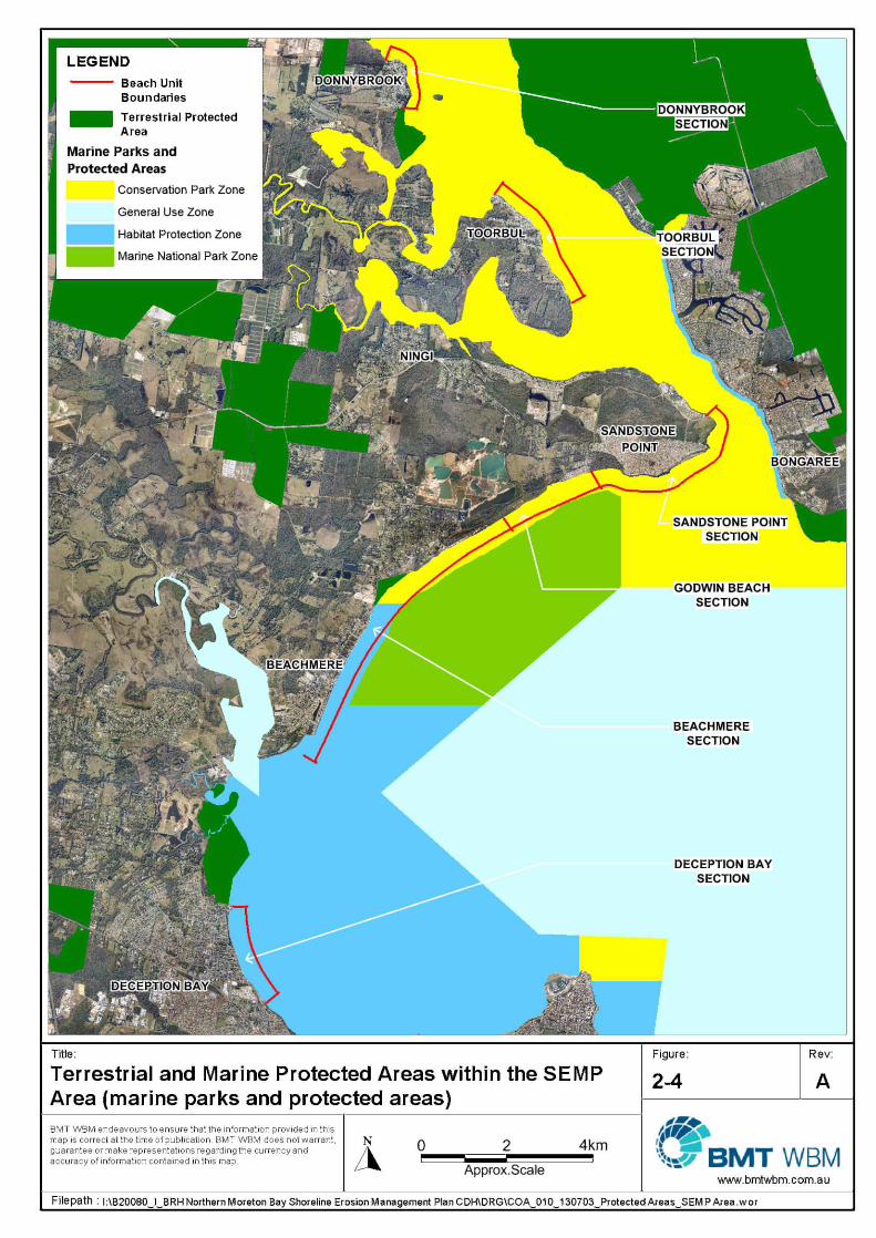
Beachmere Conservation Park is a protected areas designated under the Nature Conservation
(Protected Areas) Regulation 1994 (see Figure 2-4). In addition, least concern (LC) and
endangered, vulnerable or near threatened (EVNT) species under the Nature Conservation
(Wildlife) Regulation 2006 have been identified through online searches as occurring in the study
area.
Any action that involves the taking or native flora or fauna is unlawful unless authorised by a
permit. Wherever clearing is required for the purposes of coastal protection works, including
clearing to gain access to sand extraction areas, the proponent must obtain the appropriate permit
under the NC Act. This does not apply, however, to flora covered under the provisions of other
Acts (e.g. marine plants). All clearing of koala habitat trees must be in accordance with the Nature
Conservation (Koala) Conservation Plan 2006.
Similarly, any works in a conservation park require a permit from the Chief Executive or trustee
managing the park. This includes the use of all natural resources (i.e. natural and physical
features) and/or cultural resources (i.e. resources of spiritual, historic, archaeological significance).
2.2.2.6 Marine Parks Act 2004
The Marine Parks Act 2004 (MP Act) establishes a framework for protecting the marine
environment through declaration of marine parks. Under the MP Act the Moreton Bay Marine Park
(MBMP) has been declared over the tidal waters and tidal land (up to HAT)6 of all beach units in
the study area (see Figure 2-4). This marine park is managed under the Marine Parks (Moreton
Bay) Zoning Plan 2008.
Zones, their objects and limitations are summarised in Table 2-6. For each zone, persons may
carry out works where they are consistent with the objects of the zone, and under the appropriate
permit (where necessary).
Table 2-6 Objects of Marine Park Zones in the SEMP Area
Zone Areas Objects
Conservation park (yellow)
Toorbul, Donnybrook, Sandstone Point, Goodwin Beach
1. To provide for the conservation of the areas of the marine park within the zone
2. To provide opportunities for reasonable use and enjoyment, including, for example, limited extractive use, of the areas
Habitat protection (blue)
Beachmere and Deception Bay
3. To provide for the conservation of the areas of the marine park within the zone through the protection and management of sensitive habitats that are generally free from potentially damaging activities
4. To provide opportunities for reasonable use of the
6 Highest astronomical tide

Northern Moreton Bay Shoreline Erosion Management Plan Stage 1 29Planning and Legislative Framework
G:\Admin\B20080.g.mpb_NorthernMoretonBay_SEMP\R.B20080.001.03.Stage_1.docx
Zone Areas Objects
areas
Marine national park (green)
~50m offshore of Goodwin Beach and Beachmere
5. To provide for the protection of the natural integrity and values of the areas of the marine park that are generally free from extractive activities
6. To provide opportunities for particular activities, including, for example, the presentation of the values of the marine park, to be undertaken in relatively undisturbed areas within the zone
The following activities relevant to erosion management require permits:
• Carrying out works consistent with the objects for the zone;
• Carrying out a program for taking marine resources (e.g. sand) that poses a threat to human life
or safety, the marine park’s marine ecosystems or the use or amenity of an area in, or adjacent
to, the marine park;
• Carrying out major works in a works area (habitat protection zone only); and
• Any other activity that is consistent with the objects of the zone.
Permits can be obtained for these works from the Department of National Parks, Recreation, Sport
and Racing (DNPRSR).

Northern Moreton Bay Shoreline Erosion Management Plan Stage 1 31Planning and Legislative Framework
G:\Admin\B20080.g.mpb_NorthernMoretonBay_SEMP\R.B20080.001.03.Stage_1.docx
2.2.2.7 Queensland Heritage Act 1992
The Queensland Heritage Act 1992 establishes a system for identifying and protecting places of
state heritage significance. Any development which will occur on or in association with a heritage
place listed on the Queensland Heritage Register by the Queensland Heritage Council requires
assessment by EHP.
The only State heritage places identified in the study area on the Queensland Heritage Register is
the Deception Bay Sea Baths, located on Captain Cook Parade at Deception Bay.
Local heritage sites in the study area are discussed in Section 2.2.3 below.
Development for erosion management as recommended under this Technical Study which occurs
in relation to any of these sites (e.g. erosion control structures for caravan parks) will therefore be
assessable under the Queensland Heritage Act 1992.
2.2.2.8 Aboriginal Cultural Heritage Act 2003
When undertaking coastal protection works, Council must take all reasonable and practicable
measures to ensure their activities do not harm Aboriginal cultural heritage, pursuant to the
Aboriginal Cultural Heritage Act 2003. Measures that Council must take to ensure compliance with
this Act include:
• Following the statutory ‘duty of care’ guidelines, which may require consultation with the
relevant Aboriginal party; or
• Development and approval of a Cultural Heritage Management Plan.
Compliance with the Aboriginal Cultural Heritage Act 2003 should be determined at the planning
stage of any coastal protection works.
No objects of Aboriginal cultural heritage have been noted as occurring in the study area but may
be uncovered during subsequent works. In addition, based on a search conducted on 6th May
2013, no active Native Title claims exist over any of the beach units.
2.2.2.9 Tenure Issues
The Land Act 1994 governs the ownership and distribution of land in Queensland. Specifically, the
Act vests all land within the State. Any development involving coastal land other than private
freehold land (e.g. intertidal zone, coastal parks and reserves, beds and banks of estuaries),
therefore, requires evidence of resource entitlement. In the coastal zone, State land is typically
one of the following:
• Deed of grant in trust (DOGIT), held by local government for community purposes;
• Reserve (e.g. parks, caravan parks);
• Road reserve; or
• Unallocated State Land (USL), especially for land below high water.
Proof of owners consent from the State Government is required for development on this land.
Majority of State land is administered by the Department of Natural Resources and Mines (DNRM).
Northern Moreton Bay Shoreline Erosion Management Plan Stage 1 32Planning and Legislative Framework
G:\Admin\B20080.g.mpb_NorthernMoretonBay_SEMP\R.B20080.001.03.Stage_1.docx
2.2.2.10 Other Considerations
It may be necessary to liaise with, and obtain permission from, the following agencies regarding the
issues mentioned above:
• EHP for matters concerning dredging, nourishment, conservation values, tidal quarry material
allocations, and management under the QCP;
• DNPRSR for marine parks and NC Act permits;
• DNRM for matters concerning the allocation and use of State land, vegetation management,
Indigenous cultural issues and land title;
• DAFF for matters concerning fisheries resources, marine plants and FHAs; and
• Department of Transport and Main Roads (TMR)/Maritime Safety Queensland (MSQ)/Regional
Harbour Master in relation to navigation and navigation channels for potential dredging
within/adjacent to channels and watercourses.
2.2.3 Local Government Instruments
The Northern Moreton Bay SEMP occurs within the local government jurisdiction of MBRC. This
jurisdiction extends seaward to the high water mark under the Local Government Act 2009 (LG Act)
but the Council also has jurisdiction for development assessment over its local government tidal
area. The LG Act also enables local government to obtain specific jurisdiction from the State
Government over the foreshore between the high and low water mark for special purposes, such
as coastal protection works.
MBRC controls land use and activity under the local planning scheme (under the SP Act) and Local
Laws (under the LG Act). In relation to coastal management, local government has responsibility
for the following:
• Land use control;
• Recreational planning;
• Management of local reserves;
• Bathing reserves;
• Environmental protection and rehabilitation; and
• Monitoring.
2.2.3.1 Caboolture Shire Plan
Each of the Study Area beach units are part of the former Caboolture Shire and managed under
the Caboolture Shire Plan. This plan provides for development assessment and is meant to reflect
a combination of State interests (as reflected in SPPs) and local interests.
The planning scheme assesses activities based on the nature of the activity and the area in which
it occurs. In assessing development, the key concern is to ensure the development complies with
the outcomes of the LPI. These include desired environmental outcomes (DEOs), overall

Northern Moreton Bay Shoreline Erosion Management Plan Stage 1 33Planning and Legislative Framework
G:\Admin\B20080.g.mpb_NorthernMoretonBay_SEMP\R.B20080.001.03.Stage_1.docx
outcomes, specific outcomes, probable solutions (for code assessment) and acceptable solutions
(for self-assessment).
For each beach unit Table 2-7 summarises the applicable zoning and overlays constraints. This
Table is to be read in conjunction with Table 2-8 which lists the level of assessment for common
erosion management works for different land uses and overlays.
Table 2-7 Applicable Zones and Overlays for Each Beach Unit
Beach unit Zones Overlays
Donnybrook Rural, Residential A, Open Space
Acid Sulfate Soils, Catchment Protection, Nature Conservation, Scenic Amenity
Toorbul Rural, Residential A, Open Space
Acid Sulfate Soils, Catchment Protection, Nature Conservation, Scenic Amenity
Sandstone Point
Rural, Residential A, Residential B, Open Space
Acid Sulfate Soils, Bushfire Hazard, Nature Conservation, Scenic Amenity
Godwin Beach
Rural, Rural Residential, Residential A, Open Space
Acid Sulfate Soils, Catchment Protection, Extractive Resources, Nature Conservation, Scenic Amenity
Beachmere Rural Residential, Residential A, Open Space
Acid Sulfate Soils, Catchment Protection, Nature Conservation
Deception Bay
Residential A, Residential B, Open Space, Special Use
Acid Sulfate Soils, Catchment Protection, Cultural Heritage (Deception Bay Sea Baths), Nature Conservation, Scenic Amenity
Table 2-8 Maximum Assessment Level for Common Erosion Management Works
Activity Zones/Overlay Assessment
level
Caboolture ShirePlan
Filling or excavating greater than 50m3 Rural or Rural Residential
Acid Sulfate Soils
Catchment Protection
Code assessable
Filling or excavating greater than 20m3 Residential A, Residential B, Open Space or Special Use
Acid Sulfate Soils
Code assessable
Filling or excavating on land within a Biodiversity Significance Area or Conservation Estate Area, or their buffers
Nature Conservation Code assessable
Vegetation clearing Catchment Protection Code assessable
All other development Exempt
Northern Moreton Bay Shoreline Erosion Management Plan Stage 1 34Planning and Legislative Framework
G:\Admin\B20080.g.mpb_NorthernMoretonBay_SEMP\R.B20080.001.03.Stage_1.docx
For the above activities, the following codes may be applicable:
• Dams, Filling and Excavation Code;
• Stormwater Code;
• Acid Sulfate Soils Overlay Code;
• Catchment Protection Overlay Code; and
• Nature Conservation Overlay Code.
These should be applied in conjunction with planning scheme policies (PSPs) including the PSP1
Acid Sulfate Soils, PSP3 Cultural Heritage, PSP6 Ecological Assessment, PSP 12 Hazard and
Risk and PSP18 Scenic Amenity.
2.2.3.2 Moreton Bay Regional Council Planning Scheme 2014
MBRC is currently preparing a new Moreton Bay Regional Council Planning Scheme for the MBRC
area, consolidating the former Caboolture, Pine Rivers and Redcliffe planning schemes into a
single document. The estimated time of release of this planning scheme is late 2014. Upon
commencement, it will alter the local planning environment for the NMBSEMP.
2.2.3.3 Climate Change Instruments
MBRC’s Climate Change Policy (No. 35-2150-004) represents initiative to ‘take reasonable,
measured and developing steps to incorporate into its operations a planned approach to dealing
with climate change, mindful of Council’s other obligations as a Local Government’.
The MBRC Roadmap for a changing climate 2013-2016 was developed under as an instrument
intended to assist in achieving the Climate Change Policy. The Roadmap Vision is to ‘Create a low
carbon region that is resilient to changing climate’. Under this vision, ten strategic outcomes were
developed. The most relevant outcomes for coastal erosion planning are:
• Strategic Outcome 5: Council assets are resilient to climate change risks and ongoing costs
are minimised;
• Strategic Outcome 7: Strategic planning documents include climate change mitigation
strategies; and
• Strategic Outcome 10: Council and the community have the capacity to respond to climate
change (mitigation and adaptation).
Strategic Outcome 5 requires the following actions:
• 5.3 Action: Identify climate change risks which will compromise the service delivered of council
assets. Prioritise remedial action (e.g. modify or replace) based on modelling predicted timing
for impact to occur. Indicator: Exposure to climate risks is reduced.
• 5.4 Action: Integrate climate change implications into: asset planning and design process,
asset construction process, and asset condition inspections. Indicator: Council assets are
managed to be more resilient to weather events.

Northern Moreton Bay Shoreline Erosion Management Plan Stage 1 35Planning and Legislative Framework
G:\Admin\B20080.g.mpb_NorthernMoretonBay_SEMP\R.B20080.001.03.Stage_1.docx
These actions correspond to the development of the Northern Moreton Bay SEMP as this
instrument aims to identify and mitigate the risks of coastal erosion, including erosion induced by
sea level rise, and to protect local assets (where in accordance with legislative requirements). The
installation of coastal protection assets (e.g. seawalls, groynes) in accordance with the SEMP
accounts for coastal erosion threats from climate change.
Strategic Outcome 7 adopts a critical planning action related to coastal erosion (7.1): Ensure
climate change scenarios are considered in river, creek and storm tide mapping. While the
Northern Moreton Bay is concerned primarily with coastal erosion, not flooding or storm tide
inundation, there is often correlation between these events, with coastal erosion planning assisting
the definition of at risk rive, creek and storm tide areas.
Strategic Outcome 10 provides that Council and community are to have capacity to respond to
climate change, including by adaptation. In part, the Northern Moreton Bay SEMP supports this by
identifying management strategies addressing coastal erosion, including that caused by sea level
rise.
2.2.3.4 Other Local Instruments
Key planning instruments and policies utilised by MBRC include the following:
• Moreton Bay Region Community Plan 2011-2021 – sets the overarching targets for the Moreton
Bay Region, to be achieved through use of the Corporate Plan, operational measures and other
plans. Targets include T12 Increase the resilience of communities and business to a disaster
and T20 Increase the health and resilience of waterways and coastal areas.
• Corporate Plan 2012-2017 – MBRC’s response to the first 5 years of the Community Plan in
terms of direct action.
• Moreton Bay Regional Council Local Disaster Management Plan – statutory disaster
management plan required under Disaster Management Act 2003. Identifies flooding and storm
tide inundation as potential disasters (which can be exacerbated by erosion). Measures to
address these disasters include land use management through application of the QCP (see
Section 2.1.1.
• Caboolture River Recovery Plan, Stage 1: Action Plan – provides actions for the improvement of
the health of the Caboolture River, including erosion problems. Proposed Action 6 is the
development of an Erosion and Sediment Control program which could link to the SEMP for
Beachmere and Deception Bay.
• Draft Open Space Strategy 2012-2031 – provides strategic outcomes for open spaces areas in
the region. Strategic Outcome 3 is promotion and fostering of environmental values and
response to climate variability, including vulnerability to erosion induced by sea-level rise.
• Land Management Plan: Godwin Beach Environmental Reserve – management strategy for
Godwin Beach Environmental Reserve at Godwin Beach. Requires retention of intertidal habitat
in ‘good condition’, protection of the integrity of natural vegetation communities, and the
development of implementation plans which may interact with the SEMP.

Northern Moreton Bay Shoreline Erosion Management Plan Stage 1 36Planning and Legislative Framework
G:\Admin\B20080.g.mpb_NorthernMoretonBay_SEMP\R.B20080.001.03.Stage_1.docx
• Policy No: 35-2150-004 Climate Change – MBRC’s policy on climate change including meeting
legislated obligations in regards to climate change, the reduction of vulnerability to weather
related risk, and the implementation of adaptation measures.
• Policy No: 12-2150-044 Sustainability – MBRC’s policy on sustainability including the
enhancement of natural areas and use of an integrated planning approach.