Planning and Environmental Linkages (PEL) Report
103
Transcript of Planning and Environmental Linkages (PEL) Report


Planning and Environmental Linkages (PEL) Report
for the
Douglas County US 85 Corridor Improvements Study
Prepared for:
Douglas County
Colorado Department of Transportation
Prepared by:
HDR WSP Parsons Brinckerhoff
In Association with:
CRL Associates Eco-Resolutions Paleo Solutions
Pinyon Environmental Engineering Two Hundred Woolpert, Inc.
Yeh & Associates
December 2016


December 2016 i
Table of Contents
EXECUTIVE SUMMARY .............................................................................................................. 1
Background ............................................................................................................................ 1
Screening Process ................................................................................................................. 2
Alternatives to be Advanced into NEPA ................................................................................. 3
Conceptual Project Phasing ................................................................................................... 4
1.0 Introduction ..................................................................................................................... 1-1
1.1 Logical Termini and Independent Utility ................................................................... 1-1
1.2 Study Background .................................................................................................... 1-2
2.0 Purpose and Need .......................................................................................................... 2-1
2.1 Purpose of the Project .............................................................................................. 2-1
2.2 Need for the Project .................................................................................................. 2-1
3.0 Alternatives Development, Refinement, and Analysis .................................................... 3-1
3.1 Alternatives Development ......................................................................................... 3-1
3.2 No-Action Alternative ................................................................................................ 3-2
3.3 Level 1 Ideas and Screening .................................................................................... 3-4
3.4 Level 2 Development and Screening ........................................................................ 3-8
3.5 Level 3 Screening ................................................................................................... 3-24
3.6 Alternatives to be Advanced to NEPA .................................................................... 3-32
3.7 Alternatives Access Assumptions ........................................................................... 3-33
4.0 Environmental Resources ............................................................................................... 4-1
4.1 Primary Findings Summary ...................................................................................... 4-1
4.2 Resources Not Reviewed ......................................................................................... 4-5
4.3 Floodplains ............................................................................................................... 4-5
4.4 Wetlands and Waters of the United States ............................................................... 4-6
4.5 Vegetation and Noxious Weeds ............................................................................... 4-7
4.6 Threatened and Endangered Species and Wildlife .................................................. 4-7
4.7 Historic, Archaeological, and Paleontological Resources ........................................ 4-9
4.8 Hazardous Materials ............................................................................................... 4-11
4.9 Recreational Resources ......................................................................................... 4-12
4.10 Farmlands ............................................................................................................... 4-15
4.11 Noise ...................................................................................................................... 4-15
4.12 Air Quality ............................................................................................................... 4-17

December 2016 ii
4.13 Water Quality (including Groundwater and Surface Water) ................................... 4-19
4.14 Visual Characteristics ............................................................................................. 4-19
4.15 Socioeconomic Characteristics and Environmental Justice ................................... 4-20
4.16 Land Use ................................................................................................................ 4-21
4.17 Cumulative Impacts ................................................................................................ 4-21
5.0 Agency Coordination and Public Involvement ................................................................. 5-1
5.1 Agency Coordination ................................................................................................ 5-1
5.2 Stakeholder Engagement ......................................................................................... 5-3
5.3 Public Meetings ........................................................................................................ 5-4
5.4 Other Outreach Methods .......................................................................................... 5-7
5.5 Summary of Activities ............................................................................................... 5-7
6.0 Next Steps ....................................................................................................................... 6-1
6.1 Conceptual Project Phasing Plan ............................................................................. 6-1
6.2 Action Plan ............................................................................................................... 6-5
6.3 Outstanding Issues ................................................................................................... 6-6
7.0 References ...................................................................................................................... 7-1
Appendices (on Flash Drive)
Appendix A: FHWA Questionnaire
Appendix B: Northwest Douglas County Feasibility Study for US Highway 85 and State Highway 121 – Conceptual Alternatives Development
Appendix C: Traffic Forecasts and Analysis
Appendix D: Wildlife Crossings Assessment
Appendix E: Conceptual Design Plan Sets
Appendix F: US 85 Access Management Summary
Appendix G: Cost Estimates
Appendix H: US 85 Corridor Improvements in Douglas County Planning and Environmental Linkages (PEL) Study Existing Conditions Report

December 2016 iii
List of Figures
Figure 1-1. US 85 Study Area Existing Conditions ............................................................ 1-5
Figure 1-2. Status of FEIS/ROD Improvements ................................................................ 1-6
Figure 2-1. LOS Visual Example ....................................................................................... 2-2
Figure 2-2. Existing and 2050 Traffic Volume and Level of Service Conditions ................ 2-3
Figure 3-1. No-Action (FEIS/ROD Selected Alternative) ................................................... 3-3
Figure 3-2. Anticipated Laneage Needed to Serve 2050 Demand .................................... 3-8
Figure 3-3. Corridor Segment Map .................................................................................... 3-9
Figure 3-4. Segment A – Expressway ............................................................................. 3-10
Figure 3-5. Segment A - Expressway with Standalone Intersections .............................. 3-11
Figure 3-6. Segment A - One Way Pair ........................................................................... 3-12
Figure 3-7. Segment A – Bypass .................................................................................... 3-13
Figure 3-8. Segment B - 3/4 Movements ........................................................................ 3-14
Figure 3-9. Directional Ramp .......................................................................................... 3-14
Figure 3-10. Partial Clover ................................................................................................ 3-14
Figure 3-11. Continuous Flow ........................................................................................... 3-14
Figure 3-12. Segment B - Right In/Right Out .................................................................... 3-15
Figure 3-13. Segment C .................................................................................................... 3-16
Figure 3-14. Example of Offset Diamond Interchange ...................................................... 3-16
Figure 3-15. Rendering of Flyover from Northbound US 85 to Westbound C-470 ............ 3-18
Figure 3-16. Rendering of Partial Continuous Flow Intersection from Northbound US 85 to Westbound C-470 ......................................................................................... 3-18
Figure 4-1. PEL-recommended Wildlife Crossings ......................................................... 4-10
Figure 4-2. Recreational Resources in the Study Area ................................................... 4-13
Figure 6-1. Potential Triggers for Highlands Ranch Parkway to C-470 ............................. 6-2
Figure 6-2. Potential Triggers for Titan Parkway to Highlands Ranch Parkway ................ 6-2
Figure 6-3. Potential Triggers for SH 67 to Titan Parkway ................................................ 6-3
Figure 6-4. Conceptual Project Phasing Plan ................................................................... 6-4
List of Tables
Table 3-1. Level 1 Preliminary Screening Recommendations ......................................... 3-5
Table 3-2. Level 2 Results and Rationale ...................................................................... 3-23
Table 3-3. Level 3 Screening Mainline Results and Rationale ....................................... 3-29
Table 3-4. Level 3 Screening Interchange Summary Results and Rationale ................ 3-30
Table 3-5. Level 3 Screening Interchange Detailed Results and Rationale ................... 3-31
Table 4-1. Primary Findings ............................................................................................. 4-1
Table 4-2. Typical Sound Levels .................................................................................... 4-15

December 2016 iv
Table 4-3. Representative Ambient Air Quality Data (2014) .......................................... 4-17
Table 5-1. Outreach Activities .......................................................................................... 5-7
List of Photos
Photo 2-1. Example of shoulder in improved section ....................................................... 2-1
Photo 2-2. Uncontrolled private access onto US 85. ........................................................ 2-4
Photo 2-3. Pedestrians walk on shoulder of US 85. ......................................................... 2-5
Photo 2-4. Lack of safe connection where the C-470 Trail crosses US 85 ...................... 2-5
Photo 4-1. Palustrine emergent wetland. ......................................................................... 4-6
Photo 4-2. Typical right-of-way habitat containing a variety of noxious weeds. ............... 4-7
Photo 4-3. There is occupied habitat for the Preble’s meadow jumping mouse along Plum Creek. ............................................................................................................. 4-8
Photo 4-4. View of High Line Canal on the Highlands Ranch Mansion Property, circa 1930-37. .......................................................................................................... 4-9
Photo 4-5. Cherokee Ranch. .......................................................................................... 4-12
Photo 4-6. Noise wall example. ...................................................................................... 4-16
Photo 5-1. Open house Twitter invite ............................................................................... 5-5

December 2016 v
Acronyms
BMP best management practices BNSF Burlington Northern Santa Fe Railway CDPHE Colorado Department of Public Health and Environment CDOT Colorado Department of Transportation CO Carbon Monoxide CPW Colorado Parks and Wildlife CSG Corridor Stakeholder Group dBA A-weighted decibels EIS Environmental Impact Statement EPA Environmental Protection Agency FACWet Functional Assessment of Colorado Wetlands FEIS Final Environmental Impact Statement FPPA Farmland Protection Policy Act FHWA Federal Highway Administration LTS Level of Traffic Stress LOS Level of Service MS4 Municipal Separate Storm Sewer System MESA Modified Phase I Environmental Site Assessment NAAQS National Ambient Air Quality Standards NAC Noise Abatement Criteria NEPA National Environmental Policy Act NO2 Nitrogen Dioxide NRCS Natural Resources Conservation Service O3 Ozone OAHP Office of Archaeology and Historic Preservation PM10 & PM2.5 Particulate matter smaller than 10 and 2.5 microns in the Aerodynamic
Diameter PEL Planning and Environmental Linkages ppm/ppb Parts per million/Parts per billion SB 40 Senate Bill 40 ROD Record of Decision RTD Regional Transportation District SHPO State Historic Preservation Officer SO2 Sulfur Dioxide TNM Traffic Noise Model USACE U.S. Army Corps of Engineers USFWS U.S. Fish and Wildlife Service V/C Volume over capacity µg/m3 Micrograms per Cubic Meter of Air


December 2016 ES-1
EXECUTIVE SUMMARY
Background In the summer of 2015, Douglas County initiated this US 85 Planning and Environmental Linkages (PEL) study to analyze the improvements necessary to respond to additional development expected in the Chatfield Basin (northwest Douglas County) that is anticipated to extend beyond 2040. The extent of this additional development was not foreseen in 2002, so only a portion of growth was accounted for in the 2002 South I-25 Corridor and US 85 Corridor Final Environmental Impact Statement (FEIS)/Revised Record of Decision (ROD) (FEIS/ROD) (CDOT 2002). Therefore, greater transportation needs are anticipated. Because the full build-out of this development is likely to be completed well beyond 2040, this PEL study also assesses potential phasing and prioritization of US 85 Corridor improvements to accommodate development as it occurs.
The purpose of this study is to identify improvements needed to the US 85 Corridor to safely and efficiently meet the future multimodal travel demands on US 85 associated with the build-out of the Chatfield Basin in northwest Douglas County, which is anticipated to occur beyond the 2040 time frame. The need for the improvements is centered on the following factors: inadequate capacity; existing access concerns; safety concerns; and lack of multimodal facilities and connections.
The US 85 PEL study area is approximately 11 miles long. The termini for this study are State Highway (SH) 67 on the south and County Line Road on the north. The southern terminus was selected because the additional travel demand from the Chatfield Basin is expected to access US 85 at Airport Road – and if there were additional infrastructure needs, it would be clear what was needed with analysis and improvements of the major intersection to the south, which is SH 67. The northern terminus was selected for similar reasons. Though C-470 is the major exit/access point, it was important to look north to the County Line Road intersection since the queuing and signal coordination of that intersection have direct impacts on the performance of the US 85/C-470 interchange.
The starting point for improvements within the PEL study area from SH 7 to C-470 are the improvements that were identified and approved in the FEIS/ROD as the Selected Alternative. Without additional National Environmental Policy Act (NEPA) analysis or PEL studies, these approved improvements comprise the No-Action Alternative for this PEL study. Because the portion of the study area from C-470 to County Line Road was not part of the FEIS/ROD, existing conditions were assumed as the No-Action Alternative.
The major features of the No-Action Alternative include:
Four lanes north of C-470 (not part of FEIS/ROD)
Four-lane C-470 bridge and diamond interchange with southbound to eastbound flyover (not part of FEIS/ROD)
Six lanes between C-470 and Highlands Ranch Parkway
Intersection improvements at Highlands Ranch Parkway, Town Center Drive, and Blakeland Drive

December 2016 ES-2
Four lanes between Highlands Ranch Parkway and Meadows Parkway in Castle Rock
US 85/SH 67 intersection reconfiguration
US 85 minor realignment at Cook Ranch
Bicycle and pedestrian facilities along US 85
High Line Canal Trail grade-separated crossing under US 85
Enhanced wildlife crossings
Some of the improvements in the FEIS/ROD have already been constructed on individual segments based on need and funding availability (shown in Figure 1-3). The segments between the Sedalia Extensions to Cook Ranch and between Highlands Ranch Parkway and C-470 are still in project development.
Screening Process The PEL study process was designed to consider a wide array of transportation options initially and then to systematically identify the alternatives that best met the Purpose and Need of the project while minimizing impacts to the human and natural environment. The Alternatives Development process consisted of three levels and involved a continuous and proactive involvement process. The agency coordination and public involvement activities conducted as part of this PEL study were designed to help identify alternatives and to draw out concerns and issues that would need to be addressed in the corridor. Activities included scoping meetings, individual agency coordination meetings, identification of and meetings with a Corridor Stakeholder Group (CSG), two public open houses, an interactive website, and other issue- or stakeholder-specific meetings.
Level 1 was intended to eliminate concepts that have fatal flaws because they were either unreasonable or did not meet the project’s Purpose and Need. Level 1 involved identifying a wide array of ideas. These ideas were categorized as: highway improvements; intersection and interchange improvements; local street access and network connectivity improvements; transit improvements; bicycle improvements; and pedestrian improvements. They were not intended to be stand-alone alternatives but rather potential components to a comprehensive corridor-wide solution. The ideas represented conventional as well as newer, more innovative practices and concepts. During Level 1, a total of 41 different ideas were identified by the project team and various stakeholders.
Level 2 provided a qualitative assessment of alternatives that passed the Level 1 screening to differentiate between those that had a strong potential to achieve the project needs and those that did not. In Level 2, the viable ideas from Level 1 were combined to form an initial list of roadway alignment and access alternatives. Four alternatives were identified for Segment A between Highlands Ranch Parkway and County Line Road, two alternatives were identified for Segment B between Titan Parkway and Highlands Ranch Parkway, and one alternative was identified for Segment C between SH 67 and Titan Parkway. The alternatives listed in the Northwest Douglas County Feasibility Study for US 85 and State Highway 121 (Douglas County 2014), included in Appendix B, formed the basis for three of the Segment A alternatives. The limited number of alternatives in Segments B and C were directly related to the presence of the railroads on the west side and the topography on the east side of US 85. Common elements to

December 2016 ES-3
all of the alternatives were transit service enhancements, sidewalks where applicable, a multiuse path for bicyclists and pedestrians on the east side of US 85 the entire length of the corridor, grade-separated wildlife crossings, and US 85/C-470 interchange improvements. Evaluation criteria were based on transportation benefits provided, environmental consequences, and ability to implement.
Level 3 used specific quantitative data so the pros and cons of each remaining alternative from Level 2 could be compared to make an informed decision as to which alternative(s) were recommended. Based on the results of the Level 2 screening, three alternatives in Segment A were advanced to Level 3, one alternative was advanced in Segment B, and one alternative was advanced in Segment C. Conceptual designs were then developed for these remaining alternatives based on engineering principles, current design standards, physical constraints, and environmental concerns. Based on the conceptual designs, these alternatives were quantitatively evaluated to determine overall feasibility, impacts, and costs.
The screening determined whether an alternative was recommended, feasible, or not recommended. Recommended Alternatives were those that performed best based on all three levels of screening. Feasible alternatives did not perform as well as the recommended, but could be revisited in the subsequent NEPA process if conditions change. Not recommended alternatives should not be revisited because fatal flaws exist that prevent them from being acceptable for this corridor.
Alternatives to be Advanced into NEPA In Segment A, the Enhanced Expressway and the Bypass Alternatives were recommended, and the One Way Pair Alternative was deemed to be feasible. In Segment B, the analysis focused on interchange concepts at Titan Parkway. The Directional Ramp to serve eastbound traffic on Titan Parkway to northbound traffic on US 85 was recommended, and the continuous flow intersection on the Titan overpass was deemed to be feasible. The partial cloverleaf interchange was not recommended because of property impacts and lower traffic capacity. Both the Directional Ramp and the Continuous Flow alternatives will require more detailed study and design before a Selected Alternative can be identified.
In Segment C, the at-grade alternative at Airport Road was recommended, and the grade-separated interchange was deemed to be feasible. Again, both alternatives will require more detailed study and design before a Selected Alternative can be identified.
In addition, all of the Recommended Alternatives can accommodate the additional ideas that were advanced through the PEL study, including managed lanes, autonomous vehicles, commuter rail, light rail transit, and park-n-ride facilities. These ideas should all be considered in the subsequent NEPA process.
It should be noted that through a transit coordination meeting, it was confirmed that RTD’s district and corresponding southern service limits end at Highlands Ranch Parkway. RTD does not serve communities south of Highlands Parkway including the Chatfield Basin area, Louviers, or Sedalia. However, technical staff from RTD agreed that service would be warranted if the Chatfield Basin residents opted into the RTD district. Other options for transit service would be for Douglas County or Chatfield Basin to separately provide bus service.

December 2016 ES-4
Conceptual Project Phasing Based on the recommended alternatives, a total of 15 different improvements were identified for the entire study corridor. These would allow the incremental upgrade of the US 85 Corridor over time to match the anticipated growth in traffic resulting from the phased development of the Chatfield Basin. Four of these improvements are in Segment A, six are in Segment B, and five are in Segment C. Figure ES-1 lists each improvement by segment and identifies when the improvement is needed over a 35-year timeframe from 2015 to 2050.
To carry out any or all of the recommendations from this PEL, Douglas County, FHWA, and CDOT are committed to completing the appropriate NEPA process. The recommended transportation solutions documented in this PEL study considered travel mode, capacity, and general location and comprised a program of improvements. Recommendations from this PEL study will not directly result in construction or impacts. To carry out the improvements identified in the PEL study, subsequent NEPA processes will be initiated to develop and evaluate specific impacts associated with any changes to the recommendations, policies, guidance, or laws. Douglas County, CDOT, and FHWA will together determine the NEPA Class of Action (Categorical Exclusion, Environmental Assessment, or Environmental Impact Statement).
Based on the known environmental resources on the corridor, it is likely that an Environmental Assessment (EA) would be appropriate. The EA would be prepared and submitted through the successive review processes of CDOT Region 1, CDOT Environmental Programs Branch, and FHWA. In concert with the lead agencies, a stakeholder and public involvement process would be defined during scoping relative to the NEPA process. The process would give the public and other vested stakeholders the opportunity to participate and provide meaningful input to the NEPA decision-making process. The public would have 30 days to review and comment before FHWA makes its final decision. If at any point in the EA process, FHWA determines that the action would likely have a significant impact on the Environment, that EA process would stop and the preparation of an Environmental Impact Statement (EIS) would be required. If FHWA agrees the action would have no significant impacts on the environment, FHWA would prepare a Finding of No Significant Impact to serve as the decision document for the proposed action.

December 2016 ES-5

December 2016 1-1
1.0 INTRODUCTION
A Planning and Environmental Linkages (PEL) is a study process that is typically used to identify transportation issues and environmental concerns in either a large corridor or at a specific location. It is generally conducted before any project construction funding is identified and before specific problems and solutions are known. PEL studies strive to link planning to environmental issues and result in useful information that can be carried forward into the NEPA process.
In the summer of 2015, the US 85 PEL study was initiated by Douglas County to analyze the improvements necessary from SH 67 to County Line Road to respond to additional development expected in the Chatfield Basin (northwest Douglas County). The extent of this additional development was not foreseen in 2002, so it was not accounted for in the 2002 South I-25 Corridor and US 85 Corridor Final Environmental Impact Statement (FEIS)/Revised Record of Decision (ROD) (FEIS/ROD) (CDOT 2002). Recently, Douglas County approved development plans that would allow up to 13,000 new housing units in the Chatfield Basin. If those were all constructed, they would create the need for more substantial transportation improvements on this segment of US 85. As of the completion of this PEL Report, permits have been granted and construction has begun for 600 of those housing units. Because the full build-out of this development would likely not be completed until at least 2050, this PEL study also assesses potential phasing and prioritization of US 85 Corridor improvements to accommodate development as it occurs.
The project team, in cooperation with the Colorado Department of Transportation (CDOT) and the Federal Highway Administration (FHWA), prepared this PEL study in accordance with the CDOT Planning and Environmental Linkages (PEL) Handbook, January 2016, Version 2 (CDOT 2016a). This report documents the process for completing the PEL study. It also includes descriptions of the environmental resources identification, including impacts and mitigation (if necessary); alternatives development and screening; agency coordination and public involvement; and next steps.
Sections with large green numbers indicate text that addresses questions asked in the FHWA Questionnaire. The completed questionnaire can be found in Appendix A of this document.
1.1 Logical Termini and Independent Utility Logical termini identified for this study are the rational starting and end points for evaluating transportation improvements. These starting and end points are also used as a basis to potential environmental impacts. Independent utility means that a project would be functional even in the absence of other projects in the area. This lays the appropriate groundwork for future NEPA analyses.
Figure 1-1 shows existing conditions and the limits of the US 85 PEL study area. The US 85 PEL study area is approximately 11 miles long. The termini for this
study are State Highway (SH) 67 on the south and County Line Road on the north. The southern terminus was selected because the additional travel demand from the Chatfield Basin is expected to access US 85 at Airport Road – and if there were additional infrastructure needs, it would be clear what was needed with analysis and improvements of the major intersection to the south, which is SH 67. The northern terminus was selected for similar reasons. Though C-470 is the major exit/access point, it was important to look north to the County Line Road

December 2016 1-2
intersection since the queuing and signal coordination of that intersection have direct impacts on the performance of the US 85/C-470 interchange.
Though both termini are located at specific intersections, the study area is extended over 1,000 feet north and south of those intersections in order to account for any work that may be required to transition the transportation infrastructure into those intersections or interchanges. The environmental scan considered an area one mile wide, centered on US 85.
Because of geographical constraints that include the Plum Creek floodplain and the Chatfield Reservoir (and State Park), as well as two major railroads, there is limited opportunity to develop parallel facilities. These constraints limit the capacity of the US 85 transportation corridor (within Douglas County). This means US 85 will continue to be burdened with a significant amount of shorter trips because there is not a well-developed local street network to help accommodate trips related to the recent and continued growth in the Chatfield Basin in northwest Douglas County. Consequently, the alternatives were focused on the existing US 85 highway and are within a ¼-mile envelope of the highway (660 feet on each side).
1.2 Study Background The US 85 PEL study used information developed in previous studies and projects. The following summarizes their relevance to the PEL study.
South I-25 Corridor and US 85 Corridor Final Environmental 1.2.1Impact Statement (EIS)
In the late 1990s, CDOT and FHWA initiated a NEPA study to identify improvements to both I-25 and US 85 in northern Douglas County. The study identified three alternatives (and three variations of the alternatives for US 85). The South I-25 Corridor and US 85 Corridor FEIS recommended one alternative based on a three-step screening process. FHWA signed a Record of Decision (ROD) in 2001, and a revised ROD in 2002 (CDOT 2002).
Figure 1-2 shows the segments of the US 85 Corridor that have already been improved. These improvements have provided needed capacity for the mainline, improved operations at key intersections, improved safety by managing local access, and enhanced bicycle safety by providing wide shoulders. Figure 1-2 also shows the Highlands Ranch Parkway to C-470 segment that is funded and will be constructed in the near term (anticipated by 2020), plus those segments that are currently unfunded (i.e., the black segments on the map) but are included in the current Denver Regional Council of Governments (DRCOG) 2040 Fiscally Constrained Regional Transportation Plan (DRCOG 2015).
Since the only improvements for this portion of US 85 that have been approved are those in the 2002 FEIS/ROD, that set of improvements serves as the No-Action Alternative for this PEL study. The No-Action Alternative includes:
Four lanes north of C-470 (not part of FEIS/ROD)
Four-lane C-470 bridge and diamond interchange with southbound to eastbound flyover (not part of FEIS/ROD)
Six lanes between C-470 and Highlands Ranch Parkway

December 2016 1-3
Intersection improvements at Highlands Ranch Parkway, Town Center Drive and Blakeland
Four lanes between Highlands Ranch Parkway and Meadows Parkway in Castle Rock
US 85/SH 67 intersection reconfiguration
US 85 minor realignment at Cook Ranch
Bicycle and pedestrian facilities along US 85
High Line Canal Trail grade-separated crossing under US 85
Enhanced wildlife crossings
Northwest Douglas County Feasibility Study for US 85 and State Highway 121 1.2.2The Northwest Douglas County Feasibility Study for US 85 and State Highway 121 (Wadsworth Boulevard) (Douglas County 2014), included in Appendix B, was conducted by Douglas County in 2014. The purpose of this study was to assess traffic impacts associated with proposed development in northwest Douglas County and to identify a representative alternative that provides a reasonable basis for allocating costs to developers in the Chatfield Basin.
The alternatives development process ranged from simple identification of intersection improvements needed on SH 121 to an extensive operational and feasibility analysis of multiple alternatives for US 85 between Titan Parkway and C-470. The Recommended Representative Alternative included the following improvements:
Wadsworth Boulevard/Waterton Road Intersection Improvements
C-470/US 85 Interchange Improvements
US 85/Titan Parkway Interchange Improvements
US 85 6- to 8-lane Enhanced Expressway from Titan Parkway to C-470
Intersection Improvements at US 85 and Kelley Court, Airport Road, and SH 67
All of the alternatives developed for US 85 in the Northwest Douglas County Feasibility Study, including the Recommended Representative Alternative, were included in the broad range of alternatives initially considered in this PEL study alternatives development process.
CDOT C-470 Express Lanes Project 1.2.3FHWA and CDOT are making improvements to C-470 that will relieve congestion, decrease delays, and improve travel reliability. The improvements will add one toll express lane in each direction between I-25 and Kipling Parkway, and a second toll express lane westbound between I-25 and Lucent Boulevard and eastbound between Broadway and I-25. These new lanes, plus new auxiliary lanes where warranted, will supplement the existing non-tolled general purpose lanes. The C-470 Corridor Revised Environmental Assessment, Kipling Parkway to I-25 was completed in 2015, and the Finding of No Significant Impact (FONSI) was signed by both CDOT and FHWA on November 20, 2015 (CDOT 2015a). Final design is proceeding with the goal of starting construction for an interim build in the fall of 2016, with full build anticipated by late 2018 to early 2019.

December 2016 1-4
These improvements were included in the US 85 PEL study travel demand model so that the build-out traffic forecasts represented programmed conditions.
Because the C-470 project does not include US 85/C-470 interchange improvements, those were developed and analyzed as part of this PEL study.
RTD – Southwest Rail Extension 1.2.4The Regional Transportation District’s (RTD) Southwest Light Rail Line opened in the summer of 2000. The line is 8.7 miles in length and runs from I-25/Broadway to Mineral Avenue in Littleton. The Southwest Rail Extension is part of RTD’s 2004 voter-approved FasTracks plan to expand transit across the Denver metro region. The project will extend the Southwest Corridor light rail 2.5 miles from Mineral Avenue to Lucent Boulevard in Highlands Ranch. This end of line station will have 1,000 parking spaces. This extension project currently is not funded but RTD continues to work with stakeholders to secure funding.
City of Littleton Mineral Station Area Market Assessment 1.2.5The market assessment was conducted during Phase 1 of the City of Littleton’s Mineral and Downtown Littleton Station Areas Master Plan. It summarized the existing market conditions, trends, and key opportunities. This study area was based on a half-mile radius of the RTD Mineral Station, and was used to understand possible multimodal tie-in opportunities on the northern end of the study area. (City of Littleton 2016)

December 2016 1-5
Figure 1-1. US 85 Study Area Existing Conditions Source: WSP Parsons Brinckerhoff

December 2016 1-6
Figure 1-2. Status of FEIS/ROD Improvements Source: WSP Parsons Brinckerhoff

December 2016 2-1
2.0 PURPOSE AND NEED
One of the first steps in the study was to develop the purpose of and need for the project. The Purpose and Need established the justification for the project and drove the alternatives development, refinement, and analysis.
2.1 Purpose of the Project The purpose of this project is to identify improvements needed to the US 85 Corridor to safely and efficiently meet the future multimodal travel demands on US 85 associated with the build-out of the Chatfield Basin in northwest Douglas County, which is anticipated to occur beyond the 2040 time frame.
2.2 Need for the Project The project is needed for the following reasons:
Portions of the existing highway may not have enough capacity to accommodate future traffic volumes beyond what was included in the FEIS/ROD for the US 85 Corridor.
The existing highway access management plan may not provide sufficient access control to handle future travel demand on portions of the US 85 Corridor from development that is occurring and is projected to occur along US 85 beyond what was included in the FEIS/ROD.
The existing highway experiences a large number of crashes per year. Most of them occur in the unimproved section between County Line Road and Highlands Ranch Parkway, and in the improved/unimproved transition zone between Titan Parkway and Airport Road. Most are crash types that are typically related to congested conditions and access points. The total number of crashes is expected to increase over time as the US 85 Corridor becomes more congested.
Photo 2-1. Example of shoulder in improved section Source: WSP Parsons Brinckerhoff

December 2016 2-2
The existing highway primarily accommodates motor vehicles, with bicycles on the shoulders at recently constructed improved segments where shoulders are present. There is otherwise a general lack of bicycle and pedestrian facilities along the US 85 Corridor. Additionally, transit (bus) service is limited, with poor access and connectivity.
Inadequate Capacity 2.2.1The FEIS/ROD showed four through lanes on US 85 between Meadows Parkway (in Castle Rock) and Highlands Ranch Parkway and six through travel lanes between Highlands Ranch Parkway and C-470. Future 2025 traffic volumes were forecasted to range from 40,000 vehicles per day south of Highlands Ranch Parkway and 60,000 vehicles per day north of Highlands Ranch Parkway. Currently, the corridor ranges between two and four lanes (four total lanes from County Line Road south to approximately 1/3 mile north of Kelly Court, then two total lanes south to approximately 1.75 miles south of Airport Road before returning back to four lanes south through the study area).
Future 2050 traffic is now forecasted to be 100,000 plus vehicles per day between Titan Parkway and C-470. These most recent traffic forecasts would substantially increase based on the potential for over 14,000 new dwelling units planned in the Chatfield Basin. This amount of traffic would exceed the capacity improvements of US 85 that were identified in the FEIS/ROD.
Figure 2-1 provides a visual example of Level of Service (LOS) levels. LOS is a qualitative measure used to describe the condition of traffic flow and delay, ranging from excellent conditions at LOS A to very poor conditions at LOS F. LOS D is commonly used as the minimum acceptable condition. The 2050 forecasts indicate that between Town Center Drive and Blakeland Drive and County Line Road, the AM and PM peak hour levels of service for the mainline would be LOS D under the No-Action Alternative. Between Titan Parkway and Highlands Ranch Parkway, the AM and PM peak hour levels of service for the mainline would be LOS F. Between SH 67 and Airport Road, the AM and PM peak hour for the mainline would be LOS D.
Figure 2-2 shows the daily traffic volumes and LOS conditions for the existing and 2050 No-Action scenarios. More detailed information on the traffic analyses performed for this PEL study can be found in Appendix C.
Figure 2-1. LOS Visual Example Source: WSP Parsons Brinckerhoff

December 2016 2-3
Figure 2-2. Existing and 2050 Traffic Volume and Level of Service Conditions
Source: WSP Parsons Brinckerhoff/HDR

December 2016 2-4
Lack of Existing Access Control 2.2.2There are currently 53 access points to the US 85 Corridor within the PEL study area (access movement for the existing roadway shown in Appendix F). Nine of these intersections are controlled by a traffic signal and one (Titan Parkway) is grade separated. The remaining access points are either controlled by a median or a stop sign or are uncontrolled, making it difficult for vehicles to enter the highway because of heavy traffic on US 85. In segments where the FEIS/ROD improvements have not been completed, many of the private access points present safety concerns because of poorly defined driveways and lack of auxiliary lanes. Some of the signalized intersections are currently operating either at or over capacity in the morning and afternoon peak hours. As the Chatfield Basin continues to develop, future traffic trying to access US 85 will experience congestion and long delays throughout much of the day.
Safety Concerns 2.2.3Vehicular safety is a major concern along this corridor, particularly along several poorly performing segments. According to the Preliminary Safety Report for US 85, SH 67 – North (DiExSys, LLC 2015), 629 crashes occurred in the corridor in a 5-year period from 2010 through 2014. Of this total, 67 percent of the crashes were north of Highlands Ranch Parkway and were of the type typically experienced in congested corridors, primarily rear-end, approach turn, and same-direction sideswipe. It should be noted this segment of the corridor is planned to be widened to six lanes, which would lessen congestion for a period of time. South of Highlands Ranch Parkway, there were 204 crashes over the same five-year period. Most of these crashes involved roadside objects and wildlife, typical of the roadway’s rural character. One two-lane section in this stretch was noted as having a high potential for crash reduction and several sections were noted as having a moderate to high potential for crash reduction. A lack of adequate shoulders was identified as a contributing factor. Appendix H includes additional safety analyses that were prepared for the US 85 Corridor Improvements in Douglas County PEL Study Existing Conditions Report (PEL Study Existing Conditions Report) (HDR et al. 2016). As the Chatfield Basin continues to develop and more demand is placed on US 85, this section south of Highlands Ranch Parkway will likely experience a higher rate of congestion-related crashes.
US 85 is an arterial roadway that is part of the National Highway System. It plays a critical role in the I-25 Incident Management Plan as an alternate route should a major incident occur on I-25 that requires a closure. With high levels of congestion, the US 85 corridor is not a reliable alternate route unless improvements are made.
Photo 2-2. Uncontrolled private access onto US 85. Source: WSP Parsons Brinckerhoff

December 2016 2-5
Lack of Multimodal Facilities and Connections 2.2.4The existing corridor lacks consistent facilities and amenities for pedestrians, bicycles, and transit users. Currently, bicyclists use the shoulders (where they are present) to travel along US 85, but the large speed differential between the vehicles traveling near the 55 mph speed limit and bicycles traveling at 10-15 mph creates a less than ideal condition. Multiple vehicular access points entering and exiting US 85 also create potential interferences for bicyclists. In addition, other than a couple of very short segments, there are no pedestrian facilities along the corridor, and pedestrians also use the shoulders walking next to the highway traffic.
Transit service is only provided by limited a bus service north of Highlands Ranch Parkway. Proposed improvements identified in the FEIS/ROD called for enhancing multimodal connectivity along the US 85 Corridor to improve access to the existing, but somewhat limited, transit services. Additionally, multimodal improvements along the US 85 Corridor are needed to connect regional facilities, such as the High Line Canal Trail, the C-470 Trail, and the Douglas County Highlands Ranch Trail systems.
DRCOG’s 2040 Fiscally Constrained Regional Transportation Plan (DRCOG 2015) designates this corridor as a Potential Regional and State Intercity Transit Corridor, meaning the corridor traverses major developed areas within the region and/or provides service to and from other parts of the state. Currently, only limited transit service exists in the northern portion of the study area, and no transit services exist on US 85 south of Highlands Ranch Parkway.
Photo 2-3. Pedestrians walk on shoulder of US 85. Source: WSP Parsons Brinckerhoff
Photo 2-4. Lack of safe connection where the C-470 Trail crosses US 85 Source: WSP Parsons Brinckerhoff

December 2016 3-1
3.0 ALTERNATIVES DEVELOPMENT, REFINEMENT, AND ANALYSIS
3.1 Alternatives Development The study process was designed to consider a wide array of transportation options initially and then systematically identify the alternatives that best met the Purpose and Need of the project, while minimizing impacts to the human and natural environment. The Alternatives Development process consisted of three levels. At each screening level, the Project Management Team, made up of representatives from Douglas County, CDOT, and FHWA, agreed on the evaluation criteria, participated in the alternatives evaluation, and agreed to the results of the screening process. Level 1 involved identifying a wide array of
ideas. These ideas were categorized as: highway improvements; intersection and interchange improvements; local street access and network connectivity improvements; transit improvements; bicycle improvements; and pedestrian improvements. They were not intended to be stand-alone alternatives but rather potential components to a comprehensive corridor-wide solution. The ideas represented conventional as well as newer, more innovative practices and concepts. During Level 1, a total of 41 different ideas were identified by the project team and various stakeholders. These ideas were then qualitatively evaluated to determine if they were either practical or feasible.
In Level 2, the viable ideas from Level 1 were combined to form an initial list of roadway alignment and access alternatives. Four alternatives were identified for Segment A between Highlands Ranch Parkway and County Line Road, two alternatives were identified for Segment B between Titan Parkway and Highlands Ranch Parkway, and one alternative was identified for Segment C between SH 67 and Titan Parkway. Figure 3-3 provides a corridor segment map for reference. The alternatives listed in the Northwest Douglas County Feasibility Study for US 85 and State Highway 121 (Douglas County 2014), included in Appendix B, formed the basis for three of the Segment A alternatives. The limited number of alternatives in Segments B and C were directly related to the presence of the railroads on the west side and the topography on the east side of US 85. Common elements to all of the alternatives were transit service enhancements, sidewalks where applicable, a multiuse path on the east side of US 85 the entire length of the corridor, grade-separated wildlife crossings, and US 85/ C-470 interchange improvements. Evaluation criteria were based on transportation benefits provided, environmental consequences, and ability to implement.
Based on the results of the Level 2 screening, three alternatives in Segment A were advanced to Level 3, one alternative in Segment B, and one alternative in Segment C. Conceptual designs were then developed for these alternatives based on engineering principles, current design standards, physical constraints, and environmental concerns. Based on the conceptual designs, these alternatives were quantitatively evaluated to determine overall feasibility, impacts, and costs. In addition to transportation performance criteria, the project team developed criteria and considerations related to those environmental resources that had the potential to be a differentiator between the alternatives.

December 2016 3-2
Stakeholder and public input was sought and provided at all key decision points and major study milestones. In addition, the following four Coordination Points were discussed with both CDOT and FHWA and approved at regularly scheduled Project Management Team meetings.
Coordination Point 1 – Determining the reason for the PEL Study (July 2015)
Coordination Point 2 – Purpose and Need (September 2015)
Coordination Point 3 – Alternatives screening (October 2015 – April 2016)
Coordination Point 4 – Draft PEL document (July 2016)
The remainder of this section provides a detailed accounting of the alternatives development and screening process.
3.2 No-Action Alternative In an alternatives development process, a No-Action Alternative is used as a baseline condition to compare alternatives. For this PEL study, the No-Action Alternative is the Preferred Alternative (also called the Selected Alternative) from the FEIS/ROD. The major features of this alternative include:
Four lanes north of C-470 (not part of FEIS/ROD)
Four-lane C-470 bridge and diamond interchange with southbound to eastbound flyover (not part of FEIS/ROD)
Six lanes between C-470 and Highlands Ranch Parkway (a median divided highway with additional access controls)
Intersection improvements at Highlands Ranch Parkway, Town Center Drive, and Blakeland Drive. (During the NEPA Reevaluation, the US 85/Highlands Ranch Parkway and Town Center Drive intersections were considered to operate with partial continuous flow intersections to handle southbound to eastbound left turns and westbound to northbound right turns; and this configuration was assumed to be part of the No-Action Alternative.)
Four lanes between Highlands Ranch Parkway and Meadows Parkway in Castle Rock
US 85/SH 67 intersection reconfiguration
US 85 minor realignment at Cook Ranch
Bicycle and pedestrian facilities along US 85
High Line Canal Trail grade-separated crossing under US 85
Enhanced wildlife crossings
Figure 3-1 illustrates the PEL study No-Action Alternative.
For the portion of the PEL study area north of C-470, which was not part of the FEIS/ROD, existing conditions were assumed to be part of the No-Action Alternative.

December 2016 3-3
Figure 3-1. No-Action (FEIS/ROD Selected Alternative)
Source: WSP Parsons Brinckerhoff

December 2016 3-4
No-Action Alternative Traffic Operations Analysis Findings 3.2.1Analysis was conducted to understand how the No-Action Alternative would operate using 2050 forecasted volumes that reflect the full build-out of the Chatfield Basin to determine the need for analyzing other alternatives. The lane configuration of the intersections was obtained using the approved Final US 85 Access Management Plan, South I-25 Corridor and US 85 Corridor EIS (CDOT 2001) as part of the FEIS/ROD. The nine major intersections along the corridor were analyzed to understand both AM and PM LOS for each.
As shown in Figure 2-2 all intersections in Segments B and C are expected to operate at LOS F for both AM and PM peak hours, which would likely experience significant delay. Intersections in Segment A operate between LOS C and D for the AM peak hours, and between LOS D and E during the PM peak hours. This analysis confirms that other alternatives needed to be considered that would handle the 2050 forecasted volumes.
3.3 Level 1 Ideas and Screening Level 1 identified 41 different ideas for improving the US 85 Corridor. These ideas were categorized as:
Highway improvements
Intersection and interchange improvements
Local street access and network connectivity improvements
Transit improvements
Bicycle and pedestrian improvements
They were not intended to be stand-alone alternatives but rather potential components to a comprehensive corridor solution. The ideas represented conventional, as well as newer, more innovative practices and concepts that responded to the identified project needs, and were developed in concert with project stakeholders. The screening was qualitative in nature and considered both the entire study corridor and its individual segments/intersections. The project’s Purpose and Need was the basis for the five criteria used for the screening.
1. Is the alternative practical and feasible? 2. Does the alternative meet future travel demands? 3. Does the alternative provide reasonable access? 4. Does the alternative enhance safety for all modes of travel? 5. Does the alternative improve multimodal travel options for pedestrians, bicyclists and
transit users? Table 3-1 shows the idea, the qualitative screening outcome and the rationale for the decision. As shown, 29 ideas were advanced to Level 2, and 12 were not.

December 2016 3-5
Table 3-1. Level 1 Preliminary Screening Recommendations
Improvements Option/Element Advance to Level 2 (Yes/No)
Rationale
No-Action No-Action Alternative (FEIS Selected Alternative)
Yes Serves as baseline condition
Highway 4 Lanes (2 General Purpose Lanes each direction)
Yes May meet capacity needs south of Titan Parkway. Eliminate north of Titan Parkway
6 Lanes (3 General Purpose Lanes each direction)
Yes May meet capacity needs in entire corridor
8 Lanes (4 General Purpose Lanes each direction)
Yes Likely needed to meet capacity needs north of Highlands Ranch Parkway. May be needed from Titan Parkway to Highlands Ranch Parkway.
Bypass Yes Meets capacity needs and preserves access between Highlands Ranch Parkway and Blakeland Drive
One Way Yes Meets capacity needs and preserves access between Highlands Ranch Parkway and Blakeland Drive
Reversible Lanes No This concept does not work with an even directional split in peak hour traffic, which is forecast for the US 85 Corridor
Managed Lanes Yes Could be used north of Titan Parkway to manage future congestion
Autonomous Vehicle Considerations
Yes Emerging technology that can be included in any highway option
Intersections and Interchanges
Conventional Intersection Yes Possible when combined with applicable highway improvements. Does not apply to either C-470 or Titan Parkway
Continuous Flow Intersection Yes Part of the No-Action Alternative between Highlands Ranch Parkway and Blakeland Drive
Superstreet No Does not provide additional capacity when compared to the No-Action Alternative
Michigan Left Intersection No Does not provide additional capacity when compared to the No-Action Alternative
Diamond Interchange Yes Most common type of grade separated interchange
Diverging Diamond Interchange Yes May be applicable at the Titan Parkway interchange based on forecasted traffic volumes
Offset Diamond Interchange Yes May be applicable to avoid sensitive land uses or minimize right-of-way impact

December 2016 3-6
Improvements Option/Element Advance to Level 2 (Yes/No)
Rationale
Single Point Urban Interchange Yes May be applicable at the Highlands Parkway and Town Center intersections
Partial Cloverleaf Interchange Yes May be applicable at the Titan Parkway interchange based on forecasted traffic volumes. Forecasted traffic volumes do not support use at other potential locations because of larger right-of-way requirements
Directional Ramps Yes May be applicable at both the C-470 and Titan Parkway interchanges based on forecasted traffic volumes
Split Diamond Interchange Yes Commonly used in locations with less than one mile spacing between interchanges. This condition exists north of Highlands Ranch Parkway where local access needs to be accommodated between interchanges
Local Street Access and Network Connectivity
US 85 Access Management Plan (part of FEIS/ROD)
Yes Preserves existing access but provides restrictions in some cases for safety reasons
Right in, Right out and Left in in various combinations
Yes Included in the approved Final US 85 Access Management Plan, South I-25 Corridor and US 85 Corridor EIS (CDOT 2001)
Frontage Road Yes Most applicable north of Titan Parkway. Used when direct access to the highway results in unsafe conditions
Collector/Distributor No Not feasible as part of an access-controlled interchange complex system
Southern Connector Yes Potential connector (proposed just south of Louviers at Airport Road) to US 85 providing access to the southern portion of the Chatfield Basin
Transit Bus in Mixed Traffic Yes Most common type of service in Denver region
Bus on Shoulder No Not feasible as shoulders may not be provided throughout corridor if continuous auxiliary lanes are needed
Light Rail Transit (LRT) Yes Not precluded, but not part of this study because Chatfield Basin is not included in RTD boundaries. To be studied by others
Bus Rapid Transit (BRT) No LRT already part of US 85 corridor to the north. Regional planning efforts are considering commuter rail to the south. Introducing third high capacity transit technology in the form of BRT to the US 85 corridor is unlikely
BRT in Mixed Traffic No Most successful when used in fully dedicated right-of-way
Commuter Rail Yes Likely in existing freight rail corridor, so not precluded. To be studied by others

December 2016 3-7
Improvements Option/Element Advance to Level 2 (Yes/No)
Rationale
Park-n-Ride Yes Possible at both Highlands Ranch Parkway and Titan Parkway
Bicycle 2-Way Cycle Track No Not commonly used in rural areas. Most applications are in dense urban areas and are designed just for bicycle usage only, not pedestrians
1-Way Cycle Track No It requires bike only facility on both sides of US 85. Pedestrians would require separate facility and any facilities located on the west side of US 85 are severely constrained by railroad right-of-way
2-Way Multiuse Path Yes Very versatile and applicable for a long, mostly rural corridor
Split Shoulder No Too many conflicts because of right-turning traffic and any additional facilities located on the west side of US 85 are severely constrained by the railroad
New Alignment East Yes Allows the facility to be placed in a context sensitive manner
New Alignment West No Not practical because it is not consistent with the recommendations (including already built improvements) from the FEIS/ROD
Bike/Bus Lane No Not feasible as speeds along the corridor are too high to safely operate
Pedestrian 2-Way Multiuse Path Yes Very versatile and applicable for a long, mostly rural corridor
Detached Sidewalk Yes May be required in certain situations north of Highlands Ranch Parkway
Attached Sidewalk Yes May be required in certain situations north of Highlands Ranch Parkway

December 2016 3-8
3.4 Level 2 Development and Screening The ideas from Level 1 were used to develop the Level 2 corridor-wide build alternatives. The Level 2 alternatives focused on how to fit the number of lanes recommended based on travel demand forecasts into the corridor, and how to define access.
Figure 3-2 shows the anticipated number of lanes required to meet the 2050 peak hour traffic demands. Each bar represents the forecasted 2050 peak hour volumes per each segment, with the black line showing the anticipated capacity threshold based on the FEIS/ROD recommended laneage.
For purposes of organization, the Level 2 corridorwide build alternatives are presented by segment. Figure 3-3 shows the limits of each segment. Each build alternative is presented on the following pages.
Figure 3-2. Anticipated Laneage Needed to Serve 2050 Demand
Source: WSP Parsons Brinckerhoff

December 2016 3-9
Figure 3-3. Corridor Segment Map Source: WSP Parsons Brinckerhoff

December 2016 3-10
Segment A (Highlands Ranch Parkway to County Line Road) 3.4.1Expressway Alternative
Figure 3-4 provides a map of the Expressway Alternative The main improvements for this alternative would include:
Widen US 85 to eight through lanes from Highlands Ranch Parkway to C-470.
Convert existing signalized intersections to grade-separated interchanges.
Convert all other access to right in/right out if possible.
Add a northbound to westbound directional flyover ramp at the C-470 interchange.
Widen US 85 to six through lanes from the eastbound C-470 ramp terminal to County Line Road (includes US 85 bridge over C-470).
Figure 3-4. Segment A – Expressway
Source: WSP Parsons Brinckerhoff
Other elements common to this alternative and all other Level 2 alternatives are described in Section 3.4.5.

December 2016 3-11
Expressway with Standalone Intersections Alternative
Figure 3-5 provides a map of this alternative. The main improvements would include:
Widen US 85 to eight through lanes from Highlands Ranch Parkway to
C-470.
Convert existing signalized intersections at Highlands Ranch Parkway and Town Center Drive to grade-separated interchanges connected by frontage roads (split diamond). The exact limits of the frontage road will be revisited in the NEPA subsequent process.
Restrict access at both Norwood Drive and Blakeland Drive to right-in/right-out. So that the land uses currently served by these two streets have viable access in the future, different access options could be considered. These options include local road extensions, frontage roads, protected U-turn movements on US 85, and underpass access points.
Add a northbound to westbound directional flyover ramp at the C-470 interchange.
Widen US 85 to six through lanes from the eastbound C-470 ramp terminal to County Line Road (includes US 85 bridge over C-470).
Figure 3-5. Segment A - Expressway with
Standalone Intersections Source: WSP Parsons Brinckerhoff
Other elements common to this alternative and all other Level 2 alternatives are described in Section 3.4.5.

December 2016 3-12
One Way Pair Alternative
Figure 3-6 provides a map of this alternative. The main improvements would include:
Convert existing US 85 to a one-way northbound roadway with four through lanes.
Construct a four-lane one-way southbound roadway along the east side of the railroad corridor.
Extend Norwood Drive, Town Center Drive, and Dumont Way to connect the one-way pair.
Maintain existing access along the US 85 Corridor.
Add a traffic signal at Norwood Drive and possibly at both Brandon Drive and Carder Court.
Add a northbound to westbound directional flyover ramp at the C-470 interchange.
Widen US 85 to six through lanes from the eastbound C-470 ramp terminal to County Line Road (includes US 85 bridge over C-470).
Figure 3-6. Segment A - One Way Pair
Source: WSP Parsons Brinckerhoff
Other elements common to this alternative and all other Level 2 alternatives are described in Section 3.4.5.

December 2016 3-13
Bypass Alternative
Figure 3-7 provides a map of this alternative. The main improvements would include:
Construct a four/six-lane controlled access roadway along the east side of the railroad corridor on the south end of the alignment, then cross over to the west side of the railroad corridor near Carder Court for the north end of the alignment.
Provide directional grade-separated ramps at both the north and south ends of the Bypass to connect to existing US 85.
Convert existing US 85 mainline to a local north-south arterial street that promotes access to businesses.
Include shared-use path on existing
US 85 mainline.
Widen US 85 to eight through lanes between Blakeland Drive and C-470.
Add a traffic signal at Norwood Drive.
Add a northbound to westbound directional flyover ramp at the C-470 interchange.
Widen US 85 to six through lanes from the eastbound C-470 ramp terminal to County Line Road (includes US 85 bridge over C-470).
Figure 3-7. Segment A – Bypass Source: WSP Parsons Brinckerhoff
Other elements common to this alternative and all other Level 2 alternatives are described in Section 3.4.5.

December 2016 3-14
Segment B (Titan Parkway to Highlands Ranch Parkway) 3.4.2Improved US 85 with ¾ Movements Alternative
Figure 3-8 provides a map of this alternative. The main improvements would include:
Widen US 85 to six/eight through lanes between Titan Parkway and Highlands Ranch Parkway.
Modify all full-movement access points to eliminate the left out movement. Use protected U-turn movements on US 85 at regular intervals to minimize out-of-direction travel resulting from the elimination of the left out movement.
Maintain the existing right-in/right-out access points.
Modify the existing Titan Parkway interchange to accommodate the high eastbound to northbound traffic volumes. Per the State of Colorado State Highway Access Code, any new proposed development east of the selected Titan Parkway interchange option would require a realignment of Winfield Lane to provide a minimum of 550 feet of separation from the northbound Titan Parkway interchange ramps. Options would include:
Figure 3-8. Segment B - 3/4
Movements Source: WSP Parsons Brinckerhoff
Figure 3-9. Directional Ramp
Figure 3-10. Partial Clover
Figure 3-11. Continuous Flow
Other elements common to this alternative and all other Level 2 alternatives are described in Section 3.4.5.
December 2016 3-15
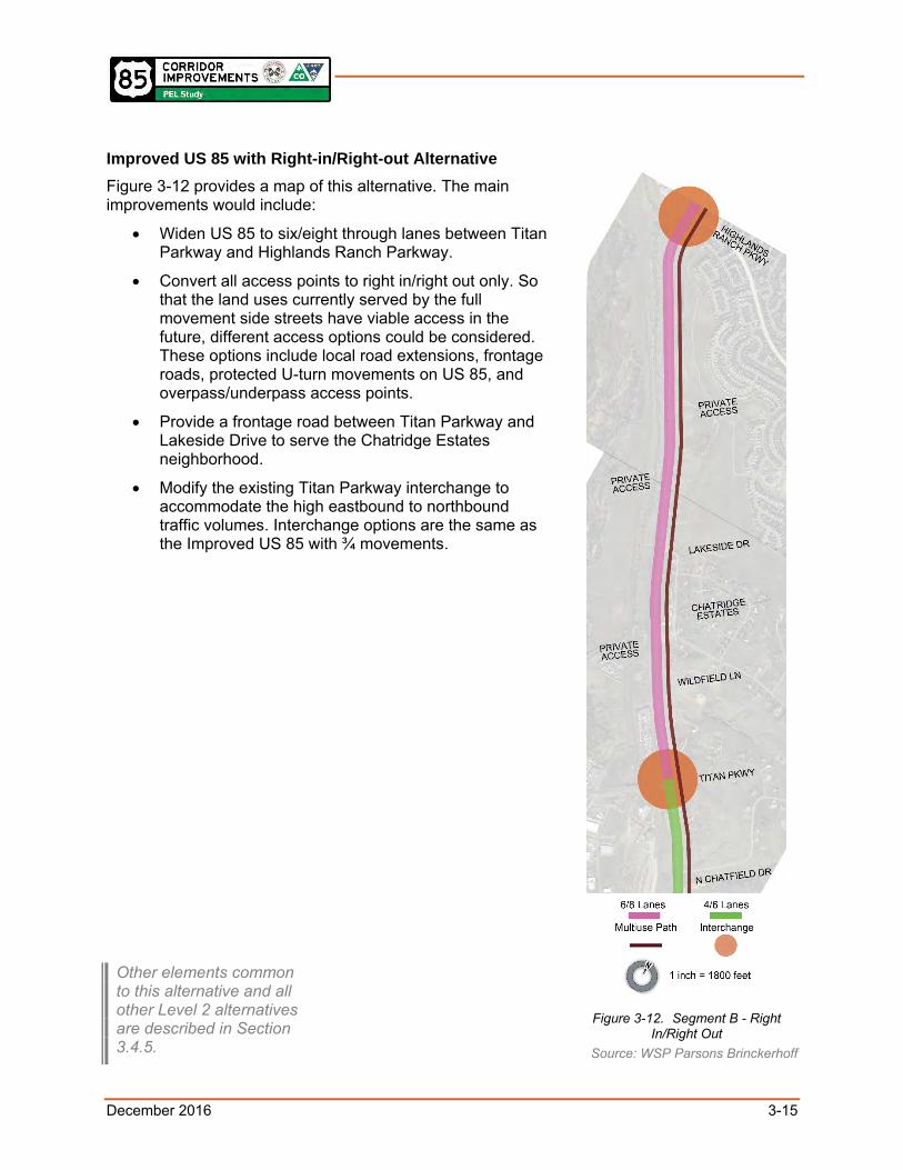
Improved US 85 with Right-in/Right-out Alternative
Figure 3-12 provides a map of this alternative. The main improvements would include:
Widen US 85 to six/eight through lanes between Titan Parkway and Highlands Ranch Parkway.
Convert all access points to right in/right out only. So that the land uses currently served by the full movement side streets have viable access in the future, different access options could be considered. These options include local road extensions, frontage roads, protected U-turn movements on US 85, and overpass/underpass access points.
Provide a frontage road between Titan Parkway and Lakeside Drive to serve the Chatridge Estates neighborhood.
Modify the existing Titan Parkway interchange to accommodate the high eastbound to northbound traffic volumes. Interchange options are the same as the Improved US 85 with ¾ movements.
Figure 3-12. Segment B - Right
In/Right Out Source: WSP Parsons Brinckerhoff
Other elements common to this alternative and all other Level 2 alternatives are described in Section 3.4.5.

December 2016 3-16
Segment C (SH 67 to Titan Parkway) 3.4.3Four Lane US 85 with Access Options Alternative Figure 3-13 provides a map of this alternative. The main improvements would include:
Provide four/six through lanes.
Provide improved intersection design (based on one of these possible options):
o Maintain the existing signalized intersections at SH 67, Delva Way, and Airport Road; and provide additional through lanes and turn lanes, as needed, at intersections to accommodate future volumes.
o Provide additional capacity with continuous flow intersections.
o Provide grade-separated interchange at Airport Road.
Maintain the other existing access points.
Figure 3-14 illustrates an offset diamond interchange option at Airport Road shifted east to accommodate the necessary number of lanes, while minimizing impacts to the parcels just west of US 85.
Figure 3-13. Segment C
Source: WSP Parsons Brinckerhoff
Figure 3-14. Example of Offset Diamond Interchange
Source: WSP Parsons Brinckerhoff
1 inch = 800 feet
Other elements common to this alternative and all other Level 2 alternatives are described in Section 3.4.5.

December 2016 3-17
Level 2 Alternative Horizontal Alignment Analysis 3.4.4This section describes how each of the previously described alternatives would be placed in the US 85 Corridor.
For the Segment A Expressway Alternatives and the Expressway with Standalone Intersections Alternative, three widening options were considered. The first option would place all of the widening on the west side. The second option would widen the highway equally to both the west and the east. Finally, the third option would place all of the widening on the east side. A conceptual design was developed for each option, and the right-of-way impacts were assessed. This option that would place all of the widening to the east would require 20-30 property acquisitions; the option that has the widening to the west would require 30-40 acquisitions; and the option that would have the widening on both sides would require 40-50 acquisitions. In addition, there was concern that any widening to the west would potentially affect more buildings and that replacement property for the properties impacted would be difficult to find. This area is already limited by the railroad to the west, US 85 to the east, and the High Line Canal traversing through the middle. Based on this analysis, the option that places all of the widening to the east was carried forward to Level 2 screening.
For the Segment A One Way Pair Alternative, two options for the new southbound roadway were considered. The first option would place the southbound roadway on the west side of the railroad corridor and the second option would place it on the east side of the railroad corridor. A conceptual design was developed for each option, and a comparative analysis was conducted. Based on this analysis, the option that would place the southbound roadway on the east side of the railroad corridor was carried forward to Level 2 screening. This option would require fewer property acquisitions (40-50 versus 55-65), would be less expensive ($75-$85 million versus $125- million), and would have less impact on the Chatfield State Park (5.5-6.5 acres required versus 7-8 acres).
For the Segment A Bypass Alternative, two options for the new roadway were considered. The first option places the new alignment west of the railroad corridor, and the second option places it east of the railroad corridor. Again, a conceptual design was developed for each and the potential impacts were assessed. Based on this assessment, the option that places the new alignment on the east side of the railroad corridor was carried forward to Level 2 screening. This option requires basically the same number of property acquisitions (40-50 versus 45-55), is less expensive ($105-$115 million versus $155-$165 million), and has less impact on the Chatfield State Park (2.5-3.5 acres required versus 8.5-9.5 acres).
In Segment B, widening US 85 to six lanes had already been accounted for by the current cross-section and placement of the existing retaining walls. The concept would convert the existing shoulders to an additional through lane in each direction and then construct new shoulders. If Segment B ever requires eight through lanes, this widening would have to be on the east side because of the proximity of the railroad to the west. Because the six-lane scenario appears most likely, this was carried forward to Level 2 screening.
In Segment C, any widening to provide more than four through lanes would likely be to the east because of the proximity of the railroad to the west. At Airport Road, an offset diamond interchange and an alignment shift to the east are shown as an option because of the railroad constraint to the west and were carried forward to Level 2 screening.

December 2016 3-18
Common Elements to All Alternatives 3.4.5Based on the FEIS/ROD recommendations, all of the previously described alternatives include these common elements: transit service enhancements, sidewalks where applicable, a multiuse path for bicyclists/pedestrians on the east side of US 85 along the entire length of the corridor, grade-separated wildlife crossings as described in Appendix D, permanent water quality treatment, and US 85/C-470 interchange improvements. The US 85/C-470
interchange improvements for the northbound US 85 to westbound C-470 movement include either a directional flyover ramp (Figure 3-15) or a continuous flow intersection (Figure 3-16); six-lane bridge over C-470; a grade-separated crossing for the existing C-470 multiuse trail under US 85 just south of the interchange; and a north-south bicycle/pedestrian crossing over C-470 to connect up to at least County Line Road.
In addition, all of the alternatives could accommodate all of the ideas that were advanced from Level 1, including managed lanes, autonomous vehicles, commuter rail, light rail transit, and park-n-ride facilities. The following provides a description of each and their applicability to US 85. All ideas should be advanced to the subsequent NEPA process.
Managed Lanes – Typically, managed lane facilities are a “highway within a highway” where a set of lanes within the overall cross-section is separated from general purpose lanes. The intent is to incorporate a high degree of operational flexibility so that over time operations can be actively managed to respond to growth and changing needs. There are three managed lane types (pricing, vehicle eligibility, and access control). One of
Figure 3-15. Rendering of Flyover from Northbound US 85 to Westbound C-470
Source: WSP Parsons Brinckerhoff
Figure 3-16. Rendering of Partial Continuous Flow Intersection from Northbound US 85 to Westbound C-470
Source: WSP Parsons Brinckerhoff

December 2016 3-19
these managed lane types is used to continuously achieve an optimal condition. When US 85 needs to be widened to meet the demand, a decision will have to be made whether the new capacity is general purpose or managed lanes. Managed lanes can provide a faster and more reliable trip for buses, thereby improving ridership for transit. Managed lanes can generate revenue and promote higher occupancy vehicles. In addition, because managed lanes are being added to C-470, managed lanes on US 85 could directly connect to a managed lane system.
Autonomous Vehicles – An example of a promising emerging technology is autonomous vehicles. These are vehicles that are capable of sensing their environment and navigating without human input. In terms of benefit, roadway capacity may double in a situation with all autonomous vehicles, and substantial gains are possible even at lower participation levels.
Commuter Rail – This form of passenger rail serves longer distances and typically shares tracks or right-of-way with freight trains. This service is characterized as having higher speeds, lower frequency, and fewer stations along the line. Per the FEIS/ROD, this concept is compatible with all of the US 85 build alternatives, but further study is required to determine if the transit ridership would be high enough to eliminate the need for future additional roadway capacity.
Light Rail Transit (LRT) – The Southwest Extension project will extend the Southwest Corridor light rail 2.5 miles from Mineral Avenue to Lucent Boulevard in Highlands Ranch. The FEIS/ROD raised the idea that it may make sense to extend LRT to the south within or adjacent to the US 85 Corridor. If this were to happen, both the One Way Pair and the Bypass Alternatives would best accommodate this new line since they have new alignments. The extension of LRT south of Highlands Ranch Parkway, however, would be difficult because of limited right-of-way. The proximity of the railroads west of US 85 and the topography on the east constrain the corridor.
Park-n-Rides – Several park-n-ride sites have been discussed for the corridor. One is located at Highlands Ranch Parkway. Another is in the vicinity of Titan Parkway. All of the US 85 alternatives are compatible with any potential park-n-ride location.
Level 2 Screening Criteria Methodology 3.4.6The Level 2 Screening used the criteria listed below to provide both a qualitative and comparative analysis of the alternatives. A “good/fair/poor/unsatisfactory” response was given for each criterion to provide some idea of relative effectiveness. This qualitative assessment was based on engineering judgment and sketch-planning analysis.
1. Provides Long-Term Capacity and Operational Solutions for US 85 – Assess the extent to which an alternative helps reduce future vehicular congestion on US 85.
Good if meets capacity needs with little or no traffic operational issues.
Fair if meets capacity needs with minimal traffic operational issues.
Poor if meets capacity needs with potential for major traffic operational issues.
Unsatisfactory if does not meet capacity needs or has major traffic operational issues.

December 2016 3-20
2. Results in Improved Travel Safety – Assess the extent to which an alternative addresses identified safety problems in the US 85 Corridor.
Good if left turn conflicts are eliminated.
Fair if left turn conflicts exist but only have to cross 2 through lanes.
Poor if left turn conflicts exist but have to cross 3 or more through lanes.
Unsatisfactory if left turn conflicts exist and the through lanes are over capacity.
3. Provides Reasonable Access Management – Assess the compatibility of the access to the functional characteristics of the roadway, the ability to consolidate access points where necessary, and the need for out-of-direction travel.
Good if reasonable access is provided.
Fair if reasonable access is restricted with minimal out-of-direction travel.
Poor if reasonable access is restricted with major out-of-direction travel.
Unsatisfactory if reasonable access would no longer exist.
4. Expands Multimodal Options for All People – Assess the extent to which an alternative provides transportation options to vehicular travel and user experience.
Good if fixed guideway transit and bike/ped facility can be added with little impact.
Fair if bus service and bicycle/pedestrian facility can be accommodated with little impact.
Poor if bus service is expected to operate in congested conditions.
Unsatisfactory if bicycle/pedestrian facilities are one-dimensional and not continuous.
5. Accommodates Land Use Goals and Plans – Assess how well the alternative complies with or clearly supports local and regional land use goals and plans.
Good if adequate capacity is provided to meet future travel demands based on established land use goals and plans.
Fair if capacity does not meet future peak hour travel demands based on established land use goals and plans.
Poor if capacity does not meet future peak hour and shoulder travel demands based on established land use goals and plans.
Unsatisfactory if capacity does not meet daily travel demands based on established land use goals and plans.
6. Enhances Life/Safety for Area Residents – Assess the extent to which an alternative improves the response time for emergency vehicles and provides a reliable alternate route.
Good if there are no changes to the approved Final US 85 Access Management Plan, South I-25 Corridor and US 85 Corridor EIS (CDOT 2001).

December 2016 3-21
Fair if access becomes more restricted but special provisions are made for emergency vehicles.
Poor if emergency vehicles are required to go one mile or less out of direction to gain access.
Unsatisfactory if emergency vehicles are required to go greater than one mile out of direction to gain access.
7. Supports the Preservation of the Environment – Assess the extent to which the project would minimize impacts on trails, floodplains, wetlands and waters of the U.S., endangered species habitat, historic properties, Section 4(f) properties, right-of-way acquisition/relocation, noise, and air quality.
Good if no environmental impacts are expected.
Fair if all improvements are within existing right-of-way, thereby minimally changing the impact to nearby environmental resources.
Poor if use of the existing right-of-way is maximized but some new land is required that could moderately impact environmental resources.
Unsatisfactory if substantial new land is required for improvements that could substantially impact environmental resources.
8. Creates a Sustainable Solution – Assess the extent to which an alternative can use best management practices and creative/innovative solutions.
Good if all social, economic, and environmental principles can be met or exceeded.
Fair if all social, economic, and environmental principles can be met.
Poor if it is a viable long-term solution but causes impacts.
Unsatisfactory if it is not a long-term solution.
9. Ensures Implementation – Assess the ability to use existing facilities and not disrupt railroad infrastructure.
Good if no new right-of-way is required and railroad is not impacted.
Fair if new right-of-way is required but railroad is not impacted.
Poor if new right-of-way is required and railroad is impacted.
Unsatisfactory if project cannot be phased.
Recommendations of Level 2 Screening 3.4.7Table 3-2 summarizes the qualitative results and the rationale of the Level 2 screening (the full rationale is provided in the following sections).
3.4.7.1 Segment A (Highlands Ranch Pkwy to County Line Road) In Segment A, it was recommended the following three alternatives be advanced to Level 3.
Expressway with Standalone Intersections: This alternative would meet the Purpose and Need, would provide an acceptable level of capacity, and would improve travel safety.

December 2016 3-22
One Way Pair: This alternative would meet the Purpose and Need, would provide an acceptable level of capacity, and would improve travel safety.
Bypass: This alternative would meet the Purpose and Need, would provide an acceptable level of capacity, and would improve travel safety.
These three alternatives provide different approaches that will highlight the advantages and disadvantages of each in Level 3.
The concept of the Expressway with Standalone Intersections Alternative is a split diamond with frontage roads connecting the south end of the diamond at Highlands Ranch Parkway to the north end of the diamond at Town Center Drive with frontage roads. The frontage roads also maintain the possibility of local access to the properties and local streets between those two expressway access points. Providing access along lower-speed frontage roads is safer than along higher-speed multilane facilities.
The other Expressway Alternative that was assessed and not advanced to Level 3 included independent diamond interchanges at Highlands Ranch Parkway and Town Center Drive (Expressway Alternative in Table 3-2). This concept was not advanced because the proposed interchange spacing causes operational, safety and access concerns. Between Highlands Ranch Parkway and Town Center Drive there is not enough distance to meet CDOT requirements for safe merge weave movements due to limited spacing between the on ramp and off ramp merge points. While this alternative would likely have fewer environmental impacts due to less right-of-way needed for additional interchanges and secondary roads, all driveways and secondary road access would have to be closed because they would conflict with the interchange ramps. The effect of driveway and secondary road closures would be severe on current economic conditions and on future land uses in this area.
3.4.7.2 Segment B (Titan Parkway to Highlands Ranch Parkway) In Segment B, the Improved US 85 (widening to six lanes and potentially a future phase up to eight lanes) with Right-in/Right-out Alternative was recommended. To accommodate the forecasted volumes on US 85, this segment of the highway must be converted to an expressway, which eliminates all left-turning traffic. So that the land uses currently served by full-movement intersection side streets have viable access in the future, different access options could be considered. These options include local road extensions, frontage roads, protected U-turn movements on US 85, and underpass access points.
The Improved US 85 with ¾ Movements Alternative was not recommended because of safety concerns. There would not be adequate gaps for left-turning traffic to safely cross three travel lanes. The speed differential between a stopped car trying to make a left turn and traffic traveling at the speed limit in three through lanes was also a concern.
3.4.7.3 Segment C (SH 67 to Titan Parkway) In Segment C, the Four Lane US 85 with Access Options Alternative (widening to four lanes and potentially a future phase up to six lanes) was advanced to Level 3. Based on the 2050 horizon year, travel demand steadily increases based on the full Chatfield Basin build-out, as shown in Figure 6-3. This alternative is anticipated to provide adequate capacity. Should four lanes not adequately address capacity issues, an evaluation should be conducted for six through lanes from SH 67 to Titan Parkway.

December 2016 3-23
Table 3-2. Level 2 Results and Rationale

December 2016 3-24
3.5 Level 3 Screening Level 3 screening was a more detailed and quantitative analysis of the alternatives remaining after the Level 2 screening.
To facilitate this evaluation, conceptual designs were developed for the corridor mainline alternatives from SH 67 to County Line Road. Conceptual interchange designs were also developed for Blakeland Drive, Town Center Drive, Highlands Ranch Parkway, Titan Parkway, and Airport Road. All of the conceptual designs used existing topographic base mapping and survey information where available. The designs were based on current design standards and done in a context sensitive manner to respect physical constraints and environmental concerns. They incorporated the elements that were common to all alternatives described in Section 3.4.5. These Level 3 designs are illustrated in Appendix E.
The Level 3 screening used criteria that considered the balance between capacity needs, safety, property and environmental impacts, and implementation.
The environmental resources that are described in Chapter 4.0 of this report were reviewed to determine which of these would show a difference among the alternatives. The ones that would differentiate were then used in the Level 3 screening. These included:
Right of way impacts
Park property and open space
Wetlands
Waterways
Prairie dog impacts
Potential environmental justice impacts
Accommodates wildlife crossings
The actual values for these impacts are shown in Table 3-5 Level 3 Screening Interchange Detailed Results and Rationale.
Level 3 Screening Criteria Methodology 3.5.1This section shows screening criteria, measure of effectiveness, and quantitative metrics for the Level 3 screening. The criteria selected for evaluation were those that would be differentiating factors between alternatives. A “good/fair/poor/unsatisfactory” response justification was provided for each criterion based on a quantitative analysis.
1. Provides Long-Term Capacity
Mainline and/or interchange LOS
Good if LOS C or better
Fair if LOS D
Poor if LOS E
Unsatisfactory if LOS F

December 2016 3-25
Peak hour cross-street LOS and delay
Good if LOS C or better
Fair if LOS D
Poor if LOS E
Unsatisfactory if LOS F
2. Results in Improved Safety
Roadway crash reduction (based on DRCOG Crash Reduction Criteria)
Good if crash reduction is greater than 40%
Fair if crash reduction is between 20% and 40%
Poor if crash reduction is less than 20%
Unsatisfactory if there is no reduction in crashes The crash reduction percentage estimate was derived by using the DRCOG Crash Reduction (Safety) Criteria. This process is an evaluation criterion for roadway projects to estimate the reduction in the number of crashes. This analysis includes roadway data (roadway study area length and average travel volumes), the number of crashes over a five year period of time, and the estimated reduction in the number of crashes based on various proposed improvement characteristics (e.g. grade separation, raised medians, etc.).
3. Provides Reasonable Access
Distance for out-of-direction travel
Good if out-of-direction travel is one mile or less
Poor if out-of-direction travel is more than one mile
4. Expands Multimodal Options
Bicycle/Pedestrian comfort level
Good if Level of Traffic Stress (LTS) is 1
Fair if LTS is 2
Poor if LTS is 3
Unsatisfactory if LTS is 4 The assessment of the alternatives was based on the qualitative application of LTS principles. Because the facility is shared by bicyclists and pedestrians, the assumption was that the LTS rating is applicable to both user types. The bicycle LTS methodology measures and assesses a bicycle facility’s comfort level for cyclists based on its exposure and separation from vehicular traffic, speeds of adjacent vehicular traffic, and quality of bicycle infrastructure at intersections.
5. Supports Land Use Goals and Plans
Right-of-Way impacts
Good if no acquisitions are anticipated to occur
Fair if only partial acquisitions are anticipated to occur
Poor if less than eight full acquisitions are anticipated in some scattered areas to non connected parcels

December 2016 3-26
Unsatisfactory if more than eight full acquisitions are anticipated to connected parcels in a specific area
6. Minimizes Impacts to the Environment
Park property and open space impacts
Good if no parks or open space are impacted
Poor if parks or open space are impacted
Wetlands and waters of the U.S. impacts
Good if no wetlands and waters of the U.S. are impacted
Poor if wetlands and waters of the U.S. are impacted
Prairie dog town impacts
Good if no prairie dog town colonies are impacted
Poor if prairie dog town colonies are impacted
Potential environmental justice impacts
Good if no impacts will occur
Fair if impacts are unlikely
Poor if impacts are possible
Unsatisfactory if impacts are likely
Accommodates wildlife crossing needs
Good if the alternative could accommodate the potential wildlife crossing locations and design features as recommended in the US 85 Wildlife Crossing Assessment
Poor if the alternative could not accommodate the potential wildlife crossing locations and design features as recommended in the US 85 Wildlife Crossing Assessment
7. Creates a Sustainable Solution
Reduction of throw-away
Good if the alternative uses 75-100% of existing investment
Fair if the alternative uses 50-74% of existing investment
Poor if the alternative uses 25-49% of existing investment
Unsatisfactory if the alternative uses 0-24% of existing investment
8. Ensures Implementation
Total project costs (design, construction, and contingency)
Good if the total project cost of an alternative or individual intersection option is anticipated to equal or cost less than the FEIS/ROD No-Action Alternative recommendation (i.e., not constructing beyond FEIS/ROD recommended action)
Fair if total project costs are anticipated to cost less than $60M
Poor if total project costs are anticipated to cost between $60M and $120M
December 2016 3-27
Unsatisfactory if project costs are anticipated to cost more than $120M
Maintenance of traffic during construction
Good if at least 75% of No-Build capacity is maintained during construction
Poor if less than 75% of No-Build capacity is not maintained during construction
During final documentation of the Level 3 alternatives, it was observed that the average travel time measure of effectiveness related to emergency response had some redundancy with delay. Additionally, emergency response agencies may relocate before implementation of any PEL-recommended modifications. Therefore, it was determined inappropriate to include emergency response time as a separate measure of effectiveness in the Level 3 screening process, and it was removed.
Recommendations of Level 3 Screening 3.5.2
3.5.2.1 Segment A (Highlands Ranch Pkwy to County Line Road) In Segment A, the Expressway with Standalone Intersections (renamed to Enhanced Expressway) and the Bypass Alternatives were recommended, and the One Way Pair Alternative was feasible but not recommended. The Enhanced Expressway was recommended because it is expected to operate at LOS D during the AM and PM peak hours. LOS is a qualitative measure used to describe the condition of traffic flow and delay, ranging from excellent conditions at LOS A to very poor conditions at LOS F. LOS D is commonly used as the minimum acceptable condition. With this alternative, a 25 percent reduction in crashes is expected and out-of-direction travel would be less than one mile, which meets the requirements of the State of Colorado State Highway Access Code, Volume 2 (Transportation Commission 1998). In terms of impact, this alternative would result in 24 property acquisitions and would require approximately 3 acres of parkland. The estimate of probable cost is $69 million as shown in Appendix G.
The Bypass Alternative’s performance would be very similar to the Enhanced Expressway Alternative. It is expected to operate at LOS D during the AM and PM peak hours, has a 25 percent reduction in crashes, and out of direction travel is less than one mile. It would, however, result in more acquisitions (approximately 46), would require slightly more parkland (approximately 3 acres), and the cost would be almost 60 percent higher ($108 million). It is recommended because it can be constructed with little or no disruption to future traffic on US 85. It would also maximize the proposed investment to US 85 (six through lanes with continuous flow intersections) because the bypass can be sized to add just the required capacity for the corridor.
The One Way Pair Alternative also is expected to operate at LOS D in the AM and PM peak hours. The reduction in crashes, however, would be much better when compared to the other two alternatives (45% versus 25%). Out-of-direction travel would be greater than one mile and would not meet State of Colorado State Highway Access Code requirements. This alternative would result in approximately 46 property acquisitions, which is the same as the Bypass Alternative, but would require approximately 6 acres of parkland, which is over twice as much as the other two alternatives. The estimate of probable cost is between the other two alternatives at
The Expressway with Standalone Intersections from the Level 2 screening was renamed to Enhanced Expressway in Level 3 after the alignment shift was established and specific access options were refined from Highlands Ranch Parkway to Town Center Drive.
December 2016 3-28
$82 million. This alternative is feasible but not recommended because it is not compatible with the improvements identified in the FEIS/ROD. With a one way pair, the existing alignment of US 85 would only serve northbound traffic, and the roadway capacity would be much greater than the demand. The one way pair also would result in much greater out-of-direction travel, and would have a higher peak hour cross-street delay compared to the other alternatives in this segment.
3.5.2.2 Segment B (Titan Parkway to Highlands Ranch Parkway) The Segment B alternative includes six/eight through lanes, converting all access to right in/right out, overpass/underpass access points, a frontage road between Titan Parkway and Lakeside Drive, and a modified Titan Parkway interchange. In Segment B, the analysis focused on interchange concepts at Titan Parkway. The directional ramp option to serve eastbound traffic on Titan Parkway to northbound traffic on US 85 is recommended, the continuous flow intersection on the Titan overpass is feasible, and the partial cloverleaf interchange is not recommended. For both the directional ramp option and the continuous flow option, the critical eastbound to northbound traffic movement is expected to operate at LOS B.
The partial cloverleaf option was not recommended because it would require more right-of-way acquisitions for the larger footprint of the cloverleaf, some of which would likely create an impact on park land in Chatfield East Park just east of the current intersection.
The estimate of probable cost for the continuous flow option is $51 million and the directional ramp option is almost 20 percent higher at $60 million. Both alternatives are feasible, and more detailed study and design in subsequent phases are needed before a Selected Alternative can be identified.
3.5.2.3 Segment C (SH 67 to Titan Parkway) The Segment C alternative includes four/six through lanes, improved intersection design, and maintaining existing access points. In Segment C, the at-grade alternative at Airport Road is recommended, and the grade-separated interchange is feasible. Again, both alternatives are feasible, and more detailed study and design are needed before a Selected Alternative can be identified.
3.5.2.4 Results of Level 3 Screening Table 3-3 (mainline analysis) and Table 3-4 (interchange analysis) provides the results and rationale of the Level 3 screening based on the metrics developed and listed above. A draft version of these tables was presented during a public meeting as part of the public involvement process, but have since been refined based on additional analyses. The results were not weighted, and the criteria was used based on the applicability towards the Purpose and Need. Because this study focuses on post 2050, ranges were sometimes used when determining impacts and costs.
All applicable technical quantitative data analysis results can be found in Table 3-5. All Level 3 analyses were completed based on 8 lanes in Segment A, and 6 lanes in Segments B and C. This was done in order to understand potential impacts based on the largest possible footprint.
In some instances, the screening results were modified based on value engineering, known conditions, and assumptions based on the level of the analysis conducted. These are explained in the notes below the table.

December 2016 3-29
Table 3-3. Level 3 Screening Mainline Results and Rationale

December 2016 3-30
Table 3-4. Level 3 Screening Interchange Summary Results and Rationale

December 2016 3-31
Table 3-5. Level 3 Screening Interchange Detailed Results and Rationale


December 2016 3-32
3.6 Alternatives to be Advanced to NEPA The screening determined whether an alternative was recommended, feasible, or not recommended. Recommended Alternatives are those that performed best based on all three levels of screening. Feasible alternatives did not perform as well as the recommended, but could be revisited in the subsequent NEPA process if conditions change. Not recommended alternatives should not be revisited because they have fatal flaws that prevent them from being acceptable for this corridor.
Of the six mainline alternatives, five are recommended:
No-Action Alternative – FEIS/ROD Selected Alternative
Segment A - Enhanced Expressway (east side alignment)
Segment A - Bypass
Segment B - Improved US 85 with Right-in/Right-out (six/eight through lanes with access controls and intersection/interchange enhancements)
Segment C – Four Lane US 85 with Access Options (four/six lanes with access controls and intersection/interchange enhancements
One is feasible:
One Way Pair
None are eliminated.
Of the five interchange/intersection options in Segments B and C, two are recommended:
Directional Ramp (Titan Parkway)
At-Grade (Airport Road)
Two are feasible:
Continuous Flow (Titan Parkway)
Diamond Interchange (Airport Road)
One is not recommended:
Partial Cloverleaf (Titan Parkway)
In addition, all of the Recommended Alternatives can accommodate the additional ideas that were advanced through the PEL study, including managed lanes, autonomous vehicles, commuter rail, light rail transit, and park-n-ride facilities. These ideas should all be advanced to the subsequent NEPA process.
After the Level 3 screening was conducted, a continuous flow intersection design option from northbound US 85 to westbound C-470 was introduced, and needs to be analyzed further. This design option should be included in future analysis of this corridor. Upon cursory review, this design options seems more compatible for the Enhanced Expressway Alternative, but not the Bypass Alternative due to merging movements.
During review of this PEL study, CDOT suggested that additional analysis in subsequent NEPA phases be done to examine optimal traffic through-put of each intersection in Segment A. This

December 2016 3-33
should include an analysis of right-of-way impacts, short- and long-term construction costs (including utility relocation), constructability (i.e., time and traffic disruption), operations and maintenance costs, and any other relevant factors. The purpose of this examination is to understand and rank optimal design for traffic efficiency within this segment of US 85 at each major intersection.
3.7 Alternatives Access Assumptions Appendix F contains the a summary of access management developed for each segment of the corridor, with the access points and movements for existing conditions, the FEIS/ROD No-Action Alternative from the Final US 85 Access Management Plan, South I-25 Corridor and US 85 Corridor EIS (CDOT 2001), and for the recommended mainline alternatives developed for this PEL study— Enhanced Expressway, One Way, and Bypass. The illustrations show that appropriate access is provided for each alternative. The access options shown are conceptual, and should be revisited in a subsequent NEPA process.

December 2016 4-1
4.0 ENVIRONMENTAL RESOURCES
This section summarizes existing conditions in the study area, discusses potential impacts associated with implementation of the Recommended Alternatives, identifies potential mitigation, and begins to define what steps will be needed when a NEPA process is undertaken. Please note that the impacts discussed for each resource are based on very high-level, conceptual-level design. As the design is advanced and refined during the subsequent NEPA process, some impacts could change.
For more information on environmental resources, refer to Appendix H, pages 30 to 85 of the PEL Study Existing Conditions Report.
4.1 Primary Findings Summary The primary findings from the environmental analysis are summarized in Table 4-1.
The PEL Study Existing Conditions Report in Appendix H and the FEIS/ROD plus the Technical Reports supporting these documents were primary sources of information.
Table 4-1. Primary Findings
Resource Methodology/ Data Source Used
Present in Study Area?/Impacts
Next Steps
Floodplains Secondary data from the Federal Emergency Management Agency
Yes/Yes Finalize impact assessment.
Coordinate with Douglas County for floodplain permitting.
Prepare technical report in compliance with Executive Order 11988.
Wetlands and other Waters of the U.S.
Secondary data from FEIS/ROD plus high-level field review
Yes/Yes Conduct wetland delineation and wetland functional assessment.
Examine practicable alternatives to avoid or minimize wetland impact.
Prepare full impact assessment, followed by Wetland Finding and FACWet analysis if needed.
Coordinate with USACE.

December 2016 4-2
Table 4-1. Primary Findings
Resource Methodology/ Data Source Used
Present in Study Area?/Impacts
Next Steps
Vegetation and Noxious Weeds
High-level field review
Yes/Yes Conduct more detailed field review plus survey of riparian vegetation.
Prepare Noxious Weed Management Plan.
Coordinate with Colorado Parks and Wildlife (CPW) for SB 40 impacts and mitigation.
Threatened and Endangered Species and Other Wildlife
Secondary data from the U.S. Fish and Wildlife Service (USFWS) plus high-level field review
Used CPW data for mapping of Preble’s habitat, coordinated with CPW relative to Chatfield State Park impacts and wildlife connectivity issues
Yes/Yes Conduct full field survey.
Work with engineering team to incorporate recommendations for wildlife crossings (see Appendix D).
Prepare full impact assessment.
Prepare Biological Assessment.
Coordinate with USFWS and CPW.
Enter into Section 7 consultation if needed.
Cultural Resources
Secondary data from State Historical Preservation Officer (SHPO) and high-level field review
Yes/Yes Conduct full field survey.
Obtain agreement from SHPO on the Area of Potential Effects.
Determine effects and submit to the SHPO for concurrence.
If adverse effects, work with SHPO to resolve mitigation through a Memorandum of Agreement.
Hazardous Materials
Secondary data from federal and state environmental databases (Geosearch) and historical records, plus field survey
Yes/Yes Prepare Modified Environmental Site Assessment (MESA).

December 2016 4-3
Table 4-1. Primary Findings
Resource Methodology/ Data Source Used
Present in Study Area?/Impacts
Next Steps
Recreational Resources
High-level field survey
Yes/Yes Finalize site surveys.
Finalize impact assessment.
Determine if feasible and prudent alternatives exist, if necessary.
Determine Section 4(f) documentation requirements.
Coordinate with CDOT and FHWA to finalize Section 4(f) Evaluation.
Pedestrian and Bicycle, Traffic and Transit
Secondary data from CDOT traffic data, the Preliminary Safety Report for US 85, SH 67 – North (DiExSys, LLC 2015), and DRCOG, plus field data
Yes/Yes Redo traffic analysis using most recent model from DRCOG.
Determine how each NEPA project will accommodate transit and pedestrian/bicycle facilities.
Develop mitigation for any impacts identified.
Farmland Review of Natural Resources Conservation Service mapping
Yes/Yes Map farmland.
Determine impacts.
Fill out National Resources Conservation Service (NRCS) form and coordinate with NRCS, if necessary.
Noise Secondary data from the C-470 Corridor Revised Environmental Assessment, Kipling Parkway to I-25 (CDOT 2015b)
Yes/Yes Conduct FHWA Traffic Noise Model (TNM) using new plan and profile plus new future year traffic volumes.
Conduct feasibility and reasonableness analysis for noise abatement.
Coordinate with CDOT and FHWA for review of Noise Technical Report.

December 2016 4-4
Table 4-1. Primary Findings
Resource Methodology/ Data Source Used
Present in Study Area?/Impacts
Next Steps
Air Quality Secondary data from EPA Airdata database
EPA Airdata Database: http://www.epa.gov/airdata
Yes/Yes Review volumes and future LOS data for all intersections.
Coordinate with CDOT and Colorado Department of Public Health and Environment (CDPHE) Air Pollution Control Division to conduct hot spot modeling, if necessary.
Submit Air Quality Technical Report to CDOT, FHWA and CDPHE Air Pollution Control Division for review and sign-off.
Water Quality Secondary data from CDOT’s Erosion Control and Stormwater Quality Guide
Yes/Yes Finalize location of permanent water quality facilities.
Determine impacts.
Prepare Water Quality Technical Report for review by CDOT and FHWA.
Land Use Secondary data from the Douglas County 2035 Comprehensive Master Plan (Douglas County 2014), plus high-level field review
Yes/Yes Confirm impact assessment.
Visual High-level field review
Yes/Yes Conduct visual impact analysis.
Review CDOT’s US 85 Corridor C-470 to Castle Rock Aesthetic Study and Design Guidelines (CDOT 2002).
Social and Environmental Justice
Census data plus high-level field review
Yes/Yes Prepare impact assessment.
Determine if any impacts are high and adverse for Environmental Justice populations.
Conduct targeted outreach to low income and minority populations.
Right-of-Way and Economic
Secondary data from CDOT, plus high-level field review
Yes/Yes Prepare impact assessment.
Develop mitigation for any right-of-way impacts.
Cumulative Secondary data derived from all resources
Yes/Yes Prepare impact assessment.

December 2016 4-5
4.2 Resources Not Reviewed None of the resources received a NEPA-level analysis of existing conditions or impact assessment. Resources that were not considered even at a high level were paleontological, economics, and fisheries because they were not anticipated to be critical to the development or screening of alternatives.
4.3 Floodplains
Existing Conditions 4.3.1
4.3.1.1 Rivers and Other Waters of the U.S. Water resources in the study area include Plum Creek, Marcy Gulch, Spring Gulch, and several unnamed tributaries of Plum Creek.
4.3.1.2 Floodplains The study area is mapped in the Federal Emergency Management Agency
Digital Flood Insurance Rate program for Douglas County, with a small portion in Arapahoe County, effective date September 30, 2005. Plum Creek, Springs Gulch, and Marcy Gulch experience seasonal flooding. Plum Creek and Spring Gulch have experienced severe flood events in the past.
Impacts 4.3.2It is likely that these floodplains would be directly impacted by the Recommended Alternatives.
Mitigation 4.3.3Mitigation measures that could be considered include:
Limiting the extent of the widening and earthwork done to avoid impacts into the adjacent floodplain.
Possible modifications to the overbank areas to mitigate the impacts.
Next Steps 4.3.4During the subsequent NEPA process, the limits of the impact on the floodplain will need to be determined. Per Executive Order 11988, Floodplain Management, the project will need to avoid adverse impacts associated with the occupancy and modification of the floodplains. If there are impacts, the project must follow the process as described in Executive Order 11988. Coordination with Urban Drainage and Flood Control District, Douglas County, CDOT, and the U.S. Army Corps of Engineers will be required for all permitting.
If there are impacts, the Flood Insurance Rate Map will need to be revised by a Conditional Letter of Map Revision prior to construction and a Letter of Map Revision after construction.

December 2016 4-6
4.4 Wetlands and Waters of the United States
Existing Conditions 4.4.1Waters of the U.S. include wetlands and streams with an ordinary high water mark delineated by flowing and/or standing water. The FEIS/ROD identified 33 wetlands totaling 3.9 acres and 17 streams. The high-level field review conducted in August 2015 for this PEL Study did not attempt to quantify wetlands except to note where they occurred (in 24 locations) and that areas identified in the previous FEIS process still appeared saturated (Photo 4-1). No wetland delineations were done.
Impacts 4.4.2Direct and indirect wetland impacts would occur as US 85 is improved. As project plans are being developed, avoidance of wetlands and waters of the U.S. is recommended. If that is not possible, impacts should be minimized as much as possible.
Mitigation 4.4.3Mitigation measures that could be considered include:
Mitigate all impacts to wetlands, either by replacing them on site, creating a new wetland off site or by purchasing wetland credits.
Using CDOT’s standard mitigation techniques to protect wetlands during construction activities. These include such measures as fencing the edges of wetlands and protecting wetlands from pollutants generated during construction using erosion and sediment control best management practices (BMP).
Next Steps 4.4.4During the subsequent NEPA process, wetlands in the study area will be fully delineated and a Functional Assessment of Colorado Wetlands (FACWet) analysis done. FACWet is CDOT’s required analysis of functions for wetlands. A Wetland Delineation Report will be prepared and, if necessary, a Wetland Finding, to document compliance with Executive Order 11990, Protection of Wetlands. Documentation of the FACWet analysis is required if a project impacts 0.1 acre or more of wetland. Coordination is also required with the U.S. Army Corps of Engineers to review the Delineation Report and to issue any Section 404 permits, which could include amending the existing Individual Permit that was completed for the earlier implementation phases of the FEIS/ROD.
Photo 4-1. Palustrine emergent wetland. Looking south along US 85 at wetland W-5. Note the dominance of broadleaf cattail and narrowleaf willow, representative of vegetation growing within wetlands of the study area. Source: HDR

December 2016 4-7
4.5 Vegetation and Noxious Weeds
Existing Conditions 4.5.1The general habitat in the study area includes upland grassy/weedy roadside habitat (e.g., gambel’s oak), riparian and wetland habitat, and landscaped areas (Photo 4-2). Noxious weeds are present throughout the study area. A full listing of vegetation and noxious weed in the study area can be found in the PEL Study Existing Conditions Report (Appendix H).
Impacts 4.5.2The Recommended Alternatives would result in removal of vegetation to accommodate roadway widening. This would include riparian vegetation protected by Senate Bill 40 (SB 40). Construction activities would likely result in increased noxious weeds in the study area.
Mitigation 4.5.3Mitigation measures that could be considered include:
Use CDOT’s standard mitigation requirements for vegetation, including seeding with a native grass seed.
Use erosion and sediment control BMPs, such as implementing phased seeding and containing potential pollutants.
Ensure that materials used for the project are inspected and determined to be weed free.
Minimize the use of fertilizers.
Next Steps 4.5.4During the subsequent NEPA process, the study area will be surveyed for the presence of noxious weeds and riparian vegetation. If impacts to riparian vegetation occur, coordination with Colorado Parks and Wildlife (CPW) relative to compliance with SB 40 will be needed, and replacement of trees and riparian vegetation will be required. A Noxious Weed Management Plan will be prepared or will be assigned to the contractor to complete prior to and during construction.
4.6 Threatened and Endangered Species and Wildlife
Existing Conditions 4.6.1The U.S. Fish and Wildlife Service (USFWS) and CPW list numerous state and federally protected species that are known to occur in Douglas County.
Based on a preliminary review that did not identify exact locations, species with potential or suitable habitat in the study area include the Bald Eagle, Western yellow-billed cuckoo,
Photo 4-2. Typical right-of-way habitat containing a variety of noxious weeds. Source: HDR

December 2016 4-8
burrowing owl, ferruginous hawk, Preble’s meadow jumping mouse, black-tailed prairie dog, northern pocket gopher, common shiner, northern redbelly dace, Iowa darter, northern leopard frog, Ute ladies’ tresses orchid, and the Colorado butterfly plant. There is occupied habitat for Preble’s meadow jumping mouse along Plum Creek. One inactive raptor nest (possible a red-tailed hawk) was documented during a field review in August 2015. This nest was located just south of the Spring Gulch Equestrian Facility, north of Highlands Ranch Parkway. Active cliff swallow nests were observed under the bridge near McLellan Reservoir. There are active prairie dog towns in the study area.
The study area was examined for existing impediments to the US 85 crossing of wildlife with the intent of improving wildlife connectivity for mule deer and elk where possible and reducing wildlife-vehicle collisions throughout the corridor. The findings from this study are included in Appendix D.
Impacts 4.6.2The Recommended Alternatives would result in impacts to wildlife and potentially to threatened and endangered species and species of special status. Because new lanes are being added, US 85 would become a larger barrier to wildlife movement east and west. Impacts to riparian habitat along Plum Creek would be of most concern because that is likely habitat for Preble’s meadow jumping mouse (Photo 4-3).
Mitigation 4.6.3Mitigation measures that could be considered include:
Installation of wildlife underpasses and fencing would minimize the barrier effect to large and small mammals. Figure 4-1 and Appendix D includes the recommendations for 8 specific locations for these mitigation measures. These recommendations should be included in all future projects along US 85.
Use of BMPs during construction to minimize sedimentation.
Revegetation of disturbed areas, including replacement of riparian vegetation.
Avoidance of construction during nesting seasons, if occupied nests are observed.
Compliance with the CDOT Black-Tailed Prairie Dog Policy.
Next Steps 4.6.4During the subsequent NEPA process, a biological survey of special status species and riparian vegetation will be required. Coordination with the USFWS and CPW will be necessary.
If construction is planned to occur during the primary nesting season for migratory birds in Colorado (typically April 1 through August 31), a qualified biologist will resurvey the study area to verify if any active nests are present. If no active nests are present, then trees can be removed. However, if active migratory bird nests are identified and cannot be avoided by construction activities, the USFWS field office will be contacted to help determine the
Photo 4-3. There is occupied habitat for the Preble’s meadow jumping mouse along Plum Creek. Source: USFWS

December 2016 4-9
appropriate mitigation action. This may include removing nests before egg-laying begins or ceasing construction until all nestlings have fledged.
A presence/absence survey will be required that must be scheduled to coincide with the blooming period of known nearby populations of Ute ladies’-tresses orchid and the Colorado butterfly plant. Suitable habitat may occur along Plum Creek wetlands and/or riparian areas. Coordination with the USFWS and CPW will be required to determine potential impacts and mitigation for impacted species and/or habitat.
If a future project is to receive federal funding administered by CDOT, impacts to downstream species will be managed through an existing programmatic agreement between CDOT and USFWS. If this programmatic agreement is unavailable for use, additional consultation with USFWS would be required.
The recommended wildlife crossings, as shown in Appendix D, will be examined further in the subsequent NEPA process. Coordination with the USFWS and CPW will be required to confirm the recommended crossing locations. Figure 4-1 shows the recommended wildlife crossings.
4.7 Historic, Archaeological, and Paleontological Resources
Existing Conditions 4.7.1Based on a records search at the Office of Archaeology and Historic Preservation (OAHP), a windshield survey of the US 85 Corridor, and an on-line review of Douglas County Assessor’s data, the study area contains 70 previously identified and evaluated historic built resources. The study area also includes 26 previously identified archaeological resources. The windshield survey identified a potential additional 67 properties not included in OAHP records that are 45 years of age or older (Photo 4-4).
Impacts 4.7.2Direct impacts to historic and archaeological properties from the Recommended Alternatives would be expected. These could include property acquisitions, rerouting or extensions of canals or ditches, visual impacts, impacts to the setting of a historic property, or noise impacts.
No official Section 106 determination of eligibility or effects to these properties have been made.
Mitigation 4.7.3Mitigation measures that could be considered include:
Route construction traffic away from historic properties to avoid or minimize temporary visual and noise effects to these properties during construction.
Use retaining walls or other methods to minimize property acquisitions.
Retain or replant trees may help avoid or minimize visual and noise effects.
Photo 4-4. View of High Line Canal on the Highlands Ranch Mansion Property, circa 1930-37. Source: Douglas County History Research Center.
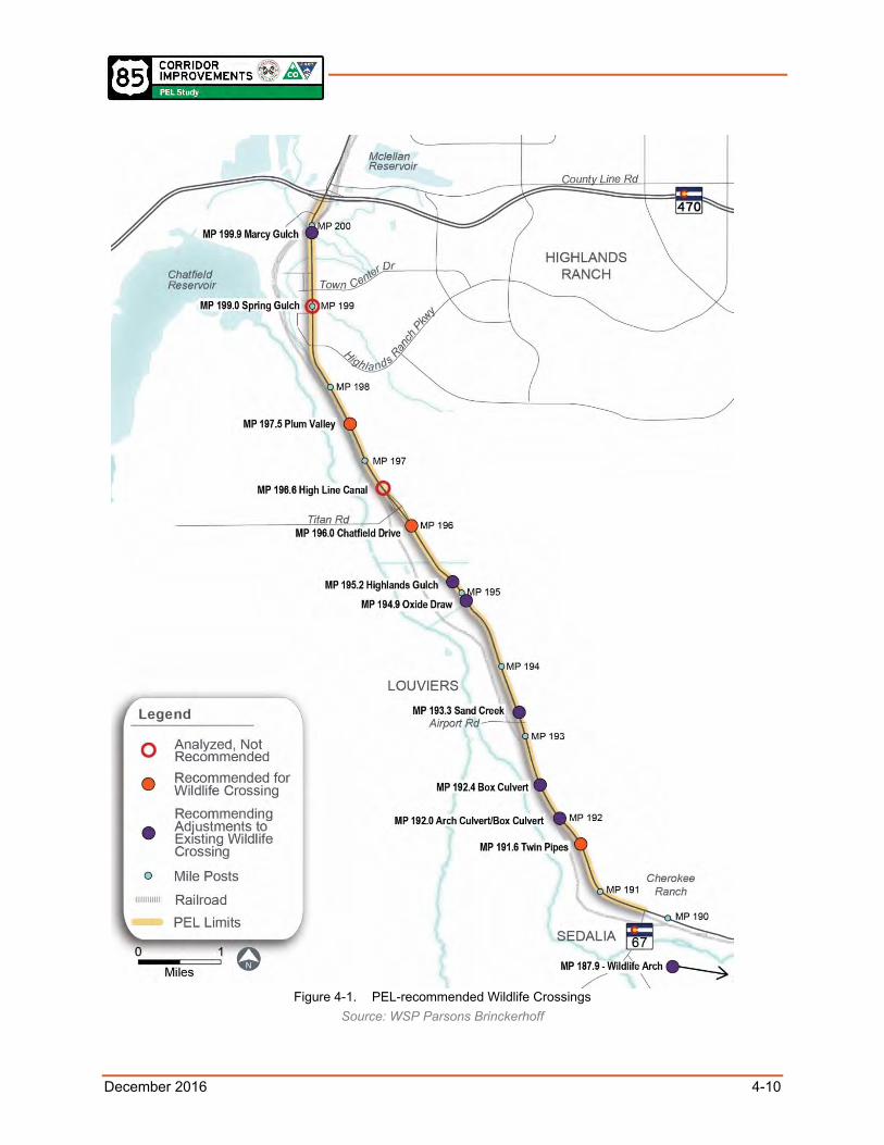
December 2016 4-10
Figure 4-1. PEL-recommended Wildlife Crossings
Source: WSP Parsons Brinckerhoff

December 2016 4-11
Next Steps 4.7.4During the subsequent NEPA process, steps that need to be followed include defining the proposed Area of Potential Effects, resurveying the Area of Potential Effects, and submitting eligibility and effects determinations for any historic or archaeological properties to the State Historic Preservation Office (SHPO) for review. Through consultation with SHPO, any potential adverse effects to historic properties would need to be avoided, minimized, or mitigated.
Archaeological sites and associated artifacts or materials may be unearthed during construction. In the event of an inadvertent discovery, work at the discovery should be halted immediately and CDOT and SHPO/the OAHP should be notified. Work should remain halted until the discovery can be investigated by a qualified professional archaeologist. Additional archaeological work may be necessary, including testing and data recovery, before work may be resumed and only after CDOT grants clearance.
4.8 Hazardous Materials
Existing Conditions 4.8.1Properties within the study area were evaluated to assess their potential to contain hazardous materials in the soil, groundwater, air, or building materials that could pose inhalation, dermal, or ingestion hazards to workers or the general public, or require special handling and disposal when removed from the property. The environmental database report identified 103 mappable listings and 3 unmappable listings.
Sites of greatest concern were identified in Table 8 of the Existing Conditions Report (HDR et. al. 2016). These sites include 5 Comprehensive Environmental Response, Compensation, and Liability Information System sites, 4 Resource Conservation Recovery Act sites, 4 hazardous waste sites, 27 LUST sites, and 18 solid waste facilities.
Impacts 4.8.2The Recommended Alternatives would likely result in property acquisition and disturbance of the soil and groundwater at some of these sites of concern. Construction workers could be exposed to airborne contaminants.
Mitigation 4.8.3Activities at sites containing hazardous materials are governed by Section 250 of the 2014 CDOT Construction Manual, Revised June 7, 2016 (CDOT 2016b). If complete avoidance of hazardous materials in the soil and groundwater is not possible, partial avoidance can minimize health risks.
Mitigation measures that could be considered include:
Per the 2014 CDOT Construction Manual, the contractor is required to prepare an appropriate health and safety monitoring program to protect workers from exposure to the contamination at these sites during construction.
If contaminants exceed safe worker exposure levels, workers must wear appropriate personal protective equipment.

December 2016 4-12
It is unlikely that contaminant levels from these sites would affect the general public, but this could be mitigated through measures designed by the contractor engineering controls.
The contractor will additionally prepare a material management plan (MMP) to address the proper handling and disposal of hazardous materials and contaminants.
Next Steps 4.8.4During the subsequent NEPA process, a Modified Environmental Site Assessment (MESA) should be undertaken.
4.9 Recreational Resources
Existing Conditions: Parks and Open Space 4.9.1There are 11 parks within the study area, as shown in Figure 4-2. These parks include:
Chatfield State Park
Fly’n B Park
Johnny’s Pond
Highlands Ranch Golf Club
Redstone Park
Spring Gulch Equestrian Area
Frisbee golf course
Plum Valley Park
Chatfield East Park
Wilderness area owned by Highlands Ranch Metropolitan District
Cherokee Ranch and Castle (Photo 4-5)
Chatfield State Park used funding from the Land and Water Conservation Fund; therefore, Section 6(f) protection will apply to this parcel.
Existing Conditions: Trails 4.9.2There are five trails that intersect US 85 or are adjacent to it. These trails include:
High Line Canal Trail
C-470 Trail (also called Centennial Bike Trail)
Plum Valley Trail
The East/West Regional Trail
Chatfield State Park trail system, which includes the Turtle Pond Trail and the Plum Creek Trail
Photo 4-5. Cherokee Ranch. Source: cherokeeranch.org.

December 2016 4-13
Figure 4-2. Recreational Resources in the Study Area
Source: HDR

December 2016 4-14
Impacts 4.9.3Direct impacts of property conversion from parks to transportation use could occur at any of the parks that are adjacent to US 85 or an access road that would be improved along with the Recommended Alternatives.
Indirect effects to parks and trails could include:
Increased noise because traffic lanes moved closer to receptors in the parks and on the trails.
Negative visual impacts of walls.
Positive visual effects of enhanced landscaping.
Enhanced access.
Increased use because of improved access.
Temporary impacts during construction would occur to all recreation facilities.
Mitigation 4.9.4Mitigation measures that could be considered include:
Use BMPs during construction to reduce impacts from sedimentation and noxious weed invasions.
Minimize property acquisition through the use of design techniques such as retaining walls.
Provide trail detours during construction.
Revegetate adjacent to parks and trails after construction.
Next Steps 4.9.5Because the parks and trails are protected by the U.S. Department of Transportation Section 4(f) Act, there are very specific next steps to be followed:
Confirm all Section 4(f) properties in the study area, both existing and planned.
Define uses of these properties.
If an individual Section 4(f) Evaluation is determined to be needed, determine if a feasible and prudent alternative exists. The definition of what constitutes a feasible and prudent alternative is contained in 23 CFR 774.17. If so, this will need to be selected.
Identify all possible planning measures to minimize harm to the properties.
Coordinate with the officials with jurisdiction over the property, CDOT, and FHWA.
Determine together with CDOT and FHWA the correct type of Section 4(f) documentation to pursue. Options could include an Individual Section 4(f) Evaluation, a de minimis impact, an enhancement exception, or a net benefit (because of the improved access and safety associated with wider walks). If an Individual Section 4(f) Evaluation is needed, feasible and prudent alternatives to the use of the property will be developed. For a de minimis impact or an enhancement exception, the official with

December 2016 4-15
jurisdiction will need to concur with the finding that the project does not adversely affect the attributes that qualify the properties for protection under Section 4(f).
Prepare documentation of Section 4(f) Evaluation in accordance with 23 CFR 774.
4.10 Farmlands The study area has pockets of land classified as prime farmland if irrigated.
Impacts to this land are likely, as the corridor is widened. Under the Farmland Protection Policy Act (FPPA), farmlands subject to FPPA requirements require a Farmland Conversion Impact Rating Form AD 1006 to be filled out with the quantity of the impacted farmland.
4.11 Noise
Existing Conditions 4.11.1Identified noise-sensitive land uses located within and near the study area include residential areas, schools, parks and open space areas, and churches. More densely developed residences and commercial and retain businesses are located near C-470 and I-25.
The primary existing noise source in the study area is traffic noise from US 85; however, train noise and aircraft noise are also heard. Noise levels were not measured as a part of this study; however, existing noise levels were observed to be consistent with rural and urban areas located in close proximity to highways carrying high volumes of traffic.
Noise levels were a concern that was expressed during the public involvement part of this project, with concerns about increasing traffic levels on US 85 and side streets.
Impacts 4.11.2CDOT has two ways of defining a noise impact. The first method compares future noise levels to CDOT’s Noise Abatement Criteria (NAC) that are defined in the CDOT Noise Analysis and Abatement Guidelines (CDOT 2015b) Based on the guidelines, future noise levels for the Recommended Alternatives could result in a noise impact.
The second method compares existing noise levels to future noise levels. If the difference between the two is 10 decibels or more, an impact would occur. It is highly unlikely the analysis would show that the difference in noise levels will even be close to 10 decibels or more, because the noise levels from US 85 are already noticeable. (Table 4-2 lists the typical sound levels for different noise sources.)
Travel lanes would be moving closer to residential areas than was analyzed for the FEIS/ROD. In addition, the PEL study predicts greater traffic volumes than what was used in the
Table 4-2. Typical Sound Levels
Sound Level (dBA)
Noise Source
120 Jet takeoff (at 200 feet)
100 Shout (at 0.5 feet)
80 Truck (at 50 feet)
70 Gas lawnmower (at 100 feet)
60 Normal construction (at 10 feet)
50 Traffic (at 50 feet)
40 Library
30 Soft whisper (at 15 feet)
Source: EPA 1971 and 1974

December 2016 4-16
FEIS/ROD. For these reasons, as NEPA projects are developed from the PEL recommendations, new noise analyses will be done. These new noise analyses will take into consideration the higher traffic volumes and the new horizontal and vertical location of the improved US 85. If future noise levels are predicted to be approaching or exceeding the CDOT NAC of 66 A-weighted decibels (dBA) or substantial increase threshold of 10 dBA over existing noise levels, these locations will be analyzed for noise abatement, such as noise barriers or berms. The effectiveness of these abatement measures, as well as their cost, will be taken into consideration. In addition, the opinions of the affected residents will be taken into consideration because, as one example, noise berms or barriers may cut off mountain views to the west. These studies will be shared with the public at future public meetings.
Traffic on side streets will increase in the future because of population and employment growth regardless of whether or not improvements are made to US 85. Because no widening of these side streets is planned, except perhaps where they intersect with US 85, it is unlikely noise at adjacent residential areas will increase noticeably. However, because existing noise is relatively loud, these future levels could approach or exceed the NAC. A doubling of traffic volumes results in noise increases of 3 decibels, which is barely perceptible by the human ear.
FHWA and CDOT do not recognize pavement type, in and of itself, as a noise abatement measure; therefore, is not a primary factor when selecting a pavement. This is because there are several components to the noise generated from a roadway facility, including tire-surface contact, engine brakes (including truck Jake brakes), and wind drag around vehicles. The application of quieter surface materials would only address one component of this spectrum. CDOT is tracking several ongoing research studies on quieter pavements that attempt to address concerns, including cost, placement temperature, safety, and long-term noise mitigation.
Property values are a function of many different variables, including, but not limited to, type of land use, location, exposure, visibility, access, demographics, market trends, the overall health of the national and local economy, and government policies. It is difficult to say with certainty that one factor in isolation will have a positive or negative impact on property values because property value is usually a result of the accumulation of these factors. For example, exposure, visibility, and easy access to roadways with high traffic volumes, which usually means exposure to higher noise levels, may be desirable attributes for the value of commercial properties. These same attributes may be undesirable for the value of residential properties. One example of this is that before E-470 was built, there were many very quiet farmlands that sold from $0.25 a square foot. After E-470 was added, even with all of its dust and noise, those same properties, especially at the freeway interchanges, are now valued at $30 to $40 a square foot.
Mitigation 4.11.3The CDOT Noise Analysis and Abatement Guidelines (CDOT 2015b) clearly identify the steps to take to explore possible mitigation for noise impacts. These mitigation measures include:
Examine strategies, such as altering the roadway alignment or vertical profile, adding buffers, adding berms, or adding noise walls.
Evaluate the feasibility and reasonableness of
Photo 4-6. Noise wall example. Source: fhwa.dot.gov

December 2016 4-17
each mitigation technique, including the cost of the mitigation and the benefit to the affected receptors. Noise barriers (Photo 4-6) are generally cost-effective when residential areas are compact and located close to the highway facility.
Construction noise will be subject to relevant local regulations and ordinances.
Next Steps 4.11.4During the subsequent NEPA process, a full Type 1 noise analysis and noise mitigation study will need to be conducted in compliance with the CDOT Noise Analysis and Abatement Guidelines (CDOT 2015b). This will include building a noise model using FHWA’s Traffic Noise Model (TNM) and analyzing the Recommended Alternatives using the TNM to determine how it will affect noise levels compared to the No-Action Alternative. It is likely this will show increases in noise because the travel lanes are moving closer to existing residences and recreation facilities. The output from this model will be used to determine if there is an impact; and if there is an impact, an analysis of the mitigation will be conducted as described above.
4.12 Air Quality
Existing Conditions 4.12.1The study area is part of the Denver-Metro/North Front Range Region for air quality, which is considered a nonattainment area for ozone and a maintenance area for carbon monoxide (CO) and particulate matter less than 10 microns in diameter (PM10). Since 2002, the region has complied with all National Ambient Air Quality Standards (NAAQS) except for ozone. Since the early 2000s the region exceeded the Environmental Protection Agency’s (EPA) ozone standards and was formally designated a “nonattainment” area on November 20, 2007, for 8-hour ozone. On May 21, 2012, the EPA issued the final rule designating 8-hour ozone non-attainment areas, and again designated the region as a “marginal nonattainment” area. This means that in 2012 the area met the definition of being only slightly over the NAAQS.
Also included in the region are former areas of nonattainment, including the Denver metropolitan area CO and PM10 maintenance areas. However, air quality improvement plans were implemented for each of the communities in the Denver-Metro/North Front Range Region in an attempt to move back into attainment designation (CDPHE-Air Pollution Control Division 2012).
Representative monitored ambient air quality data for the study area are summarized in Table 4-3.
Table 4-3. Representative Ambient Air Quality Data (2014)
Pollutant Monitor Averaging Time Highest Concentration
NAAQS
O3 11500 N. Roxborough Park Rd 8-hour 0.077 ppm 0.075 ppm
CO 2105 Broadway—Camp 1-hour 3.1 ppm 35 ppm
8-hour 2.2 ppm 9 ppm
NO2 2105 Broadway—Camp 1-hour 136 ppb 100 ppb
SO2 2105 Broadway—Camp 1-hour 19 ppb 75 ppb

December 2016 4-18
Table 4-3. Representative Ambient Air Quality Data (2014)
Pollutant Monitor Averaging Time Highest Concentration
NAAQS
PM10 2105 Broadway—Camp 24-hour 129 µg/m3 150 µg/m3
PM2.5 11500 N. Roxborough Park Rd 24-hour 44.9 µg/m3 35 µg/m3
Annual 5.6 μg/m3 12 μg/m3
Impacts 4.12.2One of the significant reasons for improving the US 85 Corridor is that improvements would reduce congestion and, therefore, improves traffic flow. Improved traffic flow would reduce idling and, therefore, reduce CO emissions and improve air quality. Air quality impacts could occur because traffic lanes would be moved closer to sensitive receptors and because an increased amount of pavement would need to be sanded, which would result in increased PM10 emissions. Temporary impacts to air quality would occur during construction.
Mitigation 4.12.3To address the temporary elevated air emissions during construction, standard mitigation measures that could be considered include:
Keep engines and exhaust systems on construction equipment in good working order.
Control excessive idling of construction vehicles.
Implement strict dust control measures.
Next Steps 4.12.4The study area is in a nonattainment area for ozone and a maintenance area for CO and PM10. Therefore, the conformity requirements of the Clean Air Act apply. What this means is that the project is subject to regional and local conformity requirements. As the project proceeds to the subsequent NEPA process, regional and local conformity requirements will need to be satisfied. This includes placement of the project on the fiscally constrained Regional Transportation Plan and on the Transportation Improvement Program.
Local conformity requirements are to assess whether future traffic conditions may cause an exceedance of the NAAQS. Though this PEL is forecasting travel demand to 2050, it used the latest 2040 air quality model. This includes:
Analyze future 2040 volumes and LOS at each of the study area’s signalized intersections. If any of these are projected in the future to operate at LOS D, E or F, a hot spot analysis for CO will be needed. Based on current analysis, this situation is likely.
Coordinate with the CDPHE Air Pollution Control Division.
Commit to mitigation, if necessary.

December 2016 4-19
4.13 Water Quality (including Groundwater and Surface Water)
Existing Conditions 4.13.1There are five surface waters present in the study area:
Plum Creek
East Plum Creek
Spring Gulch
Marcy Gulch
High Line Canal
There are no 303(d) listed waters in the study area.
Impacts 4.13.2Because the Recommended Alternatives would add additional pavement to the study area, they would have water quality impacts. The Recommended Alternatives may increase the amount of impervious surface in the study area because of the widened roadway. The increase in impervious surface could increase the amount of sediment, heavy metals (such as zinc and copper), magnesium chloride or salt (used for winter maintenance), and oils and grease.
Mitigation 4.13.3Mitigation measures that could be considered include:
CDOT and Douglas County both have Phase II Municipal Separate Storm Sewer System (MS4) permits from CDPHE. This means that for any project that results in 1 acre or more of new pavement, permanent BMPs are required.
Use CDOT requirements will be used.
Design the project to include permanent BMPs.
Use temporary BMPs during construction. These could include silt fences, erosion logs, inlet filters, concrete washouts, or other strategies.
Next Steps 4.13.4During subsequent NEPA processes, water quality impacts will be evaluated and permanent BMPs will be developed in more detail and documented in a stormwater management plan. Temporary BMPs will be documented in erosion control plans.
4.14 Visual Characteristics
Existing Conditions 4.14.1The study area varies in visual character from north to south. The northern portion has denser commercial, industrial, and residential lands use; the southern portion is more open and rural. This is anticipated to change as the population and employment growth occurs.

December 2016 4-20
Impacts 4.14.2The roadway improvements would change views of the road and views from the road. The larger expanse of pavement would be noticeable from the driver’s perspective as well as from viewers on either side of US 85 looking at the widened roadway. Temporary visual impacts would occur during construction.
Mitigation 4.14.3Mitigation that could be considered for visual impacts incudes:
Selection of colors and treatments to blend with adjacent surroundings.
Careful grading for new cut or fill slopes to blend with adjacent surroundings.
Screening of material stockpiles used during construction.
Next Steps 4.14.4During the subsequent NEPA process, a full visual impact assessment will be performed. This will begin with the scoping form included in the 2015 FHWA Visual Impact Analysis Guidelines.
4.15 Socioeconomic Characteristics and Environmental Justice
Existing Conditions 4.15.1
4.15.1.1 Businesses, Residences, and Community Resources There are numerous businesses, community facilities, and residences within the study area. Page 79 of the PEL Study Existing Conditions Report in Appendix H discusses these in detail.
4.15.1.2 Environmental Justice and Protected Populations The study area contains percentages of low-income and minority population that are greater than the percentages of Douglas County as a whole.
Impacts 4.15.2The Recommended Alternatives would provide bicycle and transit facilities that would improve conditions for residents and businesses, improve mobility, and reduce the likelihood of accidents. The right-of-way needed from private property owners would be considered an adverse effect to these owners and renters.
The Recommended Alternatives would reduce congestion, which would improve conditions for emergency vehicles. Safety for schoolchildren would be improved because of consistent and widened sidewalks.
Impacts and benefits to the protected populations of low-income people in the study area would include:
Full acquisitions affecting residential properties.
Reductions in air pollution associated with congestion.
Increases in traffic noise by minor amounts.

December 2016 4-21
Increases in safety because of reduced congestion and wider sidewalks.
Improvements in quality of life for pedestrians and bicyclists because of better facilities.
Improvements in mobility for all travelers, including emergency service providers.
Mitigation 4.15.3Mitigation measures that could be considered include:
Provide right-of-way and relocation benefits defined in the Uniform Relocation Assistance and Real Property Acquisition Policies Act of 1970, as amended.
Enhance bus stops for bus riders.
Improve access to bus stops for bus riders.
Revegetate disturbed areas.
Next Steps 4.15.4During the subsequent NEPA process, a full environmental justice analysis will be undertaken to determine if the Recommended Alternatives would cause disproportionately high and adverse impacts to any of the low-income and minority populations along US 85. Mitigation will be incorporated in the Recommended Alternatives to reduce any impacts that are identified.
4.16 Land Use
Existing Conditions 4.16.1The study area consists mostly of rural communities, parks, and open space with industrial and commercial uses closer to C-470 and I-25. Zoning and land use designations are identified in the PEL Study Existing Conditions Report in Appendix H.
Impacts 4.16.2The Recommended Alternatives are consistent with land use plans and zoning. The increased capacity of US 85 would better handle the planned substantial increases of population and employment associated with Chatfield Basin development that has already been approved.
Mitigation 4.16.3No mitigation is needed.
Next Steps 4.16.4During the subsequent NEPA process, a full land use compatibility analysis will be performed.
4.17 Cumulative Impacts The purpose of cumulative impacts analysis for a PEL study is to identify and analyze the direct, indirect, and cumulative impacts of a proposed action in sufficient detail to make an informed decision. Although no final NEPA decision is being made at this time, a cumulative impact analysis for a PEL study can be useful to flag any cumulative impacts that could be of

December 2016 4-22
concern and that might warrant consideration for mitigation. Cumulative impacts result when the impacts of an action are added to or interact with the impacts of other actions, including past, present, and reasonably foreseeable future actions. The cumulative impacts can be viewed as the total impacts on a resource, ecosystem, or human community of that action and all other activities affecting that resource.
Past actions that have affected the resources in the study area include past expansions of US 85 in compliance with the FEIS/ROD, development of the Southwest Corridor light rail, development of Highlands Ranch and the industrial and commercial areas along US 85, and development south of the Chatfield Reservoir.
Present actions that affect resources in the study area include ongoing development in Douglas County (especially Chatfield Basin and recent/upcoming development on and near County Line Road), Arapahoe County, Littleton, and Englewood.
Reasonably foreseeable future actions that could affect resources in the study area include:
The expansion of C-470, including adding one managed lane between I-25 and Kipling. In addition, the WestConnects PEL Study is currently underway to examine improvements along C-470 from Kipling to I-70 (and further north along SH 6 and SH 93 to the north end of Golden).
The extension of the Southwest Corridor light rail to Lucent Boulevard.
The approved development proposals in the Chatfield Basin.
Redevelopment of the veterinary clinic or other parcels near County Line Road.
Resources in the study area that would be expected to be affected by ongoing transportation and land use development include natural resources (water quality, wetlands, floodplains, riparian vegetation, black-tailed prairie dog towns, Preble’s meadow jumping mouse habitat, and wildlife habitat), air quality, and transportation. Increased population and employment from development would increase pressure on the existing and planned future recreational facilities in the study area.
When combined with past, present and reasonably foreseeable future actions, resources in the study area that could have cumulative impacts include water quality, air quality, and wildlife habitat. The primary influencer of impacts on these resources would be the Chatfield Basin developments. Improvements to US 85 would serve this development pressure. As the area develops, increased demand is likely to be placed on vehicular travel lanes, bicycle facilities, sidewalks, and transit facilities. The Recommended Alternatives accommodate this demand.
None of the cumulative impacts would rise to the level of a significant change to the resources in question. No mitigation is necessary.
Next Steps 4.17.1These preliminary findings will be reassessed during the subsequent NEPA process, when full environmental surveys will be conducted and resource agency coordination will occur.

December 2016 5-1
5.0 AGENCY COORDINATION AND PUBLIC INVOLVEMENT
The agency coordination and public involvement activities conducted as part of this PEL study were designed to help identify alternatives and draw out concerns and issues that would need to be addressed in the corridor. Activities included scoping meetings, individual agency coordination meetings, identification of and meetings with a Corridor Stakeholder Group (CSG), two public open houses, an interactive website, and other issue- or stakeholder-specific meetings. Because the PEL was conducted concurrently with a NEPA reevaluation of the Highlands Ranch Parkway to C-470 segment, many of the meetings included discussion of both projects.
5.1 Agency Coordination Agency coordination occurred at study milestones to solicit information about local resources, identify issues of concern, and provide updates. The four categories of agencies involved in the PEL were:
Resource agencies: SHPO, CPW, USACE, CDPHE, CDOT, and FHWA.
Regional transportation agencies: DRCOG, and RTD.
Local agencies: Arapahoe County, Douglas County, Denver Water
Private Transportation Businesses: Union Pacific Rail Road (UPRR), Burlington North Santa Fe Railway (BNSF).
Agency Involvement 5.1.1Information related to study initiation, summary of past studies, initial Purpose and Need, and identification of issues of concern was mailed to the agencies identified above on August 27, 2015, along with an invitation to participate in the project.
Agency Meetings
August 28, 2015, CDOT Specialty Unit Scoping: Eighteen individuals attended, including representatives from CDOT, FHWA, and Douglas County to discuss PEL priorities, interchange standards, and segments.
September 2, 2015, Water Quality Coordination Meeting: A Water Quality Coordination Meeting was held at CDOT’s Region 1 Office to discuss MS4 permits, best management practices, 303(d) listings, and the Chatfield Watershed Authority as applicable to the PEL study. Twelve participants attended, including representatives from CDOT Region 1 and Douglas County.
September 24, 2015, Resource Agency Scoping Meeting: A resource agency scoping meeting was held at the CDOT Region 1 office to introduce the group to the PEL and associated NEPA reevaluation. Twenty-seven participants attended including representatives from USACE, Douglas County, CDOT, FHWA, SHPO, CPW, and CDPHE.
September 29, 2015, USACE Coordination Meeting: A coordination meeting was held to discuss the Individual Permit issued after the completion of the FEIS/ROD, wetland

December 2016 5-2
mitigation, and the Section 408 process. Fifteen participants attended, including representatives from Douglas County, USACE, CDOT, and FHWA.
October 2, 2015, Railroad Coordination Meeting: Five participants, including representatives from Douglas County and BNSF met to discuss the two US 85 studies. During the PEL portion, the project team described how at-grade intersections and grade separations will be evaluated in the PEL study and how the railroads may be affected. The project team requested information on train counts, expansion plans, and BNSF contacts.
October 20, 2015, Denver Water Meeting: Representatives from Denver Water and Douglas County met to discuss trail crossings, conduits, and future coordination efforts. Seven representatives attended.
November 20, 2015, Transit Coordination Meeting: Nine representatives from RTD and Douglas County met to discuss Level 2 alternative considerations including: park-n-ride recommendations, RTD district limits, commuter rail, light rail, bus, dedicated lane mixed traffic and local bus service.
In addition, CDOT and FHWA met for regular coordination to discuss project progress several times between July 2015 and June 2016.
Agency Response to Existing Conditions Report On November 6, 2015, the Existing Conditions Report (ECR) was provided to CDOT and FHWA for their review. Comments included revisions to the descriptions and analysis of biological resources, visual impacts, archaeology, paleontology, and potential Environmental Justice populations. These revisions were addressed, and the PEL Study Existing Conditions Report was revised for distribution to resource agencies.
On January 28, 2016, the revised PEL Study Existing Conditions Report was provided to the USACE, Federal Railroad Administration, USFWS, CPW, CDPHE, and SHPO. A few comments were received from Alison Michael with the USFWS clarifying the review of Threatened and Endangered species.
The final PEL Study Existing Conditions Report was distributed February 2016.
Future Agency Coordination
Additional agency coordination will need to be undertaken during the subsequent NEPA process. Agencies that will be involved are:
U.S. Fish and Wildlife Service
U.S. Army Corps of Engineers
Colorado Parks and Wildlife
State Historic Preservation Officer
Colorado Department of Health and Environment, Air Pollution Control Division

December 2016 5-3
5.2 Stakeholder Engagement
Corridor Stakeholder Group Meetings 5.2.1The CSG was organized in September 2015 to provide community direction and feedback on the PEL study. Members of the CSG represented a variety of community groups related to transportation and mobility, recreation, business and homeowners associations, emergency management agencies, and regional jurisdictions.
CSG Meeting #1 October 29, 2015: During the first CSG meeting the project team identified additional issues that could be addressed by these planning efforts. They reviewed and provided comment on a draft set of existing conditions, needs, and objectives, which the project team incorporated into materials for the initial public open house.
CSG Meeting #2 December 16, 2015: During the second CSG meeting, the project team shared the results from the first public open house, discussed Level 1 screening results, and reviewed Level 2 screening criteria and alternatives. The CSG also requested a Bicycle /Pedestrian discussion, which was scheduled as a task force meeting in January 2016.
CSG Bicycle / Pedestrian Task Force Meeting January 19, 2016: CSG members with specific interest in bicycle and pedestrian issues were invited to attend a bicycle and pedestrian task force. At this meeting, the group reviewed Level 1 and 2 alternatives and screening results, discussed potential cycle track volumes, and provided guidance for trail widths. Suggestions were included in the Level 3 screening process.
CSG Meeting #3 January 19, 2016: During the third CSG meeting, the project team recapped the Bicycle/Pedestrian Task Force Meeting. The group discussed the bike/pedestrian path location and grade separations. They also reviewed and provided comment on the Level 2 alternatives, including US 85 alignments for Segments A, B, and C. The meeting concluded with a discussion of the draft screening criteria for Level 3.
CSG Meeting #4 June 1, 2016: During the fourth and final CSG meeting, the project team recapped the input received at the second public open house and online meeting. The group reviewed the FAQ that the project team developed to respond to the public’s concerns and ideas. They also reviewed the final draft results of the Level 3 alternatives screening results and the proposed implementation timeline.
Outreach to Other Interested Stakeholders and Constituencies 5.2.2The project team met with several other regional stakeholders through a variety of coordination meetings. The meetings included:
NW Douglas County Economic Development Council Meeting November 12, 2015: Members of the project team gave a project overview and discussed the development of the Chatfield Basin and the two active US 85 studies, one of which is the PEL study. They reviewed a draft set of existing conditions, needs, and objectives.
Grace Presbyterian Church Access Meeting February 2, 2016: Five representatives from the project team and Grace Presbyterian Church met to discuss the church’s expansion plans and access options. The church indicated a preferred access to a full-movement intersection.

December 2016 5-4
Corridor Neighbor Meetings March 9 and 10, 2016: The project team hosted three information sessions on March 9 and 10 for business and property owners along US 85 who may be impacted by the improvements proposed between Highlands Ranch Parkway and C-470. The project team shared what was approved in the FEIS/ROD and the resulting changes in capacity and access along the corridor. Participants were provided an overview of the PEL alternatives but focused on nearer-term improvements to address capacity and safety improvements, including the proposed continuous flow intersection design and operation. Several hundred businesses and property owners were invited through mailed postcards and hand delivered flyers. Approximately 60 corridor neighbors attended these meetings.
Highlands Ranch Community Association Presentation March 15, 2016. Like the corridor neighbor meetings, the project team shared what was approved in the FEIS/ROD and the resulting changes in capacity and access along the corridor. Association representatives were provided an overview of the PEL alternatives but focused on the proposed near-term continuous flow intersection design and operation. Approximately 100 representatives attended this meeting.
Wolhurst Adult Community Presentation April 20, 2016: Members of the project team presented information about the PEL and adjacent NEPA study to residents of the Wolhurst Adult Community. Items discussed included congestion management, transit, access, pedestrian and bicycle safety, signal timing, and alternatives. Most of the conversation focused on the area north of C-470. Approximately 40 people attended.
Highlands Ranch Metro District Board April 20, 2016: Members of the project team presented information about the PEL and associated NEPA reevaluation. Items discussed included congestion management, transit, access, pedestrian and bicycle safety, signal timing, and alternatives.
Grace Presbyterian Church Access Meeting June 28, 2016: Members of the project team met with seven Grace Presbyterian Church senior leaders, facility managers, and architect to discuss property access. The existing church access would be compromised by the configuration of the medians near Highlands Ranch Parkway so the project team proposed to provide a new roadway on the north end of the Church property as the consolidated access for the Church and Spring Gulch Equestrian Facility.
Email Updates: Several times throughout the process the project team sent project updates via email to interested stakeholders. The list was first populated with about 40 CSG members but as additional people provided comment through the website or other meeting venues, the list of recipients grew steadily to several hundred people. An email update is expected to be sent to announce the final publication of this PEL study report once it is finalized.
5.3 Public Meetings Two public meetings were held at Valley View Christian Church in Littleton, Colorado. The format of these meetings included an overview presentation and a series of maps and information boards. Project team members attended to explain the information and answer questions. Materials were also posted the project website for comment through two concurrent on-line public meetings. Outreach for the public meetings included:

December 2016 5-5
Updates to the project website
Public meeting notice
A postcard invitation to the second open house was sent to 5,500 addresses to property and business owners within about ¼ mile of the US 85 Corridor study area.
Social media updates through Douglas County’s Facebook and Twitter pages
Email blasts to participating CSG members, CDOT’s “govdelivery” system and Douglas County’s email contacts provided by their public information officer, Wendy Holmes.
Notices of the meeting were posted on the Denver Post’s “Your Hub” website, Nextdoor, and the Douglas County newsroom page.
The details of these events and other supporting outreach efforts are presented at the conclusion of this section.
On-line and Traditional Open House 1 (November 19, 2015) 5.3.1The first traditional open house was held on November 19, 2015. It was attended by 28 people. The primary purpose of the meeting was to discuss the project background, environmental clearance process, and alternatives screening process and considerations. Participants were invited to comment through in-person Question and Answer, over the phone, or through the online open house. Comments raised during the traditional open house included concerns related to adding or adjusting signs and signals along the roadway, congestion around Titan Parkway, and intersection safety.
Ninety-one comments were received through the first on-line open house, which was held from November 19 – December 18, 2015. The on-line open house included all materials presented at the traditional open house, as well as a survey and interactive comment mapping tool. Specific concerns raised online included the addition of bike paths into the area, traffic flow on Titan Parkway, and Roxborough Park access to US 85.
Based on information from responses to a survey given during the on-line public meeting and an accounting of questions on comments verbalized during the traditional public meeting, safety was the most important factor respondents identified. This was followed by traffic, accessibility, air quality, environmental impacts, corridor aesthetics, economic impacts, and transit/bicycle/pedestrian options. On-line queries that included contact information and face-to-face comments were responded to directly by project team members through email, over the phone, and in person. The project team scheduled additional meetings with neighborhood
Photo 5-1. Open house Twitter invite Source: HDR

December 2016 5-6
associations and businesses following the first open house to garner more feedback from the corridor property owners.
Online and Traditional Open House 2 (April 7, 2016) 5.3.2The second traditional open house was held on April 7, 2016. It was attended by 66 people. A narrowed scope of project alternatives was presented at this meeting and online, as well as the Level 2 and 3 screening results. Participants were encouraged to comment through an in-person Question and Answer session, comment forms, and sticky note comments placed on public meeting boards. Concerns raised during the traditional open house included project funding, Grace Presbyterian Church access, and right-of-way acquisition needed for the PEL study alternatives.
The second open house’s companion online public meeting was held from March 25, 2016, to April 15, 2016. One hundred seventeen people participated in the online open house. Participants were encouraged to comment using the website’s interactive online mapping comment tool and the “Contact us” page. Sixty-four comments were received. Specific comments frequently raised included concerns related to turning movements into and out of Chatfield Estates, congestion around the Titan Parkway intersection, and the idea that reconstruction from asphalt to concrete would create a louder roadway.
Primary concerns identified through project comments from the online public meeting included noise impacts (including a desire for mitigation), intersection safety, and property access.
Summary of Comments Received 5.3.3
Nearly 1,000 people participated in the public meetings, stakeholder presentations, and the interactive website. In addition to the questions asked in live settings, several hundred comments were submitted. The primary issues of concern that were raised by participants in the various meetings and other outreach efforts included:
Traffic and Congestion. One frequent comment was the concern about traffic congestion. Several commenters noted the increase in congestion near C-470. Others commented on how traffic throughout the corridor would increase as new homeowners continue to move into the corridor. One online meeting participant noted “Several homes are being added over the next 20 years. I don't believe 85 can handle the capacity. A discussion about sustainable growth would be nice.”
Noise Impacts and Mitigation. The majority of written comments at the April 2016 public meeting noted noise impacts and a desire for noise mitigation as a primary concern in the project area. Of those who commented on the desire for noise mitigation in the project area, many mentioned that reconstruction from asphalt to concrete would create a louder roadway. They also mentioned that expansion and additional traffic would bring more noise to neighborhoods bordering US 85. Property value decline as a result of noise levels on US 85 was also frequently mentioned in noise mitigation comments.
Intersection Safety. Another comment trend was the idea of intersection safety. Participants raised concerns related to the need for additional wildlife crossing signs and additional traffic control in the area near Murdock’s at Highlands Ranch Parkway. One online meeting participant noted “To improve safety today on Santa Fe Dr. eliminate all of the left turns onto and off of Santa Fe Between Mineral and Titan Road.” A few commenters specifically mentioned the continuous flow intersections presented at the

December 2016 5-7
U85 open house. One commenter suggested that the continuous flow intersections at Highlands Ranch Parkway and Town Center Drive do not seem to flow continuously and suggested that another approach would be to design those areas similar to the Santa Fe/Belleview interchange. Another commenter noted “there are a couple of things you can do to make it (the continuous flow intersection) more effective: 1) incorporate higher barriers so that you don't realize you are traveling in a weird flow between 2 lanes of traffic and 2) cutting an underpass from south bound US 85 to the other side of the north bound of US 85.”
Property Access. Commenters online and in person noted property access issues along the roadway. Specific areas to be addressed were business and church access from C-470 to Highlands Ranch, and northbound Santa Fe to west bound C-470. Several commenters suggested that additional traffic from new housing developments will aggravate the already difficult access points.
Comments received with contact information were responded to directly by project team members through email, over the phone, and in person. The project team also posted a meeting materials and other documents and videos on the project website to provide clarification to frequently asked questions.
5.4 Other Outreach Methods
Website 5.4.1Project updates and materials were regularly posted on the US 85 Corridor Improvements website at: http://us85douglascounty.com/. Members of the public could find Corridor Stakeholder Group meeting minutes, presentation materials, and a regularly updated log of public outreach activities on the website. Throughout the study, members of the public were encouraged to comment on the study and ask questions through the site’s “contact us” form or through the site’s interactive mapping tool. Public comments through the website were responded to directly by members of the project team.
Impacted Property Owner Mailing 5.4.2In July 2015, letters were mailed to several property owners along the corridor advising them that the consultants hired by Douglas County would be conducting land and environmental surveys of the study area. The letters included a request for “Permission to Enter” certain properties to complete these surveys. The letters and forms were mailed July 15, 2015. The initial site inspection and survey work were completed in September 2015.
5.5 Summary of Activities This table provides a chronological summary of outreach activities for the study.
Table 5-1. Outreach Activities
Month Activity
July 2015 15—Property owner letter
August 2015 28— CDOT Spec Unit Scoping
September 2015 2—Water Quality Coordination Meeting
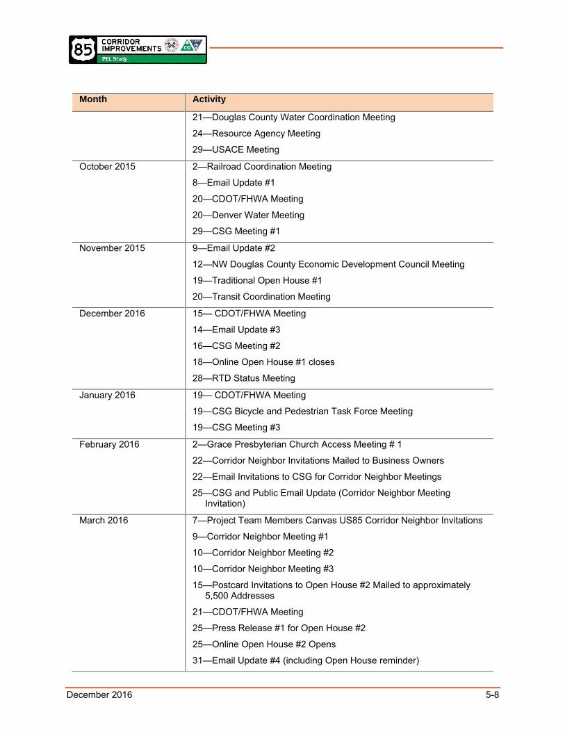
December 2016 5-8
Month Activity
21—Douglas County Water Coordination Meeting
24—Resource Agency Meeting
29—USACE Meeting
October 2015 2—Railroad Coordination Meeting
8—Email Update #1
20—CDOT/FHWA Meeting
20—Denver Water Meeting
29—CSG Meeting #1
November 2015 9—Email Update #2
12—NW Douglas County Economic Development Council Meeting
19—Traditional Open House #1
20—Transit Coordination Meeting
December 2016 15— CDOT/FHWA Meeting
14—Email Update #3
16—CSG Meeting #2
18—Online Open House #1 closes
28—RTD Status Meeting
January 2016 19— CDOT/FHWA Meeting
19—CSG Bicycle and Pedestrian Task Force Meeting
19—CSG Meeting #3
February 2016 2—Grace Presbyterian Church Access Meeting # 1
22—Corridor Neighbor Invitations Mailed to Business Owners
22—Email Invitations to CSG for Corridor Neighbor Meetings
25—CSG and Public Email Update (Corridor Neighbor Meeting Invitation)
March 2016 7—Project Team Members Canvas US85 Corridor Neighbor Invitations
9—Corridor Neighbor Meeting #1
10—Corridor Neighbor Meeting #2
10—Corridor Neighbor Meeting #3
15—Postcard Invitations to Open House #2 Mailed to approximately 5,500 Addresses
21—CDOT/FHWA Meeting
25—Press Release #1 for Open House #2
25—Online Open House #2 Opens
31—Email Update #4 (including Open House reminder)

December 2016 5-9
Month Activity
April 2016 4—Press Release #2 for Open House #2
5—Notices of Traditional and Online Open House # 2 Shared on Douglas County Social Media
7—Notices of Traditional and Online Open House # 2 Shared on Douglas County Social Media
7—Traditional Open House #2
12—USACE Section 408 Coordination Meeting
15—Online Open House #2 closes
20—Wolhurst Adult Community Presentation
20—Highlands Ranch Metro District Board Presentation
26—CDOT/FHWA Meeting
June 2016 1— CSG Meeting #4
21— Highlands Ranch Metro District Board Presentation
28— Grace Presbyterian Church Access Meeting # 2

December 2016 6-1
6.0 NEXT STEPS
6.1 Conceptual Project Phasing Plan Section 3.0 described a number of alternatives that could accommodate the future travel demands associated with the build-out of the Chatfield Basin. The purpose of this section is to identify when those improvements would be needed.
Figure 6-1, Figure 6-2, and Figure 6-3 show the volumes that are expected to “trigger” the need for the improvement in Segments A, B, and C respectively. The triggers are based on traffic volumes and represent a straight line projection from existing volumes to forecasted 2050 volumes based on full build-out of the Chatfield Basin. The straight line projection was used for planning purposes. If development plans are accelerated, the improvements would be needed sooner than shown. Conversely, if development is slowed because of economic conditions, the need for the improvements would be extended into the future.
It should be noted the triggers represent when a project is complete and open to traffic. Prior to this, there are three primary steps that must be met. The first step represents Project Development/NEPA. This step defines the specific elements of the project, identifies costs and sources of funding, and secures environmental compliance. The second step involves designing the proposed improvement, and the third step is the construction of the improvement.
This PEL study identified the need for the following long-term projects based on travel demand forecasts and capacity analyses using current traffic variables and research:
Eight through lanes from Titan Parkway to Highlands Ranch Parkway.
Eight-lane expressway with grade-separated interchanges or a bypass on a new alignment from Highlands Ranch Parkway to C-470.
Six through lanes from SH 67 to Titan Parkway.
Improvements to the US 85/Airport Road intersection.
These projects may not be required if transit and telecommuting become viable options, and/or if vehicle technologies continue to evolve to increase the capacity of the existing infrastructure. An example of a promising emerging technology is autonomous vehicles. These are vehicles that are capable of sensing their environment and navigating without human input. In terms of benefit, roadway capacity nearly doubles in a situation with all autonomous vehicles, and substantial gains are possible even at lower levels. Consequently, six through lanes from Titan Parkway to C-470 and four through lanes from SH 67 to Titan Parkway may be all that is required to accommodate the travel demand associated with the full build-out of the Chatfield Basin.
Figure 6-1, Figure 6-2, and Figure 6-3 provide the potential triggers to implement the proposed improvements from the recommended phasing plan. The triggers are based on the anticipated capacity of US 85 (which also account for other proposed implemented improvements that will increase capacity, such as adding lanes), as well as the travel demand anticipated with the full build-out of Chatfield Basin through 2050. Each figure is represented by segments. as shown in Figure 3-4.

December 2016 6-2
Figure 6-1. Potential Triggers for Highlands Ranch Parkway to C-470
Source: WSP Parsons Brinckerhoff
Figure 6-2. Potential Triggers for Titan Parkway to Highlands Ranch Parkway
Source: WSP Parsons Brinckerhoff

December 2016 6-3
Figure 6-3. Potential Triggers for SH 67 to Titan Parkway
Source: WSP Parsons Brinckerhoff
Based on the Recommended Alternatives, a total of 14 different improvements were identified for the entire study corridor. These would allow the incremental upgrade of the US 85 Corridor over time to match the anticipated growth in traffic resulting from the phased development of the Chatfield Basin. Four of these improvements are in Segment A, five are in Segment B, and five are in Segment C. Figure 6-4 lists each improvement by segment and identifies when the improvement would be needed over a 35-year timeframe (from 2015 to 2050).

December 2016 6-4
Figure 6-4. Conceptual Project Phasing Plan
Source: WSP Parsons Brinckerhoff

December 2016 6-5
6.2 Action Plan The status of the near-term projects (2015 to 2020) is summarized below:
Resurface US 85 from Blakeland Drive to Belleview Avenue. This project is funded and began in the summer of 2016.
Provide 6 through lanes with continuous flow intersections from Highlands Ranch Parkway to C-470. This project is funded and design/NEPA is underway.
Convert stop-sign-controlled ramp terminals at Titan Parkway to a signalized intersection, This project is funded through developer fees, and the improvements will be made when traffic signal warrants are met.
Widen the remaining two-lane section from SH 67 to Titan Parkway. This project is not funded, but the design is complete. Both CDOT and Douglas County are actively pursuing funding opportunities.
Through the implementation of the improvements recommended by this PEL to address the purpose and needs on US 85, Douglas County and CDOT are working to provide a multimodal roadway corridor consistent with the roadway classification defined in Section 3.1 of the State of Colorado State Highway Access Code, Volume 2 (Transportation Commission 1998). By adoption of the recommendations of this PEL study, these agencies are demonstrating their commitment to strengthen, improve, and optimize the throughput of traffic through planned limitation of local access connections.
To carry out any or all of the recommendations from this PEL, Douglas County, FHWA and CDOT are committed to completing the appropriate NEPA processes. These may include a Categorical Exclusion, Environmental Assessment or Environmental Impact Statement, depending on the extent of improvements that have been funded and their anticipated impacts.
The key steps in the subsequent NEPA process are shown to the right. Because it is unknown when the NEPA process will start, these key steps should be revisited to understand the level of refinement needed, if any. Additionally, the outstanding issues identified and listed in Section 6.3 of this report will need to be fully addressed in the NEPA phase.
The environmental resources, as identified in Section 4.0 of this report, will need to be formally reviewed by the appropriate resource agencies to make determinations about impacts and mitigation. Additional public involvement and agency coordination will also be required.
Full funding for improvements included within the Recommended Alternatives has not been identified at this time. The FHWA Environmental Review Toolkit (FHWA 2015) states that fiscal constraint requirements must be satisfied for FHWA and CDOT to approve further NEPA documentation. Prior to FHWA signing a decision document (a Categorical Exclusion, Finding of No Significant Impact or Record of Decision), Douglas County and CDOT will need to demonstrate that full funding is reasonably available for the completion of the project and that the project is included in the fiscally-constrained Regional Transportation Plan.
Key NEPA Requirements
Purpose and Need
Alternatives
Impacts
Mitigation
Interagency Coordination
Public Involvement
Source: FHWA Environmental Review Toolkit (FHWA 2015)
December 2016 6-6
For the projects beyond 2030, traffic volumes on US 85 should be annually monitored and compared to the “triggers” in Section 3.0. Additional studies can then be conducted to determine if the improvement is still needed or are there other options for meeting the demands based on emerging technologies.
6.3 Outstanding Issues The most pressing issue for the US 85 Corridor is the ability to secure funding for the identified improvements so the corridor capacity can keep pace with the future travel demands. Other issues include:
The continued development of the Chatfield Basin, including the timing, the density, the land use mix, and the number of trips that are generated.
Potential redevelopment of the US 85 Corridor between Highlands Ranch Parkway and C-470 (does the west side stay predominantly industrial or does it start transitioning to more commercial?).
The growth in regional traffic using US 85.
A determination of which agency or agencies might provide transit south of Highlands Ranch Parkway and engaging the Federal Transit Administration in any NEPA action required to identify and establish those improvements, whether they are bus, light rail or some other form of high-capacity transit to help meet the future travel demand.
The applicability of using emerging technologies to reduce the need to widen US 85.
The need to either avoid or minimize impacts to parkland.
The need for noise mitigation.
Future NEPA analyses will need to look more specifically at the 53 access points to the US 85 Corridor within the PEL study area to determine what changes should be made (see access tables in Appendix F).
The number of property acquisitions resulting from the need for additional right-of-way.
Evaluation of a continuous flow intersection design option from northbound US 85 to westbound C-470.

December 2016 7-1
7.0 REFERENCES
City of Littleton. 2016. Mineral and Downtown Littleton Station Areas Master Plan. http://littletonplans.org/mineral-and-downtown-littleton-station-areas-master-planning-stamp.
Colorado Department of Health and Environment-Air Pollution Control Division. 2012. Air Quality Data Report. Retrieved May 19, 2014.
Colorado Department of Transportation (CDOT). 2001. Final US 85 Access Management Plan, South I-25 Corridor and US 85 Corridor EIS. March.
CDOT. 2002. South I-25 Corridor and US 85 Corridor Final Environmental Impact Statement/Revised Record of Decision. October.
CDOT. 2015a. CDOT Noise Analysis and Abatement Guidelines.
CDOT. 2015b. C-470 Corridor Revised Environmental Assessment, Kipling Parkway to I-25.
CDOT. 2016a. Planning and Environmental Linkages (PEL) Handbook. Version 2.
https://www.codot.gov/programs/environmental/planning-env-link-program/pel-handbook-january-2016
CDOT. 2016b. 2014 CDOT Construction Manual (Revised on June 7, 2016).
Douglas County. 2014. Douglas County 2035 Comprehensive Master Plan.
Denver Regional Council of Governments (DRCOG). 2015. 2040 Fiscally Constrained Regional Transportation Plan. https://drcog.org/sites/drcog/files/resources/2040%20Fiscally%20Constrained%20Regional%20Transportation%20Plan.pdf.
DiExSys, LLC. 2015. Preliminary Safety Report for US 85, SH 67 – North.
Douglas County. 2014. Northwest Douglas County Feasibility Study for US 85 and State Highway 121.
U.S. Environmental Protection Agency (EPA). 1974. Information on Levels of Environmental Noise Requisite to Protect Public Health and Welfare with an Adequate Margin of Safety. Report Number 550/9- 74-004.
EPA. 1974. Noise from Construction Equipment and Operations, Building Equipment, and Home Appliances NTID300.1.
EPA. Airdata Database. http://www.epa.gov/airdata.
Federal Highway Administration. 2015. FHWA Environmental Review Toolkit. Retrieved from https://www.environment.fhwa.dot.gov/index.asp.
HDR et al. 2016. US 85 Corridor Improvements in Douglas County Planning and Environmental Linkages (PEL) Study Existing Conditions Report.
Transportation Commission of Colorado. 1998. State of Colorado State Highway Access Code, Volume 2, Code of Colorado Regulations 601-1, Adopted June 18, 1998, page 36 amended March 2002.

7-1