Planet Earth: An Introduction to Earth Sciencesaboulang/4d4/planet/Planet_Earth_Topic_4.pdfPlanet...
19
© Roger N. Anderson 1 Planet Earth: An Introduction to Earth Sciences Roger N. Anderson Columbia University Topic 4: Continental Formation & Deformation
Transcript of Planet Earth: An Introduction to Earth Sciencesaboulang/4d4/planet/Planet_Earth_Topic_4.pdfPlanet...
© Roger N. Anderson
1
Planet Earth:
An Introduction to
Earth Sciences
Roger N. Anderson
Columbia University
Topic 4: Continental Formation & Deformation

© Roger N. Anderson
2
Planet Earth Topic 4: Continental Formation and Deformation
Roger N. Anderson
The geology that has the most visible effect on our daily lives is on the continents.Volcanoes kill scores of people, disrupt thousands of lives, and even change the weather.Earthquakes kill thousands of people, destroy entire cities and cost billions of dollars ofproperty. Hurricanes, floods, tornadoes, monsoons and other weather-related events do thesame year after year. Yet we have seen that many more volcanoes erupt below the sea thanabove it, and many more earthquakes occur each year below the ocean. Plate boundary eventslike these, which have happened repeatedly over billions of years, are the building blocksfrom which the continents have been made.
The continents are much more complex than the relatively simplistic ocean floorbecause they have existed at the Earth's surface 20 times longer than the oldest sea floor.They are like buoyant logs in a flood: they crash and collide, smash together, and rip apartonly to remain as cluttered debris long after the last waters have receded. The prime reasonfor this is that continents are very difficult to force down into the mantle because the rockfrom which they are made is just too lightweight and buoyant compared to oceanic rock.Continents are made of granites and other “white rocks” that are made of quartz, plagioclaseand other light minerals that are the “froth” from the calderon that is the mantle. Ocean flooris made of basalt and other “black rocks” that are made of olivine, amphibolite and otherheavy minerals that are left behind after the froth has been removed.
The continents record most of the Earth's history not simply because they are olderthan the sea floor, but also because they are built from generation after generation of oldocean floor. It is not altogether correct to state that the oldest ocean floor is 160 million yearsold. The oldest rock currently under water is that age. However, the oldest rock ever found onon Planet Earth is a piece of 3.7-billion-year-old sea floor, which long ago was forced ontoland at a subduction zone. This rock now forms the core of the Australian continent. Weknow it was formed deep below the ocean because it is sedimentary in origin; because itschemical composition is not too different from that of present submarine sedimentary rocks;and for certain proof, because there are fossils of the earliest sea creatures preserved within it.
Plate Tectonics not only explains how the ocean floor evolves, but also how thecontinents rift apart, collide together, slide across each other, and ride passively in the centerof plates during their long evolution. Remember that a continent is not synonymous with aplate. A continent's boundary need not be the edge of a plate, but it sometimes is. NorthAmerica, for example, is mostly one large plate, but the boundary runs through the middle ofCalifornia along the San Andreas fault. In contrast, Africa is far from any of the plateboundaries of its plate, with the exception of the Red Sea and the soon to be new plateboundary that is currently rifting the continent itself apart along the East African Rift Zone.
The same three plate-boundary processes affect continents as ocean floor whenevertheir fate brings them to a plate's edge: subduction, rifting, or transform faulting. There is,however, one major exception: Continents are not subducted back into the mantle. Instead,they are too light and “scrape off” instead to form the biggest of our mountain ranges.
Although continents are correspondingly more complex, they are all the moreimportant to our understanding of the history of Planet Earth because all those long-agoevents are recorded in the rocks of the continents, and nowhere else. Continents generallyhave an old core at their center, called the craton, which is ringed by sequentially youngerand' younger rock toward the coasts. This is because the continents are continually“accreting” new terrain, or adding pieces of other continents or other sea floor during plate-boundary interactions.
© Roger N. Anderson
3
Clues to the Past on Continents
We interpret the clues preserved in continental rocks using two main sources: fossilsand the rocks they are found in. We are looking for evidence of past climate, surfacegeography, coastlines and mountains, and where the great rivers and glaciers of the pastflowed.
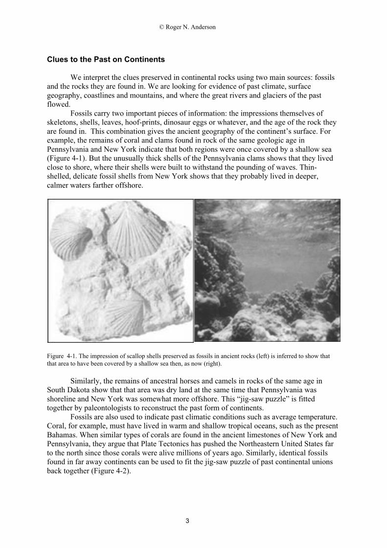
Fossils carry two important pieces of information: the impressions themselves ofskeletons, shells, leaves, hoof-prints, dinosaur eggs or whatever, and the age of the rock theyare found in. This combination gives the ancient geography of the continent’s surface. Forexample, the remains of coral and clams found in rock of the same geologic age inPennsylvania and New York indicate that both regions were once covered by a shallow sea(Figure 4-1). But the unusually thick shells of the Pennsylvania clams shows that they livedclose to shore, where their shells were built to withstand the pounding of waves. Thin-shelled, delicate fossil shells from New York shows that they probably lived in deeper,calmer waters farther offshore.
Figure 4-1. The impression of scallop shells preserved as fossils in ancient rocks (left) is inferred to show thatthat area to have been covered by a shallow sea then, as now (right).
Similarly, the remains of ancestral horses and camels in rocks of the same age inSouth Dakota show that that area was dry land at the same time that Pennsylvania wasshoreline and New York was somewhat more offshore. This “jig-saw puzzle” is fittedtogether by paleontologists to reconstruct the past form of continents.
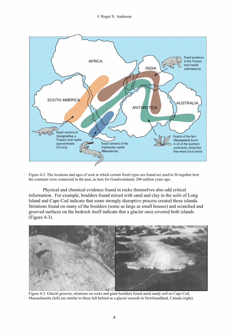
Fossils are also used to indicate past climatic conditions such as average temperature.Coral, for example, must have lived in warm and shallow tropical oceans, such as the presentBahamas. When similar types of corals are found in the ancient limestones of New York andPennsylvania, they argue that Plate Tectonics has pushed the Northeastern United States farto the north since those corals were alive millions of years ago. Similarly, identical fossilsfound in far away continents can be used to fit the jig-saw puzzle of past continental unionsback together (Figure 4-2).
© Roger N. Anderson
4
Figure 4-2. The locations and ages of rock in which certain fossil types are found are used to fit together howthe continets were connected in the past, as here for Gondwanaland, 200 million years ago.
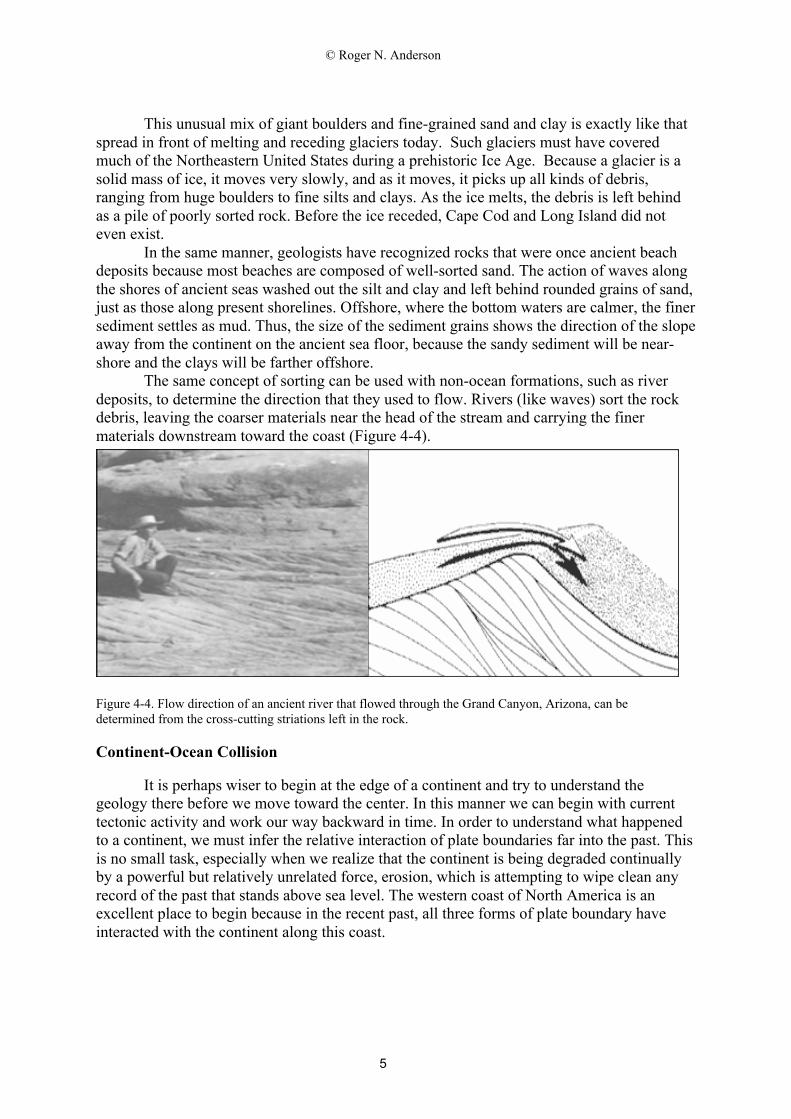
Physical and chemical evidence found in rocks themselves also add criticalinformation. For example, boulders found mixed with sand and clay in the soils of LongIsland and Cape Cod indicate that some strongly disruptive process created these islands.Striations found on many of the boulders (some as large as small houses) and scratched andgrooved surfaces on the bedrock itself indicate that a glacier once covered both islands(Figure 4-3).
Figure 4-3. Glacial grooves, striations on rocks and giant boulders found amid sandy soil on Cape Cod,Massachusetts (left) are similar to those left behind as a glacier receeds in Newfoundland, Canada (right).
© Roger N. Anderson
5
This unusual mix of giant boulders and fine-grained sand and clay is exactly like thatspread in front of melting and receding glaciers today. Such glaciers must have coveredmuch of the Northeastern United States during a prehistoric Ice Age. Because a glacier is asolid mass of ice, it moves very slowly, and as it moves, it picks up all kinds of debris,ranging from huge boulders to fine silts and clays. As the ice melts, the debris is left behindas a pile of poorly sorted rock. Before the ice receded, Cape Cod and Long Island did noteven exist.
In the same manner, geologists have recognized rocks that were once ancient beachdeposits because most beaches are composed of well-sorted sand. The action of waves alongthe shores of ancient seas washed out the silt and clay and left behind rounded grains of sand,just as those along present shorelines. Offshore, where the bottom waters are calmer, the finersediment settles as mud. Thus, the size of the sediment grains shows the direction of the slopeaway from the continent on the ancient sea floor, because the sandy sediment will be near-shore and the clays will be farther offshore.
The same concept of sorting can be used with non-ocean formations, such as riverdeposits, to determine the direction that they used to flow. Rivers (like waves) sort the rockdebris, leaving the coarser materials near the head of the stream and carrying the finermaterials downstream toward the coast (Figure 4-4).
Figure 4-4. Flow direction of an ancient river that flowed through the Grand Canyon, Arizona, can bedetermined from the cross-cutting striations left in the rock.
Continent-Ocean Collision
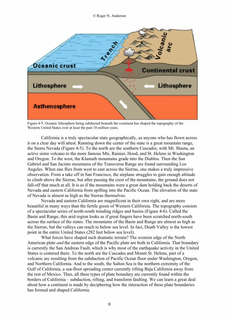
It is perhaps wiser to begin at the edge of a continent and try to understand thegeology there before we move toward the center. In this manner we can begin with currenttectonic activity and work our way backward in time. In order to understand what happenedto a continent, we must infer the relative interaction of plate boundaries far into the past. Thisis no small task, especially when we realize that the continent is being degraded continuallyby a powerful but relatively unrelated force, erosion, which is attempting to wipe clean anyrecord of the past that stands above sea level. The western coast of North America is anexcellent place to begin because in the recent past, all three forms of plate boundary haveinteracted with the continent along this coast.
© Roger N. Anderson
6
Figure 4-5. Oceanic lithosphere being subducted beneath the continent has shaped the topography of theWestern United States over at least the past 10 million years.
California is a truly spectacular state geographically, as anyone who has flown acrossit on a clear day will attest. Running down the center of the state is a great mountain range,the Sierra Nevada (Figure 4-5). To the north are the southern Cascades, with Mt. Shasta, anactive sister volcano to the more famous Mts. Rainier, Hood, and St. Helens in Washingtonand Oregon. To the west, the Klamath mountains grade into the Diablos. Then the SanGabriel and San Jacinto mountains of the Transverse Range are found surrounding LosAngeles. When one flies from west to east across the Sierras, one makes a truly impressiveobservation. From a take off in San Francisco, the airplane struggles to gain enough altitudeto climb above the Sierras, but after passing the crest of the mountains, the ground does notfall-off that much at all. It is as if the mountains were a great dam holding back the deserts ofNevada and eastern California from spilling into the Pacific Ocean. The elevation of the stateof Nevada is almost as high as the Sierras themselves.
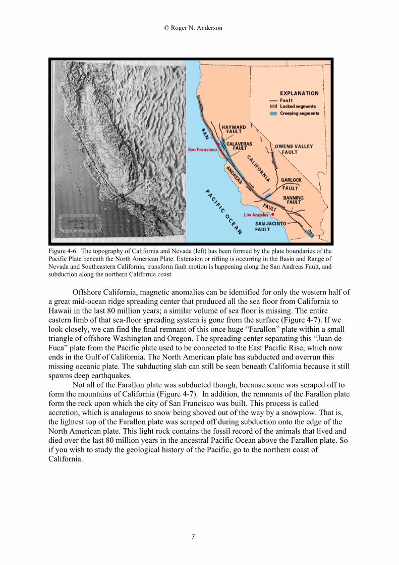
Nevada and eastern California are magnificent in their own right, and are morebeautiful in many ways than the fertile green of Western California. The topography consistsof a spectacular series of north-south trending ridges and basins (Figure 4-6). Called theBasin and Range, this arid region looks as if great fingers have been scratched north-southacross the surface of the states. The mountains of the Basin and Range are almost as high asthe Sierras, but the valleys can reach to below sea level. In fact, Death Valley is the lowestpoint in the entire United States (282 feet below sea level).
What forces have shaped such dramatic terrain? The western edge of the NorthAmerican plate and the eastern edge of the Pacific plate are both in California. That boundaryis currently the San Andreas Fault, which is why most of the earthquake activity in the UnitedStates is centered there. To the north are the Cascades and Mount St. Helens, part of avolcanic arc resulting from the subduction of Pacific Ocean floor under Washington, Oregon,and Northern California. And to the south, the Salton Sea is the northern extremity of theGulf of California, a sea-floor spreading center currently rifting Baja California away fromthe rest of Mexico. Thus, all three types of plate boundary are currently found within theborders of California – subduction, rifting, and transform faulting. We can learn a great dealabout how a continent is made by deciphering how the interaction of these plate boundarieshas formed and shaped California.
© Roger N. Anderson
7
Figure 4-6. The topography of California and Nevada (left) has been formed by the plate boundaries of thePacific Plate beneath the North American Plate. Extension or rifting is occurring in the Basin and Range ofNevada and Southeastern California, transform fault motion is happening along the San Andreas Fault, andsubduction along the northern California coast.
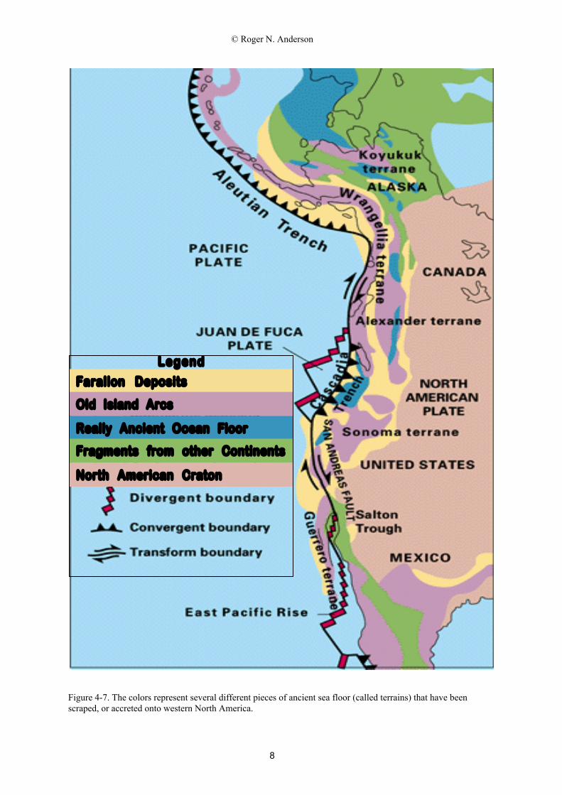
Offshore California, magnetic anomalies can be identified for only the western half ofa great mid-ocean ridge spreading center that produced all the sea floor from California toHawaii in the last 80 million years; a similar volume of sea floor is missing. The entireeastern limb of that sea-floor spreading system is gone from the surface (Figure 4-7). If welook closely, we can find the final remnant of this once huge “Farallon” plate within a smalltriangle of offshore Washington and Oregon. The spreading center separating this “Juan deFuca” plate from the Pacific plate used to be connected to the East Pacific Rise, which nowends in the Gulf of California. The North American plate has subducted and overrun thismissing oceanic plate. The subducting slab can still be seen beneath California because it stillspawns deep earthquakes.
Not all of the Farallon plate was subducted though, because some was scraped off toform the mountains of California (Figure 4-7). In addition, the remnants of the Farallon plateform the rock upon which the city of San Francisco was built. This process is calledaccretion, which is analogous to snow being shoved out of the way by a snowplow. That is,the lightest top of the Farallon plate was scraped off during subduction onto the edge of theNorth American plate. This light rock contains the fossil record of the animals that lived anddied over the last 80 million years in the ancestral Pacific Ocean above the Farallon plate. Soif you wish to study the geological history of the Pacific, go to the northern coast ofCalifornia.
© Roger N. Anderson
8
Figure 4-7. The colors represent several different pieces of ancient sea floor (called terrains) that have beenscraped, or accreted onto western North America.
Farallon Deposits
Old Island Arcs
Really Ancient Ocean Floor
Fragments from other Continents
North American Craton
Legend
© Roger N. Anderson
9
The history of this collision event can be traced back in time by backtracking themotion of the three plates involved: Pacific, Farallon, and North American plates.Backtracking is accomplished by rotating each plate backwards in time about the present poleof each two-plate pair. This method assumes that the present plate motions have beenconstant back into the past. The Pacific plate has apparently been moving to the northwestrelative to the mantle for the last 40 million years, judging from the islands trailing awayfrom the Hawaiian volcanic center. Hawaii is thought to be a hot-spot fixed in location withinthe mantle. As the Pacific plate moves over this hot-spot, volcanoes cook their way throughthe plate to form islands at the surface. A trail of old islands to the northwest shows that thePacific plate has been moving steadily in that direction for a long time into the past.
The Farallon-Pacific motion is recorded in the direction of fracture zones frozen intothe Pacific plate between Hawaii and California. Since these are almost straight lines, theassumption of constant Pacific-Farallon motion appears justified. North America-Farallon ismore difficult, however. No fracture zones remain to record this motion. The San AndreasFault is a transform fault that faithfully records the recent relative motion of the NorthAmerica-Pacific plates, but not the North America-Farallon plate motion.
North American plate motion over the last tens of millions of years can be estimatedeither relative to a fixed volcanic center located within the plate (i.e., relative to the mantle)or relative to the Farallon plate if fracture zones can be found across a series of plateboundaries beginning with Farallon and ending at North America. For example, YellowstoneNational Park in Wyoming is the latest volcanic center of a trail of lava extending across theSnake river Plateau of southern Idaho and western Washington. This trail is a relativelystraight line, so we might assume that North America has not changed motion by much in theperiod of time between the ages of Washington lavas ( 40 million years old) and Yellowstonelavas (recent).
This direction for North America relative to the mantle is not relevant to the Farallonplate interaction, so we still must find North America-Farallon plate motion. We must stringtogether relative motion across fracture zones of the following plate pairs: Farallon-Pacific,Pacific-Antarctica, Antarctica-South America, and South America-North America. We findthat again North American plate motion has been relatively constant over the last 40 millionyears, moving southwestward and overriding Farallon (Figure 4-7).
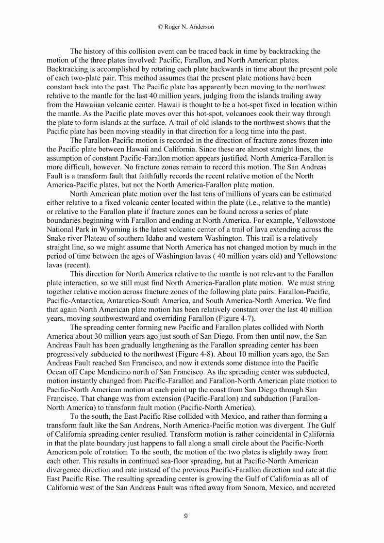
The spreading center forming new Pacific and Farallon plates collided with NorthAmerica about 30 million years ago just south of San Diego. From then until now, the SanAndreas Fault has been gradually lengthening as the Farallon spreading center has beenprogressively subducted to the northwest (Figure 4-8). About 10 million years ago, the SanAndreas Fault reached San Francisco, and now it extends some distance into the PacificOcean off Cape Mendicino north of San Francisco. As the spreading center was subducted,motion instantly changed from Pacific-Farallon and Farallon-North American plate motion toPacific-North American motion at each point up the coast from San Diego through SanFrancisco. That change was from extension (Pacific-Farallon) and subduction (Farallon-North America) to transform fault motion (Pacific-North America).
To the south, the East Pacific Rise collided with Mexico, and rather than forming atransform fault like the San Andreas, North America-Pacific motion was divergent. The Gulfof California spreading center resulted. Transform motion is rather coincidental in Californiain that the plate boundary just happens to fall along a small circle about the Pacific-NorthAmerican pole of rotation. To the south, the motion of the two plates is slightly away fromeach other. This results in continued sea-floor spreading, but at Pacific-North Americandivergence direction and rate instead of the previous Pacific-Farallon direction and rate at theEast Pacific Rise. The resulting spreading center is growing the Gulf of California as all ofCalifornia west of the San Andreas Fault was rifted away from Sonora, Mexico, and accreted
© Roger N. Anderson
10
onto the Pacific plate (Figure 4-7). These rocks are far from new. Some are hundreds ofmillions of years old. But now they ride on the Pacific plate. They were literally transferredfrom one plate to another as a piece of North America tore away and accreted to the Pacificplate. Yet these are still part of the North American continent.
Figure 4-8. Aerial view, looking north toward San Francisco, of Crystal Springs Reservoir, which follows theSan Andreas fault zone. Silicon Valley is on the right.
Such an accretion event is hard to believe, but the facts are incontrovertible. Forexample, you can pick up rocks on the beaches of southern California that have been polishedby wave action to a brilliant red color. The exact same rocks can only be found in one otherlocale in the North American continent: Sonora, Mexico, hundreds of miles to the southeast.
We still have not touched upon he origin of the two most striking features ofCalifornia, the Sierra Nevada mountains and the Basin and Range. The Sierras are thevolcanic pile left after millions and millions of years of subduction of Farallon ocean floorbeneath the edge of the North American continent before all of the above happened. TheFarallon plate was subducted into the mantle, dehydrated, and then melted not only thesurrounding mantle, but also the bottom of the North American continent as the magmastruggled to reach the surface. Granitic mountains, or the melted continent “froth”, werepushed to the surface along with magmas that had high concentrations of light minerals. Thisvolcanism formed a buoyant pile of rocks that intermixed with accretion products to form theSierra Nevadas (Figure 4-7).
The Sierra Nevadas were forming about the same time as the Rocky Mountains ofNew Mexico, Colorado, Wyoming, and Montana far to the east. The Rockies are an evenlarger mountain range that connects to the north with the Canadian Rockies. The Andes inSouth America are contemporaneous with both the Rockies and the Sierra Nevadas. Theremust have been another plate between the Sierras and the Rockies whose underthrustingproduced the mountain-building responsible for the Rockies.
If we look between the Sierras and the Rockies today, we find the Basin and Range.The Basin and Range are a series of extensional basins behind the volcanic arc (the Sierras).
© Roger N. Anderson
11
The faulting direction is north-south, perpendicular the extension motion of Pacific-NorthAmerica, which is east-west (Figure 4-7). These basins are, therefore, being pulled apart.
The Future of California
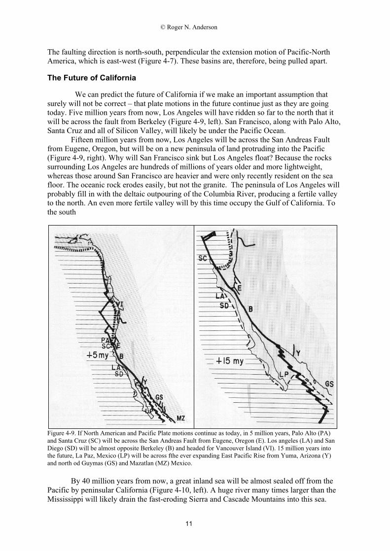
We can predict the future of California if we make an important assumption thatsurely will not be correct – that plate motions in the future continue just as they are goingtoday. Five million years from now, Los Angeles will have ridden so far to the north that itwill be across the fault from Berkeley (Figure 4-9, left). San Francisco, along with Palo Alto,Santa Cruz and all of Silicon Valley, will likely be under the Pacific Ocean.
Fifteen million years from now, Los Angeles will be across the San Andreas Faultfrom Eugene, Oregon, but will be on a new peninsula of land protruding into the Pacific(Figure 4-9, right). Why will San Francisco sink but Los Angeles float? Because the rockssurrounding Los Angeles are hundreds of millions of years older and more lightweight,whereas those around San Francisco are heavier and were only recently resident on the seafloor. The oceanic rock erodes easily, but not the granite. The peninsula of Los Angeles willprobably fill in with the deltaic outpouring of the Columbia River, producing a fertile valleyto the north. An even more fertile valley will by this time occupy the Gulf of California. Tothe south
Figure 4-9. If North American and Pacific Plate motions continue as today, in 5 million years, Palo Alto (PA)and Santa Cruz (SC) will be across the San Andreas Fault from Eugene, Oregon (E). Los angeles (LA) and SanDiego (SD) will be almost opposite Berkeley (B) and headed for Vancouver Island (VI). 15 million years intothe future, La Paz, Mexico (LP) will be across fthe ever expanding East Pacific Rise from Yuma, Arizona (Y)and north od Guymas (GS) and Mazatlan (MZ) Mexico.
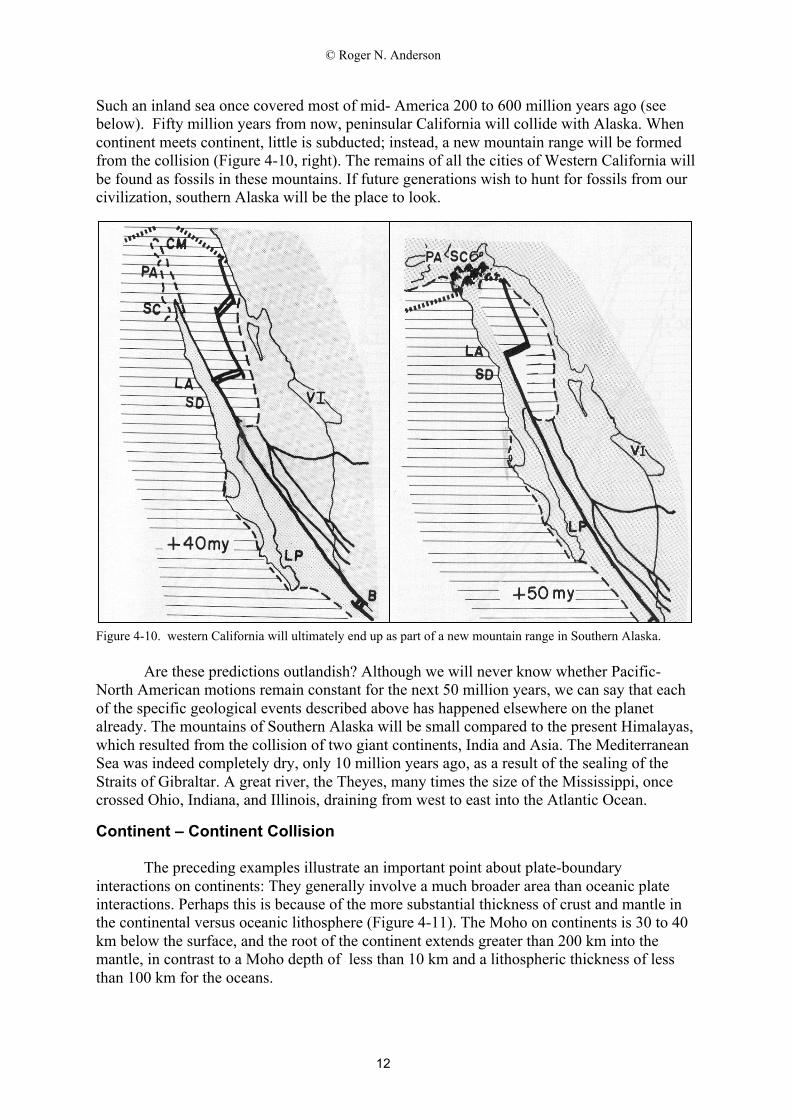
By 40 million years from now, a great inland sea will be almost sealed off from thePacific by peninsular California (Figure 4-10, left). A huge river many times larger than theMississippi will likely drain the fast-eroding Sierra and Cascade Mountains into this sea.
© Roger N. Anderson
12
Such an inland sea once covered most of mid- America 200 to 600 million years ago (seebelow). Fifty million years from now, peninsular California will collide with Alaska. Whencontinent meets continent, little is subducted; instead, a new mountain range will be formedfrom the collision (Figure 4-10, right). The remains of all the cities of Western California willbe found as fossils in these mountains. If future generations wish to hunt for fossils from ourcivilization, southern Alaska will be the place to look.
Figure 4-10. western California will ultimately end up as part of a new mountain range in Southern Alaska.
Are these predictions outlandish? Although we will never know whether Pacific-North American motions remain constant for the next 50 million years, we can say that eachof the specific geological events described above has happened elsewhere on the planetalready. The mountains of Southern Alaska will be small compared to the present Himalayas,which resulted from the collision of two giant continents, India and Asia. The MediterraneanSea was indeed completely dry, only 10 million years ago, as a result of the sealing of theStraits of Gibraltar. A great river, the Theyes, many times the size of the Mississippi, oncecrossed Ohio, Indiana, and Illinois, draining from west to east into the Atlantic Ocean.
Continent – Continent Collision
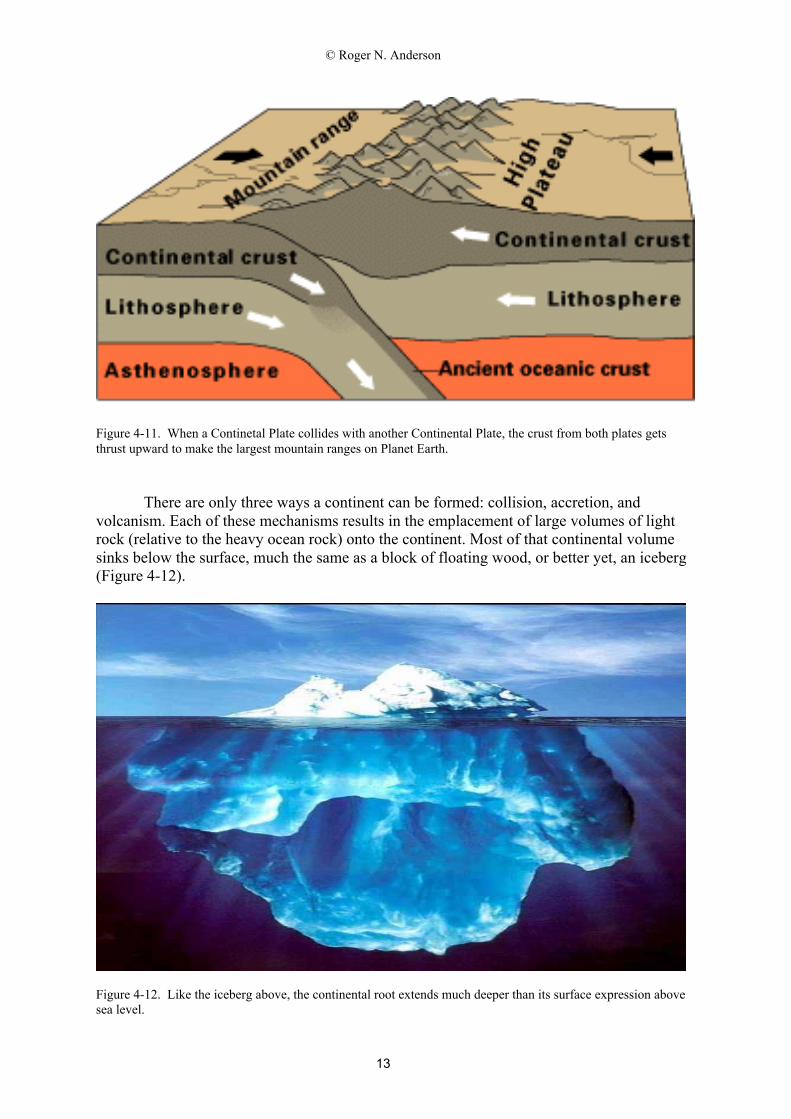
The preceding examples illustrate an important point about plate-boundaryinteractions on continents: They generally involve a much broader area than oceanic plateinteractions. Perhaps this is because of the more substantial thickness of crust and mantle inthe continental versus oceanic lithosphere (Figure 4-11). The Moho on continents is 30 to 40km below the surface, and the root of the continent extends greater than 200 km into themantle, in contrast to a Moho depth of less than 10 km and a lithospheric thickness of lessthan 100 km for the oceans.
© Roger N. Anderson
13
Figure 4-11. When a Continetal Plate collides with another Continental Plate, the crust from both plates getsthrust upward to make the largest mountain ranges on Planet Earth.
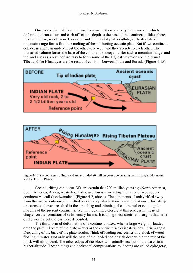
There are only three ways a continent can be formed: collision, accretion, andvolcanism. Each of these mechanisms results in the emplacement of large volumes of lightrock (relative to the heavy ocean rock) onto the continent. Most of that continental volumesinks below the surface, much the same as a block of floating wood, or better yet, an iceberg(Figure 4-12).
Figure 4-12. Like the iceberg above, the continental root extends much deeper than its surface expression abovesea level.
© Roger N. Anderson
14
Once a continental fragment has been made, there are only three ways in whichdeformation can occur, and each affects the depth to the base of the continental lithosphere.First, of course, is collision. If oceanic and continental plates collide, an Andean-typemountain range forms from the melting of the subducting oceanic plate. But if two continentscollide, neither can under-thrust the other very well, and they accrete to each other. Theincreased volume forces the base of the continent to deepen under such a mountain range, andthe land rises as a result of isostasy to form some of the highest elevations on the planet.Tibet and the Himalayas are the result of collision between India and Eurasia (Figure 4-13).
Figure 4-13. the continents of India and Asia collided 80 million years ago creating the Himalayan Mountainsand the Tibetan Plateau.
Second, rifting can occur. We are certain that 200 million years ago North America,South America, Africa, Australia:, India, and Eurasia were together as one large super-continent we call Gondwanaland (Figure 4-2, above). The continents of today rifted awayfrom the mega-continent and drifted on various plates to their present locations. This riftingor extensional event resulted in the stretching and thinning of continental crust along themargins of the present continents. We will look more closely at this process in the nextchapter on the formation of sedimentary basins. It is along these stretched margins that mostof the world's oil and gas were deposited.
The third form of deformation of a continent occurs when a large weight is loadedonto the plate. Flexure of the plate occurs as the continent seeks isostatic equilibrium again.Deepening of the base of the plate results. Think of loading one corner of a block of woodfloating in water. Not only will the base of the loaded corner sink deeper, but the rest of theblock will tilt upward. The other edges of the block will actually rise out of the water to ahigher altitude. These tiltings and horizontal compensations to loading are called epirogeny,
© Roger N. Anderson
15
as opposed to the vertical motions from processes such as mountain-building, which arecalled orogeny.
One can see that the emplacement of any large load results in flexure as well as themore traditional plate-tectonic processes such as rifting or collision. Examples ofemplacement of such loads are deep sedimentary basins, such as those off the shore of easternNorth America, and river deltas such as the Gulf of Mexico. As another example is iceloading during glaciation, which causes major epirogenic movements within continents. Themelting of the great North American Ice Sheet 18,000 years ago left behind the Hudson’sBay, a large but shallow lake that is rebounding today. Soon it will rise above sea level andexpel all that water back into the Atlantic Ocean.
If we can understand the interaction of the three processes of continental formationand the three processes of continental deformation on any continent, then we should be ableto describe the geological history of that continent. If we examine the continents as a whole,we find that each has one to several central cratons that have survived tectonics for severalhundred million to billions of years (Figure 4-7). Surrounding these cratons are successiverings that record histories of collision, rifting, volcanism, and flexure – much as tree rings do.
The Geological History of North America
It is perhaps useful to end our introduction of continental processes with a trip backthrough as much of the history of one continent as we know at present. The maps depictingthe initial breakup of Gondwanaland (Figure 4-14), and the paleo-geography of NorthAmerica 500 million years ago (Pennsylvanian Period, Figure 4-15), 100 million years ago(Cretaceous, Figure 4-16) and less than 1 million years ago (Pleistocene, Figure 4-17) giveexamples of the changes in the size and shape of the North American continent over thattime.
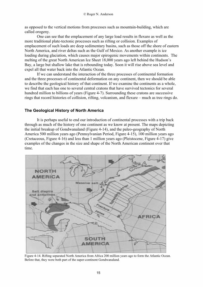
Figure 4-14. Rifting separated North America from Africa 200 million years ago to form the Atlantic Ocean.Before that, they were both part of the super-continent Gondwanaland.
© Roger N. Anderson
16
The Pennsylvanian Coal Age
So far, we have followed North America from its current plate interactions inCalifornia to the formation of the Rockies. We also can see that North America could bereattached to Aftica and Europe prior to the formation of the Atlantic Ocean (Figure 4-14).The rifting from Africa formed our present eastern coast, but what about the AppalachianMountains? For their history, we must go back in time to when the mega-continent ofGondwanaland itself was assembled, before it was torn apart. Prior to the rifting event thatformed the Atlantic, Africa collided with North America. They were not always stucktogether. Continent-continent collision pushed up the Appalachians far higher than thepresent-day Rockies. They were so high that 300 million years of erosion has still not leveledthe Appalachians. South America was still attached to Africa at that time, and subduction ofocean lithosphere was occurring all along the western shore of the newly reforming super-continent of Gondwanaland.
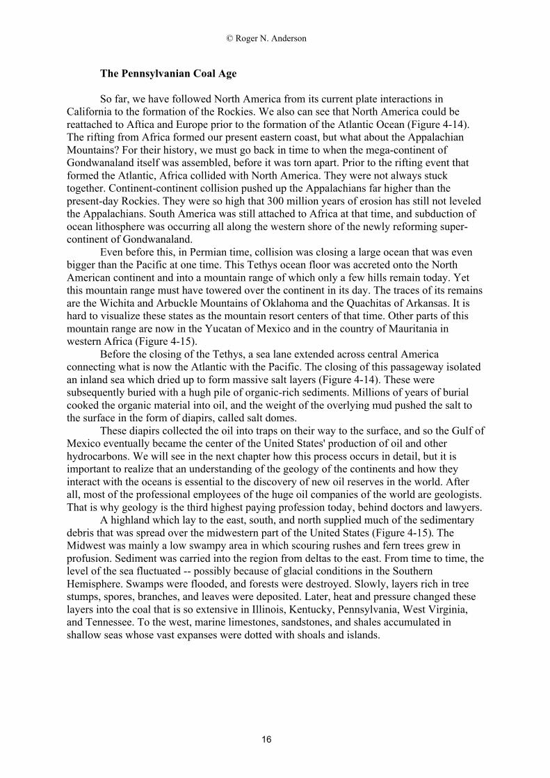
Even before this, in Permian time, collision was closing a large ocean that was evenbigger than the Pacific at one time. This Tethys ocean floor was accreted onto the NorthAmerican continent and into a mountain range of which only a few hills remain today. Yetthis mountain range must have towered over the continent in its day. The traces of its remainsare the Wichita and Arbuckle Mountains of Oklahoma and the Quachitas of Arkansas. It ishard to visualize these states as the mountain resort centers of that time. Other parts of thismountain range are now in the Yucatan of Mexico and in the country of Mauritania inwestern Africa (Figure 4-15).
Before the closing of the Tethys, a sea lane extended across central Americaconnecting what is now the Atlantic with the Pacific. The closing of this passageway isolatedan inland sea which dried up to form massive salt layers (Figure 4-14). These weresubsequently buried with a hugh pile of organic-rich sediments. Millions of years of burialcooked the organic material into oil, and the weight of the overlying mud pushed the salt tothe surface in the form of diapirs, called salt domes.
These diapirs collected the oil into traps on their way to the surface, and so the Gulf ofMexico eventually became the center of the United States' production of oil and otherhydrocarbons. We will see in the next chapter how this process occurs in detail, but it isimportant to realize that an understanding of the geology of the continents and how theyinteract with the oceans is essential to the discovery of new oil reserves in the world. Afterall, most of the professional employees of the huge oil companies of the world are geologists.That is why geology is the third highest paying profession today, behind doctors and lawyers.
A highland which lay to the east, south, and north supplied much of the sedimentarydebris that was spread over the midwestern part of the United States (Figure 4-15). TheMidwest was mainly a low swampy area in which scouring rushes and fern trees grew inprofusion. Sediment was carried into the region from deltas to the east. From time to time, thelevel of the sea fluctuated -- possibly because of glacial conditions in the SouthernHemisphere. Swamps were flooded, and forests were destroyed. Slowly, layers rich in treestumps, spores, branches, and leaves were deposited. Later, heat and pressure changed theselayers into the coal that is so extensive in Illinois, Kentucky, Pennsylvania, West Virginia,and Tennessee. To the west, marine limestones, sandstones, and shales accumulated inshallow seas whose vast expanses were dotted with shoals and islands.
© Roger N. Anderson
17
Figure 4-15. Generalized geographic map of the United States about 500 million years ago. Note the extensivecoal-swamp in the east and the shallow seas covering all the Midwest and what will become the Rockies.
The Cretaceous Age of Dinosaurs
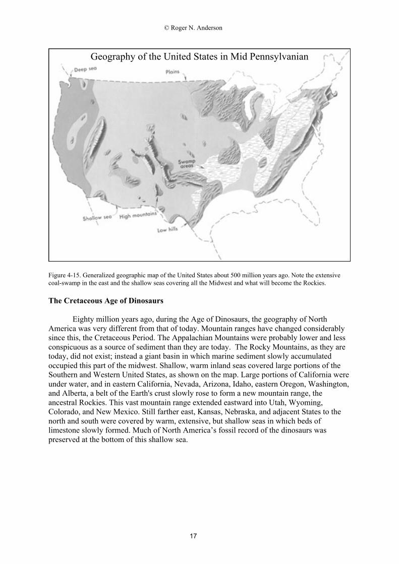
Eighty million years ago, during the Age of Dinosaurs, the geography of NorthAmerica was very different from that of today. Mountain ranges have changed considerablysince this, the Cretaceous Period. The Appalachian Mountains were probably lower and lessconspicuous as a source of sediment than they are today. The Rocky Mountains, as they aretoday, did not exist; instead a giant basin in which marine sediment slowly accumulatedoccupied this part of the midwest. Shallow, warm inland seas covered large portions of theSouthern and Western United States, as shown on the map. Large portions of California wereunder water, and in eastern California, Nevada, Arizona, Idaho, eastern Oregon, Washington,and Alberta, a belt of the Earth's crust slowly rose to form a new mountain range, theancestral Rockies. This vast mountain range extended eastward into Utah, Wyoming,Colorado, and New Mexico. Still farther east, Kansas, Nebraska, and adjacent States to thenorth and south were covered by warm, extensive, but shallow seas in which beds oflimestone slowly formed. Much of North America’s fossil record of the dinosaurs waspreserved at the bottom of this shallow sea.
Geography of the United States in Mid Pennsylvanian
© Roger N. Anderson
18
Figure 4-16. Generalized geographic map of the United States in Late Cretaceous time.The Cretaceous Period marked the last extensive covering of the North American continent by a shallow sea.Since then, sea level has dropped and the continent has gradually emerged to its present size and shape.
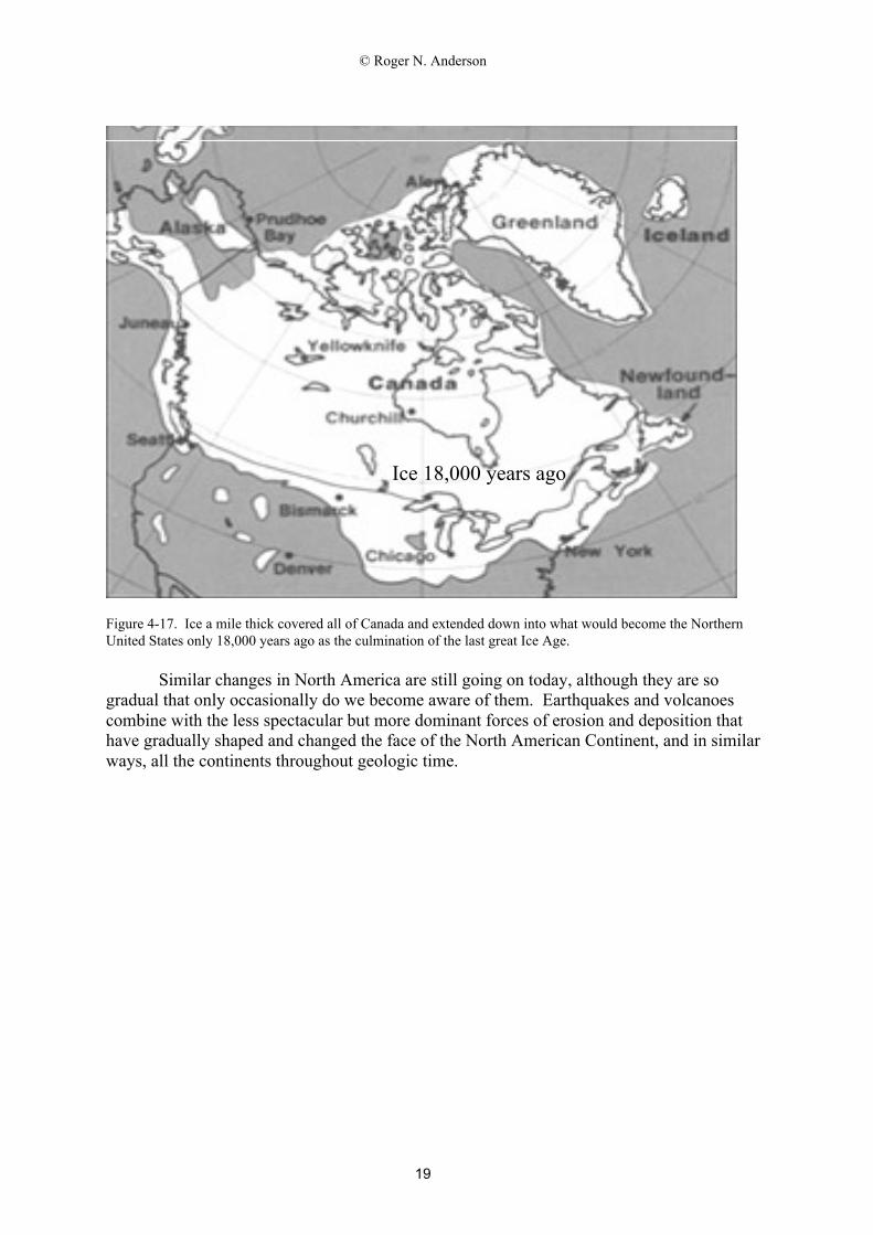
The Great Pleistocene Ice Age
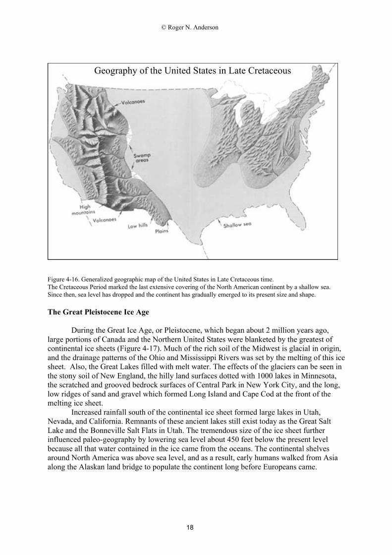
During the Great Ice Age, or Pleistocene, which began about 2 million years ago,large portions of Canada and the Northern United States were blanketed by the greatest ofcontinental ice sheets (Figure 4-17). Much of the rich soil of the Midwest is glacial in origin,and the drainage patterns of the Ohio and Mississippi Rivers was set by the melting of this icesheet. Also, the Great Lakes filled with melt water. The effects of the glaciers can be seen inthe stony soil of New England, the hilly land surfaces dotted with 1000 lakes in Minnesota,the scratched and grooved bedrock surfaces of Central Park in New York City, and the long,low ridges of sand and gravel which formed Long Island and Cape Cod at the front of themelting ice sheet.
Increased rainfall south of the continental ice sheet formed large lakes in Utah,Nevada, and California. Remnants of these ancient lakes still exist today as the Great SaltLake and the Bonneville Salt Flats in Utah. The tremendous size of the ice sheet furtherinfluenced paleo-geography by lowering sea level about 450 feet below the present levelbecause all that water contained in the ice came from the oceans. The continental shelvesaround North America was above sea level, and as a result, early humans walked from Asiaalong the Alaskan land bridge to populate the continent long before Europeans came.
Geography of the United States in Late Cretaceous
© Roger N. Anderson
19
Figure 4-17. Ice a mile thick covered all of Canada and extended down into what would become the NorthernUnited States only 18,000 years ago as the culmination of the last great Ice Age.
Similar changes in North America are still going on today, although they are sogradual that only occasionally do we become aware of them. Earthquakes and volcanoescombine with the less spectacular but more dominant forces of erosion and deposition thathave gradually shaped and changed the face of the North American Continent, and in similarways, all the continents throughout geologic time.
Ice 18,000 years ago