
PLAN OF STUDY FOR THE IDENTIFICATION OF...
144
PLAN OF STUDY FOR THE IDENTIFICATION OF MEASURES TO MITIGATE FLOODING AND THE IMPACTS OF FLOODING OF LAKE CHAMPLAIN AND RICHELIEU RIVER July 2013 Commission Joint International
Transcript of PLAN OF STUDY FOR THE IDENTIFICATION OF...
PLAN OF STUDY FOR
THE IDENTIFICATION OF MEASURES TO MITIGATE FLOODING AND THE IMPACTS OF FLOODING OF LAKE
CHAMPLAIN AND RICHELIEU RIVER
July 2013 Commission Joint International

International Joint Commission Commission mixte internationale Canada and United States Canada et États-Unis
www.ijc.org 234 Laurier Avenue W., 22nd Floor, Ottawa, ON K1P 6K6 2000 L St. NW, Suite 615, Washington, DC 20036 Phone: (613) 995-2984 Fax: (613) 993-5583 Phone: (202) 736-9000 Fax: (202) 632-2006 [email protected] [email protected]
July 15, 2013
The Honourable John Kerry Secretary of State U.S. Department of State 2201 C Street NW Washington, DC 20520
The Honourable John Baird Minister of Foreign Affairs Foreign Affairs and International Trade Canada 125 Sussex Drive Ottawa, ON K1A 0G2
Dear Minister Baird and Secretary Kerry: On March 19, 2012, the governments of Canada and the United States asked the International Joint Commission (IJC) to draft a plan of study that would examine the causes and impacts of the spring of 2011 flooding on Lake Champlain and the Richelieu River and would develop possible mitigation measures. The IJC therefore established the International Lake Champlain-Richelieu River Work Group (ILCRRWG) to develop the requested plan of study. This letter transmits to you the Work Group’s proposed Plan of Study and conveys the IJC recommendations. The IJC recommends:
1. that governments invest an estimated $14 million over five years in the necessary data gathering, model development and analysis to determine the causes and impacts of flooding and evaluate flood mitigation measures along the shores of Lake Champlain and the Richelieu River;
2. that governments establish a binational Study Board as soon as possible to coordinate this work and to implement a strong transboundary and public consultation mechanism to support the development of a shared integrated set of state-of-the-art physical, socio-economic, and ecological resource response models;
3. that local governments use their existing authorities to take immediate action to keep residences and new development away from flood areas through development and implementation of local flood plain land use regulation; and
4. that action be taken to strengthen comprehensive transboundary coordination mechanisms for flood preparedness, forecasting, and response that includes New York, Vermont, Quebec, and the federal governments as well as local municipalities.
The IJC endorses the Work Group’s recommendation that the governments of Canada and the United States should invest in the necessary data gathering and analysis to develop the full set of

- 2 -
integrated state-of-the-art physical, socio-economic, and ecological resource response models for the Lake Champlain Richelieu River basin as proposed in the third option (Option C) of the Work Group’s report. These models and their use to examine specific options within the Lake Champlain-Richelieu River Basin will help create a better understanding of the impacts of potential structural and non-structural flood mitigation measures on the basin’s resources, the environment, and multiple water users. This suite of shared models will enhance understanding of the complexities of the transboundary basin, enable alternative solutions to be identified and evaluated, and support the development of binationally agreed upon comprehensive flood mitigation solutions. The scientifically-sound, comprehensive suite of models proposed in the Work Group’s report would fully assess the positive and negative impacts of proposed measures. Using shared models agreed to by the experts and stakeholders for this assessment is essential to foster the mutual understanding and acceptance of any measures that would significantly alter natural water levels. The Work Group estimates that the data gathering and analysis to develop this full suite of models and the ensuing analysis of measures will cost approximately $14 million. The development of this strategic shared tool will enable those in the basin to evaluate their options and to move forward together. The modelling would also include an ongoing real-time state-of-the-art flood forecasting system for the whole of Lake Champlain and the Richelieu River. The March 2012 request from governments is the third time governments have asked the IJC to study flooding in the Lake Champlain Richelieu River Basin. In 1937 the IJC reviewed flooding in the basin in conjunction with the approval of an application for a dam and remedial works in the Richelieu River outside Saint-Jean-sur-Richelieu, now known as Fryers Dam. While part of the dam structure was built, associated construction and river excavation was never completed, and the dam was never operated. In 1973 the IJC received a reference to study flooding in the region, and, in 1981 after a six year study, the IJC issued a final report that concluded that flood forecasting and warning mechanisms in conjunction with flood plain regulation were both feasible and desirable to reduce flood damages in the region. In addition, the IJC in its report noted that a gated control structure (dam) and channel excavation would be a feasible means to reduce flood damages and could be managed to meet the defined environmental criteria. However, the desirability of building a control structure was left to the governments to determine. While forecasting and flood plain regulations were, to some extent put into place, no action was taken by governments with respect to a dam or excavation of the shoals. Prior IJC efforts in this basin teach us that strong and ongoing basinwide consultations with the public and all levels of government are essential. A binational Study Board is necessary to lead and coordinate the development of the proposed modelling tools and to foster basinwide communication and mutual understanding in the evaluation of flood mitigation measures. The IJC recommends that governments establish this binational Study Board as soon as possible. Flooding in the Lake Champlain-Richelieu River basin is an ongoing hazard and financial burden for the region, and the building of a structure that would significantly impact or control the water levels of Lake Champlain and the Richelieu River remains a sensitive issue. Once established, the Study Board should initiate on-going public and government consultations to include local governments and periodic public opinion research that will help identify specific agreed options and promote understanding of the impacts of proposed measures. The proposed models would be used to evaluate a range of solutions, some of which have not been seriously considered within prior studies. The development and results of these analyses would be shared on an ongoing basis with the public and all levels of governments to identify and prioritize those

- 3 -
solutions that are realistic and meet both the flood mitigation needs and ecological concerns of those living in the Basin. The Study Board should establish the structure for this ongoing communication as its first task so as to establish a basis for the mutual understanding of all groups throughout the study process. The IJC’s recommendations 3 and 4 are based on two additional issues that the Working Group highlighted. They emphasize the need for local governments to address regional flood response coordination and flood plain management. The Commission’s 1981 study recommended flood plain land use regulation to keep residences and new development away from flood areas. While the Work Group recommends that flood plain management and best practices be examined again and that flood plain mapping be updated, local governments have sufficient authority and understanding to make strides in this area immediately, and they should take action. The IJC also endorses the Work Group’s observation that there is an immediate need to further strengthen comprehensive transboundary coordination mechanisms for flood preparedness, forecasting, and response that includes New York, Vermont, Quebec, and the federal governments as well as local municipalities. The International Joint Commission commends the efforts of the Work Group and appreciates that the menu of studies presented are sensitive to the governments’ request to identify options at different funding levels for consideration. We support the comments and analysis of the Work Group and support their recommendation to proceed with a comprehensive study with a budget of $14 million over five years and forward their report to governments for their consideration and action. As always, Commissioners and members of its Work Group are available to brief governments on these points or the analysis of the proposed plan of study. We look forward to hearing the governments’ direction on next steps for the Lake Champlain-Richelieu River basin. Regards,
Lana B. Pollack Chair U.S. Section
Joseph R. Comuzzi, P.C. Chair Canadian Section

- 4 -
Dereth B. Glance Commissioner U.S. Section
Gordon W. Walker Commissioner Canadian Section
Richard Moy Commissioner U.S. Section
Benoît Bouchard Commissioner Canadian Section
Attachment
1. Plan of Study for the Identification of Measures to Mitigate Flooding and the Impacts of Flooding of Lake Champlain and Richelieu River

Lake Champlain – Richelieu River Plan of Study
ii
EXECUTIVE SUMMARY
Prepared for the International Joint Commission By the
International Lake Champlain and Richelieu River Plan of Study Workgroup
Introduction In April 2011, a combination of record spring precipitation and snowmelt from the third highest cumulative snowfall year on record caused subsequent overflow of the Richelieu River in Canada and Lake Champlain in the United States. Lake water elevation crested at 31.477 m (103.27 ft) above mean sea level, setting a new record for a system that has been plagued by flood events for at least the last one hundred years. In the spring flood of 2011, waters exceeded flood stage on April 13, 2011 and remained there until June 19, 2011, a total of 67 days. Close to 4,000 homes were damaged in both countries resulting in tens of millions of dollars in damage.
In response to these devastating floods of 2011 the governments of Canada and the United States requested that the International Joint Commission review and make recommendations regarding a comprehensive study of measures to mitigate flooding and the impacts of flooding within the Lake Champlain and Richelieu River watershed. To answer this request, the International Joint Commission established in May 2012 the International Lake Champlain Richelieu River Workgroup and tasked the Workgroup with a Directive to answer the governments’ request through a Plan of Study.
The Directive to the International Lake Champlain Richelieu River Workgroup was to develop a Plan of Study that will establish specifically what studies are necessary to allow an evaluation of the causes and impacts of the flooding of the Lake Champlain and Richelieu River and what studies are necessary to develop appropriate flood mitigation measures and recommendations.
Three distinct evaluations must be addressed in the Plan of Study:
1. Evaluate the causes and impacts of the past floods on the system, with an emphasis on the events of 2011.
2. Evaluate flood mitigation measures for Lake Champlain and its tributaries and the Richelieu River, considering non-structural and structural measures, and their combination, associated with benefits/costs analysis.
3. Evaluate the need for flood inundation mapping based on real-time forecasting to help predict and prepare local communities and emergency responders for future floods.
The elaboration of flood mitigation measures shall encompass two specific analyses and recommendations:

Lake Champlain – Richelieu River Plan of Study
iii
1. Analyze and recommend actions for adapting to the expected variability of future water supplies to the Lake Champlain and Richelieu River watershed, building on existing relevant studies.
2. Analyze the existing country-wide flood plain regulation best management practices, to include recommendations for community-based regulation.
Development of the Plan of Study As an underlying requirement of the Directive, there is an obligation for future studies on Lake Champlain and Richelieu River flooding to address not only the specific objectives laid out in the Directive but also the differences in opinion, misunderstandings, and data integration needs surrounding the issue.
To fully address the principles and objectives of the Directive, the International Lake Champlain and Richelieu River Workgroup performed information collecting tasks prior to and concurrent with the development of this Plan of Study, including a cursory analysis of the current perceptions of mitigation measures from the past and those that may be recommended in the future.
A series of public meetings and site visits were conducted by the International Lake Champlain and Richelieu River Workgroup in August 2012. An intensive two-day workshop for technical experts was held in September 2012 and a discussion with the International Joint Commission was held in October 2012. The draft was presented to the International Joint Commission in January 2013 and posted for public comment on February 21st. A second series of public meetings was held in March 2013 to gather comments and answer questions.
This Plan of Study provides valuable information including a history of flooding and the studies done to date, a discussion on the social environment that surrounds and impacts the issue, and finally presents three separate, individually scalable options for study implementation that address the requests of the United States and Canadian governments and the objectives of the International Joint Commission Directive.
Findings The workgroup has identified and wishes to relay to the Commissioners the following highlights from public meetings and comments received from citizens, experts and organizations:
• There is a wide variety of views on what the ideal mitigation solutions would be. These measures span the full range from mitigating only the damages and not the floods to full regulation of water levels for flood damage control generally considered to be the construction of a dam at Saint-Jean-sur-Richelieu and the dredging of the shoals.
• Several potential measures mentioned aim at slowing down the inflow of water into the Lake Champlain and Richelieu River. There were also other measures that aimed to accelerate the water flow out of the system.
• It has been expressed clearly that if structural flood mitigation measures, even moderate ones, were to be analyzed, the quality of the assessments of the expected impacts on the resources

Lake Champlain – Richelieu River Plan of Study
iv
and uses and especially the environment would have to be based on the best possible science and sound analytical principles.
• There is a definite will to find solutions to this issue. Several citizens, organizations, mayors as well as the Municipalité Régionale de Compté du Haut-Richelieu, have communicated to the workgroup a sense of urgency to see that measures be put in place quickly to mitigate flooding and prevent undue risk to people and property in case of another flood.
• Local and regional organizations are responsible for and can implement many best management practices and improvements locally and in the short-term. However, the workgroup acknowledges that integrated bi-national solutions, on a longer term, are also required and it is in this respect that work by the International Joint Commission including this study on the identification of measures to mitigate flooding and the impacts of flooding on Lake Champlain and the Richelieu River is so valuable.
However, the International Lake Champlain Richelieu River Workgroup considers that, at the moment, there is a basin wide governance gap with respect to flood preparedness and coordination among jurisdictions, basin wide. This gap will not be filled by the creation of a Study Board as recommended in this report and it should be addressed by the appropriate jurisdictions as soon as possible.
• Governments at all levels need to promote a culture of flood preparedness and flood resiliency in the basin; provide opportunities for multi-stakeholder problem solving and the exchange of best practices and information; and integrate flood plain management activities into the broader field of watershed management.
• Governments should also ensure that key monitoring stations continue to operate, that common data and forecasted information are available to all, especially in the context of emergency situations, during the period before the final results and recommendations of a Study are available.
The International Lake Champlain Richelieu River Workgroup also reviewed several historical documents and studies over the last year.
• The work group considers that the International Joint Commission studies performed in the 1970s and 1980s concerning the substantial structural measure of a gated dam at Saint-Jean-sur-Richelieu and the dredging of the rock shoal were well done and that it is not necessary to redo this work.
• However, the estimation of the impacts on resources, the environment and uses of the construction and operation of such a control structure could benefit from the scientific developments and enhanced modeling capacity gained in the last 40 years.

Lake Champlain – Richelieu River Plan of Study
v
The Plan of Study The International Lake Champlain Richelieu River Workgroup constructed this Plan of Study so that it is scalable and adaptable. It can be broken into components if necessary to take the best advantage of funding opportunities; modules could be created for studies limited to one region and for evaluation of site-specific or particular measures.
The various study components deemed appropriate have been consolidated into three Study Options to serve as guidelines to the International Joint Commission and Governments, who may decide to modulate and rearrange activities to address specific preoccupations.
The International Lake Champlain Richelieu River Workgroup believes that the content of this Plan of Study address all of the objectives of the Directive and is scientifically sound and sufficient to allow the International Joint Commission and Governments to explore potential flood plain management solutions and a range of structural and non-structural flood prevention and mitigation measures, potentially including those that may not have been considered in previous studies.
Study Options
Option A
The suite of tasks that make up Study Option A address the majority of objectives listed in the Directive at their most basic level through preliminary analyses by:
• Evaluating the causes and impacts of past floods, especially the event of 2011.
• Assessing the possibilities offered by the best possible flood plain management practices.
• Providing preliminary indications of the expected benefits associated with the forecasting of floods and real-time mapping.
• Evaluating possible adaptation strategies to the expected future variability in the water supplies.
In support of these four preliminary analyses, groundwork such as basic hydrologic and hydraulic modeling of the system will be performed with the required physiographic, bathymetric and flood plain features and topometric data to allow the real-time flood forecasting and inundation mapping capacity.
This option allows for some understanding of causes and impacts of the historical floods, on country-wide floodplain management practices, on adaptation to the variability of water supplies and provision of an operational flood forecasting and inundation mapping capability. Also part of option A is an in-depth study of current social and political perception on structural and other mitigation measures to support and confirm the desirability of potential structural mitigation solutions.
The total cost of Study Option A is $5,020,000 and the duration is approximately 3 years.

Lake Champlain – Richelieu River Plan of Study
vi
Option B
Study Option B includes all components of Study Option A, plus a combination of some quantitative and qualitative assessment of potential flood mitigation measures (essentially non-structural with / without combination with moderate structural works) and their impacts on important resources of the system: the wetland and fauna, recreational, domestic, industrial and municipal uses of water, shoreline and floodplain built environment and agriculture. Resource response models will be developed and will include basic indicators for water resources response to water levels fluctuations, with special attention on the data inventory and identification of thresholds. Those indicators would allow for the assessment of impacts from a suite of mitigation solutions that will be reviewed through this Study Option. Climatic projections, wind wave and ice models, additional new data for the evolution of watershed physiographic characteristics over time and a complete digital terrain model would also be produced to allow the planning, evaluation and ranking of potential flood mitigation solutions, using a shared-vision approach.
This option allows for a complete response to the Directive and evaluation of potential non-structural flood mitigation measures, and an evaluation of moderate structural mitigation measures.
The total cost of Study Option B is $11,315,000 and the duration is approximately 5 years.
Option C
Study Option C includes all components of Study Option B with the addition of more refined qualitative and quantitative resource response modeling to handle potentially larger annual water level variations caused by major structural flood mitigation measures, including the addition of erosion models and associated ancillary data to hydrologic and hydraulic models.
This option addresses all objectives listed in the International Joint Commission Directive including the evaluation of a more exhaustive inventory of structural mitigation measures and non structural mitigation measures covering the complete range of expected water level impacts. More elaborate planning and evaluation would also have to take place to accommodate the more complex mitigation solutions and associated various regulation plans.
The total cost of Study Option C is $14,220,000 and the duration is approximately 5 years.
International Lake Champlain Richelieu River Workgroup Recommendations: The International Lake Champlain and Richelieu River Work Group, considering the technical work done in developing this Plan of Study, the information gathered on the current perceptions and the comments heard during the public meetings as well as those sent in by citizens, experts and organisations recommends the following actions to be undertaken:
Recommendation 1
The International Lake Champlain Richelieu River Workgroup recommends that the In-depth study of current social and political perceptions on structural and other mitigation measures described in the Plan of Study be undertaken as early as possible by the International Joint

Lake Champlain – Richelieu River Plan of Study
vii
Commission. This will be a key piece to help the Study Board to refine and target more precisely the studies that will go forward over the next few years.
Recommendation 2
The International Lake Champlain Richelieu River Workgroup recommends that, if a reference is given to the IJC to study flooding in the area, that a Study Board be set up to direct and conduct the various studies required to answer questions concerning flooding in Lake Champlain and the Richelieu River. The study Board should be composed of an equal number of members from Canada and the United States, with equal representation from the States of Vermont and New York. The study must be open, inclusive, and fair to the stakeholders and users of the Lake Champlain and Richelieu River, and the public consultation and participation process should begin early in the study and continue throughout the process.
Recommendation 3
The International Lake Champlain Richelieu River Workgroup has discussed in length the options that are identified in the draft Plan of Study. Balancing the scientific, historic, social and funding considerations has proven to be daunting.
• The International Lake Champlain Richelieu River Workgroup strongly recommends that all the studies in Options A and B should be carried out.
• Following comments received on the draft Plan of Study, the International Lake Champlain Richelieu River Workgroup recommends that an enhanced investment towards understanding the impacts of implementable and desirable flood mitigation measures on the resources, on the environment and on uses, be considered. This will also require a somewhat enhanced resource allocation to Planning, Evaluation and Analysis over what was been identified in Option B.
• The International Lake Champlain Richelieu River Workgroup recommends that the best possible science be applied to evaluate the physical processes and impacts of a combination of non-structural and moderate structural flood mitigation measures, including those that could encompass regulation possibilities.
• Therefore, the International Lake Champlain Richelieu River Workgroup recommends that the studies proposed in Option B, plus enhanced estimation of the potential impacts on the resources, uses and the environment be fully undertaken, at an expected cost approaching 14M$. Further understanding expected from the in-depth study of current social and political perception will assist in targeting the most promising combination of flood mitigation measures to analyze.
Recommendation 4
The International Lake Champlain Richelieu River Workgroup also recommends that the International Joint Commission as well as other appropriate authorities look more closely at the need to fill the governance gap that seems to exist at the moment with respect to the flood preparedness and coordination in the Lake Champlain and Richelieu River Basin. Governments

Lake Champlain – Richelieu River Plan of Study
viii
should ensure that the appropriate arrangements are in place for coordinating and implementing measures for flood preparedness and flood resiliency over the next few years.
Acknowledgment This document could not have been developed without the assistance of over one hundred individuals, listed in Annex 3, who participated in public meetings, an expert workshop, and worked directly with the members of the International Lake Champlain and Richelieu River Workgroup.
This Plan of Study is respectfully submitted by the International Lake Champlain and Richelieu River Workgroup:
U.S. Membership Canadian Membership
Jenifer E. Thalhauser (Co-Chair) Jean-François Cantin (Co-Chair)
Brian D. Chipman Daniel Leblanc
Fred Dunlap Paula Bergeron
Stephanie Castle (Co-Secretary) Madeleine Papineau (Co-Secretary)
The members of the Working Group were appointed by the International Joint Commission to provide the expertise needed to prepare this Plan of Study. Although they are employed by government agencies in both countries, they do serve the Commission in their personal and professional capacities and not as representatives of their agencies. The proposals presented in this Plan of Study were developed by the members of the work group and should not be considered as official opinions, positions, or commitments of any organizations, agencies or departments named in this report.

Lake Champlain – Richelieu River Plan of Study
ix
TABLE OF CONTENT 1 Introduction ...................................................................................................................................1
1.1 Background ............................................................................................................................1
1.2 The Directive .........................................................................................................................1
1.3 Scope of Study .......................................................................................................................2
1.3.1 The Lake Champlain-Richelieu River System .............................................................. 2
1.3.2 History of Flooding ........................................................................................................ 4
1.4 Challenges ..............................................................................................................................6
1.5 Historical, Social and Political Perspectives: A Cursory Analysis ........................................8
1.5.1 Background to the Cursory Analysis ............................................................................. 8
1.5.2 Methods for Conducting the Cursory Analysis ............................................................. 9
1.5.3 Results of the Cursory Analysis ................................................................................... 11
1.6 Options for Implementing the Study ....................................................................................13
1.6.1 Study Option A: ........................................................................................................... 13
1.6.2 Study Option B: ........................................................................................................... 14
1.6.3 Study Option C: ........................................................................................................... 14
1.7 Study Approach ...................................................................................................................16
1.7.1 Guiding Principles ....................................................................................................... 16
1.7.2 Organizational Period .................................................................................................. 17
1.7.3 Evaluation Methodologies ........................................................................................... 17
1.7.4 Timeline ....................................................................................................................... 17
2 Preliminary Analyses and Studies ..............................................................................................19
2.1 Evaluation of the Causes and Impacts of the History of Flooding on the Lake Champlain – Richelieu River Watershed, with emphasis on the events of 2011 ............................................19
2.2 Study on Flood Plain Management Practices ......................................................................24
2.3 Implementation of Real-Time Flood Inundation Mapping ..................................................27
2.4 Societal Analysis and Recommendations for Adapting to the Variability of Water Supplies to the Lake Champlain and Richelieu River ..............................................................................30
3 Development of Common Data, Information and Tools ............................................................34
3.1 Common Data Needs ...........................................................................................................34
3.1.1 Topographic and Bathymetric Data, Aquatic Vegetation and Soil Texture (Option A)............................................................................................................................................... 34

Lake Champlain – Richelieu River Plan of Study
x
3.1.2 Set-up a Complete Common Database of Observed Climate and Hydrometric Characteristics (Option A) .................................................................................................... 37
3.1.3 Set-up a Complete Common Database of High-resolution Geophysical Data Including Evolution of Watershed Characteristics (Options B and C) ................................................. 38
3.1.4 Land Use Data (Options A, B and C) .......................................................................... 38
3.1.5 Digital Terrain Model (DTM) (Options A, B and C) .................................................. 39
Liaison with Other Technical Work Groups ......................................................................... 40
3.2 Estimation of Water Supplies to the Lake Champlain and Richelieu River ........................42
3.2.1 Preliminary Flood Frequency Analysis Based on Lake levels, River Discharges and Inflow Data (Option A) ......................................................................................................... 43
3.2.2 Set-up and Calibration of a Selection of High-resolution Hydrological Models (Option A) .......................................................................................................................................... 43
3.2.3 Measurement of Overlake Evaporation (Option B & C) ............................................. 44
3.2.4 Climatic Projections on the Temporal Horizons 2050 and 2100 (Options B & C) ..... 44
3.2.5 Generate an Ensemble of Daily Water Supply Time Series Resulting from Historical and Several Projected Climatic Scenarios Covering a Period of 150 Years and More (Options B & C) .................................................................................................................... 45
3.3 Lake and River Physics Models of Lake Champlain and Richelieu River ..........................47
3.3.1 2D Hydrodynamic Model (Option A) .......................................................................... 48
3.3.2 3D Hydrodynamic Model (Option B) .......................................................................... 48
3.3.3 Wave Models (Option B) ............................................................................................. 49
3.3.4 Ice Model (Option B) ................................................................................................... 49
3.3.5 Erosion Models (Option C) .......................................................................................... 49
3.4 Information Management.....................................................................................................51
4 Development of Resource Relationships With Water Level Fluctuations .................................55
4.1 Wetlands and Fauna Evaluation ...........................................................................................55
4.1.1 Integrated Modeling Linking Physics, Wetland and Fauna (Options B and C) .......... 56
4.1.2 Wetlands Study Tasks (Options B and C) ................................................................... 57
4.1.3 Fauna Study Tasks (Options B and C) ......................................................................... 58
4.2 Recreational, Domestic, Industrial and Municipal Uses of Water .......................................62
4.2.1 Recreational Water Use Study ..................................................................................... 62
4.2.2 Domestic, Industrial and Municipal Uses of Water Study .......................................... 63
4.3 Shoreline and Floodplain Built Environment ......................................................................65
4.4 Agriculture ...........................................................................................................................67

Lake Champlain – Richelieu River Plan of Study
xi
5 Planning, Evaluation and Analysis .............................................................................................70
5.1 Planning ...............................................................................................................................71
5.1.1 In-Depth Study of Current Social and Political Perception on Structural and Other Mitigation Measures (Option A) ........................................................................................... 71
5.1.2 Early Identification of Potential Constraints, & Decision Criteria; Ensure Coordination With Other Relevant Portions of the PoS. (Option A) .......................................................... 72
5.1.3 Cumulative Impacts (Option A) ................................................................................... 73
5.2 Evaluation of Flood Mitigation Measures ...........................................................................74
5.2.1 Build a Shared Vision Model (Option B) .................................................................... 74
5.2.2 Incorporate Performance Criteria, Objectives, Thresholds, and Metrics for Evaluation of Mitigation Measures (Option B) ....................................................................................... 75
5.2.3 Develop the Baseline Impacts Assessment (Option B) ............................................... 75
5.2.4 Potential Non-structural Flood Mitigation measures (Option B) ................................ 75
5.2.5 Potential Structural Flood Mitigation Measures (Options B and C) ............................ 76
5.3 Analysis................................................................................................................................78
5.3.1 Evaluate and Rank Alternatives (Options B and C) .................................................... 78
5.3.2 Run the Associated Workshops, Involve the Public and Stakeholders (Options A, B and C) .................................................................................................................................... 78
5.3.3 Recommend Solutions in a Written, Published IJC Approved Report ........................ 78
6 Plan of Study Organization .........................................................................................................81
6.1 Study Management ..............................................................................................................81
6.1.1 Study Board ................................................................................................................. 81
6.1.2 Technical Study Groups ............................................................................................... 82
6.1.3 Adaptive Management ................................................................................................. 83
6.2 Overarching Groups .............................................................................................................84
6.2.1 Communication Group ................................................................................................. 84
6.2.2 Public Interest Advisory Group (PIAG) ...................................................................... 86
6.2.3 Independent Technical Review Group ......................................................................... 87
7 Findings and Recommendations .................................................................................................89
7.1 Study Option A ....................................................................................................................92
7.2 Study Option B ....................................................................................................................93
7.3 Study Option C ....................................................................................................................94
ANNEX 1: Letters from the Governments ....................................................................................99
ANNEX 2 Directive .....................................................................................................................103

Lake Champlain – Richelieu River Plan of Study
xii
ANNEX 3: Information Regarding Public Meetings, Site Visits, and Technical Workshop ......106
ANNEX 4: Brief History of the 1973 Richelieu River and Lake Champlain Reference ............118
ANNEX 5: Cited Organisations and Programs Acronyms ..........................................................120
ANNEX 6: References .................................................................................................................127
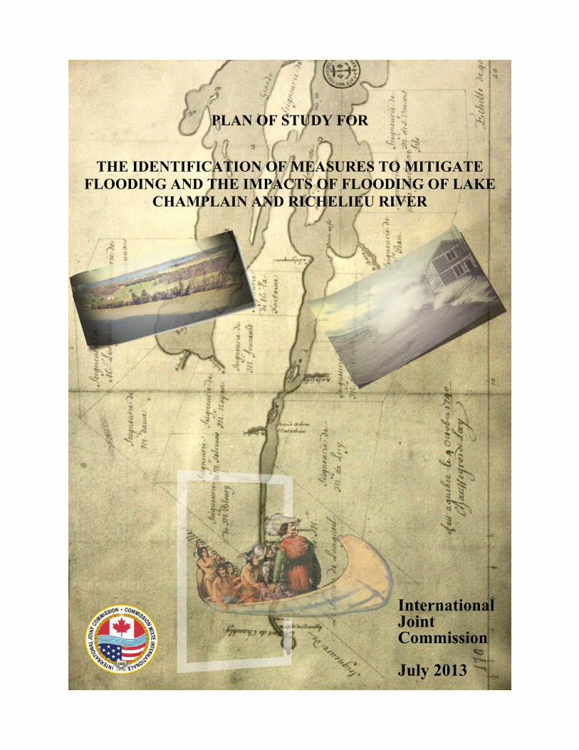
Cover:
1740 Historic Lake Champlain Map from Library of Congress (11LC_LAKC_1740_CARTE_DE_LER-wb).
Gravure Exploration of Lake Champlain in 1609. Post Card, Jacques Saint-Pierre Collection, from The Richelieu River : Valley of Memories, Parks Canada, 2012.
Left picture: Isle La Motte, Vermont, May 2011, Bill Howland.
Right picture: Unknown source.

Lake Champlain – Richelieu River Plan of Study
1
1 Introduction
1.1 Background In response to the devastating floods of 2011 in Lake Champlain and Richelieu River (LCRR) the Governments of Canada and the United States requested that the International Joint Commission (IJC) review and make recommendations regarding a comprehensive study of measures to mitigate flooding and the impacts of flooding in the LCRR watershed (Annex 1). To answer this request, the IJC established in May 2012 the International Lake Champlain Richelieu River Workgroup (ILCRRWG) and tasked the ILCRRWG with a Directive (Annex 2) to answer the governments’ request through a Plan of Study (PoS).
The PoS was produced by the ILCRRWG in collaboration with many others to ensure that it meets the objectives of the Directive and answers the questions, concerns, and comments from the scientific, public, and political interests.
A series of public meetings and site visits were conducted by the International Lake Champlain and Richelieu River Workgroup in August 2012. An intensive two-day workshop for technical experts was held in September 2012 and a discussion with the International Joint Commission was held in October 2012. The draft was presented to the International Joint Commission in January 2013 and posted for public comment on February 21st. A second series of public meetings was held in March 2013 to gather comments and answer questions (Annex 3). The PoS has been revised based upon all of the feedback received from the aforementioned events
This PoS provides valuable information including a history of flooding and the studies done to date, a discussion on the social environment that surrounds and impacts the issue, and finally recommendations on how to move forward in addressing the objectives of the IJC Directive and answers to the governments’ requests.
1.2 The Directive The IJC’s Directive to the ILCRRWG is to develop a PoS that establishes specifically what studies are necessary to allow an evaluation of the causes and impacts of the flooding on the LCRR watershed and to develop appropriate flood mitigation measures and recommendations. More specifically, three distinct evaluations must be addressed:
1. Evaluate the causes and impacts of the past floods on the system, with an emphasis on the events of 2011.
2. Evaluate flood mitigation measures for Lake Champlain and its tributaries and the Richelieu River, considering non-structural and structural measures, and their combination, associated with benefits/costs analysis.
3. Evaluate the need for flood inundation mapping based on real-time forecasting to help predict and prepare local communities and emergency responders for future floods.
The elaboration of flood mitigation measures (2nd item above) shall encompass two specific analyses and recommendations:
Lake Champlain – Richelieu River Plan of Study
2
1. Analyze and recommend actions for adapting to the expected variability of future water supplies to the LCRR watershed, building on existing relevant studies.
2. Analyze the existing, country-wide flood plain regulation best management practices, to include recommendations for community-based regulation.
The full Directive is included as Annex 2.
Note: the term “water supplies” in this document refer to the natural sources of water to the basin from natural precipitation events rather than water supplied to a region or community by controlled or managed resources.
1.3 Scope of Study The geographical scope of the study area addressed by the PoS is the entire LCRR watershed with the downstream limit controlled by the Saint-Lawrence River regime (see sub-section 1.3.1). Although the management of floodplains in the tributaries of the LCRR may be considered as potential flood mitigation measures, the assessment of the effectiveness of all potential flood mitigation measures will be performed only on floodplains adjacent to the Lake Champlain and Richelieu River.
The scope in time includes recorded historical data, current observed, and potential future variability that take into account climatic variability and other estimation of future changes in use and development within the study area (see sub-section 1.3.2).
The scope of data will focus on maximizing the exploitation of the wealth of existing information and data generated by multiple studies in the past as well as common new data needs of future studies.
All studies recommended are to be carried out in accordance with the 1909 Boundary Waters Treaty.
1.3.1 The Lake Champlain-Richelieu River System Lake Champlain is located in the northwestern corner of Vermont (VT), the northeastern corner of New York (NY) and the southwestern portion of Quebec (QC). Lake Champlain is approximately 193 km (120 mi) long and flows from Whitehall, NY, north almost across the U.S./Canadian border to its outlet at the Richelieu River in QC. As Lake Champlain narrows near Rouses Point NY, it becomes the Richelieu River, which flows for 125 km (78 mi) and drops some 26 m (85 ft) to reach the St. Lawrence River in the city of Sorel (QC) (Figure 1.1).
Between Rouses Point and the shoals at St. Jean, QC, a distance of 37 km (23 mi), the gradient of the water surface of the Richelieu River rarely exceeds 30 cm (1 ft) in total drop, even at high flows. The Richelieu River is not regulated by man-made structures. The outflow from Lake Champlain is controlled by a long natural barrier, the rock shoals at Saint-Jean-sur-Richelieu.
The Lake Champlain-Richelieu River watershed covers an area of 23,899 km2 (9,227 mi2) of which 84% are in the United States and 16% are in Canada.

Lake Champlain – Richelieu River Plan of Study
3
Ninety percent of the water that enters the Richelieu River flows through the Lake's 21,326 km2 (8234 mi2) watershed before it reaches the river.
Fifty-six percent of the Lake Champlain Watershed is in Vermont, 37% is in New York, and 7% is in the Province of Quebec.
The population of the watershed has been growing at an average of 1.04% between 2000 and 2010. According to the U.S. Census Bureau and Stats Canada, the LC Basin was 710,257 in 2000 and 738,713 in 2010. Water resources depending upon the LCRR system include, but are not limited to, recreation (camping, boating, swimming, fishing, and hunting), commercial navigation, agriculture, and municipal and industrial water uses. Ecosystems of the lake and river, including shorelines and wetlands, aquatic environments, and forests support a wide diversity of flora and fauna.
Figure 1.1 Map of the LCRR Watershed

Lake Champlain – Richelieu River Plan of Study
4
1.3.2 History of Flooding Over 100 years of water level and discharge data have been collected in the study area with lake levels recorded in Burlington, VT and discharge flows at Fryer’s Dam in QC. Four major high water events of the 1900s are highlighted in Figure 1.2 with the highest lake levels recorded on May 12, 2011 at Rouses Point, NY. The Advanced Hydrological Prediction Service (AHPS) reported that the lake had exceeded its record flood level of 31.1 meters (102.1 feet) set in 1869.
The flooding of the lake and river in the spring of 2011 had an extreme impact on the people and resources of the LCRR ecosystem, as demonstrated in table 1.1, with a total of approximately $88,500,000 damages reported. 79% of the economic damages were recorded in Quebec, 10% in VT, and 11% in NY. Impacts estimates for the U.S. were obtained from the Federal Emergency Management Agency (FEMA) and from the Ministère de la Sécurité Publique (MSP) for Quebec.
Table 1.1 Impact estimates from the 2011 Lake Champlain Richelieu River Flood
VT NY QC
# People Evacuated
75 (+426 from associated
flash floods in tributaries)
124 1 651
# Houses Affected 500 929 2375# Municipalities Affected 8 5 27Individual Claims 800 900 3000Estimated Damages Reported 8 600 000 9 900 000 72 000 000
Impact Estimates from 2011 Flood Event (as of January 2013)
Following each of the major flood events highlighted in Figure 1.2, the IJC has worked with the affected governments in the United States and Canada on various studies and recommendations related to flooding.
In response to the flooding of the 1930s, the IJC conducted various studies, presented a plan for and approved construction and operation of remedial works in the Richelieu River in QC for the reclamation and protection from flooding of lowlands in QC. A dam, Fryers Dam, with thirty-one gates, each thirty feet wide was completed at Fryers Island in 1939. Other project components, including construction of dikes in the vicinity of the dam and the dredging through the rock shoal at St. Jean, provided by the Order of Approval, were not undertaken. Because all project components were not completed, the dam, which still exists, was never placed into operation.
In 1973, the U.S. and Canada governments issued a reference to the IJC, requesting it reports and recommends on the desirability of regulating outflows from Lake Champlain and on interim measures which might be instituted t o alleviate flooding. The Study Board examined in detail the use of the already constructed Fryers Island Dam, a possible new control structure and a number of dredging alternatives in the St. Jean Rapids and published the results in a report (IJC, 1975).

Lake Champlain – Richelieu River Plan of Study
5
Figure 1.2 Historical Variation of Lake Champlain Water Levels and Richelieu River Discharge

Lake Champlain – Richelieu River Plan of Study
6
As recommended as a result of the 1975 report, additional studies were conducted to determine the environmental impacts of the recommended flood structure implementation. The IJC concluded that a flood control structure in the Richelieu River was technically feasible, but it could not determine its desirability, believing that was a question more appropriately addressed by governments (IJC, 1981). The IJC did however recommend a flood forecasting and warning system which was, as a result, implemented in the US.
In April 2011, a combination of record spring precipitation and snowmelt from the third highest cumulative snowfall year on record caused subsequent overflow of the Richelieu River in Canada and Lake Champlain in the United States. Lake water elevation crested at 31.477 m (103.27 ft) above mean sea level according to the National Geodetic Vertical Datum of 1929 (NGVD 29) on May 7, 2011, setting a new record. Waters exceeded flood stage on April 13, 2011 and remained there until June 19, 2011, a total of 67 days. This most recent flood event in 2011 has resulted in governmental requests to the IJC to investigate possible options for flood mitigation and the subsequent establishment of the ILCRRWG.
1.4 Challenges Toward the end of the IJC Study on the LCRR flooding that took place between 1973 and 1981, a synopsis was presented of the situation prevailing on the LCRR, in the article titled “Exchanging Information Across Boundaries: The Richelieu – Champlain Experience” by Brande and Lapping (1979). The article outlined hurdles that stressed the need to converge toward a recognized, scientifically sound common understanding of the various aspects impacting and being impacted by the hydrological regime of the LCRR watershed. Though written in the 1970s, the article remains applicable to the challenges facing today’s flood situation.
“Today the question of whether the leve1s of Lake Champlain and the Richelieu River should be artificially regulated by control structures at St. Jean is again before the International Joint Commission, and a great many aspects of the future of the region await the recommendations of that body and subsequent decision by governments. Many hope the decision will be favorable for some sort of structural flood control scheme. Most of these are home owners or farmers in the area south of St. Jean and Iberville, and they want that favorable decision soon. Many others view this prospect with alarm. Most of the latter are Americans who feel that such regulation will have a drastic, adverse effect on Lake Champlain, especially its wildlife. Moreover, they feel that once started, regulation will necessitate increased water level management in the future. They would prefer to see some sort of non-structural floodplain zoning that would keep people away from floods rather than trying to keep floods away from people. Moreover' recent proceedings of the International Joint Commission on the Canadian side have witnessed the development of a considerable disparity of views in the formerly virtually unanimous attitude favorable to the concept of structural regulation. The issues, while reasonably clear, are unfortunately badly joined and under great pressure. Those involved in the matter have major differences and misunderstandings about the data, needs, premises, policies and possible

Lake Champlain – Richelieu River Plan of Study
7
alternatives available. The issues are joined after serious extensive flooding; and the subsequent proceedings have been conducted on an adversary basis in an atmosphere of considerable tension and urgency for a resolution in the shortest possible time. As with many other major resources conflicts, actual or potential, a great deal of study and information has been developed over the years on this problem. But still, it is not enough with which to do a really good job of managing this great shared resource. Of course, planners and policy makers almost always have "to go with what they’ve got", making the best possible decisions on imperfect information. Worse yet, what information we do gather in the Lake Champlain-Richelieu River Basin is discontinuous and not integrated. No one is charged with pulling it all together, filling in the gaps, keeping it current and ranking it available to those who need and want it, though a good beginning has just been completed for Lake Champlain itself by the New England River Basins Commission (1979).”
In summary there are key phrases in this excerpt that especially apply to today’s situation which include:
• People have major differences and misunderstandings about the data, needs, premises, policies and possible alternatives available.
• Much information and studies were developed over the years, but the information gathered has not been integrated, is discontinuous in space and time, gaps have not been filled, and the information have not been updated, and made available to serve who needs it.
As it will be addressed more specifically in Section 1.5, the ILCRRWG has created a PoS with these specific challenges in mind. As an underlying principle of the IJC’s directive, there is an obligation for future studies to address differences in opinion, misunderstandings, and data integration. Addressing this obligation requires putting emphasis on the credibility of the scientific information, the understanding of the watershed’s response to the possible water supplies, and to the transparent sharing of information with the hope to gain a common understanding. Removing subjectivity is of utmost importance, given the polarized views among the general public, interest groups, agencies, committees and governments. Approaches that facilitate visualization and intuitive understanding of complex interactions must be a priority.
Some specific challenges to overcome in future studies that have more recently been brought to the attention of the ILCRRWG are:
• Vertical datum harmonization of the entire watershed. Discrepancies were observed at the border between the Canadian Geodetic Vertical Datum of 1928 (CGVD 28), the North American Vertical Datum of 1988 (NAVD 88), and the National Geodetic Vertical Datum of 1929 (NGVD 29) (Addressed in Common Data Needs; Chapter 3).
• Overall geospatial datum harmonization for consistency and continuity. (Addressed in Common Data Needs; Chapter 3).
• Licensing for free exchange of data regarding the LCRR PoS should be facilitated by the establishment of a Memorandum of Understanding (MOU). Geophysical data, remote sensing imagery and possibly other sensitive datasets should be included in the MOU.
• International travel, communication (language differences), and other challenges that arise in transboundary endeavours.

Lake Champlain – Richelieu River Plan of Study
8
1.5 Historical, Social and Political Perspectives: A Cursory Analysis
1.5.1 Background to the Cursory Analysis Considerable resources and money have been spent addressing LCRR flooding in the past and the ILCRRWG now proposes that additional resources and money be spent on future work in support of additional studies. In this context it is of utmost importance that all efforts be made to ensure that those efforts will lead to actual, implementable and desirable flood mitigation measures. To maximize the probability that future investments in similar work are advisable to the governments, scientific community, public and other stakeholders, it is extremely important for the ILCRRWG that any tools resulting from the proposed Study will be valuable and used for their intended purpose and that any proposed mitigation measures have a good probability of implementation.
Since the establishment of the ILCRRWG in May 2012, a variety of activities has taken place through which the Workgroup gained a sense of current questions, concerns, and comments on the issue of LCRR flooding. In August 2012, site visits on both the US and Canadian sides of the study area were conducted, during which workgroup members viewed in person a number of key areas that may have an effect on flooding, have been impacted by historical flooding, or may be impacted by future floods. Also in August 2 public meetings were held in Saint-Paul-de-l’Ile-aux-Noix, QC CA and North Hero, VT, US. The meetings were held at this time specifically in order to ensure that vacationers to the region would be present to attend. In September 2012, a Technical Workshop was hosted by the IJC and ILCRRWG at which close to 70 experts in a variety of scientific fields, all related to LCRR flooding, attended and provided input to the PoS. Finally, a first draft of the PoS was presented to the Commissioners of the IJC in October, and the ILCRRWG received valuable feedback from the Commissioners.
Although much valuable information was gathered through the aforementioned events, trends and similarities in issues raised in the past and today made the ILCRRWG and IJC aware of the need for additional information collection on the current public, management and scientific attitudes toward flood prevention/mitigation measures as well as an historical, social and political context review to obtain a better sense of the desirability of various flood mitigation measures, especially the ones that involve the actual regulation of the water levels of the system. The ILCRRWG expected that this information would prove to be very helpful in the crafting of the PoS and in the value of its recommendations for a path forward.
Considering this, the ILCRRWG conducted from November 2012 through January 2013, a cursory analysis of the current attitudes toward flood prevention/mitigation measures within a historical context to support its recommendations to the IJC.
Prior to collecting additional information and conducting reviews, a Brief History of the 1973 LCRR Reference was composed (Annex 4). This last IJC study and the resulting limited implementation of flood mitigation measures illustrate the need to assess the current likelihood for implementation before investing in conducting further studies. Using the information summarized in the Reference, ILCRRWG members gathered general information on current attitudes towards various flood mitigation measures which are presented in Sub-section 1.5.3.

Lake Champlain – Richelieu River Plan of Study
9
1.5.2 Methods for Conducting the Cursory Analysis Understanding to the extent possible the current desirability for implementation done at a cursory level begins with an understanding of the roles that government agencies in both countries play in decision-making on such matters. The following is a list, prepared by the ILCRRWG of those parties that contribute to making decisions (or providing expert advice) toward implementation.
Canadian Federal Government:
• Environment Canada (EC)
• Fisheries and Oceans Canada (DFO)
• Parks Canada (PC)
• Public Safety Canada (PS)
• Transport Canada (TC)
• Canadian Space Agency (CSA)
• Natural Resources Canada (NRCan)
• Agriculture and Agri-Food Canada (AAFC)
• Foreign Affairs and International Trade Canada (DFAIT)
The Québec Government:
• Ministère du développement durable, de l’environnement, de la faune et des parcs du Québec (MDDEFP)
• Ministère de l’agriculture, des pêcheries et de l’alimentation du Québec (MAPAQ)
• Ministère des ressources naturelles du Québec (MRN)
• Ministère des affaires municipales, des régions et de l’occupation du territoire du Québec (MAMROT)
• MSP
• Ministère de la santé et des services sociaux du Québec (MSSS)
• Ministère des finances et de l’économie du Québec (MFEQ)
• Ministère des transports du Québec (MTQ)
• Ministère des relations internationales, de la francophonie et du commerce du Québec (MRIFCE)
Municipalities: Saint-Jean-sur-Richelieu, Sainte-Anne-de-Sabrevois, Saint-Blaise-sur-Richelieu, Henryville, Saint-Paul-de-lÎle-aux-Noix, Lacolle, Noyan, Saint-Georges-de-Clarenceville, Saint-Sébastien,

Lake Champlain – Richelieu River Plan of Study
10
Venise-en-Québec, Saint-Armand, Pike-River, Richelieu, Saint-Mathias-sur Richelieu, Beloeil, Carignan, Chambly, McMasterville, Mont-Saint-Hilaire, Otterburn Park, Saint-Antoine-sur-Richelieu, Saint-Basile-le-Grand, Saint-Charles-sur-Richelieu, Saint-Denis-sur-Richelieu, Saint-Marc-sur-Richelieu, Sorel-Tracy, Sainte-Victoire-de-Sorel, Saint-Joseph-de-Sorel, Saint-Rock-de-Richelieu and Saint-Ours.
Also part of that list, the Municipalités régionale de comté (MRC) of Brome-Missisquoi, Haut-Richelieu, de Rouville and of the Vallée-du-Richelieu.
United States, State and Federal Government:
• U.S. Environmental Protection Agency (EPA)
• U.S. Fish and Wildlife Service (USFWS)
• U.S. Geological Survey (USGS)
• U.S. Department of Agriculture (USDA)
• National Oceanic and Atmospheric Administration (NOAA)
• Vermont Agency of Natural Resources (VTANR)
• New York State Department of State (NYSDOS)
• New York State Canal Corporation (NYSCC)
• U.S. Army Corps of Engineers (USACE)
• U.S. Forest Service, Green Mountain National Forest (USFS, GMNF)
• U.S. National Park Service (USNPS)
Municipalities: Alburgh (VT), Altona (NY), Ausable Forks (NY), Beecher Falls (VT), Burlington (VT), Cambridge (VT), Charlotte (VT), Chazy (NY), Colchester (VT), Crown Point (NY), Essex (VT/NY), Essex Junction (VT), Georgia (VT), Grand Isle (VT), Isle La Motte (VT), Jeffersonville (VT), Johnson (VT), Keene Valley (NY), Keeseville (NY), Lake Placid (NY), Montpelier (VT), Moriah (NY), Plattsburgh (NY), Point Au Roche (NY), Port Henry (NY), Port Kent (NY), Rouses Point (NY), Rutland (VT), St Albans (VT), St Johnsbury (VT), Saranac Lake (NY), Shelburne (VT), South Burlington (VT), South Hero (VT), Swanton (VT), Ticonderoga (NY), Westport (NY), Willsboro (NY)
ILCRRWG members reached out to selected staff from some of the aforementioned agencies to inquire as to what the current perceptions are regarding recommendations made in the 1970s/80s and the individual’s personal perceived acceptability of potential future recommendations that may result from a future study. Measures that may be recommended from a future study were anticipated based upon the information collected during the technical workshop and public meetings held in August and September 2012 as well as those mitigation measures and flood protection measures mentioned in the IJC’s Directive to the ILCRRWG.

Lake Champlain – Richelieu River Plan of Study
11
The results of these inquiries are summarized in the following sub-section. It was anticipated that the results of the cursory analysis would be helpful and possibly ground tested during the upcoming public meetings. It is important to note that these inquiries and the results of these inquiries represent only the views and personal opinions of selected staff of the agencies that were consulted. They were consulted by ILCRRWG members for nothing more than a sense of possible perceptions of any of the agencies and assistance to the ILCRRWG in the identification of potential future situations surrounding decisions on flood mitigation or prevention measure implementation.
It cannot be stressed enough that the results presented in the Cursory Analysis should not be considered official interpretations or representations of any agency positions.
1.5.3 Results of the Cursory Analysis Flood damages incurred as a result of the 2011 flood events caused immediate concern to area residents, commercial enterprises, and policymakers at all levels within the affected region. Throughout the entire LCRR region, about 4,000 homes were damaged, about $90M in damages incurred and more than 30 municipalities were directly affected. Policymakers immediately directed resources to mitigate damages, alleviate suffering and reconstruct the flood-affected areas. Scientists worked together to assess the degree of effects the flooding had on the region (environmental, financial, tourism, and recreation). Finally, residents continue to make up for loss of personal belongings and property while doing their best to plan ahead for future flood events.
As mentioned in the previous sub-section, a cursory analysis of the perceptions of the general public as well as staff associated with agencies that partake in the decision making process regarding flood damage recovery, mitigation, and preparedness has been done with particular scenarios of flood mitigation measures in mind. These measures include those recommended in 1981 via the last IJC study and potential measures that have been proposed in public meetings and technical workshops since the establishment of the ILCRRWG in May 2012.
The following is a summary of potential attitudes and perceptions of the past regarding specific flood mitigation measures discussed by the IJC in the 1970s/80s (IJC, 1981):
1. Construction & Operation of a Gated Structure at Saint-Jean-sur-Richelieu that would accommodate the proposed Environmental Criteria: In general, a majority of agency staff and public polled opposed this option for various reasons including the concern for environmental impacts, high costs for construction, operation and maintenance as well as potential issues on what agency would be given the jurisdiction to control the structure. Some residents as well as a few agencies supported this option as flooding of private and agricultural land was a major concern within the Richelieu River valley.
2. Implementation and Operation of flood forecasting system: This measure was considered favorable by all agency staff and general public polled. Some areas within the LCRR region currently employ such systems but there is a need to increase the accessibility and coverage of the existing forecasting network.
Lake Champlain – Richelieu River Plan of Study
12
3. Implementation and application of well-planned flood plain regulations: This was considered favorable by all agency staff and general public polled and was in fact implemented in a majority of the LCRR region.
The following is a summary of potential attitudes and perceptions of current perceptions regarding specific flood mitigation measures discussed by the IJC in the 1970s/80s and others:
1. Construction & Operation of a Gated Structure at Saint-Jean-sur-Richelieu that would accommodate updated Environmental Criteria: Attitudes toward this option seem not to have changed since the 1980s. Nearly all agency staff and public polled opposed this option for various reasons including the concern for environmental impacts, high costs for construction, operation and maintenance and the concern over potential issues on what agency would be given the jurisdiction to control the structure. However, some residents as well as few agencies supported this option as flooding of private and agricultural land was a major concern within the Richelieu River valley.
2. Partial Diversion of Flow in the Chambly Canal to compensate for Canal Widening at High Waters: Similar to the gated structure proposition, general public and agency staff polled indicate that there may be hesitation in supporting this particular measure, partially due to a lack of knowledge about it. Environmental impacts remain the highest concern. However as this measure was never fully explored in past studies, there is some interest in learning more about this potential measure including the design, cost, and impacts.
3. Implementation and Operation of a flood forecasting system: Flood forecasting for events such as that of the spring 2011 seem to be considered effective tools that would assist property owners and municipalities in minimizing or preventing damages due to loss of property.
4. Implementation and application of well-planned flood plain regulation: Based upon the results of polls done at this time, this seems to be a mitigation measure generally supported and although some policy and regulation currently exists, there is significant room for improvement. Questions on how appropriate regulations are, how to implement policies and how to best to regulate and enforce such policies remain. A majority of policies would be implemented and affect local municipalities on a greater magnitude however, local municipalities were not consulted through this cursory analysis. A more in-depth analysis on local perceptions and support should be a major component of any flood plain management study that is conducted.
5. Wetland restoration and preservation: General public and staff polled indicate that implementation of this measure is looked upon favorably but also may be looked upon as having limited effectiveness in actually mitigating for floods and flood damages in the future but should be researched further.
6. Build dams or elevated roads to protect urban areas, or elevate the first floor over the level of 100-year flood event. This measure, which may be considered more of a locally-implemented structural measure that protects smaller geographical areas, may generally not be well supported. In most areas, this measure may be done by individual homeowners or municipalities if they choose to devote funds to it and is not necessarily implementable at a higher level of government.

Lake Champlain – Richelieu River Plan of Study
13
7. No action. All agency staff consulted do not support a”no-action” alternative and are in agreement that something must be done.
In summary, based upon the cursory analysis, important structural mitigation measures continue to raise concerns in the areas of environmental impact and significant costs for construction, operation and maintenance. However, some limited structural measures such as a diversion channel in the Chambly Canal, have not been studied in depth and there could likely be support in moving forward with analyzing that potential alternative. Non structural measures, in particular well-planned, applied and enforced flood plain management regulations, are strongly supported. Consultation and perceptions of local municipalities on the feasibility of this option is lacking. The majority of the impacts of these policies and the onus of implementation and enforcement often lie on the local municipalities. The public meetings held in March 2013, tended to confirm the above findings.
Based on the cursory analysis completed, a phased approach in the PoS was decided upon and is presented hereafter, as it appears reasonable to adjust the potential course of actions of an IJC supported study to the current acceptability and desirability of flood mitigation measures.
1.6 Options for Implementing the Study In responding to the Directives of the IJC, three major factors have driven the development of the PoS and guided the prioritization and recommendations set forth such as:
• Awareness that time, resources, and funding are limited.
• Concerns and ideas brought forth from public, political, scientific and private interests.
• The cursory analysis conducted and summarized in section 1.5.
The PoS presents a way forward in implementing a Study presented as three options for implementation. The options presented are incremental, as Study Option B includes Study Option A, plus additional activities, and similarly for Study Option C. These options and the studies that make up each option are summarized below and represented in figure 1.6.
1.6.1 Study Option A: Study Option A addresses the majority of objectives listed in the IJC Directive at their most basic level through preliminary analyses by:
• Evaluating the causes and impacts of past floods, especially the event of 2011.
• Assessing the possibilities offered by the best possible flood plain management practices.
• Evaluating possible adaptation strategies to the expected future variability in the water supplies.
• Providing preliminary indications of the expected benefits associated with the forecasting of floods and real-time mapping.

Lake Champlain – Richelieu River Plan of Study
14
Study Option A is comprised mainly of the tasks that occur in Chapter 2 (Preliminary Analysis) and Chapter 3 (Development of Common Data, Information and Tools).
In support to these four preliminary analyses, basic hydrologic and hydraulic modeling of the system will be performed with the required physiographic, bathymetric and flood plain features and topometric data to allow the real-time flood forecasting and inundation mapping capacity. Scaled-down Evaluation and Analysis activities (Chapter 5) and Study Management (Chapter 6) activities complete Study Option A.
This option allows for some understanding on causes and impacts of the historical floods, on country-wide floodplain management practices, on adaptation the variability of water supplies and provision of an operational flood forecasting and inundation mapping capability. Also part of option A is an in-depth study of current social and political perception on structural and other mitigation measures to support and confirm the desirability of potential structural mitigation solutions.
1.6.2 Study Option B: Study Option B includes all components of Study Option A, plus a combination of some quantitative and qualitative assessment of potential flood mitigation measures (essentially non-structural with / without combination with moderate structural works) and their impacts on important resources of the system: the wetland and fauna, recreational, domestic, industrial and municipal uses of water, shoreline and floodplain built environment and agriculture. Resource response models will be developed and will include basic indicators for water resources response to water levels fluctuations, with special attention on the data inventory and identification of thresholds. Those indicators would allow for the assessment of impacts from a suite of mitigation solutions that will be reviewed through this Study Option. Climatic projections, wind wave and ice models, additional new data for the evolution of watershed physiographic characteristics over time and a complete digital terrain model would also be produced to allow the planning, evaluation and ranking of potential flood mitigation solutions, using a shared-vision approach.
This option allows for a response to the Directive with the evaluation of potential non-structural flood mitigation measures, and evaluations of moderate structural mitigation measures such as removing vestiges of structures on the Saint-Jean Shoal. This option would not offer the flexibility to assess the larger spectrum of water level fluctuations associated with important regulation measures.
1.6.3 Study Option C: This option addresses all of the objectives listed in the IJC Directive including the best possible evaluation of impacts on the resources and the environment associated with structural flood mitigation measures, and with all non structural mitigation measures covering the complete range of expected water levels. Study Option C includes all components of Study Option B with the addition of more refined qualitative and quantitative resource response model to handle potentially larger annual water level variations associated with more substantial structural flood mitigation measures. Erosion models and associated ancillary data and more refined hydraulic models are also part of this option, to better understand the impacts of a wider spectrum of water

Lake Champlain – Richelieu River Plan of Study
15
level fluctuations and gain better representation of future water cycle interactions on the LCRR watershed.
This option addresses all objectives listed in the IJC Directive including the evaluation of a more exhaustive inventory of structural and non structural mitigation measures covering the complete range of expected water level impacts. More elaborate planning and evaluation would also have to take place to accommodate the more complex mitigation solutions and associated various regulation plans.
Figure 1.6 Framework for Study Options A, B, and C

Lake Champlain – Richelieu River Plan of Study
16
1.7 Study Approach
1.7.1 Guiding Principles Regardless of what Study Option is chosen for implementation, it is important that the following guiding principles be adhered to throughout implementation of the Study:
1. While not disregarding any form of flood mitigation measures a priori, the ILCRRWG believes that study efforts shall concentrate on measures that are likely to be actually implemented. In this regard, the information, models and other tools developed must be adaptable to any form of flood mitigation measures considered.
2. All tasks proposed for the study must be compatible with the objectives of the Directive.
3. Decision-making with respect to the development of water management options and evaluation methods will be transparent. Opportunity will be provided for meaningful participation from various levels of governments, First Nations, Native Americans and the public in all aspects of the study to ensure their advice and concerns are considered and that all have the opportunity to contribute to the success of the study.
4. Credible and generally accepted science, current knowledge and state-of-the-art technologies for hydrological, hydraulic, economic and environmental evaluations are to be used in all tasks. New and innovative techniques are encouraged if they result in the provision of critical information for the decision making process that would have otherwise not been available. The modeling approach and management of data sets shall be done in conjunction with the guidelines laid out in Model Selection and Implementation Guidelines. Technical Report: OCRE-TR-2012-006 (Jenkinson, 2012). Peer review by independent experts would be conducted prior to adopting study methods and techniques, including major assumptions and overall approaches to be undertaken.
5. Ensure the information funded through the study, the models results, and all technical reports should be placed on the web site for public access and scrutiny, even after the study is complete. Information technology will be used for public communications, while at the same time making provisions for providing information in conventional ways.
6. Ensure that the results of these studies can enhance the real-time forecasting efforts that can be provided in an operational setting where timely forecasts can be disseminated to stakeholders.
7 Adaptive Management; the technical guide on Adaptive Management produced for the U.S. Department of the Interior (Williams, Szarp and Shapiro, 2007) states that “adaptive management is appropriate if management can strongly influence the system but uncertainty about management impacts is high”. Influence on the system related to mitigation measures is currently unknown.
It is imperative that adaptive management principles are applied throughout the implementation of the Study modulating them with respect to the actual mitigation measures selected and their level of influence on the system. Applying actual elements of adaptive management is explored further in the Study Management section of this PoS, many of which are already incorporated into this POS.

Lake Champlain – Richelieu River Plan of Study
17
1.7.2 Organizational Period The experience from the International Lake Ontario - St. Lawrence River and Upper Great Lakes Studies has shown the importance to lay the proper groundwork prior to initiating a study. An organizational period spanning about six months is recommended. During this period, a small team would scope out the tasks to be done which may or may not include, depending upon what study option is chosen, an envelope of reasonable and acceptable flood mitigation measures and refinement of the nature and extent of the hydrological, hydraulic, economic and environmental studies, including deciding on evaluation methods and assumptions.
The team would also consider potential study participants from the public, government agencies and the academic community, and design a study organization with terms of references for study groups.
1.7.3 Evaluation Methodologies To ensure a cost-effective study and the credibility of the science in the study, the organization team would consult with experts in governments and academia on appropriate scientific and engineering approaches to consider within the study. This makes a scoping exercise essential to determine whether qualitative or detailed quantitative evaluations are sufficient, particularly in the implementation of Study Options B and C. A hydrological and hydraulic team will be required throughout the study to determine the water levels and flows resulting from various flood mitigation measures considered.
With respect to evaluating impacts of potential mitigation measures on water resources (under Study Options B and C), it is expected that evaluation of the impacts will follow essentially a sequence that was used in past IJC studies which is:
1. Identify the needs of the interest groups related to the resources that might be impacted.
2. Investigate potential flood mitigation measures.
3. Generate water levels and flows under (1) current conditions and (2) alternative flood mitigation measures, assuming current climate and climate change scenarios.
4. Evaluate impacts on the interest groups.
5 Analyze, compare and rank the evaluation results.
6. Consider flood mitigation options and make recommendations.
1.7.4 Timeline The timeline for Study Option A is estimated to be approximately three years long.
In Study Options B and C, the inclusion of identification and evaluation of flood mitigation measures and their associated effectiveness and impacts requires a timeline that is expected to span over five years.
For Study Options A, B and C, Year 1 would initially focus on study organization and evaluating the causes and impacts of the past floods on the system with an emphasis on the events of 2011.

Lake Champlain – Richelieu River Plan of Study
18
An in-depth study of current social and political perception on structural and other mitigation measures to support and confirm the desirability of potential structural mitigation solutions would be performed and will modulate the work on the investigation and definition of an ensemble of flood mitigation measures that are likely to be examined if Study Options B or C are implemented. Concurrent with these tasks, the acquisition, collation and construction of a good description of the LCRR watershed including geophysical, hydrological, climatological and land uses characteristics will be initiated.
For all three study options, analysis of existing country-wide best practices in flood plain management, possible adaptation to water supply variability and benefits associated with real-time flood forecasting and mapping will be assessed in Year 2. For Study Options B and C, findings of desirable mitigation measures will contribute to refinements in the resources response assessment methodologies will be applied as work progresses into Year 2.
In Study Options B and C, Years 3, 4 and 5 will see the completion of the required tools and the initiation of the testing of potential flood mitigation measures, including benefits-cost analysis.
Throughout the entire study, application of Adaptive Management principles and public participation are key elements.

Lake Champlain – Richelieu River Plan of Study
19
2 Preliminary Analyses and Studies Tasks done as part of the Preliminary Analyses will lay the groundwork required to further develop and analyse flood mitigation measures. Additionally the following tasks will produce results that address four of the five major study objectives listed in the IJC Directive.
• Evaluating the causes and impacts of past floods, especially the event of 2011.
• Assessing the possibilities offered by the best possible flood plain management practices.
• Providing preliminary indications of the expected benefits associated with the forecasting of floods and its real-time mapping.
• Evaluating possible adaptation strategies to the expected future variability in the water supplies.
In support to these four tasks, the necessary associated tasks to produce a Digital Terrain Model (DTM) and the basic hydrologic and hydraulic modelling capacity are required, and are thus listed along with Preliminary Analyses and Studies as required tasks for Options A, B, and C.
The Preliminary Analyses and Studies will provide a general approximation of the variables at play and consequences of floods, the identification of vulnerabilities and ways to adapt to water supplies variability from “what if” climatic scenarios (not actual climate projections), identification of best possible flood plain management practices and potential benefits associated with a flood forecasting and real-time mapping tool. These studies are in themselves valuable and can be accomplished with limited data and information gathering; they allow for a least costly option (Study Option A) and are also required for Study Options B and C.
2.1 Evaluation of the Causes and Impacts of the History of Flooding on the Lake Champlain – Richelieu River Watershed, with emphasis on the events of 2011
Statement of Work The 2011 flood in Lake Champlain and the Richelieu River was unprecedented by the water levels that were experienced, by the extent of the territory that was flooded, by the duration of the event, and by the subsequent damages. The characterization of this flooding event, as well as other events experienced in the past in the watershed, from both climatological and hydrological perspectives, is a fundamental piece of the ILCRR PoS. Understanding the 2011 flood event allows a better understanding of the general flooding issue that will in turn feed into the work of defining possible flood mitigation measures, structural and non-structural and subsequently improving how we deal with future flooding events, reducing associated damages, and preventing loss of life.
Evaluating the causes and impacts of flood events with an emphasis on the flood of 2011 requires cursory analysis of climatology and hydrology, a physical description of the watershed

Lake Champlain – Richelieu River Plan of Study
20
(physiography, bathymetry, topography, land use, hydrology, etc.). This will in turn feed the analysis of potential measures to adapt to the expected variability in water supplies as well as tasks associated with Study Options B and C.
This study will examine and explain the sequence of events that led to the 2011 flood in the LCRR. The flood event will be characterized in terms of magnitude, extent and duration and compared with past events in the watershed over the last 100 years. Impacts of each flood event will be analyzed. Finally, a set of recommendations on additional monitoring activities that may be required to properly characterize the hydrology of the watershed will be produced.
This study will make use of relevant existing studies and information from past floods through the synthesis of information and analyses that have already been collected and conducted. Particular emphasis will be placed on data collected from the 2011 flood compiled by the LCBP report “Flood Resilience in the Lake Champlain Basin and Upper Richelieu River,” (LCBP, 2013) as well as other 2011-specific reports published by state, provincial and federal agencies. Existing information on regional climatology and adaptation to climate change produced by The Nature Conservancy (TNC), Vermont Experimental Program to Stimulate Competitive Research – Research on Adaptation to Climate Change (EPSCoR - RACC), the Ouranos Consortium, and others, will be incorporated and considered.
Methodology The specific tasks listed below will provide a description of the main flooding events experienced in the LCRR watershed over the past 100 years with special emphasis on the event of 2011.
1. Gather information on the LCRR watershed including but not limited to:
a. Morphology, dimension, topography.
b. Main tributaries, relative contribution, and response times.
c. Main hydraulic structures (dams, dikes, roads, etc.) and human interventions.
d. Land use.
e. Climatology.
2. Analyze past hydrometric records on LCRR to identify a subset of extreme flood events in the watershed for further analysis.
3. Conduct a historical analysis of flooding in the LCRR system including:
a. Climatology (sequence of events) for each flood event.
i. Synoptic patterns and “weather typing”.
ii. Atmosphere/ocean Oscillations and Teleconnection.
iii. Liquid precipitation.
iv. Snow accumulation.
v. Winds and waves.
vi. Temperature.

Lake Champlain – Richelieu River Plan of Study
21
vii. Evaporation.
b. Hydrology for each flooding event (flood magnitude, timing and typical duration).
i. Water level stations around the lake (e.g., Burlington, Rouses Point, Phillipsburg, etc.), main tributaries to the lake and river, Richelieu River at Fryer’s Rapids, Saint-Jean-sur-Richelieu.
ii. Compare magnitude of flooding, timing and flood duration for each event.
iii. Validity of stage-discharge curves used.
iv. Relate the sequence of climatological events with the eventual response of the watershed.
c. The flood of 2011 compared to past flood events to respond to:
i. Return period of hydrometeorological indicators.
ii. What was different for this flooding event compared to past years?
d. Comparative studies in other important watersheds such as the:
i. Mississippi River watershed (major floods in 1993 and 2011).
ii. Red River watershed (US and Manitoba).
iii. Souris River.
iv. Saguenay River and other examples in the US and Canada, as required
4. Based on the historical analysis of flooding in the LCRR system, produce recommendations for additional hydrometric or atmospheric monitoring that may be required to properly characterize flood events in the watershed.
5. Analyse the economical and social impacts (lives, property, social, health, municipal tax revenue, etc.) of the selected flooding events including:
a. 2011 event.
b. Other selected events.
(For both a. and b. see “Key impacts to investigate” below)
6. Produce and publish an IJC approved scientific report on the causes and impacts of flooding events in the LCRR.
Potential causes of flooding to investigate include, but are not limited to:
• Snow and precipitation drive the volume of water.
• Storage in watersheds, floodplains, and in the lake itself all are critical to the ultimate duration and level of water levels and flow rates in the river.
• To some extent, infrastructure, natural constrictions (Saint-Jean-sur-Richelieu shoal), and impedance to flow (aquatic plant density and debris from historical construction) that can exacerbate levels and or velocity of flow – Fryers Dam, bridges, natural impedance, roads, Chambly Canal, etc..

Lake Champlain – Richelieu River Plan of Study
22
• Development within the watershed (structures/impervious surfaces modifying the hydrology) displacing volume of land that could hold water.
• Changes in land use and tributary morphology in the watershed that effects hydrologic response.
• Seiche and wave effects on water levels and resulting exacerbation of erosion.
• Where people are located and placing infrastructure – human exposure and vulnerability.
Key impacts of flooding to investigate include, but are not limited to:
• Direct impacts to health and safety of people, homes and facilities – impacts of flooding and sedimentation on access, housing for affected/displaced people, care for those who need it and preparedness.
• Septic systems (flooded) and wells primarily along the river.
• Impacts of seiche and wave impacts in terms of erosion and impacts to infrastructure- primarily lake-related.
• Management of the Chambly Canal, impacts on recreational boating, and on ferries.
• Water quality impacts in terms of concentration and loading caused among others things by flooded septic and gas tanks, effluent, sanitary and combined sewers, runoff from farm fields, sediments, rotted vegetation and crops and fish that were stranded; for both urban area and agricultural area; include also subsequent impacts on water uses;
• Health and psycho-social impacts particularly on the more vulnerable – this is tied to the duration of the impact and nature of the response.
• Long term impacts – mold in flooded homes, loss and replacement of lost property, lack of awareness of resources that can help and possible long term impacts.
• Management of waste and debris from destroyed homes and property and from the reconstruction/renovation of affected buildings.
• Modification in the distribution of invasive species.
• Impacts of changes in water levels and erosion on wildlife and wetlands.
• Emergency management costs.
• Impact of past floods on the recreational/tourism sector in all areas (e.g., employment, contribution to the viability of municipalities based on the type of municipality).
• An evaluation of the economic impact on domestic, industrial, agricultural and municipal water uses (roads, travel, interruption of business).
• An evaluation of the impact of flooding on agricultural industry.
• An assessment of the economic impacts on shoreline properties and infrastructure.
• Investigation of all dam/retention/detention structures, such as the Waterbury dam to evaluate what capacity they had.

Lake Champlain – Richelieu River Plan of Study
23
Other questions to address in this study include:
• How does duration of the event influence the impact?
• What is an acceptable level of risk and damage?
• How will this risk change in the future due to climate change and changes in population around the lake?
• How can we reduce our vulnerability?
• What are the impacts to society as a whole? What is the awareness of the risk?
• Is the 2011 flood likely to happen again?
• Will climate change make flooding worse or more frequent?
• Did human activity cause the record high levels in 2011?
• Is there something we can/should do immediately?
Study Organization, Costs and Schedule Agencies that are suggested to lead this study:
• EC (Meteorological Service of Canada)
• Centre d’Expertise Hydrique du Québec (CEHQ);
• USGS
• NOAA
Agencies and organizations that could contribute to this study could include, but are not limited to:
• Ministère de la Sécurité Publique du Québec (MSP)
• Ministère de la Santé et des Services Sociaux (MSSS)
• Ministère des Finances et de l’Économie du Québec (MFEQ)
• MDDEFP
• MAMROT
• MRCs in the LCRR watershed
• USACE- National Flood Risk Management Program
• USACE- Institue for Water Resources
• Lake Champlain Basin Program (LCBP)
• VTANR
• NYSDEC

Lake Champlain – Richelieu River Plan of Study
24
• USFWS
• RACC
• Lake Champlain Sea Grant
• USDA-NRCS
Table 2.1 Time and Cost Estimates – Evaluation of the Causes and Impacts of the history of flooding on the Lake Champlain – Richelieu River Watershed, with emphasis on the events of 2011 - Study Option A (k$).
Major Tasks Option A Year 1 Year 2 Year 3 Year 4 Year 5 TotalDescription of the Lake Champlain – Richelieu River basin (morphology, dimension, topography, main tributaries, relative contribution and response times, main hydraulic structures (dams, dykes, roads, etc.) and human interventions, land use, climatology. 50 0 0 0 0 50Analyse past hydrometric records on Lake Champlain and the Richelieu River to identify a subset of extreme flood events in the basin for further analysis 50 0 0 0 0 50Conduct a historical analysis of flooding in the LCRR 100 0 0 0 0 100Produce recommendations for additional hydrometric or atmospheric monitoring that may be required to properly characterize flood events in the basin 50 0 0 0 0 50Analyse the impacts of the selected flooding events 100 0 0 0 0 100Scientific report on the causes and impacts of flooding events in the LCRR 50 0 0 0 0 50Total Option A 400 0 0 0 0 400
2.2 Study on Flood Plain Management Practices
Statement of Work In spite of investments of funds and resources, flood losses continue in the LCRR watershed. Population growth and migration, changes in climate coinciding with persistent flood events overwhelms current attempts to reduce flood losses and to protect water-based resources.
As a majority of the vulnerability and risk for loss and damage lies within the floodplains, the study of land use planning and flood plain management practices is an essential component of the Study. Costs and impacts of flooding to landowners, homeowners, and federal, state, provincial and local governments can be enormous. Floodplain management practices address and may mitigate these costs and impacts and will be investigated as a potential means to mitigate flood damages and will be considered as non-structural mitigation measures.
Although the management of floodplains in the tributaries of the LCRR may be considered as potential flood mitigation measures, due to the scope of the study limited to boundary and transboundary waters and the focus on impacts of flood events on the Lake Champlain and Richelieu River, the assessment of the effectiveness of all potential flood mitigation measures will be performed only on floodplains adjacent to the Lake Champlain and Richelieu River. The future study

Lake Champlain – Richelieu River Plan of Study
25
board should cooperate closely with and keep fully informed those regional and municipal governments in the wider watershed in order to share data and ensure that those aspects of the funded studies that are useful to other area governments and flood response managers are shared and taken into account
The Study will provide a description of current practices, assess the effectiveness of these practices, identify potential improvements in floodplain management and regulation and make potential recommendations.
Methodology 1. Current Flood Plain Management Practices Review
a. Conduct a review of floodplain management policies and regulations and implementation of such in the United States (mainly VT and NY), Canada (mainly QC) and possibly other countries. This review should include an assessment of the qualitative impacts of floodplain management policies on floodplain occupancy and land use planning. Some examples include relocation of infrastructure within high risk areas of the floodplain, land acquisition and preservation of open space; design and location of services, utilities, and critical facilities; disaster preparedness plans and programs; disaster assistance programs; flood proofing; smart growth practices, flood forecasting; warning systems; and emergency plans, and public information dissemination. As an example, a review may cover the application by the municipality of regulation and the decree passed on the Richelieu River by the Government of QC and the management municipal level following the Spring 2011 floods.
b. Conduct a review of regulation and enforcement practices and approaches concerning the communication of flood risk to the citizen in the United States, Canada and possibly other countries, (e.g. flood map access, flood risk mapping, emergency warnings).
c. Conduct a review of the municipalities’ flood risk management (emergency plans, knowledge of the vulnerabilities in the floodplain, flood risk knowledge of the people) of municipalities in the Lake Champlain Watershed vs. examples of municipalities elsewhere (Canada, U.S., Europe).
d. Conduct an inventory of any “exceptions” / “orders of approval” to the guidelines that allowed construction in the waterways or flood plains after the event, including the assessment of current permit regulations among the different jurisdictions in the Watershed.
e. Conduct a review of existing flood maps. Some Flood Hazard Maps throughout the Lake Champlain and Richelieu River watersheds are outdated and inadequate for use by municipalities as a planning and regulatory tool. Provincial, State and Country differences in approaches contribute to inhomogeneous risk-sharing throughout the watershed.
i. Conduct a qualitative analysis of flood compensation and/or insurance programs in the U.S. and Canada, (including costs such as damages, emergency measures expenditures, social costs, human health and impacts on municipal taxation, etc.).

Lake Champlain – Richelieu River Plan of Study
26
2. Review of Effectiveness and Impacts of Current Flood Plain Management Practices
a. Conduct an analysis of the strengths and weaknesses of all current Flood Plain Management Practices identified in the above task (Task 1, a-e) based upon actual results post chosen flood events.
b. Conduct interviews to identify issues and constraints, private, public, and political related to possible implementation of any new policies, regulations or other mitigation measures that would affect the flood plains looking for opportunities to harmonize implementation of all three jurisdictions. Discuss potential best management practices that could be implemented on a regional scale.
c. Conduct an analysis of economic impacts and incomes to municipalities, agriculture and other sectors.
3. Assessment and analysis of potential new floodplain management practices including, but not limited to practices such as agricultural storage possibilities, the potential for relocation of infrastructure within high risk areas of the floodplain, land acquisition and preservation of open space; wetland restoration; and design and location of services, utilities, and critical facilities.
4. Recommendations for Flood Plain Management Practice Improvements
a. Based upon the analysis of current practices and the assessment of the effectiveness of these practices and with the understanding of local politics and how they affect implementation and enforcement, make recommendations for improvement to current flood plain management practices. This could include recommendations for new practices that may have been identified in the assessments.
b. Determine if/how existing diked agricultural land is used or can be used as water storage and the corresponding impacts on water levels in the watershed. This assessment should take into consideration the fact that potential changes in agricultural management may affect water storage (perennial/annual cropping, drainage and pumping, nutrient loading and effects on hydrodynamics).
c. New data needs such as new flood hazard mapping will be identified through this task.
Study Organizations, Costs and Schedule Coordination of the Flood Plain Management Practices Study will be headed by the Floodplain Management Technical Study Group.
Agencies that are suggested to lead this study include:
• MDDEFP
• USACE-New York District
Agencies and organizations that could contribute to this study could include, but are not limited to:
• MSP
• MAMROT

Lake Champlain – Richelieu River Plan of Study
27
• USACE (National Flood Risk Management Program)
• FEMA
• VTANR
• NYSDOS
These studies should be performed by a combination of consultants, government agencies, and educational institutions.
Some municipalities in QC have already evaluated their own emergency measures. For VT and NY, this evaluation of procedures would likely be done in the regional municipalities with both states coordinating the studies with the collaboration of the local and regional municipalities.
Table 2.2 Time and Cost Estimates – Flood Plain Management Practices - Study Option A (k$).
Major Tasks Option A Year 1 Year 2 Year 3 Year 4 Year 5 TotalFlood Plain Management Practices Literature Review 100 50 150Analysis of the effectiveness of Flood Plain Management Practices 150 150Formulation of Best Practices in Flood Plain Managemment Applicable to the Lake Champlain Richelieu River Basin 150 150Total Option A 100 200 150 0 0 450
2.3 Implementation of Real-Time Flood Inundation Mapping Statement of Work Flood inundation maps show the extent of flooding expected spatially over a given area indicating when roadways, streets, buildings, airports, etc. are likely to be impacted by floodwaters.
Target audiences for these tools include state and local agencies that must make emergency operational decisions during flooding events as well as anyone with an interest in the floodplain, such as federal, state, provincial, private and public agencies and the general public.
Many existing applications are experimental and not publicly available. This study aims at the assessment of the benefits associated with the implementation of a real-time flood inundation mapping system and at the definition of it components
Implementation of a real-time flood inundation mapping system requires that key models and monitoring networks be organized and exploited in operational mode within agencies mandated and resourced to do so. Weather forecasts models, surface models, hydrological models and hydraulic models must interact together to produce the best possible estimation of water elevations expected in the future. Not only the water supplies must be precisely forecasted and routed to LCRR system, but also the seiche effect must be predicted and incorporated in the predictions as it has a great impact on flooding in the region. Ensemble weather forecasts and ensemble hydrologic predictions of water supplies should be considered to provide a quantitative

Lake Champlain – Richelieu River Plan of Study
28
estimation of the uncertainties associated with the water level predictions. A forecast lead-time of 2 weeks is desirable and achievable.
Forecast accuracy does not only depend on the accuracy of the hydrological model. In fact, as the lead time increases, uncertainty of hydrological forecasts is generally dominated by the uncertainty in the weather forecast. An assessment of the decrease in skill with lead time should be performed using recent weather forecasts, as the skill of such forecasts increases from year to year. Ensemble forecasts are known to provide more skill to hydrological forecasts at medium range in this region (Velasquez et al., 2009). For 2011 and 2012, 33 km (2 days out) and 60 km (15 days out) ensemble forecasts are available from EC and could be used to assess hydrological forecast skill. Running the hydrologic models at high-resolution (on the order of 1 km) would require:
• A seamless precipitation analysis with a horizontal resolution of at most 10 km and a temporal resolution of at most 3 hours.
• Hourly temperature, humidity and pressure information with a horizontal resolution of 1 km.
• Wind direction and intensity, as well as incoming radiation fluxes with a resolution of at most 10 km.
Information on temperature, humidity and wind can be provided at an altitude of down to 50 m above the surface. In fact, it is preferable not to force the model at a level which is too close to the surface, in order to give the land-surface model some freedom, which will be required when running with climate forcing.
If Option A is chosen this study will use the hydrological and 2-D hydraulic models developed in Chapter 3 – Study Option A and other tools and information already available. If Study Options B or C are chosen, this Real Time Forecasting Study could include more refined models and data describing the energy fluxes to incorporate ice and evaporation for example.
Methodology Many of the tools and data developed in Chapter 3 of the PoS would be used and put in operation mode. Specifically, the activities identified as Study Option A in common data needs (section 3.1), Water Supplies (section 3.2, and Lake and River Physics (3.3). The following activities are required to achieve the actual operation of those models in the responsible agencies:
• Analysis and quantification of the benefits associated to the availability of water level forecasts coupled to a high resolution Digital Terrain Model (DTM) of the flood plain. Consider impacts on capacity to react, enhanced lead time, associated economic impacts and other metrics relevant to the emergency response business.
• Implementation of the water levels forecast system in U.S. and Canada operational agencies, including a stable conduit for dissemination of the predictive products to the public, local communities and the emergency response organizations.
Study Organizations, Costs and Schedule The costs identified in table 2.3 reflect essentially the implementation of the operational flood
Lake Champlain – Richelieu River Plan of Study
29
inundation mapping system; the actual models, datasets, analysis and real-time monitoring data required to develop the system and it’s associated costs are described in section 3.1, 3.2 and 3.3 of the PoS.
Agencies that are suggested to lead this study include, but are not limited to:
• EC
• CEHQ
• NOAA/
• USGS
Agencies and organizations that could contribute to this study could include, but are not limited to:
• MSP
• National Defense of Canada (DND)
• PS
• USACE
• VTANR
• NYSDOS
Table 2.3 Time and Cost Estimates – Real-Time Flood Inundation Mapping - Study Option A (k$).
Major Tasks Option A Year 1 Year 2 Year 3 Year 4 Year 5 TotalAnalysis and quantification of the benefits of Real-Time Flood Inundation Mapping 35 35Definition and construction of the appropriate ensemble forecasts and analysis required for the operation of the models 35 35Implementation of the water levels forecast system in U.S. and Canada operational agencies; - need refinement 100 100 200Total Option A 70 100 100 0 0 270
Lake Champlain – Richelieu River Plan of Study
30
2.4 Societal Analysis and Recommendations for Adapting to the Variability of Water Supplies to the Lake Champlain and Richelieu River
Statement of Work Considering that the land bordering the LCRR is affected by floods which could be exacerbated by climate change, the overall objective of the project is to assess for and with government and stakeholders the evolution of past and present societal vulnerabilities and evaluate future vulnerability pathways by identifying/developing adaptation options for uncertain flooding regimes in the context of climate change. Methodology The proposed approach is primarily a social one to allow the study of the links between the area of interest (land and its uses bordering LCRR region), the evolution of land use (at the uses and functions levels), flooding, climate change, past and future adaptation decisions and options. Community adaptation to climate change faces many challenges including 1) the limited documentation of the role of past decisions in the preconditioning of vulnerability, 2) the societal vulnerabilities misconceptions and 3) the transfer of knowledge in a concerted action to decision-makers and targeted users. To overcome these challenges, this project will use a collaborative process (bottom-up) with the aim of bringing together national/regional/local decision-makers, researchers and other relevant actors to identify, discuss and prioritize adaptation options while facilitating the intake of the best and most relevant science available. The collaborative process will be supported by the collection, analysis and presentation of relevant historical/current/future data linked to land use, past decisions, hydroclimatic sciences to allow the identification, discussion and analysis of future adaptation options in the context of current vulnerabilities and available scientific information. The approach and results of this project fits perfectly in an adaptive management approach that will improve policies and practices to reduce vulnerabilities and implement appropriate adaptation, even in an evolving situation. Figure 2.4 schematizes the method used to analyze of the societal and territorial vulnerability to floods in climate change context.

Lake Champlain – Richelieu River Plan of Study
31
Figure 2.4 Diagram of the method of analysis of vulnerability and adaptation options (Adapted from Bleau et al., 2012)
Activities Draw a historical profile of the evolution of the land use, its exposure and sensitivity to flooding and solutions put forward to protect. Profiles should include:
• History of land use bordering Lake Champlain and the Richelieu River.
• History of floods that have affected the area of interest.
• History of laws / regulations / policies that have affected land use, construction (residential, commercial, industrial, etc.), activities.
• History of approaches used to deal with flooding (structural and non-structural).
Analyze using indicators to be developed, the Societal Vulnerability and importance of areas likely to be flooded. The results will allow the identification, characterization and listing of areas to prioritize.
• Societal Vulnerability Analysis under 3 to 5 scenarios established by another team. A Multi-faceted approach will be used, involving not only a strict statistical analysis of indicators, but also an iterative form through workshop consultations involving researchers and relevant actors, allowing the validation of indicators and their weighting.
Identify, with scientists, stakeholders / decision makers and other relevant actors, a portfolio of adaptation options with advantages and disadvantages. Tasks include:
• An inventory of adaptation options.
• Exchange of ideas, hypotheses and adaptation options and analyses of advantages and disadvantages for a spectrum of stakeholders extending from central agencies (central

Lake Champlain – Richelieu River Plan of Study
32
governments) to community-based decision makers (groups of residents, environmental, etc.).
• Preparing information on adaptation options for an eventual cost-benefit analysis.
Data needs Information and data needed to accomplish the tasks set forth in this statement of work include:
Active data – As identified and provided by, and through the:
• Creation of user committees.
• Organization of workshops.
• Interviews / meetings with key stakeholders.
Passive data provided by, and through the:
• History of flooding (flow readings / levels at strategic stations, terminals marking territory, iconographic archives, map of the affected area, etc.) since about 1800.
• Flood scenarios in a climate change context from analysis of water supplies under Study Option B or C, or “what-if” scenarios if Option A is selected.
• History of laws / regulations / policies (planning, safety, construction) for territories bordering Lake Champlain / Richelieu River since about 1800.
• History of adaptation solutions to flooding (structural and non-structural) put in place since about 1800. Structural flood mitigation measures: Dikes, dams (permanent or temporary), retaining wall, etc. Non-structural flood mitigation measures: Laws / regulations, campaign, support program (immunization, travel, etc.), urban plan, safety plan, rezoning, etc..
• Watershed Management Plans and studies.
• Floodmaps.
• Documentation of Laws and Regulations.
Data provided by the Common Data Needs Section of the PoS:
• Land use data bordering Lake Champlain / Richelieu River since about 1800.
• Statistics on socio-economic data (Number of inhabitants, population density, population trends, % aged 75 and over, 14 and under, families with three or more children, single parent families, of applicants employment, etc. / Location of housing for the elderly, social housing, prisons, health services, childcare, schools, gas stations, fire stations, police stations, etc. / location of places of business, number of employees, data from past censuses, etc.).
• Town planning (municipal) and development plan (regional).
• Maps of built environment.
• Censuses and associated maps/analyses (Canada and U.S.).

Lake Champlain – Richelieu River Plan of Study
33
• Thematic mapping and analyses (Infrastructure (critical or not) interest, hazardous material, water-communication-network-etc., Economic activity-industrial-etc.).
Study Organization, Costs and Schedule Agencies that are suggested to lead this study include, but are not limited to:
• Ouranos Consortium
• EC
• NOAA
• USACE
• (EPSCoR - RACC)
Agencies and organizations that could contribute to this study could include, but are not limited to:
• MDDEFP – CEHQ
• MAMROT
• MSP
• Watershed authorities (Ex: Missisquoi Bay and Richelieu River watershed agencies, etc…)
• Lake Champlain Basin Program
• VTANR
• NYSDOS
• USGS
• FEMA
• Other municipal organizations, provincial and federal agencies already linked to climate change and flooding in the area
Table 2.4 Time and Cost Estimates – Adaptation to the Variability of Water Supplies – Study Option A (k$)
Major Tasks Option A Year 1 Year 2 Year 3 Year 4 Year 5 TotalHistorical profile of the evolution of the land use, its exposure and sensitivity to flooding and solutions put forward to protect 40 20 60List of indicators of social and territorial sensitivity and adaptive capacity 40 10 50Vulnerability Mapping (Sensitivity, social, territorial, adaptability) 30 20 50Inventory of adaptation options with list of advantages and disadvantages 10 20 30Report Writing 0 10 10Total Option A 120 80 0 0 0 200

Lake Champlain – Richelieu River Plan of Study
34
3 Development of Common Data, Information and Tools To achieve the objectives of the PoS outlined in the IJC Directive and conduct the desired evaluations and analyses, preliminary actions must be undertaken to assemble common elements that will be used in the Study, whether Option A, B or C is implemented. This section of the PoS aims at the definition of an ensemble of “tools”, that is data, information, rules and models made available to simulate the LCRR System in all its potential states. This “toolbox” is where the implementation of the flood mitigation measures will be simulated and their associated effects on the physical behaviour of the system assessed. The outputs of those models will allow the real-time flood inundation mapping capacity and will provide, if used in conjunction with the Resources Response Models which will be described in Chapter 4, the ability to analyse the impacts and effectiveness of various flood mitigation measures. Common elements and tools include:
• Common Data Needs.
• Estimation of the Water Supplies to the LCRR.
• Lake and River Physics Models of LCRR.
• Information Management.
Those common data, information and tools would also be an essential component of an adaptive management practice to ensure that the system reacts as expected to the flood mitigation measures actually implemented.
3.1 Common Data Needs
3.1.1 Topographic and Bathymetric Data, Aquatic Vegetation and Soil Texture (Option A) A common geophysical database with a horizontal resolution of approximately 100 m and a vertical resolution of 1 m has been identified by many experts as essential. Required datasets would have to be selected from various sources, transformed to a common format to be defined, and made available to users involved in the PoS. The database would be constructed essentially from various already available datasets, but some new datasets are required and transformations need to be performed. This should result in seamless information through the states, province and national borders (see section 3.2 Estimation of Water Supplies to the LCRR for details).
Floodplain high resolution topometry:
Experts agreed on the necessity to have a high-resolution elevation data covering the flood plain of the watershed. The airborne Light Detection and Ranging (LiDAR) is the technology of choice to obtain this high-resolution data with horizontal and vertical resolutions in the order of 1 m and 25 cm (3.28 ft and 10 in). Figure 3.1.1 represents the currently available datasets covering the Lake Champlain and Richelieu River floodplains. New LiDAR data is required for the western shoreline of Lake Champlain in NY, for the southern portion of the Lake shoreline in VT and for the Richelieu River upstream of Saint-Jean-sur-Richelieu in QC is required to cover

Lake Champlain – Richelieu River Plan of Study
35
the area corresponding to the Probable Maximum Flood discharge area; this will need to be confirmed early in the study.
Figure 3.1.1 LiDAR coverage status – 2012
Bathymetry:
Bathymetric data is another very important dataset that is required for several portions of the Study. The current bathymetric datasets available from the VT Center for Geographic Information (VCGI) or from the NY State Geographic Information System website (NYSGIS) covers the whole lake including the Missisquoi Bay in Canada with a resolution of 500 m in open lake and 10 m in the near shore portions. Figure 3.1.2 provides an example of this dataset. Other bathymetric datasets for the lake were collected by the Middlebury College and the Lake Champlain Maritime Museum, some of them apparently acquired through bottom sonar scans with a 10 m horizontal resolution. This dataset would help the modeling of near shore physical processes and habitat models.
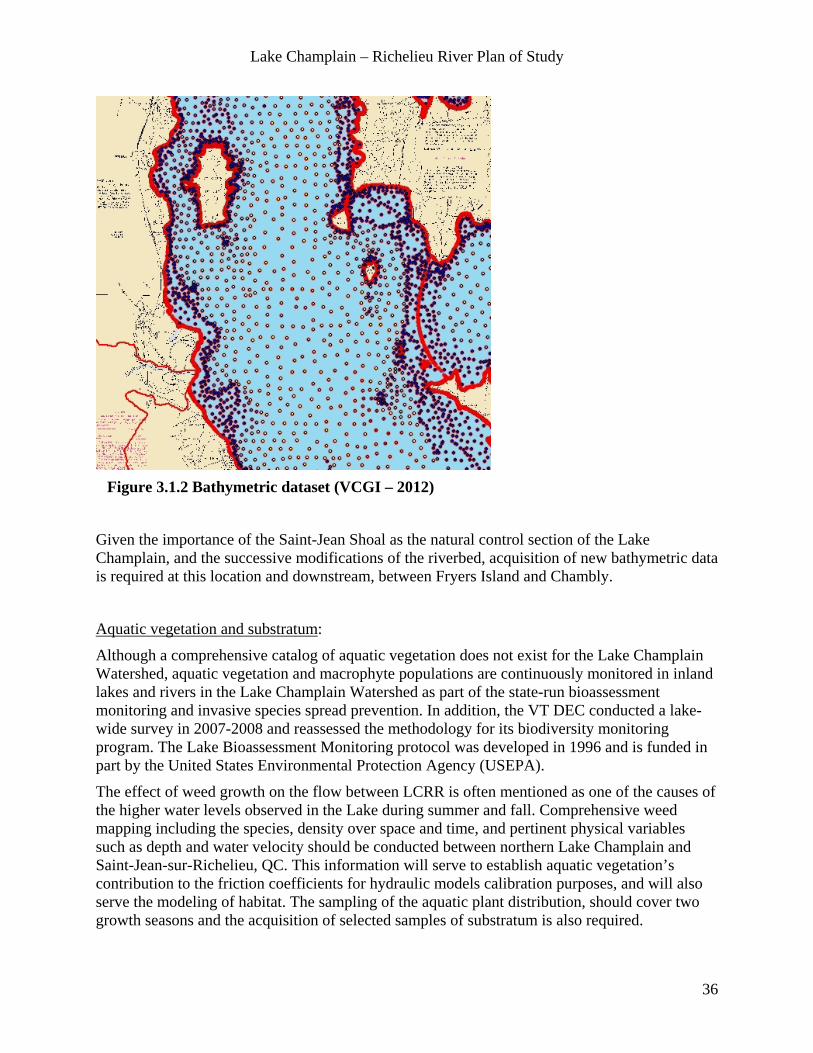
Lake Champlain – Richelieu River Plan of Study
36
Figure 3.1.2 Bathymetric dataset (VCGI – 2012)
Given the importance of the Saint-Jean Shoal as the natural control section of the Lake Champlain, and the successive modifications of the riverbed, acquisition of new bathymetric data is required at this location and downstream, between Fryers Island and Chambly.
Aquatic vegetation and substratum:
Although a comprehensive catalog of aquatic vegetation does not exist for the Lake Champlain Watershed, aquatic vegetation and macrophyte populations are continuously monitored in inland lakes and rivers in the Lake Champlain Watershed as part of the state-run bioassessment monitoring and invasive species spread prevention. In addition, the VT DEC conducted a lake-wide survey in 2007-2008 and reassessed the methodology for its biodiversity monitoring program. The Lake Bioassessment Monitoring protocol was developed in 1996 and is funded in part by the United States Environmental Protection Agency (USEPA).
The effect of weed growth on the flow between LCRR is often mentioned as one of the causes of the higher water levels observed in the Lake during summer and fall. Comprehensive weed mapping including the species, density over space and time, and pertinent physical variables such as depth and water velocity should be conducted between northern Lake Champlain and Saint-Jean-sur-Richelieu, QC. This information will serve to establish aquatic vegetation’s contribution to the friction coefficients for hydraulic models calibration purposes, and will also serve the modeling of habitat. The sampling of the aquatic plant distribution, should cover two growth seasons and the acquisition of selected samples of substratum is also required.

Lake Champlain – Richelieu River Plan of Study
37
3.1.2 Set-up a Complete Common Database of Observed Climate and Hydrometric Characteristics (Option A) Note: This database will be developed essentially by the Climatology and Hydrology Technical Work Group and integrated in the common Digital Terrain Model.
A gridded climate database will be used for calibration and validation of hydrological models and will include available data and analyses of precipitation, temperatures, snow pack water equivalent and other variables to be identified.
The “gridded” database will be populated from data processed with state-of-the-art interpolation techniques and present a spatial resolution of the order of 0.1 degree in latitude and longitude, ≈10 km (6.25 miles). The temporal resolution for historical climatic data and analysis will be 24 hours.
Sources of climatic data and analysis are multiple and include: - Réseau de surveillance du climat du Québec (MDDEFP) (P, T, daily+hourly, real time), EC meteorological network (P, T, hourly, real time), US NWS Cooperative Observer Network (P, T, daily, real time), US Cocorahs (www.cocorahs.org, daily, real time), Réseau climatologique du Québec (P, T, daily, real time), gridded data from University of Santa Clara (daily, historic), Canadian precipitation analysis CaPA (6 hour, real time), Downscaling of the reanalysis (6 hour, historic), Snow Water Equivalent (SWE) from the Réseau nivométriques du Québec - MDDEFP, Next-Generation Radar (NEXRAD), AHPS (hourly, sub-hour, real time) and Canadian radar (hourly, sub-hour, real time). Regional climate models (RCMs) driven by reanalysis will be used to generate the relevant high-resolution climatic variables (i.e. air and soil temperature, precipitation, snow cover, runoff, soil frozen- and liquid-water content) for the last 50 years (which samples high- and low-level events). Others variables that are required by complex hydrological models (winds, radiation, clouds, etc.) will also be available from the RCMs.
In addition to climate data, hourly and daily water level and river flow data, including Lake Champlain inflows computed with water balance tools will be obtained from the USGS, EC’s Water Survey of Canada (EC-WSC) and the CEHQ.
The USGS maintains 38 gages in the Lake Champlain watershed. Of these, thirty-five gages are located on tributaries and three gages are on Lake Champlain (Burlington, VT; Whitehall, NY; Rouses Point, NY). The gages operate continuously throughout the year.
EC – WSC operates a gauging station at the Fryers Rapids since 1937 and water levels stations at Saint-Jean-sur-Richelieu and Saint-Armand on the Missisquoi Bay. The CEHQ also installed a gauging station at Saint-Paul-de-l’Ile-aux-Noix in 2011 after the historical flood.
Other relevant hydro-data collected via remote sensing such as satellite radar and visible, soil moisture and eventually by the Soil Moisture Active Passive (SMAP) satellite will be incorporated in the “gridded” database at appropriate resolution. Lake and river inundation mapping obtained during flood events, including the 2011 flood will also be incorporated. Sources include CSA Radarsat, National Aeronautic and Space Administration (NASA) EO-1, Landsat, and Moderate Resolution Imaging Sectroradiometer (MODIS).
Additional inundation mapping will be available through the combination of hydraulic model outputs and high-resolution DTM of the flood plain.

Lake Champlain – Richelieu River Plan of Study
38
3.1.3 Set-up a Complete Common Database of High-resolution Geophysical Data Including Evolution of Watershed Characteristics (Options B and C) Note: This database will be developed essentially by the Climatology and Hydrology Technical Work Group and integrated in the common Digital Terrain Model.
A common geophysical database will be created and used to set-up and calibrate the hydrological models. It will have a suggested horizontal resolution of 3 arcseconds, or approximatively 100 m (328 pi) and a vertical resolution of 1 m (3.28 ft), limited by the actual resolution of the various datasets. The datasets will have to be selected from various sources, transformed to a common format to be defined and made available to users involved in the PoS. Licensing for free exchange of data is expected to require the establishment of a MOU. This should result in seamless information through the states, provincial and national borders.
Existing land cover data, vegetation characteristics such as vegetation height, leaf area index, root zone depth, albedo and emissivity, soil textures and hydraulic properties for the root zone area are available from the USGS, USDA’s Natural Resources Conservation Service (NRCS), EC, MDDEFP and from Institut de Recherche et de Développement en Agroenvironnement (IRDA).
In addition, a consistent River and Lake digital network with drainage directions at a resolution of 1 km and information about channel slope, length, width, roughness, as well as bank full heights will be provided.
Information about control structures in the watershed headwaters (location and stage-discharge relationships), ice cover, surface water temperature data and evolution of watershed characteristics such as land use / land cover, change in flood plains of tributaries will be included in the database. For example, available fluvial geomorphology data collected using VTANR geomorphic assessment protocols that could contribute to the tributary floodplain information.
3.1.4 Land Use Data (Options A, B and C) Note: This database will be developed in collaboration with the Societal Analysis and Recommendations for Adapting to the Variability of Water Supplies to the Lake Champlain and Richelieu River (Section 2.4) and with the Shoreline and Built Environment (Section 4.3) Technical Work Groups.
The collation of relevant land use data is essential to many aspects of the study namely, the Real-Time Flood Inundation Mapping, the Societal Analysis and Recommendations for Adapting to the Variability of Water Supplies to the Lake Champlain and Richelieu River, the Shoreline and Built Environment and the Planning, Evaluation and Analysis of potential flood mitigation measures. The following datasets should be acquired and incorporated in the DTM.
• Land use data bordering Lake Champlain / Richelieu River since about 1800.
• Town planning (municipal) and development plan (regional)
• Maps of built environment at a horizontal resolution in the order of 1m
• Watershed Management Plans and studies
• Censuses and associated maps/analyses (Canada and U.S.)

Lake Champlain – Richelieu River Plan of Study
39
• Thematic mapping and analyses (Infrastructure (critical or not) interest, hazardous material, water-communication-network-etc., Economic activity-industrial-etc.)
• Statistics on socio-economic data (Number of inhabitants, population density, population trends,% aged 75 and over, 14 and under, families with three or more children, single parent families, of applicants employment status, etc. / Location of housing for the elderly, social housing, prisons, health services, childcare, schools, gas stations, fire stations, police stations, etc. / location of places of business, number of employees, etc.).
3.1.5 Digital Terrain Model (DTM) (Options A, B and C) The datasets identified in sub sections 3.3.1 to 3.3.4. will be coming from different sources, resolutions, datums and formats. Special attention needs to be paid for the integration of those in a seamless DTM including quality control and cleaning of the composite LiDAR data set from acquisition projects spanning more than 10 years and involving technological evolution.
Seamless datum of the flood plain
A discrepancy between the U.S. NGVD 29, North American Vertical Datum of 1988 (NAVD 88), and Canadian CGVD 28 vertical datum has been observed in the water level data between Missisquoi Bay (Qc) and Rouses Point (NY); the published water levels indicate that Missisquoi Bay water surface would be lower than Rouses Point by some 11 cm (figure 3.1.3).
Experts from NRCan, the USGS and NOAA are currently analysing the situation and will suggest a course of action. Participants in the transboundary hydrographic data harmonization task force, convened in 2008 by the IJC, may be consulted. The DTM production will need to account for this.
Figure 3.1.3 Vertical Datum Discrepancies at the U.S. – Canada Border near Rouses Point, NY.
NAVD88
CGVD28
NGVD29
3 cm
10,8 cm

Lake Champlain – Richelieu River Plan of Study
40
The various datasets acquired through the common data needs and other technical work groups must be made available and useable to all it’s users for the determination of flood mitigation measures. Data sets must be homogeneously georeferenced and interoperable, and their characteristics (metadata) must be known. Close collaboration with the Information Management (section 3.4) is essential to achieve this.
Liaison with Other Technical Work Groups The study directors might work closely with the common data needs, information management and all technical work groups to make sure the data acquired or collated is made available to all. A coordination meeting at the beginning of the study should be held.
Following is a non-exhaustive list of data and information likely to be produced by various technical work groups for their specific needs that should be incorporated in the digital terrain model.
From the Flood Plain Management Practices Technical Work Group:
• Shoreline elevations/slopes: USGS, NYSDEC, APA, VTANR
• Information on current flood plain management: FEMA, VTANR, NYSDEC, MDDEFP, MAMROT, MSP
• Information on flood compensation and/or insurance programs: FEMA, NYSDOS, MSP
• Information on emergency management practices and risk communication: Vermont Emergency Management (VEM), New York State Department of Emergency Management (NYSDEM), County and State Emergency Management Office; MSP
• Inventory of as-built floodplain and compliance assessment: US: FEMA, NYSDEC, VTANR
From the Adaptations to Water Supplies Variability Technical Work Group:
• History of adaptation solutions to flooding (structural and non-structural) put in place since about 1800. Structural flood mitigation measures: Dikes, dams (permanent or temporary), retaining wall, etc. Non-structural flood mitigation measures: Laws / regulations, campaign, support program (immunization, travel, etc.), urban plan, safety plan, rezoning, etc…
From the Recreational, Domestic, Industrial and Municipal Uses of Water Technical Work Group:
• Inventory / update of recreational, domestic, industrial and municipal water uses.
From the Shoreline and Floodplain Built Environment Technical Work Group:
• Actual damages compensations paid for reclamations in past floods events from governmental agencies and from field surveys.
• Survey of the altitude of the first floor of the built environment to a resolution of 0.1 m (4 in.) in order to establish the stage – damage curves.

Lake Champlain – Richelieu River Plan of Study
41
From the Agriculture Technical Work Group:
• Spatial information for all jurisdictions such as animal density, farmstead locations, soil types, cropland information, floodplain regulation.
• Aerial photography; LiDAR; satellite relevant satellite imagery & data.
Study Organization, Costs and Schedule The following agencies are suggested to lead this study. These agencies have extensive expertise in data production for hydrology, physics and habitat modeling.
• CEHQ
• EC
• NOAA
• USGS
Agencies and organizations that could contribute to this study could include, but are not limited to:
• Canadian Geodetic Survey (CGS)
• NRCan
• IRDA for soil types data in Québec
• MSP
• Municipalities
• MRCs in the LCRR watershed
• Ouranos Consortium
• CSA for remote sensing product
• USGS
• USACE
• NOHRSC (US - National Operational Hydrologic Remote Sensing Center) for spatial databases especially gridded snow products
• RACC and The Nature Conservancy for Climate Change impact assessment
• Vermont Center for Geographic Information (VCGI)
• EPSCoR - RACC
• Middlebury College and the Lake Champlain Maritime Museum

Lake Champlain – Richelieu River Plan of Study
42
Table 3.1 Time and Cost Estimates – Common Data Needs – Study Options A, B and C (k$)
Major Tasks Option A Year 1 Year 2 Year 3 Year 4 Year 5 TotalAcquisition of LiDAR data to achieve complete coverage of the Lake Champlain Richelieu River floodplain 150 150High resolution bathymetry of the Saint-Jean Shoal & between Chambly and Fryers Dam 25 25Aquatic Vegetation Mapping in the upper Richelieu River and Northern portion of Lake Champlain, Substratum samplling 65 35 100
Common database of observed climate and hydrometric characteristics 100 100 200Common database of geophysical data 100 100 200Land Use Data 100 100 200Setup of a Seamless Digital Terrain Model 50 50Total Option A 590 335 0 0 0 925
Major Tasks Options B & C Year 1 Year 2 Year 3 Year 4 Year 5 TotalTotal Option A 590 335 0 0 0 925Watershed Physiographic Characteristics Changes Over Time 50 50Total Options B & C 640 335 0 0 0 975
3.2 Estimation of Water Supplies to the Lake Champlain and Richelieu River Statement of the work The objective of this study is to estimate water supplies (inflows) for a hydrodynamic model in order to simulate historical, current and future water level regimes of the Lake Champlain and Richelieu River. Future inflows will be derived from a selection of possible climate change scenarios. Ultimately, once calibrated and validated, the hydrological models will be used to generate an ensemble of daily water supply time series obtained from historical climate and several projected climatic scenarios covering a 100-year period. One of the main emphases will be on furthering our understanding of the climatic and hydrological contexts that caused the devastating 2011 flood. Also, water supply estimations will be used to assess potential structural and non-structural flood mitigation measures.
A number of factors can contribute to extreme water levels on Lake Champlain, including above average snow water equivalent and precipitation (including its temporal distribution), as well as seiche effects. Simulation of the processes leading to these conditions will require high-resolution modeling to capture terrain effects. However, setting up high-resolution, watershed-wide, hydrological models can be a daunting task for transboundary watersheds. Indeed, it may not be easy to readily build homogeneous datasets (i.e., elevation, vegetation cover, soil texture and other geophysical variables, climate and meteorological forcing, and in particular precipitation) required by various models.
Methodology The following tasks should be conducted to meet the objectives:
• Conduct a flood frequency analysis including regional hydrological trends analysis.
• Set-up and calibrate a selection of hydrological models including:

Lake Champlain – Richelieu River Plan of Study
43
- Compatible geospatial database including evolution of watershed characteristics.
- Multiple hydrological models calibration and validation.
• Assess impacts of climate change and land use/cover change on hydrologic inputs, for 2050 and 2100 timeframes.
• Generate an ensemble of daily water supply time series resulting from historical and projected climatic scenarios.
3.2.1 Preliminary Flood Frequency Analysis Based on Lake levels, River Discharges and Inflow Data (Option A) Perform a flood frequency analysis on the inflows, water levels and discharge, with an emphasis on the 2011 flood, including, if possible, proxy information to extend the period of historical data available. The use of information pre-dating the systematic observations like newspaper clippings will be considered.
Perform regional analysis of other comparable watersheds in the vicinity of the LCRR watershed. The water runoff of rivers comparable to the Richelieu is worth exploring, as it is expected to explain a proportion of the reported rise in water levels of the Lake Champlain and Richelieu River commonly associated with anthropogenic modifications. Literature indicates a rise in average annual precipitation and in the frequency of extreme precipitation events has occurred in the North-East US in the last century, as demonstrated by Wake (2005).
3.2.2 Set-up and Calibration of a Selection of High-resolution Hydrological Models (Option A) Hydrologic model calibration and validation should be performed using a long-enough periods of data (streamflow and snow pack observations) in order to include both wet and dry years. Because of the increased reliability of simulated atmospheric forcings and a larger number of available observations, recent years should be preferred. In practice, given the observed upward shift in annual precipitation since the 1970s, and the record high levels of 2011, it will be easier to find extremely high water years than extremely low water years in the recent past. Fairly low water levels were observed in the fall of 2001. Furthermore in the last decade, there have been a number of years with lower-than-average annual maximum levels. Thus, it is recommended to use the 2001-2010 decade for model calibration, leaving out at least 2011 for validation purposes. The model(s) should have a spatial resolution of the order of 1 km and provide daily estimates of water supplies to the Lake Champlain and Richelieu River.
To account for uncertainties in model structure and compensate for model-specific bias over the range and variability of the forcing (climatic) conditions, the use of more than one hydrological model was recommended by consulted experts to generate a trustable ensemble of water supply scenarios. This approach is encouraged by the ILCRRWG and should be explored by the Study Directors and concerned government agencies responsible for the operation of hydrologic models.
Four models are currently used by the major agencies involved: NOAA- Community Hydrologic Prediction System (CHPS) suite of models such as the Sacramento Soil Moisture Accounting

Lake Champlain – Richelieu River Plan of Study
44
(SAC/SMA), USGS-Precipitation Runoff Modeling System (PRMS), EC-Modélisation Environnementale Couplée – Surface and Hydrology (MESH) and CEHQ-Hydrologie et Télédétection (HYDROTEL). At this point in time, the NOAA operates the SAC/SMA model on the Lake Champlain watershed within the U.S. boundaries. CEHQ and EC have started to set-up HYDROTEL and MESH on the watershed as part of the Plan d’Action Saint-Laurent agreement but no calibration points are currently selected on the US side of the border. The USGS PRMS model is currently not installed on the watershed but other installations on watersheds in the vicinity are available and can be transferred to Lake Champlain and Richelieu River watershed.
Based on the current status, the set-up of the PRMS model and incremental efforts to extend the other models (SAC/SMA, MESH and HYDROTEL) to the entire watershed would provide a cost-effective opportunity to meet the objective of the sought-after diversity in hydrologic model structures and credibility in the resulting production of ensemble hydrologic responses. The resolution of the models could be adapted to meet operational requirements when used for the real-time flood inundation mapping.
The use of a common modeling platform such as NOAA Community Hydrologic Prediction System (CHPS) is expected to ease the use of multiple models; that is for the preparation of the required input data files, the running of the simulations using climate data, and the post processing of data for time series analyses.
3.2.3 Measurement of Overlake Evaporation (Option B & C) Overlake evaporation: During the Upper Great Lakes Study eddy covariance systems were deployed to measure overlake evaporation on the Great Lakes. The evaporation measurements obtained have proven to be of particular value in reducing uncertainty in modeled evaporation estimates. The Lake Champlain is obviously much smaller and it’s surface ratio with respect to the surface of the actual Lake Champlain watershed is also smaller than those of the Great Lakes, but Lake Champlain ice regime has changed significantly (Stager and Thill, 2010).
Understanding the effects of evaporation on the net Lake Champlain basin supplies appears important, especially for reducing the uncertainty associated with future water supplies scenarios under climate change projections. Hence, provision for the installation, operation and analysis of an eddy covariance system for the duration of the Study, to measure of evaporation of the Lake Champlain and calibration of models is made in this PoS.
3.2.4 Climatic Projections on the Temporal Horizons 2050 and 2100 (Options B & C) The goal here is twofold: 1- to build a database of projected precipitation and temperature series under future climate scenarios that would be used as input to the hydrological models; 2- to investigate change in future (2050-2100) variability with respect to the current.
Existing projections will be used (i.e., from the North American Regional Climate Change Assessment Program (NARCCAP) at a 50-km resolution and from the large Ouranos database (multiple thousands of simulated years) at 45-km resolution). A new ensemble of CRCM runs at a 15-km resolution will be available in mid 2014.
For the first objective (input data for hydrological models), precipitation and temperature data will be extracted, corrected for bias, and made available to users. For the second objective, the
Lake Champlain – Richelieu River Plan of Study
45
same RCM database will be analysed to assess the current and future interannual variability for the hydrology sensitive variables (e.g. snow cover, soil water content, runoff, precipitation, temperature). The inter model variance will be explored to assess the uncertainty on the estimates. The inter member variance will be investigated to assess the natural variability of the climate system.
3.2.5 Generate an Ensemble of Daily Water Supply Time Series Resulting from Historical and Several Projected Climatic Scenarios Covering a Period of 150 Years and More (Options B & C) Precipitation and temperatures from observed climate, as well as from projected climates, including uncertainty analysis, will be used to run the hydrological models and generate water supply time series to the Lake Champlain, Richelieu River, and their tributaries.
Relative changes in flood frequencies will be assessed, including the identification of the potential return period of an event similar to the 2011 flood for each climatic scenario.
Stochastic modelling techniques will also be used to generate long time series of daily water supplies having statistical characteristics similar to the observed time series. This tool will be useful to assess the water supplies time series obtain through climatological analysis and ensure that a wide array of plausible water supply time series will be considered in the assessment of potential mitigation measures.
A selection of water supplies will be used as “base-case events” for input to the hydraulic, erosion, ice and transport models used to simulate water levels and discharge regimes of the system under various structural and non-structural flood mitigation measures.
Missing data Essentially, the studies are expected to rely on existing data, with a few exceptions addressed in the Common Data Needs (section 3.1).
Study Organizations, Costs and Schedule The following agencies are suggested to lead this study. These agencies have extensive expertise in hydrological modeling, climate modeling, weather and hydrological forecasting, in contingency planning and operational contexts
• EC
• CEHQ
• NOAA
• USGS
Agencies and organizations that could contribute to this study could include, but are not limited to:
• Ouranos consortium for the Climate Change modeling and Impact assessment
Lake Champlain – Richelieu River Plan of Study
46
• EPSCoR - RACC
• QC academia for general hydrological expertise (Institut National de la Recherche Scientifique – Centre Eau Terre Environnement (INRS-ETE), École de Technologie Supérieure (ÉTS), Université de Sherbrooke (UdeS), Université Laval (U L))
• IRDA for soil types data on Québec
• USDA for soil type data in US
• CSA for remote sensing products
• NOHRSC for spatial databases especially gridded snow products
• US - Great Lakes Environmental Research Laboratory (GLERL) for interpolation techniques
• USACE
• VTANR
• NYSDOS
• RACC and The Nature Conservancy for Climate Change impact assessment
Table 3.2 Time and Cost Estimates – Estimation of Water Supplies to the Lake Champlain and Richelieu River – Study Options A, B and C (k$)
Major Tasks Option A Year 1 Year 2 Year 3 Year 3 Year 3 TotalPreliminary flood frequency analysis based on inflow data 50 50Set-up and calibrate high-resolution hydrological models 200 200 400Total Option A 250 200 0 0 450
Major Tasks Options B & C Year 1 Year 2 Year 3 Year 3 Year 3 TotalTotal Option A 0 250 200 0 0 450Measurement of overlake evaporation 70 20 20 20 20 150Climatic projections on the temporal horizon 2050 – 2100 200 200 400Generate an ensemble of daily water supplies time series scenarios from climate and stochastic analysis 150 300 450Total Option B & C 70 620 720 20 20 1450

Lake Champlain – Richelieu River Plan of Study
47
3.3 Lake and River Physics Models of Lake Champlain and Richelieu River Statement of work The aim of this work is to develop a methodology to study the physics of LCRR system. The objective is to quantify the effects on the system (both hydrodynamics and sediment dynamics) of anthropogenic and climatic changes and to provide a set of tools to examine structural and non-structural flood mitigation measures relative performance submitted to a set of water supplies, representative of the historical observations and associated with potential future climates.
The resulting simulations of the physical processes will in turn supply basic physical data input required to assess the impacts of the proposed flood mitigation measures on various resources of the ecosystem, namely environment, recreation, loss of shoreline property, domestic, municipal and industrial use of water, agriculture and infrastructure.
An added benefit of this modelling approach is that some components of the approach will also contribute to the PoS section (2.3) on Evaluation of the Need for Real-Time Flood Inundation Mapping to help predict flooding potential and prepare local communities and emergency responders for future floods. The resolution of the models could be adapted to meet operational requirements when used for the real-time flood inundation mapping.
A numerical modeling based approach is thus proposed for this work. Different kinds of models will be required to simulate both the lake and the river, under the constraint that these models must interact with one another, and be able to incorporate or feed the work done by other groups (hydrology, climate change, wetlands...). Both the river and the lake have to be studied, with emphasis on the Saint-Jean shoal that forms a natural control on this lake-river system. It is anticipated that any structural alternative proposed will require that special attention be given to this area.
Methodology A number of different numerical models are required to fully describe the physical response of both LCRR since these two bodies of water have different responses in regards to hydrological inputs, wind and wave action, seiches etc. Even more, there are major differences in the geography and hydromorphology of the watersheds surrounding the lake and the watersheds alongside the Richelieu River. The final modeling approach and management of data sets shall comply with guidelines developed in cooperation with the IJC (Jenkinson, 2012). This is especially important since large data sets will be required for analysis or produced from the models. Some will address spatial and / or time series, all of those provided under several formats and shapes that will need to be accessed and used by specialists from other specialties. Data gathered or produced must remain accessible once the study is completed. See Information Management (section 3.4) of the PoS for details.
The Digital Terrain Model required to implement all hydraulic models will be constructed from the topometric data, aquatic plants and substratum distribution data assembled together in a harmonized, continuous ensemble covering the entire LCRR system.

Lake Champlain – Richelieu River Plan of Study
48
3.3.1 2D Hydrodynamic Model (Option A) Given the relatively low cost of implementing a 2-D model, it is proposed that an unsteady-2D hydrodynamic model be developed for the Richelieu River to serve as a basic tool for real time flood inundation mapping and for preliminary analysis of surface elevations along the entire LCRR system. This type of model allows for the incorporation of wind-induced seiching effects, anthropogenic structures, and its ability to deal with long time series of water supplies and wind climatology will be advantageous if numerous simulations are required in a probabilistic approach.
The same model installed with more precision will allow for more detailed hydrodynamic analysis of the Richelieu River for the investigation of the hydrodynamics, sediment dynamics, flood plain inundation mapping, habitat models, etc. A 2D hydrodynamic model can provide spatial and temporal flow patterns and water levels, including flood inundation determination, using a wetting-drying cell algorithm. A 2D sediment model (transport and morphological evolution) can be used to determine erosion and deposition patterns present and those resulting from changes to the system. A major advantage of a 2D approach is the ability to include physical aspects that cannot be assessed with a 1D approach, such as effects of angular wind stresses, cross-channel variability, nearshore currents, recirculation/stagnation cells, etc. Results from or coupling can also be used as the basis of several resources response models such as habitat and wetlands explicit 2D indicators, as demonstrated in the LOSLR and Namakan / Rainy Lakes IJC Studies.
It is proposed that the 2D models be used to investigate the anthropogenic changes to the river (each major structure or work). This will be useful in identifying the contribution of individual structures and to assess what was the pre-development river state. The models will also be used to investigate the effect of the various proposed flood mitigation measures. On the lake, the impact of seiching on outflow will be investigated, potential effects of aquatic vegetation, as will the exchange of flow between the various parts of the lake and the sediment transport driven by wave action and tributary inflows. A 2D hydrodynamic model will be required to provide the spatial flow and level patterns required for environmental modeling. EC is currently developing a 2D hydrodynamic model for the river. A 2D hydrodynamic model for the Lake Champlain is also being investigated by NOAA. The hydrodynamic modeling of this system could be done with a single model or with two coupled models; it is likely that the latter approach will be more efficient and suitable for the needs of the study.
3.3.2 3D Hydrodynamic Model (Option B) A 3D hydrodynamic model of the lake is required to meet the needs of other study groups to address model water quality, water temperature, ice regime, and better operational predictions of water levels resulting from the data assimilation systems and the coupling of atmospheric, surface, hydrologic and hydraulic models. Those explicit couplings will allow effects from parameters like air pressure, air and water temperature, dew point, relative humidity, and solar radiation on water volume and ice formation over time to be accounted for.
It is important to note that the 3D model will not replace, but supplement the finer scale 2D model that is at much finer scale. The 3D model will be most valuable in examining large scale processes in the open lake, while the much finer scale 2D model will be important in examining

Lake Champlain – Richelieu River Plan of Study
49
processes in the nearshore zones or shallow water, especially for the set-up of wetland and habitat models. Both models should allow for wetting and drying of grid cells to allow for transmission of water under flooded conditions (e.g., the area known to exist between Missisquoi Bay and the Richelieu River) and to allow for temporal level variations that can lead to significant expansion of the domain. Both models should incorporate hydrologic input from the atmosphere and tributaries.
The resolution of the models could be adapted to meet operational requirements when used for the real-time flood inundation mapping.
3.3.3 Wave Models (Option B) A wave modeling approach needs to be developed for the lake, since waves are considered to be a dominant forcing mechanism for bank erosion on the lake shores. An experimental deepwater wave generation model, operated by NOAA, currently provides deep water wave conditions on the lake. In order to model erosion adequately, the deep water wave climate must be propagated toward the shore using a nearshore shallow water wave propagation model. The model would have to be applied at a specific number of locations that are representative of regions around the lake. Boundary conditions will be obtained from the National Weather Service (NWS) model.
3.3.4 Ice Model (Option B) An ice model for the lake and the river may also be required. This is especially important for erosion modeling on the lake and the river. In the Richelieu River, ice jams do not seem to be a problem. It was brought to our attention that freezing was occurring at higher lake levels, and that it resulted in some damages. This aspect should be further investigated.
3.3.5 Erosion Models (Option C) Shore erosion modeling could be performed using 1D cross-shore modeling at a series of indicator sites, as was done in the IJC's previous studies on the Lake Ontario and on the Saint-Lawrence River. As was the case in these studies, relationships between water levels and loss of shoreline would be determined under a number of scenarios. Other impacts on the various sediment systems would require more detailed modeling; in these cases, 2D sediment transport and morphological modeling combined with a regional sediment management approach would be required.
Boat generated waves have been identified as an erosion problem for the Richelieu River. This kind of erosion process was studied in the IJC's LOSLR study and numerical modeling techniques do exist to investigate.

Lake Champlain – Richelieu River Plan of Study
50
Data Needs The required LiDAR and Bathymetry data will be acquired and consolidated under the Common Data Needs Technical Study Group. Satellite imagery and bank erosion data will be made available through the information management system.
The existing bathymetry datasets appears to be sufficiently accurate for hydraulic and nearshore wave modeling, with a spatial resolution in the order of 10 m (33 ft) but insufficient for the proposed erosion modeling (order of 1 m (3 ft) spatial resolution).
Characterization of the substrate in the lake and river, especially nearshore, is required and addressed in the Common Data Needs section.
Historical ice/temperature data is required and addressed in the Common Data Needs section.
Major rivers contributing to Lake Champlain are currently well gauged and the monitoring information available from responsible agencies. The LCRRWG considers these monitoring gauges important for the conduct of studies described in this PoS.
Missing Data Water velocity measurements and water level lines will be needed to calibrate and validate the different numerical models.
Characterization of banks for erosion purposes is known for a stretch of 15 km up the Richelieu River from the Saint-Laurence River (Université de Montréal) and could be obtained for the stretch up to Chambly from the Ministère des Transport du Québec. Erosion between Chambly and Rouses Point is unknown. Boat waves are also a problem for erosion in the Richelieu River. Surveys of erosion rates should be undertaken at selected locations on the lake and river. 50 different locations seem reasonable, where bathymetry mapping at 10 to 30 m resolution in general and more detailed cross-shore profiles would be needed. To complete and update the characterization and identification of erosion processes, it is desirable to take high-resolution pictures of the shore at low altitude by helicopter or by boat.
A stage/height station should be installed on the "Inland Sea" portion of the lake, possibly in the South Hero aera, since a station operated by EC is already located at the north end in Missisquoi Bay. Seiche effects are less known in the inland sea, and it is hypothesized that this part of the lake would see seiche effects independent of the Broad Lake. New gage at south end of this area would help quantify the magnitude and effects of such seiches.
Study Organization, Costs and Schedule The following agencies are suggested to lead this study. These agencies have extensive expertise in hydrodynamics modeling in contingency planning and operational contexts.
• EC
• CEHQ
• NOAA
• USGS
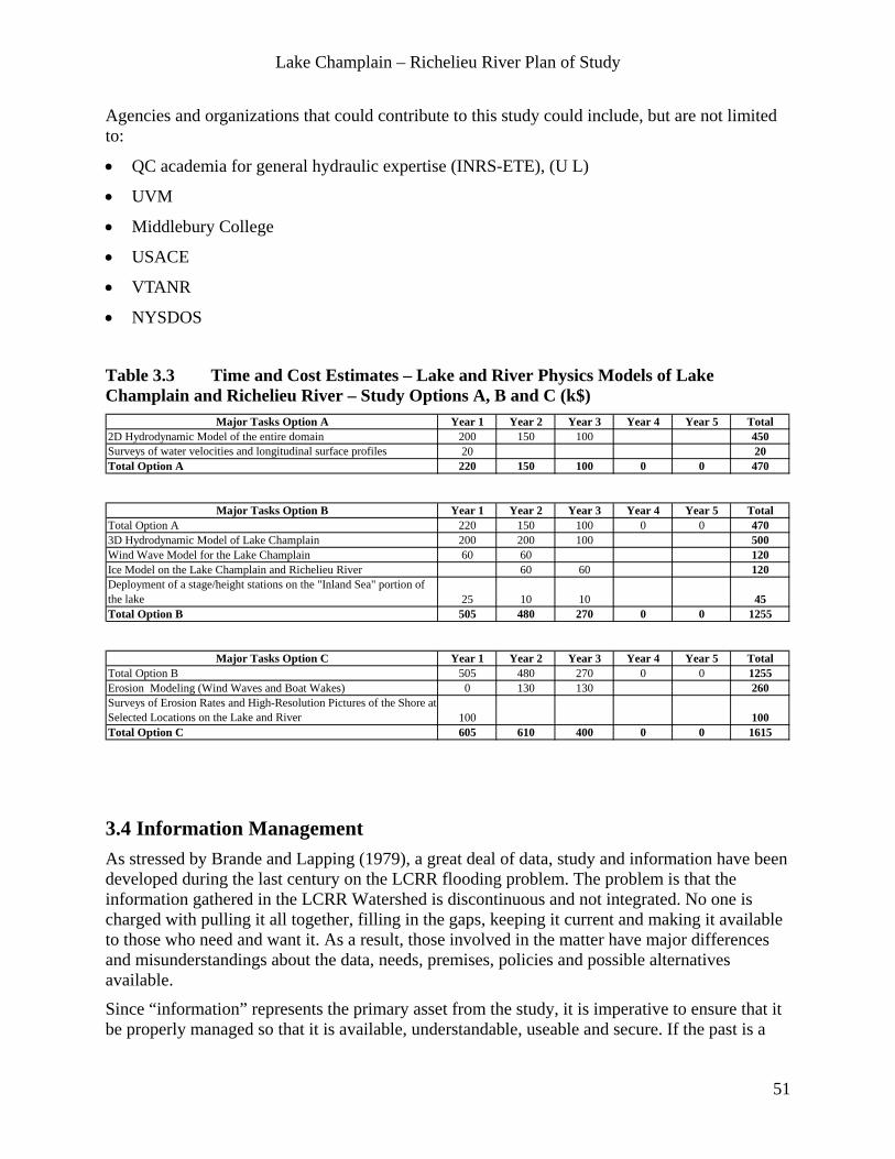
Lake Champlain – Richelieu River Plan of Study
51
Agencies and organizations that could contribute to this study could include, but are not limited to:
• QC academia for general hydraulic expertise (INRS-ETE), (U L)
• UVM
• Middlebury College
• USACE
• VTANR
• NYSDOS
Table 3.3 Time and Cost Estimates – Lake and River Physics Models of Lake Champlain and Richelieu River – Study Options A, B and C (k$)
Major Tasks Option A Year 1 Year 2 Year 3 Year 4 Year 5 Total2D Hydrodynamic Model of the entire domain 200 150 100 450Surveys of water velocities and longitudinal surface profiles 20 20Total Option A 220 150 100 0 0 470
Major Tasks Option B Year 1 Year 2 Year 3 Year 4 Year 5 TotalTotal Option A 220 150 100 0 0 4703D Hydrodynamic Model of Lake Champlain 200 200 100 500Wind Wave Model for the Lake Champlain 60 60 120Ice Model on the Lake Champlain and Richelieu River 60 60 120Deployment of a stage/height stations on the "Inland Sea" portion of the lake 25 10 10 45Total Option B 505 480 270 0 0 1255
Major Tasks Option C Year 1 Year 2 Year 3 Year 4 Year 5 TotalTotal Option B 505 480 270 0 0 1255Erosion Modeling (Wind Waves and Boat Wakes) 0 130 130 260Surveys of Erosion Rates and High-Resolution Pictures of the Shore at Selected Locations on the Lake and River 100 100Total Option C 605 610 400 0 0 1615
3.4 Information Management As stressed by Brande and Lapping (1979), a great deal of data, study and information have been developed during the last century on the LCRR flooding problem. The problem is that the information gathered in the LCRR Watershed is discontinuous and not integrated. No one is charged with pulling it all together, filling in the gaps, keeping it current and making it available to those who need and want it. As a result, those involved in the matter have major differences and misunderstandings about the data, needs, premises, policies and possible alternatives available.
Since “information” represents the primary asset from the study, it is imperative to ensure that it be properly managed so that it is available, understandable, useable and secure. If the past is a

Lake Champlain – Richelieu River Plan of Study
52
good indicator, this component must be incorporated early in the study because the requirements for information management will translate into guidelines that the other study components will need to follow to ensure consistency across the board. The definition of information includes the following elements: data (points, spatial layers), metadata, images (JPG, satellite, etc.), video, documents of all types and models (code, parameters). As well, multiple levels of information will need to be managed (raw, validated) and it is recognized that some information are common to all Study components (ex. LiDAR) while others may be project specific. An eventual system (or system of systems) will need to be tailored to reflect this fact. The approach used to manage information produced by way of the ILCRR study will need to comply with current industry standards in terms of system architecture, data modelling, data formats, data dissemination, etc. For example, model code and associated data/metadata should be managed as per the mutually agreed upon guidelines Jenkinson (2012). Other standards worth considering are those promoted by the World Meteorological Organization (WMO) and the Open Geospatial Consortium (OGC), among others.
Although it is likely that each organization involved in the study has formal data management practices, there is a need for a standardized approach across the Study to ensure that the information that is produced is well managed to ensure its continued use.
Statement of Work Develop an infrastructure to manage information (data, models, documents, videos, pictures, etc.) produced by way of the PoS to ensure that it properly supports the objectives of the ILCRR study both during the study itself and afterwards for the implementation of any recommendations made by the study group and to support adaptive management.
Methodology The activities are broken down along three main themes which are: 1) the container (servers), 2) the contents (information) and 3) the governance (policies, who does what, etc.) including ongoing system management. The activities are presented along a logical timeline that begins with the definition of requirements, all the way to the actual implementation of the resulting system.
Activities:
1. Develop requirements for the management of information produced through the ILCRR Study and:
a) Conduct data flow analyses, identify data types and produce use case analyses.
b) Develop a stewardship plan for model code and model data as recommended by Jenkinson (2012).
2. Analyze existing solutions and adapt in whole or in part as required.
3. Design the physical system architecture based on the requirements produced in point 1.
4. Choose information management technologies (i.e. database platforms, etc.) based on requirements.
Lake Champlain – Richelieu River Plan of Study
53
5. Establish a server and a server operation and maintenance plan.
6. Design an information management model (data model, requirements for an archive).
7. Define user roles and level of access for all the information managed in the system.
8. Define a governance mechanism for the systems and data holdings that support the ILCRR and any subsequent flood mitigation measures that may be implemented; (need to understand the various security requirements/restrictions and issues of the various organizations involved).
9. Develop standard formats for data exchange (OGC compliance, standard metadata, units, projections, datum, etc.).
10. Develop a data dissemination strategy (portals, web hubs, web services, interfaces, archive, etc.).
11. Develop an annual maintenance plan for the system and its components.
12. Produce complete system documentation (IT, user, maintainer, etc.).
13. Implement and maintain operations of the system.
Study Organization, Costs and Schedule Study board Directors and Administrators need to provide oversight and establish a technical committee of IM technical experts to implement the solution. Requirements should be prepared early in the Study, in consultation with all the organizations involved in the various components of the Study.
Agencies that are suggested to lead this study include, but are not limited to:
• EC
• NOAA
Agencies and organizations that could contribute to this study could include, but are not limited to:
• NRCan - GSC
• CSA
• Shared Services Canada (SSC)
• MDDEFP
• CEHQ
• MSP
• USACE
• USGS
• FEMA
• EPA
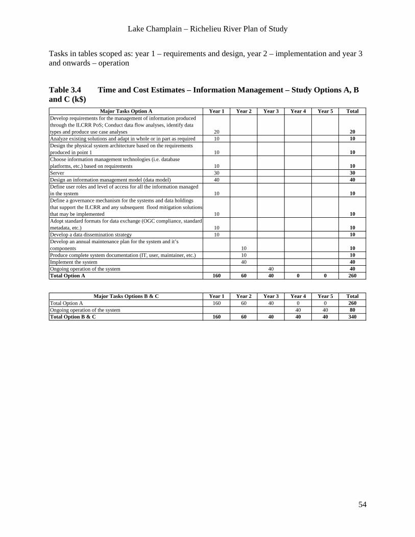
Lake Champlain – Richelieu River Plan of Study
54
Tasks in tables scoped as: year 1 – requirements and design, year 2 – implementation and year 3 and onwards – operation
Table 3.4 Time and Cost Estimates – Information Management – Study Options A, B and C (k$)
Major Tasks Option A Year 1 Year 2 Year 3 Year 4 Year 5 TotalDevelop requirements for the management of information produced through the ILCRR PoS; Conduct data flow analyses, identify data types and produce use case analyses 20 20Analyze existing solutions and adapt in whole or in part as required 10 10Design the physical system architecture based on the requirements produced in point 1 10 10Choose information management technologies (i.e. database platforms, etc.) based on requirements 10 10Server 30 30Design an information management model (data model) 40 40Define user roles and level of access for all the information managed in the system 10 10Define a governance mechanism for the systems and data holdings that support the ILCRR and any subsequent flood mitigation solutions that may be implemented 10 10Adopt standard formats for data exchange (OGC compliance, standard metadata, etc.) 10 10Develop a data dissemination strategy 10 10Develop an annual maintenance plan for the system and it’s components 10 10Produce complete system documentation (IT, user, maintainer, etc.) 10 10Implement the system 40 40Ongoing operation of the system 40 40Total Option A 160 60 40 0 0 260
Major Tasks Options B & C Year 1 Year 2 Year 3 Year 4 Year 5 TotalTotal Option A 160 60 40 0 0 260Ongoing operation of the system 40 40 80Total Option B & C 160 60 40 40 40 340
Lake Champlain – Richelieu River Plan of Study
55
4 Development of Resource Relationships With Water Level Fluctuations This chapter aims at the definition of metrics, relationships, or indicators, quantifying the impact on important resources and uses associated with potential flood mitigation measures submitted to various water supplies scenarios. Those metrics will be associated where appropriate with threshold and criteria defining the preferred response from the resources and uses.
The metrics, relationships, or indicators identified in this chapter are required only if option B or C of the PoS are selected.
4.1 Wetlands and Fauna Evaluation
Statement of work Annual and seasonal cycles of water level variation have been natural features of Lake Champlain and the Richelieu River for thousands of years. Ecological effects of water level fluctuations are greatest in shallow areas where even small changes in water level can result in substantial alterations to shoreline/wetland habitats for many organisms. The significance of these changes is most evident in wetlands, since these areas are directly affected by water levels and because they have a high level of biological productivity and diversity of plant and animal species. Wetland-dependent species are adapted to the natural variation in the amplitude and timing of water level fluctuations, and their population dynamics are driven by these variations.
Spatial distribution, temporal dynamic and diversity of wetland plant communities are largely controlled by water level fluctuations. Wetlands provide a fundamental dimension of habitat for several species of fish, birds and mammals. Wetlands spatial distribution is temporally dynamic over multiyear hydrogram. Periods of low water levels, especially in spring, can result in restricted spawning and early life stage habitat for some fish species. Periods with high water levels provide greater areas of suitable spawning and rearing habitat for fish such as northern pike, as well as expansion of riparian plant species into higher elevation areas, which may benefit species such as muskrats and waterfowl depending on the terrain geometry. Changes in water level and discharge also affect fauna in fast-flowing habitats of the Richelieu River. Water depth and velocity fluctuations can alter the habitat suitability for river-spawning fish species such as walleye, lake sturgeon and copper redhorse.
Quantification of the effects from water level or hydrological modifications can be done using a spatially explicit approach based on 2D habitat modelling. This approach links physical characteristics of habitat with biota. It has been recently used in IJC study for Lake Ontario-St. Lawrence River regulation with the construction of the Integrated Ecosystem Response Model - 2 Dimensions (IERM2D) (Morin and Champoux, 2006) in the Lower River portion, and it is presently being adapted for the Rainy-Namakan Lakes Study (Kallemeyn et. al., 2009). This modelling approach allows taking into accounts long-term temporal evolution of wetlands
Lake Champlain – Richelieu River Plan of Study
56
classes and the effects of these changes on wetland-dependant faunal groups that are directly affected by water level changes on short term.
Wetland and Fauna Evaluation Study Objectives:
• Develop an Integrated ecosystem response model for the Richelieu River - Lake Champlain system that integrates the data produced by physical models with wetlands and faunal models, which allows quantification of impact on biota from hydraulic regime.
• Use these models to quantify the effects of changes in the water level regime on selected indicator species and wetlands classes (or species) in Lake Champlain and Richelieu River including the implications of climate, land use and other changes in hydrology/hydraulics, as well as the 2011 flood.
Methodology
4.1.1 Integrated Modeling Linking Physics, Wetland and Fauna (Options B and C) Quantification of the effects of water level modifications on riparian/aquatic fauna and vegetation can be a complex and multidimensional task. It can be especially complex, if the goal is to cover several aspects of the life history of a large number of organisms and take into account interactions between them. However, because resources and time are limited, studies will be limited to wetlands dynamics and to a relatively small number of faunal “indicators” representing particularly sensitive species in a critical period of their life cycle using physically based habitat models (2D habitat models). Generally, reproduction period is analyzed (e.g. spawning, nesting) often during the springtime, overwintering or juvenile habitat during summer.
As wetlands are temporally dynamic and are influencing a large number of species, it is mandatory to model their response to water levels and use it to model wetland-dependent species. The “integrated ecosystem response model” to be developed for this study will allow to analyse long term temporal series, coming either from climates change, historical measurements or effect from any type of manmade structure, it will use physical data (water depth, levels, currents, waves) coming from Hydrology and Hydraulics studies.
Previous IJC studies have developed and use a spatially explicit and temporally dynamic model for Wetlands and Fauna that were integrated in a modeling system. This system, the IERM2D integrates physical variables (water level, currents, waves, light…) over a long time period to calculate the wetlands and aquatic vegetation evolution and the impact of physics and vegetation on several wildlife indicators (Environment Canada, 2006). Muskrat overwintering, fish reproduction and living habitat, nesting success for riparian birds, migration potential and reproduction of dabbling ducks, reproduction success of turtles are examples of models that are very sensitive to water level fluctuations. The IERM2D can be adapted to the present study needs; obviously field data have to be collected for proper validation and adaptation of these models. The task of assembling existing data and collecting new data for calibration and validation of Wetlands and fauna models are described in 4.1.2 and 4.1.3.

Lake Champlain – Richelieu River Plan of Study
57
Tasks to be performed for the adaptation of a existing spatially explicit habitat models:
• Construct the modeling grid.
• Adapt the modeling time step.
• Integrate measured and modeled physical variables.
• Adapt and construct wetland and specific plants models.
• Adapt and construct faunal models.
• Calibrate and validate of results.
• Produce results of long time series from diverse modification in hydrology or terrain modification (effect of alternative flood mitigation measures) and impacts from 2011 flood.
4.1.2 Wetlands Study Tasks (Options B and C) The wetlands study will assess wetland vegetation assemblages and their relationships to water level fluctuations; it will also identify key wetlands classes, natural communities or species to include in the wetland dynamics model. This wetland model will integrate physical variables obtained from Hydrology and Hydraulics work and it will produce temporally dynamic results that will be used as input data for fauna models.
Calibration and validation of wetlands models need field data from the entire domain from current state of the wetland spatial distribution and composition. Also as wetlands are dynamic and influenced by multiyear hydrograms, it is mandatory to use available maps and data from past studies to allow validation of temporal change (vegetative succession and sensitivity). Metrics would be quantified as hectares of each wetland types per year.
Particular attention should be given to some species of interest that are known for their sensitivity to water level alterations: wild rice (Zizania aquatica) and hard stem bulrushes (Scirpus acutus). Also because of possible impacts from water level alteration on invasive plant species (ex: Phragmities), the possible impact of flow alteration should be assessed and documented. The task includes:
Tasks for the Inventory and collection of data on wetlands distribution and evolution:
• A review of past studies/existing wetlands data and mapping of Lake Champlain and Richelieu River.
• Digitalization of available maps.
• Standardization of wetland classes to be modeled.
• Inventory of the current state of wetland (classes and species of interest) from the entire domain in order to calibrate and validate the wetlands predictive models (wetland temporal dynamics).

Lake Champlain – Richelieu River Plan of Study
58
4.1.3 Fauna Study Tasks (Options B and C) The species listed in Table 4.1.1 have been selected to represent the habitats and life stage periods that may be significantly affected by changes in water level regime, several of which have special conservation status designated by the different jurisdictions.
Table 4.1.1 Selected indicator species for Lake Champlain and Richelieu River resource response studies Taxon Common Name Scientific Name Conservation
Status*Critical Habitat Type and period
Study Option
Fish
Northern pike
Esox lucis Wetland-spawning and nursery- spring
B
Copper redhorse
Moxostoma hubbsi E-CA; T-QC River-spawning and nursery-early summer
C
BirdLeast bittern
Ixobrychus exilis T-CA, NY; SCGN-VT
Wetland-nesting spring
B
Black ternChlidonias niger E-NY, VT Wetland-nesting
springB
Virginia railRallus limicola Wetland-nesting
springB
Blue-winged teal Anas discors SCGN-NY, VT Wetland-rearing BMammal Muskrat Ondatra zibethicus SCGN-VT Wetland-winter CHerptile
Spiny softshell turtleApalone spinifera T-CA,QC, VT;
SGCN-NYShoreline-nesting and incubation
B
InsectHairy-necked tiger beetle
Cicindela hirticollis T-VT Shoreline-sand beach
B
* E=endangered, T=threatened, SGCN=species of greatest conservation need.
Most of fauna models are already available from past IJC studies. However, calibration and validation of these models are mandatory in order to insure proper representation of the Lake Champlain - Richelieu River particular context, especially the link between Wetland and Fauna models.
Faunal models that were selected as the most important to be addressed can be grouped in two sets of priorities based on period of sensitivity to possible alteration of the natural hydrogram. It is believed that potential modifications of the hydrogram in term of water level and discharge are expected to be the more significant in springtime than in summer, fall or winter period. Therefore, wetland fish spawners, wetland-nesting birds and near shore nesting turtles and beetles that are in their reproduction period would be mostly affected by such alterations. These higher priority indicators are: Wetland-spawning fish (northern pike), turtles (spiny softshell), insects (hairy necked tiger beetle) and riparian birds (Least bittern, Blue-wing teal, Black tern and Virginia rail).
The second group contains indicators that are mostly influenced by alteration of the natural hydrogram in summer, fall or winter. It is believed that possible modifications of the natural

Lake Champlain – Richelieu River Plan of Study
59
hydrogram are less likely to be observed in these periods. The lower priorities indicators are: Copper Redhorse spawning in the Richelieu River, and Muskrat overwintering in wetlands.
The tasks for the faunal indicators are to gather existing data and collect new information on spatial distribution, preferred habitat, and timing of reproduction. Metrics would be quantified as hectares of proper reproduction habitat. The tasks include:
• An inventory and collection of data on fauna indicators: a review of past studies/existing data for Lake Champlain and Richelieu River about critical habitat needs, population dynamics and critical life history periods.
• Digitalization of available data.
• Assessment of models performance from these data.
• Assistance to calibration-validation and results analysis.
Past Studies A number of environmental studies were conducted in association with the 1973 Reference requesting investigation of the feasibility and desirability of regulating the Richelieu River. The studies included assessments of nutrients and biological productivity, wetland vegetation, and fish and wildlife habitat in relation to water level variations.
Most nutrients that support growth of wetland vegetation and fauna were supplied by runoff into wetland tributary streams, and little change in available phosphorus and nitrogen was found as a result of water level fluctuations; however lower water levels may result in shifting these nutrients from areas of rooted aquatic vegetation to open water areas (Turk 1977). Henson and Potash (1977) found that occasional high water events in spring (above 30.0 m (98.4 ft) with respect to the Main Sea Level (MSL) have no effect on the overall productivity of wetlands; however, maintenance of water levels below 29.20 m (95.81 ft) above MSL in late summer may diminish the ability of wetlands to trap nutrients, and maintaining winter water levels below 30.0 m (98.4 ft) above MSL will kill off much of the wetland vegetation, resulting in increased decomposition and release of more nutrients into the lake in the spring and summer.
Countryman (1977) inventoried plant species in several Lake Champlain wetlands and reported their relative frequency of occurrence along a continuum of elevations. He concluded that submerged and floating plants would not be appreciably affected by water level fluctuations, while emergent plants and wet meadows, and swamp forest are more likely to be affected. Areas of swamp forests and wet meadows in particular would be likely to decline if peak lake levels were lowered. Hamel and Breuer (1977) conducted a similar assessment of wetland plants in the upper Richelieu River and Missisquoi Bay, and found that spring floodwater elevations had little influence on plant life cycles, but they are affected to a much greater extent by the duration of the flood period. It was also determined that the distribution of wetland plant species is influenced more by summer lake levels.
Fisheries investigations focused primarily on northern pike spawning in selected wetlands influenced by Lake Champlain and the Richelieu River (Kretzer 1977; Dumont and Fortin 1977). Both studies reported similar findings regarding northern pike spawning habitat. Northern pike favored spawning in the month of April, in depths from 15 to 60 cm (6 to 24 in) over flooded

Lake Champlain – Richelieu River Plan of Study
60
terrestrial grasses, and this spawning habitat was available to northern pike only at lake level elevations greater than 29.9 m to 30.0 m (98.1 to 98.4 ft) above MSL, with lake levels greater than 30.5m (100.0 ft) above MSL providing the best areas of spawning habitat. Northern pike spawning success was best during years with higher lake levels which were relatively stable for 30 to 40 days post egg deposition, followed by a gradual decline. Dumont and Fortin (1977) also suggested that a predictive model of northern pike spawning success could be developed based historical lake level data and corresponding air temperature and precipitation data.
Northern pike spawning observations continued annually in a subset of the marshes included in the Kretzer (1977) study through 1984 (Anderson 1990). Results from the ten years study generally supported findings from the earlier studies. The majority of northern pike spawning occurred in depths of less than 45 cm (18 in), flooded terrestrial grasses (wet meadows) were the most preferred spawning substrate, and water levels from the time of spawning to fry mobility appeared to have the strongest relationship to year class strength of the factors studied. Anderson (1990) also reported that year class strength was not always consistent among different spawning areas, suggesting that site-specific environmental factors may be important.
Myers and Foley (1977) found that waterfowl and muskrat production varies with lake levels. Mallard and black duck nested primarily in flooded timber (most of which lies at elevations of 29.0 to 30.0 m above MSL in April and May, and brood survival was dependent on these areas remaining inundated through early June. Fluctuations (mainly increase in water level) in late fall and winter water levels of greater than 0.5 m (1.64 ft) may negatively affect muskrat populations.
Existing Data and Models on Wetlands and Fauna Evaluation
• Existing wetland survey mapping and databases, and indicator species data are available from government natural resources agencies.
• Wetland and several faunal models are available at EC and biological expertise is available in several agencies in VT, NY and QC.
• Partial LiDAR data exists and resides with various governmental agencies.
Data Needs
• Completion of LiDAR coverage for wetland study areas is required for accurate quantification of wetland community and indicator species habitat surface area in relation to elevation. The LiDAR coverage is addressed in the Common Data Needs section (3.1).
• Adaptation of existing wetlands and faunal models needs physical models results (current, water level, water depth, wind-waves action…) coming from hydrologic and hydraulic modelling studies.
• Available data and new data on wetland distribution and composition as well as data on modeled fauna are essential for proper adaptation/construction of biotic models.

Lake Champlain – Richelieu River Plan of Study
61
Study Organizations, Costs and Schedule Coordination of the studies will be headed by the Wetland and Fauna Evaluation Group. The following agencies are suggested to lead this study. These agencies have extensive expertise in fauna and wetland modeling in contingency planning and operational contexts.
• EC and MDDEFP
• USFWS
Agencies and organizations that could contribute to this study could include, but are not limited to:
• Fisheries and Oceans Canada (DFO)
• VTANR
• NYSDEC
• USACE
The Wetland and Fauna Evaluation Group will work as an integrated group: all models have to be integrated in order to get proper response from wetland and fauna based on modeled physical data. As wetlands and fauna projects are mainly composed of field data collection and establishment of relations between physical variables and biota, collaboration with the physical modelers is essential. The integrated modeling project will prepare physical data and models (currents, water level, depth, waves, light penetration, etc.) and will build and compute relationships between physics and biota. Results will be validated with data and expertise from wetland and fauna projects.
Table 4.1.2 Time and Cost Estimates – Wetlands and Fauna Evaluation – Study Options B and C (k$)
Major Tasks Option B Year 1 Year 2 Year 3 Year 4 Year 5 TotalWetlands study (+wild rice and hard stem bulrushes) 80 80 70 15 15 260Wetland fish reproduction (Northern pike) 60 70 70 15 15 230Turtle (Spiny Softshell) 50 40 40 10 10 150Riparian birds (Least bittern, Blue wing teal, Black tern, Virginia rail) 135 125 75 25 25 385Hairy necked tiger beetle (US only) 30 30 10 10 10 90Integrated modelling 25 50 90 90 50 305Total Option B 380 395 355 165 125 1420
Major Tasks Option C Year 1 Year 2 Year 3 Year 4 Year 5 TotalTotal Option B 380 395 355 165 125 1420Copper redhorse (Canada only) 65 65 45 10 10 195Muskrat overwintering 40 35 15 10 10 110Integrated modelling 20 50 50 70 50 240Total Option C 505 545 465 255 195 1965
Lake Champlain – Richelieu River Plan of Study
62
4.2 Recreational, Domestic, Industrial and Municipal Uses of Water
Statement of Work The functional use of lakes and rivers may be negatively impacted by varying water levels, both high and low. Impacts may be physical, operational, and economic.
Recreational uses may include marinas (including docks, boat repair and storage, fueling and marine stores), boat launch sites, fishing businesses/charters, wildlife management areas including wildlife/bird viewing areas, campgrounds, waterfront parks, hiking/bike trails and cultural/historic resources. Domestic, industrial and municipal uses of water may include drinking water plants, wastewater treatment plants and municipal, industrial, commercial and institutional water intakes and outfalls.
The goals of the Recreational, Domestic, Industrial and Municipal Uses of Water Study are to:
• Complete an inventory of existing functionally dependent uses.
• Identify the degree of impact at various water levels along with associated cost.
• Identify impacts associated with water level ranges and timing (hydrograms).
Methodology 4.2.1 Recreational Water Use Study Tasks to be performed as a part of this study include:
• An inventory / update of recreational water uses shall be conducted and cover, but not be limited to, the following water dependant resources: marinas, boat launches, water-based activities (boating, sailing, water skiing, swimming), campgrounds, mobile homes or rental cottages (rental buildings category, golf courses, etc.), wetlands, nature observation areas and fishing areas, heritage and historic buildings and archaeological sites. In QC, this information is available from the municipalities and regional county municipalities (RCMs) for Missisquoi Bay and the Richelieu River, For VT and NY, data are available from various organizations and will have to be aggregated. This information will be shared with the Common Data Needs and Information Management Working Groups, adding to the watershed description tools.
• A survey will be conducted to obtain from all recreational water uses inventoried the information on the preferred range of water level fluctuations (maximum, optimal and minimum) and the identification of the periods when those water levels are important, and cost estimates and data associated with water levels fluctuations inside / outside of the preferred range. Other potential impacts such as observations on water quality and temperatures etc. will be gathered.
• An assessment of the impacts of water level fluctuations on the recreational uses will be done based on the information obtained from the survey. An initial assessment will be done to identify affected / unaffected uses for the expected water regimes and the stage-damage form will be privileged where applicable.

Lake Champlain – Richelieu River Plan of Study
63
Existing Data on Recreational Water Uses:
• In collaboration with the MFEQ and the regional Conference of Elected Montérégie Est, the QC Department of Tourism (TQ) has developed a strategic recreational/tourism development plan that may be considered as a part of this task.
• In QC, data on the economic impact of the application of existing regulations and the current state of infrastructure on existing businesses data are available at MFE and/or the MSP on 160 companies whose activities have been affected by flooding (economic cost) and this would make it possible to identify the tourism sectors at greatest risk.
• In QC, information on heritage and historic buildings and archaeological sites is available from municipalities and the Department of Culture.
• In VT and NY, the information is available from various levels of government. State employees know the sources of this information. In VT and NY, there are problems identifying these sites on a floodplain map in order to determine whether they are located in a floodplain.
4.2.2 Domestic, Industrial and Municipal Uses of Water Study Tasks to be performed as a part of this study include:
• Conduct an inventory / update of domestic, industrial and municipal water uses, including drinking water plants, wastewater treatment plants and municipal, industrial, commercial and institutional water intakes and outfalls. Obtain the intake levels of these facilities and their condition and vulnerability.
• Conduct a survey to obtain from all domestic, industrial and municipal water uses inventoried the information on the preferred range of water level fluctuations (maximum, optimal and minimum) and the identification of the periods when those water levels are important, and cost estimates and data associated with water levels fluctuations inside / outside of the preferred range. Other potential impacts such as observations on water quality and temperatures etc. will be gathered.
• An assessment of the impacts of water level fluctuations on the various domestic, industrial and municipal water uses will be done based on the information obtained from the survey. An initial assessment will be done to identify affected / unaffected uses for the expected water regimes and the stage-damage form will be privileged where applicable.
Existing Data on Domestic, Industrial and Municipal Uses of Water:
• Information on drinking water plants, wastewater treatment plants and municipal, industrial, commercial and institutional water intakes and outfalls is available from the three governments and has to be aggregated.

Lake Champlain – Richelieu River Plan of Study
64
Study Organization, Costs and Schedule Coordination of these studies could be headed by the Recreational, Domestic, Industrial and Municipal Uses of Water Technical Study Group.
The following agencies are suggested to lead this study:
• MDDEFP
• USEPA
Agencies and organizations that could contribute to this study could include, but are not limited to:
• MSP
• MAMROT
• TQ
• MFEQ
• EC
• Local and regional municipalities
• Federal Energy Regulatory Commission (FERC)
• USACE
• USFWS
• VTANR
• NYSDOS
Table 4.2 Time and Cost Estimates – Recreational, Domestic, Industrial and Municipal Uses of Water River – Study Options B and C (k$)
Major Tasks Option B Year 1 Year 2 Year 3 Year 4 Year 5 TotalInventory / update of recreational, domestic, industrial and municipal water uses
50 50
A survey to obtain from all water uses information on the preferred regime of water level fluctuations
50 50
Assessment of the impacts of moderate water level fluctuations on the uses
100 100
Total Option B 50 50 100 0 0 200
Major Tasks Option C Year 1 Year 2 Year 3 Year 4 Year 5 TotalTotal Option B 50 50 100 0 0 200Assessment of the impacts of important water level fluctuations on the uses 100 100 50 250
Total Option C 50 50 200 100 50 450

Lake Champlain – Richelieu River Plan of Study
65
4.3 Shoreline and Floodplain Built Environment
Statement of work Fluctuating water levels affect lake and river shoreline as well as infrastructure within this flood-zone. Shoreline impacts include erosion and flooding as well as impacts due to low water levels. These impacts affect shore property values and thus result in economic gains or losses. Assessing the economic flood impacts associated with various flood mitigation measures under various water supplies scenarios require a common basis. It is proposed to:
• Establish stage-damage relationships for buildings and real estate property, aggregated to homogeneous types of land uses and areas.
• Qualitatively assess the impacts, specifically costs, of erosion of shorelines and impacts on real estate and public infrastructure.
Methodology 1. Conduct a Flood Vulnerability Assessment: It is a critical point that actualised economic
damage curves and functions between water level and built environment (residential, commercial, municipal, road, electric line, …) be developed for the watershed, aggregating the damage potential for each municipality, regional municipality county or any appropriate homogeneous area within the floodplain. More specifically, the elevation of the first floor of the built environment shall be surveyed to a resolution of 0.1 m (4 in.) in order to establish the stage – damage curves. Similarly, unit cost for several infrastructures (unit cost for 100 m of road, electric line or flood protection dikes, for example) could be developed in order to correctly evaluate both proposed structural and non-structural scenarios.
2. Conduct a qualitative assessment of the shoreline erosion and loss of real estate property and public infrastructures such as roads, bridges and railroads and telecom networks. This qualitative assessment aims at the identification of areas particularly vulnerable to erosion and the associated damages on private property and public services, as well as documenting differences between developed and undeveloped shorelines. It may include evaluation of state, provincial and municipal roads impacted by heavy wave action during wind events under flood conditions and suggestion of equalization measures, such as expansion of existing culverts or bridges, or construction of new passageways to alleviate pressure against these structures. Damage Costs will be estimated.
3. Quantitative evaluation of erosion impacts. This project requires the availability of erosion models and aims at the quantification of impacts of water regulation scenarios on the erosion patterns in the Lake Champlain – Richelieu River. Damage Costs will be estimated.
Existing Data on Shoreline and Built Environment Actual damages compensations paid for reclamations in past floods events can be obtained from governmental agencies and from field surveys to conduct this work.
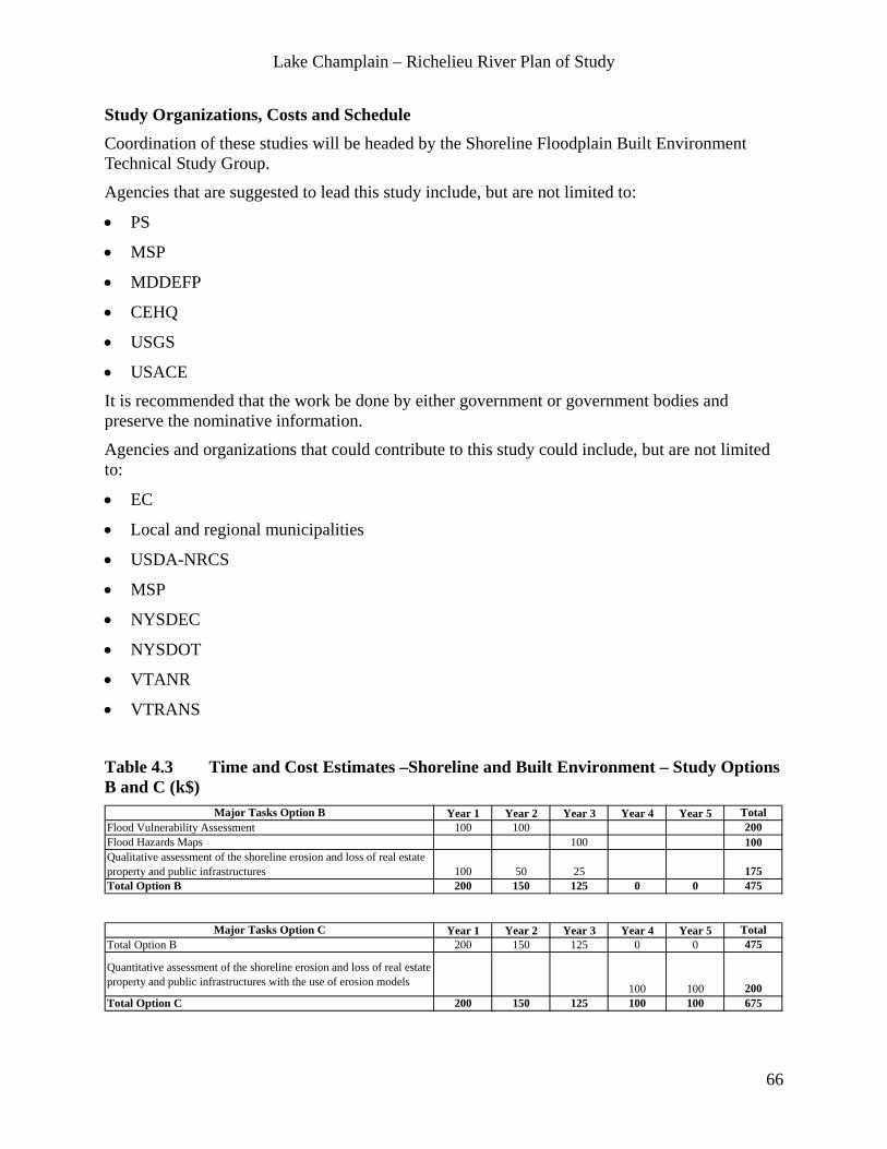
Lake Champlain – Richelieu River Plan of Study
66
Study Organizations, Costs and Schedule Coordination of these studies will be headed by the Shoreline Floodplain Built Environment Technical Study Group.
Agencies that are suggested to lead this study include, but are not limited to:
• PS
• MSP
• MDDEFP
• CEHQ
• USGS
• USACE
It is recommended that the work be done by either government or government bodies and preserve the nominative information.
Agencies and organizations that could contribute to this study could include, but are not limited to:
• EC
• Local and regional municipalities
• USDA-NRCS
• MSP
• NYSDEC
• NYSDOT
• VTANR
• VTRANS
Table 4.3 Time and Cost Estimates –Shoreline and Built Environment – Study Options B and C (k$)
Major Tasks Option B Year 1 Year 2 Year 3 Year 4 Year 5 TotalFlood Vulnerability Assessment 100 100 200Flood Hazards Maps 100 100Qualitative assessment of the shoreline erosion and loss of real estate property and public infrastructures 100 50 25 175Total Option B 200 150 125 0 0 475
Major Tasks Option C Year 1 Year 2 Year 3 Year 4 Year 5 TotalTotal Option B 200 150 125 0 0 475
Quantitative assessment of the shoreline erosion and loss of real estate property and public infrastructures with the use of erosion models 100 100 200Total Option C 200 150 125 100 100 675

Lake Champlain – Richelieu River Plan of Study
67
4.4 Agriculture
Statement of the work One of the major resources and interests affected by water levels is Agriculture. Spring 2011 flood particularly affected agricultural lands in the northernmost portion of Lake Champlain as well as settlements, agricultural landscapes and towns along the Richelieu River, such as Saint-Paul-de-l'Ile-aux-Noix and Saint-Jean-sur-Richelieu.
The objectives of this study are:
• To evaluate the effects of changes in water level regime on agricultural land in the Lake Champlain and Richelieu River watershed.
• To assess existing agriculturally developed land within the watershed; assess its value, and determine how it has been, is, and will be affected by flooding.
• To identify potential areas for floodplain reclamation, land protection (agricultural dikes), and other flood risk mitigation measures.
• To recommend optimal water levels needed to maintain agricultural lands and communities in LCRR.
Methodology Tasks include:
• Agricultural Flood Hazard Mapping. Identify and map, dikes, types of crops, farm buildings, fuel storage, barn placement and other features associated with agricultural practices. Delineate the floodplain and describe the occupied floodplains types of crop and animal units at different levels of water. This will inform the flood hazard area and support the development of response plans.
• Quantification of Current and Historical Agricultural Practices on Flooding. Practices include tillage, farm placement, number of animals, stream alteration, crop rotation, agriculture related field drainage etc. The historical and current average and peak water levels in the LCRR must also be addressed.
• Assessment of agricultural land in the watershed that is protected by dikes. Assess the total area of land, cash crops that are insured, and the cultivated areas inside the dikes, and calculate how much water can be held in dikes. Modeling methods such as Hydrologic Engineering Centers River Analysis System HEC-RAS can be used. An evaluation of existing dike system-maintenance and repairs should be included. Include an investigation of the possibility of starting up de-commissioned Small Watershed PL566 program (land treatment and structural mitigation) in USDA.
• Qualitative evaluation of the soil quality following flood deposits. Identify the types of crops that may be planted as a result of the flood impact of sediment deposition. Study of the

Lake Champlain – Richelieu River Plan of Study
68
history of flooding. Develop common criteria to monitor soil health. Include historical land use data including pesticide/toxins data, infiltration rates, bulk density, and health of soil (physical and chemical components of soil).
• Identify opportunities for floodplain reclamation. A lot of floodplain management happens on agricultural land. Identify areas of opportunity for restoration and protection of function and value of floodplains. Use agricultural land as floodplain easements (prioritizing land not deemed acceptable for agricultural production) – this will need the support of the agricultural community. Include an evaluation of legal aspects of land acquisition (grandfather clause, compensation, expropriation…).
• Analyze the impacts of stream alteration, tillage and animal densities. The historical and current average and peak water levels in the LCRR must also be addressed. Models will be important to reflect the situation; the SWAT (Soil and Water Assessment Tool) model will be useful.
• Assessment of the use of agricultural land combined with majors structural flood mitigation measures and associated regulation scenarios.
Existing Data on Agricultural Resources Some soil data has been collected and is available from groups such as the Soil and Water Commissions of the USDA, IRDA and academic institutions.
Study Organizations, Costs and Schedule Coordination of these studies will be headed by the Agriculture Technical Study Group.
Agencies that are suggested to lead this study include, but are not limited to:
• MAPAQ
• USDA
Agencies and organizations that could contribute to this study could include, but are not limited to:
• Union des Producteurs Agricoles (UPA)
• AAFC
• EC
• NYS Ag & Markets
• USGS
• VAAFM

Lake Champlain – Richelieu River Plan of Study
69
Table 4.4 Time and Cost Estimates – Agriculture – Study Options B and C (k$) Major Tasks Option B Year 1 Year 2 Year 3 Year 4 Year 5 Total
Agricultural Flood Hazard Mapping 50 50 100Quantification of Current and Historical Agricultural Practices on Flooding 20 20Assessment of agricultural land in the watershed that is protected by dikes. 20 20 40Evaluation of the soil quality following flood deposits. 20 20Identify opportunities for floodplain reclamation 20 40 40 100Analyze the impacts of stream alteration, tillage and animal densities 20 20 40Total Option B 100 130 90 0 0 320
Major Tasks Option C Year 1 Year 2 Year 3 Year 4 Year 5 TotalTotal Option B 100 130 90 0 0 320Assessment of the use of agricultural land combined with important structural flood mitigation measures and associated regulation scenarios 100 100 50 250Total Option C 100 130 190 100 50 570

Lake Champlain – Richelieu River Plan of Study
70
5 Planning, Evaluation and Analysis Under the broad objective of reducing flood damages cost-effectively, the planning, evaluation and analysis work aims at establishing and running a multi-faceted process that allows the evaluation and ranking of the various flood mitigation measures (structural, non-structural and combinations of both) proposed to best meet the broad range of management criteria based on evaluation methods including benefit-cost ratio analysis, multi-criteria tradeoffs, etc.
The planning, evaluation and analysis work is scalable and can be broken into components if necessary to take advantage of funding opportunities. Modules could be created for studies limited to one region, site-specific or particular measures such as only non-structural measures.
Statement of Work Acting in close relationship with the Study Board, the Technical Study Groups and the Study Directors and Administrators, the Planning, Evaluation and Analysis Group work will involve virtually all aspects of the PoS. It is where the tools developed, the data and information generated, the potential flood mitigation measures, the management criteria and the public involvement will come together to define and propose the best possible course of actions.
It will integrate costs and other social challenges associated with the implementation of the potential flood mitigation measures, as well as their projected impacts on the resources such as the health of the environment, recreation, loss of shoreline and infrastructure, domestic, industrial and municipal uses of water and agriculture, etc.
This section of the PoS essentially deals with the integration of the various components of the study for the assessment of the benefits and impacts of proposed structural and non-structural measures with the ultimate goal of recommending one or more measures that properly address concerns related to the mitigation of flooding impacts.
Components and information sources to integrate include:
• Physical models (hydrodynamic, winds, hydrological, waves, erosion) and supporting data.
• Ecosystem models (habitat, spawning areas, shore birds, wetlands, etc.) and supporting data.
• Socio-economic analysis (valuation) and supporting data. Choose a valuation methodology that is consistent across the border.
• Impact assessment of flood mitigation measures on water quality.
• Impact assessment of flood mitigation measures on public health.
• Economic impacts on municipal tax revenue and other sectors such as agriculture associated with the proposed flood mitigation measures.
• Costs-benefit analysis of the proposed flood mitigation measures.
• Climate change scenarios and water inflows.
• Flood management options.
Lake Champlain – Richelieu River Plan of Study
71
• Inventory of constructed works (homes, commercial and municipal buildings, transportation infrastructure, recreation areas, churches, municipal infrastructure – roads, water treatment plants, etc.) within the floodplains.
• Land-use maps (residential, commercial, agricultural, forestry, mining, wildlife reserves, etc.).
• Stage-damage curves.
• Basic socio-economic indicators (polls, census information, changes in land-use, economic trends, etc.).
• Other potential opportunities and constraints that may affect the implementation of potential mitigation measures.
A series of selected scenarios of water supplies will be used in conjunction with the physical processes models and a comprehensive digital terrain model to evaluate, analyse and ultimately rank a selection of alternative mitigation measures including non-structural and structural methods including the best possible floodplain management practices.
5.1 Planning
Methodology 5.1.1 In-Depth Study of Current Social and Political Perception on Structural and Other Mitigation Measures (Option A) To evaluate the desirability of potential structural and other mitigation measures, an in-depth study on the social, economical and political feasibility of major structural mitigation measures could be conducted. This study would confirm and/or modulate the initial findings of the PoS Cursory Analysis regarding current social, economical and political attitudes towards the implementation of specific flood prevention and mitigation measures. This valuable information will be used directly in the planning process toward evaluation of both economically AND socially acceptable flood mitigation measures that have reasonable chances of implementation.
This study will also include tasks that will bring together public, political, and private stakeholders with differing views and promote information and opinion sharing with an ultimate goal of cooperation, negotiation, and mediation where and when possible.
The objectives of this study are to:
• Engage the people, municipalities, institutions, industries of the LCRR watershed in the topic of lake and river flooding and flood prevention or mitigation measures.
• Understand with as much certainty as possible the likelihood of implementing potential flood prevention or mitigation measures.

Lake Champlain – Richelieu River Plan of Study
72
• If necessary, perform consensus building activities and foster an environment where as many stakeholders as possible are in agreement on a path forward toward reduction of flood damage and impacts to the people and environmental of the LCRR system.
Proposals must demonstrate competence in the design and use of a combination of outreach techniques which could include focus groups, survey instruments, canvassing, facilitated meetings, or other creative uses of technology (items mentioned are descriptive and may not include all options). Proposals would at the least address the following tasks that should be included as a part of this study:
• Identification of information needs: determine what information is valuable in relation to implementation (or non-implementation) of flood prevention and damage mitigation measures (e.g. current perceptions? constraints? benefits? impacts? solutions?).
• Perform Public, political, and private information and opinion gathering polls to acquire necessary information as identified in Task 1.
• Summaries and presentations of results to the Study Board, the IJC and any other party identified (possibly governments and public audiences).
• Identification of needs for consensus building. Where is there a need? How can it be addressed?
• Suggested plan forward for consensus building activities identified in Task 4.
• Consensus building activities (TBD).
It is suggested that a neutral party be identified to employ this task (a Canadian-American company would be well suited). Request for Proposals would be gathered from qualified consulting agencies. Once hired, consulting agencies would be required to work in close conjunction with the Study Board and all relevant technical working groups.
Schedule: From contract approval to final product this effort should be at the very beginning of the Study implementation, to ensure choices of flood mitigation measures to be examined would have a reasonable chance to actually be implemented. It is essential that the results of this effort may be utilized to guide the Planning, Evaluation and Analysis Team through the alternative analysis process.
5.1.2 Early Identification of Potential Constraints, & Decision Criteria; Ensure Coordination With Other Relevant Portions of the PoS. (Option A) It is important to engage the major stakeholders early on in assessing potential risks, constraints, and vulnerabilities related to structural and non-structural flood mitigation measures in cooperation with the physical processes and resource response technical study groups. The planning process aims at the identification of promising non-structural, structural and combined measures to mitigate the adverse effects of flooding. It should be done iteratively because it

Lake Champlain – Richelieu River Plan of Study
73
informs the nature and extent of other technical components of the study including data collection.
This task should occur immediately, at the beginning of the study as a risk management measure and to ensure no significant aspect is neglected. Use of simple questions (examples below) in an early workshop with the experts and major stakeholders and all Technical Study Groups may be ideal and would accompany the in-depth social analysis that will be done as described in sub-section 5.1.1.
• Is there an obvious quick solution, even if it’s partial?
• What are the perceived potential negative environmental impacts of structural flood mitigation measures?
• What are the perceived potential impacts of structural flood mitigation measures on public security?
• How well are existing floodplain management practices working?
5.1.3 Cumulative Impacts (Option A) As it was made clear in the public meetings held in August 2012, there is concern and questions about the cumulative effects associated with anthropogenic modifications to the system that have occurred in the past. Outlining the successive modifications of the watershed such as changes in the surface drainage, floodplain occupancy, coastal and littoral structures, dikes, streambed straightening, etc. would provide the information required to simulate the natural regime of the system. While technically doable, achieving this would be expected to be a major undertaking, possibly beyond the scope of the current study directive.
However, the ILCRRWG recognizes the concerns expressed at the public meetings about the impacts on the hydraulic regime that may have resulted from past structural works, especially in the vicinity of Saint-Jean-sur-Richelieu. For example, remaining piles from Pont Jones (now removed), eel crib on the Saint-Jean shoal, Fryers Dam, Pont Drouin piles widening, railroad bridge piers protection works construction and widening of the Chambly Canal, piers supporting bridges and other works were mentioned and associated with a rise of the water levels of the Lake Champlain that was observed in the 70’s. The modeling of selected major structural works modifications to the system will effectively allow for the quantification of their relative impacts on the hydraulic regime and may answer some questions raised thus far.
Scientific quantification of the relative impacts of selected historical anthropogenic alterations of the system leading to the current hydraulic regime appears as a first step toward a common understanding.

Lake Champlain – Richelieu River Plan of Study
74
5.2 Evaluation of Flood Mitigation Measures
General comments Drawing the line between structural and non-structural measures is debatable, as some form of structural work may be required to apply a non-structural measure such as removing buildings from a flood plain. In first approximation, this study considers the following definitions:
A structural mitigation measure aims primarily at keeping the flood away from the people and their assets, whereas a non-structural mitigation measure would aim primarily at keeping the people and their assets away from the flood.
Ranking of the flood mitigation measures will be based on the assessment of their impacts and on a benefits-costs analysis. The impacts will be evaluated by the use of indicators, metrics and intelligence developed in Chapter 4, i.e. wetland and fauna, recreational, domestic, industrial and municipal uses of water, shoreline and floodplain built environment, and agriculture. Through a benefit-costs analysis process, the direct outputs of the various plans will be compared. Beneficial and adverse effects of each plan will be compared, including monetary and non-monetary benefits and costs. Social and health impacts will be performed as well to assess the relative performance of the solutions (e.g., insurance, damages, benefits, etc.). Specific methods and values/costs assigned would be decided upon by the Planning, Evaluation and Analysis Group in consultation with experts.
Methodology 5.2.1 Build a Shared Vision Model (Option B) A “Shared Vision” model is a collective view of a water resources system. It has four principal components: a systems-based planning process, a formal stakeholder involvement process, a process for collaboratively building a simulation model of the system under analysis, and a decision support system that applies both to the initial decision and subsequent adaptations (pers. comm. Bill Werick).
As stated by Creighton (2010),
A primary characteristic of Shared Vision Planning is that it combines a rigorous planning (or decision making) process with the use of a computer model that is developed with extensive stakeholder participation. Both the planning process and the development of a computer model require a series of steps that must be blended to produce an effective single process. Once the model is believed to be valid, i.e., there is general agreement among the stakeholders that the model seems to reliably predict the interaction between all the variables, it is ready for use in developing and evaluating scenarios in the planning process.

Lake Champlain – Richelieu River Plan of Study
75
It incorporate various techniques such as sensitivity analysis to test the robustness of any recommendations made given the uncertainty surrounding data and forecasts. The approach will be adapted to the Lake Champlain Richelieu River context and to the actual mitigation measures to be compared.
5.2.2 Incorporate Performance Criteria, Objectives, Thresholds, and Metrics for Evaluation of Mitigation Measures (Option B) This task will be done in collaboration with experts involved in resource response models (Chapter 4) and the major stakeholders. The team of experts will assess performance criteria, objectives, and threshold requirements in terms of spatial and temporal resolution of the information required to properly assess flood mitigation measures.
5.2.3 Develop the Baseline Impacts Assessment (Option B) The study process must include the assessment of potential impacts without action, to serve as the reference. Various scenarios of water supplies under stable and modified climates, and socio-economic scenarios will be used to generate the baselines and the process should then evaluate alternatives and compare their impacts against each of those baseline impact assessments. The Baseline will serve to test the Evaluation Methodologies and make adjustments as required.
5.2.4 Potential Non-structural Flood Mitigation measures (Option B) The main objective of this study is to identify possible non-structural measures that may be considered for the Lake Champlain Richelieu River study area with the intent to assist the public in anticipating, mitigating, withstanding and recovering from water-related problems. Measures reviewed may include, but are not limited to:
• Wetland restoration and preservation.
• Shoreline stability & bio-engineering.
• River corridor and floodplain reclamation and management.
• Use of lakeshore buffers, agricultural lands for storage.
• Improved or new regulations, ordinances, bylaws, laws (municipal, state, provincial, federal).
• Elevation or relocation of structures, building on piles.
• Flood proofing.
• Relocation of buildings on a sector with less risk.
• Public outreach and education including outreach to industries about incorporation of flood risk management in business decisions and their planning processes.
• Improved flood warning systems that optimizes the level of detail of the models and data feeds with the computing power available, to achieve delivery of useful forecast products in a timely manner.

Lake Champlain – Richelieu River Plan of Study
76
• Risk management.
• Aquatic plant removal.
• Acquisition and easement programs.
• Installation of road side water mark monuments identifying the water levels and dates of significant flood events in the flood plains of the Lake Champlain and Richelieu River.
Work iteratively and formulate recommendations for nonstructural mitigation measures to be carried into the planning and evaluation stage. Include recommendations for additional information/data that would need to be collected.
5.2.5 Potential Structural Flood Mitigation Measures (Options B and C) The aim of this work is to develop a methodology to list potential structural flood mitigation measures, identify the most promising avenues through an initial assessment of their advantages and disadvantages, and “play” those solutions through the modelling environment to assess their performance.
Most of the measures enumerated should be looked at conjointly with non-structural measures. As an example, building of a new dam would require revisiting the actual politics on land uses.
Preliminary Evaluation:
A preliminary evaluation of flood mitigation measures can be made based on information already available. It means however that an effort has to be undertaken immediately to create a common database where all agencies should put all pertinent information already in their possession.
• Evaluation should contain only a brief description of the project (protection level desired for the future, a description of each solution and a preliminary evaluation of costs). Several flood mitigation measures have been studied in the past. Those estimations from past studies should be updated.
• The most promising flood mitigation measures should emerge from the analysis and the less «realistic» measures would be dismissed.
In-depth Evaluation of Promising Flood Mitigation Measures:
The next steps are to implement the most promising measures in the 2D hydrodynamic models, and establish as required the associated water regulation plans to achieve the desired management criteria. Measures will be modeled and tested against the water supply scenarios to quantify risks and vulnerabilities related to each component, maximize benefits/impact and benefits-cost ratios and other recommended analysis tools.

Lake Champlain – Richelieu River Plan of Study
77
Examples of potential structural flood mitigation measures:
The experts consulted at the expert workshop identified a preliminary list of potential structural measures to mitigate the flooding and erosion along LCRR that should be assessed. The preliminary list options should be confirmed through a second exercise focussed on innovative solutions.
Moderate structural flood mitigation measures (Option B) include:
• Build retention watersheds on tributaries of the Lake and River to slow water inflow in the lake (flood routing).
• Remove the vestiges or remnants of structures such as the eel fishing cribs and/or other fill and structures that are located on the Saint-Jean Shoal.
• Partial dredging of the Saint-Jean Shoal.
• Chambly Canal:
- Construct a narrow wall to gain more river width along the wall expansion that took place in the beginning of the 1970’s.
- Remove the canal or reduce the canal width in the Saint-Jean region.
- Build a new canal in the Saint-Jean region that would result in better river conveyance.
- Reconfiguration and use of the Chambly Canal to act as a diversion structure for flood mitigation, including the development of associated regulation plans.
• Use of farmlands to hold water during flooding (for routing purposes).
• Building of levees to create protected areas.
• Relocation of buildings and infrastructures situated in the flood hazard zone.
• Use of dam/retention/detention structures, such as the Waterbury dam and any other potential to evaluate if there is any mitigating capacity in the existing and proposed structures.
Substantial structural flood mitigation measures allowing regulation for all ranges of water supplies (Option C) include:
• Construction of dam combined with dredging of the rock shoal at Saint-Jean-sur-Richelieu:
- A dam at Saint-Jean-sur-Richelieu.
- A dam at the outlet of the lake in the vicinity of Rouses Point.
- A new dam at the site of Fryers Dam.
• Installation of barge-operated movable gabion baskets near Saint-Jean-sur-Richelieu combined with dredging of the rock shoal at Saint-Jean-sur-Richelieu.
• Weir with a fixed crest elevation combined with dredging of Saint-Jean’s shoal.
• Dredging of the shoal alone without any structure implementation.
• Water diversion toward the Champlain Canal with outflow to the Hudson River.

Lake Champlain – Richelieu River Plan of Study
78
• Divert certain streams to other bodies of water (e.g. riviere aux Brochets).
• Possibility of a diversion canal (floodway) with inlet and outlet location to be defined.
• Rebuild the roads on both sides of the river and around the lake to act as protective dikes or levees.
5.3 Analysis
Methodology 5.3.1 Evaluate and Rank Alternatives (Options B and C) Quantify risks and vulnerabilities related to each component likely to be affected by structural and non-structural measures to mitigate flooding impacts and derive corresponding performance criteria for each component. The resource response models, information, thresholds, decision criteria, benefits-costs analysis, Shared-Vision modelling techniques and other tools will be used for the evaluations.
5.3.2 Run the Associated Workshops, Involve the Public and Stakeholders (Options A, B and C) As the study progress, seek bi-directional information exchange with the public, experts, stakeholders, agencies involved in the decision process, members of the Public Interest Advisory Group (PIAG) and inform on study progress via the communication group and appropriate tools.
The results from the in-depth study of current social and political perception on structural mitigation measures are expected to help streamline the directions to investigate.
5.3.3 Recommend Solutions in a Written, Published IJC Approved Report The potential flood mitigation measures evaluated and analysed will be described, and recommendations will be formulated with sufficient detail to clearly appreciate the benefits and negative impacts of the solutions and support the recommendations.
Study Organization, Costs and Schedule Agencies that are suggested to lead this study include, but are not limited to:
• EC
• MSP
• MDDEFP
• USACE
Agencies and organizations that could contribute to this study could include, but are not limited

Lake Champlain – Richelieu River Plan of Study
79
to:
• PS
• Stats Canada
• MAPAQ
• MSSS
• VTANR
• NYSDEC
• USGS
• NOAA
• Non-Profits (LCC, LCBP, VACD, etc.)

Lake Champlain – Richelieu River Plan of Study
80
Table 5.1 Time and Cost Estimates – Planning Evaluation and Analysis – Study Options A, B and C (k$)
Major Tasks Option A Year 1 Year 2 Year 3 Year 4 Year 5 TotalIn-Depth Study of Current Social and Political Perception on Structural Mitigation Measures 65 20 85Early identification of problems, decision criteria, coordination 50 50 25 125Cumulative Impact of selected past anthropogenic 50 50 100Recommend solutions 40 40Run the associated workshops, involve public 10 10 20 40Write the associated reports 20 40 60Total Option A 125 150 175 0 0 450
Major Tasks Option B Year 1 Year 2 Year 3 Year 4 Year 5 TotalTotal Option A 125 150 175 0 0 450Early identification of problems, decision criteria, coordination 25 25 50Build the shared vision model or similar 35 35 25 95Develop Objectives and Metrics for Evaluation 10 10 10 0 0 30Baseline Impact Assessment 40 40Potential non-structural flood mitigation solutions 50 50 50 100 100 350Potential moderate structural flood mitigation solutions 20 20 50 100 100 290Evaluate and rank alternatives 30 60 60 150Recommend solutions 40 40 80Run the associated workshops, involve public 20 20 40Write the associated reports 20 40 60Total Option B 240 265 380 365 385 1635
Major Tasks Option C Year 1 Year 2 Year 3 Year 4 Year 5 TotalTotal Option B 240 265 380 365 385 1635Potential non-structural flood mitigation solutions 50 50 100Potential important structural flood mitigation solutions 40 40 100 200 200 580Evaluate and rank alternatives 0 0 60 180 180 420Recommend solutions 40 60 100Run the associated workshops, involve public 20 20 40Write the associated reports 20 40 60Total Option C 280 305 540 875 935 2935

Lake Champlain – Richelieu River Plan of Study
81
6 Plan of Study Organization
6.1 Study Management Study management and technical working groups will work in close consultation with the Public Interest Advisory Group throughout the study. The level of management required depends on which study option is actually implemented. While the pertinence of a study board remains for all study options, study direction and management for a Study Option A would be a scaled-down version of study management required for Study Options B and C described in this sub-section, as Option A is essentially composed of preliminary analysis and groundwork. Figure 1.6 illustrates the proposed Lake Champlain Richelieu River Study organizational structure.
Study management and overarching groups, as well as technical work groups should be comprised equally of persons from the U.S. and Canada.
6.1.1 Study Board Given the multi-disciplinary nature of the study, it is proposed that a Study Board be set up to direct the work of the study teams. The Study Board would be responsible for the conduct of the study; ensure that study objectives are met, that work is focused on meeting objectives, that schedules are maintained, and that funds are allocated in a timely and logical manner. The Study Board would be composed of an equal number of members from Canada and the United States who would be appointed by the IJC to serve in their personal and professional capacities. It is suggested that the Study Board consist of 10 people, as a Study Board that is too large can become unwieldy, which reduces effectiveness. The Study Board members should be experts in the fields related to this study with the experience and ability to understand and take an objective approach to scientific/technical information. Composition of the Study Board could be: Two Co-Chairs (one from Canada, one from the US), likely the Study Directors and, on the U.S. side a representative from each of VT and NY, a representative from the federal government plus one member of the PIAG. On the Canada side, representatives from the Province of Quebec, the federal government plus one member from the PIAG would complete the Study Board. The Study Board would meet 4 – 5 times a year or at any other frequency deemed appropriate.
Leading the Study Board would be two half-time Study Directors who would chair the Board, and two half-time Study Administrators working closely with the technical working groups on the day to day financial and administrative operations and issues that arise such as the administration of contracts.
In addition, administrative assistant(s) may also help in the process, depending on the time commitments of any director(s) and administrator(s). Clear objectives for these positions would need to be established at the outset to ensure the leadership of the study is clear and duplication of effort is not occurring.
The Study Board would then establish specific bi-national technical study groups as needed. They would be responsible for conducting the individual studies for their particular resource

Lake Champlain – Richelieu River Plan of Study
82
area. They would be composed of an equal (as nearly as possible) number of members from Canada and the United States who would serve the Commission in their personal and professional capacities.
While experts in government agencies are expected to be appointed to the study organization, private citizens, companies and industries, and the academic community who have good knowledge of Lake Champlain and Richelieu River water level issues and experience in multidisciplinary studies should be considered.
6.1.2 Technical Study Groups The Study Board would also establish specific technical study groups that would be responsible for study design and execution using the scope, methods, and tasks discussed in this PoS. All Technical Study Groups would also use the available expertise of the two nations and allocate resources accordingly using various agencies. Development and schedules of their work would need to be coordinated through the Study Board. Technical workgroups should work in collaboration with each other to ensure efficiency and information sharing.
Technical Study Groups could be necessary for the following studies / activities:
• Causes & Impacts of Flooding
• Flood Plain Management Practices
• Evaluation of the Need for Real-Time Flood Inundation Mapping
• Adaptations to Water Supplies Variability
• Common Data Needs
• Climatology & Hydrology
• Hydraulics & Erosion
• Information Management
• Wetlands and Fauna Evaluation
• Recreational, Domestic, Industrial and Municipal Uses of Water
• Shoreline and Floodplain Built Environment
• Agriculture
• Planning, Evaluation and Analysis
Individual members of each Technical Study Group should work together and, when necessary, provide input on the study plans and implementation, be updated on progress/results, and review and comment on final reports and recommendations. The whole technical study group should be represented during all public presentations of the study component results.
Costs for technical advisory groups are not listed separately as it would be expected that time spent by members of Technical Study Groups would occur concurrently with the studies being conducted and be covered as such.

Lake Champlain – Richelieu River Plan of Study
83
6.1.3 Adaptive Management As mentioned in the Guiding Principles sub-section (1.7.1) of this PoS, adaptive management must be a key component of each study or task undertaken. The technical guide on Adaptive Management produced for the U.S. Department of the Interior (Williams, Szarp, and Shapiro, 2007) states that:
“Adaptive management is appropriate if management can strongly influence the system but uncertainty about management impacts is high”.
While uncertainty about management actions might be high, the level of potential influence on the system related to mitigation measures is currently unknown.
Nevertheless, it is proposed to that the Study Board incorporate adaptive management principles and apply them throughout the conduct of the study, modulating them with respect to the actual mitigation measures selected and their level of influence on the system. The Study Board that might want to apply the following elements:
• Management objectives that are regularly revisited and accordingly revised.
• A model(s) of the system being managed.
• A range of management choices.
• Monitoring and evaluation of outcomes.
• A mechanism(s) for incorporating learning into future decisions.
• A collaborative structure for stakeholder participation and learning.
Many of these items are already designed into this POS. The Study Board should then ensure that the other pertinent aspects are addressed as need be, according to the level of control on the system that will emerge and make any overarching recommendations on adaptive management in their report to the IJC.
Study Management Costs Costs include essentially salary and travel for two half-time study directors and two half time study administrators.

Lake Champlain – Richelieu River Plan of Study
84
Table 6.1 Time and Cost Estimates – Study Management – Study Options A, B and C (k$)
Major Tasks Option A Year 1 Year 2 Year 3 Year 4 Year 5 TotalStudy management Operation Costs - Preliminary Analysis and Groundwork 240 240 240 720Total Option A 240 240 240 0 0 720
Major Tasks Options B and C Year 1 Year 2 Year 3 Year 4 Year 5 TotalTotal Options A 240 240 240 0 0 720Study Management Operation Costs 240 240 480Total Option B and C 240 240 240 240 240 1200
6.2 Overarching Groups The overarching groups described in this section are integral portions of the study which provide resources and support to all.
6.2.1 Communication Group The topics of mitigating flooding and the impacts of flooding in the LCRR Watershed have been explored for nearly a century. Throughout this time the importance and challenges of involving all users of the lake and river has been obvious. The study must be seen as being open, inclusive and fair. The foundation for success will be laid only through effective two-way communication between governments and the users of the Lake Champlain and Richelieu River.
Utilizing lessons learned from past experiences would ensure that future studies involve the public in the most productive and effective way possible. Public communication and education are vital to the effective implementation of flood mitigation measures.
Once the study is initiated, a detailed study web page will be established and maintained for the Study effort with the aim to provide ongoing public communication. The Webpage would have a section for comments/questions and responses to all questions would be provided as soon as possible, depending on the complexity of the questions and the progress status of the study. The Webpage would have separate sections for the component studies including project descriptions, participant listings, approved working documents and any progress/results summaries.
The web page would contain, at a minimum:
• Study Board members and Director(s) / Administrator(s).
• Working Group members.
• Descriptions on ongoing studies.
• Searchable metadata system, describing distributed data that reside on users’ Systems.
• Periodic updates on study progress.
• Individual committee reports on methods and results.

Lake Champlain – Richelieu River Plan of Study
85
• Any graphics or PowerPoint presentations developed to help explain study.
• Objectives / goals.
• An area that allows public to provide feedback and to add their name to a mailing.
• List for notification of public meetings and events.
• Basic educational information on LCRR hydrology and hydraulics.
A study newsletter will be published and widely mailed on at least a semi-annual basis describing the on-going studies and their progress. A circulation list would have to be derived and continually updated. Lists similar to those used in the development of this PoS could be updated for this purpose. This Newsletter will also go to media outlets with news releases highlighting any interesting developments.
Public meetings would be planned on an annual basis to communicate with the public in a more formal manner. In addition to mail outs and internet notices, the team should also use newspapers and radio to publicize public meetings. Presentations for regional conferences are another good means of communicating the study goals and early results with the technical community.
A wrap-up conference or symposium, with published proceedings, would be desirable during or at the end of the process wherein the results of all the underlying scientific studies are presented.
Communication plan Developing a formal public communications plan should be the first step taken by the Study Board. The purpose of this communications plan is to integrate the Study Board efforts with public education and advocacy efforts.
Key questions to be addressed in developing a Communications Plan should include:
• What communications capacity is available (staff/time/resources)?
• What are the goals of the Communication Plan?
• Who is the target audience?
• What issues exist? Who is affected by these issues?
• What are the messages that must be sent to the public?
• Who are the best messengers to reach the target audience?
• What are the communications channels and outlets?
• How will the plan be implemented?
• At what points and in what way will the success of the plan be measured?

Lake Champlain – Richelieu River Plan of Study
86
Communication Group Costs
Table 6.2.1 Time and Cost Estimates – Communication – Study Options A, B and C (k$) Major Tasks Option A Year 1 Year 2 Year 3 Year 4 Year 5 Total
Communication Group Operation Tasks - Preliminary Analysis and Groundwork 50 50 50 150Total Option A 50 50 50 0 0 150
Major Tasks Options B and C Year 1 Year 2 Year 3 Year 4 Year 5 TotalTotal Option A 50 50 50 0 0 150Communication Group Operation Tasks 50 50 100Total Option B and C 50 50 50 50 50 250
6.2.2 Public Interest Advisory Group (PIAG) A Public Interest Advisory Group (PIAG) will be established to participate in the entire study process. The PIAG will have membership on each of the committees, and thereby have significant influence upon the direction of the study. The ILCRRWG recommends that the PIAG be assembled to ensure that the interests and issues of major affected groups and parties are represented in a formal way during the study. The PIAG will be composed of individuals selected by the IJC from stakeholder groups in US and Canada. They would report to Study Board, but be appointed by the IJC. The PIAG would work with the Study Board to conduct public outreach as well as provide input to the Study Board; the PIAG should be an advisory arm of the Study Director. Interests to be represented, but not limited to, include:
• Riparian/ shore property owners.
• Recreation.
• Agriculture.
• Environmental.
• Business community.
• First Nations.
• Municipalities and their regional / county grouped collectivities.
• Others as appropriate.
Due to the multiple facets of each of these interest groups, members of the Group are expected to assist, through their own local contacts, with other public involvement efforts.
It is critical that the public consultation/participation process begin early in the formulation of the final terms of reference for individual studies and continue throughout the process. The PIAG should be established at the very start and should meet twice a year as a minimum; A size of 10 – 12 is recommended. It should be noted that PIAG members are volunteers, with only their travel expenses paid. The expectations of time commitments should be clearly communicated to potential members at the start of the study.

Lake Champlain – Richelieu River Plan of Study
87
PIAG or a subset of the group should serve as liaison with technical groups to provide input and report back as necessary. These individuals would provide input on the study plans, be updated on progress/results, and review and comment on final reports and recommendations. They would participate at the front table at all public presentations of the study component results. Given its unique role, PIAG would be a forum for evaluating and ground-truthing the direction of the study.
Group Organization, Schedule and Costs The PIAG should be established in the first year of Study and remain viable and active through the entire Study and post Study to provide continuity, using the Adaptive Management principles as a guideline for goals that fall after the Study is complete.
Public Interest Advisory Group Costs
Table 6.2.2 Time and Cost Estimates – Public Interest – Study Options A, B and C (k$) Major Tasks Option A Year 1 Year 2 Year 3 Year 4 Year 5 Total
Public Interest Advisory Group Operation Tasks - Preliminary Analysis and Groundwork 50 50 50 150Total Option A 50 50 50 0 0 150
Major Tasks Options B and C Year 1 Year 2 Year 3 Year 4 Year 5 TotalTotal Option A 50 50 50 0 0 150Public Interest Advisory Group Operation Tasks 50 50 100Total Option B and C 50 50 50 50 50 250
6.2.3 Independent Technical Review Group The Study Board or its work groups will invite peer review when warranted. Panels of experts on various disciplines especially Flood Plain Management Practices, Physical modeling and Resource Response assessments would be essential to assist the Study Board on deciding study methods and major study assumptions.
Study Organization, Costs and Schedule It is suggested that organizations such as the National Academy of Sciences be requested to lead this study.
These agencies have extensive expertise in scientific reviews:
• National Academy of Sciences
• Commission for Hydrology (CHy) of the World Meteorological Organisation (WMO).

Lake Champlain – Richelieu River Plan of Study
88
Independent Technical Review Costs
Table 6.2.3 Time and Cost Estimates – Independent Technical Review – Study Options A, B and C (k$)
Major Tasks Option A Year 1 Year 2 Year 3 Year 4 Year 5 TotalIndependent Technical Review Group Operation Costs - Preliminary Analysis and Groundwork 50 75 125Total Option A 0 50 75 0 0 125
Major Tasks Options B and C Year 1 Year 2 Year 3 Year 4 Year 5 TotalTotal Option A 0 50 75 0 0 125Independent Technical Review Group Operation Costs 0 75 25 100Total Option B and C 0 50 75 75 25 225

Lake Champlain – Richelieu River Plan of Study
89
7 Findings and Recommendations
ILCRRWG Findings The workgroup has identified and wishes to relay to the Commissioners the following highlights from public meetings and comments received from citizens, experts and organizations:
• There is a wide variety of views on what the ideal mitigation solutions would be. These measures span the full range from mitigating only the damages and not the floods to full regulation of water levels for flood damage control generally considered to be the construction of a dam at Saint-Jean-sur-Richelieu and the dredging of the shoals.
• Several potential measures mentioned aim at slowing down the inflow of water into the Lake Champlain and Richelieu River. There were also other measures that aimed to accelerate the water flow out of the system.
• It has been expressed clearly that if structural flood mitigation measures, even moderate ones, were to be analyzed, the quality of the assessments of the expected impacts on the resources and uses and especially the environment would have to be based on the best possible science and sound analytical principles.
• There is a definite will to find solutions to this issue. Several citizens, organizations, mayors as well as the Municipalité Régionale de Compté du Haut-Richelieu, have communicated to the workgroup a sense of urgency to see that measures be put in place quickly to mitigate flooding and prevent undue risk to people and property in case of another flood.
• Local and regional organizations are responsible for and can implement many best management practices and improvements locally and in the short-term. However, the workgroup acknowledges that integrated bi-national solutions, on a longer term, are also required over the longer term and it is in this respect that work by the International Joint Commission including this study on the identification of measures to mitigate flooding and the impacts of flooding on Lake Champlain and the Richelieu River is so valuable.
However, the International Lake Champlain Richelieu River Workgroup considers that, at the moment, there is a basin wide governance gap with respect to flood preparedness and coordination among jurisdictions, basin wide. This gap will not be filled by the creation of a Study Board as recommended in this report and it should be addressed by the appropriate jurisdictions as soon as possible.
• Governments at all levels need to promote a culture of flood preparedness and flood resiliency in the basin; provide opportunities for multi-stakeholder problem solving and the exchange of best practices and information; and integrate flood plain management activities into the broader field of watershed management.
• Governments should also ensure that key monitoring stations continue to operate, that common data and forecasted information are available to all, especially in the context

Lake Champlain – Richelieu River Plan of Study
90
of emergency situations, during the period before the final results and recommendations of a Study are available.
The International Lake Champlain Richelieu River Workgroup also reviewed several historical documents and studies over the last year.
• The work group considers that the International Joint Commission studies performed in the 1970s and 1980s concerning the substantial structural measure of a gated dam at Saint-Jean-sur-Richelieu and the dredging of the rock shoal were well done and that it is not necessary to redo this work.
• However, the estimation of the impacts on resources, the environment and uses of the construction and operation of such a control structure could benefit from the scientific developments and enhanced modeling capacity gained in the last 40 years.
ILCRRWG Recommendations: The International Lake Champlain and Richelieu River Work Group, considering the technical work done in developing this Plan of Study, the information gathered on the current perceptions and the comments heard during the public meetings as well as those sent in by citizens, experts and organisations recommends the following actions to be undertaken:
Recommendation 1
The International Lake Champlain Richelieu River Workgroup recommends that the In-depth study of current social and political perceptions on structural and other mitigation measures described in the Plan of Study be undertaken as early as possible by the International Joint Commission. This will be a key piece to help the Study Board to refine and target more precisely the studies that will go forward over the next few years.
Recommendation 2
The International Lake Champlain Richelieu River Workgroup recommends that, if a reference is given to the IJC to study flooding in the area, that a Study Board be set up to direct and conduct the various studies required to answer questions concerning flooding in Lake Champlain and the Richelieu River. The study Board should be composed of an equal number of members from Canada and the United States, with equal representation from the States of Vermont and New York. The study must be open, inclusive, and fair to the stakeholders and users of the Lake Champlain and Richelieu River, and the public consultation and participation process should begin early in the study and continue throughout the process.

Lake Champlain – Richelieu River Plan of Study
91
Recommendation 3
The International Lake Champlain Richelieu River Workgroup has discussed in length the options that were identified in the draft Plan of Study. Balancing the scientific, historic, social and funding considerations has proven to be daunting.
• The International Lake Champlain Richelieu River Workgroup strongly recommends that all the studies in Options A and B should be carried out.
• Following comments received on the draft Plan of Study, the International Lake Champlain Richelieu River Workgroup recommends that an enhanced investment towards understanding the impacts of implementable and desirable flood mitigation measures on the resources, on the environment and on uses, be considered. This will also require a somewhat enhanced resource allocation to Planning, Evaluation and Analysis over what was been identified in Option B.
• The International Lake Champlain Richelieu River Workgroup recommends that the best possible science be applied to evaluate the physical processes and impacts of a combination of non-structural and moderate structural flood mitigation measures, including those that could encompass regulation possibilities.
• Therefore, the International Lake Champlain Richelieu River Workgroup recommends that the studies proposed in Option B, plus enhanced estimation of the potential impacts on the resources, uses and the environment be fully undertaken, at an expected cost approaching 14M$. Further understanding expected from the in-depth study of current social and political perception will assist in targeting the most promising combination of flood mitigation measures to analyze.
Recommendation 4
The International Lake Champlain Richelieu River Workgroup also recommends that the International Joint Commission as well as other appropriate authorities look more closely at the need to fill the governance gap that seems to exist at the moment with respect to the flood preparedness and coordination in the Lake Champlain and Richelieu River Basin. Governments should ensure that the appropriate arrangements are in place for coordinating and implementing measures for flood preparedness and flood resiliency over the next few years.
The ILCRRWG constructed this PoS so it is scalable and adaptable. It can be broken into components if necessary to take advantage of funding opportunities; modules could be created for studies limited to one region, site-specific or particular measures.
The ILCRRWG has consolidated the various activities deemed appropriate in three incremental Study Options to serve as guidelines to the IJC and Governments, who may decide to modulate and rearrange activities to address specific preoccupations.
The ILCRRWG believes that the content of this PoS is scientifically sound and sufficient to allow the IJC and the U.S. and Canadian Governments to implement effective flood mitigation measures.

Lake Champlain – Richelieu River Plan of Study
92
7.1 Study Option A The suite of tasks that make up Study Option A are summarized in Table 7.1 and is comprised mainly of the tasks that are presented in Chapter 2 (Preliminary Analysis), and parts of Chapter 3 (Development of Common Data, Information and Tools), Chapter 5 (Planning, Evaluation and Analysis) and Chapter 6 (Study Organization). Study Option A addresses the majority of objectives listed in the IJC Directive at its most basic level by allowing for the:
• Evaluating the causes and impacts of past floods, especially the event of 2011.
• Assessing the possibilities offered by the best possible flood plain management practices.
• Providing preliminary indications of the expected benefits associated with the forecasting of floods and real-time mapping.
• Evaluating possible adaptation strategies to the expected future variability in the water supplies.
These four preliminary analyses would be conducted using basic hydrologic and hydraulic modeling of the system performed with the required physiographic, bathymetric and flood plain features and topometric data to allow for the real-time flood forecasting and inundation mapping capacity.
Pros: Study Option A allows for some understanding on causes and impacts of the historical floods, on country-wide floodplain management practices, on adaptation the variability of water supplies and provision of an operational flood forecasting and inundation mapping capability.
Cons: No new data or scientific information would be gathered on the physical description of the system, on the physical processes of the system (climate, hydrology, hydraulics) and on the potential impacts, and no flood mitigation measures, except for real-time flood inundation mapping) would be implemented.
The total cost of Study Option A is $5,020,000 and the duration of Study Option A is approximately 3 years.

Lake Champlain – Richelieu River Plan of Study
93
Table 7.1 Time and Cost Estimates – Study Option A (k$) Total Cost - Option A
Major Tasks Year 1 Year 2 Year 3 Year 4 Year 5 TotalCauses and Impacts of Flooding 400 0 0 0 0 400Floodplain Management 100 200 150 0 0 450Real-Time Flood Inundation Mapping 70 100 100 0 0 270Adaptation to the Variability of Water Supplies 120 80 0 0 0 200Common Data Needs 590 335 0 0 0 925Water Supplies 0 250 200 0 0 450Lake and River Physics 220 150 100 0 0 470Information Management 160 60 40 0 0 260Wetlands and Fauna 0 0 0 0 0 0Recreational, Domestic, Industrial and Municipal Uses of Water 0 0 0 0 0 0Shoreline and Built Environment 0 0 0 0 0 0Agriculture 0 0 0 0 0 0Planning and Evaluation 125 150 175 0 0 450Study Management 240 240 240 0 0 720Overarching Groups 100 150 175 0 0 425GRAND TOTAL Option A 2125 1715 1180 0 0 5020
7.2 Study Option B Study Option B tasks are summarized in Table 7.2; it includes all components of Study Option A, plus a combination of some quantitative and qualitative assessment of potential flood mitigation measures (essentially non-structural with / without combination with moderate structural works) and their impacts on the wetland and fauna, recreational, domestic, industrial and municipal uses of water, shoreline and floodplain built environment and agriculture. Resource response models will be developed and will include basic indicators for estimating the water resources response to water level fluctuations, with special attention on the data inventory and identification of thresholds. Those indicators would allow for the assessment of impacts from a suite of mitigation measures that will be reviewed through this Study Option. Climatic projections, wind wave and ice models, additional new data for the evolution of watershed physiographic characteristics over time and a complete digital terrain model would also be produced to allow the planning, evaluation and ranking of potential flood mitigation solutions, using a shared-vision approach.
This option allows for a complete response to the Directive and evaluation of potential non-structural flood mitigation measures, and an evaluation of moderate structural mitigation measures.
Pros: This option allow for an exhaustive response to the IJC directive to state-of the-art evaluation of potential non-structural flood mitigation measures, combined or not with moderate structural works.
Cons: This option would not offer the flexibility to assess the larger spectrum of water level fluctuations associated with structural measures that present more important regulation capacities and dredging of the rock shoal in Saint-Jean-sur-Richelieu.
The total cost of Study Option B is $11,315,000 and the duration of Study Option B is approximately 5 years.
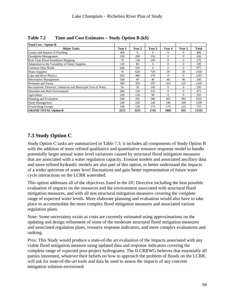
Lake Champlain – Richelieu River Plan of Study
94
Table 7.2 Time and Cost Estimates – Study Option B (k$) Total Cost - Option B
Major Tasks Year 1 Year 2 Year 3 Year 4 Year 5 TotalCauses and Impacts of Flooding 400 0 0 0 0 400Floodplain Management 100 200 150 0 0 450Real-Time Flood Inundation Mapping 70 100 100 0 0 270Adaptation to the Variability of Water Supplies 120 80 0 0 0 200Common Data Needs 640 335 0 0 0 975Water Supplies 70 620 720 20 20 1450Lake and River Physics 505 480 270 0 0 1255Information Management 160 60 40 40 40 340Wetlands and Fauna 380 395 355 165 125 1420Recreational, Domestic, Industrial and Municipal Uses of Water 50 50 100 0 0 200Shoreline and Built Environment 200 150 125 0 0 475Agriculture 100 130 90 0 0 320Planning and Evaluation 240 265 380 365 385 1635Study Management 240 240 240 240 240 1200Overarching Groups 100 150 175 175 125 725GRAND TOTAL Option B 3375 3255 2745 1005 935 11315
7.3 Study Option C Study Option C tasks are summarized in Table 7.3; it includes all components of Study Option B with the addition of more refined qualitative and quantitative resource response model to handle potentially larger annual water level variations caused by structural flood mitigation measures that are associated with a water regulation capacity. Erosion models and associated ancillary data and more refined hydraulic models are also part of this option, to better understand the impacts of a wider spectrum of water level fluctuations and gain better representation of future water cycle interactions on the LCRR watershed.
This option addresses all of the objectives listed in the IJC Directive including the best possible evaluation of impacts on the resources and the environment associated with structural flood mitigation measures, and with all non structural mitigation measures covering the complete range of expected water levels. More elaborate planning and evaluation would also have to take place to accommodate the more complex flood mitigation measures and associated various regulation plans.
Note: Some uncertainty exists as costs are currently estimated using approximations on the updating and design refinement of some of the moderate structural flood mitigation measures and associated regulation plans, resource response indicators, and more complex evaluations and ranking.
Pros: This Study would produce a state-of-the art evaluation of the impacts associated with any viable flood mitigation measure using updated data and response indicators covering the complete range of expected post-project hydrograms. The ILCRRWG believes that essentially all parties interested, whatever their beliefs on how to approach the problem of floods on the LCRR, will ask for state-of-the-art tools and data be used to assess the impacts of any concrete mitigation solution envisioned.

Lake Champlain – Richelieu River Plan of Study
95
Cons: Additional uncertainty is associated with the cost estimations and with the outcomes of the in-depth study of Current Social and Political Perception on Structural and other mitigation measures.
The total cost of Study Option C is $14,220,000 and the duration of Study Option C is approximately 5 years.
Table 7.3 Time and Cost Estimates – Study Option C (k$) Total Cost - Option C
Major Tasks Year 1 Year 2 Year 3 Year 4 Year 5 TotalCauses and Impacts of Flooding 400 0 0 0 0 400Floodplain Management 100 200 150 0 0 450Real-Time Flood Inundation Mapping 70 100 100 0 0 270Adaptation to the Variability of Water Supplies 120 80 0 0 0 200Common Data Needs 640 335 0 0 0 975Water Supplies 70 620 720 20 20 1450Lake and River Physics 605 610 400 0 0 1615Information Management 160 60 40 40 40 340Wetlands and Fauna 505 545 465 255 195 1965Recreational, Domestic, Industrial and Municipal Uses of Water 50 50 200 100 50 450Shoreline and Built Environment 200 150 125 100 100 675Agriculture 100 130 190 100 50 570Planning and Evaluation 280 305 540 875 935 2935Study Management 240 240 240 240 240 1200Overarching Groups 100 150 175 175 125 725GRAND TOTAL Option C 3640 3575 3345 1905 1755 14220
Specific tasks for Study Options A, B and C and associated costs are summarized below and in Table 7.4a and 7.4b.

Lake Champlain – Richelieu River Plan of Study
96
Table 7.4a Specific Tasks for Study Options A, B and C and associated costs (k$) Option A Option B Option C
400 400 400450 450 450270 270 270200 200 200
Acquisition of LiDAR data to achieve complete coverage of the Lake Champlain Richelieu River floodplain 150 150 150
High resolution bathymetry of the Saint-Jean Shoal & between Chambly and Fryers Dam 25 25 25Aquatic Vegetation Mapping in the upper Richelieu River and Northern portion of Lake Champlain, Substratum samplling 100 100 100
Common database of observed climate and hydrometric characteristics 200 200 200Common database of geophysical data 200 200 200Land Use Data 200 200 200Setup of a Seamless Digital Terrain Model 50 50 50Watershed Physiographic Characteristics Changes Over Time 50 50
Preliminary flood frequency analysis based on inflow data 50 50 50Set-up and calibrate high-resolution hydrological models 400 400 400Measurement of overlake evaporation 150 150Climatic projections on the temporal horizon 2050 – 2100 400 400Generate an ensemble of daily water supplies time series scenarios from climate and stochastic analysis 450 450
2D Hydrodynamic Model of the entire domain 450 450 450Surveys of water velocities and longitudinal surface profiles 20 20 203D Hydrodynamic Model of Lake Champlain 500 500Wind Wave Model for the Lake Champlain 120 120Ice Model on the Lake Champlain and Richelieu River 120 120Deployment of a stage/height stations on the "Inland Sea" portion of the lake 45 45Erosion Modeling (Wind Waves and Boat Wakes) 260Surveys of Erosion Rates and High-Resolution Pictures of the Shore at Selected Locations on the Lake and River 100
260 340 3404.1 Wetlands and Fauna
Wetlands study (+wild rice and hard stem bulrushes) 260 260Wetland fish reproduction (Northern pike) 230 230Turtle (Spiny Softshell) 150 150Riparian birds (Least bittern, Blue wing teal, Black tern, Virginia rail) 385 385Hairy necked tiger beetle (US only) 90 90Integrated modelling 305 305Copper redhorse (Canada only) 195Muskrat overwintering 110Integrated modelling 240
Inventory / update of recreational, domestic, industrial and municipal water uses 50 50A survey to obtain from all water uses information on the preferred regime of water level fluctuations 50 50Assessment of the impacts of moderate water level fluctuations on the uses 100 100Assessment of the impacts of important water level fluctuations on the uses 250
Flood Vulnerability Assessment 200 200Flood Hazards Maps 100 100Qualitative assessment of the shoreline erosion and loss of real estate property and public infrastructures 175 175
Quantitative assessment of the shoreline erosion and loss of real estate property and public infrastructures with the use of erosion models 200
Agricultural Flood Hazard Mapping 100 100Quantification of Current and Historical Agricultural Practices on Flooding 20 20Assessment of agricultural land in the watershed that is protected by dikes. 40 40Evaluation of the soil quality following flood deposits. 20 20Identify opportunities for floodplain reclamation 100 100Analyze the impacts of stream alteration, tillage and animal densities 40 40Assessment of the use of agricultural land combined with important structural flood mitigation measures and associated regulation scenarios 250
Study Item2.1 Causes and Impacts of Flooding2.2 Floodplain Management2.3 Real-Time Flood Inundation Mapping2.4 Adaptation to the Variability of Water Supplies
3.4 Information Management
3.1 Common Data Needs
3.2 Water Supplies
3.3Lake and River Physics
4.4 Agriculture
4.2 Recreational, Domestic, Industrial and Municipal Uses of Water
4.3 Shoreline and Built Environment
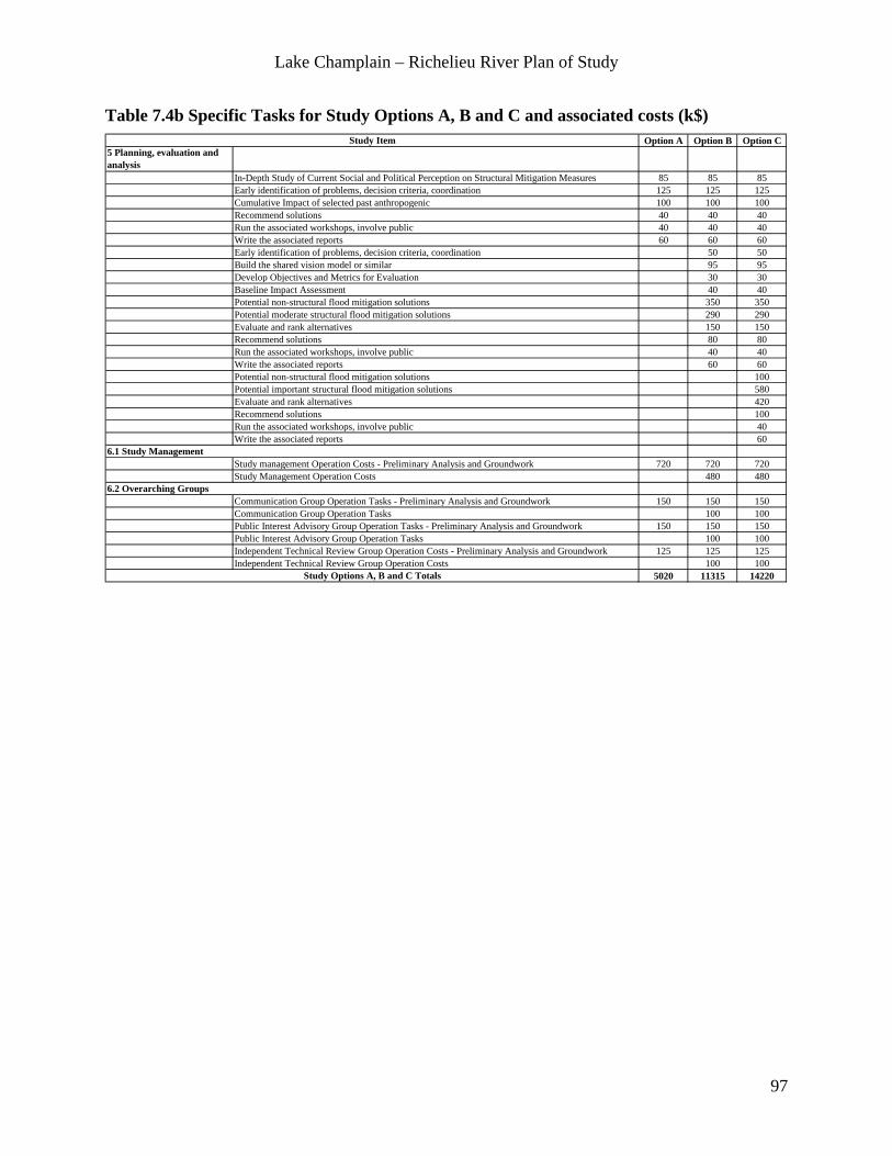
Lake Champlain – Richelieu River Plan of Study
97
Table 7.4b Specific Tasks for Study Options A, B and C and associated costs (k$) Option A Option B Option C
5 Planning, evaluation and analysis
In-Depth Study of Current Social and Political Perception on Structural Mitigation Measures 85 85 85Early identification of problems, decision criteria, coordination 125 125 125Cumulative Impact of selected past anthropogenic 100 100 100Recommend solutions 40 40 40Run the associated workshops, involve public 40 40 40Write the associated reports 60 60 60Early identification of problems, decision criteria, coordination 50 50Build the shared vision model or similar 95 95Develop Objectives and Metrics for Evaluation 30 30Baseline Impact Assessment 40 40Potential non-structural flood mitigation solutions 350 350Potential moderate structural flood mitigation solutions 290 290Evaluate and rank alternatives 150 150Recommend solutions 80 80Run the associated workshops, involve public 40 40Write the associated reports 60 60Potential non-structural flood mitigation solutions 100Potential important structural flood mitigation solutions 580Evaluate and rank alternatives 420Recommend solutions 100Run the associated workshops, involve public 40Write the associated reports 60
Study management Operation Costs - Preliminary Analysis and Groundwork 720 720 720Study Management Operation Costs 480 480
Communication Group Operation Tasks - Preliminary Analysis and Groundwork 150 150 150Communication Group Operation Tasks 100 100Public Interest Advisory Group Operation Tasks - Preliminary Analysis and Groundwork 150 150 150Public Interest Advisory Group Operation Tasks 100 100Independent Technical Review Group Operation Costs - Preliminary Analysis and Groundwork 125 125 125Independent Technical Review Group Operation Costs 100 100
5020 11315 14220Study Options A, B and C Totals
6.1 Study Management
6.2 Overarching Groups
Study Item

Lake Champlain – Richelieu River Plan of Study
98
ANNEXES

Lake Champlain – Richelieu River Plan of Study
99
ANNEX 1: Letters from the Governments

Lake Champlain – Richelieu River Plan of Study
100

Lake Champlain – Richelieu River Plan of Study
101

Lake Champlain – Richelieu River Plan of Study
102

Lake Champlain – Richelieu River Plan of Study
103
ANNEX 2 Directive
DIRECTIVE TO THE
INTERNATIONAL LAKE CHAMPLAIN-RICHELIEU RIVER
PLAN OF STUDY WORKGROUP
The purpose of this directive is to establish and direct the International Lake Champlain-Richelieu River Plan of Study Workgroup (Workgroup) to develop a Plan of Study (POS). This Workgroup will examine and report to the International Joint Commission on matters expressed by the governments of Canada and the United States in letters to the International Joint Commission dated March 19 (copies attached). In response to the devastating floods of 2011 in the Richelieu River and Lake Champlain and its tributaries, the Governments requested that the IJC review and make recommendations regarding a comprehensive study of measures to mitigate flooding and the impacts of flooding in the Richelieu River and Lake Champlain Basin. The purpose of the Workgroup is to develop a Plan of Study that would establish specifically what studies are necessary to allow an evaluation of the causes and impacts of the flooding that occurred during the spring and summer of 2011; and what studies are necessary to develop appropriate mitigation solutions and recommendations.
This POS shall include:
a. the definition of the studies to be performed and the level of detail anticipated for each study,
b. recommendations as to the agencies or organizations capable of carrying out each study, recognizing that studies are to be conducted bi-nationally,
c. sources of, or means of obtaining, needed information and data,
d. recommendations on the order and duration of the overall study and its phases (in the case of a phased study), and
e. estimates of the time, dollar and personnel resources required for the conduct of each unit of the study.
Consideration shall always be given to the goal of an improved short and long-term flood management framework for Lake Champlain and the Richelieu River in formulating the extent to which any topic or issue is to be studied.
The POS should clearly indicate the various studies both required and preferred to develop a comprehensive flood mitigation framework and to meet the requirements as set forth in the letters attached. Within the Plan of Study, the Workgroup should take into account the work ongoing or already undertaken in the Lake Champlain Basin and Richelieu River, possible in-kind contributions that jurisdictions may support, and the overall costs required to fulfill the request from the Governments.
At a minimum, the following studies are required:

Lake Champlain – Richelieu River Plan of Study
104
1. An evaluation of the causes and impacts of flooding in the Lake Champlain watershed, with emphasis on the events of 2011;
2. An evaluation, including a cost and benefit analysis of flood mitigation solutions for Lake Champlain and its tributaries and the Richelieu River, considering both structural and non-structural solutions;
3. An analysis and recommendations for adapting to the variability of water supplies to the Lake Champlain and Richelieu River watershed, building upon existing relevant studies. This includes, but is not limited to, work produced by the Lake Champlain Basin Program, the University of Vermont, and the Ouranos Consortium on regional climatology and adaptation to climate change;
4. An analysis of existing, country-wide flood plain regulation best management practices, to include recommendations for community-based regulation; and
5. An evaluation of the need for real-time flood inundation mapping to help predict flooding potential and prepare local communities and emergency responders for future floods.
The Workgroup should address, in a sustainable development perspective including its three pillars of economic and social development and environmental protection, the need for:
a. Review of available data and research that will inform and prioritize studies and activities to be completed throughout the implementation of the POS;
b. Review of the economic and social impact of floods for various Lake Champlain Basin and Richelieu River interests;
c. Topographic and bathymetric data acquisition;
d. Examination of the effects of past structural work in the basin including among other possible items: past and/or current dredging, streambed straightening, and the operation of Chambly Canal on levels and flows;
e. Examination of environmental considerations of the possible impact of anthropogenic regulation effects compared to natural levels and flows in the basin;
f. Development of alternative mitigation measures, including recommendations on structural and non-structural methods, on regulatory or policy changes that consider economic, social and environmental interests, the integrity of the ecosystem, make provisions for emergency conditions and respect the requirements of the Boundary Waters Treaty;
g. Examination of shoreline impacts of levels and flows, including assessment of zoning and other land use management issues;
h. Examination of social considerations, including qualitative assessment of how demographic and other possible future changes that may affect all interests and alternative mitigation measures;
i. Ongoing public involvement in executing the study, including institutional arrangements to ensure appropriate communication with and among all interests, as well as a means of testing and demonstrating the effects of possible mitigation measures with the public; and
j. Consideration of climate change impacts on levels and flows and subsequent impacts on suitability of mitigation measures.
The Commission will appoint Members of the Workgroup, Co-Chairs to lead the Workgroup’s efforts, and Co-Secretaries. The Co-Chairs will be responsible for organizing and executing the work of the Workgroup, and for coordinating with, and reporting to, the Commission. The Workgroup will

Lake Champlain – Richelieu River Plan of Study
105
be bi-national, comprising an equal number of members from each country. Under the general supervision of the Co-Chairs, the Co-Secretaries shall carry out such duties as are assigned by the Co-Chairs or the Workgroup as a whole. When identified by the Workgroup, the Commission will pursue technical assistance from the two Governments, the province of Québec, and the States of Vermont and New York. Members of the Workgroup and any committees or work groups created by it will be responsible for their own expenses unless otherwise arranged with the Commission.
The Commission may provide guidance to the Workgroup. The Workgroup shall consult with others as necessary to seek their views so that each is aware of any activities in the basin that might be useful to it in carrying out its responsibilities.
The Workgroup shall produce:
1. Within six weeks of its formation, a document outlining how it plans to proceed in developing a POS, with special emphasis on public involvement;
2. By October 1, 2012, a draft POS; and
3. By December 3, 2012, a final POS (an electronic copy and two signed copies, one provided to each section of the Commission.)
The Workgroup will submit a work plan with an associated schedule of activities and budget for the Commission’s approval as soon as practicable. The work plan shall include a proposal that will describe how public consultation will be undertaken. The consultation plan shall discuss how the Workgroup will collaborate with federal governments, the province, and states, as well as the wider body of stakeholders and the public.
The Workgroup shall make use of public input received prior to and during the development of the POS. The Workgroup shall distribute information widely to raise awareness of the effort to develop a Plan of Study and the purpose of the proposed study. To the extent possible, the development of the POS shall be an open and transparent process. The Workgroup shall provide opportunities for the public to comment on the draft POS concurrently with the Commission’s review. The Workgroup shall coordinate its public involvement plans with the Commission.
The Workgroup will evaluate and analyze available information, and it will inform the Commission of any additional informational requirements necessary to address the matters raised by the Governments. The Workgroup will strive to reach decisions by consensus and will immediately notify the Commission of any irreconcilable differences. Any lack of clarity or precision in instructions or directions received from the Commission shall be promptly referred to the Commission for clarification.
Documents, letters, memoranda, and communications of every kind in the official records of the Commission are privileged and become available for public information only after their release by the Commission. The Commission considers all documents in the official records of Workgroup or any of its committees or work groups to be similarly privileged. Accordingly, all such documents shall be so identified and maintained as separate files.

Lake Champlain – Richelieu River Plan of Study
106
ANNEX 3: Information Regarding Public Meetings, Site Visits, and Technical Workshop
August 2012 Public Meetings
The goal of both initial public meetings was that the public share, early on, with the ILCRRWG, their ideas, concerns, information, and data sources as the draft PoS is being developed.
Summary of Public meeting at Saint-Paul-de-l’île-aux Noix (Canada), August 7th 2012
About 50 people attended the meeting excluding the ILCRRWG members and IJC staff. Simultaneous interpretation was available. The following were represented (list established from Comment cards):
• Municipalities of: Saint-Paul-de-l’Île-aux-Noix, Lacolle and Saint-Georges-de-Clarenceville
• Municipalité régionale de comté du Haut-Richelieu
• Comité de concertation et de valorisation du bassin de la rivière Richelieu (COVABAR)
• Conservation de la Nature Canada
• Mouvement écologique du Haut-Richelieu
• Union des Producteurs Agricoles (UPA)
• Ministère de l’Agriculture, des Pêcheries et de l’Alimentation
• Ministère de la Sécurité publique
• Le Canada français (newspaper)
• Conseil National de Recherche du Canada
• GENIVAR Inc
Minutes of the meeting are available from the ILCRRWG.

Lake Champlain – Richelieu River Plan of Study
107
Summary of Public meeting at North Hero (VT, United States) August 8th 2012
About 25 people attended excluding the ILCRRWG members and IJC staff. The following organizations were represented:
• Lake Champlain Basin Program
• The Nature Conservancy- Adirondacks
• Lake Champlain Committee
• Lake Champlain International
• Friends of Northern Lake Champlain
• Composting Association of VT
Minutes of the meeting are available from the ILCRRWG.
Summary of Sites visited by ILCRRWG, August 7 and 8, 2012
Richelieu River Field Visit Agenda – Tuesday August 7th 2012
• Saint-Ours locks • Chambly Canal • Fryers Dam • Saint–Jean-sur-Richelieu Meeting with representatives from Quebec Agriculture/MAPAQ,
Quebec Public Safety and the Regional Municipal County /MRC
Lake Champlain Watershed Field Visit Agenda - Wednesday August 8th 2012
• Rouses Point, NY USGS Gage Station
• Sand Bar State Park
• Waterbury Dam
• Marshfield Dam
• St. Albans Bay
• Missisquoi National Wildlife Refuge
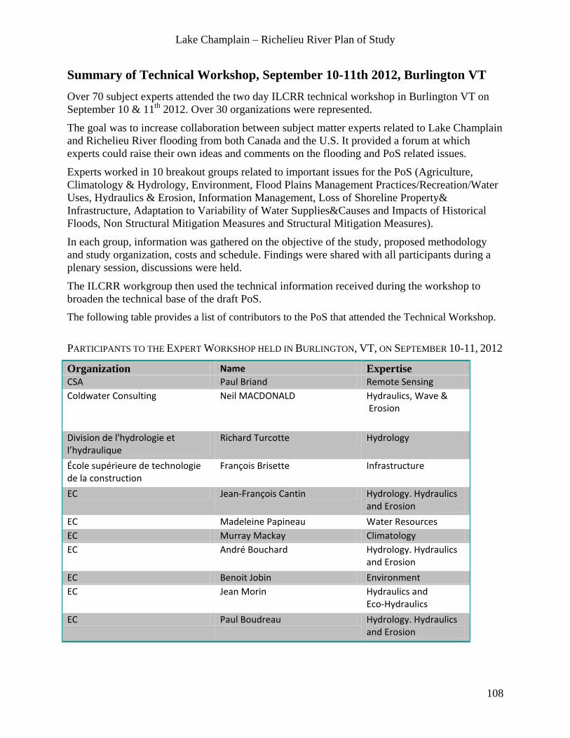
Lake Champlain – Richelieu River Plan of Study
108
Summary of Technical Workshop, September 10-11th 2012, Burlington VT Over 70 subject experts attended the two day ILCRR technical workshop in Burlington VT on September 10 & 11th 2012. Over 30 organizations were represented.
The goal was to increase collaboration between subject matter experts related to Lake Champlain and Richelieu River flooding from both Canada and the U.S. It provided a forum at which experts could raise their own ideas and comments on the flooding and PoS related issues.
Experts worked in 10 breakout groups related to important issues for the PoS (Agriculture, Climatology & Hydrology, Environment, Flood Plains Management Practices/Recreation/Water Uses, Hydraulics & Erosion, Information Management, Loss of Shoreline Property& Infrastructure, Adaptation to Variability of Water Supplies&Causes and Impacts of Historical Floods, Non Structural Mitigation Measures and Structural Mitigation Measures).
In each group, information was gathered on the objective of the study, proposed methodology and study organization, costs and schedule. Findings were shared with all participants during a plenary session, discussions were held.
The ILCRR workgroup then used the technical information received during the workshop to broaden the technical base of the draft PoS. The following table provides a list of contributors to the PoS that attended the Technical Workshop. PARTICIPANTS TO THE EXPERT WORKSHOP HELD IN BURLINGTON, VT, ON SEPTEMBER 10-11, 2012
Organization Name Expertise CSA Paul Briand Remote Sensing Coldwater Consulting Neil MACDONALD Hydraulics, Wave &
Erosion
Division de l'hydrologie et l’hydraulique
Richard Turcotte Hydrology
École supérieure de technologie de la construction
François Brisette Infrastructure
EC Jean-François Cantin Hydrology. Hydraulics and Erosion
EC Madeleine Papineau Water Resources EC Murray Mackay Climatology EC André Bouchard Hydrology. Hydraulics
and Erosion EC Benoit Jobin Environment EC Jean Morin Hydraulics and
Eco-Hydraulics EC Paul Boudreau Hydrology. Hydraulics
and Erosion

Lake Champlain – Richelieu River Plan of Study
109
EC Sylvain Martin Ecohydraulics
EC Vincent Fortin Climatology
EC Wendy Leger Adaptive Management Framework
GENIVAR Pierre Dupuis Hydrology. Hydraulics and Erosion
IJC Anne Chick IJC Senior Advisor
IJC /EC David Fay Hydraulics
INRS-ETE Yves Secretan Hydraulics
IRDA Isabelle Beaudin Agriculture
LCSG - SUNY Plattsburgh Mark Malchoff Fisheries
LCBP Eric Howe Environment
LCBP Stephanie (Strouse) Castle Environment
MSP Jean-Sebastien Forest Public Safety
MSP Pascal Marceau Public Safety
MAPAQ Carrolyn O'Grady Agriculture

Lake Champlain – Richelieu River Plan of Study
110
MAMROT Claudine Beaudoin Domestic, Industrial and Municipal Uses of Water
MRNF Marc Mingelbier Fish Habitat
MRNF Steve Garceau Fisheries
MDDEFP Daniel Leblanc Environment
MDDEFP Pascal Sarrazin Floodplain Management
MDDEFP Jean Francoeur Hydrology
MDDEFP Jean-Denis Bouchard Hydrology
MDDEFP Martin Mimeault Non structural mitigation
Ministère du Développement économique, de l'Innovation et de l'Exportation
Luc Veillette Social and Economical Considerations
MRC Haut-Richelieu Joane Saulnier Emergency Response
MRC Haut-Richelieu Luc Beaudoin Emergency Response
MRC Haut-Richelieu Caroline Roberge Floodplain Management
NOAA NWS Burlington John Goff Hydraulic Modeling
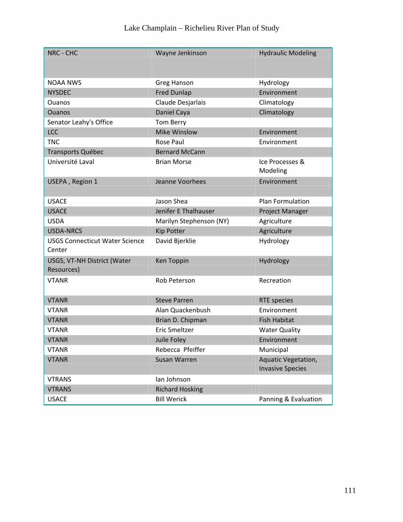
Lake Champlain – Richelieu River Plan of Study
111
NRC - CHC Wayne Jenkinson Hydraulic Modeling
NOAA NWS Greg Hanson Hydrology NYSDEC Fred Dunlap Environment Ouanos Claude Desjarlais Climatology Ouanos Daniel Caya Climatology Senator Leahy's Office Tom Berry LCC Mike Winslow Environment TNC Rose Paul Environment Transports Québec Bernard McCann Université Laval Brian Morse Ice Processes &
Modeling USEPA , Region 1 Jeanne Voorhees Environment
USACE Jason Shea Plan Formulation USACE Jenifer E Thalhauser Project Manager USDA Marilyn Stephenson (NY) Agriculture USDA-NRCS Kip Potter Agriculture USGS Connecticut Water Science Center
David Bjerklie Hydrology
USGS, VT-NH District (Water Resources)
Ken Toppin Hydrology
VTANR Rob Peterson Recreation
VTANR Steve Parren RTE species VTANR Alan Quackenbush Environment VTANR Brian D. Chipman Fish Habitat VTANR Eric Smeltzer Water Quality VTANR Juile Foley Environment VTANR Rebecca Pfeiffer Municipal VTANR Susan Warren Aquatic Vegetation,
Invasive Species VTRANS Ian Johnson VTRANS Richard Hosking USACE Bill Werick Panning & Evaluation

Lake Champlain – Richelieu River Plan of Study
112
March 2013 Public Meetings The goal of the second round of public meetings in both countries and both states was to obtain feedback and comments on the revised draft Plan of Study prior to submission to the IJC commissioners in early April, 2013.
Summary of the Public Meetings in Burlington, VT and Plattsburgh, NY March 11th 2013 About 20 people attended the meeting in each location (~40 total) excluding the ILCRR workgroup members, IJC staff and the IJC Commissioner. The meetings were broadcast concurrently through a GoToMeeting Webinar.
Other than private citizens, the following organizations were present:
• Town of Jay Supervisor • County Planner of Essex County, NY • Lake Champlain Basin Program • Lake Champlain Committee • SUNY Plattsburgh • Friends of the Missisquoi National Wildlife Refuge • The Nature Conservancy • Lake Champlain International • Colchester (VT) Conservation Committee • Senator Leahy’s Office • Vermont Agency of Natural Resources (VT ANR) • U.S. Fish and Wildlife Service (USFWS) • National Ocean and Atmospheric Association (NOAA) • Vermont Citizen’s Advisory Committee (VT CAC) • Department of Foreign Affairs and International Trade Canada (DFAIT)
Media Coverage: Two television teams were present at the Burlington location and a newspaper reporter was present at the Plattsburgh meeting. Interviews were given before and after the meeting date by Stephanie Castle, Brian Chipman, Jenifer Thalhauser and Anne Chick (IJC).
Minutes of both meetings are available from ILCRRWG.

Lake Champlain – Richelieu River Plan of Study
113
Summary of Public Meeting at Saint-Jean-sur-Richelieu, March 12th 2013
About 30 people attended the meeting excluding the ILCRR workgroup members, MC, IJC staff and the IJC Commissioner. Simultaneous language interpretation was available.
Other than private citizens, the following organizations were present:
• Municipalities of: Saint-Jean-sur-Richelieu. Saint-Paul-de-l’Île-aux-Noix, Lacolle and Saint-Georges-de-Clarenceville
• Municipalité régionale de comté du Haut-Richelieu • Comité de concertation et de valorisation du bassin de la rivière Richelieu (COVABAR) • Mouvement écologique du Haut-Richelieu • Conservation Baie Missisquoi • Lake Champlain Basin Program (LCBP) • Ministère de l’Agriculture, des Pêcheries et de l’Alimentation (MAPAQ) • Ministère de la Sécurité publique Québec (MSP) • Ministère des Affaires Municipales, des Régions et de l’Occupation du territoire
(MAMROT) • Parks Canada Agency • Department of Foreign Affairs and International Trade (DFAIT) • US Consulate Montreal • Le Canada français (local newspaper) Media coverage: Interviews were given by the Canadian Co-chair to Sarah Rogers (Quebec AM – CBC Radio Broadcast). Gilles Bérubé a reporter with Le Canada français was at the meeting.
Minutes of the meeting are available from ILCRRWG.

Lake Champlain – Richelieu River Plan of Study
114
In attendance at U.S. Meetings (August, 2012 in North Hero, VT; March, 2013 in Burlington, VT and Plattsburgh, NY):
Name Organization Location
In North Hero:
Barbara Derick Private Citizen Clarenceville, QC
Pat O'Neill Composting Association of Vermont Troy, VT
Steve Wright Private Citizen Craftsbury Common, VT
Richard Ernst Private Citizen Alburgh, VT
Carolyn Prasch Private Citizen Grand Isle, VT
Mike Winslow (attended both meetings)
Lake Champlain Committee Burlington, VT
Denise Messier Private Citizen QC
Michelle Brown The Nature Conservancy Keene Valley, NY
Jason Lee Private Citizen South Hero, VT
Ross Saxton Lake Champlain International Colchester, VT
Floyd Derick Private Citizen Clarenceville, QC
David Borthwick-Leslie
Friends of Northern Lake Champlain Grand Isle, VT
Ellen and Norman Vaillancourt Private Citizens
In Plattsburgh:
Ann Ruzow-Holland Lake Champlain Committee Board/Lake Resident Willsboro, NY
Jessica Levine The Nature Conservancy Keene Valley, NY
Jay Frank Private Citizen Keeseville, NY
Eileen Allen SUNY Plattsburgh Plattsburgh, NY
Sue Hagar Private Citizen Morrisonville, NY
Norman Monette Private Citizen Plattsburgh, NY
Dave Robertson Champlain Sail and Power Plattsburgh, NY

Lake Champlain – Richelieu River Plan of Study
115
Squadron
Dennis Hulbert Private Citizen Plattsburgh, NY
Name Organization Location
Henry C. Schwartz Champlain Sail and Power Squadron Plattsburgh, NY
Joe Makara Private Citizen Plattsburgh, NY
Jeffrey Clock Buena Vista Cottagers Association Willsboro, NY
Dr. and Mrs. Richard Lutinski Private Citizens Plattsburgh, NY
Randy Douglas Essex County NY (Town of Jay Supervisor) Jay, NY
Rachel Schultz SUNY Plattsburgh Plattsburgh, NY
Alan Booth Lake Champlain Committee Board/Lake Resident Plattsburgh, NY
Vic Putman Essex County NY Willsboro, NY
Eric Howe Lake Champlain Basin Program Williston, VT
In Burlington:
James Ehlers Lake Champlain International Burlington, VT
Dave Tilton USFWS Essex, VT
Carolyn Bates Private Citizen Burlington, VT
Rose Paul The Nature Conservancy Burlington, VT
Eric Smeltzer VT ANR Waterbury, VT
Russ Ford Friends of the Missisquoi National Wildlife Refuge Franklin, VT
Tom Berry Senator Leahy's Office Burlington, VT
Richard Downer Private Citizen Shelburne, VT
Jeff Rossetti Private Citizen
Joseph Horn Private Citizen
Greg Hanson NOAA/NWS Burlington, VT
Neal Burnham DFAIT Ottawa, Ontario
Theresa Carroll Colchester Conservation Committee Colchester, VT

Lake Champlain – Richelieu River Plan of Study
116
In attendance at Canadian meetings (August, 2012 in Saint-Paul-de-l’Île-aux-Noix, Quebec and March, 2013 in Saint-Jean-sur-Richelieu, Quebec):
Name
Organization
Meeting attended
Claudine Beaudoin MAMROT St-Jean
Robert Beaudoin St-Jean
Claude Benoît Conservation Baie Missisquoi St-Jean
Gilles Bérubé Le Canada français (newpaper) St-Paul; St-Jean
Jaclin Bisaillon Union des producteurs agricoles(UPA)
St-Paul
Robert Boudreau Municipalité de St-Georges-de-Clarenceville
St-Paul
Denis Boudrias St-Jean
Neal Burnham Foreign Affairs and International Trade – Canada
St-Jean
Luc Castonguay Ville de Saint-Jean-sur-Richelieu St-Jean
Chantale Chatelain COVABAR St-Paul
Isabelle Cognac COVABAR St-Paul
Marcel Comiré COVABAR St-Jean
Claude Dambrine St-Paul
Marc Delage Saint-Blaise-sur-Richelieu St-Jean
Pierre Dupuis GENIVAR Inc St-Paul
Yves Duteau Maire, Municipalité de Lacolle St-Paul; St-Jean
Maureen Dutil St-Jean
Gérard Dutil Maire, St-Paul-de-l’Île-aux-Noix St-Jean
Gaston Florent Domaine Florent St-Paul; St-Jean
Guy Florent St-Paul
Marcel Florent Domaine Florent St-Paul; St-Jean
Jean-Sébastien Forest Ministère de la sécurité publique St-Paul; St-Jean
Carmen Fortin Municipalité de St-Paul-de-l’Île-aux-Noix
St-Paul

Lake Champlain – Richelieu River Plan of Study
117
Nathalie Fortin National Research Council of Canada
St-Paul
Gerardo Gollo Gil MAPAQ St-Jean
Louise Gratton Conservation de la Nature Canada St-Paul
Louis Hak St-Georges-de-Clarenceville St-Paul; St-Jean
Gilles Hébert St-Paul
Bill Howland LCBP St-Jean
Marc Jetten Mouvement écologique du Haut -Richelieu
St-Paul; St-Jean
Marie-Hélène Lafond U.S. Consulate Montreal St-Jean
Jacques LaLanne Mouvement écologique du Haut Richelieu
St-Jean
Guy Langlois St-Paul
Alain Laplante Ville de Saint-Jean-sur-Richelieu St-Jean
Marie-Lili Lenoir Saint-Paul-de-l’Île-aux-Noix St-Paul
Robert Meloche Ville de Saint-Jean-sur-Richelieu St-Jean
Jacques Morin Municipalité de Lacolle St-Jean
Mathilde Morin MAPAQ St-Paul
Carrolyn O’Grady MAPAQ St-Jean
Alain Paradis Ville de Saint-Jean St-Jean
Thomas Piché Parcs Canada St-Jean
Daniel Ponton St-Paul
Caroline Roberge MRC Haut Richelieu St-Paul
Renée Rouleau St-Paul
Anne Saucier St-Paul
Joane Saulnier MRC Haut Richelieu St-Jean
France St-Onge St-Paul
Harm Sloterdijk COVABAR St-Jean
Note: this list may not contain all the names of people present at the meetings as the list was established from comment cards and the sign-in list.

Lake Champlain – Richelieu River Plan of Study
118
ANNEX 4: Brief History of the 1973 Richelieu River and Lake Champlain Reference
On June 10, 1937, the IJC approved construction and operation by Canada of remedial works in the Richelieu River in QC for reclamation and protection from flooding of low lands located in QC. The Government of Canada appropriated $500,000 for this purpose.1 Pursuant to this Order of Approval, a dam was completed in 1939 at Fryers Island (see map on page 3). The dikes in the vicinity of the dam and the dredging through the rock shoal at St. Jean, provided by the Order of Approval, were not undertaken. Because these channel works were never completed, the Fryers Island dam was never operated. Regulation of the Richelieu River for flood control wasn’t achieved.
Between 1970 and 1973, the Canadian Federal Government undertook works in the Chambly Canal in the Richelieu River which had the effect of constricting the channel and raising the level of the Richelieu River and Lake Champlain upstream in the United States. Commission approval was never requested for these works2.
On March 29, 1973, the Assistant-Secretary of State of the United States of America and the Under-Secretary of State for External Affairs of Canada sent a Reference to the IJC3 to investigate and report upon the feasibility and desirability of regulation of the Richelieu River in the Province of QC for the purpose of alleviating extreme water conditions in the Richelieu River and in Lake Champlain, and for other beneficial purposes.
The IJC established the International Champlain Richelieu Engineering Board to investigate4. An Interim Report was provided to Governments in 1975 recommending an intensive environmental and economic study be undertaken by the Commission before moving forward with any kind of construction5. Both the Canadian6 and US7 Governments endorsed and agreed to fund the recommendations.
1 10 June 1937 Order of Approval. Docket 38-1-5:1 2 6 July 1979 letter from the Canadian Secretary of the Commission, to the Hon. Flora MacDonald, Secretary of External Affairs, Canada. Docket 98-3-1 3 29 March 1973 reference letter from the Office of The Under Secretary of State for External Affairs, Canada, to D. G. Chance, Canadian Secretary of the IJC. Docket 98-3-1-1 4 24 April 1973 “Directive to the International Richelieu-Champlain Engineering Board”. Docket 98-4A-2:1 5 12 March 1975 IJC’s “Interim Report on the Regulation of the Richelieu River and Lake Champlain”. Docket 98-4-1:1 6 2 May 1975 letter from The Hon. A. J. MacEachen, The Secretary of State for External Affairs Canada, to Maxwell Cohen, Chairman, Canadian Section IJC. Docket 98-1-4:1 7 24 March 1975 letter from Richard D. Vine, Deputy Assistant Secretary, U.S. Department of State, to Christian Herter Jr., U.S. Chairman, IJC. Docket 98-1-4:1

Lake Champlain – Richelieu River Plan of Study
119
In 1976, the Government of Canada supported by the Government of QC applied for permission to dredge the Richelieu River channel and construct a fixed-crest weir at St. Jean, QC8. The Commission decided to defer taking action on the Application pending the completion of the environmental impact study9.
Over the course of the following 5 years, the Commission received reports from the International Champlain-Richelieu board, the Environmental Impact, Physical Aspects and Net Benefits Committees, as well as two supplemental reports comprising a comprehensive review on the regulation of the Lake Champlain and Richelieu River. These reports, along with over 3000 pages of public hearing transcripts were used to produce the IJC’s final report to Governments in February 198110.
The Commission’s final report to the 1973 reference concluded that it was technically feasible to build and operate a gated control structure at St. Jean in conjunction with dredging through the St. Jean shoal to increase channel capacity which would accommodate the proposed environmental criteria, however the Commission was unable to determine the desirability of this option and therefore could not make recommendations to Governments regarding regulation of Lake Chaplain and the Richelieu River. In the same report, the Commission recommended that a flood forecasting and warning system be instituted, and that flood plain regulation be implemented. In addition, the Commission said it would await advice from Governments before acting on the 1976 application. A flood forecasting system was implemented, however no further action was taken on the dredging or gated control structure.
Why was no further action taken?
It seems that the Commission was unable to determine the desirability of flow regulation mainly because most proponents of flow regulation (in the form of a gated control structure and channelization near St. Jean) were residents of QC, while most opponents were residents of VT and NY, the latter being principally concerned with the preservation of Lake Champlain in its natural condition. Following the release of the IJC’s 1981 report, Governor Richard Snelling of VT indicated that he would speak with Governor Hugh Carey of NY and Premier René Lévesque to find a less drastic solution to the flooding11, however no further Government action was taken.
8 5 January 1976 application letter from Allan J. MacEachen, The Secretary of State for External Affairs Canada, to D.G. Chance, Secretary, Canadian Section, IJC. Docket 102-1-1:1 9 19 February 1976 letter from D.G. Chance, Secretary, Canadian Section IJC, to The Hon. A.J. MacEachen, Secretary of State for External Affairs, Canada. Docket 102-1-1:1 10 1 January 1981 IJC’s “Regulation of the Richelieu River and Lake Champlain” Report to the Governments of Canada and the United States. Docket 98-4A-7:1 11 11 February 1
981 The Gazette, Montreal newspaper article “Richelieu flood control dam not recommended”. Docket 98-6-2:1; and
Heavy Construction News, Toronto newspaper article “IJC withholds approval of $16m dam plan”. Docket 98-6-2:1
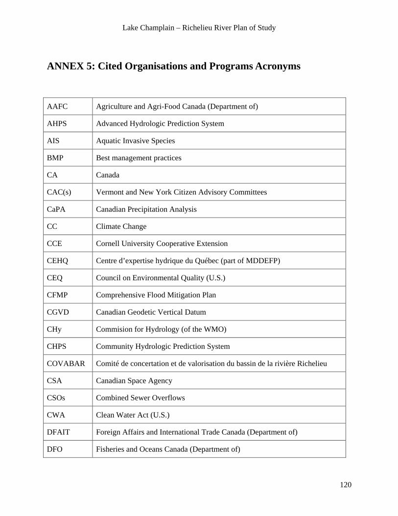
Lake Champlain – Richelieu River Plan of Study
120
ANNEX 5: Cited Organisations and Programs Acronyms
AAFC Agriculture and Agri-Food Canada (Department of)
AHPS Advanced Hydrologic Prediction System
AIS Aquatic Invasive Species
BMP Best management practices
CA Canada
CAC(s) Vermont and New York Citizen Advisory Committees
CaPA Canadian Precipitation Analysis
CC Climate Change
CCE Cornell University Cooperative Extension
CEHQ Centre d’expertise hydrique du Québec (part of MDDEFP)
CEQ Council on Environmental Quality (U.S.)
CFMP Comprehensive Flood Mitigation Plan
CGVD Canadian Geodetic Vertical Datum
CHy Commision for Hydrology (of the WMO)
CHPS Community Hydrologic Prediction System
COVABAR Comité de concertation et de valorisation du bassin de la rivière Richelieu
CSA Canadian Space Agency
CSOs Combined Sewer Overflows
CWA Clean Water Act (U.S.)
DFAIT Foreign Affairs and International Trade Canada (Department of)
DFO Fisheries and Oceans Canada (Department of)

Lake Champlain – Richelieu River Plan of Study
121
DIFW Department of Inland Fisheries and Wildlife (U.S.)
DND National Defence Canada (Department of)
DTM Digital Terrain Model
EC Environment Canada (Department of)
EPSCoR-RACC
Vermont Experimental Program to Stimulate Competitive Research–Research on Adaptation to Climate Change
ÉTS École des technologies supérieures
FEMA Federal Emergency Management Agency
FERC Federal Energy Regulatory Commission (U.S.)
GIS Geographic Information System
GLERL Great Lakes Environmental Research Laboratory
GSC Geodetic Survey of Canada
HEC-RAS Hydrologic Engineering Centers River Analysis System
HYDROTEL Hydrologie et Télédétection
IERM2D Integrated Ecosystem Response Model – 2 Dimensions
IJC International Joint Commission
ILCRRWG International Lake Champlain Richelieu River Workgroup
IM Information management
INRS-ETE Institut national de la recherche scientifique–Centre Eau Terre Environnement
IPCC Intergovernmental Panel on Climate Change
IRDA Institut de Recherche et de Développement en Agroenvironnement
LCBP Lake Champlain Basin Program (PMVLC)
LCC Lake Champlain Committee
LCI Lake Champlain International
LCRC Lake Champlain Research Consortium (at St. Michael’s College)

Lake Champlain – Richelieu River Plan of Study
122
LCRR Lake Champlain-Richelieu River Basin
LCSG Lake Champlain Sea Grant
LiDAR Light Detection And Ranging (Laser Altimetry Remote Sensing Data)
LOSLRS Lake Ontario – St. Lawrence River IJC Study
MAMROT Ministère des affaires municipales, des régions et de l’occupation du territoire du Québec
MAPAQ Ministère de l’agriculture, des pêcheries et de l’alimentation du Québec
MDDEFP Ministère du développement durable, de l’environnement, de la faune et des parcs du Québec
MESH Modélisation Environnementale Couplée – Surface and Hydrology
MFEQ Ministère des finances et de l’économie du Québec
MODIS Moderate Resolution Imaging Sectroradiometer
MOU Memorandum of Understanding
MRC Municipalité régionale de comté (Regional County Municipality)
MRI Ministère des relations internationales, de la francophonie et du commerce du Québec
MRN Ministère des ressources naturelles du Québec
MS4s Municipal Separate Storm Sewer Systems (U.S.)
MSC Meteorological Service of Canada (part of EC)
MSL Mean Sea Level
MSP Ministère de la sécurité publique du Québec
MSSS Ministère de la santé et des services sociaux du Québec
MTQ Ministère des transports du Québec
NARCCAP North American Regional Climate Change Assessment Program
NASA National Aeronautic and Space Administration (US)
NAVD North American Vertical Datum

Lake Champlain – Richelieu River Plan of Study
123
NYSDOS New York State Department of State
NEXRAD Next-Generation Radar
NGO Non-Government Organization
NGVD National Geodetic Vertical Datum
NHD National Hydrography Database (U.S.)
NOAA National Oceanic and Atmospheric Administration
NOHRSC National Operational Hydrologic Remote Sensing Center (US)
NPS National Park Service (US)
NRCan Natural Resources Canada (Department of)
NRC-CHC National Research Council (of Canada) – Canadian Hydraulic Center
NRCS Natural Resources Conservation Service (USDA)
NWS National Weather Service (US National)
NY New York
NYFB New York Farm Bureau
NYPA New York Power Authority
NYSDEC New York State Department of Environmental Conservation
NYSDEM New York State Department of Emergency Management
NYSDOT New York State Department of Transportation
NYSAM New York State Agriculture and Markets
NYSCC New York State Canal Corporation
NYSDOS New York State Department of State
NYSED New York State Empire Development
NYSGIS New York State Geographic Information System
NYSOPRHP New York State Office of Parks, Recreation and Historic Preservation

Lake Champlain – Richelieu River Plan of Study
124
OBVBM Organisme de bassin versant de la Baie Missisquoi
OGC Open Geospatial Consortium
PAC Public Advisory Committee
PC Parks Canada (Agency)
PIAGs Public Interest Advisory Groups
PIO Public Information Officers
PMVLC Programme de mise en valeur du Lac Champlain (LCBP)
PRMS Precipitation Runoff Modeling System
PoS Plan of Study
PS Public Safety Canada
QC Quebec
RACC Research on Adaptation to Climate Change (at UVM)
RCM Regional County Municipality (see MRC)
RCMs Regional Climate Models/Regional Circulation Model
SAC/SMA Sacramento Soil Moisture Accounting
SMAP Soil Moisture Active Passive
SSC Shared Services Canada
Statcan Statistics Canada
SUNY State University of New York at Plattsburgh
SWAT Soil and Water Assessment Tool
SWE Snow Water Equivalent
TC Transport Canada
THDHTF Transboundary Hydrographic Data Harmonization Task Force
TMDL Total Maximum Daily Load (CQMT)
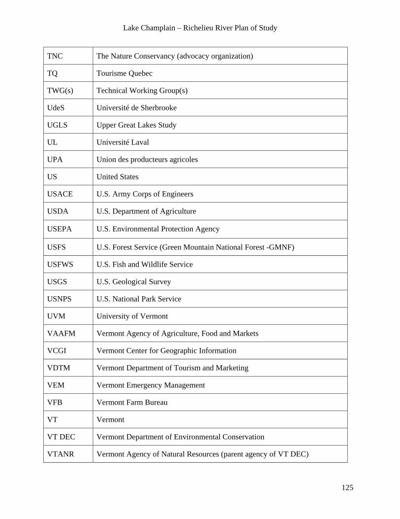
Lake Champlain – Richelieu River Plan of Study
125
TNC The Nature Conservancy (advocacy organization)
TQ Tourisme Quebec
TWG(s) Technical Working Group(s)
UdeS Université de Sherbrooke
UGLS Upper Great Lakes Study
UL Université Laval
UPA Union des producteurs agricoles
US United States
USACE U.S. Army Corps of Engineers
USDA U.S. Department of Agriculture
USEPA U.S. Environmental Protection Agency
USFS U.S. Forest Service (Green Mountain National Forest -GMNF)
USFWS U.S. Fish and Wildlife Service
USGS U.S. Geological Survey
USNPS U.S. National Park Service
UVM University of Vermont
VAAFM Vermont Agency of Agriculture, Food and Markets
VCGI Vermont Center for Geographic Information
VDTM Vermont Department of Tourism and Marketing
VEM Vermont Emergency Management
VFB Vermont Farm Bureau
VT Vermont
VT DEC Vermont Department of Environmental Conservation
VTANR Vermont Agency of Natural Resources (parent agency of VT DEC)

Lake Champlain – Richelieu River Plan of Study
126
VTRANS Vermont Agency of Transportation
WBD Water Boundaries Dataset (International)
WMO World Meteorological Organization
WSC Water Survey of Canada (part of EC)

Lake Champlain – Richelieu River Plan of Study
127
ANNEX 6: References Anderson, J. K. 1990. Evaluation of northern pike spawning in Lake Champlain. Final Report F-12-R, Job, No. II-4. Vermont Fish and Wildlife Department, Essex Junction. 47 pp.
Bleau N., Thomas-Maret I, Soto Abasolo P., Desjardins-Dutil G, Fuamba M., Kadi S., 2012, Analyser la vulnérabilité sociétale et territoriale aux inondations en milieu urbain dans le contexte des changements climatiques, en prenant comme cas d’étude la Ville de Montréal, Rapport final, Disponible à l'automne 2012, 143 p.
Brande, J., Lapping, M., 1979. Exchanging Information Across Boundaries : The Richelieu – Champlain Experience. Canadian Water Resources Journal, Vol. 4, No. 4, pp. 39 – 50.
Countryman, W. D., 1977. An analysis of lake level influence on vegetation in Lake Champlain. Report prepared for the IJC under contract to USFWS. Aquatec, Inc., South Burlington, VT. 23 pp. plus appendicies.
Creighton, J.L., 2010. How to Conduct a Shared Vision Planning Process. Report Submitted to the U.S. Army Corps of Engineers, Institute for Water Resources. IWR Report 10-R-6, 91p. Dumont P., and R. Fortin. 1977. Effects of spring water levels on the reproduction of upper Richelieu River and Missisquoi Bay northern pike (Esox lucius L.). Report prepared for the IJC. University of QC at Montreal. 114 pp.
Environnement Canada, 2006. Water availability issues for the St.Lawrence River : An environmental synthesis. Tabot A. (ed) Environment Canada. Montreal 204 p.
Hamel, C., and P. Breuer. 1977. Influences of spring water levels on aquatic and riparian plant distribution in upper Richelieu and Missisquoi Bay Areas. Report prepared for the IJC. University of QC at Montreal. 65 pp.
Henson, E. B., and M. Potash. 1977. Biological production and nutrient studies of Lake Champlain. Report prepared for the IJC under contract to USFWS. University of Vermont. 183 pp.
International Joint Commission, 1975. Interim Report on the Regulation of the Richelieu River and Lake Champlain. Docket 98 Interim Report to Gov., 22 pages.
International Joint Commission, 1981. Regulation of the Richelieu River and Lake Champlain. An IJC report to the governments of Canada and the United States, 40p.
Jenkinson, R.W., 2012. International Joint Commission - Model Selection and Implementation Guidelines. Technical Report: OCRE-TR-2012-006. National Research Council of Canada - Ocean, Coastal and River Engineering (NRC-OCRE), Ottawa, Ontario, June 2012. Kallemeyn, L., W.R. Darby, E. Eaton, K. Peterson, K. Smokorowski and J. Van den Broeck. 2009. Plan of study for the evaluation of the IJC 2000 Order for Rainy and Namakan lakes and Rainy River. Unpublished report prepared for the International Joint Commission by the 2000 Rule Curve Assessment Workgroup, 55+ pp.
Kretzer, W. A. 1977. Lake Champlain Fisheries Investigation, United States Waters. Report prepared for the IJC under contract to USFWS. 236 p.
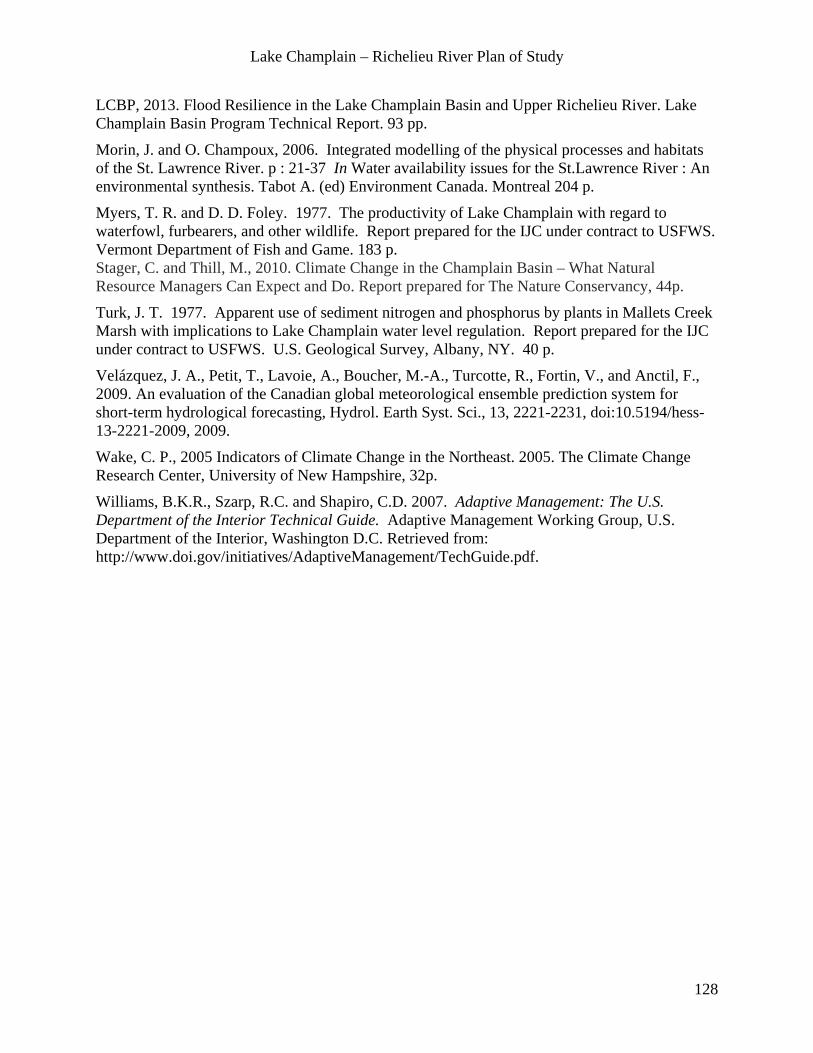
Lake Champlain – Richelieu River Plan of Study
128
LCBP, 2013. Flood Resilience in the Lake Champlain Basin and Upper Richelieu River. Lake Champlain Basin Program Technical Report. 93 pp.
Morin, J. and O. Champoux, 2006. Integrated modelling of the physical processes and habitats of the St. Lawrence River. p : 21-37 In Water availability issues for the St.Lawrence River : An environmental synthesis. Tabot A. (ed) Environment Canada. Montreal 204 p.
Myers, T. R. and D. D. Foley. 1977. The productivity of Lake Champlain with regard to waterfowl, furbearers, and other wildlife. Report prepared for the IJC under contract to USFWS. Vermont Department of Fish and Game. 183 p. Stager, C. and Thill, M., 2010. Climate Change in the Champlain Basin – What Natural Resource Managers Can Expect and Do. Report prepared for The Nature Conservancy, 44p.
Turk, J. T. 1977. Apparent use of sediment nitrogen and phosphorus by plants in Mallets Creek Marsh with implications to Lake Champlain water level regulation. Report prepared for the IJC under contract to USFWS. U.S. Geological Survey, Albany, NY. 40 p.
Velázquez, J. A., Petit, T., Lavoie, A., Boucher, M.-A., Turcotte, R., Fortin, V., and Anctil, F., 2009. An evaluation of the Canadian global meteorological ensemble prediction system for short-term hydrological forecasting, Hydrol. Earth Syst. Sci., 13, 2221-2231, doi:10.5194/hess-13-2221-2009, 2009.
Wake, C. P., 2005 Indicators of Climate Change in the Northeast. 2005. The Climate Change Research Center, University of New Hampshire, 32p.
Williams, B.K.R., Szarp, R.C. and Shapiro, C.D. 2007. Adaptive Management: The U.S. Department of the Interior Technical Guide. Adaptive Management Working Group, U.S. Department of the Interior, Washington D.C. Retrieved from: http://www.doi.gov/initiatives/AdaptiveManagement/TechGuide.pdf.