PLAN OF OPERATIONS AMENDMENT DENISON MINES...
100
PLAN OF OPERATIONS AMENDMENT DENISON MINES (USA) CORP. LA SAL MINES COMPLEX SAN JUAN COUNTY, UTAH Prepared for: DENISON MINES (USA) CORP. Prepared by: CDM Inc. 555 17 th Street, Suite 1100 Denver, CO 80202 November 2010 Revised March 2012
Transcript of PLAN OF OPERATIONS AMENDMENT DENISON MINES...

PLAN OF OPERATIONS AMENDMENT DENISON MINES (USA) CORP.
LA SAL MINES COMPLEX SAN JUAN COUNTY, UTAH
Prepared for: DENISON MINES (USA) CORP.
Prepared by: CDM Inc.
555 17th Street, Suite 1100 Denver, CO 80202
November 2010 Revised March 2012

i
C:\cdmxm\nelsonmr\d0879788\La Sal Mines PO_Rev 3 16 12.docx
Contents
Section 1 Introduction
1.1 Purpose ...................................................................................................................... 1-1 1.2 Background ............................................................................................................... 1-2 1.3 Planned Mine Development ................................................................................... 1-3
1.3.1 Phase 1 Amendments (Start of 2011 through end of 2013) ................. 1-4 1.3.2 Phase 2 Amendments (Start of 2014 through end of 2018) ................. 1-5 1.3.3 Phase 3 Amendments (Start of 2019 to the start of 2030) .................... 1-6
1.4 Proposed Surface Disturbance on Federal Lands Administered by BLM and USFS ................................................................................................................... 1-7
1.5 Protection of the Environment ............................................................................... 1-7 1.5.1 Unnecessary or Undue Degradation of Lands Managed by BLM ........... 1-8 1.5.2 Environmental Protection of Lands Managed by USFS ............................ 1-8 1.6 Organization of the Plan ......................................................................................... 1-8
Section 2 Operator Information 2.1 La Sal Mines Complex Operator Information ...................................................... 2-1 2.2 Location and Legal Description ............................................................................. 2-2 2.3 Surface Ownership within Area of Operations and Mining Claim
Information ............................................................................................................... 2-2 2.4 Other Federal, State, or Local Authorizations...................................................... 2-3
Section 3 Proposed Amendments to La Sal Mines Complex Plans of Operations
3.1 Amendment of Surface Facilities at the Pandora Mine ...................................... 3-1 3.1.1 Proposed Surface Facilities ...................................................................... 3-1 3.1.2 Water Management Plans ........................................................................ 3-3 3.1.3 Rock Characterization and Handling Plans .......................................... 3-4 3.1.3.1 Rock Characterization ................................................................. 3-4 3.1.3.2 Rock Handling ............................................................................... 3-5 3.1.4 Quality Assurance Plans .......................................................................... 3-6
3.2 Mine Vents and Access Roads ............................................................................... 3-6 3.3 Exploration Drilling Activities ............................................................................... 3-8
Section 4 Facilities and Activities Approved by Existing Permits 4.1 Description of Equipment ....................................................................................... 4-2 4.2 Surface Facilities ....................................................................................................... 4-3
4.2.1 Development Rock Areas ........................................................................ 4-4 4.2.2 Ore Stockpile Area .................................................................................... 4-5 4.2.3 Topsoil Stockpile Areas ............................................................................ 4-5 4.2.4 Surface Drainage Control Structures ..................................................... 4-6
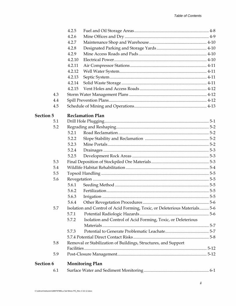
Table of Contents
ii
C:\cdmxm\nelsonmr\d0879788\La Sal Mines PO_Rev 3 16 12.docx
4.2.5 Fuel and Oil Storage Areas ...................................................................... 4-8 4.2.6 Mine Offices and Dry ............................................................................... 4-9 4.2.7 Maintenance Shop and Warehouse ...................................................... 4-10 4.2.8 Designated Parking and Storage Yards ............................................... 4-10 4.2.9 Mine Access Roads and Pads ................................................................ 4-10 4.2.10 Electrical Power ....................................................................................... 4-10 4.2.11 Air Compressor Stations ........................................................................ 4-11 4.2.12 Well Water System .................................................................................. 4-11 4.2.13 Septic System ........................................................................................... 4-11 4.2.14 Solid Waste Storage ................................................................................ 4-11 4.2.15 Vent Holes and Access Roads ............................................................... 4-12
4.3 Storm Water Management Plans ......................................................................... 4-12 4.4 Spill Prevention Plans ............................................................................................ 4-12 4.5 Schedule of Mining and Operations .................................................................... 4-13
Section 5 Reclamation Plan 5.1 Drill Hole Plugging .................................................................................................. 5-1 5.2 Regrading and Reshaping ....................................................................................... 5-2
5.2.1 Road Reclamation ..................................................................................... 5-2 5.2.2 Slope Stability and Reclamation ............................................................ 5-2 5.2.3 Mine Portals ............................................................................................... 5-2 5.2.4 Drainages ................................................................................................... 5-3 5.2.5 Development Rock Areas ........................................................................ 5-3
5.3 Final Deposition of Stockpiled Ore Materials ...................................................... 5-3 5.4 Wildlife Habitat Rehabilitation .............................................................................. 5-4 5.5 Topsoil Handling ..................................................................................................... 5-5 5.6 Revegetation ............................................................................................................. 5-5
5.6.1 Seeding Method ........................................................................................ 5-5 5.6.2 Fertilization ................................................................................................ 5-5 5.6.3 Irrigation .................................................................................................... 5-5 5.6.4 Other Revegetation Procedures .............................................................. 5-6
5.7 Isolation and Control of Acid Forming, Toxic, or Deleterious Materials ......... 5-6 5.7.1 Potential Radiologic Hazards ................................................................. 5-6
5.7.2 Isolation and Control of Acid Forming, Toxic, or Deleterious Materials .................................................................................................... 5-7 5.7.3 Potential to Generate Problematic Leachate ......................................... 5-7 5.7.4 Potential Direct Contact Risks ....................................................................... 5-8
5.8 Removal or Stabilization of Buildings, Structures, and Support Facilities ................................................................................................................... 5-12
5.9 Post-Closure Management .................................................................................... 5-12
Section 6 Monitoring Plan
6.1 Surface Water and Sediment Monitoring ............................................................. 6-1
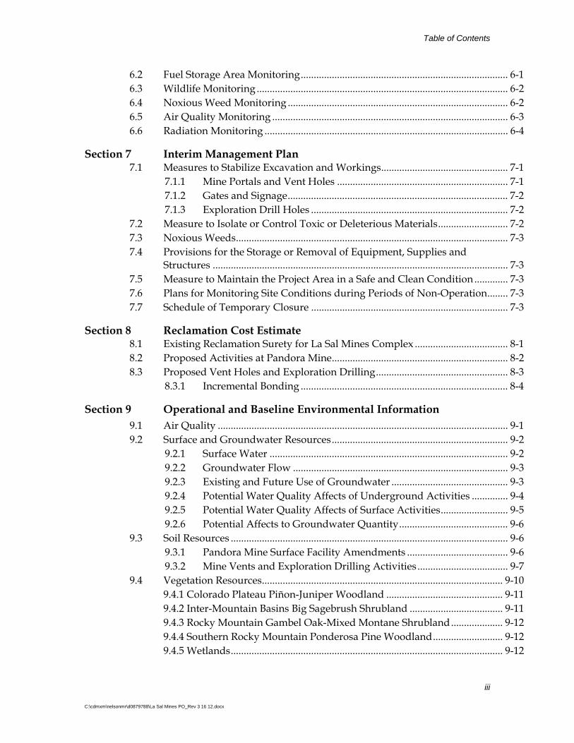
Table of Contents
iii
C:\cdmxm\nelsonmr\d0879788\La Sal Mines PO_Rev 3 16 12.docx
6.2 Fuel Storage Area Monitoring ................................................................................ 6-1 6.3 Wildlife Monitoring ................................................................................................. 6-2 6.4 Noxious Weed Monitoring ..................................................................................... 6-2 6.5 Air Quality Monitoring ........................................................................................... 6-3 6.6 Radiation Monitoring .............................................................................................. 6-4
Section 7 Interim Management Plan 7.1 Measures to Stabilize Excavation and Workings ................................................. 7-1
7.1.1 Mine Portals and Vent Holes .................................................................. 7-1 7.1.2 Gates and Signage ..................................................................................... 7-2 7.1.3 Exploration Drill Holes ............................................................................ 7-2
7.2 Measure to Isolate or Control Toxic or Deleterious Materials ........................... 7-2 7.3 Noxious Weeds ......................................................................................................... 7-3 7.4 Provisions for the Storage or Removal of Equipment, Supplies and
Structures .................................................................................................................. 7-3 7.5 Measure to Maintain the Project Area in a Safe and Clean Condition ............. 7-3 7.6 Plans for Monitoring Site Conditions during Periods of Non-Operation ........ 7-3 7.7 Schedule of Temporary Closure ............................................................................ 7-3
Section 8 Reclamation Cost Estimate 8.1 Existing Reclamation Surety for La Sal Mines Complex .................................... 8-1 8.2 Proposed Activities at Pandora Mine .................................................................... 8-2 8.3 Proposed Vent Holes and Exploration Drilling ................................................... 8-3
8.3.1 Incremental Bonding ................................................................................ 8-4
Section 9 Operational and Baseline Environmental Information
9.1 Air Quality ................................................................................................................ 9-1 9.2 Surface and Groundwater Resources .................................................................... 9-2
9.2.1 Surface Water ............................................................................................ 9-2 9.2.2 Groundwater Flow ................................................................................... 9-3 9.2.3 Existing and Future Use of Groundwater ............................................. 9-3 9.2.4 Potential Water Quality Affects of Underground Activities .............. 9-4 9.2.5 Potential Water Quality Affects of Surface Activities .......................... 9-5 9.2.6 Potential Affects to Groundwater Quantity .......................................... 9-6
9.3 Soil Resources ........................................................................................................... 9-6 9.3.1 Pandora Mine Surface Facility Amendments ....................................... 9-6 9.3.2 Mine Vents and Exploration Drilling Activities ................................... 9-7
9.4 Vegetation Resources ............................................................................................. 9-10 9.4.1 Colorado Plateau Piñon-Juniper Woodland ............................................. 9-11 9.4.2 Inter-Mountain Basins Big Sagebrush Shrubland .................................... 9-11 9.4.3 Rocky Mountain Gambel Oak-Mixed Montane Shrubland .................... 9-12 9.4.4 Southern Rocky Mountain Ponderosa Pine Woodland ........................... 9-12 9.4.5 Wetlands ......................................................................................................... 9-12

Table of Contents
iv
C:\cdmxm\nelsonmr\d0879788\La Sal Mines PO_Rev 3 16 12.docx
9.5 Wildlife Resources ................................................................................................. 9-13
9.5.1 Threatened or Endangered Species ...................................................... 9-13 9.5.2 Sensitive Species ...................................................................................... 9-13 9.5.3 Management Indicator Species ............................................................. 9-16 9.5.4 Migratory Birds ....................................................................................... 9-16 9.5.5 Protection of Wildlife Habitat and Endangered Species ................... 9-16 9.5.6 Screening-Level Evaluation of Potential Direct Contact Risks
to Wildlife ................................................................................................ 9-17 9.6 Cultural Resources ................................................................................................. 9-18 9.7 Paleontological Resources ..................................................................................... 9-19 9.8 Socioeconomic Conditions .................................................................................... 9-19 9.9 Worker Health and Safety .................................................................................... 9-20 9.10 Transportation ........................................................................................................ 9-22
Section 10 Period of Use/Occupancy for Surface Facilities
Section 11 References

Table of Contents
v
C:\cdmxm\nelsonmr\d0879788\La Sal Mines PO_Rev 3 16 12.docx
Figures
1-1 Location Map 1-2 La Sal Mines Complex Site Map 1-3 La Sal Mines Complex Phased Activities Plan 2-1 Surface Ownership Map 2-2 Mineral Ownership Map 2-3 CONFIDENTIAL - Map of Underground Workings 3-1 Pandora Mine Proposed Surface Facilities 3-2 Typical Vent Hole Area of Disturbance 3-3 Typical Drill Hole Area of Disturbance 4-1 Pandora Mine Existing Surface Facilities 4-2 La Sal Mine Existing Surface Facilities 4-3 Snowball Mine Existing Surface Facilities 4-4 Beaver Shaft Mine Existing Surface Facilities 4-5 La Sal Mines Complex Site Map with Surface Ownership 5-1 Pandora Mine Reclamation 5-2 La Sal Mine Reclamation 5-3 Snowball Mine Reclamation 5-4a Beaver Shaft Mine Reclamation (West) 5-4b Beaver Shaft Mine Reclamation (East) 9-1 NRCS Soil Map
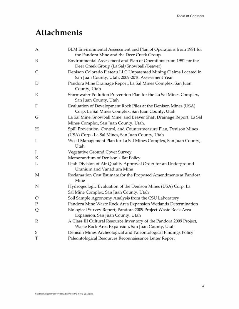
Table of Contents
vi
C:\cdmxm\nelsonmr\d0879788\La Sal Mines PO_Rev 3 16 12.docx
Attachments
A BLM Environmental Assessment and Plan of Operations from 1981 for the Pandora Mine and the Deer Creek Group
B Environmental Assessment and Plan of Operations from 1981 for the Deer Creek Group (La Sal/Snowball/Beaver)
C Denison Colorado Plateau LLC Unpatented Mining Claims Located in San Juan County, Utah, 2009-2010 Assessment Year
D Pandora Mine Drainage Report, La Sal Mines Complex, San Juan County, Utah
E Stormwater Pollution Prevention Plan for the La Sal Mines Complex, San Juan County, Utah
F Evaluation of Development Rock Piles at the Denison Mines (USA) Corp. La Sal Mines Complex, San Juan County, Utah
G La Sal Mine, Snowball Mine, and Beaver Shaft Drainage Report, La Sal Mines Complex, San Juan County, Utah. H Spill Prevention, Control, and Countermeasure Plan, Denison Mines (USA) Corp., La Sal Mines, San Juan County, Utah I Weed Management Plan for La Sal Mines Complex, San Juan County,
Utah. J Vegetative Ground Cover Survey K Memorandum of Denison’s Bat Policy L Utah Division of Air Quality Approval Order for an Underground
Uranium and Vanadium Mine M Reclamation Cost Estimate for the Proposed Amendments at Pandora
Mine N Hydrogeologic Evaluation of the Denison Mines (USA) Corp. La Sal Mine Complex, San Juan County, Utah O Soil Sample Agronomy Analysis from the CSU Laboratory P Pandora Mine Waste Rock Area Expansion Wetlands Determination Q Biological Survey Report, Pandora 2009 Project Waste Rock Area
Expansion, San Juan County, Utah R A Class III Cultural Resource Inventory of the Pandora 2009 Project,
Waste Rock Area Expansion, San Juan County, Utah S Denison Mines Archeological and Paleontological Findings Policy T Paleontological Resources Reconnaissance Letter Report

Table of Contents
vii
C:\cdmxm\nelsonmr\d0879788\La Sal Mines PO_Rev 3 16 12.docx
Acronyms
AADT Average Annual Daily Traffic ALARA As low as reasonable achievable AO Air Approval Order ATV BLM
All Terrain Vehicle U.S. Bureau of Land Management
BMP CDM
Best Management Practice Camp, Dresser & McKee Inc.
CFR Code of Federal Regulations CMP Corrugated Metal Pipe CSU Colorado State University CWA Clean Water Act cy Cubic yards Denison Denison Mines (USA) Corp DOE U.S. Department of Energy DOT U.S. Department of Transportation DRA Development Rock Area E EA
East Environmental Assessment
EPA U.S. Environmental Protection Agency ft Feet H:V Horizontal to Vertical lb/ft3 pounds per cubic foot mrem millirem mrem/hr Millirem per hour MSHA Mine Safety and Health Administration mSv millisieverts MWMP Meteoric Water Mobility Procedure N NAD
North North American Datum
NCRP National Council on Radiation Protection and Measurements
NE NEPA
Northeast National Environmental Policy Act
NESHAP National Emissions Standards for Hazardous Air Pollutants
NHPA National Historic Preservation Act NPDES National Pollution Discharge Elimination System NRC Nuclear Regulatory Commission NRCS Natural Resources Conservation Service NRHP National Register of Historic Places OSHA Occupational Safety and Health Administration pCi/g Picocuries per gram PO Plan of Operations

Table of Contents
viii
C:\cdmxm\nelsonmr\d0879788\La Sal Mines PO_Rev 3 16 12.docx
POA Plan of Operations Amendment R Range RMC Risk Management Criteria RSL S SE SCBA
Regional Screening Level South Southeast Self Contained Breathing Apparatus
SCS Soil Conservation Service SITLA Utah State Institutional Trust Lands Administration SPCC Spill Prevention Control and Countermeasures STI Steel Tank Institute SWCA SWCA Environmental Consultants SWPPP Storm Water Pollution Prevention Plan T Township TI Transport Index UAC Utah Administrative Code UDEQ Utah Department of Environmental Quality UDOGM Utah Division of Oil, Gas, and Mining UDWR USFS
Utah Division of Water Rights U.S. Forest Service
USGS United States Geological Survey UTM Universal Transverse Mercator WL Working Level WLM Working Level Month

1-1
C:\cdmxm\nelsonmr\d0879788\La Sal Mines PO_Rev 3 16 12.docx
Section 1 Introduction 1.1 Purpose The La Sal Mines Complex is operated by Denison Mines (USA) Corp. (Denison), and consists of four existing underground mines: the Pandora Mine, the La Sal Mine, the Snowball Mine, and the Beaver Shaft Mine. The surface facilities of the La Sal Mines Complex are located on a combination of the following lands:
Federal lands administered by the U.S. Bureau of Land Management (BLM);
Federal lands administered by the U.S. Forest Service (USFS);
State of Utah lands managed by Utah State Institutional Trust Lands Administration (SITLA); and
Privately-owned lands.
This proposed Plan of Operations Amendment (POA) combines existing operations and addresses existing and proposed surface disturbance on federal lands administered by the BLM and the USFS. SITLA and private lands are not under the jurisdiction of either BLM or USFS. The purpose of this POA is to facilitate:
Expansion of an existing development rock area (DRA) at the Pandora Mine
Construction of additional mine vents and associated access roads to support future mining
Ongoing exploration drilling activities and associated road development to delineate ore bodies for future mining
Compilation of activities previously approved by two existing BLM Plan of Operations (PO) and one USFS PO and associated amendments, including any existing disturbed areas resulting from historic operations that may not have been fully delineated in those documents or in correspondence with previous operators, into one POA that will address the entire La Sal Mines Complex
The first item is proposed surface disturbance on federal lands administered by BLM that is incident to locatable mining activities. The second two items are proposed surface disturbance on federal lands administered by BLM and USFS, which are incident to locatable mining activities. Therefore, BLM and USFS approval of a PO as set forth at 43 Code of Federal Regulations (CFR) 3809 and 36 CFR 228A, respectively, is required before Denison can commence the proposed activities.
The fourth item, compilation of previously approved activities and all existing disturbed areas into one BLM/USFS PO, is largely an administrative task, because the

Section 1 Introduction
1-2
C:\cdmxm\nelsonmr\d0879788\La Sal Mines PO_Rev 3 16 12.docx
existing POs and associated amendments are currently valid based on previous approvals from BLM and the USFS. Denison proposes compilation of previously approved activities and existing disturbed areas at the La Sal Mines Complex into this POA to simplify environmental management by Denison and to facilitate effective and efficient regulation of surface disturbing activities by BLM and the USFS.
Copies of the previously approved POs and associated Environmental Assessments (EAs) for the Pandora Mine and for the La Sal Mine, Beaver Shaft Mine, and Snowball Mine (formerly known as the Deer Creek Group) are included in Attachment A. The USFS documentation can be found at http://www.fs.fed.us/r4/mantilasal/projects/ projects_moabmonticello/Projects_MM_Decision/pandora_mine/dm_pandora_mine.pdf.
1.2 Background The La Sal Mines Complex consists of four separate, existing, underground mines: the Pandora Mine (BLM Case File number UTU-69800); and the La Sal Mine, the Beaver Shaft Mine, and the Snowball Mine combined under one PO (BLM Case File number UTU-69812). The La Sal Mines Complex is located in the vicinity of La Sal, Utah, on the south flank of the La Sal Mountains in San Juan County (see Figure 1-1). The locations of the mines that comprise the La Sal Mines Complex are shown in Figure 1-2.
The La Sal Mines Complex is part of a series of underground uranium mines that were previously operated by Atlas Minerals Corporation and Umetco Minerals Corporation. The complex has been in operation since the 1970’s, with intervening periods of decreased or increased mining activity in relation to changing economic conditions.
Current mining activities include:
Rehabilitation of existing mine workings
Production of ore
Extension of underground workings at the Pandora and Beaver Shaft mines
Re-establishment of mine ventilation
Construction and interim reclamation of surface facilities
At the Pandora and Beaver Shaft mine sites, ore is loaded into trucks for transport to off-site mineral processing facilities, and development rock, generated as part of the underground mining activities, is placed in on-site DRAs located on the surface. There is no on-site physical or chemical mineral processing at the mines; accordingly, no tailings or mineral processing chemicals are generated or stored on site. Ore produced from the La Sal Mines Complex is shipped to Denison’s White Mesa Mill, located near Blanding, Utah for processing.

Section 1 Introduction
1-3
C:\cdmxm\nelsonmr\d0879788\La Sal Mines PO_Rev 3 16 12.docx
A breakdown of the surface ownership and mine regulatory jurisdiction of existing facilities at the La Sal Mines Complex is as follows:
Facility Name Property owner
Regulatory
Jurisdiction
Disturbed
Acreage
Pandora Mine Surface Facilities BLM BLM/State 8.9
Pandora Mine Vents BLM BLM/State 1.98
Pandora Mine Vents USFS USFS/State 2.46
Total Area (by Property Owner)
BLM
USFS
BLM/State
USFS/State
10.88
2.46
Total Pandora Mine Acreage 13.34
La Sal Mine Surface Facilities BLM BLM/State 17.69
Snowball Mine Surface Facilities BLM BLM/State 5.51
Beaver Shaft Surface Facilities BLM BLM/State 8.12
Beaver Shaft Surface Facilities Private State 8.43
La Sal/Beaver/Snowball Vents Private State 1.49
La Sal/Beaver/Snowball Vents BLM BLM/State 0.67
La Sal/Beaver/Snowball Vents USFS USFS/State 0.21
La Sal/Beaver/Snowball Vents SITLA State 1.04
Total Area (by Property Owner) BLM
USFS
Private
SITLA
BLM/State
USFS/State
State
State
31.99
0.21
9.92
1.04
Total Acreage La Sal/Beaver/Snowball 43.16
1.3 Planned Mine Development This section describes planned mining-related development that Denison anticipates based on existing plans and projected extensions to uranium and vanadium mineralization. At the request of BLM and the USFS to have Denison address reasonably foreseeable developments, portions of the planned exploration and development, as described below, are very forward-looking and are subject to change based on geologic findings and market conditions. These plans are conservative because they include all postulated, but as yet uncommitted, development activities by Denison or other operators; however the timing and extent of the future development is reliant on market conditions.
In this proposed amendment to the La Sal Mines Complex PO, Denison is requesting BLM and USFS approval of planned development that will take place on lands under BLM and USFS jurisdiction. These proposed amendments to the La Sal Mine Complex PO are discussed further in Section 3. Information regarding planned development on private lands and state lands is provided to assist BLM and the USFS with analysis of environmental impacts in accordance with the National Environmental Policy Act of 1969 (NEPA). It is also provided to assist BLM and USFS in understanding Denison’s overall mining operations.
Section 1 Introduction
1-4
C:\cdmxm\nelsonmr\d0879788\La Sal Mines PO_Rev 3 16 12.docx
Uranium deposits at the La Sal Mines Complex are found in localized stratigraphic horizons that follow meandering river channel deposits within the sedimentary basin south of the La Sal Mountains. As a result, the specific locations of future development such as mine vent holes and exploration drill holes are difficult to determine in advance, and their ultimate placement will be reliant on geologic conditions determined by drilling from the surface. Therefore, planned locations for vent holes and exploration drilling are described generally to allow flexibility in future placement of these facilities. This approach is necessary to address BLM’s and USFS’s request for reasonably foreseeable future plans, while maintaining adequate flexibility to support the requirements of the mining operations.
This proposed future development will be completed in three general phases, and the details of each phase will be heavily dependent on the results of exploration drilling.
1.3.1 Phase 1 Amendments (Continuing for Approximately Two to Three Years of Operations after Approval of this POA) Pandora Mine Expansion The Pandora Mine surface facilities (with the exception of vents and proposed exploration drilling) are located on BLM Land. Proposed amendments at the Pandora Mine include expansion of the DRA to provide capacity for an additional 200,000 cubic yards (cy) of development rock, upgrades and improvement to the drainage plan, and modification of the reclamation plan. These amendments will disturb approximately 6.49 acres of BLM land in addition to the 8.9 acre disturbed area previously approved for the Pandora Mine site (i.e., excluding vents and access roads).
Exploration Drilling and Installation of Vent Holes Exploration drilling and installation of vent holes during Phase 1 will be conducted in an area of current mining, located northeast of the Pandora Mine surface facilities (approximately in a portion of the NE ¼ Sec. 6 and portion of the N ½ Sec. 5, Township(T) 29S, Range(R) 25E, Salt Lake Base Meridian, San Juan County, Utah) and an area west of the Beaver Shaft Mine (approximately in a portion of the NW ¼ of Sec. 3 and portions of the NE ¼ and NW ¼ Sec. 4, T29S, R24E and portions of the SW ¼ and SE ¼ Sec. 33, portions of NE ¼ SW ¼, and the SE ¼ Sec. 34, T28S, R24E, Salt Lake Base Meridian, San Juan County, Utah) as shown in Figure 1-3. Mining will continue in these areas for approximately two to three years of operations following approval of this POA.
Anticipated disturbances within the area includes an estimated 24 vent holes; estimated as seven in the area northeast of the Pandora Mine surface facilities and 17 in the area west of the Beaver Shaft Mine. Of these vents, it is likely that four will be on BLM land, six will be on USFS land, and the remaining 14 (west of Beaver Shaft Mine) will be on private land. Exploration drilling in the Phase 1 area will include up to approximately 200 exploration holes per year for a period of four years.
Section 1 Introduction
1-5
C:\cdmxm\nelsonmr\d0879788\La Sal Mines PO_Rev 3 16 12.docx
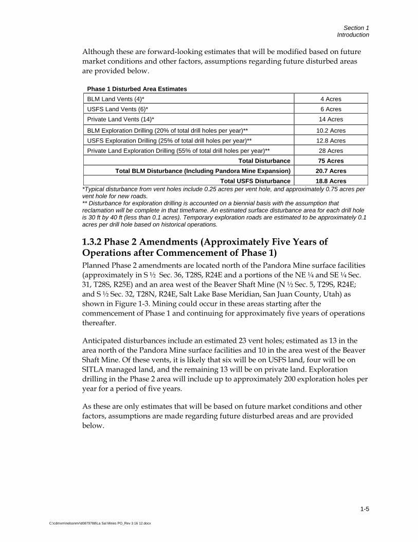
Although these are forward-looking estimates that will be modified based on future market conditions and other factors, assumptions regarding future disturbed areas are provided below.
Phase 1 Disturbed Area Estimates
BLM Land Vents (4)* 4 Acres
USFS Land Vents (6)* 6 Acres
Private Land Vents (14)* 14 Acres
BLM Exploration Drilling (20% of total drill holes per year)** 10.2 Acres
USFS Exploration Drilling (25% of total drill holes per year)** 12.8 Acres
Private Land Exploration Drilling (55% of total drill holes per year)** 28 Acres
Total Disturbance 75 Acres
Total BLM Disturbance (Including Pandora Mine Expansion) 20.7 Acres
Total USFS Disturbance 18.8 Acres *Typical disturbance from vent holes include 0.25 acres per vent hole, and approximately 0.75 acres per vent hole for new roads. ** Disturbance for exploration drilling is accounted on a biennial basis with the assumption that reclamation will be complete in that timeframe. An estimated surface disturbance area for each drill hole is 30 ft by 40 ft (less than 0.1 acres). Temporary exploration roads are estimated to be approximately 0.1 acres per drill hole based on historical operations.
1.3.2 Phase 2 Amendments (Approximately Five Years of Operations after Commencement of Phase 1) Planned Phase 2 amendments are located north of the Pandora Mine surface facilities (approximately in S ½ Sec. 36, T28S, R24E and a portions of the NE ¼ and SE ¼ Sec. 31, T28S, R25E) and an area west of the Beaver Shaft Mine (N ½ Sec. 5, T29S, R24E; and S ½ Sec. 32, T28N, R24E, Salt Lake Base Meridian, San Juan County, Utah) as shown in Figure 1-3. Mining could occur in these areas starting after the commencement of Phase 1 and continuing for approximately five years of operations thereafter.
Anticipated disturbances include an estimated 23 vent holes; estimated as 13 in the area north of the Pandora Mine surface facilities and 10 in the area west of the Beaver Shaft Mine. Of these vents, it is likely that six will be on USFS land, four will be on SITLA managed land, and the remaining 13 will be on private land. Exploration drilling in the Phase 2 area will include up to approximately 200 exploration holes per year for a period of five years.
As these are only estimates that will be based on future market conditions and other factors, assumptions are made regarding future disturbed areas and are provided below.

Section 1 Introduction
1-6
C:\cdmxm\nelsonmr\d0879788\La Sal Mines PO_Rev 3 16 12.docx
Phase 2 Disturbed Area Estimates
USFS Land Vents (6)* 6 Acres
SITLA Land Vents (4)* 4 Acres
Private Land Vents (13)* 13 Acres
USFS Exploration Drilling (25% of total drill holes per year)** 12.8 Acres
SITLA Exploration Drilling (20% of total drill holes per year)** 10.2 Acres
Private Land Exploration Drilling (55% of total drill holes per year)** 28 Acres
Total Disturbance 74 Acres
Total BLM Disturbance 0 Acres
Total USFS Disturbance 18.8 Acres *Typical disturbance from vent holes include 0.25 acres per vent hole, and approximately 0.75 acres per vent hole for new roads. ** Disturbance for exploration drilling is accounted on a biennial basis with the assumption that reclamation will be complete in that timeframe. An estimated surface disturbance area for each drill hole is 30 ft by 40 ft (less than 0.1 acres). Temporary exploration roads are estimated to be approximately 0.1 acres per drill hole based on historical operations.
1.3.3 Phase 3 Amendments (Twelve Years or More of Operations after Commencement of Phase 2) Planned Phase 3 amendment activities are projected to be located south and east of Pandora Mine surface facilities (approximately in a portion of the S ¼ Sec. 1 T29S, R24E and portions of Sec. 5 and Sec. 6, T29S, R25E, Salt Lake Base Meridian, San Juan County, Utah) as shown in Figure 1-3. Properties owned/operated by others could conceivably be mined in areas east of this Planned Phase 3 area; however, Denison does not currently control these properties. Phase 3 also includes an area to the far west of the Beaver Shaft Mine, where a new shaft on private land called the Redd Block IV shaft will be constructed (approximately in the SE ¼ and a portion of NE ¼ Sec. 31, T28S, R24E, Salt Lake Base Meridian, San Juan County, Utah). Properties owned/operated by others could conceivably be mined in areas west of this Planned Phase 3 area; however, these mining areas are currently owned or operated by others. Mining could occur in these areas starting after the commencement of Phase 2 and extending for twelve or more years of operations thereafter.
Anticipated disturbances include an estimated 12 vent holes; estimated as eight in the vicinity of the Pandora Mine surface facilities and four in the area west of the Beaver Shaft Mine. Of these vents, it is likely that six will be on BLM land, two will be on USFS managed land, and the remaining four will be on private land. Exploration drilling in the Phase 3 area will include up to approximately 200 exploration holes per year for a period of 11 years.
As these are only estimates that will be modified based on future economic conditions and other factors, assumptions regarding future disturbed areas are provided below.

Section 1 Introduction
1-7
C:\cdmxm\nelsonmr\d0879788\La Sal Mines PO_Rev 3 16 12.docx
Phase 3 Disturbed Area Estimates
BLM Land Vents (6)* 6 Acres
USFS Land Vents (2)* 2 Acres
Private Land Vents (4)* 4 Acres
BLM Exploration Drilling (50% of total drill holes per year)** 25.5 Acres
USFS Exploration Drilling (15% of total drill holes per year)** 7.7 Acres
Private Land Exploration Drilling (35% of total drill holes per year)** 17.9 Acres
Total Disturbance 63.1 Acres
Total BLM Disturbance 31.5 Acres
Total USFS Disturbance 9.7 Acres *Typical disturbance from vent holes include 0.25 acres per vent hole, and approximately 0.75 acres per vent hole for new roads. ** Disturbance for exploration drilling is accounted on a biennial basis with the assumption that reclamation will be complete in that timeframe. An estimated surface disturbance area for each drill hole is 30 ft by 40 ft (less than 0.1 acres). Temporary exploration roads are estimated to be approximately 0.1 acres per drill hole based on historical operations.
1.4 Proposed Surface Disturbance on Federal Lands Administered by BLM Based on the planned development described above, the following surface disturbances are proposed for federal lands administered by BLM and USFS. The total additional disturbance associated with the proposed activities and subject to the jurisdiction of BLM is approximately 52 acres. The total additional disturbance associated with the proposed activities and subject to the jurisdiction of the USFS is approximately 47 acres.
BLM Disturbance
Activity Disturbed Acreage
Phase 1 Amendments (Pandora Mine, Vents, Exploration, and Access Roads) 20.7 Acres
Phase 2 Amendments (Vents, Exploration, and Access Roads) 0 Acres
Phase 3 Amendments (Vents, Exploration, and Access Roads) 31.5 Acres
Total proposed acreage through 2030 52.2 Acres
Total longer-term BLM Land disturbance is 16.5 acres (i.e., excluding exploration drilling which is a short
term disturbance).
USFS Disturbance
Activity Disturbed Acreage
Phase 1 Amendments (Vents, Exploration, and Access Roads) 18.8 Acres
Phase 2 Amendments (Vents, Exploration, and Access Roads) 18.8 Acres
Phase 3 Amendments (Vents, Exploration, and Access Roads) 9.7 Acres
Total proposed acreage through 2030 47.3 Acres
Total longer-term USFS Land disturbance is 14 acres (i.e., excluding exploration drilling which is a short
term disturbance).

Section 1 Introduction
1-8
C:\cdmxm\nelsonmr\d0879788\La Sal Mines PO_Rev 3 16 12.docx
These projections of future disturbed areas are the total anticipated disturbance based on long term projections by Denison. These projections are considered conservative, but the timing of surface disturbance activities cannot be precisely predicted in advance of mining operations due to geologic variability of uranium deposits and future uranium market price cycles. These projections also do not take into account concurrent reclamation work that will be conducted. Concurrent reclamation on an annual basis is taken into account for exploration drilling, but closure of vents and vent access roads is not accounted for and will arguably be less than the acreages for exploration drilling. Therefore, the total disturbed acreages are not continuously additive.
1.5 Protection of the Environment Protection of the environment is a major purpose of both the BLM and USFS regulations for locatable mining operations, which are set forth at 43 CFR 3809 and 36 CFR 228 Subpart A respectively. BLM regulations address requirements for protection of the environment in terms of prevention of “unnecessary or undue degradation” which is set forth at 43 CFR 3802.0-5(l). USFS regulations for locatable mining operations address requirements for environmental protection at 36 CFR 228.8, Requirements for Environmental Protection.
1.5.1 Unnecessary or Undue Degradation of Lands Managed by BLM Denison’s existing and proposed activities are authorized by the General Mining Law of 1872, comply with applicable environmental laws and regulations, and employ current procedures, methods and standards for mining and environmental protection. 43 CFR 3802.0-5(l) defines unnecessary or undue degradation as follows:
“…impacts greater than those that would normally be expected from an activity being accomplished in compliance with current standards and regulations and based on sound practices, including use of the best reasonably available technology”.
BLM also sets forth the requirements to prevent unnecessary or undue degradation (43 CFR §3809.415):
…You prevent unnecessary or undue degradation while conducting operations on public lands by— (a) Complying with § 3809.420, as applicable; the terms and conditions of your notice or approved plan of operations; and other Federal and State laws related to environmental protection and protection of cultural resources …
In accordance with 43 CFR 3809.420, this POA provides all required information to demonstrate that the proposed operations would not result in unnecessary and undue degradation of public lands.

Section 1 Introduction
1-9
C:\cdmxm\nelsonmr\d0879788\La Sal Mines PO_Rev 3 16 12.docx
1.5.2 Environmental Protection of Lands Managed by USFS USFS requirements for environmental protection are found in 36 CFR 228A §228.8 and include compliance with applicable Federal and State air and water quality standards and compliance with Federal and State standards for the disposal and treatment of solid wastes. In addition, the operator is required to harmonize operations with scenic values, take all practicable measures to maintain and protect wildlife habitat, construct and maintain roads in accordance with USFS guidelines in §228.8 (f) and reclaim the disturbances in accordance with §228.8 (g).
This POA also provides required information to demonstrate that the existing and proposed mining operations will protect the environment in accordance with requirements of 36 CFR 2228.8.
1.6 Organization of the Plan This POA is organized to meet the general purpose described in Section 1 and to provide information required for plans of operations for locatable minerals set forth at 43 CFR Part 3809 and 36 CFR 228 Subpart A. The POA contains the following sections:
Section 1 Introduction
Section 2 Operator Information
Section 3 Proposed Amendments to La Sal Mines Complex Plans of Operations
Section 4 Facilities and Activities Approved by Existing Plans of Operations
Section 5 Reclamation Plan
Section 6 Monitoring Plan
Section 7 Interim Management Plan
Section 8 Reclamation Cost Estimate
Section 9 Operational and Baseline Environmental Information
Section 10 Period of Use/Occupancy for Surface Facilities
Section 11 References
The purpose of this organizational structure is to provide details regarding proposed and approved activities at the La Sal Mines Complex separately, and to follow these sections with a holistic description of the reclamation plan, monitoring plan, interim management plan, and reclamation cost estimate that addresses both the proposed amendments and the existing activities. Sections 2 through 8 provide information required by 43 CFR 3809.401(b), 43 CFR 3809.401(d), and 36 CFR 228A §228.4 through
Section 1 Introduction
1-10
C:\cdmxm\nelsonmr\d0879788\La Sal Mines PO_Rev 3 16 12.docx
§228.13. Section 9 provides operational and baseline environmental information in accordance with 43 CRF 3809.401(c).
As discussed previously, the La Sal Mines Complex lies on lands that are under the permitting jurisdiction of a number of agencies. This POA addresses proposed and existing activities on lands under the regulatory jurisdiction of BLM and the USFS. General information is provided regarding activities on lands that are not under the jurisdiction of BLM or the USFS. Although these activities are not subject to BLM or USFS regulatory authority, this information is provided for general information and to support evaluation of cumulative effects during subsequent NEPA analysis.

2-1
C:\cdmxm\nelsonmr\d0879788\La Sal Mines PO_Rev 3 16 12.docx
Section 2 Operator Information In accordance with 43 CFR 3809.401 (b)(1) and 36 CFR 228A §228.4 (c)(1), this section presents information about the operator of the La Sal Mines Complex, the location and legal description of BLM and USFS lands affected and proposed to be affected by La Sal Mines Complex, and information regarding mining claims.
2.1 La Sal Mines Complex Operator Information The La Sal Mines Complex will be operated by Denison:
Denison Mines (USA) Corp. 1050 17th Street, Suite 950 Denver, CO 80265 Phone: (303) 628-7798 Taxpayer identification number: 841397924 Point of Contact: Philip G. Buck Denison may also use mining contractors to operate portions of the La Sal Mines Complex.
All mining operations will be conducted by Denison on claims controlled by: Denison Colorado Plateau LLC 1050 17th Street, Suite 950 Denver, CO 80265 Phone: (303) 628-7798 Taxpayer identification number: 841397924 Point of Contact: Philip G. Buck
Name of Officers: Title: Ron F. Hochstein President and Chief Executive Officer Harold R. Roberts Executive Vice President – US Operations David C. Frydenlund Vice President Regulatory Affairs and Counsel Philip G. Buck Vice President Mining
Field Representative Contact is: Terry MacKinnon Denison Mines (USA) Corp. 9244 W. Highway 141 PO Box 160 Egnar, Colorado 81325 (970) 677-2702
Name Change and Ownership Information: Denison will notify the BLM and USFS of any change in operator in writing within 30 days of such a change.
Section 2 Operator Information
2-2
C:\cdmxm\nelsonmr\d0879788\La Sal Mines PO_Rev 3 16 12.docx
2.2 Location and Legal Description The La Sal Mines Complex is generally located at Universal Transverse Mercator (UTM) coordinates 654,311 meters east and 4,241,669 meters north (North American Datum) [NAD] 83), Zone 12. The complex consists of a series of active and inactive underground uranium and vanadium mines. These mines are situated on the south flank of the La Sal Mountains in San Juan County, Utah, as shown in Figure 1-1. Specifically, the mine sites are located as follows:
Pandora Mine - Located approximately 1.5 miles east-southeast of La Sal, Utah in portions of the SW ¼ of Sec. 6, T29S, R25E and in a portion of the SE ¼ Sec. 1; T29S, R24E, Salt Lake Meridian, San Juan County, Utah.
La Sal Mine – Located approximately 0.5 miles east-southeast of La Sal, Utah in portions of the W ½ Sec. 1, T29S, R24E, Salt Lake Base Meridian, San Juan County, Utah.
Snowball Mine – Located approximately 1.5 miles east of La Sal, Utah in a portion of the NW ¼ Sec. 6, T29S, R25E and in a portion of the NE ¼ Sec. 1; T29S, R24E, Salt Lake Base Meridian, San Juan County, Utah.
Beaver Shaft Mine – Located approximately 0.5 miles northwest of La Sal, Utah in the SW ¼ Sec. 35, T28S, R24E and in a portion of the NW ¼ Sec. 2, T29S, R24E, Salt Lake Base Meridian, San Juan County, Utah. Also, in the SE ¼ Sec. 35, T28S, R24E, Salt Lake Base Meridian, San Juan County, Utah.
2.3 Surface Ownership within Area of Operations and Mining Claim Information As previously stated, the surface facilities of the La Sal Mines Complex are located on a combination of the following lands:
Federal lands administered by the BLM
Federal lands administered by the USFS
State of Utah lands managed by SITLA
Privately-owned lands
A map showing lands under the jurisdiction of BLM and USFS within the area of operations is presented in Figure 2-1. State of Utah lands managed by SITLA, and privately-owned lands are also shown on Figure 2-1.
Currently, Denison holds or controls 142 unpatented lode claims as shown in Attachment C – La Sal Complex Unpatented Mining Claims Located in San Juan County, Utah. Twenty-one of those claims are held by Denison as claimant, and the remaining 121 claims are leased by Denison. In addition, the BLM serial numbers for

Section 2 Operator Information
2-3
C:\cdmxm\nelsonmr\d0879788\La Sal Mines PO_Rev 3 16 12.docx
these claims are also provided in the attachment. A mineral ownership map is provided as Figure 2-2. A confidential map showing the location of the underground workings is provided as Figure 2-3.
2.4 Other Federal, State, or Local Authorizations The following table provides a list of permits or approvals that the La Sal Mines Complex has applied for or that have been issued.
Permit/Number Agency
Existing EA and PO for Pandora Mine (UT–060-
GR-1-25)
BLM
Existing EA and PO for La Sal Mines (UT-060-GR-
1-29)
BLM
Air Order/NESHAP (DAQE-AN014150002-09) Utah Department of Environmental Quality (UDEQ)
Large Mine Permit/PO/Reclamation Plan –
Pandora (M/037/012)
Utah Division of Oil, Gas, and Minerals (UDOGM)
Large Mine Permit/PO/Reclamation Plan – La Sal,
Snowball, and Beaver Shaft (M/037/026)
UDOGM
Stormwater Permit for Mining UDEQ
Cultural Clearance BLM/USFS
Concurrence on Wildlife Protection BLM/USFS
MSHA U.S. Department of Labor
PO for Vents USFS
Road Use Permit (#0410-04-42) USFS
BLM PO Decision Record/Finding of No Significant
Impact
BLM
US Army Corps of Engineers 404 Permit for
channel construction
US Army Corps of Engineers

3-1
C:\cdmxm\nelsonmr\d0879788\La Sal Mines PO_Rev 3 16 12.docx
Section 3 Proposed Amendments to La Sal Mines Complex Plans of Operations The purpose of the proposed amendment to the existing PO’s is to support future development at the La Sal Mines Complex. The proposed amendment includes the following:
Amendment of surface facilities at the Pandora Mine
Construction of additional mine vents
Ongoing exploration drilling activities
The proposed amendments also compile all activities previously approved by two existing BLM Plan of Operations (PO) and one USFS PO and associated amendments, including any existing disturbed areas resulting from historic operations that may not have been fully delineated in those documents or in correspondence with previous operators, into one POA that will address the entire La Sal Mines Complex
This section describes the proposed amendments to the existing BLM and USFS PO’s for the La Sal Mines Complex.
3.1 Amendment of Surface Facilities at the Pandora Mine The proposed amendments to existing surface facilities at the Pandora Mine include the following:
Expansion of the Existing DRA
Creation of a topsoil stockpile area
Installation of drainage control structures
The combination of these amendments will result in additional surface disturbance of 6.49 acres. The total disturbance at the Pandora Mine will change from 8.9 acres to 15.39 acres.
Surface facilities at the Pandora mine are located on public lands administered by BLM. Denison requests that BLM approve the proposed change in disturbance area and the amendments to the surface facilities to facilitate continued mineral production at the mine. Details of each amendment are provided in the following sections.

Section 3 Proposed Amendments to La Sal Mines Complex Plan of Operations
3-2
C:\cdmxm\nelsonmr\d0879788\La Sal Mines PO_Rev 3 16 12.docx
3.1.1 Proposed Surface Facilities Expansion of the Existing DRA To accommodate continued mineral production, the existing DRA at the Pandora Mine site will be expanded to the south and west. The expansion will ultimately encompass approximately 2.1 of the 6.49 acres proposed for site expansion. It is proposed that this facility be constructed by placing development rock on the existing DRA at an angle of repose slope ranging from approximately 30 to 35 degrees. This approach will facilitate efficient production during mining, and provide for placement of approximately 200,000 cy of additional development rock material. This process will gradually extend the footprint of the facility south and west toward the boundary of the expansion.
During reclamation, the angle of repose slopes would be reduced to a final reclamation slope of 3 horizontal (H):1 vertical (V) (18.4 degrees) as discussed in Section 5. The full extent of the proposed footprint will be utilized upon completion of reclamation activities when the slopes are reduced to the finished grade. Figure 3-1 shows the ultimate proposed footprint of the expansion of the DRA.
The ore stockpile area will remain in its current location until prior to reclamation activities. At that time, all stockpiled ore will be removed, and development rock will then be placed over the ore stockpile area and graded to 3H:1V. During reclamation, any stockpiled ore remaining will either be hauled to the White Mesa Mill for mineral processing, or it will be placed back into the underground mine.
Creation of a Topsoil Stockpile Area Approximately 36 inches of soil material from approximately 2.6 acres of disturbed area will be salvaged and stockpiled at the Pandora Mine. Topsoil will be salvaged mainly from the proposed DRA expansion and portions of the proposed drainage channel realignment. Approximately 8,000 cy of topsoil will be stockpiled from the upper soil horizons, and approximately 4,500 cy of suitable fill material will be salvaged and used as inert fill where needed along the realigned channel during construction.
Most soil stripping will be performed using a tracked dozer, although a front-end loader and/or motor grader may also be used. Haulage equipment will not be allowed to cross the stockpiles so that compaction of stockpiled soil is minimized. The topsoil storage location is designed to be outside of drainage areas to minimize erosion. The topsoil stockpile will be contoured, ripped, and broadcast seeded in the late fall with BLM, USFS, and UDOGM approved seed mix(es). Seeding efforts will continue until vegetation is established.
Maps and cross-sections of the reclaimed development rock area at the Pandora Mine are presented in Section 5.2.5, which focuses on reclamation of all DRAs at the La Sal Mines Complex.
Section 3 Proposed Amendments to La Sal Mines Complex Plan of Operations
3-3
C:\cdmxm\nelsonmr\d0879788\La Sal Mines PO_Rev 3 16 12.docx
Installation of Drainage Control Structures for Channel Realignment Denison proposes to improve drainage control structures at the Pandora Mine during expansion of the DRA. The proposed design for the drainage control structures is provided in the Final Drainage Report for the Pandora Mine included as Attachment D. All drainage control structures were designed for a 100-year, 24-hour storm event. Drainage control structures that would be improved include realignment of an ephemeral drainage west of the Pandora DRA, a culvert that conveys storm water from watersheds north and west of the mine surface facilitates, and culverts beneath an existing access road.
The ephemeral drainage channel west of the Pandora DRA must be realigned to accommodate DRA expansion. The existing drainage will be improved and realigned as shown in Figure 3-1. The designed drainage channel will consist of two reaches; an upstream grass-lined reach from the culvert under the road crossing and a downstream riprap-lined reach. The channel construction will require a cut of approximately 1,500 cy and fill of approximately 6,000 cy. The net earth fill required is approximately 4,500 cy.
A long underground culvert will be used to convey surface water runoff from the watersheds north and east of the Pandora Mine surface facilities to the realigned drainage channel. This culvert will convey storm water beneath the surface facilities, and mitigate potential effects to storm water quality from the surface facilities. The culvert will be a 36-inch diameter circular corrugated metal pipe (CMP). Riprap erosion protection will be installed at the outlet of this long culvert.
Culverts will also be used to convey water within the realigned drainage channel under the existing access road to the surface facilities. Two 36-inch diameter CMP culverts will be installed to convey flow with a 3-foot high headwall to prevent overtopping. Also, riprap protection will be installed at the culvert outlet to minimize scour damage caused by exit velocities and turbulence. Some minor improvements to other existing drainage channels are also included in the Final Drainage Report for the Pandora Mine; however, these pertain to operations and maintenance of existing structures.
3.1.2 Water Management Plans The water management plans for the La Sal Mines Complex consists of measures to be taken to avoid disturbance of existing natural drainage channels, minimize sedimentation, minimize erosion, and protect surface water and groundwater systems.
The Storm Water Pollution Prevention Plan (SWPPP) (Attachment E) has been updated for the La Sal Mines Complex in conformance with the US. Environmental Protection Agency (EPA) Region 8 requirements under the Clean Water Act (CWA) National Pollution Discharge Elimination System (NPDES) as established by 40 CFR Part 122 Chapter 1. The SWPPP establishes best management practices such as

Section 3 Proposed Amendments to La Sal Mines Complex Plan of Operations
3-4
C:\cdmxm\nelsonmr\d0879788\La Sal Mines PO_Rev 3 16 12.docx
sediment and erosion controls, inspections, and maintenance schedules to prevent the migration of sediments by surface water runoff.
Areas of potential erosion include the topsoil stockpiles, the ore stockpiles, and the DRAs, and the proposed expansion to the DRA at Pandora Mine. The remaining areas are relatively flat with low potential for erosion. The topsoil stockpile at the Pandora Mine will be temporarily seeded using BLM, USFS, and UDOGM approved seed mix(es) during the first fall planting season after the soil is stockpiled. Seeding may be done in combination with other stabilization measures, such as crimp mulching, and/or installation of erosion control blankets as appropriate for the site slope.
3.1.3 Rock Characterization and Handling Plans Rock characterization included evaluation of the potential for the rock to produce acid mine drainage or deleterious leachate, and the potential for the rock to pose direct contact hazards related to incidental ingestion or inhalation. Evaluation of radiological characteristics of the rock is in progress, and this information will be provided to BLM to facilitate further analysis of the POA in accordance with NEPA.
Detailed geochemical characterization of development rock was conducted at the Pandora mine, because expansion of that DRA is proposed. Detailed geochemical characterization was not conducted at other DRAs, because those facilities will be operated in accordance with existing Plans of Operations. However, all mines at the La Sal Mines Complex extract rock from the same geological unit, and geochemical characteristics of the other DRAs are expected to be generally similar to the rock evaluated at the Pandora mine. In addition, all piles will be handled the same during operation and reclamation.
3.1.3.1 Rock Characterization Rock at the Pandora Mine DRA was characterized in Evaluation of Development Rock Piles at the La Sal Mines Complex (Camp, Dresser & McKee Inc (CDM) 2009a; Attachment F) to address identification of potentially deleterious materials as defined in state mine permitting regulations and prevention of unnecessary or undue environmental degradation in accordance with BLM mining regulations. Potential issues consist of:
Potential for the rock to generate acid mine drainage;
Potential for the rock to generate deleterious leachate; and
Potential for the rock to cause risks related to direct contact.
Potential for Rock to Generate Acid Mine Drainage The potential for the Pandora rock to generate acid rock drainage was evaluated through completion of a field paste pH survey and field examination of rock mineralogy using a hand lens. The data indicate that the rock does not have the potential to generate acid mine drainage.
Section 3 Proposed Amendments to La Sal Mines Complex Plan of Operations
3-5
C:\cdmxm\nelsonmr\d0879788\La Sal Mines PO_Rev 3 16 12.docx
Potential for Rock to Generate Deleterious Leachate The potential for rock at the Pandora DRA to generate deleterious leachate was evaluated by completion of Meteoric Water Mobility Procedure (MWMP) tests and evaluation of the likelihood of significant percolation from the rock pile. The MWMP tests suggest that the rock could produce leachate that contained problematic concentrations of deleterious substances if climate and rock pile conditions were conducive to production of significant leachate. However, unsaturated flow modeling using UNSAT-H suggests that is unlikely that significant leachate will be produced from the DRA. The UNSAT-H simulations predict an annual percolation rate of only 0.007 cm per year.
Potential for the Rock to Cause Risks Related to Direct Contact Assessment of direct contact risks considers exposure pathways such as incidental ingestion and inhalation of dust during various activities. Evaluation of the potential for the rock pile to cause human health risks related to direct contact was conducted in two phases:
An initial screening-level evaluation, and
A follow-up evaluation focused on site-specific factors.
The initial screening-level evaluation compared total metals concentrations of development rock samples to Risk Based Criteria for Metals at BLM Mining Sites (BLM 2004) and EPA Regional Screening Levels (EPA 2008). These criteria relate to various post-reclamation land uses such as camper, all terrain vehicle (ATV) rider, or BLM worker. The evaluation indicates that the rock does not contain concentrations of uranium, vanadium or numerous other metals that could cause risks to humans related to direct contact. However, the rock does contain concentrations of arsenic that exceed the BLM risk management criteria. This screening-level evaluation indicates that direct contact with mine wastes could potentially causes risks associated with arsenic. Therefore, follow-up evaluation of the potential for the rock to pose direct contact risks related to incidental ingestion and inhalation of arsenic was completed. The follow-up evaluation consisted of examination by a qualified risk assessor of site specific factors controlling potential arsenic exposure in relation to assumptions used in calculation of the standard BLM Risk Based Criteria. These site specific factors were included in recalculation of the screening criterion for arsenic, which is common practice in risk assessments. Recalculation provides a more representative site-specific evaluation of potential risks during the post-reclamation period. Incorporation of site-specific factors in evaluation of risk indicates that the average concentration of arsenic in the samples does not exceed the site-specific arsenic criterion for direct contact risk. However, one of the three samples did exceed the site-specific criterion. This suggests that local areas on the DRA could be present where arsenic concentrations could potentially pose a risk to human health during post-reclamation land uses. Management of these potential risks is addressed below in Section 3.1.3.2.

Section 3 Proposed Amendments to La Sal Mines Complex Plan of Operations
3-6
C:\cdmxm\nelsonmr\d0879788\La Sal Mines PO_Rev 3 16 12.docx
Additional details regarding rock characterization, sampling results, and risk evaluation are found in Section 5.7 and in Evaluation of Development Rock Piles at the La Sal Mines Complex (CDM 2009a). A copy of the report is provided as Attachment F.
3.1.3.2 Rock Handling Characterization of development rock indicates that the rock is unlikely to generate acid mine drainage or contribute to formation of problematic leachate. Therefore, special procedures for rock handling during mining are not warranted. However, for potential post-reclamation land uses, local areas on the DRAs could be present that pose a human health risk associated with direct contact with rock containing arsenic. Therefore, management procedures are proposed to be implemented during reclamation of all DRAs to mitigate this potential risk for the post-reclamation period.
The rock that is currently exposed at the DRAs will be covered by future development rock placement. Therefore, identification at this time of areas on the DRAs that exceed the site-specific arsenic criterion is not useful to address potential risks that could occur during the post-reclamation period. Accordingly, the proposed rock handling procedures will be implemented during reclamation to mitigate potential post-reclamation hazards. The procedures include the following:
Evaluation of exposed development rock for local areas that present potential direct contact risks; and
Mitigation of any areas of development rock that pose potential post-reclamation risks by covering with inert material or selective excavation and placement in the underground mine.
It should also be noted that reclamation of the DRAs will include slope reduction, placement of topsoil or other inert material over development rock, and establishment of vegetation. This process will also mitigate the potential for human health risks related to direct contact with rock containing arsenic during the post-reclamation period. Reclamation of DRAs is described further in Section 5.
3.1.4 Quality Assurance Plans Quality assurance will be conducted during construction of the facilities at the Pandora Mine. The extent of the expansion of the DRA and the realignment of the drainage channel will be delineated on the ground surface to ensure facilities will be constructed per design. All drainage control structures will be installed as described in the Final Drainage Report for the Pandora Mine included as Attachment D.
Surface topsoil and suitable fill will be removed to a depth of approximately 36 inches from all areas where new surface disturbance is expected. Denison will provide that as much topsoil as practicable will be salvaged from these areas and stockpiled.

Section 3 Proposed Amendments to La Sal Mines Complex Plan of Operations
3-7
C:\cdmxm\nelsonmr\d0879788\La Sal Mines PO_Rev 3 16 12.docx
3.2 Mine Vents and Access Roads Mine ventilation is required for all underground mining activities. Worker health and safety at the La Sal Mines Complex depends on the installation of vent holes, which are vertical shafts that provide for either inflow or discharge of air. The estimated numbers of vent holes within each planned phase were shown previously in Figure 1-3 are based on professional judgment, past operations, and estimated ore trends. As discussed previously, the specific location and timing for installation of individual vent holes may be modified based on ore trends and economic conditions.
Standard procedures for installation of vent holes include the following. Under standard conditions, setting up to drill the vent hole would take approximately 5 to 7 days using a typical 7:00 am to 5:00 pm shift. This process starts with drilling of a small-diameter pilot hole for the vent shaft. This is followed by reaming of the pilot hole to construct a vent shaft with a diameter of approximately six to ten feet. Once pilot drilling begins, the process will proceed for 24 hours a day, 7 days a week until reaming of the hole is complete. If necessary, all casing work would be completed during the typical 7:00 am to 5:00 pm shift. Approximately 2,000 to 4,000 gallons of water would be required during the vent hole drilling process. All water will be acquired from Redd Ranches.
During each drilling operation, there is typically a 1,000 gallon diesel tank, one to two 55 gallon drums of hydraulic oil, and several 5 gallon cans of motor oil. All of these petroleum products are stored with adequate secondary containment using best management practices. In the event of an inadvertent leak of petroleum products during drilling activities, a BLM or USFS designate (as appropriate for the specific land status) will be immediately contacted, and containment and clean-up activities will be conducted. Any necessary mitigation activities such as excavation of affected soil will be conducted in accordance with state and federal requirements.
In general, the proposed vent holes are expected to be approximately 6 to 10 ft in diameter, similar to existing vent holes in the area. The surface disturbance associated with proposed vent holes will be minimal (approximately ¼ acre per vent hole). Metal diffusers will be installed above the proposed opening for vents where the fan is placed on the surface. Diffusers are used to maximize flow and ventilation system efficiency. The diffusers will be approximately 4 to 5 ft tall and screened on top to prevent entry. Fans are generally placed on the surface to improve mine ventilation and avoid noisy underground conditions to meet MSHA requirements for workers; however, in some cases, fans can be placed underground in areas where workers will not be continuously working. All electrical connections and fan components for the vent holes will be kept underground to the greatest extent possible. A figure of a typical vent hole layout is included as Figure 3-2.
On a case by case basis, vent holes may be reclaimed prior to final reclamation of the mine sites; however, concurrent reclamation will only be performed if these activities do not jeopardize worker health and safety. Reclamation of vent holes will be performed as described in Section 5.

Section 3 Proposed Amendments to La Sal Mines Complex Plan of Operations
3-8
C:\cdmxm\nelsonmr\d0879788\La Sal Mines PO_Rev 3 16 12.docx
Surface disturbance associated with the access roads to vent holes is estimated to be approximately ¾ acre based on historical operations. All roads used/constructed that are not part of the BLM and USFS Moab Travel Plan located in Sections 5 and 35, T28S, R24E shall be gated and/or signed “Administrative Use Only” or “Closed to the Public”.
A total of 10 acres of disturbed area on BLM lands and 14 acres of disturbed USFS lands are proposed for vent holes and access roads during the three general phases of future development. This estimated disturbance includes four acres in Phase 1, and six acres in Phase 3 on BLM lands; and six acres in Phase 1, six acres in Phase 2, and two acres in Phase 3 on USFS lands. The exact placement of these vent holes is variable and is heavily dependent on the specific location and geometry of ore delineated underground. Therefore, Denison has provided general locations of these activities for review and approval by BLM and USFS.
Denison requests BLM approval of the following vent holes as part of this proposed POA for the La Sal Mines Complex:
Phase 1: Four vent holes located on lands subject to BLM jurisdiction within the Phase 1 perimeter shown on Figure 1-3, encompassing a maximum disturbance of four acres;
Phase 2: No planned vent holes on lands subject to BLM jurisdiction; and
Phase 3: Six vent holes located on lands subject to BLM jurisdiction within the Phase 3 perimeter shown on Figure 1-3, encompassing a maximum disturbance of six acres.
Denison requests USFS approval of the following vent holes as part of this proposed POA for the La Sal Mines Complex:
Phase 1: Six vent holes located on lands subject to USFS jurisdiction within the Phase 1 perimeter shown on Figure 1-3, encompassing a maximum disturbance of six acres;
Phase 2: Six vent holes located on lands subject to USFS jurisdiction within the Phase 1 perimeter shown on Figure 1-3, encompassing a maximum disturbance of six acres; and
Phase 3: Two vent holes located on lands subject to USFS jurisdiction within the Phase 3 perimeter shown on Figure 1-3, encompassing a maximum disturbance of two acres.
Denison proposes that the specific locations for these facilities and the location of associated access roads be subject to BLM and USFS review prior to construction. Denison proposes that this requirement be included in the La Sal Mines Complex POA as a Condition of Approval.

Section 3 Proposed Amendments to La Sal Mines Complex Plan of Operations
3-9
C:\cdmxm\nelsonmr\d0879788\La Sal Mines PO_Rev 3 16 12.docx
The installation of these facilities would be in support of the extraction of uranium ore from BLM unpatented mining claims in accordance and compliance with applicable federal and state rules and regulations.
3.3 Exploration Drilling Activities The proposed exploration drilling and access road development as part of the three phase plan for future development is expected to disturb a total surface area of approximately 35.7 acres on BLM lands and 33.3 acres on USFS lands.
Exploration drilling will typically be conducted using a truck-mounted rotary drilling rig, although diamond core drilling methods may be used in some areas. The exploration drilling operation generally includes one truck-mounted drill rig; one support truck that is used to haul drilling water, drill pipe and other supplies; and a 1-ton pick-up or similar vehicle to transport fuel and personnel to the drilling rig. A pick-up or similar vehicle may also be on site to provide transportation for Denison personnel to supervise drilling contractors and conduct geological or geophysical logging. Diamond drills are generally smaller than rotary drills, and in the event that diamond core drilling is conducted, the overall footprint of the drilling operation will be somewhat smaller.
During drilling, it is necessary to remove drill cuttings from the drill hole. In addition, drilling additives such as water and drill foam may be necessary to stabilize the drill hole. A surface pit will be excavated at each site to contain the drill cuttings and foam. This pit will be approximately 10 feet in diameter and up to 10 feet deep. At least one side of the pit will be sloped to provide for egress of wildlife in the event that wildlife inadvertently enters the pit. After drilling is completed the drill site and the drill pit will be reclaimed.
The drilling operations require the use of various petroleum products including fuel, hydraulic oil, and lubricants. These fluids will be stored in appropriate portable containers such as truck mounted fuel tanks, and best practices for product storage and use will be conducted at all times. In the event of an inadvertent leak of petroleum products during drilling activities, a BLM or USFS designate (as appropriate for the specific land status) will be immediately contacted, and containment and clean-up activities will be conducted. Any necessary mitigation activities such as excavation of affected soil will be conducted in accordance with state and federal requirements.
In general, an estimated surface disturbance area for each drill hole is 30 ft by 40 ft (less than 0.1 acres). In preparation for setting up the drill rig, a small surface area will be cleared with a small bulldozer. Topsoil will be pushed to one side and redistributed following drilling to reseed and replant disturbed areas around the holes. A figure of a typical exploration drill hole layout is included as Figure 3-3.
Access trails or roads would also be required for exploration drilling. All roads used/constructed that are not part of the BLM and USFS Moab Travel Plan located in

Section 3 Proposed Amendments to La Sal Mines Complex Plan of Operations
3-10
C:\cdmxm\nelsonmr\d0879788\La Sal Mines PO_Rev 3 16 12.docx
Sections 5 and 35, T28S, R24E shall be gated and/or signed “Administrative Use Only” or “Closed to the Public”. An estimate for access road disturbance is 0.1 acres per drill hole based on estimates from previous drilling. For all possible instances, access to exploration sites will be over land with rubber tired vehicles to prevent vegetation disturbance to the greatest extent possible.
Drill holes will be plugged and drill sites reclaimed directly following drilling, typically within several days as discussed in Section 5. Reclaimed drill sites and access roads are re-seeded. Denison assumes two seasons to re-establish sustainable vegetative cover. Therefore, the total surface disturbance is temporary and reclaimed on an ongoing basis.
At the request of BLM and USFS, Denison has provided a very forward-looking three-phase plan for conducting exploration drilling over the period starting in 2011 through the start of 2030.
Denison requests BLM approval of the following exploration drill holes as part of this proposed POA for the La Sal Mines Complex:
Phase 1: Up to approximately 40 exploration drill holes per year on lands subject to BLM jurisdiction within the Phase 1 perimeter shown on Figure 1-3, encompassing a biennial disturbance of 10.2 acres;
Phase 2: No planned drill holes on lands subject to BLM jurisdiction; and
Phase 3: Up to approximately 100 holes per year on lands subject to BLM jurisdiction within the Phase 3 perimeter shown on Figure 1-3, encompassing a biennial disturbance of 25.5 acres.
Denison requests USFS approval of the following exploration drill holes as part of this proposed POA for the La Sal Mines Complex:
Phase 1: Up to approximately 50 exploration drill holes per year on lands subject to USFS jurisdiction within the Phase 1 perimeter shown on Figure 1-3, encompassing a biennial disturbance of 12.8 acres;
Phase 2: Up to approximately 50 exploration drill holes per year on lands subject to USFS jurisdiction within the Phase 2 perimeter shown on Figure 1-3, encompassing a biennial disturbance of 12.8 acres; and
Phase 3: Up to approximately 30 exploration drill holes per year on lands subject to USFS jurisdiction within the Phase 3 perimeter shown on Figure 1-3, encompassing a biennial disturbance of 7.7 acres.
The specific location of the exploration drill holes will be determined based on examination of surface and subsurface exploration data, projected trends of uranium mineralization and other factors. Mineral exploration is an iterative process by nature, and therefore it is not practical to plan specific locations for all future drill holes.

Section 3 Proposed Amendments to La Sal Mines Complex Plan of Operations
3-11
C:\cdmxm\nelsonmr\d0879788\La Sal Mines PO_Rev 3 16 12.docx
Accordingly, Denison requests that BLM and USFS approve the planned exploration drilling in the phases described above, and that a Condition of Approval to the POA be established that would provide for BLM and USFS review of specific locations for exploration drill holes and access trails and/or roads prior to commencement of the activities.
These exploratory activities would be conducted in accordance and compliance with applicable federal and state rules and regulations.
4-1
C:\cdmxm\nelsonmr\d0879788\La Sal Mines PO_Rev 3 16 12.docx
Section 4 Facilities and Activities Approved by Existing Permits The existing mine operations at the La Sal Mines complex and major components of planned future mine development are operating under permits issued by the BLM, USFS, and the Utah Division of Oil, Gas and Mining (UDOGM).
The Pandora Mine is permitted under a 1981 BLM PO and EA and the USFS PO and EA. Since that time only minor improvements have been made that are incident to the approved POs (BLM case file number UTU-69800). The La Sal, Snowball, and Beaver Shaft Mines are permitted under a separate PO and EA, and only minor changes that are incident to the approved PO (BLM case file number UTU-68912) have been made since that time.
As discussed in Section 1, the La Sal Mines Complex encompasses areas with a variety of land ownership. All mining activities are subject to UDOGM regulatory jurisdiction. BLM or USFS regulatory jurisdiction applies to areas of surface disturbance on federal lands administered by those agencies. Figures 4-1 through 4-4 show the boundaries of surface disturbance at the La Sal Mines Complex and the areas of existing disturbance that are subject to BLM regulatory jurisdiction. Figure 4-5 shows disturbed areas and land ownership for areas under BLM and USFS jurisdiction (per 36 CFR §228.4 (c)(2)).
The following sections provide a compilation of existing facilities and activities at the La Sal Mines Complex. These activities are included in this proposed POA to provide an update of existing facilities and activities for BLM and USFS, to simplify environmental management of the La Sal Mines Complex by Denison, and to facilitate effective and efficient regulation of surface disturbing activities by BLM and the USFS. This section provides the Description of Operations as required by 43 CFR 3809.401(b)(2) and 36 CFR §228.4 (c)(3) as follows:
Description of Equipment
Surface Facilities
Water Management Plans
Spill Prevention Plans
Schedule of Operations
The following subsections describe mining activities under the regulatory jurisdiction of BLM and USFS and activities that are located on private land, which are not subject to regulatory jurisdiction of BLM and USFS. This organizational strategy is used in the La Sal Mines Complex POA because of the complicated surface ownership status. Information regarding facilities not under regulatory jurisdiction of BLM and USFS

Section 4 Facilities and Activities Approved by Existing Plans of Operations
4-2
C:\cdmxm\nelsonmr\d0879788\La Sal Mines PO_Rev 3 16 12.docx
(i.e. facilities located on private or state land) is provided to facilitate an overall understanding of site operations by BLM and USFS, and to facilitate the evaluation of cumulative effects during BLM/USFS NEPA analysis. The regulatory jurisdiction of the facilities described below is discussed in the various subsections to specify the facilities that are subject to BLM and USFS regulatory jurisdiction in this POA.
4.1 Description of Equipment A variety of underground and surface equipment will be utilized during production at the La Sal Mines Complex. The following tables provide summaries of the minimum required equipment and an estimate of the quantities required. The quantities and types of equipment are subject to change depending on market conditions and other factors.
Underground Equipment
Description
Beaver Shaft Mine(Quantity)
Pandora Mine(Quantity)
Current Future Current Future
Diesel Loaders, 2 - 5 cy capacity 11 15 6 8
Diesel Trucks, 2 - 10 ton capacity 6 10 15 20
Development Drills, Jumbos 2 2 0 1
Production Drills, Jacklegs 24 35 20 30
Diesel Mantrips and Utility Vehicles 6 10 7 10
Water Truck 1 1 1 1
Skid Steer 1 1 2 2
Surface Equipment
Description
Beaver Shaft Mine(Quantity)
Pandora Mine(Quantity)
Current Future Current Future
Front-End Loader 1 1 1 1
Tracked Dozer 1 1 1 1
Dump Truck, 10 ton 1 1 0 0
Highway Haul Trucks, 25 tons (a) 10 - 15 15 - 20 10 – 15 15 - 20
Water Truck 1 1 0 1
Motor Grader 0 1 0 0
Tanker Truck (water) 1 1 1 1
Pick-up Trucks, 3/4-ton (4-wheel drive)(b) 6 9 5 7
Notes a. Highway haul trucks are provided by a Contractor b. Pick-up trucks will generally be used for transportation to and from the site c. Passenger vans or buses are used to get employees to the Beaver Shaft site
Raise Bore Equipment (equipment used for vent hole installation)
Description (Quantity)
Raise Bore machine 1
Caisson Machine 1
Skid Steer Loader 1

Section 4 Facilities and Activities Approved by Existing Plans of Operations
4-3
C:\cdmxm\nelsonmr\d0879788\La Sal Mines PO_Rev 3 16 12.docx
4 WD Pickup Trucks 3
Concrete Trucks 1
Drill Rig 1 Exploration Drilling Equipment
Description (Quantity)
Drill Rig 1
Water Truck 1
Excavator 1
4 WD Vehicles 3
Bulldozer 1
4.2 Surface Facilities The La Sal Mines Complex consists of four mine sites: Pandora Mine, La Sal Mine, Snowball Mine, and Beaver Shaft Mine. An additional mine site, called the Redd Block IV shaft (west of the Beaver Shaft), will potentially be constructed at a later date; however, it currently is not addressed in this POA. At each of these sites, there are existing surface facilities that are utilized to support mining operations. These facilities include the following:
Development rock areas
Ore stockpile areas
Fuel and oil storage areas
Mine offices and dry
Maintenance shops and warehouses
Designated parking areas and storage yards
Mine access roads
Electrical generators
Air compressor stations
Water systems
Septic systems (including leach field)
Vent holes and access roads
These facilities are discussed in detail in the sections below. Figures 4-1 through 4-5 show the location and regulatory jurisdiction of these surface facilities.

Section 4 Facilities and Activities Approved by Existing Plans of Operations
4-4
C:\cdmxm\nelsonmr\d0879788\La Sal Mines PO_Rev 3 16 12.docx
4.2.1 Development Rock Areas Descriptions of DRAs are provided in the following sections. Additional information regarding development rock management including volumes of development rock areas are provided in Section 4.5.
Pandora Mine The DRA at the Pandora Mine is currently approximately 4.3 acres in size. It is located on the east side of a small ephemeral drainage as shown in Figure 4-1. The DRA has a current slope of approximately 30 to 35 degrees with an approximate height of 80 ft relative to the ground surface west of the pile. Development rock is currently placed on top of the DRA along a temporary access road via mine trucks. The Pandora Mine development rock pile is located on lands subject to BLM regulatory jurisdiction.
La Sal Mine At the La Sal Mine, there are three separate DRAs. All DRAs are located east of the fuel storage area as shown in Figure 4-2. Denison may resume mining operations at the La Sal Mine in the future; however, currently the portal is used for ventilation and access purposes. The northern, central, and southern DRAs are currently approximately 0.3, 0.5, and 1.3 acres in size, respectively. The northern DRA has a current slope of approximately 25 degrees while the two other DRAs have a current slope of approximately 35 degrees. The height of each DRA relative to the ground surface to the east is approximately 6 ft for the northern pile, 30 ft for the central pile, and 35 ft for the southern pile.
The La Sal Mine DRAs are located on lands subject to BLM regulatory jurisdiction. Denison intends to continue using these facilitates in the future in accordance with the currently approved Plan of Operations. Additional stockpiled development rock will stay within previously proposed disturbed areas.
Snowball Mine The DRA at the Snowball Mine is currently approximately 3.3 acres in size. It is located south of the portal and east of the main access road to the mine as shown in Figure 4-3. The Snowball Mine is currently an inactive mine site that is used only for emergency access and ventilation. Currently, no development rock is placed in this area, and Denison does not anticipate placing additional rock on this facility in the future. The DRA has a current slope of approximately 35 degrees with an approximate height of 40 ft relative to the ground surface to the south.
Beaver Shaft Mine At the Beaver Shaft Mine site there are four separate DRAs, one east of the shaft area on land under the jurisdiction of BLM and three to the west on privately-owned property as shown in Figure 4-4. The DRA to the east is currently approximately 2.4 acres in size and is accessed from a road that tees from the main access to the shaft site. The DRA has a current slope of approximately 15 to 20 degrees with an approximate height of 15 ft relative to the ground surface to the east. The three other DRAs west of the shaft on privately-owned property are located along the west edge

Section 4 Facilities and Activities Approved by Existing Plans of Operations
4-5
C:\cdmxm\nelsonmr\d0879788\La Sal Mines PO_Rev 3 16 12.docx
of the disturbed area. The northern, central, and southern DRAs are currently approximately 0.6, 0.7, and 1.2 acres in size, respectively. The northern DRA has a current slope of approximately 20 degrees while the remaining two DRAs have a current slope of approximately 30 degrees. The current height of each DRA relative to the ground surface to the west is approximately 10 ft for the northern pile, 14 ft for the central pile, and 30 ft for the southern pile. Denison intends to continue using these facilities in the future in accordance with the currently approved Plan of Operations. Additional stockpiled development rock will stay within previously proposed disturbed areas.
4.2.2 Ore Stockpile Areas
Active ore stockpile areas are located at the Pandora Mine site south of the surface facility buildings and at the Beaver Shaft Mine northwest and southwest of the shaft as shown in Figures 4-1 and 4-4, respectively. Upon resumption of operations at the La Sal Mine, an ore stockpile area will be located southeast of the mine portal as shown in Figure 4-2. A former ore stockpile area was located at the Snowball Mine southwest of the mine portal as shown in Figure 4-3; however, Denison does not plan to stockpile ore at Snowball in the future. All ore stockpile areas are on lands under the jurisdiction of BLM except for those at Beaver Shaft Mine, which are located on privately-owned land.
At the active sites, ore is typically end dumped directly onto the nearby stockpile ore pads. These pads are comprised of development rock base material compacted by ongoing vehicle traffic. The ore is then loaded using a front end loader into 25-ton, over-the-road haul trucks for transportation to the mill. Ore transportation will be limited to weekdays with no ore being shipped on weekends or holidays, with the exception of occasional Saturdays. The truck beds are covered with tarps to prevent fugitive dust. Ore will be stored in stockpiles, with normal stockpiled quantities less than a few thousand tons to maintain continuous ore flow to the White Mesa Mill near Blanding, Utah.
4.2.3 Topsoil Stockpile Areas La Sal Mine Two existing topsoil stockpile areas are present at the La Sal Mine. One stockpile is located southwest of the DRAs and is estimated to contain 1,535 cy of topsoil. The other stockpile is located west of the DRAs and is estimated to contain 590 cy of topsoil. These topsoil stockpiles are located as shown in Figure 4-2.
Beaver Shaft Mine Four existing topsoil stockpile areas are present at the Beaver Shaft Mine. Two stockpiles are located west of the shaft, north and south of the existing DRAs. These two topsoil stockpiles are located on privately-owned property. The estimated volume of these stockpiles is 320 and 164 cy, respectively. The remaining two stockpiles are located within the disturbed area east of the shaft site on land under the jurisdiction of BLM. These stockpiles are positioned southeast and southwest of the existing DRAs. The estimated volume of these stockpiles is 87 and 311 cy,
Section 4 Facilities and Activities Approved by Existing Plans of Operations
4-6
C:\cdmxm\nelsonmr\d0879788\La Sal Mines PO_Rev 3 16 12.docx
respectively. These topsoil stockpiles are located as shown in Figure 4-4. Vegetation is present on all existing topsoil stockpiles. Soil stockpiles are not present at the Pandora and Snowball mines; however, a topsoil stockpile is proposed at Pandora Mine as described in Section 3.1.1.
4.2.4 Surface Drainage Control Structures Surface drainage features for each of the La Sal Mines Complex facilities are described below and have been designed to convey the 100-year, 24-hour storm event. The design of these facilities includes structures that will both divert surface water away from disturbed areas and retain surface water within the disturbed areas. These drainage control structures will be upgraded as part of general site operations and maintenance activities.
Pandora Mine The Pandora Mine has a drainage area of approximately 247 acres encompassing the 8.9-acre surface mine permit area. Run-on drainage is partially diverted via an existing run-on control ditch located to the east of the development rock pile. Runoff from the DRA flows east to west into an existing earthen berm located west of the facility offices, this berm acts as a retention basin for the mine surface facility. An existing drainage channel west of the facility drains the runoff outside of the surface mine permit area and runoff from the surface facility area that is not retained by the existing earthen berms. Also, an existing culvert conveys the existing drainage channel runoff under the access road into the facility on the east. All waters are eventually conveyed to an ephemeral drainage ditch at the southwest corner of the site. Water is then discharged into an intermittent tributary of the East Coyote Wash, which is located approximately two miles southwest of the mine. The East Coyote Wash drains southeast to the Dolores River, which ultimately discharges to the Colorado River. The general topography at the Pandora Mine is illustrated in Figure 4-1. Planned and on-going maintenance to the existing channels generally includes reshaping the channels, placing rip rap for scour protection, and installing catchment berms. All catchment berms have been designed with a minimum elevation of 1.5 feet, which includes one foot of freeboard.
La Sal Mine The La Sal Mine has a drainage area of approximately 98.66 acres encompassing the 17.7-acre surface mine permit area. Runoff drains along the eastern edge of the permit boundary or drains into an existing drainage channel located between the two eastern DRA’s. An existing berm located in the drainage channel within the facility to the north of the site acts as a retention basin for off-site runoff from the north. Runoff from the DRA flows northwest to southeast into an existing earthen berm located at the toe of the DRA. This berm acts as a retention basin for the facility.
All waters are eventually conveyed to an ephemeral drainage ditch at the southeast corner of the site. Water is then discharged into an intermittent tributary of the East

Section 4 Facilities and Activities Approved by Existing Plans of Operations
4-7
C:\cdmxm\nelsonmr\d0879788\La Sal Mines PO_Rev 3 16 12.docx
Coyote Wash, which is located approximately two miles south of the mine workings area. East Coyote Wash drains southeast to the Dolores River, which ultimately discharges to the Colorado River. The general topography is illustrated in Figure 4-2.
Planned and on-going maintenance to the existing channels generally includes reshaping the channels, placing rip rap for scour protection, and installing catchment berms. The catchment berms have been designed with a minimum elevation ranging from 1.5 feet to two feet, which includes one foot of freeboard.
Snowball Mine The Snowball Mine has a drainage area of approximately 12.5 acres encompassing the 5.5-acre surface mine permit area. Runoff from off-site flows northeast to southwest into a silt fence at the toe of the DRA. All waters are eventually conveyed to an ephemeral drainage ditch at the southeast corner of the site. Water is then discharged into an intermittent tributary of the East Coyote Wash, which is located approximately two and a half miles south of the mine workings area. East Coyote Wash drains southeast to the Dolores River, which ultimately discharges to the Colorado River. The general topography is illustrated in Figure 4-3.
Planned and on-going maintenance to the existing channels generally includes reshaping the channels and installing catchment berms. The catchment berms have been designed with a minimum elevation ranging from 1.5 feet to two feet, which includes one foot of freeboard.
Beaver Shaft Mine The eastern-most area at the Beaver Shaft Mine has a drainage area of approximately 57.5 acres encompassing the 11.6-acre surface mine permit area. Runoff off-site drains north to south into an existing earthen berm along the south edge of the surface mine permit area, this berm acts as a retention basin for the mine surface facility and off-site drainage. All waters are eventually conveyed to an ephemeral drainage ditch south of the site. Water is then discharged into an intermittent tributary southwest into the West Coyote Wash, which is located approximately two miles south of the mine workings area. West Coyote Wash drains west to Hatch Wash, which ultimately discharges to the Colorado River. The general topography is illustrated in Figure 4-4.
The western-most area at the Beaver Shaft Mine has a drainage area of approximately 15.06 acres encompassing the 4.94-acre surface mine permit area. Runoff from the facility drains northwest to southeast into an earthen berm along the crest of the DRA, this berm acts as a barrier for off-site runoff. Runoff from the DRA flows northwest to southeast also to an existing earthen berm along the toe of the DRA, this berm acts as a retention basin for the DRA. All waters are eventually conveyed to an ephemeral drainage ditch at the southwest corner of the site. Water is then discharged into an intermittent tributary of the East Coyote Wash, which is located approximately two miles south of the mine workings area. East Coyote Wash drains southeast to the Dolores River, which ultimately discharges to the Colorado River. The general topography is illustrated in Figure 4-4.

Section 4 Facilities and Activities Approved by Existing Plans of Operations
4-8
C:\cdmxm\nelsonmr\d0879788\La Sal Mines PO_Rev 3 16 12.docx
Planned and on-going maintenance to the existing channels generally includes reshaping the channels, placing rip rap for scour protection, and installing catchment berms. The catchment berms have been designed with a minimum elevation ranging from 1.5 feet to two feet, which includes one foot of freeboard.
4.2.5 Fuel and Oil Storage Areas Diesel fuel and other petroleum products are stored on-site in above ground storage tanks, drums, and smaller containers. These facilities provide appropriate containment and/or diversionary structures or equipment to prevent a discharge as described in 40 CFR 112.1(b). Fuel and oil storage areas located at each of the La Sal Mines Complex facilities are described below. Changes in fuel and oil storage at the mine sites are on-going and continuously improving. The SPCC will be updated on a periodic basis (within 6 months of changes).
Pandora Mine The Pandora Mine facility’s petroleum containing vessels currently consist of a bulk storage unleaded fuel tank that holds 563 gallons, two bulk storage diesel fuel tanks that are 1,033 and 939 gallons, and bulk storage of new and used oil in 55-gallons drums (15 maximum). The diesel and unleaded fuel tanks are located in a lined earthen berm secondary containment area that has a 19,243 gallon capacity and the drums are located in a secondary containment area with a capacity of 750 gallons.
Additional fuel or oil may be contained in equipment on-site. An emergency generator has the capacity to hold 100 gallons of diesel fuel and three pole-mounted transformers have the capacity to hold 55 gallons of oil each. Decommissioned compressors are also present at the site have the capacity to hold 90 and 100 gallons; however, they are currently empty. The general facility stormwater best management practices (BMPs) provide secondary containment for this equipment.
The Pandora Mine fuel and oil storage areas are all located on lands subject to BLM regulatory jurisdiction. These facilities are located as shown in Figure 4-1.
La Sal Mine The La Sal Mine petroleum containing vessels consist of a bulk storage unleaded fuel tank that holds 470 gallons, one bulk storage off-road diesel fuel tank that holds 470 gallons, a third 470 gallon tank holds on-road diesel, bulk storage of used oil in one 1,165-gallon tank, and bulk storage of new oil in one 1,165-gallon tank. The secondary containment for the 470 gallon tanks consists of a metal trough that has a 750 gallon capacity for each tank. The 1,165 gallon tanks with new and used oil are stored on pallets above a bermed lined area, designed to hold 110% of the fuel storage capacity of the tanks. Additional 55-gallon drums may be used on-site.
Additional fuel or oil may be contained in equipment on-site. A total of 26 decommissioned transformers have the capacity to hold 25 to 100 gallons each; however, some of the equipment is planned to be removed. Operational transformers have the capacity to hold between 55 and 100 gallons of transformer oil. Two diesel

Section 4 Facilities and Activities Approved by Existing Plans of Operations
4-9
C:\cdmxm\nelsonmr\d0879788\La Sal Mines PO_Rev 3 16 12.docx
compressors will be kept and used at the site in accordance with the modified air permit. Operational equipment that may contain various oils is stored in the fenced storage area east of the fuel loading area. The general facility stormwater BMP’s provide secondary containment for this equipment except for the decommissioned transformers, which are located in a secondary containment area with the capacity to hold 400 gallons.
The La Sal Mine fuel and oil storage areas are all located on lands subject to BLM regulatory jurisdiction. These facilities are located as shown in Figure 4-4.
Snowball Mine There are no current mining operations at this location. Snowball Mine has no storage of fuel or oil at this time, and therefore a Spill Prevention Control and Countermeasure (SPCC) plan is not necessary. Denison has no plans to store fuel or oils at the Snowball Mine in the future.
Beaver Shaft Mine The Beaver Shaft Mine petroleum containing vessels consist of a bulk storage diesel fuel tank that holds 1,760 gallons, and bulk storage of used oil in 55-gallons drums (five maximum). The bulk storage fuel tank is located in a lined earthen berm secondary containment area that has an 11,496 gallon capacity and the drums are located in a secondary containment area with a capacity of 750 gallons. Hydraulic oil is stored in 55-gallon containers (four maximum) south of the mine shaft.
Additional fuel or oil may be contained in equipment on site. An operational generator at the site has the capacity to hold 35 gallons, and a Cummins generator has a capacity of 100 gallons. Operational equipment that may contain various oils is stored southwest of the mine shaft. The general facility provides secondary containment for this equipment.
In addition, six operational transformers are located within the vicinity of the Beaver 2400 power station. Three have the capacity to hold between 55 and 100 gallons each of transformer oil and three have the capacity to hold 240 gallons each of transformer oil.
The Beaver Shaft Mine fuel and oil storage areas are all located on lands subject to BLM regulatory jurisdiction. These facilities are located as shown in Figure 4-2.
4.2.6 Mine Offices and Dry The mine offices and dry (change/shower facilities) are depicted in Figures 4-1 through 4-4. Facilities are located at the Pandora Mine and La Sal Mine sites; the La Sal Mine is currently used as the primary base of all maintenance and administrative activities.
Section 4 Facilities and Activities Approved by Existing Plans of Operations
4-10
C:\cdmxm\nelsonmr\d0879788\La Sal Mines PO_Rev 3 16 12.docx
4.2.7 Maintenance Shops and Warehouse Maintenance shops are located at the Pandora Mine and La Sal Mine. A warehouse is located at the La Sal Mine site. Information regarding storage of petroleum products and other potentially hazardous substances in maintenance shops is provided in the SPCCC, which is included as Attachment E. Typical grease and oil used in the shops include hydraulic oil, motor oil, gear oil, small amounts of gasoline (typically 1 gallon containers), automatic transmission fluid, brake fluid, and premalubeTMgrease. Typical aerosols used in the site include electronic cleaner, penetrating fluid, paint, brake cleaner and sealants.
4.2.8 Designated Parking and Storage Yards The main designated parking areas are located at the La Sal Mine north of the office. Other parking areas include the areas adjacent to the mine offices at the Pandora Mine and the Beaver Shaft Mine. Employees are bused from La Sal Mine to the various mine sites.
4.2.9 Mine Access Roads The main access to the La Sal Mine, Pandora Mine, and Snowball Mines is east via County Road 150 (Wilcox Road) from State Highway 46 for 0.2 miles, then two miles on dirt road. The road passes the La Sal Mine site at 0.5 miles, the Pandora Mine site at 1.5 miles, and ends at the Snowball Mine site.
The Beaver Shaft Mine consists of two areas located approximately 0.5 mile north of State Highway 46 and the town of La Sal, and approximately one mile northwest of the La Sal Mine. This mine is accessed by a gravel road leading from State Highway 46. These mine access roads and regulatory jurisdiction are shown in Figure 4-5.
4.2.10 Electrical Power Electrical power for the La Sal Mines Complex is supplied via overhead electric lines owned by Rocky Mountain Power. Portions of the electrical power lines and poles are owned by Denison. The electrical power lines and poles and their respective ownership is shown in Figures 4-1 through 4-4. The regulatory jurisdiction for the power lines and poles is shown in Figure 4-5.
It is likely that one additional power line will be needed in Section 5 or 6 to provide power to the Pandora Mine. It is anticipated that all other power lines can remain underground as currently supplied by main power stations. The exact location of the power line in Section 5 or 6 is not currently known; however, typical disturbance associated with power lines include poles spacing every 300 linear feet of line distance. Pole installation includes a temporary disturbance of 0.11 acre per pole. In addition, there would be temporary disturbance from access routes and staging areas which is unknown and cannot be determined at this time. Staging area disturbance is minimal compared to linear foot of line and permanent disturbance from poles is not measureable in acres.

Section 4 Facilities and Activities Approved by Existing Plans of Operations
4-11
C:\cdmxm\nelsonmr\d0879788\La Sal Mines PO_Rev 3 16 12.docx
Seven generators are used as backup power sources in the event of power failure. A Caterpillar generator is located at the Pandora Mine and a Cummins generator is located at the Beaver Shaft. These generators will supply power to the surface buildings, air compressor station, and to the underground workings in the event of line power outages. Power will be delivered to electrical transformers underground via insulated power cables hung from roof bolts. The transformers, in turn, will supply power to the ventilation system, and electronically powered equipment for the mine sites. A third generator (John Deere) is located at the 3000 #1 – 1-29-24 vent hole that is not currently being used; however, no electric line is currently run to this vent. In the event that this vent should be needed in the future, this generator would be used. The remaining four generators would be used at various ventilation sites in the event of power failure to continue to protect mine workers underground by ventilating the mine.
4.2.11 Air Compressor Stations Air compressors are currently stored for use at the La Sal Mines Complex. One of the compressors is located at the Pandora Mine and another is located in a shed at the Beaver Shaft. The locations of the compressors are shown on Figures 4-1 and 4-4.
4.2.12 Water System Water is necessary to support the mining operation for general uses in surface facilities and for dust suppression in the underground mine. The surface facilities utilize water for bathrooms, showers, washing equipment, and other general uses. Water is necessary in the underground workings to control dust during drilling, mining and haulage activities.
Denison uses three wells in the vicinity of the mine sites, one at the Pandora, one near the 1050 vent, and one at the Beaver shaft; however, with the exception of the well near the 1050, the two wells are very small producers (0.5-1.5 gallons per minute) and do not provide sufficient water for operations. Recently the 1050 well was plumbed underground all the way to Pandora. This well now provides sufficient water for all operations at the La Sal Mines. The two wells at the sites are used for the site facilities.
4.2.13 Septic System There are existing septic systems at the Pandora Mine, the Beaver Shaft, and the La Sal Mine. These septic systems service the mine sanitary facilities. The locations of the septic systems are shown in Figures 4-1, 4-2, and 4-4.
4.2.14 Solid Waste Storage Roll-off containers for disposal of trash are located at each of the active mine sites. The trash is picked up on a routine basis by a service company and disposed of at an approved landfill. Scrap metal is stored in a bin and/or on pallets near the La Sal Mine maintenance shop and warehouse until it is picked up for recycling. Used

Section 4 Facilities and Activities Approved by Existing Plans of Operations
4-12
C:\cdmxm\nelsonmr\d0879788\La Sal Mines PO_Rev 3 16 12.docx
batteries and tires are stored on pallets on the concrete floor of the shop and are transported off-site and recycled by licensed vendors.
4.2.15 Vent Holes and Access Roads The existing vent holes and access roads at the La Sal Mines Complex are shown in Figure 4-5. Denison has installed grates over all vent holes. These vent holes are accessed via secondary roads on BLM, USFS, State, and privately-owned land.
4.3 Storm Water Management Plans The storm water management plans for the La Sal Mines Complex consists of measures to be taken to avoid disturbance of existing natural drainage channels, minimize sedimentation and erosion, and protect surface water and groundwater systems. A SWPPP (Attachment E) has been developed for the La Sal Mines Complex in conformance with EPA Region 8 and UDEQ requirements implementing the Clean Water Act National Pollution Discharge Elimination System (40 CFR Part 122 Chapter 1). The SWPPP establishes best management practices such as sediment and erosion controls, inspections, and maintenance schedules to prevent the migration of sediments by surface water runoff.
In addition, an existing drainage report (Attachment G) has been updated using standard engineering practices for La Sal Mine, Snowball Mine, and Beaver Shaft Mine. As discussed previously in Section 3, an updated drainage plan has also been prepared for the Pandora mine. The drainage plan incorporates earthen berms and diversion channels to prevent sediments from leaving the mine surface facilities. The facilities have been designed to handle a 100-year, 24-hour storm event. Details of these planed and on-going maintenance activities are discussed in Section 4.2.4.
4.4 Spill Prevention Plans In accordance with 40 CFR Part 112, an existing SPCC plan (Attachment H) has been updated for the La Sal Mines Complex to prevent and mitigate damage to the environment from potential oil spills. The plan is intended to provide a basis to maintain the highest standards for spill prevention, control, and countermeasures through regular review, updating, and implementation of the SPCC plan.
Facilities must have appropriate containment and/or diversionary structures or equipment to prevent a discharge as described in 40 CFR 112.1(b). The entire containment system, including the walls and floor, must be capable of containing oil and must be constructed so that any discharge from a primary containment system, such as a tank or pipe, will not escape the containment system before cleanup occurs. Secondary containment is described in Section 3 of the SPCC plan.
Spill containment methods include dikes, berms, or retaining walls sufficiently impervious to contain oil; curbing; culverting, gutters, or other drainage systems; weirs, booms, or other barriers; spill diversion ponds; retention ponds; or absorbent materials. In addition, shop-fabricated, double-walled aboveground storage tanks

Section 4 Facilities and Activities Approved by Existing Plans of Operations
4-13
C:\cdmxm\nelsonmr\d0879788\La Sal Mines PO_Rev 3 16 12.docx
equipped with adequate technical spill and leak prevention options provide sufficient secondary containment as that required under 40 CFR 112.7(c).
The facilities are equipped with petroleum spill kits located inside a building or shelter in the vicinity of the tanks. The spill kits generally include diesel-absorbent booms, socks, and mats, safety gloves and glasses, urethane spill barriers, and loose absorbent material all contained within a polyethylene drum that also serves as a disposal container.
4.5 Schedule of Mining and Operations Currently, the mines operate on two 10 hour shifts four days per week with light maintenance on an occasional Friday.
Depending on market conditions and production rates, it is possible that these facilities will all run on two or three shifts that operate seven days a week. Potential extended periods of non-operation are discussed in Section 7. Phase 1 is expected to continue for approximately two to three years of operations after approval of this POA. Phase 2 and Phase 3 have the potential to extend the mine life to approximately 20 years of operations.
Information on the typical annual amount of the ore and development rock to be generated, in cy, is provided. An ore stockpile density of 130 pounds per cubic foot (lb/ft3) can be assumed to convert cubic yards to tonnage. These estimated average values have been approximated for the life of the mine given the reasonably foreseeable future development. Uncertainties with these developments are dependent on the results of exploration drilling and market conditions. Furthermore, an average waste-to-ore ratio of 1.5:1 for mine production was assumed.
Development rock produced during the life of the mining operation will be managed by placing the rock in underground voids and surface DRAs. Where practicable, development rock will be placed into underground voids left from previous mining. This reduces the volume of rock that must be hauled to the surface, and reduces surface disturbance associated with the mining operation. It also makes it difficult to predict the amount of waste rock produced during the life of mining. As more open areas become available to fill, less waste rock is brought to the surface. However, some development rock will require haulage to the surface and placement in DRAs to provide access to underground ore bodies. With the exception of the Pandora, development rock will be placed on existing development rock piles within existing disturbed areas. In the future, if additional stockpile area is needed at the Beaver Shaft and the future Redd Block IV site, additional areas will be used on private land and permitted and bonded for reclamation under the Utah Division of Oil, Gas and Mining.
Pandora Mine Thickness of mineral deposit: Average of 4 to 5 ft
Estimated annual volume of development rock: 31,000 to 103,000 cy

Section 4 Facilities and Activities Approved by Existing Plans of Operations
4-14
C:\cdmxm\nelsonmr\d0879788\La Sal Mines PO_Rev 3 16 12.docx
Estimated annual volume of ore mined: 21,000 to 69,000 cy
Beaver Shaft Mine Thickness of mineral deposit Average of 4 to 5 ft
Estimated annual volume of development rock: 41,000 to 103,000 cy
Estimated annual volume of ore mined: 27,000 to 68,000 cy
In the event that production at the Beaver Shaft Mine is temporarily halted or if a new ore body is discovered within the vicinity of the La Sal Mine, mineral production would occur at that location. The assumed typical annual production of the ore and development rock would be as follows:
La Sal Mine Thickness of mineral deposit: Average of 4 to 5 ft
Estimated annual volume of development rock: 31,000 to 62,000 cy
Estimated annual volume of ore mined: 21,000 to 41,000 cy

5-1
C:\cdmxm\nelsonmr\d0879788\La Sal Mines PO_Rev 3 16 12.docx
Section 5 Reclamation Plan The following sections describe Denison’s plan to reclaim mined areas and surface facilities on lands subject to UDOGM, BLM and USFS regulatory jurisdiction. This section conforms to the standards in 43 CFR Part 3809.420 and 36 CFR 228A §228.8 (f) and (g) and §228.10, in addition to applicable state regulations.
5.1 Drill Hole, Vent Shafts, and Water Wells Drill holes will be abandoned in accordance with UAC Rule R647-4-108. Drill hole abandonment will include setting a nonmetallic perma plug at a minimum of five feet below the surface and filling the hole above with concrete.
Holes that encounter significant non-artesian groundwater will be plugged by placing a 50-ft cement plug immediately above and below the aquifer(s) or filling the hole from the bottom up with a high-grade bentonite/slurry mixture in accordance with UAC Rule R647-4-108.
Vent holes will be plugged using methods similar to those previously used for site closure and reclamation. The vent holes will be filled with waste rock and a steel plate will be welded over the vent hole casing and then a collar, consisting of a minimum of six inches of reinforced concrete, will be constructed around the top of the hole. Concrete reinforcement will consist of small I-beams and rebar. Three to four feet of backfill will be placed over the concrete collar. Topsoil from the vent hole areas will be pushed to one side of the disturbed area and leveled for use in reclamation at a later time. This topsoil will then be pushed back to cover the vent hole area during reclamation. All disturbed areas will be ripped and seeded in the late fall. Reclamation will occur concurrently following disturbance whenever possible.
Pad areas will be reclaimed by replacing salvaged topsoil to the extent possible, regrading, and ripping the disturbed area, and broadcast seeding with the BLM, USFS, and UDOGM approved seed mix(es) in accordance with UAC Rule R647-4-110.5.
All water wells installed at the mines will be permanently abandoned by a licensed driller in accordance with UAC Rule R655-4-12. This rule states that “Any well that is to be permanently abandoned shall be completely filled in a manner to prevent vertical movement of water within the borehole as well as preventing the annular space surrounding the well casing from becoming a conduit for possible contamination of the groundwater supply”. After grouting, the well will be capped with concrete to a minimum of five ft below the ground surface, the well house will be demolished and removed, and the surrounding area will be regraded, ripped, seeded, and covered with soil. The demolished well house will be will hauled to an off-site landfill for disposal.
Section 5 Reclamation Plan
5-2
C:\cdmxm\nelsonmr\d0879788\La Sal Mines PO_Rev 3 16 12.docx
5.2 Regrading and Reshaping The following subsections present Denison’s proposed plans for regrading and reshaping of disturbed areas.
5.2.1 Road Reclamation Temporary roads are used to provide access to vent holes and for exploration drilling activities. Typically, these roads will be developed by pushing aside the top layer of soil into a windrow along the edge of the roadway. Upon reclamation, the windrows along these roads will be pushed back across the roadway and seeded with BLM, USFS, and UDOGM approved seed mix. All other temporary access roads will be reclaimed by:
Re-grading any cuts and fills to re-establish approximate original ground contours and drainages
Ripping the roads to a depth of 12 to 18 inches to alleviate soil compaction
Placing six inches of loose topsoil in locations where topsoil was removed (if applicable). Ideally, temporary access roads will have windrows of native soil that can be pushed back across the road
Seeding the soil with the BLM, USFS, and UDOGM approved seed mix
Access roads to the main surface facilities at each mine will also be reclaimed post-closure.
Roads labeled as permanent on the figures will not be reclaimed as they will be used for multiple other uses. Temporary access roads and permanent roads are shown on Figures 4-5. Access roads for exploration drilling are not shown on the figure given the variability of the exact location of each drill hole.
5.2.2 Slope Stability and Reclamation
All of the slopes created by mining activity will be regraded to achieve reclaimed slopes of 3H:1V or less. Topsoil will be placed over the regraded slopes to the extent practicable. The slopes will then be ripped to minimum depth of 12 inches in accordance with UAC Rule R647-4-110.5 (b) on contour and seeded with BLM, USFS and UDOGM approved seed mix.
5.2.3 Mine Portals
The mine portals will be sealed by pushing development rock 30 ft into each opening and then back filling additional material against the opening to create a 2H:1V slope. Native topsoil will be placed over the final slope, to the extent practicable, and the area will be seeded. The shaft at the Beaver Shaft Mine will be filled with development rock from adjacent DRAs.

Section 5 Reclamation Plan
5-3
C:\cdmxm\nelsonmr\d0879788\La Sal Mines PO_Rev 3 16 12.docx
5.2.4 Drainages All necessary drainage channels at the La Sal Mines Complex will remain in place following closure of the mine sites to minimize the amount of runoff flowing down the slopes of the reclaimed DRAs and across the mine sites. These drainage channels have been designed as permanent facilities to handle the 100-year, 24-hour storm event. Figures 5-1 through 5-4 shows the drainage channels that will remain post-reclamation, in addition to several drainage structures that will remain. These structures are described below.
At the Pandora Mine, a culvert that will cross underneath the main parking area will be removed and the natural drainage will be recreated to route flow to the ephemeral drainage west of the DRA. Two 36-inch CMP culverts placed beneath the surface facilities access road will be removed. The ditch will remain and the soil will be bermed on either side of the drainage channel to prevent access.
5.2.5 Development Rock Areas Reclamation of development rock areas will include in-place reclamation, and removal of development rock for backfill of the Beaver shaft. Most development rock piles will be reclaimed in-place. Development rock piles located near the Beaver Shaft will be used to backfill the shaft to provide for efficient use of resources, and minimize potential effects of reclamation activities on area residents.
5.2.5.1 In-place Reclamation of Development Rock Areas In-place reclamation will include reduction of slopes, re-contouring, scarification of the surface to alleviate soil compaction, placement of topsoil, and revegetation.
Figures 5-1 through 5-4 provide cross sections of the existing and reclaimed surfaces of DRAs at the La Sal Mines Complex. The top of the DRAs will be re-contoured to create natural appearing surfaces. The angle of repose slopes will be graded to achieve slopes with 3H:1V or less slope gradient, with the exception of the DRA east of the Beaver Shaft Mine which will be graded to a 2.5H:1V slope. DRAs planned to be reclaimed in-place are located on lands managed by BLM.
After re-contouring is complete, the DRA’s will be scarified with a triple shank ripper or other suitable equipment to alleviate potential soil compaction. Topsoil, as available due to pre-law soil salvage practices, or other inert material will then be placed loosely over the re-contoured and scarified surface, and the DRAs will be seeded with a BLM approved seed mix. Due to the small amount of topsoil salvaged during historical pre-law mining operations, the Operator will work with the BLM and UDOGM during mining operations to evaluate potential sources of inert material and suitable growth medium in the area for use during reclamation.
Denison will monitor the revegetation and to take any necessary measures to promote establishment of a self-sustaining vegetative cover until reclamation is established that meets performance standards. These measures may include construction of temporary fencing to exclude cattle from grazing reclaimed areas for several years to
Section 5 Reclamation Plan
5-4
C:\cdmxm\nelsonmr\d0879788\La Sal Mines PO_Rev 3 16 12.docx
provide for establishment of vegetation. Reclamation performance standards are addressed below in Section 5.9.
5.2.5.2 Backfill of Beaver Shaft To the extent practicable, material from the three DRAs west of the Beaver shaft will be placed inside the Beaver Shaft upon reclamation. These piles were chosen for backfill into the shaft, because it would be the most efficient use of available resources. Ultimately, to meet reclamation requirements, rock to be placed in the shaft for closure will be low-grade ore which is located at the Beaver shaft site on private property; however, additional material for vent hole closure will likely be taken from the Beaver and Pandora waste rock piles on BLM land.
5.3 Final Deposition of Stockpiled Ore Materials Any remaining ore stockpiles will be shipped to the mill for processing if market conditions are favorable. If the ore stockpiles cannot be shipped to the mill, remaining ore will be placed underground within the mined out areas, because the ore stockpiles are likely to contain low levels of uranium, vanadium, and radionuclides. After ore has been either removed to the mill or placed underground, the ore stockpile areas will be covered with soil, ripped, and seeded as shown on the Reclamation Maps (Figures 5-1 through 5-4).
5.4 Wildlife Habitat Rehabilitation Land uses prior to historical and proposed mine disturbance included wildlife habitat and livestock grazing. The post-mining land will be returned to a grazing and wildlife land use on a natural landscape. Therefore, the BLM, USFS, and UDOGM approved seeding mix will be designed to reflect the species composition observed within the project area and surrounding landscape, as well as those not observed, but typically associated with the landscape, soil type, elevation, and precipitation of the La Sal Mines Complex.
5.5 Topsoil Handling Stockpiled topsoil will be placed loosely over the regraded DRAs to cover the areas to the greatest extent practicable. This will be accomplished using a dozer, front-end loader, and either scrapers or trucks.
Following the placement of topsoil, the surface will be roughened by “ripping” the soil. A roughened soil surface exhibits lower soil loss potential, increased moisture retention, cooler surface soil temperatures, and greater seed germination.
Slopes of 3H:1V or less will be ripped on the contour of the reestablished post-mine topography to a minimum depth of 12 inches using a tracked dozer. All low-grade and flat terrain will be ripped to aid in water infiltration and retention of precipitation, and to deter soil loss due to wind erosion.
Section 5 Reclamation Plan
5-5
C:\cdmxm\nelsonmr\d0879788\La Sal Mines PO_Rev 3 16 12.docx
5.6 Revegetation The following sections describe Denison’s procedures to reestablish vegetation during reclamation activities.
5.6.1 Seeding Method Seeding of all species will be achieved with a broadcast applicator in late fall (after November 1). This will allow for the advantage of a natural cold scarification of the seeds as well as sufficient moisture at the onset of germination. A broadcast application will prevent unnecessary soil disturbance associated with a drill seeder, or equipment weight (as it relates to compaction) associated with a hydroseeder.
To minimize surface compaction and timeliness of the initial seeding efforts in late fall, broadcast seeding will be conducted concurrent with surface ripping. Ripping of the surface provides a roughened and irregular surface that minimizes surface erosion and helps trap rain and snow melt, improving available precipitation, and thus promoting better germination of distributed seeds. Where the regraded surface allows and post-mine topography is determined to not be too steep, a tracked-dozer with ripper and broadcast seeder (or equivalent method) will be used to seed along (parallel to) the re-contoured surface. Loosened soil resulting from the ripper on the back of the tracked-dozer should allow for adequate cover over concurrent broadcasted seed.
5.6.2 Fertilization No fertilizers will be applied to re-seeded areas. In areas where soils historically have exhibited nutrient limitations, and reclaimed soils continue to be low in plant-available nutrient content; the use of fertilizers has resulted in the proliferation of invasive species populations.
5.6.3 Irrigation Denison will rely on precipitation to encourage growth of vegetation in the reseeded areas. Growth of new vegetation will be monitored and additional actions including reseeding or weed control will be taken if growth has not occurred after two growing seasons.
5.6.4 Other Revegetation Procedures Denison will mark areas where noxious weeds are found on the development rock dump or low grade ore piles. Growth medium from these areas will be handled so seed or plant parts do not contaminate any other soil. If spotted knapweed or any other noxious weed is found on public land, the BLM, USFS, and UDOGM will be notified. Denison’s Weed Management Plan is presented in Attachment I.
Section 5 Reclamation Plan
5-6
C:\cdmxm\nelsonmr\d0879788\La Sal Mines PO_Rev 3 16 12.docx
5.7 Isolation and Control of Acid-Forming, Toxic, or Deleterious Materials Deleterious materials are described broadly in Utah regulations (Utah Administrative Code (UAC) R647-1-106) as:
"Deleterious Materials" means earth, waste or introduced materials exposed by mining operations to air, water, weather or microbiological processes, which would likely produce chemical or physical conditions in the soils or water that are detrimental to the biota or hydrologic systems
Isolation and control of potentially acid-forming, toxic, or deleterious materials at the La Sal Mines Complex includes consideration of:
Potential radiological hazards;
Potential generation of acid rock drainage;
Potential generation of problematic leachate; and
Potential direct contact risks related to incidental ingestion and inhalation.
The necessity of isolation and control of acid-forming, toxic, or deleterious materials at the Pandora DRA was evaluated in detail in CDM (2009a), because expansion of that pile is proposed in this POA. The geochemical characteristics of other development rock piles at the La Sal Mines Complex are expected to be similar, because they were constructed from rock excavated from the same ore deposit and geological unit (i.e., the Salt Wash Member of the Morrison Formation).
5.7.1 Potential Radiological Hazards No federal or state radiological standards exist for reclamation of the DRAs at uranium mine sites. The Nuclear Regulatory Commission (NRC) has specifically excluded natural ores from regulation under the Atomic Energy Act (Section 6.2 of the Atomic Energy Act (42 U.S.C. 2092), and as set forth in 10 CFR 40.13(b)). However, despite a lack of federal or state standards, Denison proposes to voluntarily reclaim the DRAs to a standard dose of 100 millirem (mrem) above background to a person camping on or near a DRA for 14 days for its mines in Utah. This standard falls within the radiation protection concept of ALARA (As Low As is Reasonably Achievable). The 100 mrem standard is supported technically by recommendations from the National Council on Radiation Protection and Measurements (NCRP). In addition, the standard is consistent with the numerical public dose protection standard set by the NRC for uranium milling facilities as set forth in 40 CFR Part 20.1301, Subpart D.
Denison is in the process of collecting radiological data from the area. This data will be provided to BLM to facilitate further analysis of this issue in accordance with NEPA.

Section 5 Reclamation Plan
5-7
C:\cdmxm\nelsonmr\d0879788\La Sal Mines PO_Rev 3 16 12.docx
5.7.2 Potential Generation of Acid Rock Drainage
Acid mine drainage is a potential contributor to the transport of potential deleterious materials and to unnecessary or undue degradation at mine sites. Acid mine drainage is caused by the oxidation of sulfide minerals, and the absence of sufficient acid neutralizing minerals in mine rock to counteract acidity formed by sulfide minerals. The potential for the Pandora rock to generate acid rock drainage was addressed in Evaluation of Development Rock Piles at the La Sal Mines Complex (CDM 2009a), which is included as Attachment F.
The potential for the Pandora DRA to contribute to acid mine drainage was evaluated based on a field paste pH survey of the DRA, evaluation of the general mineralogy of the deposit, and consideration of historical information regarding the Pandora Mine. Evaluation of field paste pH is a method that is well-suited to evaluations of mine rock piles that have been in place for a period of years to decades. The Pandora mine pile was constructed over a period extending from the 1960’s to the present, and therefore the paste pH method is useful to determine if rock in the pile is acid-generating. The paste pH method is based on addition of distilled water to a sample of fine grained rock from the DRA. The rock-water mixture is blended into a paste and the pH of the paste is measured in the field. Samples with strongly acidic pH indicate that the rock is acid generating. Samples with paste pH of approximately 5.0 standard units (SU) and above are not considered acid generating.
The data from the field paste pH survey conducted at the Pandora DRA range from 6.19 to 8.00 SU with a median value of 7.4 SU, which indicates that the Pandora DRA is not acid generating. Mineralogical information is also useful to evaluate the potential for the rock pile to generate acid mine drainage. Each sample analyzed for field paste pH was examined by hand lens to identify any potential sulfide minerals. No sulfide minerals were observed in any samples. This supports the conclusions of the paste pH sampling that the rock is not acid generating.
5.7.3 Potential Generation of Problematic Leachate Although acid mine drainage is a major contributor to the presence of deleterious materials and unnecessary and undue environmental degradation at mine sites, under some conditions precipitation percolating though rock piles can cause problematic leachate even when acid mine drainage is not present. This potential risk was evaluated at the Pandora DRA based on two factors:
The potential for toxic metals or metalloids to leach from the rock in laboratory leach tests; and
The potential for significant quantities of leachate to be developed at the DRA in relation to local climate conditions and other factors.
5.7.3.1 Laboratory Leaching Tests Laboratory leaching tests were conducted on three composite samples collected from rock at the Pandora DRA. DRA samples were submitted to Energy Laboratories Inc. in Casper, Wyoming for analysis via the Meteoric Water Mobility Procedure (MWMP)

Section 5 Reclamation Plan
5-8
C:\cdmxm\nelsonmr\d0879788\La Sal Mines PO_Rev 3 16 12.docx
(ASTM E2242-07). This method uses a column filled with rock collected from the DRA. Water at a 1:1 ratio by mass to the rock is percolated through the column over a 24 hour period, and the effluent from the column is collected and analyzed for metals and metalloids. This test measures the concentration of metals and metalloids released from the rock under the water to rock ratio of the test.
A preliminary screening of the potential for the rock to generate leachate migration risks can be accomplished by comparing the metal and metalloid concentrations in the MWMP leachate to groundwater quality standards. Comparison of MWMP extract solution concentration to groundwater quality standards shows that the leachate from the MWMP tests exceeds Utah groundwater quality standards for arsenic, selenium, uranium and nitrate. Arsenic, selenium, and uranium are naturally enriched elements in the rock, and nitrate is a residual product of ammonium nitrate fuel oil blasting agents. It should be noted that screening of the MWMP data with groundwater quality standards does not imply that there is a pathway for leachate from the DRA to affect groundwater, or that adverse groundwater effects will occur.
The MWMP data show that the rock has the potential to generate problematic leachate if hydrological conditions including climate and other site-specific hydrological factors are sufficient to cause significant leachate to flow from the pile. The Pandora Mine is located in a semi-arid environment where evaporation greatly exceeds precipitation. Evaluation of the potential for precipitation to percolate through the pile is addressed in the following section.
5.7.3.2 Potential for Percolation Unsaturated flow modeling was used to estimate percolation through the DRA. UNSAT-H (Fayer 2000) is a Fortran-based model that is used to simulate the one-dimensional flow of water and vapor in soils. The code addresses the processes of precipitation, evaporation, storage, and deep drainage. The UNSAT-H model was chosen for this evaluation because it simulates both downward movement of water into the development rock piles during infiltration and upward movement of water from the rock piles caused by evaporation. Consideration of upward unsaturated flow is critical for accurate simulation of percolation through mine rock piles in semiarid and arid environments (Swanson et al. 2000).
UNSAT-H simulations were conducted using both average precipitation and the wettest year on record based on data from a weather station located in La Sal, Utah. Based on the UNSAT-H simulations, percolation through the DRAs is estimated to be approximately 0.0071 cm per year for an average precipitation year, and 0.0075 cm per year for the wettest year on record. The simulations show the importance of evaluating upward movement of water from the rock piles caused by evaporation because the majority of water that infiltrates the surface of the development rock piles evaporates in the semi-arid environment. The simulations show that the rock pile gains moisture during the wettest year on record, but that the moisture storage capacity within the pile is adequate to store this additional moisture until it evaporates, restricting downward percolation.

Section 5 Reclamation Plan
5-9
C:\cdmxm\nelsonmr\d0879788\La Sal Mines PO_Rev 3 16 12.docx
The UNSAT-H simulations suggest that significant percolation from the base of the development rock piles is unlikely. The UNSAT-H model is a 1-dimensional unsaturated flow model, which cannot directly simulate all aspects of unsaturated flow through a DRA. However, the model results are useful to understand the likelihood that the pile would generate leachate in sufficient quantities to cause adverse effects to groundwater. Based on the very low estimated percolation rate of the UNSAT-H simulations, it is considered unlikely that the DRA would cause significant adverse effects to groundwater.
5.7.4 Potential Direct Contact Risks Evaluation of potential risks related to direct contact with development rock during the post-reclamation period was also conducted at the Pandora DRA. This evaluation was conducted in two phases:
Screening-level evaluation
Follow-up evaluation considering site-specific factors
5.7.4.1 Screening-level Evaluation This screening-level evaluation is based on comparison of the total metals concentrations detected in development rock samples with appropriate screening criteria developed by BLM for metals in soils in the guidance document titled, Risk Based Criteria for Metals at BLM Mining Sites (BLM 2004). This BLM document provides risk management criteria (RMC) for human exposure to soils for various land uses on BLM property including residents, campers, all terrain vehicle (ATV) drivers, workers, and surveyors. In addition, BLM has developed RMCs for wildlife and livestock for ecological risk management on BLM property. The BLM RMC values support land management of former mine sites and are used as a benchmark concentration to which environmental concentrations may be compared, assisting land managers in protecting humans and wildlife on BLM lands. In particular, BLM RMC values were developed such that “people will not experience adverse health effects from metal contamination on BLM lands during their lifetimes if exposure is limited to soil… with concentrations at or less than the RMC” (BLM 2004, p. 3).
BLM RMCs have not been identified for several site-specific metals of interest at the Pandora DRA including uranium. In order to assess the potential toxicity of the following metals in development rock and ore, EPA Regional Screening Levels (RSL; EPA 2008) for a commercial/industrial exposure scenario were utilized as screening level concentrations for aluminum, barium, beryllium, boron, calcium, chromium, cobalt, iron, lithium, magnesium, molybdenum, phosphorus, potassium, silicon, sodium, strontium, thallium, tin, titanium, uranium and vanadium.
Although the commercial/industrial exposure scenario is not the same as the expected post-mining land use of the property (e.g., non-motorized recreation), the exposure concentrations provided in this scenario are conservative; that is, the scenario provides additional human health exposure to metals on the site (e.g., hours
Section 5 Reclamation Plan
5-10
C:\cdmxm\nelsonmr\d0879788\La Sal Mines PO_Rev 3 16 12.docx
of exposure per year for a worker) than what is anticipated given the anticipated post-mining land use. Similar to RMCs, EPA RSLs have been developed using conservative exposure assumptions and represent levels that are protective of human health for most site conditions (EPA 1996). For example, the use of screening criteria for an industrial land use is very conservative for the Pandora DRA, because it assumes exposure for 250 days per year over 25 years.
Total metals data (EPA Method 6010B/6020) from development rock samples were compared to the screening levels described above to assess potential direct contact risks to humans. The only detected metal with a concentration that exceeds its respective human health screening value is arsenic. With the exception of arsenic, this screening level evaluation indicates that development rock is not problematic with respect to human health direct contact risks.
5.7.4.2 Follow-up evaluation considering site-specific factors As discussed in the BLM guidance document and consistent with screening level approaches, site-specific data can be used to reduce uncertainties in the exposure assumptions used to develop the RMCs (BLM 2004, p. 13). In particular, to further evaluate detected concentrations of arsenic in development rock and its potential to cause risks to workers, RMC input parameters were adjusted using site-specific information regarding exposure to multiple metals and media.
RMCs have been calculated based on potential for both non-cancer and cancer health effects. Health protective levels for arsenic are 65 and 12 milligrams per kilogram (mg/kg) for non-cancer and cancer health effects, respectively. For non-cancer health effects, BLM RMCs have been divided by 11 metals and “n” media to account for multiple chemical and media exposures. Such a calculation is conservative for the Pandora Mine because most metals are present only at concentrations well below their respective RMCs indicating little if any potential for adverse health effects. Even so, all arsenic concentrations are below the non-cancer “RMC” of 65 mg/kg. From a non-cancer viewpoint, development rock at the Pandora Mine is not problematic with respect to direct contact risks.
RMCs based on cancer risk assume possible exposure to arsenic in groundwater, soil and air and the number of media included in the calculations is therefore three (3). Thus, the RMC for arsenic in soil is about one third of the value that would be calculated assuming exposure to soil alone. In a telephone correspondence with Dr. Karl Ford of the BLM (author of the BLM RMC document), Dr. Ford indicated that the appropriate number of media for the worker scenario was one (1). This input to the calculations is appropriate because:
1. Groundwater is present only at depth and no contact with groundwater is possible for a worker or camper that visits the site;
2. Possible exposure to arsenic suspended as dust in ambient air is estimated in the equation for calculation of the RMC based on cancer risk; and

Section 5 Reclamation Plan
5-11
C:\cdmxm\nelsonmr\d0879788\La Sal Mines PO_Rev 3 16 12.docx
3. Possible exposure to other carcinogens observed in development rock (cadmium and nickel) is accounted for in the calculations.
Further, inputs to the calculations, as provided by Dr. Ford in telephone correspondence, imply that a worker visiting the site will accidentally ingest 114 mg of fine material from the development rock piles per day. This ingestion rate is high compared to a typical commercial/industrial worker (50 mg/day) and thus accounts for increased ingestion during short-term, relatively intense contact with soil during weed or fire control activities.
Site specific adjustment of the arsenic RBC based on the above exposure assumptions for workers, yields a criterion for arsenic of 37 mg/kg for protection from carcinogenic health effects; an upwards revision from the guidance document criteria of 12 mg/kg.
Arsenic concentrations of the three composite samples collected from the Pandora DRA were 25.0, 7.5 and 40.9 mg/kg respectively. The average of these three samples is 24.5 mg/kg, which is well below the 37 mg/kg screening criterion described above. The highest concentration of the three samples of 40.9 mg/kg was slightly above the 37 mg/kg screening criterion.
5.7.4.3 Rock Handling Procedures to Address Potential Direct Contact Risks Based on evaluation described above, the average arsenic concentration of the Pandora DRA samples does not pose risks, but it is possible that local portions of the La Sal Mines Complex DRAs could present potential direct contact risks during the post-reclamation period and may require mitigation during reclamation. Therefore, a rock handling procedure is proposed to be implemented during reclamation to address this risk. This procedure would include the following:
Evaluation of exposed development rock at the time of reclamation for local areas that present potential direct contact risks;
Mitigation of any areas of development rock that pose potential post-reclamation risks by covering with inert material or selective excavation and placement in the underground mine.
It should also be noted that reclamation of the DRAs will include placement of topsoil over development rock and establishment of vegetation. This process will also mitigate the potential presence of local areas that could cause risks related to direct contact during the post-reclamation period.
Additional details regarding rock characterization, sampling results, and risk evaluation are found in the Evaluation of Development Rock Piles at the La Sal Mines Complex (CDM 2009a). A copy of the report is provided as Attachment F.

Section 5 Reclamation Plan
5-12
C:\cdmxm\nelsonmr\d0879788\La Sal Mines PO_Rev 3 16 12.docx
5.8 Removal or Stabilization of Buildings, Structures, and Support Facilities Trailers will be hauled to another facility, sold, or hauled to a landfill for disposal. Prefabricated buildings will be disassembled and reassembled at another facility, sold, or disposed of at an off-site landfill. The metal portions of the ore chutes will be cut into pieces and either hauled off-site for recycling or used to seal the vent holes.
Solid waste meeting the definition of “inert waste” under UAC Rule R315-301-2 (e.g., concrete, blocks, brick, incidental rebar, and glass) will be broken up and buried on site. All concrete foundations and pads, including underground utilities, will be broken, using a hydraulic excavator with a concrete breaker (or equivalent) to dimensions of five feet or less. The broken concrete will be buried/covered with a minimum of three feet of soil or development rock, or alternately, it may be hauled to and disposed of within the mine prior to closing the portals. In addition, the septic system components will be removed and properly disposed of in the underground mine workings or in an off-site landfill. All power lines and poles owned by Denison will be recycled or disposed in an approved off-site landfill.
5.9 Post-Closure Management Reclamation is anticipated to take 3 to 5 years; however, success and progress of revegetation efforts are based on seasonal growth patterns, precipitation, weather patterns, and natural disturbances. Upon the completion of all reclamation activities, revegetation success will be measured in accordance with UAC Rule R647-4-111 such that revegetation has achieved 70 percent of the pre-mining vegetative ground cover. In addition, the vegetation must survive three growing seasons following the last seeding unless agriculture is to continue as part of the post-mining land use. Furthermore, revegetation will be considered accomplished if the agency has determined that the revegetation work has been satisfactorily completed within practical limits. A vegetation survey has been conducted for the purpose of established pre-mining vegetative ground cover. A copy of the vegetative cover survey is included as Attachment J.
In accordance with UAC Rule R647-4-113, Denison will maintain a surety bond for reclamation until the BLM, USFS, and UDOGM concur that reclamation is complete. Denison will promptly notify the agencies to conduct an inspection upon completion of these reclamation activities. A partial release of surety may be requested in the event that substantial phases or segments of reclamation such as demolition, backfilling, regrading, or vegetation establishment has been successfully performed and the residual amount of retained surety is determined adequate to insure completion of reclamation. Bi-annual assessments of reclamation progress and annual reporting would be conducted to inform BLM, USFS, and UDOGM of reclamation progress.

6-1
C:\cdmxm\nelsonmr\d0879788\La Sal Mines PO_Rev 3 16 12.docx
Section 6 Monitoring Plan The following sections discuss Denison’s proposed plan for monitoring the effect of proposed operations at the La Sal Mines Complex. This section conforms 43 CFR Part 3809.401, Section (b)(4) and 36 CFR 228A §228.7 and §228.9
6.1 Surface Water and Sediment Monitoring Denison is responsible for ensuring that the erosion control, materials management, and spill prevention BMPs are installed as specified and that inspections are conducted in to ensure that these facilitates are maintained in accordance with the plans and specifications. Documentation of these inspections will be kept with the SWPPP. Qualified personnel will thoroughly inspect the designated equipment and mine areas on a monthly basis, at a minimum.
The monthly inspections will be done at any time during the month and may be completed immediately following a precipitation event. For temporarily inactive sites, the inspections will be completed quarterly. Inspections are not required when adverse weather conditions, such as snow, make the site inaccessible; however, this information will be documented in the SWPPP.
All material handling areas will be inspected for evidence of, or the potential for, pollutants entering the drainage system. Erosion and sediment control systems and devices will be inspected to determine if they are working properly. Appropriate actions will be taken in response to inspections. Records of inspections will be maintained with the SWPPP.
In addition to inspections, follow-up maintenance will occur and be adequately documented in the inspection checklist. Follow-up maintenance includes maintaining equipment, and repairing BMPs that have been damaged by everyday construction, stormwater runoff, and or wind erosion. Maintenance may require replacement or addition of BMPs in areas where high erosion or sedimentation is occurring.
A copy of the SWPPP, which includes a spill and leak reporting form and log, and an example inspection form, is kept on site for use by Denison and all contractors that create disturbances that may affect the quality of stormwater discharge. In addition, a copy of the SWPPP is also provided as Attachment E.
6.2 Fuel Storage Area Monitoring In accordance with 40 CFR Part 112, an existing SPCC plan (Attachment H) has been updated for the La Sal Mines Complex to prevent and mitigate damage to the environment from potential oil spills. Components on the fuel storage areas include above ground storage tanks, compressors, generators, transformers, and drums. Secondary containment generally includes earthen berms, metal troughs, and double-walled tanks.

Section 6 Monitoring Plan
6-2
C:\cdmxm\nelsonmr\d0879788\La Sal Mines PO_Rev 3 16 12.docx
Denison will perform monthly in-service external visual inspections for any oil spilled outside the tank, especially at seams, joints, and piping. Monthly and annual inspections of the facilities will be conducted in accordance with the requirements of the SPCC plan. Precipitation that accumulates within the diked areas is visually inspected for an oil sheen, and, if none is present, the water is allowed to evaporate or the water is removed. Removed water is disposed of in accordance with applicable local, state, and federal regulations.
If water must be released from diked areas via a pump, the responsible personnel visually inspect the water in the containment structure and note the appearance of the water in the Secondary Containment Drainage Log included in Appendix B of this SPCC plan. This log is also used to record the name of the employee draining the containment as well as the date, time, and approximate quantity of water removed. The discharge is monitored through the entire drainage event.
Denison will also test each aboveground storage tank for integrity every 10 years, and whenever material repairs are made. This integrity testing will combine visual inspection with another testing technique such as hydrostatic testing, radiographic testing, ultrasonic testing, acoustic emissions testing, or another system of non-destructive shell testing. The frequency and type of testing will take into account container size and design as specified in Steel Tank Institute (STI) Standard SP001-3.
All logs and documentation of fuel unloading procedures are maintained by the person responsible for spill prevention. These records, as well as records of all inspections, will be kept with the Plan and maintained for at least 3 years from the time of inspection.
6.3 Wildlife Monitoring Biological surveys for the areas of future disturbance, including exploration, that are not yet complete will be performed when specific areas of future disturbance are identified. Biological surveys for all raptors will be performed in the nesting season preceding any anticipated disturbances for the following years. Survey results will be reported to BLM and USFS.
Mine workings that have remained inactive for a long period of time may have become habitat for bats. In the event that any bats are observed in the mine workings, Denison personnel will cease all activities in the area and report the findings to BLM and USFS. Denison’s policy related to the presence of bats in mines is provided as Attachment K.
Denison has designed the operation to minimize the effects to wildlife to the extent practicable. Denison will maintain records of any wildlife mortality and will maintain this information for BLM and USFS inspection upon request.
6.4 Noxious Weed Monitoring A weed management plan has been developed to prevent and control the spread of noxious weeds and invasive plants during and following construction, operations and

Section 6 Monitoring Plan
6-3
C:\cdmxm\nelsonmr\d0879788\La Sal Mines PO_Rev 3 16 12.docx
reclamation. Denison and its contractors will be responsible for carrying out the methods described in this plan.
Weeds and invasive species are spread by a variety of means including humans (e.g., workers, hikers and recreationalists, etc.), vehicles, construction equipment, construction and reclamation materials, livestock, and wildlife. Implementation of preventive measures to control the spread of noxious weeds and invasive plants is the most cost-effective management approach.
The following preventive measures have been implemented and will be continued to prevent the spread of noxious/invasive plants during construction and future operations and maintenance activities:
Prior to construction, Denison and its contractors will be trained on methods for cleaning equipment, identification of problem plant species in the project area, and procedures to follow when an invasive or noxious weed is located. To assist in identification, the contractor will be supplied with a list and pictures of noxious and invasive species that may exist within the project area.
Prior to any construction disturbance, all known weed populations will be flagged so that they may be avoided.
Equipment, materials, and vehicles will be stored at specified work areas or construction yards. All personal vehicles, sanitary facilities, and staging areas will be confined to a limited number of specified weed-free locations to decrease chances of incidental disturbance and spread of noxious weeds and invasive plants.
Disturbed areas will be promptly seeded following completion of activities to reduce the potential for the spread and establishment of noxious weeds and invasive plants. Seeding should occur as soon as possible following construction and during the optimal time period. Only BLM, USFS, and UDOGM approved mixture(s) of certified “weed-free” seed will be used. All other introduced construction materials used, such as straw and fill, shall also be certified weed-free. Pesticide/herbicide treatments may be utilized to promote healthy, native vegetation, and prevent the spread and proliferation of noxious weeds.
Denison’s Weed Management Plan is provided as Attachment I.
6.5 Air Quality Monitoring An air quality permit has been issued to Denison (DAQE-AN014150002-09) to operate the mine facilities in a manner consistent with good air pollution control practice for minimizing emissions. Special provisions have been outlined in the permit that describes approved equipment, requirements and limitations that must be attained.
Section 6 Monitoring Plan
6-4
C:\cdmxm\nelsonmr\d0879788\La Sal Mines PO_Rev 3 16 12.docx
The approved equipment includes an emergency generator, two front end loaders, a tracked dozer, seven low profile haul trucks, highway haul trucks rated at 22 tons capacity, a water truck, a motor grader, and a tanker truck.
The production and operating hour limits of the current air quality permit will not exceed the following:
120,000 tons of ore produced per rolling 12-month period in Beaver Shaft Mine
72,000 tons of ore produced per rolling 12-month period in Pandora Mine
200 hours of generator operating time per rolling 12-month period
However, it should be noted that Denison is currently in the process of amending the production quantities to reflect the estimated annual volumes described in Section 4.5.
Visible emissions from the following emission points will not exceed the following values:
Haul roads – 15 percent opacity
Operational areas – 20 percent opacity
All diesel engines – 20 percent opacity
All other points – 20 percent opacity
The requirements and limitations also include haul road speed limits, fuel oil requirements, and fugitive dust control methods. In addition to the requirements of the Air Permit, Denison will comply with NESHAP Part 61.B: Radon from Underground Uranium Mines. Radon emissions from the mine exhaust vents are monitored and controlled in accordance with standards implemented under the support of UDEQ and EPA’s National Emissions Standards for Hazardous Air Pollutants (NESHAP). The air volume of the mine exhausts and the measured radon concentrations within the exhausts are utilized by Denison to derive an annual radon emission rate estimate. The annualized emission rate data, the physical parameters of the mine exhaust, and the location of the nearest resident are entered into EPA’s computer model (Comply-R) or an equivalent EPA approved model. The model output is compared against the 10 mrem per year standard to determine compliance or the need for further radon control. These measurements ensure protection of human health and environment.
A copy of the air quality permit is provided as Attachment L.
6.6 Radiation Monitoring The working environment, including mine safety and radiation exposure, is regulated by MSHA. Like the Occupational Safety and Health Administration (OSHA) in
Section 6 Monitoring Plan
6-5
C:\cdmxm\nelsonmr\d0879788\La Sal Mines PO_Rev 3 16 12.docx
industrial work places, MSHA inspects and regulates the overall safety of mining operations. In addition to overall mine safety, Denison is required by MSHA to monitor and control particulate and radiation exposure to workers at the mines. This program involves monitoring and control of dust, radon daughters and gamma radiation within the working areas of the mine. In addition, Denison maintains a health and safety plan for mine workers that include ear protection, respirator policies, an evacuation plan, fire drills, stench evacuation tests, and 40- hour MSHA training.
Within the mine, Denison will perform annual gamma exposure measurements consistent with MSHA requirements. Denison will use a Geiger counter or a gamma scintillometer to measure exposure levels in mrem/hr, once per year as required by MSHA.

7-1
C:\cdmxm\nelsonmr\d0879788\La Sal Mines PO_Rev 3 16 12.docx
Section 7 Interim Management Plan This section conforms to the requirements of 43 CFR Part 3809.401, Section (b) (5) and 36 CFR 228A §228.10. Mineral commodity markets tend to be cyclical, that is, prices rise and fall substantially over periods of years. In the uranium market for example, high prices in the late 1970s gave way to very low prices in the early 1990s, with spot prices falling below the cost of production for most mines. In 1996 spot prices recovered to the point that many mines could produce profitably, though prices soon declined again and only started to recover strongly late in 2003.
Given current market conditions, Denison does not anticipate mine closure in the future; however, temporary mine cessation may occur, as it has in the past, due to the unpredictable market. In the past, these market fluctuations have led to temporary cessation and the re-opening of uranium mines in the U.S. In some instances uranium mines were reclaimed prior to the exhaustion of recoverable resources. Interim management of the mines protects BLM and USFS lands from undue degradation during periods of non-operation.
In the event that market conditions or other circumstances require a temporary cessation of mine operations, Denison will provide notice to the BLM in accordance with the requirements of 43 CFR Part 3802.4.7 and notice will be provided to the USFS in accordance with 36 CFR 228A §228.10(a), (b), and (c). During non-operating periods, Denison will maintain the buildings, drainage structures, roads, and other surface facilities in a safe and environmentally acceptable condition. Underground openings, gates, and buildings will be locked to discourage unauthorized access when mine personnel are not present.
In the event of temporary cessation of operations, in order to prevent unnecessary or undue degradation, the following Interim Management Plan will be followed by Denison.
7.1 Measures to Stabilize Excavations and Workings The following measures will be used to stabilize excavations and workings.
7.1.1 Mine Portals and Vent Holes Mine portals will be gated and locked during periods of non-operation.
Vent holes will have metal diffusers (if fans are on the surface) and metal grates (on all vents) to prevent access to them. These diffusers and grates will remain in place during periods of non-operation. The La Sal Mines Complex is a series of interconnected underground mines; therefore, no trenches or pits will be excavated during mining operations, and stabilization is not required.

Section 7 Interim Management Plan
7-2
C:\cdmxm\nelsonmr\d0879788\La Sal Mines PO_Rev 3 16 12.docx
7.1.2 Gates and Signage The signage and gates will remain in place and will be monitoring by Denison on a bi-annual basis to ensure they are functioning properly.
7.1.3 Exploration Drill Holes Exploration drill holes are typically closed following exploration drilling and it is unlikely that drill holes would remain open for longer than 30 days. In the event that exploration drilling holes are open during a period of non-operation, the holes will be reclaimed in accordance with UAC Rule R647-4-108 and the BLM and USFS best management practices.
7.2 Measures to Isolate or Control Toxic or Deleterious Materials Appropriate measures will be taken to control toxic or deleterious materials in the event of short-term temporary cessation of mining operations. These measures are commensurate with potential environmental risks associated with these materials. No mineral processing is conducted at the La Sal mines complex. Therefore, neither potentially toxic mineral processing chemicals nor waste generated by mineral processing are present at the complex. In addition, the mine rock is not acid generating and it is unlikely that development rock piles would generate significant leachate. Additional details regarding geochemical characteristics of the mine rock are presented in Evaluation of Development Rock Piles at the La Sal Mines Complex. A copy of the report is provided as Attachment F.
The evaluation of development rock piles showed potential environmental concerns related to Direct Contact of arsenic during the post-reclamation period if appropriate mitigations were not completed during reclamation. The average arsenic concentration of development rock samples did not exceed risk screening criteria, but one of three samples did exceed the criteria. This suggests that local areas could be preset on La Sal Complex development rock piles that could present potential risks during the post-reclamation period. Denison has proposed appropriate mitigation to be conducted at the time of reclamation to address this concern.
In order to provide adequate control of potential development rock hazards during a period of temporary cessation of mining activities, Denison will take the following measures:
Removal of all stockpiled ore from the mine facilities;
Placement of barriers to restrict vehicular access to development rock piles; and
Placement of signage in the development rock areas to restrict land uses such as ATV use that could lead to direct contact risks.
These mitigations would be maintained for the duration of temporary cessation.

Section 7 Interim Management Plan
7-3
C:\cdmxm\nelsonmr\d0879788\La Sal Mines PO_Rev 3 16 12.docx
7.3 Noxious Weeds If spotted knapweed or any other noxious weed is found on public land, the BLM and USFS will be notified. Denison’s Weed Management Plan is provided as Attachment I.
7.4 Provisions for the Storage or Removal of Equipment, Supplies, and Structures Equipment and supplies at the mine will be placed into locked storage boxes and within the locked and gated mine workings. No equipment and supplies will remain outside of mine buildings or outside of the workings. The locks and buildings will be monitored on a bi-annual basis to ensure that vandalism has not occurred.
7.5 Measures to Maintain the Project Area in a Safe and Clean Condition Signage for speed limits and access limitations will remain in place at the mine sites and will be monitored on a bi-annual basis to ensure that no vandalism has occurred. When temporary cessation occurs at the mine, all equipment and materials will either be removed from the site or placed and locked inside buildings and monitored on a bi-annual basis. Topsoil stockpiles will be temporarily seeded if not already stabilized and measures will be taken to ensure that the DRAs will be bermed and graded if necessary to ensure that they are stable. In addition, earthen berms will be repaired prior to cessation and maintained as needed during the cessation period. The fuel and oil storage areas will be locked and small amounts of oil and batteries in the maintenance shop will be removed. The mine offices and dry will also be locked and monitored and maintained on a bi-annual basis.
7.6 Plans for Monitoring Site Conditions during Periods of Non-Operation This section meets the requirements of 43 CFR Part 3809.401(b) (4) and 36 CFR 228A §228.10 to establish a proposed plan for monitoring at the La Sal Mines Complex during periods of non-operation. The mine facilities and all surface structures such as buildings, portals, vent holes, roads, sediment controls structures, and all fencing will be monitored on a bi-annual basis during periods of temporary cessation. Maintenance of facilities and stabilization structures and controls will occur at the mine site following monitoring activities and will be reported to BLM in annual reports. In addition, all permits will be maintained during closure and permit conditions will be adhered to.
7.7 Schedule of Temporary Closure At this time there is no schedule for anticipated periods of temporary closure; however, market conditions may dictate temporary cessation in the future. In the event of mine closure, the Interim Management Plan will be followed, the BLM will be notified in accordance with the requirements of 43 CFR Part 3802.4.7 and the USFS will be notified in accordance with 36 CFR 228A §228.10. During non-operating periods, Denison will maintain the buildings, drainage structures, roads, and other
Section 7 Interim Management Plan
7-4
C:\cdmxm\nelsonmr\d0879788\La Sal Mines PO_Rev 3 16 12.docx
surface facilities in a safe and environmentally acceptable condition. Underground openings, gates, and buildings will be locked to discourage unauthorized access when mine personnel are not present.

8-1
C:\cdmxm\nelsonmr\d0879788\La Sal Mines PO_Rev 3 16 12.docx
Section 8 Reclamation Cost Estimate This section conforms 43 CFR Part 3809.401, Section (d) and 36 CFR 228A §228.13.
8.1 Existing Reclamation Surety for La Sal Mines Complex A reclamation surety has been provided to the UDOGM, the BLM and the USFS for previously approved existing facilities. The following major tasks are included in the surety estimate.
Equipment mobilization
Supervision during reclamation
Safety gates, berms, barriers, signs, etc
General site clean-up and removal of trash and debris
Removal/disposal of hazardous materials
Cleanup and removal of structures
Demolition, removal or burial of facilities/structures, regrading/ripping of facilities areas
Backfilling, grading and contouring
Regrading, ripping of DRA tops and slopes
Regrading/ripping stockpiles and other compacted areas such as access roads
Drainage reconstruction
Soil material redistribution and stabilization
Revegetation (preparation, seeding, etc.)
The table below provides a summary of the existing reclamation bond estimates at the La Sal Mines Complex.

Section 8 Reclamation Cost Estimate
8-2
C:\cdmxm\nelsonmr\d0879788\La Sal Mines PO_Rev 3 16 12.docx
Mine Current Date of Bond Current Bond Amount Agency on Bond
Pandora Mine 10/14/2009 $175,811 UDOGM/BLM/USFS
Forest Service Road Maintenance
11/16/2007 $2,400 USFS
La Sal Mine/Snowball Mine/Beaver Shaft
12/4/2009 $348,686 UDOGM/BLM
8.2 Proposed Activities at Pandora Mine Reclamation surety for the proposed expansion at the Pandora Mine was estimated based on following activities:
Removal and disposal of two 36-inch CMP culverts
Removal of one, additional 36-inch CMP culvert
Installation of one drainage ditch through the Pandora Mine site
Grading approximately 38,000 cy of development rock from a 1.5:1 slope to an approximately 3:1 slope
Placement of stockpiled topsoil over the graded DRA
Ripping and broadcast seeding of the impacted area with BLM approved seed mixes until vegetation is established
The additions to the Pandora reclamation cost estimate are summarized in the table below:
The reclamation cost estimate is summarized in the table below:
Direct Costs
Removal of the two 36-inch culverts from the Pandora Mine access $642.45
Removal of one 36-inch culvert from the Pandora Mine site $5,825.53
Installation of one drainage ditch through the Pandora Mine site $32,367.57
Development Rock Grading $37,749.39
Placing Topsoil, Ripping, and Seeding $63,685.91
Total $140,270.85
Indirect Costs
Contingency (10 percent) $14,027.00
Subtotal $154,297.85
Management (10 percent) $15,430.00
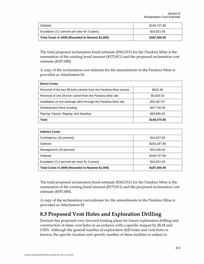
Section 8 Reclamation Cost Estimate
8-3
C:\cdmxm\nelsonmr\d0879788\La Sal Mines PO_Rev 3 16 12.docx
Subtotal $169,727.85
Escalation (3.2 percent per year for 3 years) $16,821.00
Total Costs in 2009 (Rounded to Nearest $1,000) $187,000.00
The total proposed reclamation bond estimate ($362,811) for the Pandora Mine is the summation of the existing bond amount ($175,811) and the proposed reclamation cost estimate ($187,000).
A copy of the reclamation cost estimate for the amendments to the Pandora Mine is provided as Attachment M.
Direct Costs
Removal of the two 36-inch culverts from the Pandora Mine access $642.45
Removal of one 36-inch culvert from the Pandora Mine site $5,825.53
Installation of one drainage ditch through the Pandora Mine site $32,367.57
Development Rock Grading $37,749.39
Placing Topsoil, Ripping, and Seeding $63,685.91
Total $140,270.85
Indirect Costs
Contingency (10 percent) $14,027.00
Subtotal $154,297.85
Management (10 percent) $15,430.00
Subtotal $169,727.85
Escalation (3.2 percent per year for 3 years) $16,821.00
Total Costs in 2009 (Rounded to Nearest $1,000) $187,000.00
The total proposed reclamation bond estimate ($362,811) for the Pandora Mine is the summation of the existing bond amount ($175,811) and the proposed reclamation cost estimate ($187,000).
A copy of the reclamation cost estimate for the amendments to the Pandora Mine is provided as Attachment M.
8.3 Proposed Vent Holes and Exploration Drilling Denison has proposed very forward-looking plans for future exploration drilling and construction of mine vent holes in accordance with a specific request by BLM and USFS. Although the general number of exploration drill holes and vent holes is known, the specific location and specific number of these facilities is subject to

Section 8 Reclamation Cost Estimate
8-4
C:\cdmxm\nelsonmr\d0879788\La Sal Mines PO_Rev 3 16 12.docx
uncertainty. Therefore, Denison has prepared a three-phase plan for future exploration drilling and vent shaft installation. These phases include the following:
Phase 1: continuing for approximately two to three years of operations after approval of this POA
Phase 2: Beginning after commencement of Phase 1 and continuing for approximately five years of operations
Phase 3: Beginning after commencement of Phase 2 and continuing for twelve years of more of operations.
Denison provided the general area of the planned exploration drilling and ventilation shaft installation in Figure 1-3.
8.3.1 Incremental Bonding Denison proposes that these vent holes and exploration drilling activities be bonded on an incremental basis and that submittal of reclamation bonds for individual phases be required prior to commencement of these activities. Denison proposes that this requirement be included as a Condition of Approval for this POA.
Denison requests to include the following condition of approval to address incremental bonding for future exploration drilling and ventilation shaft installation:
Prior to initiation of exploration drilling activities or ventilation shaft installation during Phases 1, 2 or 3 of the La Sal Mines Complex Plan of Operations, Denison shall submit a reclamation bond for the proposed activities to the Utah Division of Oil, Gas and Mining that complies with requirements of 43 CFR Part 3809.401, Section (d) and 36 CFR 228A §228.13, and is approved in advance by the BLM, USFS and UDOGM.
The ability to use incremental bonding to address the very forward-looking plans for future exploration drilling and vent hole installation provides both Denison, UDGOM, the BLM, and the USFS with flexibility to ensure adequate and appropriate bonding is in place prior to commencement of planned exploration drilling or vent shaft installation. This approach also allows Denison the flexibility to bond for these activities as necessary over the planned 20 year period addressed by this POA. Furthermore, this approach is necessary given the uncertainty in the exact disturbance areas, vent hole depths, and exploration drilling locations.

9-1
C:\cdmxm\nelsonmr\d0879788\La Sal Mines PO_Rev 3 16 12.docx
Section 9 Operational and Baseline Environmental Information Operational and baseline environmental information has been provided to the extent practicable at this time to support analysis of potential environmental impacts as required by the NEPA, and to determine if this POA will prevent unnecessary or undue degradation in accordance with 43 CFR 3809 and protect the environment in accordance with 36 CFR 228.8.
9.1 Air Quality Airborne emissions at the La Sal Mines are controlled and monitored under the requirements of two regulatory Agencies, UDEQ and the Mine Safety and Health Administration (MSHA).
All fugitive emissions, including airborne particulates, are regulated by permits issued by the UDEQ’s Air Quality Division. Denison has received an Air Emissions Permit for the La Sal Mines which limits fugitive dust from truck haulage and loading operations to 20 percent visual opacity. Airborne particulates are controlled by spraying the haul roads with a magnesium chloride solution or water. In addition, the topsoil stockpiles and areas that will have not been used for significant periods of time are stabilized by vegetation to prevent erosion. The proposed topsoil stockpile at the Pandora site will be seeded for stabilization.
Radon emissions from the mine exhaust vents are monitored and controlled in accordance with standards implemented under the support of UDEQ and EPA’s NESHAP. The air volume of the mine exhausts and the measured radon concentrations within the exhausts are utilized by Denison to derive an annual radon emission rate estimate. The annualized emission rate data, the physical parameters of the mine exhaust, and the location of the nearest resident are entered into EPA’s computer model (Comply-R) or an equivalent, EPA approved model. The model output is compared against the 10 mrem per year standard to determine compliance or the need for further radon control. This process ensures protection of human health and environment.
The underground working environment, including mine safety and radiation exposure, is regulated by MSHA. Like OSHA in industrial work places, MSHA inspects and regulates the overall safety of mining operations. In addition to overall mine safety, Denison is required by MSHA to monitor and control particulate and radiation exposure to workers at the mines. This program involves monitoring and control of dust, radon daughters, and gamma radiation within the working areas of the mine. In addition, Denison maintains a health and safety plan for mine workers that includes ear protection, respirator policies, an evacuation plan, fire drills, stench evacuation tests, and 40 hour MSHA training.

Section 9 Baseline and Operational Environmental Information
9-2
C:\cdmxm\nelsonmr\d0879788\La Sal Mines PO_Rev 3 16 12.docx
Denison controls fugitive dust for the on-site roads by enforcing low speed limits (i.e. 20 to 25 mph, or less, for haul trucks on the county road) and applying water, magnesium chloride, calcium chloride, or equivalent to the haul roads within the mine workings and shaft area as needed to reduce fugitive dust. These fugitive dust controls have successfully reduced fugitive dust emissions during existing operations. The future frequency of chemical suppressant applications will depend on site-specific conditions such as precipitation, wind, road dust silt content, and traffic type and volume.
As previously discussed in Section 6, Denison has received an Air Approval Order (AO) from the UDEQ Division of Air Quality (DAQE-AN014150002-09) permitting sources of air emissions associated with the La Sal Mines Complex that include generators, vehicles travel on unpaved roads, ore and rock storage and handling, and other fugitive emissions. Denison is committed to compliance with the conditions outlined in the permit; however, it should be noted that Denison is currently in the process of amending the production quantities to reflect the estimated annual volumes described in Section 4.5.
A copy of the air permit is provided as Attachment L.
9.2 Surface and Groundwater Resources A report titled Hydrogeologic Evaluation of the Denison Mines (USA) Corp., La Sal Mines Complex (CDM 2009b), was developed to provide information regarding hydrogeologic conditions at the La Sal Mines Complex. A copy of the report is included in Attachment N and summarized in the following sections.
9.2.1 Surface Water The La Sal Mines Complex is located in the Dolores River and Colorado River watersheds. The mines straddle the watershed boundary between the Dolores and Colorado Rivers, with the Pandora and Snowball in the Dolores River Watershed and the La Sal and Beaver Shaft mines in the Colorado River Watershed. No perennial surface water is present in the direct vicinity of the La Sal Mines Complex, and drainages in the area are ephemeral (i.e. they flow seasonally or in response to occasional intense precipitation events). The Dolores and Colorado Rivers are the nearest perennial surface water to the La Sal Mines Complex, but there is generally no direct surface water flow towards either river.
Surface water discharges from the La Sal Mines Complex are permitted under an Industrial Stormwater permit for construction activities as required by the Clean Water Act and associated state and federal water pollution control laws. A Stormwater Pollution Prevention Plan for the La Sal Mines Complex is in place at the mines, and stormwater pollution control facilities are in place and operating at the mines.

Section 9 Baseline and Operational Environmental Information
9-3
C:\cdmxm\nelsonmr\d0879788\La Sal Mines PO_Rev 3 16 12.docx
9.2.2 Ground Water Flow The principle direction of groundwater flow within the Mesozoic and Tertiary to Upper Cretaceous aquifers is lateral, because the confining layers restrict groundwater flow between the individual sandstone aquifers (Weir et al. 1983). In the vicinity of the La Sal Mines Complex, groundwater flows from the recharge areas in the La Sal Mountains generally towards the south. 9.2.3 Existing and Future Uses of Groundwater The La Sal Mines Complex is located near the town of La Sal. Current uses of groundwater in the area include: (1) local uses such as domestic drinking water, stock watering water, irrigation water, and (2) Denison’s industrial water for their mining operations. 9.2.3.1 Local Uses A query of the water well records maintained by the Utah Division of Water Rights (UDWR) was completed to identify local wells within approximately two miles of the La Sal Mine Complex (http://www.waterrights.utah.gov/cgi-in/wellview.exe? Startup). Results from the query list identified water wells within the area and illustrate the relative location of the wells to the La Sal Mines Complex. This information is provided in the report as Attachment N. Additional local water well completion data was collected from UDWR including the finished well depth, the well intake depth, the static water level and the lithology or formation name at the depth of the well intake. The aquifer units exploited by the local water wells can be generally interpreted from the well files and indicate water use from the following aquifers:
Alluvial aquifers hosted by Quaternary alluvial sediments such as sand and gravel; and
The Dakota Formation, which is a part of the D aquifer as defined by Lowe (1996);and
The Morrison Formation, which is likely a part of the M aquifer as defined by Lowe (1996).
The majority of the wells appear to be completed in the D aquifer and in alluvial aquifers located south and west of the La Sal Mines Complex near the town of La Sal. The D aquifer is separated from the areas of mining by the Brushy Basin member of the Morrison Formation, which is a low-permeability confining unit. 9.2.3.2 Mine Operation Uses Denison utilizes water from the following locations for underground mining operations including drilling operations and dust control:
Beaver Shaft Mine: Perched groundwater from aquifers stratigraphically above the Brushy Basin member drains into the Beaver Shaft Mine through the 1280 borehole and the collapsed 1350 borehole on a seasonal basis. Water

Section 9 Baseline and Operational Environmental Information
9-4
C:\cdmxm\nelsonmr\d0879788\La Sal Mines PO_Rev 3 16 12.docx
was reported to be flowing into the underground mine workings via the 1280 bore hole at a rate of approximately 4 gallons per hour in July 2009. This groundwater flows through underground workings to a stope at the 6354 level, where it is collected and used in underground mining operations. However, flow of water into the mine from this borehole is reported to have ceased in September 2009, which suggests that these inflows are seasonal. Currently water trucked to the mine from the Redd Ranch is used to support mining activities at the Beaver Shaft Mine.
Pandora Mine: Water from the Redd Ranch is transported to the Pandora Mine and is currently pumped for use into the active underground areas of the mine. Denison is investigating alternative sources of water to support mining activities at the Beaver Shaft and Pandora mines. If suitable alternative sources are located, Denison will obtain water rights for this usage in accordance with Utah regulations.
9.2.4 Potential Water Quality Affects of Underground Activities Underground mining involves a number of activities that could potentially affect groundwater quality. However, potential risks to groundwater are mitigated by the hydrogeologic framework of the mineral deposit and the location of the underground mining activities in relation to the water table. Several factors are pertinent to this discussion:
Underground mining activities are located in the unsaturated zone of the Salt Wash Member of the Morrison Formation;
There is potential that groundwater is present at depth beneath the underground mine workings and in perched zones in the aquifers;
Potential recharge through the underground workings and into a deeper aquifer is restricted by the overlying bentonitic shale of the Brushy Basin Member of the Morrison Formation, which is a confining layer that restricts groundwater flow.
Potential leakage from the overlying aquifers into the underground mine workings is limited by proper sealing of vent shafts and drill holes in the area.
Two major classes of environmental risks related to underground mining are relevant to this discussion: 1) risks of spills of petroleum products used in underground mining equipment; and 2) risks of natural oxidation of ore minerals, dissolution of potentially hazardous metals and metalloids, and subsequent mobilization downward to the water table.
Underground mining requires the use of mechanized equipment within the mine. This equipment is powered by diesel fuel and requires hydraulic fluids and other petroleum products, which are similar to fluids used in surface construction

Section 9 Baseline and Operational Environmental Information
9-5
C:\cdmxm\nelsonmr\d0879788\La Sal Mines PO_Rev 3 16 12.docx
operations. There is potential for spills or other unanticipated releases of petroleum products to occur within the underground mine workings. Denison has an SPCC plan in place at the mine, and Denison has procedures in place to address spills that occur within the underground workings. Therefore, the risks of these types of effects to groundwater underlying the mine are considered low.
Minerals that are associated with uranium-vanadium mineralization may oxidize when exposed to the surficial oxidized conditions during mining and ventilation. The process of drilling and blasting the rock followed by mine ventilation can lead to mineral oxidation and potentially to dissolution of metals or metalloids from the ore minerals. This process can occur in surficial rock piles or in exposed rock surfaces within the underground mine. It is possible that mineral oxidation is occurring within the underground mine. However, groundwater is not present in the underground workings and it is unlikely that significant water percolates downward through the mine workings to underlying groundwater, because the mining areas are overlain by the low permeability confining unit of the Brushy Basin Member of the Morrison Formation. Although there is potential for oxidation reactions to change the mineralogical forms of metals and metalloids within the mine, there is not sufficient water percolating through the underground workings to cause a significant risk of mobilizing the products of mineral oxidation reactions.
9.2.5 Potential Water Quality Affects of Surface Activities The following surface activities are associated with the operations at the La Sal Mines Complex:
Operation of equipment maintenance facilities to support mechanized equipment used in the underground mine;
Operation of fuel storage facilities;
Operation of offices, restroom and shower facilities; and
Storage of non-mineralized rock excavated from the mine in the development rock storage area.
Denison has in place an SPCC plan, which complies with federal regulations at 40 CFR Part 112. This plan addresses storage of petroleum products at the mine and provides information regarding facility management, a description of facilities, spill information, and spill prevention and control measures. The risks to groundwater from spills of stored petroleum products are managed and mitigated by the infrastructure and practices identified in the SPCC and on-going site management in accordance with the SPCC.
Storage of development rock at mining operations can lead to water quality risks based on site specific factors including the geochemistry of the rock, the local climate, and rock storage and reclamation methods. Potential risks to groundwater are considered low as discussed previously in Sections 3 and 5, and are further discussed

Section 9 Baseline and Operational Environmental Information
9-6
C:\cdmxm\nelsonmr\d0879788\La Sal Mines PO_Rev 3 16 12.docx
in Evaluation of Development Rock Piles at the La Sal Mines Complex (CDM 2009), which is included as Attachment F.
9.2.6 Potential Affects to Groundwater Quantity It is unlikely that groundwater use at the mine would result in significant affects to the quantity of groundwater available to existing or future wells in the La Sal area. Groundwater is only used at the mine for dust control, drilling fluids and ancillary needs, and this use complies with Utah water rights law. Mineral processing is not conducted at the La Sal Mines Complex, and therefore ground water is not necessary to support mineral processing activities. Perched aquifers are present in local areas overlying the unsaturated underground workings. This presents some risk that exploration drilling or installation of ventilation shafts could penetrate the confining layer between the perched aquifers and the underlying unsaturated underground mine workings. This could lead to groundwater flow into the workings and potential to lowering of the water table within the perched aquifer. These risks are mitigated by sealing of vent shafts that encounter water, and plugging of exploration drill holes in the area in accordance with UDOGM requirements.
9.3 Soil Resources 9.3.1 Pandora Mine Surface Facility Amendments 9.3.1.1 Soil Descriptions The disturbed surface area of the proposed DRA at the Pandora Mine includes only the Barnum loam soil map unit as determined by the U.S. Department of Agriculture, Natural Resources Conservation Service (NRCS) Soil Conservation Service (SCS) (NRCS 2009). Figure 9-1 shows the extent of the various soil types that may be within area of potential soil disturbance. These soil map units are based on landscape-scale similarities observed in parent material, general soil characteristics, elevation, precipitation, position within the landscape, and vegetation.
Barnum loam is present at the Pandora Mine site within the drainage channel area west of the DRA and occurs at slopes from 0 to 3 percent on alluvial flats. The parent material consists of alluvium derived from sandstone. The drainage class is considered to be well drained and water movement in the most restrictive layer is moderate to high. The soil is occasionally flooded; however, there is no frequency of ponding. The available water capacity in the soil is moderate. The depth to a root restrictive feature is more than 80 inches in depth.
9.3.1.2 Plan for Protecting and Re-Depositing Existing Soils Approximately 36 inches of soil material from approximately 2.6 acres of disturbed area will be salvaged and stockpiled at the Pandora Mine. Topsoil will be salvaged mainly from the proposed DRA expansion and portions of the proposed drainage channel realignment. Approximately 8,000 cy of topsoil will be stockpiled from the upper soil horizons and approximately 4,500 cy of suitable fill material will be used as fill where needed along the realigned channel during construction.

Section 9 Baseline and Operational Environmental Information
9-7
C:\cdmxm\nelsonmr\d0879788\La Sal Mines PO_Rev 3 16 12.docx
Most soil stripping will be performed using a tracked dozer, although a front-end loader and/or motor grader may also be used. Equipment will not be allowed to cross the stockpiles so that compaction of stockpiled soil is minimized. The topsoil storage location is designed to be outside of drainage areas to minimize erosion. The topsoil stockpile will be contoured, furrowed, and broadcast seeded in the late fall with BLM approved seed mix. Seeding efforts will continue until vegetation is established.
9.3.1.3 Potential Growth Media Soil samples were collected from topsoil at the Pandora Mine and were sent to the Colorado State University (CSU) Soil, Water, and Plant Testing Laboratory in August 2009. A total of five samples were analyzed to determine composition of the soil and suitability for native grass growth in a non-irrigation environment. In addition, soil amendment recommendations were provided for all samples analyzed and 40 pounds per acre of nitrogen was suggested. A copy of the soil analysis results is provided as Attachment O.
9.3.2 Mine Vents and Exploration Drilling Activities The proposed disturbed areas of the phased mineral exploration include many major soil map units as determined by the NRCS SCS. Phase 1 includes seven soil map units, Phase 2 includes five soil map units, and Phase 3 includes 12 soil map units. All soil units were within the vicinity of the proposed vent hole locations.
Soil map units are based on landscape-scale similarities observed in parent material, general soil characteristics, elevation, precipitation, position within the landscape, and vegetation. The location of plant growth material at each proposed vent hole or exploration drilling location will be evaluated when a specific location has been identified.
The following sections below briefly outline the various soil types that may be affected during each phase of the project.
9.3.2.1 Phase 1 Amendments (Continuing for Approximately Two to Three Years of Operations After Approval of POA) The following soil types were identified to occur in areas where proposed vent holes may be placed during future mine development activities.
Map Unit Name (Map Unit) Setting /Slope Parent Material Depth to Restrictive Feature
Canyonlands Area, Utah – Parts of Grand and San Juan Counties (UT633) Bond-Rizno fine sandy loams (# 14)
Structural benches/ 3 to 15 percent Cuestas/ 3 to 15 percent
Eolian deposits derived from sandstone Eolian deposits over residuum weathered from sandstone and shale
10 to 20 inches 4 to 20 inches

Section 9 Baseline and Operational Environmental Information
9-8
C:\cdmxm\nelsonmr\d0879788\La Sal Mines PO_Rev 3 16 12.docx
Map Unit Name (Map Unit) Setting /Slope Parent Material Depth to Restrictive Feature
Canyonlands Area, Utah – Parts of Grand and San Juan Counties (UT633) Falcon fine sandy loam (# 24) Cuestas, structural
benches/ 8 to 15 percent Residuum weathered from sandstone
10 to 20 inches
Sedillo very stony fine sandy loam (#78)
Alluvial fans/ 3 to 8 percent
Alluvium derived from igneous and sedimentary rock and/or colluviums derived from igneous and sedimentary rock
More than 80 inches
Shalako-Anasazi-Rock outcrop # 79)
Cuestas/ 3 to 15 percent Cuestas/ 3 to 15 percent Ledges on cuestas
Residuum weathered from sandstone Eolian deposits derived from sandstone ---
10 to 20 inches 20 to 40 inches ---
Tukuhnik loam (# 96) Cuestas, structural benches/ 3 to 10 percent
Alluvium derived from sandstone and siltstone and/or shale
40 to 60 inches
Ustic Torriorthents-Ustollic Calciothids (# 100)
Landslides on escarpments/ 10 to 60 percent Escarpments/ 10 to 40 percent
Colluvium derived from sandstone and shale Colluvium derived from sandstone and shale
20 to 79 inches 20 to 79 inches
Ustic Torriorthents-Ustollic Haplargids (# 101)
Landslides on escarpments/10 to 60 percent Landslides on escarpments/ 10 to 40 percent
Colluvium derived from sandstone and shale Colluvium derived from sandstone
20 to 79 inches 20 to 79 inches
Waas very fine sandy loam (#102)
Alluvial fans, cuestas, structural benches/ 2 to 8 percent
Eolian deposits derived from sandstone
More than 80 inches
San Juan Area, Utah (UT639) Montvale very rocky very fine sandy loam (MvG)
Plateaus/ 2 to 25 percent
Eolian deposits derived from sandstone over colluviums and/or residuum weathered from sandstone
10 to 20 inches
Scorup very fine sandy loam (SnC)
Fan remnants, stream terraces/ 2 to 6 percent
Alluvium derived from igneous rock
40 to 60 inches
Scorup cobbly very fine sandy loam (SnGC)
Stream terraces, fan remnants/ 2 to 25 percent
Alluvium derived from igneous rock
40 to 60 inches
9.3.2.2 Phase 2 Amendments (Approximately Five Years of Operations After Commencement of Phase 1) The following soil types were identified to occur in areas where proposed vent holes may be placed during future mine development activities.
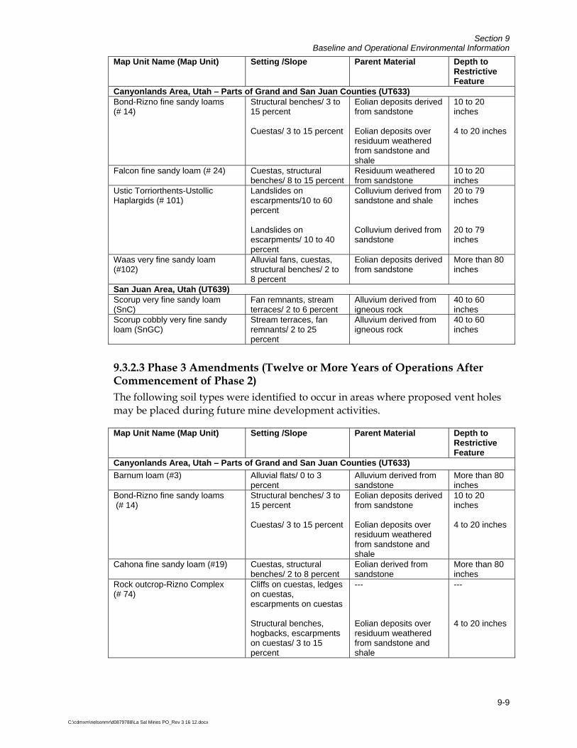
Section 9 Baseline and Operational Environmental Information
9-9
C:\cdmxm\nelsonmr\d0879788\La Sal Mines PO_Rev 3 16 12.docx
Map Unit Name (Map Unit) Setting /Slope Parent Material Depth to Restrictive Feature
Canyonlands Area, Utah – Parts of Grand and San Juan Counties (UT633) Bond-Rizno fine sandy loams (# 14)
Structural benches/ 3 to 15 percent Cuestas/ 3 to 15 percent
Eolian deposits derived from sandstone Eolian deposits over residuum weathered from sandstone and shale
10 to 20 inches 4 to 20 inches
Falcon fine sandy loam (# 24) Cuestas, structural benches/ 8 to 15 percent
Residuum weathered from sandstone
10 to 20 inches
Ustic Torriorthents-Ustollic Haplargids (# 101)
Landslides on escarpments/10 to 60 percent Landslides on escarpments/ 10 to 40 percent
Colluvium derived from sandstone and shale Colluvium derived from sandstone
20 to 79 inches 20 to 79 inches
Waas very fine sandy loam (#102)
Alluvial fans, cuestas, structural benches/ 2 to 8 percent
Eolian deposits derived from sandstone
More than 80 inches
San Juan Area, Utah (UT639) Scorup very fine sandy loam (SnC)
Fan remnants, stream terraces/ 2 to 6 percent
Alluvium derived from igneous rock
40 to 60 inches
Scorup cobbly very fine sandy loam (SnGC)
Stream terraces, fan remnants/ 2 to 25 percent
Alluvium derived from igneous rock
40 to 60 inches
9.3.2.3 Phase 3 Amendments (Twelve or More Years of Operations After Commencement of Phase 2) The following soil types were identified to occur in areas where proposed vent holes may be placed during future mine development activities.
Map Unit Name (Map Unit) Setting /Slope Parent Material Depth to Restrictive Feature
Canyonlands Area, Utah – Parts of Grand and San Juan Counties (UT633)
Barnum loam (#3) Alluvial flats/ 0 to 3 percent
Alluvium derived from sandstone
More than 80 inches
Bond-Rizno fine sandy loams (# 14)
Structural benches/ 3 to 15 percent Cuestas/ 3 to 15 percent
Eolian deposits derived from sandstone Eolian deposits over residuum weathered from sandstone and shale
10 to 20 inches 4 to 20 inches
Cahona fine sandy loam (#19) Cuestas, structural benches/ 2 to 8 percent
Eolian derived from sandstone
More than 80 inches
Rock outcrop-Rizno Complex (# 74)
Cliffs on cuestas, ledges on cuestas, escarpments on cuestas Structural benches, hogbacks, escarpments on cuestas/ 3 to 15 percent
--- Eolian deposits over residuum weathered from sandstone and shale
--- 4 to 20 inches

Section 9 Baseline and Operational Environmental Information
9-10
C:\cdmxm\nelsonmr\d0879788\La Sal Mines PO_Rev 3 16 12.docx
Map Unit Name (Map Unit) Setting /Slope Parent Material Depth to Restrictive Feature
Canyonlands Area, Utah – Parts of Grand and San Juan Counties (UT633)
Shalako-Anasazi-Rock outcrop (# 79)
Cuestas/ 3 to 15 percent Cuestas/ 3 to 15 percent Ledges on cuestas
Residuum weathered from sandstone Eolian deposits derived from sandstone ---
10 to 20 inches 20 to 40 inches ---
Ustic Torriorthents-Ustollic Calciothids (# 100)
Landslides on escarpments/ 10 to 60 percent Escarpments/ 10 to 40 percent
Colluvium derived from sandstone and shale Colluvium derived from sandstone and shale
20 to 79 inches 20 to 79 inches
Ustic Torriorthents-Ustollic Haplargids (# 101)
Landslides on escarpments/10 to 60 percent Landslides on escarpments/ 10 to 40 percent
Colluvium derived from sandstone and shale Colluvium derived from sandstone
20 to 79 inches 20 to 79 inches
San Juan Area, Utah (UT639) Monticello very fine sandy loam (MnDL)
Plateaus/ 2 to 10 percent
Eolian deposits derived from sandstone
More than 80 inches
Montvale very rocky very fine sandy loam (MvG)
Plateaus/ 2 to 25 percent
Eolian deposits derived from sandstone over colluviums and/or residuum weathered from sandstone
10 to 20 inches
Scorup very fine sandy loam (SnC)
Fan remnants, stream terraces/ 2 to 6 percent
Alluvium derived from igneous rock
40 to 60 inches
Scorup cobbly very fine sandy loam (SnGC)
Stream terraces, fan remnants/ 2 to 25 percent
Alluvium derived from igneous rock
40 to 60 inches
9.4 Vegetation Resources There are two major vegetation communities that exist within the Pandora Mine surface facilities amendment area: Woodland and Inter-Mountain Basins Big Sagebrush Shrubland. Descriptions and locations of vegetation cover types were derived from the Southwest Regional Gap Analysis Program (USGS 2004).
Approximately 30 percent of the vegetation within the Pandora Mine disturbed area is comprised of Colorado Plateau Piñon-Juniper Woodland. Twenty percent is developed with medium to high intensity, where impervious surface accounts for 50 to 100 percent of the total cover. The remaining 50 percent is Inter-Mountain Basins Big Sagebrush Shrubland. The understory consists of patches of big sagebrush (Artemisia tridentata), Gambel oak (Quercus gambelii), cliffrose (Purshia stansburiana), yellow rabbitbrush (Chrysothamnus viscidiflorus), rubber rabbitbrush (Ericameria nauseosa), snowberry (Symphoricarpos sp.), and mountain mahogany (Cercocarpus montanus) with sparse cacti, forbs, and graminoids.
There are three major vegetation communities that exist in the vicinity of the vents and exploration on USFS land: Colorado Plateau Piñon-Juniper Woodland; Mountain

Section 9 Baseline and Operational Environmental Information
9-11
C:\cdmxm\nelsonmr\d0879788\La Sal Mines PO_Rev 3 16 12.docx
Gambel Oak-Mixed Montane Shrubland; and Southern Rocky Mountain Ponderosa Pine Woodland. Descriptions and locations of vegetation cover types were derived from the Southwest Regional Gap Analysis Program (USGS 2004). Vegetation is mainly comprised of Piñon-Juniper Woodland, with the other two vegetation types scattered throughout the project area. The understory consists of patches of big sagebrush (Artemisia tridentate), Gambel oak (Quercus gambelii), cliffrose (Purshia stansburiana), yellow rabbit brush (Chrysothamnus viscidiflorus), rubber rabbitbrush (Ericameria nauseosa), snowberry (Symphoricarpos sp.), and mountain mahogany (Cercocarpus montanus) with sparse cacti, forbs, and graminoids.
9.4.1 Colorado Plateau Piñon-Juniper Woodland This ecological system occurs in dry mountains and foothills of the Colorado Plateau region including the Western Slope of Colorado to the Wasatch Range, south to the Mogollon Rim and east into the northwestern corner of New Mexico. It is typically found at lower elevations ranging from 4,900 to 8,000 feet. These woodlands occur on warm, dry sites on mountain slopes, mesas, plateaus, and ridges. Severe climatic events occurring during the growing season, such as frosts and drought, are thought to limit the distribution of piñon-juniper woodlands to relatively narrow altitudinal belts on mountainsides. Soils supporting this system vary in texture ranging from stony, cobbly, gravelly sandy loams to clay loam or clay. Piñon pine (Pinus edulis) and/or Utah juniper (Juniperus osteosperma) dominate the tree canopy. In the southern portion of the Colorado Plateau in northern Arizona and northwestern New Mexico, one-seed juniper (Juniperus monosperma) and hybrids of juniper may dominate or codominate the tree canopy. Rocky Mountain juniper (Juniperus scopulorum) may codominate or replace Utah juniper at higher elevations. Understory layers are variable and may be dominated by shrubs, graminoids, or be absent. Associated species include greenleaf manzanita (Arctostaphylos patula), big sagebrush (Artemisia tridentata), littleleaf mountain mahogany (Cercocarpus intricatus), mountain mahogany (Cercocarpus montanus), blackbrush (Coleogyne ramosissima), Stansbury cliffrose (Purshia stansburiana), antelope bitterbrush (Purshia tridentata), Gambel oak (Quercus gambelii), blue gramma (Bouteloua gracilis), James’ galleta (Pleuraphis jamesii), or mutton grass (Poa fendleriana). This system occurs at higher elevations than Great Basin Piñon-Juniper Woodland and Colorado Plateau shrubland systems where sympatric.
9.4.2 Inter-Mountain Basins Big Sagebrush Shrubland This ecological system occurs throughout much of the western U.S., typically in broad basins between mountain ranges, plains and foothills between 4,900 and 7,500 feet in elevation. Soils are typically deep, well-drained and non-saline. These shrublands are dominated by basin big sagebrush (Artemisia tridentata ssp. tridentata) and/or Wyoming big sagebrush (Artemisia tridentata ssp. wyomingensis). Scattered juniper (Juniperus spp.), greasewood (Sarcobatus vermiculatus), and saltbush (Atriplex spp.) may be present in some stands. Rubber rabbitbrush (Ericameria nauseosa), yellow rabbitbrush (Chrysothamnus viscidiflorus), antelope bitterbrush (Purshia tridentata), or mountain snowberry (Symphoricarpos oreophilus) may codominate disturbed stands. Perennial herbaceous components typically contribute less than 25 percent vegetative
Section 9 Baseline and Operational Environmental Information
9-12
C:\cdmxm\nelsonmr\d0879788\La Sal Mines PO_Rev 3 16 12.docx
cover. Common graminoid species include Indian ricegrass (Achnatherum hymenoides), blue grama (Bouteloua gracilis), thickspike wheatgrass (Elymus lanceolatus), Idaho fescue (Festuca idahoensis), needle and thread grass (Hesperostipa comata), basin wildrye (Leymus cinereus), James’ galleta (Pleuraphis jamesii), western wheatgrass (Pascopyrum smithii), Sandberg bluegrass (Poa secunda), or bluebunch wheatgrass (Pseudoroegneria spicata).
9.4.3 Rocky Mountain Gambel Oak-Mixed Montane Shrubland This ecological system occurs in the mountains, plateaus and foothills in the southern Rocky Mountains and Colorado Plateau including the Uinta and Wasatch ranges and the Mogollon Rim. These shrublands are most commonly found along dry foothills, lower mountain slopes, and at the edge of the western Great Plains from approximately 6,500 to 9,500 feet (2,000–2,900 m) in elevation, and are often situated above piñon-juniper woodlands. Substrates are variable and include soil types ranging from calcareous, heavy, fine-grained loams to sandy loams, gravelly loams, clay loams, deep alluvial sand, or coarse gravel. The vegetation is typically dominated by Gambel oak alone or codominant with Saskatoon serviceberry (Amelanchier alnifolia), Utah serviceberry (Amelanchier utahensis), big sagebrush, mountain mahogany, chokecherry (Prunus virginiana), stansbury cliffrose, antelope bitterbrush, New Mexico locust (Robinia neomexicana), mountain snowberry (Symphoricarpos oreophilus), or roundleaf snowberry (Symphoricarpos rotundifolius). There may be inclusions of other mesic montane shrublands with Gambel oak absent or as a relatively minor component. This ecological system intergrades with the lower montane-foothills shrubland system and shares many of the same site characteristics. Density and cover of Gambel oak and serviceberry often increase after fire.
9.4.4 Southern Rocky Mountain Ponderosa Pine Woodland This very widespread ecological system is most common throughout the cordillera of the Rocky Mountains, from the Greater Yellowstone region south. It is also found in the Colorado Plateau region, west into scattered locations in the Great Basin, and in the Black Hills of South Dakota and Wyoming. These woodlands occur at the lower treeline/ecotone between grassland or shrubland and more mesic coniferous forests typically in warm, dry, exposed sites. Occurrences are found on all slopes and aspects; however, moderately steep to very steep slopes or ridge tops are most common. This ecological system generally occurs on igneous, metamorphic, and sedimentary material derived soils, with characteristic features of good aeration and drainage, coarse textures, circumneutral to slightly acid pH, an abundance of mineral material, rockiness, and periods of drought during the growing season. Ponderosa pine (Pinus ponderosa) is the predominant conifer; douglas-fir (Pseudotsuga menziesii), piñon pine, and juniper may be present in the tree canopy. The understory is usually shrubby, with a mix of forbs and grasses.
9.4.5 Wetlands A site investigation was conducted by SWCA Environmental Consultants to determine the presence or absence of wetlands and jurisdictional waterbodies within the boundaries of the proposed DRA area at the Pandora Mine. Findings from the investigations were presented in a letter titled “Pandora Mine Waste Rock Area

Section 9 Baseline and Operational Environmental Information
9-13
C:\cdmxm\nelsonmr\d0879788\La Sal Mines PO_Rev 3 16 12.docx
Expansion Wetland Determination” (Attachment P) and concluded that no wetlands or jurisdictional waterbodies are present in the proposed project area at the Pandora Mine. Therefore, the proposed mining operations will not disturb or impact wetlands or jurisdictional waterbodies.
9.5 Wildlife Resources A biological survey was conducted by SWCA Environmental Consultants (SWCA) to evaluate the potential effects of the proposed amendments to the surface facilities at Pandora Mine on federally threatened or endangered species listed under the Endangered Species Act of 1973, as amended et seq., as well as species occurring on the Utah Sensitive Species List, USFS Region 4 sensitive species and the Manti-La Sal National Forest Management Indicator Species. A copy of the wildlife survey is provided in Attachment Q.
9.5.1 Threatened or Endangered Species Research was conducted to identify threatened, endangered, and candidate species that are known to, or have the potential to, occur in San Juan County. The following species were identified in San Juan County.
Common Name Scientific Name Federal Status
Black-footed ferret Mustela nigripes Endangered1
Bonytail Gila elegans Endangered
California condor Gymnogys californianus Endangered1
Humpback chub Gila cypha Endangered
Mexican spotted owl Strix occidnetalis lucida Threatened
Razorback sucker Xyrauchen texanus Endangered
Southwestern willow flycatcher Empidonax traillii extimus Endangered
Western Yellow-billed cuckoo Coccyzus americanus occidentailis Candidate
Colorado pikeminnow Ptychocheilus lucius Endangered
1Experimental Population, Non-Essential
The results from field investigations that evaluated habitat requirements for these species found that none of 11 federally listed species have the potential to occur in the Pandora Mine area.
9.5.2 Sensitive Species Twenty species listed on the Utah Sensitive Species List have the potential or may occur within the BLM Moab Field Office. The following species were identified using the Utah Conservation Data Center database.
Common Name Scientific Name Habitat Associations Allen’s big-eared bat Idionycteris phyllotis Occurs primarily in forested
mountain areas Bald Eagle Haliaeetus leucocephalus Deciduous forest, near water

Section 9 Baseline and Operational Environmental Information
9-14
C:\cdmxm\nelsonmr\d0879788\La Sal Mines PO_Rev 3 16 12.docx
Common Name Scientific Name Habitat Associations Big free-tailed bat Nyctinomops macrotis Inhabits rugged, rocky terrain and
typically roost in rock crevices Bobolink Dolichonyx oryzivorus Restricted to wet meadow and
flooded pasture habitats Burrowing Owl Athene cunicularia hypugaea Lives in dry, open areas with no
trees and short grass, often in association with prairie dog towns
Ferruginous hawk Buteo regalis Relies on grassland or shrub-steppe terrain and, in many parts of Utah, nests on the ecotone between these habitats and piñon-juniper woodlands
Fringed myotis Myotis thysanodes Commonly roost in mine tunnels, caves, and buildings
Greater sage-grouse Centrocercus urophasianus Uses sagebrush-grassland habitats and nests on the ground
Gunnison’s prairie dog Cynomys gunnisoni Inhabits grasslands, semidesert and montane shrublands
Great Plains Toad Bufo cognatus Inhabits prairies and deserts. In addition to grasslands, it occurs in creosote bush scrub, mesquite woodlands, desert riparian situations, and sagebrush steppe.
Kit fox Vulpes macrotis A desert-adapted fox, it is found exclusively in arid and semi-arid landscapes with soils suitable for denning
Lewis’ woodpecker Melanerpes lewis Habitat includes ponderosa pine and open riparian areas
Long-billed curlew Numenuis americanus Nests in dry grasslands where sufficient cover and abundant prey exists
Short-eared owl Asio flammeus Prefers open country and is ground-nesting species that occupies grasslands and tundra
Spotted bat Euderma maculatum Found in dry, rough, desert terrain. Roosts are typically in rock crevices or under loose rocks or boulders
Three-toed woodpecker Picoides tridactylus Coniferous forests with a significant percentage of dead trees
Townsend’s big-eared bat Corynorhinus townsendii Roosts in abandoned mines and natural caverns
Of these Utah Sensitive Species, only three have the potential to occur in the La Sal Mines Complex. They include the fringed myotis (Myotis thysanodes), and Townsend’s big-eared bat (Corynorhinus townsendii), and wintering bald eagles.
In addition, the area is considered critical winter range for deer and elk. Although the area is not occupied by sage grouse, it is considered suitable historic Gunnison sage grouse habitat.
The USFS Intermountain Region has identified wildlife and plant species with sensitive species status. The following species may occur on the Moab District of the Manti-La Sal National Forest.

Section 9 Baseline and Operational Environmental Information
9-15
C:\cdmxm\nelsonmr\d0879788\La Sal Mines PO_Rev 3 16 12.docx
Species Habitat Associations Potential to Occur in the Project Area
Abajo peak draba (Draba abajoensis)
On steep rocks or under overhangs.
Yes.
Bald eagle (Haliaeetus leucocephalus)
Forages mainly in rivers and large lakes; in open country, typically close to water; nests in tall trees or cliffs.
Yes – this species is known to winter in the area from La Sal to Lisbon
Bighorn sheep (Ovis Canadensis)
Prefers rock outcrop habitats, preferably areas of low visibility near escape terrain
Yes.
Canyonlands lomatium (Lomatium latilobum)
Occurs in association with Entrada sandstone in piñon/juniper and desert shrub communities.
No. Soil types in the PPA do not meet the requirements for this species.
Colorado River cutthroat and greenback trout (Oncorhynchus clarki pleuriticus and O.c.stomiua)
Now naturally occur only in isolated high-elevation headwater streams that drain into the upper Colorado River.
No. Suitable habitat for this species does not occur in the PPA.
Flammulated owl (Otus flammeolus)
Common raptor in montane pine forests (especially ponderosa pine forests) in the western United States.
Yes. Ponderosa pine habitat is scattered throughout the PPA.
Greater sage-grouse (Centrocercus urophasianus)
Uses sagebrush-grassland habitats and nests on the ground.
No. Suitable habitat for this species does not occur in the PPA.
Isely’s milkvvetch (Astragalus iselyi)
Cold and arid to semi-arid regions with poor or saline soils.
Yes.
La Sal daisy (Erigeron mancus)
Alpine endemic to the La Sal Mountains.
No. Suitable habitat for this species does not occur in the PPA.
Northern goshawk (Accipiter gentilis)
Prefers mature mountain forest and riparian zone habitats.
Yes. Suitable habitat for this species occurs in the PPA. An active northern goshawk territory is known to exist west of the PPA.
Peregrine falcon (Falco peregrinus anatum)
Found in a variety of habitats, mostly consisting of cliffs for nesting and open areas for foraging; also nests on buildings in urban areas.
Yes - suitable cliff faces or substantial rock outcroppings were observed within the PPA.
Spotted bat (Euderma maculatum)
Found in dry, rough, desert terrain. Roosts are typically in rock crevices or under loose rocks or boulders.
Yes. Suitable habitat for this species occurs in the PPA.
Sweet-flowered rock-jasmine (Androsace chamaejasme carinata)
Mat-forming perennial species found in alpine tundra and talus communities on the top of the La Sal Mountains at elevations of 10,000 to 12,600 feet.
No. Suitable habitat for this species does not occur in the PPA.
Three-toed woodpecker (Picoides tridactylus)
Coniferous forests with a significant percentage of dead trees.
No. Suitable habitat for this species does not occur in the PPA.
Townsend’s big-eared bat (Corynorhinus townsendii)
Roosts in abandoned mines and natural caverns.
Yes. Suitable woodland and forested areas occur within the PPA. However, the preferred roosting sites of caves, mines, or abandoned buildings were not observed in the PPA.
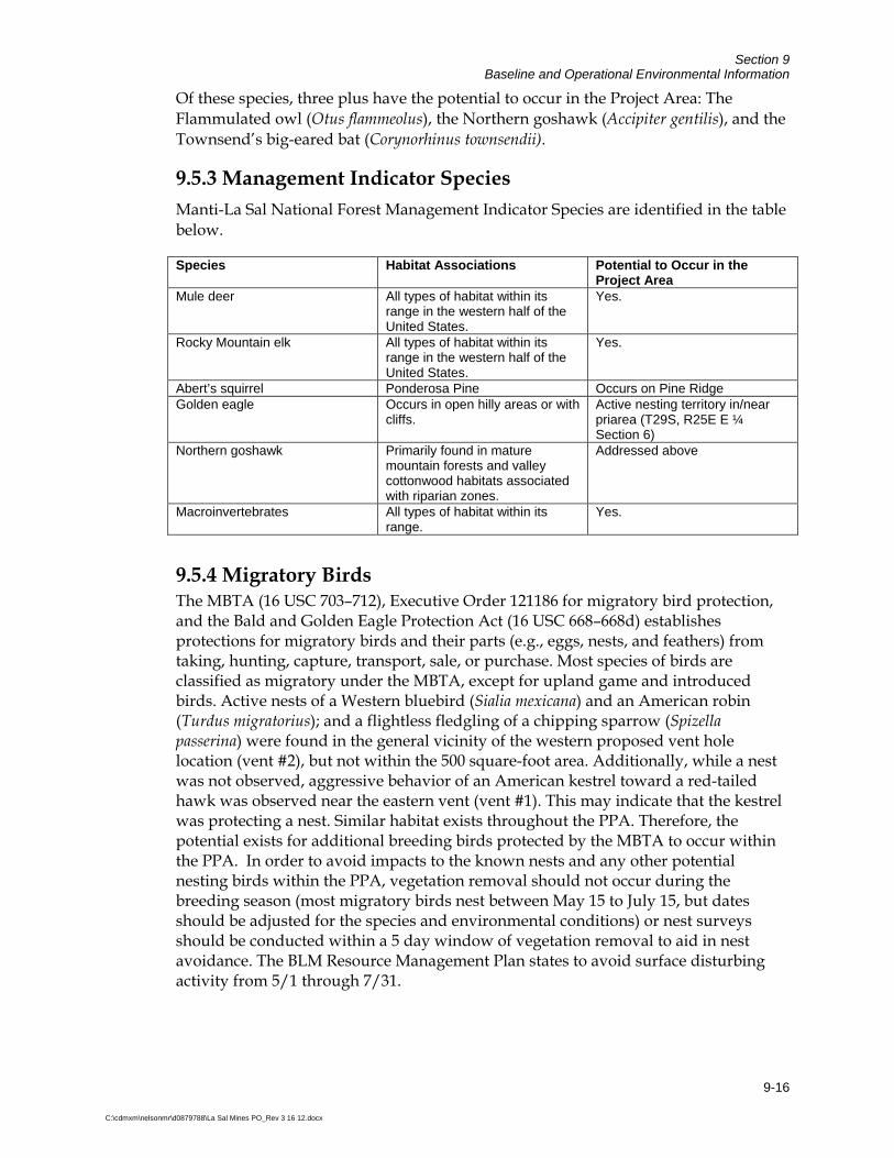
Section 9 Baseline and Operational Environmental Information
9-16
C:\cdmxm\nelsonmr\d0879788\La Sal Mines PO_Rev 3 16 12.docx
Of these species, three plus have the potential to occur in the Project Area: The Flammulated owl (Otus flammeolus), the Northern goshawk (Accipiter gentilis), and the Townsend’s big-eared bat (Corynorhinus townsendii).
9.5.3 Management Indicator Species Manti-La Sal National Forest Management Indicator Species are identified in the table below.
Species Habitat Associations Potential to Occur in the Project Area
Mule deer All types of habitat within its range in the western half of the United States.
Yes.
Rocky Mountain elk All types of habitat within its range in the western half of the United States.
Yes.
Abert’s squirrel Ponderosa Pine Occurs on Pine Ridge Golden eagle Occurs in open hilly areas or with
cliffs. Active nesting territory in/near priarea (T29S, R25E E ¼ Section 6)
Northern goshawk Primarily found in mature mountain forests and valley cottonwood habitats associated with riparian zones.
Addressed above
Macroinvertebrates All types of habitat within its range.
Yes.
9.5.4 Migratory Birds The MBTA (16 USC 703–712), Executive Order 121186 for migratory bird protection, and the Bald and Golden Eagle Protection Act (16 USC 668–668d) establishes protections for migratory birds and their parts (e.g., eggs, nests, and feathers) from taking, hunting, capture, transport, sale, or purchase. Most species of birds are classified as migratory under the MBTA, except for upland game and introduced birds. Active nests of a Western bluebird (Sialia mexicana) and an American robin (Turdus migratorius); and a flightless fledgling of a chipping sparrow (Spizella passerina) were found in the general vicinity of the western proposed vent hole location (vent #2), but not within the 500 square-foot area. Additionally, while a nest was not observed, aggressive behavior of an American kestrel toward a red-tailed hawk was observed near the eastern vent (vent #1). This may indicate that the kestrel was protecting a nest. Similar habitat exists throughout the PPA. Therefore, the potential exists for additional breeding birds protected by the MBTA to occur within the PPA. In order to avoid impacts to the known nests and any other potential nesting birds within the PPA, vegetation removal should not occur during the breeding season (most migratory birds nest between May 15 to July 15, but dates should be adjusted for the species and environmental conditions) or nest surveys should be conducted within a 5 day window of vegetation removal to aid in nest avoidance. The BLM Resource Management Plan states to avoid surface disturbing activity from 5/1 through 7/31.
Section 9 Baseline and Operational Environmental Information
9-17
C:\cdmxm\nelsonmr\d0879788\La Sal Mines PO_Rev 3 16 12.docx
9.5.5 Protection of Wildlife Habitat and Endangered Species The surface disturbance associated with the proposed amendments at Pandora Mine combined with the noise, moving equipment, and the increased presence of humans from the existing facilities at the La Sal Mine and Beaver Shaft Mine is likely to result in the temporary displacement of some of the small mammals and birds that inhabit the area. No riparian areas and no threatened , endangered, or candidate plant or wildlife species have been identified within or near the project area.
The BLM Moab Field Office has identified 24 species with special management status. Of these, two have the potential to occur in the project area and surroundings. These include the fringed myotis (Myotis thysanondes), and Townsend’s big-eared bat (Corynorhinus townsendii). Denison recognizes the use of underground mines for bats and supports BLM’s efforts to conserve and manage their habitat. When Denison personnel or contractors enter a mine for the first time following the breeding season (spring and summer) a visual observation for bats will be made. In the event that bats are observed in the mine workings, Denison personnel will cease all activities in the area and report the findings to Denison’s Environmental Coordinator. Recommendations made by USFS and BLM personnel will be implemented by Denison.
The Manti-La Sal National Forest has identified 12 species with sensitive species status. The USFS also has Management Indicator Species (MIS) to consider which include golden eagle, Albert’s squirrel, deer and elk. The following species were identified; of these species, three have the potential to occur in the Project Area: The Flammulated owl (Otus flammeolus), the Northern goshawk (Accipiter gentilis), and the Townsend’s big-eared bat (Corynorhinus townsendii). Denison will conduct raptor and nest surveys prior to any vent construction or exploration drilling to ensure that nest locations are not located within construction areas. Seasonal restrictions on construction activity may be put in place. Denison will work with the USFS to ensure that potential impacts to birds are mitigated.
Big game species were not observed at the site; however, mule deer may be present in low numbers. Impacts to big game species are not anticipated because the mine sites are relatively small compared to the available habitat for these species. The impact from the development rock on wildlife is discussed in the following section.
9.5.6 Screening-Level Evaluation of Potential Direct Contact Risks to Wildlife To evaluate potential direct contact risks of mine development rock to wildlife, the total metals data from samples collected at the Pandora DRA were compared to BLM wildlife RMC values (CDM 2009a). Direct contact risks are related to incidental ingestion or inhalation of development rock. The BLM RMCs are species-specific, and this screening-level evaluation considers RMC values for deer mouse, cottontail, bighorn sheep, white-tailed deer, mule deer, elk, cattle, and sheep. The screening-level evaluation shows that most metals in development rock occur at concentrations that are lower than their respective screening criteria. However, one of the three samples

Section 9 Baseline and Operational Environmental Information
9-18
C:\cdmxm\nelsonmr\d0879788\La Sal Mines PO_Rev 3 16 12.docx
exceeded wildlife screening values for cadmium, lead and zinc, and two of the three samples exceeded the screening level for lead. Although local areas may be present where cadmium, lead, and zinc concentrations exceed the BLM screening levels, potential risks to wildlife were not evaluated further for several reasons:
The development rock areas where cadmium, lead and zinc locally exceed the wildlife screening criteria are very small relative to home and/or foraging ranges for most ecological receptors of interest, which reduces the potential exposure levels.
Threatened or endangered species, or suitable habitat for those species, are not present in the Pandora DRA. Therefore, complete mitigation of potential risks to all individual wildlife organisms is not warranted.
It is unlikely that potential adverse effects to wildlife related to direct contact risks would cause a significant impact to overall populations and community of the referenced species.
Additional details are presented in Evaluation of Development Rock Piles at the La Sal Mines Complex (CDM 2009a). A copy of the report is provided as Attachment F.
9.6 Cultural Resources Cultural resources are sensitive, irreplaceable resources with potential public and scientific uses, and are an important and integral part of our national heritage. Cultural resources constitute “a definite location of human activity, occupation, or use identifiable through field inventories (i.e. surveys), historical documentation, or oral evidence” (BLM-M-8110).
A Class III cultural resources survey was conducted by SWCA in July 2009 for the proposed surface disturbance at the Pandora Mine (SWCA 2009b). The survey was conducted to comply with Section 106 of the National Historic Preservation Act (NHPA) of 1966, as amended, and the governing rules found in 36 CFR 800, “Protection of Historic Properties.” Findings from the inventory of the expansion area resulted in the identification and documentation of one prehistoric isolated find located within the survey area. The isolate consisted of five flakes found within a 15 × 10–m (49 × 33–foot) area. Isolates, by definition, are not considered eligible for inclusion on the National Register of Historic Places (NRHP).
A Class III cultural resources survey was conducted by SWCA in July 2009 for the proposed surface disturbance for vents and exploration on USFS lands (SWCA 2009c). The survey was conducted to comply with Section 106 of the National Historic Preservation Act (NHPA) of 1966, as amended, and the governing rules found in 36 CFR 800, “Protection of Historic Properties.” Findings from the inventory of the block survey area resulted in the identification and documentation of one prehistoric site and seven isolated finds located within the survey area. The site is a moderate-density lithic scatter with no apparent features or intact deposits and has been recommended as not eligible for listing on the NRHP. The isolated artifacts are all lithic debitage
Section 9 Baseline and Operational Environmental Information
9-19
C:\cdmxm\nelsonmr\d0879788\La Sal Mines PO_Rev 3 16 12.docx
with the exception of one biface fragment and one projectile point, possibly a San Jose’ type. Isolated finds are, by definition, considered not eligible for the NRHP inclusion. In addition, one previously recorded prehistoric site is located within the proposed project area. Recorded by the USFS in 2008, this site has been determined not eligible for NRHP inclusion.
Based on the findings of the surveys, no NRHP-eligible or other significant cultural resources occur in the proposed disturbance area of potential effect and that the project does not impact any historic properties. A copy of the BLM cultural resources survey is provided as Attachment R. The USFS was provided with a copy of the previous survey. Denison’s policy on cultural resources is provided as Attachment S.
9.7 Paleontological Resources A paleontological resources reconnaissance, literature review, and fossil locality record search was conducted for the proposed amendments at the Pandora Mine by SWCA in July 2009 (SWCA 2009d). A copy of the paleontological resources survey is provided as Attachment T.
Findings from the research conducted determined that no previously known paleontological localities are located within a 1-mile radius of the project area on either BLM or USFS land. No significant fossils were observed during the field reconnaissance. Non-significant silicified wood fragments were observed weathering out of rocks of the Burro Canyon Formation, indicating that this unit is locally fossiliferous in the general area. The absence of previously recorded fossil localities in the Pandora Mine project area is likely the result of the minimal bedrock exposures and extensive soil and vegetative cover in the area.
In general, the impacts to surface fossils resulting from the proposed surface disturbance are anticipated to be negligible due to the surface characteristics (minimal exposed bedrock) of the project area.
Denison’s policy on paleontological resources is provided in Attachment S.
9.8 Socioeconomic Conditions The population of San Juan County in 2007 (the most recent year for which data is available) was 14,484 people (City Data 2009). The population increased by 1,102 people from 2003 to 2007. San Juan County’s regional economy relies largely on education, health and social services (28.1 percent), arts, entertainment, recreation, accommodation, and food services (13.2 percent), retail trade (10.8 percent), and construction (10.1 percent). Agriculture is also present in the county, primarily cattle grazing; however, numbers for this industry are not reported.
In 2007, San Juan County contained 3,242 housing units and 847 renter-occupied apartments, and the median household income in San Juan County was estimated at $23,254 in 2003 (City Data 2009). The 2008 cost of living index in San Juan County is low at 78.9 (U.S. Average is 100).

Section 9 Baseline and Operational Environmental Information
9-20
C:\cdmxm\nelsonmr\d0879788\La Sal Mines PO_Rev 3 16 12.docx
The nearest town to the mine is La Sal; however, services and housing in La Sal is limited. Most of the existing work force in the La Sal area is self-employed in agriculture or employed at the existing mines. The next nearest community to the mine is Moab, Utah; however, the mine employees reside either in Monticello, Utah or in rural areas in southwestern Colorado.
The races in San Juan County are broken out as 56.6 percent American Indian, 39.6 percent white non-Hispanic, 3.7 percent Hispanic, 1.7 percent other races, and 1.5 percent with two or more races (total can be greater than 100 percent because Hispanics could be counted in other races). The mine employees currently working in the area are estimated to be 10 percent American Indian, 30 percent Hispanic, and 60 percent white non-Hispanic.
Currently, there are approximately 54 employees present at the Beaver Shaft Mine and 32 employees present at the Pandora Mine. The proposed future development plan for the operations at the La Sal Mines Complex has the potential to employ up to approximately 80 employees at the Beaver Shaft Mine and 50 employees at the Pandora Mine and extend the mine life to 20 years or more.
Mine operations would provide long-term employment and would contribute relatively high-paying jobs and a dependable long-term tax base to San Juan County. In addition, expansion of the mine sites would bring additional jobs to San Juan County and use the existing local work force from the County to the greatest extent practicable. The La Sal Mines will continue to increase the work force in San Juan County. The result would be a direct positive impact to the local economy and residents.
In addition, the mine sites will provide continued ancillary employment for the following:
Denison’s Egnar, Colorado Office
Contracted ore trucking companies
Processing support at the White Mesa Mill near Blanding, Utah
Other technical services such as mechanics, electricians, etc.
Mine equipment manufacture, sales, and delivery
9.9 Worker Health and Safety Mining-related illnesses and injuries have steadily declined over the years because of stricter safety laws and improvements in mining machinery and practices. Although mine health and safety conditions have improved dramatically, dust generated by drilling in mines can still place miners at risk of developing silicosis from rock dust. The Federal Coal Mine Health and Safety Act of 1969 regulates dust concentrations in coal mines, and respirable dust levels are closely monitored. Dust concentrations in mines have declined as a result. Underground miners have the option to have their

Section 9 Baseline and Operational Environmental Information
9-21
C:\cdmxm\nelsonmr\d0879788\La Sal Mines PO_Rev 3 16 12.docx
lungs x-rayed when starting a job, with a mandatory follow-up x-ray 3 years later, in order to monitor any development of respiratory illness. Additional x-rays are given every 5 years, on a voluntary basis (www.bls.gov).
The potential for health impacts from modern uranium mining does not differ appreciably from those associated with other types of mining. The aspect of uranium mining that differentiates it from other mining is the potential for exposure to ionizing radiation from uranium ore and radon gas and its progeny.
The main atmospheric impacts from mining are from the production of dust and release of naturally-occurring radon. Radon and its daughter products exposed during mining operations are reduced to acceptable levels by ventilation to the outside, where atmospheric dispersion quickly reduces concentrations to well below the allowable levels for the general public established by UDEQ and EPA’s NESHAP program. In addition, gamma surveys are conducted in the working areas of the mine to ensure protection of workers from external radiation. Also, waste rock piles from mining are shielded by ground cover whenever possible and, where necessary, by wetting to control dust.
As discussed in the U.S. Department of Energy (DOE) Uranium Leasing Program Final Programmatic EA (DOE 2007), uranium mine sites comprise rocks and soils that contain naturally occurring radioactive material. Most of the natural radioactivity is derived from the uranium-238 and uranium-235 decay chains. One of the products in the uranium-238 decay chain is radium-226, which is the principal radionuclide of concern for characterizing the distribution of radioactivity in the environment.
The primary radioactive sources on uranium mine lands are mine-waste-rock piles, mine portals, ore-bearing outcrops and airborne particulates derived from these sources. Background concentrations of radium-226 in mine-waste-rock piles have been reported to average 23.7 picocuries per gram (pCi/g). In the underground mines, the primary radium-226 source is the ore-bearing Salt Wash Member (DOE 2007).
Worker health and safety at the La Sal Mines could be affected by multiple work hazards, such as ground fall, explosives handling, scaling activities, roof bolting, drilling, dust and other respiratory issues associated with inadequate ventilation, and equipment handling and maintenance. Worker health and safety could also be affected by exposure to ionizing radiation and radon. The Operator would conduct monitoring and inspection programs responsive to the requirements of MSHA, as discussed above, to maximize worker health and safety. Compliance with MSHA requirements, as well as requirements set forth in the Operator’s air permit and implementation of the operational measures discussed above, would also reduce effects to worker health and safety to regulatory levels. For radon, the safety program at the mine calls for keeping all working areas ventilated to at or below 0.3 working levels (WL). A working level is any combination of the short-lived radon daughters in one liter of air that will result in ultimate emission of 1.3x10⁵ million electron volts of potential alpha energy. This level is used as a precaution to ensure that a person
Section 9 Baseline and Operational Environmental Information
9-22
C:\cdmxm\nelsonmr\d0879788\La Sal Mines PO_Rev 3 16 12.docx
working in the area would not receive greater than 4 Working Level Months (WLM) in a year, in accordance with regulatory standards. If radon levels rise above this level, additional ventilation would be implemented. If radon levels rise above 1.0 WL, respiratory protection would be required in the area. The only work that would be permitted in an area with radon levels above 1.0 WLs would be to install or improve ventilation, and additional ventilation would be used to reduce the radon level to 0.3 or below. Work in areas exhibiting radon at more than 10 WL would require the use of Self Contained Breathing Apparatus (SCBA).
Breathing zone samples would also be taken in accordance with approved MSHA protocols to (30 CFR 56.5002 and 57.5002) assess potential exposures to both radon and dust. In addition to these environmental controls, the equipment issued to miners includes a half-face respirator with a 99 percent efficiency rating for protection against radon and particulates. Miners are encouraged to wear their respirators at all times and in all work areas.
9.10 Transportation Ore extracted from the La Sal Mines would be hauled to the White Mesa Mill near Blanding, Utah for processing. An independent contractor would transport the ore according to the U.S. Department of Transportation (DOT) regulations (CFR Title 49, Transportation), and in accordance with the Operator’s “Transportation Policy for Shipments of Colorado Plateau Uranium Ores to the White Mesa Uranium Mill” (Denison Mines [USA] Corp. 2007).
Table 9-1 shows the minimum and maximum haul truck loads based on estimated production rates from the Mines. However, the volume would depend on the ore being mined at the current price of uranium. The transportation route from the mines to the White Mesa Mill would be east on Utah State Route 46 (about 8.75 miles), and then south (about 59.8 miles) along Utah State Highway 191.
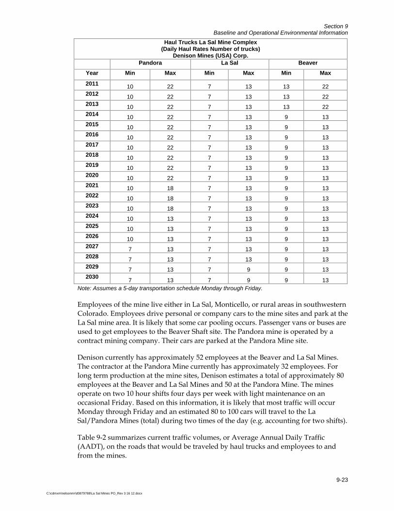
Section 9 Baseline and Operational Environmental Information
9-23
C:\cdmxm\nelsonmr\d0879788\La Sal Mines PO_Rev 3 16 12.docx
Haul Trucks La Sal Mine Complex(Daily Haul Rates Number of trucks)
Denison Mines (USA) Corp. Pandora La Sal Beaver
Year Min Max Min Max Min Max
2011 10 22 7 13 13 22 2012 10 22 7 13 13 22 2013 10 22 7 13 13 22 2014 10 22 7 13 9 13 2015 10 22 7 13 9 13 2016 10 22 7 13 9 13 2017 10 22 7 13 9 13 2018 10 22 7 13 9 13 2019 10 22 7 13 9 13 2020 10 22 7 13 9 13 2021 10 18 7 13 9 13 2022 10 18 7 13 9 13 2023 10 18 7 13 9 13 2024 10 13 7 13 9 13 2025 10 13 7 13 9 13 2026 10 13 7 13 9 13 2027 7 13 7 13 9 13 2028 7 13 7 13 9 13 2029 7 13 7 9 9 13 2030
7 13 7 9 9 13 Note: Assumes a 5-day transportation schedule Monday through Friday.
Employees of the mine live either in La Sal, Monticello, or rural areas in southwestern Colorado. Employees drive personal or company cars to the mine sites and park at the La Sal mine area. It is likely that some car pooling occurs. Passenger vans or buses are used to get employees to the Beaver Shaft site. The Pandora mine is operated by a contract mining company. Their cars are parked at the Pandora Mine site.
Denison currently has approximately 52 employees at the Beaver and La Sal Mines. The contractor at the Pandora Mine currently has approximately 32 employees. For long term production at the mine sites, Denison estimates a total of approximately 80 employees at the Beaver and La Sal Mines and 50 at the Pandora Mine. The mines operate on two 10 hour shifts four days per week with light maintenance on an occasional Friday. Based on this information, it is likely that most traffic will occur Monday through Friday and an estimated 80 to 100 cars will travel to the La Sal/Pandora Mines (total) during two times of the day (e.g. accounting for two shifts).
Table 9-2 summarizes current traffic volumes, or Average Annual Daily Traffic (AADT), on the roads that would be traveled by haul trucks and employees to and from the mines.
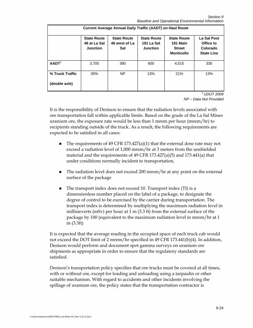
Section 9 Baseline and Operational Environmental Information
9-24
C:\cdmxm\nelsonmr\d0879788\La Sal Mines PO_Rev 3 16 12.docx
Current Average Annual Daily Traffic (AADT) on Haul Route
State Route 46 at La Sal
Junction
State Route 46 west of La
Sal
State Route 191 La Sal Junction
State Route 191 Main
Street Monticello
La Sal Post Office to Colorado State Line
AADT1 3,705 380 600 4,515 335
% Truck Traffic
(double axle)
35% NP 13% 21% 13%
1 UDOT 2009 NP – Data Not Provided
It is the responsibility of Denison to ensure that the radiation levels associated with ore transportation fall within applicable limits. Based on the grade of the La Sal Mines uranium ore, the exposure rate would be less than 1 mrem per hour (mrem/hr) to recipients standing outside of the truck. As a result, the following requirements are expected to be satisfied in all cases:
The requirements of 49 CFR 173.427(a)(1) that the external dose rate may not exceed a radiation level of 1,000 mrem/hr at 3 meters from the unshielded material and the requirements of 49 CFR 173.427(a)(5) and 173.441(a) that under conditions normally incident to transportation,
The radiation level does not exceed 200 mrem/hr at any point on the external surface of the package
The transport index does not exceed 10. Transport index (TI) is a dimensionless number placed on the label of a package, to designate the degree of control to be exercised by the carrier during transportation. The transport index is determined by multiplying the maximum radiation level in millisieverts (mSv) per hour at 1 m (3.3 ft) from the external surface of the package by 100 (equivalent to the maximum radiation level in mrem/hr at 1 m (3.3ft)
It is expected that the average reading in the occupied space of each truck cab would not exceed the DOT limit of 2 mrem/hr specified in 49 CFR 173.441(b)(4). In addition, Denison would perform and document spot gamma surveys on uranium ore shipments as appropriate in order to ensure that the regulatory standards are satisfied.
Denison’s transportation policy specifies that ore trucks must be covered at all times, with or without ore, except for loading and unloading using a tarpaulin or other suitable mechanism. With regard to accidents and other incidents involving the spillage of uranium ore, the policy states that the transportation contractor is
Section 9 Baseline and Operational Environmental Information
9-25
C:\cdmxm\nelsonmr\d0879788\La Sal Mines PO_Rev 3 16 12.docx
responsible for handling the accident and that the contractor must have an Emergency Response Plan in case of emergency (Denison Mines [USA] Corp. 2007).
In section 5.2.1.4, the DOE Programmatic EA contained two studies on the potential radiation exposure to the public from radiological truck accidents on land. The analysis for a rural area assumed an individual resident located 33 feet from the accident. Under the conditions specified in section 5.2.1.4 of the DOE EA, the individual would receive a radiation dose of 4.9 mrem/hr, which equates to about 3 chances in 1 million of a latent cancer fatality. In a more populated area, the collective population would receive a collective dose that would equal about 6 chances in 1 million of a latent cancer fatality. The EA also contained a scenario in which the uranium ore was spilled in a river during low flow conditions. The calculated conclusion was that a spill, followed by immediate clean-up, would not perceptibly increase the uranium concentration in the rivers.
For more details, refer to Section 4.3 of the DOE Programmatic EA for its Uranium Leasing Program (DOE 2007).

10-1
C:\cdmxm\nelsonmr\d0879788\La Sal Mines PO_Rev 3 16 12.docx
Section 10 Period of Use/Occupancy for Surface Facilities The Surface Resources Act of July 23, 1955, and associated regulations at 43 CFR 3715 authorize surface occupancy of unpatented mining claims for ‘‘prospecting, mining, or processing operations and uses reasonably incident thereto’’. Denison activities at the La Sal Mines Complex are focused on prospecting and mining. Mineral processing is not conducted at the La Sal Mines Complex. Denison also conducts activities that are reasonably incident to prospecting and mining such as operation of surface support facilities for underground mining operations.
Denison’s existing occupancy of BLM land is in accordance with 43 CFR 3715.2 and meets the following requirements:
(a) Be reasonably incident;
(b) Constitute substantially regular work;
(c) Be reasonably calculated to lead to the extraction and beneficiation of minerals;
(d) Involve observable on-the-ground activity that BLM may verify under §3715.7; and
(e) Use appropriate equipment that is presently operable, subject to the need for reasonable assembly, maintenance, repair or fabrication of replacement parts.
Surface occupancy in association with prospecting, mining and reasonably incident uses will continue for the life of the mine complex. The current life of the mine is estimated at 20 years; however, results of future exploration, market conditions, and other factors may extend the life of the mine. Depending on market conditions and production rates, Phase 1 is expected to start at the beginning of 2011 and extend over a 3-year period until the end of 2013. Phase 2 and Phase 3 have the potential to extend the mine life to approximately 20 years.
Unnecessary or undue degradation of the public lands and resources will be prevented or avoided in all uses and occupancies. Use and occupancy conforms to all applicable Federal and State environmental standards and all required permits have been obtained, as required under 43 CFR 3800. All permanent and temporary structures on public lands conform with applicable State and local building, fire, and electrical codes and occupational safety and health and mine safety standards.
11-1
C:\cdmxm\nelsonmr\d0879788\La Sal Mines PO_Rev 3 16 12.docx
Section 11 References CDM 2009a. Evaluation of Development Rock Piles at the La Sal Mines Complex, San Juan County, Utah. October. CDM 2009b. Hydrogeologic Evaluation of the Denison Mines (USA) Corp. La Sal Mines Complex, San Jan County, Utah. October. City Data. 2009. San Juan County, Utah. Accessed in November. On-line Address: http://www.city-data.com/county/San_Juan_County-UT.html. Denison Mines (USA) Corp. 2007. Transportation Policy for Shipments of Colorado Plateau Uranium Ores to the White Mesa Uranium Mill. Fayer, M.J. 2000. UNSAT-h Version 3.0: Unsaturated Soil Water and Heat Flow Model Theory, User Manual, and Examples. http://www.pnl.gov/main/publications/external/technical_reports/PNNL-13249.pdf
Lowe, M., 1996. Ground-Water Resources of San Juan County, in Huffman, A.C., Lund, W.R., and Goodwin, L.H. eds., 1996, Geology and Resources of the Paradox Basin: Utah Geological Association Guidebook 25, p. 389-394. Natural Resources Conservation Service (NRCS) 2009. Soil Survey Staff, Natural Resources Conservation Service, United States Department of Agriculture. Web Soil Survey. Available online at http://websoilsurvey.nrcs.usda.gov/ accessed [09/22/2009]. SWCA Environmental Consultants (SWCA) 2009a. Biological Survey Report, Pandora 2009 Project Waste Rock Area Expansion, San Juan County, Utah. July. SWCA 2009b. A Class III Cultural Resource Inventory of the Pandora 2009 Project, Waste Rock Area Expansion, San Juan County, Utah. July. SWCA 2009c. A Class III Cultural Resource Inventory of the Pandora 2009 Project, Exploration and Vents, USDA Forest Service Jurisdiction, San Juan County, Utah. July. SWCA 2009d. Paleontological Resources Reconnaissance Letter Report. Letter to Rebecca Doolittle of BLM and Joel Nowak of USFS. July 20. Swanson, D.A., Savci, G., Danziger, G., Williamson, A., Barnes, C. 2000. Unsaturated Hydrologic Assessment of Waste Rock Stockpiles in Semi-Arid Climates, in Semi-Arid Mine Waste Issues, ICARD 2000-Proceedings from the 5th International Conference on Acid Mine Drainage.

Section 11 References
11-2
C:\cdmxm\nelsonmr\d0879788\La Sal Mines PO_Rev 3 16 12.docx
U.S. Census Bureau (USCB). 2000. United States Census. http://www.census.gov/main/www/cen2000.html U.S. Bureau of Land Management (BLM). 2004. Risk Management Criteria for Metals at BLM Mining Sites. Technical Note 390 Rev. October.
U.S. Department of Energy. (DOE). 2007. Uranium Leasing Program Final Programmatic Environmental Assessment. Office of Legacy Management. DOE/EA-1535. July. U.S. Environmental Protection Agency (EPA). 2008. EPA Region 9, Regional Screening Levels. See http://www.epa.gov/region09/superfund/prg/.
United States Geological Survey (USGS) National Gap Analysis Program. 2004. Provisional Digital Land Cover Map for the Southwestern United States. Version 1.0. RS/GIS Laboratory, College of Natural Resources, Utah State University. Utah Department of Transportation (UDOT) 2009. 2008 Annual Average Daily Traffic. Accessed in November. On-line Address: http://www.udot.utah.gov, click on Traffic Statistics. Weir, James E.; Maxfield, E. Blair; Zimmerman; Everett A. 1983. Regional Hydrology of the Dolores River Basin, Eastern Paradox Basin, Colorado and Utah. USGS Water-Resources Investigations Report 83-4217.