Plan Melbourne 2017-2050 DRAFT INNER METRO LAND USE ...
18
Plan Melbourne 2017-2050 DRAFT INNER METRO LAND USE FRAMEWORK PLAN SUMMARY
Transcript of Plan Melbourne 2017-2050 DRAFT INNER METRO LAND USE ...

Plan Melbourne 2017-2050 D R A F T I N N E R M E T R O L A N D U S E F R A M E W O R K P L A N SUMMARY

D R A F T I N N E R M E T R O L A N D U S E F R A M E W O R K P L A N - S U M M A R Y
Photo credit: Department of Jobs, Precincts and Regions/ Lynton Crabb

01D R A F T I N N E R M E T R O L A N D U S E F R A M E W O R K P L A N - S U M M A R Y
Great cities aren’t born. They’re made.
Melbourne is a great city. It’s a great place to live, work and raise a family. It’s a great place for investment and creativity. It’s a great place to visit and enjoy.
The Victorian Government has developed land use framework plans for each of the six metropolitan regions that are all about ensuring Melbourne remains a great city as it grows.
These plans mark a new era in the planning of Melbourne, building on the efforts of generations of Victorians to shape the way land is used around Port Phillip Bay.
The Inner Metro Land Use Framework Plan is a 30-year strategy for action across three local government areas – Melbourne, Port Phillip and Yarra.
It’s about making the long-term plans and investments that protect and enhance local areas
and communities while ensuring Melbourne’s inner city grows more prosperous, liveable, affordable and sustainable.
The Inner Metro Land Use Framework Plan is also about maximising the social, economic and environmental benefits of transformational city-shaping investments such as:
• Metro Tunnel, West Gate Tunnel, Melbourne Airport Rail, North East Link and Suburban Rail Loop
• Major urban renewal projects in Arden, E-Gate, Fishermans Bend and Macaulay
• Parkville and Fishermans Bend National Employment and Innovation Clusters (NEICs).
This plan is all about keeping inner Melbourne marvellous – from its parks and laneways to its rivers and bayside beaches to its innovative industries and dynamic culture. It’s also about building the best possible future for the booming population of the Inner Metro region, which is projected to almost double by 2051.
Photo credit: Department of Jobs, Precincts and Regions/ Lynton Crabb
02 D R A F T I N N E R M E T R O L A N D U S E F R A M E W O R K P L A N - S U M M A R Y
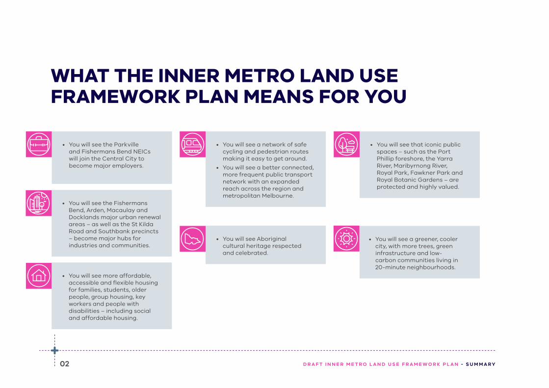
• You will see the Parkville and Fishermans Bend NEICs will join the Central City to become major employers.
• You will see the Fishermans Bend, Arden, Macaulay and Docklands major urban renewal areas – as well as the St Kilda Road and Southbank precincts – become major hubs for industries and communities.
• You will see a network of safe cycling and pedestrian routes making it easy to get around.
• You will see a better connected, more frequent public transport network with an expanded reach across the region and metropolitan Melbourne.
• You will see that iconic public spaces – such as the Port Phillip foreshore, the Yarra River, Maribyrnong River, Royal Park, Fawkner Park and Royal Botanic Gardens – are protected and highly valued.
• You will see Aboriginal cultural heritage respected and celebrated.
• You will see a greener, cooler city, with more trees, green infrastructure and low-carbon communities living in 20-minute neighbourhoods.
WHAT THE INNER METRO LAND USE FRAMEWORK PLAN MEANS FOR YOU
• You will see more affordable, accessible and flexible housing for families, students, older people, group housing, key workers and people with disabilities – including social and affordable housing.
Port of Melbourne
Port of Melbourne
Station Pier
")2
1
Epworth
Hospital
St Vincent's Hospital
& Australian Catholic
University Precinct
Parkville Medical,
Bioscience and
Education Precinct
Alfred Medical
Research & Education
Precinct
Balaclava
St Kilda
Port Melbourne-Bay Street
SouthMelbourne
Richmond-Swan Street
Richmond-Bridge Road
Richmond-Victoria Street
Fitzroy-Smith StreetCarlton -
Lygon Street
Fitzroy-Brunswick Street
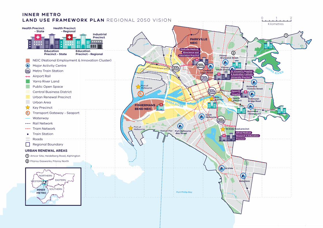
PARKVILLENEIC
FISHERMANSBEND NEIC
Cit
y L
ink
Eastern Freeway
Westgate Freeway
Port Phillip Bay
YARRARI VER
YARRA RIVER
NEIC (National Employment & Innovation Cluster)
Major Activity Centre
Metro Train Station
Airport Rail
Yarra River Land
Public Open Space
Central Business District
Urban Renewal Precinct
Urban Area
Key Precinct
Transport Gateway - Seaport
Waterway
Rail Network
Tram Network
Train Station
Roads
Regional Boundary
St Kilda Road precinct
Arts precinct
Sportsprecinct
I N N E R M E T R O L A N D U S E F R A M E W O R K P L A N R E G I O NA L 2 0 5 0 V I S I O N
1
2
URBAN RENEWAL AREASAmcor Site, Heidelberg Road, Alphington
Fitzroy Gasworks, Fitzroy North
Education Precinct - Regional
Education Precinct - State
IndustrialPrecinct
Health Precinct- Regional
Health Precinct- State
0 1 2
Kilometres
EASTERN
SOUTHERNINNER METRO
NORTHERN
WESTERN
04 D R A F T I N N E R M E T R O L A N D U S E F R A M E W O R K P L A N - S U M M A R Y
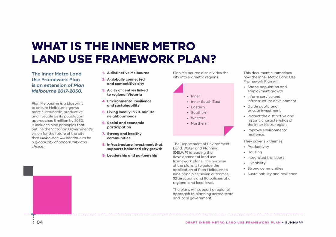
WHAT IS THE INNER METRO LAND USE FRAMEWORK PLAN? The Inner Metro Land Use Framework Plan is an extension of Plan Melbourne 2017-2050.
Plan Melbourne is a blueprint to ensure Melbourne grows more sustainable, productive and liveable as its population approaches 8 million by 2050. It includes nine principles that outline the Victorian Government’s vision for the future of the city that Melbourne will continue to be a global city of opportunity and choice.
1. A distinctive Melbourne
2. A globally connected and competitive city
3. A city of centres linked to regional Victoria
4. Environmental resilience and sustainability
5. Living locally in 20-minute neighbourhoods
6. Social and economic participation
7. Strong and healthy communities
8. Infrastructure investment that supports balanced city growth
9. Leadership and partnership
Plan Melbourne also divides the city into six metro regions:
• Inner
• Inner South East
• Eastern
• Southern
• Western
• Northern
The Department of Environment, Land, Water and Planning (DELWP) is leading the development of land use framework plans. The purpose of the plans is to guide the application of Plan Melbourne’s nine principles, seven outcomes, 32 directions and 90 policies at a regional and local level.
The plans will support a regional approach to planning across state and local government.
This document summarises how the Inner Metro Land Use Framework Plan will:
• Shape population and employment growth
• Inform service and infrastructure development
• Guide public and private investment
• Protect the distinctive and historic characteristics of the Inner Metro region
• Improve environmental resilience.
They cover six themes:
• Productivity
• Housing
• Integrated transport
• Liveability
• Strong communities
• Sustainability and resilience.
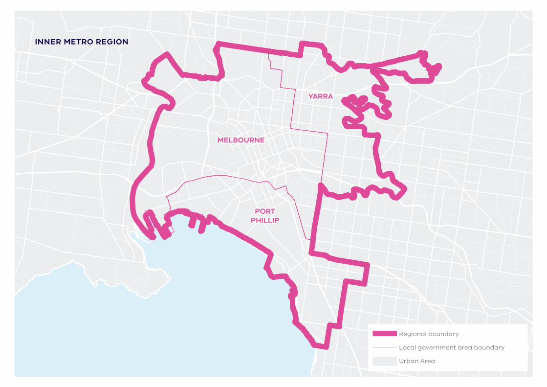
YARRA
MELBOURNE
PORTPHILLIP
Regional boundary
Local government area boundary
Urban Area
INNER METRO REGION

06 D R A F T I N N E R M E T R O L A N D U S E F R A M E W O R K P L A N - S U M M A R Y
Geographicallyits footprint covers just 0.9 per cent of metropolitan Melbourne, with 460 hectares zoned for industrial use and 1158 hectares zoned for commercial use.
Demographicallyalmost 8 per cent of Melburnians, more than 400,000 people, live in the region.
Economicallyit generates $117 billion a year in economic activity and employs 682,800 people, accounting for 30 per cent of metropolitan Melbourne’s employment.
Environmentallyit has 6.3 per cent of metropolitan Melbourne’s open space and 12.6 per cent urban tree canopy cover.
The Wurundjeri Woi Wurrung and Bunurong peoples of the Kulin Nation are Traditional Owners of the Inner Metro region.
The Inner Metro region is home to the largest concentration of jobs across metropolitan Melbourne. It is the research and knowledge capital of Australia. It is a leading location for biomedical, education, health, research, professional and technical industries. It is becoming a leading location for innovation in design, engineering and advanced manufacturing services. It has several emerging enterprise precincts. It has major urban renewal precincts. And it is internationally recognised as a tourism and major events destination.
On Port Phillip Bay, it extends from the mouth of the Yarra River to the beaches of Elwood. Around the Central City it takes in most of Melbourne’s oldest
settlements, from its first street (Flinders) to its first suburb (Fitzroy), as well as a world-class cluster of cultural, sporting, industrial, recreational and educational precincts that ring the original grid layout of the Central Business District.
As the centre of one of the world’s greatest Victorian-era cities, its streetscape has extensive heritage buildings and gardens, including the World Heritage-listed Royal Exhibition Building and Carlton Gardens.
Urban areas include:
• Melbourne’s Central Business District, on the northern side of the Yarra River
• Historic inner suburbs such as Collingwood, Carlton, Richmond, East Melbourne and North Melbourne
• Major urban renewal precincts such as Fishermans Bend, Arden and Docklands
• Historic suburbs by the bay and Albert Park Lake such as South Melbourne, St Kilda and Elsternwick
• Large established inner-city parklands and significant recreation facilities, including the Royal Botanic Gardens, Flemington Racecourse, Melbourne Cricket Ground and Marvel Stadium in Docklands
• The underground City Loop rail system, major transport interchanges such as Flinders Street, Southern Cross and Richmond stations and the radial rail network to all metropolitan regions
• West Gate Bridge, the Bolte Bridge and the Burnley and Domain tunnels and freeway network
• Port of Melbourne and Coode Island.
By 2051, the Inner Metro region’s population is projected to nearly double from around 403,000 to 746,000 – and the number of dwellings is projected to more than double from 177,670 in 2016 to 402,750 in 2051. By 2031, employment is projected to increase by 280,000 jobs and an additional 4 million square metres of commercial floorspace will be needed.
ABOUT THE INNER METRO REGION

Future/ProjectedNow/Current
I N N E R M E T R O R E G I O N - R E G I O N A L S N A P S H O T
AVERAGE LAND SURFACE TEMPERATURE5
INNERMETRO REGION
METRO MELBOURNE
2018
33.2ºC
33.9ºC
EMISSIONSSCENARIO6
HIGH
MEDIUM +0.6˚C TO +2.1˚C
+1.1˚C TO +2.9˚C
+0.7˚C TO +2.7˚C
+1.3˚C TO +3.3˚C
INNERMETRO REGION
METRO MELBOURNE
PROJECTED INCREASETO AVERAGE DAILY
MAXIMUM TEMPERATURE6
2050
(1) Australian Bureau of Statistics (2021) Regional Population 2019-20 financial year, Commonwealth of Australia, Canberra, Australia.(2) Department of Environment, Land, Water and Planning (2019) Victoria in Future 2019, Department of Environment, Land, Water and Planning, Melbourne, Australia..(3) Australian Bureau of Statistics (2016) Census of Population and Housing, Commonwealth of Australia, Canberra, Australia.(4) Department of Environment, Land, Water and Planning (2020) Melbourne Industrial and Commercial Land Use Plan, State of Victoria, Melbourne, Australia.(5) Department of Environment, Land, Water and Planning (2018) Land Surface Temperature Data, State of Victoria, Melbourne, Australia.(6) Clarke JM, Grose M, Thatcher M, Hernaman V, Heady C, Round V, Rafter T, Trenham C & Wilson L. (2019). Victorian Climate Projections 2019 Technical Report, CSIRO, Melbourne, Australia.
2020 2051
2016
2016
POPULATION1,2
AGE STRUCTURE 1,2
HOUSEHOLD STRUCTURE 2,3
403,360 746,150
30,100 48,350
61,940 142,610
44,740 101,530
31,430 81,000
AGES 0-14
AGES 15-29
AGES 30-44
AGES 45-59
GROUPS/OTHER HOUSEHOLDS
LONE PERSONS
COUPLES WITHOUT CHILDREN
FAMILIES WITH CHILDREN
AGES 60-74
AGES 75+
10%
35%
28%
14%
10%
24%
28%
21%
11%
6%
9%
4%
2051
2051
HOUSING (NO. OF DWELLINGS)1 402,750177,670
2016 2031
EMPLOYMENT & ECONOMY (NO. OF JOBS)3 962,800682,800
2016 2051
* 2050 temperature change projections depend on future levels of global greenhouse gas emissions, with a 'high emissions scenario' resulting in a range of hotter temperatures than a 'medium emissions scenario’

08 D R A F T I N N E R M E T R O L A N D U S E F R A M E W O R K P L A N - S U M M A R Y
Socially – bring jobs, services and leisure opportunities closer to where people live.
Economically – reduce transport congestion, boost productivity and create jobs.
Environmentally – cut commuting times, reduce transport emissions, promote public and active transport use, and create 20-minute neighbourhoods.
The Victorian Government is currently implementing the largest transport infrastructure program in the state’s history.
City-shaping projects include:
• The West Gate Tunnel – creating a second river crossing to link the Western Metro region with the Port of Melbourne, CityLink and the CBD, and take traffic pressures off the West Gate Bridge
• Metro Tunnel – linking Melbourne’s south-east and Gippsland to the Sunbury line in Melbourne’s west and north-west
• North East Link – connecting Melbourne’s south-east to the Eastern Freeway, the Western Ring Road and Hume Freeway
• Melbourne Airport Rail – connecting Melbourne Airport to Victoria’s regional and metropolitan train network
• Suburban Rail Loop – connecting every major passenger railway line in Melbourne from the Frankston line in the south to the Werribee line in the west.
These city-shaping projects will improve access to jobs, education and social opportunities for residents in the Inner Metro region by better connecting the region with other areas of Melbourne and Victoria. They will create opportunities to maximise social, economic and environmental benefits.
CITY-SHAPING PROJECTS
09D R A F T I N N E R M E T R O L A N D U S E F R A M E W O R K P L A N - S U M M A R Y
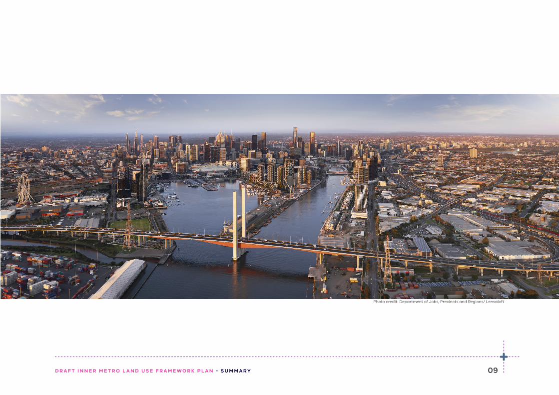
Photo credit: Department of Jobs, Precincts and Regions/ Lensaloft

10 D R A F T I N N E R M E T R O L A N D U S E F R A M E W O R K P L A N - S U M M A R Y
INNER METRO REGION STRENGTHS AND CHALLENGES
ProductivityThe Central City is a location of state-significance and a focal point for business and commerce. The region is internationally recognised as a destination for tourism and major events, and a magnet for creativity and culture, research and innovation. The fundamental challenge it faces is to manage demand and balance the needs of residents, workers and visitors. To achieve that balance, infrastructure and services need to stay ahead of demand and planning must include generational changes in demography, environment and technology. With smart planning and investments, the Inner Metro region can grow more accessible, liveable and sustainable.
Housing ChoiceThe Arden, E-Gate, Fishermans Bend and Macaulay major urban renewal precincts cover more than 630 hectares. These precincts are all on the doorstep of the Melbourne CBD – creating unique opportunities to not just create new neighbourhoods and industries, but new benchmarks for sustainable urban design. The challenge will be to connect new and established inner-city communities and to ensure that housing is affordable and accessible – and designed to cope with everything from climate change to working from home to an ageing population.
Integrated TransportThe Inner Metro region already has strong public and active transport networks – and will benefit from transformational projects like the Metro Tunnel. Key issues include improving public and active transport connections, managing freight volumes and improving pedestrian and cyclist safety.

11D R A F T I N N E R M E T R O L A N D U S E F R A M E W O R K P L A N - S U M M A R Y
LiveabilityThe Inner Metro region is one of the reasons why Melbourne is one of the world’s most liveable cities. It has magnificent parks and waterways and a wealth of heritage buildings dating from the gold rush. And it is the national capital of culture, entertainment and events. But as its population grows the region must invest in smart design and ensure its heritage and liveability are protected.
Strong CommunitiesEstablished local communities have access to everything they need in the Inner Metro region, which is well placed for services, infrastructure and open space. But social infrastructure must keep up with the needs of a growing population and the new communities that will be created in urban renewal precincts.
Sustainability and ResilienceThe region’s tree canopy is relatively high, but needs to be expanded to reduce heat stress – particularly in urban renewal precincts and new developments. Climate change is also bringing an increased risk of flood events, storm surge, coastal inundation and sea level rise.

12 D R A F T I N N E R M E T R O L A N D U S E F R A M E W O R K P L A N - S U M M A R Y
Productivity • Plan for the Central City’s
future as Australia’s premier commercial centre – ensuring a supply of affordable and diverse workplaces; balancing the needs of industry and commerce with residential development; and continuing to develop cultural, sport, entertainment and recreational industries.
• Develop the Parkville and Fishermans Bend NEICs – with Parkville becoming a premier location for biomedicine, education, health, research, professional and technical industries and Fishermans Bend a centre for innovation in design, the creative industries and advanced manufacturing.
• Develop activity centres and alternative enterprise precincts in places like Cremorne, South Melbourne, Arden and Collingwood – creating a diversity of industry, employment and activity choices for start-ups, small businesses and visitors.
• Prioritise design and public space across the Inner Metro region – including urban renewal areas, employment and enterprise precincts, and activity centres.
• Protect the operations of the Port of Melbourne – and shift more freight movements from road to rail.
Housing choice • Secure a 15-year supply of
housing across the Inner Metro region, including the Central City.
• Ensure new housing is well-designed, high-quality, climate change resilient and in keeping with neighbourhood character.
• Deliver a pipeline of social and affordable housing near jobs, transport and services – and deliver student and key-worker accommodation close to education and health precincts.
• Develop a mix of medium- and higher-density dwellings suitable for singles, older residents and families – and facilitate alternative developments such as co-housing, build-to-rent and car-free housing.
PLANNING FOR THE INNER METRO REGION
Photo credit: Steven Crabtree

13D R A F T I N N E R M E T R O L A N D U S E F R A M E W O R K P L A N - S U M M A R Y
Integrated Transport • Ensure major road and rail
projects include public and active transport improvements and connections.
• Improve public transport and walking and bike paths to, from and through the region, including: from the inner west to the CBD and Fishermans Bend; across the Yarra River, orbitally within the region; between major activity centres and regionally-significant places; and for the Parkville and Fishermans Bend NEICs, major urban renewal precincts and enterprise precincts.
• Enhance public transport coverage, frequency and capacity – investing in public transport in the early stages of NEICs and urban renewal developments.
• Ensure transport infrastructure projects consider the impacts of last-kilometre freight movements.
Liveability• Work with Traditional Owners
to ensure incorporate cultural heritage, design and stories into the built environment – and protect heritage places, precincts and streetscapes.
• Create new open spaces within large development sites and urban renewal precincts and prioritise pedestrian movement in activity centres and employment precincts.
• Ensure public realm design in night-time precincts promotes safety and amenity.
• Reinvigorate and restore urban waterways.

14 D R A F T I N N E R M E T R O L A N D U S E F R A M E W O R K P L A N - S U M M A R Y
Strong Communities
• Invest in better social infrastructure. That means building libraries and community and recreation facilities that can be easily accessed and used by a wide range of people and groups – day and night, seven days a week.
• Invest in health and education facilities. That means ensuring facilities are located near activity centres and major urban renewal precincts and accessible by public transport, walking and cycling.
• Build 20-minute neighbourhoods around existing activity centres and ensure urban renewal precincts and major transport infrastructure projects are developed as 20-minute neighbourhoods.

15D R A F T I N N E R M E T R O L A N D U S E F R A M E W O R K P L A N - S U M M A R Y
Sustainability and Resilience• Outdoor spaces need to
be usable all year round – including summer. That is why the tree canopy must be increased across the region.
• Floodplain management is a challenge and an opportunity. Stormwater can be harvested and reused to irrigate the region’s increased tree canopy – and reduce the risk of floods.
• Plan for sea level rises in coastal environments, prepare local communities and limit land use change in places vulnerable to coastal inundation.
Photo credit: Department of Jobs Precincts and Regions

ISBN 978-1-76105-650-5 (pdf/online/MS word)
Submissions can be made online at engage.vic.gov.au
For any questions or assistance please contact [email protected]