PLA C A R D 1: A PPA L A C HI A N MO UN TA I N S
8
PLACARD 1: APPALACHIAN MOUNTAINS MOUNTAIN: PROBLEM: CHALLENGE: The range is mostly located in the United States but extends into southeastern Canada, forming a zone from 100 to 300 mi (160 to 480 km) wide, running from the island of Newfoundland Central Alabama in the United States. The highest mountain in the Appalachians is Mount Mitchell in North Carolina at 6,684 feet (2,037 m), which is the highest point in the United States east of the Mississippi River. Explosives and giant machines are destroying Appalachian peaks to obtain coal. Since the mid-1990s, coal companies have pulverized Appalachian mountaintops in West Virginia, Kentucky, Virginia and Tennessee. Peaks formed hundreds of millions of years ago are obliterated in months. Forests that survived the last ice age are chopped down and burned. The Environmental Protection Agency estimates that by 2012, two decades of mountaintop removal will have destroyed or degraded 11.5 percent of the forests in those four states, an area larger than Delaware. Rubble and waste will have buried more than 1,000 miles of streams. Read the rest of this article on mining in the Appalachians: http://www.smithsonianmag.com/ecoce nter-energy/mining-the-mountains-130 454620/?no-ist 1. Create an alternative way to maintain the important coaling industry without destroying ecosystems and land. 2. Find a way to boost tourism in the surrounding area of West Virginia to help local towns with an alternative source of income.
Transcript of PLA C A R D 1: A PPA L A C HI A N MO UN TA I N S

PLACARD 1: APPALACHIAN MOUNTAINS
MOUNTAIN: PROBLEM: CHALLENGE:
The range is mostly located in the United States but extends into southeastern Canada, forming a zone from 100 to 300 mi (160 to 480 km) wide, running from the island of Newfoundland Central Alabama in the United States. The highest mountain in the Appalachians is Mount Mitchell in North Carolina at 6,684 feet (2,037 m), which is the highest point in the United States east of the Mississippi River.
Explosives and giant machines are destroying Appalachian peaks to obtain coal. Since the mid-1990s, coal companies have pulverized Appalachian mountaintops in West Virginia, Kentucky, Virginia and Tennessee. Peaks formed hundreds of millions of years ago are obliterated in months. Forests that survived the last ice age are chopped down and burned. The Environmental Protection Agency estimates that by 2012, two decades of mountaintop removal will have destroyed or degraded 11.5 percent of the forests in those four states, an area larger than Delaware. Rubble and waste will have buried more than 1,000 miles of streams. Read the rest of this article on mining in the Appalachians: http://www.smithsonianmag.com/ecocenter-energy/mining-the-mountains-130454620/?no-ist
1. Create an alternative way to maintain the important coaling industry without destroying ecosystems and land. 2. Find a way to boost tourism in the surrounding area of West Virginia to help local towns with an alternative source of income.

PLACARD 2: MT. NIMBA
MOUNTAIN: PROBLEM: CHALLENGE: The Nimba mountain range is a 40 km-long narrow ridge running southwest to northeast along Guinea’s border. The range has many valleys, plateaus, rounded hilltops, rocky peaks, abrupt cliffs, waterfalls, and bare granite blocks. The Nimba mountain range includes the strict nature reserve, which is an important water tower with about fifty springs between Guinea and Côte d'Ivoire. Mount Richard-Molard is the highest peak at 1,752 m (5,750 ft), and is the second highest point in West Africa, west of the country of Cameroon.
The animals that live in the Nimba mountain ranges are being poached like the viviparous toad and chimpanzees that use stones as tools. The need for farm land and cattle breeding has strengthened the need to clear land by fire. These fires occur regularly in protected areas.
HELPFUL LINKS: http://whc.unesco.org/en/list/155/gallery/ http://apes.eva.mpg.de/apeswiki/index.php/Mount_Nimba_Strict_Nature_Reserve#Conservation_activities
1. Create a way that the local government and preservation groups can involve local communities to help preserve and take care of the endangered areas as well as take care of them.
2. Create a reliable system of surveillance for the property to help combat illegal and destructive activity.
3. Help management authorities with technical and human resource support to maintain areas in trouble and help find a way to help management financially.

PLACARD 3: SICHUAN PROVINCE
Between the Himalayas and the Daba Mountains
MOUNTAIN: PROBLEM: CHALLENGE: Sichuan consists of two geographically very distinct parts. The eastern part of the province is mostly within the fertile Sichuan basin. The western Sichuan consists of the numerous mountain ranges forming the easternmost part of the Qinghai-Tibet Plateau, which are known as the Hengduan Mountains. One of these ranges, Daxue Mountains, contains the highest point of the province Gongga Shan at 7,556 metres (24,790 ft) above sea level.
Lesser mountain ranges surround the Sichuan Basin from north, east, and south. Among them are the Daba Mountains.
Children in the Sichuan province in Zhaojue county are forced to take seventeen separate ladders totaling a climb of almost 2500 feet up a mountain cliff to school. In addition to the safety issue of the children adults who work as traders are negatively affected as well. These traders are taken advantage of because buyers know they are unable to carry unsold produce back up the cliff. (NBC News)
Read the following article: http://www.nbcnews.com/news/china/chinese-students-climb-2000-foot-bamboo-ladder-get-school-n581596
1. Help the students figure out a safer way to climb the mountain to school.
2. Create a way traders can transport their goods back down the cliff so they are not taken advantage of when trading goods.
3. Create a way to bring attention and awareness to the students in order to raise funds to help the province create a safer way to get to school.

PLACARD 4: SWISS ALPS
MOUNTAIN: PROBLEM: CHALLENGE: The Alps is a range of mountains that form a crescent shape in Europe that covers a distance of 1,200 km (750 miles). The Alps can be found in Austria, Italy, Slovenia, Germany, France, Switzerland, Liechtenstein, and Monaco. The Alps is the home of many glaciers which provides water that those in the region drink; use for irrigation purposes; and create hydroelectric power in over 500 power plants that can produce up to 2900 kilowatts of electricity per hour.
Shorter ski seasons at lower elevations, millions of tourists and their vehicles are adding to already heavy commercial traffic, causing dangerous air pollution levels in many alpine valleys. In addition, the threat of water pollution stemming from development of all kinds—including mass tourism—is growing in the Alps.
The growing tourism, the UN reported, has created a shift of Alpine communities from farming economies to tourism economies. This can cause a problem in Alpine communities. Farming combats soil erosion and landslides. Neglecting farming can be detrimental to the landscape and contribute to landscape degradation. (National Geographic)
Resources to use: http://news.nationalgeographic.com/news/2002/02/0201_020201_wiremountain_2.html
1. Create a way that Alpine communities can educate or inform tourists of the dangers of pollution in the Alps.
2. Create a way to stem the
abandonment of farming economies in favor of tourism. Try to develop a way that communities can have both.
3. Create a way to cut back on the heavy commercial traffic in the alps in order to combat the air pollution and traffic congestion in these areas.

PLACARD 5: THE HIMALAYAS
MOUNTAIN: PROBLEM: CHALLENGE: The Himalayas cover approximately 1,500 mi (2,400 km) and pass through the nations of India, Pakistan, Afghanistan, China, Bhutan and Nepal. Mount Everest at 29,029 ft. (8,848 m) is not only the highest peak in the Himalayas, but the highest peak on the entire planet. Another famous peak is Karakora (K2). The Himalayas provide a water resource for billions. The main rivers that start in the Himalayas are the Ganges, Indus, Yangtze, Yellow, Mekong, and Nujiang. The Himalayas also have glaciers. They contain the third largest deposit of ice and snow in the world, after Antarctica and the Arctic. There are approximately 15,000 glaciers located throughout the range.
In the Himalaya-Karakorum-Hindu Kush range, massive road-building in the mountains in the last few decades has given loggers and others access to previously remote areas. According to the UN report, increased deforestation is a major source of deteriorating environmental conditions in many areas of the Himalaya, along with activities such as overgrazing, accidental forest fires, and rock quarrying.
The Himalayas also provide drinking water. For millions of people. More than half a billion people depend on water supplied by rivers that include the Indus and Ganges, which start in the Himalayas. The wetlands in these mountains that provide so much water are being ruined. (UNESCO)
Resource to help you:
http://news.nationalgeographic.com/news/2002/02/0201_020201_wiremountain_2.html
1.Create a presentation for logging companies to educate them on the destructiveness of their logging. 2. Create a way to educate and enlist help from people who use the Ganges and Indus rivers as a water source to help in the education of water pollution and how detrimental it is. 3. Create a way to convince the national park service there needs to be stricter laws to protect the wildlife in the Himalayas from extinction and endangerment.
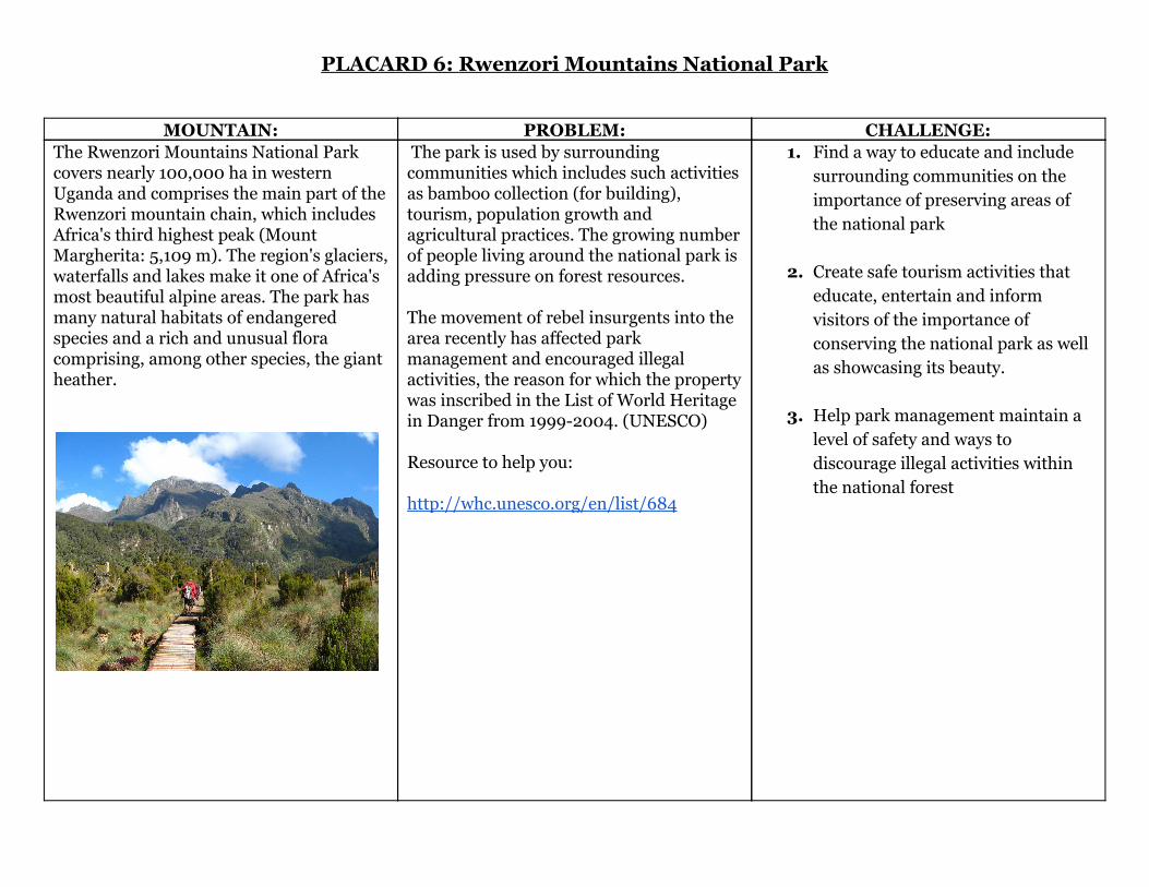
PLACARD 6: Rwenzori Mountains National Park
MOUNTAIN: PROBLEM: CHALLENGE: The Rwenzori Mountains National Park covers nearly 100,000 ha in western Uganda and comprises the main part of the Rwenzori mountain chain, which includes Africa's third highest peak (Mount Margherita: 5,109 m). The region's glaciers, waterfalls and lakes make it one of Africa's most beautiful alpine areas. The park has many natural habitats of endangered species and a rich and unusual flora comprising, among other species, the giant heather.
The park is used by surrounding communities which includes such activities as bamboo collection (for building), tourism, population growth and agricultural practices. The growing number of people living around the national park is adding pressure on forest resources. The movement of rebel insurgents into the area recently has affected park management and encouraged illegal activities, the reason for which the property was inscribed in the List of World Heritage in Danger from 1999-2004. (UNESCO) Resource to help you: http://whc.unesco.org/en/list/684
1. Find a way to educate and include surrounding communities on the importance of preserving areas of the national park
2. Create safe tourism activities that educate, entertain and inform visitors of the importance of conserving the national park as well as showcasing its beauty.
3. Help park management maintain a level of safety and ways to discourage illegal activities within the national forest

PLACARD 7: Great Smoky Mountains
MOUNTAIN: PROBLEM: CHALLENGE: The Great Smoky Mountains are America's most visited national park. The highest elevation is 6,643 ft. There are sixteen mountains within the park that reach higher than 6,000 ft. The Great Smoky Mountains are located in North Carolina and Tennessee and are a part of the Appalachian Mountains.
Scientists have begun to research the effects of human caused factors such as air and water pollution and non-native species (non native species are species that are not from the area). are having on the natural resources in the Great Smoky Mountains. Other impacts on the park are the ten million human visits each year. Litter and pollution along with forest fires carelessly started by visitors are a few of the many challenges the national forest faces. Park staff carefully monitor threats and are working to implement proactive plans to help preserve the mountains of the Great Smoky Mountain range. (UNESCO) resources to help you: http://www.nps.gov/grsm/index.htm http://whc.unesco.org/en/list/259/
1. Help the park staff create ways to educate and inform visitors of the dangers of littering and forest fires.
2. Create a way to help park staff
monitor threats such as pollution and forest fires.
3. Create a way to help park staff
monitor or stop non-native species from hurting natural resources within the mountain range.

PLACARD 8: Kahuzi and Biega Volcanoes
MOUNTAIN: PROBLEM: CHALLENGE: The Kahuzi-Biega National Park is a protected area near the Democratic Republic of the Congo. It is located near the western bank of Lake Kivu and the Rwandan border. The park is named after two dormant volcanoes, Mount Kahuzi and Mount Biega. The volcanoes are considered dormant because they have not erupted for a very long time. The national park is 6,000 square kilometers (2,300 square miles) making it one of the biggest national parks in the country. Set in both mountainous and lowland terrain, the park is one of the largest refuges of the rare species of eastern lowland gorilla.
Economic problems have caused serious issues with the effectiveness of the management and protection of endangered species. Also, large areas of the pact were only rarely observed , even never visited by the under-staffed guards, and poaching of animals has increased. Political problems in the region, has caused the displacement of thousands of people, which has threatened property in and around the park. this has also caused resources and populations of large mammals in the park to decline. Another challenge is that of the control of poaching. Hunting of wild game for bush meat as well as changing of habitats due to miners is a serious problem. With the financial and human resources lacking, it has become important to obtain additional means to strengthen the effectiveness of management. (UNESCO) resource to help: whc.unesco.org/en/list/137
1. Create a way to help management of the national park bring awareness to the plight of the mammals losing their habitats in the national park as well as the need to protect the flora that is only located within the park.
2. Create a way to help the
management survey the more land in order to help conserve it and to make sure endangered animals are not being hunted for meat.