Pima County, Arizona FLOOD CONTROL DISTRICT 2 Flood Control District Administration, 2003/2004 3...
24
Pima County, Arizona FLOOD CONTROL DISTRICT 2003/2004 Annual Report
-
Upload
nguyenduong -
Category
Documents
-
view
215 -
download
1
Transcript of Pima County, Arizona FLOOD CONTROL DISTRICT 2 Flood Control District Administration, 2003/2004 3...

Pima County, ArizonaFLOOD CONTROLDISTRICT2003/2004 Annual Report

CONTENTS2 Flood Control District Administration, 2003/2004
3 Message from the Chief Engineer
4 District Overview
4 Establishment of the District
4 Goals and Objectives
4 District Organization
6 District Activities
6 Service Programs
7 Internal Business Processes
8 Management Programs
9 Floodplain Management Program
10 Emergency Preparedness
12 Capital Improvement Programs
16 Capital Improvement Project Expenditures
17 Capital Improvement Project Map
18 District Finances
19 Financial Highlights
20 Coordination with Other Agencies

VisionThe District will continue to be a leader in providing quality flood protection and floodplain management serviceswithin Pima County.
MissionPima County Flood Control District is a regional agency whose mission is to protect the health, safety, and welfare ofPima County residents by providing comprehensive flood protection programs and floodplain management services.These services emphasize fiscal responsibility, protection of natural resources, and a balanced multi-objective approachto managing regional watercourses, floodplains, and stormwater resources.
Value StatementThe District is committed to the fair treatment of the general public and our employees, an open decision-makingprocess, fostering the opportunity for employee contributions, improved quality of work through working inpartnership, and consideration of environmental values along with economic benefits in our programs.
PIMA COUNTYFLOOD CONTROLDISTRICT

ADMINISTRATION2003/2004
BOARD OF DIRECTORS (BOARD OFSUPERVISORS)
Ann Day, District 1
Dan Eckstrom, District 2
Sharon Bronson, Chairperson, District 3
Raymond J. Carroll, District 4
Richard Elías, District 5
FLOOD CONTROL DISTRICT ADVISORYCOMMITTEE
Nick Bokaie, Oro Valley
Paul Cella, District 4
Farhad Moghimi, Marana
Mike Zeller, Chair, City of Tucson
Antonio Figueroa, City of Tucson
Vacant, District 3
Linwood Smith, City of Tucson
Richard Salaz, City of South Tucson
Phil Pearthree, 2nd Vice Chair, District 5
Doug Shakel, Vice Chair, District 1
Vacant, District 2
Martin Roush, Sahuarita
GENERAL MANAGER (COUNTYADMINISTRATOR)
C. H. Huckelberry
PUBLIC WORKS DIRECTORJohn M. Bernal
CHIEF ENGINEER (DIRECTOR)TRANSPORTATION AND FLOODCONTROL DISTRICT
Kurt Weinrich
DEPUTY DIRECTOR, FLOOD CONTROLDISTRICT
Suzanne Shields

Kurt Weinrich, P.E.
Director, Department of Transportationand Flood Control District
On behalf of the Board of Directors of the Pima County Flood Control District, I ampleased to present the District’s Annual Report for fiscal year 2003/2004.
In the past year, the District has continued in the best tradition of serving the communityby providing comprehensive flood protection programs, floodplain management servicesand riparian habitat preservation programs. A few highlights of the District’s activities inFY 2003/2004 include:
■ In participation with the Pima Association of Governments, the District secured 3,272square miles of digital orthophotographic color imagery, and 360 square miles oftopographic mapping, which will be used to further develop more accuratefloodplain maps and basin master plans.
■ The Water Resources Division is assisting in the implementation of the SonoranDesert Conservation Plan. As an example, they supported the continuing activities ofthe Science Technical Advisory Team, which is responsible for development of thebiological monitoring component of the plan. In addition, they updated the inventoryof surface water resources in Pima County and conducted new investigations tounderstand and protect existing streams and springs.
■ In August 2003, following the Aspen Fire, a redevelopment outreach symposium was held for Mt. Lemmon residentsat the Tucson Community Center. Additionally, a significant rainfall event occurred in August, resulting in flows ofapproximately 7,000 cfs—a 25-year flow in the downstream community of Catalina. Immediately following the flood,the District began assisting the residents by accepting applications to the Floodprone Land Acquisition Program fromresidents who wanted Pima County to appraise their properties for possible acquisition.
■ The District completed the design phase of the Ajo Detention Basin to make improvements to the Ed PastorEnvironmental Restoration Project in response to safety related concerns noted by Pima County Risk Management.Construction began January 2004 and will be completed in July 2004.
■ Improvements to Casa Adobes Wash were provided via the River Road project and via adjacent land developers.The District designed a pedestrian ramp on the north side of River Road to allow for equestrians and pedestriansaccess to a multicell box culvert under River Road as an underpass.
■ The District completed improvements to reduce the flooding and erosion hazards with three major washes traversingGreen Valley’s Continental Vista subdivision. In addition, a new pedestrian bridge was provided at the Green ValleyRecreation Center.
■ Each month, staff assisted an average of 476 counter customers, issued an average of 54 Floodplain Use Permits,and investigated an average of 26 drainage complaints. In addition, an average of 541 Flood Hazard InformationSheets were completed.
I believe that the District’s efforts in this fiscal year made a significant contribution toward minimizing flood and erosionhazards for Pima County residents and their property. I hope you’ll take a close look at this year’s annual report formore details on the District’s many flood control activities. This and previous annual reports are available at:www.dot.pima.gov/flood
MESSAGE FROM THECHIEF ENGINEER

Establishment of theDistrictTo comply with federal law, the State of Arizonapassed the Floodplain Management Act of 1973. This actauthorized Arizona counties to adopt rules and regulationsconcerning management of floodplain areas. The Arizonastate legislature subsequently authorized flood controldistricts to levy taxes on real property to financedistrict operating expenses. The Pima County Board ofSupervisors, which sits as the Pima County Flood ControlDistrict Board of Directors (Board), organized the PimaCounty Flood Control District (District) on June 5, 1978.The District first became operational on July 1, 1978.
Provisions of state legislation also allow incorporatedcities and towns within the county to undertake theirown floodplain management duties and regulatoryfunctions. In Pima County, the incorporated areas of theCity of Tucson, the Town of Oro Valley and the Town ofMarana have elected to assume floodplain managementduties in their respective jurisdictions. The District isresponsible for floodplain management activities forthe remainder of unincorporated Pima County (withthe exception of national forests, parks, monuments,and Indian Nations) and for the City of South Tucsonand the Town of Sahuarita.
Goals and ObjectivesThe goals and objectives of the District represent bothflood control and resource protection views and vary fromtraditional flood control approaches because of a multi-benefit public philosophy. The District recognizes thatit is necessary and desirable to maintain a balancedrelationship between human communities and the landand resources that sustain them. To that end, thefollowing twelve specific policy goals and objectiveshave been adopted by the Board as part of the District’sFloodplain and Erosion Hazard Management Ordinance:
■ To minimize flood and erosion damages.
■ To meet or exceed state and federal requirementsrelating to floodplain management—thereby enablingPima County residents to purchase low-cost floodinsurance to receive disaster relief, should the needarise, and to seek residential and commercial realestate loans.
OVERVIEW OF THEDISTRICT
■ To establish minimum flood protection elevations anddamage protection requirements for structures and othertypes of development, which may be vulnerable to floodand erosion damage.
■ To regulate encroachment and building developmentwithin areas subject to flooding or erosion, and to ensurethat the flood-carrying capacity within the altered and/orrelocated portion of any watercourse is maintained.
■ To encourage the most effective expenditures of publicmoney for flood control projects.
■ To protect, preserve, and enhance groundwater recharge.
■ To minimize the need for rescue and relief effortsassociated with flooding and erosion, usually undertakenat the expense of the general public.
■ To minimize damage to public facilities and utilities suchas water and gas mains, electric, telephone and sewerlines, and streets located in regulatory floodplain anderosion hazard areas.
■ To help maintain a stable tax base by providing for theprotection of regulatory floodplain and erosion hazardareas.
■ To inform the public when property is in a regulatoryfloodplain or erosion hazard area.
■ To ensure that those who occupy the areas within aregulatory floodplain and erosion hazard area assumeresponsibility for their actions.
■ To encourage the preservation of natural washes andenhance the riverine environment.
District OrganizationThe District is organized into three main divisions basedon the major functions of each group: 1) the FloodplainManagement Division; 2) the Flood Control EngineeringDivision; and 3) the Water Resources Division. The Districtreceives substantial support from other divisions within thePima County Department of Transportation and FloodControl District. These include Administrative SupportServices, Maintenance Operations, Field Engineering,Real Property, and Technical Services. Further assistanceis received from other county departments, includingDevelopment Services, Environmental Quality, GraphicServices, and the Pima County Attorney’s Office. TheDistrict pays for services rendered by Pima County
4
District Organizational Chart
ManagerWater Resources
Division
Board of Directors
General Manager(County Administrator)
Flood Control DistrictAdvisory Committee
DirectorPublic Works
Chief Engineer(Director)
Deputy DirectorFlood Control District
ManagerFlood Control
Engineering Division
ManagerFloodplain Management
Division
5
Department of Transportation and Flood Control Districtand other departments through interdepartmental fundtransfers from the District to Pima County.
Although District employees are part of the Pima CountyDepartment of Transportation and Flood Control District,their positions are funded entirely from District revenues.The District funded 56 full-time equivalent staff positionsin FY 2002/03.
As noted, the Board governs the Flood Control District. TheBoard also hears requests for variances and appeals to theFloodplain and Erosion Hazard Management Ordinance(FPMO). In 1988, the Board formed the Flood ControlDistrict Advisory Committee (FCDAC) to advise on flood-related matters and to increase public participation in thedecision-making process. The 12-member FCDAC includesfive members appointed by the Board (one for each Boardmember), three representatives from the City of Tucson,and one representative each from the City of South Tucson,the towns of Marana, Oro Valley and Sahuarita. Oneposition, in an ex-officio capacity, is available forappointment by the Tohono O’odham Nation.
Policy goals and objectives adopted by the Board of Supervisors strive to inform thepublic when property is in an erosion hazard area and to ensure that those whooccupy areas within a regulatory floodplain assume responsibilities for their actions.

DISTRICT ACTIVITIES
Service ProgramsCustomer ServiceDynamic public outreach activities build upon thewealth of information created and gathered by Districtstaff throughout the years. Flood awareness, floodpreparedness, and safety are major themes along withgroundwater recharge, watershed protection and riparianhabitat conservation.
Public Information and EducationIn July and August 2003, following the massivedestruction from the Aspen Fire, District staff along withmany other volunteers went to Mt. Lemmon several daysa week and every weekend to assist residents with thedelivery of seed, bales of hay and sandbags. The Districtworked closely with the Natural Resources ConservationServices (NRCS) to help control or stop potential erosionproblems. On August 26th, a redevelopment outreachsymposium was held for Mt. Lemmon property owners atthe Tucson Community Center.
Pima County Natural Resources, Parks and Recreationand Old Tucson Studios sponsored the 14th Annual TedWalker Youth Day on January 13, 2004. It marked the firsttime the District participated in this event. Approximately3,000 elementary school students, their teachers andchaperones visited Old Tucson. The Rolling River FloodSafety Trailer was once again a huge success.
In July 2004 220,000 Flood Safety Flyers were sent outwith Tucson Water utility bills throughout Pima County.
Public Works Week May 17-21,2004On Thursday, May 20, 2004, department staff along withother Public Works departments, the City of Tucson, theTown of Marana, the City of South Tucson, and PimaAssociation of Governments participated in the 2ndSouthern Arizona Annual Public Works Week Fair. Thisevent is an annual reminder of the many ways publicworks professionals maintain and improve our quality oflife. Each jurisdiction provided displays and informationon the services and facilities they provide to the public.This year’s event was held at the Joel Valdez–Main Libraryin the outdoor plaza.
District World Wide Web SiteOver the past year, the District continued to develop itsWorldwide Website, which provides public informationon a variety of flood control and floodplain managementtopics. New content areas were developed includinginformation on area river parks, capital improvementprojects, water resources and stream restoration activities.
The District's website is used by real estate agents,insurance and engineering firms, and the general public,and has seen a steady increase in its use and requests forinformation resulting in 26% increase in viewer activityover the previous year.
Customer Service Training and SatisfactionSurveysIn 2003/04, new Flood Control District employees wereencouraged to attend a two-day customer service trainingclass. All counter customers were asked to complete asurvey to rate flood control personnel in customer serviceduring a period of two weeks (June 21 - July 2, 2004). TheDistrict received an overall customer service satisfactionscore of 96%.
Employee TrainingAs part of the ongoing effort to expand the basefloodplain management knowledge of all Flood ControlDistrict employees, a series of seven training modules wasdeveloped. These modules are taught onsite, which makesit convenient for employees to attend, eliminates travelexpenses, allows for increased training opportunities, andgreatly reduces the time that staff is away from the office.Registered Professional Civil Engineers taught the firstthree modules—Geomorphology, Pima County HydrologyMethod, and Floodplain Hydraulics—by the end ofJune 2004.
Invitations to attend each of these training modules wereextended to flood control and drainage review staffs fromthe City of Tucson, Oro Valley, Marana, Sahuarita, and theTohono O’odham Nation. The invitations were readilyaccepted and appreciated.
6
Internal BusinessProcessesProviding prompt, high quality service to external and internalcustomers is the goal of the Floodplain Management Section.In order to achieve this goal, the section’s staff meets twiceeach month to discuss process improvements.
In 2003, work began on reviewing and updating severalstandard operating procedures to better serve the public.Several improvements were implemented such as placingadditional layers of resource material on the geographicinformation system to advance project reviews andprocessing times; creating databases for elevationcertificates; improving and adopting updated recordkeeping processes; using efficient digital cameras savingtime and public funds; and improving and adopting theVehicle Preventive Maintenance Program.
Drainage Maintenance Process ImprovementThe Maintenance Operations and Floodplain Managementdivisions work together to resolve drainage problemsaffecting public safety. There are many causes for drainage
7
problems that staff diligently works toward understanding,correcting, and ultimately preventing future problems.
Process improvements embrace better communicationbetween staff. Meetings are held to resolve large watershedproblems or development projects and to improve drainagedesign and construction methods for development projectsto reduce maintenance needs and costs. These ongoingdiscussions integrate small projects to remedy the smallerproblems with capital improvement projects.
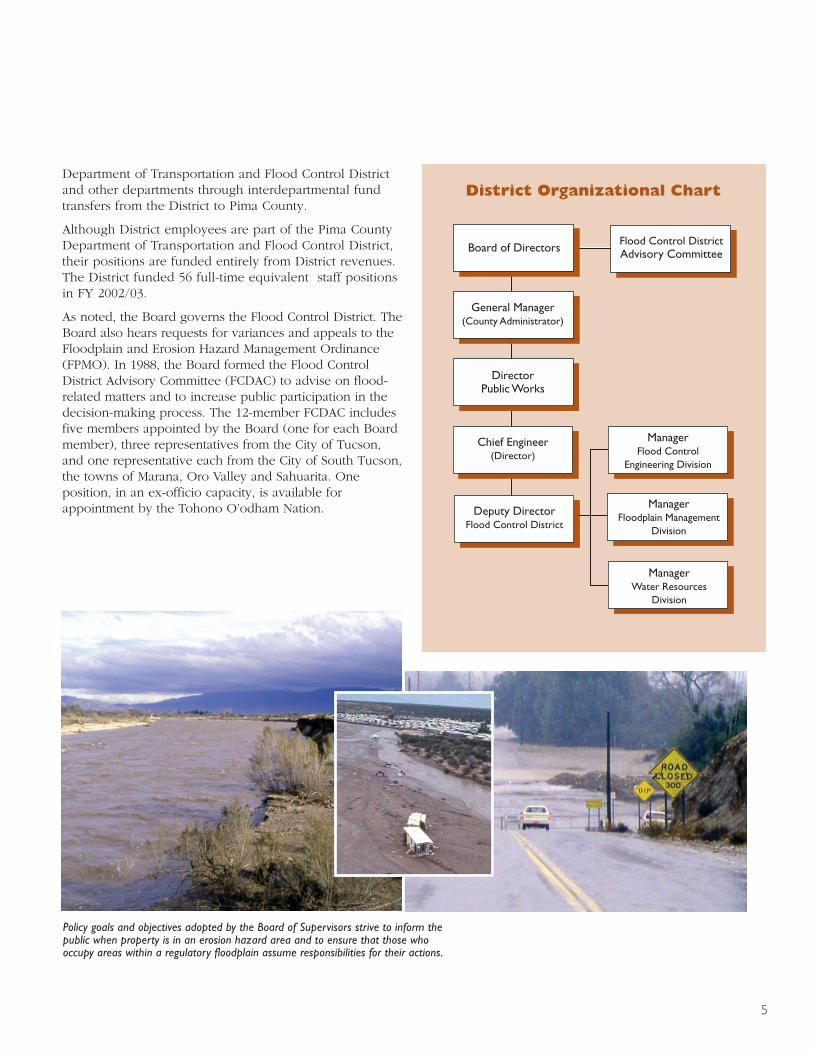
Orthophotography/Topography ProjectIn participation with the Pima Association ofGovernments, the District secured 3,272 square milesof digital orthophotographic color imagery, and 360square miles of topographic mapping. These productswill be used to further develop more accurate floodplainmaps and basin master plans.
Computer Design InnovationThe District has developed a computer aided draftingdesign standard (CADD) for the Department ofTransportation and Flood Control District. The FloodControl Engineering Division has utilized this standardon several new projects.
A Roadrunner takes a break alongthe lower Santa Cruz basin northof Tucson.

Management ProgramsWater Resources and Riparian HabitatManagement ProgramThis program consists of activities intended to: 1) preventexisting flooding, erosion and riparian habitat loss fromgetting worse and 2) prevent the creation of new flooding,erosion, and habitat loss by means other than constructingstructural flood control improvements. The Districtpromotes and supports regional riparian restoration withthe intent that it will result in some level of recovery ofnatural functions within riverine systems.
Sonoran Desert Conservation PlanThe Water Resources Division is assisting in theimplementation of the Sonoran Desert ConservationPlan (SDCP). Following is a list of key steps in fiscalyear 2003/04:
■ Improvements to the stewardship of lands acquired bythe District including updating caretaker agreements,maintaining and installing fences, and conductingresource inventories.
■ Proposed revisions to the riparian habitat mitigationordinance, including the maps.
■ Evaluating the biological and water resources ofpotential new acquisitions.
■ Participating in the implementation of the conservation(open space) bonds.
■ Staffing the Science Commission which has oversight forthe development of monitoring the overall progress ofthe SDCP.
■ Supported the continuing activities of the Science TechnicalAdvisory Team which is responsible for development ofthe biological monitoring component of the SDCP.
■ Developing studies and plans necessary for theUSACOE’s restoration projects.
■ Updated the inventory of surface water resources inPima County and conducting new investigations tounderstand and protect existing streams and springs.
Floodprone Land Acquisition ProgramFloodprone parcels continue to be evaluated alongmany of the washes and rivers located in Pima County.The Flood Control District increased its holdings in AvraValley during 2003/2004 along the Black Wash throughtwo purchases and one purchase along the BrawleyWash. The non-Catalina acquisitions totaled 56 acres for$344,900. The bulk of the FLAP acquisitions handled bythe Water Resources team were concentrated in theCañada del Oro area of Catalina following the Aspen Fire.By the end of fiscal year 2003-2004, the District hadacquired 148.34 acres of property along this watercourse.Additional details can be found in the Aspen Fire sectionof this report.
The total fiscal year 2003/04 FLAP acquisitions was 204acres for $9,346,084.
Riparian Habitat OrdinanceIn fiscal year 2003/04, 22 hydro/mesoriparian mitigationplans were approved by the Board of Supervisors. Districtstaff reviewed 25 subdivision plans and 5 private propertyxeroriparian mitigation plans.
8
Fiscal Year Statistics
A total of 30,400 customers were served in 2003/04for an average of 2,500 customers per month. Theservices provided included:
■ Issued an average of 54 Floodplain Use Permitsper month.
■ Investigated an average of 26 drainagecomplaints per month.
■ Processed approximately 541 Flood HazardInformation Sheets per month.
■ Assisted an average of 476 customers at thecounter per month.
■ Reviewed an average of 1,430 permits permonth.

Flood Insurance Program
The District works in conjunction with the FederalEmergency Management Agency (FEMA) under theFlood Insurance Study Program (FIS) to identifyfloodprone areas, which are used to set insurancerates for flood hazard areas within Pima County.An essential effect resulting from this effort is a setof official maps called Flood Insurance Rates Maps(FIRMs). These maps display flood hazard zones andother relevant hydrological information. Federal,state, and local floodplain management regulationsapply to development and other activities that takeplace within designated flood hazard zones.
FIRMs have been prepared for most of the majorwatercourses and many of the smaller watercourseswithin Pima County. These maps are revisedperiodically when structural improvements areimplemented or when floodplain characteristics arealtered; a modification to channel geometry is oneexample. The Floodplain Management Division is thelocal map repository for these FIRMs.
In fiscal year 2003/04, District staff performed thefollowing activities:
■ The District remapped the Rillito Creek, LowerPegler Wash, and the Lower Finger Rock Wash.
■ The District continued to improve and updatedigital floodplain data into the GIS system.
■ Work continued on the remapping of the LowerSanta Cruz River.
■ FEMA and the District began the process ofentering into a Cooperative Technical Partnershipto improve the accuracy of the floodplainmapping.
9
Flood Warning and EmergencyPreparednessThe Flood Warning Program encompasses the District’sAutomated Local Evaluation in Real Time (ALERT) System,which consists of approximately 85 automatic self-reportingprecipitation gauges, 32 stream gauges, 4 weather stations,and 4 radio repeater stations. The system automaticallytransmits hydrometeorological data via radio telemetry to theDistrict’s base station and to the Tucson office of the NationalWeather Service (NWS). During storm events, District staffevaluated incoming data to monitor changing floodconditions. The NWS also uses the information when issuingflash flood warnings and advisories. In addition to annualmaintenance on all sites, the following highlights occurredduring 2003/04:
■ Four precipitation gauges and two streamflow gaugeswere installed in the Santa Catalina Mountains toprovide enhanced early-warning information on stormsin the Aspen Fire burn areas.
■ Non-submersible streamflow sensors were installed attwo critical ALERT system sites on the Cañada del OroWash, where ash-contaminated runoff affected theaccuracy of standard streamflow measurement devices.
Floodplain ManagementProgramThe main responsibility of District staff in the FloodplainManagement Program is to enforce provisions of the PimaCounty Floodplain and Erosion Hazard ManagementOrdinance. This ordinance, prepared in accordance withthe National Flood Insurance Program (NFIP), includesregulations and requirements designed to minimize flooddamage and losses throughout the community. Thisimportant goal is accomplished largely through review andthe issuance of Floodplain Use Permits, detailed sitereviews for potential development, and investigation ofdrainage and flood-related complaints. Flood HazardInformation Sheets provide a succinct listing of a parcel’sfloodplain status. Customers are assisted by phone, faxor in person.
Illustrations on pages 9 and 13by Bill Singleton, Pima County GraphicServices Department.
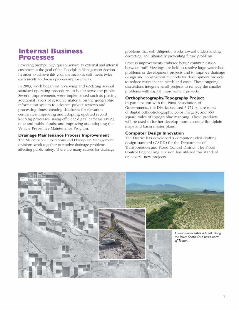
Aspen FireThe Aspen Fire consumed 85,000 acres of land and 335structures between June 17, 2003 and July 17, 2003. Theincendiary point was located near Marshall Peak on theAspen Trail. By nightfall of June 19th, the community ofSummerhaven was engulfed in flames.
One of the principal dangers resulting from significantfires is increased flooding; erosion and debris flow dueto the destruction of large quantities of vegetation.A mountain fire, such as the Aspen Fire, increases themagnitude of this danger, due to large topographic reliefand flow concentration into more urbanized areas. Earlyestimates from the United States Forest Service indicatedthat watersheds in areas severely burned could produceup to five times the quantity of runoff from a given area.
In order to address these dangers and other related issues,District staff launched a comprehensive and multifacetedprogram to provide an enhanced early flood warningsystem, mitigate the newly developed hazards, and tobetter characterize the nature of the hazards.
As a first step, the Pima County ALERT Flood WarningSystem damaged by the fire was quickly repaired andsupplemented with additional weather and stream gaugemonitoring sites in order to provide enhanced earlywarning, if potential post-fire flood dangers becameimminent threats to urbanized areas downstream. ALERTSystem repairs and enhancements costs were $47,000.Second, Pima County worked with the Natural ResourceConservation Service to quickly develop and implementa multi-phased program under the Emergency WatershedProtection Program to reduce the potential damages that
could be caused by increased flood and debris flowsthrough containment of ash from burned structures,revegetation and structural erosion control efforts. Third,the District launched a total of four hydrologic studies toevaluate, in more detail, the hydrologic conditions withinthe different watersheds in the post-fire era.
Emergency Watershed Protection Revegetation and ErosionControl Program costs were $727,061. Several emergencycontracts and agreements were required to implement theelements of this Flood Control District program. The totalcontract amount to successfully complete this three-tieredeffort was approximately $944,000.
Hydrologic Studies are estimated at $170,000 to study thefront-range watersheds of Ventana, Sabino, and Molino,the Upper Cañada del Oro Watershed, and agreementwith the United States Army Corps of Engineers to studyCarter Canyon.
The only waste materials generated during theimplementation of the post-fire Flood Control Programwere from activities associated with the removal of debrisfrom major drainage channels within the Summerhavenarea. This activity was necessary to prevent the formationof large and potentially hazardous debris dams (mostlyvegetative waste) within the watercourses. A breach inthese unstable debris dams, due to hydrostatic andhydrodynamic forces, could have exacerbated downstreamflash flooding. These removal activities are one of the mostsignificant efforts in the Revegetation and Erosion ControlProgram requiring repeated efforts to remove debris fromvegetation and felled trees that continued to appear within
EMERGENCYPREPAREDNESS
10
President George W. Bush surveyed the damage onMt. Lemmon before speaking about his Healthy ForestsInitiative.
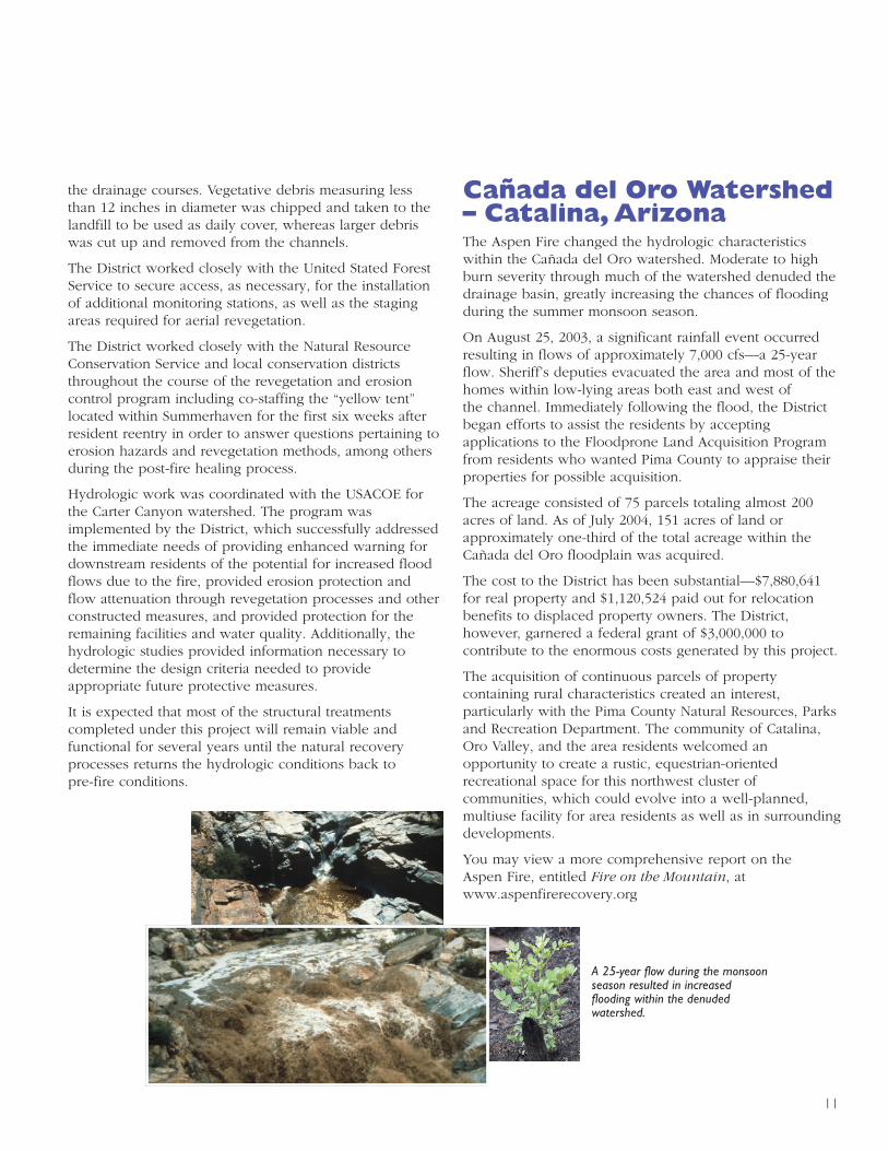
A 25-year flow during the monsoonseason resulted in increasedflooding within the denudedwatershed.
the drainage courses. Vegetative debris measuring lessthan 12 inches in diameter was chipped and taken to thelandfill to be used as daily cover, whereas larger debriswas cut up and removed from the channels.
The District worked closely with the United Stated ForestService to secure access, as necessary, for the installationof additional monitoring stations, as well as the stagingareas required for aerial revegetation.
The District worked closely with the Natural ResourceConservation Service and local conservation districtsthroughout the course of the revegetation and erosioncontrol program including co-staffing the “yellow tent”located within Summerhaven for the first six weeks afterresident reentry in order to answer questions pertaining toerosion hazards and revegetation methods, among othersduring the post-fire healing process.
Hydrologic work was coordinated with the USACOE forthe Carter Canyon watershed. The program wasimplemented by the District, which successfully addressedthe immediate needs of providing enhanced warning fordownstream residents of the potential for increased floodflows due to the fire, provided erosion protection andflow attenuation through revegetation processes and otherconstructed measures, and provided protection for theremaining facilities and water quality. Additionally, thehydrologic studies provided information necessary todetermine the design criteria needed to provideappropriate future protective measures.
It is expected that most of the structural treatmentscompleted under this project will remain viable andfunctional for several years until the natural recoveryprocesses returns the hydrologic conditions back topre-fire conditions.
11
Cañada del Oro Watershed– Catalina, ArizonaThe Aspen Fire changed the hydrologic characteristicswithin the Cañada del Oro watershed. Moderate to highburn severity through much of the watershed denuded thedrainage basin, greatly increasing the chances of floodingduring the summer monsoon season.
On August 25, 2003, a significant rainfall event occurredresulting in flows of approximately 7,000 cfs—a 25-yearflow. Sheriff’s deputies evacuated the area and most of thehomes within low-lying areas both east and west ofthe channel. Immediately following the flood, the Districtbegan efforts to assist the residents by acceptingapplications to the Floodprone Land Acquisition Programfrom residents who wanted Pima County to appraise theirproperties for possible acquisition.
The acreage consisted of 75 parcels totaling almost 200acres of land. As of July 2004, 151 acres of land orapproximately one-third of the total acreage within theCañada del Oro floodplain was acquired.
The cost to the District has been substantial—$7,880,641for real property and $1,120,524 paid out for relocationbenefits to displaced property owners. The District,however, garnered a federal grant of $3,000,000 tocontribute to the enormous costs generated by this project.
The acquisition of continuous parcels of propertycontaining rural characteristics created an interest,particularly with the Pima County Natural Resources, Parksand Recreation Department. The community of Catalina,Oro Valley, and the area residents welcomed anopportunity to create a rustic, equestrian-orientedrecreational space for this northwest cluster ofcommunities, which could evolve into a well-planned,multiuse facility for area residents as well as in surroundingdevelopments.
You may view a more comprehensive report on theAspen Fire, entitled Fire on the Mountain, atwww.aspenfirerecovery.org

CAPITALIMPROVEMENTPROGRAMSSTRUCTURAL IMPROVEMENTSStructural capital improvement projects are intendedto reduce flooding and erosion by designing andconstructing improvements to safely convey floodwaterand protect channel banks from erosion.
Structural projects are typically a solution in areas thathave already been built-out or when protecting importantinfrastructure.
Ajo Detention Basin Safety ImprovementsThe District completed the design phase to makeimprovements to the Ed Pastor Environmental RestorationProject in response to safety related concerns noted byPima County Risk Management. Construction began inJanuary 2004 and will be completed in July 2004.
Arroyo Chico Detention BasinsThis $27.5 million flood control project will protectresidents and businesses in downtown Tucson byremoving 220 residences from the 100-year floodplain.The USACOE has started the final construction plans andspecifications to begin construction in March 2005.
Avra Valley Road Flood Control ImprovementsThe District designed and constructed a flood controlberm and wall along the north side of Avra Valley Road toremove the Happy Acres subdivision from the regulatoryfloodplain. Construction began in November 2003 andwas summarily completed within one month.
Continental Vista Erosion ProtectionThe District completed improvements to reduce theflooding and erosion hazards within three major washestraversing Green Valley’s Continental Vista subdivision.In addition, a new pedestrian bridge was provided at theGreen Valley Recreation Center. Construction began inDecember 2003 and the project was completed inApril 2004.
Gibson ArroyoAjo, ArizonaAjo, Arizona, is an unincorporated community located withinPima County, Arizona, and lies approximately 160 mileswest of Tucson. On July 29, 2003, the community of Ajoexperienced a severe thunderstorm producing significantrainfall—approximately 1.3 inches of rain in just over onehour. Flooding occurred primarily along the Gibson Arroyoand tributaries located south of the arroyo.
The Flood Control District quickly responded by providingimmediate assistance with clean up and maintenance ofstreets, bridges, and portions of the Gibson Arroyo. Inaddition, the District immediately requested and receivedapproval to enter a portion of the Gibson Arroyo owned byPhelps Dodge in order to dredge along an extensive stretchof the channel to provide increased hydraulic capacity.
As part of the District’s response, a consultant was hired toprovide an emergency evaluation and report on the floodingincluding new aerial-topographic mapping, a field review ofthe flooding, data collection, and preparation of preliminaryhydrologic and hydraulic analyses. Accordingly, a MasterDrainage Plan was developed to recommend specific
12
At left and center, Ajo Detention Basin. On the right, new concrete drainageway nextto Shannon Road has alleviated the ponding problems.

approaches to address these floodprone areas includingthe Second Avenue Bridge and southern tributaryflooding.
Second Avenue Bridge ReplacementEyewitness accounts of the July 29, 2003 flood provideample evidence that debris and sediment effectivelyblocked the conveyance area of the bridge andincreased flooding conditions during the flood event.
The bridge is a 3-cell structure with a relatively lowprofile with two pier walls between the cells, whichrestrict the amount of debris and sediment that canfreely pass downstream. Hydraulic modeling of theexisting bridge reveals that if the opening were notclogged by debris and sediment the 100-year flowdepth at the bridge would be reduced by about 1.3feet. A new bridge can be designed to accommodatedebris and sediment, thereby reducing flooding.
Curley School Site Detention BasinThe southern portion of Ajo contains several tributariesto the Gibson Arroyo. This area maintains poordrainage infrastructure such as private culvert systemsthat run under residential structures.
The most effective way to alleviate the floodingproblem is to reduce the peak discharge by storing theflood volume in a flood control basin. The formerfootball field at Curley School is a prime location forthe detention basin as this is a sizeable piece ofproperty capable of sustaining a detention basin.Therefore, the planning has been initiated in concertwith the renovation planned for Curley School.
13
Holladay/Forrest Drainage ImprovementsDrainage improvements are needed to eliminate therepeated flooding of homes located northwest of theMission and Drexel roads intersection. The District iscontinuing the design, which includes a storm drain toconvey flows to an existing drainageway along MissionRoad.
Lower Santa Cruz Recharge ProjectThe Lower Santa Cruz Recharge Project is a StateDemonstration Recharge Project developed jointly bythe Pima County Flood Control District, Central ArizonaWater Conservation District, and the Town of Marana.The facility consists of approximately 30 acres ofspreading basins that are used to recharge up to 30,000acre-feet of Central Arizona Project water into theunderlying aquifer. Approximately 37,758 acre-feetwere recharged during the 2003/2004 fiscal year.
Mission View WashDesign continues on this project to mitigate downstreamflooding including the construction of a regional detentionbasin east of Park Avenue and south of 36th Street.
Shannon Road Drainage ImprovementsThe Palmdale subdivision was constructed in 1962. Thissubdivision has sustained long-standing drainage andponding issues along Shannon Road creating a myriad ofsafety hazards, and in general is a nuisance to theresidents. The District constructed a new concretedrainageway next to Shannon Road, which has alleviatedthe ponding problems. Construction began in October2003, and the project was completed in February 2004.
Pima County is considering revisions to its existing floodplain ordinance tostrengthen the protection of streamside vegetation.

14
ENVIRONMENTAL RESTORATIONEnvironmental restoration capital improvement projectsare intended to protect and/or enhance riparian habitatand promote groundwater recharge utilizing acombination of constructing structural improvementsand planting native habitat.
El Rio AntiguoEl Rio Antiguo is an ecosystem restoration study beingconducted in cooperation with the USACOE. Goals of theproject include habitat restoration, restoration of naturalriver functions, stormwater harvesting, and providingpassive recreational opportunities along the Rillito Riverbetween Craycroft Road and Campbell Avenue. TheFeasibility Study phase began with a public meeting heldin November 2001. The Feasibility Study report wascompleted in December 2003, which was then sent toCorps headquarters for final review. The project designis expected to begin in 2005 with construction beginningin 2008.
El Rio MedioThis study is a cooperative effort by the USACOE, theDistrict and the City of Tucson to provide ecosystemrestoration, flood control improvements, river park traildevelopment and water recharge development along theSanta Cruz River between Congress and Prince Road. Thisstudy in conjunction with the Paseo de las Iglesias andTres Rio del Norte studies completes an environmental,
hydrological and economic cost and benefit review of theSanta Cruz River within the Tucson metropolitan area.
Methods being considered for possible implementation ofthe project include a variety of water harvesting features,irrigation, river bank terracing, and reestablishment ofnative trees, shrubs, and riparian communities.
Marana High Plains Effluent Recharge ProjectThe Marana High Plains Effluent Recharge Project is amultipurpose facility that is used to recharge surfacewater diverted from the effluent-dominated reach of theSanta Cruz River while enhancing wildlife habitat throughthe planting and establishment of native trees and shrubsadjacent to the recharge basins. Stormwater harvesting isalso used on the site, along with fencing to restrict cattle.A total of 364 acre-feet has been recharged at the facilitysince operations began in February 2003. Biologicalstudies have noted significant habitat improvementto the site due to the successful establishment andrecruitment of native plants and shrubs. The District islooking at opportunities to expand the facility incooperation with the Town of Marana.
Paseo de las Iglesias Environmental RestorationFeasibility StudyThe Paseo de las Iglesias Environmental RestorationFeasibility Study is being conducted by the USACOE andthe District with input from the City of Tucson and otherstakeholders. The study purpose is to evaluate ecosystem
The County endorsed the USACOE recommended plan forthe Paseo de las Iglesias Environmental RestorationProject—one which will use a mesoriparian-dominantapproach along riverbanks and terraces.

15
restoration, flood control improvements, and river parktrail development along seven miles of the Santa CruzRiver historic floodplain upstream from Congress Street.Methods being considered to implement this projectinclude water harvesting features, irrigation, riverbankterracing, and reestablishment of native tree, shrub, andemergent wetland communities. Analyses for biologic,hydrologic, and economic costs and benefits were used torank the restoration alternatives.
After soliciting public input, the County endorsed theUSACOE’s recommended plan, which will use amesoriparian-dominant approach for environmentalrestoration along the riverbanks and terraces. Therecommended alternative includes restored and irrigatedmesquite-hackberry bosques on river terraces andfloodplain. Watercourse areas will be bordered bymesquite and palo verde woodland and Sonorandesertscrub species. Riverbanks will be laid-back and/orterraced and planted. Water harvesting features will beincorporated. Vegetation will provide improved habitat fornative wildlife and a pleasant setting for passiverecreation. Numerous viable water sources are underconsideration—1.7 MGD (1,900 acft/yr) of irrigation willbe needed to accomplish draft design goals. Recreationalelements including the Juan Bautista National HistoricalTrail and other amenities are being planned.
Returning vegetation such as themorning glory enhances a pleasantsetting for passive recreation.
Rillito/Swan WetlandsThe Rillito/Swan Wetlands is an ecosystem restorationproject being conducted in partnership with the USACOE.The USACOE completed a Feasibility Study to determinethe costs and benefits of enhancing approximately 60acres of riparian habitat between Craycroft and Columbusroads along the Rillito River. Staff conducted a publicworkshop in an effort to obtain input into the selection ofthe final design alternative.
Tres Rio del NorteThe Tres Rios del Norte project is an EnvironmentalRestoration Study being conducted in cooperation withthe USACOE, the Town of Marana, and the City of Tucson.The project area covers 18 miles of the Santa Cruz Riverfrom Prince Road to Sanders Road in northern PimaCounty. Proposed restoration efforts in this reach focus oncapitalizing on available resources such as stormwaterrunoff and effluent discharged from the Ina Road andRoger Road wastewater treatment facilities to enhanceriparian habitat. Other features include channelstabilization projects, grade control structures to increaseinfiltration and widen the extent of the shallowgroundwater table, a trail system, and ecoducts beneathI-10 and Silverbell Road to provide habitat connectivitybetween the Tucson Mountains, the Santa Cruz River andthe Tortolita Fan area. The project is currently in the endphases of the feasibility stage.

MARGORPSTNEMEVORPMILATIPACserutidnepxEcificepStcejorP
4002,03enuJ–3002,1yluJraeYlacsiF
tcejorP gninnalP ngiseDWOR
noitisiuqcAnoitcurtsnoC
tsoC rehtOtcejorP
latoT
1 oideMoiRlE 0 233,171 0 515,6 941 699,771
2 )kraPreviR(noitazilibatSknaBkeerCotilliR 909,85 0 541,1 0 680,1 041,16
3 otdaoRtnarG,noitazilibatSknaBreviRzurCatnaSdaoRllewoL.tF
342,81 241,02 384,65 228,2 125,7 112,501
4 notgnivrIotaicnelaV,reviRzurCatnaS 0 0 0 0 0 0
5 nisaBnoitneteDocihCoyorrA 701 150,362 978,9 428,1 514,13 772,603
6 ytefaSnisaBnoitneteDojA 0 650,34 0 559,594 766,32 876,265
7 ottforcyarC,keerCedreVeuqnaTdaoRnoynaConibaS
601 279,02 463,7 619,1 702 565,03
8 )snialPhgiH(tcejorPtnemhsinelpeRtsewhtroN 356,51 0 0 469,01 850,4 576,03
9 eeveLlortnoCdoolFzurCatnaSrewoL 066,51 898,31 450,7 648,601 160,22 025,561
01 9#yaweganiarDyellaVneerG 771 130,32 0 555 155 413,42
11 noisividbuSeladmlaP,daoRnonnahS 17 351,81 0 509,164 434,4 265,484
21 nisaBnoitneteDelagnissaM 0 598,111 0 268,6 915 672,911
31 noitcetorPnoisorEsatsiVlatnenitnoC 789 348,32 210,4 567,154 624,3 330,484
41 hsaWweiVnoissiM 0 551,74 0 0 0 551,74
51 eganiarDtserroF/yadalloH 106,2 255,521 688,8 643 067 641,831
61 )detelpmoC(sdnalteW-nisaBnoitneteDojA 862,231 0 0 0 0 862,231
71 sdnalteWnawS/keerCotilliR 912,7 758,2 0 004 734 219,01
81 noitarotseRlatnemnorivnEkeerCotilliR)ougitnAoiRlE(
672,11 153,65 233,93 644,5 548,4 052,711
91 hsaWsebodAsasaCtakraPraeniLkeerCotilliR 35 411,7 625 057,2 0 344,01
02 euqsoBetiuqseMoratroC 013,42 655,36 0 925 530,3 624,19
12 stnemevorpmIeganiarDtsolrebmiLweivriaF)detelpmoC(
0 0 0 296 0 296
22 etroNledoiRserT 589,751 237 316,4 0 049,13 072,591
32 stnemevorpmIeganiarDnoscuTfoytiChsaWpraE
788 255,23 733,6 0 0 677,93
42 )detelpmoC(kraPreviRdnallelCcM 0 851 0 96 0 722
52 saiselgIsaledoesaP 730,86 083,31 398,43 134,3 673,2 811,221
62 daoRedreVeuqnaTtahsaWetneilaCaugA 802,5 074,31 0 0 917,22 793,14
72 tuotuCleumaSedellaC 81 0 0 0 0 81
82 yrarbiLnoscuThtuoS 058,82 051,72 0 0 0 999,55
92 hsaWsubmuloC 0 0 0 0 0 0
03 stnemevorpmIeganiarDadañaCaLatirauhaS 0 0 0 0 0 0
13 eganiarDnabrU 0 868,2 0 0 648 417,3
23 hsaWlaeRonimaC/daoRreviR 014,5 260,7 0 0 0 174,21
33 trevluCxoBaicnelaV/edreVonimaC 856,6 551,5 423,1 0 0 731,31
43 yaWnonrevlAot.evAllebpmaC:daoRreviR 0 464 0 387,5 0 742,6
)dnob-noN(noitisiuqcAdnaLenorpdoolF 490,56 414,84 440,857,01 593,09 964,33 614,599,01
16

33
Ventana C anyonWash
Pantano Wash
Black
Was
h
SabinoCreekR
inco
nC
reek
AguaCaliente
Wash
Tanq
ue
Verd
eC
reek
Rilli
to
Riv
er
Pegl
erW
ash
Cañadade
lO
ro
Sant
aC
ruz R
iver
Santa Cruz Rive
r
86
19
10
10
SAG
UA
RO
NA
TIO
NA
L
PA
RK
TU
CSO
N
SAG
UA
RO
NA
TIO
NA
L
PA
RK
TO
HO
NO
O'O
DH
AM
NA
TIO
N
SAN
XA
VIE
R D
IST
RIC
T
PA
RK
MT
N.
CO
LO
SSA
L
CA
VE
PA
RK
TO
RT
OL
ITA
MT
N. PA
RK
T U
C S
O N
OR
O V
ALL
EY
MA
RA
NA
CO
RO
NA
DO
NA
TIO
NA
L
FO
RE
ST
CA
TA
LIN
AST
AT
EP
AR
K
MO
OR
E R
D
TA
NG
ER
INE
RD
AV
RA
VA
LLE
Y R
D
MO
OR
E R
D
SILV
ERBE
LL R
DGR
IER
RD
TRIC
O-M
AR
AN
A R
D SANDERS RD
SANDARIO RD
WADE RD
GERHART RD.
HARTMAN LN.
WADE RD
INA
R
D.
SOLDIER TRAIL
SN
YD
ER
RD
.
SK
YLI
NE
DR
.
1ST AVE.
PIC
TUR
E R
OC
KS
RD
SAN JOAQUIN
RD
BO
PP
RD
WILMOT RD.
SWAN RD.
RITA RD.LO
S R
EA
LES
ALVERNON WAY
HU
GH
ES
AC
CE
SS
RD
.
OLD
VA
IL C
ON
NE
CTI
ON
LOS
RE
ALE
S R
D.
CMO. VERDE
VA
LEN
CIA
RD
.
SN
YD
ER
HIL
L R
D
SANDARIO RD
STONE AVE.
LAGODELORO PARKWAY
CAMPBELLAVE
RIV
ER
RD
.
HARRISON RD.
MELPOMENE WAY
IRV
ING
TON
RD
.IR
VIN
GTO
N R
D.
GO
RET
RD
.
SW
EE
TWAT
ER
DR
.
HOUGHTON RD.
22N
D S
T.
PARK AVE.
ALVERNON WAY
KOLB RD.
PANTANO RD.
CAMINO SECO
CRAYCROFT RD.
OLD
SPANIS
HTRAIL
KOLB RD.
SU
NR
ISE
DR
.
CO
RTA
RO
FAR
M
SRD.
THORNYDALE RD.
SHANNON RD.
KIN
NEYRD
JOSEPH
R
D.
PALO VERDE BLVD.
BENSONHW
Y.
HACIENDADELSOL
REDIN
GTONRD.
NOGALES HWY.
TW
IN P
EA
KS
RD
CARDINAL
SABINOCA
N
YONRD.
HARD
Y RD
.
IRO
NW
OO
D H
ILLS
DR
.
BRO
ADW
AYCOUNTRY CLUB RD.
WILMOT RD.
FOR
T LO
WE
LL R
D.
PR
INC
E R
D.
GR
AN
T R
D.
LA CANADA DR.
TAN
GE
RIN
E R
D.
NA
RA
NJA
DR
.
LAM
BER
T LN
.
WET
MO
RE R
D.
SPEE
DW
AY B
LVD
.
SU
NS
ET
RD
PARK AVE.
AJO
WA
Y
ES
CA
LAN
TE R
D.
GO
LF L
INK
S R
D.
DR
EX
EL
RD
.
6TH AVE.
12TH AVE.
ELCA
MIN
OD
EL
CER
RO
VA
LEN
CIA
RD
.
FREEMAN RD.
TAN
QU
E
VE
RD
E
RD
.
PONTATOC
MAG
EE
RD.
LIN
DA
V
ISTA
GREASEWOOD RD.
CATALI
NAH
WY.
LA CHOLLA BLVD.
ORACLERD.
GAT
ES
PASS
RD.
RANCHOVIST
OSO
BLVD
CMO. DE OESTE CMO. DE OESTE
BEARCANYONRD.
WENTWORTH
CAMINO LOMA ALTA
7
17
25
2124
11
22
20
9
8
3
5
1525
4
14
16 6
23
19
26
218
1
12
27
293432
28
PCGS 11/04 af
ABREGODR.
SantaCruzRi
v
er
19T
OW
N O
FSA
HU
AR
ITA
GR
EE
NV
AL
LE
Y
TWIN
BUTT
ES
RD
.
CONTINEN
TAL
RD
.
WHITE
HOUS
ECA
NYON
RD.
LACANADADR.
OLDNOGALESHWY.
DUVAL
MIN
ERD.
10
CMODELSOL
1330
Pim
a C
ount
y Fl
ood
Con
trol D
istri
ct
CA
PIT
AL
IMP
RO
VE
ME
NT
PR
OJE
CTS
FY 2
003/
2004
See
tabl
e on
pag
e 14
for p
roje
ct d
escr
iptio
ns.
0
Sca
le in
Mile
s
12
�
17

RevenuesAlthough the District receives assistance from state andfederal agencies to construct major capital facilities, mostof the District’s funding is generated from the property taxlevy along with general obligation bond sales authorizedby the electorate.
Information on the District tax levy rate is shown in thetable at right.
United States Army Corpsof Engineers (USACOE)In addition to direct cash received from the federalgovernment, the District received monies for in-kindservices from the USACOE. Some projects under our costshare financial agreement are as follows:
ExpendituresThe table on page 16 provides information on capitalproject expenditures for FY 2003/04. Project numbersshown in the table correspond to the projects shownon the map on page 17. The remainder of Districtexpenditures goes toward debt services and operatingexpenses, which include funds allocated for maintenanceof flood control structures, floodplain management,planning, and administration activities. A detailedbreakdown of the District’s finances is provided onpage 19.
El Rio Medio $400,000
Arroyo Chico 50,000
Paseo de las Iglesias 134,000
El Rio Antiguo 50,000
Tres Rios del Norte 125,000
TOTAL $759,000
DISTRICT FINANCES
18
Riparian ProtectionServices include riparianhabitat managementprograms.
1981 0.5143 $4,637,000
1982 0.4683 $5,342,000
1983 0.5072 $6,882,000
1984 0.4739 $7,652,000
1985 0.5269 $9,243,000
1986 0.5102 $9,969,000
1987 0.5346 $11,713,000
1988 0.7630 $17,272,000
1989 0.5592 $13,730,000
1990 0.5985 $14,663,000
1991 0.5985 $14,058,000
1992 0.5871 $13,689,000
1993 0.5871 $13,767,000
1994 0.5398 $12,678,000
1995 0.4623 $11,379,000
1996 0.3596 $9,368,000
1997 0.3596 $9,467,000
1998 0.3296 $10,392,000
1999 0.3246 $10,411,000
2000 0.3046 $10,327,151
2001 0.3046 $10,414,427
2002 0.3546 $13,713,102
2003 0.3546 $14,467,389
Flood Control DistrictTax Levy Rate 1981 to 2003
Fiscal YearEnding Tax Revenue**Levy Rate*
*Per $100 assessed value**Unaudited

Financial Highlights forFiscal Year 2003/2004RevenuesThe primary source of revenue is the District’s secondaryproperty tax levy of $0.3546 per $100 of real propertyassessed valuation. In 2003/04, the District receivedapproximately $16.5 million dollars in tax levy revenue.Other local sources of revenue include revenue for capitalimprovements from the sale of general obligation (GO)bonds ($0.3 million) and reimbursements for other funds($0.1 million). Federal aid and state grants are anadditional potential source of revenue, with the Districtreceiving $0.5 million in state and federal aid in FY 2003/04. The total revenue reserved in FY 2003/04 was $17.4million.
ExpendituresThe total expenditures for the District in FY 2003/04 wereapproximately $16.5 million. The Capital ImprovementProgram expenditures of $8.2 million were direct capitalexpenses. The annual operating budget for the Districtwas approximately $7.2 million. The other significantexpenditure was $1.0 million in debt service for floodcontrol bonds.
Fiscal year 2003/04 unaudited amounts. Annual audits conducted by
State Auditor General.
Breakdown ofExpendituresCapital ImprovementsThe expenditures for capital improvements includeengineering service costs for planning and design;construction costs; right-of-way acquisition costs; andother costs such as costs to prepare new FEMA FloodInsurance Maps once a capital project is completed.
Operating BudgetThe District’s operating budget includes administrative,personnel, supplies and services costs associated withFlood Control Support, Flood Prevention and RiparianProtection. Flood Control Support Services includeprograms such as customer service, permits, publiceducation, and financial management. Flood PreventionServices include maintenance, flood warning, emergencypreparedness, and enforcement activities. RiparianProtection Services include the environmentalrestoration, water resources and riparian habitatmanagement programs.
19
Property Tax,Flood Control District....... 94.5%Federal Participation.............. 3%
Bond Proceeds........................ 2%
Other Funds........................... .5%
Total Revenue..................... 100%
Capital Improvements.......... 50%Operating Budget................. 44%
Debt Service........................... 6%
Expenses............................ 100%
ROW Acquisitions& Improvements................... 98%Construciton.......................... .8%
Planning.................................. .6%
Design..................................... .4%
Other...................................... .3%
Expenses............................ 100%
Flood Control SupportServices................................. 51%Flood Prevention Services 36%
Riparian Protection...............13%
Expenses............................ 100%

PIMA COUNTY DEPARTMENT OFTRANSPORTATIONThe District contracts with Pima County for services fromdivisions within the Department of Transportation:
■ Field Engineering Division
■ Maintenance Operations Division
■ Real Property Division
■ Technical Services Division
■ Administrative Services Division
OTHER PIMA COUNTY DEPARTMENTSThe District cooperates with other Pima CountyDepartments on various projects and exchangesinformation as needed:
■ County Attorney’s Office
■ Development Services Department
■ Department of Environmental Quality
■ Health Department
■ Natural Resources, Parks and Recreation Department
■ Real Property
■ Tucson-Pima County Office of EmergencyManagement
■ Wastewater Management Department (WWM)
LOCAL GOVERNMENTSThe District has entered into intergovernmentalagreements (IGAs) to provide specific flood control orfloodplain management services to, or to jointly fundflood control activities with, the following:
■ City of Tucson
■ City of South Tucson
■ Town of Oro Valley
■ Town of Marana
■ Town of Sahuarita
PIMA ASSOCIATION OFGOVERNMENTS (PAG)PAG facilitates coordination among local governmentagencies, including the District, on environmental mattersaffecting the community.
STATE AGENCIESThe District coordinates activities with the following stateagencies:
■ Arizona Department of Water Resources (ADWR)
■ Arizona Department of Environmental Quality(ADEQ)
■ Arizona Game and Fish Department (AGFD)
■ Arizona State Land Department
FEDERAL GOVERNMENTSeveral federal agencies participate in local flood controlprojects, as listed below:
■ U. S. Army Corps of Engineers (USACOE)
■ Federal Emergency Management Agency (FEMA)
■ Federal Highway Administration (FHWA)
■ U. S. Bureau of Reclamation (USBR)
■ U. S. Natural Resources Conservation Service (NRCS)
■ National Weather Service (NWS)
■ U. S. Geological Survey (USGS)
■ U. S. Fish and Wildlife Service (USFWS)
NONGOVERNMENT ORGANIZATIONSOther nongovernmental agencies that the District workswith include:
■ The Nature Conservancy (TNC)
■ Cortaro-Marana Irrigation District (CMID)
■ Central Arizona Water Conservation District (CAWCD)
■ Metropolitan Domestic Water Improvement District(MDWID)
■ University of Arizona (UA)
COORDINATIONWITH OTHERAGENCIES
20

All photos copyrighted and reprinted with permission. Design and Production by Pima County Graphic Services Department, Design Division. 02/05/AF 11391
The Aspen Fire devastated the Mt. Lemmon community of Summerhaven.

Pima County Flood Control District201 North Stone Avenue • 4TH Floor
Tucson, Arizona 85701-1207