PI3 - National Oceanic and Atmospheric Administration€˜apo Bay Kukuihaele Landing Punalu‘u...
11
Office of Coast Survey – Print at Home Nautical Chart Catalog Pacific Island Index (PI) www.nauticalcharts.noaa.gov/catalog Color Key for Charts Type of Chart Scale Purpose HARBOR CHARTS (outlined in red) 1:50,000 and larger For navigation and anchorage in harbors and small waterways. SMALL-CRAFT CHARTS (outlined in green) 1:80,000 and larger Specially designed charts with small craft information. COAST CHARTS (outlined in blue) 1:50,001 to 1:150,000 For coastwise navigation inside the offshore reefs and shoals, entering bays and harbors of considerable size, and navigating certain inland waterways. GENERAL CHARTS (outlined in purple) 1:150,001 to 1:600,000 For use when a vessel’s course is offshore but when its position can be fixed by landmarks, lights, buoys, and characteristic soundings. SAILING CHARTS (outlined in purple) 1:600,001 and smaller Plotting charts used for offshore sailing between distant coastal ports and for approaching the coast from the open ocean. The scale of a chart is the ratio of a given distance on the chart to the actual distance that it represents on the earth. (Example: One unit of measurement on a 1:10,000 scale chart is equal to 10,000 of the same unit on the earth’s surface.) Large-scale charts show greater detail of a relatively small area. Small-scale charts show less detail, but cover a larger area. Certain hydrographic information may be omitted on smaller-scale charts. Mariners should always obtain the largest-scale coverage for near shore navigation. June 2014 PI1 PI2 PI3 PI4 PI5 N O R T H E R N P A C I F I C O C E A N CANADA WA OR CA NV AZ UT ID MT Mariana Islands Haiwain Islands
Transcript of PI3 - National Oceanic and Atmospheric Administration€˜apo Bay Kukuihaele Landing Punalu‘u...
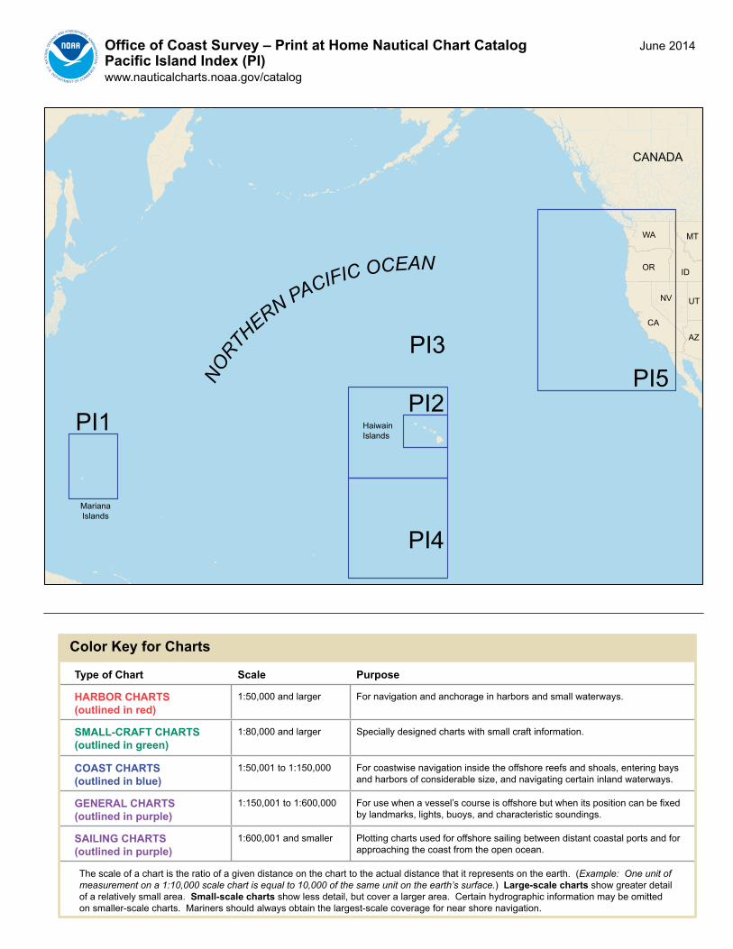
Office of Coast Survey – Print at Home Nautical Chart CatalogPacific Island Index (PI)www.nauticalcharts.noaa.gov/catalog
Color Key for Charts
Type of Chart Scale Purpose
HARBOR CHARTS(outlined in red)
1:50,000 and larger For navigation and anchorage in harbors and small waterways.
SMALL-CRAFT CHARTS(outlined in green)
1:80,000 and larger Specially designed charts with small craft information.
COAST CHARTS(outlined in blue)
1:50,001 to 1:150,000 For coastwise navigation inside the offshore reefs and shoals, entering bays and harbors of considerable size, and navigating certain inland waterways.
GENERAL CHARTS(outlined in purple)
1:150,001 to 1:600,000 For use when a vessel’s course is offshore but when its position can be fixed by landmarks, lights, buoys, and characteristic soundings.
SAILING CHARTS(outlined in purple)
1:600,001 and smaller Plotting charts used for offshore sailing between distant coastal ports and for approaching the coast from the open ocean.
The scale of a chart is the ratio of a given distance on the chart to the actual distance that it represents on the earth. (Example: One unit of measurement on a 1:10,000 scale chart is equal to 10,000 of the same unit on the earth’s surface.) Large-scale charts show greater detail of a relatively small area. Small-scale charts show less detail, but cover a larger area. Certain hydrographic information may be omitted on smaller-scale charts. Mariners should always obtain the largest-scale coverage for near shore navigation.
June 2014
PI1PI2
PI3
PI4
PI5NORTH
ERN PACIFIC OCEAN
CANADA
WA
OR
CA
NV
AZ
UT
ID
MT
MarianaIslands
HaiwainIslands

PI1Office Of Coast Survey – Print at Home Nautical Chart CatalogPacific Islands – Mariana Islandswww.nauticalcharts.noaa.gov (see PI1T for chart table)
148°0'E
148°0'E
147°0'E
147°0'E
146°0'E
146°0'E
145°0'E
145°0'E
144°0'E
144°0'E
143°0'E
143°0'E
142°0'E
142°0'E
141°0'E
141°0'E
21°0'N 21°0'N
20°0'N 20°0'N
19°0'N 19°0'N
18°0'N 18°0'N
17°0'N 17°0'N
16°0'N 16°0'N
15°0'N 15°0'N
14°0'N 14°0'N
13°0'N 13°0'N
12°0'N 12°0'N
81086 (Plan A)
81092
81086 (Plan D)
81086 (Plan E)
81092
81086 (Plan G)
81086 (Plan H)
81086 (Plan B)
81086 (Plan J)
81086 (Plan C)
81063
81054
81071 (Plan B)
81071 (Plan A)81076
81067
81048
81004
81004
Farallon de Paiaros
Maug Islands
Asuncion Island
Agrihan
Pagan Island
Alamagan Island
Guguan Island
Sarigan Island
Anatahan Island
Farallon de Medinilla
Tinian Island
Saipan Island
Rota
GUAM
MARIANA ISLANDS
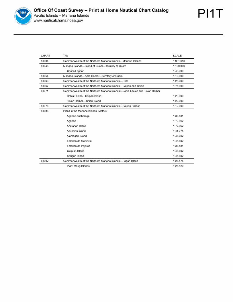
PI1TOffice Of Coast Survey – Print at Home Nautical Chart CatalogPacific Islands – Mariana Islandswww.nauticalcharts.noaa.gov
CHART Title SCALE
81004 Commonwealth of the Northern Mariana Islands—Mariana Islands 1:931,650
81048 Mariana Islands—Island of Guam—Territory of Guam 1:100,000
Cocos Lagoon 1:40,000
81054 Mariana Islands—Apra Harbor—Territory of Guam 1:10,000
81063 Commonwealth of the Northern Mariana Islands—Rota 1:25,000
81067 Commonwealth of the Northern Mariana Islands—Saipan and Tinian 1:75,000
81071 Commonwealth of the Northern Mariana Islands—Bahia Laolao and Tinian Harbor
Bahia Laolao—Saipan Island 1:20,000
Tinian Harbor—Tinian Island 1:20,000
81076 Commonwealth of the Northern Mariana Islands—Saipan Harbor 1:12,000
81086 Plans in the Mariana Islands (Metric)
Agrihan Anchorage 1:36,481
Agrihan 1:72,962
Anatahan Island 1:72,962
Asuncion Island 1:41,275
Alamagan Island 1:45,602
Farallon de Medinilla 1:45,602
Farallon de Pajaros 1:36,481
Guguan Island 1:45,602
Sarigan Island 1:45,602
81092 Commonwealth of the Northern Mariana Islands—Pagan Island 1:25,475
Plan: Maug Islands 1:26,420

PI2Office of Coast Survey – Print at Home Nautical Chart CatalogPacific Islands – Hawai’ian Islandswww.nauticalcharts.noaa.gov (see PI2T for chart table)
!
!
!
!
!
!
1932219322
19324
19326
19329
19330
19331
19332
19358
1935919361
19362
19366
1936719369
19322
Kaua‘i
O‘ahu
Ni‘ihau
Lana‘i
Moloka‘i
Hawai’i
155°00'W
155°00'W
155°30'W
155°30'W
156°00'W
156°00'W
156°30'W
156°30'W
157°00'W
157°00'W
157°30'W
157°30'W
158°00'W
158°00'W
158°30'W
158°30'W
159°00'W
159°00'W
159°30'W
159°30'W
160°00'W
160°00'W
160°30'W
160°30'W
22°30'N 22°30'N
22°00'N 22°00'N
21°30'N 21°30'N
21°00'N 21°00'N
20°30'N 20°30'N
20°00'N 20°00'N
19°30'N 19°30'N
19°00'N 19°00'N
KAULAKAHI CHANNEL
1938419383
1938219386
19381
KAU
AI C
HAN
NEL
KAIW
I CH
ANN
EL
ALENUIHAHA CHANNEL
19353
19348
Kaho‘olawe
19357
19351
19347
19327
19380
19340
19320
Kalae
Maui
19385
1935319353
19350
19342
19341

PI2T
Office of C
oast Survey – Print at Hom
e Nautical C
hart Catalog
Pacific Islands – H
awai’ian Islands
ww
w.nauticalcharts.noaa.gov
CH
AR
TTITLE
SC
ALE
19320Island of H
awai‘i
1:250,000
19322H
arbors & Landings on the N
ortheast & S
outheast Coasts of H
awai‘i
Honokaa Landing
1:2,500
Honu‘apo B
ay1:2,500
Kukuihaele Landing
1:2,500
Punalu‘u H
arbor1:2,500
19324Island of H
awai‘i—
Hilo B
ay1:10,000
19326P
a‘auhau Landing—Island of H
awai‘i
1:5,000
19327W
est Coast of H
awai‘i—
Cook P
oint to Upolu P
oint1:80,000
Honokohau H
arbor1:5,000
Keauhou B
ay1:5,000
19329M
ahukona Harbor and A
pproaches—Island of H
awai‘i
1:5,000
19330K
awaihae B
ay—Island of H
awai‘i
1:10,000
19331K
ailua Bay—
Island of Haw
ai‘i1:5,000
19332K
ealakekua Bay to H
onaunau Bay
1:10,000
19340H
awai‘i to O
‘ahu1:250,000
19341H
ana Bay—
Island of Maui
1:5,000
19342K
ahului Harbor and A
pproaches1:30,000
Kahului H
arbor1:10,000
19347C
hannels between M
oloka‘i, Maui, Lana‘i and K
aho‘olawe
1:80,000
Manele B
ay1:10,000
19348A
pproaches to Lahaina Island of Maui
1:15,000
19350Island of M
aui—M
aalaea Bay
1:10,000
19351C
hannels between O
‘ahu, Moloka‘i and Lana‘i
1:80,000
Kaum
alapu Harbor
1:5,000
19353H
arbors of Moloka‘i
Kam
alo Harbor
1:5,000
Kaunakakai H
arbor1:5,000
Kolo H
arbor1:5,000
Lono Harbor
1:5,000
Puko‘o H
arbor1:5,000
19357Island of O
‘ahu1:80,000
Barbers P
oint Harbor
1:20,000
19358S
outheast Coast of O
‘ahu—W
aimanalo B
ay to Diam
ond Head
1:20,000
19359E
ast Coast of O
‘ahu—K
ane‘ohe Bay
1:15,000
19361P
ort Wai‘anae—
Island of O‘ahu
1:10,000
19362S
outh Coast of O
‘ahu—K
alaeloa1:20,000
19366P
earl Harbor—
South C
oast of O‘ahu
1:15,000
19367Island of O
‘ahu—H
onolulu Harbor
1:5,000
19369S
outh Coast of O
‘ahu—A
pproaches to Pearl H
arbor1:20,000
19380O
‘ahu to Ni‘ihau
1:247,482
19381Island of K
aua‘i1:80,000
19382P
ort Allen—
Island of Kaua‘i
1:5,000
19383K
aua‘i—N
awiliw
ili Bay
1:5,000
19384H
anamaulu B
ay—Island of K
aua‘i1:2,500
19385N
orth Coast of K
aua‘i—H
a‘ena Point to K
epuhi Point
1:20,000
19386K
aua‘i—A
pproaches to Waim
ea Bay
1:10,000
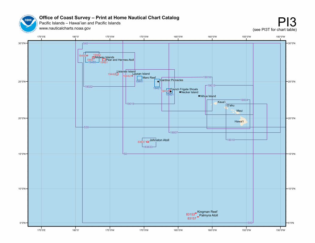
PI3Office of Coast Survey – Print at Home Nautical Chart CatalogPacific Islands – Hawai’ian and Pacific Islandswww.nauticalcharts.noaa.gov (see PI3T for chart table)
!
!!
!
8315383157
Kingman ReefPalmyra Atoll
Johnston Atoll
150°0'W
150°0'W
155°0'W
155°0'W
160°0'W
160°0'W
165°0'W
165°0'W
170°0'W
170°0'W
175°0'W
175°0'W180°0'175°0'E
180°0'175°0'E
30°0'N 30°0'N
25°0'N 25°0'N
20°0'N 20°0'N
15°0'N 15°0'N
10°0'N 10°0'N
5°0'N 5°0'N
530
19022
540
540
83633
83637
50
19007
19010
19019
19016
19004
19013
Hawai’i
Maui
O’ahuKaua’i
Nihoa Island
1948319481
19482
1946119480
Midway IslandsPear and Hermes Atoll
19442 19442Lisianski Island
Laysan Island
19441Maro Reef
19421
Gardner Pinnacles
1940119402 French Frigate Shoals
Necker Island

PI3T
Office of C
oast Survey – Print at Hom
e Nautical C
hart Catalog
Pacific Islands – H
awai’ian and P
acific Islandsw
ww
.nauticalcharts.noaa.gov
CH
AR
TTITLE
SC
ALE
50N
orth Pacific O
cean (Eastern P
art)1:10,000,000
530S
an Diego to A
leutian Islands and Haw
ai'ian Islands1:4,860,700
540H
awai‘ian Islands
1:3,121,170
19004H
awai‘ian Islands
1:600,000
19007H
awai‘i to French Frigate S
hoals1:1,650,000
19010H
awai‘ian Islands—
Southern P
art1:675,000
19013H
awai‘ian Islands—
Northern P
art1:675,000
19016N
i‘ihau to French Frigate Shoals
1:633,392
Necker Island
1:20,000
Nihoa
1:20,000
19019French Frigate S
hoals to Laysan Island1:653,219
19022Laysan Island to K
ure Atoll
1:642,271
19401French Frigate S
hoals1:80,000
19402French Frigate S
hoals—A
nchorage1:25,000
19421G
ardner Pinnacles and A
pproaches1:100,000
Gardner P
innacles1:20,000
19441M
aro Reef
1:80,000
19442Lisianski and Laysan Islands
1:40,000
West C
oast of Laysan Island1:10,000
19461P
earl and Herm
es Atoll
1:40,000
19480G
ambia S
hoal to Kure A
toll Including Approaches to the M
idway Islands
1:180,000
19481M
idway Islands
1:32,500
19482M
idway Islands
1:10,000
19483K
ure Atoll
1:20,000
83153K
ingman R
eef1:25,000
83157P
almyra A
toll1:10,000
Approaches to P
almyra A
toll1:47,750
83484S
amoa Islands
Manua Islands
1:80,000
Pago P
ago Harbor
1:15,000
Rose A
toll1:80,000
Sw
ains Island1:40,000
Tutuila Island1:60,000
83633A
pproaches to Johnston Atoll
1:200,000
83637Johnston A
toll1:50,000
Johnston Island Harbor
1:12,500
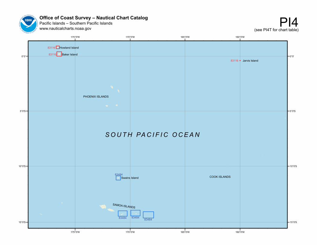
PI4Office of Coast Survey – Nautical Chart CatalogPacific Islands – Southern Pacific Islandswww.nauticalcharts.noaa.gov (see PI4T for chart table)
160°0'W
160°0'W
165°0'W
165°0'W
170°0'W
170°0'W
175°0'W
175°0'W
0°0' 0°0'
5°0'S 5°0'S
10°0'S 10°0'S
15°0'S 15°0'S
83116
83116
83116
83484
83484 8348483484
Howland Island
Baker Island
Jarvis Island
Swains Island
SAMOA ISLANDS
PHOENIX ISLANDS
S O U T H PA C I F I C O C E A N
COOK ISLANDS

PI4T
Office of C
oast Survey – Nautical C
hart Catalog
Pacific Islands – S
outhern Pacific Islands
ww
w.nauticalcharts.noaa.gov
CH
AR
TTITLE
SC
ALE
83116Islands in the P
acific Ocean
Baker Island
1:15,000
How
land Island1:15,000
Jarvis Island1:15,000
83484S
amoa Islands
Manua Islands
1:80,000
Pago P
ago Harbor
1:15,000
Rose A
toll1:80,000
Sw
ains Island1:40,000
Tutuila Island1:60,000

PI5Office of Coast Survey – Nautical Chart CatalogPacific Islands – North Pacific Oceanwww.nauticalcharts.noaa.gov (see PI5T for chart table)
!
!
!
!
120°00'W
120°00'W
125°00'W
125°00'W
130°00'W
130°00'W
135°00'W
135°00'W
140°00'W
140°00'W
145°00'W
145°00'W
150°00'W
150°00'W
155°00'W
155°00'W
160°00'W
160°00'W
165°00'W
165°00'W
170°00'W
170°00'W
175°00'W
175°00'W180°00'175°00'E170°00'E
180°00'
45°00'N 45°00'N
40°00'N 40°00'N
35°00'N 35°00'N
30°00'N 30°00'N
25°00'N 25°00'N
20°00'N 20°00'N
15°00'N 15°00'N
10°00'N 10°00'N
5°00'N 5°00'N
175°00'E170°00'E
530
50
50
531
50118022
18007
18020
1801
018
003
18400Seattle
Portland
HAWAI’IAN ISLANDS
N O R T H PA C I F I C O C E A N
Cape Mendocino
San Francisco
Los Angeles

PI5T
Office of C
oast Survey – Nautical C
hart Catalog
Pacific Islands – N
orth Pacific O
ceanw
ww
.nauticalcharts.noaa.gov
CH
AR
TTITLE
SC
ALE
50IN
TER
NATIO
NA
L CH
AR
T North P
acific Ocean—
(Eastern part)
INT-50
Bering S
ea Continuation
1:10,000,000
501IN
TER
NATIO
NA
L CH
AR
T North P
acific Ocean—
West C
oast
INT-801
of North A
merica—
Mexican B
order To Dixon E
ntrance1:3,500,000
530N
orth Am
erica—W
est Coast—
San D
iego to
Aleutian Islands and H
awai‘ian Islands
1:4,860,700
531G
ulf of Alaska—
Strait of Juan de Fuca to K
odiak Island1:2,100,000
18003C
ape Blanco to C
ape Flattery1:736,560
18007S
an Francisco to Cape Flattery
1:1,200,000
18010M
onterey Bay to C
oos Bay
1:811,980
18020S
an Diego to C
ape Mendocino
1:1,444,000
18022S
an Diego to S
an Francisco Bay
1:868,003
18400S
trait of Georgia and S
trait of Juan de Fuca1:200,000