Physical Geography (B.A.-I Sem-I)willingdoncollege.in/pdf/Study/Geography/2.pdfPhysical Geography...
59
2018 For B.A.-I. SEM-I SHIVAJI UNIVERSITY, KOLHAPUR
Transcript of Physical Geography (B.A.-I Sem-I)willingdoncollege.in/pdf/Study/Geography/2.pdfPhysical Geography...

2018
For
B.A.-I. SEM-I
SHIVAJI UNIVERSITY,
KOLHAPUR
1
WILLINGDON COLLEGE SANGLI
DEPARTMENT OF GEOGRAPHY
SEM - 1 (English Medium)
PHYSICAL GEOGRAPHY

Shivaji University Kolhapur
B. A. Part – I , DSE (Discipline Specific Elective) - I Geography
June 2018 onwards
Physical Geography
Compile by
Dr. Ratnadeep Govind Jadhav
Head Department of Geography
Willingdon College Sangli
jratnadeep@rediffmail.
Shivaji University Kolhapur B. A. Part – I , DSE (Discipline Specific Elective) - I Geography
June 2018 onwards
Physical Geography

ContentsIntroduction to Physical Geography ......................................... 1
1.1 Definition of Physical Geography .............................................. 2
1.2 Scope of Physical Geography ................................................... 3
1.3 Branches of Physical Geography .............................................. 5 a. Geomorphology: ................................................................................ 5 b. Climatology: ....................................................................................... 5 c. Oceanography: .................................................................................. 5 d. Pedology: ........................................................................................... 6 e. Biogeography: .................................................................................... 6
1.4 Importance of Physical Geography ........................................... 6
Atmosphere .............................................................................. 9
2.1 Composition and Structure of Atmosphere ............................... 9 a. Composition of the Atmosphere: ....................................................... 9 b. Structure of the Atmosphere ............................................................ 12
2.2 Insolation: Factors affecting on Insolation ............................... 14
2.3 Temperature: Distribution of temperature (Vertical and
Horizontal) ..................................................................................... 17 a. Vertical Distribution of temperature ................................................. 17 b. Horizontal Distribution of temperature ............................................. 18
2.4 Atmospheric Pressure: Belts and Planetary Winds. ................ 19 a. Pressure Belts ................................................................................. 19 b. Planetary Winds............................................................................... 22
Lithosphere ............................................................................ 26
3.1 Structure of Earth’s interior ..................................................... 27
3.2 Wegener’s Theory of Continental Drift .................................... 30
3.3 Earthquake: Causes and Effects ............................................. 32 a. Definition and nature of earthquake. ............................................... 32 b. Causes of earthquakes .................................................................... 34 c. Effects of Earthquake ...................................................................... 35
3.4 Volcano: Causes and effects .................................................. 36 a. Definition of Volcano ........................................................................ 36 b. Causes of volcanoes ....................................................................... 37 c. Effects of Volcanic Eruption ............................................................. 38
Denudation ............................................................................. 44
4.1 Weathering: ............................................................................. 44
4.2 Davis Concept of Cycle of Erosion .......................................... 49
4.3 Erosional Landforms of River .................................................. 51
4.4 Depositional Landforms of River ............................................. 53

G E O G R A P H Y D E P A R T M E N T
1
Introduction to
Physical Geography
A geographer explains the phenomena in a frame of cause and effect
relationship, as it does not only help in interpretation but also foresees
the phenomena in future.
he word geography comes from two Greek roots. ‘Geo’ refers to the earth, and
‘graphy’ means picture or writing. Geography examines, describes, and explains
the earth- its variation from time to time and from place to place. Geography is
often called the "spatial science" because it includes the recognition, analysis,
and explanation of likenesses and differences, or of variations in phenomena as
they are distributed on the earth's surface (through earth space).
A geographer explains the phenomena in a frame of cause
and effect relationship, as it does not only help in interpretation
but also foresees the phenomena in future.
Geography is both a physical and a social science. In its
concern with the natural environment, geography is very much a physical science. Yet
geography also examines humanity's two-way relationship with the earth and is thus a
social science as well Cultural or human geography is the study of human activity and of
the results of that activity. The human geographer studies such subjects as population
distribution, cities and urbanization, natural resource utilization, industrial location, and
transportation networks. When a geographic study concentrates primarily on the
Module
1
T
Valuable information
Test your knowledge
Keyboard exercise
Workbook review
Physical Geography (B.A.-I Sem-I)
Willingdon College Sangli
physical and human features of a specific region, such as India, we call this regional
geography. In other word Geography is a fundamental science that helps us to
understand our physical environment with its elements and components forming a
complex structure of the earth which is the only habitable planet in the solar system.
Geographers study the factors responsible for spatial distribution and variation of
people, places with their locations. Physical geographers explain the phenomenon of
evolution of landforms, tectonic movements, weather and climate, ocean characteristics
and properties, flora and fauna.
In this global age, the study of geography is absolutely essential to an educated
citizenry of a nation whose influence extends throughout the world. Geography deals
with location; and a good sense of where things are, especially in relation to other things
in the world, is an invaluable asset whether you are traveling, conducting international
business, or sitting at home reading the newspaper. Thus, geography was perceived to
study all those phenomena which vary over space. Geographers do not study only the
variations in the phenomena over the earth’s surface (space) but also study the
associations with the other factors which cause these variations. For example, cropping
patterns differ from region to region but this variation in cropping pattern, as a
phenomenon, is related to variations in soils, climates, demands in the market, capacity
of the farmer to invest and technological inputs available to her/him. Thus, the concern
of geography is to find out the causal relationship between any two phenomena or
between more than one phenomenon. The geographical phenomena, both the physical
and human, are not static but highly dynamic. They change over time as a result of the
interactive processes between ever changing earth and untiring and ever-active human
beings.
Physical geography encompasses the study of the natural aspects of the human
environment. That is, physical geographers look at the atmospheric elements that affect
the surface of the earth and that together make up weather and climate. They examine
the variations in soil and in natural vegetation. The varieties of water bodies on earth and
their movements, effects, and other characteristics are subjects of physical geography, as
are the landforms of the earth, their formation, and their modification. Yet although
physical geographers emphasize the elements that make up our physical environment,
they do not ignore the effect of people on those elements.
1.1 Definition of Physical Geography
Physical geography is that branch of systematic geography (physical and human)
that examines activities. Physical geography differs from other sciences in that it focuses
on the world around us from changes in daily weather conditions to landforms we travel
every day. Physical geography is not only the agglomeration of different branches of
earth and natural sciences like geomorphology, climatology, meteorology, pedology,
geology etc. but it also studies the patterns of interactions between human activities and
physical environment. Physical geography can be defined differently as follows:
Physical Geography (B.A.-I Sem-I)
Willingdon College Sangli
1. Physical geography is the study of forces that influence the surface of earth.
2. Physical geography is to study natural phenomena.
3. Physical geography is the study of physical processes and patterns in the
natural environment that shape the surface of the earth and their associated
variability over space and time.
4. Physical geography studies the spatial patterns and spatial relationships of
environmental components of the globe in regional context, it also studies the
causes of regional patterns of such relationships.
5. A field of physical geography including climate and atmosphere,
geomorphology, biogeography, hydrology, oceans, Quaternary environmental
change, soils, remote sensing and GIS.
The main purpose of studying physical geography is to explain the spatial
characteristics of the various natural phenomena associated with geomorphology,
climatology, oceanography, pedology, biogeography etc.
1.2 Scope of Physical Geography
It is evident from the foregoing discussion on the nature of physical geography that the
detailed consideration of four components of the earth viz. lithosphere, atmosphere,
hydrosphere and biosphere are included in physical geography wherein characteristic
features of these components are studied spatially and temporally. First the origin age
and structure of the interior of the earth, isostasy and evolution of continents and ocean
basins are studied in order to understand the characteristic features of the aforesaid four
components. The study of forces or movements of the earth both endogenetic
(originating from within the earth) and exogenetic (originating from the atmosphere)
becomes significant to understand the interactions between these two forces and
resultant features. In fact endogenetic forces (termed as constructive forces) coming
from within the earth, create reliefs of varying dimensions on the earth’s surface (e.g.
mountains, folds, faults, volcanic cones etc.) which provide habitats for living organisms
of the biospheric ecosystem on the one hand, and present initial reliefs for the interplay
of exogenetic forces originating from the atmosphere termed as destructive forces
(denudational processes e.g. fluvial, marine, glacial, aeolian, periglacial etc. processes and
weathering agents) on the other hand. The study of evolution of continents and ocean
basins and their drifting (continental drift as evidenced by plate tectonics) helps in the
understanding of evolution and dispersal of plants and animals.
The characteristics, origin and distribution of constructional reliefs namely
mountains, faults, folds etc. are thoroughly investigated. The distribution, characteristics
and origin of volcanicity and landforms resulting therefrom are studied as physical
features and natural hazards which adversely affect both human being and plants and
animals. The study of features resulting from the interactions between endogenetic and
exogenetic fences involves the discussion of mode of denudational processes
(Weathering and erosion), hetherto termed as geomorphic processes, their mechanism
of operation (mechanism of erosion, transportation and deposition by running water-

Physical Geography (B.A.-I Sem-I)
Willingdon College Sangli
river, groundwater, sea waves, wind: glacier and periglacial agent) and resultant
landforms. The study of hydrospheric component involves the consideration of reliefs
of the ocean basins (continental shelves, submarine canyons. continental slope. deep sea
plains. ocean deeps etc.); thermal characteristics of ocean water; salinity (composition of
seawater, sources and distribution of oceanic salinity); ocean deposits; ocean tides; ocean
currents and coral geek and atolls (their distribution and origin. coral bleaching etc.).
The study of atmospheric component includes the discussion of composition
and structure of atmosphere, elements of weather and climate, insolation and heat
balance, terrestrial radiation balance and anthropogenic factors causing imbalance, air
temperature, air pressure and winds (permanent or planetary winds, seasonal and local
winds), characteristics and origin of monsoon, humidity and precipitation, airmasses,
frontagenesis, cyclones and anticyclones, world climate etc. The study of biospheric
component involves the consideration of components of biosphere (both abiotic and
biotic), soil system, ecological production and energy flow in the biospheric ecosystem,
circulation of elements in the ecosystem, biogeochemical cycles, evolution, dispesal and
extinction of plants and animals. biomes and man, ecosystem stability and man, man and
atmospheric environment (global radiation balance. ozone depletion, greenhouse effect:
and global warming) man and environmental processes, main induced soil erosion and
sedimentation, environmental degradation and pollution, extreme events, hazards and
disaster, environmental planning and management, global environmental problems and
international co-operations.
It is evident from the aforementioned discussion that the scope of physical
geography includes the consideration of systematic study of physical environment as well
as the study of interactions between man and physical environment. Major changes have
taken place in the subject matter and methodology of physical geography due to
following factors : (1) Universal desire to make physical geography more meaningful and
applicable for human welfare and to integrate it more intimately with human geography
in order to redefine and to keep the discipline of geography intact and to make it more
relevant to society. (2) More attention of man towards natural hazards and disaster and
greater emphasis on the evaluation of adverse impacts of human activities on physical
environment and environmental problems resulting therefrom and remedial measures
therefor. (3) Greater emphasis on instrumentation and measurement of operation of
different geomorphic processes and mathematical analysis of data derived through field
and laboratory studies. (4) More attention towards the study of certain aspects of physical
geography e.g. ecosystem and ecological stability and instability, hydrology, plate
tectonics etc. (5) Recent trends of increasing emphasis on micro-temporal scale (i.e.
graded and steady state time scale) in place of macro-temporal scale (i.e, cyclic time
involving geological time i.e. millions of years) and on shorter microspatial scale (10 to
100 km2) in place of large or macro-spatial scale (megascale, millions of square
kilometres) in the study of geomorphic and environmental processes to make such study
more relevant to society in order to solve immediate environmental problems.

Physical Geography (B.A.-I Sem-I)
Willingdon College Sangli
1.3 Branches of Physical Geography
There are five fields or branches of physical geography varying from geomorphology
to biogeography as highlighted below:
a. Geomorphology:
It is the science of earth surface processes and landforms. In other words it is the
scientific study of surface involving interpretative description of landforms, their origin
and development and nature and mechanism of geomorphological processes which
evolve the landforms. Modern geomorphology also focuses on modeling landform
shaping processes to predict both short-term (rapid) changes such as landslides, floods,
coastal storm, erosion, and long term (slower) changes, such as soil erosion in agricultural
areas or as a result of strip mining.
Geomorphology also has two sub-fields which are fluvial geomorphology, tropical
and desert geomorphology. These fields deal with the study of some specific landforms
which consists in various environments. One of the common thing between these fields
is that the fact that these are all united by the core processes which shaped them, which
was mainly tectonic processes. The various dynamics and landform history is studied by
geomorphology and also predicts the changes which re going to appear because of the
combination of field observation, some numeric modeling and physical experiment.
b. Climatology:
Climatology is the science that describes and explains the variability of atmospheric
conditions (heat and moisture) over space and time. According to Critchfield,
climatology is the science which studies the nature of climate, the causes and
interpretation of its spatial variations and its association with the elements of natural
environment and human activities. In simple words, it is the systematic and regional
study of atmospheric conditions i.e. weather and climate. Climatology is concerned with
climate change, both in past and future.
Climatology is the study of climatic conditions which are also called as the weather
conditions which are studied and averaged over a long period of time. This subject
covers both the nature of macro or global and micro or local climatic conditions. The
anthropogenic as well as natural influences which occur on them are also studied. The
sub fields which divide different parts of this subject are tropical climatology as well as
the paleoclimatology. The climatic study differences are dividing on the basis of the
various different regions.
c. Oceanography:
The science of hydrosphere i.e. oceans and seas is called oceanography which
includes the consideration, description and analysis of both physical and biological
aspects of hydrosphere. It is concerned with the study of various types of Oceanic
component and processes related to ocean floor depths, currents, corals reefs,
continental drifts, motion of sea water, wave energy, currents and estuary etc. The study
of oceanography has gained much importance during the current times because of the
economic and strategic importance of oceans and seas. Today more focus is on applied

Physical Geography (B.A.-I Sem-I)
Willingdon College Sangli
oceanography which includes the consideration of delineation, mapping, exploration,
utilization and management of marine abiotic as well as biotic resources.
d. Pedology:
Pedology is the study of the distribution of soil types and properties and the
processes of soil formation. It is related to both geomorphic processes of rock break up
and weathering, and to biological processes of growth, activity and decay of organisms
living in the soil. Since both geomorphic and biological processes are influenced by the
surface temperature and availability of moisture, broad-scale soil patterns are often
related to climate.
e. Biogeography:
Biogeography is the science of the distributions of organisms at varying spatial and
temporal scales, as well as the processes that produce these distribution patterns. Alfred
Russell Wallace is known as the father of this fields study. Local distribution of plants
and animals typically depend on the suitability of the habitat that supports them. In this
application biogeography is closely aligned with ecology. Over broader scales and time
periods, the migration, evolution and extinction of plants and animals are key processes
that determine their spatial distribution patterns. Thus, bio-geographers often seek to
reconstruct past patterns of plants and animal communities from fossil evidence of
various kinds. There are five main sub fields of biogeography: zoogeography,
phytogeography, paleobiography, island biography and phylogeopgraphy.
In addition to these five main fields of physical geography, two others are strongly
involved with applications of physical geography – water resources and hazards
assessment.
1.4 Importance of Physical Geography
It is important to study Physical Geography because it helps us to understand the
relationship between man and his physical environment. It tells us how nature nourishes
and puts limitations on man. It also helps us to recognize man's impact on the natural
environment. Thus, the knowledge of Physical Geography can be used for land use
planning and for resource management.
By studying the lithosphere, we are aware of what lies within the earth's crust and
hence we are able to understand the Geography of the external landforms. The study of
rocks helps us understand the relationship of rocks and landforms and their uses e.g. that
softer rocks like clay and shale are worn down easily compared to harder rocks like
granite. Rocks also form the basis for soil, vegetation and land use, so we must have a
fair knowledge of rocks around us. Knowledge of the earth's movements helps us to
understand the modelling of mountains plateaus and plains. We also become aware of
the diverse landfonns that come into existence because of the various agents of
denudation, viz, running water, moving ice, wind, waves etc.
The study of volcanism and earthquakes helps us understand the resultant
landforms, inside and outside the’ earth. Finally, the lithosphere has various influences

Physical Geography (B.A.-I Sem-I)
Willingdon College Sangli
on man and his activities, e.g. rapids and waterfalls interrupt the navigability of a river,
slope of landforms influencing the farming and grazing activities. Silting in the lower
courses prevents large steamers anchoring close to the coast, making dredging
compulsory. The slope of the land is closely associated with the thickness of soils which
in turn influences the vegetation cover, e.g. the found on the soil of Himalayas are poor
and thin but in the plains of the Ganga the soil is thick and fertile.
By studying climate and its various elements viz. temperature, pressure, moisture etc.
we learn how they are so essential for plants and organisms, how they regulate man's
food, clothing, shelter and occupations. Climate influences our physical characteristics,
mental alertness and even racial differences. Farmers and their crops are still at the mercy
of the climate. A sound knowledge of the atmosphere helps us to avoid or reduce the
seriousness of calamities influenced by climate.
Climate influences landforms through the joint processes of weathering and
denudation. The main agents of denudation-wind, rain and ice are the direct results of
climatic factors. Climate, through its elements of rainfall and temperature, has an
influence on vegetation. e.g. the high temperatures and heavy rainfall of equatorial
regions are responsible for a luxuriant growth of trees. The Sahara receives scanty rainfall
and is barren with only thorny bushes. As the conditions of climate vary, the forests may
be evergreen hardwoods or conifers or deciduous. Further the grasslands may have tall
grasses like the Savannas or low and rich grasses like the Prairies.
Climate influences soil through the elements of moisture conditions, temperature
and wind, e.g. in equatorial areas, due to heavy rainfall, silica is washed away and the soils
are heavily leached. The temperature grasslands add rich humus to the soil and make the
soil fertile.
By studying the climatic elements of the earth, the earth can be divided into man
climatic regions. Each region has approximately the same temperature, wind, rainfall
conditions and is therefore capable of producing the same vegetation or supporting the
same type of animals, which in turn influence the occupations of the people. In Physical
Geography, we study the hydrosphere. Oceans have a tremendous influence on climate.
Land and water heat and cool down at different rates that is why temperature and
pressure differences are created. Oceans are also a source of humidity to the atmosphere.
Places near the coast have an equable climate e.g. Bombay, while places far inland have
an extreme climate e.g. Delhi.
The differences of pressure on land and water lead to the formation of winds on a
global scale, or periodic winds like the monsoons or land sea breezes. The oceans act as
trackless transportation routes and connect every continent. Oceans are a source of food
for man, for, they sustain a vast and complex marine life. They constitute a vast reservoir
of salt and mineral matter which may be extracted by man.
Finally, it is important to study plant Geography as a part of Physical Geography. It
deals with vegetation types i.e. forests, grasslands-and deserts. It provides valuable
information regarding different types of forests, their species. areas of growth. and their
economic uses. Plant Geography helps us to recognize which forests are valuable, e.g.

Physical Geography (B.A.-I Sem-I)
Willingdon College Sangli
the coniferous forests are valuable for their softwood. Plant Geography explains how
vegetation influences soil formation, soil fertility, soil erosion, reduction of temperature
and increase in rainfall. It also deals with vegetation as the home of animals. It helps us
realise how much vegetation cover has been destroyed by man.
The study of Physical Geography is very important in this technological era; it gives us
a physical background or base for Human Geography study, urban planning and natural
disasters management. Construction of road, building, savage and sanitary waste, water lines
are planned according to the slopes. Military strategic planning is influenced by the physical
structure of any nation. Physical environment provides resources, and human beings utilise
these resources and ensure their economic and cultural development. Accelerated pace of
resource utilization with the help of modern technology has created ecological imbalance in
the world. Hence, a better understanding of physical environment is absolutely essential for
sustainable development.
Physical Geography (B.A.-I Sem-I)
Willingdon College Sangli
Atmosphere
The atmosphere is a blanket of gases and suspended liquids and solid entirely
envelop the earth’.-
H. J. Chritchfield
he atmosphere is a mixture of numerous gases. It envelops the earth and extends
as far as 9600 km. above the earth’s surface. This gaseous cover of the earth is
held around it by gravitational attraction. Like the lithosphere and hydrosphere,
the atmosphere too is an integral part of the planet earth and is inseparable from
it. About 97 percent of the air is concentrated in the lower 29 km.
According to H. J. Chritchfield ‘the atmosphere is a blanket
of gases and suspended liquids and solid entirely envelop the
earth’. The atmosphere is act as a great canopy to protect the
earth’s surface from the solar radiation.
The atmosphere differs from the lithosphere and the hydrosphere in many respects.
Atmosphere is a colourless, odourless and tasteless substance. Besides, it is mobile, elastic
and compressible. The most interesting fact about air is that we do not feel its presence
unless there is horizontal motion in it. Air in horizontal motion is known as ‘wind’.
Although air is not as dense as land or water, it has weight, and the pressure it exerts on
the surface is called the atmospheric pressure.
2.1 Composition and Structure of
Atmosphere
a. Composition of the Atmosphere:
Module
2
T Valuable information
Test your knowledge
Keyboard exercise
Workbook review

Physical Geography (B.A.-I Sem-I)
Willingdon College Sangli
The atmosphere is a mixture of many gases. In addition. it contains huge numbers of
solid and liquid particles, collectively called aerosols. Some of the gases may be regarded
as permanent atmospheric components that remain in fixed proportions to the total gas
volume. Other constituents vary in quantity from place to place and from time to time.
If the suspended particles, water vapour and other variable gases were excluded from the
atmosphere, we would find that the dry air is very stable all over the earth up to an
altitude of about 80 kilometers.
Two gases, nitrogen and oxygen, make up about 99 per cent of the clean, dry air.
The remaining gases are mostly
inert and constitute about 1 per
cent of the atmosphere. At
higher altitudes, the chemical
constituents of air change
considerably. This layer is
known as the heterosphere.
At sea level the following
principal gases comprise the
dry air; nitrogen, oxygen,
argon, carbon dioxide, neon,
helium, ozone, hydrogen,
krypton, xenon and methane.
Out of these gases, argon,
neon, helium, krypton and
xenon are so inert chemically
that they are never found in any
chemical compounds. They
stand completely alone. Besides these gases, quantities of water vapour and dust particles
are also present in the atmosphere. These solid and liquid particles are of great climatic
significance. Different constituents of the atmosphere, it may be noted, have got their
individual characteristics as briefly discussed below.
a) Oxygen (O2): All living organisms inhale oxygen. No life is possible without it. It is
capable of combining with all other elements to form different compounds. It is essential
for most combustion. When any substance burns, oxygen is consumed. Oxygen alone
constitutes about one-fifth of dry air.
b) Nitrogen (N2): Nitrogen is another important gas of which about 78 percent of the
atmosphere’s volume is made up. Nitrogen does not easily enter into chemical union
with other substances, but it is an important constituent of many organic compounds.
Nitrogen serves mainly as a diluent. It is relatively inactive chemically, though many of
its compounds are very active. Its main function in the atmosphere is to regulate
combustion by diluting oxygen. It also indirectly helps in oxidation of different kinds.

Physical Geography (B.A.-I Sem-I)
Willingdon College Sangli
c) Carbon dioxide (CO2): The third important gas is carbon dioxide, which is a
product of combustion and constitutes only about 0.03 per cent of the dry air. Green
plants, in the process of photosynthesis, extract carbon dioxide from the atmosphere
and utilize it. It is exhaled by animals. Being an efficient absorber of heat from the upper
atmosphere as well as the earth, carbon dioxide is considered to be of great climatic
significance. This gas emits about half of the absorbed heat back to the earth. Thus, it
influences the flow of energy through the atmosphere. Carbon dioxide is considered to
be a very important factor in the heat energy budget. Its role in the atmosphere and its
possible impact on climate cannot be overemphasized. Despite the fact that the
proportion of carbon dioxide is relatively constant in the air, its percentage is gradually
rising for more than a century. By burning fossil fuels such as coal, oil, and natural gas,
we are steadily adding more and more of this gas to our atmosphere. Although about
half of this additional carbon dioxide is absorbed by the oceans, or is consumed by plants,
the remaining 50 percent is present in the air.
d) Ozone (O3): It is found very small quantity in the upper atmosphere. It is less than
0.00005 per cent by volume, and is not uniformly distributed 1n the atmosphere. The
greatest concentrations of ozone are found between about 20 and 25 km, although it is
formed at higher levels and transported downward. It is the most efficient absorber of
the burning ultraviolet radiation from the sun. In the absence of the ozone layer found
in the atmosphere and in the event of the ultraviolet rays reaching the earth’s surface,
our planet would have been rendered unfit for human habitation as well as for all living
organisms. The ozonosphere protects us from excessive quantities of these deadly rays.
e) Water Vapour: Water vapour is one of the most variable gases in the atmosphere,
which is present in small amounts, but is nonetheless very important. Water vapour is
always present in some proportion in the lower atmosphere. The Water vapour content
of air may vary from 0.02 percent by volume in a cold dry climate to nearly 4 percent in
the humid tropics. The variations in this percentage over time and place are very
important considerations climatically. In addition, it absorbs not only the long wave
terrestrial radiation, but also a part of the incoming solar radiation. Water vapour is the
source of all clouds and precipitation. The most important as well as the most interesting
thing about water vapour is that about 90 percent of it lies below 6 kilometers of the
atmosphere.
f) Dust Particles: dust particles includes all the solid particles present in air excepting
the gases and Water vapour. There is a great variation in the amount of dust over the
earth’s surface. Even over the oceans, the air contains hundreds of dust particles per
cubic centimeter. Many particles are invisible to the naked eye and are microscopic. They
originate from different sources, both natural and man-made They include sea salts from
breaking sea waves, pollen and various organisms lifted by the wind, smoke and soot
from fires, tiny sand particles raised from active volcanoes.

Physical Geography (B.A.-I Sem-I)
Willingdon College Sangli
b. Structure of the Atmosphere
From the beginning of the
20th century the information
of the atmosphere received
from when aeroplanes and
radio were invented, the
knowledge of the upper part
of the atmosphere became
rather essential. Layer of the
shows differences in the
properties consist of density,
pressure, chemical and
electrical properties, and
temperature etc. According to
Petterssen, the atmosphere is
divided into the following
more significant spheres, (l)
Troposphere (2) Stratosphere
(3) Ozonosphere (4) Ionosphere (5) Exosphere
1) Troposphere: The lowermost part of the atmosphere in which we live, in which most
clouds form and which is the theatre for weather as we know it, is termed as the
troposphere. It contains about 75 per cent of the total gaseous mass of the atmosphere
and practically all the moisture and dust particles.
The term troposphere was first suggested by Teisserence de Bort. Troposphere
literally means the ‘region of mixing’. It has been derived from the Greek word ‘tropos’
meaning ‘mixing’ or ‘turbulence’.
The average height of this lowermost layer of the atmosphere is placed at about
14 kilometers above sea level. However, its height varies from place to place and from
season to season. Under normal conditions, the height of the troposphere at the poles is
about 8 kilometers, while at the equator it is about 16 kilometers. Thus, there are marked
variations in the height of this layer as between different latitudes.
Troposphere is marked by turbulence and eddies. It is also called the convective region,
for all the convective activities cease at the upper limit of the troposphere. Various types
of clouds, thunderstorms as well as the cyclones and anticyclones occur in this sphere
because of the concentration of almost all the water vapour and aerosols in it.
Another important characteristic of the troposphere is that the wind velocities
increase with height and attain the maximum at the top.
The most important feature of the troposphere is that there is a decrease of
temperature with increasing elevation at a mean lapse rate of about 6.5° Celsius per
kilometer (or 336° F/ 1000 ft.).

Physical Geography (B.A.-I Sem-I)
Willingdon College Sangli
The level of change is the tropopause, which also marks the upper boundary of
the troposphere. The word tropopause has also been taken from the Greek word which
literally means, ‘where the mixing stops’.
(2) Stratosphere: The stratosphere begins at the tropopause, which forms its lower
boundary. The lower stratosphere is isothermal in character. Above the tropopause no
visible weather phenomena ever occur. There is a gradual temperature increase with
height beyond 20 kilometers. This region is known as the upper stratosphere. The
thickness of the stratosphere is highest at the poles. The upper boundary of the
stratosphere is called the stratopause. Above this level there is a steep rise in temperature.
(3) Ozonosphere (Mesosphere) : There is the maximum concentration of ozone, a
vital gas, between 30 and 60 km above the surface of the earth. Because of the
concentration of ozonein this layer it is called the ozonosphere. It is made up of three
atoms of oxygen while ordinary oxygen is made up of only two. The formation of ozone
takes place in the upper stratosphere when an oxygen molecule is broken into two atoms
by ultra-violet radiation and the free unstable atoms combine with two other oxygen
molecules. This results in the formation of two molecules of ozone which comprise three
oxygen atoms each. The ozone layer acts as a filter for the ultra-violet rays of the sun.
Because of its inherent quality to absorb short-wave radiation its usefulness to climate
cannot be overemphasized. The presence of this layer is undoubtedly a boon to
humanity. Harmful ultra-violet radiation in excessive quantity would render men and
animals blind. This would also burn man’s skin, increase the incidence of skin cancer, a
dreadful disease, and destroy many microscopic forms of life. In addition, it could
damage flora on our earth. Because of the preponderance of chemical processes, this
layer is also called chemosphere.
(4) Ionosphere : Ionosphere, according to Petterssen, lies beyond the ozonosphere at
a height of about 60 km above the earth’s surface. At this level the ionization of
atmosphere begins to occur. The first knowledge about the existence of this highly
ionized layer at such great heights was acquired by means of radio waves. The credit for
the discovery of this layer goes to Kennelly and Heaviside.
Layers of the ionosphere: The ionosphere consists of the following ionized layers as
following
D-Layer-60-99 km
E-Layer-90-l30 km
Sporadic E-layer-l 10 km
E1-layer150 km
Fl-layer F2 layer ~150-380 km
G-layer-400 km and above.
D-layer: The D-layer reflects low-frequency radio waves, but absorbs medium-and high-
frequency waves. Being closely associated with solar radiation. it disappears as soon as

Physical Geography (B.A.-I Sem-I)
Willingdon College Sangli
the sun sets. During increased sun spot activity all medium-and high frequency radio
waves stop.
E-layer: The E-layer is also called the Kennelly-Heaviside layer. It reflects the medium-
and high-frequency radio waves. It is much better defined than the D-layer. It is
produced by ultraviolet photons from the sun interacting with nitrogen and nitrogen
molecules. This layer also does not exist night.
Sporadic E-layer: This layer occurs under special, circumstances. It is believe that this
sporadic layer is caused by meteors and by the same processes that cause aurora lights.
This region is often characterized by high-velocity winds. It affects very high-frequency
radio waves.
E2-layer: This region is found above the E-layer and sporadic E-layer. It is produced by
ultraviolet photons acting upon oxygen molecules. It appears in day time and vanishes
at the sunset.
F1 player: There is another reflecting layer above the different layers of E-region. There
are two sub-layers in this region : F1 and F2. These two sub-layers are collectively known
as the “Appleton layer”. The F1 appears during the day, but disappears at night. This
layer is especially important in long-distance radio communication. It reflects the
medium-and high-frequency radio waves.
F2-layer: Like the Fl-layer this layer is very important in long-distance radio transmission.
This layer is characterized by diurnal as well as seasonal variability. It appears as directly
related to sunspot activity. Its maximum development occurs shortly after local noon
and during the middle of winter.
G-layer: This reflecting layer is found above the F2-layer. Its existence came to be known
as a result of the latest exploration carried into the upper part of the atmosphere. It is
most probably present much of the time, but it may not be detectable since the F-layer
reflects all waves reflected by this layer. Because of the interaction of ultraviolet photons
with nitrogen atoms, free electrons are produced in the G-layer.
(5) Exosphere: The outermost layer of the earth’s atmosphere is known as the
exosphere which lies between 400 and 1000 kilometers. At such a great height the density
of atoms in the atmosphere is extremely low. The atmosphere in this region is so rarefied
that it resembles a nebula. Hydrogen and helium gases predominate in this outermost
region. At the outermost boundary of our atmosphere the kinetic temperatures may
reach a fantastically high value of about 5568° Celsius. However, this temperature in its
real sense is entirely different from the temperatures at the earth’s surface. If an astronaut
inside a satellite orbiting the earth in the exosphere were to take out his hand, it would
not feel hot.
2.2 Insolation: Factors affecting on
Insolation
(1) Angle of incidence (2) Duration of sun-shine (3) Solar constant (4) Distance between
the earth and the sun (5) Transparency of the atmosphere.

Physical Geography (B.A.-I Sem-I)
Willingdon College Sangli
1) Angle of incidence: The altitude of the sun, i.e. the angle between its rays and a
tangent to the earth’s surface at the point of observation, controls the amount of
insolation received at the earth’s surface. As the elevation angle decreases, the area over
which the radiation is distributed increases. The vertical rays of the sun heat the
minimum possible area, but on the contrary, the
oblique rays are spread over a relatively larger
area, so that the amount of area over which the
available solar energy has to be distributed in
increased and the energy per unit area on the
earth’s surface is decreased. In addition, the
oblique rays have to traverse a larger distance
through the atmosphere before they strike the
surface of the earth. The longer their path, the
larger the amount of energy lost by various
processes of reflection, absorption, and
scattering, etc. Thus, it is clear that the larger
amount of radiant energy is destroyed in case of slanting rays than in vertical rays.
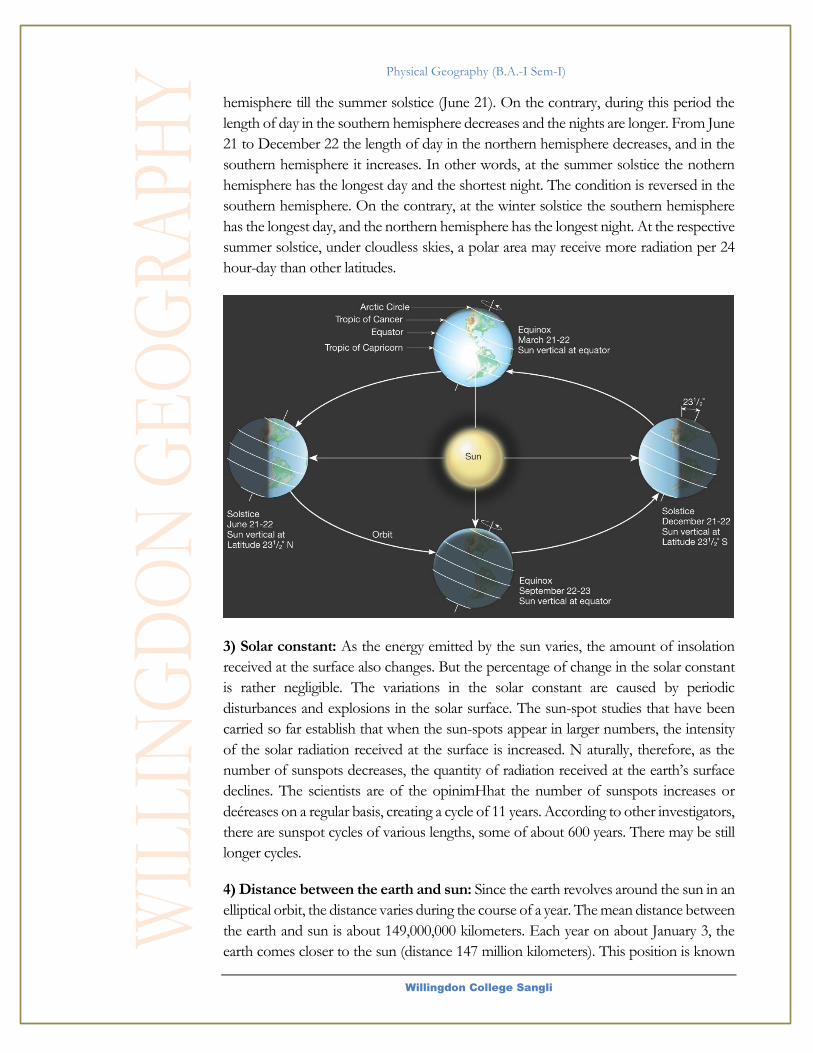
2) Duration of sunshine: The duration of sunlight hours determines the length of the
day, which also affects the amount of solar radiation received at the surface.
Undoubtedly, the longer period of sunshine ensures larger supply of radiation which
particular area of the earth will receive. Obviously, the latitudes exercise the most
dominant control over the duration of sunshine and thereby the length of the day. The
latitudinal and monthly variations in the length of days. The inclination of the earth’s
axis, its parallelism, the earth’s rotation and revolution, all these factors combine together
to bring about seasonal changes. It is to be remembered that these astronomical factors
not only cause differences in the altitude of the sun, but also differences in the length of
day from the equator poleward. At the equator the length of days and nights is 12 hours.
On the autumnal and vernal equinoxes that occur on September 21 and March 21
respectively, the mid-day sun is overhead at the equator. On these days all over the earth
the days and nights are equal. On these two days, the maximum amount of insolation is
received at the equator, and the amount goes on decreasing towards the poles. But from
the winter solstice (December 22) onward the length of day increases in the northern
Physical Geography (B.A.-I Sem-I)
Willingdon College Sangli
hemisphere till the summer solstice (June 21). On the contrary, during this period the
length of day in the southern hemisphere decreases and the nights are longer. From June
21 to December 22 the length of day in the northern hemisphere decreases, and in the
southern hemisphere it increases. In other words, at the summer solstice the nothern
hemisphere has the longest day and the shortest night. The condition is reversed in the
southern hemisphere. On the contrary, at the winter solstice the southern hemisphere
has the longest day, and the northern hemisphere has the longest night. At the respective
summer solstice, under cloudless skies, a polar area may receive more radiation per 24
hour-day than other latitudes.
3) Solar constant: As the energy emitted by the sun varies, the amount of insolation
received at the surface also changes. But the percentage of change in the solar constant
is rather negligible. The variations in the solar constant are caused by periodic
disturbances and explosions in the solar surface. The sun-spot studies that have been
carried so far establish that when the sun-spots appear in larger numbers, the intensity
of the solar radiation received at the surface is increased. N aturally, therefore, as the
number of sunspots decreases, the quantity of radiation received at the earth’s surface
declines. The scientists are of the opinimHhat the number of sunspots increases or
deéreases on a regular basis, creating a cycle of 11 years. According to other investigators,
there are sunspot cycles of various lengths, some of about 600 years. There may be still
longer cycles.
4) Distance between the earth and sun: Since the earth revolves around the sun in an
elliptical orbit, the distance varies during the course of a year. The mean distance between
the earth and sun is about 149,000,000 kilometers. Each year on about January 3, the
earth comes closer to the sun (distance 147 million kilometers). This position is known

Physical Geography (B.A.-I Sem-I)
Willingdon College Sangli
as perihelion. On about July 4, the earth is a little farther from the sun when the distance
becomes about 152 million kilometers, This position is called aphelion. Although the
amount of incoming solar radiation received at the outer boundary of the atmosphere is
a little greater (7 percent) in January than in July, there are other major factors, such as
the angle of incidence and the duration of sunshine that more than offset its effect on
seasonal temperature variations. It may be interesting to note that the earth is relatively
closer to the sun during the northern hemisphere winter.
5) Transparency of the atmosphere: Transparency of the atmosphere is an important
control on the amount of insolation which reaches the earth’s surface. Reflection from
dust, salt, and smoke particles in the air is an important mechanism for returning
shortwave solar radiation to space. Similarly, reflection from cloud tops also depletes the
amount of solar radiation that would otherwise be available to the earth. The effect of
certain gases, water vapour, and dust particles on reflection, scattering, and absorption is
well-known. Obviously, areas with heavy cloudiness and turbid atmosphere will receive
lesser amount of radiant energy at the surface. But the transparency of the atmosphere
varies with time and place.
2.3 Temperature: Distribution of
temperature (Vertical and Horizontal)
a. Vertical Distribution of temperature
Temperature decreases with increasing height in the troposphere but the rate of decrease
varies according to seasons, duration of sunshine and location. On an average, the rate
of decrease of temperature with increasing altitudes in a stationary column of air with
absence of any vertical motion is 6.5°C per 1000 metres. This decrease of temperature is
called vertical temperature gradient or normal lapse rate which is 1000 times greater than
the horizontal lapse rate (decrease of temperature with increasing latitudes). The decrease
of temperature upward in the atmosphere proves the fact that the atmosphere gets heat
from the earth's surface through the processes of conduction, radiation and convection.
It is, thus, obvious that 'as the distance from the earth’s surface (the source of direct heat
energy to the atmosphere) increases (i.e. as the altitude increases) the air temperature
decreases. The following are the reasons for decrease of temperature with increasing
altitudes in the troposphere.
(i)Heat is transferred to the atmosphere from the earth’s surface through the processes
of conduction radiation and convection. Thus, as the altitude increases the amount of
heat transported upward decreases. Consequently, every air layer receives less heat than
the air layer lying below.
(ii)The air pressure is higher in the lower portion of the atmosphere near the earth’s
surface because of weight of all the air layers lying above and thus the air density is
maximum in the lower atmosphere but it decreases rapidly upward and the air becomes
thin.
Physical Geography (B.A.-I Sem-I)
Willingdon College Sangli
(iii)The quantity of water vapour, dust particles, water droplets, carbon dioxide etc.,
which absorb outgoing longwave terrestrial radiation, is more concentrated in the lower
portion of the atmosphere and decreases rapidly with increasing altitude. Thus, the
temperature of lower atmosphere becomes more than the air layers lying above because
of more and more absorption of terrestrial radiation in the lower air layers. In other
words, the temperature decreases upward because of decrease of absorption of terrestrial
radiation with increasing height in the troposphere.
(iv)It may be pointed out that the decrease of temperature with increasing height is
confined to the troposphere only. The height of troposphere is 16km and 6 km over the
equator and the poles respectively but this height also varies in different seasons i.e. it
becomes higher in summer than in winter. The upper limit of troposphere is called
tropopause.
It is interesting to note that the temperature at tropopause increases from over
the equator towards the poles because the height of tropopause decreases from over the
equator towards the poles. The height of tropopause during July and January over the
equator is l7km while temperature at the top of tropopause is 70°C. The height of
tropopause decreases to 15km in July and 12.5km in January over 45°N latitude but the
temperature at the top of tropopause increases to 60°C in July and 58°C in January. The
height of tropopause further decreases to 10km in July and 9 km in January over the
poles but the temperature increases to 45°C in July and -58°C in January. Upward from
tropopause the temperature is reported to increase with increasing height in the
stratosphere wherein it becomes 0°C or 32°F at the height of 50km from sea level. This
is the upper limit of the stratosphere and is called stratosphere. Temperature again
decreases with increasing height in the mesosphere (50km80km). The temperature
becomes -80°C at mesopause, the upper limit of the mesosphere. Beyond mesopause
temperature again increases with increasing height in the thermosphere. It is estimated
that the temperature at its upper limit (height undecided) becomes 1700°C. It may be
pointed out that this temperature cannot be measured by ordinary thermometer because
the gases become very light due to very low air density. Sometimes temperature increases
with increasing height in the troposphere. In other words, sometime warm air lies over
cold air. This phenomenon is called inversion of temperature.
b. Horizontal Distribution of temperature
According to ancient Greek thinkers the globe is divided into three temperature zones
on the basis of latitudes e.g. (l) tropical zone. (2) Temperate zone, and (3) Frigid Zone.
(1) Tropical zone extends between the tropics of Cancer (23.5°N) and Capricorn
(23.5°S). The Sun’s rays are more or less vertical on the equator throughout the year. The
remaining areas are also characterized by vertical sun’s rays at least once every year. There
is no winter around the equator because of high temperature prevailing throughout the
year but as one approaches the tropics of Cancer and Capricorn summer and winter are
clearly observed and differentiated.
Physical Geography (B.A.-I Sem-I)
Willingdon College Sangli
(2) Temperate zone extends between 23.5° and 66.5° latitudes in both the hemispheres.
Though the duration of day and night is longer in this zone but it is never more than 24
hours. There are marked seasonal contrasts with the northward and southward (summer
and winter solstices) migration of the overhead sun and thus the range of temperature
between summers and winters becomes exceptionally very high.
(3) Frigid zone extending between 66.5° latitude and the poles in both the hemispheres
is characterized by more oblique sun’s rays throughout the year resulting into
exceptionally very low temperature. The length of day and night is more than 24 hours.
Days and nights are of 6 months duration at the poles. Sun is never vertical and the
ground is covered with snow as temperature more or less remains below freezing point.
It may be pointed out that the Greeks gave undue importance to latitudes in
determining different temperature zones and overlooked the controls of contrasting
nature of continents and oceans in terms of their heating and cooling, prevailing winds,
ocean currents, nature of ground surface etc. Taking all these factors in consideration
Soupan divided the globe into temperature zones on the basis of isotherms. According
to him the outer limit of trapical zone should be determined on the basis of annual
isotherm of 68°F (20°C). The boundary between temperate and-frigid zones in the
northern hemisphere should be demarcated by 50°F (10°C) isotherm of July while
January isotherm of 50°F (10°C) should separate temperate zone in the southern
hemisphere.
2.4 Atmospheric Pressure: Belts and
Planetary Winds.
a. Pressure Belts
The horizontal distribution of air pressure on the globe is studied on the basis of isobars.
Air pressure is generally divided in two type’s viz. (1) high pressure, also called as ‘high’
or anticyclone, and (2) low pressure, also called as ‘low’ or cyclone or depression. If we
look fit the globe then it appears that there is certain definite system of high and low
pressure. If, for generalization, the globe is considered to be homogeneous (either of
land or water), then there should be regular and systematic zonal distribution of high
and low pressure but the regularity of pressure belts is disturbed due to unequal
distribution of land and water on the globe. The pressure belts are discontinued in the
northern hemisphere and several centres of pressure belts are developed but the pressure
belts are found more or less in regular pattern in the southern hemisphere.
There is no definite trend of distribution of pressure from equator towards the
poles. If the air pressure would have been the function of air temperature alone there
should have been regular increase of pressure poleward because temperature regularly
decreases from the equator towards the poles but this is not the case. There is low
pressure near the equator due to high mean annual temperature but the existence of high

Physical Geography (B.A.-I Sem-I)
Willingdon College Sangli
pressure belts near the tropics of Cancer and Capricorn cannot be explained on the basis
of temperature because the tropics record very high temperature and hence there should
have been low pressure if the temperature would have been the only control of air
pressure. The air pressure should increase poleward from the tropics of Cancer and
Capricorn because there is rapid rate of decrease of temperature poleward but we find
low pressure belt near 60° latitude. Again we find high pressure belts near the poles due
to exceedingly low temperature throughout the year. It is obvious that pressure belts are
not only induced by thermal factor but they are also induced by dynamic factors.
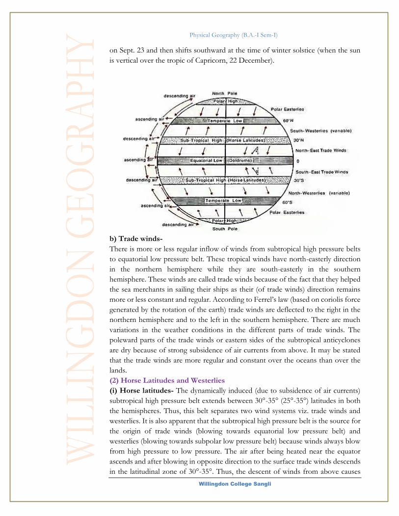
In all, there are seven pressure belts on the globe. On the basis of mode of
genesis pressure belts are divided into two broad categories e.g. (l) thermally induced
pressure belts (e.g. equatorial low pressure belt and polar high pressure belt), and (2)
dynamically induced pressure belts (e.g. subtropical high pressure belt and subpolar low
pressure belt.
(1) Equatorial Low Pressure Belt : The equatorial low pressure belt is located on either
side of the geographical equator in a zone extending between 5°N and 5°S latitudes but
this zone is not stationary because there is seasonal shift of this belt with the northward
(summer solstice) and southward (winter solstice migration of the sun). During northern
summer this belt extends upto 20°N in Africa and to the north of tropic of Cancer in
Asia while during southern summer this low pressure belt shifts to 10° to 20°S latitude.
The equatorial low pressure belt is thermally induced because the ground surface is
intensely heated during the day due to almost vertical sun‘s rays and thus the lowermost
layers of air coming in contact with the heated ground surface also gets warmed. Thus,
warmed air expands, becomes light, and consequently rises upward causing low pressure.
The equatorial low pressure belt represents the zone of convergence of north-east and
south-east trade winds. There are light feeble and variable winds within this convergence
belt. Because of frequent calm conditions this belt is called a belt of calm or doldrum.
(2) Sub-Tropical High Pressure Belt:
Sub-tropical high pressure belt extends between the latitudes of 25°-35° in both the
hemispheres. It is important to note that this high pressure belt is not thermally induced
Physical Geography (B.A.-I Sem-I)
Willingdon College Sangli
because this zone besides two to three winter months, receives fairly high temperature
throughout the year. Thus, this belt owes its origin to the rotation of the earth and sinking
and settling down of winds. It is, thus, apparent that the sub-tropical high pressure belt
is dynamically induced. The convergence of winds at higher altitude above this zone
results in the subsidence of air from higher altitudes. Thus, descent of winds results in
the contraction of their volume and ultimately causes high pressure. This is why this zone
is characterized by anticyclonic conditions which cause atmospheric stability and aridity.
This is one of the reasons for the presence of hot deserts of the world in the western
parts of the continents in a zone extending between 25°-35° in both the hemispheres.
This zone of high pressure is called ‘horse latitude’ because of prevalence of frequent
calms. In ancient times, the merchants carrying horses in their ships had to throw out
some of the horses while passing through this zone of calm in order to lighten their
ships. This is why this zone is called horse latitude. It is interesting to note that this zone
of high pressure is not a continuous belt but is broken into a number of high pressure
centres on cells
(3) Sub-Polar Low Pressure Belt:
This belt of sub-polar low pressure is located between 60°-65° latitudes in both the
hemispheres. The low pressure belt does not appear to be thermally induced because
there is low temperature throughout the year and as such there should have been high
pressure belt instead of low pressure belt. It is, thus, obvious that this low pressure belt
is dynamically produced. In fact, the surface air spreads outward from this zone due to
rotation of the earth and low pressure is caused. It may be pointed out that this factor
should be more effective at the poles but the effects of the rotation is negated or say
overshadowed due to exceptionally low temperature prevailing throughout the year at
the poles. The sub-polar low pressure belt is more developed and regular in the southern
hemisphere while it is broken in the northern hemisphere because of over dominance
of water (oceans) in the former. Instead of regular and continuous belt there are well
defined low pressure centres or cells over the oceans in the northern hemisphere e.g. In
the neighbourhood of Aleutian Islands in the Pacific Ocean and between Greenland and
Iceland in the Atlantic Ocean. It may be noted that due to great contrasts of temperatures
of the continents and oceans during northern summer the low pressure belt becomes
discontinuous and is found in a few low pressure cells while the temperature contrast
between the continents and oceans is much reduced during winter and hence low
pressure belt becomes more or less regular and continuous in the northern hemisphere.
(4) Polar high Pressure Belt:
High pressure persists at the poles throughout the year because of prevalence of very
low temperature (below freezing point) all the year round. In fact, both the factors,
thermal and dynamic, operate at the poles. There is thinning out of layers of air due to
diurnal rotation of the earth as the air spreads outward due to this factor but this effect
is overshadowed by thermal factor and hence high pressure is produced due to very low
temperature. The horizontal distribution of air pressure is represented and studied
through isobars for the months of July (to represent pressure conditions during summer

Physical Geography (B.A.-I Sem-I)
Willingdon College Sangli
season) and January (to represent air pressure during Winter season in the northern
hemisphere) portray the world distribution of air pressure through isobars in July and
January respectively. The class interval of isobars is 3 mb.
b. Planetary Winds.
The location of the high and low-pressure belt is considered to be stationary on the
globe. Consequently, wind blows from high pressure belt to low pressure belt. The
direction remain more or less same throughout the year though their areas change
seasonally. Thus, such wind called as permanent or planetary winds. These winds
include trade winds, westerlies and polar winds.
(1) Winds In The Tropics:
Generally, the areas extending between 30°N and 30°S latitudes are included in
tropical zone. Formerly, it was believed that trade winds blow from the subtropical
high-pressure belts to the equatorial low pressure belt. The north-east and south-
east trades converge along the equator and there are upper air antitrades blowing in
the opposite directions of the surface trade winds. The weather conditions
throughout the tropical zone remain more or less uniform. There is a belt of calm
or doldrum characterized by feeble air circulation. The tropical zone is characterized
by doldrum, equatorial westerlies, and trade winds.
a) Doldrum and equatorial westerlies -
A belt of low pressure, popularly known as equatorial trough of low pressure,
extends along the equator within a zone of 5°N and 5°S latitudes. This belt is called
the belt claim or doldrum because of light and variable winds. The doldrum is a
regular feature all along the equator and characterized by strong convective
instability leading to the formation of cumulonimbus clouds and copious rainfall
daily. The belt of doldrum shifts northward during summer solstice (when the sun
is vertical over the tropic of Cancer, 21 J une) and comes back to its normal position
Physical Geography (B.A.-I Sem-I)
Willingdon College Sangli
on Sept. 23 and then shifts southward at the time of winter solstice (when the sun
is vertical over the tropic of Capricorn, 22 December).
b) Trade winds-
There is more or less regular inflow of winds from subtropical high pressure belts
to equatorial low pressure belt. These tropical winds have north-easterly direction
in the northern hemisphere while they are south-easterly in the southern
hemisphere. These winds are called trade winds because of the fact that they helped
the sea merchants in sailing their ships as their (of trade winds) direction remains
more or less constant and regular. According to Ferrel’s law (based on coriolis force
generated by the rotation of the earth) trade winds are deflected to the right in the
northern hemisphere and to the left in the southern hemisphere. There are much
variations in the weather conditions in the different parts of trade winds. The
poleward parts of the trade winds or eastern sides of the subtropical anticyclones
are dry because of strong subsidence of air currents from above. It may be stated
that the trade winds are more regular and constant over the oceans than over the
lands.
(2) Horse Latitudes and Westerlies
(i) Horse latitudes- The dynamically induced (due to subsidence of air currents)
subtropical high pressure belt extends between 30°-35° (25°-35°) latitudes in both
the hemispheres. Thus, this belt separates two wind systems viz. trade winds and
westerlies. It is also apparent that the subtropical high pressure belt is the source for
the origin of trade winds (blowing towards equatorial low pressure belt) and
westerlies (blowing towards subpolar low pressure belt) because winds always blow
from high pressure to low pressure. The air after being heated near the equator
ascends and after blowing in opposite direction to the surface trade winds descends
in the latitudinal zone of 30°-35°. Thus, the descent of winds from above causes
Physical Geography (B.A.-I Sem-I)
Willingdon College Sangli
high pressure on the surface which in turn causes anticyclonic conditions. This is
why the anticyclonic conditions cause atmospheric stability, dry condition and very
weak air circulation. Thus, this zone (30°-35°) is characterized by weak and variable
winds and calm. This belt of calm is very popularly known as horse latitudes because
of the fact that in ancient times the merchants had to throw away some of the horses
being carried in the ships in order to lessen the weight so that the ships could be
sailed through the calm conditions of these latitudes.
(ii) Westerlies - The permanent wind blowing from the subtropical high pressure
belts (30°-35°) to the subpolar low pressure belts (60°-65°) in both the hemispheres
are called westerlies. The general direction of the westerlies is S.W. to NE. in the
northern hemisphere and N.W. to SE in the southern hemisphere. There is much
variation in the weather conditions in their poleward parts where there is
convergence of cold and denser polar winds and warms and lighter westerlies. In
fact, a cyclonic front, called as polar front, is formed due to two contrasting air
masses as referred to above and thus temperate cyclones are originated. These
cyclones move along with the westerlies in easterly direction. Thus, the general
characteristic features of the westerlies are largely modified due to cyclones and
anticyclones associated with them. Because of the dominance of land in the
northern hemisphere the westerlies become more complex and complicated and
become less effective during summer seasons and more vigorous during winter
season. These westerlies bring much precipitation in the western parts of the
continents (e.g. north~west European coasts) because they pick up much moisture
while passing over the vast stretches of the oceans. The westerlies become more
vigorous in the southern hemisphere because of lack of land and dominance of
oceans. Their velocity increases southward and they become stormy they are also
associated with boisterous gales. The velocity of the westerIies becomes so great
that they are called roaring forties between the latitudes of40°- 50° s, furious fifties
50°S latitude and shrieckng sixties at 60° S latitude.
(3) Polar Winds-
A low pressure belt, produced due to dynamic factor, lies within the latitudinal belt
of 60°-65° in both the hemispheres. This belt of low pressure is more persistent in
summer season but generally disappears in winter season. The Icelandic and
Aleutian low-pressure cells persist throughout the year. There is very high pressure
over the poles because of exceedingly low temperature. Thus, winds blow from
polar high pressure to subpolar low-pressure cells. These are called polar winds,
which are north-easterly in the southern hemisphere and south-easterly in the
southern hemisphere.

Physical Geography (B.A.-I Sem-I)
Willingdon College Sangli

Physical Geography (B.A.-I Sem-I)
Willingdon College Sangli
Lithosphere
Our planet is almost spherical, with a radius of approximately 6400 km (about
4000 mi).
he knowledge of the internal structure and composition of the earth has been
remained a matter of great controversy among the geologists and geo-physicists.
Today, there is a lot of knowledge available about the earth’s interior. The most
ambitious human effort to penetrate Earth’s interior was made by the former
Soviet Union, which drilled a super-deep research well, named the Kola Well,
near Murmansk, Russia. This was an attempt to penetrate the crust and reach the upper
mantle. The reported depth of the Kola Well is a little more than 7.5 miles (12 km.). The
main sources for the study of earth’s interior includes
1. Evidences based on Artificial Sources
a. Density: The average density of Earth is about 5.52 g/cm3
and the average density of Earth's crust is about 2.6 to 3.3 g/cm3.
This indicates higher density below the crust and because the
acceleration due to gravity is quite uniform everywhere therefore mass is distributed
uniformly in the form of concentric layers. It is estimated that the relative density of the
rocks of the interior part of the earth is about 11 to 13.
b. Pressure: Pressure in itself is not responsible for the increase in density; rather the
core is composed of intrinsically heavy metallic materials of high density.
c. Temperature: there is a rise of 1°C with every 32 meters of depth. This rate of
increase is uniform everywhere on the earth. The temperature at the depth of 50 km
should be around 1500° C. It is, therefore, clear that the solid layer of the Earth is a thin
film over the otherwise molten material. Evidences based upon temperature indicate that
Module
3
T
Valuable information
Test your knowledge
Keyboard exercise
Workbook review

Physical Geography (B.A.-I Sem-I)
Willingdon College Sangli
middle layer exists between 1200 to 2900 km of depth. The lowest layer is considered to
be 2900 to 6378 km deep.
d. Meteorites: Meteorites (hitting earth) allow us to determine the density, mineralogy
and chemistry of the nickel iron core of bodies having a similar composition to that of
the earth.
2. Natural sources
a. Vulcanicity: Some geologists on the basis of upwelling and spread of hot and liquid
lava on the earth’s surface during volcanic eruptions believe that there is at least a layer
below the earth’s surface which is in liquid state.
b. Evidences from Seismology: It has been experimentally proved that three types of
waves are produced at the time of earthquake. These waves are also known as seismic
waves. These include,
1. Primary (Longitudinal or Compressional or „P‟) waves-to and fro motion of particles
in line of the propagation of the ray. These waves can pass through both the solid and
the liquid medium
2. Secondary (transverse or distortional or S) waves-particles move at right angles to the
rays. These waves cannot pass through the liquid.
3. Surface (Long-Period or ‘L’) waves: Affect only the surface of the earth and covers
the longest distance of all seismic waves. It has lower speed than P and S waves but is of
most violent and destructive nature. These waves get reflected and refracted while
passing through a body having heterogeneous composition and varying density zones at
the discontinuities.
P-wave velocity depends on the elasticity, rigidity, and density of the material. By
contrast, S-wave velocity depends only on the rigidity and density of the material. In
most rock types P-waves travel between 1.7 and 1.8 times more quickly than S-waves;
therefore, P-waves always arrive first at seismographic stations. P-waves travel by a series
of compressions and expansions of the material through which they travel. The slower
S-waves, also called shear waves, move like a wave in a rope. This movement makes the
S-wave more destructive to structures like buildings and highway overpasses during
earthquakes. Because S-waves can travel only through solids and cannot travel through
Earth’s outer core, seismologists concluded that Earth’s outer core must be liquid or at
least must have the properties of a fluid. This proves that there are various layers of
different densities and medium which split the waves in many parts. It is meant that earth
is made up of various shells.
3.1 Structure of Earth’s interior
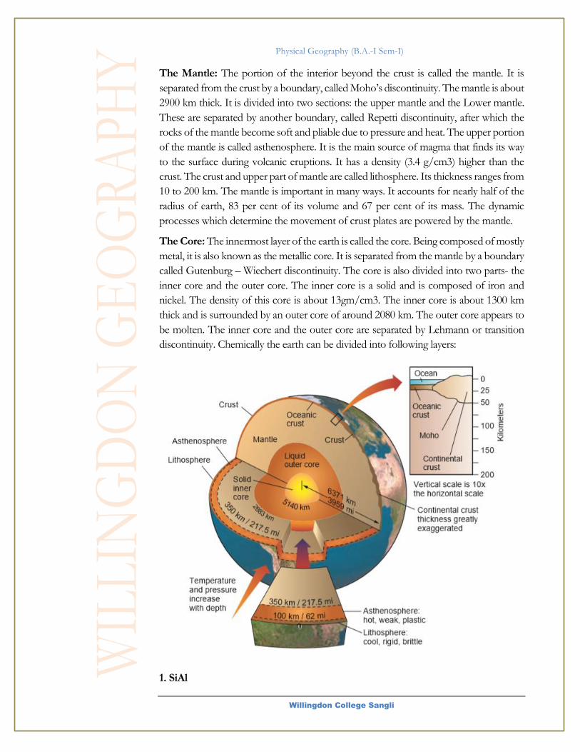
The Crust: It is the outermost part of the earth. It is brittle in nature. The thickness of
the crust varies under the oceanic and continental areas. The main thickness of oceanic
crust is 5 to 8 km and that of continental is around 30 km. the continental crust is thicker
in the areas of major mountain systems. It is as much as 70 km thick in the Himalayan
region. It is made up of heavier rocks having density of 3 g/cm3. This type of rock found
in the oceanic crust is basalt. The mean density of material in oceanic crust is 2.7g/cm3.
Physical Geography (B.A.-I Sem-I)
Willingdon College Sangli
The Mantle: The portion of the interior beyond the crust is called the mantle. It is
separated from the crust by a boundary, called Moho’s discontinuity. The mantle is about
2900 km thick. It is divided into two sections: the upper mantle and the Lower mantle.
These are separated by another boundary, called Repetti discontinuity, after which the
rocks of the mantle become soft and pliable due to pressure and heat. The upper portion
of the mantle is called asthenosphere. It is the main source of magma that finds its way
to the surface during volcanic eruptions. It has a density (3.4 g/cm3) higher than the
crust. The crust and upper part of mantle are called lithosphere. Its thickness ranges from
10 to 200 km. The mantle is important in many ways. It accounts for nearly half of the
radius of earth, 83 per cent of its volume and 67 per cent of its mass. The dynamic
processes which determine the movement of crust plates are powered by the mantle.
The Core: The innermost layer of the earth is called the core. Being composed of mostly
metal, it is also known as the metallic core. It is separated from the mantle by a boundary
called Gutenburg – Wiechert discontinuity. The core is also divided into two parts- the
inner core and the outer core. The inner core is a solid and is composed of iron and
nickel. The density of this core is about 13gm/cm3. The inner core is about 1300 km
thick and is surrounded by an outer core of around 2080 km. The outer core appears to
be molten. The inner core and the outer core are separated by Lehmann or transition
discontinuity. Chemically the earth can be divided into following layers:
1. SiAl
Physical Geography (B.A.-I Sem-I)
Willingdon College Sangli
Just below outer sedimentary
cover.
Composed mainly of granites
Density- 2.9 g/cm3
50 to 300 km thick.
Rich in silica and aluminium
(Silicates mainly present are those
of sodium, potassium and
aluminum.)
It forms the continental layer.
Acidic in nature
2. SiMa
Below SiAl
Composed mainly of basalt
Source of magma and lava
Rich in silica and magnesium
Density-2.9 to 4.7 g/cm3
Thickness-1000 to 2000 km
Basic in nature
Silicate mainly present are those
of magnesium, calcium and Iron.
3. NiFe
Below SiMa
Rich in nickel and iron
Very high density
Diameter of this layer-6880 km
Indicates magnetic property of the earth's interior
Mechanical Divisions of Earth
Prof. Edward Suess divides the earth’s interior into three parts
(1) Lithosphere: The lithosphere is the solid layer composed of the crust and the upper
mantle (40 to 100 km). Its relative density ranges from 2.75 to 2.90. It is composed of
Silicon and Aluminum. It is called SIAL by Suess. This layer is mainly composed of
granite. It is divided into several large fragments called plates. It moves over
Asthenosphere, which is a 100 km thick layer found at the top of the lower mantle. It is
a low velocity zone (that is slow speed of seismic ways in this zone) and plastic or less
viscous (softer, more pliable) in nature.
(ii) Pyropsphere: this is the middle layer, surrounds the core on all sides. Its relative
density ranges from 2.9 to 4.75. It is composed of Silicon and Magnesium. Suess calls it
SIMA.
(iii) Barysphere: It comprises core. Outer layer is liquid in state where as the inner core is
solid. The rocks of this layer are composed of Iron and Nickel. The relative density of
these rocks is about 11 to 13. Suess calls this layer as NIFE.
Discontinuities:
Many such discontinuities are expressed as follows-
1. Gutenberg discontinuity-Between outer liquid core and the solid mantle
2. Mohorovicic discontinuity-Between crust and mantle.
3. Conrad discontinuity-Between oceanic (Basaltic or SIMA layer) and continental
(Granites or SIAL layer) Crust-Up to 30 − 40 km beneath the continents (greater depth
in mountainous regions). 10 km deep beneath the oceans.
Physical Geography (B.A.-I Sem-I)
Willingdon College Sangli
3.2 Wegener’s Theory of Continental Drift
The theory of continental theory is an attempt to explain the present arrangement of
continents and ocean basins. Continental drift is the large scale horizontal displacement
of continents with respect to each other and with respect to ocean basins during one or
more episodes of geological time.
It is worthy to mention here that though the credit for the development of
continental drift goes to Alfred Wegener, there were a number of earlier scholars who
also talked about continental drift in one way or the other. These scholars were Abraham
Ortelius, Sir Francis Bacon, Antonio Snider Pellinerigi, F.B Taylor etc.
However the, Alfred Wegener, a German meteorologist and geophysicist is
considered by most scientists to be the pioneer of the modern continental drift theory.
He presented his ideas in 1912. As Wegener was a meteorologist and geophysicist, he
was interested to investigate the relative distribution of land and sea and the climatic
anomaly of the past and with this thing in mind he concluded about the drift of
continents, which he presented in his book „origin of continents and oceans’, which was
first published in German in the year 1915 and was later translated into English in 1924.
As already mentioned, the main theme of Wegener’s theory was based on climatic
changes reported in the past history.
Wegener believed on three system of earth’s layers; SIAL, SIMA and NIFE. He
believed that SIAL being lighter and uppermost floats over a denser SIMA and NIFE.
Assuming on the basis of paleo- climatology, paleo-botany and geology that all the
landmasses were united together which he called “Pangaea” surrounded by a huge water
body called “panthallassa”. According to Wegener Pangaea started breaking about 300
million years ago and about 200 million years ago (Mesozoic era) first split took place,
which divided the continent into two main landmasses namely Laurasia (Europe, Asia,
North America and Greenland) in the north and Gondwanaland (South America, Africa,
India, Australia and Antarctica) in the south. These two blocks were separated by a long
shallow inland sea called sea of Tethys.
According to Wegener, again 70 million years ago, the second drift took place in
which the drift was westward and equator ward to southwards. The equator ward drift
was due to force of gravity and buoyancy and westwards due to tidal currents because
of the earth’s motion. In this drift the centrally located sea of Tethys was filled and the
blocks of plates of America drifted westwards and mountain ranges of Rockies and
Andes were formed with rubbing of pacific plates. Meanwhile, the peninsular India
broke from Gondwanaland and was attracted towards Laurasia being larger one. So the
mountain ranges of the Himalayas, Suleiman, Hindukush, Armenia, Atlas and Alps were
buckled (raised) from the materials of sea of Tethys whose remaining portion still exists
in the form of Meditterean Sea, Black Sea and Caspian Sea. The Gondwanaland’s split
portion of Australia moved towards east forming east mountainous region of Australia.
In the same manner, Antarctica also moved southwards forming the present position of
continents and ocean basins.

Physical Geography (B.A.-I Sem-I)
Willingdon College Sangli
Some of the evidences that are used to support the continental drift theory
are the following:
1. Like a jigsaw puzzle, there is a near perfect match of the coastlines of distant
continents, such as South America and Africa.
2. Found in continents separated by oceans are identical remains of fossils of certain
species of plants and animals.
3. Coal deposits in Antarctica showed that this continent has experienced warm climate.
That was the time when it was part of the supercontinent Pangaea.
4. Identical rock formations were found on opposite shores of the Atlantic. This is proof
that these shores were once part of the continent.
5. North and South America continue to move away from Europe at the rate of 4
cm/year. India continues to move into Asia at the rate of 5 cm/year. As a consequence,
Mount Everest and the Himalayan mountain ranges grow higher by 1 cm/year.
Criticism
One of the main objections to Wegner’s hypothesis stemmed from his inability to
provide a driving mechanism for continental drift. Wegner proposed two possible energy
sources for drift.
1. The Tidal force/influence of the moon was presumed by Wegner to be strong enough
to give the continents a westward motion. However, the prominent Physicist Harold
Jeffrey’s quickly countered with the argument that the tidal friction of the magnitude
needed to displace the continents would bring the earth’s rotation to a halt in a matter
of few years.
2. Further Wegner proposed that the larger and sturdier continents broke through the
oceanic crust, much like icebreakers cut through ice.
3. However no evidence existed to suggest that the ocean floor was weak enough to
permit passage of the continents without themselves being appreciably deformed in the
process.
4. The hypothesis was criticized largely on grounds of its inability to suggest a satisfactory
means of engineering continental movements. It must be conceded that the cumulative
evidence supporting the theory of continental drift was massive and the theory was very
attractive. If all the points in the theory could be established and an adequate motive
force discovered then as Professor Shand has said, “We would have to credit prof.
Wegner with the greatest piece of geological synthesis that has ever been accomplished”
(1933).
5. Wegner himself in response to his critics said “Scientists still do not appear to
understand sufficiently that all earth Sciences must contribute evidence towards
unraveling the state of our planet in earlier times, and the truth of the matter can only be
reached by combining all this evidence”.
Although most of Wegner’s contemporaries opposed his views, even to the
point of openly ridiculing him, a few considered his ideas plausible. Amongst the noted
supporter were. Arthur Holmes (1928) contributed to the cause by proposing a plausible
driving mechanism for continental drift. Since the time he first proposed, he kept on
Physical Geography (B.A.-I Sem-I)
Willingdon College Sangli
modifying his hypothesis and in his book Physical Geology (1966) he suggested that
convection currents operating within the Mantle were responsible for propelling the
continents across the globe.
Although, even to this day geologists are not in agreement on the exact nature of the
driving mechanism, the concept proposed by Holmes is still one of the most appealing.
Wegner also in 1929 suggested thermal convection currents.
3.3 Earthquake: Causes and
Effects
a. Definition and nature of earthquake.
Earthquakes are the most prominent evidence of present day earth movements. An
earthquake is a vibratory motion of the ground surface, ranging from a faint tremor
to wild motion capable of shaking buildings apart. In other words, an earthquake is
a form of energy of wave motion transmitted through the surface layer of the earth
in widening circles from a point of sudden energy release, the focus. The point
within the earth where earthquakes are generated is called focus or hypocenter. The
point on the earth's surface directly or vertically above the focus is called the
epicenter and experience the seismic event first. The science of studying earthquakes
is known as seismology. Hence, all the phenomena related to the emergence and
manifestation of earthquakes are called seismic. The magnitude or energy released
by an earthquake is measured with the help of Richter Scale. Its values range from
1 and 09. Elastic Rebound Theory explains the mode and cause of earthquake.
Earthquake waves or seismic waves
Earthquakes generate pulses of energy called seismic waves. Four types of
earthquake waves are found. Three were discovered by R. D Oldham and one later,
by Augustas E. H. Love. Basically, they may be divided into two chief kinds of
seismic waves:
1. Body waves
2. Surface waves.
1. Body Waves: The fastest seismic waves, move through the earth. Slower surface
waves travel along the surface of the earth. Body waves tend to cause the most
earth-quake damage. There are two kinds of body waves:
(I). P-waves/ Compressional/ longitudinal waves
(II). S- waves/ Transverse/ Shear waves.
(I). P-waves/ Compressional/ longitudinal waves
As the waves pass through the earth, they cause particles of rock to move in
different ways. Compressional waves push and pull the rock. They cause buildings
and other structures to contract and expand. Compressional waves can travel
through solids, liquids, or gases. Compressional or longitudinal waves are the fastest
seismic waves, and they arrive first at a distant point. For this reason, compressional
waves are also called primary (P) waves. They have shortest wavelength among the
four. Their velocity is 5 to 12 km/sec. They can travel through liquids (outer core)

Physical Geography (B.A.-I Sem-I)
Willingdon College Sangli
and solids (crust, mantle and inner core) but travel faster in denser solid media.
These waves are like sound waves and cause any rock in their path to compress and
then expand in the same direction as the waves are traveling. Primary waves undergo
refraction and reflection at the margin of earth's outer lighter shell and inner dense
core.
(II). S- waves/ Transverse/ Shear waves.
Secondary or S waves which are of medium wavelength and high frequency, are also
called Shake or Shear waves. Shear waves make rocks bend or slide from side to
side, and buildings shake. Shear waves, which travel slower and arrive later, are called
secondary (S) waves. Shear waves also called as transverse waves travel through all
solid parts of earth but not the liquid part of the core. It is also called distortional
wave. Their velocity is about 3 to 4 km/sec.
2. Surface Waves or L - Waves:
These waves are long and slow waves. They are of long wavelength and low
frequency. These are confined to the skin of the earth’s crust, thereby, causing most
of the earthquake structural damage. These waves cover the longest distance of all
seismic waves. There are two kinds of surface waves: Love waves and Rayleigh
waves.
Love waves, named after A.E.H Love in 1911, travel through the earth's surface
horizontally and move the ground from side to side. Typical Love waves travel at
about 4.4 kilometers per second.
Rayleigh waves, named after Lord Rayleigh in 1885, makes the surface of the earth
roll like waves on the ocean. Rayleigh waves, the slowest of the seismic waves, move
at about 3.7 kilometers per second. Types of earthquakes on the basis of
depth/focus.
Depending on the depth (focus) at which they emerge, earthquakes are classified as:
(i) Surface Earthquake: Earthquakes having a focus at the depth of upto 10 kms are
known as surface earthquakes.
(ii) Normal earthquakes: Earthquakes having a focus at the depth of 10 to 70 kms
are known as normal earthquakes.
(iii) Intermediate Earthquakes: Their depth /focus ranges from 70 to 300 kms. They
accounts for about 18 per cent of the total earthquakes.
(iv) Deep focus earthquakes: Their depth of focus exceeds 300 kms. They are very
inconsiderable and are mainly recorded within the confines of Far East. The focus
of Deep- Focus earthquakes is placed at 760 km.
Measurement of Earthquakes
There are many scales devised for the measurement of earthquake intensity. Out of
these Mercalli and Richter are most well-known.
1. Richter scale: Probably the best-known gauge of earth-quake intensity is the local
Richter magnitude scale, developed in 1935 by United States seismologist Charles
Francis Richter. This scale, commonly known as the Richter scale, measures the
ground motion caused by an earthquake. It is a logarithmic scale that runs from 0

Physical Geography (B.A.-I Sem-I)
Willingdon College Sangli
to 9, though no upper limit exists. There are about 10 times as many quakes for
every decrease in Richter magnitude by one unit. For example, a magnitude 7 quake
is 10 times more powerful than a magnitude 6 quake, 100 times more powerful than
a magnitude 5 quake, 1000 times more powerful than a magnitude 4 quake, and so
on. Until 1979 an earthquake of magnitude 8.5 was thought to be the most powerful
possible; since then, however, improvements in seismic measuring techniques have
enabled seismologists to refine the scale, and 9.5 is now considered to be the
practical limit. Every increase of one number in magnitude means the energy release
of the quake is 32 times greater. For example, an earthquake of magnitude 7.0
releases 32 times as much energy as an earthquake measuring 6.0. The largest
earthquake ever recorded on the moment magnitude scale measured 9.5. It was an
inter-plate earthquake that occurred along the Pacific coast of Chile in South
America in 1960.
2. Mercalli Scale: It is a qualitative scale. Hence it is not considered to be accurate
from the point of view of scientific measurement. Its scale is dependent upon the
experiences gained by human sensory organs and the devastating effects of the
earthquakes. It was introduced in 1800’s by the Italian seismologist Giuseppe
Mercalli, measures the intensity of shaking with gradations from I to XII. Intensity
I on this scale is defined as an event felt by very few people, whereas intensity XII
is a catastrophic event that causes total destruction. Intensities II to III on the
Mercalli scale are roughly equal to magnitudes 3 to 4 on the Richter scale, and XI to
XII to 8 to 9.
b. Causes of earthquakes
The earthquakes can be divided into three main types on the basis of cause of
generation.
(i) Volcanic Earthquakes
These are connected with the processes of volcanism. They develop only in the
regions of contemporary volcanic activity. They emerge as a result of deep
explosions of gases, emitted from the magma and hydraulic shocks of magma. But
there are many places where there are no signs of volcanoes but are visited by
earthquakes. Hence, volcanic activity can be considered to be a local cause of
volcanic activity. The earthquake caused by Krakatao (1883) and Katmai (1912)
were experienced only at a small distance from the volcanic areas.
(ii) Denudational Earthquakes
They result from the collapses of considerable masses of rocks, mainly in
mountainous region. They are also called earthquakes due to collapse. For example
earthquakes due to large landslides or sinking of underground karst caves.
(iii) Tectonical Earthquakes:
Earthquakes belonging to this group are characterized by maximum force and
account for 95 per cent of all the earthquakes that are registered. These earthquakes

Physical Geography (B.A.-I Sem-I)
Willingdon College Sangli
result due to the displacement or dislocation of individual blocks of lithosphere due
to short relaxation of plate.
In other words Earthquakes may arise for a variety of reasons. Some
tensional earthquakes clearly arise from faulting. Some others arise due to
converging hard lithospheric converging plates. Others may result from tearing of
the lithosphere under high pressure.
Distribution of earthquakes/ seismic zones of the world
The observation of earthquakes that have been made in course of time has provided
an opportunity for the scientists to single out the seismic zones of the world.
Earthquakes are mainly felt in the following seismic regions.
(i) The Circum-Pacific Seismic Belt
This belt is also called as Ring of Fire and corresponds to approximately 68 per cent
of all the earthquakes. It has been found that 80 per cent of shallow, 90 per cent of
medium and all the deep focus-earthquakes originated in this belt. It includes the
western coast of North and South America, the Aleutians, Kamachatka, the Kurilis,
Japan, the Philippines and a strip through the East Indies to New Zealand.
(ii) The Mediterranean or Alpine and Trans Asiatic Belt
This seismic zone accounts for 21 per cent of all the earthquakes. This belt is
characterized by larger earthquakes of shallow origin and some of the intermediate
origin. This belt extends along
the Alpine mountain system of Europe and North Africa, through Asia Minor and
the Caucasus, Iran and Pakistan to the Himalayan mountain system including Tibet,
the Pamir and China.
(iii) The Atlantic Belt
This belt runs from north to south through the middle of the Atlantic Ocean. It
contains mostly the earthquakes of shallow origin. These constitute major fracture
zones where the plates diverge
and new oceanic crust is being formed by the up welling of magma on the mid-
ocean ridges.
Earthquake distribution in India
In India, the earthquake region is connected with the Himalayas. The region follows
the junction
of Tertiary rocks with the older rocks. The most important earthquake areas of India
are
(i) Zone of maximum Intensity -- The Himalayan Region
(ii) Zone of Minimum Intensity – The Northern Plain Region
c. Effects of Earthquake
Environmental implications of earthquakes
A. Disadvantages
(i) Landslides swamps fields and houses in the hilly regions.
(ii) Earthquakes results in emergence and subsidence of land.
Physical Geography (B.A.-I Sem-I)
Willingdon College Sangli
(iii) Earthquakes cause great damage to buildings, roads, railways, dams, bridges
etc. it becomes difficult to send supplies to the victims.
(iv) The rivers are dammed. It creates floods which inundates fields, towns etc.
(v) Fires are caused in the areas of earthquakes.
(vi) Glaciers are breached and their avalanches scatter to far off places.
(vii) Underground water is also affected. Lakes and swamps are created at many
places.
(viii) The water recedes from the sea ports under the influence of earthquake
waves.
B. Advantages
(i) New waterfalls and streams are created on the account of the disturbances
of the underground water.
(ii) Due to submergence of sea bottoms, deep gulfs are formed
(iii) New soil is formed due to breakdown of rocks.
(iv) New mineral areas are uncovered.
(v) Rivers adopt new courses that are fruitful for agriculture.
3.4 Volcano: Causes and effects
The terms volcanoes, mechanism of volcanoes and vulcanicity are more or less
synonymous to common man but these have different connotations in geology and
geography.
a. Definition of Volcano
A volcano is a conical or dome-shaped initial landform that is built from lava
emerging through constricted vents in the Earth’s surface. Volcanism, or volcanic
activity, constructs lofty cones of imposing mountain ranges as well as huge domes or
plateaus of volcanic rock.
‘A volcano is a vent, or opening, usually circular or nearly circular in form, through
which heated materials consisting of gases, water, liquid lava and fragments of rocks are
ejected from the highly heated interior to the surface of the earth’ (P.G. Worcester, 1948).
According to A. Holmes and UL. Holmes (1978) a volcano is essentially a fissure or
vent, communicating with the interior, from which flows of lava, fountains of
incandescent spray or explosive bursts of gases and volcanic ashes are erupted at the
surface. On the other hand, ‘the term vulcanicity covers all those processes in which
molten rock material or magma rises into the crust or is poured out on its surface, there
to solidify as acrystalline or semicrystalline rock’ (S.W. Wooldridge and KS. Morgan,
1959). Some scientists have also used the term of vulcanism as synonym to the term of
vulcanicity.
Volcanic mouth which is connected with the interior part of the earth by a narrow
pipe, which is called as volcanic pipe. Volcanic materials of various sorts are ejected
through this pipe and the vent situated at the top of the pipe. The enlarged form of the
Physical Geography (B.A.-I Sem-I)
Willingdon College Sangli
volcanic vent is known as volcanic crater and caldera. Volcanic materials include lavas,
volcanic dusts and ashes, fragmental materials etc.
Types of Volcanoes:
There is a wide range of variations in the mode of volcanic eruptions and their
periodicity. Thus, volcanoes are classified on the basis of (i) the mode of eruption and
(ii) the period of eruption and the nature of their activities.
1 Classification on the Basis of the Mode of Eruptions
A) Central eruption type or explosive eruption type. (a) Hawiin type (b)
Strombolian type (c) Vulcanian type (d) Peleean type (e) Visuvius type
B) Fissure eruption type or quiet eruption type (a) Lava hood or lava flow (b) Mud
flow (c) Fumaroles
2 Classification on the Basis of Periodicity of Eruptions (a) Active volcanoes (b)
Dormant volcanoes (c) Extinct volcanoes
b. Causes of volcanoes
The volcanic eruptions are associated with weaker zones of the earth surfaces
represented by mountain building at the destructive or convergent plate margin and
fracture zones represented by constructive or divergent plate boundaries at the splitting
zones of mid-oceanic ridges and the zones of transform faults represented by
conservative plate boundaries. The mechanism of vulcanicity (vulcanism) and volcanic
eruptions is closely associated with several interconnected processes such as
(i) gradual increase of temperature with increasing depth at the rate of 1°C per 32
m due to heat generated from the disintegration of radioactive elements deep within the
earth,
(ii) origin of magma because of lowering of melting point caused by reduction in
the pressure of overlying super incumbent load due to fracture caused by splitting of
plates and their movement in opposite direction,
(iii) origin of uses and vapour due to heating of water which reaches underground
through percolation of rainwater and melt-water (water derived through the melting of
ice and snow),
(iv) the ascent of magma forced by enormous volume of gases and vapour and
(v) Finally the occurrence of volcanic eruptions of either violent explosive central
type or quiet tissue type depending upon the intensity of gases and vapour and the nature
of crustal surface.
Theory of plate tectonics now very well explains the mechanism of volcanism and
volcanic eruptions. In fact, volcanic eruptions are very closely associated with the plate
boundaries. It may be pointed out that the types of plate movements and plate
boundaries also determine the nature and intensity of volcanic eruption. Most of the
active fissure volcanoes are found along the mid-oceanic ridges which represent splitting
zones of divergent plate boundaries.
Two plates move in opposite directions from the mid-oceanic ridges due to thermal
convective currents which are originated in the mantle below the crust (plates). This
Splitting and lateral spreading of plates creates fractures and faults (transform faults)

Physical Geography (B.A.-I Sem-I)
Willingdon College Sangli
which cause pressure release and lowering of melting point and thus materials of upper
mantle lying below the mid-oceanic ridges are melted and move upward as magmas
under the impact of enormous volume of accumulated gases and vapour. This rise of
magmas along the mid-oceanic ridges (constructive or divergent plate boundaries) causes
fissure eruptions of volcanoes and there is constant upwelling of lavas. These lavas are
cooled and solidified and are added to the trailing ends of divergent plate boundaries and
thus there is constant creation of new basaltic crust.
The volcanic eruptions of Iceland and the islands located along the mid-Atlantic
ridge are caused because of sea-floor spreading and divergence of plates. It is obvious
that divergent or constructive plate boundaries are always associated with quiet type of
fissure flows of lavas because the pressure release of superincumbent load due to
divergence of plates and formation of fissures and faults is a slow and gradual process.
It is apparent from the above discussion that the mid-oceanic ridges, representing
splitting zones' are associated with active volcanoes wherein the supply of lava comes
from the upper mantle just below the ridge because of differential melting of the rocks
into tholeiitic basalts.
Since there is constant supply of basaltic lavas from below the mid-oceanic ridges
and hence the volcanoes are active near the ridges but the supply of lavas decreases with
increasing distance from the mid-oceanic ridges and therefore the volcanoes become
inactive, dormant and extinct depending on their distances from the source of lava
supply e.g. mid-oceanic ridges. This fact has been validated on the basis of the study of
the basaltic floor of the Atlantic Ocean and the lavas of several islands. It has been found
that the islands nearer to the mid-Atlantic Ridge have younger lavas whereas the islands
away from the ridge have older lavas. For example, the lavas of Azores islands situated
on either side of the mid-Atlantic Ridge are 4 million years old whereas the lavas of Cape
Verde Illustration of constructive (divergent) and destructive (convergent) boundaries
and their relationship with Island, located far away from the said ridge, are 120million
years old. Destructive or convergent plate boundaries are associated with explosive type
of volcanic eruptions. When two convergent plates collide along Benioff zone
(subduction zone), comparatively heavier plate margin (boundary) is subducted beneath
comparatively lighter plate boundary. The subducted plate margin, after reaching a depth
of 100 km or more in the upper mantle, is melted and thus magma is formed. This
magma is forced to ascend by the enormous volume of accumulated explosive gases and
the magma appears as violent volcanic eruption on the earth’s surface. Such type of
volcanic eruption is very common along the destructive or convergent plate boundaries
which represent the volcanoes of the Circum-Pacific Belt and the Mid-Continental Belt.
The volcanoes of the island arcs and festoons (off the east coast of Asia) are caused due
to subduction of oceanic crust (plate) say Pacific plate below the continental plate, say
Asiatic plate near Japan Trench.
c. Effects of Volcanic Eruption
Volcanic eruptions cause heavy damage to human lifes and property through
advancing hot lavas and fallout of volcanic materials; destruction to human structures
Physical Geography (B.A.-I Sem-I)
Willingdon College Sangli
such as buildings, factories, roads, rails, airports, dams and reservoirs through hot lavas
and fires caused by hot lavas; floods in the rivers and climatic changes. A few of the
severe damages wrought by volcanic eruptions may be summarized as given below.
(1) Huge volumes of hot and liquid lavas moving at considerably fast speed
(recorded speed is 48 km per hour) bury human structures, kill people and animals,
destroy agricultural farms and pastures, plug rivers and lakes, burn and destroy forest etc.
The great eruption of Mt. Loa on Hawaii poured out such a huge volume of lavas that
these covered a distance of 53 km down the slope. Enormous Laki Lava flow of 1783
A.D. travelled a distance of 350 km engulfing two churches, 15 agricultural farms and
killing 24 per cent of the total population of Iceland. The cases of Mt. Pelee eruption of
1902 in Martinique Island (in Caribbean Sea) (total death 28,000) and St. Helens eruption
of 1980 (Washington, USA) are representative examples of damages done by lava
movement. The thick covers of green and dense forests on the flanks of Mt. St. Helens
were completely destroyed due to severe forest fires kindled by hot lavas.
(2) Fallout of immense quantity of volcanic materials including fragmental materials
(pyroclastic materials), dusts and ashes, smokes etc. covers large ground surface and thus
destroys crops, vegetation and buildings, disrupts and diverts natural drainage systems,
creates health hazards due to poisonous gases emitted during the eruption, and causes
killer acid rains. (3) All types of volcanic eruptions, if not predicted well in advance,
causes tremendous losses to precious human lives. Sudden eruption of violent and
explosive type through central pipe does not give any time to human beings to evacuate
themselves and thus to save themselves from the clutches of death looming large over
them. Sudden eruption of Mt. Pelee on the Island of Martinique, West Indies in the
Caribbean Sea, on May 8, 1902 destroyed the whole of St. Pierre town and killed all the
28,000 inhabitants leaving behind only two survivors to mourn the sad demise of their
brethren. The heavy rainfall, associated with volcanic eruptions, mixing with falling
volcanic dusts and ashes causes enormous mudflow or ‘lahar’ on the steep slopes of
volcanic cones which causes sudden deaths of human beings. For example, great mud
flow created on the steep slopes of Kelut volcano in Japan in the year 1919 killed 5,500
people.
(4) Earthquakes caused before and after the volcanic eruptions generate destructive
tsunamis seismic waves which create most destructive and disastrous sea waves causing
innumerable deaths of human beings in the affected coastal areas. Only the example of
Krakatoa in 1883 would be sufficient enough to demonstrate the disastrous impact of
tsunamis which generated enormous sea waves of 30 to 40 m height which killed 36,000
people in the coastal areas of Java and Sumatra.
(5) Volcanic eruptions also change the radiation balance of the earth and the
atmosphere and thus help in causing climatic changes. Greater concentration of volcanic
dusts and ashes in the sky reduces the amount of insolation reaching the earth’s surface
as they scatter and reflect some amount of incoming shortwave solar radiation. Dust
veils, on the other hand, do not hinder in the loss of heat of the earth’s surface through
outgoing longwave terrestrial radiation. The ejection of nearly 20 cubic kilometres of

Physical Geography (B.A.-I Sem-I)
Willingdon College Sangli
fragmental materials, dusts and ashes upto the height of 23 km in the sky during the
violent eruption of Krakatoa volcano on August 27, 1883 formed a thick dust veil in the
stratosphere which caused a global decrease of solar radiation received at the earth’ 8
surface by 10 to 20 per cent.
(6) A group of scientists believes that volcanic eruptions and fallout of dusts and
ashes cause mass extinction of a few species of animals. Based on this hypothesis the
mass extinction of dinosaurs about 60 million years ago has been related to increased
worldwide volcanic activity. Acid rains accompanied by volcanic eruptions cause large-
scale destruction of plants and animals.
Numerous types of landforms are created due to cooling and solidification of
magmas below the earth’s surface and lavas at the earth’s surface and due to
accumulation of fragmental materials, dusts and ashes with lavas such as different types
of volcanic cones. The cones and craters are not always permanent landforms because
they are changed anti modified during every successive eruption. Explosive type of
volcanic eruptions helps in the formation of several types of volcanic cones whereas
fissure flows result in the formation of lava plateaux and lava plains due to accumulation
of thick layers of basaltic lavas over extensive areas. The topographic features produced
by the entire process of vulcanicity are grouped into two broad categories viz. (l)
cxtrusivc topography and (ii) intrusive topography. Fig. 9.6 depicts major characteristic
volcanic landforms.
(l) Extrusive Volcanic Topography (i) From Explosive Type of Eruptions (a)
Elevated forms. e.g. volcanic cones (b) Depressed form. e.g. craters and calderas (ii)
From Fissurc Eruptions (a) Lava plateaux and domes (b) Lava plains
(2) Intrusive Volcanic Topography (i) intrusive lava domes, (ii) batholfths, (iii)
Iaccoliths, (iv) phacoliths, (v) lopohths, (vi)’;ills, (vii) dikes, (viii) volcanic plugs and stocks
etc.

Physical Geography (B.A.-I Sem-I)
Willingdon College Sangli
Temperature, air, water etc. soften the rocks of earth’s surface. After sometime the
outer surface of the rock is covered by the soften rock mixture. It happens in two phases
– (i) Disintegration through physical action & (ii) Decomposition through chemical
action which softens the outer hard cover of the rock. The process of forming softened
mixture over a hard rock is called weathering Weathering is the mechanical fracturing
and chemical decomposition of rocks, in situ, by natural agents at the surface of the earth
(SPARKS)
The hard and solid rock on which weathering takes place is called Bed rock. The
softened and loose rock mixture formed on the bed rock due to weathering is called
Regolith.
Types of Weathering
According to physical and chemical processes, weathering can be divided into two
types
1. Physical weathering
2. Chemical weathering
The importance of physical and chemical weathering depends upon the nature of
climate. Physical weathering becomes important in arid climate while chemical
weathering is important in hot and humid climate.
1. Physical weathering:
Though the main factor of physical weathering is temperature change, yet other
factors like pressure release, freeze, gravity and biological action help a lot in this process.
i) Temperature Change: The rocks are bad conductors of heat and expend on
heating in the day but contract on cooling in the night. A pressure develop on the rocks
due to continuous expansion and contraction. It produces cracks and joints on the rocks.
For example granite rock with a diameter of 30.48 meters when heated and temperature
raised by 65.5 degree Celsius, its diameter is increased by 2.54 cm.
Most of the sedimentary and igneous rocks are composed of different minerals.
Their expansion is different on account of different specific heats, colours etc. Due to
the different expansion of the constituents of rocks, small fissures, fractures etc. are
produced into rocks which help in the disintegration of the rocks.
ii) Pressure release: Many igneous and metamorphic rocks crystalline deep in the
interior under the combined influence of high pressure and temperature. When the rocks
above them are eroded away, the rocks exposed are released from the pressure. Due to
pressure release, cracks are produced in the rocks and exfoliation (peeling off thin flakes
from the rock) starts.
iii)Freeze thaw: in cold countries, water in the day enters the cracks, fissures and
holes in the rocks. The water freeze in the night and its volume increase by 1/11 times.
This exert a huge pressure on rocks and weaken them.
iv)Gravity: Many rocks which have large joints disintegrate on account of gravity.
Though the effect of gravity is weak, yet its action in breaking down the cracking rocks
is not insignificant. v) Biological action: Vegetation and animals are helpful in the

Physical Geography (B.A.-I Sem-I)
Willingdon College Sangli
disintegration of rocks. The roots of plants and trees enter the cracks and fissures of the
rocks and loosen the rocks from inside.
Animals also go on wearing away rocks.
2. Chemical weathering: The part of the atmosphere in contact with the earth’s
surface contain excess of oxygen, carbon dioxide and water vapour. Oxygen and carbon
dioxide become very active in the presence of water and water vapour. The following
are the main processes which constitute chemical weathering:-
i) Oxidation: The oxygen of the atmosphere reacts with minerals in the presence of
water. For example the iron compound change from ferrous to ferric state (red brown).
Clay as long as is submerged in water appear blue as it has iron in ferric state. When the
clay is taken out of water, the ferric iron of clay is converted into ferric state and the clay
becomes red-brown. When pyrites are acted upon by water, sulphuric acid is produced
which start dissolving the pyrites.
ii) Carbonation: ordinary water dissolve calcium carbonate and magnesium
carbonate of rocks but when carbon dioxide from atmosphere or rain water comes in
contact with them, they are converted to bicarbonates of calcium and magnesium. The
limestone, marble and gypsum dissolve in water.
iii)Hydration: It is the process when minerals incorporate water into their molecular
structure. Hydration causes swelling thus helps in the crumbling of coarse grained
igneous rocks. When calcium carbonate is hydrated it becomes gypsum. When carbon
dioxide is dissolved in water, the chemical action takes place at a fast speed. Feldspar
mineral through hydration is converted into Kaolin.
iv)Desilication: The separation of silica from the rocks is called desilication. The
running water separates silica from granite. Due to excess silica separation, the rock is
readily disintegrated. Silica in the form of Quartz is very hard. If there is silica in
sedimentary rocks, the latter becomes harder than even igneous rocks but these rocks
are readily disintegrated with the separation of silica.
v) Solution: The rain water is able to dissolve certain minerals and leach the soil.
Through this process many minerals are washed out of the soil and rocks so that their
chemical composition changes. Soluble rock forming minerals like nitrates, sulphates,
and potassium etc. are affected by this process. So, these minerals are easily leached out
without leaving any residue in rainy climates and accumulate in dry regions. Minerals like
calcium carbonate and calcium magnesium bicarbonate present in lime stones are soluble
in water containing carbonic acid (formed with the addition of carbon dioxide in water),
and are carried away in water as solution. Carbon dioxide produced by decaying organic
matter along with soil water greatly aids in this reaction. Common salt (sodium chloride)
is also a rock forming mineral and is susceptible to this process of solution.
Factors affecting weathering
The various factors which affect weathering are the nature of rock, climate and time.
Weathering is a complex process to understand because many factors act in combination
but it is necessary to understand the nature of various factors.
Physical Geography (B.A.-I Sem-I)
Willingdon College Sangli
i. Nature of rocks: the rock may be hard or soft, but we have to see whether the rock
is porous, soluble and traversed by planes of weakness. Stability of the minerals that
constitute the rocks has also to be taken into account. The exposure of rock also fall
within the same category. The strength of aparticular rock structure, its durability and
power of resistance depend upon massiveness of rock, humid climates. In equatorial
regions there is high temperature as well as high humidity. Chemical weathering is
definitely most important in this region. Rocks as deep as
62 meters from the surface have been found to be decaying. The carbon dioxide
from air and nitric acid from thunder of clouds help in the chemical weathering of rocks.
iii. Time: Weathering increases with time but weathering can decrease if the regolith
deposited on the rocks is not removed. Davis thinks that the regolith deposited on bed
rocks acts as a security layer and almost stops the weathering process. This conclusion
may be correct for physical weathering but the same cannot be said for chemical
weathering which is not stopped by regolith layer. Ordinary water and acidic water reach
the bed rock through regolith and chemical weathering starts.

Physical Geography (B.A.-I Sem-I)
Willingdon College Sangli
Denudation
Denudation is continuing process of wearing away earth surface material.
n geography, denudation involves the processes that cause the wearing away of the
Earth's surface by moving water, by ice, by wind and by waves, leading to a
reduction in elevation and in relief of landforms and of landscapes. Endogenous
processes such as volcanoes, earthquakes, and plate tectonics uplift and expose
continental crust to the exogenous processes of weathering, of erosion, and of mass
wasting.
4.1 Weathering:
Temperature, air, water etc. soften the rocks of earth’s surface.
After sometime the outer surface of the rock is covered by the
soften rock mixture. It happens in two phases – (i) Disintegration
through physical action & (ii) Decomposition through chemical action which softens the
outer hard cover of the rock. The process of forming softened mixture over a hard rock
is called weathering. Weathering is the mechanical fracturing and chemical
decomposition of rocks, in situ, by natural agents at the surface of the earth (SPARKS)
The hard and solid rock on which weathering takes place is called Bed rock. The
softened and loose rock mixture formed on the bed rock due to weathering is called
Regolith.
Types of Weathering
According to physical and chemical processes, weathering can be divided into two
types
Module
4
I
Valuable information
Test your knowledge
Keyboard exercise
Workbook review

Physical Geography (B.A.-I Sem-I)
Willingdon College Sangli
1. Physical weathering
2. Chemical weathering
The importance of physical and chemical weathering depends upon the nature of
climate. Physical weathering becomes important in arid climate while chemical
weathering is important in hot and humid climate.
1. Physical weathering:
Though the main factor of physical weathering is temperature change, yet other
factors like pressure release, freeze, gravity and biological action help a lot in this process.
i) Temperature Change: The rocks are bad conductors of heat and expend on heating
in the day but contract on cooling in the night. A pressure develop on the rocks due to
continuous expansion and contraction. It produces cracks and joints on the rocks. For
example granite rock with a diameter of 30.48 meters when heated and temperature
raised by 65.5 degree Celsius, its diameter is increased by 2.54 cm.
Most of the sedimentary and igneous rocks are composed of different minerals.
Their expansion is different on account of different specific heats, colours etc. Due to
the different expansion of the constituents of rocks, small fissures, fractures etc. are
produced into rocks which help in the disintegration of the rocks.
ii) Pressure release: Many igneous and metamorphic rocks crystalline deep in the
interior under the combined influence of high pressure and temperature. When the rocks
above them are eroded away, the rocks exposed are released from the pressure. Due to
pressure release, cracks are produced in the rocks and exfoliation (peeling off thin flakes
from the rock) starts.
iii)Freeze thaw: in cold countries, water in the day enters the cracks, fissures and holes
in the rocks. The water freeze in the night and its volume increase by 1/11 times. This
exert a huge pressure on rocks and weaken them.
iv)Gravity: Many rocks which have large joints disintegrate on account of gravity.
Though the effect of gravity is weak, yet its action in breaking down the cracking rocks
is not insignificant. v) Biological action: Vegetation and animals are helpful in the
disintegration of rocks. The roots of plants and trees enter the cracks and fissures of the
rocks and loosen the rocks from inside. Animals also go on wearing away rocks.
2. Chemical weathering: The part of the atmosphere in contact with the earth’s surface
contain excess of oxygen, carbon dioxide and water vapour. Oxygen and carbon dioxide
become very active in the presence of water and water vapour. The following are the
main processes which constitute chemical weathering
i) Oxidation: The oxygen of the atmosphere reacts with minerals in the presence of
water. For example, the iron compound change from ferrous to ferric state (red brown).
Physical Geography (B.A.-I Sem-I)
Willingdon College Sangli
Clay as long as is submerged in water appear blue as it has iron in ferric state. When the
clay is taken out of water, the ferric iron of clay is converted into ferric state and the clay
becomes red-brown. When pyrites are acted upon by water, sulphuric acid is produced
which start dissolving the pyrites.
Oxidation occurs when an atom or an ion loses an electron, increasing its
positive charge or decreasing its negative charge. It involves oxygen combining with a
substance. Oxygen dissolved in water is a prevalent oxidizing agent in the environment.
Oxidation weathering chiefly affects minerals containing iron, though such elements as
manganese, sulphur, and titanium may also be oxidized. The reaction for iron, which
occurs mainly when oxygen dissolved in water comes into contact with iron-containing
minerals, is written:
4Fe2 + 3O2 + 2e → 2Fe2O3 [e = electron]
Alternatively, the ferrous iron, Fe2+, which occurs in most rock-forming minerals, may
be converted to its ferric form, Fe3+, upsetting the neutral charge of the crystal lattice,
sometimes causing it to collapse and making the mineral more prone to chemical attack.
If soil or rock becomes saturated with stagnant water, it becomes oxygen-deficient and,
with the aid of anaerobic bacteria, reduction occurs.
ii) Carbonation:
Carbonation is the formation of carbonates, which are the salts of carbonic acid (H2CO3). Carbon dioxide dissolves in natural waters to form carbonic acid. The reversible reaction combines water with carbon dioxide to form carbonic acid, which then dissociates into a hydrogen ion and a bicarbonate ion. Carbonic acid attacks minerals, forming carbonates. Carbonation dominates the weathering of calcareous rocks (limestones and dolomites) where the main mineral is calcite or calcium carbonate (CaCO3). Calcite reacts with carbonic acid to form calcium hydrogen carbonate (Ca(HCO3)2) that, unlike calcite, is readily dissolved in water. This is why some limestones are so prone to solution. The reversible reactions between carbon dioxide, water, and calcium carbonate are complex. In essence, the process may be written:
CaCO3 + H2O + CO2 ⇔Ca2+ + 2HCO3–
This formula summarizes a sequence of events starting with dissolved carbon dioxide (from the air) reacting speedily with water to produce carbonic acid, which is always in an ionic state:
CO2 + H2O ⇔H+ + HCO3
Carbonate ions from the dissolved limestone react at once with the hydrogen ions to produce bicarbonate ions:
CO32– + H+ ⇔HCO32–
Physical Geography (B.A.-I Sem-I)
Willingdon College Sangli
This reaction upsets the chemical equilibrium in the system, more limestone goes into
solution to compensate, and more dissolved carbon dioxide reacts with the water to
make more carbonic acid. The process raises the concentration by about 8 mg/l, but it
also brings the carbon dioxide partial pressure of the air (a measure of the amount of
carbon dioxide in a unit volume of air) and in the water into disequilibrium. In response,
carbon dioxide diffuses from the air to the water, which enables further solution of
limestone through the chain of reactions. Diffusion of carbon dioxide through water is
a slow process compared with the earlier reactions and sets the limit for limestone
solution rates. Interestingly, the rate of reaction between carbonic acid and calcite
increases with temperature, but the equilibrium solubility of carbon dioxide decreases
with temperature. For this reason, high concentrations of carbonic acid may occur in
cold regions, even though carbon dioxide is produced at a slow rate by organisms in such
environments. Carbonation is a step in the complex weathering of many other minerals,
such as in the hydrolysis of feldspar.
iii)Hydration: It is the process when minerals incorporate water into their molecular
structure. Hydration causes swelling thus helps in the crumbling of coarse grained
igneous rocks. When calcium carbonate is hydrated it becomes gypsum. When carbon
dioxide is dissolved in water, the chemical action takes place at a fast speed. Feldspar
mineral through hydration is converted into Kaolin.
iv)Desilication: The separation of silica from the rocks is called desilication. The
running water separates silica from granite. Due to excess silica separation, the rock is
readily disintegrated. Silica in the form of Quartz is very hard. If there is silica in
sedimentary rocks, the latter becomes harder than even igneous rocks but these rocks
are readily disintegrated with the separation of silica.
v) Solution: The rain water is able to dissolve certain minerals and leach the soil.
Through this process many minerals are washed out of the soil and rocks so that their
chemical composition changes. Soluble rock forming minerals like nitrates, sulphates,
and potassium etc. are affected by this process. So, these minerals are easily leached out
without leaving any residue in rainy climates and accumulate in dry regions. Minerals like
calcium carbonate and calcium magnesium bicarbonate present in lime stones are soluble
in water containing carbonic acid (formed with the addition of carbon dioxide in water),
and are carried away in water as solution. Carbon dioxide produced by decaying organic
matter along with soil water greatly aids in this reaction. Common salt (sodium chloride)
is also a rock forming mineral and is susceptible to this process of solution.
VI) Hydrolysis: Generally, hydrolysis is the main process of chemical weathering and can completely decompose or drastically modify susceptible primary minerals in rocks. In hydrolysis, water splits into hydrogen cations (H+) and hydroxyl anions (OH–) and reacts directly with silicate minerals in rocks and soils. The hydrogen ion is exchanged with a metal cation of the silicate minerals, commonly potassium (K+), sodium (Na+),

Physical Geography (B.A.-I Sem-I)
Willingdon College Sangli
calcium (Ca2+), or magnesium (Mg2+). The released cation then combines with the hydroxyl anion. The reaction for the hydrolysis of orthoclase, which has the chemical formula KAlSi3O8, is as follows:
2KAlSi3O8 + 2H+ 2OH– → 2HAlSi3O8 + 2KOH
So, the orthoclase is converted to aluminosilicic acid, HAlSi3O8, and potassium hydroxide, KOH. The aluminosilicic acid and potassium hydroxide are unstable and react further.
Factors affecting weathering
The various factors which affect weathering are the nature of rock, climate and time.
Weathering is a complex process to understand because many factors act in combination
but it is necessary to understand the nature of various factors.
i. Nature of rocks:
The rock may be hard or soft, but we have to see whether the rock is porous, soluble
and traversed by planes of weakness. Stability of the minerals that constitute the rocks
has also to be taken into account. The exposure of rock also fall within the same category.
The strength of aparticular rock structure, its durability and power of resistance depend
upon massiveness of rock, humid climates.
ii) Climate:
In equatorial regions there is high temperature as well as high humidity. Chemical
weathering is definitely most important in this region. Rocks as deep as62 meters from
the surface have been found to be decaying. The carbon dioxide from air and nitric acid
from thunder of clouds help in the chemical weathering of rocks.
iii. Time:
Weathering increases with time but weathering can decrease if the regolith deposited on
the rocks is not removed. Davis thinks that the regolith deposited on bed rocks acts as a
security layer and almost stops the weathering process. This conclusion may be correct
for physical weathering but the same cannot be said for chemical weathering which is
not stopped by regolith layer. Ordinary water and acidic water reach the bed rock
through regolith and chemical weathering starts.

Physical Geography (B.A.-I Sem-I)
Willingdon College Sangli
4.2 Davis Concept of Cycle of Erosion The ‘geographical cycle’, expounded by William Morris Davis, was the first modern
theory of landscape evolution (e.g. Davis 1889, 1899, 1909). It assumed that uplift takes
place quickly. Geo morphic processes, without further complications from tectonic
movements, then gradually wear down the raw topography. Furthermore, slopes within
landscapes decline through time – maximum slope angles slowly lessen (though few field
studies have substantiated this claim). So, topography is reduced, little by little, to an
extensive flat region close to baselevel a peneplain. The peneplain may contain occasional
hills, called monadnocks after Mount Monadnock in New, USA, which are local
erosional remnants, standing conspicuously above the general level. The reduction
process creates a time sequence of landforms that progress through the stages of youth,
maturity, and old age. However, these terms, borrowed from biology, are mis leading
and much censured (e.g. Ollier 1967; Ollier and Pain 1996, 204–5). The ‘geographical
cycle’ was designed to account for the development of humid temperate landforms
produced by pro- longed wearing down of uplifted rocks offering uniform resistance to
erosion. It was extended to other landforms, including arid landscapes, glacial landscapes,
periglacial landscapes, to landforms produced by shore processes, and to karst
landscapes. William Morris Davis’s ‘geographical cycle’– in which landscapes are seen to
evolve through stages of youth, maturity, and old age – must be regarded as a classic
work, even if it has been superseded. Its appeal seems to have lain in its theoretical tenor
and in its simplicity (Chorley 1965). It had an all-pervasive influence on
geomorphological thought and spawned the once highly influential field of denudation
chronology.
Physical Geography (B.A.-I Sem-I)
Willingdon College Sangli
Fluvial erosion and transport Streams are powerful geomorphic agents capable of
eroding, carrying, and depositing sediment. Stream power is the capacity of a stream to
do work. It may be expressed as:
Ω = ρgQs
where Ω (omega) is stream power per unit length stream channel, ρ (rho) is water
density, Q is stream discharge, and s is the channel slope. It defines the rate at which
potential energy, which is the product of the weight of water, mg (mass, m, times
gravitational acceleration, g), and its height above a given datum, h, is expended per unit
length of channel. In other words, stream power is the rate at which a stream works to
transport sediment, overcome frictional resistance, and generate heat. It increases with
increasing discharge and increasing channel slope.
Stream load All the material carried by a stream is its load. The total load consists of the dissolved load (solutes), the suspended load (grains small enough to be suspended in the water), and the bed load (grains too large to be suspended for very long under normal flow conditions). In detail, the three components of stream load are as follows:
1. The dissolved load or solute load comprises ions and molecules derived from chemical weathering plus some dissolved organic substances. Its composition depends upon several environmental factors, including climate, geology, topography, and vegetation. Rivers fed by water that has passed though swamps, bogs, and marshes are especially rich in dissolved organic substances. River waters draining large basins tend to have a similar chemical composition, with bicarbonate, sulphate, chloride, calcium, and sodium being the dominant ions.
2. The suspended load consists of solid particles, mostly silts and clays, that are small enough and light enough to be supported by turbulence and vortices in the water. Sand is lifted by strong currents, and small gravel can be suspended for a short while during floods. The suspended load reduces the inner turbulence of the stream water, so diminishing frictional losses and making the stream more efficient. Most of the suspended load is carried near the stream bed, and the concentrations become lower in moving towards the water surface.
3. The bed load or traction load consists of gravel, cobbles, and boulders, which are rolled or dragged along the channel bed by traction. If the current is very strong, they may be bounced along in short jumps by saltation. Sand may be part of the bed load or part of the suspended load, depending on the flow conditions. The bed load moves more slowly than the water flows as the grains are moved fitfully. The particles may move singly or in groups by rolling and sliding. Once in motion, large grains move more easily and faster than small ones, and rounder particles move more readily than flat or angular ones. A stream’s competence is defined as the biggest size of grain that a stream can move in traction as bed load. Its capacity is defined as the maximum amount of debris that it can carry in traction as bed load.
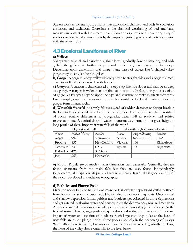
Physical Geography (B.A.-I Sem-I)
Willingdon College Sangli
Stream erosion and transport Streams may attack their channels and beds by corrosion, corrasion, and cavitation. Corrosion is the chemical weathering of bed and bank materials in contact with the stream water. Corrasion or abrasion is the wearing away of surfaces over which the water flows by the impact or grinding action of particles moving with the water body.
4.3 Erosional Landforms of River a) Valleys Valleys start as small and narrow rills; the rills will gradually develop into long and wide gullies; the gullies will further deepen, widen and lengthen to give rise to valleys. Depending upon dimensions and shape, many types of valleys like V-shaped valley, gorge, canyon, etc. can be recognised. b) Gorge: A gorge is a deep valley with very steep to straight sides and a gorge is almost equal in width at its top as well as its bottom. c) Canyon: A canyon is characterised by steep step-like side slopes and may be as deep as a gorge. A canyon is wider at its top than at its bottom. In fact, a canyon is a variant of gorge. Valley types depend upon the type and structure of rocks in which they form. For example, canyons commonly form in horizontal bedded sedimentary rocks and gorges form in hard rocks. d) Waterfall: Waterfall or simply fall are caused of sudden descents or abrupt break in the longitudinal course of river due to several factors such as variation in relative resistant of rocks, relative differences in topographic relief, fall in sea-level and related rejuvenation etc. A vertical drop of water of enormous volume from a great height in long profile of river. Important waterfalls of the world
Highest waterfall Falls with high volume of water
Name Height(Metres) location Name Height(Metres) location
Angel 997 Venuzuela Niagra 62 (W11Km) USA
Browne 837 NewZealand Victoria 108 Zimbabwe
Yosemite 739 USA Iguazu 70 Argentina
Kalambo 426 S. Africa
Jog 253 Karnataka
e) Rapid: Rapids are of much smaller dimension than waterfalls. Generally, they are found upstream from the main falls bur they are also found independently. Ghodchinmalaki Rapid on Malprabha River near Gokak, Karnataka is good example of the rapids developed in sandstone topography. d) Potholes and Plunge Pools Over the rocky beds of hill-streams more or less circular depressions called potholes form because of stream erosion aided by the abrasion of rock fragments. Once a small and shallow depression forms, pebbles and boulders get collected in those depressions and get rotated by flowing water and consequently the depressions grow in dimensions. A series of such depressions eventually join and the stream valley gets deepened. At the foot of waterfalls also, large potholes, quite deep and wide, form because of the sheer impact of water and rotation of boulders. Such large and deep holes at the base of waterfalls are called plunge pools. These pools also help in the deepening of valleys. Waterfalls are also transitory like any other landform and will recede gradually and bring the floor of the valley above waterfalls to the level below.

Physical Geography (B.A.-I Sem-I)
Willingdon College Sangli
c) Incised or Entrenched Meanders In streams that flow rapidly over steep gradients, normally erosion is concentrated on the bottom of the stream channel. Also, in the case of steep gradient streams, lateral erosion on the sides of the valleys is not much when compared to the streams flowing on low and gentle slopes. Because of active lateral erosion, streams flowing over gentle slopes, develop sinuous or meandering courses. It is common to find meandering courses over floodplains and delta plains where stream gradients are very gentle. But very deep and wide meanders can also be found cut in hard rocks. Such meanders are called incised or entrenched meanders (Figure 7.2). Meander loops develop over original gentle surfaces in the initial stages of development of streams and the same loops get entrenched into the rocks normally due to erosion or slow, continued uplift of the land over which they start. They widen and deepen over time and can be found as deep gorges and canyons in hard rock areas. They give an indication on the status of original land surfaces over which streams have developed. River Terraces River terraces are surfaces marking old valley floor or floodplain levels. They may be bedrock surfaces without any alluvial cover or alluvial terraces consisting of stream deposits. River terraces are basically products of erosion as they result due to vertical erosion by the stream into its own depositional floodplain. There can be a number of such terraces at different heights indicating former river bed levels. The river terraces may occur at the same elevation on either side of the rivers in which case they are called paired terraces.
When a terrace is present only on one side of the stream and with none on the other side or one at quite a different elevation on the other side, the terraces are called non-paired terraces. Unpaired terraces are typical in areas of slow uplift of land or where the water column changes are not uniform along both the banks. The terraces may result due to (i) receding water after a peak flow; (ii) change in hydrological regime due to climatic changes; (iii) tectonic uplift of land; (iv) sea level changes in case of rivers closer to the sea.
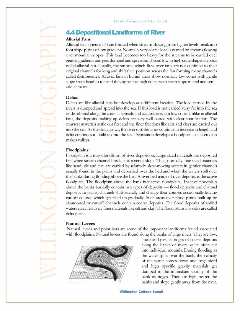
Physical Geography (B.A.-I Sem-I)
Willingdon College Sangli
4.4 Depositional Landforms of River Alluvial Fans Alluvial fans (Figure 7.4) are formed when streams flowing from higher levels break into foot slope plains of low gradient. Normally very coarse load is carried by streams flowing over mountain slopes. This load becomes too heavy for the streams to be carried over gentler gradients and gets dumped and spread as a broad low to high cone shaped deposit called alluvial fan. Usually, the streams which flow over fans are not confined to their original channels for long and shift their position across the fan forming many channels called distributaries. Alluvial fans in humid areas show normally low cones with gentle slope from head to toe and they appear as high cones with steep slope in arid and semi-arid climates. Deltas Deltas are like alluvial fans but develop at a different location. The load carried by the rivers is dumped and spread into the sea. If this load is not carried away far into the sea or distributed along the coast, it spreads and accumulates as a low cone. Unlike in alluvial fans, the deposits making up deltas are very well sorted with clear stratification. The coarsest materials settle out first and the finer fractions like silts and clays are carried out into the sea. As the delta grows, the river distributaries continue to increase in length and delta continues to build up into the sea. Deposition develops a floodplain just as erosion makes valleys.
Floodplains: Floodplain is a major landform of river deposition. Large sized materials are deposited first when stream channel breaks into a gentle slope. Thus, normally, fine sized materials like sand, silt and clay are carried by relatively slow-moving waters in gentler channels usually found in the plains and deposited over the bed and when the waters spill over the banks during flooding above the bed. A river bed made of river deposits is the active floodplain. The floodplain above the bank is inactive floodplain. Inactive floodplain above the banks basically contain two types of deposits — flood deposits and channel deposits. In plains, channels shift laterally and change their courses occasionally leaving cut-off courses which get filled up gradually. Such areas over flood plains built up by abandoned or cut-off channels contain coarse deposits. The flood deposits of spilled waters carry relatively finer materials like silt and clay. The flood plains in a delta are called delta plains.
Natural Levees Natural levees and point bars are some of the important landforms found associated with floodplains. Natural levees are found along the banks of large rivers. They are low,
linear and parallel ridges of coarse deposits along the banks of rivers, quite often cut into individual mounds. During flooding as the water spills over the bank, the velocity of the water comes down and large sized and high specific gravity materials get dumped in the immediate vicinity of the bank as ridges. They are high nearer the banks and slope gently away from the river.

Physical Geography (B.A.-I Sem-I)
Willingdon College Sangli
The levee deposits are coarser than the deposits spread by flood waters away from the river. When rivers shift laterally, a series of natural levees can form.
Point bar Point bars are also known as meander bars. They are found on the convex side of meanders of large rivers and are sediments deposited in a linear fashion by flowing waters along the bank. They are almost uniform in profile and in width and contain mixed sizes of sediments. If there more than one ridge, narrow and elongated depressions are found in between the point bars. Rivers build a series of them depending upon the water flow and supply of sediment. As the rivers build the point bars on the convex side, the bank
on the concave side will erode actively. Point bars are also known as meander bars. They are found on the convex side of meanders of large rivers and are sediments deposited in a linear fashion by flowing waters along the bank. They are almost uniform in profile and in width and contain mixed sizes of
sediments. If there more than one ridge, narrow and elongated depressions are found in between the point bars. Rivers build a series of them depending upon the water flow and supply of sediment. As the rivers build the point bars on the convex side, the bank on the concave side will erode actively. Meanders In large flood and delta plains, rivers rarely flow in straight courses. Loop-like channel patterns called meanders develop over flood and delta plains. Meander is not a landform but is only a type of channel pattern. This is because of (i) propensity of water flowing
over very gentle gradients to work laterally on the banks; (ii) unconsolidated nature of alluvial deposits making up the banks with many irregularities which can be used by water exerting pressure laterally; (iii) Coriolis force acting on the fluid water deflecting it like it deflects the wind. When
the gradient of the channel becomes extremely low, water flows leisurely and starts working laterally. Slight irregularities along the banks slowly get transformed into a small curvature in the banks; the curvature deepens due to deposition on the inside of the curve and erosion along the bank on the outside. If there is no deposition and no erosion or undercutting, the tendency to meander is reduced. Normally, in meanders of large

Physical Geography (B.A.-I Sem-I)
Willingdon College Sangli
rivers, there is active deposition along the convex bank and undercutting along the concave bank. The concave bank is known as cut-off bank which shows up as a steep scarp and the convex bank presents a long, gentle profile and is known as slip-off bank. As meanders grow into deep loops, the same may get cut-off due to erosion at the inflection points and are left as ox-bow lakes.
Braided Channels When rivers carry coarse material, there can be selective deposition of coarser materials causing formation of a central bar which diverts the flow towards the banks; and this flow increases lateral erosion on the banks. As the valley widens, the water column is reduced and more and more materials get deposited as islands and lateral bars developing a number of separate channels of water flow. Deposition and lateral erosion of banks are essential for the formation of braided pattern. Or, alternatively, when discharge is less and load is more in the valley, channel bars and islands of sand, gravel and pebbles develop on the floor of the channel and the water flow is divided into multiple threads. These thread-like streams of water rejoin and subdivide repeatedly to give a typical braided pattern
References:
Physical Geography- Savindra Sing
Fundamentals of Physical Geography- NCERT
Introducing Physical Geography- Alan H. Strahler 5th edition
Fundamentals of Geomorphology- Huggett 3rd textbook
Physical Geography A Self-Teaching Guide- Michael Craghan
Essentials of Physical Geography- Gabler, Sager, Wise Climatology- D. S. Lal Geography- P.N. Padey