Philippines - Eastern Samar Province - Shelter Cluster · Biliran Eastern Samar Leyte Northern...
1
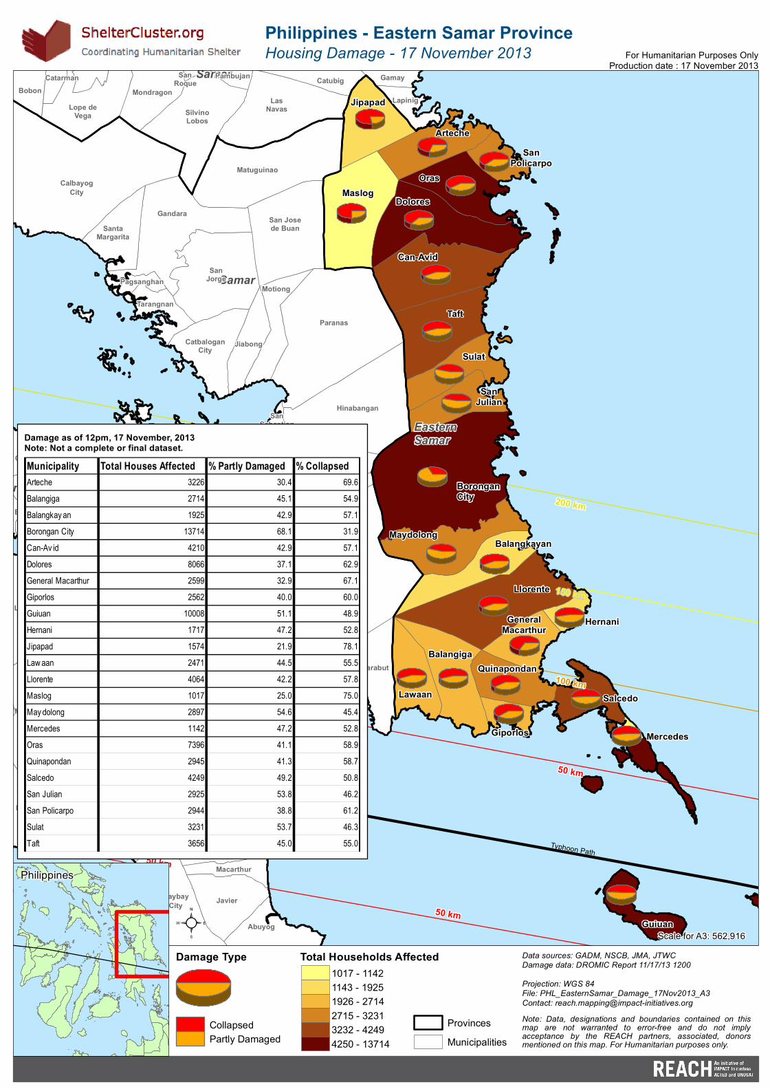
n Eastern Samar Samar Samar Arteche Balangiga Balangkayan Borongan City Can-Avid Dolores General Macarthur Giporlos Guiuan Hernani Jipapad Lawaan Llorente Maslog Maydolong Mercedes Oras Quinapondan Salcedo San Julian San Policarpo Sulat Taft 2 0 0 k m 1 50 km 100 km 50 km 50 km 50 km Typhoon Path Biliran Culaba Abuyog Baybay City Javier Leyte Macarthur Matag-Ob Merida Bobon Catarman Catubig Gamay Lapinig Las Navas Lope de Vega Mondragon Pambujan San Roque Silvino Lobos Calbayog City Catbalogan City Gandara Hinabangan Jiabong Marabut Matuguinao Motiong Pagsanghan Paranas San Jorge San Jose de Buan San Sebastian Santa Margarita Tarangnan Philippines - Eastern Samar Province Housing Damage - 17 November 2013 Data sources: GADM, NSCB, JMA, JTWC Damage data: DROMIC Report 11/17/13 1200 Projection: WGS 84 File: PHL_EasternSamar_Damage_17Nov2013_A3 Contact: [email protected] Scale for A3: 562,916 For Humanitarian Purposes Only Production date : 17 November 2013 Note: Data, designations and boundaries contained on this map are not warranted to error-free and do not imply acceptance by the REACH partners, associated, donors mentioned on this map. For Humanitarian purposes only. Philippines ² Total Households Affected Provinces Municipalities Damage Type Collapsed Partly Damaged Municipality Total Houses Affected % Partly Damaged % Collapsed Arteche 3226 30.4 69.6 Balangiga 2714 45.1 54.9 Balangkay an 1925 42.9 57.1 Borongan City 13714 68.1 31.9 Can-Av id 4210 42.9 57.1 Dolores 8066 37.1 62.9 General Macarthur 2599 32.9 67.1 Giporlos 2562 40.0 60.0 Guiuan 10008 51.1 48.9 Hernani 1717 47.2 52.8 Jipapad 1574 21.9 78.1 Law aan 2471 44.5 55.5 Llorente 4064 42.2 57.8 Maslog 1017 25.0 75.0 May dolong 2897 54.6 45.4 Mercedes 1142 47.2 52.8 Oras 7396 41.1 58.9 Quinapondan 2945 41.3 58.7 Salcedo 4249 49.2 50.8 San Julian 2925 53.8 46.2 San Policarpo 2944 38.8 61.2 Sulat 3231 53.7 46.3 Taft 3656 45.0 55.0 Damage as of 12pm, 17 November, 2013 Note: Not a complete or final dataset. 1017 - 1142 1143 - 1925 1926 - 2714 2715 - 3231 3232 - 4249 4250 - 13714
Transcript of Philippines - Eastern Samar Province - Shelter Cluster · Biliran Eastern Samar Leyte Northern...
Biliran
EasternSamar
Leyte
NorthernSamar
Samar
Arteche
Balangiga
Balangkayan
BoronganCity
Can-Avid
Dolores
GeneralMacarthur
Giporlos
Guiuan
Hernani
Jipapad
Lawaan
Llorente
Maslog
Maydolong
Mercedes
Oras
Quinapondan
Salcedo
SanJulian
SanPolicarpo
Sulat
Taft
200 km
200 km150 km
150 km
100 km
100 km
100 km
50 km
50 km
50 km
50 kmTyphoon Path
Typhoon Path
Tudela
BiliranCabucgayan
Caibiran
Culaba
Pilar
Abuyog
Alangalang
Albuera
Babatngon
Barugo
BaybayCity
Burauen
Capoocan Carigara
Dagami
Dulag
Jaro
Javier
Julita
Kananga
La Paz
Leyte
Macarthur
Matag-Ob
Mayorga
Merida
OrmocCity
PaloPastrana
SanMiguel
Santa Fe
Tabontabon
TaclobanCity
Tanauan
Tolosa
Tunga
BobonCatarman Catubig Gamay
LapinigLasNavasLope de
Vega
MondragonPambujanSan
Roque
SilvinoLobos
Basey
CalbayogCity
Calbiga
CatbaloganCity
Daram
Gandara
Hinabangan
Jiabong
Marabut
Matuguinao
MotiongPagsanghan
Paranas
Pinabacdao
SanJorge
San Josede Buan
SanSebastian
SantaMargarita
SantaRita
Talalora
Tarangnan
Villareal
Zumarraga
Philippines - Eastern Samar ProvinceHousing Damage - 17 November 2013
Data sources: GADM, NSCB, JMA, JTWCDamage data: DROMIC Report 11/17/13 1200Projection: WGS 84File: PHL_EasternSamar_Damage_17Nov2013_A3Contact: [email protected]
Scale for A3: 562,916
For Humanitarian Purposes OnlyProduction date : 17 November 2013
Note: Data, designations and boundaries contained on thismap are not warranted to error-free and do not implyacceptance by the REACH partners, associated, donorsmentioned on this map. For Humanitarian purposes only.
Philippines
²Total Households Affected
ProvincesMunicipalities
Damage Type
CollapsedPartly Damaged
Municipality Total Houses Affected % Partly Damaged % CollapsedArteche 3226 30.4 69.6Balangiga 2714 45.1 54.9Balangkay an 1925 42.9 57.1Borongan City 13714 68.1 31.9Can-Av id 4210 42.9 57.1Dolores 8066 37.1 62.9General Macarthur 2599 32.9 67.1Giporlos 2562 40.0 60.0Guiuan 10008 51.1 48.9Hernani 1717 47.2 52.8Jipapad 1574 21.9 78.1Law aan 2471 44.5 55.5Llorente 4064 42.2 57.8Maslog 1017 25.0 75.0May dolong 2897 54.6 45.4Mercedes 1142 47.2 52.8Oras 7396 41.1 58.9Quinapondan 2945 41.3 58.7Salcedo 4249 49.2 50.8San Julian 2925 53.8 46.2San Policarpo 2944 38.8 61.2Sulat 3231 53.7 46.3Taft 3656 45.0 55.0
Damage as of 12pm, 17 November, 2013Note: Not a complete or final dataset.
1017 - 11421143 - 19251926 - 27142715 - 32313232 - 42494250 - 13714