
Petroleum geology and potential hydrocarbon plays in the ...
38
AAPG Bulletin, v. 87, no. 1 (January 2003), pp. 143–180 143 Petroleum geology and potential hydrocarbon plays in the Gulf of Suez rift basin, Egypt A. S. Alsharhan ABSTRACT The Gulf of Suez in Egypt has a north-northwest–south-southeast orientation and is located at the junction of the African and Arabian plates where it separates the northeast African continent from the Sinai Peninsula. It has excellent hydrocarbon potential, with the prospective sedimentary basin area measuring approximately 19,000 km 2 , and it is considered as the most prolific oil province rift basin in Africa and the Middle East. This basin contains more than 80 oil fields, with reserves ranging from 1350 to less than 1 million bbl, in reservoirs of Precambrian to Quaternary age. The lithostratigraphic units in the Gulf of Suez can be subdivided into three megasequences: a prerift succession (pre-Miocene or Paleo- zoic–Eocene), a synrift succession (Oligocene–Miocene), and a postrift succession (post-Miocene or Pliocene–Holocene). These units vary in lithology, thickness, areal distribution, depositional environment, and hydrocarbon importance. Geological and geo- physical data show that the northern and central Gulf of Suez con- sist of several narrow, elongated depositional troughs, whereas the southern part is dominated by a tilt-block terrane, containing nu- merous offset linear highs. Major prerift and synrift source rocks have potential to yield oil and/or gas and are mature enough in the deep kitchens to generate hydrocarbons. Geochemical parameters, sterane distribution, and biomarker correlations are consistent with oils generated from ma- rine source rocks. Oils in the Gulf of Suez were sourced from po- tential source rock intervals in the prerift succession that are typi- cally oil prone (type I), and in places oil and gas prone (type II), or are composites of more than one type (multiple types I, II, or III for oil prone, oil and gas prone, or gas prone, respectively). The reservoirs can be classified into prerift reservoirs, such as the Precambrian granitic rocks, Paleozoic–Cretaceous Nubian sand- stones, Upper Cretaceous Nezzazat sandstones and the fractured Eocene Thebes limestone; and synrift reservoirs, such the Miocene sandstones and carbonates of the Nukhul, Rudeis, Kareem, and Be- layim formations and the sandstones of South Gharib, Zeit, and Copyright 2003. The American Association of Petroleum Geologists. All rights reserved. Manuscript received February 28, 2001; provisional acceptance December 5, 2001; revised manuscript received May 23, 2002; final acceptance June 20, 2002. AUTHOR A. S. Alsharhan Faculty of Science, United Arab Emirates University, P.O. Box 17551, Al-Ain, United Arab Emirates; [email protected] A. S. Alsharhan is professor of geology and dean of the Faculty of Science at the United Arab Emirates University. He holds a Ph.D. (1985) in petroleum geology from the University of South Carolina. He has authored and published more than 80 scientific articles. He coauthored Sedimentary Basins and Petroleum Geology of the Middle East (1997) with A. E. Nairn and Hydrogeology of an Arid Region: Arabian Gulf and Adjacent Areas (2001) with Z. Rizk, A. E. Nairn, D. Bakhit, and S. Al-Hajari. He co-edited Quaternary Deserts and Climate Change (1998) with K. W. Glennie, G. Whittle, and C. Kendall and Middle East Models of Jurassic/Cretaceous Carbonate Systems (2000) with R. W. Scott. His research interests include Holocene coastal sabkhas of the Arabian Gulf region and the geology and hydrocarbon habitats of the Middle East and North Africa. He is a member of the AAPG, SEPM, International Association of Sedimentologists, and Geological Society of London. ACKNOWLEDGEMENTS I would like to thank M. G. Salah, who sparked my enthusiasm for the fascinating ge- ology of the Gulf of Suez rift basin and coau- thored with me many of the articles on this subject. I also thank A. Fowler, who read the early draft of this article and offered valuable suggestions. Thanks go to P. E. Binns and R. P. Martinsons who reviewed this article for AAPG.
Transcript of Petroleum geology and potential hydrocarbon plays in the ...

AAPG Bulletin, v. 87, no. 1 (January 2003), pp. 143–180 143
Petroleum geology and potentialhydrocarbon plays in the Gulfof Suez rift basin, EgyptA. S. Alsharhan
ABSTRACT
The Gulf of Suez in Egypt has a north-northwest–south-southeastorientation and is located at the junction of the African and Arabianplates where it separates the northeast African continent from theSinai Peninsula. It has excellent hydrocarbon potential, with theprospective sedimentary basin area measuring approximately19,000 km2, and it is considered as the most prolific oil provincerift basin in Africa and the Middle East. This basin contains morethan 80 oil fields, with reserves ranging from 1350 to less than 1million bbl, in reservoirs of Precambrian to Quaternary age. Thelithostratigraphic units in the Gulf of Suez can be subdivided intothree megasequences: a prerift succession (pre-Miocene or Paleo-zoic–Eocene), a synrift succession (Oligocene–Miocene), and apostrift succession (post-Miocene or Pliocene–Holocene). Theseunits vary in lithology, thickness, areal distribution, depositionalenvironment, and hydrocarbon importance. Geological and geo-physical data show that the northern and central Gulf of Suez con-sist of several narrow, elongated depositional troughs, whereas thesouthern part is dominated by a tilt-block terrane, containing nu-merous offset linear highs.
Major prerift and synrift source rocks have potential to yield oiland/or gas and are mature enough in the deep kitchens to generatehydrocarbons. Geochemical parameters, sterane distribution, andbiomarker correlations are consistent with oils generated from ma-rine source rocks. Oils in the Gulf of Suez were sourced from po-tential source rock intervals in the prerift succession that are typi-cally oil prone (type I), and in places oil and gas prone (type II), orare composites of more than one type (multiple types I, II, or IIIfor oil prone, oil and gas prone, or gas prone, respectively).
The reservoirs can be classified into prerift reservoirs, such asthe Precambrian granitic rocks, Paleozoic–Cretaceous Nubian sand-stones, Upper Cretaceous Nezzazat sandstones and the fracturedEocene Thebes limestone; and synrift reservoirs, such the Miocenesandstones and carbonates of the Nukhul, Rudeis, Kareem, and Be-layim formations and the sandstones of South Gharib, Zeit, and
Copyright �2003. The American Association of Petroleum Geologists. All rights reserved.
Manuscript received February 28, 2001; provisional acceptance December 5, 2001; revised manuscriptreceived May 23, 2002; final acceptance June 20, 2002.
AUTHOR
A. S. Alsharhan � Faculty of Science,United Arab Emirates University, P.O. Box17551, Al-Ain, United Arab Emirates;[email protected]
A. S. Alsharhan is professor of geology anddean of the Faculty of Science at the UnitedArab Emirates University. He holds a Ph.D.(1985) in petroleum geology from theUniversity of South Carolina. He has authoredand published more than 80 scientific articles.He coauthored Sedimentary Basins andPetroleum Geology of the Middle East (1997)with A. E. Nairn and Hydrogeology of an AridRegion: Arabian Gulf and Adjacent Areas(2001) with Z. Rizk, A. E. Nairn, D. Bakhit, andS. Al-Hajari. He co-edited Quaternary Desertsand Climate Change (1998) with K. W.Glennie, G. Whittle, and C. Kendall andMiddle East Models of Jurassic/CretaceousCarbonate Systems (2000) with R. W. Scott.His research interests include Holocenecoastal sabkhas of the Arabian Gulf regionand the geology and hydrocarbon habitats ofthe Middle East and North Africa. He is amember of the AAPG, SEPM, InternationalAssociation of Sedimentologists, andGeological Society of London.
ACKNOWLEDGEMENTS
I would like to thank M. G. Salah, whosparked my enthusiasm for the fascinating ge-ology of the Gulf of Suez rift basin and coau-thored with me many of the articles on thissubject. I also thank A. Fowler, who read theearly draft of this article and offered valuablesuggestions. Thanks go to P. E. Binns and R. P.Martinsons who reviewed this article forAAPG.

144 Hydrocarbon Potential in the Gulf of Suez Rift Basin (Egypt)
Figure 1. Tectonic setting and major tectonic developments. Successive group of tilt blocks with regional dips. The homogeneoustilt provinces are separated by tectonic boundaries (transform faults), which are the effects of Aqaba faults that acted as strike-slipfaults during the early stage of the rift structuration (compiled from Jarrige et al. [1990]; Alsharhan and Salah [1994, 1995]; andMontenat et al. [1998]). Insert figure shows location map of Egypt and Gulf of Suez study area.
post-Zeit. The majority of oil fields in the region in-corporate multiple productive reservoirs. Mioceneevaporites are the ultimate hydrocarbon seals, whereasthe shale and dense limestones of the prerift and thesynrift stratigraphic units are the primary seals. Struc-tural, stratigraphic, and combination traps are encoun-tered in the study area. The Gulf of Suez is the mostprolific and prospective oil province in Egypt, and anyopen acreage, or relinquished area, will be of great in-terest to the oil industry.
INTRODUCTION
The Gulf of Suez is bounded by long. 32�10� and 34�Eand lat. 27� and 30�N (Figure 1) and is known to be aClysmic Gulf (Robson, 1971), a rejuvenated, slightlyarcuate northwest-southeast–trending taphrogenic de-pression. It is an intracontinental, late Oligocene riftedbasin but was originally formed during the early Paleo-zoic as a narrow embayment of the Tethys that wasintensively rejuvenated during the rifting phase of thegreat East African rift system in the Paleogene (see alsoBosworth et al., 1998; Montenat et al., 1998; Jarrigeet al., 1990). The Gulf runs in a northwest-southeastdirection and forms an elongated graben measuringabout 320 km in length, with width ranging between30 and 80 km, and water depth only 40–60 m. It isbounded by two major sets of marginal faults. Paleo-zoic–Tertiary strata and huge Precambrian basementblocks are exposed on both sides of the Gulf of Suez.
Surface hydrocarbons are uncommon and foundonly in the southern part of the Gulf of Suez. Asphalticimpregnations have been found in alluvial sands, andseeps exist mainly in Pliocene and Pleistocene lime-stones. Oil was first found in the Gulf of Suez in 1886,when crude oil seeped into tunnels that had been dugto extract sulfur in the Gemsa area, on the westerncoast of the Gulf of Suez (Schlumberger, 1995). Sub-sequently, drilling was conducted close to the surfaceoil seeps in the west coastal strip of the southern Gulfof Suez, resulting in the discovery of the Gemsa oilfield in 1907, the first oil discovery in the Middle Eastand Africa. Oil also was found in 1918, when the An-glo Egyptian Oil Company drilled near an oil seep on
the eastern side of the Gulf of Suez and discovered thenoncommercial Abu Durba oil field. Ras Gharib wasthe field providing the first commercial oil and is themost prolific in the area. It was discovered in 1938 onthe western side of the Gulf of Suez by the StandardOil Company of Egypt. Drilling ceased during the Sec-ond World War and recommenced in 1946. The ex-ploration activity in the Gulf of Suez and in Egypt hasbeen affected by changes in the political environmentand has passed through several phases of activity. From1970 onward, the Egyptian government encouragedforeign oil companies, leading to continuous and inten-sive exploration. At present, the Gulf of Suez oil basinhas more than 1000 exploration wells, resulting in 240oil discoveries in more than 80 oil fields (Figure 2),with reserves from 1350 to less than 1 million bbl, inreservoirs ranging in age from Precambrian to Quater-nary. The purpose of this article is to illustrate the com-parative influences of geology, hydrocarbon potential,and tectonism on hydrocarbon generation, migration,and accumulation within the basin and to clarify thecontrols on hydrocarbon occurrences and hydrocarbonpotential in the Gulf of Suez onshore and offshoreregions.
L ITHOSTRATIGRAPHY
The stratigraphy, age, and lithological characterizationof rock units described in this article from the Gulf ofSuez region (i.e., western Sinai Peninsula, offshore theGulf, and Eastern Desert) relies on data from measuredstratigraphic sections and subsurface cores, electric logstied to microfaunal and palynological studies of ditchsamples, and rock thin sections. These data are incor-porated with reference to previous studies, such as Sa-dek (1959), Abdallah et al. (1963), Egyptian GeneralPetroleum Corporation Stratigraphic Committee(1964), Issawi (1973), Mazhar et al. (1979), Beleity(1982), Webster (1982), Sellwood and Netherwood(1984), Beleity et al. (1986), Barakat et al. (1986,1988), Darwish (1992), Darwish and El-Araby (1993),and Alsharhan and Salah (1994, 1995). The lithostrat-igraphic units in the study area range from Precambrianto Holocene in age and have been divided into three

Alsharhan 145

146 Hydrocarbon Potential in the Gulf of Suez Rift Basin (Egypt)
Figure 2. Major oil fields in the Gulf of Suez.

Alsharhan 147
major sequences relative to the Miocene rifting event:postrift lithostratigraphic units (post-Miocene units),synrift lithostratigraphic units (Miocene units), andprerift lithostratigraphic units (pre-Miocene units).These units vary in thickness and other facies attributeswithin the Gulf of Suez. A generalized lithostrati-graphic scheme of the study area is given in Figure 3and Tables 1, 2, and 3.
PRERIFT L ITHOSTRATIGRAPHIC UNITS
The prerift stratigraphic sequence is composed ofstrata ranging from Precambrian to upper Eocene andcontains sand, shale, and carbonate facies that were laiddown under terrestrial and marine-platform environ-ments (Table 1). This period of sedimentation was af-fected by major unconformities representing nonde-position or erosion at different geologic times, as shownin Figure 3.
Basement rocks have been penetrated by about200 wells in the southern Gulf of Suez at depths rang-ing from 1000 to 5000 m (3000 to 15,000 ft) and areinterpreted to be granitic rocks on the basis of petro-physical and structural similarities with their surfaceexposures (Salah and Alsharhan, 1998). The basementis highly weathered and intensively fractured in re-sponse to the tectonic activity in this area.
The term “Nubian sandstone” is applied to the Pa-leozoic–Lower Cretaceous clastic section that lies un-conformably on the Precambrian basement complex(see also Pomeyrol, 1968). Pollens and spores havebeen used to determine geologic ages of the Nubiansandstone succession.
The distribution of these strata in the Gulf of Suezvaries widely. In the southern part, the strata range inthickness from 25 to 430 m. In the northern Gulf ofSuez, the strata reach their maximum thickness ofabout 700 m in the western part of the basin, whereasin the central Gulf of Suez the thickness increases to-ward the east and reaches almost 915 m. The strataalso are exposed along the western and eastern flanksof the Gulf of Suez and have thicknesses ranging from305 to 1065 m.
SYNRIFT L ITHOSTRATIGRAPHIC UNITS
Interbedded Oligocene limestones, sandstones, andshales are present in the southern Gulf of Suez, wherethey rest unconformably on the Eocene rocks. Red bed
strata known as Tayiba red beds were deposited in thelate Oligocene and are sporadically distributed, havingaccumulated during the early stages of rifting in thecentral and northern Gulf of Suez regions. The Mio-cene sequences were previously subdivided into twomain groups, the Gharandal and Ras Malaab (Table 2).
The term “Gharandal” was introduced by the An-glo Egyptian Oil Company (1949, cited in Said[1962]) to describe the strata that lie beneath the Mio-cene evaporites in the area between Ayun Musa andLagia on the Sinai side of the Gulf of Suez. The rockswere divided into two formations: the Nukhul and theRudeis. The term “Ras Malaab” was first introduced todescribe surface exposures at the entrance to WadiGharandal. As the name “Gharandal” was already re-served for the underlying clastic group, the closest geo-graphic name, “Ras Malaab,” was chosen for this groupby the Egyptian General Petroleum Corporation(1964). This group was redefined and subdivided bythe Egyptian General Petroleum Corporation (1974)into the Zeit, South Gharib, Belayim, and Kareem for-mations, in descending order.
POSTRIFT L ITHOSTRATIGRAPHIC UNITS
The postrift sedimentary fill of the Gulf of Suez is Pli-ocene–Holocene in age (Table 3). The thickness andlithology of these strata show marked variations fromone area to another. Generally, the post-Miocene strataconsist of sands and sandstones, shales, and/or lime-stones. The sand and sandstones and minor shales arepredominant in marginal areas, whereas limestones andminor shales are well developed in the central parts,and carbonate with thin streaks of anhydrite occupiesthe southern part. The strata were deposited in a shal-low to deep marine setting. The thickness of this suc-cession ranges from 15 to greater than 1525 m in someof the southern offshore wells.
STRUCTURE AND TECTONISM
The present-day Gulf of Suez rift, together with theRed Sea oceanic basin and the Aqaba–Dead Sea trans-form systems, comprise the Sinai triple junction, whichinitiated during the northeasterly movement of Arabiaaway from Africa. The age of such movements ismainly Neogene (Fichera et al., 1992). The riftingcommenced in the pre-Miocene, with the maximumtectonic subsidence, accompanied by magmatic events,

148 Hydrocarbon Potential in the Gulf of Suez Rift Basin (Egypt)
Figure 3. Lithostratigraphy and hydrocarbon distribution in the Gulf of Suez.

Alsharhan 149
occurring in the late Oligocene–early Miocene (Gan-dino et al., 1990). Subsidence may have continued un-til the late Neogene. The interpretation of the phasesof tectonic subsidence and their periods and structuralstages during the late Tertiary are shown in Figures 4and 5. The Suez rift was initiated between 24 and 21Ma, that is, latest Oligocene to earliest Miocene(Evans, 1990). Rifting was caused by tensional stressestransmitted through the lithosphere, accompanied byan upwelling of hot asthenosphere. Both the crustalextension and tectonic subsidence of the axial troughreached their maximum development between 19 and15 Ma (Steckler et al., 1988). Between 20 and 17 Ma,the flanks of this basin began to rise because of heatingeffects (Steckler, 1985). By 15 Ma, the movementalong the Aqaba–Dead Sea transform fault had begun(Bartov et al., 1980). By 5 Ma, this transform fault re-placed the Gulf of Suez as the primary plate boundarybetween the African and Arabian plates (Evans, 1990).Several unconformities interrupt the sedimentary rec-ord, with major ones in the Paleozoic, Triassic–Juras-sic, Oligocene, and late Miocene (Messinian). Thesebasinwide unconformities formed primarily in re-sponse to regional tectonic adjustments associated withdifferent rift phases of the Gulf of Suez (Dolson et al.,2001).
The Gulf of Suez occupies the northern end of theRed Sea rift (Said, 1962) and is separated from it bythe Aqaba transform faults. The Suez rift is boundedby the Sinai massif on the east and the Red Sea hills ofthe Eastern Desert of Egypt on the west and constitutesa large depression, lying below sea level in its axial partonly. This extensional tectonic basin is approximately60 to 80 km wide and contains a sedimentary prismabout 3–5 km thick, with fill ranging in age from Mio-cene to Holocene (James et al., 1988).
The Gulf of Suez represents a typical interior ba-sin. The evolution of this basin is illustrated in Figure6 in stages from the Paleozoic to the Holocene and ischaracterized by tectonic extensional episodes produc-ing tension block faulting (horst and graben) and blocksubsidence (see also Kingston et al., 1983). Thus theGulf of Suez has developed in a series of distinct evo-lutionary stages. (1) In the first stage, Paleozoic terres-trial clastics were deposited over Precambrian crystal-line basement with minor tectonic movements. TheHercynian epeirogeny folded and uplifted the Paleo-zoic deposits. The hiatus caused by these movementsis evident in the thinning or absence of sedimentationin many parts of the Gulf of Suez, where Cenomanianstrata rest unconformably on Carboniferous strata. (2)
The second stage occurred during the Permian–Triassicto Jurassic and is characterized by local subsidence andminor transgression, leading to deposition of fluvio-marine red shales and sandstones. (3) The third stagedates from the Early Cretaceous and involved rifting ofthe continental crust, under tension, to produce a sys-tem of grabens via block faulting. Depressions werelater filled with nonmarine sandstone and shale. (4)During the fourth stage, which extended from themiddle Cretaceous to the Miocene, normal faultingcontinued and the graben system gradually subsided toform a deep basin. Early and middle Alpine move-ments occurring in this stage had significant effects onthe structure of Mesozoic and Paleogene strata andgave rise to a series of folds in areas of tectonic com-pression. Marine waters invaded the basin and depos-ited a range of different sedimentary facies, varyingwith location in the basin. Marine sandstone and shal-low marine limestone, including reefal limestone,were deposited on structural highs, whereas shale andglobigerinal marl accumulated in the low areas. Thelast strata of this stage were thick salt deposits. (5) Dur-ing the fifth and final stage of rift evolution, the interiorfracture system widened during the Pliocene–Holo-cene, the basin fill was uplifted at the rift margins be-cause of continued block faulting, and nonmarinewedge-top strata (mainly sandstone) penetrated thebasin. Within-basin faulting is generally not evident inthis stage, and sedimentary accumulation in the basinwas accommodated by sag.
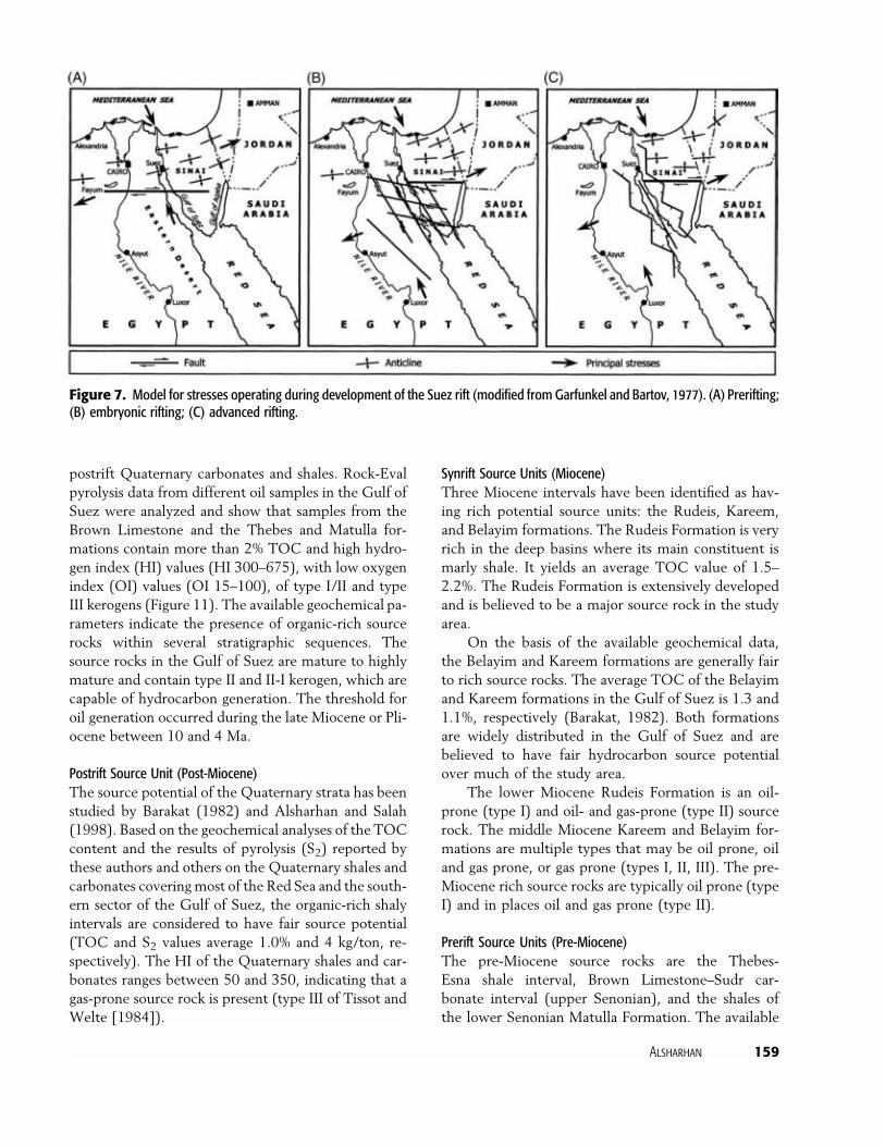
Garfunkel and Bartov (1977) modeled the stressesoperating during development of the Suez rift (Figure7). The north-south and northwest-southeast orien-tations of faults imply a preexisting grid of fracturesthat were reactivated during subsidence of the rift. InGarfunkel and Bartov’s (1977) model, the fracturegrid was established by a stress regime intermediatebetween the north-northwest–south-southeast com-pression, associated with the Syrian Arc System, andeast-northeast–west-southwest extension, which oc-curred during the time of advanced rifting. Most ofthe normal faults in the Gulf of Suez are not straightbut show curved or zigzag traces. Dips of the faultstend to be toward the center of the rift, but this pat-tern is only modestly dominant (Garfunkel and Bar-tov, 1977).
The geometry of the basinal fault system is typicalfor those of extensional settings, and the Gulf of Suezcan be considered as a failed rift. Generally, the Gulfof Suez is subdivided into three tectonic provinces(from north to south, the Ataqa, Gharib, and Zeit).

150Hydrocarbon
Potentialinthe
GulfofSuezRiftBasin
(Egypt)
Table 1. Prerift Lithostratigraphic Units in the Gulf of Suez
Age Group FormationThickness
(m) Lithology Depositional Setting Contacts
Cambrian–Ordovician
Qebliat Araba Nubia D 130 Interbedded fine to medium-grained colorless yellowishwhite sandstones and gray togreenish-gray mudstones
Shallow marine Rests unconformably over thePrecambrian basement
Qebliat Naqus Nubia C 410 Thick and massive pebbly andcross-bedded sandstones
Continental Unconformably overlain by theUmm Bogma Formation
EarlyCarbonifeorus
Umm Bogma Nubia B 45 Interbedded fossiliferous, highlycalcareous marl and dolomite
Shallow marine Unconformably overlies NaqusFormation and is overlain bythe Abu Durba Formation
LateCarboniferous–Permian
Ataqa Abu Durba 120 Fossiliferous black shale withthin carbonate streaks
Marine Rests unconformably on theRod El Hamal Formation
Ataqa Rod El Hamal 275 Interbedded sandstones andshale with streaks ofcarbonates in the upper part
Shallow marine Overlies the Abu DurbaFormation and isunconformably overlain bythe Qiseib Formation
Triassic El-Tih Qiseib Nubia A 50 Interbedded ferruginoussandstone red beds andvariegated shale with somelimestone in the basal part
Continental deposits withmarine influence in the lowerpart
Rests unconformably on theRod El Hamal Formation
Jurassic–EarlyCretaceous
El-Tih Malha 150 White to gray sandstones Continental deposits passinginto shallow marine in theupper part of the section
Conformably overlies the QiseibFormation
Cenomanian Nezzazat Raha 50 White sandstone and light todark gray shale interbeds,with minor thin marl streaks
Shallow marine Rests conformably on theMalha Formation andconformably overlain by theAbu Qada Formation

Alsharhan151
Cenomanian–earlyTuronian
Nezzazat Abu Qada 25 Sand and shale interbeds, withsome thin carbonate streaks
Shallow marine Unconformably overlain by theWata Formation
Late Turonian Nezzazat Wata 100 Dense dolomite, fossiliferouscarbonates with minor streaksof shale, and muddylimestone with minorsandstone
Moderately shallow marineshelf or possibly lagoon
Unconformably overlain by theMatulla Formation
Early Campanian Nezzazat Matulla 120–240 Sandstones and shale interbedswith occasional carbonatestreaks and, near the middlepart of the formation, aninterval of oolitic grainstoneextends regionally
Delta plain and interdistributarybay, with high-energy ooliticshoal formed by the constantebb and flood of water in asubtidal setting
Unconformably overlain by theDuwi Formation
Late Campanian–earlyMaastrichtian
El-Egma Brown limestone 15–105 Limestone with interbeds ofhighly calcareous shale. Thelower part of the successioncontains chert, while theupper part is moreargillaceous
Marine outer sublittoral Conformably overlies theMatulla Formation
El-Egma Duwi 50 Hard, highly argillaceous,cherty, phosphatic limestonewith thin interbeds of shaleand marl
Deep marine Overlain unconformably by theSudr Formation and overliesunconformably the MatullaFormation
Maastrichtian El-Egma Sudr (Sudr Chalk) 140 Chalky limestone, with thininterbeds of chalk andargillaceous limestone
Deep marine Unconformably overlain by theEsna Formation
Late Paleocene El-Egma Esna (Esna Shale) 60 Soft fossiliferous shale withinterbeds of limestone
Marine outer sublittoral toupper bathyal
Unconformably overlain by theThebes Formation
Early–middleEocene
El-Egma Thebes 60 Massive fossiliferous limestone,flints (bands and concretions),and thin interbeds of marl
Marine outer sublittoral Overlain unconformably by theOligocene Tayiba red beds orby the lower Miocene NukhulFormation
152Hydrocarbon
Potentialinthe
GulfofSuezRiftBasin
(Egypt)
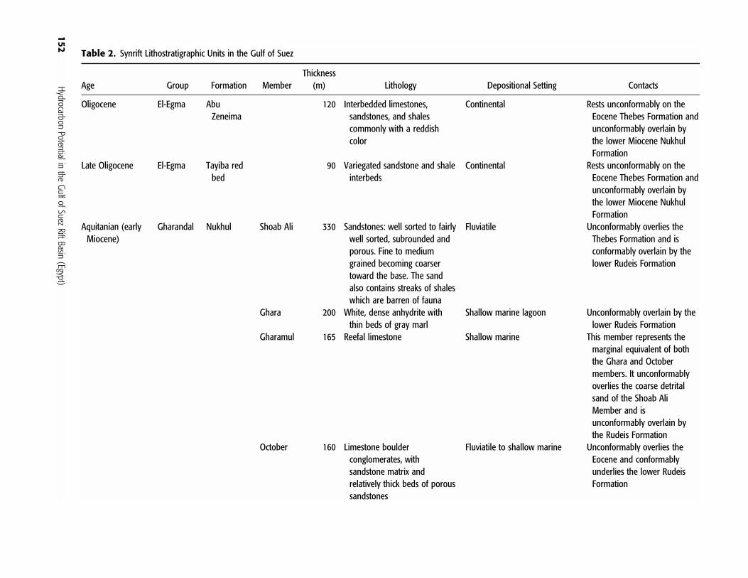
Table 2. Synrift Lithostratigraphic Units in the Gulf of Suez
Age Group Formation MemberThickness
(m) Lithology Depositional Setting Contacts
Oligocene El-Egma AbuZeneima
120 Interbedded limestones,sandstones, and shalescommonly with a reddishcolor
Continental Rests unconformably on theEocene Thebes Formation andunconformably overlain bythe lower Miocene NukhulFormation
Late Oligocene El-Egma Tayiba redbed
90 Variegated sandstone and shaleinterbeds
Continental Rests unconformably on theEocene Thebes Formation andunconformably overlain bythe lower Miocene NukhulFormation
Aquitanian (earlyMiocene)
Gharandal Nukhul Shoab Ali 330 Sandstones: well sorted to fairlywell sorted, subrounded andporous. Fine to mediumgrained becoming coarsertoward the base. The sandalso contains streaks of shaleswhich are barren of fauna
Fluviatile Unconformably overlies theThebes Formation and isconformably overlain by thelower Rudeis Formation
Ghara 200 White, dense anhydrite withthin beds of gray marl
Shallow marine lagoon Unconformably overlain by thelower Rudeis Formation
Gharamul 165 Reefal limestone Shallow marine This member represents themarginal equivalent of boththe Ghara and Octobermembers. It unconformablyoverlies the coarse detritalsand of the Shoab AliMember and isunconformably overlain bythe Rudeis Formation
October 160 Limestone boulderconglomerates, withsandstone matrix andrelatively thick beds of poroussandstones
Fluviatile to shallow marine Unconformably overlies theEocene and conformablyunderlies the lower RudeisFormation

Alsharhan153
Burdigalian–Langhian
Gharandal Rudeis Yusr 85 Quartzarenites andsublitharenites
The sandstone deposited asvalley and basin fills in apreexisting topography. Itforms narrow, eastward-prograding tongues thataccumulated in linearstructural depressions andgrabens
Conformably overlies theNukhul Formation and isunconformably overlain bythe Kareem Formation
Safra 75 Shales, with sandstone unitsand minor carbonatesintercalated in the lower part
Transgressive marine shale withnarrow discontinuous tonguesof sandstone and carbonatesaccumulated in structuraltroughs
Ayun 160 The lower part is medium tovery coarse grained, poorlysorted sandstone. The upperpart is dominated by shale
The sandstone influx andaccumulation was controlledby fault valleys and graben.The shale was depositedduring a period of relativetectonic quiescence
Middle–lateMiocene
Ras Malaab Kareem Rahmi 165 Thin beds of anhydriteintercalated with sands,shales, and carbonates
Shallow marine to partly openmarine, with local lagoonalconditions
Unconformably overlies theRudeis Formation
Shagar 300 Interbedded shales, limestones,and sandstones
Deep inner to shallow outersublittoral
Ras Malaab Belayim Baba 15–80 Anhydrite with thin interbeds ofshale and salt
Shallow marine lagoon Unconformably overlain by theSidri Member
Sidri 13 Shale that is locally dolomitic,with greater abundance ofcoarse sand along the westernand eastern onshore area
Inner neritic to littoral marine Unconformably overlain by theFeiran Member
Feiran Thick evaporates (anhydrite,salt, and some polyhalite),with minor shale andsandstone
Shallow marine lagoon Unconformably overlain by theHammam Faraun Member

154 Hydrocarbon Potential in the Gulf of Suez Rift Basin (Egypt)
Table2.
Continued
Age
Grou
pForm
ation
Mem
ber
Thick
ness
(m)
Lithology
Depo
sitionalSettin
gCo
ntacts
Middle–late
Miocene
RasMalaab
Belayim
Hammam
Faraun
90Interbeddedshale,
sand
ston
e,andcarbon
atewith
occasio
nal
thin
beds
ofanhydrite
Openmarinein
thecentralp
art
ofthebasin
,and
tidal
flatto
intertidalinthemarginal
areas
Unconformablyun
derlies
the
RasGh
arib
evaporites
RasMalaab
SouthRas
Gharib
45–2285
Thick
evaporite
(saltw
ithanhydrite)w
iththin
intercalations
ofshales
and
sand
s
Restricted,
subsidingsaline
basin
Unconformablyoverlain
bythe
ZeitForm
ation
RasMalaab
Zeit
25–945
Interbeddedanhydrite,gypsum,
andshalewith
somethin
salt
streaks.Locally
inthe
marginala
reas,itc
ontains
somethin
intercalations
ofsand
ston
esandlim
estones
Deep
semire
strictedto
lagoon
alsetting
Unconformablyoverlain
bypo
st-M
iocene
depo
sits
The three provinces are separated by two north-north-east–south-southwest major accommodation faults orhinge zones. Each province has its own structural andstratigraphic history. The accommodation faults in-clude a zone of fault rotation in the Gulf of Suez, calledthe Galala-Zenima hinge zone (Figure 1). This faultseparates the northern province of the Gulf of Suez,with a basin floor generally dipping southwest, fromthe central province, with a northeast-dipping basinfloor. Another similar zone is called the Morgan hingezone, which separates the central and southern prov-inces, the latter with dips toward the southwest (Figure1). Meshref and Khalil (1990) calculated 5.1 and 14km of widening in the northern and central provincesof the Gulf of Suez, respectively, representing an in-crease of 11 and 17%, respectively, in the initial basinwidth. Clearly the northern province of the Gulf ofSuez has suffered less extension than the centralprovince.
Interpretation of geological and geophysical dataindicates that the Gulf of Suez consists of elongatedtroughs containing several submarine ridges (elongatedstructural highs). Both troughs and highs have thesame trend as the Gulf of Suez (northwest-southeast).These highs are dissected by some high-angle discor-dant elements that trend northeast-southwest and east-northeast–west-southwest. These later elements areviewed as cross faults that segment the highs. The dis-tinctive structural and stratigraphic features within thesubbasins of the rift vary in both the northern and cen-tral provinces of the Gulf, and even within the sameprovince. The stratigraphic succession and depth tobasement also varies from one structural high to an-other and also within the same high (Rashed, 1990;Saoudy, 1990). The temperature gradient is in agree-ment with the proposed dog-leg model for the Suezrift. Figure 8 shows that the major troughs along therift axis are associated with a high temperature gradient(reaching 2�F/100 ft or more). This may be explainedby the axis of the rift being associated with thin crustand upwelling of hot mantle by convection (Meshref,1990).
The Gulf of Suez basin axis has apparently shiftedprogressively eastward with time, probably due to theevolution of the deep structural detachment below thisasymmetric rift (Ahmed, 1972). This asymmetry hasled to subsidence of former reefal and clastic coastlinesin the eastern part of the Gulf, and their subsequentburial beneath impermeablebasinalmudrocks,whereassimilar units were uplifted and exposed in thewest. TheMiocene sequence forms a broadly fining-upward se-

Alsharhan 155
Table 3. Postrift Lithostratigraphic Units (Pliocene–Pleistocene Strata) in the Gulf of Suez
Group FormationThickness
(m) Lithology Depositional Setting Contacts
Ashrafi 1300 Fossiliferous and sandy limestone,intercalated with minor streaks ofcrystalline and cryptocrystallineanhydrite and gray to greenishcalcareous shale
Shallow marine It underlies the fine sediment ofrecent deposits, well developedin the south and showing anarrow extension into the centralpart of the Gulf of Suez
El Tor 1100 Thick coarse to very coarsesubangular to subrounded sandand sandstone, with some tracesof mafic and feldspar fragments.The sandstone is intercalatedwith streaks of tan brown shales,cryptocrystalline limestones, andanhydrite
Alluvial deposits The formation underlies the finesediment of recent deposits, welldeveloped in the central Gulf ofSuez
Darag Wardan 112 Sandstone and shale intercalationswith some streaks of limestoneand occasional anhydrite nearthe base and the top
Shallow marine Conformably underlies theZaafarana Formation and welldeveloped in the northern part ofthe Gulf of Suez
Zaafarana 815 Evaporite and shale and sandstoneintercalations with minor streaksof limestone and salt
Shallow marine lagoon The formation underlies the fineclastic sediments of recentdeposits well represented in thenorthern sector of the Gulf ofSuez
from free circulation of Mediterranean water, and asequence of evaporites more than 2 km thick was de-posited over most of the basin. Salt deposition domi-nated along the central axis of the rift, whereas anhy-drite is the principal evaporite in the marginal areas(Fawzy and Abd El Aal, 1984). This evaporite se-quence provides the seal for many of the oil fields inthe Gulf. Sand derived from the uplands of the SinaiPeninsula and the Egyptian Eastern Desert was depos-ited in the rift as deltas and alluvial fans. Clastic de-position was intermittent throughout the Miocene, andthe sands are interbedded with shales and evaporites asfar as the center of the Gulf.
In the Pliocene, the Gulf of Suez became essen-tially tectonically quiescent. There were repeated in-cursions of marine water from the Red Sea, as at thepresent time, but the Pliocene deposits are not signifi-cantly petroliferous. Pliocene alluvial fan and playa de-posits covered the evaporitic basin to a thickness ofmore than 3 km in the deeper fault troughs. Subsi-dence and graben evolution continued during the Pli-ocene, mainly in the central part of the basin. Under
quence passing gradually upward into evaporites (Cof-field and Smale, 1987). The thickness of the individualunits varies greatly because of the irregular topographyof the underlying block-faulted early Miocene, whichhas elevations ranging from 19 to 890 m.
The first stage of rifting produced a graben about50–70 km wide. Some upper Eocene and Oligoceneconglomerates found in the Gulf area are continuouswith lower Miocene conglomerates. In the early Mio-cene, the conglomerates were followed by organic-richshales and marls containing abundant foraminifera andexceeding 2 km in stratigraphic thickness in parts ofthe basin. These fine-grained deposits provide the po-tential source rock for most of the oil in the Gulf ofSuez. In the late early Miocene the rift became morerestricted, and a partly evaporitic sequence was depos-ited (Fichera et al., 1992; Ibrahim, 1992).
The middle Miocene witnessed a renewed episodeof rift faulting. The central line of the original rift be-came a deep trough. Many tilted fault blocks devel-oped, from which the lower Miocene beds werestripped by erosion. The Gulf was effectively cut off

156 Hydrocarbon Potential in the Gulf of Suez Rift Basin (Egypt)
Figure 4. The relationship be-tween tectonic subsidence rates,types, and periods and climateand sea level changes duringthe Neogene in the Gulf ofSuez (compiled and modifiedfrom Griffin [1999] and Bos-worth et al. [1998]). Smaller Vsymbols represent periods ofrapid basin subsidence, for ex-ample, the Burdigalian; larger Vsymbols represent modest ratesof basin subsidence, for exam-ple, in the Serravallian.
the accumulated weight of Pliocene strata, the Mio-cene salt flowed upward into broad salt pillows andridges. These salt structures commonly obscure thedeeper prospective characteristics.
HYDROCARBON HABITAT
The hydrocarbon potential of the study area is gener-ally high because (1) rifting tended to produce bothrestricted and open marine settings favorable to sourcerock accumulation; (2) relatively high geothermal gra-dients helped convert organic matter in the source
rocks to hydrocarbons; (3) subsequent rotational fault-ing and marginal uplifting produced clastic systemsserved by the mature shield terranes and formed shoalareas where porous reef buildups and dolomitizedlimestones—potential reservoirs—could develop; (4)rotational faulting of these units produced structuraltraps, which were sealed by onlapping basinal mud-rocks or evaporites during later thermal subsidence ofthe rift; (5) all faults in the Gulf of Suez are normalfaults. The trapping structures of the numerous oilfields are horsts or tilted fault blocks. The interveninggrabens contain thick accumulations of basinal shalesand marls, producing favorable conditions for rich

Alsharhan 157
Figure 5. Chronodiagram oftectonic, sedimentary, and mag-matic events that characterizethe Gulf of Suez and northwest-ern Red Sea evolution (modi-fied from Montenat et al.,1998).
source rock deposition and a suitable maturity regimefor generation of hydrocarbons; (6) thick accumula-tions of the evaporites, mainly of Miocene age, containmuch salt, which has formed broad salt swells and pil-lows in the deeper parts of the basin, and provide ex-cellent seals; and (7) reservoirs are characterized by arelatively active water drive and good to excellent po-rosity and flow capacity (exceptions to the water driverule are Umm al Yusr and July fields in the Rudeisreservoirs). A summary chart of hydrocarbon habitat(source rocks, seals, and reservoirs) and types of trapsare shown in Tables 4 and 5, and their distributionrelative to the formations and geologic ages is shownin Figure 3.
Source Rock Potential
The source rock potential of the Gulf of Suez has beenstudied by many authors, such as Rohrback (1982),Barakat (1982), Shaheen and Shehab (1984), Atef(1988), Mostafa (1993), Mostafa et al. (1993), and Al-sharhan and Salah (1994, 1995), and these studies areconsidered here.
Potentially rich source rock intervals have beenidentified on the basis of total organic carbon (TOC)content and pyrolysis result (S2) within the Gulf ofSuez. In stratigraphic ascending order these are theUpper Cretaceous carbonates (Brown Limestone andSudr Chalk); the Eocene Thebes, lower Miocene

158 Hydrocarbon Potential in the Gulf of Suez Rift Basin (Egypt)
Figure 6. Development stagesof the Gulf of Suez, as an ex-ample of a typical interior frac-ture rift basin (stages 3–5 mod-ified from Kingston et al.[1983]).
Rudeis, and middle Miocene Kareem formations; andthe Hammam Faraun Member of the Belayim Forma-tion. The Upper Cretaceous Brown Limestone carbon-ates (with an average TOC of 3.5%) and the EoceneThebes Formation (average TOC 3.2%) are the preriftdeposits formed during the Tethyan transgressionacross northeastern Africa. The Rudeis Formation (av-erage TOC 2.5%), and the Kareem Formation andHammam Faraun Member (average TOC 1.5%, rang-
ing from 0.20 to 1.5%) are synrift deposits. In terms ofTOC content of well-preserved source rocks, the syn-rift sequence is more important than the prerift (Figure9). Figure 10 shows that the prerift source intervals aretypically oil prone (type I) and in places oil and gasprone (type II). The synrift source rocks are of multipletypes that may be oil prone, oil and gas prone, or gasprone (types I, II, and III, respectively, of Tissot andWelte [1984]). There is also a minor contribution from
Alsharhan 159
Figure 7. Model for stresses operating during development of the Suez rift (modified from Garfunkel and Bartov, 1977). (A) Prerifting;(B) embryonic rifting; (C) advanced rifting.
postrift Quaternary carbonates and shales. Rock-Evalpyrolysis data from different oil samples in the Gulf ofSuez were analyzed and show that samples from theBrown Limestone and the Thebes and Matulla for-mations contain more than 2% TOC and high hydro-gen index (HI) values (HI 300–675), with low oxygenindex (OI) values (OI 15–100), of type I/II and typeIII kerogens (Figure 11). The available geochemical pa-rameters indicate the presence of organic-rich sourcerocks within several stratigraphic sequences. Thesource rocks in the Gulf of Suez are mature to highlymature and contain type II and II-I kerogen, which arecapable of hydrocarbon generation. The threshold foroil generation occurred during the late Miocene or Pli-ocene between 10 and 4 Ma.
Postrift Source Unit (Post-Miocene)The source potential of the Quaternary strata has beenstudied by Barakat (1982) and Alsharhan and Salah(1998). Based on the geochemical analyses of the TOCcontent and the results of pyrolysis (S2) reported bythese authors and others on the Quaternary shales andcarbonates covering most of the Red Sea and the south-ern sector of the Gulf of Suez, the organic-rich shalyintervals are considered to have fair source potential(TOC and S2 values average 1.0% and 4 kg/ton, re-spectively). The HI of the Quaternary shales and car-bonates ranges between 50 and 350, indicating that agas-prone source rock is present (type III of Tissot andWelte [1984]).
Synrift Source Units (Miocene)Three Miocene intervals have been identified as hav-ing rich potential source units: the Rudeis, Kareem,and Belayim formations. The Rudeis Formation is veryrich in the deep basins where its main constituent ismarly shale. It yields an average TOC value of 1.5–2.2%. The Rudeis Formation is extensively developedand is believed to be a major source rock in the studyarea.
On the basis of the available geochemical data,the Belayim and Kareem formations are generally fairto rich source rocks. The average TOC of the Belayimand Kareem formations in the Gulf of Suez is 1.3 and1.1%, respectively (Barakat, 1982). Both formationsare widely distributed in the Gulf of Suez and arebelieved to have fair hydrocarbon source potentialover much of the study area.
The lower Miocene Rudeis Formation is an oil-prone (type I) and oil- and gas-prone (type II) sourcerock. The middle Miocene Kareem and Belayim for-mations are multiple types that may be oil prone, oiland gas prone, or gas prone (types I, II, III). The pre-Miocene rich source rocks are typically oil prone (typeI) and in places oil and gas prone (type II).
Prerift Source Units (Pre-Miocene)The pre-Miocene source rocks are the Thebes-Esna shale interval, Brown Limestone–Sudr car-bonate interval (upper Senonian), and the shales ofthe lower Senonian Matulla Formation. The available

160 Hydrocarbon Potential in the Gulf of Suez Rift Basin (Egypt)
Figure 8. Geothermal gradient and hot spot areas in the Gulf of Suez.

Alsharhan161
Table 4. Hydrocarbon Habitat Summary for the Gulf of Suez
Cap Rocks Reservoir Rocks Source Rocks
Lateral Vertical Secondary Primary Secondary Primary
Zeit Formation(evaporite)
South Gharib Formation(evaporite)
Rudeis Formation(mudstone)
Zeit Formation (evaporite)South Gharib Formation(evaporite)
Belayim Formation (Feiranand Baba members)(evaporite)
Kareem Formation (ShagarMember) (mudstone)
Rudeis Formation(mudstone)
Thebes Formation(Limestone)
Esna Formation (shale)Sudr Formation (chalk)Duwi Formation (carbonate)
Post-Zeit (sandstone)Zeit Formation (clastic)South Gharib Formation(clastic)
Hammam Faraun Member(reefal carbonate)
Hammam Faraun Member(clastic)
Sidri Formation (clastic)Kareem and Rudeisformations (reefalcarbonate)
Rudeis Formation (fracturedlimestone)
Nukhul Formation (reefalcarbonate)
Thebes Formation(limestone)
Wata Formation (clastic)Raha Formation (clastic)Nubian sandstone (Araba,Naqus, Qiseiba and Malhaformations)
Fractured and weatheredbasement
Belayim Formation(clastic)
Kareem Formation(clastics: deltaic andturbidite sands)
Rudeis Formation(clastics: shallow-marineand turbidites)
Nukhul Formation(clastics: shallow-marine)
Belayim, Kareem, Rudeis,and Nukhul formations(Miocene); MatullaFormation (lowerSenonian); Abu Qada(Cenomanian); Rod ElHamal (Carboniferous)
Brown limestone, Duwiand Sudr formations(upper Senonian);Thebe Formation(Eocene)

162 Hydrocarbon Potential in the Gulf of Suez Rift Basin (Egypt)
Table5.
Hydrocarbo
nTrapsandTrapping
Mechanism
sin
theGu
lfof
Suez
Structural
Combinatio
nStratigraph
ic
Crestsof
tilted
blocks
(e.g.,
Ramadan,
Octob
er,
Belayim,
and
Morgan
fields)
Draping
over
fault-
block
boun
darie
s(Belayim
Marine
and
Belayim
Land
fields)
Twist
zone–
subtle
trap
(e.g.,South
Ramadan
field)
Fault-con
trolled
closures
(intersectio
nof
several
longitu
dinal-
Clysmic-faults)
(e.g.,
Ramadan
field)
Faulted
structure
(e.g.,Hilal,
EastZeit,
Ramadan,
Octob
er,
Geisu
m,
ShoabAli,
andRas
Budran
fields)
Four-way
dipclo
sure
(e.g.,
Belayim
Marine
andZeit
Bayfields)
Fractured
limestone
onfaults
(e.g.,
ShoabAli,
Ras
Matarma,
Asl,and
Sudr
fields)
Reefal
buildup
onblock
crests(e.g.,
RR89,R
asGh
arib,
RasBa
kr,
andGe
msa
fields)
Trun
catio
nbelow
unconformity
(e.g.,Ras
Gharib
and
Julyfields)
Onlap
pinch-
out(e.g.,
Abu
Rudeis,
Ekma,
and
RasBa
krfields)
Updippinch-
outo
fsand
lenses
(e.g.,Um
mEl
Yusr
and
ElAy
unfields)
Reefal
buildup
sover
block
crests(e.g.,
Ras
Gharib,
Gemsa,
andRas
Bakr
fields)
Weathered
and
fractured
basement
(e.g.,
ShoabAli,
ZeitBa
y,and
Hurghada
fields)
geochemical data for these intervals indicate that theThebes-Esna shale interval is considered a fair to richsource unit, with average TOC values ranging be-tween 1.40 and 1.70%.
The upper Senonian carbonates (Brown Lime-stone, locally known as the Duwi and Sudr forma-tions) are the richest and most important source rocksin the northern and central provinces of the Gulf ofSuez. This accords with other studies by Rohrback(1982) and Alsharhan and Salah (1994, 1995) thatthe Brown Limestone and Sudr formations are the pri-mary source rocks of the Gulf of Suez. The averageTOC of this interval in the study area is 1.7%, with amaximum recorded TOC value of 16%.
The richness of the Matulla Formation is readilyapparent from the TOC values, available only fromthe GS24-1 and GS195-1 wells, where these recordedvalues are 1.38 and 1.16%, respectively, indicating fairto rich source rocks (Alsharhan and Salah, 1995).
Source Rock Maturity
The Gulf of Suez rift basin is characterized by het-erogeneity of crustal thickness. Several hot spots havegiven rise to localized source kitchens even at shallowdepths, especially in the southernmost Gulf of Suezand northern Red Sea. The average geothermal gra-dient of the northern and central sectors of the Gulfof Suez basin is 1.55�F/100 ft, whereas it averages1.75�F/100 ft in the southern part (Alsharhan and Sa-lah, 1994, 1995).
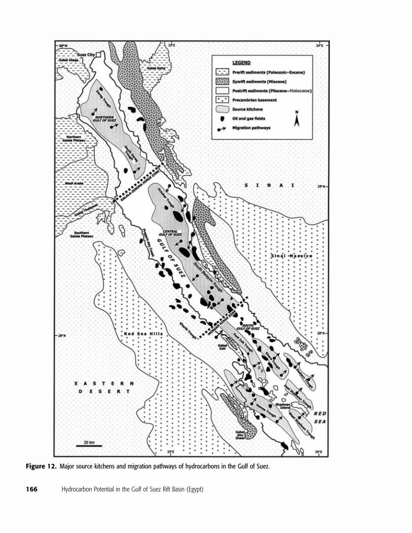
The geothermal gradient estimated for most ofthe drilled exploratory wells in the Gulf of Suez wascalculated from the available drillstem tests, electriclogs, and temperature surveys, after correcting thebottom-hole temperature (Figure 8). These correctedreadings were used to calculate the time-temperatureindex on the burial history diagrams and discussed inAlsharhan and Salah (1994, 1995). The major sourcekitchens and probable migration pathways of hydro-carbons are shown in Figure 12. The synrift and preriftsource kitchens (primarily Miocene) are the East andWest Shadwan Island and Gemsa troughs and the EastGhara, East Zeit, Darag, South Darag, October, SouthBelayim, and Gharib troughs, respectively. In theGemsa trough, the depth to basement reaches morethan 4600 m in places, at which the prerift sourcerocks are effectively in the gas generation window.The Shadwan and Ghara prerift source kitchens ex-tend to the Precambrian basement and range in depthfrom 2900 to 4000 m. At these depths the prerift

Alsharhan 163
Figure 9. Average organiccarbon content (% TOC) forUpper Cretaceous, Eocene, andMiocene formations in the Gulfof Suez.
sources lie within the oil generation window. The oilgeneration threshold is believed to have been estab-lished at 10 Ma for the prerift sources and around 4Ma for the synrift sources (mainly Miocene) in thesouthern Gulf of Suez. The depth to the level of onsetof oil generation ranges in the area from about 2290to greater than 3660 m and decreases southwardwithin the study area.
In the Darag trough, the basement is as deep asapproximately 7000 m, at which prerift source rocksare within the gas generation window or below it. Theoil generation threshold rates from approximately 9Ma for the prerift sources and around 3 Ma for thesynrift sources (mainly Miocene). The depth to theonset of oil generation ranges from about 2280 togreater than 3650 m for this trough.
Oil Groups
Multiple analytical parameters of oil samples, col-lected from both Miocene and pre-Miocene reservoirs,and several extracts from offshore and onshore areasof the Gulf of Suez were used to compare the geneticrelations of these oils with the analytical parametersfor oils from the whole Gulf of Suez, described byRohrback (1982), Mostafa (1993), and Alsharhan andSalah (1994, 1995). These analyses include liquidchromatograph separation, gas chromatography, gaschromatography–mass spectroscopy (GC-MS), and
stable isotope mass spectroscopy. The Gulf of Suezoils are interpreted to be of a single genetic family,suggesting the same or similar source rocks of marineorigin. Crude oils and their geochemical analyses areshown in Table 6.
Based on geochemical analyses and interpretation,the oil families in the Gulf of Suez can be classifiedinto groups (see also Barakat, 1982; Rohrback, 1982;Mostafa, 1993; Mostafa et al., 1993; Alsharhan andSalah, 1994, 1995; Wever, 2000) as summarized inthe following sections. The different number of clas-sified groups is due to different analytical techniques,oil samples (numbers and distributions), and localities.Moreover, all the samples and group numbers are dis-tinguished by biomarker distribution (gammacerane),gross composition, pristane/phytane ratios, carbonreference index, and sulfur content.
Group I OilThe source rock for group I oil is the CenomanianRaha Formation, confined to northeast fields such asAsal, Ras Matarma, and Sudr. These oils have beengenerated at an early stage of thermal maturity. Theoil is 20� API, has about 2% sulfur, d13C values forsaturates around –27‰, and n-alkane distributionwith pristane dominant over phytane. The lower C35/C34 homohopane ratios are less than 1, suggestinga less reducing marine environment for the sourcerock.

164 Hydrocarbon Potential in the Gulf of Suez Rift Basin (Egypt)
Figure 10. Van Krevelen dia-gram showing source rocktypes in the Gulf of Suez.
Group II OilThe group II oils show good correlation with the sourcerocks of the Brown Limestone and the Thebes For-mation. Sulfur-rich kerogen in these two source rocksmight be the source material for the high sulfur (poor-quality) oils of this group. Oils have been generated atlower temperature than the oils of the other groups.The oil fields belonging to this group are Ras Budran,October, Abu Rudeis, Belayim Land, and Belayim Ma-rine. The oil is characterized by d13C values of satu-
rates ranging between –28.6 and –29.3‰, with lowgravity and high sulfur content, and high C35/C34 ho-mohopanes, which is consistent with a reducing marineenvironment.
Group IIA OilThe group IIA oils originated essentially from theBrown Limestone in the Rahmi, Ras Amr, Ras Bakr,Ras Gharib, and Umm Al Yusr fields. The oils haved13C values ranging between –28.8 and –29.7‰ and

Alsharhan 165
Figure 11. Van Krevelen–typeplot of oxygen index and hy-drogen index of different for-mations from different fields inthe Gulf of Suez.
high sulfur content and poor quality, with lower APIgravity, due to the strong reducing conditions of thesource rock.
Group III OilThe group III oils show a correlation with the RudeisFormation and the lower Senonian Matulla Limestone.There also may be some contribution of oils generatedfrom the Brown Limestone and the Thebes Formation.The oils belonging to this group are confined to theRamadan, July, Morgan, Ras Gharra, Shoab Ali, Ash-rafi, Ganim, Geisum, Ras Al Bahr, and Ras Shukeirfields. The oil is characterized by a d13C range between–28.1 and –29.2‰, medium to high API oil gravity,and low to medium (less than 2%) sulfur content. Pris-tane/phytane ratios are relatively high (�1). Steranesand terpanes show that the source rocks were depos-ited under less reducing conditions and have high con-centration of C28 steranes, due to the variations in phy-toplanktonic assemblages, because these source rocksare younger than those for the other oil groups in theGulf of Suez.
The API gravity of the crude oils can be expectedto decrease from south to north in the basin and fromthe center of the basin to the edges. Thus, oil gravityreaches 39� API in midbasin fields near the southernpart of the Gulf of Suez. Crude gravity gradually de-creases to 27� API at midbasin fields at the north endand also decreases to as low as 19� API at fields on theshallow basin west and east flanks (Figure 13).
Crude oil samples from some of the producingfields were geochemically investigated by Rohrback(1982), Mostafa (1993), Alsharhan and Salah (1994,1995), and Wever (2000) to determine the number ofgenetically related families of oils and to evaluate ma-turity and migration trends. Multiple analytical param-eters used to characterize the petroleum samples in-clude API gravity, sulfur content, and crude oilcomposition; the distribution of C15� compounds; andspecific parameters (liquid chromatographic separa-tion, gas chromatography, GC-MS, and stable isotopemass spectroscopy). Each of these parameters wastabulated and interpreted to determine the genetic re-lationship(s) between the studied oil samples from
166 Hydrocarbon Potential in the Gulf of Suez Rift Basin (Egypt)
Figure 12. Major source kitchens and migration pathways of hydrocarbons in the Gulf of Suez.

Alsharhan 167
different parts of the Gulf of Suez cited in previousreferences.
The relationship between API gravity and sulfurcontent is shown in Figure 14. Little variation exists inthe API gravity and sulfur contents of the studied oilsamples, which may reflect a common source rock. Thehigh percentage of sulfur (�1%) indicates marinesource(s). The general crude oil composition of ana-lyzed oil samples shows no major geochemical differ-ences (Figure 15). This supports the contention thatthese oils were generated from one source rock or simi-lar source rocks. The distribution of the C15� com-ponents (paraffin, naphthene, aromatic, asphalt, andthe nitrogen, sulfur, and oxygen compounds) also in-dicates the same or similar source rocks in these fields(Figure 16). The studied oil samples from this part ofthe Gulf of Suez reflect a marine origin, show no ap-parent biodegradation, and display similar carbon iso-tope ratios (approximately �29‰ for the saturate and�28‰ for the aromatic hydrocarbons) (Figure 17).
RESERVOIR POTENTIAL
The Gulf of Suez is known for its multireservoir char-acter, in that each field contains several productive res-ervoirs (Tables 4, 7; Figure 3). The reservoirs can beclassified into prerift reservoirs and synrift reservoirs(for more details see Khalil and Meshref, 1988; Mesh-ref et al., 1988; Tewfik et al., 1992; Alsharhan and Sa-lah, 1994, 1995).
The Paleozoic sandstones in the Gulf of Suez arecharacterized by mature, well-sorted strata, whichconstitute one of the major prerift reservoirs in the Nu-bian sandstone formations. Net pay thickness reachesgreater than 300 m, with known recovery factors of upto 60%. The sandstones have good porosity up to 29%,and permeabilities reached about 400 md.
The Miocene sandstones are the most importantreservoir units in the Gulf of Suez, having porosities of15–35%. Dolomitized reef limestones also have reser-voir potential in the Miocene units. These facies weredeposited during rotational faulting, as the early Mio-cene uplifted horsts along the Gulf of Suez marginsshed alluvial sands into marine basins. The active fault-ing provided a topographic relief, which was progres-sively submerged by a middle Miocene transgression,allowing the development of reefs on local highs (Cof-field and Smale, 1987; Smale et al., 1988). Periodicuplift of the horsts probably allowed repeated flushingof the Miocene sandstones by acidic ground waters,
creating secondary porosity by leaching of carbonatecements. At the same time, feldspars were leached toproduce kaolinite cements (Coffield and Smale, 1987).The reef limestones, which are also important reser-voirs, were probably dolomitized as a result of mag-nesium enrichment of pore waters due to removal ofcalcium from seawater by precipitation of the evapo-rites that cap the dolostones (Heybroek, 1965).
The synrift reservoirs have greater potential in theGulf of Suez than the prerift (Table 7) because theyare better preserved, more broadly distributed, andproduce hydrocarbons from several formations.
Prerift Reservoirs
Fractured and Weathered BasementOil and gas were first discovered in the fractured base-ment rocks in 1981 in the QQ89 and RR89 wells (Fig-ure 2). These days the basement is a common reservoirin the Gulf of Suez and represents about 3.2% of pro-duction potential, yielding oil/gas in eight fields (ZeitBay, Shoab Ali, Hilal, Sidki, Geisum, Ashrafi, Hareed,and Esh El Mellaha). Porosity of the basement rocksranges between 1 and 15%, permeability ranges be-tween 10 and 300 md, and net pay thicknesses rangebetween about 10 and 300 m (Salah and Alsharhan,1998). The basement is granitic (quartz-diorite, gran-odiorite, syenogranite, alkali granites, and andesite por-phyry) and is cut by mafic and acidic dikes. The res-ervoir properties depend on crystal disaggregations,caused by weathering of the basement complex, andon tectonic brecciation caused by faulting and fractur-ing. The reservoir characterization of the Precambrianbasement depends mainly on the fractures, the diage-netic processes, and the dip and direction of the dikesand brecciated zones. The topmost section, known asthe basement cover, yields the best reservoir potential,resulting from the enlargement of the fractures andtheir vertical interconnections and the more intensiveeffect of diagenetic processes.
Nubian SandstoneThe Nubian sandstone (Cambrian–Lower Cretaceous)in the Gulf of Suez is characteristically a mature andwell-sorted sandstone. This facies forms one of the ma-jor prerift reservoirs and is confined to four formations(the Araba, Naqus, Qiseib, and Malha). Its net paythickness ranges between 30 and 305 m, with theknown recovery factor lying between 15 and 60%.The Nubian sandstone has a maximum-recorded thick-ness of about 465 m, located in the northern part. It

168Hydrocarbon
Potentialinthe
GulfofSuezRiftBasin
(Egypt)
Table 6. Crude Oil and Bulk Geochemical Compositions in Some Gulf of Suez Fields*
Crude Oil CompositionC15� Composition
Stable Isotope Ratios
FieldAPI
Gravity%
�C15
%C15�
%S Paraffin Naphthene Aromatic NSO Asphalt d34S
d13CSaturate
d13CAromatic
d13CNSO
d13CAsphalt
Amer 21 14.5 86 4.7 9 17 28.5 28.5 16.5 4.4 �28.8 �28 �28 �28Bakr 13–22 6–17 83–94 4–5.3 6–9 7–17.5 25–27 26–32 20–30 2–4.5 �29.5 �28 �28 �28Belayim Land 17–23 8–17 83–90 2.2–3.4 6–10.5 12–18.0 23–31 18–33 14–32 1.0–3.5 �29 �28 �28 �28Belayim Marine 26–28 14–25 75–85 2 11–19 22–25 24–37 14–22 7–16 3.8 �28.8 �28 �27 �28El Morgan 17–26 20–27 69–78 1.4 14–26 17–38 29–35 5–17 4–15 — �28.5 �28 — —GS 382 30 28 72 1.3 25 26 31 9 10 — �27 �27 — —July 25–33 24–36 63–76 1.2 14–27 22–34 19–34 5.5–28 2–15 0.5 �28.5 �27.5 �27 �27.5October 26.6 23 77 2 20 23 34 9 14 — �28.5 �28.8 — —Ramadan 20–28.5 21–35 65–78 1.0 20–29 27–32 20–31 7–26 2–11 0.3 �29 �27.5 �27 �28Ras Gharib 17 18–20 81 2.5 12.5 21 30 23 13 6.5 �29 �28 �27 �28Rudeis 25 12–21 80–88 2.2 12–18 17–22 25–37 10–30 13–18 2.6 �29 �28 �27 �28Shaob Ali 33 36 64 1.7 24 25 35 11 5.5 — �27.5 �27.5 — —Shukheir Bay 29 25.5 75 1.3 23 28 32 11 7 — �28.5 �28 — —Shukheir Marine 41 47 53 0.3 25 35 20 12 7 4.0 �29 �25 — —Sudr 22 17 83 2.1 16.0–20 23 33–37 3.5–11 16 — 27 �26.5 — —Umm El Yusr 21 17 83 3 14 17 39 14 15 — �29 �28.5 — —Wadi Dara Marine 45 42 58 0.4 26 37 21 9 7 5.0 �28.5 �27.5 �27 �27.5West Bakr 18 12 88 3.7 13 13 41 11 22 — �29 �28 — —
*Data compiled from Rohrback (1982) and Alsharhan and Salah (1994, 1995).

Alsharhan 169
Figure 13. API gravity map of oils in the Gulf of Suez (compiled and modified from Mostafa [1993] and Alsharhan and Salah [1994,1995]).

170 Hydrocarbon Potential in the Gulf of Suez Rift Basin (Egypt)
Figure 14. API gravity andsulfur content (wt. %) of someoil samples from main produc-ing formations in representativefields.
Figure 15. Crude oil compo-sition of some oil samples formajor reservoirs in representa-tive fields.
generally thins southward and is absent in most of thewells drilled in the southern Gulf of Suez area. Thesandstones yield a porosity ranging from 13 to 29% andpermeability from 70 to 400 md. The quality of thereservoir depends on the amount of shale, the diage-netic processes (including secondary silica dissolutionand precipitation), and the depth of burial. The Nu-bian sandstone produces oil in many fields in the areaand represents about 17% of production potential inthe Gulf of Suez. Most of the Nubian sandstone res-
ervoir is quartzarenite-type with minor reservoirs ofquartzwacke type.
The Araba Formation consists of sandstones withkaolinitic, illitic, and calcareous cements and is inter-bedded with thin siltstone. This sandstone reservoir hasan average porosity of 15% and yields hydrocarbons inthe Bakr and Ras Gharib oil fields with a net pay zonethickness range of 45 to 450 m.
The Naqus Formation comprises medium tocoarse-grained sands and sandstones, with minor clay

Alsharhan 171
Figure 16. Distribution ofC15� components for some oilsamples from main producingformation in each field.
Figure 17. Aromatics/satu-rates carbon isotopes of someoil samples from main produc-ing formations in representativefields.

172 Hydrocarbon Potential in the Gulf of Suez Rift Basin (Egypt)
and kaolinitic interbeds at the top of the unit. The Na-qus sandstone is the main producing reservoir zone inthe July, Hurghada, and Ramadan oil fields, with netpay thicknesses of 210, 340, and 230 m, respectively.These sandstones possess an average porosity of 15%and an average permeability of 250 md.
The Qiseib Formation consists mainly of a reddish,fine to coarse-grained, cross-bedded sandstone, withthin interbeds of shale. Petrographically, these sand-stones are quartzarenite. The Qiseib Formation testedoil from an 18% porosity sandstone in the North Daragdiscovery in the northern Gulf of Suez.
The Malha Formation provides the best qualitysandstone reservoir in the Gulf of Suez. The sandstonesform the main producing reservoir in several oil fields(e.g., Ras Budran, July, October, Feiran, East Zeit,Hilal, Shoab Ali, Ramadan, GS 382, Ras Gharib, andBakr). The porosity of the Malha Sandstone rangesfrom 13 to 28%, depending mainly on the depth ofburial, kaolinite content, and silica dissolution and/orprecipitation. The net pay thickness of the MalhaSandstone varies from one field to another; for exam-ple, in the October, Hilal, and GS382 oil fields it is245, 95, and 30 m, respectively.
Nezzazat GroupThe Nezzazat Group includes the Matulla, Wata, AbuQada, and Raha sandstones, which provide about 1%of production potential, and produces oil from severalfields, such as the Belayim Marine, October, Ras Bud-ran, Abu Rudeis/Sidri, Feiran, Bakr, Ras Gharib,Amer, Kareem, July, Ramadan, Sidki, Shoab Ali, ZeitBay, Geisum, and Bahr fields. Porosity ranges between15 and 23% and permeability between 100 and 250md. The quality of the reservoir depends on the depthof the sandstone and the amount of argillaceous matterand/or calcareous cement.
Thebes FormationThe Thebes Formation contributes about 1.1% of pro-duction potential and produces from the Sudr, Asal,Ras Matarma, Bakr, West Bakr, Kareem, Rahmi, Is-saran, and Shoab Ali fields. It consists of fractured ma-rine carbonates with an average porosity of 13% andnet pay thickness of 15–17 m.
Synrift Reservoirs
Nukhul FormationThe Nukhul sandstone is well developed in the Gulfof Suez, but is locally absent, particularly in places that
remained structurally high or emergent until latertimes. The Nukhul Formation thins toward the mar-gins of the Gulf of Suez and reaches its maximumthickness in the central offshore area. It representsabout 11.5% of production potential and produces oilfrom the Rudeis, Sidri, Shoab Ali, GS 173, Zeit Bay,Hilal, Ashrafi, Gemsa SE, and Darag fields and oil andgas from Hareed field. The sandstone is conglomeraticin parts and yields porosities ranging between 17 and25%. The Nukhul carbonates of reefal origin produceoil from three fields (Al Ayun, Kareem, and Zeit Bay)and oil and gas from the Felefel field. The average po-rosity of these carbonates is 16%. The net pay thicknessof the Nukhul reservoirs in these fields ranges from 20to 60 m.
Rudeis FormationThe Rudeis reservoirs are present over most of thestudy area and represent about 20% of production po-tential in the Gulf of Suez. The Rudeis sandstone hasproduced oil from fields such as the Shoab Ali, EastZeit, Ashrafi, GH376, Amal, Asal, Belayim Marine,Belayim Land, Al Ayun, July, Kareem, Matarma, Sudr,Morgan, Kheir, and Umm El Yusr and has tested gasfrom the Felefel field. The net pay thickness of the res-ervoir ranges between about 15 and 30 m in the south,whereas in the north the range is 20 to 75 m. Theporosity ranges between 13 and 26%, and permeabilitylies between 10 and 1000 md. The Rudeis carbonatesare producers of oil in the Zeit Bay, Bahr, Sudr, Asl,and Matarma fields and of gas in the Felefel field, withan average porosity of 16%. These carbonates are par-ticularly well developed in submerged high areaswithin the lower Miocene basin, such as in the NorthBahar area.
Kareem FormationThe sandstones of the Kareem Formation are one ofthe most important reservoir lithologies in the Gulf ofSuez Basin and produce and/or test oil from many oil-fields (including Morgan, Belayim Land and BelayimMarine, Amal, Kareem, Badri, Zeit Bay, East Zeit,Shoab Ali, Hilal, Sidki, Geisum, Ashrafi, GH376,Bahr, Warda, Kheir, Hareed, and Esh El Mellaha). Often potential reservoir units in the basin, almost 23%of the oil is produced from the Kareem Formationsandstones. Their net pay thicknesses range between10 and 200 m, porosities range from 7 to 33%, andpermeabilities range from 20 to 730 md. Overallreservoir quality depends on the shale content, theimportance of diagenetic processes, such as silica
Alsharhan 173
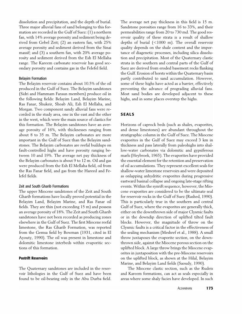
dissolution and precipitation, and the depth of burial.Three major alluvial fans of sand belonging to this for-mation are recorded in the Gulf of Suez: (1) a northernfan, with 14% average porosity and sediment being de-rived from Gebel Zeit; (2) an eastern fan, with 25%average porosity and sediment derived from the Sinaimassif; and (3) a southern fan, with 20% average po-rosity and sediment derived from the Esh El Mellaharange. The Kareem carbonate reservoir has good sec-ondary porosity and contains gas in the Felefel field.
Belayim FormationThe Belayim reservoir contains about 10.5% of the oilproduced in the Gulf of Suez. The Belayim sandstones(Sidri and Hammam Faraun members) produce oil inthe following fields: Belayim Land, Belayim Marine,Ras Fanar, Shukeir, Shoab Ali, Esh El Mellaha, andMorgan. Two component sandy alluvial fans were re-corded in the study area, one in the east and the otherin the west, which were the main source of clastics forthis formation. The Belayim sandstones have an aver-age porosity of 16%, with thicknesses ranging fromabout 8 to 35 m. The Belayim carbonates are moreimportant in the Gulf of Suez than the Belayim sand-stones. The Belayim carbonates are reefal buildups onfault-controlled highs and have porosity ranging be-tween 10 and 19%. The average net pay thickness ofthe Belayim carbonates is about 9 to 12 m. Oil and gaswere produced from the Esh El Mellaha field, oil fromthe Ras Fanar field, and gas from the Hareed and Fe-lefel fields.
Zeit and South Gharib FormationsThe upper Miocene sandstones of the Zeit and SouthGharib formations have locally proved potential in theBelayim Land, Belayim Marine, and Ras Fanar oilfields. They are thin (not exceeding 15 m) and possessan average porosity of 18%. The Zeit and South Gharibsandstones have not been recorded as producing zoneselsewhere in the Gulf of Suez. The first Miocene reefallimestone, the Ras Gharib Formation, was reportedfrom the Gemsa field by Bowman (1931, cited in ElAyouty, 1990). The oil was present in limestone anddolomitic limestone interbeds within evaporitic sec-tions of this formation.
Postrift Reservoirs
The Quaternary sandstones are included in the reser-voir lithologies in the Gulf of Suez and have beenfound to be oil-bearing only in the Abu Durba field.
The average net pay thickness in this field is 15 m.Sandstone porosities range from 16 to 33%, and theirpermeabilities range from 20 to 730 md. The good res-ervoir quality of these strata is a result of shallowdepths of burial (�1000 m). The overall reservoirquality depends on the shale content and the impor-tance of diagenetic processes, including silica dissolu-tion and precipitation. Most of the Quaternary clasticstrata in the southern and central parts of the Gulf ofSuez are derived from eroded basement rocks flankingthe Gulf. Erosion of horsts within the Quaternary basinpartly contributed to sand accumulation. However,some of these highs have acted as a barrier, effectivelypreventing the advance of prograding alluvial fans.Most sand bodies are developed adjacent to thesehighs, and in some places overstep the highs.
SEALS
Horizons of caprock beds (such as shales, evaporites,and dense limestones) are abundant throughout thestratigraphic column in the Gulf of Suez. The Mioceneevaporites in the Gulf of Suez may exceed 3 km inthickness and pass laterally from paleohighs into shal-low-water carbonates via dolomitic and gypsiferousmarls (Heybroek, 1965). The evaporites have providedthe essential element for the retention and preservationof oil accumulations. They represent excellent seals forshallow-water limestone reservoirs and were depositedas onlapping anhydritic evaporites during progressiveeastward basinal collapse and ongoing late-stage riftingevents. Within the synrift sequence, however, the Mio-cene evaporites are considered to be the ultimate sealfor reservoir rocks in the Gulf of Suez (Rashed, 1990).This is particularly true in the southern and centralGulf of Suez, where the evaporites are generally thick,either on the downthrown side of major Clysmic faultsor in the downdip direction of uplifted tilted faultblocks. However, the magnitude of throw on theClysmic faults is a critical factor in the effectiveness ofthe sealing mechanism (Meshref et al., 1988). A smallthrow juxtaposes the evaporite section, on the down-thrown side, against the Miocene porous section on theuplifted block. A large throw brings the Miocene evap-orites in juxtaposition with the pre-Miocene reservoirson the uplifted block, as shown at the Hilal, BelayimMarine, and Belayim Land fields (Saoudy, 1990).
The Miocene clastic section, such as the Rudeisand Kareem formations, can act as seals especially inareas where some shaly facies have developed. In such

174Hydrocarbon
Potentialinthe
GulfofSuezRiftBasin
(Egypt)
Table 7. Hydrocarbon Habitat, Mode of Migration, and Trapping Mechanism in Miocene Gharandal and Ras Malaah groups
Reservoir
Formation Lithology Source Rock Cap Rock (Seal) Mode of Migration Trapping Mechanism Examples
Belayim, Kareem,and Rudeis
Sandstone withminor limestones,shale, andanhydrite
Kareem andRudeis
Mudstone andevaporites verticallyand laterally
Sourced across/up faults,then updip withpossible direct/verticalmigration frominterbedded mudstone/carbonate source beds
3-way dip closed,fault-bounded trap
El Morgan, Badri,and Amal fields
Belayim, Kareem,and Rudeis
Clastics inmultireservoirstacked sequence
Rudeis Individual sandssealed byinterbeddedmudstone
Lowermost reservoir indirect (erosional)contact with preriftaccumulation, vertical,fracture migrationwithin sands
3-way dip, faultclosure
Belayim Marineand Shoab Alifields
Belayim, Kareem,and Rudeis
Sandstones withminor limestone,shale, andanhydrite
Nukhul Sealed by surroundingmudstones
Sourced by combinationof direct access fromsynrift source and/orvertical/upfaultmigration from preriftsource beds
Stratigraphic pinch-outtrap
Umm El Yusr andEl Ayun fields
Belayim, Kareem,and Rudeis
Sandstones withthin interbeddedanhydrite andintercalated shale
Kareem andRudeis
Sealed vertically byinterbeddedmudstone andlaterally by changeto tighter lithologies
Sourced by cross-faultand updip migrationfrom prerift sourcebeds
Stratigraphic trapformed by lateralfacies change tomudstone/wackestone
Esh Mellaha field

Alsharhan175
Belayim andKareem
Sandstones withminor limestonesand shale
Kareem Sealed vertically andlaterally byevaporites
Migration verticallythrough Rudeis andKareem formations, upfaults from prerift andsynrift source beds
Fault-bounded horst GH375 and Kheirfields
Belayim andRudeis
Carbonate reefalbuildup,evaporite withminor shale
Belayim Sealed by overlying/draped
mudstones orevaporites
Sourced fromsubcropping preriftand/or upfault/updipcontribution
Combination faultblock trap andstratigraphic trap
Ras Fanar, ZeitBay, and Gemsafields
Rudeis Sandstones withinterbeddedshale andlimestone
Rudeis Updip migrationsealed by upper partof the RudeisFormation, bothlaterally andvertically
Sourced by cross-faultjuxtaposition withprerift sediments
Eroded/faulted atmid-Clysmicunconformity toproducegeomorphic/faultedtrap
July field
Nukhul Interbeddedsandstones withlimestone andhighly calcareousshale
Nukhul Sealed both laterallyand vertically byNukhul/Rudeismudstones
Direct communicationwith underlying Thebessource beds
Combination onlap/fault bounded
East Zeit andHurghada fields
Nukhul Clastics with minorcarbonates andshales
Nukhul Vertical sealing byoverlying tightformations
Sourced by upfaultmigration
Trapping byhydrocarbons as aresult of updipformation of tar matby biodegradation ofearlier generated oil
Ekma andGazwarina fields
Zeit, South Gharib,Belayim, andNukhul
Clastics, salt, andanhydriteinterbed
Rudeis Sealed by overlyingmudstones/evaporites
Sourced by upfaultmigration. Spill may becontrolled by faults
4-way dip closed(rollover anticline)structure
Belayim Land,Garra Marine,and Shukheirfields

176 Hydrocarbon Potential in the Gulf of Suez Rift Basin (Egypt)
cases, porous intervals within the formation act as res-ervoirs, whereas the shaly intervals become verticaland/or horizontal seals, depending on the magnitudeof the throw of the fault. The Miocene shales alsoare an important factor in stratigraphic traps, wherethey confine a body of sandstone as a lateral faciesvariation.
The prerift Cretaceous carbonates (Brown Lime-stone and Sudr), the Paleocene Esna Shale, and theEocene Thebes limestone formations can act as verticalseals over the Cretaceous sandstone reservoirs.
HYDROCARBON ENTRAPMENT
The main trap types are due to rotational faulting andrelated unconformities. Porous Carboniferous, Creta-ceous, and Eocene facies in the footwalls of the basin-edge half grabens have been faulted against and aresourced by middle Miocene marls. Unconformity trapsoccur in the eroded formations at the tops of horstsand in onlapped Miocene reefs, which cap the horsts.Drape anticlines above buried horsts provide traps inmany of the later Miocene reservoirs. Small crossfaults, related to transfer faults, cut the horsts to pro-duce prospective trap door structures (Clifford, 1987).The main directions of the fractures affecting thesebasement rocks are northwest-southeast, northeast-southwest, and east-northeast–west-southwest. Sev-eral mechanisms for hydrocarbon entrapment are re-corded in the Gulf of Suez. These are structural,stratigraphic, and combination traps, as reported byMeshref et al. (1988), Tewfik (1988), Zahran andMeshref (1988), El Ayouty (1990), Rashed (1990),Saoudy (1990), Hammouda (1992), Alsharhan and Sa-lah (1994, 1995), and Salah and Alsharhan (1998).These are summarized in the following sections and inTable 5.
Structural Traps
In the Gulf of Suez, most oil accumulations are trappedstructurally. The following are examples of these traps.
Both the prerift and synrift reservoirs produce oilfrom fault-related traps where the reservoir is laterallyand vertically confined by a down-faulted overlyingseal. Hydrocarbons in this type of trap are from eitherprerift sources across synthetic faults (e.g., October,Belayim Land, Morgan, Geisum, and Shoab Ali fields)or the underlying prerift or synrift sources, as in theHilal, East Zeit, Ramadan, and Ras Badran fields.
Closures induced by intersection of severalClysmic faults are exemplified by the traps in the Ram-adan field, where such intersecting faults determine ad-ditional producing compartments. In several fields,such as the Belayim fields, drape over fault-blockboundaries produced by differential sediment compac-tion in synrift formations has generated asymmetricalanticlines overlying a faulted high with hingeline or as-sociated flexures.
In the Belayim Marine and Zeit Bay fields, afour-way dip closure trap has formed as a hanging-wall anticline, related to thrusting of Miocene strata.This trap is sealed vertically by intraformational mud-stones or Miocene evaporites, with sources lyingacross or in the upfault direction from prerift sourcerocks. Draping over fault-block boundaries created bydifferential sediment compaction over the crests ofblocks is common in synrift formation. Such traps arefound in the Belayim Land and Belayim Marinefields. A subtle trap occurs as flat lying areas betweentwo grabens or two horst structures, such as in SouthRamadan field.
Stratigraphic Traps
Stratigraphic traps have recently become importanttargets for hydrocarbon exploration in the Gulf of Suezin general. There are some proven stratigraphic trapsat the Ras El Bahar discovery, where the Miocene po-rous carbonate wedge is sealed vertically and laterallyby a facies change to dense carbonate. In the BelayimLand field, Miocene porous sandstone is present aslenses that are sealed vertically and laterally by a facieschange to evaporites. Oil sources lie across faults or arelocated updip from the prerift sections. A stratigraphictrap occurs in well-developed Miocene reefal lime-stone on the eastern flank of the Ras Gharib field. Inthe Gemsa field, a basement horst is capped by Mio-cene and younger strata. In the lower part of the Mio-cene, a reefal limestone developed, within which oilaccumulated. This reefal limestone is surrounded byfossiliferous, organic-rich shales, which also surroundthe basement horst (Bowman [1931] cited in El Ay-outy [1990]).
Truncations below an unconformity are recog-nized in prerift strata cut by the basal rift unconfor-mity or in Miocene strata cut by the intra-Mioceneunconformity, as in the Ras Gharib and July fields.Onlap pinch-out can be seen where the sandstonesof the Nukhul Formation are overlain by transgres-sive shales, on the flanks of tilted blocks in the Ekma,

Alsharhan 177
Ras Bakr, and Abu Rudeis fields. Updip pinch-out ofsand lenses within the Kareem and Rudeis formationshas developed on the flanks of some structures.These pinch-outs have irregular patterns, and suchrapid changes in thickness and lateral facies representgood stratigraphic traps in the Umm El Yusr and ElAyun fields. Some block crests composed of weath-ered and fractured basement rocks contain oil accu-mulations in the Shoab Ali, Zeit Bay, and Hurghadafields.
Combination Traps
There are two proven cases of combination traps. (1)In the Shoab Ali, Asl, Sudr, and Ras Matarma fields,the Eocene limestone is both reservoir and source, withan updip contribution from the Upper Cretaceous car-bonates and sealed by synrift mudstones. In these fieldssome of the synthetic faults act as sealing faults. (2) Inthe RR89 discovery and the Ras Gharib field, a reefreservoir deposited on a fault-controlled high is sealedby Miocene evaporites. The hydrocarbon source was aprerift source rock with a long migration range. Thesereefs possess very high porosity (up to 30%), as in theMiocene reef complex at Gebel Abu Shaar. Reefalbuildups accumulated on the crests of some blocks andhave good petrophysical properties due to dolomiti-zation and fracturing. These can be seen in the Ras Bakrfield.
SUMMARY FACTORS RESPONSIBLE FORTHE HYDROCARBON POTENTIAL
Several common factors that we believe are importantfor the development and occurrence of hydrocarbonsin the Gulf of Suez rift basin are summarized in thefollowing list.
• Composite maximum thickness of the strata is about8000 m. The sequence comprises lower Paleozoicsandstone of terrestrial origin and carboniferousshales of marine origin. Mesozoic and Paleocene–Eo-cene units were essentially uniform in a marine plat-form environment of mainly carbonates, with sub-ordinate sandstones and shales, Oligocene red beds,Miocene marls, sandstones and evaporites, Plioceneclastics, and Quaternary carbonates.
• Large traps were formed by anticlines over prede-positional highs and by reservoir beds within the pre-depositional highs. The traps commonly have an
areal extent of a few square kilometers and are faultcontrolled. They accommodate the oil fields formedduring the late Tertiary.
• Since the formation of traps (most of them duringthe Miocene), no later major tectonic events haveoccurred, except for basaltic extrusions in the Oli-gocene, before the deposition of the source rocks.After that, minor vertical uplift and strike-slipmove-ments occurred.
• Major disconformities occur within and at the top ofthe Nubian sandstone during the Permian–Triassicand Jurassic, at the top of the Cretaceous, at the topof the Eocene, at the base of the Gharandal Group,and within the Miocene.
• Significant oil has accumulated in strata ranging inage from Paleozoic to Eocene, but the largest oil ac-cumulations occur in Miocene strata.
• Highly organic-rich marls and shales were depositedduring the Late Cretaceous and Miocene. Theserocks encase the uplifted blocks, which acted as amajor source for giant traps, and filled these withhydrocarbons in highly porous and permeablereservoirs.
• A thick evaporite sequence (up to 2000 m) was de-posited during the Miocene. Salt flowage has beenan important factor in sealing active faults to preventoil migration. This thick evaporite sequence was de-posited above the reservoirs and forms an effectivecaprock.
• A higher than normal geothermal gradient is presentdue to the processes of rifting, crustal thinning, di-abase dike intrusions, and thick salt deposits.
POTENTIAL PLAYS
The geologic controls on the distribution of hydrocar-bons in the Gulf of Suez are based on the areal extentand richness of potential source rock, tectonic subsi-dence, and excellent seals (e.g., evaporite) that accel-erated hydrocarbon formation and redistribution. Fig-ure 18 represents a typical model of trap mechanismand formation in the southern Gulf of Suez. The fol-lowing is a summary of potential plays.
• Fractured and karstified limestone reservoirs lie be-low the Rudeis Limestone unconformity or wherethere is intense folding in the hanging wall. Hydro-carbons could migrate from surrounding Rudeissource rocks, up faults from prerift strata, and besealed by surrounding mudstones.

178 Hydrocarbon Potential in the Gulf of Suez Rift Basin (Egypt)
• Belayim reefal buildups have developed as carbonatetalus in the hanging wall of major faults. These car-bonate reservoirs are sourced by lateral potential se-quences or underlying prerift sequences and aresealed by overlying mudstones and laterally by im-permeable units in the footwall.
• In the southeast Gulf of Suez, the reservoir in clasticsof the lower Belayim Formation and also an intra-evaporite event, which represents a subcrop/uncon-formity play, could have been sourced by vertical orupfault migration and sealed above and below bymudstones and evaporites.
• Clastic reservoirs in the Zeit and South Gharib for-mations occur in structural traps formed by saltdiapirism/piercement. Hydrocarbons migrated upalong faults from deeper sources and were sealed lat-erally by salts and vertically by evaporites ormudstones.
• There are possibilities for finding new prerift struc-tures near and associated with prominent fault sys-tems with large throws. The prerift reservoirs are not
in contact with the overlying rift source beds unlessthere are large throws on the faults.
• Prerift reservoirs have not been fully tested bydeeper drilling on several older fields. Among these,early discoveries are producing only from the firstproduction encountered, which is commonly synrift(Miocene reservoirs).
REFERENCES CITED
Abdallah, A. M., A. Adindani, and N. Fahmy, 1963, Stratigraphy ofthe lower Mesozoic rocks, western side of the Gulf of Suez:Egyptian Geological Survey and Mineral Resources Depart-ment, v. 27, 23 p.
Ahmed, S. S., 1972, Geology and petroleum prospects in easternRed Sea: AAPG Bulletin, v. 56, no. 4, p. 707–719.
Alsharhan, A. S., and M. G. Salah, 1994, Geology and hydrocarbonhabitat in rift setting: southern Gulf of Suez, Egypt: Bulletin ofCanadian Petroleum Geology, v. 42., p. 312–331.
Alsharhan, A. S., and M. G. Salah, 1995, Geology and hydrocarbonhabitat in rift setting: northern and central Gulf of Suez, Egypt:Bulletin of Canadian Petroleum Geology, v. 43, no. 2, p. 156–176.
Figure 18. Formation of typical oil field in the Gulf of Suez (modified from O’Connor and Kanes, 1984).

Alsharhan 179
Alsharhan, A. S., and M. G. Salah, 1998, Sedimentological aspectsand hydrocarbon potential of the Quaternary in the Gulf ofSuez rifted basin, in A. S. Alsharhan, K. W. Glennie, G. L.Whittle, and C. G. St. C. Kendall, eds., Quaternary deserts andclimatics changes: Rotterdam, Balkema, p. 531–538.
Atef, A., 1988, Source rock evaluation of the Brown Limestone (up-per Senonian), Gulf of Suez: 9th Egyptian General PetroleumCorporation, Petroleum Exploration and Production Confer-ence, v. 1, p. 256–275.
Barakat, H., 1982, Geochemical criteria for source rock, Gulf ofSuez: 6th Egyptian General Petroleum Corporation, PetroleumExploration and Production Conference, v. 1, p. 224–251.
Barakat, M. G., M. Darwish, and A. N. El-Barkooky, 1986, Litho-stratigraphy of the post-Carboniferous pre-Cenomanianclasticsin the west central Sinai and Gulf of Suez: 8th EgyptianGeneralPetroleum Corporation, Petroleum Exploration andProductionConference, v. 1, p. 380–405.
Barakat, M. G., M. Darwish, and N. S. El Outefi, 1988, Eocenetectonostratigraphy and basin evaluation in the Gulf of Suezpetroliferous province: 9th Egyptian General Petroleum Cor-poration, Petroleum Exploration and Production Conference,v. 1, p. 1–22.
Bartov, Y., G. Steinitz, M. Ayal, and Y. Ayal, 1980, Sinistral move-ment along the Gulf of Aqaba—its age and relation to the open-ing of the Red Sea: Nature, v. 285, p. 220–222.
Beleity, A., 1982, The composite standard and definition of paleoevents in the Gulf of Suez: 6th Egyptian General PetroleumCorporation, Petroleum Exploration and Production Confer-ence, v. 1, p. 181–199.
Beleity, A. M., M. Ghoneim, M. Hinnawy, M. Fathi, H. Gebali, andM. Kamel, 1986, Palaeozoic stratigraphy, and palaeotectonicsin the Gulf of Suez: 9th Egyptian General Petroleum Corpo-ration, Petroleum Exploration and Production Conference, v. 1,p. 96–117.
Bosworth, W., P. Crevello, R. D. Winn Jr., and J. Steinmetz, 1998,Structure, sedimentation, and basin dynamics during rifting ofthe Gulf of Suez and northwestern Red Sea, in B. H. Purser andD. W. J. Bosence, eds., Sedimentation and tectonics of rift ba-sins: Red Sea–Gulf of Aden: London, Chapman and Hall, p. 77–96.
Clifford, A. C., 1987, African oil—past, present and future, in M. T.Halbouty, ed., Future petroleum provinces of the world:AAPGMemoir 40, p. 339–372.
Coffield, D. Q., and J. L. Smale, 1987, Structural geometry and syn-rift sedimentation in an accommodation zone, Gulf of Suez,Egypt: Oil & Gas Journal, v. 85, no. 51, p. 56–59.
Darwish, M., 1992, Facies development of the upper PalaeozoicLower Cretaceous sequences in the northern Galala Plateauandevidences for their hydrocarbon reservoir potentiality, northernGulf of Suez: 1st International Conference on Geology of ArabWorld, v. 1, p. 175–213.
Darwish, M., and A. M. El-Araby, 1993, Petrography and diageneticaspects of some siliciclastic hydrocarbon reservoirs in relationto the rifting of the Gulf of Suez: Geological Society of EgyptSpecial Publication 1, p. 155–187.
Dolson, J. C., M. V. Shann, S. Matbouly, C. Harwood, R. Rashed,and H. Hammouda, 2001, The petroleum potential of Egypt,in M. W. Downey, J. C. Threet, and W. A. Morgan, eds., Pe-troleum provinces of the twenty-first century: AAPG Memoir74, p. 453–482.
Egyptian General Petroleum Corporation Stratigraphic Committee,1964, Oligocene and Miocene rock stratigraphy of the Suezregion: Cairo, Egyptian General Petroleum Cooperation, 142p.
Egyptian General Petroleum Corporation Stratigraphic Committee,1974, Miocene rock stratigraphy of Egypt: Journal of EgyptianGeological Society, v. 18, p. 1–59.
El Ayouty, M. K., 1990, Petroleum geology, in R. Said, ed., Thegeology of Egypt: Rotterdam, Balkema, p. 567–599.
Evans, A. L., 1990, Miocene sandstone provenance relations in theGulf of Suez: insights into synrift unroofing and uplift history:AAPG Bulletin, v. 74, p. 1386–1400.
Fawzy, H., and A. Abd El Aal, 1984, Regional study of Mioceneevaporites and Pliocene to Recent sediments in the Gulf ofSuez: 7th Petroleum Exploration Seminar, Egyptian GeneralPetroleum Corporation, v. 1, p. 49–74.
Fichera, R., I. Giori, and G. Milad, 1992, Interpretation of seismic,gravity and magnetic data as constraints in the resolution ofdeep structural setting, southern Gulf of Suez: 11th EgyptianGeneral Petroleum Corporation, Petroleum Exploration andProduction Conference, v. 1, p. 31–44.
Gandino, A., I. Giori, and G. Milad, 1990, Magnetic interpretationcontrolled by interactive 3D modelling in the southern Gulf ofSuez: 10th Egyptian General Petroleum Corporation, Petro-leum Exploration and Production Conference, v. 1, p. 740–786.
Garfunkel, Z., and Y. Bartov, 1977, The tectonics of the Suez rift:Geological Survey of Israel Bulletin, v. 71, p. 1–44.
Griffin, D. L., 1999, The late Miocene climate of northeastern Af-rica: unravelling the signals in the sedimentary succession: Jour-nal of the Geological Society, v. 156, p. 817–826.
Hammouda, H., 1992, Rift tectonics of the southern Gulf of Suez:11th Egyptian General Petroleum Corporation, Petroleum Ex-ploration and Production Conference, v. 1, p. 18–19.
Heybroek, F., 1965, The Red Sea Miocene evaporite basin, in Saltbasins around Africa: London, Institute of Petroleum, p. 17–40.
Ibrahim, M., 1992, Analysis and tectonic history of the onshore ba-sins of the western side of the Gulf of Suez: implications forhydrocarbon occurrences: 11th Egyptian General PetroleumCorporation, Petroleum Exploration and Production Confer-ence, v. 1, p. 45–53.
Issawi, B., 1973, Nubia sandstone type section: AAPG Bulletin,v. 57, p. 741–745.
James, N. P., M. Congilio, D. M. Aissaoui, and B. H. Purser, 1988,Facies and geologic history of an exposed Miocene rift margincarbonate platform, Gulf of Suez: AAPG Bulletin, v. 72, p. 86–109.
Jarrige, J. J., P. Ott d’Estevou, P. F. Burollet, C. Montenat, J. P.Richert, and J. P. Thiriet, 1990, The multistage tectonic evo-lution of the Gulf of Suez and northern Red Sea continental riftfrom field observations: Tectonics, v. 9, p. 441–465.
Khalil, B., and W. M. Meshref, 1988, Hydrocarbon occurrences andstructural style of the southern Suez Rift Basin, Egypt: 9thEgyptian General Petroleum Corporation, Petroleum Explora-tion and Production Conference, v. 1, p. 86–109.
Kingston, D. R., C. P. Dishroon, and P. A. Williams, 1983, Globalbasin classification system: AAPG Bulletin, v. 67, no. 12,p. 2175–2193.
Mazhar, A., E. Naser, and Y. A. Kader, 1979, Contribution to theCretaceous early Tertiary stratigraphy of southern Galala Pla-teau: Journal of Egyptian Geological Society, v. 9, p. 377–387.
Meshref, W. M., 1990, Tectonic framework, in R. Said, ed., Thegeology of Egypt: Rotterdam, Balkema, p. 113–156.
Meshref, W. M., and B. Khalil, 1990, Evidence for northerly prop-agation in Suez rift: 10th Egyptian General Petroleum Corpo-ration, Petroleum Exploration and Production Conference, v. 1,p. 55–77.
Meshref, W. M., M. S. Abu Karamat, and M. Gindi, 1988, Explo-ration concepts for oil in the Gulf of Suez: 9th EgyptianGeneralPetroleum Corporation, Petroleum Exploration andProductionConference, v. 1, p. 1–24.
Montenat, C., P. Ott d’Estevou, J. J. Jarrige, and J. P. Richert, 1998,Rift development in the Gulf of Suez and the north-western
180 Hydrocarbon Potential in the Gulf of Suez Rift Basin (Egypt)
Red Sea: structural aspects and related sedimentary processes,in B. H. Purser and D. W. J. Bosence, eds., Sedimentation andtectonics of rift basins: Red Sea–Gulf of Aden: London, Chap-man and Hall, p. 97–116.
Mostafa, A. R., 1993, Organic geochemistry of source rocks and re-lated crude oils in the Gulf of Suez, Egypt: Berlin Geowissen-schaften Abbandlungen, v. 147, 163 p.
Mostafa, A. R., E. Klitzsch, G. Matheis, and H. Ganz, 1993, Originand evaluation of hydrocarbons in the Gulf of Suez Basin,Egypt, in U. Thorweihe and H. Schandelmeier, eds., Geoscien-tific research in north east Africa: Rotterdam, Balkema, p. 267–275.
O’Connor, T. E., and W. H. Kanes, 1984, Tectonic evolution andsedimentary response: a hydrocarbon accumulation model ofthe eastern north African continental margin, in Proceedings ofthe Seminar on Source and Habitat of Petroleum in the ArabCountries: Kuwait, Organization of Arab Petroleum ExportingCountries (OAPEC), p. 543–576.
Pomeyrol, R., 1968, Nubian sandstone: AAPG Bulletin, v. 52, no. 9,p. 589–600.
Rashed, A., 1990, The main fault trends in the Gulf of Suez andtheir role in oil entrapment: 10th Egyptian General PetroleumCorporation, Petroleum Exploration and Production Confer-ence, v. 1, p. 143–178.
Robson, D. A., 1971, The structure of the Gulf of Suez (Clysmic)rift, with special reference to the eastern side: Journal of theGeological Society, v. 127, p. 247–276.
Rohrback, B. G., 1982, Crude oil geochemistry of the Gulf of Suez:6th Egyptian General Petroleum Corporation, Petroleum Ex-ploration and Production Conference, v. 1, p. 212–224.
Sadek, H., 1959, The Miocene in the Gulf of Suez region, Egypt:Geological Survey of Egypt Special Publication, 118 p.
Said, R., 1962, The geology of Egypt: Amsterdam, Elsevier, 317 p.Salah, M. G., and A. S. Alsharhan, 1998, The Precambrianbasement:
a major reservoir in the rifted basin, Gulf of Suez: Journal ofPetroleum Science and Engineering, v. 19, p. 201–222.
Saoudy, A. M., 1990, Significance of NE cross faults on oil explo-ration in the southern Gulf of Suez area, Egypt: 10th EgyptianGeneral Petroleum Corporation, Petroleum Exploration andProduction Conference, v. 1, p. 104–143.
Schlumberger, 1995, Well evaluation conference, Egypt: Paris,France, Schlumberger, 87 p.
Sellwood, B., and R. Netherwood, 1984, Facies evolution in the Gulfof Suez area—sedimentation history as an indicator of rift ini-tiation and development: Modern Geology, v. 9, p. 43–69.
Shaheen, A. N., and M. Shehab, 1984, Petroleum generation, mi-gration and occurrence in the Gulf of Suez offshore, southSinai: 7th Egyptian General Petroleum Corporation,PetroleumExploration and Production Conference, v. 1, p. 126–152.
Smale, J. L, R. C. Thunell, and S. Schamel, 1988, Sedimentologicevidence for early Miocene fault reactivation in the Gulf ofSuez: Geology, v. 16, p. 113–116.
Steckler, M. S., 1985, Uplift and extension of the Gulf of Suez: Na-ture, v. 317, p.135–139.
Steckler, M. S., F. Berthelot, N. Lyberis, and X. Le Pichon, 1988,Subsidence in the Gulf of Suez: implications for rifting andplate kinematics: Tectonophysics, v. 153, p. 249–270.
Tewfik, N., 1988, An exploration outlook on the northern Gulf ofSuez, Egypt: 9th Egyptian General Petroleum Corporation, Pe-troleum Exploration and Production Conference, v. 1 p. 24–45.
Tewfik, N., C. Harwood, and I. Deighton, 1992, The Miocene, Rud-eis and Kareem formations of the Gulf of Suez: aspects of sed-imentology and geohistory: 11th Egyptian General PetroleumCorporation, Petroleum Exploration and Production Confer-ence, v. 1, p. 84–113.
Tissot, B. P., and D. H. Welte, 1984, Petroleum formation and oc-currence, 2d ed.: Berlin, Springer-Verlag, 699 p.
Webster, D. J., 1982, Post Eocene stratigraphy of the Suez Rift,Egypt: 6th Egyptian General Petroleum Corporation, Petro-leum Exploration and Production Conference, v. 1, p. 76–189.
Wever, H. E., 2000, Petroleum and source rock characterizationbased on C7 plot results: examples from Egypt: AAPG Bulletin,v. 84, no. 7, p. 1041–1054.
Zahran, M. E., and W. Meshref, 1988, The northern Gulf of Suezbasin evolution, stratigraphy and facies relationship: 9th Egyp-tian General Petroleum Corporation, Petroleum Explorationand Production Conference, v. 1, p. 110–126.


