Petrography of metamorphic rocks in northwestern...
27
EARTH SCIENCES INTERNATIONAL CONFERENCE, PHILIPPINES | 91 Petrography of metamorphic rocks in northwestern Mindoro, Philippines: Preliminary results R. G. Aldea 1 , G. B. Briones 1 , M. E.C. Comsti 1,2 , K.L. Queaño 1,2 , C.B. Dimalanta 3 , L.T. Armada 3 , D. Faustino-Eslava 3 , J.T. Padrones 3 , J. Gabo 3 and R.A.Tamayo Jr. 3 1 Department of Earth Sciences and Engineering, Mapua Institute of Technology, Intramuros, Manila 2 Mines and Geosciences Bureau- Department of Environment and Natural Resources, North Avenue, Q.C. 3 Rushurgent Working Group, National Institute of Geologic Sciences, University of the Philippines, Diliman, Q . C. Abstract The petrological characteristics, structure and age of the metamorphic rocks in Mindoro have been described in some detail by previous workers. Despite the efforts, the interpretation of these units in terms of their distribution, facies relations and protolith remains equivocal owing to the limited field and petrographic descriptions and mineral chemistry data on these rocks. Accordingly, preliminary results on the field occurrence and petrographic attributes of metamorphic rocks in the region are herein presented in support of the current scientific efforts aimed at unraveling the tectonic evolution of Mindoro and the surrounding regions. Field data and sample collection was limited in northwestern Mindoro as well as in Lubang and Ambil islands situated north of the island. In these areas, metamorphic rocks as chlorite schist, epidote- chlorite schist, quartz mica schist, quartzo-feldspathic schist and marble underlie a large portion of northwestern Mindoro. Commonly, these rocks occur in thrust fault contact with Mesozoic to early Cenozoic ophiolitic bodies. Preliminary data suggest different protoliths for the schist, with the chlorite schist and the quartz mica schist possibly originating from arc- and continent-derived sediments. The latter as well as the quartzo- feldspathic schist could have also been derived from felsic intrusions, basing on observations from the northern coast of Mindoro.
Transcript of Petrography of metamorphic rocks in northwestern...

EARTH SCIENCES INTERNATIONAL CONFERENCE, PHILIPPINES | 91
Petrography of metamorphic rocks in
northwestern Mindoro, Philippines:
Preliminary results
R. G. Aldea1, G. B. Briones1, M. E.C. Comsti1,2, K.L. Queaño1,2, C.B. Dimalanta3, L.T. Armada3, D. Faustino-Eslava3, J.T. Padrones3, J. Gabo3 and R.A.Tamayo Jr.3
1Department of Earth Sciences and Engineering, Mapua Institute of Technology, Intramuros, Manila
2Mines and Geosciences Bureau-Department of Environment and Natural Resources, North Avenue, Q.C.
3Rushurgent Working Group, National Institute of Geologic Sciences, University of the Philippines, Diliman, Q.C.
Abstract
The petrological characteristics, structure and age of the metamorphic rocks in Mindoro have been described in some detail by previous workers. Despite the efforts, the interpretation of these units in terms of their distribution, facies relations and protolith remains equivocal owing to the limited field and petrographic descriptions and mineral chemistry data on these rocks. Accordingly, preliminary results on the field occurrence and petrographic attributes of metamorphic rocks in the region are herein presented in support of the current scientific efforts aimed at unraveling the tectonic evolution of Mindoro and the surrounding regions.
Field data and sample collection was limited in northwestern Mindoro as well as in Lubang and Ambil islands situated north of the island. In these areas, metamorphic rocks as chlorite schist, epidote-chlorite schist, quartz mica schist, quartzo-feldspathic schist and marble underlie a large portion of northwestern Mindoro. Commonly, these rocks occur in thrust fault contact with Mesozoic to early Cenozoic ophiolitic bodies. Preliminary data suggest different protoliths for the schist, with the chlorite schist and the quartz mica schist possibly originating from arc- and continent-derived sediments. The latter as well as the quartzo-feldspathic schist could have also been derived from felsic intrusions, basing on observations from the northern coast of Mindoro.
EARTH SCIENCES INTERNATIONAL CONFERENCE, PHILIPPINES | 92
PHIVOLCS-ITER research team monitoring
diffuse CO2 emission from active
Philippine volcanoes: Pinatubo, Taal and
Mayon Volcanoes 2008-2009 surveys
M.C. Arpa1, D. Calvo2, P.A. Hernandez2, G. Melian2, M. Menguito1, G. Padilla2, N.M. Perez2, P. Reniva1 and C. Saquilon1
1Philippine Institute of Volcanology and Seismology, C.P. Garcia Ave., Diliman, Quezon City, Philippines 1101
2Division de Medio Ambiente, Instituto Tecnologico y de Energias Renovables (ITER), 38611 Granadilla de Abona, Tenerife, Islas Canarias
Abstract
Diffuse CO2 emission surveys were conducted in 2008 and 2009 by a PHIVOLCS-ITER team on 3 active Philippine volcanoes (Pinatubo, Taal and Mayon) under the collaborative project: SpanishAID contribution to strengthen the early warning system of volcanic activity in the Philippines. Detecting significant temporal and spatial changes in CO2 emissions from these active volcanoes are
important in eruption forecasting and hazard assessments. The Pinatubo Volcano surveys done in March 2008 included measurements of diffuse CO2 emission, temperature, pH and conductivity on the 1991 eruption Crater Lake. This survey was repeated in February 2009 with additional measurements of soil diffuse CO2 emissions and temperature on the east to southeast shore of the lake. Surveys for Taal Volcano were conducted on Taal Caldera Lake, Taal Volcano Island and Taal Main Crater Lake between March-April 2008. For the second survey period done in February 2009, measurements were conducted only in the Main Crater Lake and fumarolic areas on the north shore of this lake. Taal Volcano Island within Taal Caldera Lake is composed of around 47 cones and craters and a central crater lake (Main Crater Lake). Identifying changes in values and areas with the highest CO2 and thermal anomalies is important in Taal Volcano where eruption centers are numerous, can vary with time and are influenced by local structures. Surveys conducted at Mayon Volcano included transects done around the volcano for initial assessments.

EARTH SCIENCES INTERNATIONAL CONFERENCE, PHILIPPINES | 93
Mineralogical and geochemical zoning of a
weathered sequence of serpentinized
dunite in Brgy. Berong, Palawan
M. Calibo and C. Arcilla
National Institute of Geological Sciences, University of the Philippines, Diliman, Quezon City, Philippines 1101
Abstract
A total of 619 drill core samples from 49 holes within the MPSA area of Berong Nickel Corporation in Brgy. Berong, Palawan, were analyzed by X-ray Fluorescence for major and minor oxides composition. Additionally, 19 samples were also analyzed by X-Ray Diffraction to characterize mineral phases. Petrographic results show phaneritic, serpentinized dunite bedrock showing mesh texture replacement by antigorite of olivine. Unweathered but highly-serpentinized dunites in the study area have elevated Ni contents compared to typical olivine compositions (cf USGS standards: 0.6% vs. 0.24% Ni). Analysis of combined XRF and XRD data suggests four mineralogical and geochemical zones, namely: (1) the oxides and hydroxides zone, made up of goethite (FeO(OH)), hematite (Fe2O3), ilmenite (FeTiO3) and magnetite (Fe3O4) ± ferrihydrite; (2) the mixed oxides and serpentine zone, consisting of goethite, ilmenite, and serpentine, possibly antigorite ((Mg,Fe)3Si2O5(OH)4) and chrysotile
(Mg3Si2O5(OH)4) ± pecoraite (Ni3Si2O5(OH)4); (3) the mineralized serpentine zone, wherein antigorite and chrysotile ± pecoraite are the possible serpentine minerals; (4) and the barren serpentine, possibly antigorite and chrysotile, zone. Zones 3 and 4 cannot simply be distinguished by mineralogy but in the difference of Ni contents. Zone 2, which marks the transitional boundary between the oxide-rich and serpentine zones, contain around 25% SiO2, 20-25% MgO and 40% Fe2O3, and is marked by prominent shifts in trends of Al, Ti and N.

EARTH SCIENCES INTERNATIONAL CONFERENCE, PHILIPPINES | 94
A plate tectonic mechanism fluid migration
in the convergent margin, southwestern
Taiwan
W.-B. Cheng1, S.-K. Hsu2 and C.-H. Chang3
1 Department of Environment and Property Management, Jinwen University of Science and Technology, Taiwan 2Institute of Geophysics, National Central University 3Central Weather Bureau, Taiwan
Abstract
In a subduction zone, the most likely source of the fluid would be water contained in the hydrous minerals of the subducting oceanic crust, because dehydration of clay minerals in sediments is completed at depths shallower than 10 km. Therefore, the sources and pathways of upward expelled fluid flow on the accretionary prism of southern Taiwan have been the subjects of intense debate. This paper investigates velocity structure of the active plate boundary in southwestern Taiwan by joint analysis of gravity anomaly and seismic arrival time data. P and S-P arrival time data from 3,238 earthquakes. In addition to CWBSN permanent networks, seismic data include the Central Weather Bureau permanent networks and a temporary network consisting of 11 ocean bottom seismometers (OBSs) that was deployed to detect the aftershocks of the 2006 (ML7.1) Henchun earthquake occurred
beneath southern Taiwan. The total available OBS data set consists of ~700 detected earthquakes, from which around 500 could be well located where about 450 events have been used in simultaneous inversion for hypocenters, three-dimensional Vp and Vp/Vs models for the study area. Gravity data are used to improve the model for the offshore area, where it is poorly sampled by local earthquakes. This study found three crustal anomalies: (1) two prominent high velocity/high Poisson's ratio anomalies in the mid to lower crust beneath the eastern coastal and offshore area; (2) several volumes of relatively high-velocity/high Poisson's ratio rocks in the upper- to mid-crust beneath the Central Range; (3) a thin low-velocity zone is detected above the subducting Eurasian slab in the mantle wedge and earthquakes are distributed along the transition zone between this thin low-velocity zone and the high-velocity Eurasian slab. Based on gravity modeling and our resulting velocity and Poisson's ratio models suggest that the subduction decollement, which is characterized beneath the continental shelf can be traced landward into a duplex structure in the lower crust near southern Taiwan. This study also suggested that the geochemical and geologic setting in a convergent plate boundary exerts specific controls on the formation of a bottom simulating reflections and the inferred distribution of gas hydrates. This crustal thickening occurred above the locked plate boundary and uplifts the continental margin should

EARTH SCIENCES INTERNATIONAL CONFERENCE, PHILIPPINES | 95
raising stored gas hydrate out of the stability zone and thus destabilizing them to release methane in the region east to the deformation front. Continuous sedimentation could ensure carbon supply according to the very high sedimentation rate despite the dissociation of gas hydrates due to uplift in active margin.

EARTH SCIENCES INTERNATIONAL CONFERENCE, PHILIPPINES | 96
Landslide susceptibility assessment of
northwestern Mindoro, Philippines
N. Degracia1, J. Ibanez1, K.L. Queaño1,2, C.B. Dimalanta3, L.T. Armada3, D.V. Faustino-Eslava3, J.T. Padrones3, J. Gabo3 and R.A.Tamayo Jr.3
1Department of Earth Sciences and Engineering, Mapua Institute of Technology, Intramuros, Manila, Philippines
2Mines and Geosciences Bureau-Department of Environment and Natural Resources, North Avenue, Quezon City, Philippines
3Rushurgent Working Group, National Institute of Geologic Sciences, University of the Philippines, Diliman, Quezon City, Philippines
Abstract
In recent years, many investigations on landslides in the Philippines have been performed. Regional assessments that were carried out were based on mapping techniques as part of the extensive field survey campaigns and can be considered as qualitative approaches to evaluating landslide susceptibility. Such approaches typically involve the conduct of landslide inventories and examination of the physical and structural characteristics of the lithologies. Aside from these geologic information, geomorphologic, hydrologic and to a certain extent, meteorologic data provide crucial inputs to the qualitative assessment of landslides. The
clamor for such an assessment rises particularly in highly urbanized areas where the need for space forces new developments on mountain or hill slopes.
Northwestern Mindoro, owing to its proximity to tourist and urban areas, is one of the provinces in the Central Philippines where developments and increasing population have called for the need to conduct geohazard assessment. Initial work conducted in the area showed developments starting to spread out into critical areas, with people seemingly oblivious of the possible unfavorable conditions of the ground around them. In an attempt to assist planners in identifying areas that have more favorable ground conditions for the province’s expansion, this study which documents the nature and occurrence of landslides and assesses the landslide susceptibility of northwestern Mindoro, is made.
Landslide inventory suggests that many of slope failures occur in areas underlain by regionally metamorphosed rocks as schist and phyllites. Although not so common, translational and rotational slides have also been noted in some areas underlain by ophiolitic bodies and metasediments. The occurrence of landslides in these areas can be explained by the fact that many of these rocks are moderately to highly fractured and weathered. The fractured and, in some outcrops, the highly sheared nature of the rocks, are expected given the complex tectonic evolution northwestern

EARTH SCIENCES INTERNATIONAL CONFERENCE, PHILIPPINES | 97
Mindoro had undergone. Predictably, landslides underlain by these rocks are especially pronounced where steep slopes abound and where foliation and bedding of the rocks daylight the slope. Modifications on the slopes (which to date remain unprotected) following coastal
road construction have also contributed significantly to slope instability in some areas in the province. In line with the geologic investigations and the landslide inventory, this study also presents a landslide susceptibility map for northwestern Mindoro generated using a qualitative approach.

EARTH SCIENCES INTERNATIONAL CONFERENCE, PHILIPPINES | 98
From continental to ocean island arc
setting: Reaffirmation of the geologic and
tectonic evolution of Philippine terranes
from whole sedimentary rock
geochemistry
C.B. Dimalanta1 and G.P. Yumul Jr.1,2
1Rushurgent Working Group - Tectonics and Geodynamics Group, National Institute of Geological Sciences, College of Science, University of the Philippines, Diliman, Quezon City, Philippines 1101 2Department of Science and Technology, Bicutan, Taguig, Metro Manila, Philippines
Abstract
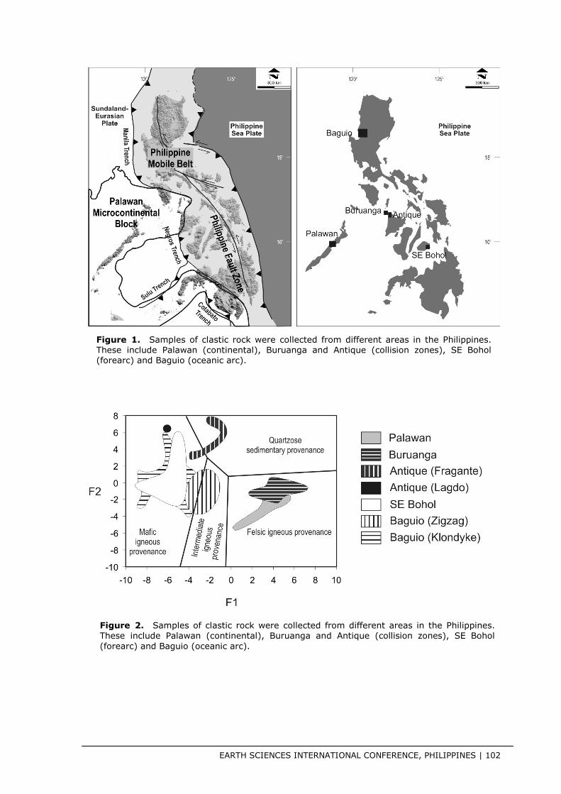
The Philippine archipelago is the result of the interaction of continental, oceanic, ophiolitic and island arc terranes. Microcontinent – island arc collision, ophiolite emplacement through strike slip faulting, subduction-related forearc accretion and back-thrusting, and evolution from oceanic to island arc setting are some of the geologic features present in the archipelago (e.g. Yumul et al. 2008; Dimalanta and Yumul 2003). To understand the geologic and tectonic evolution of the Philippines, field geological mapping complemented by geophysical and geochemical surveys have been done in several areas of the country. Some of these areas are characterized by continental (Palawan), collision zones (Buruanga, Antique),
forearc (SE Bohol) and oceanic arc settings (Baguio) (Fig. 1). Palawan is of continental derivation being made up of quartz-rich sandstones (e.g. Suzuki et al. 2000). Miocene granites (senso stricto) are also found in this island (Encarnacion and Mukasa 1997). Palinspathic reconstruction shows this part of the Philippine archipelago to be derived from mainland Asia. The North Palawan Block (NPB), which the Palawan island is part of, has collided with the Philippine Mobile Belt (Yumul et al. 2009). The leading edge of the NPB consisted of chert-limestone-clastic rocks (Buruanga) typical of oceanic plate stratigraphy and emplaced oceanic lithosphere (Antique Ophiolite Complex) (e.g. Marquez et al. 2006; Zamoras and Matsuoka 2004; Tamayo et al. 2001). On the other hand, whole rock geochemistry of volcanic rocks and spinel mineral chemistry from the Southeast Bohol Ophiolitic Complex in Bohol island suggest its transitional mid-ocean ridge – island arc characteristics (Faustino et al. 2006). Geologic mapping suggests that this oceanic lithosphere is a forearc ophiolite (De Jesus et al. 2000). Lastly, the Baguio Mineral District has been recognized to have evolved from a marginal oceanic basin platform, dominated by basaltic rocks, to an island arc setting characterized mostly by more silicic rocks (e.g. Tam et al. 2005).

EARTH SCIENCES INTERNATIONAL CONFERENCE, PHILIPPINES | 99
To further understand and constrain the evolution of these representative areas from four different settings as defined by their respective igneous rocks, whole rock geochemical analyses of the related sedimentary rocks were done. The highlights of the collated analyses can be summarized as follow:
1. The major elements Al2O3, TiO2, Fe2O3, MgO, CaO, Na2O and K2O contents are used to define F1 and F2.
F1 = 1.773*TiO2 + 0.607*Al2O3 + 0.760* Fe2O3T – 1.500*MgO + 0.616*CaO + 0.509*Na2O – 1.224*K2O – 9.090
F2 = 0.445*TiO2 + 0.070* Al2O3 – 0.250* Fe2O3T – 1.142*MgO + 0.438*CaO + 1.475*Na2O + 1.426*K2O – 6.861.
In the F2 versus F1 of Roser and Korsch (1988), it can be seen that the sedimentary rocks of SE Bohol and Antique-Lagdo Formation plot in the field of rocks derived from primary mafic sources. The Antique-Fragante Formation plots in the primary intermediate mafic-felsic sources consistent with having at least two sources. The Antique-Fragante Formation is believed to be a product of province linking being deposited in an overlap basin on top of a suture zone related to the collision of NPB and PMB (Gabo et al. 2009) On the other hand, the Baguio samples (Zigazag and Klondyke Formations) straddle the primary mafic and intermediate mafic-felsic. The Palawan samples plot dominantly in the field of primary felsic sources whereas the Buruanga samples straddle the primary felsic and quartzose recycled sources;
2. Using the same major elements but this time computing F1 and F2 as follows:
F1 = 30.638TiO2/Al2O3 – 12.541Fe2O3T/Al2O3 + 7.329MgO/Al2O3 + 12.031Na2O/Al2O3 + 35.402K2O/Al2O3 – 6.382
F2 = 56.5TiO2/Al2O3 –10.879Fe2O3T/Al2O3 + 30.875MgO/ Al2O3 – 5.404Na2O/Al2O3 + 11.112K2O/ Al2O3 – 3.89
In the F2 versus F1 of Bhatia (1983) (Fig. 2), Palawan and Buruanga samples cluster in the felsic igneous provenance field. The clustering of the Palawan and Buruanga samples are consistent with their being continentally derived. The Antique-Fragante Formation plots both in the quartzose sedimentary provenance and mafic igneous provenance fields consistent again with its being an overlap basin sedimentary formation. The plotting of the Antique-Lagdo Formation, Baguio (Zigzag and Klondyke Formations) and SE Bohol samples are consistent with a dominant source coming from mafic igneous rocks;
3. The TiO2 versus Fe2O3+MgO and Al2O3/SiO2 versus Fe2O3+MgO succinctly show that the Palawan and Buruanga samples have dominant affinity with Passive Margin and Active Continental Margin settings; The Antique-Fragante and Lagdo Formation samples plot in the Continental Island Arc setting suggestive of having multiple sources; The Baguio (Zigzag and Klondyke) and SE Bohol samples plot dominantly in vicinity of the Oceanic Island Arc field. The same relationship is shown in the SiO2/20 – K2O+Na2O – TiO2+Fe2O3+MgO ternary diagram plot;

EARTH SCIENCES INTERNATIONAL CONFERENCE, PHILIPPINES | 100
4. The K2O/Na2O versus SiO2 exhibits the affiliation of the Palawan and Buruanga samples with Passive Margin and Active Continental Margin settings. The plot of Baguio (Zigzag Formation) in the Active Continental Margin and Passive Margin settings is consistent with its sources which have shed quartz into its depositional basin. The rest of the samples plot in the Arc field consistent with their field setting and related igneous rock geochemistry. The SiO2/Al2O3 versus K2O/Na2O diagram basically shows the same thing.
As a conclusion, the whole rock geochemistry of the sedimentary rock samples analysed and collated here add further constraints in the delineation of how these different terranes of the Philippine archipelago had evolved. The Palawan and Buruanga sedimentary rock samples are continent-related. The Antique-Fragante Formation samples were derived from continental and oceanic arc masses that were eroded and deposited into the depositional basins. This is consistent with province linking as the setting is that of a collision-related suture zone. Although the Antique-Lagdo Formation contains continent signature, too, oceanic island arc signature dominates. The oceanic island source for the Baguio and SE Bohol sedimentary rocks are manifested by the whole rock geochemistry.
Acknowledgements
This work was supported by the Department of Science and Technology, National Research Council of the Philippines, National Institute of Geological Sciences and the Commission on Higher Education.
References [1] Bhatia, M.R. 1983. Plate tectonics and geochemical composition of sandstones. Journal of Geology 91, 611–627.
[2] De Jesus, J.V., Yumul, G.P.Jr. and Faustino, D.V. 2000. The Cansiwang Melange of Southeast Bohol (Central Philippines): Origin and tectonic implications. The Island Arc 9, 566-575.
[3] Dimalanta, C.B. and Yumul, G.P.Jr. 2003. Magmatic and amagmatic contributions to crustal growth of an island arc system: The Philippine example. International Geology Review 45, 922-935.
[4] Encarnación, J. and Mukasa, S.B. (1997) Age and geochemistry of an `anorogenic' crustal melt and implications for the origin of I-type granites. Lithos 42, 1-13.
[5] Faustino, D.V., Yumul, G.P.Jr., Dimalanta, C.B., De Jesus, J.V., Zhou, M.-F., Aitchison, J. and Tamayo, R.A.Jr. 2006. Volcanic-hypabyssal rock geochemistry of a subduction-related marginal basin ophiolite: Southeast Bohol Ophiolite – Cansiwang Mélange Complex, Central Philippines. Geosciences Journal 10, 291-303.
[6] Gabo, J.A.S., Dimalanta, C.B., Asio, M.G.S., Queano, K.L., Yumul, G.P.Jr. and Imai, A. 2009. Geology and geochemistry of the clastic sequences from Northwestern Panay (Philippines): Implications for provenance and geotectonic setting. Tectonophysics, doi:10.1016/j.tecto.2009.02.004.
[7] Marquez, E.J., Aitchison, J.C. and Zamoras, L.R. 2006. Upper Permian to Middle Jurassic radiolarian assemblages of Busuanga and surrounding islands, Palawan, Philippines. Eclogae Geologicae Helveticae 99, 101-125.
[8] Roser, B.P. and Korsch, R.J. 1988. Provenance signatures of sandstone-mudstone suites determined using discriminant function analysis of major element data. Chemical Geology 67:119-139.
[9] Suzuki, S., Takemura, S., Yumul, G.P.Jr., David, S.D.Jr., and Asiedu, D.K. 2000. Composition and provenance of the Upper

EARTH SCIENCES INTERNATIONAL CONFERENCE, PHILIPPINES | 101
Cretaceous to Eocene sandstones in Central Palawan, Philippines: Constraints on the tectonic development of Palawan. The Island Arc 9, 612-627.
[10] Tam, T.A. III, Yumul, G.P.Jr., Ramos, E.G.L., Dimalanta, C.B., Zhou, M.-F. and Suzuki, S. 2005. Rare earth element geochemistry of the Zigzag – Klondyke sedimentary rock formations: Clues to the evolution of the Baguio Mineral District (Luzon), Philippines. Resource Geology 55, 217-224.
[11] Tamayo, R.A.Jr., Yumul, G.P.Jr., Maury, R.C., Polve, M., Cotten, J. and Bohn, M. 2001. Petrochemical investigation of the Antique Ophiolite (Philippines): Implications on volcanogenic massive sulfide and podiform chromitite deposits. Resource Geology 51, 145-164.
[12] Yumul, G.P.Jr., Dimalanta, C.B., Marquez, E.J. and Maglambayan, V.B. 2008. Tectonic setting of a composite terrane: A review of the Philippine island arc system. Geosciences Journal 12, 7-17.
[13] Yumul, G.P.Jr., Dimalanta, C.B., Marquez, E.J. and Queaño, K.L. 2009. Onland signatures of the Palawan microcontinental block and Philippine mobile belt collision and crustal growth process: A review. Journal of Asian Earth Sciences 34, 610-623.
[14] Zamoras, L.R. and Matsuoka, A. 2004. Accretion and postaccretion tectonics of the Calamian Islands, North Palawan block, Philippines", Zamoras, L.R., Matsuoka, A., The Island Arc 13, 506–519.
EARTH SCIENCES INTERNATIONAL CONFERENCE, PHILIPPINES | 102
Figure 1. Samples of clastic rock were collected from different areas in the Philippines. These include Palawan (continental), Buruanga and Antique (collision zones), SE Bohol (forearc) and Baguio (oceanic arc).
Figure 2. Samples of clastic rock were collected from different areas in the Philippines. These include Palawan (continental), Buruanga and Antique (collision zones), SE Bohol (forearc) and Baguio (oceanic arc).

EARTH SCIENCES INTERNATIONAL CONFERENCE, PHILIPPINES | 103
Figure 3. Samples of clastic rock were collected from different areas in the Philippines. These include Palawan (continental), Buruanga and Antique (collision zones), SE Bohol (forearc) and Baguio (oceanic arc).

EARTH SCIENCES INTERNATIONAL CONFERENCE, PHILIPPINES | 104
Calcareous nannofossil and foraminifera
studies in the Philippines from 2000 - 2009
A.G.S. Fernando, A.M. Peleo-Alampay, M.M. de Leon, L.P. de Silva Jr., W. Brin, L.D. Doma, A.D. Fajardo-Angeles, K.A. Hipol, E.S. Lucero, M.A. Marcial, R.P.L. Pineda, A.N. Concepcion-Lim, A.M.F. Cordero, A.R.C. Fernandez, D.N. Tangunan, J.B. Abuda, J.A.O. Aviso, R.A.B. Concepcion, R.M. Cristobal, K.B. Domingo, E.D.J. Escaner, L.G. A. Estrada, L.A.T. Mambuay, B.S.M. Masangcay
Micropaleontology and Nannoworks Laboratory, National Institute of Geological Sciences, University of the Philippines, Diliman, Quezon City 1101 Philippines
Abstract
The present study reports, updates and summarizes selected micropaleontological studies involving calcareous nannofossils and foraminifera in the Philippines from 2000 to 2009 by the members of the Micropaleontology and Nannoworks Laboratory of UP-NIGS. While most of the earlier studies focused on taxonomic distribution and the use of the two microfossil groups as tools for biostratigraphy, more recent studies involve the use of the microfossils for environment monitoring purposes and as paleoceanographic and paleoclimate indicators or proxies. This shift is in response of the
members of the laboratory to study these microorganisms in the context of a changing world, brought about by natural and anthropogenic processes, as well as the impending problem of global warming and associated climate change that is threatening to disrupt ocean water chemistry and destroy habitats of these microorganisms.
Foraminifera (or forams) are single-celled organisms that typically live in the ocean and produce mineralized tests/shells which are generally composed of secreted calcium carbonate (CaCO3). They are microscopic in size (0.1 – 1 mm) and occur in varied forms, ranging from single-chambered forms to multi-chambered and elaborately structured forms. There are two major classes of forams: benthic and planktonic foraminifera. The former live either on top (epifaunal) or within (infaunal) the sediments of the sea floor, while the latter float freely in the surface waters of the world’s oceans and seas. When both planktonic and benthic forams die, their tests (shells) accumulate on the sea floor and become part of the sedimentary record. Foraminifera, specifically the benthic forms/species, are limited to certain water depth, type of substrate and bottom water conditions like temperature, salinity and dissolved oxygen and are, therefore, sensitive to slight changes in these parameters. Because of this, they are considered important tools in deciphering short-term and long-term environmental changes both at present and in the past when studying sediment cores. More

EARTH SCIENCES INTERNATIONAL CONFERENCE, PHILIPPINES | 105
recent applications of benthic forams in environmental studies include their use as pollution indicators in estuarine and coastal areas (e.g., Alve, 1995; McGann and Sloan, 1999; Tsujimoto et al., 2006) and as bioindicators of coral reef vitality using the FORAM (Foraminifera in Reef Assessment and Monitoring) Index of Hallock et al. (2003). During the last 9 years, a number of environmental studies involving benthic foraminifera have already been conducted in the Philippines. Most notable are the studies of De Leon and Fajardo-Angeles (2000) and De Leon and Doma (2001) regarding the effects of anthropogenic activities on the distribution of foraminifera in Bacuit Bay, El Nido, Palawan; De Silva and Marcial (2002), De Silva and Hipol (2004) and De Silva et al. (2007) regarding the impact of the mine tailings of the Marcopper Mining Company to the coral reefs and shallow benthic foraminifera in Marinduque; Hipol and De Silva (2005; 2007; 2008) on the effects of organic matter loading from aquaculture to benthic foraminifera in Bolinao, Pangasinan; De Leon et al. (2005; 2006; 2007; 2008) on the benthic foraminifera distribution in the Taklong Island National Marine Reserve (TINMAR) in Guimaras before and after the 2006 M/V Solar oil spill incident; and De Silva and Lucero (2001) and Lucero and De Silva (2006) on the distribution and recovery of benthic foraminifera in Subic Bay after the 1991 Mt. Pinatubo eruption. Other studies include the distribution of Recent foraminifera in the South China Sea (De Leon and Brin, 2002) and selected areas in the Spratly Islands (Fernando et al., 2009).
Calcareous nannofossils include all calcareous fossils smaller than 30 µm, although they are mostly the remains of marine haptophyte algae, the dominant group of calcareous nannoplankton which produces extra-cellular plates called coccoliths. These coccoliths are usually preserved in the ocean floor and eventually in the fossil record, where they are studied for a number of purposes. Calcareous nannoplankton or coccolithophores are considered one of the major marine phytoplankton and are, therefore, important primary producers in the world’s oceans and seas. Along with planktonic foraminifera, they are contributors of calcium carbonate to the water column and the seafloor. Calcareous nannoplankton are largely restricted to normal marine environments, have little tolerance for either turbidity or freshwater-diluted environs and are sensitive to changes in surface water productivity, temperature and salinity (Godfrey, 1998). Hence, calcareous nannoplankton can be used as indicators of changes in the quality and/or properties of marine surface waters through time. Because of their widespread distribution, rapid evolution and relative ease of processing and identification, they are very useful tools for biostratigraphy (i.e., age dating of samples) and paleoceanography (i.e., reconstruction of past oceanographic conditions). Calcareous nannofossil biostratigraphic studies include the works of De Leon et al. (2002) in southwest Palawan; De Leon and Doma (2004) in northwest Palawan; Fernando and Peleo-Alampay et al. (2007) in Bukidnon, northern Mindanao; De Leon and Cordero (2008) regarding the nannofossil stages of the limestone units in the Baguio Mining District; and Fernando et al. (2008; 2009) in selected areas

EARTH SCIENCES INTERNATIONAL CONFERENCE, PHILIPPINES | 106
in the Visayan Basin. Other studies include Peleo-Alampay et al. (2000; 2001) regarding the influence of the East Asian Monsoon System and the El Nino phenomenon in the flux of coccoliths in the South China Sea; Fernando et al. (2007) and Fernandez et al. (2008) on the surface sediment distribution of calcareous nannofossils across the South China Sea; Peleo-Alampay et al. (2000), Peleo-Alampay and Fernando (2001; 2002), Peleo-Alampay and Pineda (2004); and Peleo-Alampay et al. (2004) regarding the surface sediment distribution of calcareous nannofossils in Subic Bay, Lingayen Gulf and Boac and Calancan Bays in Marinduque; and Tangunan and Peleo-Alampay (2008; 2009), Concepcion-Lim et al. (2008) and Fernandez and Fernando (2009) regarding the paleoceanographic history of the Sulu Sea, Sibuyan Sea and Bohol Sea, respectively.
EARTH SCIENCES INTERNATIONAL CONFERENCE, PHILIPPINES | 107
Managing a sustainable community water
resources in San Jose, Camarines Sur:
Engineering and economic considerations
G. Imperial, R.V. Romero, S. Pasasala and A.R. Pesimo
Partido State University Partido, Camarines Sur, Philippines
Abstract
The main purpose of this study is to evaluate the free-flowing wells in San Jose, Camarines Sur. This study was divided into three aspects: 1) analysis on the occurrence of FFAWs, 2) Engineering and construction investigation, and 3) economic analysis.
The researchers used ocular inspection, interviews and observations as tools in gathering data. The number of existing FFAWs was manually counted. Interview with concerned local officials and residents was used to gather vital information on the construction and utilization of the FFAWs. Observations validated some of the information gathered through interviews. The volume of discharged water was calculated using the formula Q=V/t. The consumed water was determined by actual observation and interviews. The amount of wasted water was calculated by getting the difference of the volume of discharged water and the consumed water. The economic value of the discharged, consumed and wasted water was determined by multiplying them
with the current rate of the local water district which is Php 16.20 per cubic meter or Php 0.0162.
This study concluded that the location and underground soil formation in the locality is suited to construct FFAWs, to have water rise freely and flow continuously above the ground. Hydrological activity in the area is adequate to continuously supply the FFAWs with underground water even changes of climatic conditions occurred for the last four years. Calalahan is the barangay with highest recorded number of FFAWs. FFAWs are used by the residents to provide them with quality water fitted for human and household consumption. FFAWs were constructed by drilling a hole and inserting pipes down the aquifer to allow the underground water to flow out. Some FFAWs were constructed with water tank to impound the water. Others were provided with distribution system to deliver the water from FFAWs to the houses. But FFAWs continue to discharge water in the ground even when not in use for stopping the flow will create pressure and destroy the piping system. FFAWs are discharging large volume of water; however, large percentage (88.62%) of the water resource was wasted. Only 12.38% of the total discharged water was properly consumed. The local government is losing billions of pesos of the wasted water. The continued use and construction of FFAWs can lead to ground subsidence leading to the

EARTH SCIENCES INTERNATIONAL CONFERENCE, PHILIPPINES | 108
displacement of some residents and loss of agricultural lands.
This study recommends to the local executives and other concerned authorities and agencies that the use of FFAWs be regulated in accordance with the provision in the Water Supply of the Code of Sanitation of the Philippines (P.D. 856; wasted water be impounded and be utilized for agricultural and recreational activities; artesian wells can be redesigned to control the flow of water and prolong the water supply in the reservoir. This action can protect the environment from degradation and conserve water for future use. The residents be discouraged to permanently depend on the free flowing wells and coordinate with the Partido Water District (PWD), to have their barangays be connected with the main lines of the water supply system.

EARTH SCIENCES INTERNATIONAL CONFERENCE, PHILIPPINES | 109
Mesozoic radiolarians of the Mamonia
Complex, Southwest Cyprus
E.J. Marquez1 and J.C. Aitchison2
1 2009 Centennial Faculty Grant Awardee, Department of Physical Sciences and Mathematics, University of the Philippines Manila, Padre Faura St., Ermita, Manila, Philippines 2Department of Earth Sciences, The University of Hong Kong, Pokfulam Road, Hong Kong SAR, China
Abstract
The Mamonia Complex in southwestern Cyprus records the history of the entry of a passive margin sequence into a south-facing Neotethyan intra-oceanic subduction system during the Late Cretaceou. Compared with the classic ophiolitic sections in the tectonically overlying Troodos Ophiolite, the Mamonia Complex is considerably less understood. This work focuses on the biostratigraphy of Mesozoic radiolarian assemblages within the Mamonia Complex. Sixty-nine samples from eight sections yielded poor to very well-preserved radiolarians. Identifiable radiolarians were recovered from outcrops exposed on the Dhiarizos River valley, Khapotami River, Statos west inlier, Trakhypedhoula, Episkopi, and Ayia Varvara areas, Mavrokolymbos Dam and Kholetria Road. Planktonic foraminifers were noted from one sample collected at Episkopi. Results indicate that the samples
cover a stratigraphic interval from the Upper Triassic to the Lower Cretaceous.

EARTH SCIENCES INTERNATIONAL CONFERENCE, PHILIPPINES | 110
Stratigraphy and resource potential of
Northern Sierra Madre: Insights from
Nagtipunan, Quirino Province, Philippines
C.A. Pagulayan1 and K.L. Queaño2
1Department of Geology, College of Engineering, Adamson University, Manila, Philippines 2Mines and Geosciences Bureau-Department of Environment and Natural Resources, North Avenue, Quezon City, Philippines
Abstract
Field mapping was conducted in the Nagtipunan, Quirino province situated at the southern tip of the northern Sierra Madre to establish in detail its stratigraphic make-up. This undertaking is also in line with the evaluation of the resource potential of the region following the upsurge of mining activities in the country. From oldest to youngest, the formations recognized are the Eocene Caraballo Formation, the Oligocene Ibulao Limestone, the Upper Oligocene to Middle Oligocene Lubuagan Formation, the Middle Miocene Aglipay Limestone, and the Upper Miocene to Lower Pleistocene Cabagan Formation. Interestingly, the survey also revealed the presence of manganese and coal deposits, previously unrecognized, within the Eocene Caraballo Formation. The manganese deposits occur as thin layers sandwiched between the turbiditic beds of the
formation. In some sections, these occur as disseminations or nodules within the beds. Concentrations of manganese are up to 70% based on geochemical analysis. On the other hand, the coal (lignite) deposits occur as seam within the formation and likely represents facies reflective of a sub-aqueous, possibly deltaic environment.

EARTH SCIENCES INTERNATIONAL CONFERENCE, PHILIPPINES | 111
Radiolarians of Northeast Luzon,
Philippines: Stratigraphic and tectonic
implications
K.L. Queaño1,2, E.J. Marquez3, J. Aitchison4 and J.R. Ali4
1Earth and Material Science and Engineering Department, Mapua Institute of Technology, Intramuros, Manila, Philippines 2Mines and Geosciences Bureau, North Avenue, Diliman, Quezon City, Philippines 3Department of Physical Sciences and Mathematics, University of the Philippines Manila, Padre Faura St., Ermita, Manila, Philippines (2009 Centennial Faculty Grant Awardee) 4Department of Earth Sciences, The University of Hong Kong Pokfulam Road, Hong Kong SAR
Abstract
Results from the first detailed radiolarian biostratigraphic study conducted in Luzon are reported. Moderately to well-preserved radiolarians were obtained from cherts associated with the Casiguran Ophiolite exposed along the eastern coast of the Northern Sierra Madre, Luzon, Philippines. The radiolarian assemblages constrain the stratigraphic range of the cherts to the Lower Cretaceous, upper Barremian-lower Aptian to Albian. This result is in contrast with the Upper Cretaceous stratigraphic range previously reported in the region.
Radiolarians obtained from the Casiguran Ophiolite also provide additional evidence for the existence of a Mesozoic oceanic substratum upon which Luzon and neighboring regions within the Philippine archipelago were likely built. Interestingly, the result closely resembles those reported for the ophiolite in southeastern Luzon as well as the oceanic crust of the Huatung Basin situated east of Taiwan and the ophiolites in eastern Indonesia. In light of this, along with previously gathered geochemical data from the ophiolites, a common provenance is being looked into for these crust-upper mantle sequences in the western Pacific region.

EARTH SCIENCES INTERNATIONAL CONFERENCE, PHILIPPINES | 112
Deciphering the origin of the Buaki
Porphyry Copper Prospects in the
Mankayan Mineral District, Central
Cordillera, Philippines: Insights from field
and petrographic studies
J.D. Rodrigo
Department of Geology, Adamson University, Manila, Philippines
Abstract
The Buaki porphyry copper prospect is one of the important deposits within the Mankayan Mineral District in the Central Cordillera where world class, Far Southeast gold-rich porphyry copper, Victoria carbonate base metal gold, Lepanto Cu-Au and several types of porphyry copper and vein-type deposits all exist. Field and petrographic studies indicate that the Buaki prospect has an alteration zoning not typical of a porphyry copper system. The enveloping alteration is confined within the Imbanguila Dacite Porphyry (IDPO), grading from phyllic (sericitic), advanced argillic to intermediate argillic. The argillic zone, on the other hand, is confined within the Imbanguila Dacite Pyroclastics (IDPY). The lack of the potassic zone and the presence of the sericite-chlorite clay zone within portions of the IDPO suggest that another event might have caused the overprinting of the mineral assemblages. The propylitic zone
occurring within the Lepanto Metavolcanics (LPMV), the basement rock in the region, is mainly represented by a greenschist facies metamorphism assemblage predating the mineralization event. Extension of the phyllic zone is also noted within the contact between the IDPO within the LPMV.

EARTH SCIENCES INTERNATIONAL CONFERENCE, PHILIPPINES | 113
Landslide assessment in eastern
Rodriguez municipality, Rizal province,
Philippines
C.J. Telles1, K.L. Queaño2, A. Fernando2 and G.M. Mercado2
1Department of Geology, College of Engineering Adamson University, Manila, Philippines
2Mines and Geosciences Bureau-Department of Environment and Natural Resources, North Avenue, Quezon City, Philippines
Abstract
The occurrence of catastrophic landslide events (e.g., debris slide in Infanta, Quezon; Guinsaugon, Southern Leyte) in the Philippines has called for the conduct of geohazard assessment, particularly in areas of rapid urban development. This includes Rodriguez, one of the fastest growing municipalities of Rizal owing to its proximity to Metro Manila. Landslide assessment in the municipality was made following detailed stratigraphic and structural studies in the region. The landslide inventory suggests that most slope failures occur in the form of translational slide. This type of slide is most notable in areas underlain by pillow lavas belonging to the Cretaceous (?) Montalban Ophiolite Complex (MOC). Along with steep slopes, the highly jointed and sheared nature of the MOC-related basalts attribute for such occurrence. In turn, the onramping of the MOC coupled with later tectonic events
(including movement along the East Valley Fault) explain the highly deformed nature of the rocks.
Rock fall is another mass wasting process that could potentially occur in eastern Rodriguez. This event is more likely in areas underlain by the Early to Middle Miocene Angat Formation, where dissolution of its limestone member has resulted to the development of vertical joints in the rock unit.

EARTH SCIENCES INTERNATIONAL CONFERENCE, PHILIPPINES | 114
Geotechnical design and assessment of
mine tailing impounding facilities
L.V. Torio1, R.A.C. Luna2,3 and M.A.H. Zarco4
1Institute of Civil Engineering, University of the Philippines Quezon City 1101
2Institute of Civil Engineering, University of the Philippines Quezon City 1101
3AMH Philippines, Inc. Bahay ng Alumni Building, University of the Philippines Diliman, Quezon City 1101
4Institute of C Civil Engineering, University of the Philippines Quezon City 1101
Abstract
This paper discusses the design and assessment of the stability of earth embankment structures which are constructed for impounding tailings from nickel mines. Specific case studies of impounding facilities which will be constructed in the provinces of Albay, Masbate and Palawan are presented. The case studies show that the stability of the proposed structure is assessed using limit equilibrium and continuum-based finite element methods for end of construction, steady state seepage, rapid drawdown and earthquake cases. A comparison of the two methods indicate that the use of continuum‐based finite element methods is advantageous over limit equilibrium methods because it is able to quantify deformations in cases that involve localized failure of the
embankment, particularly with regard to seismic loads. Results of the study also indicate that less stringent requirements regarding the minimum factors of safety against piping and slope failure may be used to design mine tailings impoundment facilities as compared to embankment designed to impound water.
EARTH SCIENCES INTERNATIONAL CONFERENCE, PHILIPPINES | 115
Is the Antique Ophiolite Complex part of
the Philippine Mobile Belt or the North
Palawan Block? Unraveling this oceanic
lithosphere’s secret
G.P. Yumul Jr.1,2, R.A. Tamayo Jr.1 and C.B. Dimalanta1
1Rushurgent Working Group - Tectonics and Geodynamics Group, National Institute of Geological Sciences, College of Science, University of the Philippines, Diliman, Quezon City, Philippines 1101 2Department of Science and Technology, Bicutan, Taguig, Metro Manila, Philippines
Abstract
The collision boundary between the North Palawan Block (NPB) and Philippine Mobile Belt (PMB) has been the subject of several research programs recently. Some of the recent findings can be summarized as follows:
1. The whole of Mindoro island can be considered part of the NPB based on U-Pb datings of sedimentary and metamorphic rocks (Knittel et al. 2009, submitted);
2. The Romblon Island Group is part of NPB (Yumul et al., 2009a);
3. The Sibuyan Ophiolitic Complex marks the easternmost boundary of the collision zone (Dimalanta et al., 2009);
4. The amphibolites, metagabbros, hornblende pyroxenites and hornblendites sampled in Calaton Hill, Tablas island of the Romblon Island Group is representative of the lower crust underlying the Philippine island arc (Payot et al., 2009);
5. The Buruanga Peninsula and Busuanga Group of Islands manifest the same oceanic plate stratigraphy (Marquez et al., 2007; Zamoras et al., 2008);
6. There is a suture zone between the Buruanga Peninsula and the Antique Ophiolitic Complex which can be part of the collision boundary between the NPB and PMB (Gabo, 2009);
7. The Fragante Formation, whose sedimentary rocks contain both continental and oceanic arc materials, was deposited in an overlap basin on top of this suture zone (Gabo et al., 2009);
8. There were several collision events that can be mapped and suture zones that can be recognized between and within the NPB and PMB (Yumul et al., 2003; Yumul et al., 2009b).
With these recognition, one is left with the question on the relationship of the Antique Ophiolitic Complex with the NPB and PMB. The Antique Ophiolitic Complex is an Early Cretaceous ophiolite based on radiolarian dating of cherts. Early

EARTH SCIENCES INTERNATIONAL CONFERENCE, PHILIPPINES | 116
Eocene calcarenites have also been sampled suggesting the presence of a Paleocene unconformity (Tamayo et al., 2001). Whole rock and mineral geochemistry shows that this ophiolite complex has T- to N-MORB volcanic rocks similar to other back-arc basins in the Western Pacific region. Furthermore, this ophiolite complex is cut by serpentinite mud diapirs which appear to have been extruded in a forearc setting. Westward-verging thrust faults bound the Antique Ophiolite Complex consistent with subduction accretion and an east-facing subduction zone. The Middle Miocene sedimentary rocks that cap this oceanic lithosphere suggest that subduction and accretion should be pre-Middle Miocene. The presence of a complete ophiolite sequence which could mark a collision zone boundary, the timing of its emplacement and its structural configuration of westward-verging thrusts all suggest the possibility that the Antique Ophiolite Complex can be part of the leading oceanic edge of the NPB!
Acknowledgements
Our research initiatives are supported by the Department of Science and Technology, Philippine Council for Industry and Energy Research and Development, National Institute of Geological Sciences and the Commission on Higher Education.
References [15] Dimalanta, C.B., Ramos, E.G.L., Yumul, G.P.Jr. and Bellon, H. 2009. New features from the Romblon Island Group: Key to
understanding the arc-continent collision in Central Philippines. Tectonophysics, doi:10.1016/j.tecto.2009.02.015.
[16] Gabo, J.A.S., Dimalanta, C.B., Asio, M.G.S., Queano, K.L., Yumul, G.P.Jr. and Imai, A. 2009. Geology and geochemistry of the clastic sequences from Northwestern Panay (Philippines): Implications for provenance and geotectonic setting. Tectonophysics, doi:10.1016/j.tecto.2009. 02.004.
[17] Marquez, E.J., Aitchison, J.C. and Zamoras, L.R. 2006. Upper Permian to Middle Jurassic radiolarian assemblages of Busuanga and surrounding islands, Palawan, Philippines. Eclogae Geologicae Helveticae 99, 101-125.
[18] Payot, B.D., Arai, S., Tamayo, R.A.Jr. and Yumul, G.P.Jr. 2009. What underlies the Philippine Island Arc? Clues from the Calaton Hill, Tablas Island, Romblon (Central Philippines). Journal of Asian Earth Sciences, doi:10.1016/j.jseaes.2009.07.001.
[19] Tamayo, R.A.Jr., Yumul, G.P.Jr., Maury, R.C., Polve, M., Cotten, J. and Bohn, M. 2001. Petrochemical investigation of the Antique Ophiolite (Philippines): Implications on volcanogenic massive sulfide and podiform chromitite deposits. Resource Geology 51, 145-164.
[20] Yumul, G.P.Jr., Dimalanta, C.B., Tamayo, R.A.Jr. and Maury, R.C. 2003. Collision, subduction and accretion events in the Philippines: a synthesis. The Island Arc 12, 77-91.
[21] Yumul, G.P.Jr., Dimalanta, C.B., Marquez, E.J. and Queaño, K.L. 2009a. Onland signatures of the Palawan microcontinental block and Philippine mobile belt collision and crustal growth process: A review. Journal of Asian Earth Sciences 34, 610-623.
[22] Yumul, G.P.Jr., Jumawan, F.T. and Dimalanta, C.B. 2009b. Geology, geochemistry and mineralization potential of the South China Sea oceanic lithosphere as revealed by the Amnay Ophiolitic Complex, Mindoro, Philippines. Resource Geology 59, 263-281. doi: 10.1111/j.1751-3928.2009.00095.x.
[23] Zamoras, L.R., Montes, M.G.A., Queaño, K.L., Marquez, E.J., Dimalanta, C.B., Gabo, J.A.S. and Yumul, G.P.Jr. 2008. The Buruanga Peninsula and the Antique Range: Two contrasting terranes in Northwest Panay, Philippines featuring an arc-continent collision zone. Island Arc 17, 443-457.

EARTH SCIENCES INTERNATIONAL CONFERENCE, PHILIPPINES | 117
Figure 1. New findings indicate that the whole of Mindoro island and the Romblon Island Group can be considered part of the Palawan Microcontinental Block. Recent investigations in Panay island suggest that the Antique Ophiolite Complex may be part of the oceanic leading edge of the Palawan Microcontinental Block.