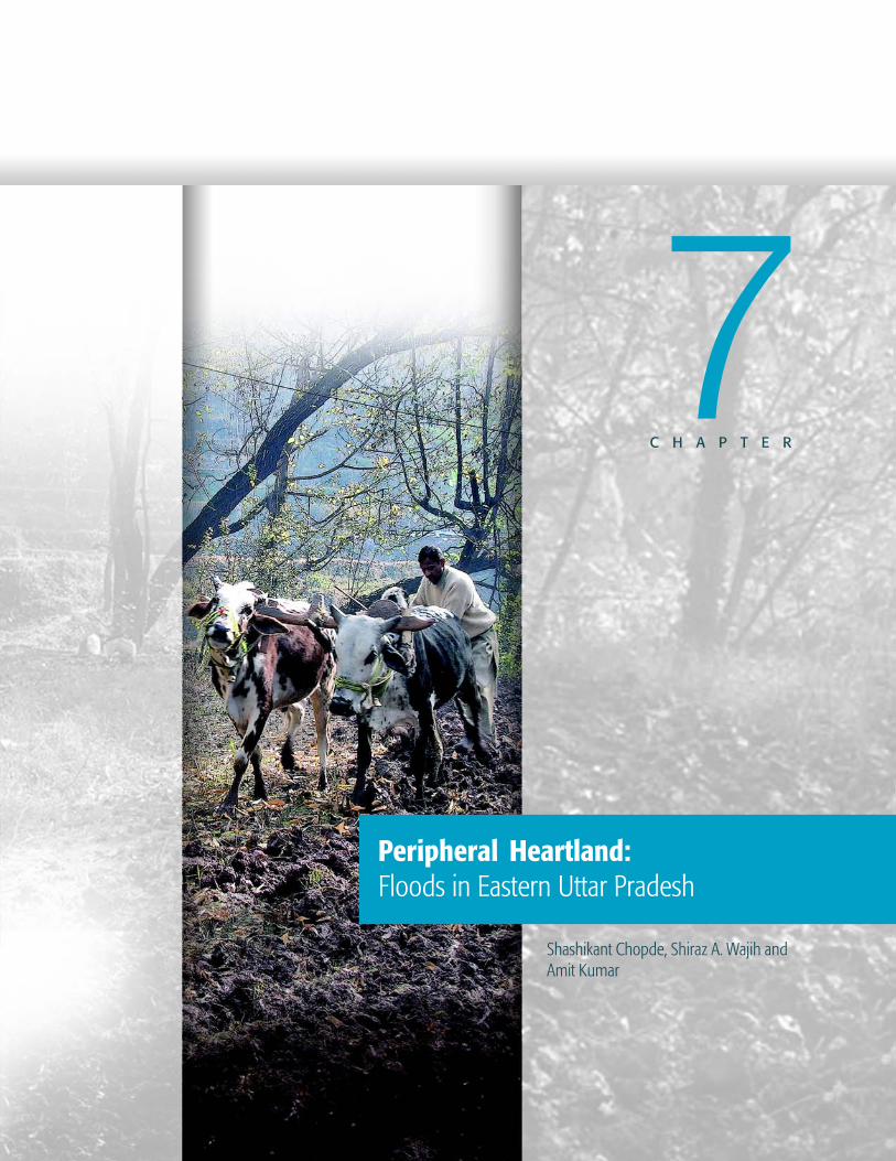
Peripheral Heartland: Floods in Eastern Uttar Pradesh · CHAPTER Peripheral Heartland: Floods in...
36
PROVENTION CONSORTIUM Community Risk Assessment and Action Planning project INDIA – Eastern Uttar Pradesh Copyright 2002-2005, Maps-Of-The-World.com The maps used do not imply the expression of any opinion on the part of the International Federation of Red Cross and Red Crescent Societies or National Societies or the ProVention Consortium concerning the legal status of a territory or of its authorities Peripheral Heartland: Floods in Eastern Uttar Pradesh CRA Toolkit CASE STUDY This case study is part of a broader ProVention Consortium initiative aimed at collecting and analyzing community risk assessment cases. For more information on this project, see www.proventionconsortium.org.
-
Upload
hoangtuyen -
Category
Documents
-
view
220 -
download
0
Transcript of Peripheral Heartland: Floods in Eastern Uttar Pradesh · CHAPTER Peripheral Heartland: Floods in...

PROVENTION CONSORTIUM Community Risk Assessment and Action Planning project
INDIA – Eastern Uttar Pradesh
Copyright 2002-2005, Maps-Of-The-World.com
The maps used do not imply the expression of any opinion on the part of the International Federation of Red Cross and Red Crescent Societies or National Societies or the ProVention Consortium concerning the legal status of a territory or of its authorities
Peripheral Heartland: Floods in Eastern Uttar Pradesh
CRA Too lk i t CASE STUDY
This case study is part of a broader ProVention Consortium initiative aimed at collecting and analyzing community risk assessment cases. For more information on this project, see www.proventionconsortium.org.
Bibliographical reference: Chopde et al. (2007) Peripheral Heartland: Floods in Eastern Uttar Pradesh in Moench, M. and Dixit, A. (2007) ‘Working with the Winds of Change: Towards strategies for responding to the risks associated with climate change and other hazards” ProVention Consortium, Institute for Social and Environmental Transition-International and Institute for Social and Environmental Transition-Nepal. Kathmandu, Nepal, second edition, chapter 7, pp. 159-192. Case study can be downloaded from: http://www.proventionconsortium.org/themes/default/pdfs/winds_of_change.pdf Click-on reference to the ReliefWeb country file for India: http://www.reliefweb.int/rw/dbc.nsf/doc104?OpenForm&rc=3&cc=ind Note: A Guidance Note has been developed for this case study. It contains an abstract, analyzes the main findings of the study, provides contextual and strategic notes and highlights the main lessons learned from the case. The guidance note has been developed by Dr. Ben Wisner and Stephanie Bouris in close collaboration with the author(s) of the case study and the organization(s) involved.
C H A P T E R
Peripheral Heartland:Floods in Eastern Uttar Pradesh
Shashikant Chopde, Shiraz A. Wajih andAmit Kumar
7
W O R K I N G W I T H T H E W I N D S O F C H A N G E
PERI
PHER
AL H
EART
LAN
D:
FLO
OD
S IN
EAS
TERN
UP
160
Country: IndiaLocation: Uttar PradeshDate: May 2007Sector and Spatial focus: Adaptation and DRRTitle: Peripheral Heartland: Floods in Eastern Uttar PradeshBibliographical reference: Chopde et al. (2007) Peripheral Heartland: Floods in
Eastern Uttar Pradesh
AbstractThe challenge of climate variability and change are increasingly recognised as seriousimpediments to poverty alleviation. Floods, for example, reverse the development processto a great extent and worsen the situation of disadvantaged and vulnerable groups. Thepost-disaster context, especially, offers a window of opportunity for political support andfor development processes. There is a need to make best use of this opportunity to bring ina change, to design and implement systems in a way that mitigates disaster risk for futurerisks. The strategy followed is to work outward from the conditions of a household orcommunity and those factors enabling or constraining responses to disasters to identifypoints of leverage for change. Shared learning dialogues (SLDs) are central to this processbecause they allow us and the community to build a shared understanding ofopportunities and constraints without being held in by predefined notions of what riskreduction consists of.
Eastern UP is a flood prone region of the Indo-Gangetic plain of India. The methodologyfor the project involves vulnerability and capacity analysis and SLDs. Information fromprevious studies is being used. The research is finding that a significant number ofhouseholds are more vulnerable due to factors related to the during-flood and post-floodperiods than to physical damage caused by floods. Key factors causing vulnerability in acommunity are the lack of diversified agriculture systems and income avenues that are lesssusceptible to the impacts of floods. The most vulnerable group, however, are the landlesswho are significantly dependent on agriculture labor for their income.
The SLDs were helpful in identifying strategies that included sets of direct risk reductioninterventions and interventions for changing underlying systems for adaptation.
Capacity and vulnerability analyses (CVAs) in conjunction with SLDs at different levelscan help identify solutions envisaged in DRR. The ongoing research is showing that bothCVAs and SLDs generate multi-pronged benefits in terms of data collection, validationand triangulation of the data, stakeholder engagement and policy advocacy. Mostimportantly, they also help identify potential solutions and mechanisms for developmentinterventions.
PERI
PHER
AL H
EART
LAN
D:
FLO
OD
S IN
EAS
TERN
UP
160
Case Study Guidance Note
W O R K I N G W I T H T H E W I N D S O F C H A N G E
PERIPHERAL H
EARTLAND
: FLOO
DS IN
EASTERN U
P
161
PERIPHERAL H
EARTLAND
: FLOO
DS IN
EASTERN U
P
Technical DescriptionHazard/risk type: Floods - recurrent and frequent disruption of human andlivelihood systems.Type of assessment: Research to understand the factors that constrain and enablelocal communities to reduce risk and adapt to climatic and other sources ofvulnerability
Research and Analytical ProcessMethods/tools used: Scoping surveys, SLDs, ranking tools
Key Insights Generated for Vulnerability Reduction and Capacity EnhancementDirect support to DRR and Adaptation: Agriculture interventions relating toinundation resistant and early sowing/ harvesting crops, irrigation technologiesenhancing access to irrigation, financial risk spreading through crop insurance,innovative models of sanitation and handpumps, housing technology resistant tofloods, and early warning systems.System Level support: Adaptation incubation systems that support self-managementof people’s institutions for continual innovations in agriculture and communication,and improvement in education, health and transport systems.
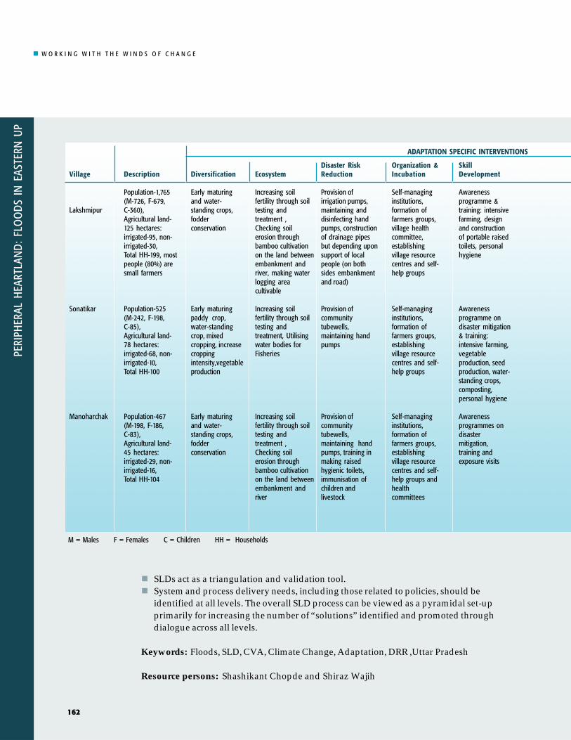
Potential Strategies Identified:See Table on following page.
Strategic Notes and Lessons Learned – Key Points to Emphasise:Capacity and vulnerability analyses act as an initial pointer to the solutionsenvisaged in disaster risk reduction, complemented by the SLDs at different levels.This study establishes that both these tools/techniques do work and that theygenerate multi-pronged benefits in terms of data, validation and triangulation of datacollected, stakeholder engagement and policy advocacy. Most importantly, they alsohelp to identify potential solutions and mechanisms for development interventions.At the field level, SLDs conducted with disaster affected communities not only serveas a platform for sharing experience but also help to identify useful solutions forproblems identified by the community.SLDs are useful in building capacity in community members and the project team.SLDs are a two-way knowledge transfer process. For example, we communicatetechnical and qualitative details of global warming to local communities. Communitymembers, in return, explain to us the impacts at the field level (both existing andexpected) in terms of occupational mobility, migration patterns, livelihood systems etc.This two-way transfer of information regarding knowledge of climate change and itsimpacts (tangible or indirect) needs to be interposed with the community’sperspectives. These set the stage for making decisions on key action points.Solutions emerging in SLDs need to be documented and shared with stakeholdersduring further SLDs and/or in meetings with policy makers.SLDs need to be have greater participation from women and other marginalizedgroups.
161
W O R K I N G W I T H T H E W I N D S O F C H A N G E
PERI
PHER
AL H
EART
LAN
D:
FLO
OD
S IN
EAS
TERN
UP
162
M = Males F = Females C = Children HH = Households
PERI
PHER
AL H
EART
LAN
D:
FLO
OD
S IN
EAS
TERN
UP
162
Village
Lakshmipur
Sonatikar
Manoharchak
Description
Population-1,765(M-726, F-679,C-360),Agricultural land-125 hectares:irrigated-95, non-irrigated-30,Total HH-199, mostpeople (80%) aresmall farmers
Population-525(M-242, F-198,C-85),Agricultural land-78 hectares:irrigated-68, non-irrigated-10,Total HH-100
Population-467(M-198, F-186,C-83),Agricultural land-45 hectares:irrigated-29, non-irrigated-16,Total HH-104
Diversification
Early maturingand water-standing crops,fodderconservation
Early maturingpaddy crop,water-standingcrop, mixedcropping, increasecroppingintensity,vegetableproduction
Early maturingand water-standing crops,fodderconservation
Ecosystem
Increasing soilfertility through soiltesting andtreatment ,Checking soilerosion throughbamboo cultivationon the land betweenembankment andriver, making waterlogging areacultivable
Increasing soilfertility through soiltesting andtreatment, Utilisingwater bodies forFisheries
Increasing soilfertility through soiltesting andtreatment ,Checking soilerosion throughbamboo cultivationon the land betweenembankment andriver
Disaster RiskReduction
Provision ofirrigation pumps,maintaining anddisinfecting handpumps, constructionof drainage pipesbut depending uponsupport of localpeople (on bothsides embankmentand road)
Provision ofcommunitytubewells,maintaining handpumps
Provision ofcommunitytubewells,maintaining handpumps, training inmaking raisedhygienic toilets,immunisation ofchildren andlivestock
Organization &Incubation
Self-managinginstitutions,formation offarmers groups,village healthcommittee,establishingvillage resourcecentres and self-help groups
Self-managinginstitutions,formation offarmers groups,establishingvillage resourcecentres and self-help groups
Self-managinginstitutions,formation offarmers groups,establishingvillage resourcecentres and self-help groups andhealthcommittees
SkillDevelopment
Awarenessprogramme &training: intensivefarming, designand constructionof portable raisedtoilets, personalhygiene
Awarenessprogramme ondisaster mitigation& training:intensive farming,vegetableproduction, seedproduction, water-standing crops,composting,personal hygiene
Awarenessprogrammes ondisastermitigation,training andexposure visits
ADAPTATION SPECIFIC INTERVENTIONS
SLDs act as a triangulation and validation tool.System and process delivery needs, including those related to policies, should beidentified at all levels. The overall SLD process can be viewed as a pyramidal set-upprimarily for increasing the number of “solutions” identified and promoted throughdialogue across all levels.
Keywords: Floods, SLD, CVA, Climate Change, Adaptation, DRR ,Uttar Pradesh
Resource persons: Shashikant Chopde and Shiraz Wajih

W O R K I N G W I T H T H E W I N D S O F C H A N G E
PERIPHERAL H
EARTLAND
: FLOO
DS IN
EASTERN U
P
163
PERIPHERAL H
EARTLAND
: FLOO
DS IN
EASTERN U
P
163
Financial andRisk Spreading
Incomegenerationactivities such asmushroomproduction, goatrearing, fisheries,poultry farming,candle-making
Incomegenerationactivities such asmushroomproduction, goatrearing, fisheries,poultry farming,candle-making
Incomegenerationactivities such asmushroomproduction,kitchen gardening,goat rearing,fisheries, poultryfarming, candle-making
Communication
Informationcentre at villagelevel, earlywarning systems,communicationcentres,community radio(FM), mobilephones
Informationcentre at villagelevel, earlywarning systems,communicationcentres,community radio(FM), mobilephones
Informationcentre at villagelevel, developingand early warningsystem throughmobile phonesand communityradio (FM) butdepending uponexternalstakeholder’ssupport
Education
Training on seedproduction, KishanCredit Cards-KCC-(farmer’s creditcards), cropinsurance,ensuringavailability ofInformation,Education andCommunication(IEC) materials,exposure visits
Training on seedproduction,vermiand nadepcomposting,ensuringavability of IECmaterials,exposure visits,KCC and cropinsurance
Training on KCC,crop insurance,ensuring avabilityof IEC materialsthrough resourcecentre, exposurevisits
Transport
Boats, bamboobridge
Boats, bamboobridge
Boats, bamboobridge
FinancialMechanism
Linking self-helpgroups with banksand savings andcreditorganisations
Linking self-helpgroups with banksand savings andcreditorganisations
Linking self-helpgroups with banksand savings andcreditorganisations
Organisation
Communityirrigationmanagement,setting upsystems forcommunitycontributions torepair waterpumps
Communityirrigationmanagement
Communityirrigationmanagement,voluntarilydraining excesswater
Livelihood
Off-seasonvegetable &mushroomfarming, seedproduction,kitchen gardeningandvermicomposting
Off-seasonvegetable &mushroomfarming, seedproduction,kitchen gardeningandvermicomposting
vegetable andmushroomproduction, seedproduction,kitchen gardening,vnursery raising ,vermicomposting,goat rearing,fisheries, incensestick-making,candle-making
UNDERLYING SYSTEM FOR ADAPTATION
W O R K I N G W I T H T H E W I N D S O F C H A N G E
PERI
PHER
AL H
EART
LAN
D:
FLO
OD
S IN
EAS
TERN
UP
164
Introduction
Mechanisms can beidentified by working
with households,communities and
other local entities toidentify the factors
that constrain orenable them to
respond to events thatcould cause disaster.
The impacts of climate variability andchange are increasingly beingrecognised as serious impediments topoverty alleviation in South Asia. Infact, the repeated occurrence of disasterssuch as floods and droughts and theirimpacts has added a new layer to theendemic poverty of a large section of theIndian populace. Extreme events worsenthe situation of disadvantaged andvulnerable groups and reverse the fewbenefits which have accrued from thedevelopment process. South Asia’sseventy per cent of disasters are climaterelated and as global climatic changeincreases the frequency and intensity offloods and drought events, the poor andthe disadvantaged will become evenmore vulnerable. Furthermore, much ofthe world’s population lives invulnerable regions and the number ofsuch people is projected to grow. Unlessthe cycle of disaster and poverty can bebroken, the world stands little chance ofever reaching the millenniumdevelopment goals (MDGs).
It is worthwhile to note that there is asilver lining under the dark cloud ofdisasters. This lining is the window ofopportunity the disasters create not onlyfor influencing the approaches ofdevelopment practitioners and policy-makers but also for catalysing politicalsupport for change in post-disastercontexts. Disasters create an
opportunity as affected local populationstend to be more willing to make structuraland livelihood changes they mightotherwise not have been willing to make.Further, the financial constraints faced bypoor and vulnerable communities can beovercome more easily in post-disastercontexts, when a flow of funds is madeavailable through government grants,relief aid and other support. Though suchopportunities are pulsed, they promote abetter understanding of disaster recoveryprocesses and enable the introduction ofmeasures for systemic changes. Often, theimpact of extreme climatic eventsintertwine with the social and economicconstraints prevailing within a region -such as a non-diversified livelihood baseand poor social and economicinfrastructures – and make its populationmore vulnerable.
During the course of this study, we didnot limit our definition of interventionsfor disaster risk reduction toconventional techniques such asstructural protection and provision ofrelief. We believe that other practical andeffective mechanisms can be identified byworking with households, communitiesand other local entities to identify thosefactors that constrain or enable them torespond to events that could causedisaster. In almost all communities, somegroups are relatively unaffected byextreme events while others aredevastated. The differences betweenthose who thrive despite the impacts ofextreme events and those who areharmed reveal the nature of bothenabling and constraining factors andinclude behavioural as well as otherfactors. The identification of differencescan, in turn, help identify points ofleverage (policy, infrastructure or otherchanges) for removing constraints whichlimit the ability of vulnerable groups to
W O R K I N G W I T H T H E W I N D S O F C H A N G E
PERIPHERAL H
EARTLAND
: FLOO
DS IN
EASTERN U
P
165
undertake the actions to reducevulnerability that unaffected groupsgenerally take. Once these constraintsare known we can identify strategiesthat should help local people respondbetter to local conditions.
Our overall strategy is to work outwardfrom the conditions of a household or acommunity. Shared learning dialogues(SLDs) are central because they allow usresearchers, to build a sharedunderstanding of opportunities andconstraints without being limited bypre-conceived notions of what riskreduction constitutes. Through dialogueand semi-structured qualitative andquantitative surveys with localcommunities, governmentrepresentatives, NGOs and other actorsin the area, our goal is to develop both ashared vision of key issues and a semi-quantitative baseline of information.
The impacts of monsoon river floods,which occur more regularly than coastalfloods are well documented andunderstood, the mitigation strategiesadopted by state agencies are fairly wellreported on. The strategies localcommunities pursue for coping withand adapting to such impacts, incontrast, are not at all well documented.This paper discusses the strategiesadopted by communities within theflood-affected region of the Rohini Basinin India’s Eastern Uttar Pradesh, India.The case study field sites were selectedbecause the issues that are mostimportant at the field level – access tocommunication systems and thelocation of homes in vulnerable areassuch a flood plains – relate well tonational policy regarding, knowledgemanagement in the areas ofenvironmental management,vulnerability and communication.
These field locations are also vulnerableto the sudden problems, typicallyassociated with flooding or extremestorm events. As a result, issues related toearly warning systems and the role ofecosystems in buffering floods andstorms are significant. In addition, therapid onset of floods and the vulnerablelocations of homes and workplaces at thefield sites resemble patterns ofvulnerability similar to those of otherfield sites for this project in India, Nepaland Pakistan. In fact, the field-levelscenario as well as the national-levelpolicy and knowledge managementactivities found in the Eastern UtterPradesh study are both core parts of alarger programme on adaptation as wellas being an integrated study of their own.
Two villages in Maharajganj District,Lakshmipur and Manoharchak, and onevillage in Gorakhpur District, Sonatikarwere selected in Eastern Uttar Pradesh.In all three villages, flood disaster is aprocess rather than a single event. Eachdisaster makes the poor more vulnerableto the next disaster and all disasters are anormal condition for those repeatedlyaffected. This process is aggravated bythe fact that these communities sufferfrom multiple hazards, both natural andman-made.
Peripheral Heartland
Around 29 % of the 33,270 km2 of EasternUttar Pradesh is a flood-prone region ofthe Indo-Gangetic plain. The flood-affected areas cover the low lyingdistricts of Gorakhpur and Maharajganj,whose socio-economic and humandevelopment indices are lower thanthose of other Indian states (Figure 1).Floods affect agriculture, the main sourceof livelihood in this region, disrupt life
The strategies localcommunitiespursue for copingwith and adaptingto flood impactsare not at all welldocumented.

W O R K I N G W I T H T H E W I N D S O F C H A N G E
PERI
PHER
AL H
EART
LAN
D:
FLO
OD
S IN
EAS
TERN
UP
166
�
����������
�����������
��� ���
���������
�������������������
�����������
����
��������
���������������
�����������
��������������
�����
��������
������
������!��
"�"����
#$
#%
���&����
���������������������
���������'��
����
����� ��
��������
�������� ������
| FIGURE 1 | Gorakhpur/Maharajganj
and devastate property on a large scale,impede socio-economic progress,including education, and destroy ruralinfrastructure. The effects of floodingare exacerbated by the characteristicswhich prevail in the region: poverty,poor health services, malnutrition,illiteracy, lack of food and livelihoodsecurity, extensive out-migration andecological degradation.
Eastern Uttar Pradesh constitutes ariparian land system formed by theGandak, West Rapti rivers and theRohini River system. Situated north ofthe Ganga River, the region iscommonly known as the trans-Saryuplain. The Gandak is a snow-fed riverthat originates in Nepal. The West
Rapti also originates in Nepal, flowingdown from the Mahabharat range, andmeeting the Gandak near the town ofGorakhpur, Eastern Uttar Pradesh. TheRohini River system, which originates inNepal, is composed of three rivers, theRohini, the Tinau and the Banagana andtheir tributaries. Weirs and barrages havebeen built on the Gandak and the WestRapti rivers as well as on some of theirtributaries. Although the Rohini Riversystem is used extensively and causeslarge-scale flood damage, it does notappear on the radar screen of thegovernment of either Nepal or India.
The average annual rainfall in the area isbetween 800 mm and 900 mm. Themaximum rainfall generally occurs in Julyand the minimum, which is negligible,occurs between December and March.
Field sites for this case study wereselected within the Rohini Basin becauseit has faced major floods in the past: In1904, each year between 1952 and 1957,in 1960, and their again in1962, 1968,1970, 1971, 1974, 1980, 1981, 1995, 1996,1998, 2000 and 2001. The 2001 flood wasfollowed by a drought in 2002. Attemptshave been made to control flooding alongthe Rohini by constructing embankments,a process which began in 1952 andcontinued intermittently until 1985. Everyflood led to the loss of crops, dwellings,food grains, seeds and personalbelongings, and each case villagerssought shelter on nearby embankmentsfor many days. The receding floodwatersdeposited sand on agricultural land,rendering the land unproductive. Withthe exception of the 1998 flood, whichwas the result of a very wet monsoonmostly in the Rohini River system, everyflood event here was the result of rivers inthe lower parts of the north Ganga plainsoverflowing.
(�������������
&��������������
"���
"���
"����� �����)
&�����������*�����
+��� �,��
���
-������

W O R K I N G W I T H T H E W I N D S O F C H A N G E
PERIPHERAL H
EARTLAND
: FLOO
DS IN
EASTERN U
P
167
������������
��������������'���)�
������������������.
/�����������
�������
0��
����)����������&����"���
����)���������������'�)���
1��2.������..��������
�������..��������
0������������
(�2������������
����������)
A profile of the selected village studysites is provided in Appendix 1 at theend of this chapter..
Manoharchak
Manoharchak, a small village of just 104households, is situated on the banks ofthe Rohini River, 40 km from Gorakhpurthe district headquarters. Agriculture,the main source of income for theresidents, is seriously affected byflooding caused by the 35-year-oldRohini River embankment outside the
village. Although the embankment doescheck regular floods, it has also causedincreasing waterlogging of agriculturalfields. Most farmers own less than oneacre of land and the village lacks basicwater supply, sanitation and healthservices. Out-migration is high.
Lakshmipur
Lakshmipur, a village of 199 households,is situated on the banks of the RohiniRiver, 45 km from the district headquarters,Gorakhpur. It, too, is regularly flooded.Most of the agricultural land in the villageis surrounded by embankments, whichcause the land to become waterloggedduring heavy rains. The irrigationdepartment has an office in the village andregularly maintains the embankments. Thevillage has a primary and a junior highschool. Agriculture is the main source oflivelihood, but migration has significantlyincreased as villagers seek an alternativesource of livelihood.
Social Map of Manoharchak
The Study Villages

W O R K I N G W I T H T H E W I N D S O F C H A N G E
PERI
PHER
AL H
EART
LAN
D:
FLO
OD
S IN
EAS
TERN
UP
168
Social Map of Lakshmipur
Sonatikar
Located 45 km from the districtheadquarters, Sonatikar is situated atthe edge of the Rohini River and is one
of the most-flood affected villages in theregion though a large embankmentstands between the village and the river.The embankment prevents the riversfrom overflowing into the village of 100households but it also stops rainwaterfrom draining out of the agriculturalfields into the river. During periods ofheavy rain, fields become waterloggedfor two or three months. Almost half ofthe villagers have moved to the mainroad, which they say is safer duringfloods.
In all three villages, the majority of thefarmers own less than one acre of landand fall into the “marginal farmer”category. Landless families dependupon seasonal agricultural labour forincome. More details about the threevillages and the issues and problemsthey face due to flooding are outlined inAppendix 2.Social Map of Sonatikar on a bedsheet.
���
�����'���������/����������������
+����
��������������������
������������
"��������������'���)�
3�����������
,�����)� ����'�����������
,�����)� ����'��..����' �.��
"�����
�����
��������
�������������������.
�����������������.��
"�����"���
���
���'��
(�2������������
���
���
"�����"���
+����.�����������������������
,����..����' �.����
3�'�)�
�
W O R K I N G W I T H T H E W I N D S O F C H A N G E
PERIPHERAL H
EARTLAND
: FLOO
DS IN
EASTERN U
P
169
���������������� !����!�����"���#
��������"!����
$!%"�"�!������ ��!�!�&"�"
��%��"����'���!#���'���������#"
��%��"������" %""���������������� ���������������'����������������4�0������*���� �������������������������5��������������4
�������"�(��)��)���""%�"��������.���' ���������� ����������������������4������5���������'������������4
�������� ��� ����#�����!�*��#���������������������������������'���4�����������6��������������' �����������4�+����.����������� ��'����������������������4
��������������������' ����������� ��.����� ������������4����'���������������������.�������� ������)�.������ ���4�������..�������������� ������������������'�����4
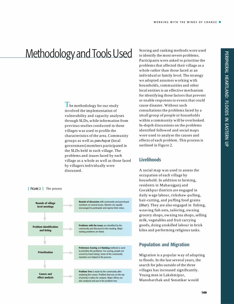
The methodology for our studyinvolved the implementation ofvulnerability and capacity analysesthrough SLDs, while information fromprevious studies conducted in thesevillages was used to profile thecharacteristics of the area. Communitygroups as well as panchayat (localgovernment) members participated inthe SLDs held in each village. Theproblems and issues faced by eachvillage as a whole as well as those facedby villagers individually werediscussed.
Scoring and ranking methods were usedto identify the most severe problems.Participants were asked to prioritise theproblems that affected their village as awhole rather than those faced at anindividual or family level. The strategywe adopted assumes working withhouseholds, communities and otherlocal entities is an effective mechanismfor identifying those factors that preventor enable responses to events that couldcause disaster. Without suchconsultations the problems faced by asmall group of people or householdswithin a community will be overlooked.In-depth discussions on the problemsidentified followed and social mapswere used to analyse the causes andeffects of each problem. This process isoutlined in Figure 2.
Livelihoods
A social map was used to assess theoccupation of each village byhousehold. In addition to farming,residents in Maharajganj andGorakhpur districts are engaged indaily wage labour, rickshaw-pulling,hair-cutting, and puffing food grains(bhar). They are also engaged in fishing,weaving fish nets, tailoring, owninggrocery shops, owning tea shops, sellingmilk, vegetables and fruit carryinggoods, doing unskilled labour in brickkilns and performing religious tasks.
Population and Migration
Migration is a popular way of adaptingto floods. In the last several years, thesearch for jobs outside of the threevillages has increased significantly.Young men in Lakshmipur,Manoharchak and Sonatikar would
| FIGURE 2 | The process
Methodology and Tools Used
W O R K I N G W I T H T H E W I N D S O F C H A N G E
PERI
PHER
AL H
EART
LAN
D:
FLO
OD
S IN
EAS
TERN
UP
170
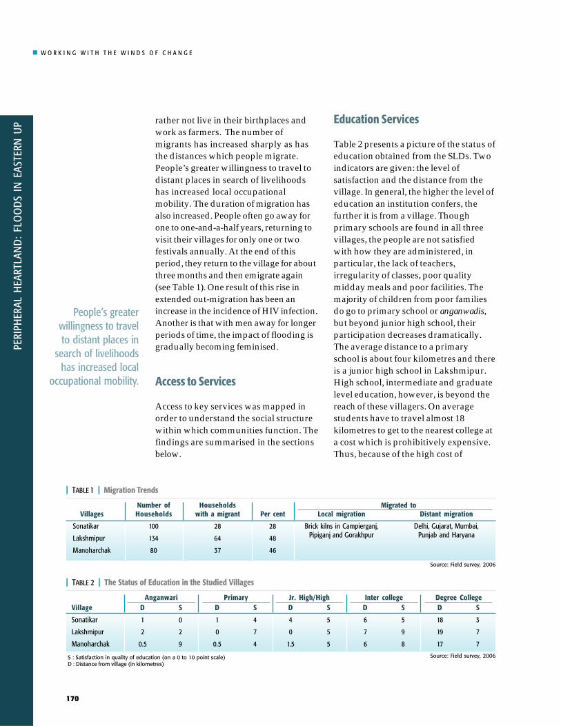
rather not live in their birthplaces andwork as farmers. The number ofmigrants has increased sharply as hasthe distances which people migrate.People’s greater willingness to travel todistant places in search of livelihoodshas increased local occupationalmobility. The duration of migration hasalso increased. People often go away forone to one-and-a-half years, returning tovisit their villages for only one or twofestivals annually. At the end of thisperiod, they return to the village for aboutthree months and then emigrate again(see Table 1). One result of this rise inextended out-migration has been anincrease in the incidence of HIV infection.Another is that with men away for longerperiods of time, the impact of flooding isgradually becoming feminised.
Access to Services
Access to key services was mapped inorder to understand the social structurewithin which communities function. Thefindings are summarised in the sectionsbelow.
Education Services
Table 2 presents a picture of the status ofeducation obtained from the SLDs. Twoindicators are given: the level ofsatisfaction and the distance from thevillage. In general, the higher the level ofeducation an institution confers, thefurther it is from a village. Thoughprimary schools are found in all threevillages, the people are not satisfiedwith how they are administered, inparticular, the lack of teachers,irregularity of classes, poor qualitymidday meals and poor facilities. Themajority of children from poor familiesdo go to primary school or anganwadis,but beyond junior high school, theirparticipation decreases dramatically.The average distance to a primaryschool is about four kilometres and thereis a junior high school in Lakshmipur.High school, intermediate and graduatelevel education, however, is beyond thereach of these villagers. On averagestudents have to travel almost 18kilometres to get to the nearest college ata cost which is prohibitively expensive.Thus, because of the high cost of
People’s greaterwillingness to travelto distant places in
search of livelihoodshas increased local
occupational mobility.
| TABLE 1 | Migration Trends
Villages
Sonatikar
Lakshmipur
Manoharchak
Number ofHouseholds
100
134
80
Householdswith a migrant
28
64
37
Per cent
28
48
46
Local migration
Brick kilns in Campierganj,Pipiganj and Gorakhpur
Distant migration
Delhi, Gujarat, Mumbai,Punjab and Haryana
Migrated to
| TABLE 2 | The Status of Education in the Studied Villages
Village
Sonatikar
Lakshmipur
Manoharchak
D
18
19
17
S
3
7
7
Degree College
S : Satisfaction in quality of education (on a 0 to 10 point scale)D : Distance from village (in kilometres)
D
6
7
6
S
5
9
8
Inter collegeD
4
0
1.5
S
5
5
5
Jr. High/HighD
1
0
0.5
S
4
7
4
PrimaryD
1
2
0.5
S
0
2
9
Anganwari
Source: Field survey, 2006
Source: Field survey, 2006

W O R K I N G W I T H T H E W I N D S O F C H A N G E
PERIPHERAL H
EARTLAND
: FLOO
DS IN
EASTERN U
P
171
transportation children of poor familiesare not educated beyond the primarylevel (see Table 2).
Health Services
Information on both government andprivate health services was assessedusing diagrams which mapped theservices provided against theopportunities to seek those services. Asindicated in Table 3, the quality ofgovernment health services at the locallevel is poor. People often consultprivate doctors or visit a medical collegefor better treatment. Private practitionersand the staff at nursing homes havemuch greater credibility than the staff atgovernment institutions. The onecommunity health care centre availableat the block level does functioncomparatively well and people aresatisfied with its services. This centre isdistant from the villages, however, andhence, in an emergency, no good qualityservices are available locally.
Agriculture Services
In the villages studied there are noagricultural facilities at the village level.For basic provisions such as seeds,fertilisers and pesticides, people must goto the block headquarters which is about13 kilometres away. For other materials,such as tube wells and equipment andeven some seeds, people must go to thedistrict headquarters about 55kilometers away. Agricultural co-operatives do exist but they areessentially defunct and people awardedthem no marks for the criterion ofsatisfaction.
Food Deficiency Months, CopingStrategies and Livelihoods
Critical information about the durationof food deficiencies among the ruralpopulation, their strategies of copingwith deficiencies and their livelihoodoptions are summarised in the Table 4.Clearly, basic infrastructure related tohealth, education and agriculture is
People often consultprivate doctors orvisit a medical collegefor better treatment.
| TABLE 3 | Status of Health Services
Village
Sonatikar
Lakshmipur
Manoharchak
S : Satisfaction of services provided (on a 0 to 10 point scale)D : Distance from village (in kilometres)
S
3
5
5
D
0
2
1
Private Doctorsat village level
S
-
4
1
D
-
10
4
PrimaryHealth Centre
S
7
5
D
37
55
CommunityHealth Centre
S
2
-
3
D
1837
2056
55
DistrictHospital
S
56
86
9
D
37
56
55
PrivateNursingHome
S
4
4
2
D
MedicalCollege
| TABLE 4 | Gap in Food Access
Basin
Rohini Basin(Maharajganj andGorakhpur districts)
Food Gap (in months)
i. Bhadra (Aug/Sept)ii. Falgun (March)iii. Magh (Feb/March)
Strategy
The major coping strategy is to consume less food.Bread eaten with salt is the main food during thesemonths. Bhuja, Chiura, Sattu, potato and a littlesugar is also eaten. For some households, fasting isa major strategy for survival. At critical times, peopleare compelled to obtain credits from moneylendersby mortgaging agricultural lands.
Livelihood
People have no option otherthan doing labour on minimalwages. The wages earnedhardly afford two meals forthe family. People considerthese periods as exploitativemonths.
Source: Field survey, 2006
Source: Field survey, 2006

W O R K I N G W I T H T H E W I N D S O F C H A N G E
PERI
PHER
AL H
EART
LAN
D:
FLO
OD
S IN
EAS
TERN
UP
172
lacking and reduces the adaptivecapacity of these communities in timesof disaster.
An attempt was also made tounderstand the service delivery roles oftwo important formal institutions –federal government extension servicesand panchayats in the context of disastermitigation.
Role of Formal Institutions
Government extension servicesExternal agencies like governmentfunctionaries and voluntaryorganisations play a vital role indisaster risk reduction. The constructionof houses on higher grounds is animportant step towards disaster riskreduction in flood-prone areas. Indeed,in Sonatikar, people were allotted landson high ground to build their homes.Very little effort, however, was accordedto rehabilitation and relief services. Onlyduring serious floods are food packetsdistributed and the maintenance ofphysical structures has been largelyoverlooked in all flood prone villages.
PanchayatsThe linkages between people andwelfare schemes in each village wereassessed. Though panchayats existwithin revenue villages they arepractically defunct and people are notsatisfied with their work. In fact, theprevailing sentiment is that these localgovernance units have become agents ofpoliticians and higher authorities andthat most are corrupt – particularly interms of how beneficiaries for welfare
schemes are selected. The statedbeneficiaries often receive nothing,while wealthy people with access topower and money enjoy substantialbenefits. Only people from Lakshmipurwere satisfied with the role of thepanchayat during floods. They believepanchayat committees properly distributerelief materials to villagers.
Natural and Climate Hazards
Eastern Uttar Pradesh is frequentlysubjected to flooding, due to itstopography and heavy rainfall. Mostcommunities know little about theimpacts climate change may have on thealready difficult local conditions. Sinceclimate change information is stillemerging, incorporating insights intorisk reduction strategies will requireeffective strategies for a two-waydialogue. The challenge is tocommunicate the often abstract andtechnical insights from global scienceinto a discourse meaningful to localcommunities. At the same time, thecommunities have to develop andunderstanding and communicate thepotential implications of climate changeon their livelihoods. The importance ofshared learning is, as a result, central toidentifying effective strategies foradapting to climate change. In addition,as enabling and constraining factors atthe community level often have roots inhigh-level systems (financial, policy,and institutional), we need to be able toidentify high-level points of entry andwork with actors operating at therelevant regional, state, or nationallevels.
External agenciesand voluntary
organisations canplay a vital role in
disaster riskreduction.

W O R K I N G W I T H T H E W I N D S O F C H A N G E
PERIPHERAL H
EARTLAND
: FLOO
DS IN
EASTERN U
P
173
Patterns of Vulnerability
Climate change impacts are, and willbe, different on all scales. This meansthat different regions, different socialgroups and different individuals willface different, diverse and unequalimpacts and difficulties in coping withclimate change. This makes vulnerabilityto climate change differ too. Hence,vulnerability is locally based and mustbe analysed and understood in context.Vulnerability can be defined simply as aset of conditions and processes resultingfrom physical, social, economic, andenvironmental factors which increase thesusceptibility of a community to the impactof hazards.
Factors that increase the ability ofpeople and the society they live in to
cope effectively with hazards, thatincrease their resilience, or thatotherwise reduce their susceptibility areconsidered as their capacity to copewith disaster. Capacity variesdepending on factors like poverty,gender, caste (social inclusion), age,physical and mental ability, or what isknown as everyday vulnerabilities.
Capacity and vulnerability analysis(CVA) was used as a tool to assess thevulnerabilities extant in the threevillages studied (see Table 5a, 5b, 5c).Social mapping and community groupdiscussions were also used. Thefindings about the existing village-levelvulnerabilities and capacities,information that is necessary for furtherintervention are summarised in thetables below.
Changing Nature of Vulnerability
Vulnerability is dynamic and context-dependent. A farming family, for
| TABLE 5a | Capacity and Vulnerability Analysis Lakshmipur
Physical/Material
Social/Organisational
Motivation/Attitude
Vulnerability
- Over 75% of households own less than one acre of land- Around 50 acres of agricultural land is waterlogged- Around 250 acres of agricultural land is under-irrigated- Health centres do not function; the satisfaction level for
these is low- Only 5-6 hours of power supply a day- local food supplies only last six months of the year- Drought is as a problem
- Defunct gram panchayat- Caste divisions during elections- 50% of households have members who migrate out,
migration of youths is increasing- No formal group like Mahila Mandal and no self-help group
- "Flood is our destiny" and "We cannot get external support"are accepted mantras
- Depend on government/panchayat to maintain hand pumps,tube wells
Capacity
- Embankment for refuge during floods- Irrigation Department office exists- Access to road- Market is 7 km away- knowledge of building temporary bridge during flood- 12 individuals have mobile phones and 36 households
have television- 3 Public Call Offices- Primary and junior high schools
- Puja committees (Durga, Saraswati) exist- Decentralised roles and responsibilities in group work- Youth sports team- Physical and moral support during floods
- Readiness to work together- Demand for new agriculture techniques- Participation in community meetings- Willingness to obtain new information- Readiness to contribute to resources
Vulnerability islocally based andmust be analysed
and understoodin context.

W O R K I N G W I T H T H E W I N D S O F C H A N G E
PERI
PHER
AL H
EART
LAN
D:
FLO
OD
S IN
EAS
TERN
UP
174
| TABLE 5b | Capacity and Vulnerability Analysis Manoharchak
Physical/Material
Social/Organisational
Motivation/Attitude
Vulnerability
- Over 80% of households own less than one acre of land- Health centre does not function well; visits by medical
worker are irregular- Only 5-6 hours of power supply a day- Local food supplies only last six months of the year- Very few natural water reservoirs; deep water table (60-65
feet)- A large number of eligible families have no Below Poverty
Line (BPL) ration cards
- Defunct gram panchayat- Caste divisions during election period- 47% of households have members who migrate; migration
of youths is gradually increasing- No formal group like Mahila Mandal and no self-help
group
- Sense of hopelessness in obtaining any government orpanchayat support
- No faith in panchayat- Depend on panchayat to repair tube well and for health
centre
Capacity
- Embankment for refuge during floods- Village electrified- Functional ITC: e-chaupal internet connectivity- Connected to road- Market is 8 km away- Knowledge to build temporary bridges and roads
during floods- Mobile phone network available- 1 Public Call Office
- Puja committees- Decentralised roles and responsibilities- Mutual physical and moral support among people in
disaster situations
- Some community members are active and encourageothers
- Demand for new agricultural techniques- Participation in community meetings- Willingness to seek new knowledge- Readiness to contribute to resources
| TABLE 5c | Capacity and Vulnerability Analysis Sonatikar
Physical/Material
Social/Organisational
Motivation/Attitude
Vulnerability
- Over 80% of households own less than one acre of land- High number of landless families- Health centre and schools do not exist in village- Half of the village is not electrified- Local food supplies only last for six months of the year- A large number of eligible families do not have Below
Poverty Line (BPL) ration cards- A large area of agricultural land is waterlogged (around
100 acres)- Land is waterlogged for 2-3 months
- Defunct gram panchayat- Caste divisions during election- 28% of households have memebers who migrate;
migration among youths is increasing- No formal group like Mahila Mandal and no self-help groups
- Poor faith in panchayat- Dependent on government/panchayat to maintain hand
pumps, tube wells- People are not interested in collective work
Capacity
- Embankment for refuge during floods- Half of the village is electrified- Connected with road- Urban market is 8 km away- Knowledge of building temporary bridges and
walkways during floods- Mobile network is available- 1 Public Call Office
- Puja committees- Decentralised roles and responsibilities- Mutual physical and moral support during disasters
- Some community members are active and influenceothers
- Demand for new agricultural techniques- Community members participate in meetings and
discussions- Willingness to obtain new knowledge- Readiness to contribute to resources

W O R K I N G W I T H T H E W I N D S O F C H A N G E
PERIPHERAL H
EARTLAND
: FLOO
DS IN
EASTERN U
P
175
example, may be more vulnerable tofloods, than a landless family is.Spatial and time factors play a crucialrole in defining vulnerability too.
In terms of their vulnerability, poorfamilies or communities are broadlyclassified as improving, coping ordeclining.
Poor people can move through thesethree classifications over the course of amonth or year. Just as there are cases ofpeople ‘coping’ with a disastersituation moving to the ‘improving’category by virtue of increasing theirincomes through out-migration thereare also incidences of people who fallfrom ‘improving’ all the way down to‘declining’. It is important to documentchanges in coping status which areinfluenced by income level as income isthe real agent of change.
Gender is clearly an indicator ofvulnerability, specifically in relation tohealth, education, mortality, economicparticipation, decision-making andsafety. As a result of proactivemeasures taken in the past, gendergaps in literacy appear to be narrowingin those states where the disparitybetween men and women was oncehigh (according to the 2001 populationcensus).
Although the poor are adverselyimpacted as a whole, women and girlsare the most vulnerable among thembecause they have little voice indecision-making. In rural areasdominated by men and elites, womenoften are not well representedpolitically, are neither consulted norincluded in development planningprocesses, and, as a result, cannot
voice their ideas about how servicesshould be designed.
Women and girls find it difficult toparticipate in consultations for severalreason. Some of these are:
socio-cultural barrierspoor timing (timings that conflict withchores women are obliged to carryout) and inappropriate venues formeetings (places where women arenot allowed)inability to travel freelylack of free time.
The 74th Constitutional Amendment(1992) has enshrined a structural basisfor women’s participation in politicaldecision-making and for bringing theminto the mainstream of development. Theprocess of actually empowering womenand promoting gender balance, however,is in a nascent stage. Numerousconstraints need to be overcome to ensurethat women participate effectively.
Numerous constraintsneed to be overcometo ensure that womenparticipate effectively.
Sand bags placed for preventing further degradation ofembankment at breached section.
© A
Pok
hrel

W O R K I N G W I T H T H E W I N D S O F C H A N G E
PERI
PHER
AL H
EART
LAN
D:
FLO
OD
S IN
EAS
TERN
UP
176
The process of SLD is based onreflexive learning from other positionsand perspectives. It is distinguishedfrom the rigid certitude of mono-disciplinary styles, especially those ofsingle-mission outfits which advocatetop-down, structural solutions tomitigate the impact of floods anddroughts. SLD is built around the ideaof introducing the insights of socialsciences into vulnerability and riskassessment. While technical expertsknow much, villagers suffering fromfloods and droughts know many of thesocial and environmental contexts inwhich they cope with the disasters stillbetter. Using the SLD method, thisstudy aimed to understand localconcerns and knowledge and tointegrate them with proposed pilotinterventions.
We undertook various activities toengage with different groups atdifferent levels and scales so that wecould gain insights into issues that mayhave been missed by focusing only on asingle perspective. Learning throughSLD involves engaging in discussionswith representatives from government,market and civic movements on issuesrelating to adaptation, livelihood andmitigation, reviewing existingmitigation strategies, and establishingcommunication links among differentgroups.
Since government bureaucrats, marketplayers and activists define a problem ordisaster event differently, they eachsupport different policy measures. As isthe case in the SLD paradigm, policyreviews were begun at the lowest level,with the communities affected bydisasters. Market players were asked todescribe constraints to provide cheaperand more efficient solutions andactivists was asked to challenge andexamine the issues of fairness affectingthose communities. The relevantgovernment departments were providedwith recommendations forimplementation procedures that couldaddress the concerns of all three sets ofactors. These recommendations focusedon innovation, fairness and effectiveregulation. The findings from the SLDsthat were conducted are summarised inTable 6.
Key Points from the SLDs forStrategies:
Varied perceptions on hazardsemerged. Although overall, at thevillage level, droughts and floods areperceived to be a common disaster,the village level definition of ahazard often did not equate with theofficial definition. For example,villagers define drought as thoseperiods when their crops requirewater and there is no rainfall. Thisdefinition is different from that usedby the state government whichdefines drought based on the deficitin total volume of annual rainfallrelative to normal volumes.Early flood warning systems need todevolve beyond the region, district orblock level to the village level. Thevillagers of Lakshmipur suggested
Using the SLDmethod, this study
aimed to understandlocal concerns and
knowledge.
Shared Learning Dialogue

W O R K I N G W I T H T H E W I N D S O F C H A N G E
PERIPHERAL H
EARTLAND
: FLOO
DS IN
EASTERN U
P
177
that if they could receive informationon water levels, then preventivemeasures could be taken to save theirassets, including crops. Currentlypeople get some information on theprobability of a flood event throughnewspapers and the radio. Suchinformation is not consideredspecific enough, however, for peopleto determine if their village is likely tobe affected or not. Currently, villagersmonitor river water levels next totheir village on their own. They useriver level assessments to makejudgments on whether or not a floodevent is likely.Farmers were interested in knowingabout suitable alternative crops thatthey could cultivate to minimise cropdamage due to floods or poorrainfall. These could include early-sowing short duration crops that canbe harvested before the onset of the
flood season (July-August) and cropsthat can survive waterloggedconditions.Seasonal migration helps localcommunities that are regularlyaffected by floods to cope with thelosses incurred.Interventions and actions are neededat different levels—household,community groups and village levels.At levels higher than the field level,questions of who should undertakewhat activities leads into thequestions of what needs to be donefor adaptation and disaster riskreduction.During the SLD process, severalissues were raised regarding highfrequency disasters with low impactsversus. low frequency disasters withhigh impacts. Three importantquestions emerged whichstakeholders felt are important to
| TABLE 6 | Summary of Findings from Shared Learning Dialogues
Level
Village
Block
State
Paneldiscussion oncrop insurancein during JanSansad
No of SLDs
5
1
1
1
Stakeholder
Community representatives fromlocal government and NGOs
Block Development Officer (BDO),Assistant Development Officer(ADO), Media, panchayat officials,block level government officials.*
NGOs, Catholic Relief Services (CRS),Oxfam, Church's Auxiliary for SocialAction (CASA), Radio and TV, Projectthematic partners, District and Statedisaster management cell
Attended by about 1,000 farmersand NGOs, chaired by senioradministrative officer who sharedhis views on farmer's rights.
Description
First SLD in five villages discussed the nature of disasters andassociated risks. This area is highly flood prone but drought is anemerging hazard as the monsoon is becoming more erratic.
Main points of earlier SLD shared. Stakeholders' views on floodand rehabilitation explored. District administration (DA) identifiedas prime authority to implement rehabilitation programme andBDO and ADO perform as instructed by the DA. Compensationassessment not the responsibility of DA. Officials agree damageassessment process is not transparent. Crop insurance can be aneffective tool.
A short discussion on the present scenario of floods and otherdisasters in Eastern UP including the nature and frequency of floodand ecological change due to disaster. Discussion of communicationneeds and systems at village, block, district and state level duringdisaster, and policies on disaster mitigation and rehabilitation.
Crop insurance and compensation was one of the major issuesdiscussed. Farmers from flood and drought affected regionssuggested that efforts should be made to raise the issue ofinsurance and compensation. Present mechanisms and policieson crop insurance and damage assessment is complicated andbeyond the reach of the community.
*Dialogue is planned for Paniyara Block.
Preventivemeasures couldbe taken to savetheir assets,including crops.

W O R K I N G W I T H T H E W I N D S O F C H A N G E
PERI
PHER
AL H
EART
LAN
D:
FLO
OD
S IN
EAS
TERN
UP
178
consider while designing disasterrisk reduction strategies:
a. How do we sustain proposedadaptive strategies for DRR(insurance, communicationmechanisms, early warning systems)for low frequency/high impactdisasters?
b. In developing adaptive strategies,should the focus be on highfrequency and low impact disasters,while nonetheless keeping highimpact events in mind?
c. How do we integrate adaptivestrategies overall development?
It was also pointed out that market andlarger political dynamics can exacerbatethe vulnerability of local communities.
The various representatives ofgovernment departments weinteracted with through SLDs weredefensive at first but tended toprovide achievable, incremental“options for the way ahead” fordisaster interventions;As a tool, SLDs allow for continuousengagement with stakeholders,which is much more meaningfulthan simply getting feedback fromthem as it allows the project team toshare experiences and findings.SLDs are inclusive and integrativebecause stakeholders at all levelsunderstand that these discussionsare not a one-off exercise but rather aforum for continuous discussion;SLDs help gather people’sperceptions of the costs and benefitsof disaster risk reduction strategies:embankments as a preventivemeasure against floods can be both aboon as well as a bane. Theembankment in Lakshmipur is a casein point. The ring bund embankment
was constructed 35 years ago. In2001, the embankment protected thevillage from floods, but later itbreached, washing away part of thevillage and forming a large pond onarable land. The ring bund alsoprevents flood water from drainingproperly, resulting in waterlogging.Though the soil is fertile,agricultural productivity has beenadversely affected. The IrrigationDepartment has neglected itsresponsibility for maintaining thebund. As a result, the threat of itsbreaching and inundating thevillage is constant.In addition to discussing field basedissues, the state level SLD, alsobroached policy requirements. Thisforum allowed for a discussion andrecognition of community needs andpossible policy changes called for.This SLD also helped explore howbest to translate policy into action.
Who is Vulnerable?
From the foregoing, it becomes clear thatSLDs have helped identify patterns ofvulnerability in project villages, and,more specifically, those factors whichpromote or prevent householdadaptation to floods. Villagers usedseveral specific indicators to identifyvulnerable households, includingsusceptibility of physical assets such ashouses and agricultural land to damageinability to cope with or recover from adisruption in the supply of primaryservices such as water supply,sanitation and health; and the inabilityto maintain household income,especially during the post flood periods,due to excessive or sole dependence onlivelihood systems affected by floods.
SLDs help gatherpeople’s
perceptions of thecosts and benefits
of disaster riskreduction.
W O R K I N G W I T H T H E W I N D S O F C H A N G E
PERIPHERAL H
EARTLAND
: FLOO
DS IN
EASTERN U
P
179
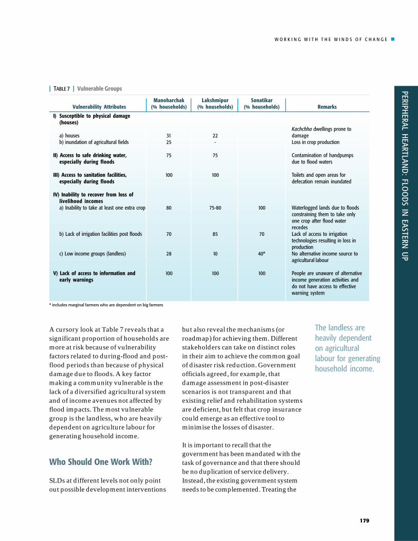
A cursory look at Table 7 reveals that asignificant proportion of households aremore at risk because of vulnerabilityfactors related to during-flood and post-flood periods than because of physicaldamage due to floods. A key factormaking a community vulnerable is thelack of a diversified agricultural systemand of income avenues not affected byflood impacts. The most vulnerablegroup is the landless, who are heavilydependent on agriculture labour forgenerating household income.
Who Should One Work With?
SLDs at different levels not only pointout possible development interventions
but also reveal the mechanisms (orroadmap) for achieving them. Differentstakeholders can take on distinct rolesin their aim to achieve the common goalof disaster risk reduction. Governmentofficials agreed, for example, thatdamage assessment in post-disasterscenarios is not transparent and thatexisting relief and rehabilitation systemsare deficient, but felt that crop insurancecould emerge as an effective tool tominimise the losses of disaster.
It is important to recall that thegovernment has been mandated with thetask of governance and that there shouldbe no duplication of service delivery.Instead, the existing government systemneeds to be complemented. Treating the
| TABLE 7 | Vulnerable Groups
Vulnerability Attributes
I) Susceptible to physical damage(houses)
a) housesb) inundation of agricultural fields
II) Access to safe drinking water,especially during floods
III) Access to sanitation facilities,especially during floods
IV) Inability to recover from loss oflivelihood incomesa) Inability to take at least one extra crop
b) Lack of irrigation facilities post floods
c) Low income groups (landless)
V) Lack of access to information andearly warnings
Manoharchak(% households)
3125
75
100
80
70
28
100
Lakshmipur(% households)
22-
75
100
75-80
85
10
100
Sonatikar(% households)
100
70
40*
100
Remarks
Kachchha dwellings prone todamageLoss in crop production
Contamination of handpumpsdue to flood waters
Toilets and open areas fordefecation remain inundated
Waterlogged lands due to floodsconstraining them to take onlyone crop after flood waterrecedesLack of access to irrigationtechnologies resulting in loss inproductionNo alternative income source toagricultural labour
People are unaware of alternativeincome generation activities anddo not have access to effectivewarning system
* includes marginal farmers who are dependent on big farmers
The landless areheavily dependenton agriculturallabour for generatinghousehold income.

W O R K I N G W I T H T H E W I N D S O F C H A N G E
PERI
PHER
AL H
EART
LAN
D:
FLO
OD
S IN
EAS
TERN
UP
180
government as a monolithic institutiondoes not improve local level situationseither. It is the existing disastermanagement cell which has beenmandated to undertake activities fordisaster risk reduction that needs to playa key role in the delivery of services.
Communities impacted by disasters arethe target groups for developing pilotintervention activities. While there is atendency of doing too many things atone go, especially in the context ofdisasters, it is more important to exerciserestraint and design interventions thatare incremental and achievable. Theinvolvement of communities throughSLDs can lead to effective diagnosis andthrow open options. SLDs at differentlevels can target achievability in thedelivery of services.
SLDs serve as a key tool for civil societyinstitutions and the media to engagewith each other. They also help donor
communities adopt a consensualapproach rather than, as is typical indisaster risk reduction interventions, beingdonor-led. Pilots and briefs (supported bydonors) can go a long way in movingtowards achieving bottom-up initiatives.
Banks and traders can also contributetowards improving conditions in ruralcommunities. The focus should be onbusiness rather than on philanthropythrough social responsibility initiatives.Presently, the private sector, banks,traders and insurance communities hidebehind the sophistry of ‘systems for andpolicies on crop insurance and damageassessment are too complicated for ruralcommunities’ rather than using thesemechanisms for risk reduction. To widenthe reach of disaster risk reductionsolutions we also need to generate spacefor market actors. First, though, theexisting data gap needs to be filled andkey insights into how that aim could beachieved needs to be generated.
© A Pokhrel
We also need togenerate space
for marketactors.
Embankments are sites of refugeduring floods.Embankments are sites of refugeduring floods.
W O R K I N G W I T H T H E W I N D S O F C H A N G E
PERIPHERAL H
EARTLAND
: FLOO
DS IN
EASTERN U
P
181
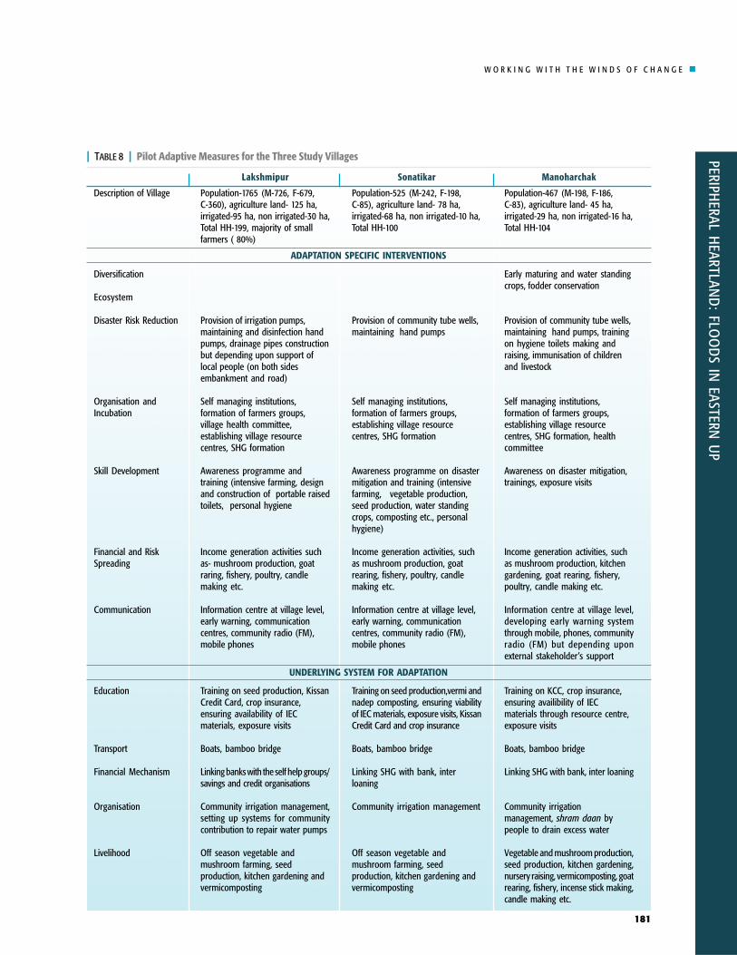
| TABLE 8 | Pilot Adaptive Measures for the Three Study Villages
Description of Village
Diversification
Ecosystem
Disaster Risk Reduction
Organisation andIncubation
Skill Development
Financial and RiskSpreading
Communication
Education
Transport
Financial Mechanism
Organisation
Livelihood
Manoharchak
Population-467 (M-198, F-186,C-83), agriculture land- 45 ha,irrigated-29 ha, non irrigated-16 ha,Total HH-104
Early maturing and water standingcrops, fodder conservation
Provision of community tube wells,maintaining hand pumps, trainingon hygiene toilets making andraising, immunisation of childrenand livestock
Self managing institutions,formation of farmers groups,establishing village resourcecentres, SHG formation, healthcommittee
Awareness on disaster mitigation,trainings, exposure visits
Income generation activities, suchas mushroom production, kitchengardening, goat rearing, fishery,poultry, candle making etc.
Information centre at village level,developing early warning systemthrough mobile, phones, communityradio (FM) but depending uponexternal stakeholder’s support
Training on KCC, crop insurance,ensuring availibility of IECmaterials through resource centre,exposure visits
Boats, bamboo bridge
Linking SHG with bank, inter loaning
Community irrigationmanagement, shram daan bypeople to drain excess water
Vegetable and mushroom production,seed production, kitchen gardening,nursery raising, vermicomposting, goatrearing, fishery, incense stick making,candle making etc.
Lakshmipur
Population-1765 (M-726, F-679,C-360), agriculture land- 125 ha,irrigated-95 ha, non irrigated-30 ha,Total HH-199, majority of smallfarmers ( 80%)
Provision of irrigation pumps,maintaining and disinfection handpumps, drainage pipes constructionbut depending upon support oflocal people (on both sidesembankment and road)
Self managing institutions,formation of farmers groups,village health committee,establishing village resourcecentres, SHG formation
Awareness programme andtraining (intensive farming, designand construction of portable raisedtoilets, personal hygiene
Income generation activities suchas- mushroom production, goatraring, fishery, poultry, candlemaking etc.
Information centre at village level,early warning, communicationcentres, community radio (FM),mobile phones
Training on seed production, KissanCredit Card, crop insurance,ensuring availability of IECmaterials, exposure visits
Boats, bamboo bridge
Linking banks with the self help groups/savings and credit organisations
Community irrigation management,setting up systems for communitycontribution to repair water pumps
Off season vegetable andmushroom farming, seedproduction, kitchen gardening andvermicomposting
Sonatikar
Population-525 (M-242, F-198,C-85), agriculture land- 78 ha,irrigated-68 ha, non irrigated-10 ha,Total HH-100
Provision of community tube wells,maintaining hand pumps
Self managing institutions,formation of farmers groups,establishing village resourcecentres, SHG formation
Awareness programme on disastermitigation and training (intensivefarming, vegetable production,seed production, water standingcrops, composting etc., personalhygiene)
Income generation activities, suchas mushroom production, goatrearing, fishery, poultry, candlemaking etc.
Information centre at village level,early warning, communicationcentres, community radio (FM),mobile phones
Training on seed production,vermi andnadep composting, ensuring viabilityof IEC materials, exposure visits, KissanCredit Card and crop insurance
Boats, bamboo bridge
Linking SHG with bank, interloaning
Community irrigation management
Off season vegetable andmushroom farming, seedproduction, kitchen gardening andvermicomposting
ADAPTATION SPECIFIC INTERVENTIONS
UNDERLYING SYSTEM FOR ADAPTATION

W O R K I N G W I T H T H E W I N D S O F C H A N G E
PERI
PHER
AL H
EART
LAN
D:
FLO
OD
S IN
EAS
TERN
UP
182
Pilot Activities
The disaster risk in the project villagescan be mitigated by targeting thefollowing activities:
a) Direct risk reduction interventions:These include agriculturalinterventions relating to inundation-resistant and early sowing and/orharvesting crops, irrigationtechnologies enhancing access toirrigation, spreading financial riskthrough crop insurance, innovativemodels of sanitation and handpumps,housing technology resistant to floods,and early warning systems.
b) Interventions for changingunderlying systems for adaptation:These include adaptation incubationsystems that support self-managingpeople’s institutions for continualinnovations in agriculture andcommunication and improvement ineducation, health and transportsystems.
While the above-identified activitiesemerged from SLDs, the activities thatare actually piloted will need to becarefully selected after validation by thecommunity in the next round of SLDs.
Disaster riskreduction also needs
technologicalinnovations.
© A
Pok
hrel
Flood damaged cash crops and paddy: 2007 monsoon,Eastern Uttar-PradeshFlood damaged cash crops and paddy: 2007 monsoon,Eastern Uttar-Pradesh

W O R K I N G W I T H T H E W I N D S O F C H A N G E
PERIPHERAL H
EARTLAND
: FLOO
DS IN
EASTERN U
P
183
Summary of Key Insightsand Conclusions
Capacity and vulnerability analysesand SLDs at different levels helppoint out disaster risk reductionstrategies. This study establishes thatboth these tools do work and thatthey generate multi-faceted benefitsin terms of generating, validatingand triangulating data, engagingstakeholders, and supporting policyadvocacy. Most importantly, theyalso help identify potential ideas andmechanisms for developmentinterventions.At the field level, SLDs conductedwith disaster-affected communitiesnot only serves as a platform forsharing experiences but also helpsidentify useful solutions to problemsidentified by the community;SLD is useful in building thecapacity of both community membersand the project team;SLD is a two-way process ofknowledge transfer. For example, wecommunicate technical details ofglobal warming to local communitieswhile they explain to us the existingand expected impacts at the fieldlevel in terms of occupationalmobility, migration patterns,livelihood systems, etc.;This two-way flow of informationregarding knowledge about climatechange impacts and their (tangibleand indirect) impacts needs to beinterposed with the understanding
the community possesses. These setthe stage for making decision on keypoints of action;Solutions emerging in SLDs need tobe documented and shared withstakeholders during further SLDsand/or in meetings with policy-makers;SLDs need to be more participatory,in particular women and othermarginalised groups need to bemore involved;SLDs can function as a tool fortriangulation and validation;System and process delivery needs,including those related to policies,should be identified at all levels.The SLD process can be viewed as ahorizontal process: more and moreSLDs and more ‘solutions’ have tobe identified and promoted throughdialogue as one moves acrossscales.
Weaknesses of the Methods andConcepts
1. One of the weaknesses that emergedis that the process of SLDs requiresintensive inputs in terms of bothmoney and time.
2. So that too many ideas do not floataround in a SLD and discussionsdo not veer away from the agenda,there is a need for effectivemoderation. Who should assumethe role of moderator is problematic.If project personnel adopt the role,their guiding the discussions can beseen as a form of bias.
3. Contentious issues such as landrights sometimes take the centrestage in these platforms.
4. Some priority areas such as gender-sensitive approaches get lowpriority if not handled carefully.
SLD is a two-wayprocess ofknowledge
transfer.

W O R K I N G W I T H T H E W I N D S O F C H A N G E
PERI
PHER
AL H
EART
LAN
D:
FLO
OD
S IN
EAS
TERN
UP
184
Profile of Project Villages
Village : SonatikarBlock : CampierganjDistrict : Gorakhpur
1. Population:
Men
242
Women
198
Children
85
Total
525
Kaccha
32
Pakka
52
Phoos
16
Total
100
2. Types of Houses:
Caste
General
Backward Class
Other Backward Class
Schedule Caste
No. of Household
7
68
5
20
Male
17
202
11
58
Female
14
165
09
49
3. Castewise PopulationPopulation
4. Number of Households with Toilet : 4
5. Total Agriculture Land Area : 78 haIrrigated : 68 haNon irrigated : 10 ha
6. Literacy
Female
40%
Male
60%
7. Number of Handpumps
India Mark
12
Private
38
8. Area open/Under forest : 2 ha
Appendix 1
W O R K I N G W I T H T H E W I N D S O F C H A N G E
PERIPHERAL H
EARTLAND
: FLOO
DS IN
EASTERN U
P
185
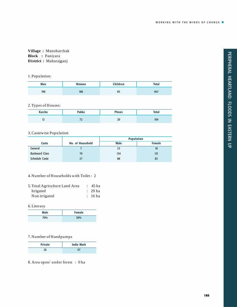
Village : ManoharchakBlock : PaniyaraDistrict : Maharajganj
1. Population:
Men
198
Women
186
Children
83
Total
467
Kaccha
12
Pakka
72
Phoos
20
Total
104
2. Types of Houses:
Caste
General
Backward Class
Schedule Caste
No. of Household
7
70
27
Male
23
134
88
Female
18
121
83
3. Castewise PopulationPopulation
4. Number of Households with Toilet : 2
5. Total Agriculture Land Area : 45 haIrrigated : 29 haNon irrigated : 16 ha
6. Literacy
Female
30%
Male
70%
7. Number of Handpumps
India Mark
07
Private
26
8. Area open/under forest : 0 ha

W O R K I N G W I T H T H E W I N D S O F C H A N G E
PERI
PHER
AL H
EART
LAN
D:
FLO
OD
S IN
EAS
TERN
UP
186
Village : LakshmipurBlock : PaniyaraDistrict : Maharajganj
1. Population:
Men
726
Women
679
Children
360
Total
1765
Kaccha
13
Pakka
156
Phoos
30
Total
199
2. Types of Houses:
3. Castewise Population
4. Number of Households with Toilet : 7
5. Total Agriculture Land Area : 225 haIrrigated : 125 haNon irrigated : 100 haIrrigated Land : 95 haNon Irrigated Land : 30 ha
6. Literacy
Female
40%
Male
60%
7. Number of Handpumps
India Mark
7
Private
45
8. Area open/under forest : 100 ha
Caste
General
Backward Class
Other Backward Class
Schedule Caste
No. of Household
19
116
29
35
Male
59
656
68
128
Female
51
631
53
119
Population
W O R K I N G W I T H T H E W I N D S O F C H A N G E
PERIPHERAL H
EARTLAND
: FLOO
DS IN
EASTERN U
P
187
Issues and Problem Identification inFlood Affected Villages
Manoharchak
Main ProblemsIdentified problems related to flood are as follows:• Unavailability of fertilisers and seeds on time• Lack of electricity• Lack of irrigation water• Lack of safe drinking water and sanitation for villagers• Inaccessibility to govt. welfare schemes (BPL cards, Antyodaya cards etc.)• Lack of labour work at village level
Followings are the problems according to the priority:1. Lack of Irrigation facilities2. Lack of safe drinking water and sanitation3. Inaccessibility to govt. welfare schemes (BPL cards, Antyodaya cards etc.)4. Unavailability of fertilisers and seeds on time
Lack of Irrigation WaterCausesThere are several causes that are contributing to lack of irrigation water.
(i) There is a community tubewell in the village but it is not working in the absenceof proper maintenance. The panchayat which is accountable for its maintenanceis not looking after it properly.
(ii) Most of the farmers have very small land holding and they do not haveresources to buy pumping sets or other irrigation equipment. Hence they oftenhire the pumps from big farmers.
(iii) Lack of electricity is one of the causes. Only 5 to 6 hours of power supply isavailable. Power cuts often create problems for farmers to assess the full benefit.Irrigation tubewells which require regular supply of power cannot be operated.Maintenance of electric equipment such as a transformer is the primeresponsibility of the gram panchayat. But this institution does not even undertakesimple repairs.
Appendix 2
W O R K I N G W I T H T H E W I N D S O F C H A N G E
PERI
PHER
AL H
EART
LAN
D:
FLO
OD
S IN
EAS
TERN
UP
188
(iv) Low water level increases the cost of deep boring and pumping. According tofarmers, where the water table is deep, farmers are not able to invest in pumps orindividual tube wells. Generally tube wells are set at 65-70 feet.
(v) Irrigation canals are not properly managed and hence interrupt the irrigationprocess.
(vi) The villages have limited surface water resources. There is no pond close toagriculture land. Carrying water from the river is an arduous job for farmersbecause there is an embankment between the village and the river. Longirrigation pipes fed by a powerful pumping set would be necessary, whichwould increase the cost.
Effects(i) Lack of water for irrigation decreases crop production. In the last few years the
area has been affected by drought. This is affecting the main kharif crop (paddy).
(ii) As a result farmers are forced to hire the pumping sets and irrigation pipes. Bothadd to direct cost.
(iii) Repeated flood and new drought has detached farmers from agriculture as thework cost of farming is increasing. Migration has significantly increased.
(iv) The load on women has increased significantly. Apart from other householdchores, they are also involved in irrigating lands using hand pumps. Overalltheir health status is affected.
Community’s Perspective of Pilots• The government should help install tubewell of high capacity• Uninterrupted power supply especially during kharif season• Ensure availability of irrigation pipes for small farmers• Irrigation canals should be lined.

W O R K I N G W I T H T H E W I N D S O F C H A N G E
PERIPHERAL H
EARTLAND
: FLOO
DS IN
EASTERN U
P
189
�������������+��!��)!� )!*
1��)��.���������������
1���������'���� ��.�.��� &�������� ���� ���������'��
-� �������������� 1������� &������'���.����� /����������������
1��������.��������������
1��)��.������������
���.���������.���������'���
-� �����������'�
1��)��.�����������'� ����������
(�������������) /����������������� /���������������
������������.������������
����������.���������'���
"���������'� ����������
,�������������� +�������.�������������������������� &����������)
���%����������+��!��)!� )!*
�������������� ��������� +�.�����
,�����'���� ��.���������������
&���������)������.������
1������������ ����,�����'���� ��.�.��� /���������)�..����
W O R K I N G W I T H T H E W I N D S O F C H A N G E
PERI
PHER
AL H
EART
LAN
D:
FLO
OD
S IN
EAS
TERN
UP
190
Sonatikar
Identified Problems• Lack of irrigation facilities• Lack of adequate safe drinking water and sanitation• Single crop in a year• Villagers lacking BPL card, ration card.• No health facilities
Problems on Priority Basis1. Single crop in a year2. Lack of irrigation facilities3. Waterlogging in agricultural fields4. Inaccessibility of BPL cards to the eligible families5. Lack of adequate safe drinking water and sanitation.
Single CropSonatikar is highly affected by flood. This is primarily a farming community that getsone cropping season (rabi) in a year.
(i) Waterlogging of agricultural fields during periods of heavy rain is common.Kharif crops are inundated for 2-3 months. The village situated on elevated land(main road) is less affected by heavy rain. Embankment does not allow rainwater to drain.
(ii) Standing water remains for 2 to 3 months and affects sowing of rabi crops.
(iii) Crop productivity has been lowered due to waterlogging. Land fertility has alsodeclined.
(iv) Farmers avoid sowing paddy crop in kharif season because they think thatsudden of flood event could cause damages.
(v) There is a lack of knowledge about deep groundwater as well as about earlyvarieties. Farmers do not take any crop in kharif season because they do not haveknowledge about the early and deep water varieties which can be grown inflood prone regions.
(vi) Lack of proper irrigation causes low production of rabi crops. Most farmers havesmall land holding and their income is low. Irrigation facilities are unavailable.Farmers have no option except to hire wells from larger farmers or from themarket.
Effects(i) Agricultural produce fetches poor prices.(ii) Food is available for only six months(iii) Compelled to take credit from money lenders

W O R K I N G W I T H T H E W I N D S O F C H A N G E
PERIPHERAL H
EARTLAND
: FLOO
DS IN
EASTERN U
P
191
(iv) Farmers are detached from agriculture(v) Increase in out migration
Community Perception on Further Action• Dissemination and knowledge about water resistant varieties• Availability of tubewells• Training on modern farming technologies to minimise the cost of production• Subsidy on agricultural inputs should be increased to minimisethe cost of
production
-� �������������� 1������� &���������)� 1������)�������������
1���������'���� ��.�.��� &�������� ���� /��������������
7� ������������ ��
1��)��.���������� (��)����.������ (��������'���� ��.�����*����� �������������������
���.����������������'��� �����'������������ ������������������� 1��)��.���������������
�������������+����!��*!�
(����������.��� (���'� &���������������
������������� ��
"���'������������ ��������'��� ��������.������������������ �������������
,�����������������)�/���������.�������� ,�����'���� ��.�������������������
������������������� 1�������������)� �������)�����������
���%����������+����!��*!�

W O R K I N G W I T H T H E W I N D S O F C H A N G E
PERI
PHER
AL H
EART
LAN
D:
FLO
OD
S IN
EAS
TERN
UP
192
Lakshmipur
Identified Problems• Lack of safe drinking water and sanitation• Lack of irrigation water• Waterlogging of fields• Farmers get only one crop in a year• Migration of youths in search of livelihood
Problems on Priority Basis1. Lack irrigation facilities ( around 250 acres are under irrigated)2. Single crop a year3. Waterlogging of agriculture field ( around 50 acre of land is water logged)4. Migration of youths5. Lack of adequate safe drinking water and sanitation.
Lack of Irrigation Facilities
Causes• Most of the agricultural lands are under irrigated. About 250 acres of land are
quite affected by lack of water. Water cannot stay in these agricultural landsbecause of the high land.
• Malfunctioning of community tubewell is a major problem. It is does not work dueto absence of timely maintenance and repairing.
• Lack of electricity increases dependency on fossil fuel. Farmers buy diesels butincur high cost.
• Most of the farmers are small holders and do not possess resources to buypumping sets. They are compelled to hire the sets from big farmers.
• Lack of water resources also affects irrigation.
EffectsIncrease in cost of production due to dependence on groundwater irrigation.Decrease in kharif crops.
Some farmers cultivate kharif crops because their lands are not close to embankment.
Migration in search of livelihood is increasing. There are few incentives for theyounger generation to stay in agriculture based livelihoods.