Pennsylvania GTO 3-Year Strategic Plan NSGIC Annual Conference 2005 Rochester, NY Jim Knudson...
17
Pennsylvania GTO 3-Year Strategic Plan NSGIC Annual Conference 2005 Rochester, NY Jim Knudson ([email protected]) Stacey White ([email protected])
-
Upload
denis-fleming -
Category
Documents
-
view
218 -
download
2
Transcript of Pennsylvania GTO 3-Year Strategic Plan NSGIC Annual Conference 2005 Rochester, NY Jim Knudson...

PennsylvaniaGTO 3-Year
Strategic Plan
NSGIC Annual Conference 2005Rochester, NY
Jim Knudson ([email protected])Stacey White ([email protected])

Pennsylvania GTO Strategic Plan• 3-Year Plan for Enterprise GT Initiatives
• Primary Goals:– Set vision and mission– Identify priorities– Identify specific projects and initiatives– Identify resources needed to accomplish and
benefits to be gained– Seek additional funding from Governor’s
Office, Budget Office and Legislature

Pennsylvania GTO Strategic Plan• First time state has published a GT
strategic plan
• Eric Jespersen assisted BGT in development of the GTO Strategic Plan
• Recognized by OIT as best Strategic Plan developed by any OIT Bureau, being used as a model for updates to OIT’s Keystone IT Strategic Plan

Commonwealth GT Strategic PlanBGT Mission:The Bureau of Geospatial Technologies develops
the Geospatial Enterprise Architecture for Pennsylvania, coordinates Executive agency and enterprise geospatial initiatives, and facilitates geospatial interoperability and data sharing across all levels of government in support of defined Pennsylvania priorities and the National Spatial Data Infrastructure (NSDI).

Commonwealth GT Strategic Plan
BGT Vision:Geospatial Technologies will improve how
governments collaborate, will provide timely and relevant information to decision makers, and will improve the safety, welfare, and quality of life for the Commonwealth and its citizens.

Commonwealth GT Strategic PlanGoals:• To make Commonwealth government operations more
effective and efficient.• To develop the GEA to guide investments and GESA to
build centralized geospatial assets for use by all governments and first responders in the Commonwealth.
• To improve geospatial data management efforts.• To establish a Statewide GT Council to augment GT
governance within Commonwealth agencies.
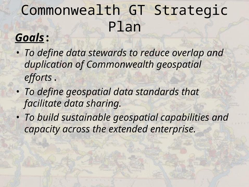
Commonwealth GT Strategic PlanGoals:• To define data stewards to reduce overlap and
duplication of Commonwealth geospatial efforts.• To define geospatial data standards that
facilitate data sharing.• To build sustainable geospatial capabilities and
capacity across the extended enterprise.

Commonwealth GT Strategic PlanGuiding Principles• Improve government services• Geospatial Enterprise Architecture Development• Leverage every dollar spent for the extended enterprise• Maximize sharing of ideas, knowledge, data and
applications• Listen and understand partner needs and priorities to
inform decision-making• Remain agile and open to new ideas, always guided by a
long-range plan• Maintain constant awareness of trends and opportunities• Relationships and communications trump technologies

Commonwealth GT Strategic PlanBGT will:• Operate an effective and inclusive Commonwealth
geospatial governance structure;• Develop a comprehensive Geospatial Enterprise
Architecture (GEA) to serve the needs of agencies and the geospatial extended enterprise;
• Create an enterprise Geospatial Strategic Plan for all agencies and extended enterprise partners to follow;
• Develop an enterprise geospatial training program for agencies to improve our technology workforce.
• Develop enterprise geospatial resources including a centralized Commonwealth geospatial data repository for all data that needs to be shared, reusable geospatial web application components, and a shared services strategy for serving all agencies and external business partners;

Commonwealth GT Strategic PlanBGT will:• Develop a strategy for geospatial interoperability for the
Commonwealth, including the use of Open Geospatial Consortium standards and the development of data sharing standards;
• Develop grant guidelines that promote data sharing, interoperability, data standards, and furtherance of Commonwealth geospatial initiatives by leveraging all available funding and projects; and
• Partner with federal, state, local government, academic, and business entities to leverage all resources to accomplish Commonwealth geospatial priorities.

Geospatial Enterprise Architecture• Concepts:
– Develop the GEA– Make data more useful, accessible and secure
• Relevance – Increased efficiency and cohesiveness of
government operations– Supports Public Safety– Fosters Economic Development– Protects and preserves our environmental
resources

Geospatial Enterprise Architecture• Initiatives
– Enterprise Geospatial Data Repository– GIS Data Inventory and Data Stewardship– PA Geospatial Data Sharing Standards– Enterprise Essential Services and Geospatial
Applications– Geospatial Standards, Directives, and Best
Practices

Enterprise Strengthening• Concepts
– Provide resources– Build partnerships– Enhance Capabilities
• Initiatives– Statewide GIS Council– Commonwealth GT Strategic Plan– GIS/JNET Integration– Agency GIS Coordination and Guidance– GT Communications– Federal GT Partnerships and National Perspectives

Building Data Assets• Concepts:
– Statewide Data – Support for NSDI
• Initiatives– Statewide Address Database– Statewide High-Resolution Imagery/PAMAP– Statewide High-Resolution Elevation Data– Real-Time Weather– Critical Infrastructure

Geospatial Communities of Practice (PA GeoCoPa)

GeoCoPa• Organized by Business functions• Hold quarterly meetings with General
Government Operations, Environmental, Public Safety, and Health and Human Services
• Replaces one-on-one meetings between GTO and agencies
• CoP Joint Project/Priority Focus Areas:– General Government Operations: Geocoding– Environmental: Land Records– Public Safety: GPS and Tracking– Health and Human Services: Geocoding Anonymity –
Density Mapping

PA GTO Website
http://www.gis.state.pa.us